The health of our waters is the principal measure of how we live on the land — Luna Leopold
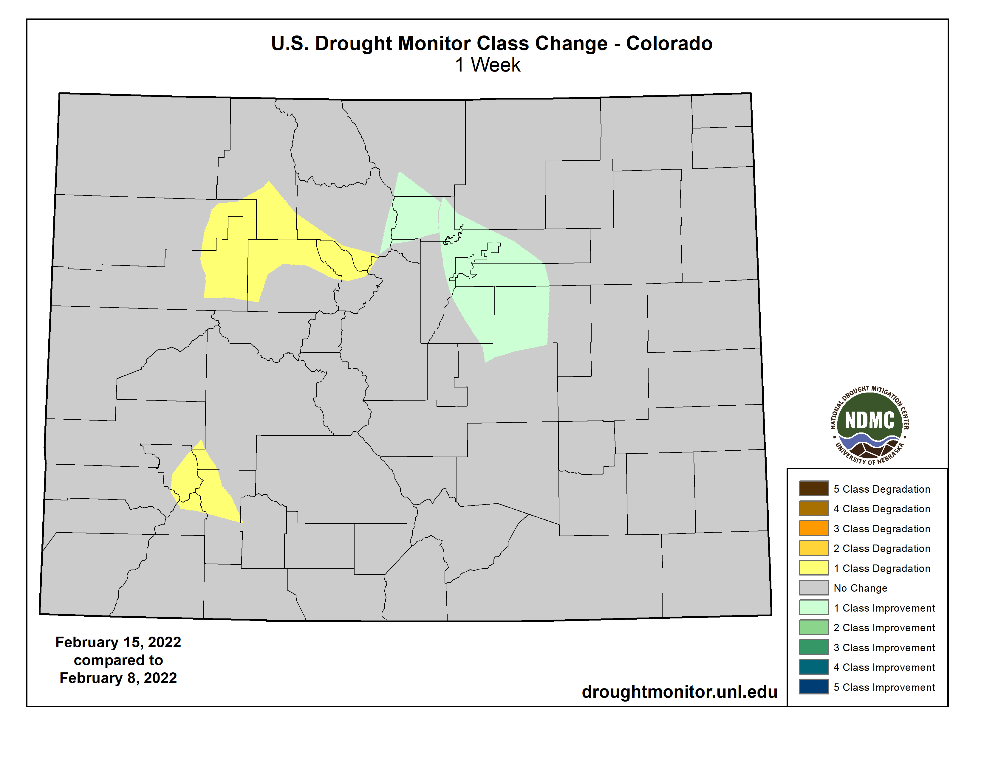
#Drought news (February 17, 2022): 1-category degradations were made to parts of W. and S. #Colorado based on longer-term SPIs and current #snowpack
Click on a thumbnail graphic to view a gallery of drought data from the US Drought Monitor.
US Drought Monitor map February 15, 2022.
High Plains Drought Monitor map February 15, 2022.
West Drought Monitor map February 15, 2022.
Colorado Drought Monitor map February 15, 2022.
Click on the link to go to the US Drought Monitor website. Here’s an excerpt:
This Week’s Drought Summary
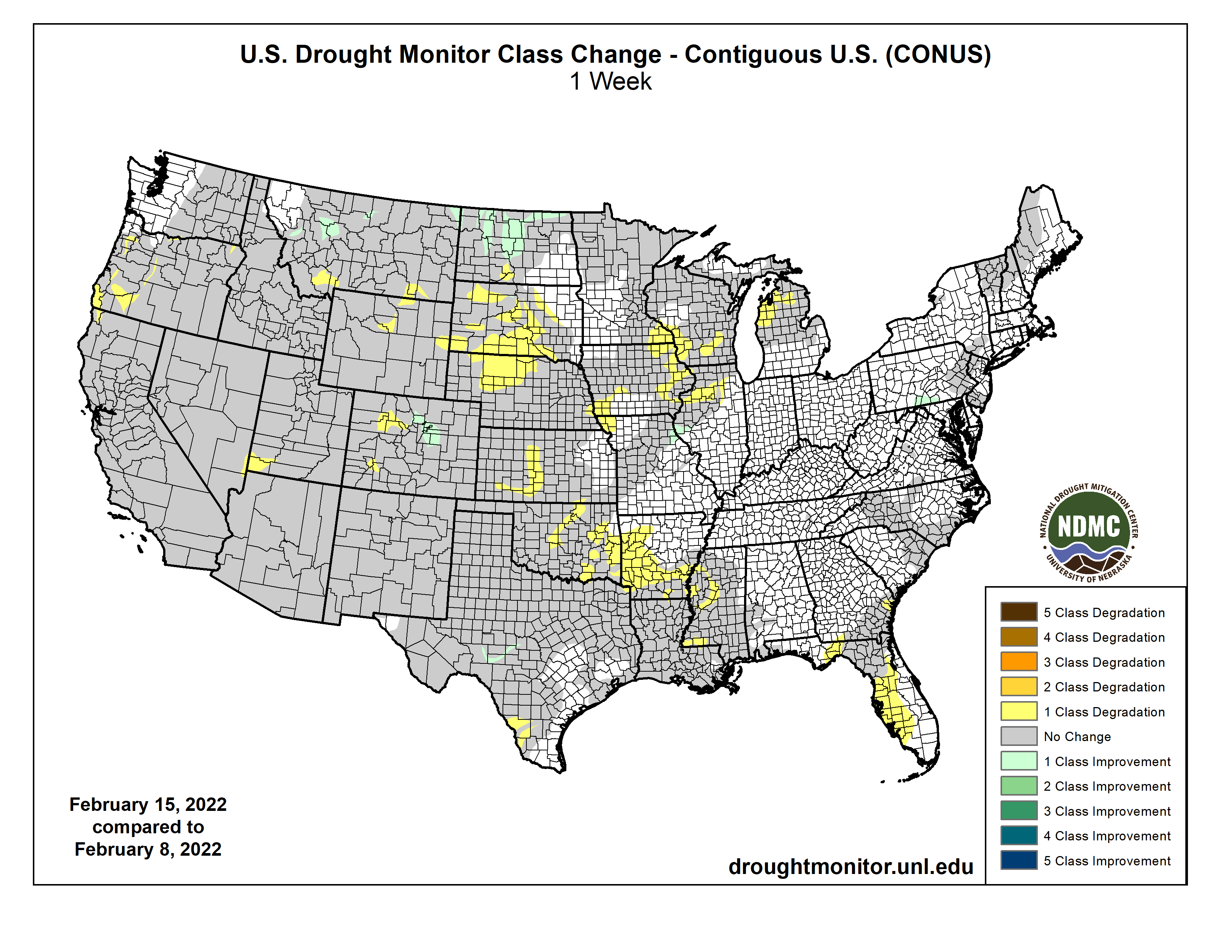
A broad area of surface high pressure resulted in little to no precipitation throughout the contiguous U.S. from February 8 to 14. During this 7-day period, the most significant precipitation (more than 0.5 inch, liquid equivalent) was limited to the Cascades, Upper Mississippi Valley, northern New England, and the Florida Peninsula. Following a wet December with beneficial snowfall, a persistent area of mid-level high pressure anchored near the West Coast led to drier-than-normal conditions across the western U.S. since early January. During the second week of February, above-normal temperatures prevailed throughout the West and much of the Great Plains. Drier weather returned to Puerto Rico by mid-February, while enhanced trade wind showers resumed across the eastern side of Hawaii’s Big Island…
Moderate drought (D1) was degraded to severe drought (D2) across central Kansas and merged with ongoing D2 in southwest Kansas, based on 120-day SPI and soil moisture indicators. Since a 1-category degradation was made the previous week across northern Kansas and eastern Nebraska, these areas remained status quo this week given the time of year when worsening conditions are slower to be realized in terms of impacts. Farther to the north, recent dryness with a lack of snow cover and above normal temperatures resulted in an increase of abnormal dryness (D0) and moderate drought (D1) across northern Nebraska and South Dakota. The updated depiction across the northern to central Great Plains follows closely the 30 to 90-day SPI and soil moisture indicators. Also, the SPI dating back 24 months was also weighed. Drought impacts for South Dakota include many days of high fire danger which is unusual during the winter, low stock ponds, and adverse conditions for recreational snowmobiling. Farther to the north across northern and eastern North Dakota, SPIs at various time scales supported a 1-category improvement. Recent snowfall (6 to 12 inches) and 6-month SPIs prompted a 1-category improvement to the Denver/Boulder metro areas, while 1-category degradations were made to parts of western and southern Colorado based on longer-term SPIs and current snowpack…
Colorado Drought Monitor one week change map ending February 15, 2022.
An expansion of extreme (D3) drought was made to parts of south-central Montana, based on SPI and EDDI at various time scales and soil moisture indicators. Although only light precipitation (less than 0.25 inch liquid equivalent) was observed in northeast Montana, a small area was improved from D3 to D2 due to a reassessment of indicators such as SPI values. Continued improvement of long-term SPI supported a slight reduction of D4 in northwest Montana. Severe (D2) drought was increased slightly in coverage across southwest Utah, as a result of low streamflows (below the 10th percentile) and 30-day SPI. 12-month SPEI along with worsening soil moisture indicators and 28-day average streamflows supported a 1-category degradation across parts of Oregon and adjacent areas of northwest California. The lack of precipitation since early January resulted in 28-day average streamflows falling below the 10th percentile throughout much of western Oregon. Following the persistent dryness since early January and above normal temperatures from early to mid-February, California’s statewide snowpack decreased to 73 percent of normal on Feb 14. If the dry pattern persists through the remainder of February, degradations in the current drought levels may be necessary for the remainder of California…
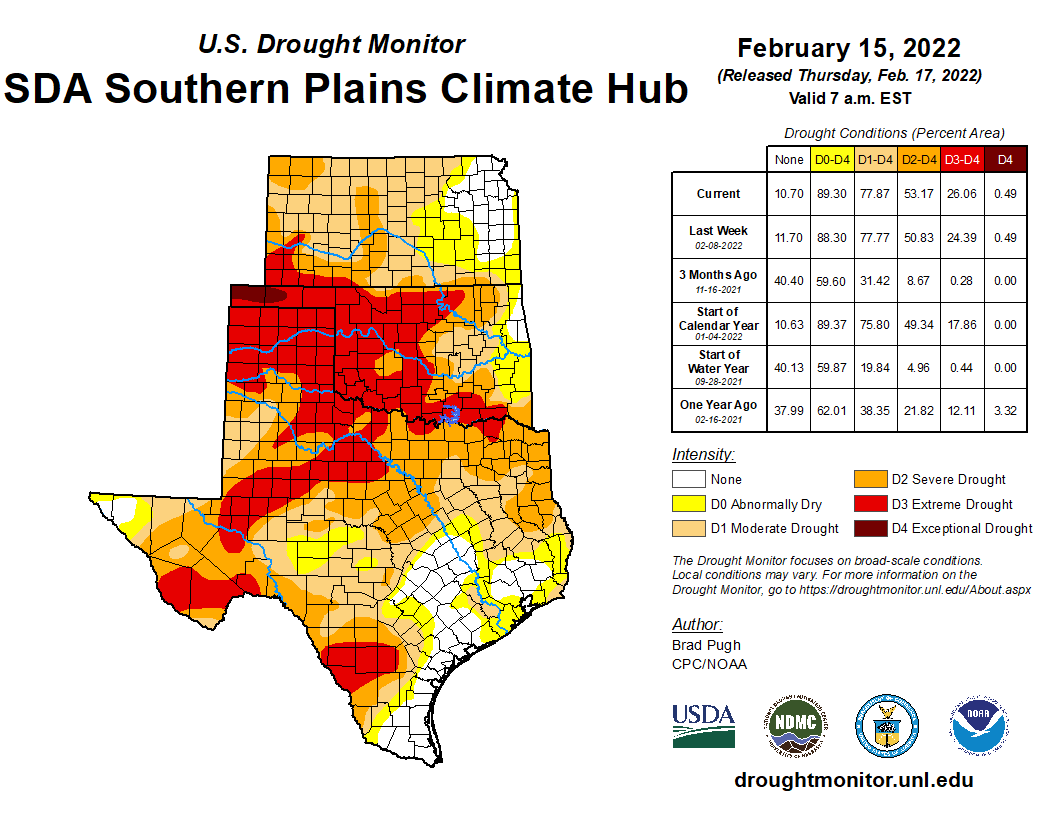
Southern Plains Drought Monitor map February 15, 2022.
Based on 90-day SPI values and soil moisture indicators, a 1-category degradation was made to parts of Arkansas and adjacent northwest Mississippi. Impacts related to these worsening drought conditions include dry ponds and continued high fire danger. The previous week’s D2 areas in southwest Mississippi and adjacent Louisiana were merged and slightly expanded eastward, consistent with SPoRT soil moisture percentiles, 28-day average streamflows, and 90-day SPI values. Precipitation deficits of more than 8 inches are observed during the past 90 days across a broad area of the Lower Mississippi Valley. Statewide precipitation across Mississippi during November-December-January was the driest since 1985/86. On February 15, a statewide burn ban was issued for Louisiana. An expansion of extreme drought (D3) was made across north-central Oklahoma, based on 90-day SPI and worsening soil moisture indicators. Persistent dryness along with periods of above normal temperatures and enhanced winds this winter prompted an expansion of severe to extreme drought (D2 to D3 ) across the middle Rio Grande Valley. Despite a dry week, a reassessment of SPI values at various time scales and soil moisture indicators supported a 1-category improvement from moderate drought (D1) to abnormal dryness (D0) across the southern Edwards Plateau. According to the USDA’s National Agricultural Statistics Service, 77 percent of the topsoil moisture was rated as poor to very poor across Texas as of February 13. Nearly two-thirds of oats, winter wheat, and rangeland and pastures were rated in poor to very poor condition…
Looking Ahead
On February 17, a low pressure system is forecast to develop with a subsequent track northeastward to the Ohio Valley and Northeast. A swath of snowfall, potentially more than 6 inches, is expected to the northwest of surface low track from the central Great Plains to the Midwest. In the warm sector of this storm system, thunderstorms with locally heavy rainfall (more than 1 inch) are forecast from the Ohio River south to the Lower Mississippi Valley. Mostly dry weather is likely across the Coastal Plain of the Southeast and Florida from Feb 17 to 21. As mid-level low pressure develops over the West on Feb 20 and 21, snow is anticipated to overspread the Cascades, Sierra Nevada Mountains, Great Basin, and Rockies.
The Climate Prediction Center’s 6-10 day outlook (valid Feb 22-26, 2022) depicts a major pattern change over the West and north-central U.S. from earlier in the month. Large probabilities (more than 70 percent) of below normal temperatures are forecast throughout the West and much of the Great Plains. Conversely, large probabilities (more than 70 percent) of above normal temperatures are forecast across the Mid-Atlantic and Southeast. Below-normal precipitation is favored for the Pacific Northwest, Great Basin, California, and Florida. A storm track, consistent with La Nina, elevates probabilities for above normal precipitation across the Ohio and Tennessee Valleys.
US Drought Monitor one week change map ending February 15, 2022.