The latest briefing is hot off the presses from Western Water Assessment #CRWUA2022

Click the link to read the briefing on the Western Water Assessment website:

November 2, 2022 – CO, UT, WY

Regional precipitation in October was generally below average, but eastern Utah and western Colorado received above average precipitation. Regional temperatures were near normal in most of Colorado and Utah, but slightly above normal in northern Wyoming, northwestern Utah and northeastern Colorado. Regional snowpack is above to much-above normal in Colorado and Utah, but below normal in Wyoming after a significant late-October storm. Drought conditions expanded slightly to cover 66% of the region with areas of drought developing in southeastern Colorado and eastern Wyoming. La Niña conditions are likely to continue through most of winter, but NOAA precipitation forecasts suggest an increased probability of above average precipitation for much of the region during November.

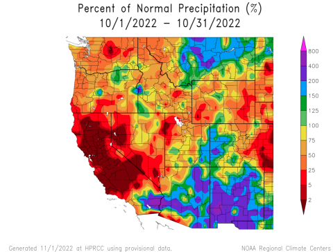
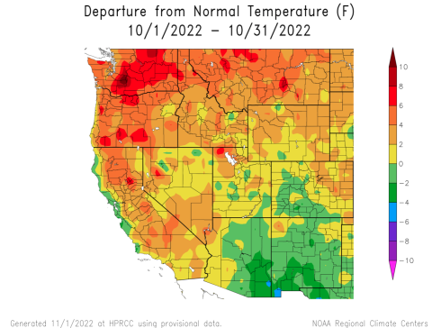
October precipitation was above normal in eastern Utah and western Colorado, but below normal elsewhere. October was a month of weather transitions in the Intermountain West. The first half of the month was dominated by a monsoonal weather pattern. During the first week of October, monsoonal precipitation fell across much of the region. During the second and third weeks of October, a monsoonal weather pattern continued, but precipitation stayed south of the Colorado/Utah border. Dry conditions covered the entire region from October 6-21. The last week of October brought the first major winter storm to the region. Rain fell in many valley locations, but most mountain locations above 7,000 feet received snow (1-3” of snow water equivalent).

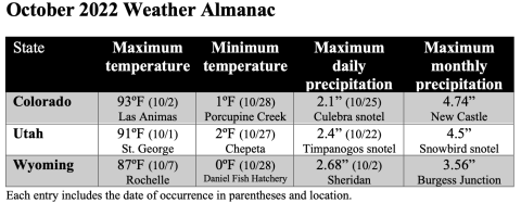
After a record hot September in much of the region, October temperatures were relatively cooler. October temperatures in most of Colorado and Utah were within two degrees of average. Temperatures were 2-4 degrees above average in northeastern Colorado, northwestern Utah and northern Wyoming.

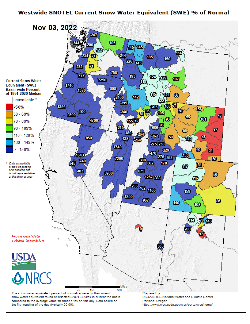
The first winter storm of the water year brought widespread snow to regional mountains on October 22-24. Seasonably cool temperatures during the last week of October caused little melting at regional snotel sites. As of November 1st, snow water equivalent (SWE) was much above normal in Utah, near-to-above normal in Colorado and below normal in Wyoming. In Utah, most snotel sites above 8,000 feet are reporting 2-4” of SWE. In western Colorado, most snotel sites are reporting 1-2” of SWE and in Wyoming, few sites have more than 1” of SWE. Note: Current SWE as a percent of normal maps are often skewed at this time of year due to the very low average SWE this early in the season.

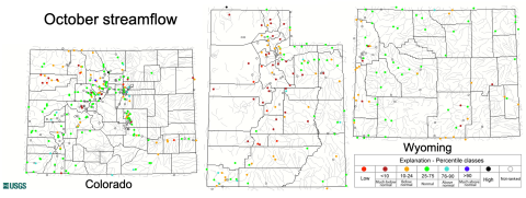
October streamflow in the Upper Colorado River Basin was normal at most locations except part so the White and Yampa River Basins where  below normal was observed. Most locations in the Utah portion of the Great Basin experienced below normal October streamflow and many sites saw monthly streamflow less than the 10th percentile. Rivers in Wyoming were generally flowing near normal except for below normal October streamflow conditions along the Snake River. Reservoir storage is below average in Utah; currently, Utah reservoirs are 40% full and average November 1st capacity is 55% full. All major Upper Colorado River Basin reservoirs are also below average capacity with Lake Powell (25% full), Blue Mesa (32%) and Flaming Gorge (72%) near record-low levels of storage.

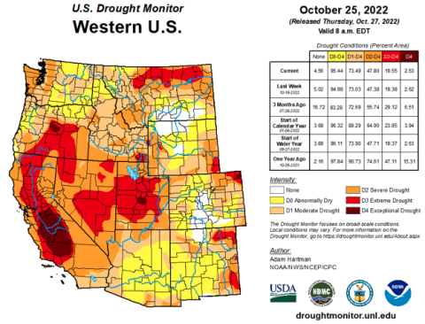
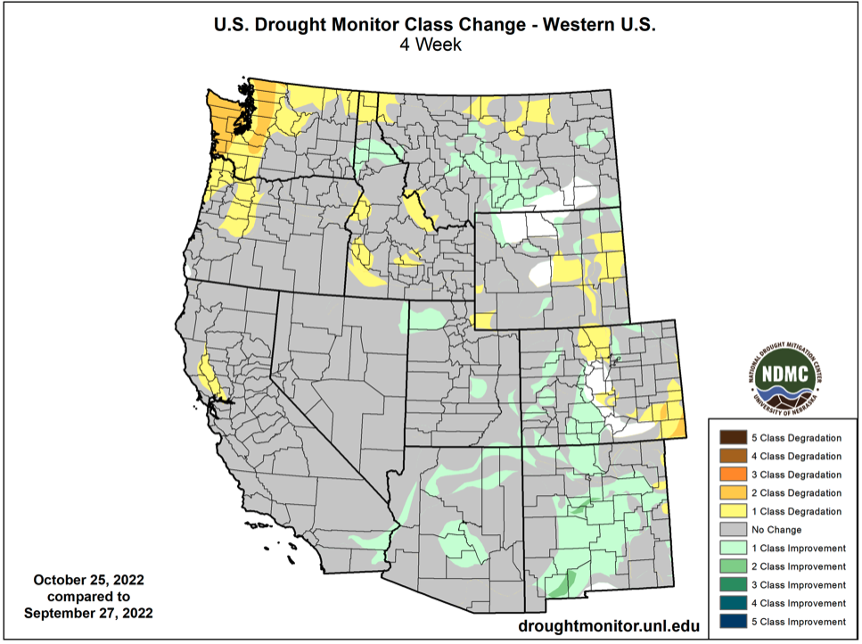
Coverage of drought in the Intermountain West increased slightly to cover 66% of the region. The slight expansion of drought was due to the development of drought conditions in southeastern Colorado and eastern Wyoming. Drought conditions worsened by one category in eastern Wyoming, north-central Colorado and southeastern Colorado. In southeastern Colorado, drought conditions worsened by two categories and severe (D2) drought developed. Small areas of D3 and D4 drought were removed in Utah and drought conditions improved by one category in parts of western Colorado. Northern Wyoming and central Colorado are the only drought-free locations in the western United States.

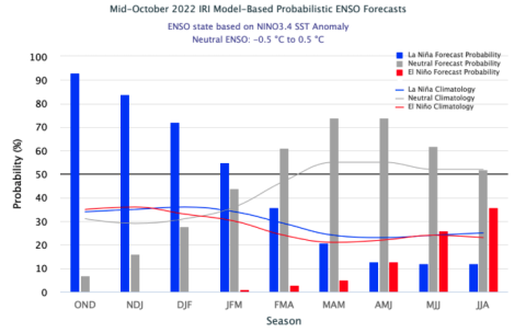
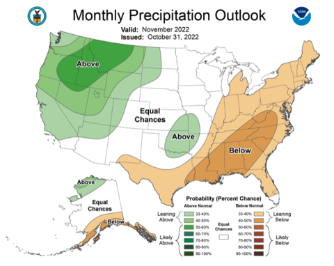
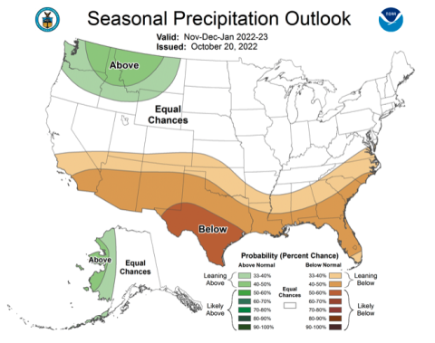
La Niña conditions continue in the eastern Pacific Ocean as sea-surface temperatures are 1-2ºC below normal. There is a 70% probability of La Niña conditions persisting through February and a 55% chance of La Niña through March; By spring, there is greater than a 70% chance of neutral ENSO conditions. In November, there is an increased probability for above average precipitation in Utah, Wyoming and western Colorado and there is an increased probability for above average temperatures in most of Colorado. There are equal chances of above or below average precipitation for most of the region during November through January, but a greater chance of below average precipitation for southern Colorado and Utah. There is an increased probability of above average temperatures for the entire region from November through January.

Significant October weather event. Late October snowstorm impacts entire region. A cold Pacific storm impacted the region from October 22-24 that brought widespread precipitation and significant snow above 7,000 feet. The highest accumulation occurred at Snowbird in the Wasatch Mountains where 27” of snow with 3.3” of SWE accumulated; other locations in the central Wasatch Mountains, Wasatch Plateaus and La Sal Mountains also received significant snow. All snotel sites in Utah received snow from this storm and over 60% of snotel sites received at least 1” of SWE. In Colorado, the snowfall winner was the Bison Lake snotel site in Garfield County with 1.9” of SWE and over 60% of snotel sites received at least 0.5” of SWE. Lewis Lake Divide snotel site in Yellowstone received 2” of SWE from the storm and half of Wyoming snotel sites received at least 0.5” of SWE.

#ColoradoRiver conditions are worsening quicker than expected. Feds prepare to step in — The #Denver Post #COriver #aridification #CRWUA2022

Colorado River “Beginnings”. Photo: Brent Gardner-Smith/Aspen Journalism

Click the link to read the article on The Denver Post website (Conrad Swanson). Here’s an excerpt:

Without enough snow this winter, the water level at Lake Powell — the country’s second-largest reservoir — will drop below a critical level by next November, according to a new report from the U.S. Bureau of Reclamation. Below that point, the Glen Canyon Dam will no longer be able to generate electricity and experts worry whether conditions will worsen to the point that the structure will no longer be able to send water downstream at all. Conditions on the Colorado River are worsening quicker than expected. The seven states in the river basin made little progress saving water over the summer and Colorado is heading into its third La Niña winter in a row, likely indicating below-average snowpack. A worst-case scenario, once considered only as a hypothetical, now presents a very real threat.

“It’s going to be ugly,” Mark Squillace, a water law professor at the University of Colorado, said. “The bottom line is there just isn’t going to be enough water available.”

The path forward for Reclamation, the states and dozens of Native American tribes is narrowing, Brad Udall, a water and climate scientist with Colorado State University, said, calling the implications “beyond serious.” If the federal government comes in too strong, requiring massive cuts to water use, the entire scheme could devolve into a morass of expensive and time-consuming lawsuits, Udall said. Not strong enough and the river dwindles further, endangering the way of life for more than 40 million people and an estimated $1.4 trillion chunk of the national economy. Reclamation officials announced Friday [October 28, 2022] that they will consider whether to turn down the faucet for downstream states next year and in 2024. A draft plan should be ready by spring.

“The Interior Department continues to pursue a collaborative and consensus-based approach to addressing the drought crisis affecting the West,” Secretary of the Interior Deb Haaland said in a news release. “At the same time, we are committed to taking prompt and decisive action necessary to protect the Colorado River and all those who depend on it.”

Westwide SNOTEL basin-filled map November 3, 2022 via the NRCS.

#Drought and Barge Backups on the #MississippiRiver — NOAA

The Mississippi River at Vicksburg, Mississippi October 7, 2022. Photo credit: NOAA
Soil moisture anomaly map October 7, 2022. Credit: NOAA

Click the link to read the article on the NOAA website:

Water levels on the Mississippi River normally decline in the fall and winter, but not by nearly as much as they did in October 2022. Lack of rain in the Ohio River Valley and Upper Mississippi River Valley in recent weeks caused river water to drop to levels not seen in more than a decade along key parts of the river. The low water levels are slowing barge traffic and raising concerns that saltwater intrusions in the Lower Mississippi could affect water supplies.

The Operational Land Imager (OLI-2) on Landsat 9 captured this natural-color image of the parched river on October 7, 2022. The image shows backed-up barges north of Vicksburg, Mississippi. At times, well over 100 towboats and barges waited due to a temporary river closure caused by barge groundings and dredging work, according to news reports. The towboats and barges are strung together into groups that vary in size but can easily be 1,000 feet (300 meters) long and 100 feet (30 meters) wide.

The map above shows how wet the soil was on the same day the Landsat 8 image was acquired. Using data from the Crop Condition and Soil Moisture Analytics (Crop-CASMA) product, the map shows soil moisture anomalies on October 7, 2022, or how the water content in the top meter (3 feet) of soil compared to normal conditions for the time of year. Brown areas were drier; blue areas were wetter. Crop-CASMA integrates measurements from NASA’s Soil Moisture Active Passive (SMAP) satellite and vegetation indices from the Moderate Resolution Imaging Spectroradiometer (MODIS) instruments on NASA’s Terra and Aqua satellites.

River levels at Vicksburg had dropped to 0.66 feet (0.20 meters) by October 20, a low level but still well above the record low of -7.00 feet in 1940. However, farther upstream in Memphis, the river level dropped to -10.79 feet on October 17, 2022, the lowest level recorded at the site since the start of National Weather Service records there in 1954.

USGS streamgage data Memphis, TN and New Madrid, MO October 2019 thru October 2022. Credit: NOAA

At New Madrid, Missouri, water levels had dropped to -5.1 feet on October 20, just slightly above the minimum operating level of the gage. Water levels, or “gage height,” or “river stages” do not indicate the depth of a stream; rather, they are measured with respect to a chosen reference point. That is why some gage height measurements are negative.

A lack of rain over a very broad area is the main reason water levels have dropped so low, explained Tennessee State Climatologist Andrew Joyner. “It doesn’t take long for water levels to go down given a lack of rain over such a large area,” he said.

Downstream, in the lower part of the river, the U.S. Army Corps of Engineers is dealing with the intrusion of saltwater into the lower reaches of the river. Normally, the flow of the river prevents saltwater from the Gulf of Mexico from moving very far upriver, but the river is so low that a wedge of saltwater has crept northward and threatens intakes used for freshwater supplies. To prevent saltwater from getting farther upstream, the Corps began construction on an underwater sill in Myrtle Grove, Louisiana, on October 11.

Forecasting from the National Weather Service Lower Mississippi River Forecast Center calls for water levels to drop even lower at several points along the river in coming weeks. In many cases, they expect water levels to drop even lower than they did in 2012, 2000, and 1988—other years when water levels hit unusually low levels.

What will happen beyond a few weeks is less clear. “Looking at one- and three-month forecasts, it looks like there are equal chances of above or below average rainfall,” Joyner said. “If we end up with average rainfall, conditions might not worsen, but it also won’t lead to improvements.”

NASA Earth Observatory images by Joshua Stevens, using soil moisture data from Crop Condition and Soil Moisture Analytics (Crop-CASMA), Landsat data from the U.S. Geological Survey, and data from the National Water Information System. Story by Adam Voiland.

Created by Imgur user Fejetlenfej , a geographer and GIS analyst with a ‘lifelong passion for beautiful maps,’ it highlights the massive expanse of river basins across the country – in particular, those which feed the Mississippi River, in pink.

#Nuclear industry eyes expansion despite tenuous start: TerraPower and PacifiCorp will consider adding five more Natrium nuclear power plants, targeting #Wyoming and #Utah — @WyoFile

The Kemmerer coal mine (left) and Naughton coal-fired power plant, pictured Jan. 19, 2022. The power plant will be retired in 2028 when TerraPower commences operations for its proposed Natrium nuclear reactor power plant at the same location. (Dustin Bleizeffer/WyoFile)

Click the link to read the article on the WyoFile website (Dustin Bleizeffer):

Having already agreed to take on one nuclear power plant in Wyoming, western utility giant PacifiCorp will now consider adding five more to its electric generation fleet by 2035, by co-locating “small modular reactors” where it plans to retire coal-fired power plants in Wyoming and Utah.

PacifiCorp, which serves customers in six western states and operates as Rocky Mountain Power in Wyoming, will join nuclear energy developer TerraPower to study “the potential for advanced reactors to be located near current fossil-fueled generation sites, enabling the companies to repurpose existing generation and transmission assets for the benefit of [PacifiCorp’s] customers,” the companies announced in a joint statement Oct. 27. 

Before choosing locations, “both companies will engage with local communities.”

“This is just a first step, as advanced nuclear power needs to be evaluated through our resource planning processes as well as receive regulatory approval,” Rocky Mountain Power President and CEO Gary Hoogeveen said in a prepared statement. “But it’s an exciting opportunity that advances us down the path to a net-zero energy future.”

A schematic of TerraPower’s proposed Natrium nuclear power plant. Credit: TerraPower

PacifiCorp entered into a tentative agreement in 2021 to take ownership of TerraPower’s first-of-its-kind Natrium nuclear power facility slated for construction at the Naughton coal-fired plant site outside Kemmerer. The plant is scheduled to begin operations in 2028. PacifiCorp would take ownership sometime thereafter.

Coal-to-nuclear shift

Nuclear power is emerging as a potential strategy to help PacifiCorp meet low-carbon emission standards — particularly in California, Oregon and Washington — while also meeting continuous power reliability and making use of its existing coal-fired power facilities. 

The utility plans to convert fuel sources or retire at least six coal-burning units in Wyoming by 2035, taking offline about 2,691 megawatts of continuous “baseload” power capacity, or more than 36% of the state’s coal-fired power generating capacity, according to PacifiCorp data and WyoFile calculations. It plans to shut down its entire coal-fired power fleet in the state by 2039, according to its 2021 Integrated Resource Plan.

A turbine whirls on a farm east of Burlington, Colo. Colorado’s eastern plains already have many wind farms—but it may look like a pin cushion during the next several years. Photo/Allen Best

Aside from potentially replacing coal plants with nuclear reactors, PacifiCorp plans to add more than 3,700 megawatts of new wind power by 2040 throughout its six-state region, including in Wyoming, while adding commercial-scale solar power and battery storage.

Wyoming lawmakers have passed a suite of bills aimed at delaying coal-plant closures in the state by forcing regulated utilities like PacifiCorp to retrofit coal units with carbon capture utilization and sequestration technologies. But so far, the cost-benefit of CCUS retrofits haven’t penciled out for PacifiCorp or Black Hills Energy, according to the companies. 

Legislators and the state’s top energy officials, however, are also enthusiastic about adding nuclear to the state’s power mix. Not only would it provide replacement jobs for coal-plant workers, but some hope it would also help revive Wyoming’s languishing uranium mining sector.

“Wyoming has been working hard to develop a nuclear industry — from the supply chain via our uranium reserves all the way through the value chain to produce zero-emissions electricity that can then be used as feedstock for other net-negative emission products,” Wyoming Energy Authority Executive Director Glen Murrell wrote WyoFile. “The news that [TerraPower and PacifiCorp are] taking on an additional feasibility study to potentially deploy more reactors in the area will strengthen the industry and create jobs and growth for Wyoming’s benefit.”

TerraPower’s Natrium Project Director Tara Neider visits with Wyoming Rep. Scott Heiner (R-Green River) during a Jan. 19, 2022 meeting with officials from TerraPower and PacifiCorp. (Dustin Bleizeffer/WyoFile)

It makes sense to begin analysis and planning for multiple nuclear power reactors now because TerraPower needs to deploy the technology “at scale” if it’s going to prove the Natrium technology commercially viable, University of Wyoming energy economist Rob Godby said.

“You have to look that far down the road when you’re talking about this sort of technological change if you’re [selling nuclear plants to a utility],” Godby said. “So it makes sense for both TerraPower and PacificCorp.”

Targeting Wyoming

TerraPower, backed by Microsoft billionaire Bill Gates, selected PacifiCorp’s Naughton power plant at Kemmerer for its demonstration Natrium nuclear power plant in November 2021. Engineering and geologic sampling work is ongoing at the Kemmerer location. Construction is slated to begin in 2024 and bring 2,000 workers to the tiny community.

The company is looking to the U.S. Department of Energy to cover about half of the estimated $4 billion cost of the Kemmerer plant, contingent on a 2028 in-service date.

That schedule, however, was thrown into question after Russia invaded Ukraine earlier this year. TerraPower cut ties with the Russian state-owned Tenex — the only facility in the world with the capacity to supply commercial volumes of high-assay, low-enriched uranium fuel. The company is working with DOE and Congress to speed up the development of a domestic HALEU supply chain, including the potential to “downblend” weapons-grade uranium to meet initial fuel needs at Kemmerer by end of 2025, according to TerraPower.

Yet some doubt the viability of adding new nuclear power to the grid under such a time constraint. The Oregon Public Utility Commission in March declined to formally acknowledge PacifiCorp’s plans for Natrium to be a part of its future electrical generation portfolio.

TerraPower is confident of a speedy federal permitting process and that a domestic HALEU supply will come into play, however, and is moving forward with the project as scheduled, a company official told WyoFile.

Kemmerer and PacifiCorp’s Naughton power plant make an ideal location for TerraPower’s demonstration Natrium plant due to “local community support, the physical characteristics of the site, the ability to obtain a license from the U.S. Nuclear Regulatory Commission for the site, access to existing infrastructure, and the needs of the grid,” the company said.

Those same factors make other locations in Wyoming a prime target for Natrium facilities, according to the company.

In its initial analysis to choose a location for its demonstration plant now slated for Kemmerer, TerraPower had also considered the Jim Bridger plant near Rock Springs, the Dave Johnston plant in Glenrock and the Wyodak plant near Gillette — all owned by PacifiCorp.

“We have been impressed and humbled by our work with the Kemmerer community and PacifiCorp,” TerraPower President and CEO Chris Levesque said in a prepared statement. “We look forward to evaluating new potential sites for Natrium plants that have the same energy expertise and capabilities as our demonstration site.”

.

a #ColoradoRiver hypothetical and an attention-getting cuss word — InkStain (@jfleck) #COriver #aridification #CRWUA2022

Lake Mead, October 2022. Photo by John Fleck

Click the link to read the post on the Inkstain website (John Fleck):

Colorado River political and policy discourse is tangled right now around an increasingly unhelpful set of questions. They involve process: Should the federal government step in and impose cuts? Should the Lower Basin states, especially Arizona and California, do more to save themselves? Should we pay farmers to fallow? How much? Should the Upper Basin contribute more cuts? What about environmental flows – will the cuts we need to make endanger our ESA coverage under the MSCP?

WHAT ABOUT MY WATER?

These are all worthy questions, but our entanglement with them avoids the largest and most important question: In a future with less water, what will this engineered hydraulic landscape of irrigated farms and cities look like? What do we want it to look like?

That was the point of my attention-getting quote to Grist’s Jake Bittle:

If you’re in Las Vegas or Phoenix or Los Angeles or San Diego (or Albuquerque!), the details of which path we’re on matter, but the larger question is unchanged. You’ll have to learn to live with less Colorado River water, and you’ll succeed at that. Your city will be less green, but you’ll have enough for cooking and cleaning and brewing your morning coffee.

If you’re in Yuma or Imperial or Palo Verde, the details of which path we’re on matter, but the larger question is unchanged. We’ll still get all the yummy melons and lettuce we love (and are willing to pay for), and there will be a lot less alfalfa grown in the deserts of the Lower Colorado River.

I’ve got a far longer blog post brewing on the hard drive, as I begin to work through the details of what a “Colorado River system crash” might look like, which is the seed for the project occupying my thinking right now. We need some sense of what the alternative is to the process the Department of the Interior has launched, the process that triggered Jake Bittle’s call and my flamboyant quote, the attempt to get things back on the rails and create an orderly approach to envisioning our desired future and acting on it.

I may never post it.

“Reservoirs fucking empty” is bait to folks’ limbic systems. It wasn’t a slip. I chose my words with care. But “fight or flight” may not be what we need right now. We need to understand that we can do this – that the key to our future is not winning a fight with Arizona/California/the Feds/the Upper Basin/the farmers/the cities over who gets what’s left, but rather envisioning a future in which we all figure out how to survive and even thrive with less water.

Brad Udall: Here’s the latest version of my 4-Panel plot thru Water Year (Oct-Sep) of 2021 of the Colorado River big reservoirs, natural flows, precipitation, and temperature. Data (PRISM) goes back or 1906 (or 1935 for reservoirs.) This updates previous work with @GreatLakesPeck. Credit: Brad Udall via Twitter