


Click the link to read the article on the Grist website (Jessie Blaeser, Joseph Lee, & Anna V. Smith):
This story was published in partnership with High Country News.
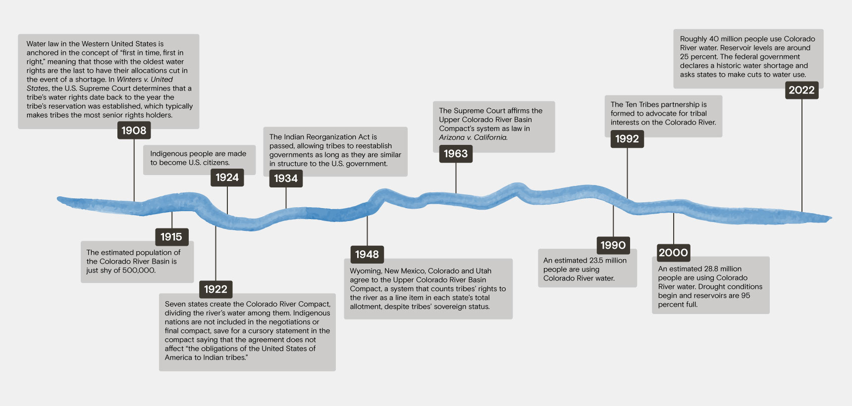
In early November, the U.S. Supreme Court agreed to hear a case brought by the Navajo Nation that could have far-reaching impacts on tribal water rights in the Colorado River Basin. In its suit, the Navajo Nation argues that the Department of Interior has a responsibility, grounded in treaty law, to protect future access to water from the Colorado River. Several states and water districts have filed petitions opposing the tribe, stating that the river is “already fully allocated.”
The case highlights a growing tension in the region: As water levels fall and states face cuts amid a two-decade-long megadrought, tribes are working to ensure their water rights are fully recognized and accessible.
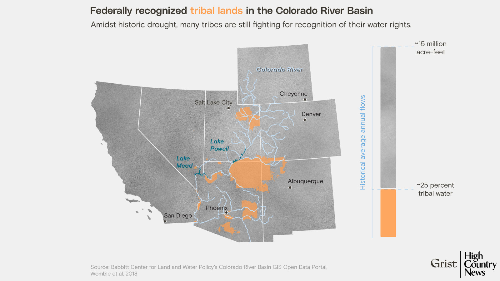
On average, 15 million acre-feet of water used to flow through the Colorado River every year. For scale, one acre-foot of water could supply one to three households annually. A century ago, states reached an agreement to divide that water among themselves. But in recent decades, the river has supplied closer to 12 million acre-feet. Scientists say water managers in the basin need to plan for closer to 9 million acre-feet per year, a 40 percent decrease in a water source that supports 40 million people, due to climate change and aridification.
No states have made plans to accommodate this drop. Meanwhile, tribal nations are legally entitled to between 3.2 and 3.8 million acre-feet of ground and surface water from the Colorado River system.
There are 30 federally recognized tribes in the river’s basin, and 12 of them, including Navajo Nation, still have at least some “unresolved” rights, meaning the extent of their rightful claims to water have yet to be agreed upon.
Ultimately, Indigenous nations in the Colorado River Basin could be serious power brokers in crucial water negotiations to come — but they face historical, legal and practical obstacles. The Navajo Nation, for example, has rights to almost 700,000 acre-feet of water annually across New Mexico and Utah, along with unresolved claims in Arizona. But, because of a lack of infrastructure, up to 40 percent of Navajo households don’t have running water. For the Navajo Nation and other tribes with allocations in the basin, building and improving infrastructure means providing citizens with access to a fundamental human right: water.
But tribal water use is taken out of state allocations, meaning the more water tribes use, the less states have. It also means that states have less incentive to work with tribal leaders or recognize pending water rights claims. This conflict is not new. It has been built into a century of policies that have excluded and divested from Indigenous nations. Read Next
The Colorado River is drying up. Here’s how that affects Indigenous water rights
Tribes often hold senior water rights, meaning their allocations are the last to be cut in a shortage, and states in the basin are beginning to reckon with this fact. A fundamental shift in how the river is governed — to a system that acknowledges tribes’ sovereignty and gives them greater say — will be key to sustainably and equitably distributing water in the years to come.
Tribes “need to be included in every one of those conversations and considered just like a state or the federal government,” Southern Ute Tribal Council Member Lorelei Cloud said at the annual Colorado River District Seminar in September. “You cannot discount us.”
One barrier to equitable distribution is a glaring information gap: There is no definitive source of data on water usage among tribes in the Colorado River Basin. Historically, federal surveys have ignored tribal water use, and though tribal-led studies have begun to fill these gaps, the lack of data makes planning for a future river with shrinking flows impossible.
“If you know how much water everyone has or is allocated, then you can come up with a comprehensive solution — not just management of the river but responses to climate change,” Heather Tanana (Diné), a professor of law at the University of Utah, said in an interview.
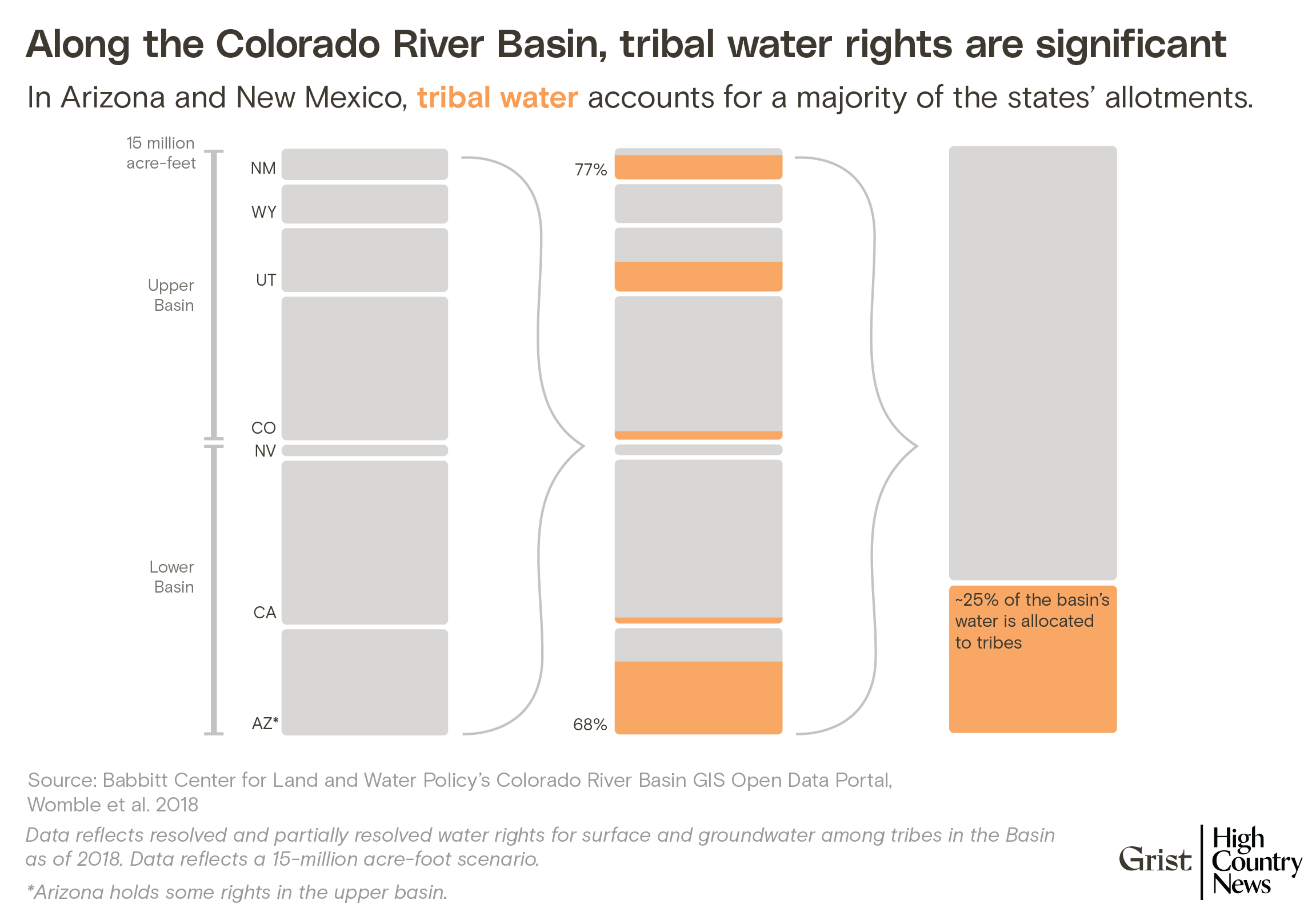
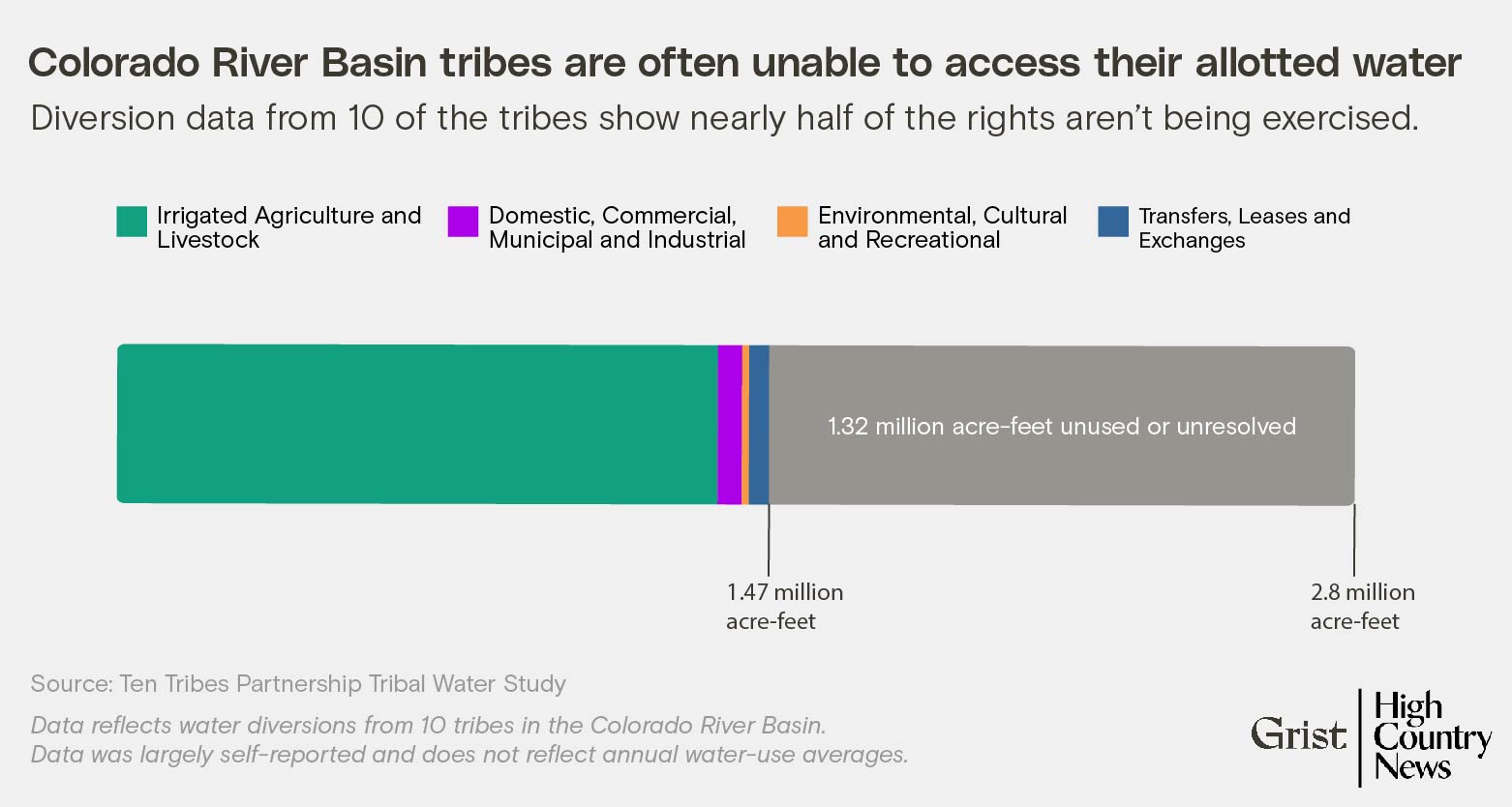
In Arizona, for example, nearly 70 percent of the state’s water allocation belongs to tribes, and nearly all the tribal nations with unresolved water rights in the basin have at least some territory in the state. According to a joint study by tribal nations and the federal government, 10 tribes in the basin, which hold the bulk of the recognized tribal water rights, are diverting just over half of what they’re entitled to — most of which is used for agriculture. It’s unclear what water availability would look like if these tribes had basic infrastructure to get water to their citizens, or if all tribes with unresolved rights settled their cases.
“My experience of negotiating water rights settlements in Arizona is that the state of Arizona very much approaches them as a zero-sum game,” said Jay Weiner, water counsel for the Quechan Indian Tribe and the Tonto Apache Tribe, which has been in settlement negotiations since at least 2014. That combative approach, he said, has persisted regardless of governor or political party. “It is something that seems to be deeply embedded in the fabric of Arizona and how it approaches Indian water rights settlements.”
In February, the federal government announced $1.7 billion for tribes to use for water settlements. That means more tribal citizens and communities could have access to water. It also means that states will have to work with tribes to plan for the future and adapt to climate change. Read Next
How Colorado River Basin tribes are managing water amid historic drought
In some places, tribes and communities have already been moving in that direction, working together to find place-based solutions that use the resources and infrastructure at hand. The Pascua Yaqui Tribe and the city of Tucson, Arizona, have an intergovernmental agreement for Tucson to store and deliver potable water for the tribe, which doesn’t have the infrastructure to do so on its own. Such partnerships will only become more essential as drought and aridification continue to stress the region.
“If folks work together and partner together, the opportunity to solve the problem, I think, is enhanced,” said Robyn Interpreter, an attorney who represents the Pascua Yaqui Tribe and the Yavapai-Apache Nation in their water rights claims.
The federal Navajo-Gallup Water Supply Project, which is building $123 million in infrastructure, is another promising example. The goal of the project is to construct water plants and a system of pipes and pumps that will deliver water to the Navajo Nation, the Jicarilla Apache Nation, and the city of Gallup, New Mexico. Crystal Tulley-Cordova, a principal hydrologist for the water management branch of the Navajo Nation Department of Water Resources, said in an interview there is a new willingness to collaborate, owing to both the severity of the situation and non-tribal water users’ realization that they must work with tribes. “Now there’s a greater desire to be able to work together. So I’m encouraged by that,” she said.
Meanwhile, tribal nations are also making progress in securing their access to water. In May, the Navajo Utah Water Rights Settlement Act was finalized, granting the Navajo Nation 81,500 acre-feet of water in Utah and authorized $220 million in federal funds for water infrastructure projects. “Our families celebrate this moment in history after decades of fighting for the Navajo Utah Water Rights Settlement,” Navajo Nation Council Delegate Charlaine Tso said in a statement at the time. “It is clear drought conditions are affecting water levels across the country. Many of our elders haul drinking water from miles away while we work to get proper water infrastructure projects completed. This settlement allows us to begin connecting our water lines to the most rural areas.”
However, tribes still have no direct means of governance over the river, and, as seen in the Navajo water rights case headed to the Supreme Court, states continue to fight tribal communities seeking access to water.
Last fall, more than 20 tribes signed a letter to Interior Secretary Deb Haaland in which they pressed for direct, sustained involvement in re-negotiating the guidelines that manage the river, which are set to expire in 2026. In Albuquerque, New Mexico, last March, Haaland and Bureau of Reclamation leadership met with tribal leaders and “committed to transparency and inclusivity for the Tribes when work begins on the post-2026 operational rules,” according to a spokesperson for the Department of the Interior.
“It’s the job of political imagination to see what’s possible,” Andrew Curley (Diné), an assistant professor of geography at University of Arizona, said in an interview. “That’s something that we collectively, not just Native nations but led by Native nations, can start to articulate. What is a different vision of the river than what has been put into law and these congressional acts and Supreme Court decisions over the years?”
Click the link to read the article on the New York Times website (Christopher Flavelle). Here’s an excerpt:
The rising toll of climate change across the United States has been measured in lives lost, buildings destroyed and dollars spent on recovery. But a report released on Wednesday uses a different measure: Which parts of the country have suffered the greatest number of federally declared disasters? That designation is reserved for disasters so severe, they overwhelm the ability of state and local officials to respond. The report finds that disasters like these have become alarmingly common.
From 2011 to the end of last year, 90 percent of U.S. counties have experienced a flood, hurricane, wildfire or other calamity serious enough to receive a federal disaster declaration, according to the report, and more than 700 counties suffered five or more such disasters. During that same period, 29 states had, on average, at least one federally declared disaster a year somewhere within their borders. Five states have experienced at least 20 disasters since 2011. The numbers exclude disaster declarations related to the coronavirus pandemic.
“Climate change is here,” said Amy Chester, the managing director of Rebuild by Design, a nonprofit that helps communities recover from disasters, and which prepared the report. “Every single taxpayer is paying for climate change.”
That doesn’t mean climate change is hitting every part of the country to the same degree. Wealthy and populous cities are often better able to sustain the shock of extreme weather events. By focusing on federally declared disasters, the report is able to equalize those differences, offering something close to a true accounting of which places are most exposed to climate shocks they cannot cope with on their own. At the top of that list are five counties that have each experienced, on average, more than a disaster a year since 2011. Those counties are concentrated in two areas: Southern Louisiana (where counties are called parishes) and eastern Kentucky. Louisiana outpaces the rest of the United States in another regard. Over the past decade, the state has received more federal disaster money per capita — $1,736 for each resident — than anywhere else in the nation, the report found. Only New York State comes close, at $1,348. But the burden of climate shocks extends beyond the Gulf Coast and Appalachia. Since 2011, California has received 25 federal disaster declarations, including for wildfires in 2017 and 2018 that resulted in $2.5 billion in federal money to rebuild public infrastructure. Mississippi and Oklahoma have each suffered 22 disasters. Iowa has had 21, mostly for severe storms and flooding…
Using an insurance surtax to pay for disasters is a strategy that is already in use, in a sense. As the report notes, Florida levies surcharges on private insurance policies to make up for shortfalls in its state-run insurance program — something that’s likely to happen in the aftermath of Hurricane Ian. Rebuild by Design suggests reversing the chronology. Rather than taxing insurance payments to pay for disaster recovery, a state would come up with additional funds before a storm, then use that money to better prepare communities before a disaster strikes, perhaps making it unnecessary for the federal government to declare a disaster at all.
Click the link to go to Brad Udall’s Twitter feed:
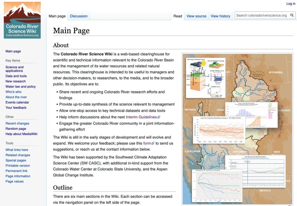
Interested in #ColoradoRiver science, data, tools, policy, events, and people ? https://coloradoriverscience.org, a new wiki is now online that addresses these topics…
Julie Vano (Aspen Global Change Institute), Jeff Lukas (Lukas Climate Consulting), Tanya Petach (Aspen Global Change Institute) and I worked on this. Hat Tip to Jonathan Overpeck (University of Michigan). @GreatLakesPeck for the original idea…
It is a wiki, so is incomplete. But we plan to continue to update and improve. Feedback here: https://coloradoriverscience.org/Feedback…
Many, many thanks to our funders. Without them, this effort would not have occurred. /end USGS Southwest Climate Adaptation Science Center
@southwest_casc Colorado Water Center, CSU
@COWaterCenter Aspen Global Change Institute

Click the link to read the article on the InkStain website (Eric Kuhn and John Fleck):
Colorado River Commission Chairman Herbert Hoover gathered the seven states’ representatives at opened at 11:00 a.m. Nov. 15, 1922, for the 17th meeting in their efforts to forge an agreement to share the Colorado River.
They had been holed up at Bishop’s Lodge outside Santa Fe for five days, wrestling with how to divide the river. By that point in the negotiations they had settled on a general framework, dividing the river into an “upper” and “lower” basin, but were stuck on the question of how much water the upper states would be required to send each year to the lower states.
Hoover intentionally set a later starting time that day to give the upper river states plenty of time to caucus among themselves to consider his proposal from the previous day that the Upper Basin deliver 82 million acre-feet every ten years plus a 4 and ½ million acre foot minimum annual flow.
QUIBBLING OVER THE SIZE OF THE UPPER BASIN’S OBLIGATION
New Mexico’s Steven B. Davis answered on behalf on the four upper states. His bottom line was that delivering 82 million put too much of the drought risk on the Upper Basin. He countered with a proposal to “guarantee” a flow of 65 million acre-feet every ten years. Davis noted that if the lower river would accept the 65 million, the upper states would negotiate an annual minimum flow.
Davis was likely chosen to be their spokesman to show that the upper river commissioners were united on this issue and their offer was not just Delph Carpenter’s, the Colorado representative who so far had monopolized the discussions. New Mexico’s Davis went on to explain that the lowest ten-year flow at Lee’s Ferry was 155 million acre-feet, thus 82 million was more than 50% of the lowest ten-year period, which Davis put at 77 million. He acknowledged that 65 million was less than a 50-50 equal divide noting since they only had a short 20-year record, they had no idea how low future drought might go, thus even guaranteeing 65 million was risky.

Carpenter supplemented Davis by explained that moving the dividing point from Yuma to Lee’s Ferry effectively gave the lower river “all the flow of the lower streams to the territory in which they arrive.” He argued that a ten-year flow of 65 million at Lee’s Ferry plus the Lower Basin’s tributaries would be the equivalent of a fifty-fifty split. Nevada’s Scrugham added “Mr. Chairman, I suggest that we abandon the discussion of that six million five hundred-thousand-acre feet per annum which would be out of the question for the lower states to accept. We are so far apart it does not seem that we will get anywhere if this figure is not changed.” Steven Davis responded, “This is not a division, we are not dividing the waters, we are guaranteeing water.”
ARIZONA: ALLOCATION SHOULD BE BASED ON THE NEEDS OF EACH BASIN, NOT AN EVEN SPLIT
Arizona’s Winfried Norviel simply reiterated his position that an equitable division should be based on the needs of each basin, not an arbitrary fifty-fifty split. He went on to say that the lower basin would accept 82 million plus a 4.5 million minimum annual flow as the basis for a compact, adding that he would accept a four million acre-feet minimum if the upper river changed its ten-year flow to a five-year flow (presumably 41 million every five years). The discussion dragged on with little give on either side. Finally, Hoover stated, “The business of the chairman is to find a medial ground. So, I am wondering if the northern states will make it seven million five hundred thousand?” Hoover suggested a ten-year delivery at Lee’s ferry of 75 million acre-feet with a 4 million acre foot annual minimum.

Before they broke for further caucusing, Wyoming’s Emerson asked about addressing the needs of Mexico. Norviel responded – “I don’t think we need to take that into consideration.” To which Carpenter countered “By eliminating the Gila and the Little Colorado and other streams, the factor of risk lies in the allocation of the Mexican Burden. We are willing to bear our share of the Mexican burden, but the sacrifice should be mutual.” Norviel added one more compact option. He suggested the river be spilt on a equal basis at Lee’s Ferry on an annual basis based a reconstructed (AKA “natural” or “virgin” flow) river. Caldwell immediately responded that determining the river’s reconstructed flow annually would be “very difficult, impossible, practically.”
Hoover quickly adjourned the meeting so each basin could caucus. He knew that he had some challenging shuttle diplomacy ahead before they would meet again tomorrow morning.
Authors’ Note – One hundred years ago the commissioners were concerned with guaranteeing a flow based on incomplete data. We imagine that if the negotiation were being held today, the conversations would be very similar, but the risks would be due to climate change.
