Click on a thumbnail graphic to view a gallery of drought data from the US Drought Monitor website.

Click the link to go to the US Drought Monitor website. Here’s an excerpt:
This Week’s Drought Summary
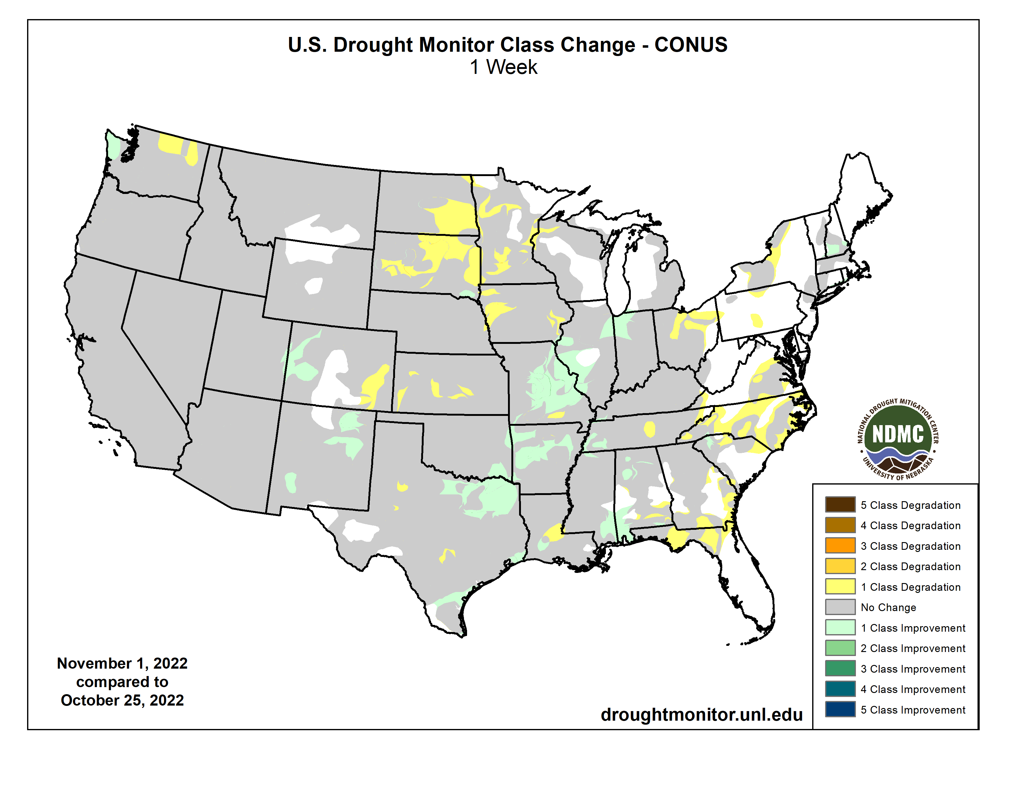
An active weather pattern over the Midwest to southern Plains brought the most precipitation to those areas this week. Warm and dry conditions dominated the northern Plains and the upper Midwest where some areas are experiencing “flash drought” conditions that are not as common this time of year. Dryness over the Southeast is starting to impact more of the region while an active pattern has started over portions of the Pacific Northwest, bringing some moisture over the western portions of the region. Temperatures were coolest over the West and southern Plains and warmest over the northern Plains and into New England…
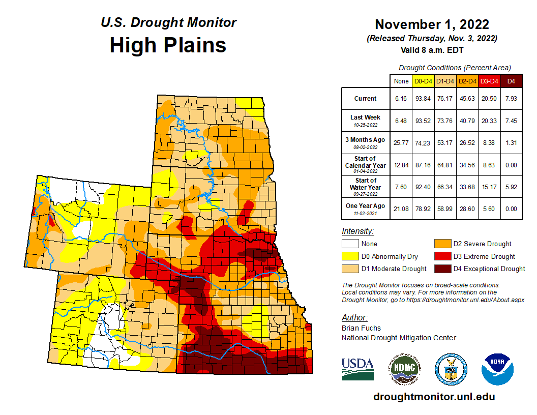
Temperatures were well above normal over the northern and eastern portion of the High Plains and below normal in the west. Temperatures were 8-10 degrees above normal in the Dakotas and 2-4 degrees above normal in Nebraska and northern Kansas. Portions of Wyoming, Colorado and western Nebraska were cooler than normal with temperatures 2-4 degrees below normal. It was quite the dry week in the region as there were only a few pockets of rain in southeast South Dakota, northeast Nebraska and into north-central Kansas. Flash drought conditions are impacting the region, especially in the Dakotas where warm, dry and windy conditions have provide ideal harvest conditions but have started taking a toll on the region. In the Dakotas, a broad expansion of severe drought conditions took place this week. Moderate drought also expanded in eastern South Dakota and into southern portions of the state. Continued dryness over Kansas, where portions of southwest Kansas had their driest October on record, allowed for the expansion of extreme and exceptional drought this week. On the plains of Colorado, moderate drought and abnormally dry conditions continue to expand…
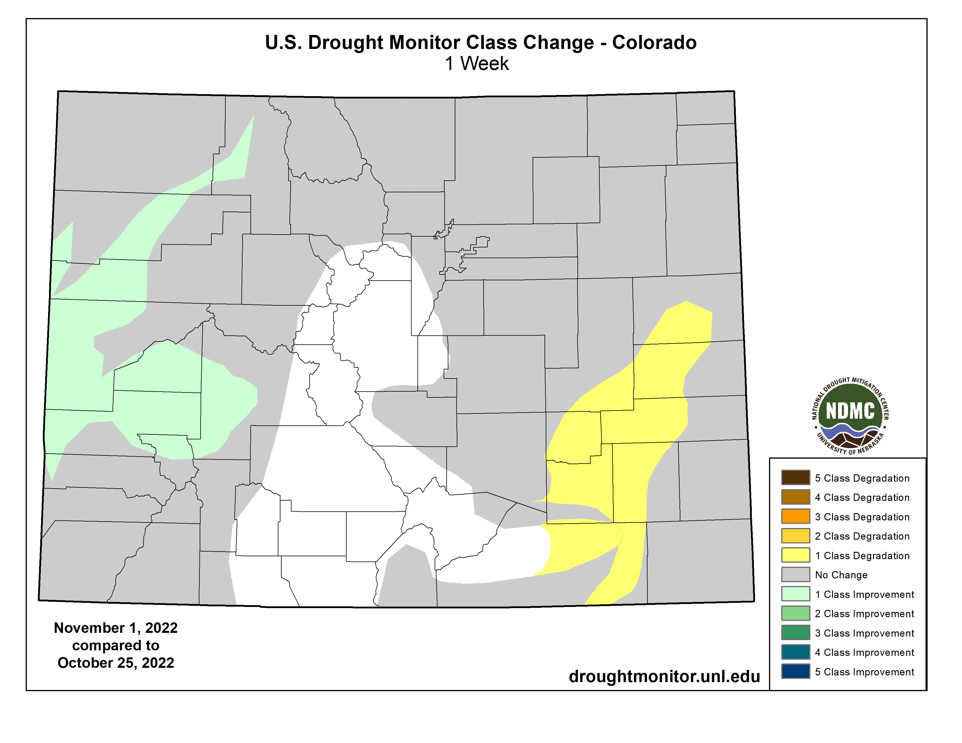
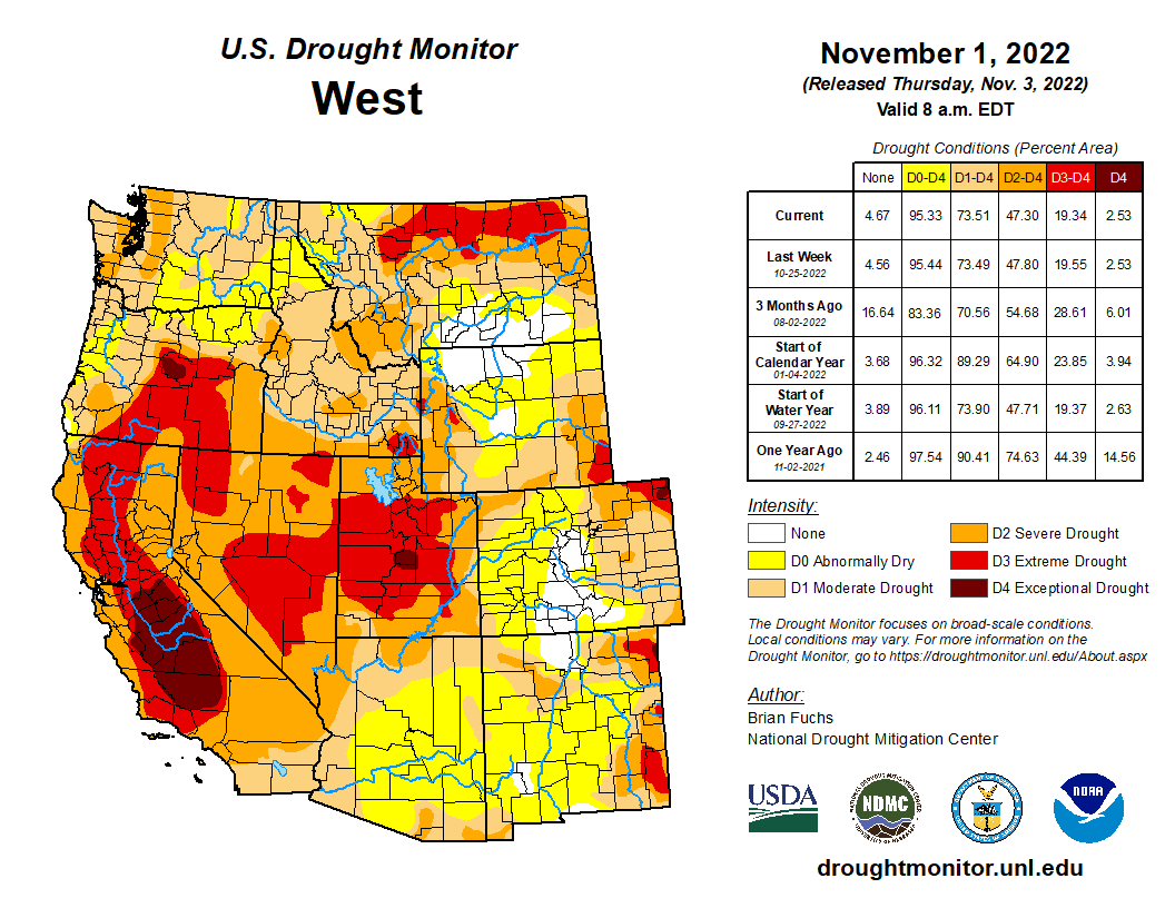
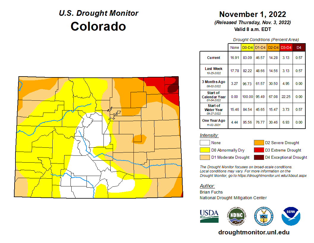
Temperatures for the week were cooler than normal over most of the region, with departures of 4-6 degrees below normal over the southwest. Warmer than normal conditions were recorded in the Pacific Northwest as well as across the northern portion of the region where temperatures were 4-6 degrees above normal with some even greater departures in Montana. Wetter than normal conditions were recorded in the Pacific Northwest as well as in western Colorado, northern Oregon, and into northern Idaho. The continued wet pattern allowed for some improvements in northeast New Mexico to the moderate, severe, and extreme drought conditions even as long-term issues remain. Western Colorado had improvements to moderate and severe drought as the ongoing wet pattern and early snows have allowed for improvements. Washington received enough rain to start showing improvements to the moderate and severe drought in the west while northern portions of the state had moderate drought expand…
Welcome rains over north and south Texas, Arkansas, northern Louisiana and into southern Oklahoma helped to build on recent precipitation events in some of these areas. Portions of north Texas and into southern Arkansas and northern Louisiana recorded 200-400% of normal precipitation for the week. Southern Louisiana as well as west Texas and the Oklahoma panhandle remained dry. Cooler than normal temperatures through much of Texas and Oklahoma as well as western Arkansas and Louisiana helped to slow down further drought development for this week and even allowed for some improvements. A full category improvement to drought levels was made over northern Texas and into southeast Oklahoma. In Arkansas, extreme and severe drought were improved. Extreme drought was removed from Tennessee this week with improvements in the western portion of the state while abnormally dry conditions expanded in the central and northeast portion of the state. Louisiana had some adjustments to the severe drought in the south as the western portion improved but the area expanded to the east. Additional improvements were made to moderate and severe drought in east Texas and to abnormally dry conditions in south Texas…
Looking Ahead
Over the next 5-7 days, it is anticipated that the Pacific Northwest will remain in an active pattern, with greatest precipitation anticipated along the coast. The Rocky Mountains also look to stay in an active pattern, with up to an inch of precipitation anticipated over much of western Colorado and Wyoming as well as into Utah. A large frontal system is anticipated over much of the Midwest, with areas of the upper Midwest expected to receive over 1.50 inches of rain. The wet pattern over the South will continue as well with much of the lower Mississippi basin anticipating rainfall of over 1 inch. Temperatures during this period show much of the eastern U.S. having above-normal temperatures, with the greatest anomalies over the Great Lakes where high temperatures could be 15-18 degrees above normal. Cooler than normal temperatures are anticipated over the West with departures of 6-9 degrees below normal over California to Arizona.
The 6-10 day outlooks show that temperatures are anticipated to be warmer than normal over the eastern half of the U.S. with the greatest chances over the East coast and into the Mid-Atlantic. Cooler than normal temperatures are anticipated over much of the West with the best chances of below normal temperatures over the northern Rocky Mountains and into the Great Basin. The likelihood of drier than normal conditions are greatest over the Midwest into the lower Mississippi valley. The best chances for wetter than normal conditions are over the southeast coastal areas, the northern Plains, upper Midwest and into the Great Basin and California.
Just for grins here’s a gallery of US Drought Monitor maps for early November for the past few years.

US Drought Monitor map November 1, 2022. 
US Drought Monitor map November 2, 2021. 
US Drought Monitor November 3, 2020. 
US Drought Monitor November 5, 2019. 
US Drought Monitor November 6, 2018. 
US Drought Monitor November 7, 2017. 
US Drought Monitor November 1, 2016. 
US Drought Monitor November 3, 2015 
US Drought Monitor November 4, 2014 
US Drought Monitor November 5, 2013 
US Drought Monitor November 5, 2012 
US Drought Monitor November 1, 2011 
US Drought Monitor November 2, 2010