#Drought news (November 10, 2022): W. #Kansas, E. #Colorado and E. #Wyoming had expansions of severe, extreme and exceptional drought conditions, severe drought was improved in portions of W. Colorado #CRWUA2022

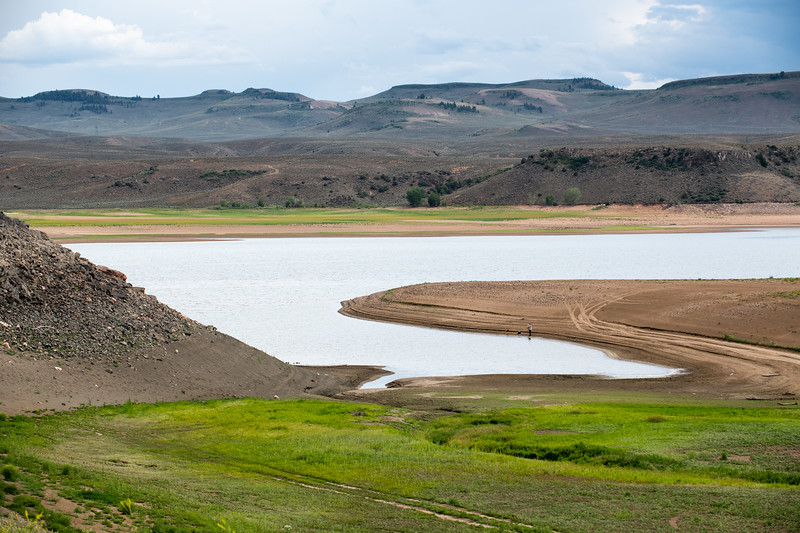
Click on a thumbnail graphic to view a gallery of drought data from the US Drought Monitor website.

Click the link to go to the US Drought Monitor website. Here’s an excerpt:

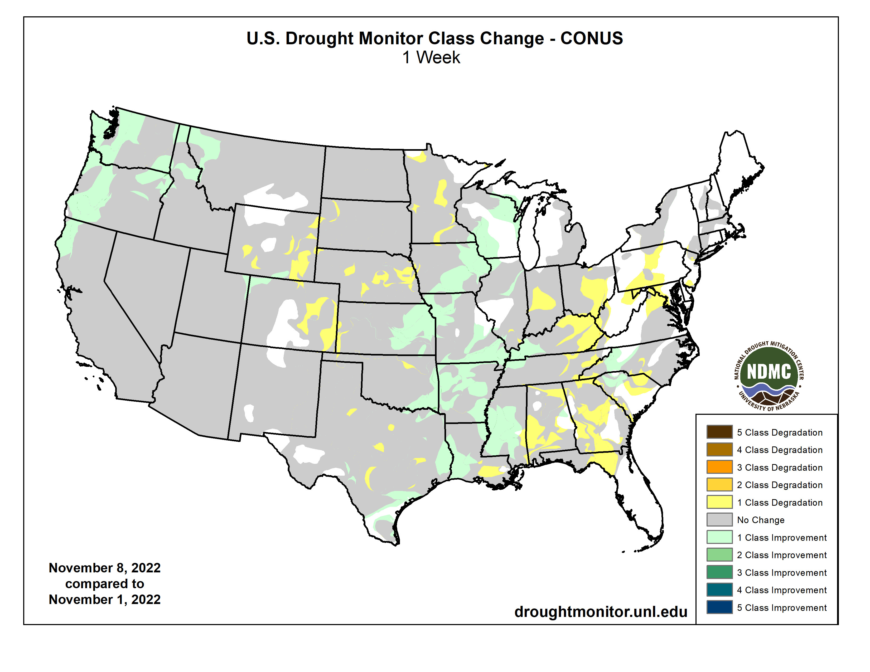
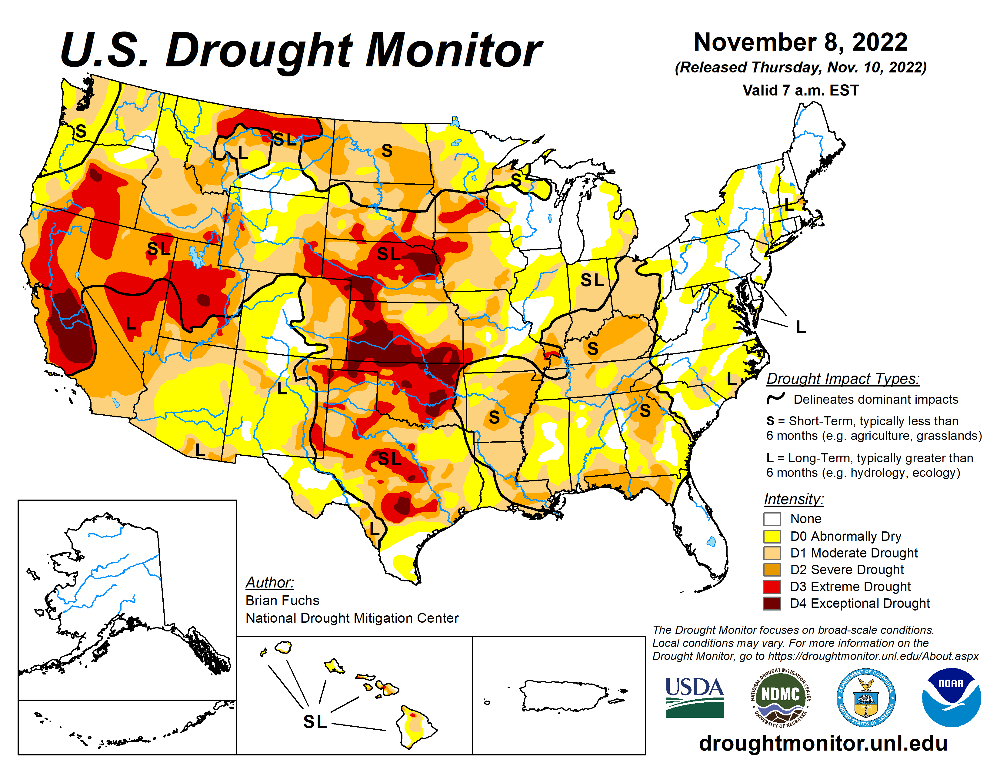
This Week’s Drought Summary

This week continued with another active weather pattern over portions of the Pacific Northwest as well as into the central Plains and Midwest. With widespread heavy rain from Kansas into Wisconsin as well as portions of the lower Mississippi River valley, some areas recorded significant precipitation during the period. Temperatures over the eastern half of the country were above normal, some significantly, while most of the West was cooler than normal. A continued wet pattern over the Pacific Northwest as well as portions of the Midwest has allowed for continued improvement to drought intensities, especially in areas that are receiving abundant precipitation. Dryness continues to build over eastern portions of the Midwest and into the Southeast as well as along the Gulf Coast…

High Plains

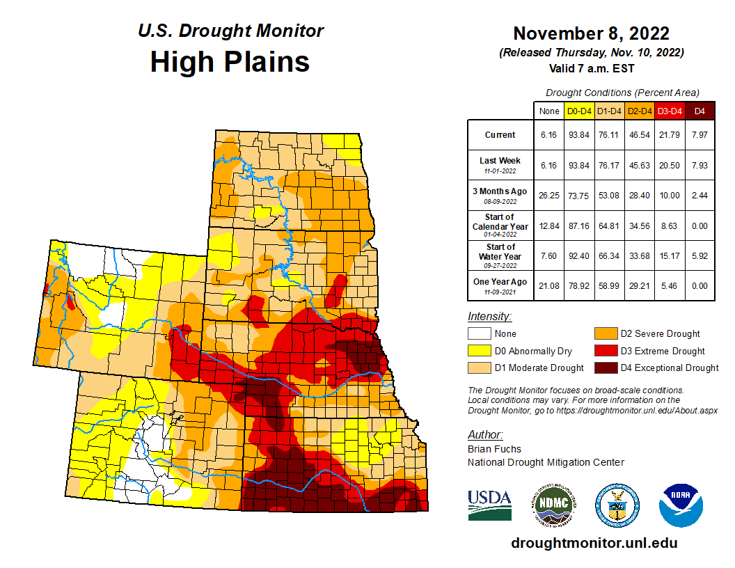
Much of the High Plains remained dry this week with only portions of southeast Nebraska and eastern Kansas recording above-normal precipitation. Temperatures were mostly above normal for the area, but western portions were normal to slightly below this week, with the warmest temperatures over eastern Kansas where departures were 6-9 degrees above normal. With the continued dryness, most of the changes were worsening drought intensities. As the autumn remained dry over much of Nebraska, expansions were made to extreme and exceptional drought in the northeast and western parts of the state. Western Kansas, eastern Colorado and eastern Wyoming also had expansions of severe, extreme and exceptional drought conditions. Much of eastern and central Kansas saw improvement from several inches of rain, which lead to the reduction of all drought intensities (including the extreme and exceptional areas in the southern portion of the state) and the removal of extreme drought in the northeast…

Colorado Drought Monitor one week change map ending November 10, 2022.

West

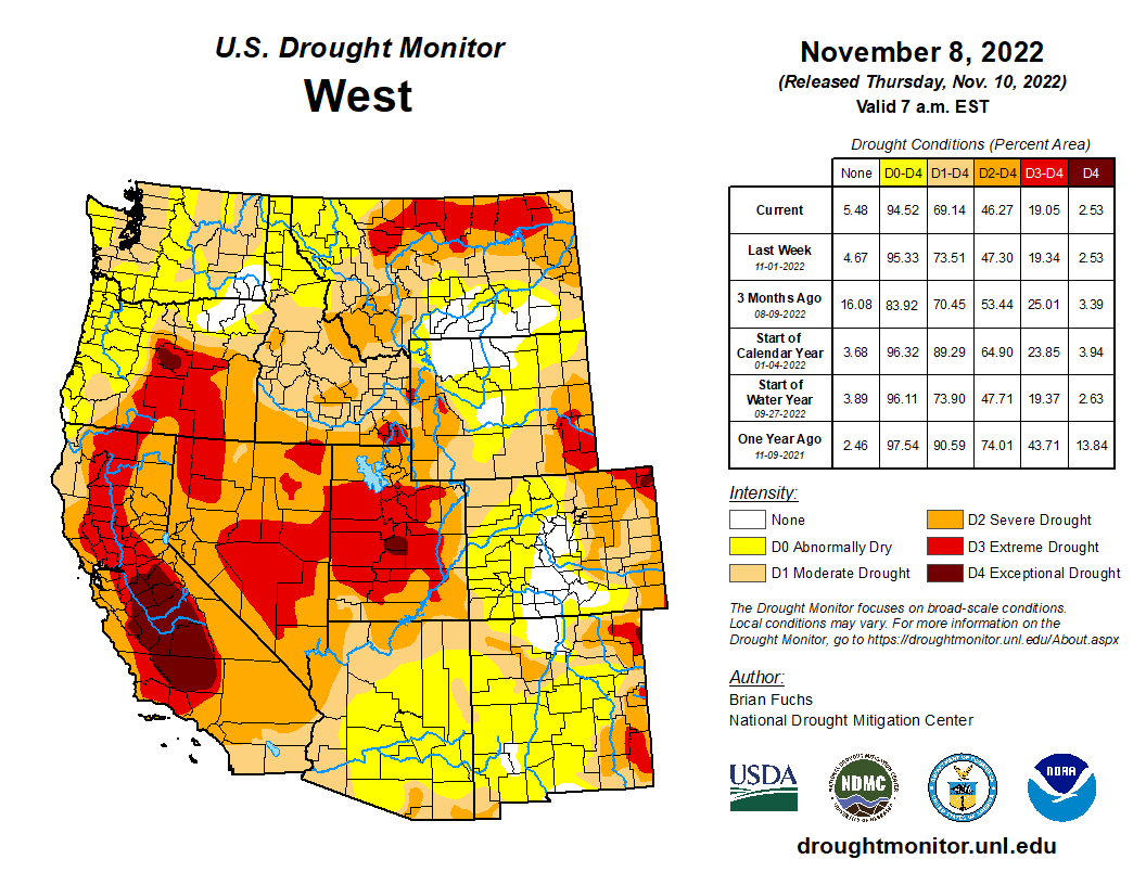
A wet week for much of the West helped to put a boost into the start of the current water year after a slow start. Continued wetness over the Pacific Northwest and into portions of the northern Rocky Mountains helped with long-term drought issues. Temperatures were cooler than normal for most of the region with some areas of Oregon and California 8-10 degrees below normal for the week. Improvements were made this week along the coastal regions of Oregon, Washington and northern California where moderate and severe drought were reduced. Areas of western Montana and northern Idaho also had drought intensities reduced with the recent wet pattern. Portions of western Wyoming saw expansion of moderate and severe drought while severe drought was improved in portions of western Colorado and northeast Utah…

South

Temperatures over the region were well above normal, with departures of 6-9 degrees above normal during the week. Only areas of the panhandles of Texas and Oklahoma were near normal. The wettest areas of the region were in eastern Oklahoma, northeast and south Texas, Arkansas and Louisiana, where some areas recorded over 200% of normal rain this week. Much of central and west Texas and central Oklahoma missed out on any rains this week. A full category improvement to the drought intensities was made over much of Arkansas, western Louisiana, and eastern Texas. Severe drought was expanded over portions of southern Louisiana where much of the recent rain has missed. Drought intensities were expanded slightly in northeast Oklahoma and central portions of Texas due to a mixture of short- and long-term drought issues…

Looking Ahead

Over the next 5-7 days, it is anticipated that the impact of tropical storm Nicole over the east coast will be significant, bringing a great deal of precipitation from Florida to Maine during the next several days. A winter storm is impacting the northern Plains into the upper Midwest, bringing with it some significant snow while a frontal passage over the Plains will allow for some precipitation from Nebraska south into the lower Mississippi valley. Temperatures during this period look to be well below normal, with portions of the northern Plains 20-24 degrees below normal during this time. Warmer-than-normal temperatures will impact the Northeast and Mid-Atlantic, with temperatures 6-9 degrees above normal.

The 6–10 day outlooks show that temperatures are expected to be well below normal over most of the country, with areas of the Plains having the highest likelihood of recording below-normal temperatures. In contrast, Alaska is anticipating warmer-than-normal temperatures during this time. The greatest chance of above-normal precipitation is over the Southeast as well as through the Rocky Mountains while much of the central Plains and Midwest as well as the West have the greatest chances of having below-normal precipitation.

US Drought Monitor one week change map ending November 10, 2022.

Governor Polis seeks $1.9 million to revamp #ColoradoRiver crisis team — @WaterEdCO #COriver #aridification #CRWUA2022

Blue Mesa Reservoir is the largest storage facility in Colorado in the Upper Colorado River system. Prolonged drought and downriver demand is shrinking the reservoir. Credit: Tom Wood, Water Desk

Click the link to read the article on the Water Education Colorado website (Jerd Smith):

Under pressure to protect the state’s dwindling supply of Colorado River water from other states with more political clout, Colorado is reshuffling its river leadership team and asking state lawmakers to approve $1.9 million in funding for a new policy and technology task force on river issues.

The changes include shifting Rebecca Mitchell from her role as director of the Colorado Water Conservation Board (CWCB), and transferring her into the executive office at the Colorado Department of Natural Resources. There she will focus on her work as Colorado’s commissioner on the Upper Colorado River Commission, according to a letter from Dan Gibbs, executive director of the Colorado Department of Natural Resources (DNR).

Gov. Polis’ proposal, contingent on lawmakers’ approval, also calls for adding more than a dozen new positions to the CWCB and DNR and adding another $5 million to fund state water plan grants. If approved the changes would take affect July 1 when the new state budget takes effect, according to Chris Arend, DNR spokesman.

Mitchell and Gibbs declined interview requests. Mitchell was appointed to the Upper Colorado River Commission (UCRC) by Polis in 2019 and has maintained a dual role as CWCB director and commissioner on the UCRC.

In an emailed statement, DNR’s Arend said the changes are critical to ensuring the state can adequately protect its share of the drought-stressed Colorado River.

“The Colorado River system is facing many challenges due to a dwindling water supply, which are amplified by one of the worst droughts in recorded history,” Arend said. “These issues are exacerbated by increasing tension in interstate negotiations that are contributing to unprecedented pressure on Colorado’s water supplies.”

Lee Miller, a water attorney who represents the Pueblo-based Southeastern Colorado Water Conservancy District and who has been part of a group of experts advising Mitchell on Colorado River issues, said there needs to be clarity around who reports to whom and what the relationship between the Colorado Water Conservation Board and the new policy and technology team will look like. When a replacement for Mitchell would be named is unclear.

“It’s important that everyone know that we have a consistent leadership voice,” Miller said. “So if staff is responding to two different leaders or if we are not completely organized, that initially is going to be problematic.

“I’m not suggesting it’s going to be a problem. I just don’t know. We can’t afford to have organizational confusion because we really are getting down to the important stages of the negotiations,” he said.

The Colorado River Basin spans seven states, with Colorado, New Mexico, Utah and Wyoming comprising the Upper Basin, and Arizona, California and Nevada making up the Lower Basin.

Graphic credit: Chas Chamberlin

Now 22 years into a megadrought widely believed to be the worst in 1,200 years, the highly developed river system is on the brink of collapse, with lakes Powell and Mead falling dangerously close to dead pool, a water level so low that, if it is reached, Powell won’t be able to produce hydropower and Mead won’t be able to serve the millions of people in the Lower Basin who rely on the river.

The river begins in Colorado’s Never Summer Mountains, high in Rocky Mountain National Park. It gathers water from major tributaries in Colorado, such as the Yampa and Gunnison rivers, and throughout the Upper Basin, accumulating some 90% of the streamflow that it will provide throughout the seven-state river system thanks to the runoff from the Upper Basin’s deep mountain snows.

But since 2002, those mountain snowpacks have been shrinking, crushed by warming temperatures and fewer snow days.

Beginning in July of 2021, and again this year, the U.S. Department of the Interior ordered, for the first time, emergency releases from Utah’s Flaming Gorge, Colorado’s Blue Mesa and New Mexico’s Navajo reservoirs. But that has done little to restore levels, although the releases are credited with providing some protection to the power supply.

With the crisis deepening, in June U.S. Bureau of Reclamation Commissioner Camille Touton ordered the seven states to find ways to cut water use by 2 million to 4 million acre-feet of water by 2023.

While Lower Basin states have been forced to begin cutting back water use under a special set of operating guidelines and drought plans approved respectively in 2007 and 2019, negotiations in recent months have failed to achieve the federally ordered cutbacks.

At the same time, the drought has continued, and this winter is forecast to be dry once again. In response, last week, the federal government announced it would expedite negotiations on a new set of operating guidelines designed to protect lakes Powell and Mead to help restore the river.

Under the terms of the Colorado River Compact of 1922, the river’s supplies are divided equally between the Upper and Lower basins. But because the Upper Basin states have smaller and fewer reservoirs than the Lower Basin, users here have had to cut back their water use as the drought has continued. At the same time, Lower Basin users have been able to rely on stored supplies in Powell and Mead, at least until now.

The crisis has left Colorado water users nervous that the state hasn’t moved quickly enough to protect itself from potential new demands for more water from the Lower Basin states.

Larry Clever manages the Ute Water Conservancy District, which serves Grand Junction, among others, and which has fairly senior rights to Colorado River water.

He has been concerned about what he describes as the state’s failure to be more aggressive in demanding changes in the Lower Basin, including major cutbacks in water use. He said the state’s new approach could be a good thing.

“We’ve got to get our butts in gear and do something,” Clever said. “Will this result in that? I hope so. In my opinion, we’re in trouble.

Update: This story has been edited to clarify that the proposed changes in the Colorado River team must be approved by lawmakers and would take effect July 1, 2023 and that the timing for hiring a new director at the CWCB to replace Mitchell is unclear.

Jerd Smith is editor of Fresh Water News. She can be reached at 720-398-6474, via email at jerd@wateredco.org or @jerd_smith.

Colorado River “Beginnings”. Photo: Brent Gardner-Smith/Aspen Journalism

Ice loss from Northeastern Greenland significantly underestimated — Denmark Technical University #ActOnClimate #KeepItInTheGround

Lake and river on the Zachariae Glacier, northeast Greenland. Photo: Shfaqat Abbas Khan, DTU Space.

Click the link to read the release on the Denmark Technical University website (Tore Vind Jensen):

Ice is continuously streaming off Greenland’s melting glaciers at an accelerating rate, dramatically increasing global sea levels. New results published 9 November in Nature indicate that existing models have underestimated how much ice will be lost during the 21st century. Hence, its contribution to sea-level rise will be significantly higher.

By 2100, the Northeast Greenland Ice Stream will contribute six times as much to the rising sea level as previous models suggested, adding between 13,5 to 15,5 mm, according to the new study. This is equivalent to the entire Greenland ice sheet’s contribution in the past 50 years. The research was carried out by researchers from Denmark, the United States, France, and Germany.

“Our previous projections of ice loss in Greenland until 2100 are vastly underestimated,” said first author Shfaqat Abbas Khan, Professor at DTU Space.

“Models are mainly tuned to observations at the front of the ice sheet, which is easily accessible, and where, visibly, a lot is happening.”

Lake and river on the Zachariae Glacier, northeast Greenland. Photo: Shfaqat Abbas Khan, DTU Space. 4

Ice loss occurs more than 200 km inland

The study is partly based on data collected from a network of precise GPS stations reaching as far as 200 km inland on the Northeast Greenland Ice Stream—located behind the Nioghalvfjerdsfjord Gletscher and Zachariae Isstrøm glaciers, one of Earth’s most hostile and remote terrains. The GPS data were combined with surface-elevation data from the CryoSat-2 satellite mission and high-resolution numerical modelling.

“Our data show us that what we see happening at the front reaches far back into the heart of the ice sheet,” said Shfaqat Abbas Khan. 

“We can see that the entire basin is thinning, and the surface speed is accelerating. Every year the glaciers we’ve studied have retreated further inland, and we predict that this will continue over the coming decades and centuries. Under present day climate forcing, it is difficult to conceive how this retreat could stop.” [ed. emphasis mine]

Significant contribution to rising sea levels

In 2012, after decade of melting, the floating extensions of Zachariae Isstrøm collapsed, and the glacier has since retreated inland at an accelerating pace. And though winter 2021 and summer 2022 have been particularly cold, the glaciers keep retreating. Since northeastern Greenland is a so-called Arctic desert – precipitation is as low as 25 mm per year in places – the ice sheet is not regenerating enough to mitigate the melt. However, estimating how much ice is lost and how far into the ice sheet the process occurs is not easy. The ice sheet’s interior, which moves at less than one meter per year, is difficult to monitor, which limits the ability to make accurate projections.

“It is truly amazing that we are able to detect a subtle speed change from high-precision GPS data, which ultimately, when combined with a model of ice flow, inform us on how the glacier slides on its bed,” said coauthor Mathieu Morlighem, a professor of earth sciences at Dartmouth College.

“It is possible that what we find in northeast Greenland may be happening in other sectors of the ice sheet. Many glaciers have been accelerating and thinning near the margin in recent decades. GPS data helps us detect how far this acceleration propagates inland, potentially 200-300 km from the coast. If this is correct, the contribution from ice dynamics to the overall mass loss of Greenland will be larger than what current models suggest.”

The Zachariae Isstrøm was stable until 2004, followed by steadily retreat of the ice front until 2012, when a large portion of the floating sections became disconnected. As more precise observations of change in ice velocity are included in models, it is likely that IPCC’s estimates of 22-98 cm global sea level rise will need to be corrected upwards.

“We foresee profound changes in global sea levels, more than currently projected by existing models,” said coauthor Eric Rignot, professor of Earth system science at the University of California, Irvine.


“Data collected in the vast interior of ice sheets, such as those described herein, help us better represent the physical processes included in numerical models and in turn provide more realistic projections of global sea-level rise.”

Iceberg at the front of Zachariae Glacier, northeast Greenland. Photo: Nicolaj K Larsen, Globe Institute, Denmark.

About the study

The study is supported by the Carlsberg Foundation and the Ministry of Climate, Energy and Supply (Climate support for the Arctic).

See the scientific article ‘Extensive inland thinning and speed-up of North-East Greenland Ice Stream‘.