


Click the link to read the article on The Guardian website (Damian Carrington). Here’s an excerpt:
The climate crisis has reached a “really bleak moment”, one of the world’s leading climate scientists has said, after a slew of major reports laid bare how close the planet is to catastrophe. Collective action is needed by the world’s nations more now than at any point since the second world war to avoid climate tipping points, Prof Johan Rockström said, but geopolitical tensions are at a high. He said the world was coming “very, very close to irreversible changes … time is really running out very, very fast”. Emissions must fall by about half by 2030 to meet the internationally agreed target of 1.5C of heating but are still rising, the reports showed – at a time when oil giants are making astronomical amounts of money.
All three of the key UN agencies have produced damning reports in the last two days. The UN environment agency’s report found there was “no credible pathway to 1.5C in place” and that “woefully inadequate” progress on cutting carbon emissions means the only way to limit the worst impacts of the climate crisis is a “rapid transformation of societies”. Current pledges for action by 2030, even if delivered in full, would mean a rise in global heating of about 2.5C, a level that would condemn the world to catastrophic climate breakdown, according to the UN’s climate agency. Only a handful of countries have ramped up their plans in the last year, despite having promised to do so at the Cop26 UN climate summit in Glasgow last November. The UN’s meteorological agency reported that all the main heating gases hit record highs in 2021, with an alarming surge in emissions of methane, a potent greenhouse gas. Separately, the IEA’s world energy report offered a glimmer of progress, that CO2 from fossil fuels could peak by 2025 as high energy prices push nations towards clean energy, though it warned that it would not be enough to avoid severe climate impacts.
Rockström, director of the Potsdam Institute for Climate Impact Research in Germany, said: “It’s a really bleak moment, not only because of the reports showing that emissions are still rising, so we’re not delivering on either the Paris or Glasgow climate agreements, but we also have so much scientific evidence that we are very, very close to irreversible changes – we’re coming closer to tipping points.”


Click the link to read the article on the Water Education Foundation website (Nick Cahill):
The foundation of California’s water supply and the catalyst for the state’s 20th century population and economic growth is cracking. More exactly, it’s disappearing.
Climate change is eroding the mountain snowpack that has traditionally melted in the spring and summer to fill rivers and reservoirs across the West. Now, less precipitation is falling as snow in parts of major mountain ranges like California’s Sierra Nevada and the Rockies in the West, and the snow that does land is melting faster and earlier due to warming temperatures.
Scientists warn the shift to more rain and less snow will become more pronounced due to climate change, presenting a particular challenge to California, which gets approximately a third of its water used by humans from Sierra Nevada snowmelt. The problem is so severe California officials expect the state could lose 10 percent of its water supply by 2040, largely due to reduced mountain snowpacks.
Hoping to get ahead of that dismal forecast, managers of a major Sierra Nevada watershed east of Sacramento are replumbing their water systems to better handle bursts of rain instead of trickling snowmelt. Their “Supershed Approach” to replace the loss of the once-reliable snowmelt calls for climate adaptation projects that stretch from the headwaters of the American River west of Lake Tahoe, to the foothills and down to the valley floor in Sacramento.
Prescribed burns, high-elevation reservoirs, updated reservoir-operation strategies and enhanced aquifer recharge are key pieces of the fledgling portfolio that state officials and water experts cast as a holistic approach to planning for climate change. The top-to-bottom management strategy could stand up as a model for other watersheds that are expected to experience stronger, more frequent snow droughts.
“We can’t think like we used to, the systems are no longer the same,” said Rosemary Carroll, research professor of hydrology at the Desert Research Institute who studies snow-fed watersheds in both the Sierra Nevada and Colorado River Basin. “Using old tools is no longer a viable option both environmentally and economically. We’ve got to think a little bit outside the box.”
Snowmelt Is Key
The Sierra Nevada, Spanish for “snowy mountain range”, naturally functions as California’s largest reservoir, storing snow that ideally melts slowly over the spring and summer months and is captured by approximately 200 downstream reservoirs. The amount of snow that falls in the mountains and lasts through the late winter and into early spring is a determining factor in how much surface water will be allocated to California’s cities and businesses — including its $51 billion agricultural industry — and whether restrictions are imposed on water users.
But in recent decades, the snowpack that recharges critical reservoirs like Lake Oroville, New Melones Lake and Folsom Lake, has become less reliable. The key factors affecting the size of snowpack — temperature and precipitation – have been trending in the wrong direction across the West. In the American River Basin alone, air temperatures are projected to increase steadily and cause earlier peak runoff periods.

California saw a glimpse of what a snowless future looks like in 2015 when the Sierra Nevada snowpack was measured at just 5 percent of its historical average. According to the U.S. Geological Survey, the dearth of snow led to a reservoir replenishment rate that was only about 9 percent of normal and resulted in statewide urban water use restrictions.
Relying on healthy spring blankets of snow draped across the Sierra Nevada’s granite peaks will become an ancient luxury for water managers: By the late 2040s, researchers at Lawrence Berkeley National Laboratory predict the mountain range could experience multi-year snow droughts. A warmer climate also will lead to a higher percentage of mountain runoff being absorbed by dry soils and thirsty plants or lost through evaporation.
“The whole system is just releasing less water,” said Carroll, the hydrologist at the Reno-based Desert Research Institute. “More snow is going directly back into the atmosphere; it’s not going back into the rivers.”
Not only are snowless winters predicted for the Sierra Nevada, the mountains that sustain the Colorado River Basin are also looking at a barren future. Scientists at the National Center for Atmospheric Research warn that in some parts of the Rocky Mountains, the amount of water contained in the snowpack at the end of an average winter could shrink by nearly 80 percent toward the end of the 21st century.
Supershed Approach
Water managers have experience dealing with California’s notoriously variable weather but mitigating the major loss of snowpack is forcing them to consider ways to augment infrastructure that was designed for a different climate.
In the sprawling 2,140 square-mile American River watershed, a group of agencies is planning climate adaptation projects to protect the drinking water supplies of more than 2 million people in the Sacramento region.

“If all of our precipitation is going to come as rain instead of snow, it means that we have to find new ways to store water that will sustain our region through the summer and into the dry fall,” said Andy Fecko, general manager of the Placer County Water Agency, which operates 170 miles of canals within the watershed and supplies treated water to Auburn and Roseville in the Sacramento metropolitan area.
Fecko’s agency and an assortment of others that rely on the American River have developed a “Supershed Approach” to buffering the loss of snowmelt. The portfolio outlines forest management projects near the river’s headwaters, a high-elevation reservoir to better capture rain, flood control enhancements and a regional groundwater bank located at the confluence of the Sacramento and American Rivers that’s designed to store up to 90,000 acre-feet of water during a wet year.
The consortium of Sacramento-area water agencies, known as the Regional Water Authority, argue the projects are even more imperative in light of a recent study by the U.S. Bureau of Reclamation that found winter temperatures in the American River watershed could spike nearly 5 degrees by the end of the century. The study also estimated that the region will have to increase groundwater pumping by up to 155,000 acre-feet a year to account for the loss of snowmelt and runoff.
“Water management in the basin is expected to be more challenging in the future due to climate pressures that include warming temperatures, shrinking snowpack, shorter and more intense wet seasons and rising sea levels,” Reclamation’s Ernest Conant, director of the agency’s California-Great Basin Region, said in a news release about the study. The federal agency operates Folsom Dam along the river as part of the Central Valley Project.

Coupled with more above- and below-ground water storage to capture rain, the portfolio aims to also improve flood control by funneling water during major storms to farmland and other high-capacity groundwater recharge areas. Fecko said there’s enough space basin-wide to bank an additional 1.5 million acre-feet, or 50 percent more than the current storage capacity of Folsom Lake, the Sacramento region’s largest reservoir.
Meanwhile on the federal side, the U.S. Army Corps of Engineers is raising Folsom Dam by 3.5 feet to increase the amount of water that can be stored during extreme weather events. The project is slated for completion in 2025 and will create an extra 42,000 acre-feet of reservoir storage.
In addition, Reclamation is expanding forecast-informed reservoir operations at the reservoir. Known as FIRO, it incorporates recent improvements in weather forecasting technology and is intended to give reservoir operators the ability to deviate from strict flood management guidelines when preparing for atmospheric river events. FIRO is being tested at several other California watersheds such as the Russian, Feather and Santa Ana river basins.
California’s 10% Plan
Amid the driest three-year stretch in history, California Gov. Gavin Newsom in August issued a startling announcement: the state was bracing for a potential 10 percent loss of its water supply over the next 20 years. To counteract the climate change-induced deficit, Newsom said, the state was setting a goal of creating up to 4 million acre-feet of new water storage and increasing its wastewater recycling capabilities, among a variety of other projects.

Jeanine Jones, interstate resources manager at the California Department of Water Resources, said the state’s major water infrastructure, primarily dams, are due for an update as most haven’t been invested in since they were built decades ago.
“As we look at a warming climate, not only do individual communities need to do things such as water recycling, conservation or desalination … we have to think about adapting some of our backbone infrastructure so we can take these high flows when they become available on a very intermittent basis in big storms and make better use of them,” said Jones during a recent news conference.
Newsom’s blueprint also calls for 430 new stream gauges to be deployed across the state as well as improved snowmelt forecasting to aid local water managers and reservoir operators.
“To account for climate change, we must simulate the physics of interactions among the atmosphere, water as rain or snow, and the land surface – and we need to do this for individual watersheds,” the document states.
A Holistic Blueprint
Western snowpacks, which for decades have functioned as slow-melting water savings accounts, are nearing default. American River water agencies are attempting to make up for the snow loss by renovating existing infrastructure and opening new underground storage accounts to bank future floodwater.
The top-to-bottom approach to managing the American River watershed is intended to protect the rapidly growing Sacramento region’s water supply, but the Regional Water Authority’s projects will have benefits throughout California. As the second largest tributary to the Sacramento River, most of the American River’s flows end up in the Sacramento-San Joaquin Delta system that provides drinking water to 27 million Californians and irrigates millions of acres of farmland.
Fecko, with the Placer County Water Agency, said Sacramento ratepayers can’t afford to foot the bill for the entire suite of projects, noting the regional groundwater bank alone is expected to cost roughly $300 million.
“We only use 7 percent of the [American River’s] water so it argues for, we think, outside sources of money to help us complete the [climate] adaptations,” said Fecko.
For now, the state, which has designated more than $8 billion over the last three years toward water supply projects across California, is monitoring whether the supershed approach can be adopted in other snow-fed watersheds.
“Focusing on just an individual facility is rather limiting and expanding and working with the coordination and collaboration needed to do a more holistic watershed approach does have a lot of merit,” said Mike Anderson, California State Climatologist.
“The American River is an interesting example of that process,” he continued. “And it will be very interesting to see what comes out of it as I think it could be used then as a blueprint for other watersheds to try.”
Reach Writer Nick Cahill at ncahill@watereducation.org, and Editor Doug Beeman at dbeeman@watereducation.org
Click the link to read the article on The Tri-Lakes Tribune website (Breeanna Jent). Here’s an excerpt:
Palmer Lake water customers will likely see their bills increase in the near future as the town looks to boost revenues to its self-sustaining water enterprise, which is projected to have inadequate funding in 2023. “Inadvertent” incorrect billing of 15 water accounts and the town’s failure to increase water rates by 3% annually starting in January 2020, as stipulated by a 2019 town resolution, have caused the budget shortfall, according to administrative and financial documents. Staff are now “working on the issues” and will “bring options to the (Board of Trustees) to consider,” Deputy Town Clerk Julia Stambaugh said by email this week…
Stambaugh reported in a Sept. 29 town memo the water account billing issues had been resolved. It was unclear how long the town had incorrectly billed the water accounts in question. But now, ballooning loan repayments upcoming in 2024 and the “significant rise” in the cost of materials for infrastructure mean the town’s water fund won’t have enough money in its projected 2023 budget, finance documents show.
From email from Reclamation (Erik Knight):
Releases from the Aspinall Unit will be decreased from 950 cfs to 370 cfs on Monday, October 31st. Releases are being decreased in coordination with the shutdown of the Gunnison Tunnel on Monday, October 31st.
Flows in the lower Gunnison River are currently above the baseflow target of 790 cfs. River flows are expected to remain above the baseflow target for the foreseeable future.
Pursuant to the Aspinall Unit Operations Record of Decision (ROD), the baseflow target in the lower Gunnison River, as measured at the Whitewater gage, is 790 cfs for October and November.
Currently, Gunnison Tunnel diversions are 570 cfs and flows in the Gunnison River through the Black Canyon are around 340 cfs. After this release change Gunnison Tunnel diversions will be zero and flows in the Gunnison River through the Black Canyon will still be near 340 cfs. Current flow information is obtained from provisional data that may undergo revision subsequent to review.

Click the link to read the article on the Sky-Hi News website (Andrew Miller). Here’s an excerpt:
The Grand County-based Upper Colorado River Watershed Group continues to search for landscape scale solutions to address immense environmental problems at least partially created by a combination of global climate change and increasing levels of water diversion. On Oct. 13, the group tested one possible large-scale solution to restoring the more than 300 square mile East Troublesome Fire burn scar on a small scale on the west side of the Grand Lake Golf Course.
Hydro mulch is a green-colored coating applied by fire hose-type sprayers, it’s often used on ground that has been exposed after road construction. This same technique, applied from the same air tankers and helicopters used to fight wildfires, might offer a scaled approach to restore blackened fire scars all over the West. As a test of this concept, the Upper Colorado River Watershed Group hydro mulched test plots on a burned area near the course. The group used funds from a Colorado Department of Health and Environment grant for the experimental treatment. Grand Environmental Services employee Adam Roth also helped concoct a hydro mulch mix including mycelium supplied by Boulder Mushroom. Mycelium is the below-ground “root” structure of a fungus, and it can help tie the soil together to prevent erosion. This mixture might help reduce the number of landslides which continue to bedevil the Colorado Department of Transportation, regularly closing Willow Creek Pass and Interstate 70 through the Glenwood Canyon.
Click the link to read the article on The Denver Post website (Conrad Swanson). Here’s an excerpt:
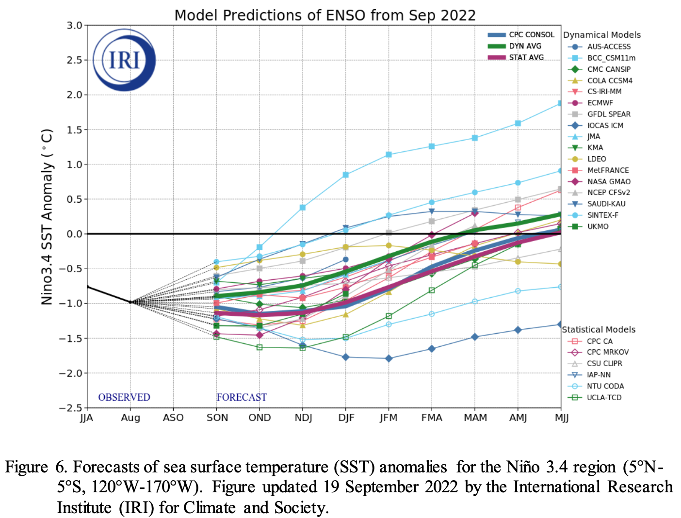
Only twice before have La Niñas struck for three straight years, according to Becky Bollinger, of the Colorado State University’s Colorado Climate Center.
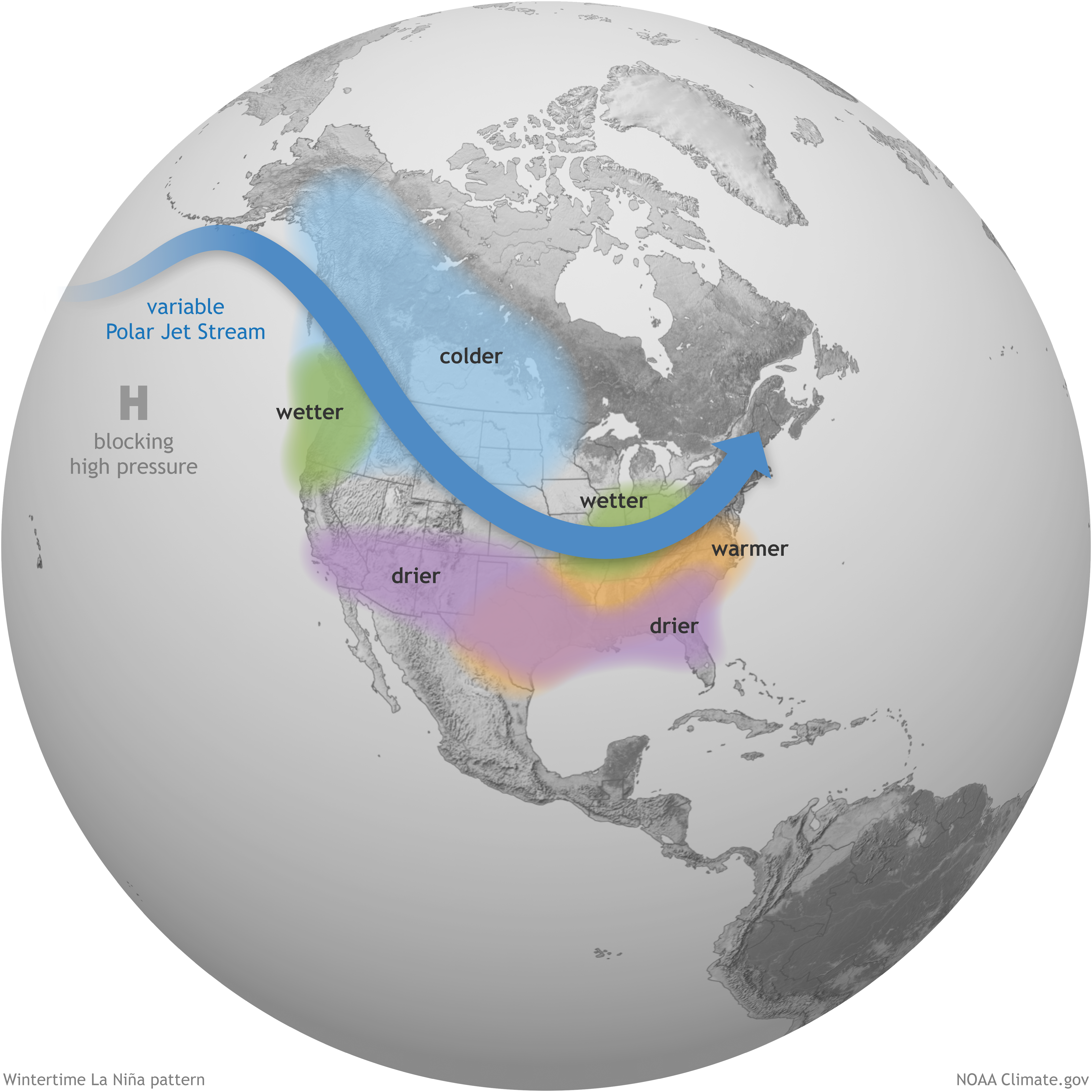
Historically speaking La Niñas split the state in half, Bollinger said. The northern portion can expect an average or above-average snowy season while the southern section will likely be warmer and drier…Think of the jetstream as a sort of “storm highway” that crosses North America from west to east, [Tom] DiLiberto said. So when cold winds push the entire highway further north, the storms that bring rain and snow move with it. Typically that means more winter rain and snow for the Pacific Northwest and the northern portions of the Rocky Mountains, DiLiberto said. The American Southwest tends to be warmer and drier for the winter.
Click the link to read the release on the Colorado Department of Agriculture website:
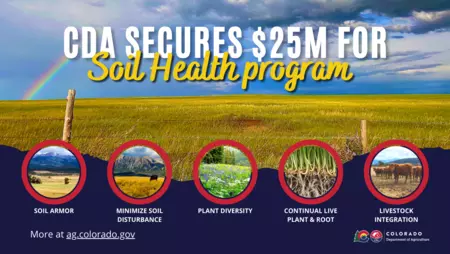
The Colorado Department of Agriculture has finalized the grant agreement to significantly invest in Colorado’s STAR program for soil health. CDA’s STAR program was one of the 70 projects selected for funding by the United States Department of Agriculture (USDA) through the Partnerships for Climate-Smart Commodities Project. This marks an historic investment in Colorado agriculture that will advance farmer- and rancher-led soil and climate solutions.
CDA will receive $25 million to more than double participation in the STAR (Saving Tomorrow’s Agricultural Resources) program across Colorado, expand research on the benefits of regenerative agriculture across eight Intermountain West states, scale the model nationwide, and continue building markets for producers deploying climate-smart agricultural practices.
This historic investment for Colorado’s farmers, ranchers, and agricultural communities means a significant influx of funds to help producers absorb the financial risks of adopting new cropping and rangeland practices that advance soil health and climate resilience. This program has always been, and will remain, completely voluntary. The funds will expand the STAR Plus program to work with Colorado’s diverse producers, from small farms to large production scale operations. In addition to expanding the capacity to offer financial and technical support to STAR participants, Colorado’s ambitious soil health pilot program will be scaled up nationwide to establish a trusted market signal that will offer producers new and diverse market opportunities that pay them for their stewardship.
“This unprecedented funding for Colorado agriculture will allow CDA and our partners to put its full force behind the soil health initiatives we’ve been piloting for the past two years,” said Colorado Commissioner of Agriculture Kate Greenberg. “This major investment from the USDA will allow us to show consumers the strides Colorado farmers and ranchers are making in deploying climate-smart agricultural practices by developing market signals that assure customers of our commitment to combating climate change. This funding will show the nation and the world that Colorado agriculture is on the leading edge of innovative production and stewardship in a changing world.”
Farmers and ranchers are experiencing first hand the impacts of climate change and healthy soils are key to mitigating these effects in agricultural landscapes. Improving soil health can increase carbon sequestration, reduce agricultural runoff, decrease erosion, and support more productive, higher-yielding crops.
The USDA and CDA have been working in partnership to advance agricultural solutions to climate change and the funding of STAR is a direct testament to that.
“This funding illustrates USDA’s commitment to natural resource conservation partnerships,” said Clint Evans, Colorado State Conservationist for USDA’s Natural Resources Conservation Service. “The STAR program leverages federal dollars, with state and local planning and action to directly benefit soil and other natural resources, as well as agricultural climate-smart efforts.”
STAR was shaped from the ground up by farmers, ranchers, conservation districts, and other partners who helped CDA tailor it to work for different crops, range, and different ways of farming and ranching across the state.
“Our community might be behind the times in terms of some farming measures, but we are on the cutting edge in terms of sustainability and it’s all because our traditional practices have been preserved for hundreds of years,” said Steven Romero, a rancher and Costilla County Commissioner who is a board member of the Sangre de Cristo Acequia Association, a key partner in this grant. “It’s amazing to see a program like this come to fruition. We as a society are finally putting a dollar amount on sustainability and on the way that people have been practicing for ages.”
The STAR program was built to serve everyone from the smallest producer to the largest, across all production types. This commitment to soil health has also been a key priority for a number of commodity groups across Colorado.
“Farmers have been ahead of the curve when it comes to sustainability, as evidenced by the incredible environmental improvements in many areas since 1980. This grant is a great opportunity that will help producers find innovative practices to build our soil’s health, which is the very foundation of what we do, and build resiliency into our agricultural systems,” said Nick Colglazier, Executive Director of Colorado Corn Administrative Committee. “It will continue agriculture’s journey of sustainability, so consumers can continue to be confident that the food, fiber, and fuel they buy is ensuring a sustainable future for all.”
The Saving Tomorrow’s Agriculture Resources (STAR) program is an innovative and simple framework that allows farmers and ranchers to evaluate their current production system, identify areas for improved management, document their progress, and share their successes. In Colorado, STAR evaluates 11 different cropping systems and grazing lands for soil health and serves as a complementary tool to the more robust STAR Plus program. STAR Plus is a three year program that provides financial and technical assistance to producers and is implemented in partnership with local experts from conservation districts.
“We believe that the expansion of this soil health program is an important step to creating a better future for our industry,” said Jim Erlich, Executive DIrector of the Colorado Potato Administrative Committee in a support letter submitted with the CSC grant application. “Recent struggles with a prolonged drought have put tremendous pressure on our groundwater aquifer. Our growers believe this program may help them continue their adoption of cover crop strategies to save water and soil, and build organic matter on their farms.”
The grant funding will also help develop new markets for items produced using regenerative agricultural practices. CDA will work to develop and implement a strategy to establish the STAR rating as a market signal for buyers and consumers who care about supporting climate-smart ag practices. CDA will also work to directly connect Colorado STAR participants with supply chain partners and to incorporate STAR with the Colorado Proud program, CDA’s highly successful marketing program that Colorado consumers already associate with high quality, locally produced food.
The 2022 growing season was the first year operating the STAR+ pilot program. There are currently 16 conservation districts, three eligible entities, and 130 farmers and ranchers shaping this program with us as we grow. The program is expected to more than double in the next application period which will cover the 2024 growing season.
CDA’s proposal received 60 letters of support, including from conservation districts, local and national nonprofits, agricultural commodity groups, and food buyers and processors. CDA will work closely with project partners to increase participation in STAR and conduct research that quantifies the benefits of soil health. The program will include research sites in Idaho, Montana, Nevada, New Mexico, Utah, and Washington in order to understand the carbon, water, and economic benefits of healthy soil practices. Incentive payments through STAR will be targeted toward historically underserved farmer populations.
List of Project Partners & their Roles:
- Colorado Natural Resources Conservation Service (NRCS) continues its long standing conservation partnership with CDA and will locally administer the CSC Agreement.
- Colorado State University (CSU) Department of Soil & Crop Sciences will quantify and verify climate outcomes across the program and study the soil heath, soil moisture, and carbon impacts of new practices. This will include use of COMET tools, soil sampling, soil moisture probes, economic analysis, and sociological analysis. Subcontractors include Montana State University, New Mexico State University, Utah State University, University of Idaho, and University of Wyoming.
- CSU Agricultural Experiment Station (AES) and CSU Extension will provide technical assistance to producers enrolled in STAR Plus.
- CSU Dept of Sociology will study the impacts of variation in STAR program participation on the adoption of soil health practices.
- Champaign County Soil & Water Conservation District (Illinois), which originated the STAR program, will create STAR National, set up a uniform market signal for STAR, and support expansion of STAR into other western states.
- Conservation Districts and other eligible entities will enroll farmers and support the adoption of climate-smart practices across Colorado.
- National Center for Appropriate Technology (NCAT) will facilitate peer-to-peer learning meetings in which farmers and ranchers can share lessons learned and best practices as they implement soil health practices.
- Colorado Open Lands and the Sangre de Cristo Association of Acequias will facilitate peer-to-peer learning within the Acequia community, and enroll STAR Plus participants.
Additional resources:
- Read the USDA Climate-Smart Commodities (CSC) Grant Proposal: Expanding the STAR Program Across Colorado and The West.
- Summary of the Colorado STAR Program (including STAR By the Numbers)
- CDA’s Soil Health website
- USDA’s Partnership for Climate-Smart Commodities
Click the link to read the article on the Pagosa Springs Sun website (Dorothy Elder). Here’s an excerpt:
The San Juan Water Conservancy District (SJWCD) Board of Directors discussed, at length, potential future actions for pursuing the creation of the Dry Gulch reservoir at its Oct. 24 meeting. The discussion stemmed from the board’s continued efforts to reevaluate its strategic objectives, especially in light of the results of the recently commissioned Wilson Water Group supply and demand study. While these new objectives have not been formalized, the board did make a motion assigning the task to board members Candace Jones and Rachel Suh…
As the conversation about strategy unfolded, there was clear consensus about the need to determine SJWCD’s official stance on support for a reservoir.
“We really need to determine as a board where we stand on the reservoir. That really needs to happen before we move forward on the strategic plan in general,” Suh said. “If we don’t have cohesion as a board, what are we really working on?”
Board member Rod Proffitt ex- plained that, technically, that decision has already been made. In 2011, the SJWCD Board of Di- rectors passed a resolution to build the reservoir, and then entered a three-way contractual agreement that SJWCD would head the effort to build the reservoir with the state of Colorado and with Pagosa Area Water & Sanitation District, Proffitt explained.
“PAWSD has made it clear that they do not want to be a part of this, and every effort I’ve made to make amends with PAWSD to move them in a direction to support this reservoir has been met with disdain,” Proffitt said, adding, “The sooner we get rid of PAWSD as a potential partner in this, the better off we’re going to be.”
Click the link to read the article on the KUNC website (Luke Runyon). Here’s an excerpt:
An analysis compiled by the Southern Nevada Water Authority estimates the total amount of water lost in the river’s lower reaches. If implemented in its current form, the proposal would translate to significant cutbacks for users in Nevada, Arizona and California. The agency’s staff presented the analysis to representatives from the seven U.S. states that rely on the beleaguered Colorado River for drinking and irrigation water supply. Federal officials were also present at the Manhattan Beach, California meeting held in the third week of October. Farmers and cities in the river’s Lower Basin states of California, Arizona, and Nevada have never had to fully account for the amount of water lost to evaporation, or to leaky infrastructure, also called transit losses. About 1.5 million acre-feet of water is lost to evaporation and other losses each year, according to the Southern Nevada Water Authority analysis. That’s more water than the state of Utah uses from the river annually…

The analysis examines where water loss occurs downstream of Lee’s Ferry in northern Arizona to the northern boundary of the U.S.-Mexico border. Both the U.S. and Mexico rely on the river. The analysis divides the river into five reaches, and includes the large reservoirs in the Lower Basin — Lake Mead, Lake Mohave and Lake Havasu. The analysis then calculates which states and which users within each state could be cut back to account for the overall basin-wide loss. Users upstream, like the Southern Nevada Water Authority, carry a lesser burden than those downstream, as users upstream are not reliant on downstream infrastructure and reservoirs to deliver their water supplies. Those users further downstream on the river, like California’s Imperial Irrigation District, would face the highest volume of potential cutbacks, factoring in their placement on the river and their volume of overall use, according to this analysis. There is no set standard to account for these losses, [Colby] Pellegrino said, and this initial analysis is meant to get the conversation started as a potential model for how to divvy up the cuts among users…
Using the Southern Nevada Water Authority’s methods, the river’s big users could be staring down significant cuts to their supplies to account for evaporative and transit loss. To achieve the total savings of 1.5 million acre-feet per year, the analysis assigns cutbacks of 509,508 acre-feet on the Imperial Irrigation District, 190,474 acre-feet on the Central Arizona Project system, and 110,464 acre-feet to the Metropolitan Water District of Southern California, with the rest being contributed by dozens of other smaller users. Mexico, which is able to store some of its river water in American reservoirs because of binational agreements, is by treaty not required to share in transit losses. But if the country were to share in additional reductions related to evaporation and transit loss, the country’s total could be 333,040 acre-feet per year when considering its total uses and its placement as the river’s final user, according to the analysis.

Accounting for evaporation has become a rallying cry from users in the river’s Upper Basin states of Colorado, Wyoming, Utah and New Mexico and a tension point in ongoing negotiations. Those states already use a system to track losses and are charged for them in their basin-wide accounting. Upper Basin water managers say the current system is unfair.
Click the link to read the article on the High Country News website (Nick Hagerty and Bryan Leonard):
It’s now clear that the Colorado River simply does not deliver as much water as we take from it. Fast, dramatic cuts — totaling up to 30% of all the water currently in use — are needed now if we’re going to avoid the “deadpool” conditions in Lake Mead and Lake Powell that would trap any remaining water behind dams. The urgency is clear, yet the seven Colorado River Basin states have repeatedly failed to agree on how to share the cuts.
On Oct. 12, the Department of the Interior announced one step toward a solution: the Lower Colorado Conservation and Efficiency Program. The program invites water users to propose new water conservation projects. In return, they’ll receive some of the $4 billion in the Inflation Reduction Act that’s been earmarked for water conservation in the West. Two parts of the program focus on short-term action for the immediate crisis; the third is focused on longer-term solutions.
There is a lot to like about Interior’s new program. It will help to reduce conflict by paying for voluntary conservation. One part offers a fixed price of $330 to $400 per acre-foot, making it easier for farmers, irrigation districts, tribes and cities to decide whether (and how much) they want to participate at that price. The other part allows water users to propose both conservation actions and their asking price for agreeing to these actions. Water users will get to choose whether to opt in to cutbacks, and at what level of compensation.
But the details are fuzzy. How much of the IRA funding will be allocated under the program, and how much will go to each component of it? How will proposals be selected? What happens if the program fails to attract enough conservation? Without clear answers, water users may be just as hesitant as they have been all summer, waiting for others to make the first move while hoping to get a better deal later on. This new program fails to meet the urgency of the current crisis.
There is another way to swiftly resolve the shortage — at least temporarily — while minimizing pain, conflict and economic harm. Interior should spend the bulk of its IRA funds by conducting what’s called a reverse auction.
In most auctions, people bid what they are willing to pay to acquire something. Here, water users would bid what they are willing to accept in order to forgo a certain quantity of water deliveries. The government would then accept the lowest bids. Many of the winning bids are likely to come from agriculture, which accounts for as much as 80% of water use.
A reverse auction would get Interior more “bang for its buck” than the fixed-price plan. Farmers would have an incentive to submit lower bids, increasing the chances that they will “win” and get paid. This leaves more money for Interior to accept more bids at higher prices, yielding more conservation. And the more conservation that Interior can achieve through voluntary means, the fewer uncompensated cuts will be needed in the future.
A reverse auction will be more successful if Interior decides to act now and use the bulk of the $4 billion authorized by Congress to pay farmers to cut their water consumption, while making it clear that this is it: There will be no more rounds of negotiation or compensation programs in the next few years. This would encourage everyone to jump at the chance to be compensated now, rather than wait for a better deal later.
Interior can also help an auction succeed by spelling out precisely how much water must be cut and identifying who will be affected if voluntary conservation fails. So far, officials have been reluctant to commit to any exact plans. A clear backup plan would put an end to wishful thinking and lead water users to bid accordingly.
IRA funds should be more than enough to resolve all of next year’s shortage through an auction. A rough estimate based on recent prices for water leases suggests that $4 billion spent through an auction could achieve all necessary cutbacks for somewhere between two and seven years.
What’s more, many farmers in the West already have experience with reverse auctions. USDA’s Conservation Reserve Program uses reverse auctions to protect millions of acres of environmentally sensitive land every year. The Nature Conservancy uses a similar approach to secure temporary habitat for migratory birds by paying farmers to flood fields in California’s Central Valley.
We fear that Interior’s current plan, as announced, is set up for failure. Participation may be low, and the funding could be exhausted too early. We don’t have another six months to sort out who is going to conserve water while fish habitat evaporates, Lake Mead continues to drain, and the turbines in Glen Canyon Dam stutter to a stop. Instead, we can solve the water shortage now — and with the least possible pain — with an auction that gets the incentives right the first time around.
Click the link to read the article on the Colorado Parks & Wildlife website (Travis Duncan):
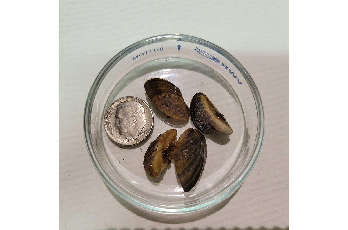
CPW staff has discovered the presence of additional invasive zebra mussels at Highline Lake located at Highline Lake State Park north of Loma, Colorado. The discovery comes following increased testing after CPW found a single adult zebra mussel on an artificial PVC substrate in the lake during routine invasive species sampling on Sept. 14.
The discovery of additional invasive mussels in the water is indicative of an established population in the reservoir and has prompted CPW to change the status of the body of water from “Suspect” to “Infested.” This is the first time a body of water has been categorized as infested with zebra mussels in the state of Colorado.
There is currently no boating on the lake because Highline Lake closes to all surface-water activities for the season annually on October 1.
“Thanks to Colorado’s robust early detection sampling and monitoring program, we were able to make this discovery,” said CPW Acting Director Heather Dugan. “As more and more people use our water resources for boating, we must continue to work tirelessly to prevent the spread of these harmful invasive species.”
The State of Colorado requires boats to be professionally inspected if:
- a boat has been in any body of water that is positive, or suspect for ANS
- a boat has been in any body of water outside of Colorado
- a boat will be entering any water body where inspections are required
Boats exiting infested waters that are not cleaned, drained, and dry are subject to mandatory decontamination requirements.
The establishment of invasive species can lead to millions of dollars in damages to water-based infrastructure, impact water quality and limit recreational opportunity. CPW’s invasive species experts are evaluating next steps and will have more to communicate on the actions it is taking at Highline Lake at a later date.
Please help CPW stop the movement of harmful invasive species, such as zebra mussels, into new waters. Public awareness and participation is the best weapon in the prevention of invasive species.
Please visit the CPW website for more information about zebra and quagga mussels.

Click the link to read “Mussels muscle into Highline: Infestation is first in Colorado” on the Grand Junction Daily Sentinel website (Dennis Webb). Here’s an excerpt:
Alan Martinez, manager of Highline Lake State Park, said that after previous sampling found no more of the mussels, 10 adults have now been found at different locations in the lake, thanks to additional discoveries on Friday and Sunday. The discovery of multiple adults means they’re assumed to be reproducing.
“We are unfortunately the first-ever body of water infested” in the state, he said. “It’s not a title that we want. Now we’ve got to figure out how to protect the rest of Colorado.”’
He said there will now be a lot of discussion within Colorado Parks and Wildlife about how to do that.
“We need to figure out where we move forward at this point and right now we don’t have an answer on that,” he said.
Now the new protocol will remain as long as the lake is infested, and Martinez said there’s no way of getting rid of the mussels short of draining the lake. He previously has said that doing that would mean losing a warm-water fishery there that took decades to build. Robert Walters, Parks and Wildlife’s invasive species program manager, has said that even draining a lake doesn’t guarantee eradication.
Click the link to read the article on the Water Education Colorado Website (Jerd Smith):
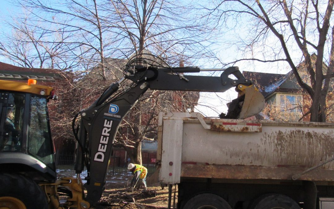
Hundreds of thousands of Coloradans exposed to drinking water tainted by lead from aging, corroded city pipes or so-called “forever chemicals,” will see clean water faster thanks to a historic infusion of $500 million from the federal government.
The money, largely from the new Bipartisan Infrastructure Law, is being funneled through the Colorado Department of Public Health and Environment over a five-year period and will allow miles of lead water delivery pipes to be replaced in towns across the state much faster than cities with little access to cash could achieve.
It will also be used to remove a set of chemicals known as PFAS, or poly and perfluoroalkyl substances, that are present in household and industrial products, such as Teflon and fire-fighting foam. The substances have been unregulated to date, although states and the federal government are writing new regulations to address the contaminants.
CDPHE officials said the money will double the agency’s capacity to fund its water quality safety work.
“The federal money is big,” said Nicole Rowan, director of the CDPHE’s Water Quality Control Division. “It’s a once in a generation opportunity to improve our infrastructure here in Colorado.”
To date, 67 Colorado water districts and communities, including the Academy Water and Sanitation District north of Colorado Springs, Limon, Louisville and Grand Junction, have expressed an interest in and are eligible for the funds, according to documents on file at the CDPHE.
Denver Water has been awarded $76 million to fast-track its lead pipe replacement program. The infusion will allow Denver to shave 1.5 years off the 15-year program, according to spokesman Jose Salas.
The City of Englewood also plans to apply, and will ask for $79 million to replace 8,000 lead service lines, according to Sarah Stone, deputy director of business solutions for Englewood Utilities.
Stone said the federal infrastructure funding will provide a critical boost to its efforts to remove lead from Englewood’s drinking water delivery system, if the city’s application is approved.
“We were extremely worried,” Stone said. “This means we can fund the program.”
Cities across the country, including Denver, Flint, Mich., Pittsburgh, Penn., Newark, N.J., and Washington, D.C., have been dogged by an increase in lead contamination as service lines age and corrode, allowing the lead to comingle with drinking water supplies, eventually reaching taps.
Denver Water, which is Colorado’s largest municipal water utility, has known lead was present at the tap in some of its customers’ homes since it appeared in routine sampling in 2013. The levels exceeded the benchmarks set under the Safe Drinking Water Act.
For several years, the utility ran pilot tests and negotiated with CDPHE and EPA over how best to eradicate the harmful metal. Though the amounts of lead found in Denver’s tap water samples varied, no amount of lead is considered safe to ingest, especially for young children.
The CDPHE issued an order in 2018 requiring Denver to begin adding phosphorous to its water, one of the most effective ways to reduce corrosion in pipes. But phosphorous is also a pollutant and causes problematic algae blooms in lakes and rivers. Adding it to the municipal drinking water supply would also make it harder for wastewater treatment operators to meet their own obligations to keep phosphorous out of rivers and streams.
Due to those concerns, Aurora, Metro Water Recovery, The Greenway Foundation, and eventually Denver, sued the CDPHE in 2018 to stop the order from taking effect.
The dispute was settled after Denver was able to obtain a rare variance under the Safe Drinking Water Act in exchange for agreeing to invest some $68 million over 15 years to replace lead service lines, offer free water filters to residents as they wait for the new lines to be installed, conduct community education programs, and increase the pH of the water supply to also help reduce corrosion in pipes.
Several cities and water districts are hoping the federal funding will allow them to mitigate their ongoing issues with PFAS contamination.
Roy Heald manages the Town of Security’s water utility. The town has been hard-hit by PFAS contamination attributed to Peterson Air Force Base. The PFAS chemicals from fire-fighting foam contaminated its groundwater.
Though the military facility has built a remediation plant for Security, it is considered a temporary facility, Heald said. With $450,000 in federal money from the American Rescue Plan Act approved earlier this year, Security is converting the plant to a permanent facility, one capable of operating for the decades it will likely take to clean up the groundwater.
“We’re happy to get it,” Heald said. “This work has to be done, and it’s $450,000 our ratepayers won’t have to pay.”
Jerd Smith is editor of Fresh Water News. She can be reached at 720-398-6474, via email at jerd@wateredco.org or @jerd_smith.
Click the link to read the article on the World Meterorological Organization website:
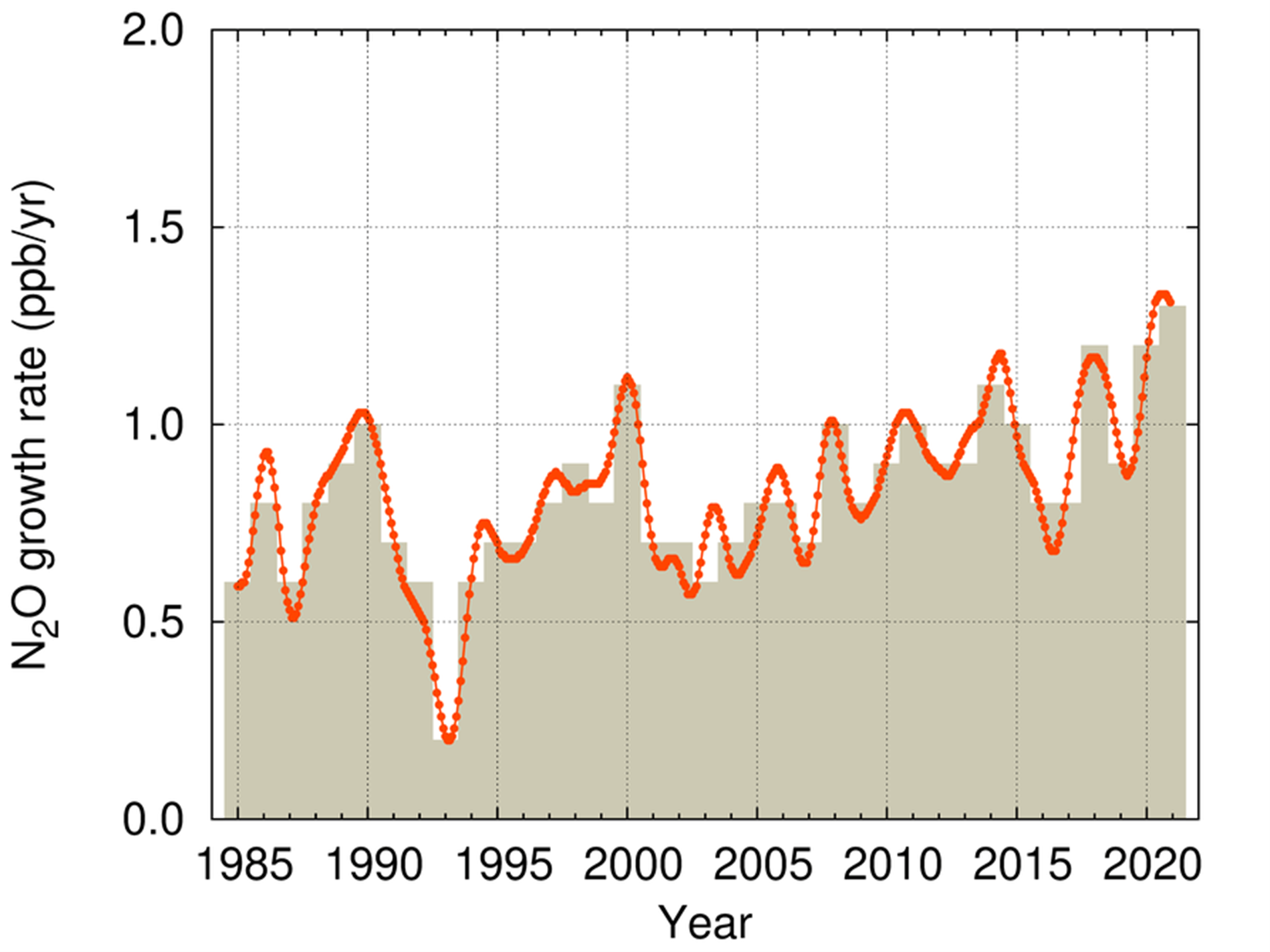
In yet another ominous climate change warning, atmospheric levels of the three main greenhouse gases – carbon dioxide, methane and nitrous oxide all reached new record highs in 2021, according to a new report from the World Meteorological Organization (WMO).
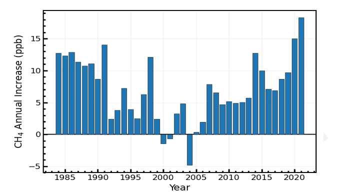
WMO’s Greenhouse Gas Bulletin reported the biggest year-on-year jump in methane concentrations in 2021 since systematic measurements began nearly 40 years ago. The reason for this exceptional increase is not clear, but seems to be a result of both biological and human-induced processes.
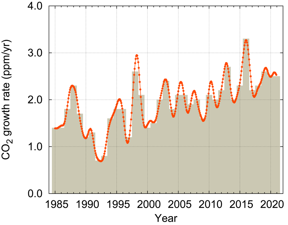
The increase in carbon dioxide levels from 2020 to 2021 was larger than the average annual growth rate over the last decade. Measurements from WMO’s Global Atmosphere Watch network stations show that these levels continues to rise in 2022 over the whole globe.
Between 1990 and 2021, the warming effect on our climate (known as radiative forcing) by long-lived greenhouse gases rose by nearly 50%, with carbon dioxide accounting for about 80% of this increase.
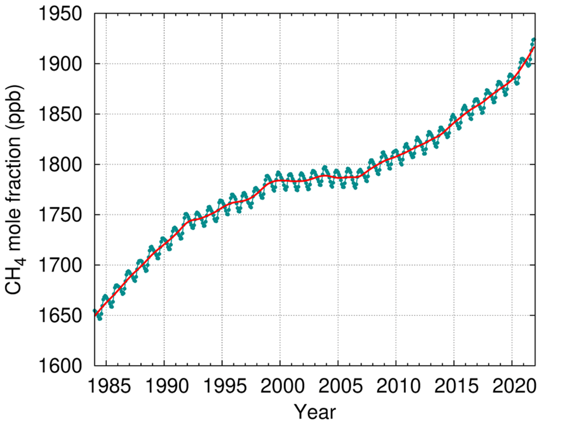
Carbon dioxide concentrations in 2021 were 415.7 parts per million (ppm), methane at 1908 parts per billion (ppb) and nitrous oxide at 334.5 ppb. These values constitute, respectively, 149%, 262% and 124% of pre-industrial levels before human activities started disrupting natural equilibrium of these gases in the atmosphere.
“WMO’s Greenhouse Gas Bulletin has underlined, once again, the enormous challenge – and the vital necessity – of urgent action to cut greenhouse gas emissions and prevent global temperatures rising even further in the future,” said WMO Secretary-General Prof. Petteri Taalas.
“The continuing rise in concentrations of the main heat-trapping gases, including the record acceleration in methane levels, shows that we are heading in the wrong direction,” he said.
“There are cost-effective strategies available to tackle methane emissions, especially from the fossil fuel sector, and we should implement these without delay. However, methane has a relatively short lifetime of less than 10 years and so its impact on climate is reversible. As the top and most urgent priority, we have to slash carbon dioxide emissions which are the main driver of climate change and associated extreme weather, and which will affect climate for thousands of years through polar ice loss, ocean warming and sea level rise,” said Prof. Taalas.
“We need to transform our industrial, energy and transport systems and whole way of life. The needed changes are economically affordable and technically possible. Time is running out,” said Prof. Taalas.
WMO UN Climate Change conference, COP27, in Egypt from 7-18 November. On the eve of the conference in Sharm-el-Sheikh it will present its provisional State of the Global Climate 2022 report, which will show how greenhouse gases continue to drive climate change and extreme weather. The years from 2015 to 2021 were the seven warmest on record.
The WMO reports seek to galvanize COP27 negotiators into more ambitious action decision makers to achieve the Paris Agreement goal to limit global warming to well below 2, preferably to 1.5 degrees Celsius, compared to pre-industrial levels. The average global temperature is now more than 1.1°C above the 1850–1900 pre-industrial average.
Given the need to strengthen the greenhouse gas information basis for decisions on climate mitigation efforts, WMO is working with the broader greenhouse gas community to develop a framework for sustained, internationally coordinated global greenhouse gas monitoring, including observing network design and international exchange and use of the resulting observations. It will engage with the broader scientific and international community, in particular regarding land surface and ocean observation and modelling.
WMO measures atmospheric concentrations of greenhouse gases – what remains in the atmosphere after gases are absorbed by sinks like the ocean and biosphere. This is not the same as emissions.
A separate and complementary Emissions Gap Report by UN Environment will be released on 27 October. The Emissions Gap report assesses the latest scientific studies on current and estimated future greenhouse gas emissions. This difference between “where we are likely to be and where we need to be” is known as the emissions gap.
As long as emissions continue, global temperature will continue to rise. Given the long life of CO2, the temperature level already observed will persist for decades even if emissions are rapidly reduced to net zero.
Highlights of the Bulletin
Carbon dioxide (CO2)
Atmospheric carbon dioxide reached 149% of the pre-industrial level in 2021, primarily because of emissions from the combustion of fossil fuels and cement production. Global emissions have rebounded since the COVID-related lockdowns in 2020. Of the total emissions from human activities during the 2011–2020 period, about 48% accumulated in the atmosphere, 26% in the ocean and 29% on land.
There is concern that the ability of land ecosystems and oceans to act as “sinks” may become less effective in future, thus reducing their ability to absorb carbon dioxide and act as a buffer against larger temperature increase. In some parts of the world the transition of the land sink into CO2 source is already happening.
Methane (CH4)
Atmospheric methane is the second largest contributor to climate change and consists of a diverse mix of overlapping sources and sinks, so it is difficult to quantify emissions by source type.
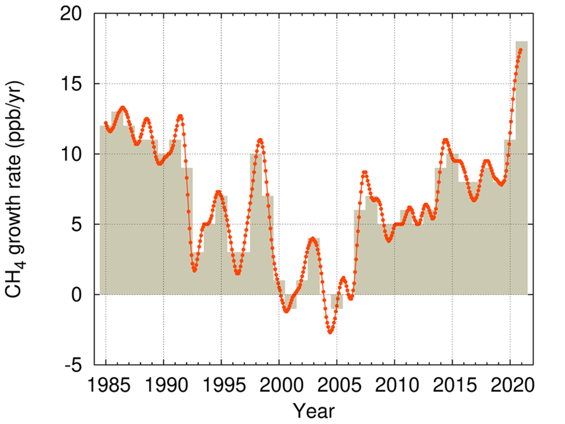
Since 2007, globally-averaged atmospheric methane concentration has been increasing at an accelerating rate. The annual increases in 2020 and 2021 (15 and 18 ppb respectively) are the largest since systematic record began in 1983.
Causes are still being investigated by the global greenhouse gas science community. Analysis indicates that the largest contribution to the renewed increase in methane since 2007 comes from biogenic sources, such as wetlands or rice paddies. It is not yet possible to say if the extreme increases in 2020 an 2021 represent a climate feedback – if it gets warmer, the organic material decomposes faster. If it decomposes in the water (without oxygen) this leads to methane emissions. Thus, if tropical wetlands become wetter and warmer, more emissions are possible.
The dramatic increase might also be because of natural interannual variability. The years 2020 and 2021 saw La Niña events which are associated with increased precipitation in tropics.
Nitrous oxide (N2O)
Nitrous oxide is the third most important greenhouse gas. It is emitted into the atmosphere from both natural sources (approximately 57%) and anthropogenic sources (approximately 43%), including oceans, soils, biomass burning, fertilizer use, and various industrial processes. The increase from 2020 to 2021 was slightly higher than that observed from 2019 to 2020 and higher than the average annual growth rate over the past 10 years.

Click the link to read the article on the Audubon California website (Andrea Jones):
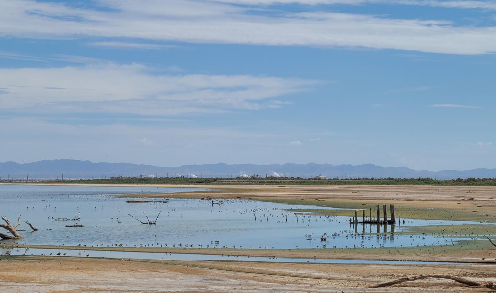
If it wasn’t for the sun low on the horizon or the sparrows singing quickly from nearby shrubs, one would barely realize it was morning. The heat along the Salton Sea, with some added humidity, already felt slightly oppressive. Our shorebird survey route included the shoreline along the State of California’s Species Conservation Habitat (SCH) 4,100 acre wetland remediation project on the southwest corner of the Sea, near the New River mouth. We found ourselves in a construction site, and after asking for access permission, were given hard hats and sent along our way to navigate a series of levees and dirt roads and look for birds.
It’s been 30 years since the last region-wide surveys for shorebirds in the Intermountain West, the mostly arid region between the Rockies and the Sierra, home to large, saline bodies of water including Great Salt Lake. National Audubon Society, in partnership with Point Blue Conservation Science, the US Fish & Wildlife Service, and state agency partners embarked on an effort this past August to resurvey freshwater wetlands and saline lakes across 11 states in the Intermountain West. The project’s goals are to complete a comprehensive surveys of wetland sites over the next 3 to 5 years, compare current distributions to historic surveys, and identify environmental- and human-related factors driving shorebird distributions.
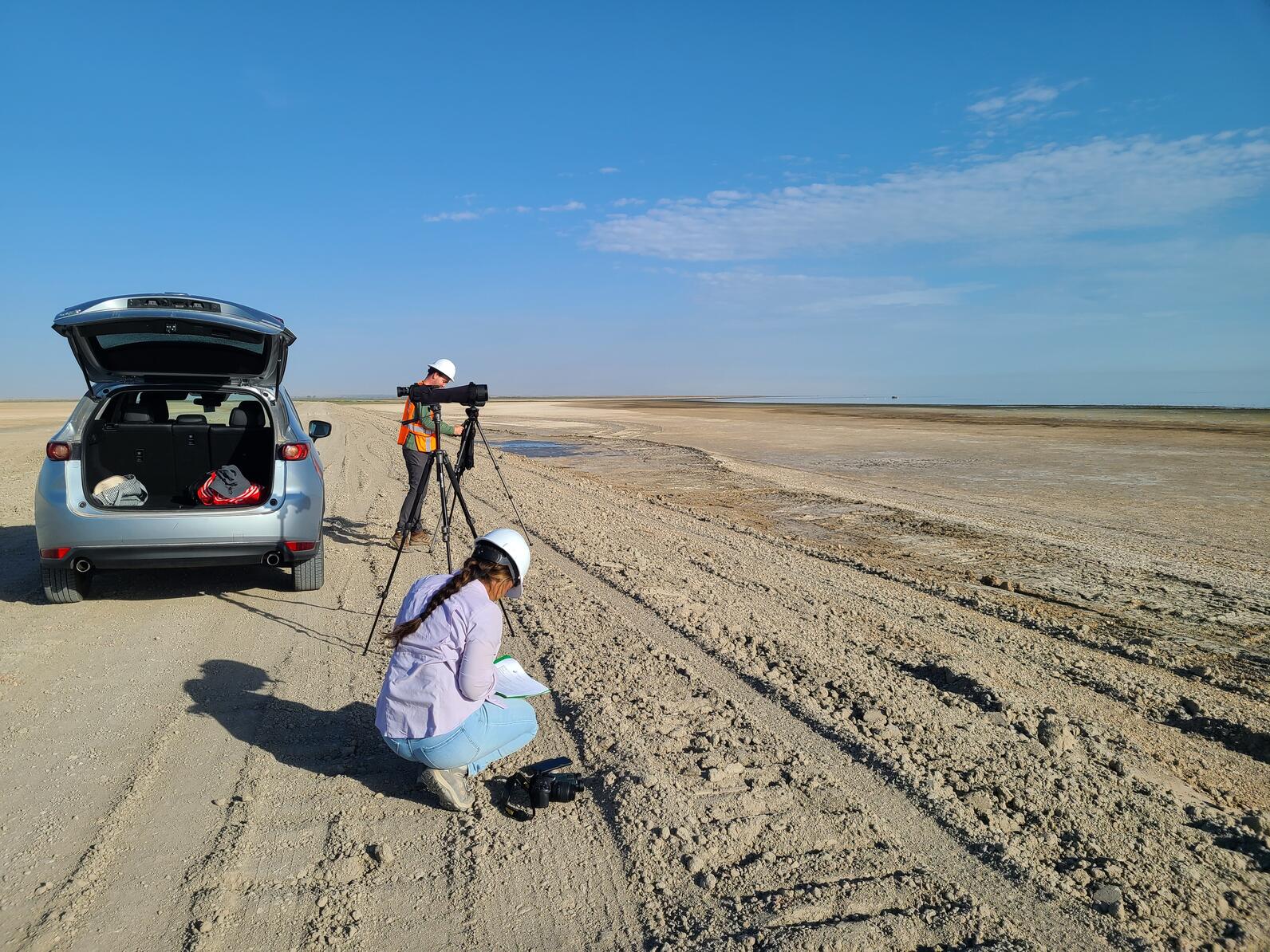
The Salton Sea is part of this effort, and a group of us set out to the Sea for shorebirds, section by section, on one hot August morning this summer. My group consisted of myself, Audubon’s Salton Sea Program Coordinator Camila Bautista, and Trevor Wimmer, Salton Sea bird survey contractor. Knowing that the temperatures would climb to or above 100 degrees, we started our survey at sunrise, when the temperature was already in the mid 80’s.
Despite the heat, an occasional noisy truck passing by, and the sweat dripping down my face from the hard hat, the view of shorebirds and many other species of waterbirds was hard to beat. The shorebirds didn’t seem to mind the heat or noise, either! We were pleasantly surprised to find ourselves counting thousands upon thousands of Black-necked Stilts, Long-billed Curlews, Least and Western Sandpipers and smaller but still significant numbers of Black-bellied and Snowy Plovers, Marbled Godwits, and less common Stilt Sandpipers. Among the shorebirds picking in the mud along the Sea’s edge were large groups of hundreds of Red-necked Phalaropes, shorebirds that spin in circles to churn up the water to reveal tasty morsels. These unusual shorebirds stop at saline lakes across the west before spending the winter out on the open oceans. The mudflats and shoreline were full of shorebirds in all directions, as far as the heat haze would allow our spotting scopes to see. The air was full of Black Terns, a beautifully elegant, little black and grey seabird that stops at the Sea post breeding before continuing its migratory journey for the winter to the Pacific Coast of Central and South America.
We poked our way along the edges of the Sea and construction zone, using our vehicle as the only shade in slight. In front of us, birds ringed the Sea, and behind us, trucks were working around the clock moving dirt in an endless maze of dirt roads and dirt pond bottoms, that, once flooded, would become future wetlands. I was relieved to still see so many birds still at the Sea, and wanted to assure them, if they could hear me, that when they come back in a year they will have so much additional new habitat to use as the Sea continues to recede. The SCH project is scheduled for completion fall of 2023, providing new habitats for waterbirds to help replace so much of what has been lost. Flooding this area will also help alleviate dust blown off the exposed lakebed.
The Salton Sea is an integral part of the migratory journey of so many species of waterbirds, and visiting the Sea during migration allowed me to see that shorebirds are still able to feed along the Sea’s muddy shoreline. It also gave me a first-hand look at the state’s progress on completing the first big wetland habitat project at the Sea. I look forward to returning next year to observe how birds make use of the new habitats being constructed. This month’s International Migratory Bird Day highlights the significant treks shorebirds take and how important it is for us to be stewards of their long journeys, ensuring that there is safety, food, shelter and water, every step along the way. To learn more about shorebird migration, visit Audubon’s new Bird Migration Explorer.

Click the link to read the release on the Reclamation website:
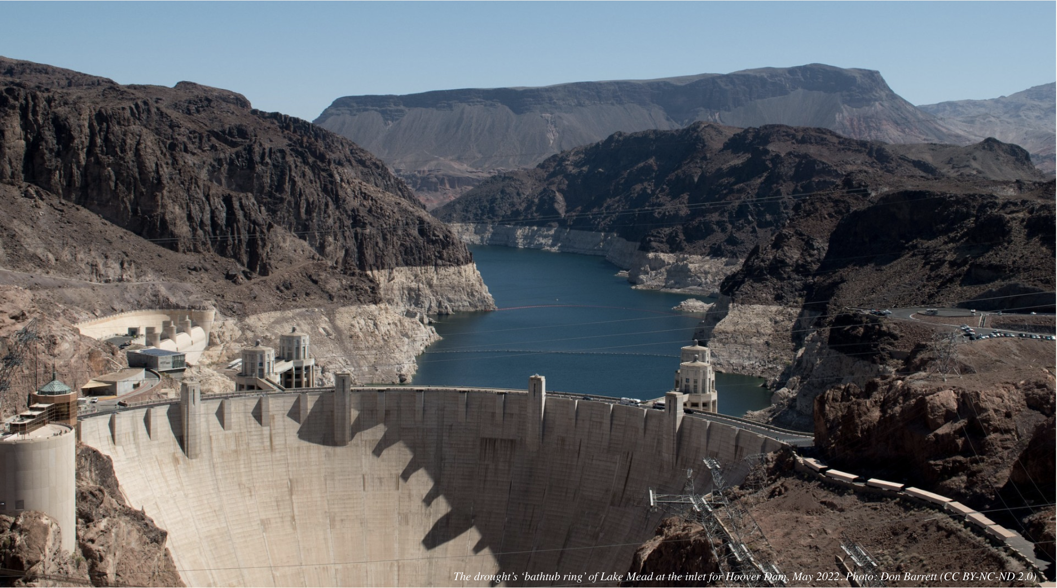
As collaborative work continues across the Colorado River Basin to address the ongoing drought crisis, the Department of the Interior today announced expedited steps to prepare new measures that, based on current and projected hydrologic conditions, are needed to improve and protect the long-term sustainability of the Colorado River System. To address the serious operational realities facing the System, the Bureau of Reclamation is initiating an expedited, supplemental process to revise the current interim operating guidelines for the operation of Glen Canyon and Hoover Dams in 2023 and 2024 in order to provide additional alternatives and measures needed to address the likelihood of continued low-runoff conditions across the Basin.
“The Interior Department continues to pursue a collaborative and consensus-based approach to addressing the drought crisis afflicting the West. At the same time, we are committed to taking prompt and decisive action necessary to protect the Colorado River System and all those who depend on it,” said Secretary Deb Haaland. “Revising the current interim operating guidelines for Glen Canyon and Hoover Dams represents one of many critical Departmental efforts underway to better protect the System in light of rapidly changing conditions in the Basin.”
Reclamation will publish a Notice of Intent (NOI) to prepare a Supplemental Environmental Impact Statement (SEIS), which will include proposed alternatives to revise the December 2007 Record of Decision associated with the Colorado River Interim Guidelines. The 2007 Interim Guidelines provide operating criteria for Lake Powell and Lake Mead, including provisions designed to provide a greater degree of certainty to water users about timing and volumes of potential water delivery reductions for the Lower Basin States, and additional operating flexibility to conserve and store water in the system.

The NOI outlines that, in order to ensure that Glen Canyon Dam continues to operate under its intended design, Reclamation may need to modify current operations and reduce Glen Canyon Dam downstream releases, thereby impacting downstream riparian areas and reservoir elevations at Lake Mead. Additionally, in order to protect Hoover Dam operations, system integrity, and public health and safety, Reclamation may need to also modify current operations and reduce Hoover Dam downstream releases.
“We are taking immediate steps now to revise the operating guidelines to protect the Colorado River System and stabilize rapidly declining reservoir storage elevations,” said Reclamation Commissioner Camille Calimlim Touton. “Today’s action brings new ideas and necessary measures to the table as we consider alternatives to revise operations to better protect Colorado River System in the near term while we also continue to develop long-term, sustainable plans that reflect the climate-driven realities facing the Colorado River Basin.”
As described in the NOI, this SEIS will analyze alternatives including:
- Framework Agreement Alternative: This alternative would be developed as an additional consensus-based set of actions that would build on the existing framework for Colorado River Operations. This alternative would build on commitments and obligations developed by the Basin States, Tribes and non-governmental organizations as part of the 2019 Colorado River Drought Contingency Plan (DCP) Authorization Act.
- Reservoir Operations Modification Alternative: This alternative would be developed by Reclamation as a set of actions and measures adopted pursuant to Secretarial authority under applicable federal law. This alternative would also consider how the Secretary’s authority could complement a consensus-based alternative that may not sufficiently mitigate current and projected risks to the Colorado River System reservoirs. [ed. emphasis mine]
- No Action: The No Action Alternative will describe the continued implementation of existing agreements that control operations of Glen Canyon and Hoover Dams. These include the 2007 Interim Guidelines and agreements adopted pursuant to the 2019 DCP. Intensive ongoing efforts to achieve water conservation actions in the Basin are underway through a number of programs, including the recent Inflation Reduction Act. Implementation and effectiveness of these efforts will inform the assessment of existing operations and agreements.
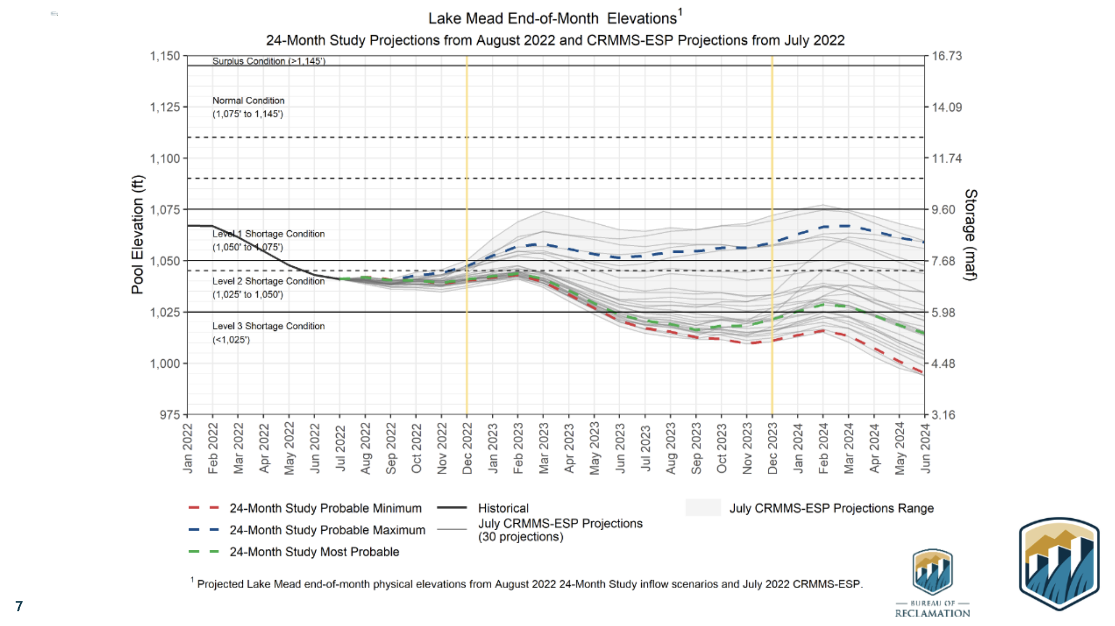
The action announced today builds on steps announced in August 2022 as part of Reclamation’s release of the Colorado River Basin August 2022 24-Month Study, as well as additional actions announced in September 2022 to reduce water consumption across the Basin in light of critically low water supplies and dire hydrological projections.
The Department also recently announced new drought mitigation funding opportunities to provide reliable, sustainable and equitable water and power supplies across the Basin. A newly created Lower Colorado River Basin System Conservation and Efficiency Program, funded with an initial allocation through the Inflation Reduction Act, will help increase water conservation, improve water efficiency, and prevent the System’s reservoirs from falling to critically low elevations that would threaten water deliveries and power production. The Inflation Reduction Act includes $4 billion in funding specifically for water management and conservation efforts in the Colorado River Basin and other areas experiencing similar levels of drought.
The NOI announced today to address immediate challenges does not interfere with Reclamation’s separate process for determining post-2026 Colorado River Operations.
Members of the public interested in providing input on the SEIS can do so through December 20, 2022, per instructions in the Federal Register that will be published in the coming days.

Click the link to read “Feds want the ability to cut back on Colorado River reservoir releases over the next two years” on the KUNC website (Alex Hager). Here’s an excerpt:
On Friday, the Interior Department began the process of revising existing guidelines for water management in the Colorado River basin. The river, which supplies 40 million people across the Southwest, is strained by a supply-demand imbalance and will likely shrink further due to climate change. The Bureau of Reclamation, which manages dams at those reservoirs, filed a Notice of Intent Friday to propose changes to water releases. An upcoming Environmental Impact Statement will contain the details of those changes. The Bureau’s plans will tweak river management rules drawn up in 2007 in response to declining reservoir levels at that time. Those rules, known as the “Interim Guidelines” were meant to last until 2025. These potential changes to water released from the dams will join a patchwork of temporary reductions and conservation agreements that have been deployed to pull the basin back from the brink of catastrophe. Ongoing dry conditions brought on by warming temperatures have worsened beyond the expectations of many water managers, and steady demand is sapping the shrinking supply. States that use water from the Colorado River are due to rewrite management guidelines by 2026, when the current set expires…
These tweaks are pitched as a means of making sure water can pass through Glen Canyon Dam normally. Dropping water levels in Lake Powell have threatened hydropower production at the dam, which supplies electricity to roughly 5 million people across seven nearby states. Lower levels mean lower power output, and if levels drop so low that air enters the hydroelectric turbines, they could be damaged.
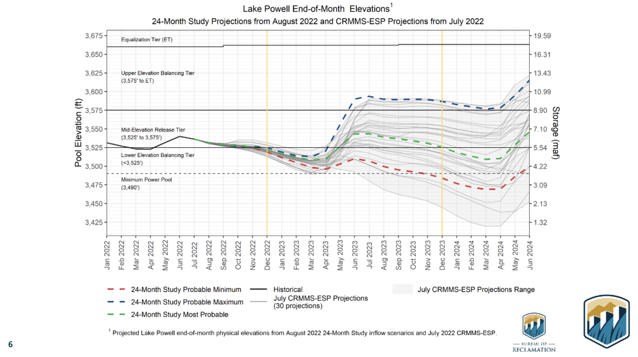
Beyond hydropower worries, some have raised concern that water from Lake Powell may soon be unable to pass through rarely-used pipes in its dam at a sufficient rate, jeopardizing the flow of water to millions of people who depend on it downstream. The lowest set of pipes — which would serve as the only exit route for water once levels fall past 3,430 feet in elevation — are not big enough to carry sufficient water for the Upper Basin states of Colorado, Wyoming, Utah and New Mexico to satisfy their legal obligation. Lake Powell was at 3,529 feet at the end of September.
Lake Mead, which stores water for the Lower Basin states of California, Arizona and Nevada, is filled with water released from Lake Powell. Because of that, any changes at Lake Powell would be felt at Lake Mead and the section of Colorado River between the two, which primarily flows through Grand Canyon National Park. Reclamation says it may modify releases at the Hoover Dam, which holds back Lake Mead, “in order to protect Hoover Dam operations, system integrity, and public health and safety.”

Click the link to read “New push to shore up shrinking Colorado River could reduce water flow to California” on The Los Angeles Times website (Ian James). Here’s an excerpt:
With water levels dropping at Lake Powell, the Interior Department said operators of Glen Canyon Dam may need to release less water, which would affect flows in the Grand Canyon and accelerate the decline of Lake Mead. In order to protect public health and safety and the integrity of the system, the department said releases from Hoover Dam may also need to be reduced — which would shrink the amounts of water flowing to California, Arizona and Mexico…
The Interior Department has the authority to step in and unilaterally impose larger cuts. But federal officials appear to be pushing for a consensus on shrinking the water take from the river rather than dictating reductions in ways that could further inflame tensions or lead to legal fights. This approach increases the pressure on the states to come up with a deal in the coming months or face federal intervention.
“The Interior Department continues to pursue a collaborative and consensus-based approach to addressing the drought crisis afflicting the West,” Interior Secretary Deb Haaland said in a news release. “At the same time, we are committed to taking prompt and decisive action necessary to protect the Colorado River System and all those who depend on it.”

Click the link to read “Feds start the clock on a plan that could deepen cuts on drought-stricken Colorado River” on the AZCentral.com website (Brandon Loomis). Here’s an excerpt:
The Interior Department and its dam managers at the Bureau of Reclamation said Friday they will complete an environmental review of options for keeping water in Lake Mead and Lake Powell, both of which in recent years have sped toward the point of losing hydropower production or even failing to flow through their respective dams. Reclamation already has reduced supplies to Arizona and Nevada based on operating guidelines approved in 2007. Those rules for shortage management have proved insufficient to halt plunging storage levels. They expire in 2026 and must be replaced by then, but the government’s announcement makes clear that emergency action is needed even sooner…
What happens to the reservoirs now also depends on how much snowpack the Rocky Mountains can pile up this winter to melt next spring. If the weather is especially poor, with flows less than half their long-term average over the next couple of years, the government’s projections now find worst-case scenarios that could dry up the river below Lake Mead before 2026, cutting off those who use the river in Arizona, California and Mexico. The Grand Canyon’s stretch of river is also at risk if Lake Powell continues to sink toward Glen Canyon Dam’s outlets.
“Reclamation is not going to let the states call its bluff any longer and realizes that the existing 2026 deadline is too far in the distance,” said Kyle Roerink, executive director of the Great Basin Water Network, a conservation group.
Doling out cuts from the river is complicated by 100 years of law and regulation meant to set how much water each of seven states can take. Arizona typically gets about a third of its total supply from the river, but has had to reduce its 2.8 million-acre share by 512,000 acre-feet, and will lose 80,000 more next year under terms of the 2007 guidelines.

Click the link to read “New US plan could lead to federal action on Colorado River” on the Associated Press website (Felicia Fonseca and Kathleen Ronayne). Here’s an excerpt:
The public has until Dec. 20 to weigh in on three options that seek to keep Lake Mead and Lake Powell from dropping so low they couldn’t produce power or provide the water that seven Western states, Mexico and tribes have relied on for decades. One of the options would allow the Interior Department’s U.S. Bureau of Reclamation to take unilateral action, as it threatened this summer when it asked states to come up with ways to significantly reduce their use beyond what they have already volunteered and were mandated to cut…
The announcement comes more than four months after Reclamation Commissioner Camille Touton told Congress that water use must be cut dramatically as drought and overuse tax the river — an essential supply of water for farmers, cities and tribes in the U.S. West, as well as Mexico. The seven states that tap the river failed to reach Touton’s August deadline and have been working ever since to reach a compromise. It now appears unlikely a grand deal will be reached. In the meantime, the bureau has offered up billions in federal money to pay farmers and cities to cut back. But Interior’s new action marks the first time it’s taking a clear step toward imposing its own, mandatory cuts. The agency anticipates changes to the conditions at which water shortages are declared in the river’s lower basin. Lake Mead and Lake Powell were about half full when the 2007 guidelines were approved and are now about one-quarter full.

Click the link to read the article on the Sustainable Waters website (Brian Richter):
I’ve just returned from a glorious 17-day river float in dory boats through the Grand Canyon. Sublime beauty punctuated by adrenalin-pumping whitewater.
Most river runs through the Canyon begin at Lee’s Ferry, located fifteen miles downstream of Glen Canyon Dam. When we arrived at Lee’s Ferry to begin our trip on September 23rd, I headed straight for the river’s edge, anxious to dip my toes in the water.
Bracing for icy water, I was stunned when I realized how warm the river had become!
The river has been — since the construction of Glen Canyon Dam in 1963 — a frigid current of water released from the deep hypolimnion bowels of Lake Powell. For 40 years since the dam was built, the river’s temperature had fluctuated between 47 and 51 degrees Fahrenheit (8-11 degrees C), even in summertime when air temperatures in the bottom of the Grand Canyon regularly soar above 100 degrees F.
This icy river water has long posed a serious risk to river runners who become unintentional swimmers when dumped from their river boats in one of the Canyon’s 80+ big water rapids. When someone gets spilled from their river boat it becomes urgent to get them out quickly, before hypothermia sets in.

But our trip would be a very different one. When I dipped a toe at Lee’s Ferry in late September the river was a comfortable 69 degrees! (21 C).
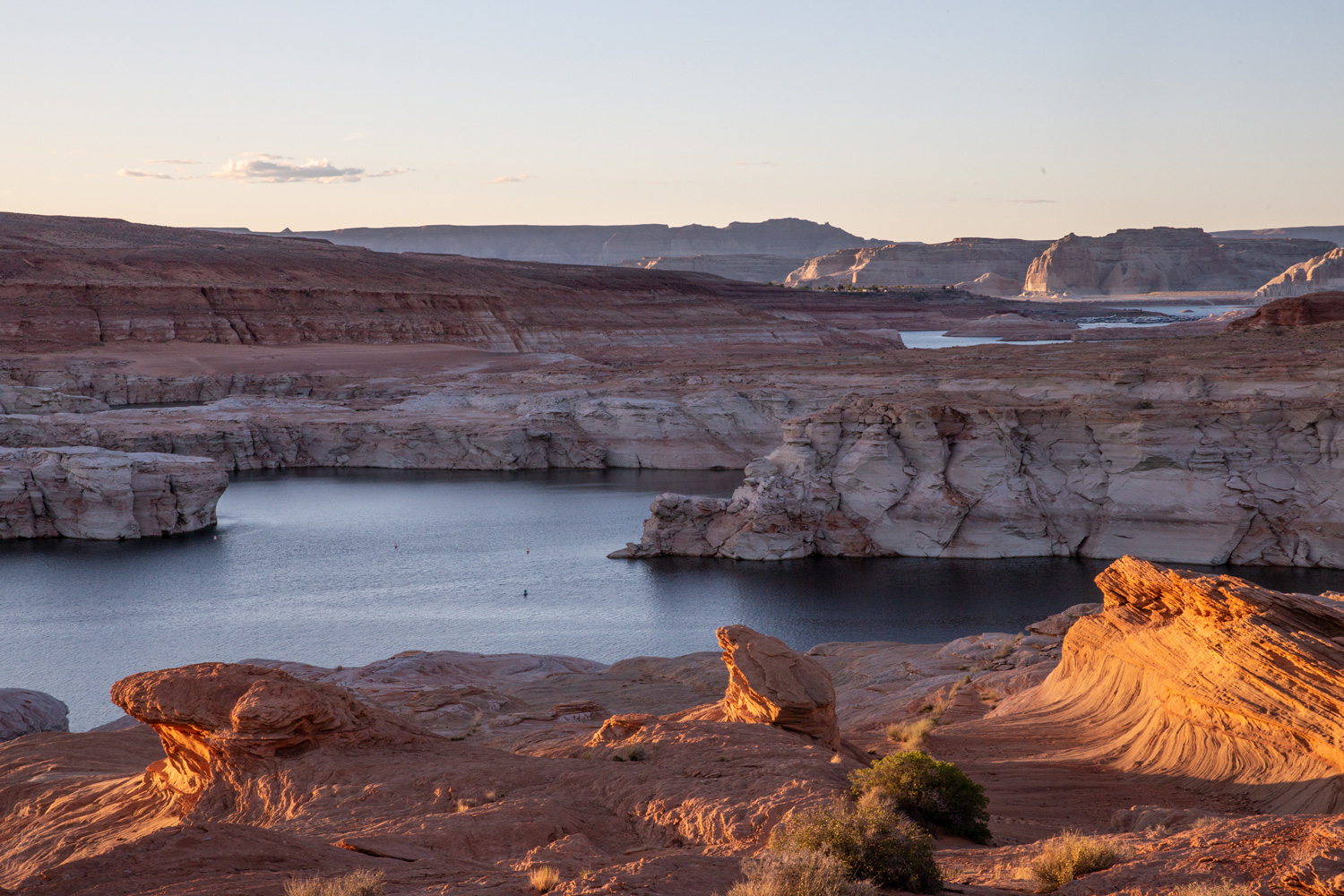
Our knowledgeable river guides were quick to explain that due to the tremendous shrinkage of Lake Powell (the result of decades of water overuse and climate change), the reservoir has heated up and water released from the dam is now much warmer…
Lake Powell began losing its water volume very quickly during a series of severely dry years from 2001-2004. By the fall of 2004, the reservoir had lost nearly two-thirds of its capacity (orange line). The greatly diminished mass of water in Lake Powell began to warm to the highest temperatures recorded since its construction, and the releases of water from the dam into the Grand Canyon reached 58 degrees in October 2004, then 60 degrees in 2005.
Lake Powell regained some volume from 2006-2018, but a precipitous drop since 2018 has sent the river’s temperature soaring again. This year’s 69-degree high point is a new record in the post-dam years. Lake Powell’s volume has shrunk to three-quarters empty.
I was of course very happy to know that hypothermia was going to be much less likely on our trip, and I was also pleased to remember that this warmer river is a good bit closer in temperature to its more natural, pre-dam condition. The warmer river helped us imagine what the wild Colorado would have been like, a feeling that was accentuated when we reached the confluences of the tributary Paria and Little Colorado rivers, both swollen with runoff from recent thunderstorms that turned the river a more natural reddish brown (Viva el Rio Colorado!) instead of its usual blue-green hue.
However, as I would confirm upon our return from the river, this warmer Colorado isn’t a good thing for the introduced trout fishery in the river. Trout don’t like warm water because warm water doesn’t hold enough oxygen to sustain them. The tailwater fishery below Glen Canyon Dam is famous for its abundance of big fat trout that attract thousands of fly-fishing enthusiasts each year.
One would think that the warmer river water would be better for native fish like the imperiled humpback chub, but the dropping reservoir levels are setting up a potentially disastrous situation for this endangered fish.
In recent decades, the humpbacks have been doing quite well in the Grand Canyon, particularly around the confluence with the Little Colorado River where warmer water joins the main river. The humpbacks have been recovering sufficiently that they were recently down-listed from ‘endangered’ to ‘threatened’ status under the US Endangered Species Act. But they’re now facing a bizarre twist of fate.
Lake Powell harbors a slew of invasive, introduced fish such as smallmouth bass that love to eat baby humpbacks. But until now, those predatory invaders in the lake haven’t been a threat to the humpbacks in the Grand Canyon because they hang out in the warmer upper layers of the lake, and the dam has been an effective barrier to their escape.
But as Lake Powell has dropped, the warm epilimnion water layer in Lake Powell has been lowering as well, and it is now at or near the same level as the hydropower outlets in Glen Canyon Dam. This means that the invasive predators may soon be able to pass through the dam’s penstocks in numbers that could put humpbacks in serious danger.
As many readers of this blog know, water solutions are oftentimes elusive and complicated. But there are many bright individuals working on these problems every day, and I remain ever hopeful for their success.
My sincere thanks to the extraordinary crew of river guides from OARS that piloted our safe yet adventurous journey. It has redoubled our hopes and efforts to keep the river flowing.
Click the link to read the article on the Alamosa Citizen website (Chris Lopez):
A location north of Creede, somewhere near Lost Lake around La Jara Creek, a site in the Trinchera area. Those are some of the general areas in the San Luis Valley where new SNOTEL stations, or automated snow monitoring stations, could show up under the Rio Grande Snow Measurement Enhancement Project being developed by water conservancy districts.
San Luis Valley Water Conservancy District Manager Heather Dutton is helping spearhead the project and has an outline for four new full SNOTEL stations and three SNO-Lite stations.
Establishing seven new sites would deliver more data from critical high-elevation areas to improve snow-depth readings and better forecast corresponding spring runoff into the creeks that feed the Upper Rio Grande Basin.
“We’re definitely going to build some sites, it’s just getting them dialed in,” Dutton said this week in an interview with Alamosa Citizen.
What’s at stake
Warmer seasonal temperatures, less snow occurrence, drier snow, and higher winds over the past two decades have created challenging conditions to forecast streamflows on the Upper Rio Grande.
Accurate forecasting, which relies on the accumulation of data from existing National Resource Conservation Service (NRCS) SNOTEL stations, matters particularly to Colorado’s management of the Rio Grande Compact with New Mexico and Texas. Better streamflow forecasting would also aid managers with the Rio Grande Water Conservation District and local irrigators in their management of groundwater well pumping and annual replacement plans.
“The goal of the project is to add more clarity, more data to on the ground sites so we can improve streamflow forecasting,” Dutton said.
The San Luis Valley Water Conservancy District initially received a $45,000 grant from the Colorado Water Plan to assist with establishing a series of SNO-Lite sites. But after showing conceptually that there were big data holes with the existing SNOTEL locations, the project evolved to include the four full stations to help with the NRCS model.
The cost is pegged at $293,000 for the seven sites, with funding coming from the San Luis Valley Water Conservancy District, the Colorado Water Conservancy District, Trinchera Ranch, and potentially from the Rio Grande Water Conservation District.
The additional SNOTEL sites will nearly double the current number of sites in the San Luis Valley, said Craig Cotten, division engineer for the state Division of Water Resources.
“This is really going to be a help for us,” he said.
The current SNOTEL sites, he said, are good for the location that they’re in. “But if you get a couple of miles away, it could be a totally different amount of snow and elevation as well.”
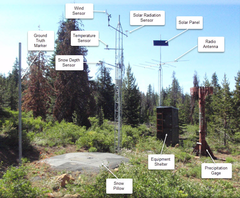
Why it matters
Data from SNOTEL sites is transmitted in near real time every hour to gauging stations to help water managers predict spring and summer streamflows. The gauging station at Del Norte, for instance, is essential to helping the state determine how much water from the Rio Grande is available to be delivered downstream into New Mexico.
The weight of the snow, which determines how much water is in the snow that has fallen, is the data a full SNOTEL site transmits. A SNO-lite site doesn’t have a similar snow pillow to weigh, and instead estimates the amount of water in snow.
In addition to improving streamflow forecasting, more SNOTEL sites means better soil moisture data, which is critical to assessing drought conditions and estimates of crop yields.
Historically, water managers could make safe assumptions on streamflows based on the readings from SNOTEL stations located in similar elevations. But those forecasts are no longer holding up as a result of the changing ecological environment in the San Luis Valley, Dutton said.
“What it comes down to, is the stream yield based on snow production is not tracking the way it used to,” she said.
The water conservancy districts, Alamosa County and the Rio Grande Water Conservation District contributed to a new Doppler weather radar at the Alamosa Regional Airport two years ago to help improve San Luis Valley weather forecasts.
The addition of SNOTEL stations is another step to get more data. They’ll be located in historically high snow-producing areas and where there currently is a need for more data, like the elevations north of Creede and in the southern end of the Valley.
“We want to make sure (a location) gets enough snow that is useful,” Dutton said.
The conservancy districts will spend the winter modeling the project and then conduct on-site analyses coming out of winter going into spring. The goal is to add two full SNOTEL sites both in 2023 and 2024, and the three SNO-Lite stations in 2023.
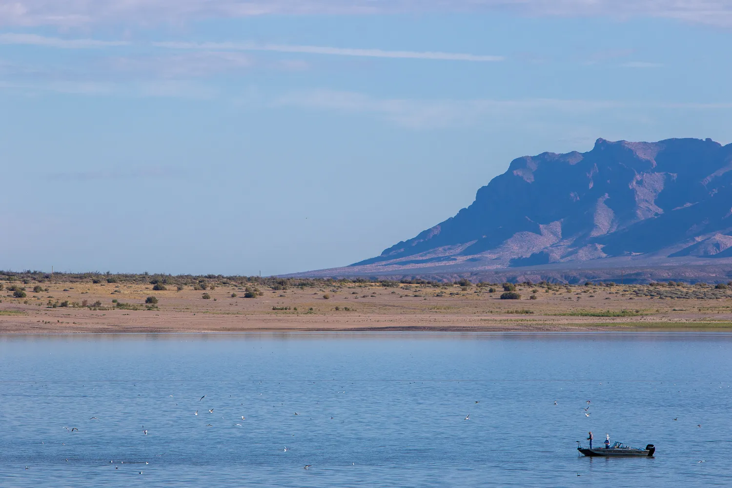
Click the link to read the article on the El Paso Matters website (Danielle Prokop):
A settlement draft is on the table to end nearly a decade of litigation over Rio Grande water before the Supreme Court — but not everyone is on board.
On Tuesday, Judge Michael Melloy — who is overseeing the case as the special master — said he would hear arguments on a draft settlement presented by Colorado, New Mexico and Texas, over the objections of the federal government and at least two irrigation districts.
The three states called the draft settlement a “carve-out decree” that resolves all issues of Rio Grande water-sharing between the states, while leaving open discussions of “intrastate” water management in New Mexico. Those discussions would involve disagreements over management of federal irrigation canals and dams, said Jeff Wechsler, the lead attorney for New Mexico.
“The settlement we believe fairly ensures that both Texas and New Mexico receive their fair share of water,” Wechsler said, adding that the state was open to resolving issues with the federal government.
Attorneys for the federal government disagreed that any issues could be “carved out,” and objected to the states’ proposed settlement, the terms of which remain confidential.
“Without the United States agreeing to this settlement, this compact dispute can’t end,” said Fred Liu, assistant to the Department of Justice’s solicitor general.
Texas sued New Mexico in the Supreme Court in 2014, arguing that groundwater pumping in southern New Mexico denied Texas its fair share of river water laid out by the 1938 Rio Grande Compact. In 2018, the high court allowed the federal government to join the case. The federal government has argued that New Mexico’s groundwater pumping threatens a water-sharing treaty with Mexico and arrangements with El Paso County Water Improvement District No. 1 and Elephant Butte Irrigation District.
Attorneys representing the irrigation districts sided with the feds Tuesday in opposing the states’ proposed settlement.
“This is a settlement over the objection of three major participating entities, all who run the (Rio Grande) Project and all who will be responsible for implementing this settlement over our objection, over our rights,” said Samantha Barncastle, who represents Elephant Butte Irrigation District. The Rio Grande Project is the series of federal dams and canals that distributes water and hydroelectric power to communities along the Texas-New Mexico state line.
Barncastle asked Melloy to send all of the parties back to the negotiating table.
Maria O’Brien, the attorney for El Paso County Water Improvement District No. 1, called the draft agreement “not workable.” She charged the states with making offers they could not actually keep.
Melloy on Tuesday called off the Jan. 17 trial date he set last month after the parties failed to reach an agreement after nearly a year of negotiations. He scheduled a Jan. 24 briefing to determine the legal issues surrounding the proposed settlement.
The judge encouraged the parties to continue negotiations in the months ahead of the briefing.
Liu pushed back, saying the federal government’s team did not have the resources to split between negotiating a new settlement, and responding to the states’ draft settlement.
Melloy responded that it was the federal government who had pushed for continuing to negotiate the case in May when the court inquired about scheduling the pending second half of the trial.
“Don’t start down that ‘poor old United States of America. We’re too busy to talk about settlement, and we don’t have the resources and we’re stretched too thin.’ I’m not buying that argument,” Melloy said, clarifying that he was not directing the parties to continue settlement discussions.
“I’m not directing you to do anything, and you can do whatever you want.”


George discusses the “Law of the River” and the notion that the river’s hydrology might be the real law of the river. Click the link to read the article on the Sibley’s Rivers website (George Sibley):
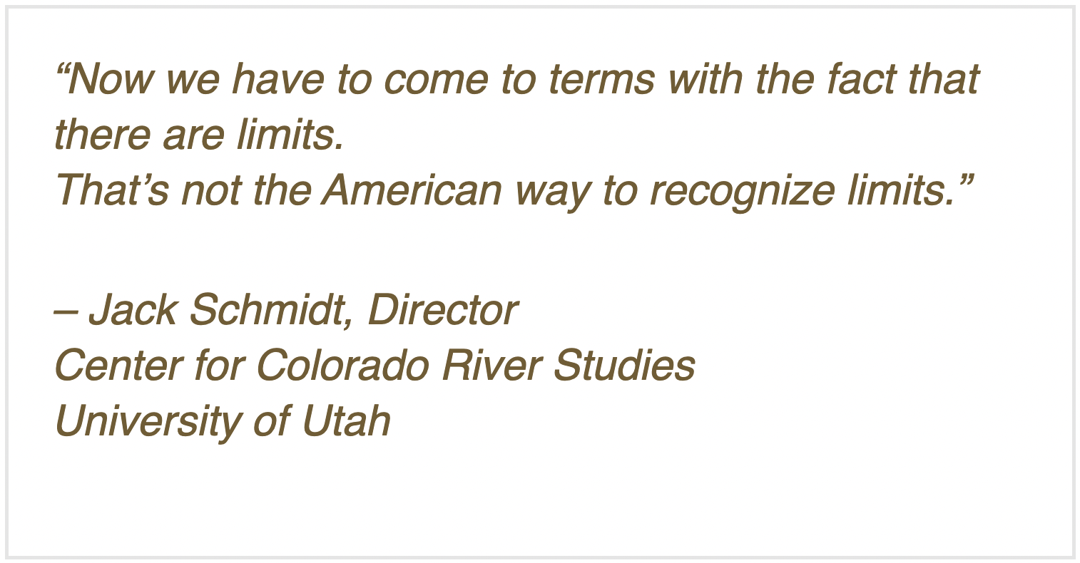
For the past several posts, we’ve been exploring the Colorado River Compact, commemorating its centennial this year. Nearly everything I have read about the Colorado River Compact in this centennial year – and it’s getting to be voluminous – speaks of it as the ‘foundation’ of ‘The Law of the River,’ an accumulation of legal and political documents accompanying the development of the Colorado River since the 1922 Compact.
I have a problem with calling the Compact the ‘foundation’ of the Law of the River – as though before the Compact was adopted, the River was lawless. That is not true. The real foundation of the Law of the River is the appropriations doctrine that all seven states (or territories) had embraced in the 19th century – an evolving body of ‘common law’ that is the foundational law of all modern water development in the arid American West.
There is much to appreciate in the appropriations doctrine, which we explored a month or so ago. It democratically only allows the appropriation of the amount of water an appropriator(s) can beneficially put to use, to prevent big money speculation. It protects existing ‘senior’ downstream users from being dried up by new upstream ‘junior’ users. Among other virtues, it has shown flexibility in opening up to incorporate new uses like recreation and the environment.
But the appropriations doctrine also evolved as a powerful engine for growth. Its basic ‘first in time, first in right’ promise of perpetual secure use rewards those who get there first, regardless of what they do so long as it can be construed as economically beneficial, which we now know covers a multitude of sins against both nature and human nature. And ‘judicial expansions’ to the basic law really increased its potential for nurturing growth. The abstract ‘right to use water’ for some specific decreed purpose came to be a property that could be bought and sold like land itself – along with its seniority. The water whose use was purchased could be moved anywhere from its natural watershed with a simple change of purpose, enabling cities with limiting natural water supplies but concentrated economic power to accumulate water from great distances – including water they were not yet ready to use, exempting their ‘prudence’ from the anti-speculation law.
The appropriations doctrine is thus like the reactor in a nuclear power plant, an explosively powerful energy. What makes a nuclear power plant functional is a whole set of systems designed to contain, control, slow down, cool down and spread that explosive energy – turn it from a potentially destructive force to beneficial use.
The Compact commission came together 100 years ago to construct exactly that kind of control mechanism around the appropriation doctrine. Appropriation law based on seniority had emerged as a way of working out local problems; but as the land filled up, the logic of the law seemed to decree that prior appropriations would have to be honored across shared watershed boundaries – and then across state boundaries, in a stream shared among states. That was in fact being tested in the early 1920s in the U.S. Supreme Court, arbiter of interstate conflicts: the state of Wyoming sued the state of Colorado, on behalf of some Laramie River irrigators with decreed water in Wyoming that Colorado diverters upstream were threatening to cut off.

Colorado water attorney Delph Carpenter had argued, in Wyoming v. Colorado, that the users in every state had the right to develop as much water as they could under their own law, and there would still be plenty to flow to downstream states. But Carpenter assumed he would lose that one, that the court would decree that the states would have to honor each other’s appropriations (which it did in June 1922), and he worried that the growth dynamic of the appropriation doctrine would then launch a ‘seven-state horserace’ with each state trying to appropriate as much water as possible as quickly as possible – with fastest-growing California half a lap ahead at the start, and the courts would be clogged with Wyoming v. Colorado situations. His concern, expressed to others in the region with similar concerns, led to the creation of the Compact Commission in 1922.
The question now, at the century mark, is whether the Compact actually succeeded in an equitable division among the states that prevented the ‘seven-state horserace’ – or whether the division into two basins just turned the seven-state race for appropriations into four-state and three-state races, since none of the states ever really damped down the drive for growth. (Arizona commissioner W.S. Norviel expressed that concern about the two-basin division in Compact meetings.)
The Compact did set a limit of 7.5 million acre feet (maf) for each Basin to use to depletion – but the Compact does not really present that as a limit; it is to be considered a major component of something to be worked out further as distribution from an uncommitted ‘surplus’ becomes possible. The short answer to the question would be that the Compact was very gentle, perhaps too gentle, in fitting the appropriations growth machine with brakes and steering. But the Compact is only the second (if you accept my analysis) element in the Law of the River. How does the further iteration of the Law of the River help or not help the rationalizing of the appropriation doctrine? Three elements came out in the decade following the Compact….
1928 – Boulder Canyon Project Act
1929 – California Limitation Act
1931 – California Seven-Party AgreementThe element following the Compact in the evolving Law of the River, as day follows night, was the Boulder Canyon Project Act in 1928 – the Congressional enabling legislation for the big bold strokes to control the Colorado River, teach it to stand in and push rather than cut and run. This was the first big step in the Compact’s main goal: ‘to secure the expeditious agricultural and industrial development of the Colorado River Basin, the storage of its waters, and the protection of life and property from floods.’

But the great dam was only one part of the Boulder Canyon Project. It also included the Imperial Weir Dam and Desilting Works 200 miles downriver, diverting a huge portion of the river’s water into a new ‘All-American Canal’ to move the water over to the Imperial and Coachella Valleys without having to go through Mexican territory to get there. And getting the dam under construction inspired the new Metropolitan Water District, serving the many suburbs in search of a city in the Los Angeles-San Diego area, to begin construction on a 250-mile aqueduct from the Colorado River below the big dam. In addition, every gallon of water that went through the dam passed through a hydropower turbine. And all of that was completed by the beginning of World War II – water, food and power for what was America’s fastest-growing urbanizing and industrializing region.
Possibly more important than the natural challenges overcome, however, was the coming-together of the private and public sectors, which set a standard for the 20th century. Hoover Dam was built by a consortium of modest-sized contractors (operating under the name ‘Six Companies’) who had done nothing on that scale – yet it was completed months ahead of schedule and under budget. Spearheading the project was Henry J. Kaiser, who went on to other mega-dam projects, and then to ship-building during the second World War. The private sector knew how to do things it could not afford to do with private-sector funding; the public sector, however, could amass substantial long-term funding to do things beyond the relatively quick return on investment the private sector required. This project was put together under the often maligned administration of President Herbert Hoover – and set the model for much of Franklin Roosevelt’s ‘New Deal.’ So much so that Roosevelt could not tolerate naming the dam for ‘Hoover,’ and dedicated it in 1936 as ‘Boulder Dam.’
On a spectrum bounded by ‘Controlling the River’ at one end, and ‘Controlling the Growth Energy of the Appropriation Doctrine,’ the Boulder Canyon Project clearly swung far toward the former. But Congress, in the Boulder Canyon Project Act, also tried to do for the Lower Basin what the Compact Commission could not bring itself to do, and that was to set limits for the individual states. Of the Lower Basin’s 7.5 million acre-feet of water, Congress decreed that California would get 4.4 maf plus half of any designated surplus; Arizona would get 2.8 maf plus the flow of its tributaries like the Gila River; and Nevada – which did not have much going on at all in its southeastern area before dam construction began – would get 300,000 af.
The extent to which California was feared in the rest of the Colorado Basin for its fast growth and growing political power was also indicated in the Act by a legislative demand that California pass legislation limiting itself to the 4.4 maf designated in the Act. The state complied with that in 1929 – the fourth specific action in the evolving Law of the River.
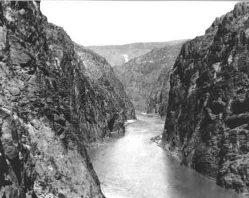
But two years later, on the eve of construction beginning in the Black Canyon (not Boulder Canyon), California water user groups adopted a ‘Seven-party Agreement’ – the fifth ‘Law of the River’ element – that laid some fairly specific claims on ‘surplus water.’
‘Surplus water’ in Colorado River discussions has had three components: most of it (and the most real part of it) was Upper River Basin water that those states were not ready to use, so it flowed on to the Lower Basin, which saw no reason to not ‘borrow’ it rather than wasting it to the ocean. Another, more ephemeral ‘surplus’ component was a million or two acre-feet of water above and beyond the 15 maf divided in the Compact (plus whatever the Mexican allotment would be): the balance of BOR Director Davis’s estimated 16.8-17.5 maf average for the 20-some years of rough records, which would be allotted at some future time. A third, even more ephemeral component was water that the engineers would be ready to import into the river from some larger river, once the Colorado’s water was fully developed.
Remember: contextually we are still back at the naive beginning of the Anthropocene, when everything was still possible. Today, all three components of ‘surplus water’ in the two Colorado River Basins have disappeared – the naked facts have prevailed over the radiant colors of the early romance of engaging the river.
But in 1931 – even with a drier period emerging – a future of surplus was an article of faith, and the ‘Seven-party Agreement’ among the major California water users not only specifically defined how much of the state’s annual 4.4 maf would go to the agricultural users (3.85 maf) and to the new Metropolitan Water District for the Southern California coastal cities (550 kaf); it also got specific about another 962 kaf of surplus water: 662 kaf for the coastal cities and 300 kaf for agriculture – essentially a 10 percent ‘temporary’ expansion of their 4.4 maf allotment.
This was getting pretty specific about something so ambiguous as the ‘surplus water’ described above. But the Metropolitan Water District took it a step further: they designed and built their Colorado River aqueduct to carry not just their designated 550 kaf per year, but the ‘surplus water’ too. They were, in other words, building an aqueduct designed to carry twice their actual allotment; Southern California would grow on borrowed water.
This is why the other states – especially Arizona – were not eager to be sharing the river with California. And it also suggests that the crafters of the Compact and these subsequent LOTR measures were less interested in containing and harnessing the growth energy of the appropriations doctrine than in just grabbing the mane and running with it.
Here at the other end of the Compact’s century, we have to ask if the real underlying foundation of the Law of the River might not be some – well, law of the river itself. It might be good to articulate what law(s) a desert river abides by before inviting 40 million people to partake of it…
Meanwhile – here is an overview timeline of all the elements of the Law of the River as they unfolded over the past century (with gratitude for most of the list to the late lamented Justice Greg Hobbs). This will make no sense right now, but we will be looking more closely at most of them over the coming posts…
1860s to present – Evolution of Appropriation-based Water Law
1922 – Colorado River Compact
1928 – Boulder Canyon Project Act
1929 – California Limitation Act
1931 – California Seven-Party Agreement
1944 – United States-Republic of Mexico Water Treaty
1948 – Upper Colorado River Basin Compact
1956 – Colorado River Storage Project Act
1963 and 1964 – Arizona v. California decision and decree
1968 – Colorado River Basin Project Act
1970 – Operating Criteria for Colorado System Reservoirs
1974 – Colorado River Basin Salinity Control Act
1992 – Grand Canyon Protection Act
2001 – Interim Surplus Guidelines
2003 – Colorado River Water Delivery Agreement
2003 – California Quantification Settlement Agreement
2007 – Colorado River Interim Guidelines for Lower Basin Shortages and Coordinated Operations for Lake
Powell and Lake Mead
2019 – Drought Contingency Plans
Another week, another rise. For the 3rd week in a row we’ve reached a 6-year high in Topsoil S/VS at 68%. Finally a positive. Some of the states w/ the worst conditions (OK) are going to see a lot of rain.
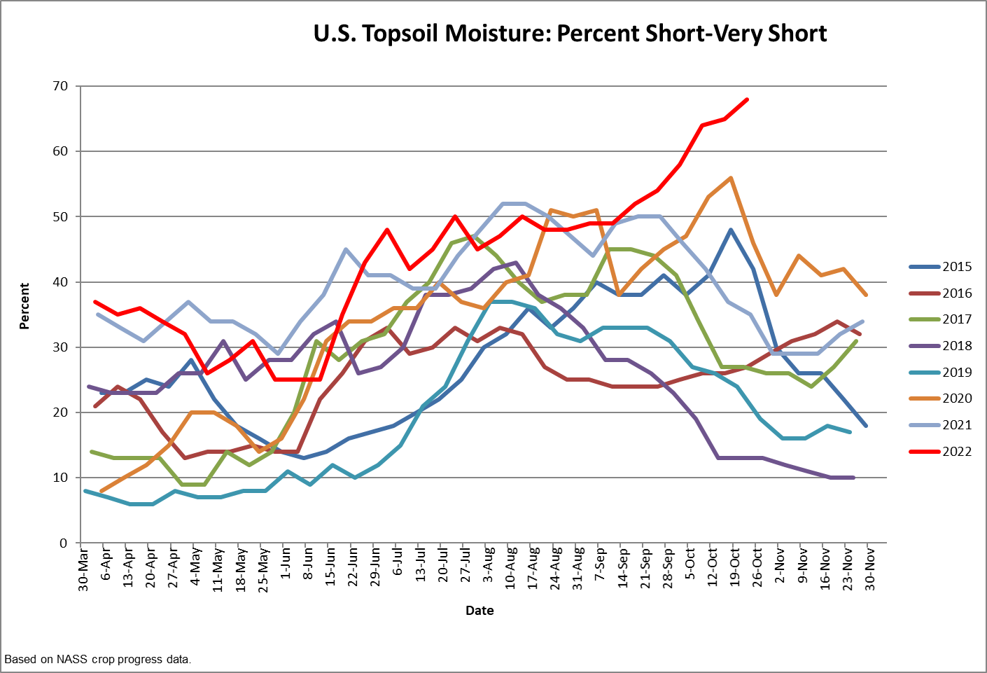
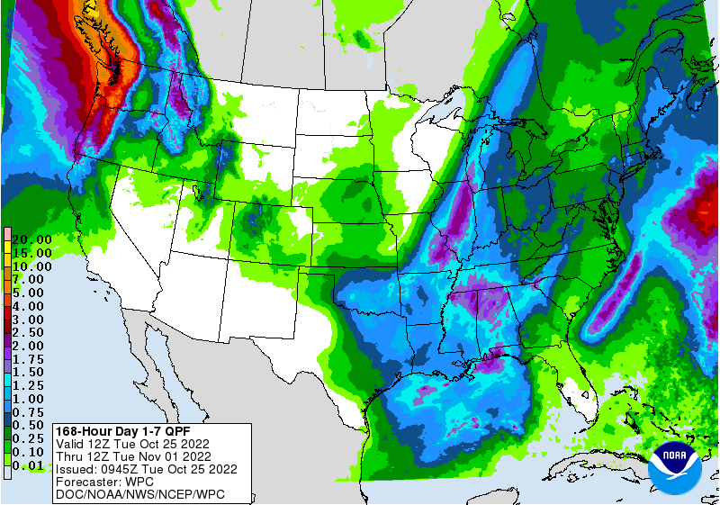
Click the link to read the announcement on the Mesa County website:
The Grand Mesa, Uncompahgre and Gunnison (GMUG) National Forests’ Grand Valley Ranger District in partnership with Delta County, Mesa County and Colorado State Forest Service announce the Grand Mesa Watershed Resiliency Partnership—a large landscape scale effort to reduce the potential for catastrophic wildfire effects in critical watersheds on and adjacent to the Grand Mesa. A series of community meetings will be offered to provide the public detailed information on the effort, what types of projects are considered and an invitation to be involved in the planning.
The Grand Mesa Watershed Resiliency Partnership was created in the summer of 2022 to plan integrated fuels reduction projects on the western portion of the Grand Mesa National Forest. Significant funding to implement projects is anticipated in two years. Early informational sessions with neighboring agencies, local governments, fire chiefs, utility companies, water producers, and wildfire councils have been very supportive. Community members are invited to actively participate and help create fire-resilient landscapes.
“The size and intensity of large wildfires have greatly increased across the West over the past 20 years, often with catastrophic results to communities and watersheds. In response, Congress has provided funding to implement locally-designed projects to reduce the intensity and negative effects of large wildfires. We are starting to work with our local communities now, so we are prepared to receive funding in two years. We are fortunate and grateful to have this unique opportunity, and community support will be necessary for this to be a successful effort,” said Bill Edwards, District Ranger for the Grand Valley Ranger District.
Several open houses in local communities will be available for in-person and online attendance:
For additional information please contact the Grand Valley Ranger District at (970) 242-8211.

Click the link to read the column on the AZCentral.com website (Joanna Allhands). Here’s an excerpt:
The Gila River Indian Community now says it will conserve 125,000 acre-feet of its own water each year for three years and make available for purchase another 125,000 acre-feet of water it has stored underground for others – mostly, central Arizona cities – to leave more water in Lake Mead during that time. The hope is that this will entice others to follow suit – and that might help finally break the logjam on the additional 2 to 4 million acre-feet of Colorado River water that states must stop using next year, simply to keep Lake Mead and the upstream Lake Powell on life support.
We’re nowhere close to saving Lake Mead
Credit the tribe for leading by example. But don’t expect much to change. Farmers must be on board to achieve this magnitude of savings, considering that agriculture uses the lion’s share of water in Arizona and across the Colorado River basin. Yet many are balking at the price the feds have put on the table. And we’re still woefully short of saving enough water to save the lakes. The Upper Basin states of Colorado, Wyoming, Utah and New Mexico, which rely on Lake Powell, have been adamant that the bulk of cuts should fall on the Lower Basin states of California, Arizona and Nevada, which rely on Lake Mead. California recently sent a letter to the feds saying it would be willing to conserve 400,000 acre-feet each year for the next three years, if it gets money to help stabilize the environmental disaster that is the Salton Sea…
Add in Gila River’s proposal, and that’s 650,000 acre-feet on the table in 2023. Another million (or so) acre-feet of water could be in play if the feds carry through with their promise to begin “charging” the Lower Basin states for water lost to evaporation and transit, which the Upper Basin already pays but the Lower Basin pretends doesn’t exist.
Click on a thumbnail graphic to view a gallery of drought data from the US Drought Monitor.
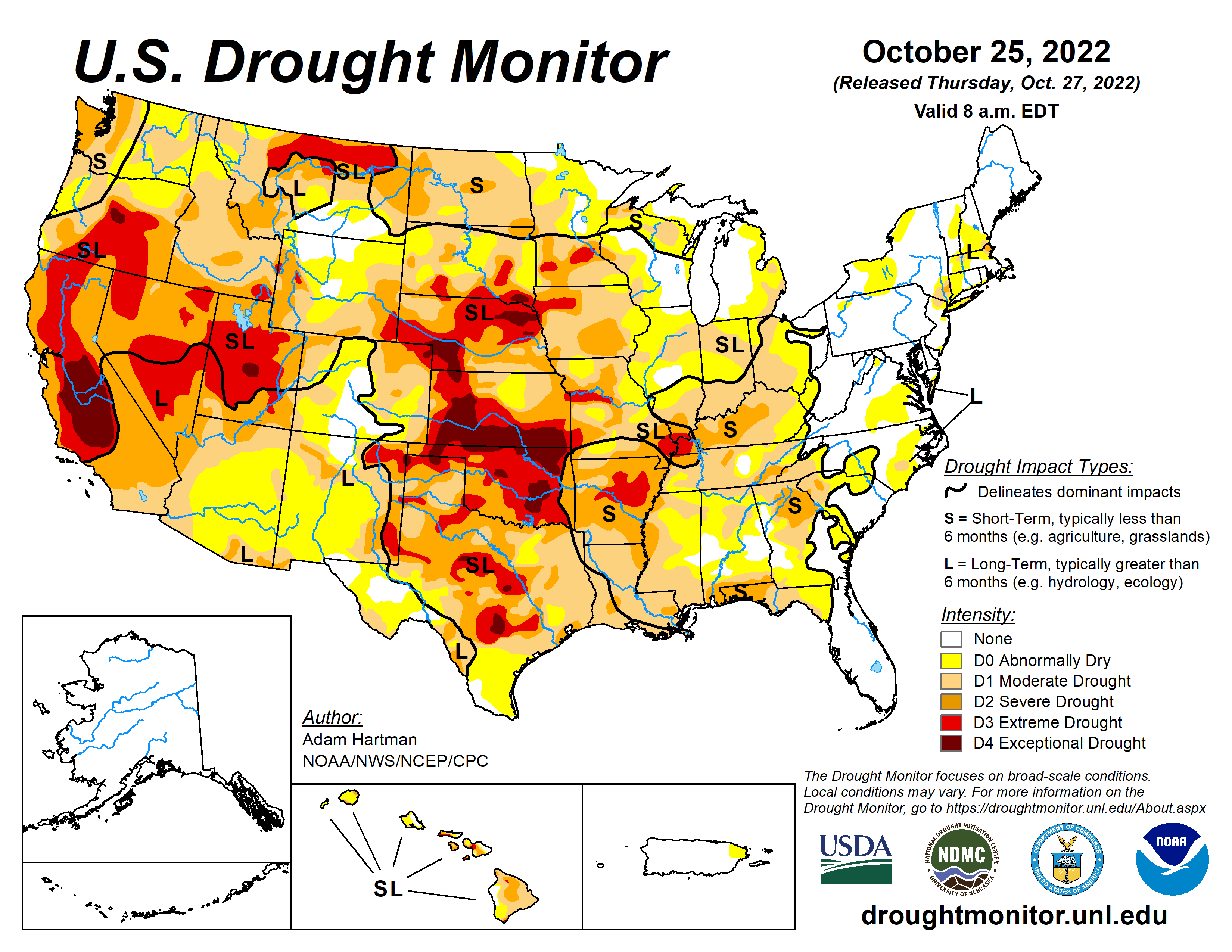
Click the link to go to the US Drought Monitor website. Here’s an excerpt:
This Week’s Drought Summary
A large shift in the weather pattern occurred this week across the lower 48 states. Early in the week, low pressure exited the Great Lakes region, allowing temperatures to gradually moderate during the latter half of the week across portions of the eastern contiguous U.S. (CONUS). In the western CONUS, high pressure broke down as a strong storm system moved into the Pacific Northwest heading into the weekend. As this storm system moved eastward into the Great Plains through the weekend and leading up to Tuesday, October 25, many locations across the western and central CONUS experienced above-normal precipitation, with cooler than normal temperatures in the system’s wake. However, with surface high pressure early in the week followed by southerly flow ahead of the storm system, warm temperatures dominated much of the central CONUS for the week as whole, with above-normal average temperatures also extending northeastward into the Great Lakes and Northeast. Unfortunately, given the expanse of drought and abnormal dryness across the U.S., antecedent dryness led to another week of degradations for many not receiving rainfall, even in areas where temperatures were cooler than normal this week. Warm conditions and high winds further exacerbated conditions in drier areas across the Great Plains. Fortunately, in areas seeing the heaviest rainfall amounts, particularly across the Southern Plains and Ozarks, some improvements were also warranted…
Above-normal temperatures, below-normal precipitation, and periods high winds resulted in degradations to ongoing D1 (moderate) to D4 (exceptional) drought across the Central Plains, east of the Front Range. Stock ponds for cattle remain low to non-existent and pastures are providing marginal feed, with supplemental feed required for many. Conversely, the storm system that moved across the Intermountain West during the weekend dropped heavy precipitation across the higher elevations of Wyoming and Colorado and parts of the Northern High Plains from Montana eastward to North Dakota. Unfortunately, even though several areas experienced in excess of 1 inch of precipitation (greater than 1.5 inches for many locations across the Northern High Plains), short to long-term drought indicators did not show many signs of improvement by Tuesday, October 25. Only surface soil moisture showed some improvement, with sparse 7-day average stream flows also improving, corroborated by ground reports. As such, given the lack of response in the indicators, much of the Northern High Plains remain unchanged this week…
A strong storm system moved into the western U.S. heading into the weekend and moved across the Intermountain West leading up to Tuesday, October 25. Many locations across the Pacific Northwest, Great Basin, and the Rockies received in excess of 0.5 inches of rainfall, with the heaviest amounts (greater than 1 inch, with locally higher totals) concentrated across the Pacific Northwest, Idaho, and Montana. Precipitation was not enough to improve drought conditions in the Pacific Northwest, but was enough to halt another week of degradation along the windward slopes of the Cascades and Coastal Ranges. Only areas east of these ranges, in the rain shadows, experienced some targeted degradations. Farther south, D2 (severe) drought degraded to D3 (extreme drought) north of San Francisco, where USGS 28-day average stream flows have fallen below the 2nd percentile of the historical distribution, CPC soil moisture indicates D4-equivalent (exceptional drought) conditions, and the long-term objective drought blend depicts D3 conditions. Elsewhere, localized and targeted improvements were made across the Intermountain West, based on 7-day precipitation totals and improvements short-term precipitation deficits…
A storm system moving out of the Rockies and intensifying across the Southern Plains dropped in excess of 2 inches of rainfall in a large swath from northeastern Texas to the western Ozarks, warranting 1-category improvements across many of these locations. In surrounding areas that received heavier precipitation amounts, improvements were more targeted in nature, as amounts were not enough to eliminate 90-day deficits. Farther eastward, from the Lower Mississippi Valley to the Tennessee Valley, antecedent dryness and a drier than normal week resulted in another round of widespread 1-category degradations…
Looking Ahead
During the next five days (October 27-31), the storm system that brought heavy rainfall to parts of the Southern Plains will bring rainfall to parts of the eastern Great Lakes and Northeast before exiting the U.S. The pattern will remain active across the remainder of the CONUS. However, much of the precipitation potential will be across the Southern Plains, extending eastward across parts of the Deep South, associated with a low pressure system that is forecast to intensify over the Southern Plains by the weekend before moving eastward through the remainder of the week. The Pacific Northwest is also expected to remain active through Monday, October 31. Additionally, near to below-normal temperatures are expected across the West Coast and much of the Southern Tier of the CONUS, along the predicted storm track. Farther north from the Northern Plains to the Northeast, predominantly above-normal temperatures are forecast due to a lesser influence from the storm track farther south.
The Climate Prediction Center’s 6-10 day outlook (valid November 1-5) predicts increased chances of below-normal temperatures and above-normal precipitation across the western half and two-thirds of the CONUS, respectively, associated with mean mid-level low-pressure. Meanwhile, mid-level high pressure favors above-normal temperatures from the Great Plains to the East Coast and drier than normal conditions from the Mississippi Valley eastward. In Alaska, a southerly storm track favors predominantly above-normal precipitation and is forecast to keep temperatures cooler than normal.
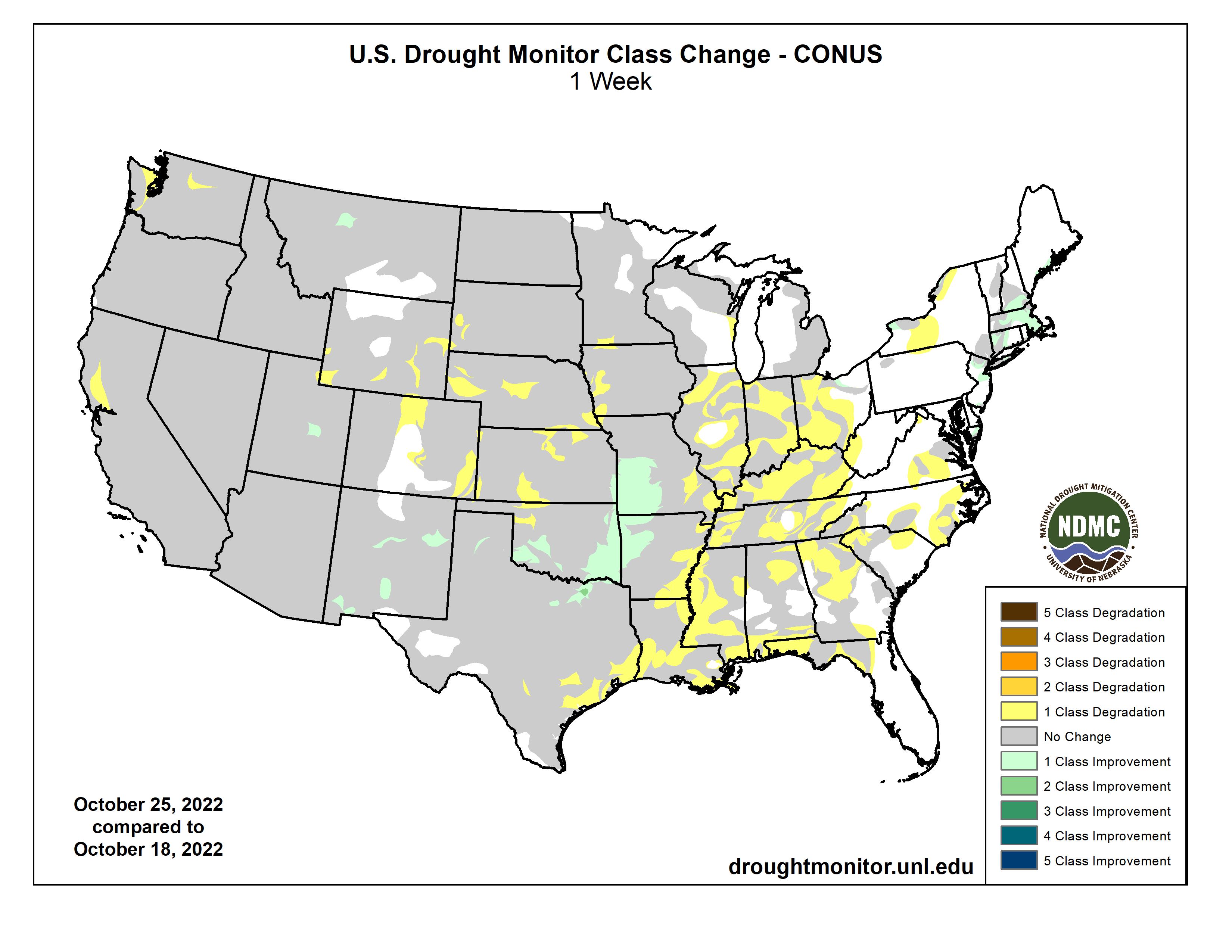
Click the link to read the article on the Denver Water website (Jay Adams):
Nestled against the foothills of the Rocky Mountains west of Denver sits an old concrete canal that’s been delivering water to the metro area since the 1930s.
Fast forward to 2022, and the South Boulder Canal is still performing its regular job for Denver Water.
But the canal has now taken on the added role of generating hydropower, with four small turbines spinning inside the concrete waterway and producing electricity. The turbines were connected to the local energy grid in mid-July.
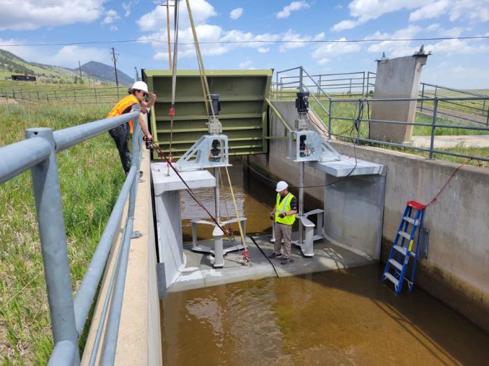
“Denver Water has been producing hydropower at our dams for decades, but this is the first time we’ve generated power from one of our canals,” said Ian Oliver, source of supply director at Denver Water whose team operates the utility’s dams, reservoirs and canals.
The innovative hydropower project began in 2017 when Denver Water teamed up with Emrgy Inc., an Atlanta-based company that specializes in creating clean, sustainable energy using the flow of water through existing infrastructure.
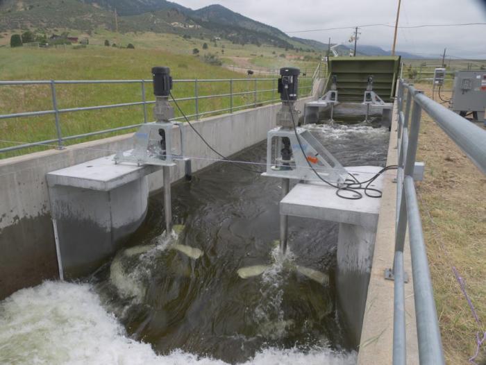
The South Boulder Canal is part of Denver Water’s northern delivery system, which brings water from Colorado’s West Slope to the Front Range. The 8-mile canal starts near Eldorado Canyon and ends at Ralston Reservoir north of Golden.
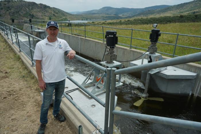
Denver Water typically runs water through the canal about nine months a year, with flows ranging between 50 and 300 cubic feet per second depending on time of the year and water demands in the city.
“Sustainability is part of our mission at Denver Water, so when we met the team at Emrgy and they told us about their turbines for low head applications, we knew it was something we wanted to pursue further,” Oliver said.
In 2017, Emrgy placed an initial array of turbines in the canal as part of a pilot project.
Since that time, the company has continued to innovate its design and installed four new turbines in June. The new turbines are easier to lift, handle and connect to the utility grid through the same inverters used in the solar power industry. The turbines are located at the end of the canal just before it reaches Ralston Reservoir.
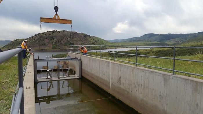
The turbines look somewhat like mixers you’d see in the kitchen to stir cake batter — just a lot bigger, stronger and more advanced.
As the moving water in the canal flows past the turbines, the blades spin and produce mechanical energy, which is then converted into electrical energy. The electrical energy is then fed to a power conversion system next to the canal and delivered to the local power company’s energy grid.
“The process is unique in that it uses the kinetic energy of the flowing water and doesn’t require a large dam to build up pressure to create hydropower,” said Emily Morris, Emrgy’s CEO. “These turbines will work in any channel with moving water where energy can be extracted.”
From the original pilot study, Emrgy refined the hydro system and made the assemblies more modular, so they are easier to deliver and install. The new design also made the turbines easier to remove for maintenance, according to Morris.
Another enhancement focused on the design of the concrete flume box assembly. The flumes include curves in the concrete structure that direct moving water to pass by the rotors more efficiently.
The new turbine system is also more “plug and play,” using the same onshore power electronics equipment used by the solar industry so it’s easier to connect to the power grid, according to Morris.
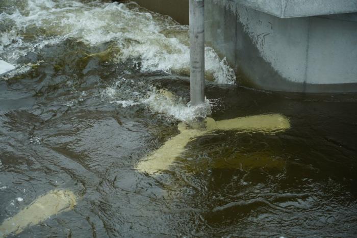
Morris said each turbine can produce anywhere from five to 25 kilowatts of instantaneous power depending on the speed and depth of the water in the canal. If running 365 days a year, that would be roughly enough to power around eight U.S. homes each year.
Denver Water’s role in letting Emrgy use the canal to refine the technology has been a win-win for both organizations. For Emrgy, the pilot program helped them develop their turbines and expand them to three other states in the U.S. and into three other countries.
For Denver Water, Oliver says putting water to work to generate electricity is part of the utility’s annual goal of being a “net-zero” organization in terms of the utility’s overall energy consumption. “Net-zero” status is when the utility produces as much electricity through its hydro and solar power units as it consumes through traditional forms of energy.
With the addition of the South Boulder turbines, Denver Water now has 13 hydropower units at its facilities. The hydro program generates an average of 61,000 megawatts of electricity annually.
“Denver Water’s interest in hydropower is really multifaceted,” Oliver said. “We generate hydropower to sell to the local power grid, which helps offset the consumption of electricity at our facilities, and, by doing so, we’re also helping to meet our own sustainability goals.”
Power generated by Emrgy’s South Boulder Canal turbines is distributed to the local power grid. Denver Water receives a credit for the hydropower on its utility bill, which helps offset energy consumption at the utility’s Northwater Treatment Plant and Ralston Reservoir.
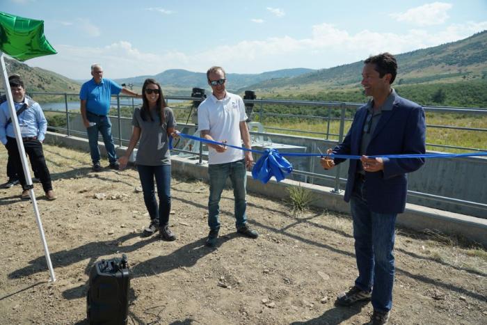
Denver Water and Emrgy are now studying the feasibility of adding six more turbines to the canal in the future to create a larger array of power generation, similar to installing a series of solar panels.
Morris said small turbines in canals help produce clean energy at the local level.
“In order to achieve a truly carbon-free future, we’re going to have to harness the power of the sun, the wind and the power of water,” Morris said. [ed. emphasis mine]
“Water is one of the only controllable natural resources that we have, and I’m excited about the ability to harvest the natural energy here to improve our environment.”
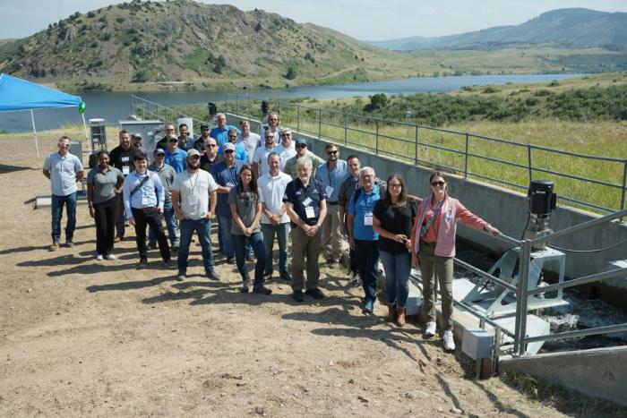

Click the link to read the article on The Arvada Press website (Rylee Dunn). Here’s an excerpt:
After multiple water treatment plant mishaps over the past year, Arvada’s City Council unanimously approved a 12.3% water rate increase to fund improvements for the city’s aging infrastructure on Oct. 17. The rate hike will increase single-family water bills by roughly $19 per bi-monthly billing cycle on average for single-family homes. The increase will see water and wastewater usage rates increase by an average of $13 per bi-monthly billing cycle for single-family homes. It also includes a $4 bi-monthly water service fee increase and a $2 bi-monthly wastewater service fee increase. Primary cost drivers of the rate hike are a 15% price hike for raw water from Denver Water, the recommended issuance of a $50 million bond later this year that will fund infrastructure upgrades and an expected overall operation cost increase of $4.2 million in 2023. Over the past five years, the average in-city water rate has increased by about 3.55% annually, Gillis said. The bi-monthly service fee was last adjusted in 2022 for the first time since 2009.

At the heart of Arvada’s decision to invest in aging infrastructure are two water treatment plants: the Ralston Water Treatment Plant, built in the 1960s; and the Arvada Water Treatment Plant, built in the 1980s. The RWTP is rated at 36 million gallons per day, while the AWTP is rated at 16 million gallons per day. 75% of Arvada’s raw water comes from Denver Water, while the remainder is provided by Clear Creek. Two recent water line breaks and leaks through an exterior wall at the RWTP over the summer have threatened the city’s water supply, as Arvada Director of Utilities Sharon Israel recounted during a tour of the RWTP with the Arvada Press…
At the Oct. 17 city council meeting, Arvada Mayor Marc Williams summed up the position of many council members, all of whom voted for the rate increase.
“We had two major water line breaks in the last two weeks that cost us well over a million gallons of water, I believe,” Williams said. “We’ve got to take lasting care of our community and this is an appropriate step that we’re taking…That passes 7-0; reluctantly, but necessarily.”

Click the link to read the article on the Inside Climate News website (Bob Berwyn):
When Stephanie Kampf visited one of her wildfire test plots near Colorado’s Joe Wright Reservoir in June of 2021, the charred remains of what had been a cool, shady spruce and fir forest before the Cameron Peak Fire incinerated it nearly took her breath away.
“We would walk through these burned areas and they were just black, nothing growing and already getting kind of hot,” she said. “And then you walk into an unburned patch, and there’d still be snow on the ground. You could almost breathe more.”
The surveys, up at about 10,000 feet in the Rocky Mountains west of Fort Collins, were part of a rapid response science assessment to measure just how much the extreme 2020 wildfire season in the West disrupted the water-snow cycle in the critical late-snowmelt zone which serves as a huge natural reservoir. The snowmelt sustains river flows that nurture ecosystems, fills irrigation ditches for crops and delivers supplies of industrial and drinking water to communities.
The findings of the study, published earlier this month in the Proceedings of the National Academies of Sciences, suggest that the relationships of snow and water in many Western mountain forests are caught in a vicious climate cycle, with more fires leading to faster snowmelt and reduced water, which, in turn, makes forests more flammable.
The critical areas are at different elevations in various parts of the West, depending on latitude and other geographic factors, but long-term wildfire records suggest that for millennia, fire was a rare visitor in many high-altitude forests, with burn intervals of 200 to 300 years, or even longer in wetter regions.
In Colorado those snow accumulation zones can produce “on the order of half of all streamflows,” with some geographic nuances, said Kampf, a Colorado State University researcher who is currently on sabbatical in Spain, where she studying the impacts of similarly devastating wildfires that have scorched the Iberian Peninsula in recent years.
During her Colorado research, “It was just so striking to go up to these places and see no snow left,” she said. In one unburned comparison plot a short distance away, there was still more than three feet of snow. “It’s disturbing when you’re accustomed to a place and how it was, and you see it change that much. It’s kind of mind blowing. I suspected that what we experienced in 2020 was outside the norm, but I didn’t realize how far outside the norm it was. And that was just honestly pretty disturbing.”

With the measurements of the Cameron Peak Fire in Colorado as a case study, Kamp’s research team also analyzed satellite data from 1984 to 2020 to show how wildfires are encroaching on the critical snow-storage zones across 70 percent of the Western mountain study area, including the Sierra Nevada, Cascades, Rocky Mountain and Great Basin ranges.
Peak snowpack is declining, which can reduce or even choke off streamflows completely in late summer because the snow is melting off the burned areas much faster. Colorado and New Mexico appear especially vulnerable to fires threatening watersheds that are critical to local residents as well as distant communities on both sides of the Continental Divide.
Wildfires are leaving mountains free of snow earlier in the year, the authors wrote, “and this loss of snow can reduce both ecosystem water availability and streamflow generation in a region that relies heavily on mountain snowpack for water supply.” And as the snowpack melts earlier, the ground and plants warm up and dry faster, setting the stage for more fire in a vicious cycle of climatic changes.
The Extreme 2020 Wildfire Season Was a Warning
The overall drying from climate change is expanding the threat in areas “that historically have provided a large fraction of annual water supplies,” said Paul Brooks, a hydrology researcher at the University of Utah, who was not involved in the new study. “Fires are becoming more frequent in colder, wetter environments that typically burned rarely.”
The research shows that burned forests often reduce the total amount of water stored in the snowpack and speed up melting, he added.
Kampf described her findings in the broader context of the extreme wildfires in the summer of 2020, when wide swaths of the West choked under gloomy layers of toxic smoke that sometimes spread all the way to the East Coast. In Colorado, the Cameron Peak fire burned from mid-August through early December—112 days—with a last patch left smoldering under winter snow near her university’s mountain campus.
“It just kept growing. And it grew to a size that was just unprecedented. And we hadn’t seen anything like that, way up in the higher elevations,” she said. “Then the East Troublesome Fire, which burned in really damp, snow-dominated areas, and then over the Continental Divide, which was not something anyone expected. And so this was just really shocking and concerning.”

Click the link to read the article on The Colorado Springs Gazette website (Mary Shinn). Here’s an excerpt:
The new rules approved by the town council last week prohibit lawns in front yards and limit lawns in backyards to 500 square feet. Castle Rock estimates that the limits on lawns could reduce outdoor water use 50% once the community is fully built out, according to the town’s website.

The community is eliminating future front yard lawns in part to help encourage the acceptance of alternative landscaping that can thrive in a drier climate, he said.

Castle Rock relies heavily on nonrenewable groundwater aquifers and it is working to transition to other sources, according to the town website.
Click the link to read the article on the Fort Collins Coloradoan website (Molly Bohannon). Here’s an excerpt:
In April 2018, Colorado adopted a law that changed the way oil and gas development is regulated, required updates to state regulations and allowed local government authorities to adopt tighter regulations than those established by the state. Following that, Larimer County adopted “comprehensive regulations along with resources for regulatory compliance programs,” according to city documents. Meanwhile, some in the Fort Collins community have expressed concerns about new oil and gas developments within city limits or city natural areas, largely because of traffic, leaks and spills, regional air quality and climate change impacts…
So in response to the changing regulations locally and community feedback, staff developed its own set of regulations for existing and new oil and gas facilities in Fort Collins. Those regulations were presented to City Council at a work session Tuesday night. All in all, council members broadly showed support for the regulations and no concrete changes were suggested. Mayor Jeni Arndt told staff she felt they had “really thought it out well” and appreciated that their updates weren’t adding a high amount of regulations but adjusting and expanding what is in place…
Current oil and gas regulations around setbacks and where wells could be built have left about 3% of city land and open space available for development, but the proposed changes for new facilities decrease that to about 0% availability.
Proposed changes to new well regulations include 2,000-foot setbacks from occupiable buildings, parks, trails or natural areas and would limit developments to industrial zone districts, which are intended to house “a variety of work processes and work places such as manufacturing, warehousing and distributing, indoor and outdoor storage, and a wide range of commercial and industrial operations,” according to the city’s land use code. Very few, if any, land in city limits meets all these requirements, so the regulations would essentially prohibit new drilling. Cassie Archuleta, the city’s air quality program manager who presented to council, said this isn’t “a ban” on drilling in the city but uses zoning to make available surface area “highly restrictive.” Adding to the severity of the regulations, the 2,000-foot standard would leave no room for exceptions, differing from the state’s standard, which allows exemptions.

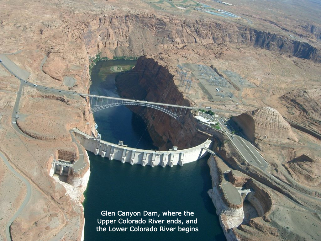
Click the link to read the article the Sibley’s Rivers website [http://sibleysrivers.com] (George Sibley):

We’ve been exploring the Colorado River Compact here – which, like Oliver Wendell Holmes’ ‘wonderful one-hoss shay’ has now lived almost ‘one hundred years to the day’ – the commissioners signed off on it November 24, 1922. The century mark is a good place to pause and pull back for a larger perspective on something like a multi-state agreement and see what it has and hasn’t actually accomplished – but without losing sight of the romantic vision of conquest that drove the Compact’s formation, back in the early decades of the Anthropocene Epoch when reorganizing the prehuman world was still fun.
In the last post here, we looked at the ‘major purposes’ cited in the first article of the Compact: the first listed purpose, ‘to provide for the equitable division and apportionment of the use of the waters of the Colorado River System’ in order ‘to remove causes of present and future controversies’ (fourth purpose); and the final listed purpose, ‘to secure the expeditious agricultural and industrial development of the Colorado River Basin.’
That fifth purpose, to facilitate the expeditious development of the Basin, was the main reason the seven state representatives had convened with a federal representative: they all wanted to get about the development of the river’s waters, the desire to take on Frederick Dellenbaugh’s ‘veritable dragon’ supported by rational reasons such as flood control and storage. In order to achieve that expeditious development, however, it was necessary to achieve the Compact’s first stated purpose: an equitable division and apportionment of the development and the water required – or cutting to the chase for most of the seven states: making sure that fast-growing Southern California did not get most of the water for its racehorse development.
After failed efforts to make specific seven-state divisions of the use of the River’s water, the expedient solution they settled on was to divide the river in two, around the mostly uninhabited canyon region: an Upper Basin including the four states above the canyons (Colorado, New Mexico, Utah and Wyoming), and a Lower Basin of the states below the canyons (Arizona, California and Nevada). It was their clear intent that each basin would get half of the river’s water for consumptive use, with the states in each basin working out an equitable division among themselves of their half, in their own good time.
It may have worked out better, had they stopped there – a 50-50 division of whatever water the river produced, with each basin responsible for half of whatever water might eventually by allotted to Mexico where the river ended. But California insisted on a specific quantification of the two shares because they were already using a substantial amount and didn’t want to over-appropriate. After much discussion and good and bad advice, the commissioners settled on 15 million acre-feet (maf) as a reasonable average flow, between the Bureau of Reclamation’s optimistic 16.5 maf and the less optimistic 13 maf of USGS scientists studying the river.

The commissioners have been chided – castigated – for settling on the 15 maf quantity, which was shown to be overly optimistic within a couple of decades. But they could have countered the criticism by asking why, if their numbers were so bad, had the states not reassembled to correct them?
Frequently in their meetings, there was either frustration or resignation at how little they knew about the river and its flow history. Chairman Hoover summarized that oft-expressed concern in their 21st meeting: ‘[W]e make now, for lack of a better word, a temporary equitable division, reserving a certain portion of the flow of the river to the hands of those men who may come after us, possessed of a far greater fund of information; that they can make a further division of the river at such a time, and in the meantime, we shall take such means at this moment to protect the rights of either basin as will assure the continued development of the river.’ (Italics added) In other words – we can work out the details down the road when we know more; meanwhile, let’s build dams and canals. They built into the Compact, in Articles III, VI, and IX, procedures for those ‘possessed of a far greater fund of information’ to reconsider the Compact to better fit the emerging reality of the River and its flows.
I should note that the commissioners, Anthropocene romantics, actually believed that future generations would reassemble to address the distribution of surplus flows. They anticipated a larger river in the future – if not provided by nature, then by the engineers who would bring in more water from larger rivers that had a surplus. This is the ‘romance of the Colorado River’ – the romance of the Anthropocene.
California’s commissioner McClure accepted the lower 7.5 maf/year figure because it moved along the process leading to stymying the veritable dragon with a big dam for storage of the river’s annual flood. But Arizona’s commissioner, W.S. Norviel, was not happy with any aspect of the two-basin division since it left Arizona competing with California for a diminished quantity of water, a mere half of the river, for which the bigger state already had plans in the process. He was essentially – on orders from economic forces in the state he represented – in a defensive posture, protecting Arizona’s right and capacity to become another California with no interference from the Upper Basin states. Most of the commissioners were patient with Norviel, but frustration was occasionally vented, as when the New Mexico commissioner observed that ‘we are absolutely and utterly up in the air because none of us knows what it is Mr. Norviel really wants.’

What it came down to – what satisfied Mr. Norviel enough to reluctantly sign the Compact – was the concession by the Upper States that Arizona’s tributaries to the Colorado River mainstem would not be counted as part of the Lower Basin’s 7.5 maf/year. This is obscurely codified in the Compact as the mysterious statement in Article 3(b): ‘In addition to the [7.5 maf] apportionment, the Lower Basin is hereby given the right to increase its beneficial consumptive use of such waters by one million acre-feet per annum’ (with no additional responsibility for that accruing to the Upper Basin).
No rationale for this ‘gift’ is to be found in the minutes of the meetings, but it would be naive to think that everything of importance happened in the formal transcribed meetings. Bishop’s Lodge had a comped bar and restaurant, and there were undoubtedly informal meetings, over breakfast and lunch and well into the evenings, and in hotel-room Basin caucuses, as well as phone exchanges with interested parties back home.
The Compact that the seven commissioners signed in late November 1922 might have raised as many questions as it answered for the states and the nation. That unexplained million acre-feet is one such instance. But the big one was, and continues to be – what did the commissioners mean when they said, in Article III(d): ‘The States of the Upper Division will not cause the flow of the river at Lee Ferry to be depleted below an aggregate of 75,000,000 acre-feet for any period of ten consecutive years.”
Does this mean – well, what it seems to say: that the users in the Upper Basin states should do nothing themselves, in the way of consumptive uses, to deplete the flow at Lees Ferry below the 7.5 maf/year average? Or does it mean that the Upper Basin has a ‘delivery obligation’ to the Lower Basin regardless of what happened naturally (drought) as well as culturally (over-use) in the Upper Basin?
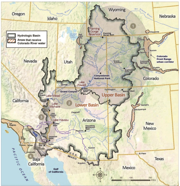
That particular question has remained unanswered because there has been no need to raise the question – yet. The Upper Basin is now consuming only around 4 maf/per year, with nearly all of its good agricultural land watered. Colorado commissioner Carpenter had opined early in the meetings that even at full development the Upper Basin states would still be passing more than half the river to the Lower Basin; that seems prescient in retrospect.
Upper Basin depletions today also include two-thirds of a million ace-feet in out-of-basin diversions to the South Platte, Arkansas, and Rio Grande rivers and the Salt Lake region. Such diversions could conceivably be a black hole into which another million or two acre-feet could be poured, but users in the natural Upper Basin are organized enough now to put very expensive conditions on future out-of-basin diversions – as Denver Water and Northern Water have learned, on ‘firming projects’ for two relatively small diversions into the South Platte for which they already had conditional rights. The Upper Basin states assumed the worst – an unconditional delivery obligation – and have been almost obsessively diligent about keeping the ten-year running average well above 75 maf. Even today, through two decades of aridification, the ten-year average remains in the 85-90 maf range, although the long-term trend in the running average is downward, bringing closer the day when that big question must be answered…
The mysterious or obfuscatory passages of the Compact to one side, however – a larger question, for me at least, is whether the division of the Colorado River into two basins was a good idea for the long term.
As Utah’s commissioner Caldwell observed in the next to last meeting, ‘I think for a practical matter we are almost making two rivers out of one in the Colorado River, to meet a practical situation.’ The ‘practical situation’ was the need for an interstate agreement on the consumptive use of the River’s water ‘to secure the expeditious agricultural and industrial development of the Colorado River Basin,’ and the two-basin concept achieved that.
But the effect over the century has been ‘almost making two rivers out of one,’ rather than developing one river with two basins. The Upper Colorado River is a ‘natural’ river, accumulating its flows from many mountain tributaries that almost all start with snowmelt above 8,000 feet in elevation and gradually conjoin to funnel into the canyon region. The Lower Colorado River is practically a reverse of that, with a single source emerging from the canyon reservoirs and gradually being diverted into canals and smaller ditches and pipes until it has been literally all spread out in southwestern desert destinations.
The clear intent of the Compact commissioners was that these two rivers would be created equal (‘to remove causes of present and future controversies’), but they failed to deliver that in the language of the Compact. Despite some wiggle room provided by the ten-year running average, the Upper Basin was clearly going to bear most of the burden of nature’s extremes like drought, while the Lower Basin was assured under the Compact of a relatively consistent flow of water from storage regardless of what happened in the Upper Basin.
The separation into ‘two rivers’ was enhanced with the construction of Glen Canyon Dam and Powell Reservoir just above Lees Ferry the basin division point; there was no further need for the Lower River to be concerned at all with the occasional dry spell in the Upper River; their portion plus the Upper River’s share of Mexico’s portion (8.23 maf/year) was always there – plus the unused Upper River ‘surplus’ which the Bureau kept sending them, enabling all manner of bad habits in the Lower River.
The problem with ‘making two rivers from’ the Colorado River is a failure to take into account the basic nature of a ‘desert river.’ Around 85 percent of the water for the entire Colorado River Basin originates in the Upper River above 8,000 feet elevation. And around 65 percent of that water is consumed by the Lower River (whose water ‘originates’ in the bubbling ‘spring’ of spent water from Glen Canyon Dam’s power turbines). Yet the Lower River is charged with no responsibility for maintaining and improving the source of its water. The back-and-forth fussing and complaining today between the two basins is evidence of a two-river split, in which the problems of flow lie mostly in the Upper River, and means for addressing those problems ($$$) are mostly untapped in the Lower River’s users.
The Compact commissioners undoubtedly did the best they could with the knowledge they had – and the romantic vision they tried to carry forward in more rational terms: they were primarily out to get about the task of unleashing the Industrial Revolution on Frederick Dellenbaugh’s ‘veritable dragon.’ But their own words in the transcriptions, as well as the ‘reform’ clauses in the Compact itself, indicate that they intended for the Compact to be a ‘living document,’ changing as we learned more about the river.
Why have the Compact’s critics not delved into the document’s weak points and unforeseeable challenges? Some elements of the so-called ‘Law of the River’ – which we’ll explore soon – have attempted to either chip away at the challenges, or to circumvent them. But the tasks of correcting the arithmetic and addressing the two-river questions can no longer be kicked down the road – like Holmes’ one-hoss shay, the Compact could fall apart at a hundred years to a day.
Republished with permission.

October 19, 2022 by Sara Van Note
A nasal, laughing bird call echoed through the Ortiz Mountains in northern New Mexico this September. A couple of pinyon jays chattered loudly as they flew over the piñon pine and juniper woodlands that sweep across the foothills. “They have really fun calls,” said Peggy Darr, then the resource management specialist with Santa Fe County’s Open Space, Trails, and Parks Program. “They’re a very hard bird not to love.”
The jays forage for piñon nuts in the dense habitat on the ridgetop in fall and winter, then cache them in more open areas near the road, she said. Caching is critical for the jays’ survival, but also for the trees. Pinyon jays and piñon pines are wholly interdependent — the piñon nuts provide essential sustenance for the bird, and the jay offers critical seed dispersal for the tree. The pinyon jay is a keystone species of these arid forests of diverse piñon pines and junipers, extending over 150,000 square miles across 13 Western states.
The “blue crows,” as the jays were once known, are year-round residents of 11 Western states, but New Mexico hosts the largest share, about one-third of their population.
Together, jays and piñon pines help create vital habitat for numerous plants and animals, including threatened bird species like Woodhouse’s scrub jay and the gray vireo. The pines also supply a traditional food source for Indigenous tribes and Hispanic communities in New Mexico.
These dusky blue birds once roamed the West in huge flocks, with hundreds alighting on piñon pines to glean nuts in the winter months. Now it’s uncommon to see flocks of more than 100. In the last 50 years, the population of pinyon jays has declined by an estimated 80 percent.
The jay is listed as a “species of greatest conservation need” in New Mexico, and this year the conservation organization Defenders of Wildlife petitioned to list it under the Endangered Species Act, citing “woefully inadequate” protections at the federal and state level.
The two major culprits of the jays’ decline are climate change and a long history of piñon pine removal carried out by federal agencies, including, increasingly, thinning and burning for wildfire prevention. Both have impacted piñon pines and led to declining nut production. Darr, now with the Defenders of Wildlife, said conservation is critical for the jay, but also “for an entire ecosystem, and all the other species” that depend upon it.
In the midst of a historic megadrought in the Southwest and a record-setting wildfire season in New Mexico, land managers are racing to implement wildfire prevention measures. Congress this year directed billions in funds to federal agencies, who in turn are planning significantly increased treatments on millions of acres of federal lands.
In forests, these treatments often involve thinning: the removal of trees by machinery, by hand, or with herbicides. While historically piñon-juniper forests were systematically cleared using destructive techniques like chaining — dragging thick steel chains between tractors to rip out trees in their path — current practices by federal agencies involve more selective thinning.
But some bird biologists, like Darr, are sounding the alarm that even today’s thinning methods degrade pinyon jay habitat. These woodlands are already under extreme drought stress, especially in New Mexico, with predictions for widespread loss due to climate change. And some studies suggest thinned piñon-juniper forests are less resilient to beetle infestation and drought.
In 2004, the International Union for Conservation of Nature placed the pinyon jay on its Red List as “vulnerable” to extinction. It cited a current rate of decline of over 3 percent per year, and a historic loss of “possibly millions” of jays from the 1940s to the 1960s. During roughly the same period, an estimated 3 million acres of piñon-juniper woodland were destroyed to create pasture for livestock.
Bryan Bird, the Southwest program director at the Defenders of Wildlife, said piñon- juniper woodlands have long been maligned as having no economic value, and targeted for removal by private, state, and federal managers in favor of grasses for livestock. The current management imperative calls for thinning to reduce wildfire risk, he said, “which most people think is benign” for the bird. “But it’s not,” he added, noting that the specific habitat requirements of pinyon jays are just beginning to be understood.
Kristine Johnson is a retired faculty member of the biology department at the University of New Mexico who for 20 years has studied pinyon jays and their habitat. While there’s not yet research on the direct impacts of thinning or burning on pinyon jays, Johnson said studies show “extreme thinning” isn’t good for nesting habitat.
And according to Bird, the flood of new federal funds for wildfire prevention combined with what he called a loosening of environmental rules is “not going to be good for the pinyon jay.”
New Mexico is home to four evergreen juniper species and the Colorado piñon, a small tree with short bottlebrush needles that sprout from dense branches. Woody cones tightly grasp its thick, egg-shaped seeds, drawing the garrulous jays to pry them out.
Johnson said the jays have several adaptations that make them excellent seed dispersers for piñon. Their long bills work like a chisel to crack open the tough piñon shell. Their esophagus expands to store up to 50 nuts, and since they’re highly social, one flock can plant millions of seeds in a fall season, Johnson said. They’re strong fliers with a huge range of several thousand hectares. And while they have an excellent memory for recalling their nut caches, the seeds they don’t retrieve can become new piñon trees.
But this feat of co-evolution comes with vulnerabilities. On an irregular cycle, piñon pines produce a mast crop — a particularly abundant supply of nuts. Pinyon jays rely on these mast crops for their reproduction, storing large quantities of seeds in the fall and winter to feed to their young in the spring. In a drought year without a mast crop or other bountiful food sources like insects, pinyon jays may not nest at all, Johnson said.
In recent years, Johnson has observed smaller piñon mast crops, occurring with less frequency, and studies have linked drought and declining cone production. And according to Johnson, not all piñon juniper forests provide good habitat for jays. She recently created a model based on previous fieldwork to predict nesting habitat across New Mexico, and found jays tend to place their nests in larger trees in areas with dense canopy cover and low levels of recent disturbance. Her analysis found the highest quality habitat was “surprisingly scarce.”
A new survey may provide help for jay conservation. The New Mexico Avian Conservation Partners, a state chapter of the national bird conservation coalition Partners in Flight, is surveying for pinyon jays and other birds in thinned and unthinned piñon-juniper forests across New Mexico. Darr, a co-chair of NMACP, said they started the study out of a sense of urgency. “We didn’t have time to wait for a bunch of little studies to be done to get a consensus” on how treatments affect jays, she said. Additional bird species that rely on these forests include Grace’s warbler and the juniper titmouse, both listed as “species of greatest conservation need” by the state of New Mexico.
The second season of the three-year study wrapped up this year, Darr said, and results from the first year’s data show lower densities of some birds in the thinned areas.
The NMACP this year released recommendations for piñon-juniper management, co-authored by Darr, Johnson, and others. Darr said unlike scientists in other states, she and other biologists with the NMACP “feel the science is strong enough” to recommend land managers reconsider or reduce thinning in order to conserve pinyon jay habitat.
For her part, Johnson said some agency management plans “are applied in sort of a generic way,” without taking into account historic wildfire frequency, for example. She noted the scientists’ recommendation for treatments like thinning near human infrastructure, with “less focus on altering the wild areas.”
The U.S. Fish and Wildlife Service declined to make a subject-area expert available for an interview. In a non-attributed written response emailed to Undark by FWS public affairs specialist Allison Stewart in September, the agency cited “little data on the effects of management on jay populations,” and said “we are exploring the effect of the removal of pines and junipers” to reduce wildfire risk in order “to determine if these contribute to short term causes of decline.”
Johnson said some agencies are receptive to recommendations for management to conserve pinyon jays. The Pinyon Jay Multi-state Working Group, for example, recommends that thinning take place outside the breeding season, and that managers avoid thinning in habitat with nesting colonies. “But they’re huge bureaucracies and changing people’s minds takes a long time,” Johnson said.
The recent Defenders of Wildlife petition also noted the impact of rules allowing the approval of projects in pinyon jay habitat without environmental assessments. “It just gives them a path to undertaking large habitat manipulations without considering the impact on this bird,” Bird said.
The petition contains the first estimate of total acreage of piñon-juniper habitat currently treated by the Bureau of Land Management and the U.S. Forest Service in states with pinyon jay populations. The estimate “suggests extensive loss of suitable pinyon jay habitat on federal lands,” with over 440,000 acres impacted, according to the petition.
Bird said that’s why listing the pinyon jay as endangered is critical: “It would require them to take a really hard look at what the impacts are to the bird” and consult with the Fish and Wildlife Service before carrying out treatments in pinyon jay habitat. Johnson agreed, saying that listing the pinyon jay as endangered would have a “huge impact” because agencies would be required to alter their management plans.
Throughout history, Indigenous peoples across the West have foraged for piñon nuts and relied on them as a critical food supply during the winter and lean years. When the Spanish arrived in the Southwest in the 1500s, they also began gathering the oily, protein-rich seeds. The long tradition of families harvesting piñon nuts continues in many communities today. Yet threats to piñon forests endanger these cultural practices.
“I’ve been picking piñon since I could walk,” said Raymond Sisneros, a retired horticulture teacher who farms outside the town of Cuba and traces his family line to the first Spanish settlers.
If the pines near their home weren’t producing, his family would drive to another site. His grandfather taught him how to harvest the nuts, and he sold them door-to-door in the nearby town. Piñon wasn’t a treat, he said, but a “way of life,” a source of both food and revenue. Now it’s rare to find New Mexico piñon for sale.
The last time Sisneros had a big crop near his home was four years ago, and family members traveled from as far away as Tennessee and California to gather piñon. But those traditions may be coming to an end. “I’m scared, because our piñon forest is going,” he said. The large trees that once produced over a hundred pounds of piñon nuts are dying because of drought, he said.
Val Panteah, governor of Zuni Pueblo in northwestern New Mexico, said many tribal members gather piñon in the late fall. He remembers harvesting piñons with his family as a teenager, climbing into trees and shaking the branches so the nuts would fall onto a bedsheet on the ground.
Panteah has observed changes in piñon crops over the years. “When I was really young, it seemed like it was every year” or every other year for a big piñon crop, he said, “but now, it feels like every four years.”
The jays may offer the best hope for resilience for piñon-juniper forests. They’re “the only species that is capable of moving a woodland uphill if there’s been a fire,” Johnson says, “or replanting an area that’s been burned or decimated by insects or drought,” by ferrying seeds away from the degraded area.
Yet these species’ intimate interconnection also leads to what Johnson calls a vicious cycle. If the bird is lost, the woodlands can’t be replanted.
If the woodland isn’t replanted, the bird populations decline.
For the tree, for the bird, and for the people, she said, “it would just be tragic for us to lose these woodlands.”
Sara Van Note is a print and audio reporter based in New Mexico.
This article was originally published on Undark. Read the original article.

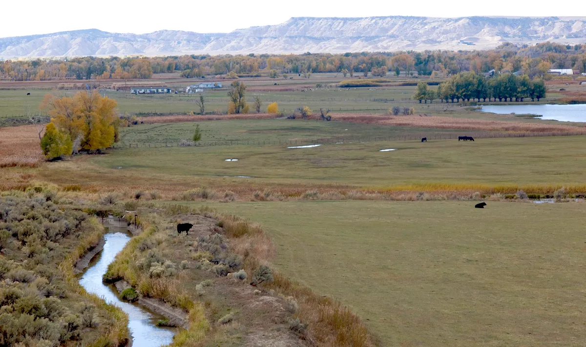
Click the link to read the article on the WyoFile website (Angus M. Thuermer Jr. and Dustin Bleizeffer):
A water fight is brewing in the West, and Wyoming water officials want to prepare for it with a study aimed at parsing and defining the state’s consumption from its Colorado River tributaries.
Anticipating a drier future and either voluntary or imposed restrictions, Wyoming should undertake a “conveyance-loss study,” Jason Mead, interim director of the Wyoming Water Development Office, told the state Water Development Commission on Oct. 6. The goal, State Engineer Brandon Gebhart told the WWDC, is to have a “defensible consumptive-use number to take to the other states,” when and if push comes to shove and Colorado River Basin water users face cuts to irrigation, industrial or municipal uses.
When Colorado River Basin water rights were divvied up starting in 1922, officials overestimated the amount of water the system would produce each year and ultimately promised more water to stakeholders than actually existed. Climate change, drought, shifting weather patterns and a population explosion in the region have exacerbated that initial over-subscription.
Further complicating the picture, the U.S. Bureau of Reclamation — the government’s Western water agency — admits there’s “an inability to exactly quantify these uses.” This “has led to various differences of opinion” regarding who gets to use how much water, the BOR states in a 2022 accounting of the river’s flows and uses.
As a result, the Colorado River and its tributaries — including Wyoming’s Green and Little Snake Rivers — do not have as much water as originally thought and apportioned. On top of that, the water that does flow can’t be precisely measured, and the 40 million people in the seven states and Mexico who rely on it haven’t agreed on how to resolve conflicting views on their rights to use what water there is.
The goal of the conveyance-loss study is to pin down Wyoming’s consumptive use in case it needs to engage in those types of water rights’ conversations with other states.
As a foundation to that study, Wyoming has “a pretty good handle on consumptive use of the crop,” Mead told the water commission. But the state is less certain about another key measurement — the loss from canals and ditches that carry the water diverted from rivers and streams to crops, and how those losses should be accounted for. Only some of those losses may be a debit to Wyoming’s share of the basin’s flows.
With the proposed study, Wyoming would be able to more precisely measure the differences between diverted flows and consumptive use.
That would allow the state to say “when we shut off a ditch … we’re actually saving this amount of consumptive use just along the ditch,” Gebhart told the WWDC. With such information at hand, “I think we could make a sensible argument that we would have to shut off less users.”
Ticking clock
Wyoming doesn’t expect potential curtailments any earlier than 2028, Gebhart told the Water Development Commission. Not all stakeholders agree with that timeline assessment, however, and say a “pinch point” in 2025 could prompt debate and conflict among states.
“The first pinch point [in 2025] raises the issue of the Upper Basin’s obligation to Mexico, if any, under the 1922 [Colorado River] Compact,” Chris Brown, a senior assistant attorney general in the Wyoming Attorney General’s office Water and Natural Resources Division wrote WyoFile.
Mexico was not part of the 1922 compact, but the Mexican Water Treaty Act of 1944 granted that country 1.5 million acre-feet of Colorado River water annually. The compact and treaty are part of a suite of decrees, agreements and court decisions that make up what’s known as the Law of the River.
Regarding Mexico’s share, “the Upper Basin and the Lower Basin have different opinions about that obligation,” Brown wrote. That difference should be addressed before 2025 to “avoid a dispute” he stated.
“That does not mean we will curtail our water uses and, under current circumstances, we will not curtail when we reach that [2025] pinch point…” he wrote. “The difference of opinion itself will not result in a curtailment.”
Sen. Larry Hicks (R-Baggs), an influential water developer in the Little Snake River Basin, recommended the study, Mead and Gebhart said. It’s an “officially proposed project” Gebhard said, and will be discussed by the WWDC further in November with an eye toward securing funding, either from over-subscribed state water accounts, through a different appropriation from the Legislature or some other source.
The study’s first phase could be completed in 2025, after two irrigating seasons of research, officials said.
Pinning down losses
After water is diverted from a river or stream into conveyance systems of canals, ditches and pipes, some of it feeds crops. But leaks and seepage in those canals and ditches also results in loss. Water managers agree that some ditch losses return to “the system” that sustains a river’s flow.
Like “return flow” water that runs back into a river after flooding an irrigated field, conveyance losses that then return to the system shouldn’t count as a debit or depletion against Wyoming’s share of Colorado River Basin water, state officials say, and a study could help determine how much that is.
“Ditch losses that do return to the system (seepage), at some point, are not considered depletions because the water re-enters the stream,” Gebhart wrote in an email.
Some diverted water, however, doesn’t benefit a crop or return to the river and must be counted as a debit. “Losses from ditches that do not return to the system, at some point, are depletions, also known as consumptive use,” Gebhart stated.
These types of losses could be from evaporation, consumption by non-crop plants like willows, consumption by trees on the ditch bank, recharge to deep groundwater aquifers that don’t flow to the Colorado River and other, similar things, Gebhart wrote.
The loss from canals and ditches is only estimated today, and only by some irrigation districts. In a 2021 accounting by the WWDC, only half of the 157 irrigation districts, ditch and canal companies and other irrigation entities contacted by the agency responded.

Statewide, the survey estimates an average of 24% of the water that runs through the conveyance systems is lost. In the Green River and Little Snake drainages, estimates include as little as 0.5% for the Austin Wall Irrigation District on the Blacks Fork and 25% at the New Fork Irrigation District.

Many entities in the Green and Little Snake basins did not respond to the latest survey, including districts where water developers and irrigators want to spend millions of state dollars building or enlarging impoundments to aid irrigation and other uses.
Depletions, losses and consumptive uses
Experts agree that more water is promised to Colorado River Basin water users than the system can actually deliver — essentially 7.5 million acre-feet annually each to the four Upper Division states and three Lower Division states, plus 1.5 million acre-feet to Mexico for a total of 16.5 million acre-feet. The calculation of available water on which the U.S. allocations were based in 1922 was flat-out wrong, many agree, and 23 recent years of drought coupled with climate change have left Lakes Powell and Mead at 28% of capacity, an historic low.
Now some experts say managers should anticipate only 9 million acre-feet annually system wide, according to proceedings at a September water seminar covered by Colorado Public Radio. That’s about three-quarters of what was used by all states, tribes and Mexico in 2021, CPR reported, and far short of the original 15 million acre-feet estimated in 1922.
If Wyoming faces curtailment or some other regulation in the Colorado River Basin, Gebhart said his office would need more staffers to monitor headgates and diversions. Today, a crew of six oversees more than 2,500 headgates in the basin, he said, and that might need to be increased to 36 or so.
Scrutiny by the state engineer is necessary because the 1922 compact prohibits Upper Division states from diminishing Colorado River flows at Lee Ferry, a gauge just below Lake Powell’s Glen Canyon Dam, below 7.5 million acre-feet annually on a running 10-year average. Wyoming is promised 14% of what’s left over to the Upper Division states.
From 2016-2020, the latest data available, a provisional U.S. Bureau of Reclamation report lists Wyoming’s average annual use at 421,000 acre-feet. Ranchers irrigated 305,800 acres in the Green and Little Snake River Basins in 2020, the report states. The population of those basins was 83,800, the BOR said.
At full supply — 7.5 million acre-feet available to the Upper Division states annually — Wyoming’s yearly portion amounts to a little over 1 million acre-feet, experts say. Should the Upper Division supply dwindle to 4 million acre-feet, under the Law of the River and 1944 Mexico treaty obligation, Wyoming would have rights to use only 553,000 acre-feet, according to a presentation by Gebhart’s office in Pinedale in September. In addition to Wyoming’s conveyance-loss study, Upper Division states want to use an up-to-date model to determine river flows and uses.


Click the link to read the article on the Deseret News website (Amy Joi O’Donoghue). Here’s an excerpt:
The storm that hit Utah this weekend spread its tendrils statewide, but was particularly generous with the Wasatch Mountains, delivering 25 inches of snow to Alta at last measurement. That amount of precipitation eclipses the monthly average for that area, 24.4 inches, and more snow is on the way Tuesday and Wednesday, with the potential to add close to a foot to the overall total at Alta. Hayden Mayhan, a meteorologist with the National Weather Service in Salt Lake City, worked over the weekend monitoring the conditions across the state, which also included lake effect snow that dumped 7 inches on the Tooele and Erda areas and blanketed the bench areas of places like West Jordan. Mayhan said snow means the water year is off to a good start, but Utah needs to see storms like this every week or two to make a dent in the state’s shriveling water supply in light of the horrific 23-year drought…
“All watersheds are above normal for precipitation at the start of the water year,” Mayhan said, cautioning that could change quickly if the weather hits a dry spell.
“If we get flatlined, the health of those watersheds could start to go below average fairly quickly.”

George walks us through the motivations and hydrology behind the Colorado River Compact. Click the link to read the article on the Sibley’s Rivers website (George Sibley):
Before getting into the Colorado River again, I want to put out a plea: Please recognize the importance of the coming ‘midterm elections.’ Especially if you live in one of 15 percent of our congressional districts that has not been gerrymandered to a foregone outcome. This is a ‘tipping point’ election, not between two political parties trying to work things out, but between two political concepts with no middle room for compromise: if both houses of Congress tip toward the Republicans this election, rather than remaining barely tipped toward the Democrats, then we are going to be taking a big bumbling step toward authoritarian governance, and away from our evolving American experiment in government by, for and of the people. I think I’m probably preaching to the choir here, but please do what you can to encourage friends to register (especially women, students with debt, seniors on Social Security), and help at the polls – be a poll watcher to counter the armed army of watchers the Trumpistas talk about having out there to make sure only the right kind of people get to vote.
Meanwhile back on (or near) the Colorado River, in 1922, commissioners from the seven basin states were attempting to develop an interstate compact for sharing the river’s waters rather than trying to outrun each other in appropriating it. Not an easy assignment – last post, we looked at the failed efforts of the Compact Commissioners to effect a seven-way division for the consumptive use of the river among themselves on the basis of anticipated development (mainly agriculture). Frustrated and disappointed, they were on the verge of abandoning the effort, but Nevada Commissioner James Scrugham and Chairman Hoover refocused them, reminding them that their charge was not to get stuck in a technical analysis of unknowable details about their futures, but just to ‘to formulate a broad constructive policy for development’ of the river.
In March and early April of 1922 they held hearings throughout the Southwest – mostly, as usual, outside the river’s natural basin – and during that time they passed around an idea that had originated with Commissioner Delph Carpenter of Colorado. This was a bold-stroke division of the river basin and its surface waters into two subbasins: an Upper Basin above the river’s Colorado Plateau canyons consisting of the four states (mostly) above the canyons, New Mexico, Colorado, Wyoming and Utah; and a Lower Basin below the canyons consisting of the other three states, California, Arizona and Nevada.
Each basin would get to develop half of the river’s waters in their own good time, with further divisions by states in each basin being determined whenever it seemed appropriate as the directions of development evolved. This was indeed a broad constructive policy for development.
This two-basin division was the idea they began discussing almost immediately when they retreated to Bishop’s Lodge near Santa Fe in November 1922, determined to work until they had a workable compact to present to their states. Even though it was a disarmingly simple idea, it took them 17 meetings over 11 days to work it out to – well, to most participants’ satisfaction.
How do we today consider, evaluate something like the Colorado River Compact? They were working in the beginning era of the Anthropocene epoch, enthusiastically employing new technologies and organizational systems to harness and rationalize nature – what we might call the Naive Anthropocene. We are living in a much less naive era of the Anthropocene, where much of our attention has to be directed to dealing with the consequences of the Naive Anthropocene, and we no longer seem to have a unified national will for the work of rationalizing nature – even within our individual hearts and minds.
A place to start a consideration of the Compact might be to consider its authors’ own goals, as set forth in the first article of the Compact, and how well they have been followed and adhered to through the century for which the Compact has been a guidestar. (The Compact text is easily obtained by just putting ‘Colorado River Compact’ in your browser.)
Article I of the Compact recites five main purposes: ‘to provide for the equitable division and apportionment of the use of the waters of the Colorado River System; to establish the relative importance of different beneficial uses of water; to promote interstate comity; to remove causes of present and future controversies; and to secure the expeditious agricultural and industrial development of the Colorado River Basin, the storage of its waters, and the protection of life and property from floods.’
I want to look here at the Compact Commissioners first and last purposes. Of the five, only the last purpose – ‘to secure the expeditious agricultural and industrial development of the Colorado River Basin’ – can be considered fully realized; this was, after all, the purpose of the Compact, the ‘broad constructive policy for development.’
And it worked: the Compact ratification process was neither easy nor simple, and Arizona refused to ratify it until 1944. But Congress was accommodating, and within a decade of the Compact drafting, a great dam in the Black Canyon on the Arizona-Nevada border was under construction to control and store the river’s water; the Imperial Weir Dam and All-American Canal to carry water to the Imperial Valley were underway downstream; and the many towns and cities making up the Los Angeles-San Diego corridor were pooling resources as the Metropolitan Water District to build a 250-mile aqueduct from the river – regional development on a unprecedented scale, and all operational by the World War II boom. This was that ‘broad constructive policy for development’ the Compact Commissioners had sought to create.
Construction to control and rationalize the natural river continued in both Basins for the first half of the ‘Compact century’; but after 1970 new construction began to be balanced and then supplanted by efforts to deal with the environmental and socioeconomic consequences of ‘expeditious agricultural and industrial development.’ That is where we are today: the development of the river’s water for human purposes is essentially done; now we are dealing with the consequences of rapid development in order to keep the system operational. Less fun, to be sure, and probably better when taken into consideration before the rapid development. But we seem often to make ‘the naked facts’ and ‘the radiant color of romance’ an either-or choice.
The first purpose stated – ‘to provide for the equitable division and apportionment of the use of the waters’ – is the content of Article III of the Compact, and the Commissioners can only be said to have succeeded in this in a messy way.
Their obvious intent, expressed in the meetings, was to give each Basin half of the river’s water to develop, with a responsibility for each to supply half of whatever was eventually apportioned to Mexico if surplus flows were insufficient to cover that.
From the perspective of most of the Commissioners, that would have been a sufficient ‘division and apportionment’ for the Compact’s purpose. Lees Ferry had been selected as the division point in the canyon region – being one of the few places accessible without a strenuous hike – but there was no measuring station there yet; the only measure of the river’s flow was a 20-year record from a gauge near Yuma. Better, they thought, to avoid specific apportionments between Basins until they had a better sense of the river’s flow.
California, however, insisted that ‘half the river’s water’ be given a specific number; they assumed they were close to whatever their specific apportionment would be, and did not want to go over that. So the Commissioners set about trying to determine a reasonable ‘maximum’ for division and apportionment. They have been most criticized for their decision in this part of the Compact creation, maybe a little unfairly.

They had advice from the Bureau of Reclamation engineers, specifically Reclamation Commissioner Arthur Powell Davis, a nephew of John Wesley Powell and a regular attendee at the Compact meetings, and from Geological Survey scientists, specifically E.C. LaRue – like Major Powell, possessed of an engineering mind that grounded itself in science. Bureau estimates of the river’s average flow, calculated mostly from Yuma data, was around 16.5 million acre-feet (maf). LaRue and his colleagues worked with some of the same data but included both more awareness of evaporation in the desert and more cultural memory back into the 19th century in their estimates, and came up with an average annual usable flow closer to 13.5 maf.
Because it was the 1920s, the beginning of the Anthropocene with the Industrial Revolution producing the equipage for previously unimaginable feats, the Commissioners wanted to go with the ever-optimistic Bureau’s numbers. But calculations using the ten worst years in the Yuma record showed that the 16.5 number would not work dependably. They finally settled on 15 million acre-feet as the compromise between the engineers’ can-do optimism and the geo-scientists pessimism about the river in the desert. At the time, there was a sincere belief (tinged with the colors of romance) that by the time all the water in the river was developed, the Bureau would have the technology and resources to bring in water from some larger river with water to spare.
Within a couple decades of the Compact’s signing – near the end of an unusually wet spell in the Colorado Basin – it was obvious that giving each Basin half of 15 maf, or 7.5 maf each, was more than the river could be depended on to deliver – a situation complicated by the State Department’s apportionment in a wartime treaty of 1.5 maf to Mexico, twice what the Compact Commissioners had anticipated.
So they had screwed up. But possibly more is made of this than the error warrants. Their error did not cause the current over-appropriation of the river, or the potential crash of the reservoir system. What caused that has been a general blithe disregard for the flow numbers for most of the past century by nearly everyone. Are we to believe that, if the Compact had given each Basin 6.5 maf rather than 7.5 maf per year to develop, there would have been fewer subdivisions sprawling out across the desert from ‘Sunbelt’ cities whose economies are predicated on growth, and less irrigated acreage to feed the people (not to mention the horses of Saudi Arabia)? Recently several states have mandated – with varying success ratios – that all new developments be able to demonstrate rights to a hundred-year water supply. But some desert states (hello Arizona) have no state control like that on development. This overuse of the river’s water would probably have happened, whatever number had been in the Compact; no one had been given a big stick to enforce good sense.
The matter of ‘equitable division and apportionment’ deserves a moment’s attention. By the end of World War II, when the Upper Basin states sat down to create their own Compact to divvy up their share of the river, it was obvious that there would almost certainly not be a dependable 7.5 maf of water for them; yet, as they interpreted it, the whole-river Compact directed them to send 7.5 maf a year past Lees Ferry to the Lower Basin. So they assigned to each state a percentage of the water ‘left over’ for them, after that obligation was met, rather than a firm amount – an unusual acknowledgement of the ‘naked facts’ of the matter.
Today, the Lower Basin has been regularly using considerably more water than their 7.5 maf, and the Upper Basin considerably less. The Lower Basin’s overuse was predicated, for most of the century, on ‘unused Upper Basin water.’ Since roughly the turn of the century, however, that slack has been taken up by Upper Basin use, but the Lower Basin has kind of pretended to not notice that. Or the fact that there is no more ‘surplus water’ to cover their half of the Mexican obligation – or for that matter the million acre-feet of evaporation from their reservoirs. The supply cuts the Bureau is imposing on Arizona, and will soon be imposing on California, are just to get them down to their Compact apportionment.
When or if that is actually achieved, the use of the river will be about two-thirds to the ‘desert river’ – the Lower Basin plus Mexico – and one third to the ‘mountain rivers’ of the Upper Basin. That will not be ‘equal,’ but it might be ‘equitable’ – fair, reasonable and just. The irrigated lands of the desert river can produce two or three times what the mountain lands can produce, and the towns and cities of the Upper Basin are more humanly scaled.
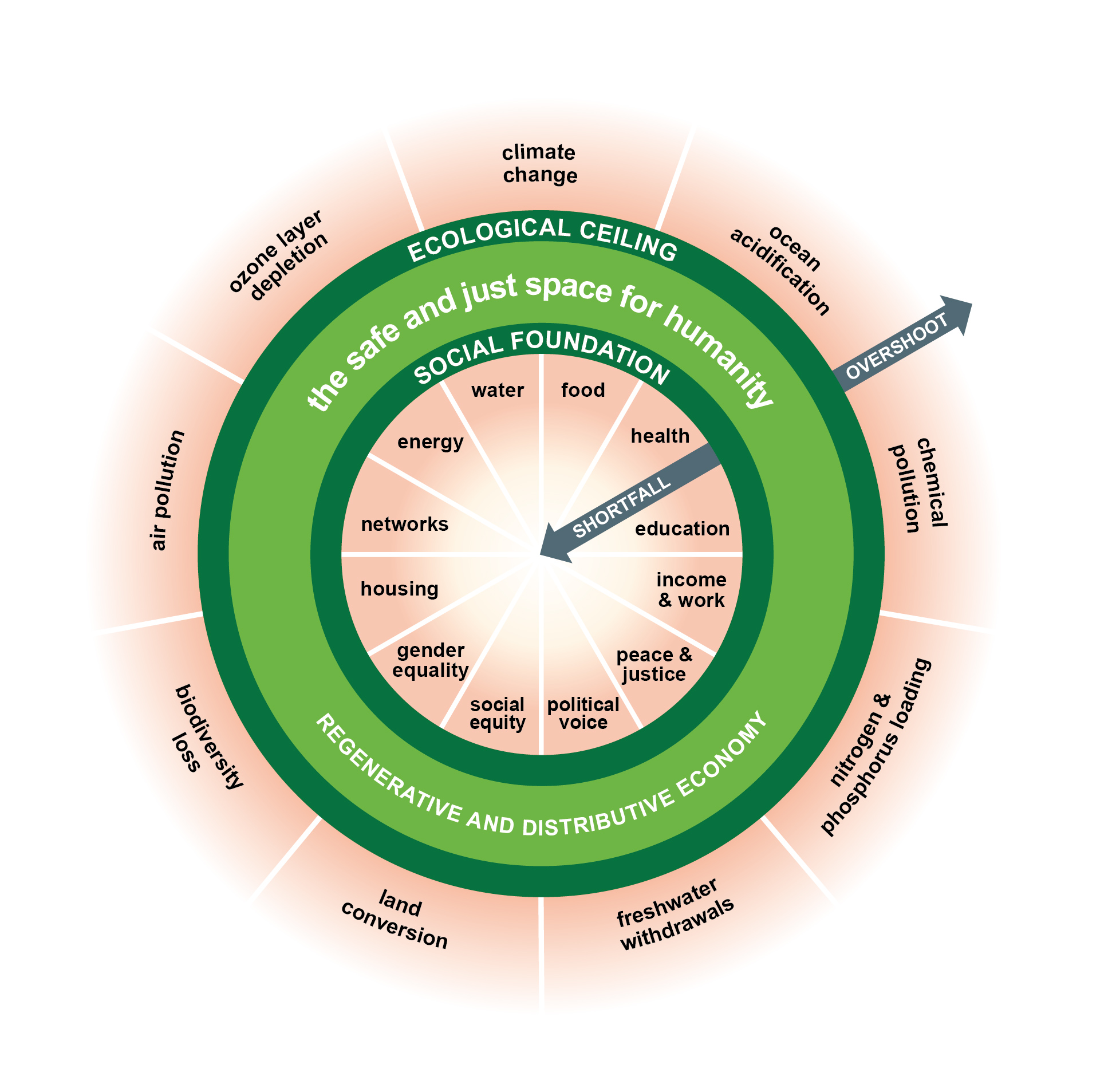
Now everyone everywhere – not just in the Colorado Basin – needs to stop growing. We’ve possibly reached the tipping point where, if you’re growing, you’re dying and taking the planet with you.
I expect to catch hell for saying that. But next time – still considering the Compact: what happens when you divide a river in two?

From email from Relamation (Susan Novak Behery):
In response to sufficient flows in the critical habitat reach, the Bureau of Reclamation has scheduled a decrease in the release from Navajo Dam from 550 cubic feet per second (cfs) to 400 cfs for tomorrow, October 26th, at 4:00 AM.
Releases are made for the authorized purposes of the Navajo Unit, and to attempt to maintain a target base flow through the endangered fish critical habitat reach of the San Juan River (Farmington to Lake Powell). The San Juan River Basin Recovery Implementation Program recommends a target base flow of between 500 cfs and 1,000 cfs through the critical habitat area. The target base flow is calculated as the weekly average of gaged flows throughout the critical habitat area from Farmington to Lake Powell.
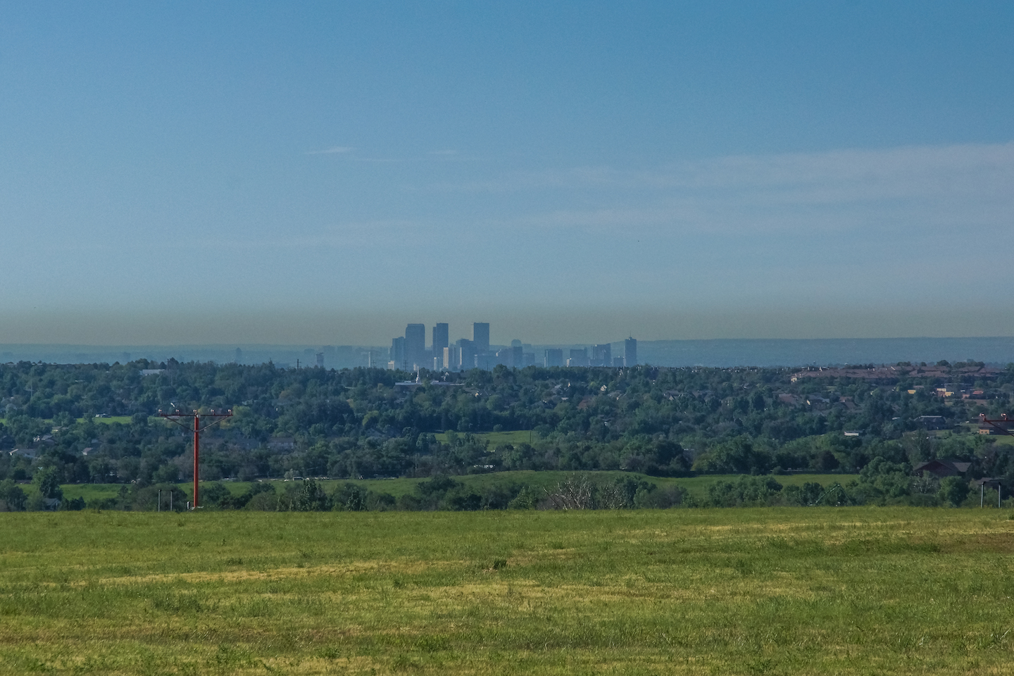
Click the link to read the article on the Colorado Newsline website (Chase Woodruff):
Environmental groups on Thursday [October 20, 2022] reiterated their longstanding calls for Colorado to “go further, faster” to combat climate change, as state officials promised to develop an updated plan for emissions reductions.
In a letter to members of the Air Quality Control Commission, representatives of a dozen major conservation and climate-action groups wrote that time is running out for the state to “correct course on our emission reduction goals.”
“All analyses performed both by the state and third parties come to the same conclusion: policies currently in place and regulations on-the-books are failing to drive down climate pollution at the pace and scale required by Colorado law,” said the letter, signed by advocates from the Environmental Defense Fund, Conservation Colorado, 350 Colorado and other organizations.
The letter followed a progress report presented to the AQCC last month that showed Colorado isn’t on pace to meet a 2025 deadline to reduce its greenhouse gas emissions by 26% below 2005 levels. The target was set by House Bill 19-1261, a landmark climate-action bill passed by the state Legislature in 2019.
Two of Colorado’s top climate officials returned to the commission Thursday to lay out the next steps as the state tries to get back on track. Clay Clarke, head of the climate change unit in the state’s Air Pollution Control Division, acknowledged the state is falling short of its goals, especially when it comes to transportation.
“Emissions from the transportation sector, based on actual fuel sales last year, were higher than initially projected, indicating additional strategies necessary to achieve the sector’s 2025 emissions targets,” Clarke said.
In the long run, state officials remain confident that the wide-ranging, flexible approach they laid out in a 2021 emissions “roadmap” will result in the necessary reductions, including a 50% statewide cut by 2030. That’s especially the case following the passage of the federal Inflation Reduction Act and the billions in clean-energy funding the state is expected to reap from the new law over the next decade.
“We’re going to have significantly more resources to further lean in on climate action,” said Will Toor, executive director of the Colorado Energy Office.
Toor’s office has begun development of what it calls “roadmap 2.0,” which will incorporate the projected impacts of the new funding and other changes. The updated roadmap is expected to be completed by the end of 2023.
“None of this means our work is done,” Toor said. “We need to keep going and go faster. But we’re going to need to carry forward in a thoughtful, holistic way.”
Officials will give another update on the new roadmap’s development to the AQCC in January.
That’s unlikely to assuage environmental advocates, who are urging the commission to use the next three months to identify near-term regulatory actions that could close the “glaring gap” between projected emissions and the 2025 goal.
“With Colorado’s 2025 climate goal less than two and a half years away, the commission has limited time to enact regulations to close the emissions gap,” advocates wrote.
But Elise Jones, an AQCC commissioner and director of the Boulder-based Southwest Energy Efficiency Project, said the roadmap update was a positive step.
“I think we have a process to get to a plan,” Jones said. “I am sympathetic to the fact that the 2025 target is still quite in question, and unlikely to be met.”
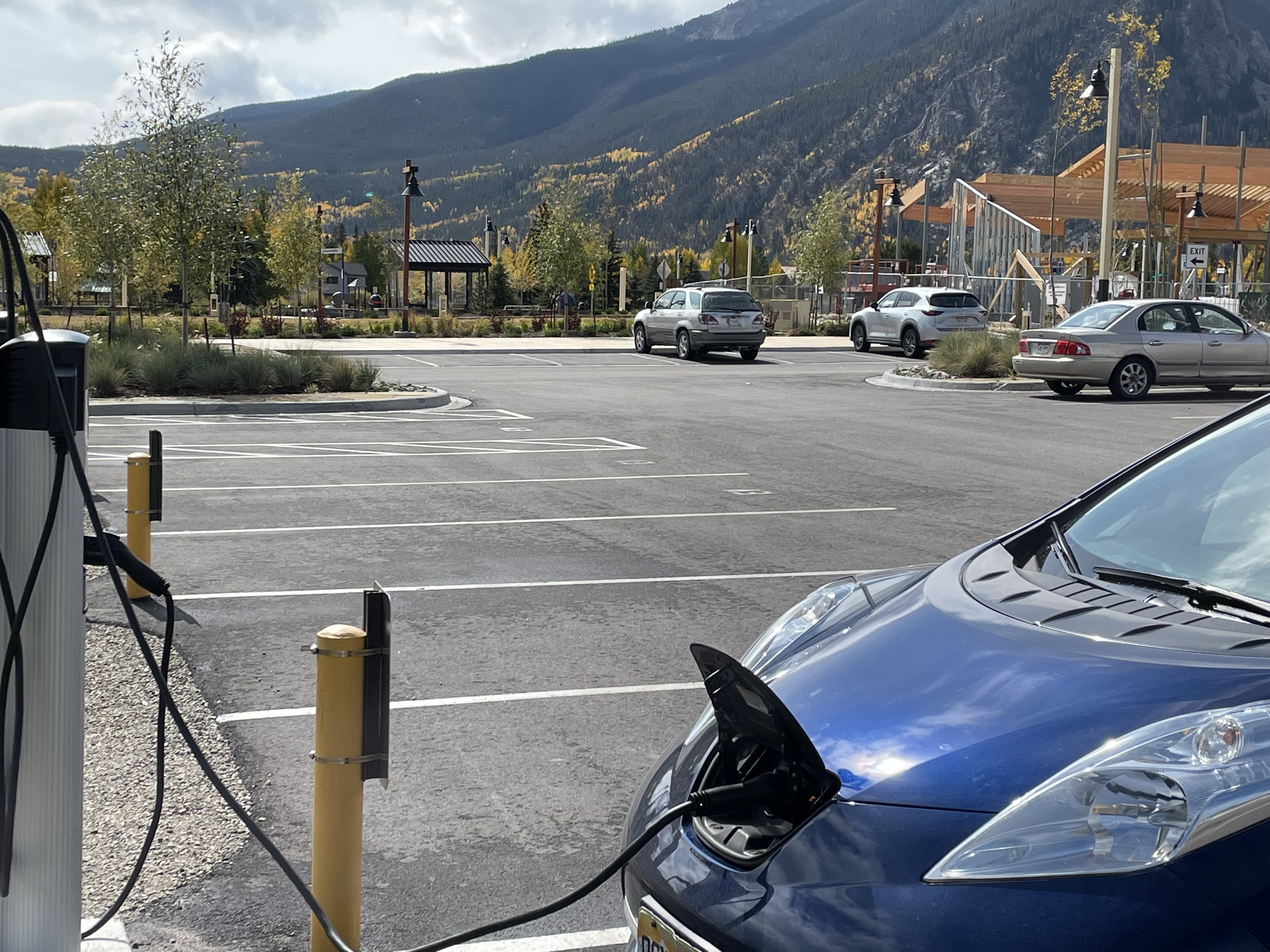
Click the link to access the article on the Ecological Society of America website (Zachary L. Steel, Gavin M. Jones, Brandon M. Collins, Rebecca Green, Alexander Koltunov, Kathryn L. Purcell, Sarah C. Sawyer, Michèle R. Slaton, Scott L. Stephens, Peter Stine, Craig Thompson). Here’s the abstract:
Mature forests provide important wildlife habitat and support critical ecosystem functions globally. Within the dry conifer forests of the western United States, past management and fire exclusion have contributed to forest conditions susceptible to increasingly severe wildfire and drought. We evaluated declines in conifer forest cover in the southern Sierra Nevada of California during a decade of record disturbance by using spatially comprehensive forest structure estimates, wildfire perimeter data, and the eDaRT forest disturbance tracking algorithm. Primarily due to the combination of wildfires, drought, and drought-associated beetle epidemics, 30% of the region’s conifer forest extent transitioned to non-forest vegetation during 2011-2020. Fifty percent of mature forest habitat and 85% of high density mature forests either transitioned to lower density forest or non-forest vegetation types. California spotted owl Protected Activity Centers (PAC) experienced greater canopy cover decline (49% of 2011 cover) than non-PAC areas (42% decline). Areas with high initial canopy cover and without tall trees were most vulnerable to canopy cover declines, likely explaining the disproportionate declines of mature forest habitat and within PACs. Drought and beetle attack caused greater cumulative declines than areas where drought and wildfire mortality overlapped, and both types of natural disturbance far outpaced declines attributable to mechanical activities. Drought mortality that disproportionately affects large conifers is particularly problematic to mature forest specialist species reliant on large trees. However, patches of degraded forests within wildfire perimeters were larger with greater core area than those outside burned areas, and remnant forest habitats were more fragmented within burned perimeters than those affected by drought and beetle mortality alone. The percent of mature forest that survived and potentially benefited from lower severity wildfire increased over time as the total extent of mature forest declined. These areas provide some opportunity for improved resilience to future disturbances, but strategic management interventions are likely also necessary to mitigate worsening mega-disturbances. Remaining dry mature forest habitat in California may be susceptible to complete loss in the coming decades without a rapid transition from a conservation paradigm that attempts to maintain static conditions to one that manages for sustainable disturbance dynamics.
Click the link to read the article on The Grand Junction Daily Sentinel website (Dennis Webb). Here’s an excerpt:
Dave Kanzer, director of science and interstate matters for western Colorado’s Colorado River District, told the district’s board at its recent meeting that the recently concluded water year was an average one overall, but was punctuated by dry and wet months, with monsoonal moisture in July and August helping the state to get through a difficult year.
“But it didn’t take care of our water supply issues, which are still very dire,” he said.
The immediate future doesn’t look all that promising either, heading into what is expected to be a third winter in a row of La Niña climate conditions, something Kanzer called a “triple-dip.”
La Niñas are associated with cooler surface water conditions in the eastern equatorial Pacific Ocean. They tend to bring less winter moisture to the Southwest and more in the Northwest.
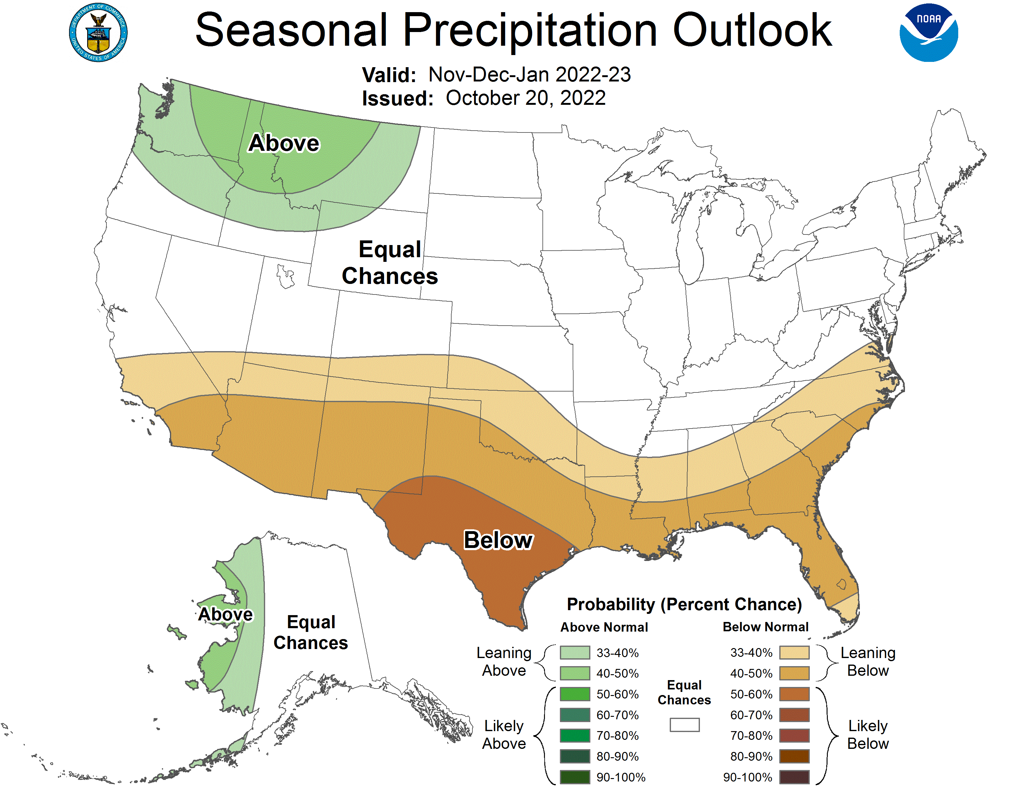
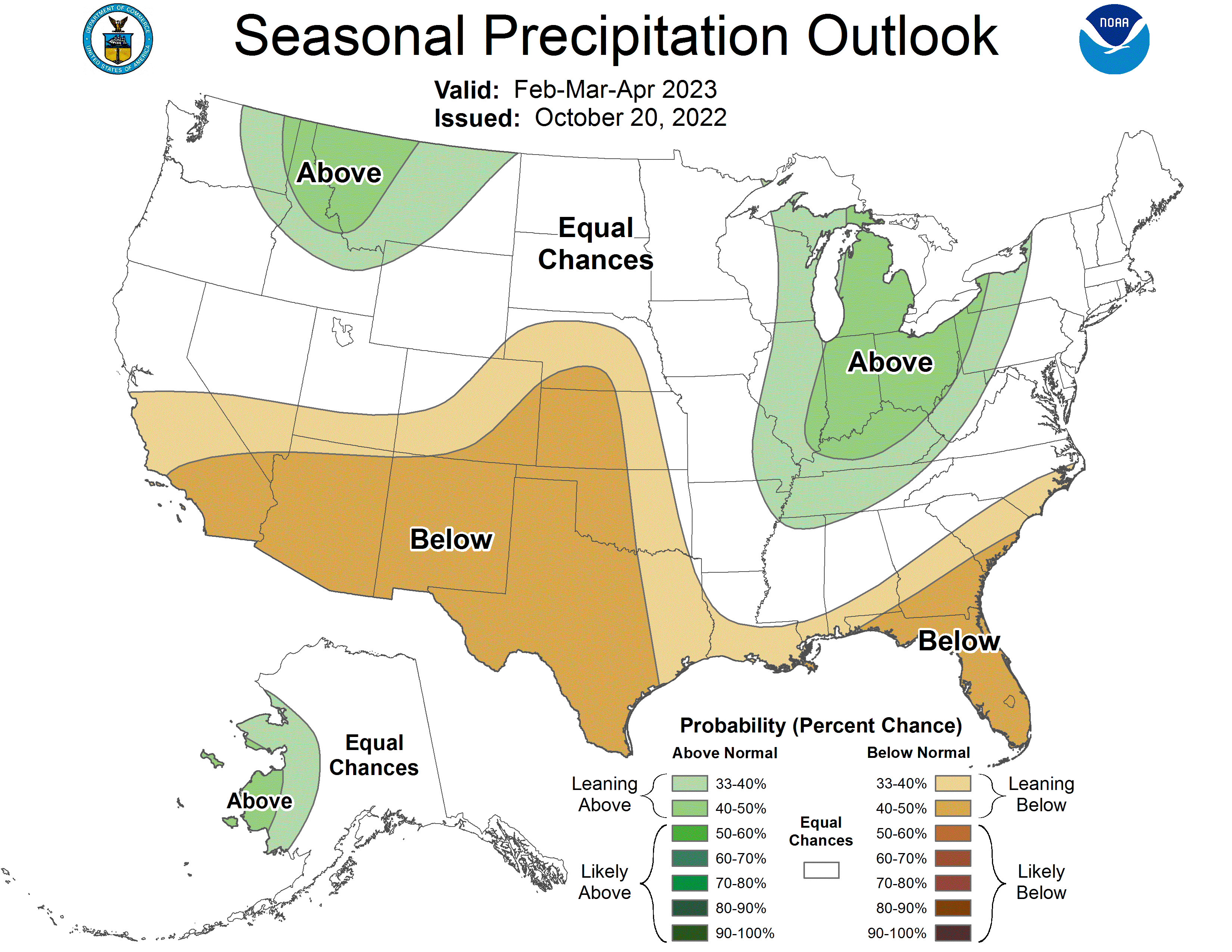
While there’s a lot of uncertainty about what to expect in the case of a rare “triple-dip” La Niña, federal Climate Prediction Center forecasts point to above-average odds of southern Colorado being in for below-normal precipitation through January, and odds leaning toward below-normal moisture for all of the state but northwestern Colorado between February and April. It’s looking like temperatures may be above normal in the state this fall and winter, too…According to a Natural Resources Conservation Service presentation prepared in September for the state Water Availability Task Force, the state’s precipitation was much improved thanks to the summer rains, but “the bulk of streamflow annual volume comes from seasonal mountain snowmelt, which was poor this year. Improvements from the monsoon this year (were) still only a smaller few drops in the bucket when considered as a total of the entire water year budget.”
Click the link to read the article on the Sibley’s Rivers website (George Sibley):
The last episode here ended with representatives of the seven Colorado River Basin states gathering in Washington, DC, as a commission charged, in the words of Herbert Hoover, U.S. Commerce Secretary and Chair of the Commission, ‘to consider and if possible to agree upon a compact between the seven states … providing for an equitable division of the water supply of the Colorado River and its tributaries amongst the seven states.’ He went on to note that ‘this Conference is unique in its attempt to determine states’ rights over so large an area by amiable agreement.’
That was in January 1922; in 2022 we commemorate the centennial of a compact created by the Commission and ratified by six of the seven states and the U.S. Congress, enabling the controlling and harnessing of the rambunctious Colorado River to commence. But this centennial comes in what is probably the worst year those depending on the Colorado River have ever experienced, at the end of the worst two consecutive decades for water in that century – or the past 12 centuries for that matter. ‘Drought’ has become a word of hope in the Southwest, because droughts end; most climatologists concur that the Southwest is mostly experiencing ‘aridification’ from climate change that is, for all practical purposes, permanent.
At the front end of that century, though, hopes were high that the use of the river’s water could be worked out so that, whatever major control structures were built on the river, favoring development by some over others, each state would be assured a share of the river’s water to develop in its own good time.
It is worth taking a moment to look at the seven commissioners and their chairman Herbert Hoover, then Secretary of Commerce. Four of the seven were State Engineers – W. F. McClure of California, Col. James Scrugham of Nevada, R.E. Caldwell of Utah, and Frank C. Emerson of Wyoming. Of the other three, Colorado’s Delph Carpenter was a water attorney, the Hon. Stephen B. Davis, Jr. of New Mexico was a judge, and W. S. Norviel was Arizona’s State Water Commissioner.
Chairman Hoover was also an engineer by training, with considerable experience globally. One might wonder why the Commerce Secretary was chosen as the federal representative rather than the Interior Secretary, but Hoover was actually asked to handle the task by Interior Secretary Albert Fall. Given his interest in such matters, one suspects Hoover might have invited the invitation….
An interesting factoid about the commissioners is that none of them called the natural Colorado River Basin home, with the exception of Arizona’s Norviel, who lived and worked in Phoenix, part of the Gila River Basin which drains most of Arizona (when there is anything to drain) and joins the Colorado River down near its delta. The Gila’s flows, however, are not officially counted in the waters divided by the Compact.
This ties in with another interesting factoid about the compact commission: none of the meeting to divide the use of the river’s waters were held within the river’s natural basin. The commissioners did make a trip through the basin in the summer of 1922, and held one public hearing on the river’s mainstem,in Grand Junction, Colorado; they also visited potential dam sites in the river’s lower canyon region. But basically the river’s future was decided in semi-closed meetings outside of the river’s natural basin – mostly in cities where eventually quite a bit of the river’s water went in tunnels and canals. One is reminded of the old political saying: If you aren’t at the table, you are on the menu.
Transcripts of all the Compact Commission meetings are available online, on the Western Water Assessment ‘Resources’ pages at the University of Colorado website (https://wwa.colorado.edu/resources/colorado-river-resources) and are interesting to read.
The commissioners began their work with seven January meetings in Washington, jumping right into discussion of the equitable division of the river’s waters. Some of the commissioners thought that the best way to try to allocate the river’s waters was on the basis of irrigable land in each state: how many acres of land could be irrigated in each state? Others thought it had to be based the amount of water each state would need to irrigate agricultural land – a quantity that increased with decreasing altitude and latitude due to evaporation. Colorado’s representative Delph Carpenter claimed that it was not necessary to set limits on the headwaters states; if they developed everything evelopable as fast as possible, nature would limit them before they’d used more than a large fraction of the water, allowing most of it to go on downstream.
They asked the Bureau of Reclamation and the state engineers (including those not already on the commission) for data on existing and potentially irrigable acreage in each state. That information was compiled by the sixth meeting that week in Washington, and it proved – interesting.
The Bureau estimated that the seven states plus Mexico already had 2.65 million acres of land under irrigation, with another 4.27 million that could be irrigated, for a potential total of 6.92 million acres. Calculating consumptive use of water to irrigate all of that acreage came to 17.45 million acre-feet (maf) – conveniently right on the mark of 17.3 maf, the 20-year average flow of the Colorado River as roughly measured at a Yuma gauge.
But that chart was countered with one presenting the state’s estimates of how much land they had left to develop agriculturally. Their estimate of existing acreage under irrigation was more or less in the same ballpark as the Bureau’s estimate – 2.95 million acres compared to 2.65 million. But their estimates for irrigable land yet to be developed in the future was a lot more optimistic than the Bureau’s – 7.81 million acres, close to twice the Bureau’s estimate. That much land under irrigation would have consumed 23.71 maf of water annually – a third more than the estimates of the river’s flow from the Yuma gauge.
The transcripts of the meetings don’t note thoughtful silences, but the presentation of those numbers must have precipitated one. Wyoming’s state engineer Frank Emerson then said that his state would probably accept the Bureau’s estimate if the other states would do the same. But Wyoming’s future estimate was only 37,000 acres higher than the Bureau’s; most of the others were two to four times the Bureau estimates, so none of the other states wanted to follow Wyoming’s example.
A note on the Bureau’s set of figures cautions that ‘all data involve estimation in varying degrees.’ Some of the degrees of estimation may have involved the aforementioned ‘Hassayampa microbe,’ then still pervasive in the waters of the River of Color, causing the drinkers to ‘no more see fact as naked fact, but all radiant with the color of romance.’ There was unquestionably a lot of the enthusiasm and optimism that colored the early 20th century, the age of the ‘can-do’ engineer, the dawn of the Anthropocene Epoch when we would ‘rationalize’ nature.
At the last meeting in Washington, the day after the presentation of the data, the commissioners considered ideas for either adjusting the data to fit the river, or collecting more, and more accurate, data, or just proceeding in development for 20 years or so and seeing if there was need then for a compact (Arizona’s idea). Delph Carpenter of Colorado believed that if every state limited itself to developing half of the water in their state, then there would be no problem with in-state development and plenty of water going on to downstream states. The downstream states disliked that idea.
Nevada’s engineer James Scrugham finally lost patience with the whole process, registering a protest against the idea that the function of the commission was to work up the technical data: ‘We are here,’ he said,’ to formulate a broad constructive policy for development which necessitates breadth of view and team work in action. I am opposed to the policy of spending several months time in getting information on small details.’
Toward the end of that seventh meeting, several members wondered if there was any reason to continue with further meetings. Hoover, seeing his vision of great engineering solutions being buried under the unknowable details of the future, practically pleaded with the commissioners: ‘It would seem a great misfortune if we dissolved the Commission without at least agreeing upon so primary a necessity as a control reservoir.’ He echoed Scrugham’s observation: ‘We ought not to let this meeting break up without bringing in a broad visioned constructive plan in general terms so as to advance the whole subject, at the same time not asking anyone to commit himself as to water division.’
The seven commissioners weren’t able to achieve that ‘broad constructive policy for development,’ but they agreed to reconvene after a couple months of discussion with people in their home states.
Hoover reconvened them in March for three weeks of public engagement around the Colorado River region – an adventure that began with public hearings and a commission meeting in Phoenix in mid-March, then to the village of Las Vegas and the canyon country to look at possible dam sites, then on to hearings in Los Angeles, then to Salt Lake City, and over into the upper river region for hearings in Grand Junction, then on to Denver for both hearings and a short commission meeting, and finally up to Cheyenne for hearings in early April.
During this period there were, as one would expect, informal discussions about their charge, and a new idea for dividing the use of the river’s waters emerged from the upper basin state commissioners: rather than pursuing the apparent ‘mission impossible’ of an equitable division according to irrigable land in each state, they might utilize a natural division in the river basin – the canyon region between the developing lands in the mountains and piedmont above the canyon, and the developing lands in the deserts below the canyon – to divide the use of the water equitably between the states above the canyons and the states below the canyons.
Chairman Hoover finally managed to reassemble the Compact Commission in November, to ‘do or die’ – do a compact or let the idea die. At the upscale resort of Bishop’s Lodge near Santa Fe – comped by the owner, a Denver developer – the commissioners participated, along with an ever-changing supporting cast of state governors, engineers, and Bureau of Reclamation officials, in an intensive charette of 18 meetings in 11 days, and created a Colorado River Compact that reflected the stress of working fast under their one-year deadline.
Commissioners Carpenter of Colorado and Caldwell of Utah brought up the concept of dividing the river basin into two basins: a four-state Upper Basin above the canyon region, and a three-state Lower Basin below the canyons, with each getting half of the river for its consumptive use. Considerable discussion followed with commissioners who thought it was an evasion of their charge to come up with an equitable division of the waters among the seven states – even though eventually all the commissioners, polled one by one by the Chair, agreed that they did not have enough knowledge for what Utah’s Caldwell called ‘the necessity of determining with exactitude the needs of the various and sundry states.’ The seven-state division acceptable to all was truly a ‘mission impossible.’
This two-basin division concept enabled them to proceed with a compact that five of the states accepted with no major reservations. California was happy with it because it achieved Scrugman’s and Hoover’s objective of creating ‘a broad constructive policy for development’ that would allow the federal government to proceed with Hoover’s vision of a big dam. The four Upper Basin states were happy because it gave them half the river’s water to develop in their own time, irrespective of what happened in California.
Arizona, however, was not happy with the concept. The Arizonans weren’t just envious of California’s fast growth; they wanted the same for themselves, and wanted enough water available to have it. And while the Upper Basin states were assured of no competition from the ‘800-pound gorilla’ downstream, the two-basin division put Arizona in the cage with the 800-pound gorilla. Their commissioner W.S. Norviel became a contrary presence in the meetings, undoubtedly pushed from behind by Arizona’s governor – a frequent onlooker at the Santa Fe meetings – and other forces at work in that desert state.
Nevada was in the same situation – in the cage with California – but there was practically nothing going on in Southern Nevada where the Colorado River touched the state. Commissioner Scrugham was based in Carson City in western Nevada, and more involved with development of the streams flowing off of the Sierras, to gradually disappear in the Great Basin. In the Washington meetings attempting the seven-state division based on acreages, the Bureau had estimated that Nevada had only 2,000 irrigable acres, while Scrugman had typically estimated on the high side: 82,000 acres. But even that was a pittance compared to the hundreds of thousands and millions of acres in the other six states’ estimates. Scrugham appeared contented that southern Nevada would benefit regardless if a big dam were built practically in its backyard.
That was the situation when the commissioners sat down in the hills above Santa Fe, far from the Colorado River itself, to negotiate the river’s future. ‘I think for a practical matter,’ said Caldwell of Utah, ‘we are almost making two rivers out of one in the Colorado River, to meet a practical situation.’
Next post, we will look at the compact they managed to come up with in those eleven days: an interstate agreement that, like Justice Holmes’ ‘wonderful one-hoss shay,’ has lasted one hundred years to the day – a compact that became the shaky infrastructure for a massive array of physical, political and legal structures laid over the Colorado River region that are currently showing serious cracks – not from the ‘drought’ alone….

Click the link to read the article on The Revelator website (Adam Burnett and Debra Merskin):
Beavers are having a moment. After being hunted to near extinction, they’ve steadily made a comeback, and today both the scientific community and the public have become increasingly aware and appreciative of their profound influence on habitat.
But as environmentalists, journalists and others praise beavers and expound upon their many planet-saving virtues, a problem has emerged: Beavers are too often seen as a tool for humans, rather than animals with their own agency and agenda.
Even those of us who are closely involved with beavers through conservation organizations or habitat restoration have long defaulted to an innate personification of beavers, unfailingly objectifying them and the “ecosystem services they provide.” How many times have you read or said that beaver activities restore watershed health, provide wildfire breaks and refuges, regulate stream flows, and stabilize the water table?
That’s all true, of course. But at the same time, the inference that they’re doing it for anyone but themselves creates an imbalance, an unrealistic expectation of a species that has no interest in the issues of humans.
Beavers are not beholden to the human-caused issues of our planet, and it’s time to adjust our language to reflect that simple but profound fact.
A simple substitution of vernacular, conceptualization and attitudes toward beavers and their natural behavior is vital to creating a well-rounded understanding of the natural processes of wildlife. Endless messages — perpetuated by well-meaning journalists and others — of giving beavers a “role” or “putting beavers to work” can be explained more accurately by “attracting them to locations where they might be naturally successful.” Rather than creating a “collaboration” or “partnership” with beavers, we are simply attempting to “support beaver success” and “restore conditions needed for ecological success.”
The personification of beavers is understandable — and to a certain extent, it’s been useful. Beavers possess natural skills that the Army Corp of Engineers would envy, so the language of “utilizing,” “partnering” and “collaborating” with beavers has served as a vital bridge, as well as connecting us back to a pathway of Indigenous knowledge.
But this also perpetuates a destructive one-to-one relationship with the natural world. “What can it do for me?” has been the guiding question, instead of “How can I be a valuable part of interspecies connectedness?”
A gentle, intentional and more precise reshaping of language around beavers, and nature as whole, could help reconnect us with the origin of our knowledge of interspecies living — recognizing we are not at the “top,” and that human supremacy is a myth.
For those of us who are “beaver believers,” this is incredibly important — to signal through language a path forward in our work, where we work in relationship with natural systems.
Words matter. By placing ourselves side by side with beavers and other species, we can help cultivate and activate a gentle tidal wave that will influence our research, and our relationship to one another and the natural world — and ultimately help restore the natural balance. When we stop seeing and talking about beavers as tools and partners, and instead treat them as free agents with their own agenda completely unrelated to humans, we can collectively transition to the next phase in our conservation effort. We can reach a point where nature is not hierarchically divided in a Linnaean system but recognized as a dynamic organism in concert with itself.
he opinions expressed above are those of the authors and do not necessarily reflect those of The Revelator, the Center for Biological Diversity or their employees.


Click the link to read the article on the Missouri Independent webiste (Allison Kite):
The project is meant to prove that large transfers of water could be a tool to help save the disappearing Ogallala Aquifer, which provides irrigation and drinking water to western Kansas
An agency charged with conserving groundwater in arid western Kansas plans to truck thousands of gallons of water from the Missouri River nearly 400 miles almost to the Colorado border.
Half of the 6,000 gallons drawn from the river will be poured onto a property in Wichita County. The other half will be taken into Colorado.
Groundwater Management District 3, in southwestern Kansas, received a permit from state water authorities for the project, which is expected to cost the district $7,000. The district manager Mark Rude said it’s designed to prove large-scale movement of water could be a tool to keep the Ogallala Aquifer from drying up.
“Basically moving water from where it’s in excess to where it’s in short supply,” Rude said.
But other groundwater management officials say it’s a distraction from the far more urgent task of conserving water that’s quickly disappearing from under Kansans’ feet.
“For one, it’s a waste of water,” said Shannon Kenyon, who manages Groundwater Management District 4 in northwest Kansas.
She said: “Their idea instead of telling their producers, ‘You need to cut back,’ is to just dump water all over western Kansas.”

The Ogallala Aquifer, America’s largest underground reservoir, has been in decline for decades — since soon after farmers started pumping the underground water to cultivate crops following World War II. Some parts of the aquifer have half the water they had before irrigation on the aquifer began. In some areas, there’s only about 10 years of water left.
Loss of the aquifer would fundamentally alter life in western Kansas and destroy farmers’ livelihoods. There’s little surface water since streams that reliably flowed through the area in 1961 all but disappeared, according to the Kansas Geological Survey.
Officials have pursued a number of strategies to help the aquifer, including equipping farmers with probes to measure moisture under the ground to help them water their crops more conservatively without reducing their yield, and reaching agreements with farmers to cut their use.
Rude’s hope with the effort to truck water is to prove that transferring water from where it’s more plentiful or where an area has become flooded is feasible. One such idea is known as the Kansas Aqueduct, which would pump water uphill from the Missouri River at Kansas’ eastern border to western Kansas.
There are no formal efforts underway to make the longshot project a reality, Rude said, but his district’s website houses a presentation on the idea, and he has touted it to the Kansas Legislature in the past.
Rude said going through the regulatory process necessary to truck the water across the state helps walk water officials through the process in preparation for whatever larger project might come along.
“And so what’s the right project? Well, I don’t know. We don’t know yet,” Rude said. “… So you take steps and you evaluate and you learn, and this (proof of concept) is part of that process for the board of the Southwest Kansas Groundwater Management District.”
Earl Lewis, the state’s chief engineer, who signed off on the permit, said the state’s Division of Water Resources didn’t see the district’s project as comparable to a larger water transfer.
“You’re not really demonstrating that you could transfer a large amount of water by hauling 6,000 gallons of water across the state,” Lewis said. “I mean, that happens all the time in the state of Kansas.”
Kansas House Rep. Lindsay Vaughn, D-Overland Park, called it a “political stunt.”
“For the sake of local farmers and families, and for the future of our entire state, I hope GMD 3 starts to take its responsibility seriously, and soon,” she said. “Time is running out.”
Groundwater management districts 1 and 4, which are north of Rude’s near the Colorado border, are taking different approaches to saving the Ogallala. Shannon Kenyon in district 4 said western Kansas needs to focus on conserving water now while an aqueduct could take decades to get off the ground.
“Am I against it? No,” she said. “But do I think it’s fantasy? Yes.”
Katie Duhram, who manages Groundwater Management District 1, noted the district’s board chose not to participate in the project though the Wichita County farm that will receive 3,000 gallons of water lies in the district’s territory.
Durham said it’s always smart to look for projects that could help in the future.
“But I think it’s also important to take steps towards managing the resource that you have in order to address decline in the Ogallala in order to protect the local communities because again,” Durham said.
Both Durham and Kenyon’s districts have established local enhanced management areas, or LEMAs, which allow the GMD to enforce reductions in groundwater use. Durham’s district is working to establish a LEMA covering the whole district.
Rude said his district is conserving water by providing information to well owners on the amount they’ve pumped from the aquifer, how that compares to their neighbors and how they’re affecting the long-term health of the aquifer.
“That information is key for people in their voluntary conservation efforts as well as discussions for collective limits to further conserve the groundwater supply,” Rude said.
At this time, he said, there are no discussions about establishing a LEMA to require reductions.

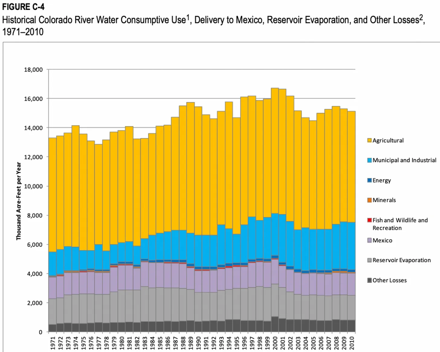
Click the link to read the article on The Grand Junction Daily Sentinel website (Dennis Webb). Here’s an excerpt:
The general manager of the West Slope’s Colorado River District says proposed cuts by California entities in river water use are much less than is needed from that state, and their implication that other states need to step up with similar reductions fails to account for uncompensated, naturally occurring cuts that already impact users in the river’s Upper Basin…He was reacting to an Oct. 5 letter by officials with California water entities using Colorado River water, including the Metropolitan Water District of Southern California and Imperial Irrigation District, proposing to conserve up to an additional 400,000 acre-feet of water in Lake Mead annually from 2023-36…
Mueller said in his memo, “California continues to take the position that it will do so only on a voluntary, temporary, compensated basis and that their participation is contingent upon the federal government paying their water users an acceptable level of compensation and the implementation of additional conservation measures from the other Basin States (including Colorado)…
Mueller and some other Colorado and Upper Basin water officials contend that while Lower Basin water users have been able to rely on water storage in Mead and Powell, Upper Basin water users are subject to varying hydrology that in some years results in users coping with cuts in use. In some years, such as 2014, water users in Colorado reduced consumption by a million acre-feet, or about 28%, Mueller says…
He says the California entities also don’t want the Bureau of Reclamation to start accounting for evaporation and transit loss in the Lower Basin that amounts to 1.2 million acre-feet a year. Reclamation has committed to address that, but Mueller thinks it is afraid to do so out of fear of litigation from Lower Basin states. At a recent river district water seminar in Grand Junction, he contended that while everyone in the basin needs to come up with solutions for reducing usage, the evaporation/transit losses must be addressed first.
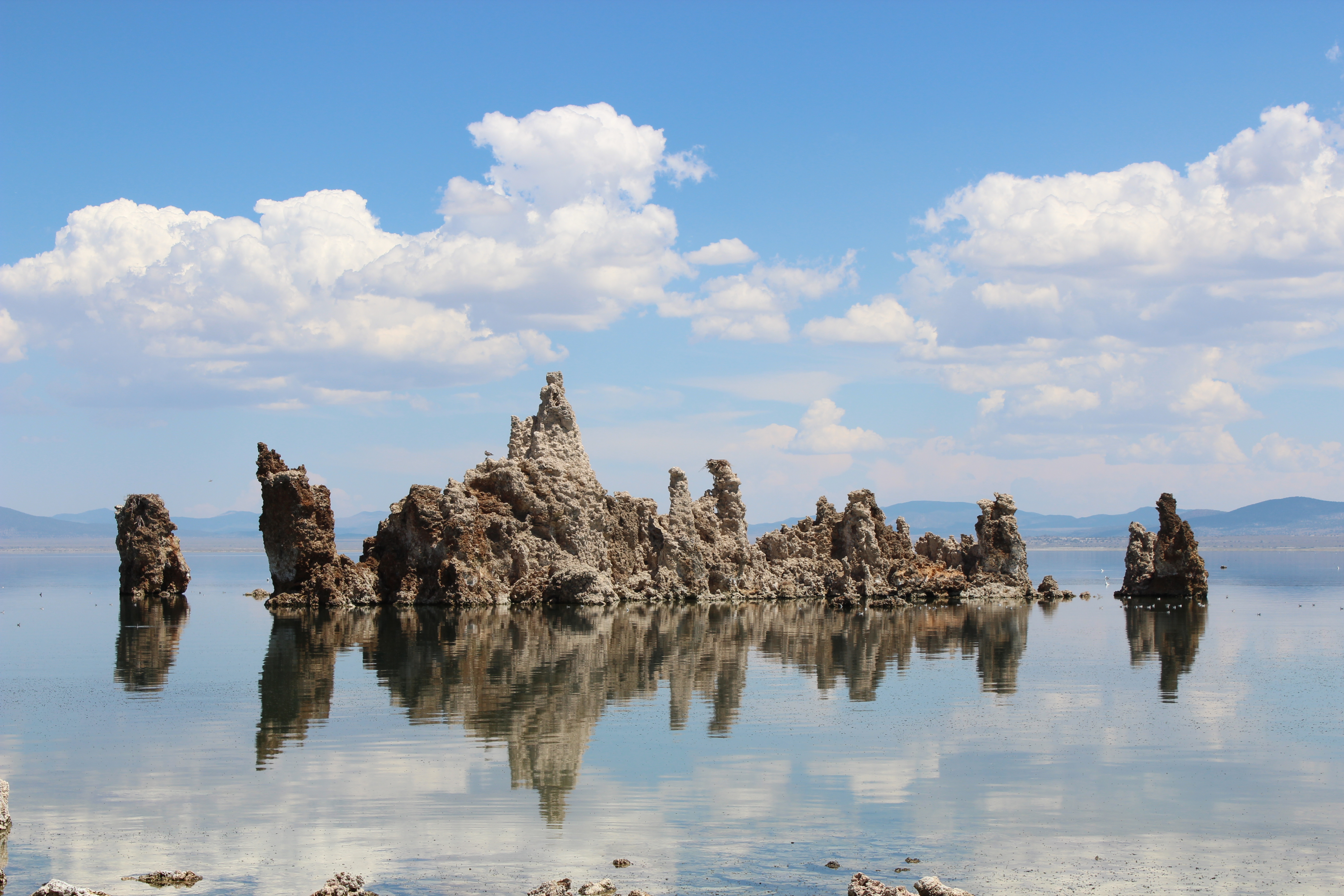
Click the link to read the article from The Salt Lake Tribune on the KSL website (Leia Larsen). Here’s an excerpt:
Owens Lake was one of the first cautionary tales about a salty lake with no outlet when it dried completely from human water consumption in Los Angeles. Lake Urmia in Iran and the Aral Sea in Central Asia followed, drained by scaled-up agriculture. All have since become sites of major dust storms. The Great Salt Lake finds itself heading down a similar path, overtapped by agriculture, cities and industry. But Mono (pronounced “moan-oh”) Lake has emerged as a success story of sorts. Alarmed by the lake’s decline when its tributary rivers were diverted away to L.A., environmental advocates fought back.
“We basically said, ‘Hey, the state is in charge of water rights and you gave [away] these water rights,” said Geoff McQuilkin, executive director of the Mono Lake Committee. “What we see [as a result] is Mono Lake being destroyed. That doesn’t meet the public trust obligation of the state to protect resources for future generations.”
They took their case all the way to the California Supreme Court in the 1980s using that public trust doctrine argument. And it worked. The concept of a public trust has its roots in English law, and may date as far back as the Roman Empire. Various courts in various states have applied the doctrine throughout U.S. history, mostly to settle issues of water access. The Mono Lake decision was the first time the public trust argument secured a lake’s right to exist. Now L.A.’s water utility has to scale back its diversions until Mono Lake reaches a sustainable level. So could someone apply the public trust doctrine in Utah to save the Great Salt Lake?
Some Utahns formed FRIENDS of Great Salt Lake in the 1990s after drawing inspiration from the Mono Lake Committee’s efforts. The group has a similar mission to educate and engage Utahns, helping them understand that the Great Salt Lake isn’t just a dead, empty sea. While the public trust doctrine hasn’t been applied to the Great Salt Lake so far, “certainly, the lake is deserving of this kind of justice,” said Lynn de Freitas, executive director of FRIENDS.
One complication is how, exactly, the public trust doctrine would solve the Great Salt Lake’s problems. At Mono Lake, the culprit depleting the lake was clear: a single utility in L.A. that could be obliged to reduce its consumption. In Utah, a patchwork of cities, towns, agricultural fields and industries across the watershed have dropped the Great Salt Lake by as much as 11 feet, according to a Utah State University analysis.
“So who do you target [in] a public trust challenge?” de Freitas wondered. “… I’m not quite sure.”
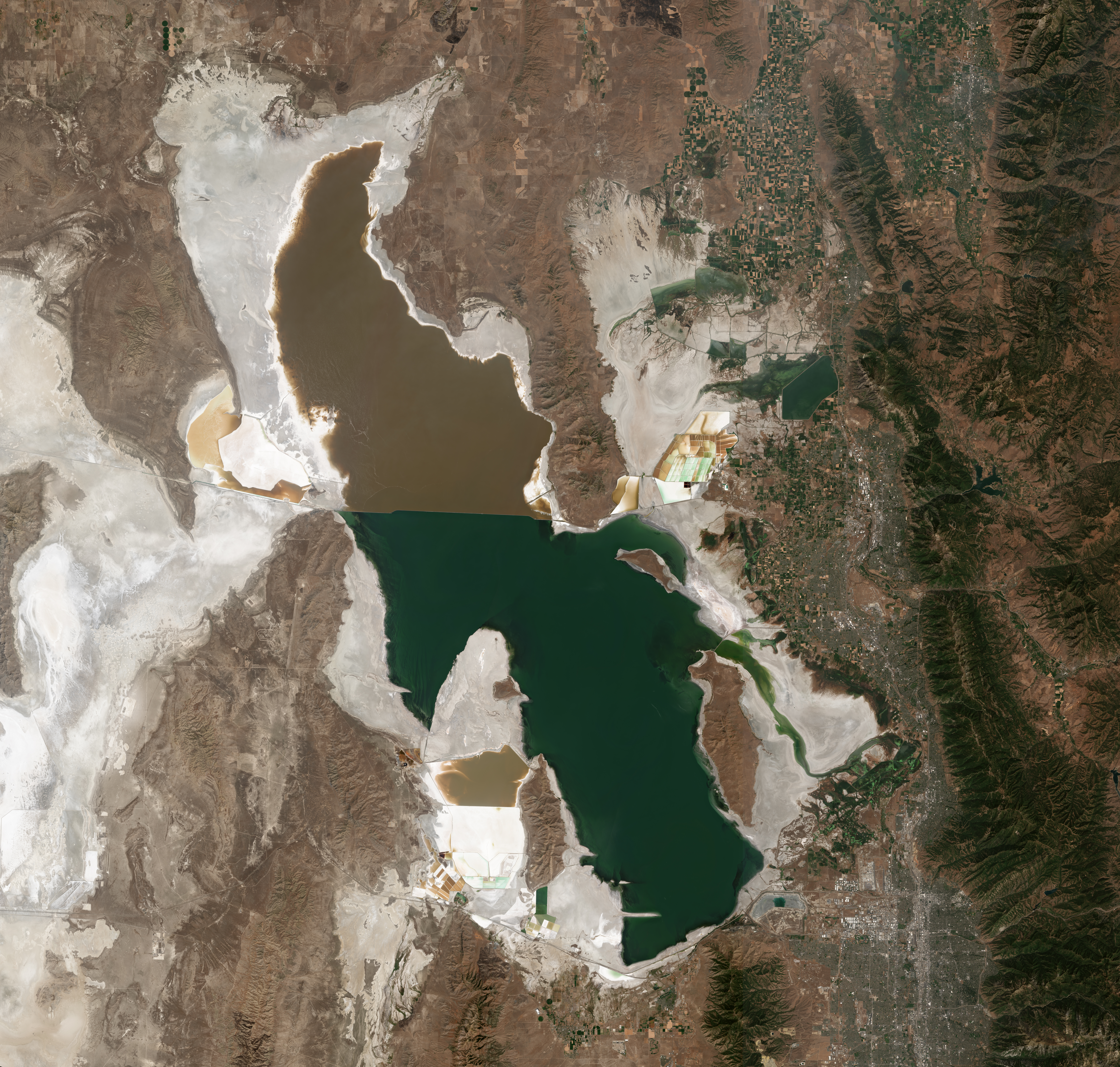

Click the link to read the article on The Grand Junction Daily Sentinel website (Dennis Webb). Here’s an excerpt:
The Colorado River District this week agreed to contribute $75,000 toward a proposed $255,123 project to more accurately assess snowpack in the upper Roaring Fork River Basin next year to improve the ability to forecast streamflow runoff volumes. The district’s board agreed to help fund the work by Airborne Snow Observatories, Inc., a Colorado public benefit corporation that was initially a program in NASA. The company “combines state-of-the-art remote sensing tools with snowpack modeling and fast data processing to deliver snow measurements of high accuracy, high resolution, and full-watershed coverage,” a river district staff memo to the board says…
The river district has agreed to contribute to the Roaring Fork basin project through Community Funding Partnership funding made possible by voter approval of a 2020 tax measure. The city of Aspen has verbally committed $50,000 for the project, Pitkin County is considering a request for a $77,000 contribution, the Twin Lakes Reservoir and Canal Co. has committed $12,500, and funding is being pursued from other Front Range water entities…
Snow-free data for comparison purposes is required for the airborne approach, and was collected this summer from the targeted region, which includes the headwaters of the Roaring Fork River and one of its tributaries, the Fryingpan River. The plan is for Airborne Snow Observatories to conduct an aerial survey around April 1, near the seasonal peak for snowpack accumulation, with a second survey following around mid-May to early June, potentially coinciding with when snow already has melted at NRCS sites. The collected data would be available for free to any interested stakeholder, according to the river district memo.
“The proposed project, through an accurate and comprehensive accounting of snowpack water resources in the Roaring Fork and Fryingpan watersheds, will provide a novel and unparalleled monitoring capacity for these snowmelt-dependent river systems,” the river district staff memo says. “This new capacity, and the runoff forecasts based on it, will provide an additional decision-support resource for water managers in the basins.”
Click the link to read the article on the Pagosa Springs Sun website (Josh Pike). Here’s an excerpt:
At its Oct. 11 work session, the Archuleta County Board of County Commissioners (BoCC) heard an update on the 2-3-2 Cohesive Strategy Partnership from Mountain Studies Institute (MSI) Director of Forest Programs Dana Guinn and Wildfire Adapted Partnership Archuleta County Coordinator Bill Trimarco…
Trimarco then discussed risks of fire in the area, highlighting the work that has been done to protect communities in the region from fire and the potentially vast economic damage that would result from a fire entering Pagosa Springs or a similar area…
Trimarco then discussed risks of fire in the area, highlighting the work that has been done to protect communities in the region from fire and the potentially vast economic damage that would result from a fire entering Pagosa Springs or a similar area…
Guinn and Trimarco also dis- cussed the two Collaborative Forest Landscape Restoration Programs (CFLRPs) — both large-scale, fed- erally funded forest restoration programs — in the region, includ- ing the Southwest Colorado CFLRP and the Rio Chama CFLRP, both created in 2022. Trimarco noted that the Rio Chama CFLRP would involve $30 million in federal funding and that the 2-3-2 Partnership would be involved in organizing and coordinating this project.

Here’s Part 1 of George Sibley’s “Romancing the River” series. In this post George describes the conditions in the Colorado River Basin that led the states to negotiate the Colorado River Compact. Click the link to read the article on the Sibley’s Rivers website (George Sibley):
You have probably heard that this is the centennial year for something called the Colorado River Compact – possibly spoken of or written about in the reverential tones usually reserved for Biblical material. The foundation, the cornerstone, et cetera, for something called, with equivalent solemnity, ‘The Law of the River.’
We will spend some time here on the Colorado River Compact because it is an important document – but not necessarily a document that deserved to exist unaltered and unamended in a kind of hallowed state for a century. Something like our U.S. Constitution in that regard – which has been amended, although not in all the places where it most needed it. But the authors of both documents would be horrified to see their work regarded as sacred texts.
This first post focusing on the Compact will explore why a river compact was even necessary in the development of the Colorado River.
It may come as a surprise to some of you, but the development of the Colorado River was considered to be a conservation project. We remember Theodore Roosevelt as ‘the Father of American Conservation’ – a title he certainly earned for the vast amount of the public domain that he removed from the great American giveaway of land and resources that dominated in the 19th century; he set aside 230 million acres to be developed as national forests, parks and monuments, all kept in the public domain – five times more than any president before or since.
Beyond that, however, other aspects of his conservation vision were quite different from today’s concept of conservation, which emphasizes reduced use of resources, long-term sustainability and the preservation or restoration of natural conditions. For Roosevelt and his conservationist sidekick Gifford Pinchot, conservation meant using the resources we have but using them wisely, without waste.
‘The first great fact about conservation’ said Pinchot, ‘is that it stands for development… In the second place conservation stands for the prevention of waste.’ A third principle was that conservation had to be for ‘the greatest good for the greatest number for the longest time’ – an ominous concept for the remnants of the Agrarian Counterrevolution, watching the flow of people from the countryside into the growing industrial cities.
Roosevelt showed no fear in trust-busting too-big corporations, but when it came to conservation there were easier battles to wage than those against those exploiting minerals, timber, grass and any other lucrative resource that could be more or less legally taken with no requisite sense of public responsibility or sustainability.
There was, for instance, the wastefulness of nature itself (and nature had no army of lawyers defending its wastefulness at the turn of the century). Conservationists today lament that the Colorado River no longer flows into the ocean; but by the tenets of Rooseveltian conservation, freshwater running in an unusable flood through a potentially productive desert and ‘wasted to the ocean’ was a terrible waste.
Thus reclamation was conservation; the Reclamation Service was created in 1902 to address that waste, helping farmers put the river to beneficial use on the land. But, as was observed in a previous post (July 5, 2022), the real problem was not digging the ditches to carry water to the land; the problem was the source of water for the ditches – a wild river that ran huge silty ditch-clogging flows early in the growing season but then had very little water for finishing crops late in the growing season.
This was waste, by Rooseveltian standards, and the Reclamation Service, looking hungrily at all the rapidly emerging new technology for potentially changing the geological face of the planet, wanted to get to work controlling the Colorado River and storing its floods for rationalized use throughout the year. Before work developing the river could begin, however, other problems had to be worked out that had nothing to do with the physical challenges.
The Colorado River wandered through or between seven states – Arizona, California, Nevada, Utah, Wyoming, Colorado and New Mexico – and all of them depended to some extent on the Colorado River and its tributaries as a major source of surface water for all needs. Given the interstate nature of the river, the federal government would have to have at least overseen the development of the river, assuring some degree of equity among the states. And there was the further fact that only the federal government could muster the upfront financial resources for such a set of projects, with a long payback period.
But the seven states all wanted a strong voice in how the river would be developed, and they were quite uncomfortable with the idea of the federal government as the principal operator of their river and water supply. There continued to be a level of mistrust, especially among the agrarians, against the centralized government.
Another problem lay in the fact that all seven of those states distributed the right intrastate to use surface water from the public domain through the appropriations system discussed in the last post (July 18, 2022): in every watershed in each state, use of the water resource was distributed on a ‘first come, first served’ basis; water users could take as much water as they could actually put to use, but their right to use that water was based on their seniority; in a water shortage, those with the oldest water rights got their water first; if they were being shorted by upstream users with junior rights, they could place a ‘call’ on the river, and the junior users would have to let some or all of their water flow past their headgate to fill the seniors’ decrees.
This became complicated within each state when water users in the larger watersheds, composed of all smaller upstream watersheds, wanted priority for the larger watershed administered in all the upstream watersheds too. For example, the Redlands Water and Power Company far down in the Gunnison River Basin had a 1905 decree for 670 cubic feet per second, and wanted to be able to place a call in a water-short year on all junior users in the entire Gunnison Basin, all the way up to the headwaters tributary watersheds. You could be a senior user in your own local watershed, but a junior in the larger more regional watershed. Compilation and administration of all of these rights required a great deal of organization from the state engineer through major hydrologic divisions down to the local districts – the kind of work for which the computer was invented. But for most of a century it was all recorded and maintained in rooms full of ledgers and paper.
But given the willy-nilly nature of state boundaries in the West – almost totally devoid of any geographic or hydrologic sense – a question rose that no one wanted to ask or answer: would the states ‘sharing’ a river have to respect and abide by each other’s prior appropriations? Would ranchers in the headwaters of the Green River in Wyoming be subject to a call on the river from the Imperial Valley in California a thousand miles away?

The headwaters states found it perfectly logical from their perspective to argue that each state should be able to develop intrastate any and all water within its boundaries. Downstream states with no rivers rising within their boundaries, on the other hand, felt that priority of rights should be enforced in a basin-wide way, top to bottom.
Addressing the question was finally unavoidable when, in 1915, Colorado tried to put to use all of the water in a small tributary of the Laramie River in the North Platte River Basin – water which was already being used in Wyoming with water rights granted there. The question of who owned the right to use the water went directly to the U.S. Supreme Court, where it was argued and re-argued several times, but finally in 1922 the Supremes issued their judgment: states with appropriation doctrines sharing an interstate river would have to honor each other’s prior appropriations on that river.
This resolution to another problem among the seven Colorado River states. Every state was growing early in the 20th century, and wanted to continue to grow. (Nevada can be exempted at that time: its development was almost entirely over on the Sierra Nevada side of the state. Las Vegas then was just a small ranching village with some depressed mineral prospectors.)
But the growth was not happening evenly among the states, or within them. The headwaters areas above 7000 feet elevation in the upstream states were growing slowly at best; they were still dealing with the bust of the gold and silver boom, and tended to be losing population. Areas below that elevation, where soil and access to water were conducive to agriculture, were booming. The Montrose-Delta-Mesa County corridor in the Gunnison River basin, for example, doubled its population in those two decades – undoubtedly assisted by the Reclamation Service’s Gunnison Tunnel project (see last post), and a big federal irrigation project in the Grand Valley. Denver and a number of other cities outside the river’s natural basin also doubled their population, and were looking seriously at tapping into the Colorado River’s mountain tributaries.
But while these states were doubling their population in those two decades, the population of Southern California quintupled. And to water that growth, the City of Los Angeles in 1905 reached more than 200 miles out into the southern Sierras to the Owens River valley. Farmers and ranchers in the valley signed over their water rights for what they believed was to be a local Reclamation Service project, but the rights ended up in the hands of the city, which constructed a 230-mile gravity-flow aqueduct that brought most of the Owens River to the Los Angeles Basin. The deceptive way in which many of the water rights were obtained caused an outcry that resonated throughout the remaining agrarian culture nationally. President Roosevelt finally weighed in on the situation: he stated his disapproval of the deception – but then came down on the city’s side: it was the greatest good for the greatest number.
The other six River Basin states watched that situation unfold, and realized that if the federal government answered California’s pleas to take on the task of controlling the river, California might appropriate so much of it that the other states, growing more slowly, might have nothing to use for their eventual development. And the Owens Valley project could become a model for the growing cities to dewater some of their mountain valleys. The alternative to losing access to their river would be a ‘seven-state horserace,’ with each state striving to put as much water under decree as possible, as quickly as possible – not exemplary of orderly growth and development.
The only way to resolve these multiple dilemmas – other than the unacceptable resolution of just turning it all over to the federal government – was through a seven-state compact that would establish some process for the equitable distribution of the consumptive use of the river’s waters.
So Congressional permission for an interstate compact was secured, and in January of 1922, governor-appointed representatives from the seven basin states gathered in Washington with a federal representative as chair: Herbert Hoover, then the Secretary of Commerce. This was six months before the Supreme Court rendered its judgment on interstate prior appropriations in Wyoming v. Colorado, but the handwriting was on the wall there.
Next post: grinding the sausage for the seven-state Colorado River Compact….
Click the link to read the article on The Denver Post website (John Aguilar). Here’s an excerpt:
Castle Rock this week became the second metro area municipality in as many months to pass a measure severely limiting the amount of water-intensive “cool-season turf” that can be rolled out with new homes in the Douglas County town. The new ordinance, passed Tuesday in a unanimous vote of the Castle Rock town council, bans turf in the front yards of new homes and limits it to no more than 500 square feet in the backyard. It also does away with turf in non-functional areas — spaces not meant for recreation — around commercial properties and multi-family developments. The new measure applies to any new home construction permitted after Jan. 1, 2023…
“Water’s on everyone’s mind and how we can conserve it,” Castle Rock Mayor Jason Gray said. “We’re going to get more and more people moving in and we’re going to have to accommodate these people.”
In fact, Castle Rock has plans to grow to around 125,000 people from 81,000 today over the next couple of decades. Nearly half of the water the town uses is for outdoor irrigation and water officials estimate Castle Rock could achieve a reduction of 52% in future outdoor water use if less thirsty turf — like fescue or Kentucky bluegrass — is planted and more drought-tolerant native vegetation is grown, a practice known as xeriscaping. The town has a goal of cutting per capita water usage from 118.4 gallons a day to 100 gallons daily by 2050.

Click the link to read the article on The Greeley Tribune website (Lucas High). Here’s an excerpt:
Two firms — one a Colorado-based hemp bioplastics company and the other a vertical-farming equipment manufacturer from the United Kingdom — were unanimously approved Thursday by the Colorado Economic Development Commission for state incentive packages aimed at enticing them to expand into Northern Colorado.
Project Dunia, an otherwise unnamed company described in commission documents as a “Colorado-based manufacturing company that produces hemp-based bioplastics that are designed for injection molding applications and are compostable,” is eyeing Weld County for a $20 million manufacturing facility.
It is the commission’s practice not to identify companies that the Colorado Office of Economic Development and International Trade is recruiting until incentives are accepted.
Next door in Larimer County, U.K.-based Intelligent Growth Solutions, a company that makes equipment for indoor farming operations, won approval for $2,758,845 in tax credits over eight years to build a North American base of operations that will serve customers in the United States and Canada.