Flaming Gorge drawdown threatens local fishing, recreation economy — WyoFile #GreenRiver #ColoradoRiver #COriver #aridification

Buckboard Marina owner Tony Valdez stands next to a stake that indicates the extent of lowering water levels at Flaming Gorge Reservoir Sept. 26, 2022. (Dustin Bleizeffer/WyoFile)

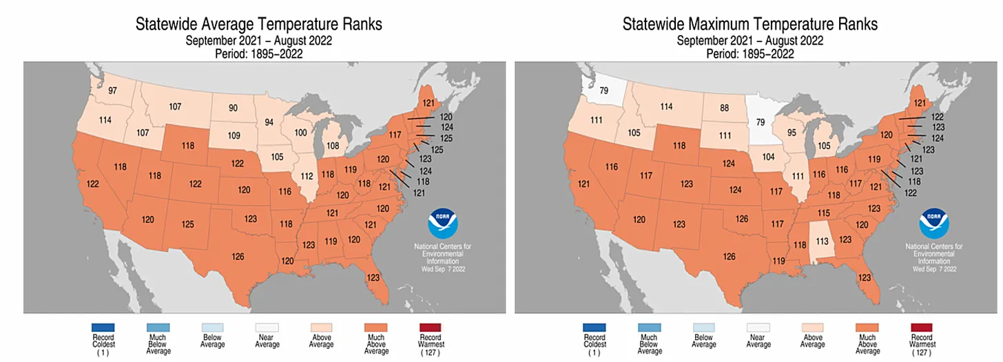
Click the link to read the article on the WyoFile website (Dustin Bleizeffer):

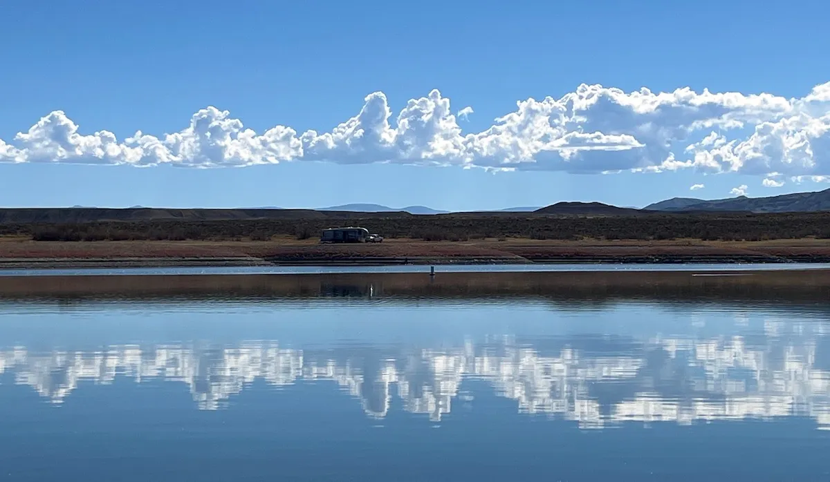
The shoreline of this large reservoir on the Wyoming-Utah border has steadily receded this summer as the Bureau of Reclamation pumped more water out to help maintain critical water levels 500 miles away at Lake Powell.

The water shrunk from boat ramps and forced marinas to scoot docks ever inward. By September, 6 feet of vertical drop in the water level translated into vast areas of exposed lakebed, leaving many boat ramps on the northern reaches of the reservoir high and dry. All told, the reservoir’s elevation is about 12 feet lower today than two years ago, according to the U.S. Geological Survey. Thousands of acres that had been underwater for 58 years now comprise a rainbow of boggy sediment, grasses and invasive plants.

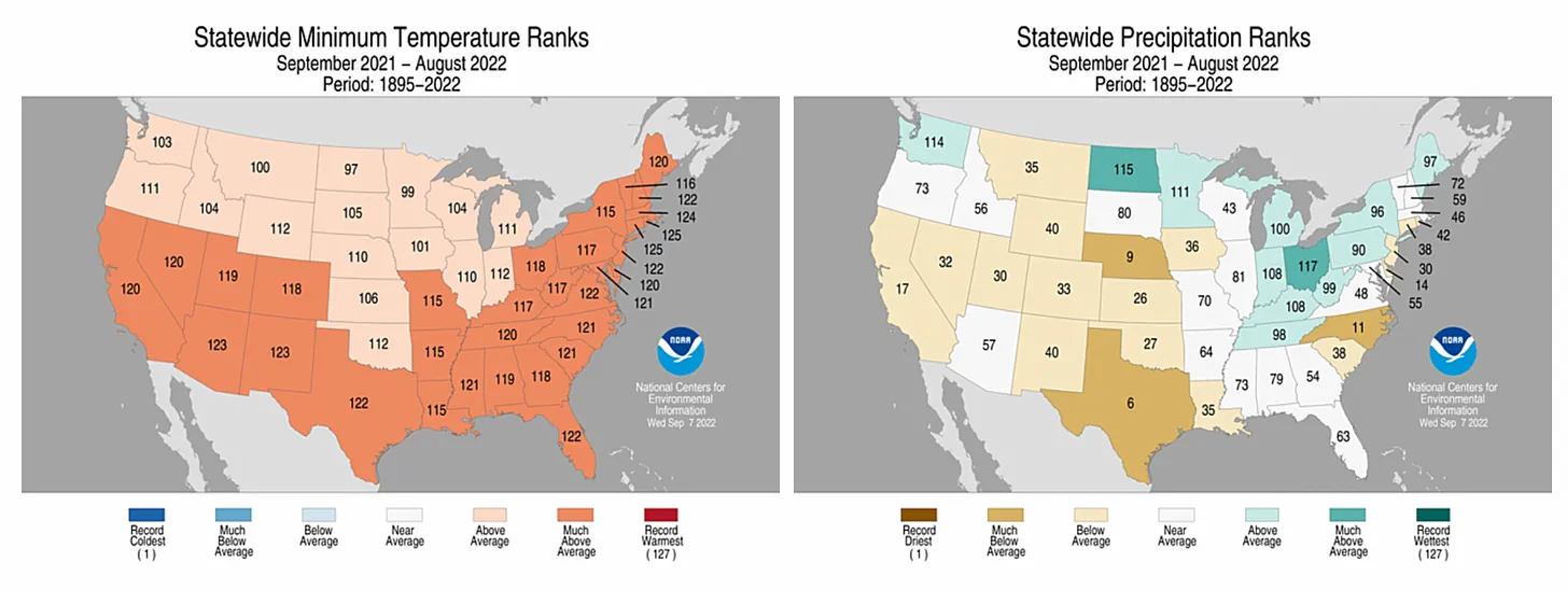
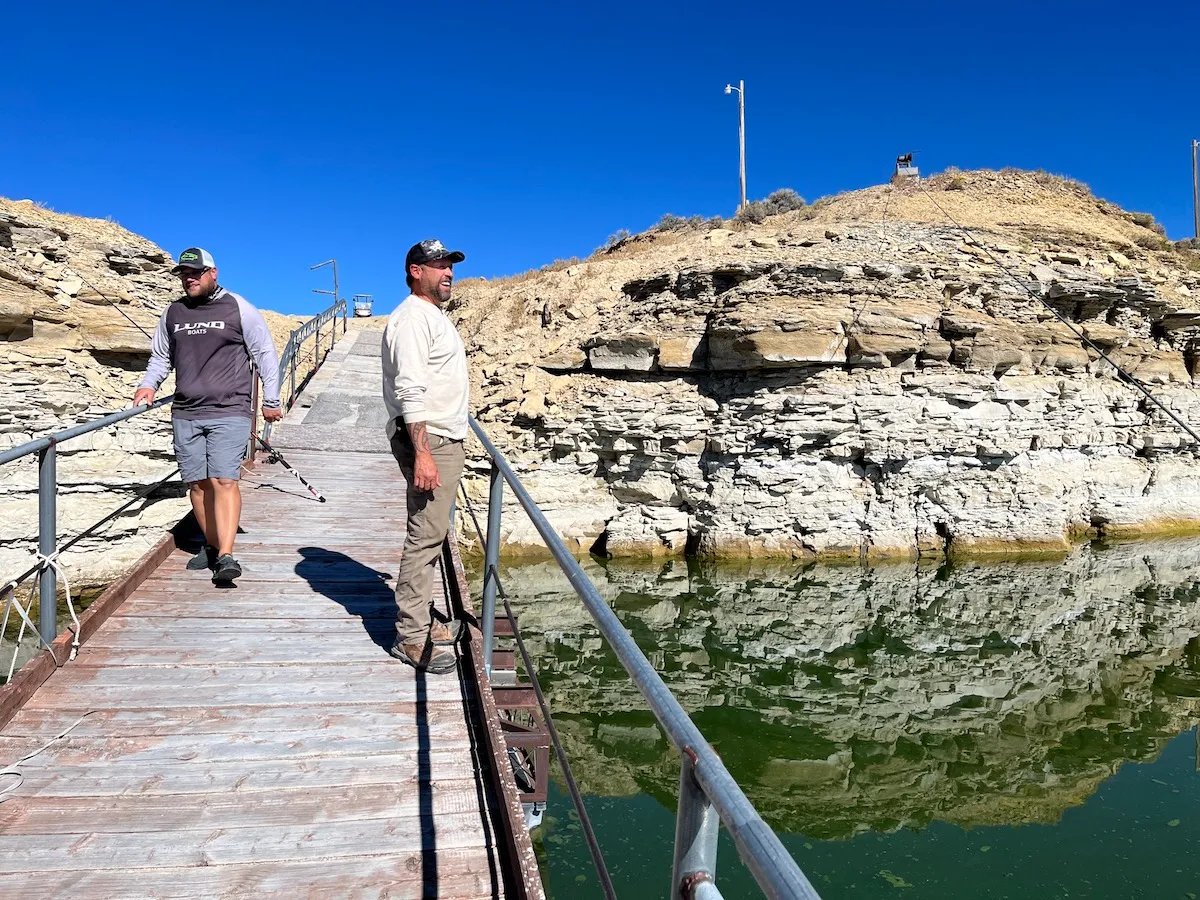
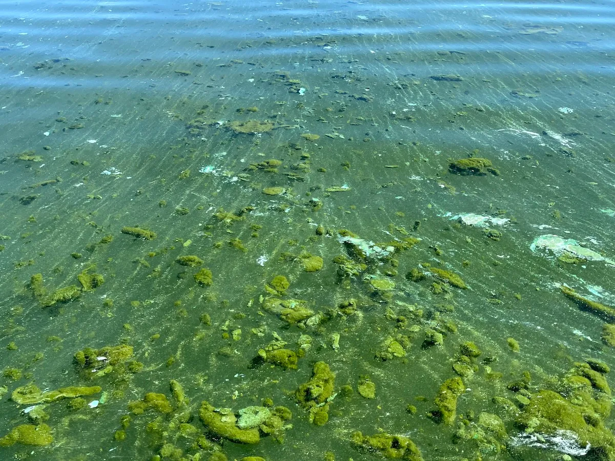
Buckboard Marina owner Tony Valdez and his staff scrambled all summer to keep boat docks in the water, but they couldn’t always keep up. Two large floating docks near a drop-off sank so low that their access ramps became too steep to safely walk. Toxic cyanobacterial blooms have also migrated further down the lake.

Buckboard Marina owner Tony Valdez observes toxic cyanobacteria blooms at Flaming Gorge Reservoir Sept. 26, 2022. (Dustin Bleizeffer/WyoFile)

“I can’t take my grandkids or my dogs to the water,” Valdez said, motioning to big green globs and sheets of muck as he stood on a boat dock. “We’re losing our marina. It will be gone after next year.”

When Valdez bought the marina in 2019, he immediately began making renovations. It was a solid investment, he believed, for a popular service at the largest recreational draw in southwest Wyoming. 

The BOR had maintained seasonably stable water levels at Flaming Gorge since 1964 when the dam was completed. Businesses in Wyoming and Utah built an economy around the fishermen, boaters, bird-watchers and others drawn to the massive impoundment.

Things began to change, however. Valdez first noticed that vehicles and boat trailers with plates from California, Arizona and other southwestern states became increasingly prevalent at the marina, he said, as reservoirs along the Colorado River began drying up.

Campers, seen here Sept. 26, 2022, are set up in areas previously under water across the bay from the Buckboard Marina at Flaming Gorge Reservoir. (Dustin Bleizeffer/WyoFile)

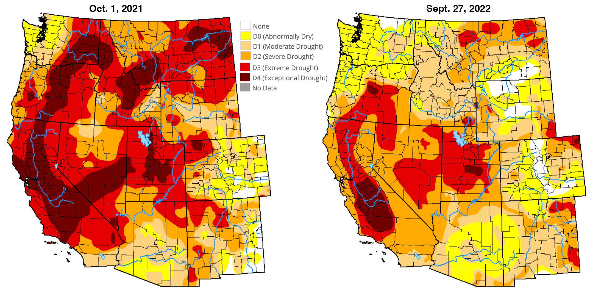
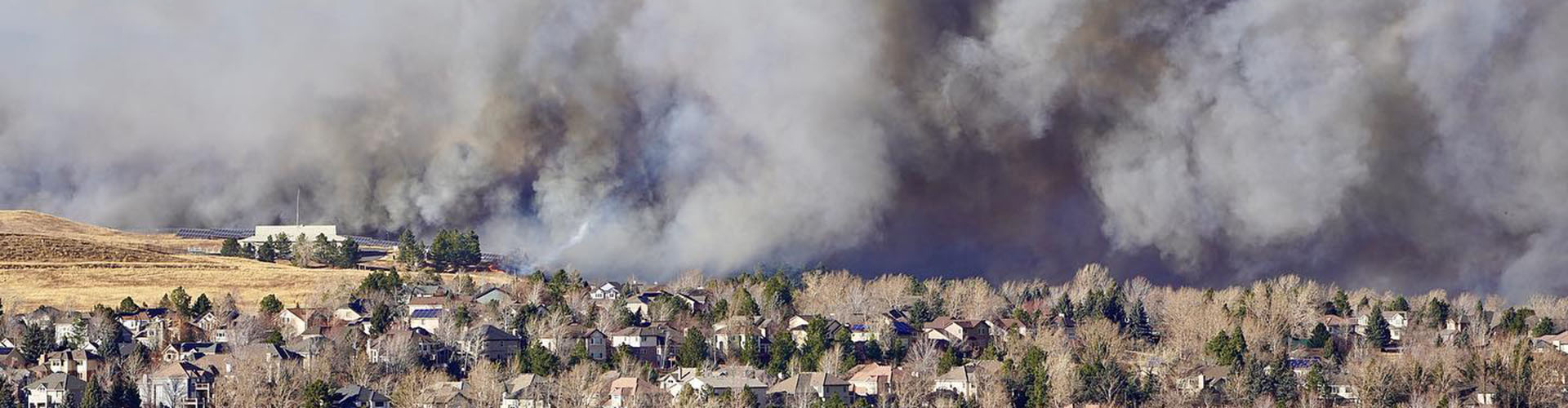
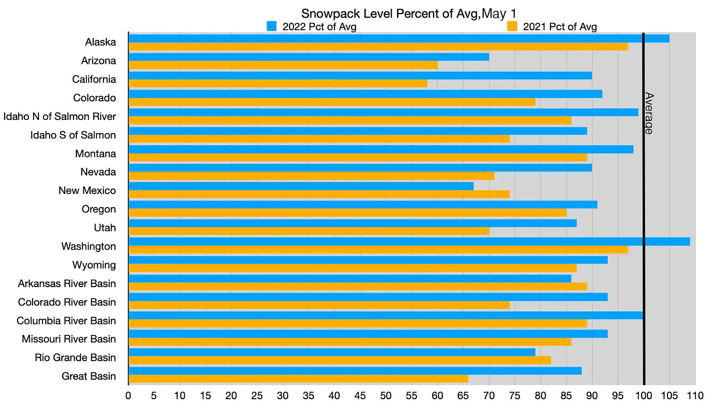
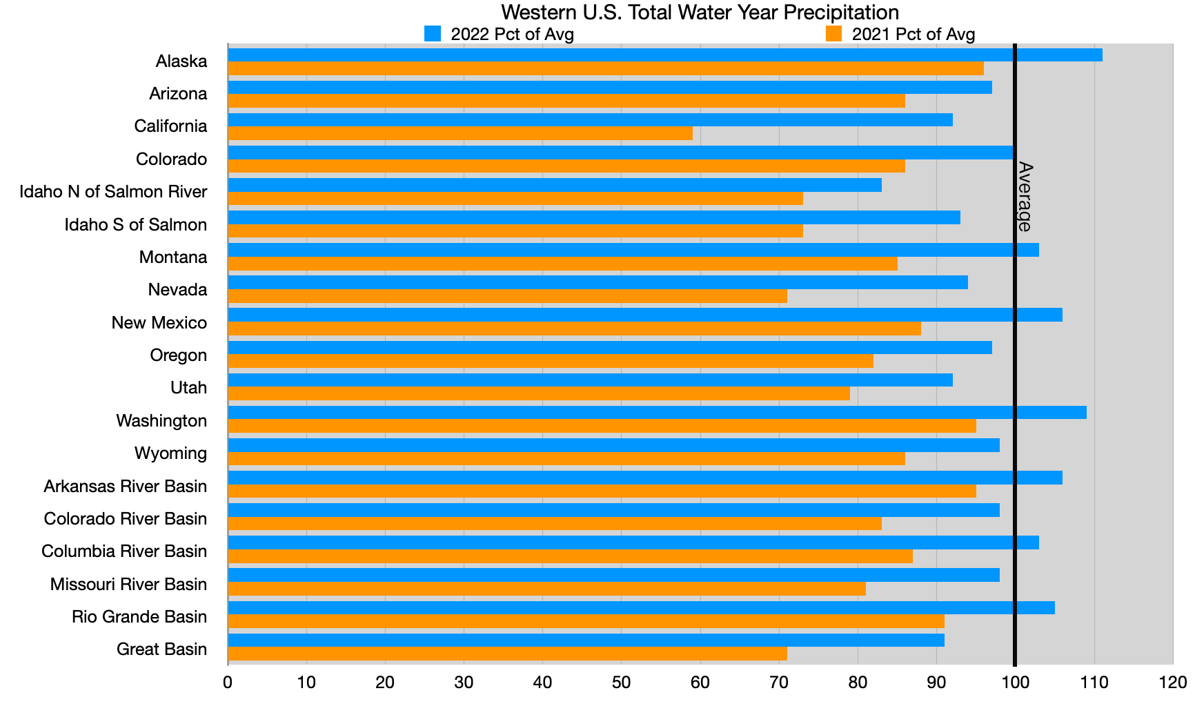
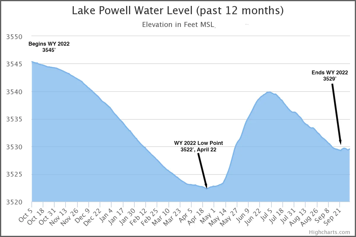
More than 20 years of drought — intensified by human-caused climate change — have pushed the Colorado River Basin and the 40 million people who depend on it into a water crisis. The system’s two largest reservoirs, Powell and Lake Mead, sank below 30% capacity this summer — the lowest levels since they were constructed. If the situation worsens, Powell and Mead could reach “deadpool” status at which the reservoirs would no longer release water downstream into the Colorado River.

The crisis is traveling upstream to places like Flaming Gorge, where it has implications for everything from riparian ecosystems to economic livelihoods. Currently, Flaming Gorge is at about 74% storage capacity, according to the U.S. Geological Survey. Whether the reservoir shrinks further depends on whether the BOR will continue to tap Flaming Gorge and how quickly it might be naturally replenished.

Lower Green River Lake

Emergency water supply

In a legal sense, Flaming Gorge Reservoir, which is fed by headwaters in western Wyoming, was created for a moment like this. Its primary purpose, according to federal officials and Colorado River Compact scholars, is to serve as a backup water bank to help maintain the Colorado River system. Specifically, Flaming Gorge and a handful of other reservoirs in the upper Colorado River Basin states of Wyoming, Colorado, Utah and New Mexico are key to ensuring a minimum flow of 7.5 million acre-feet of water at Lees Ferry just downstream of Powell on a running 10-year average.

So far, the upper basin states have met the threshold. Nonetheless, when Powell and Mead saw drastic lows in 2021, the BOR drew an extra 125,000 acre-feet of water from Flaming Gorge. This past spring when the situation in the lower basin states became even more dire, the BOR initiated a draw of an additional 500,000 acre-feet, estimating a 15-foot vertical drop in the reservoir over the water season ending in April 2023.

The Drought Response Operations Agreement, signed by Colorado River Compact stakeholders in 2019, authorizes the BOR to make those, and possibly additional emergency draws from Flaming Gorge, to help maintain critical water levels and hydropower generation at Powell and Mead. If this summer is any indication, continual draws from the reservoir might drastically alter an aquatic ecosystem and fishery that local businesses have relied on for decades.

Map credit: AGU

“This has been held at a premium, high-water mark, recreational lake for [58] years,” Valedz said. “Why wasn’t this addressed 15 years ago if we knew this was coming?”

The BOR is expected to decide whether to implement another “extra” draw from Flaming Gorge in April 2023.

Flaming Gorge fishery

Kokanee salmon and trophy-sized lake trout draw tens of thousands of visitors to Flaming Gorge each year, supporting a recreational economy in southwest Wyoming and northeast Utah. But as the lake is drawn down, water recedes from shallow shorelines and fish are forced into a smaller space, essentially shrinking the fishery toward the dam side of the reservoir.

Fishing guides and Wyoming Game and Fish have cooperated to maintain an appropriate balance to the predator-prey relationship between lake trout and kokanee, according to Recon Angling owner Shane DuBois. Now, the decreasing water levels threaten to drastically alter that balance and may require shifting management strategies. 

Recon Angling owner Shane Dubois (left) and Buckboard Marina owner Tony Valdez observe water levels at Flaming Gorge Reservoir Sept. 26, 2022. (Dustin Bleizeffer/WyoFile)

Kokanee spawning beds have been exposed, which will force the fish to spawn in areas covered in silt, reducing the reproduction success rate, according to Wyoming Game and Fish Regional Fisheries Supervisor Robert Keith. If Flaming Gorge’s normal water levels are restored, the episode will likely improve traditional spawning beds, Keith said. However, if BOR withdrawals from Flaming Gorge substantially outpace natural inflows for several more years, the fishery will suffer.

“That’s going to be an economic impact to communities around the reservoir that depend on the anglers showing up,” Keith said. “And If we don’t have any ramps in Wyoming that anglers can launch from, then they’re all going to launch further down the reservoir and those dollars are going to be spent down in Utah.”

Toxic cyanobacteria blooms at Flaming Gorge Reservoir Sept. 26, 2022. (Dustin Bleizeffer/WyoFile)

The BOR is in consultation with the Wyoming State Engineer’s office and local recreation and fishery managers regarding drawdowns at Flaming Gorge. The Flaming Gorge National Recreation Area — managed by the U.S. Forest Service — as well as Wyoming Game and Fish, can apply for federal funds set aside to aid in the Colorado River Basin water crisis. But maintaining critical water levels at Powell and Mead remains a priority, while projects involving reconstructing boat ramps and shifting fishery management would take years.

For DuBois, who depends on both a healthy fishery at Flaming Gorge and functional boat ramps, the situation threatens his livelihood. He recently invested tens of thousands of dollars in a new fishing boat and hopes it pays off.

“How does the Bureau of Reclamation not know [the recent drawdown] would leave most boat ramps unusable?” DuBois asked.

As he continues to relocate and reconstruct boat docks to adjust to lower water levels, Valdez is considering how to expand his scope of clientele to make up for losses. 

“I didn’t buy this place to come up here and watch this go to shit,” Valdez said.

Wyoming rivers map via Geology.com

Why is the Colorado River in crisis, and what is being done about it?: Pressing questions to an urgent problem asked and explained — Audubon

American White Pelican and Double-crested Cormorants at Bill Williams Wildlife Refuge in Arizona. Photo: Gary Moore/Audubon Photography Awards

Click the link to read the article on the Audubon website (Haley Paul):

**Este artículo se puede encontrar en español**

Q: Why are we in this situation, with the Colorado River and its reservoirs shrinking so quickly?

A: Truth is, we saw this coming. We use more water than the river provides. The only reason we got away with it for so long was because the reservoirs were full when the climate’s shift to hotter temperatures and reduced river flows began 22 years ago. We did not reduce the amount of water we used until recently, and it has not been enough in the face of drought exacerbated by climate change. 

Brad Udall: Here’s the latest version of my 4-Panel plot thru Water Year (Oct-Sep) of 2021 of the Colorado River big reservoirs, natural flows, precipitation, and temperature. Data (PRISM) goes back or 1906 (or 1935 for reservoirs.) This updates previous work with @GreatLakesPeck. Credit: Brad Udall via Twitter

Q: What happens if we stick with the status quo?

A: If we keep doing what we’re doing, and take water out of the reservoirs—not because it’s wise but because the law allows it—our system as we know it would crash. Water could not be released from Lakes Powell or Mead. A “Day Zero.” This is bad for ALL water users in the Colorado River basin.

There is also the dreadful possibility of no water flowing through the Grand Canyon, or through the Lower Colorado River along the Arizona-California border. That would mean no Colorado River water for tens of millions of people, including numerous sovereign Tribes. No Colorado River water for drinking, bathing, or growing crops, and no water for essential habitats, birds, and other wildlife.

Q: Why does this matter for birds?

A: A future without a running Colorado River would impact 400 bird species including California Condors, Bald Eagles, Southwestern Willow Flycatchers, and countless fish species and other wildlife that reside in and migrate through the Colorado River basin. The Colorado River Delta alone provides habitat for 17 million birds during spring migration and 14 million in the fall, from American White Pelicans and Double-breasted Cormorants to Tree Swallows and Orange-crowned Warblers. 

And because the Delta acts as a “bottleneck” for migrating birds—meaning concentrations of bird populations are significantly higher inside its geographical boundaries than outside of them—changes to water availability or habitat in the Delta could have outsized impacts on tens of millions birds. These impacts could be seen on a global scale.

Environmental water delivery in the Colorado River Delta is timed during the late spring and summer to help native trees germinate. The cottonwood seeds were evident. Photo: Jennifer Pitt/Audubon

Q: Water users need to reduce use by 2-4 million acre feet for 2023, and possibly for 2024 and 2025, according to the U.S. Bureau of Reclamation (USBR). How will the seven Colorado River Basin states (Arizona, California, Colorado, Nevada, New Mexico, Utah, and Wyoming), Tribes, other water users, and the federal government agree to the water reductions necessary to stabilize the river and reservoir system? 

A: The short answer: we don’t know. 

A deadline set by USBR came and went this past August. It’s unclear whether the seven states and water users will reach their own agreement on how to use less water, if federal officials will decide, or, likely the worst-case scenario, if the courts will be the ultimate decision-makers. In the past, the states, Tribes, and other water useres have managed to come up with agreements on how they will use less. Presently, the Upper Basin states (CO, NM, UT, and WY) have agreed to reopen a program that pays water users to use less water. They have also agreed to examine how releases of water stored behind dams in the Upper Basin can help stem the decline of downstream reservoirs such as Lake Powell. The trouble now is water levels are dropping so quickly in our two largest reservoirs—Lake Powell and Lake Mead—and water managers as a whole have not been able to come to agreements fast enough.

All water users could agree to use less. That means cities, farms, and businesses could all agree to reduce the amount of water they use so that the difficult task of stabilizing the system is distributed more evenly. 

Q: Why aren’t we all doing that right now—using less? 

A: Presently, the Upper Basin states use far less water than the Lower Basin States. Upper Basin states have agreed to reopen a program that pays water users to use less water, and have agreed to release water stored behind dams in the Upper Basin, all to help stem the decline of Lake Powell. However, the Upper Basin States should not—and cannot—shoulder the crisis alone.

Part of the reason more water users are not cutting back is because of the current way water is managed. Water management in the Colorado River Basin is based on a seniority system of water rights. First come, first served. This means those with junior rights would have their water reduced completely before a senior water rights holder would see their water reduced at all. While this has been the way the system has operated for more than 100 years, it is wearing thin in the face of 20+ years of drought and a shrinking river. 

In the 1960s, Arizona accepted junior priority rights on a portion of its Colorado River water in exchange for federal funding for the Central Arizona Project (or CAP, the 336-mile long canal that delivers Colorado River water to the central, populous parts of the state). As such, Arizona has stepped up and taken water cuts, sooner than originally anticipated. That’s a good thing. But if Arizona is forced to bear the entire shortage burden in the Lower Colorado River Basin, the impacts to millions of people, including vulnerable communities, will be considerable.

The Central Arizona Project canal moves water from the Colorado River to interior Arizona. Photo © J. Carl Ganter/Circle of Blue

In the face of a shifting climate—reduced snowpack in the mountains due to hotter temperatures and thirstier, drier soils, resulting in less water in rivers—previous efforts to reduce use and save water in Lake Mead, such as the Drought Contingency Plan and the 500+ plan, have not been enough to prevent the Colorado River system from crashing. 

Q: What are specific ideas for using less water and improving the outlook of this dire situation?

A: We could pay people to use less water as well improve the health of the ecosystems and watersheds on which we all rely. Recent federal legislation such as the Inflation Reduction Act allocates $4 billion across the West to do just that. We want to see wise use of this funding—through multi-year agreements and durable projects that reduce water use and improve the health of our rivers and watersheds. 

How will we get there? 

– Upgrade on-farm irrigation methods and equipment to grow crops on less water. 

– Provide incentives for farmers to shift from water-thirsty crops like cotton and alfalfa to drought-tolerant crops like guayule and sorghum.

– Restore degraded meadows and streams to allow for more water retention in the mountains.

– Forest management to prevent catastrophic wildfires. Burned watersheds degrade water quality and erode soils, impairing the ability for the watershed to function properly.

– Increase the reuse of water. Wastewater can be captured, purified, and reused for outdoor irrigation, groundwater recharge, river restoration, or even drinking water.

– Boost water conservation efforts from cities and businesses, through eliminating unnecessary grass; upgrading plumbing; saving water on outdoor landscaping; and industrial cooling water efficiency upgrades. 

– Deploy funding to mitigate the impacts of less water flowing into affected communities and to improve habitat. Funding should prioritize multiple benefit projects and move beyond one-year water deals.

There is also plenty of work to do just within the state of Arizona to improve our water outlook. We must do everything we can to use the water we do have as wisely as possible. Audubon and our partners in the Water for Arizona Coalition developed the Arizona Water Security Plan, which outlines six critical steps the state of Arizona could take to get our own water house in order. 

Q: What should we be watching out for in Arizona?

A: Given the circumstances, with less Colorado River water coming into Arizona, some may want to rely more heavily on groundwater and weaken existing laws that protect it in the populous parts of the state. Weakening existing groundwater protections just so Arizona can continue to grow without changing how we use and manage water would be irresponsible and short-sighted. We should be closely watching the next legislative session to ensure that doesn’t happen.

Furthermore, Arizona has failed to pass meaningful groundwater protections in the rural parts of the state where none currently exist. We cannot allow Arizona’s rural groundwater to meet the same fate as the Colorado River–especially as rural leaders plead for change. For the benefit of all people in the state, lawmakers must allow rural communities to protect their groundwater supplies. And the better we manage all of our water resources, the more credible a partner Arizona is with other states in ongoing Colorado River negotiations.

Colorado River Allocations: Credit: The Congressional Research Service


Water Year 2022 Recap: Superlatively average — @Land_Desk

A precipitation rollercoaster across much of the West helped soothe drought conditions in most of the region, especially the Interior. California, however, remains dry. National Drought Monitor via The Land Desk

Click the link to read the article on The Land Desk website (Jonathan Thompson):

Happy New Water Year! The first day of October is also when folks restart their precipitation and snowpack meters and river gages. It is a time of hope (please give us more snow this time!) and reflection (last year was bonkers!). I’m going to stick with the reflection here.

The 2022 Water Year, which ended Sept. 30, was quite the rollercoaster ride. It started out looking grim in much of the West: Many ski areas weren’t able to hit their traditional Thanksgiving weekend opening and in some areas the end of November snowpack was in worse shape even than in 2002, the winter of everyone’s discontent.

Graphic credit: Jonathan Thompson/The Land Desk

Then came the December dumps, at least to some regions. California’s Sierras got hammered by record-breaking snowfall (193 inches in December). Southwestern Colorado went from parched to chest-deep-powder in a matter of weeks. Heavy traffic to ski areas snarled roadways.

Marshall Fire December 30, 2021. Photo credit: Boulder County

To be sure, the bounty was spread out unevenly. Even as Front Range ski resorts were getting hammered, the Denver-Boulder metro area remained dry, warm, and windy as hell. The flammable combination ultimately led to the devastating Marshall Fire, which was sparked in the grasslands near South Boulder before tearing through suburbia and destroying more than 1,000 homes. It was finally extinguished by the season’s first real snowfall on New Year’s Eve.

The rollercoaster ride continued after that, with long, dry cold spells followed by big storms followed by unusually warm periods. Dry and wet offset each other in many areas, with snowpack peaking early, but at just-below to near-average levels across much of the West.

Alaska and the Northwest had average to above-average winters in terms of snowfall, but the rest of the West ended up below average, again. Still, 2022 was far healthier than 2021 in just about every area except for New Mexico. This is the level as of May 1; peak snowpack used to come later in almost every region, but lately it is more likely to occur in April in most areas. Source: SNOTEL.

Summer followed in kind as hot and dry alternated with gully-busting storms. And despite all the flooding, monsoon precipitation amounts were about average in the Southwest.

And that kind of sums up Water Year 2022: It was full of superlatives, yet ended up more or less average, precipitation-wise. But in these days of aridification and warming temperatures, and following on the heels of two decades of drought, average just doesn’t cut it.

Water Year precipitation from Oct. 1 through Sept. 30. After a slim winter an abundant monsoon helped most areas’ precipitation levels recover.

Despite near-average precipitation levels in the Colorado Basin, Lake Powell continued its steady decline, finishing the water year about 16 feet lower than the end of Water Year 2021.

To summarize: It was a year of more or less average precipitation and above average temperatures. While drought eased in some areas, aridification continues just about everywhere.