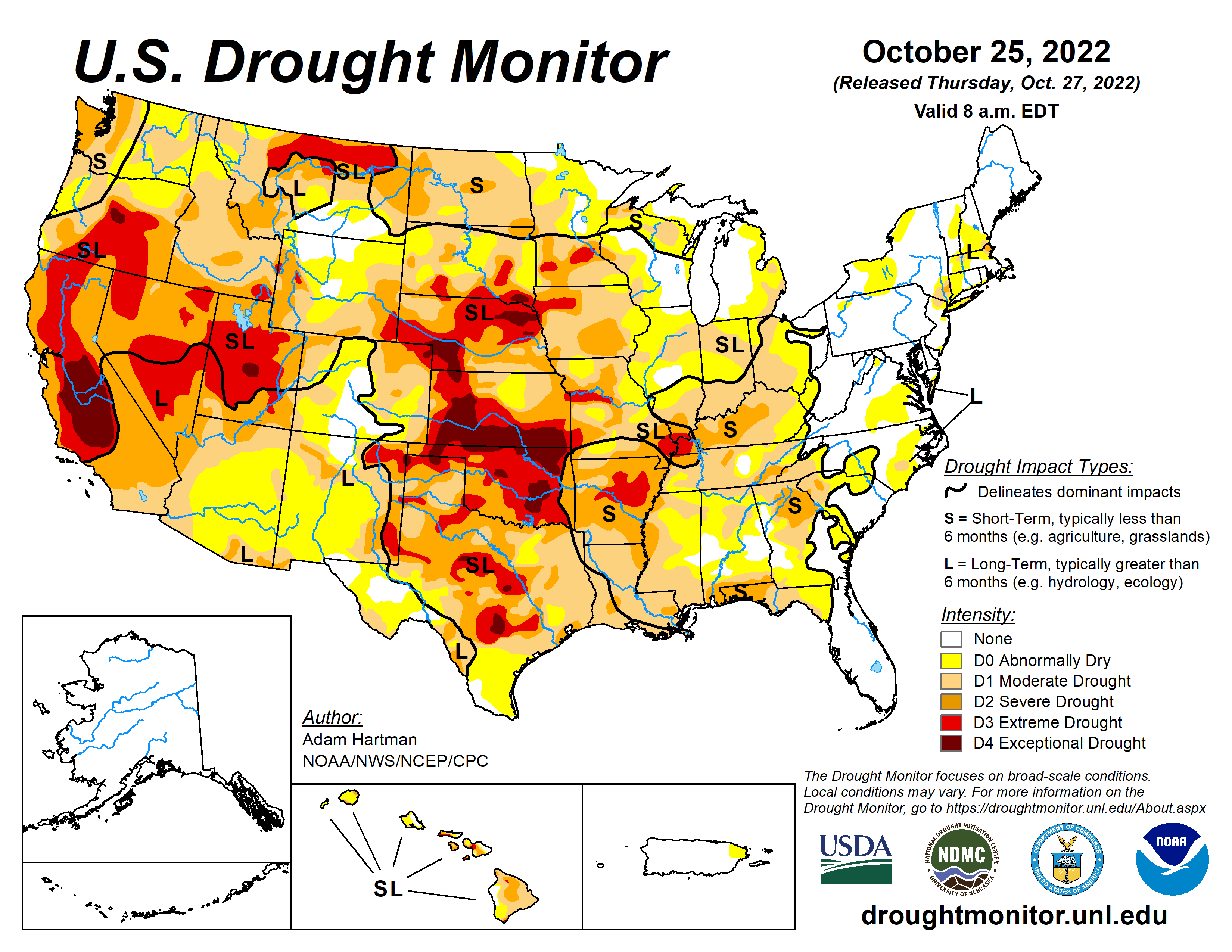
A large shift in the weather pattern occurred this week across the lower 48 states. Early in the week, low pressure exited the Great Lakes region, allowing temperatures to gradually moderate during the latter half of the week across portions of the eastern contiguous U.S. (CONUS). In the western CONUS, high pressure broke down as a strong storm system moved into the Pacific Northwest heading into the weekend. As this storm system moved eastward into the Great Plains through the weekend and leading up to Tuesday, October 25, many locations across the western and central CONUS experienced above-normal precipitation, with cooler than normal temperatures in the system’s wake. However, with surface high pressure early in the week followed by southerly flow ahead of the storm system, warm temperatures dominated much of the central CONUS for the week as whole, with above-normal average temperatures also extending northeastward into the Great Lakes and Northeast. Unfortunately, given the expanse of drought and abnormal dryness across the U.S., antecedent dryness led to another week of degradations for many not receiving rainfall, even in areas where temperatures were cooler than normal this week. Warm conditions and high winds further exacerbated conditions in drier areas across the Great Plains. Fortunately, in areas seeing the heaviest rainfall amounts, particularly across the Southern Plains and Ozarks, some improvements were also warranted…
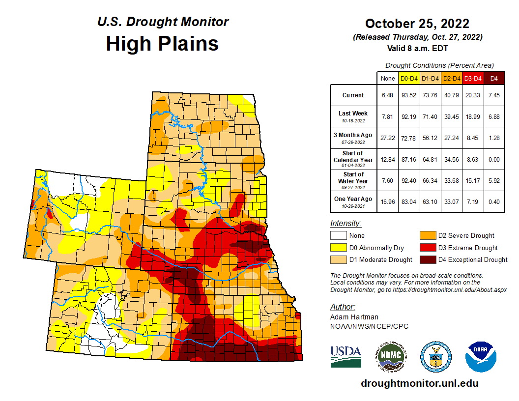
Above-normal temperatures, below-normal precipitation, and periods high winds resulted in degradations to ongoing D1 (moderate) to D4 (exceptional) drought across the Central Plains, east of the Front Range. Stock ponds for cattle remain low to non-existent and pastures are providing marginal feed, with supplemental feed required for many. Conversely, the storm system that moved across the Intermountain West during the weekend dropped heavy precipitation across the higher elevations of Wyoming and Colorado and parts of the Northern High Plains from Montana eastward to North Dakota. Unfortunately, even though several areas experienced in excess of 1 inch of precipitation (greater than 1.5 inches for many locations across the Northern High Plains), short to long-term drought indicators did not show many signs of improvement by Tuesday, October 25. Only surface soil moisture showed some improvement, with sparse 7-day average stream flows also improving, corroborated by ground reports. As such, given the lack of response in the indicators, much of the Northern High Plains remain unchanged this week…
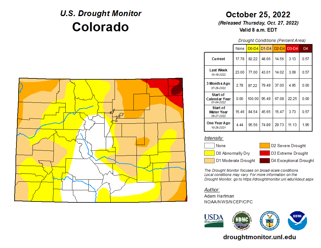
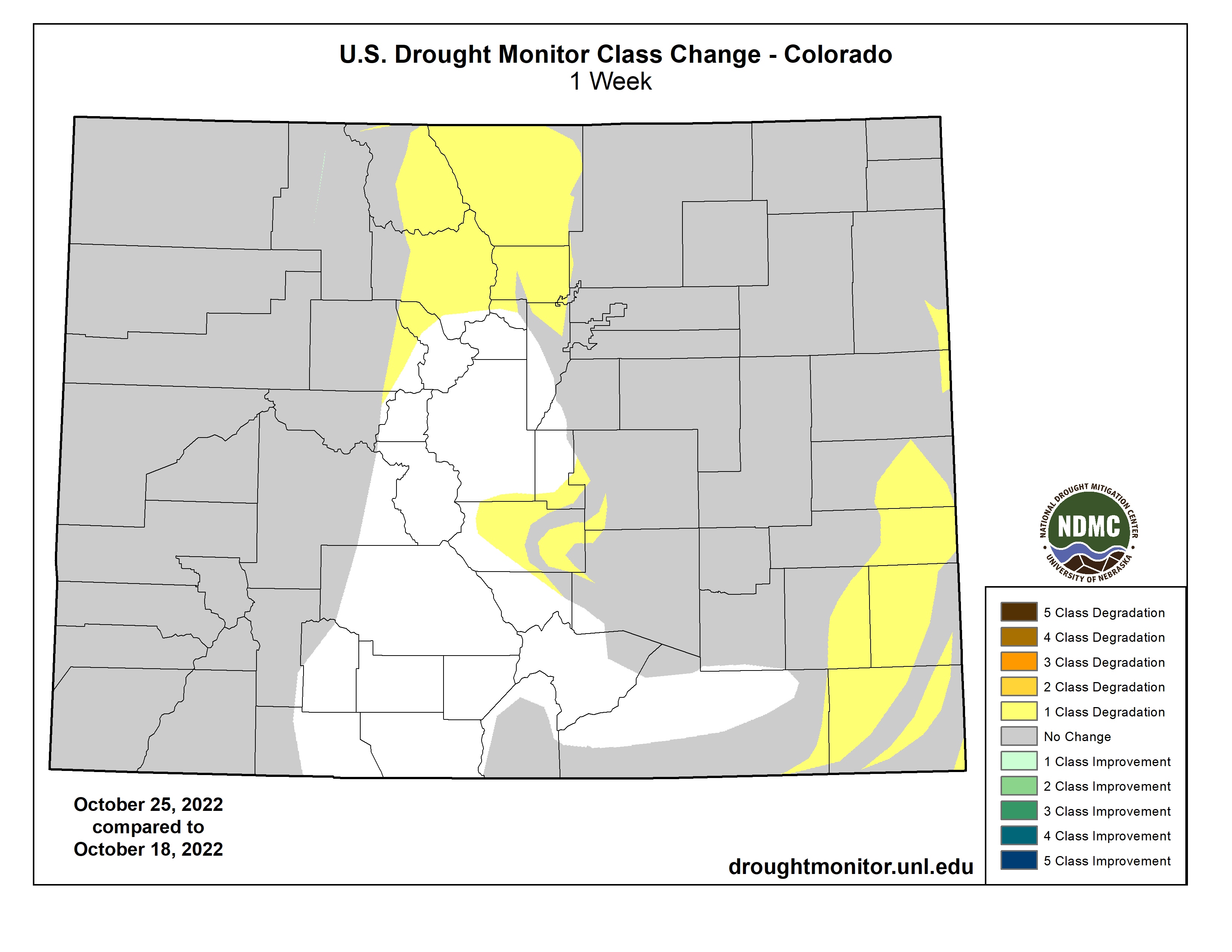
Colorado Drought Monitor one week change map ending October 25, 2022.
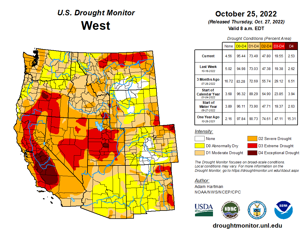
A strong storm system moved into the western U.S. heading into the weekend and moved across the Intermountain West leading up to Tuesday, October 25. Many locations across the Pacific Northwest, Great Basin, and the Rockies received in excess of 0.5 inches of rainfall, with the heaviest amounts (greater than 1 inch, with locally higher totals) concentrated across the Pacific Northwest, Idaho, and Montana. Precipitation was not enough to improve drought conditions in the Pacific Northwest, but was enough to halt another week of degradation along the windward slopes of the Cascades and Coastal Ranges. Only areas east of these ranges, in the rain shadows, experienced some targeted degradations. Farther south, D2 (severe) drought degraded to D3 (extreme drought) north of San Francisco, where USGS 28-day average stream flows have fallen below the 2nd percentile of the historical distribution, CPC soil moisture indicates D4-equivalent (exceptional drought) conditions, and the long-term objective drought blend depicts D3 conditions. Elsewhere, localized and targeted improvements were made across the Intermountain West, based on 7-day precipitation totals and improvements short-term precipitation deficits…
A storm system moving out of the Rockies and intensifying across the Southern Plains dropped in excess of 2 inches of rainfall in a large swath from northeastern Texas to the western Ozarks, warranting 1-category improvements across many of these locations. In surrounding areas that received heavier precipitation amounts, improvements were more targeted in nature, as amounts were not enough to eliminate 90-day deficits. Farther eastward, from the Lower Mississippi Valley to the Tennessee Valley, antecedent dryness and a drier than normal week resulted in another round of widespread 1-category degradations…
Looking Ahead
During the next five days (October 27-31), the storm system that brought heavy rainfall to parts of the Southern Plains will bring rainfall to parts of the eastern Great Lakes and Northeast before exiting the U.S. The pattern will remain active across the remainder of the CONUS. However, much of the precipitation potential will be across the Southern Plains, extending eastward across parts of the Deep South, associated with a low pressure system that is forecast to intensify over the Southern Plains by the weekend before moving eastward through the remainder of the week. The Pacific Northwest is also expected to remain active through Monday, October 31. Additionally, near to below-normal temperatures are expected across the West Coast and much of the Southern Tier of the CONUS, along the predicted storm track. Farther north from the Northern Plains to the Northeast, predominantly above-normal temperatures are forecast due to a lesser influence from the storm track farther south.
The Climate Prediction Center’s 6-10 day outlook (valid November 1-5) predicts increased chances of below-normal temperatures and above-normal precipitation across the western half and two-thirds of the CONUS, respectively, associated with mean mid-level low-pressure. Meanwhile, mid-level high pressure favors above-normal temperatures from the Great Plains to the East Coast and drier than normal conditions from the Mississippi Valley eastward. In Alaska, a southerly storm track favors predominantly above-normal precipitation and is forecast to keep temperatures cooler than normal.
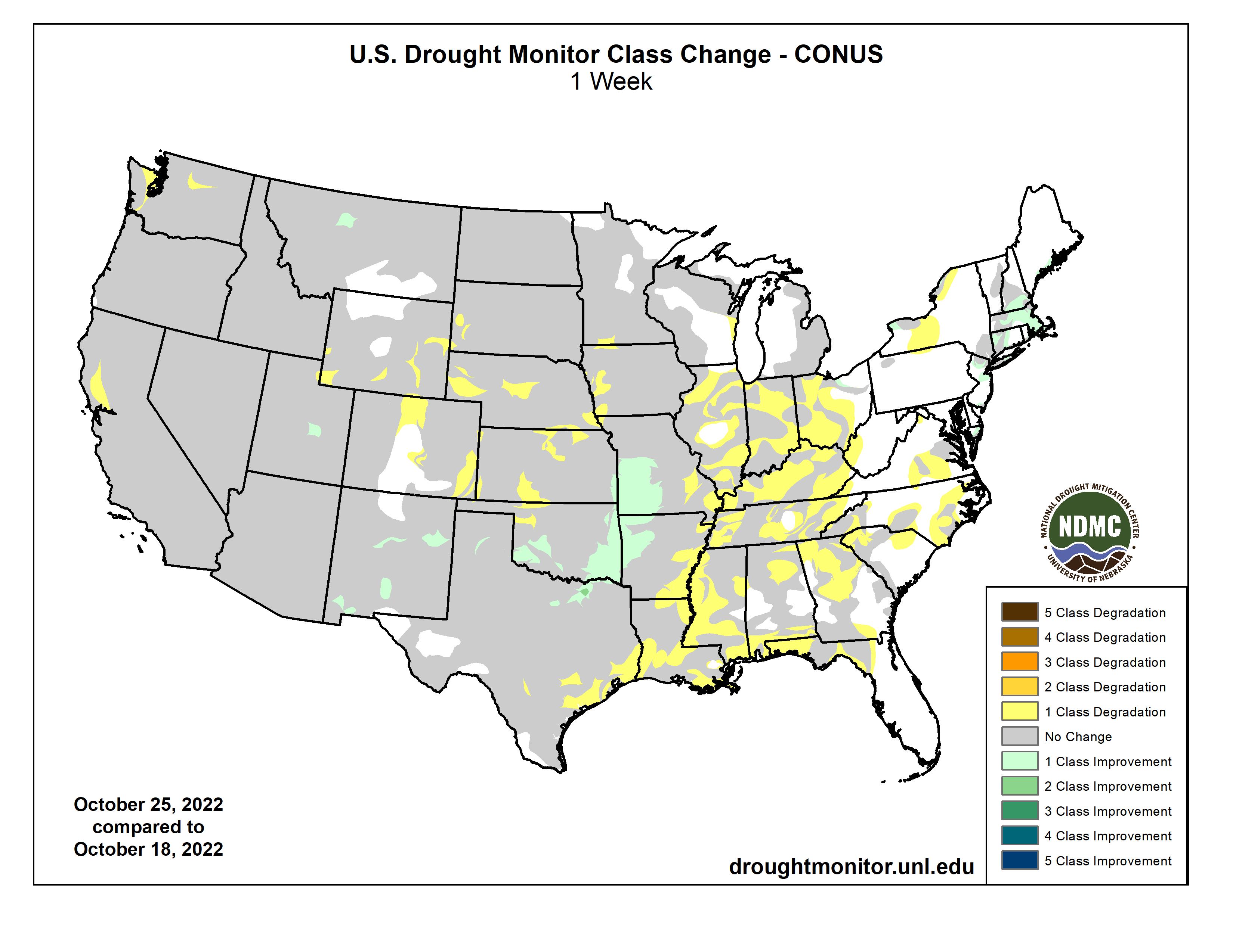
US Drought Monitor one week change map ending October 25, 2022.
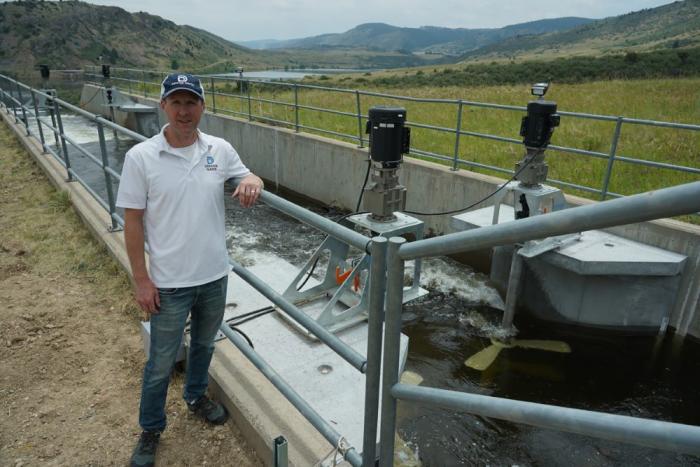
Nestled against the foothills of the Rocky Mountains west of Denver sits an old concrete canal that’s been delivering water to the metro area since the 1930s.
Fast forward to 2022, and the South Boulder Canal is still performing its regular job for Denver Water.
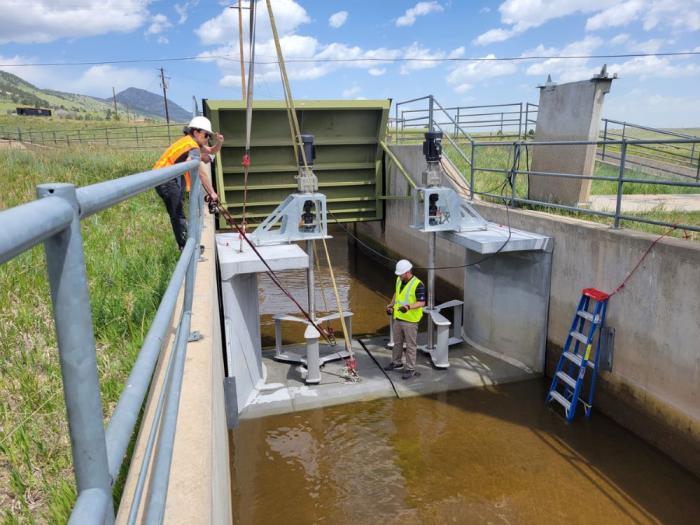
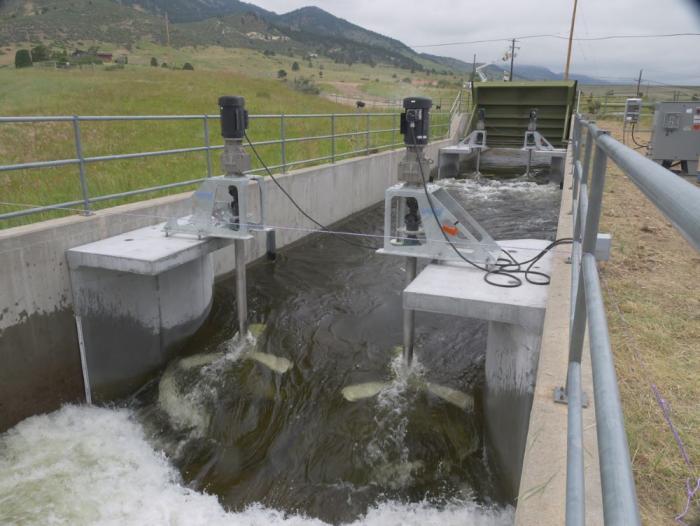
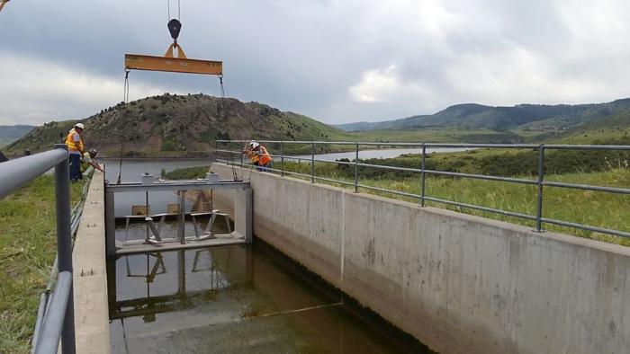
But the canal has now taken on the added role of generating hydropower, with four small turbines spinning inside the concrete waterway and producing electricity. The turbines were connected to the local energy grid in mid-July.
Emrgy crews installed new turbines in the South Boulder Canal in June. Photo credit: Emrgy Inc.
“Denver Water has been producing hydropower at our dams for decades, but this is the first time we’ve generated power from one of our canals,” said Ian Oliver, source of supply director at Denver Water whose team operates the utility’s dams, reservoirs and canals.
The innovative hydropower project began in 2017 when Denver Water teamed up with Emrgy Inc., an Atlanta-based company that specializes in creating clean, sustainable energy using the flow of water through existing infrastructure.
Water flows past four new hydropower turbines on Denver Water’s South Boulder Canal. Four units were installed in June and were connected to the local power grid in July. Photo credit: Denver Water.
The South Boulder Canal is part of Denver Water’s northern delivery system, which brings water from Colorado’s West Slope to the Front Range. The 8-mile canal starts near Eldorado Canyon and ends at Ralston Reservoir north of Golden.
Ian Oliver, Denver Water’s source of supply director, has been involved with Emrgy on the South Boulder Canal hydropower project since 2017. Photo credit: Denver Water.
Denver Water typically runs water through the canal about nine months a year, with flows ranging between 50 and 300 cubic feet per second depending on time of the year and water demands in the city.
“Sustainability is part of our mission at Denver Water, so when we met the team at Emrgy and they told us about their turbines for low head applications, we knew it was something we wanted to pursue further,” Oliver said.
In 2017, Emrgy placed an initial array of turbines in the canal as part of a pilot project.
Since that time, the company has continued to innovate its design and installed four new turbines in June. The new turbines are easier to lift, handle and connect to the utility grid through the same inverters used in the solar power industry. The turbines are located at the end of the canal just before it reaches Ralston Reservoir.
The original Emrgy turbines were placed in the South Boulder Canal just before Ralston Reservoir in 2017 as part of a pilot program. Photo credit: Denver Water.
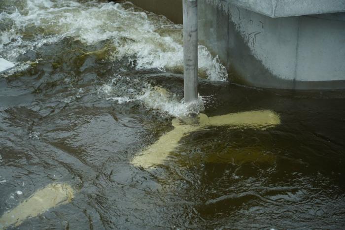
The turbines look somewhat like mixers you’d see in the kitchen to stir cake batter — just a lot bigger, stronger and more advanced.
As the moving water in the canal flows past the turbines, the blades spin and produce mechanical energy, which is then converted into electrical energy. The electrical energy is then fed to a power conversion system next to the canal and delivered to the local power company’s energy grid.
“The process is unique in that it uses the kinetic energy of the flowing water and doesn’t require a large dam to build up pressure to create hydropower,” said Emily Morris, Emrgy’s CEO. “These turbines will work in any channel with moving water where energy can be extracted.”
From the original pilot study, Emrgy refined the hydro system and made the assemblies more modular, so they are easier to deliver and install. The new design also made the turbines easier to remove for maintenance, according to Morris.
Another enhancement focused on the design of the concrete flume box assembly. The flumes include curves in the concrete structure that direct moving water to pass by the rotors more efficiently.
The new turbine system is also more “plug and play,” using the same onshore power electronics equipment used by the solar industry so it’s easier to connect to the power grid, according to Morris.
Emrgy’s new turbines use the kinetic energy of the water to generate electricity. Photo credit: Denver Water.
Morris said each turbine can produce anywhere from five to 25 kilowatts of instantaneous power depending on the speed and depth of the water in the canal. If running 365 days a year, that would be roughly enough to power around eight U.S. homes each year.
Denver Water’s role in letting Emrgy use the canal to refine the technology has been a win-win for both organizations. For Emrgy, the pilot program helped them develop their turbines and expand them to three other states in the U.S. and into three other countries.
For Denver Water, Oliver says putting water to work to generate electricity is part of the utility’s annual goal of being a “net-zero” organization in terms of the utility’s overall energy consumption. “Net-zero” status is when the utility produces as much electricity through its hydro and solar power units as it consumes through traditional forms of energy.
With the addition of the South Boulder turbines, Denver Water now has 13 hydropower units at its facilities. The hydro program generates an average of 61,000 megawatts of electricity annually.
“Denver Water’s interest in hydropower is really multifaceted,” Oliver said. “We generate hydropower to sell to the local power grid, which helps offset the consumption of electricity at our facilities, and, by doing so, we’re also helping to meet our own sustainability goals.”
Power generated by Emrgy’s South Boulder Canal turbines is distributed to the local power grid. Denver Water receives a credit for the hydropower on its utility bill, which helps offset energy consumption at the utility’s Northwater Treatment Plant and Ralston Reservoir.
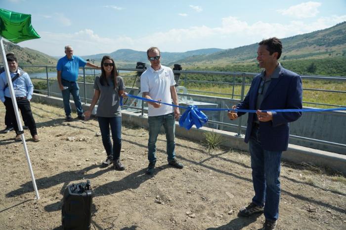
Denver Water and Emrgy held a ribbon-cutting ceremony in June to celebrate the installation of new turbines in the canal and their connection to the power grid. Photo credit: Denver Water.
Denver Water and Emrgy are now studying the feasibility of adding six more turbines to the canal in the future to create a larger array of power generation, similar to installing a series of solar panels.
Morris said small turbines in canals help produce clean energy at the local level.
“In order to achieve a truly carbon-free future, we’re going to have to harness the power of the sun, the wind and the power of water,” Morris said. [ed. emphasis mine]
“Water is one of the only controllable natural resources that we have, and I’m excited about the ability to harvest the natural energy here to improve our environment.”
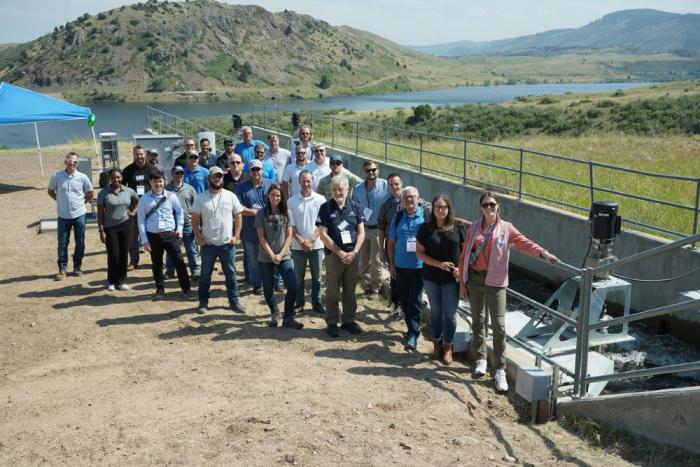
Participants of the annual Hydrovision International convention toured the South Boulder Canal project in June. Photo credit: Denver Water.
After multiple water treatment plant mishaps over the past year, Arvada’s City Council unanimously approved a 12.3% water rate increase to fund improvements for the city’s aging infrastructure on Oct. 17. The rate hike will increase single-family water bills by roughly $19 per bi-monthly billing cycle on average for single-family homes. The increase will see water and wastewater usage rates increase by an average of $13 per bi-monthly billing cycle for single-family homes. It also includes a $4 bi-monthly water service fee increase and a $2 bi-monthly wastewater service fee increase. Primary cost drivers of the rate hike are a 15% price hike for raw water from Denver Water, the recommended issuance of a $50 million bond later this year that will fund infrastructure upgrades and an expected overall operation cost increase of $4.2 million in 2023. Over the past five years, the average in-city water rate has increased by about 3.55% annually, Gillis said. The bi-monthly service fee was last adjusted in 2022 for the first time since 2009.
Credit: The City of Arvada
At the heart of Arvada’s decision to invest in aging infrastructure are two water treatment plants: the Ralston Water Treatment Plant, built in the 1960s; and the Arvada Water Treatment Plant, built in the 1980s. The RWTP is rated at 36 million gallons per day, while the AWTP is rated at 16 million gallons per day. 75% of Arvada’s raw water comes from Denver Water, while the remainder is provided by Clear Creek. Two recent water line breaks and leaks through an exterior wall at the RWTP over the summer have threatened the city’s water supply, as Arvada Director of Utilities Sharon Israel recounted during a tour of the RWTP with the Arvada Press…
At the Oct. 17 city council meeting, Arvada Mayor Marc Williams summed up the position of many council members, all of whom voted for the rate increase.
“We had two major water line breaks in the last two weeks that cost us well over a million gallons of water, I believe,” Williams said. “We’ve got to take lasting care of our community and this is an appropriate step that we’re taking…That passes 7-0; reluctantly, but necessarily.”
A burnt sign on Larimer County Road 103 near Chambers Lake. The fire started in the area near Cameron Peak, which it is named after. The fire burned over 200,000 acres during its three-month run. Photo courtesy of Kate Stahla via the University of Northern Colorado
Click the link to read the article on the Inside Climate News website (Bob Berwyn):
When Stephanie Kampf visited one of her wildfire test plots near Colorado’s Joe Wright Reservoir in June of 2021, the charred remains of what had been a cool, shady spruce and fir forest before the Cameron Peak Fire incinerated it nearly took her breath away.
“We would walk through these burned areas and they were just black, nothing growing and already getting kind of hot,” she said. “And then you walk into an unburned patch, and there’d still be snow on the ground. You could almost breathe more.”
The surveys, up at about 10,000 feet in the Rocky Mountains west of Fort Collins, were part of a rapid response science assessment to measure just how much the extreme 2020 wildfire season in the West disrupted the water-snow cycle in the critical late-snowmelt zone which serves as a huge natural reservoir. The snowmelt sustains river flows that nurture ecosystems, fills irrigation ditches for crops and delivers supplies of industrial and drinking water to communities.
The findings of the study, published earlier this month in the Proceedings of the National Academies of Sciences, suggest that the relationships of snow and water in many Western mountain forests are caught in a vicious climate cycle, with more fires leading to faster snowmelt and reduced water, which, in turn, makes forests more flammable.
The critical areas are at different elevations in various parts of the West, depending on latitude and other geographic factors, but long-term wildfire records suggest that for millennia, fire was a rare visitor in many high-altitude forests, with burn intervals of 200 to 300 years, or even longer in wetter regions.
In Colorado those snow accumulation zones can produce “on the order of half of all streamflows,” with some geographic nuances, said Kampf, a Colorado State University researcher who is currently on sabbatical in Spain, where she studying the impacts of similarly devastating wildfires that have scorched the Iberian Peninsula in recent years.
During her Colorado research, “It was just so striking to go up to these places and see no snow left,” she said. In one unburned comparison plot a short distance away, there was still more than three feet of snow. “It’s disturbing when you’re accustomed to a place and how it was, and you see it change that much. It’s kind of mind blowing. I suspected that what we experienced in 2020 was outside the norm, but I didn’t realize how far outside the norm it was. And that was just honestly pretty disturbing.”
A helicopter drops water on the Cameron Peak Fire near CSU’s Mountain Campus. Photo credit: Colorado State University
With the measurements of the Cameron Peak Fire in Colorado as a case study, Kamp’s research team also analyzed satellite data from 1984 to 2020 to show how wildfires are encroaching on the critical snow-storage zones across 70 percent of the Western mountain study area, including the Sierra Nevada, Cascades, Rocky Mountain and Great Basin ranges.
Peak snowpack is declining, which can reduce or even choke off streamflows completely in late summer because the snow is melting off the burned areas much faster. Colorado and New Mexico appear especially vulnerable to fires threatening watersheds that are critical to local residents as well as distant communities on both sides of the Continental Divide.
Wildfires are leaving mountains free of snow earlier in the year, the authors wrote, “and this loss of snow can reduce both ecosystem water availability and streamflow generation in a region that relies heavily on mountain snowpack for water supply.” And as the snowpack melts earlier, the ground and plants warm up and dry faster, setting the stage for more fire in a vicious cycle of climatic changes.
The Extreme 2020 Wildfire Season Was a Warning
The overall drying from climate change is expanding the threat in areas “that historically have provided a large fraction of annual water supplies,” said Paul Brooks, a hydrology researcher at the University of Utah, who was not involved in the new study. “Fires are becoming more frequent in colder, wetter environments that typically burned rarely.”
The research shows that burned forests often reduce the total amount of water stored in the snowpack and speed up melting, he added.
Kampf described her findings in the broader context of the extreme wildfires in the summer of 2020, when wide swaths of the West choked under gloomy layers of toxic smoke that sometimes spread all the way to the East Coast. In Colorado, the Cameron Peak fire burned from mid-August through early December—112 days—with a last patch left smoldering under winter snow near her university’s mountain campus.
“It just kept growing. And it grew to a size that was just unprecedented. And we hadn’t seen anything like that, way up in the higher elevations,” she said. “Then the East Troublesome Fire, which burned in really damp, snow-dominated areas, and then over the Continental Divide, which was not something anyone expected. And so this was just really shocking and concerning.”
Lands in Northern Water’s collection system scarred by East Troublesome Fire. October 2020. Credit: Northern Water
The new rules approved by the town council last week prohibit lawns in front yards and limit lawns in backyards to 500 square feet. Castle Rock estimates that the limits on lawns could reduce outdoor water use 50% once the community is fully built out, according to the town’s website.
Mrs. Gulch’s Blue gramma “Eyelash” patch August 28, 2021.
The community is eliminating future front yard lawns in part to help encourage the acceptance of alternative landscaping that can thrive in a drier climate, he said.
Water stored in Colorado’s Denver Basin aquifers, which extend from Greeley to Colorado Springs, and from Golden to the Eastern Plains near Limon, does not naturally recharge from rain and snow and is therefore carefully regulated. Courtesy U.S. Geological Survey.
Castle Rock relies heavily on nonrenewable groundwater aquifers and it is working to transition to other sources, according to the town website.
In April 2018, Colorado adopted a law that changed the way oil and gas development is regulated, required updates to state regulations and allowed local government authorities to adopt tighter regulations than those established by the state. Following that, Larimer County adopted “comprehensive regulations along with resources for regulatory compliance programs,” according to city documents. Meanwhile, some in the Fort Collins community have expressed concerns about new oil and gas developments within city limits or city natural areas, largely because of traffic, leaks and spills, regional air quality and climate change impacts…
So in response to the changing regulations locally and community feedback, staff developed its own set of regulations for existing and new oil and gas facilities in Fort Collins. Those regulations were presented to City Council at a work session Tuesday night. All in all, council members broadly showed support for the regulations and no concrete changes were suggested. Mayor Jeni Arndt told staff she felt they had “really thought it out well” and appreciated that their updates weren’t adding a high amount of regulations but adjusting and expanding what is in place…
Current oil and gas regulations around setbacks and where wells could be built have left about 3% of city land and open space available for development, but the proposed changes for new facilities decrease that to about 0% availability.
Proposed changes to new well regulations include 2,000-foot setbacks from occupiable buildings, parks, trails or natural areas and would limit developments to industrial zone districts, which are intended to house “a variety of work processes and work places such as manufacturing, warehousing and distributing, indoor and outdoor storage, and a wide range of commercial and industrial operations,” according to the city’s land use code. Very few, if any, land in city limits meets all these requirements, so the regulations would essentially prohibit new drilling. Cassie Archuleta, the city’s air quality program manager who presented to council, said this isn’t “a ban” on drilling in the city but uses zoning to make available surface area “highly restrictive.” Adding to the severity of the regulations, the 2,000-foot standard would leave no room for exceptions, differing from the state’s standard, which allows exemptions.
Wattenberg Oil and Gas Field via Free Range Longmont
Click the link to read the article the Sibley’s Rivers website [http://sibleysrivers.com] (George Sibley):
We’ve been exploring the Colorado River Compact here – which, like Oliver Wendell Holmes’ ‘wonderful one-hoss shay’ has now lived almost ‘one hundred years to the day’ – the commissioners signed off on it November 24, 1922. The century mark is a good place to pause and pull back for a larger perspective on something like a multi-state agreement and see what it has and hasn’t actually accomplished – but without losing sight of the romantic vision of conquest that drove the Compact’s formation, back in the early decades of the Anthropocene Epoch when reorganizing the prehuman world was still fun.
In the last post here, we looked at the ‘major purposes’ cited in the first article of the Compact: the first listed purpose, ‘to provide for the equitable division and apportionment of the use of the waters of the Colorado River System’ in order ‘to remove causes of present and future controversies’ (fourth purpose); and the final listed purpose, ‘to secure the expeditious agricultural and industrial development of the Colorado River Basin.’
That fifth purpose, to facilitate the expeditious development of the Basin, was the main reason the seven state representatives had convened with a federal representative: they all wanted to get about the development of the river’s waters, the desire to take on Frederick Dellenbaugh’s ‘veritable dragon’ supported by rational reasons such as flood control and storage. In order to achieve that expeditious development, however, it was necessary to achieve the Compact’s first stated purpose: an equitable division and apportionment of the development and the water required – or cutting to the chase for most of the seven states: making sure that fast-growing Southern California did not get most of the water for its racehorse development.
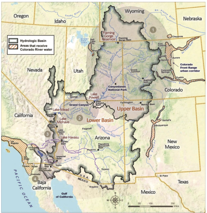
After failed efforts to make specific seven-state divisions of the use of the River’s water, the expedient solution they settled on was to divide the river in two, around the mostly uninhabited canyon region: an Upper Basin including the four states above the canyons (Colorado, New Mexico, Utah and Wyoming), and a Lower Basin of the states below the canyons (Arizona, California and Nevada). It was their clear intent that each basin would get half of the river’s water for consumptive use, with the states in each basin working out an equitable division among themselves of their half, in their own good time.
It may have worked out better, had they stopped there – a 50-50 division of whatever water the river produced, with each basin responsible for half of whatever water might eventually by allotted to Mexico where the river ended. But California insisted on a specific quantification of the two shares because they were already using a substantial amount and didn’t want to over-appropriate. After much discussion and good and bad advice, the commissioners settled on 15 million acre-feet (maf) as a reasonable average flow, between the Bureau of Reclamation’s optimistic 16.5 maf and the less optimistic 13 maf of USGS scientists studying the river.
Herbert Hoover presides over the signing of the Colorado River Compact in November 1922. Members of the Colorado River Commission stood together at the signing of the Colorado River Compact on November 24, 1922. The signing took place at the Palace of the Governors in Santa Fe, New Mexico, with Secretary of Commerce Herbert Hoover presiding (seated). (Courtesy U.S. Department of Interior, Bureau of Reclamation)
The commissioners have been chided – castigated – for settling on the 15 maf quantity, which was shown to be overly optimistic within a couple of decades. But they could have countered the criticism by asking why, if their numbers were so bad, had the states not reassembled to correct them?
Frequently in their meetings, there was either frustration or resignation at how little they knew about the river and its flow history. Chairman Hoover summarized that oft-expressed concern in their 21st meeting: ‘[W]e make now, for lack of a better word, a temporary equitable division, reserving a certain portion of the flow of the river to the hands of those men who may come after us, possessed of a far greater fund of information; that they can make a further division of the river at such a time, and in the meantime, we shall take such means at this moment to protect the rights of either basin as will assure the continued development of the river.’ (Italics added) In other words – we can work out the details down the road when we know more; meanwhile, let’s build dams and canals. They built into the Compact, in Articles III, VI, and IX, procedures for those ‘possessed of a far greater fund of information’ to reconsider the Compact to better fit the emerging reality of the River and its flows.
I should note that the commissioners, Anthropocene romantics, actually believed that future generations would reassemble to address the distribution of surplus flows. They anticipated a larger river in the future – if not provided by nature, then by the engineers who would bring in more water from larger rivers that had a surplus. This is the ‘romance of the Colorado River’ – the romance of the Anthropocene.
California’s commissioner McClure accepted the lower 7.5 maf/year figure because it moved along the process leading to stymying the veritable dragon with a big dam for storage of the river’s annual flood. But Arizona’s commissioner, W.S. Norviel, was not happy with any aspect of the two-basin division since it left Arizona competing with California for a diminished quantity of water, a mere half of the river, for which the bigger state already had plans in the process. He was essentially – on orders from economic forces in the state he represented – in a defensive posture, protecting Arizona’s right and capacity to become another California with no interference from the Upper Basin states. Most of the commissioners were patient with Norviel, but frustration was occasionally vented, as when the New Mexico commissioner observed that ‘we are absolutely and utterly up in the air because none of us knows what it is Mr. Norviel really wants.’
Gila River watershed. Graphic credit: Wikimedia
What it came down to – what satisfied Mr. Norviel enough to reluctantly sign the Compact – was the concession by the Upper States that Arizona’s tributaries to the Colorado River mainstem would not be counted as part of the Lower Basin’s 7.5 maf/year. This is obscurely codified in the Compact as the mysterious statement in Article 3(b): ‘In addition to the [7.5 maf] apportionment, the Lower Basin is hereby given the right to increase its beneficial consumptive use of such waters by one million acre-feet per annum’ (with no additional responsibility for that accruing to the Upper Basin).
No rationale for this ‘gift’ is to be found in the minutes of the meetings, but it would be naive to think that everything of importance happened in the formal transcribed meetings. Bishop’s Lodge had a comped bar and restaurant, and there were undoubtedly informal meetings, over breakfast and lunch and well into the evenings, and in hotel-room Basin caucuses, as well as phone exchanges with interested parties back home.
The Compact that the seven commissioners signed in late November 1922 might have raised as many questions as it answered for the states and the nation. That unexplained million acre-feet is one such instance. But the big one was, and continues to be – what did the commissioners mean when they said, in Article III(d): ‘The States of the Upper Division will not cause the flow of the river at Lee Ferry to be depleted below an aggregate of 75,000,000 acre-feet for any period of ten consecutive years.”
Does this mean – well, what it seems to say: that the users in the Upper Basin states should do nothing themselves, in the way of consumptive uses, to deplete the flow at Lees Ferry below the 7.5 maf/year average? Or does it mean that the Upper Basin has a ‘delivery obligation’ to the Lower Basin regardless of what happened naturally (drought) as well as culturally (over-use) in the Upper Basin?
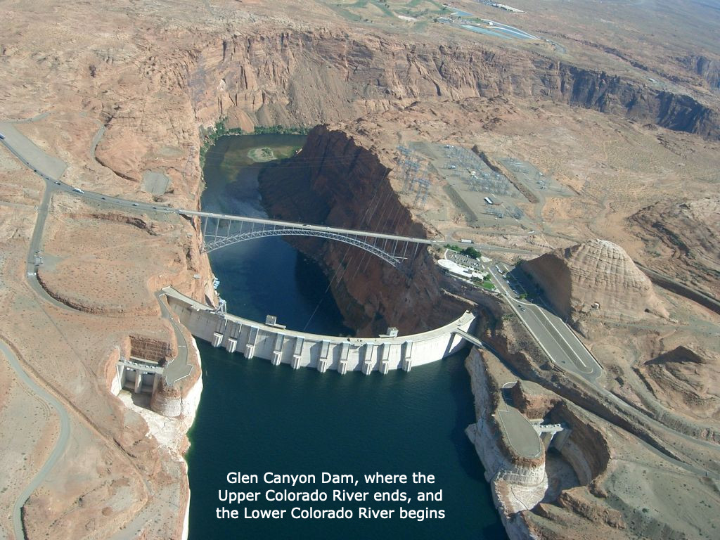
This map shows the Colorado River Basin and surrounding areas that use Colorado River Water, with four regions delineated, based on the degree to which flow is regulated and the channel physically manipulated. The dividing line for the upper and lower basin is Lee Ferry near Glen Canyon Dam.
CREDIT: CENTER FOR COLORADO RIVER STUDIES
That particular question has remained unanswered because there has been no need to raise the question – yet. The Upper Basin is now consuming only around 4 maf/per year, with nearly all of its good agricultural land watered. Colorado commissioner Carpenter had opined early in the meetings that even at full development the Upper Basin states would still be passing more than half the river to the Lower Basin; that seems prescient in retrospect.
Colorado transmountain diversions via the State Engineer’s office
Upper Basin depletions today also include two-thirds of a million ace-feet in out-of-basin diversions to the South Platte, Arkansas, and Rio Grande rivers and the Salt Lake region. Such diversions could conceivably be a black hole into which another million or two acre-feet could be poured, but users in the natural Upper Basin are organized enough now to put very expensive conditions on future out-of-basin diversions – as Denver Water and Northern Water have learned, on ‘firming projects’ for two relatively small diversions into the South Platte for which they already had conditional rights. The Upper Basin states assumed the worst – an unconditional delivery obligation – and have been almost obsessively diligent about keeping the ten-year running average well above 75 maf. Even today, through two decades of aridification, the ten-year average remains in the 85-90 maf range, although the long-term trend in the running average is downward, bringing closer the day when that big question must be answered…
The mysterious or obfuscatory passages of the Compact to one side, however – a larger question, for me at least, is whether the division of the Colorado River into two basins was a good idea for the long term.
As Utah’s commissioner Caldwell observed in the next to last meeting, ‘I think for a practical matter we are almost making two rivers out of one in the Colorado River, to meet a practical situation.’ The ‘practical situation’ was the need for an interstate agreement on the consumptive use of the River’s water ‘to secure the expeditious agricultural and industrial development of the Colorado River Basin,’ and the two-basin concept achieved that.
But the effect over the century has been ‘almost making two rivers out of one,’ rather than developing one river with two basins. The Upper Colorado River is a ‘natural’ river, accumulating its flows from many mountain tributaries that almost all start with snowmelt above 8,000 feet in elevation and gradually conjoin to funnel into the canyon region. The Lower Colorado River is practically a reverse of that, with a single source emerging from the canyon reservoirs and gradually being diverted into canals and smaller ditches and pipes until it has been literally all spread out in southwestern desert destinations.
The clear intent of the Compact commissioners was that these two rivers would be created equal (‘to remove causes of present and future controversies’), but they failed to deliver that in the language of the Compact. Despite some wiggle room provided by the ten-year running average, the Upper Basin was clearly going to bear most of the burden of nature’s extremes like drought, while the Lower Basin was assured under the Compact of a relatively consistent flow of water from storage regardless of what happened in the Upper Basin.
The separation into ‘two rivers’ was enhanced with the construction of Glen Canyon Dam and Powell Reservoir just above Lees Ferry the basin division point; there was no further need for the Lower River to be concerned at all with the occasional dry spell in the Upper River; their portion plus the Upper River’s share of Mexico’s portion (8.23 maf/year) was always there – plus the unused Upper River ‘surplus’ which the Bureau kept sending them, enabling all manner of bad habits in the Lower River.
The problem with ‘making two rivers from’ the Colorado River is a failure to take into account the basic nature of a ‘desert river.’ Around 85 percent of the water for the entire Colorado River Basin originates in the Upper River above 8,000 feet elevation. And around 65 percent of that water is consumed by the Lower River (whose water ‘originates’ in the bubbling ‘spring’ of spent water from Glen Canyon Dam’s power turbines). Yet the Lower River is charged with no responsibility for maintaining and improving the source of its water. The back-and-forth fussing and complaining today between the two basins is evidence of a two-river split, in which the problems of flow lie mostly in the Upper River, and means for addressing those problems ($$$) are mostly untapped in the Lower River’s users.
The Compact commissioners undoubtedly did the best they could with the knowledge they had – and the romantic vision they tried to carry forward in more rational terms: they were primarily out to get about the task of unleashing the Industrial Revolution on Frederick Dellenbaugh’s ‘veritable dragon.’ But their own words in the transcriptions, as well as the ‘reform’ clauses in the Compact itself, indicate that they intended for the Compact to be a ‘living document,’ changing as we learned more about the river.
Why have the Compact’s critics not delved into the document’s weak points and unforeseeable challenges? Some elements of the so-called ‘Law of the River’ – which we’ll explore soon – have attempted to either chip away at the challenges, or to circumvent them. But the tasks of correcting the arithmetic and addressing the two-river questions can no longer be kicked down the road – like Holmes’ one-hoss shay, the Compact could fall apart at a hundred years to a day.
Pinyon Jay Gymnorhinus cyanocephalus, in flight, Carson City, Nevada ebird checklist ID=S21054294 ebird.org/ebird/view/checklist?subID=S21054294. By Seabamirum from Ithaca – Pinyon Jay, CC BY 2.0, https://commons.wikimedia.org/w/index.php?curid=47102299
A nasal, laughing bird call echoed through the Ortiz Mountains in northern New Mexico this September. A couple of pinyon jays chattered loudly as they flew over the piñon pine and juniper woodlands that sweep across the foothills. “They have really fun calls,” said Peggy Darr, then the resource management specialist with Santa Fe County’s Open Space, Trails, and Parks Program. “They’re a very hard bird not to love.”
The jays forage for piñon nuts in the dense habitat on the ridgetop in fall and winter, then cache them in more open areas near the road, she said. Caching is critical for the jays’ survival, but also for the trees. Pinyon jays and piñon pines are wholly interdependent — the piñon nuts provide essential sustenance for the bird, and the jay offers critical seed dispersal for the tree. The pinyon jay is a keystone species of these arid forests of diverse piñon pines and junipers, extending over 150,000 square miles across 13 Western states.
The “blue crows,” as the jays were once known, are year-round residents of 11 Western states, but New Mexico hosts the largest share, about one-third of their population.
Together, jays and piñon pines help create vital habitat for numerous plants and animals, including threatened bird species like Woodhouse’s scrub jay and the gray vireo. The pines also supply a traditional food source for Indigenous tribes and Hispanic communities in New Mexico.
These dusky blue birds once roamed the West in huge flocks, with hundreds alighting on piñon pines to glean nuts in the winter months. Now it’s uncommon to see flocks of more than 100. In the last 50 years, the population of pinyon jays has declined by an estimated 80 percent.
The jay is listed as a “species of greatest conservation need” in New Mexico, and this year the conservation organization Defenders of Wildlife petitioned to list it under the Endangered Species Act, citing “woefully inadequate” protections at the federal and state level.
The two major culprits of the jays’ decline are climate change and a long history of piñon pine removal carried out by federal agencies, including, increasingly, thinning and burning for wildfire prevention. Both have impacted piñon pines and led to declining nut production. Darr, now with the Defenders of Wildlife, said conservation is critical for the jay, but also “for an entire ecosystem, and all the other species” that depend upon it.
In the midst of a historic megadrought in the Southwest and a record-setting wildfire season in New Mexico, land managers are racing to implement wildfire prevention measures. Congress this year directed billions in funds to federal agencies, who in turn are planning significantly increased treatments on millions of acres of federal lands.
In forests, these treatments often involve thinning: the removal of trees by machinery, by hand, or with herbicides. While historically piñon-juniper forests were systematically cleared using destructive techniques like chaining — dragging thick steel chains between tractors to rip out trees in their path — current practices by federal agencies involve more selective thinning.
But some bird biologists, like Darr, are sounding the alarm that even today’s thinning methods degrade pinyon jay habitat. These woodlands are already under extreme drought stress, especially in New Mexico, with predictions for widespread loss due to climate change. And some studies suggest thinned piñon-juniper forests are less resilient to beetle infestation and drought.
In 2004, the International Union for Conservation of Nature placed the pinyon jay on its Red List as “vulnerable” to extinction. It cited a current rate of decline of over 3 percent per year, and a historic loss of “possibly millions” of jays from the 1940s to the 1960s. During roughly the same period, an estimated 3 million acres of piñon-juniper woodland were destroyed to create pasture for livestock.
Bryan Bird, the Southwest program director at the Defenders of Wildlife, said piñon- juniper woodlands have long been maligned as having no economic value, and targeted for removal by private, state, and federal managers in favor of grasses for livestock. The current management imperative calls for thinning to reduce wildfire risk, he said, “which most people think is benign” for the bird. “But it’s not,” he added, noting that the specific habitat requirements of pinyon jays are just beginning to be understood.
Kristine Johnson is a retired faculty member of the biology department at the University of New Mexico who for 20 years has studied pinyon jays and their habitat. While there’s not yet research on the direct impacts of thinning or burning on pinyon jays, Johnson said studies show “extreme thinning” isn’t good for nesting habitat.
And according to Bird, the flood of new federal funds for wildfire prevention combined with what he called a loosening of environmental rules is “not going to be good for the pinyon jay.”
New Mexico is home to four evergreen juniper species and the Colorado piñon, a small tree with short bottlebrush needles that sprout from dense branches. Woody cones tightly grasp its thick, egg-shaped seeds, drawing the garrulous jays to pry them out.
Johnson said the jays have several adaptations that make them excellent seed dispersers for piñon. Their long bills work like a chisel to crack open the tough piñon shell. Their esophagus expands to store up to 50 nuts, and since they’re highly social, one flock can plant millions of seeds in a fall season, Johnson said. They’re strong fliers with a huge range of several thousand hectares. And while they have an excellent memory for recalling their nut caches, the seeds they don’t retrieve can become new piñon trees.
But this feat of co-evolution comes with vulnerabilities. On an irregular cycle, piñon pines produce a mast crop — a particularly abundant supply of nuts. Pinyon jays rely on these mast crops for their reproduction, storing large quantities of seeds in the fall and winter to feed to their young in the spring. In a drought year without a mast crop or other bountiful food sources like insects, pinyon jays may not nest at all, Johnson said.
In recent years, Johnson has observed smaller piñon mast crops, occurring with less frequency, and studies have linked drought and declining cone production. And according to Johnson, not all piñon juniper forests provide good habitat for jays. She recently created a model based on previous fieldwork to predict nesting habitat across New Mexico, and found jays tend to place their nests in larger trees in areas with dense canopy cover and low levels of recent disturbance. Her analysis found the highest quality habitat was “surprisingly scarce.”
A new survey may provide help for jay conservation. The New Mexico Avian Conservation Partners, a state chapter of the national bird conservation coalition Partners in Flight, is surveying for pinyon jays and other birds in thinned and unthinned piñon-juniper forests across New Mexico. Darr, a co-chair of NMACP, said they started the study out of a sense of urgency. “We didn’t have time to wait for a bunch of little studies to be done to get a consensus” on how treatments affect jays, she said. Additional bird species that rely on these forests include Grace’s warbler and the juniper titmouse, both listed as “species of greatest conservation need” by the state of New Mexico.
The second season of the three-year study wrapped up this year, Darr said, and results from the first year’s data show lower densities of some birds in the thinned areas.
The NMACP this year released recommendations for piñon-juniper management, co-authored by Darr, Johnson, and others. Darr said unlike scientists in other states, she and other biologists with the NMACP “feel the science is strong enough” to recommend land managers reconsider or reduce thinning in order to conserve pinyon jay habitat.
For her part, Johnson said some agency management plans “are applied in sort of a generic way,” without taking into account historic wildfire frequency, for example. She noted the scientists’ recommendation for treatments like thinning near human infrastructure, with “less focus on altering the wild areas.”
The U.S. Fish and Wildlife Service declined to make a subject-area expert available for an interview. In a non-attributed written response emailed to Undark by FWS public affairs specialist Allison Stewart in September, the agency cited “little data on the effects of management on jay populations,” and said “we are exploring the effect of the removal of pines and junipers” to reduce wildfire risk in order “to determine if these contribute to short term causes of decline.”
Johnson said some agencies are receptive to recommendations for management to conserve pinyon jays. The Pinyon Jay Multi-state Working Group, for example, recommends that thinning take place outside the breeding season, and that managers avoid thinning in habitat with nesting colonies. “But they’re huge bureaucracies and changing people’s minds takes a long time,” Johnson said.
The recent Defenders of Wildlife petition also noted the impact of rules allowing the approval of projects in pinyon jay habitat without environmental assessments. “It just gives them a path to undertaking large habitat manipulations without considering the impact on this bird,” Bird said.
The petition contains the first estimate of total acreage of piñon-juniper habitat currently treated by the Bureau of Land Management and the U.S. Forest Service in states with pinyon jay populations. The estimate “suggests extensive loss of suitable pinyon jay habitat on federal lands,” with over 440,000 acres impacted, according to the petition.
Bird said that’s why listing the pinyon jay as endangered is critical: “It would require them to take a really hard look at what the impacts are to the bird” and consult with the Fish and Wildlife Service before carrying out treatments in pinyon jay habitat. Johnson agreed, saying that listing the pinyon jay as endangered would have a “huge impact” because agencies would be required to alter their management plans.
Throughout history, Indigenous peoples across the West have foraged for piñon nuts and relied on them as a critical food supply during the winter and lean years. When the Spanish arrived in the Southwest in the 1500s, they also began gathering the oily, protein-rich seeds. The long tradition of families harvesting piñon nuts continues in many communities today. Yet threats to piñon forests endanger these cultural practices.
“I’ve been picking piñon since I could walk,” said Raymond Sisneros, a retired horticulture teacher who farms outside the town of Cuba and traces his family line to the first Spanish settlers.
If the pines near their home weren’t producing, his family would drive to another site. His grandfather taught him how to harvest the nuts, and he sold them door-to-door in the nearby town. Piñon wasn’t a treat, he said, but a “way of life,” a source of both food and revenue. Now it’s rare to find New Mexico piñon for sale.
The last time Sisneros had a big crop near his home was four years ago, and family members traveled from as far away as Tennessee and California to gather piñon. But those traditions may be coming to an end. “I’m scared, because our piñon forest is going,” he said. The large trees that once produced over a hundred pounds of piñon nuts are dying because of drought, he said.
Val Panteah, governor of Zuni Pueblo in northwestern New Mexico, said many tribal members gather piñon in the late fall. He remembers harvesting piñons with his family as a teenager, climbing into trees and shaking the branches so the nuts would fall onto a bedsheet on the ground.
Panteah has observed changes in piñon crops over the years. “When I was really young, it seemed like it was every year” or every other year for a big piñon crop, he said, “but now, it feels like every four years.”
The jays may offer the best hope for resilience for piñon-juniper forests. They’re “the only species that is capable of moving a woodland uphill if there’s been a fire,” Johnson says, “or replanting an area that’s been burned or decimated by insects or drought,” by ferrying seeds away from the degraded area.
Yet these species’ intimate interconnection also leads to what Johnson calls a vicious cycle. If the bird is lost, the woodlands can’t be replanted.
If the woodland isn’t replanted, the bird populations decline.
For the tree, for the bird, and for the people, she said, “it would just be tragic for us to lose these woodlands.”
Sara Van Note is a print and audio reporter based in New Mexico.