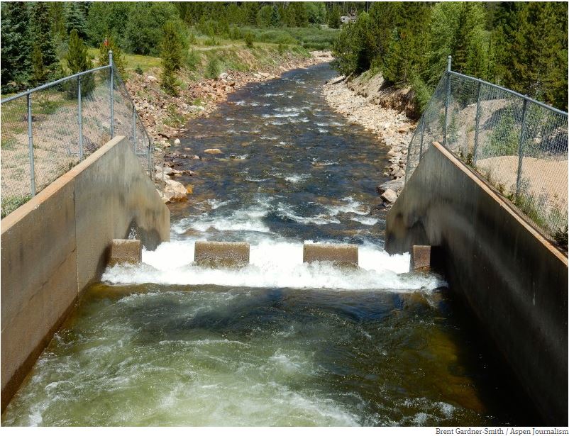
The outfall of the Bousted Tunnel, which delivers water from the Roaring Fork and Fryingpan rivers to the East Slope.
Click the link to read the article on the Ark Valley Voice website (Jan Wondra). Here’s an excerpt:
The Bureau of Reclamation (BoR) announced on Monday that it will direct $60 million in federal funding from the Infrastructure Investment and Jobs Act (IIJA) towards advancing the construction of the Arkansas Valley Conduit (AVC), a 130-mile pipeline project from Pueblo Reservoir east to Eads, Colorado that will deliver safe, clean drinking water to 50,000 people in 40 communities. The Colorado Water Conservation Board (CWCB) has supported this project with $100 million in grants and loans. The Arkansas Valley Conduit project is the final element of the larger Fryingpan-Arkansas Project, which Congress authorized in 1962. The project has literally been decades in the making.
“The SECWCD is thrilled with the announcement by the Bureau of Reclamation that $60 million from the bipartisan Infrastructure Investment and Jobs Act has been allocated for construction of the Arkansas Valley Conduit. This follows on the heels of the award of the first construction contract for the Boone reach,” said Southeastern Colorado Water Conservancy District Senior Policy and Issues Manager Chris Woodka.
“This commitment from BoR is a clear indication of their intent to move this project forward to completion, and to direct resources to it so that clean drinking water will be delivered sooner than originally planned,” he added. “We thank each and every one of you for your patience, and your ongoing support.”
The 5.5 mile Boustead Tunnel transports water from the Fryingpan River drainage into the Arkansas by way of Turquoise Lake (pictured here).
The Rio Grande Basin spans Colorado, New Mexico and Texas. Credit: Chas Chamberlin
Click the link to read the release on the Reclamation website (Mary Carlson):
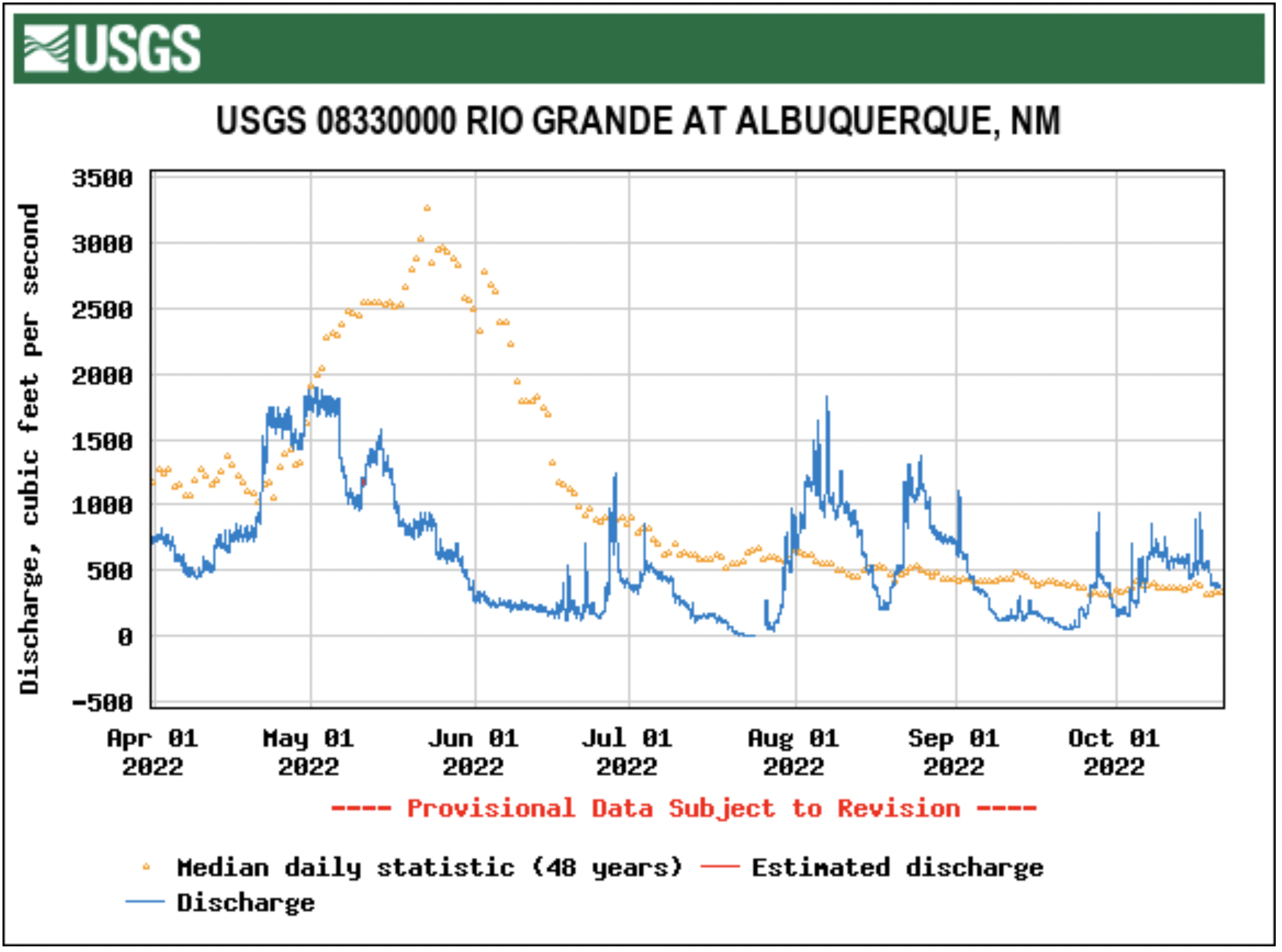
Careful management of limited water supplies and steady rainfall through much of the summer are being credited for helping keep the Rio Grande flowing.
Bureau of Reclamation water managers headed into the summer irrigation season knowing supplies in storage were extremely limited. This spring, an average snowpack for the third year in a row resulted in lower-than-average snowmelt water flows due to strong winds, warmer temperatures, and low soil moisture. El Vado Reservoir received about 62% of the median spring runoff volume, which was 24% less than was expected in April. The Rio Grande spring runoff peaked on May 2 in Albuquerque, nearly a month earlier than average.
“We are seeing higher temperatures that result in snow melting earlier than we’ve seen historically and a below average spring runoff in the Rio Grande Basin,” said Albuquerque Area Manager Jennifer Faler. “Managing the system accordingly during the prolonged drought will remain a top priority and we will continue to work with our partners towards solutions.”
Portions of the Rio Grande between Albuquerque and Elephant Butte Reservoir dried at different times this summer as temperatures spiked. For the first time since the 1980s, a portion of the river in the Albuquerque area also dried. Since the 1990s, Reclamation and our partners have taken significant measures to supplement the river flows and prevent drying in the Albuquerque area. However, without adequate water supplies in storage, it could not be prevented this year. June monsoons materialized and within days, the rainstorms began to help reconnect the river.
The Middle Rio Grande Conservancy District modified its operations early in the season in response to what looked to be dire conditions. River flow from rainstorms throughout the state, however, has allowed farmers to have a nearly full irrigation season.
As construction is underway at El Vado Dam in northern New Mexico, only a small pool of water is being held there. Construction is scheduled to continue through the winter and through the next irrigation season. Reclamation is able to run water through El Vado Dam to pass Rio Chama flows and San Juan-Chama Project releases from Heron Reservoir downstream. The San Juan-Chama Project has received about 61% of a full allocation so far this year.
Elephant Butte and Caballo reservoirs ended their irrigation seasons in late August with a combined storage of about 95,000 acre-feet, about 4% of capacity. Currently, due in large part to subsequent rain, total storage is at about 147,000 acre-feet, approximately 6% of capacity. The Elephant Butte Irrigation District received Rio Grande Project water for about 7 weeks, and Mexico for nearly 10 weeks. Mexico received about 24% of a full allocation. The El Paso County Water Improvement District No. 1 received project water for about 11 weeks.
On the Pecos River, rainfall also helped with storage at Brantley Reservoir, which ended irrigation season with 28,000 acre-feet in storage. Lake Sumner is ending the water year holding about 9,000 acre-feet. Carlsbad Irrigation District farmers received an allocation of 2.2 acre-feet this season. A full allocation of water would be 3.7 acre-feet of water per acre.
Coloradans want the state’s top water road map to mandate faster action, be more accountable, require equitable drought responses between the East and West slopes, and include the crisis on the rapidly drying Colorado River in its estimates of future water shortages.
More than 1,300 individuals and agencies submitted public comments on the draft update to the Colorado Water Plan, according to Russ Sands, chief of water supply planning for the Colorado Water Conservation Board (CWCB).
The public comment period ended Sept. 30. The CWCB is scheduled to finalize revisions to the plan in January 2023. {Editor’s note: The CWCB is a funder of Water Education Colorado, which is a sponsor of Fresh Water News.]
Commenters, including major water utilities, environmental groups, ranchers and farmers, and city and county officials, have asked for numerous changes.
“The plan lacks the language of urgency throughout. It should emphasize the scarcity of time and water to address the life-or-death reality of the drought and the climate crisis that the state of Colorado is facing,” Hispanics Enjoying Camping, Hunting and the Outdoors wrote in their submitted comments.
The CWCB is responsible for drafting and updating the plan and supporting its implementation. Championed by U.S. Senator John Hickenlooper when he served as governor, the state’s first water plan was approved in 2015 after years of public meetings and data gathering.
At the time, it was hailed as a breakthrough in grassroots water planning in the West because of its comprehensive effort to engage the public, analyze existing water use, future shortages, and potential solutions.
Since then, the CWCB has awarded more than $500 million in grants and loans to help communities develop water management plans, projects and other options locals believe are necessary to ensure their water futures.
But the plan was politically difficult to finalize even then because of conflicts between water utilities and environmentalists, pro-dam and anti-dam interests, and agricultural and urban water conflicts.
Regardless, water users across the state say that the water plan has spurred more cooperation than has ever existed before, with public roundtables in each of the state’s eight river basins making decisions and sharing information with one another, using the water plan as a roadmap.
Now, as the CWCB updates the plan and a 22-year megadrought drains the Colorado River system, pressure is building to act quickly.
For example, in their comments several individuals and agencies asked that the updated plan include more measurable goals with deadlines to improve accountability in addressing the state’s looming water shortages and environmental issues.
Business for Water Stewardship (BWS), a nonprofit that seeks to connect corporate funders with environmental initiatives, was among them.
“The water plan lacks specifics and accountability,” BWS wrote. “The plan should include metrics on conservation and storage and guidelines on how we balance competing needs. These metrics are necessary to measure progress on the plan’s goals and objectives.”
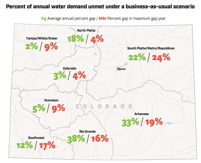
Forecasts show water supplies will not keep pace with demand by 2050 for agricultural (Ag) or municipal and industrial (M & I) needs if Colorado does not find new approaches. Source: 2019 Analysis and Technical Update to the Colorado Water Plan. Credit: Chas Chamberlin
Major water diversions between West Slope river basins and Front Range cities were also a topic of concern.
Roughly 80% of the state’s water supplies originate in West Slope mountain snowpacks, while much of that water is moved to the thirsty Front Range in pipelines and canals known as transmountain diversions or TMDs.
The Colorado River District and other West Slope interests want the state to require that when the West Slope is facing ultra-dry conditions and forced to deal with water restrictions and cutbacks, as it often is just because of its geography, urban cities who are using that West Slope water, live under the same rules. The district represents 15 West Slope counties and is responsible for managing the Colorado River within state boundaries.
For years, West Slope communities whose rivers have been subject to severe drying due to drought and climate change, have complained about urban indifference to their plight.
This year, for instance, some West Slope river basins saw runoff that was well below average, while many Front Range communities, thanks to big reservoirs and better runoff from local rivers, saw normal conditions. There were water restrictions to the west, but few if any to the east.
“The river district recommends a stronger stance towards water conservation and a recommendation that communities reliant on TMD supplies tailor conservation needs when any watershed with their source water is undergoing drought conditions. This is particularly important when the end-use basin is undergoing less severe drought conditions than their TMD source watersheds,” the river district wrote.
The CWCB’s Sands said the state has limited ability to act on a request like this one, given that it has no statewide authority to impose drought restrictions.
Still another major topic of concern among several commenters is the ongoing crisis on the Colorado River. The river begins in the Never Summer Mountains in Rocky Mountain National Park and by the time it makes its way west to the Utah state line, it has generated the majority of the entire seven-state river system’s water.
With the river in crisis and lakes Powell and Mead at historic low levels, Arizona, California and Nevada have begun taking cutbacks, a situation that eventually could occur in Colorado, where major metropolitan areas rely on the river for roughly 50% of their supplies.
And while the draft plan acknowledges the impact of climate change and uncertainties regarding future supplies, commenters say it should include more specifics on how the crisis could affect Colorado’s own water future.
The Sierra Club called release of the draft plan premature, because it did not adequately address the Colorado River crisis. Larimer County, the City of Fort Collins and the Colorado Agricultural Water Alliance, also asked that the draft plan include more specifics on the river’s dicey future.
“Adding the Colorado River crisis” to Colorado’s already well known water problems, “is like adding an overactive bull into an already somewhat ramshackle china shop,” the Sierra Club wrote. “Having the draft plan revision out at this time is premature given the likely need to stop about 30% of Colorado’s present use of Colorado River water.”
Here too, Sands said, because the plan is focused solely on intrastate water issues, rather than interstate issues, there is little more the water plan can do with data on the crisis.
The CWCB is scheduled to address which public requests for additions to the water plan will be included in the final draft at its November meeting, Sands said.
In the meantime, several commenters expressed hope that the revised water plan will create the energy and vision the state needs to address its complicated water future.
Said Colorado Springs Utilities, “The water plan is a formative document that outlines meaningful goals and actions for addressing the water supply gap in a time of increasing water scarcity. It will take political courage to ensure this plan has the impact Colorado requires.”
Jerd Smith is editor of Fresh Water News. She can be reached at 720-398-6474, via email at jerd@wateredco.org or @jerd_smith.
Colorado transmountain diversions via the State Engineer’s office
A reminder of the choices that global society has to make about the climate:
Delaying action on reducing emissions commits the world to live with severe consequences.
Rapid action now means a more habitable world for all.
There is no going back. Choose wisely. Credit: Ed Hawkins via via his Twitter feed
Interior Secretary Deb Haaland, left, and Sen Joe Manchin participated in a roundtable event hosted by the White House Interagency Working Group on Coal and Power Plant Communities, on March 18, 2022. (Interior Department via Flickr/Public domain)
Interior Secretary Deb Haaland has moved forward with proposing that nearly 225,000 acres stretching from the Glenwood Springs area south to Crested Butte and east of Crawford be withdrawn from new federal oil and gas leasing and mining claims for 20 years. Haaland acted on a petition announced by the Biden administration last week as President Biden also created the new Camp Hale-Continental Divide National Monument during a visit to the Camp Hale World War II training grounds outside Leadville. Haaland approved a petition by the U.S. Forest Service and Bureau of Land Management to file the withdrawal application…
Her approval, announced in a Federal Register notice Monday [October 17, 2022], automatically kicks off a two-year period when new mining claims and new federal mineral leases will be prohibited on parts of the White River National Forest, the Grand Mesa, Uncompahgre and Gunnison National Forests, and BLM lands, while the agencies consider moving forward with the 20-year withdrawal in those same areas. Private lands and existing rights, including current oil and gas leases, aren’t affected by the two-year action, and the 20-year withdrawal likewise wouldn’t apply to them. Haaland’s action also kicks off a 90-day public comment period on the proposed withdrawal.
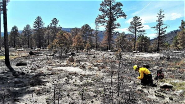
Santa Fe National Forest Hermits Peak fire April 2022. Photo credit: Jim O’Donnell
Click the link to read the article on the ensia website (Jim O’Donnell):
After megafires in the region, some forest systems may never return to their pre-fire conditions. Now, ecologists are redefining how forest ecosystems might be restored in a way that increases resiliency.
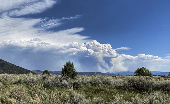
On April 6, 2022, a prescribed fire driven by unusually strong spring winds jumped a control line northwest of Las Vegas, New Mexico. About two weeks later, the same dry winds rekindled embers from another nearby prescribed burn. Driven by 60-mile-per-hour (27-meter-per-second) winds with gusts reaching upwards of 80 miles per hour (36 meters per second), the two fires merged, and the Calf Canyon/Hermits Peak complex became the largest in New Mexico history. By the time the U.S. Forest Service (USFS) declared the fire contained in late August, almost 350,000 acres (141,600 hectares), an area greater than the size of Los Angeles, had burned. Nearly 1,000 structures were destroyed and thousands of people were displaced. Post-fire flooding killed multiple area residents and caused extensive damage.
While fire is an integral part of Southwest forest ecosystems, a century of policies geared toward fire suppression in the American West that has led to a lack of diversity is colliding with climate change, upending the rules. Historically, a mature forest would burn, then, over time, return to a healthy, recognizable state. Today, however, an unprecedented decades-long drought, rising temperatures and massive insect outbreaks are hammering forests across the region, creating ideal conditions for megafires like the Calf Canyon/Hermits Peak inferno.
Thanks to climate change, experts say many southwestern forests destroyed by megafires may never return. Conditions across the region have become too hot and too dry for normal forest succession, and wildfires such as Calf Canyon/Hermits Peak are a catalyst for rapid change to an entirely different ecosystem. Forests can become fire- and flood-prone shrubland, and shrubland can become grassland dominated by invasive species such as cheat grass that likes to burn.
“All bets are off,” says Thomas Swetnam, Regents’ Professor Emeritus of Dendrochronology at the University of Arizona. “I hate to sound apocalyptic, but these are shocking, extraordinary events. The forests we had are not going to come back.”
Residents of Mora, New Mexico, evacuate in May 2022 as the Calf Canyon/Hermits Peak fire crests a ridge less than a mile to the southeast. Forest-dependent communities across northern New Mexico have been dramatically impacted by recent megafires. Photo courtesy of Jim O’Donnell
Healthy forests, especially higher up in the watershed, increase groundwater storage, regulate stream flows and improve overall water quality by holding sediments and other contaminants. “These forest areas are our water storage system,” says Swetnam. “The only way to protect that system is with forest.”
Now, impacted communities, land managers and forest ecologists are all asking the same questions: What do we do next? Is forest restoration possible? Is it desirable? And how do we even define “forest restoration” in the age of climate change?
To answer those questions, researchers are looking at a range of potential solutions. Here’s a look at three that may prove applicable throughout the American West.
Where to Focus
Matthew Hurteau, professor of biology at the University of New Mexico, says that restoring every square acre of burned forest after megafires is neither practical nor necessary.
Even a fire the size and ferocity of the Calf Canyon/Hermits Peak burn is not a complete ecological catastrophe. For much of the forest, it is an opportunity for rebirth and renewal. Most of the acreage burned in the spring of 2022 burned in what forest ecologists consider the “right way.” That is, the fire wasn’t hot enough to cause 100% tree mortality. Instead, the fire swept through, sticking low to the ground, clearing out the forest, laying down beneficial beds of fertilizing ash and triggering germination of native species adapted to fire. Just two months after the burn, many areas were covered in swaths of emerald as grasses and flowers rose through the ash. These areas, says Hurteau, don’t need active, human restoration. They just need time.
A U.S. Forest Service Burned Area Emergency Response soil scientist evaluates soil burn severity. Photo courtesy of InciWeb
Other locations, however, are cause for worry. Tens of thousands of acres burned so ferociously that every tree, shrub, flower and blade of grass is dead, including seeds that may have been waiting in the soil for years. “These high-intensity fires can sterilize the soil, making regeneration impossible. It’s these areas that will need our help,” says Hurteau. “We want to recapture as much of this forest as possible.”
To do so, Hurteau and his colleagues use a mathematical model they created to figure out where post-fire restoration will have the biggest impact and the greatest chance of success.
Utilizing 1 meter (3.3 foot) resolution digital elevation models, solar radiation indices and high-resolution topography models, Hurteau and team first identify areas where natural reseeding is likely and where trees will never be able to grow again. These they set aside. Next, they zero in on areas where reforestation is both important and possible but that were too severely burned to naturally reseed. These include wetter and shadier locations and higher elevation areas vital for watershed protection.
“Site specificity matters,” Hurteau explains. “In a drier zone that gets more sun we might do a mix of seedlings that includes drought-tolerant species like ponderosa pine, while a higher, wetter location might get a mix of other conifers.”
As harsh spring winds drove the Calf Canyon/Hermits Peak megafire, the fierce burn generated a pyrocumulous cloud towering tens of thousands of feet into the sky southeast of Taos, New Mexico. Photo courtesy of Jim O’Donnell
This is a process Hurteau calls “nucleation.” The idea is to create a nucleus of carefully selected seedlings suited for this harsh new environment. Researchers at the New Mexico State University John T. Harrington Forest Research Center in the northern New Mexico village of Mora select hardy, drought-tolerant species for restoration work in the highly impacted areas. The seedlings are drought-stressed in the nursery to acclimate and strengthen them, helping increase the chances they survive.
While a recent article in the journal Forest Ecology and Management found that, typically, survival rates for seedlings hovers around 20%, Hurteau says his team has been able to boost that rate to over 60% using the site-specific modeling tools. Instead of spending 10 to 15 years reforesting an area, 5 years might do it, Hurteau says.
“We might also consider bringing in non-natives to reforest key watershed areas instead of turning it over to fire-prone shrubs,” says Swetnam. Certain pines from the mountains of Mexico not only are adapted to hotter, drier conditions than those in New Mexico, Arizona and Colorado but also may be resistant to crown fires, which spread along the tops of trees. “Protecting our watersheds is vital going forward, and the best way to do that is with forest cover.”
New Mexico state forester Laura McCarthy is open to the idea. “It isn’t my first choice, but I say we follow the science and if the science tells us to do it, then let’s do it.”
A Patchwork Quilt
Returning diversity to southwestern forests is another tool forest ecologists say will reduce the possibility of future wildfires while protecting the headwaters of vital watersheds.
It is the higher elevation spruce-fir forests that keep McCarthy up at night. Much like the lower elevation ponderosa pine forests, spruce-fir ecosystems are naturally fire adapted, historically seeing stand-replacing fires about every 200 to 300 years.
These historic fires were destructive, but in the decades after such fires, stands of aspen rapidly filled in the burned areas, creating a natural spruce-fir ecosystem that was a mosaic of different aged spruce-fir stands, vast tracks of aspen and open meadows, somewhat like a patchwork quilt. That patchiness slowed and redirected subsequent fires, resulting in smaller burns that reinforced the pattern. Fires rejuvenated the forest diversity, creating a resilient system.
The historic fire regime of Southwestern forests began to change with grazing and wood gathering by local communities in the early 1800s. In 1910, federal forest management policy in the West turned toward total fire suppression, putting out every fire almost as soon as it began. This “10 a.m. policy” (meaning every fire should be suppressed by 10 a.m. the day following its initial report) resulted in massive swaths of landscape dominated almost exclusively by spruce-fir. The diversity that protected the overall system is gone and, without fire, the spruce-fir forest is taking over areas that were previously dominated by Douglas fir, making for a more flammable forest and further reducing diversity.
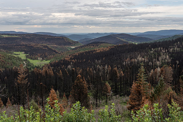
Burn scars from the Calf Canyon/Hermits Peak fire line the landscape. Photo courtesy of Matthew.kowal, licensed under CC BY-SA 4.0
“Continuous unbroken canopy becomes prone to highly destructive burns,” McCarthy says. “When you think about forests of the future, we want to lose the uniformity. Forest resilience is rooted in the patchiness, the diversity.”
To regain that diversity in the spruce-fir forests, the New Mexico State Forestry Division is working with both private landowners and the USFS on thinning and burning projects designed to encourage the return of aspen to the mix.
True Climate Change Engineer
When Emily Fairfax, assistant professor of Environmental Science and Resource Management at California State University and Utah State University, pored over satellite images of landscapes that had seen massive wildfires in recent summers, she noticed a different type of landscape diversity. Green oases burst from the images, contrasting with the surrounding charred landscape. These were wetlands created by families of beavers damming local streams.
Beavers are an important tool for future forest restoration, Fairfax says. A true climate change engineer, beavers construct dams that slow destructive floods often seen in burn scars, help replenish groundwater, filter ash that can harm fish populations and serve as seed banks to help regrow the surrounding ecosystem post-fire.
“It feels obvious,” Fairfax says. “If beavers were there before the fire, support them in recovery. If there weren’t beavers in the area, encourage them to repopulate the area after a fire. And the best part? Beavers work for free.”
Slow the Impacts
The near-term impacts of climate change are irreversible. The question facing communities throughout the world is how to adapt. In the American Southwest, forest-dependent communities are thinking about how to protect their homes and watersheds in the face of a rapidly changing climate.
“Natural systems are unstable,” Hurteau says. “Things move around and conditions change. That’s normal. But the rate of change these days is so rapid it is making it difficult, if not impossible, for forest species to adapt. We want to slow down the rate of change, slow down the climate impacts.”
It’s a common story: Candace McNatt of Durango, in southern Colorado, kept losing bidding wars to buy a house. She finally settled on a tiny home of just 350 square feet.
McNatt works as an operating room nurse and is a single mother of two teenagers, one about to go to college. Though she landed on the homeownership ladder at one of its lower rungs, she’s relieved. “But this is not how I saw myself approaching the age of 40,” she muses.
The rent on her home lot is $650; her mortgage just $604. Combined, that’s about half of what she had been paying to rent an apartment in Durango.
These days, real estate prices in Durango, as in so many Western towns, have outrun most workers’ ability to buy or even rent modest digs. McNatt, for example, makes $85,000 annually, which places her at over 90% of the area median income in Durango.
A two-year-old study by Root Policy, a Denver consulting firm, showed that single- and two-parent households have begun leaving Durango and southwestern Colorado in droves. Replacing them are retirees and wealthy non-working people. That means businesses struggle to find workers as 80% of people moving into La Plata County don’t work in the region.
Adding to the housing crisis is the boom in short-term rentals, compounded by second-home owners snatching up houses once rented to students at the local Fort Lewis College. Fort Lewis has been scrambling for housing. Starting in 2019, demand for on-campus living skyrocketed, and this August, the college of 3,856 students placed 93 kids in hotel rooms. Thirty more were quadruple-bunked in off-off-campus apartments.
The town thrums with stories of scores of students living in cars and scouting for “safe parking,” meaning places where police won’t roust them out. Others camp out on public lands.
The city of Durango, population 19,400, has tried to help by limiting short-term rentals within city limits, and hiring housing expert Eva Henson to figure out how to create workforce housing.
At a Durango council meeting last month, Henson said that only 169 housing units are under construction, while a thousand more are planned. Finished units for the first nine months of 2022 totaled 59. Meanwhile, a ballyhooed Accessory Dwelling Unit (ADU) regulation, which would allow homeowners to add “granny flats,” fizzled. Just two were completed this year, and potential builders complain that restrictions remain tight.
According to the Root Policy study, Southwestern Colorado’s overall housing deficit is 2,500 housing units. “Every town is short on housing,” agrees Nicole Killian, a community development director for the Durango bedroom community of Bayfield. Killian says developers plan to build 800 homes over the next decade, a 75% increase in housing units.
What everyone can agree on is that the area’s housing shortage began in Durango, the biggest and most attractive town, then radiated out to every other town within 50 miles.
“Durango has had a sales tax that funded parks and recreation,” says Mayor Barbara Noseworthy. “Now we need to redirect some of that money toward housing.” But the council is divided, with some members favoring a free market approach.
So far, the free market wants only million-dollar homes. McNatt tells the story of two clinical experts at the hospital, each making $160,000, who “have looked for a house forever. And he’s like, I refuse to pay $1 million for a house.” In the end, “they paid over $1 million and are now house-poor.”
One result of the housing crunch, says Mayor Noseworthy, is finding people for essential jobs: “We have difficulty getting math teachers. If you can’t get a high school math teacher, who’s going to live here?”
Meanwhile, one housing solution in Durango has been Chris Hall’s Hermosa Orchards Village of 22 tiny owner-occupied homes, a gem of collegiality. Many of its residents commute to Purgatory Ski Area or Silverton seasonally, and given their small inside spaces, tend to congregate outside on their stoops.
On Nov. 8, there is hope for affordable housing, thanks to Proposition 123 on the ballot. The measure would give grants and loans to local nonprofits to build workforce housing, and provide mortgage assistance to people like McNatt.
At the end of my interview with McNatt, she took me to meet a friend who lives in a storage unit. The box-like space was narrow, his sleeping bag on a foam pad just fitting between a snow blower and a leaf blower. He said he was glad he’d found it.
Dave Marston is the publisher of Writers on the Range, writersontherange.org, an independent nonprofit dedicated to spurring lively conversation about the West. He lives in Durango, CO.
Lake Nighthorse and Durango March 2016 photo via Greg Hobbs.