
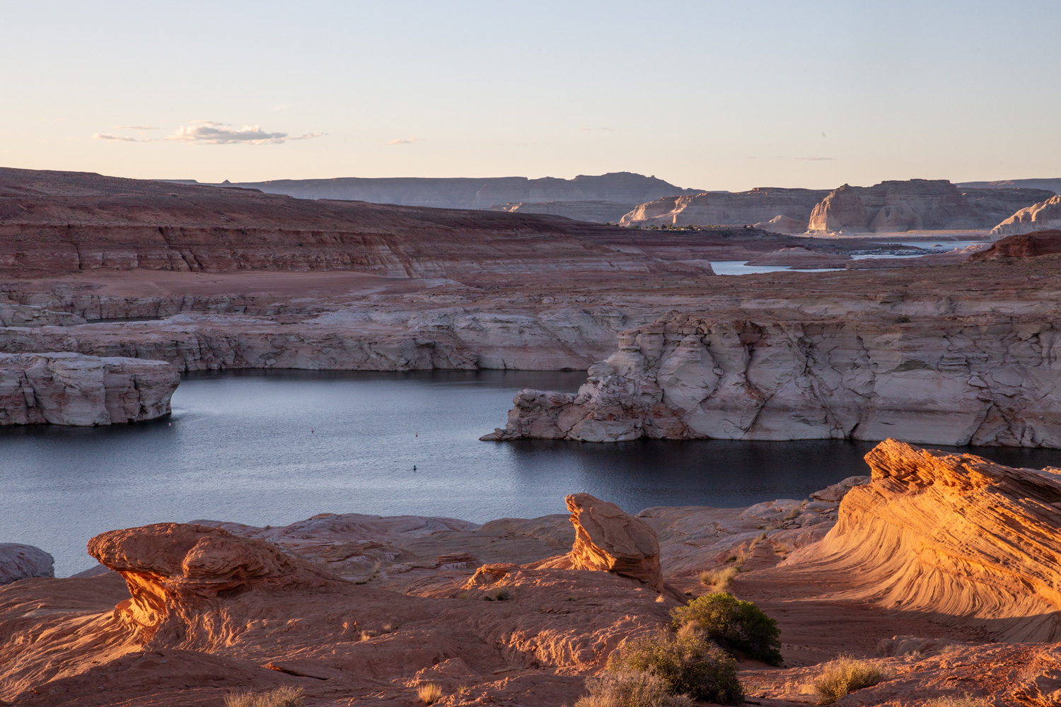
The amount of drought shown by the US #DroughtMonitor is immense, leaving little of the US in normal status.
— Denise Gutzmer (@DroughtDenise) October 27, 2022
Just 29.28% of the US and Puerto Rico is free of drought (D1-D4) and abnormal dryness (D0), while a #record low 15.54% of the contiguous US is free of #drought and dryness pic.twitter.com/rO1FPqouNV
Day: October 29, 2022
Interior’s plan won’t solve the #ColoradoRiver crisis. Here’s what will: What if farmers competed with one another to cut water consumption? — @HighCountryNews #COriver #aridification #CRWUA2022
Click the link to read the article on the High Country News website (Nick Hagerty and Bryan Leonard):
It’s now clear that the Colorado River simply does not deliver as much water as we take from it. Fast, dramatic cuts — totaling up to 30% of all the water currently in use — are needed now if we’re going to avoid the “deadpool” conditions in Lake Mead and Lake Powell that would trap any remaining water behind dams. The urgency is clear, yet the seven Colorado River Basin states have repeatedly failed to agree on how to share the cuts.
On Oct. 12, the Department of the Interior announced one step toward a solution: the Lower Colorado Conservation and Efficiency Program. The program invites water users to propose new water conservation projects. In return, they’ll receive some of the $4 billion in the Inflation Reduction Act that’s been earmarked for water conservation in the West. Two parts of the program focus on short-term action for the immediate crisis; the third is focused on longer-term solutions.
There is a lot to like about Interior’s new program. It will help to reduce conflict by paying for voluntary conservation. One part offers a fixed price of $330 to $400 per acre-foot, making it easier for farmers, irrigation districts, tribes and cities to decide whether (and how much) they want to participate at that price. The other part allows water users to propose both conservation actions and their asking price for agreeing to these actions. Water users will get to choose whether to opt in to cutbacks, and at what level of compensation.
But the details are fuzzy. How much of the IRA funding will be allocated under the program, and how much will go to each component of it? How will proposals be selected? What happens if the program fails to attract enough conservation? Without clear answers, water users may be just as hesitant as they have been all summer, waiting for others to make the first move while hoping to get a better deal later on. This new program fails to meet the urgency of the current crisis.
There is another way to swiftly resolve the shortage — at least temporarily — while minimizing pain, conflict and economic harm. Interior should spend the bulk of its IRA funds by conducting what’s called a reverse auction.
In most auctions, people bid what they are willing to pay to acquire something. Here, water users would bid what they are willing to accept in order to forgo a certain quantity of water deliveries. The government would then accept the lowest bids. Many of the winning bids are likely to come from agriculture, which accounts for as much as 80% of water use.
A reverse auction would get Interior more “bang for its buck” than the fixed-price plan. Farmers would have an incentive to submit lower bids, increasing the chances that they will “win” and get paid. This leaves more money for Interior to accept more bids at higher prices, yielding more conservation. And the more conservation that Interior can achieve through voluntary means, the fewer uncompensated cuts will be needed in the future.
A reverse auction will be more successful if Interior decides to act now and use the bulk of the $4 billion authorized by Congress to pay farmers to cut their water consumption, while making it clear that this is it: There will be no more rounds of negotiation or compensation programs in the next few years. This would encourage everyone to jump at the chance to be compensated now, rather than wait for a better deal later.
Interior can also help an auction succeed by spelling out precisely how much water must be cut and identifying who will be affected if voluntary conservation fails. So far, officials have been reluctant to commit to any exact plans. A clear backup plan would put an end to wishful thinking and lead water users to bid accordingly.
IRA funds should be more than enough to resolve all of next year’s shortage through an auction. A rough estimate based on recent prices for water leases suggests that $4 billion spent through an auction could achieve all necessary cutbacks for somewhere between two and seven years.
What’s more, many farmers in the West already have experience with reverse auctions. USDA’s Conservation Reserve Program uses reverse auctions to protect millions of acres of environmentally sensitive land every year. The Nature Conservancy uses a similar approach to secure temporary habitat for migratory birds by paying farmers to flood fields in California’s Central Valley.
We fear that Interior’s current plan, as announced, is set up for failure. Participation may be low, and the funding could be exhausted too early. We don’t have another six months to sort out who is going to conserve water while fish habitat evaporates, Lake Mead continues to drain, and the turbines in Glen Canyon Dam stutter to a stop. Instead, we can solve the water shortage now — and with the least possible pain — with an auction that gets the incentives right the first time around.
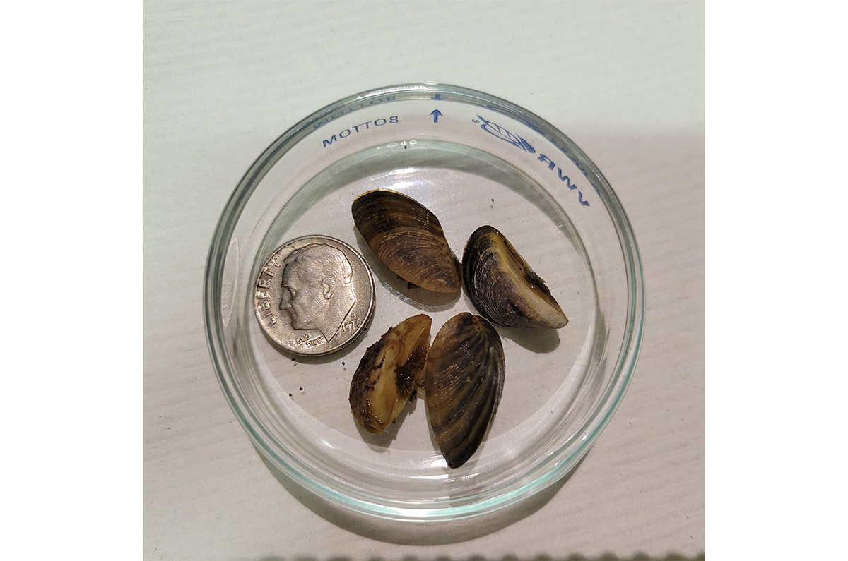
Additional invasive zebra mussels found at Highline Lake State Park — #Colorado Parks & Wildlife
Click the link to read the article on the Colorado Parks & Wildlife website (Travis Duncan):
CPW staff has discovered the presence of additional invasive zebra mussels at Highline Lake located at Highline Lake State Park north of Loma, Colorado. The discovery comes following increased testing after CPW found a single adult zebra mussel on an artificial PVC substrate in the lake during routine invasive species sampling on Sept. 14.
The discovery of additional invasive mussels in the water is indicative of an established population in the reservoir and has prompted CPW to change the status of the body of water from “Suspect” to “Infested.” This is the first time a body of water has been categorized as infested with zebra mussels in the state of Colorado.
There is currently no boating on the lake because Highline Lake closes to all surface-water activities for the season annually on October 1.
“Thanks to Colorado’s robust early detection sampling and monitoring program, we were able to make this discovery,” said CPW Acting Director Heather Dugan. “As more and more people use our water resources for boating, we must continue to work tirelessly to prevent the spread of these harmful invasive species.”
The State of Colorado requires boats to be professionally inspected if:
- a boat has been in any body of water that is positive, or suspect for ANS
- a boat has been in any body of water outside of Colorado
- a boat will be entering any water body where inspections are required
Boats exiting infested waters that are not cleaned, drained, and dry are subject to mandatory decontamination requirements.
The establishment of invasive species can lead to millions of dollars in damages to water-based infrastructure, impact water quality and limit recreational opportunity. CPW’s invasive species experts are evaluating next steps and will have more to communicate on the actions it is taking at Highline Lake at a later date.
Please help CPW stop the movement of harmful invasive species, such as zebra mussels, into new waters. Public awareness and participation is the best weapon in the prevention of invasive species.
Please visit the CPW website for more information about zebra and quagga mussels.

Click the link to read “Mussels muscle into Highline: Infestation is first in Colorado” on the Grand Junction Daily Sentinel website (Dennis Webb). Here’s an excerpt:
Alan Martinez, manager of Highline Lake State Park, said that after previous sampling found no more of the mussels, 10 adults have now been found at different locations in the lake, thanks to additional discoveries on Friday and Sunday. The discovery of multiple adults means they’re assumed to be reproducing.
“We are unfortunately the first-ever body of water infested” in the state, he said. “It’s not a title that we want. Now we’ve got to figure out how to protect the rest of Colorado.”’
He said there will now be a lot of discussion within Colorado Parks and Wildlife about how to do that.
“We need to figure out where we move forward at this point and right now we don’t have an answer on that,” he said.
Now the new protocol will remain as long as the lake is infested, and Martinez said there’s no way of getting rid of the mussels short of draining the lake. He previously has said that doing that would mean losing a warm-water fishery there that took decades to build. Robert Walters, Parks and Wildlife’s invasive species program manager, has said that even draining a lake doesn’t guarantee eradication.
$500M in new federal funds to give thousands of Coloradans freedom from #lead, #PFAS tainted drinking #water — @WaterEdCO
Click the link to read the article on the Water Education Colorado Website (Jerd Smith):
Hundreds of thousands of Coloradans exposed to drinking water tainted by lead from aging, corroded city pipes or so-called “forever chemicals,” will see clean water faster thanks to a historic infusion of $500 million from the federal government.
The money, largely from the new Bipartisan Infrastructure Law, is being funneled through the Colorado Department of Public Health and Environment over a five-year period and will allow miles of lead water delivery pipes to be replaced in towns across the state much faster than cities with little access to cash could achieve.
It will also be used to remove a set of chemicals known as PFAS, or poly and perfluoroalkyl substances, that are present in household and industrial products, such as Teflon and fire-fighting foam. The substances have been unregulated to date, although states and the federal government are writing new regulations to address the contaminants.
CDPHE officials said the money will double the agency’s capacity to fund its water quality safety work.
“The federal money is big,” said Nicole Rowan, director of the CDPHE’s Water Quality Control Division. “It’s a once in a generation opportunity to improve our infrastructure here in Colorado.”
To date, 67 Colorado water districts and communities, including the Academy Water and Sanitation District north of Colorado Springs, Limon, Louisville and Grand Junction, have expressed an interest in and are eligible for the funds, according to documents on file at the CDPHE.
Denver Water has been awarded $76 million to fast-track its lead pipe replacement program. The infusion will allow Denver to shave 1.5 years off the 15-year program, according to spokesman Jose Salas.
The City of Englewood also plans to apply, and will ask for $79 million to replace 8,000 lead service lines, according to Sarah Stone, deputy director of business solutions for Englewood Utilities.
Stone said the federal infrastructure funding will provide a critical boost to its efforts to remove lead from Englewood’s drinking water delivery system, if the city’s application is approved.
“We were extremely worried,” Stone said. “This means we can fund the program.”
Cities across the country, including Denver, Flint, Mich., Pittsburgh, Penn., Newark, N.J., and Washington, D.C., have been dogged by an increase in lead contamination as service lines age and corrode, allowing the lead to comingle with drinking water supplies, eventually reaching taps.
Denver Water, which is Colorado’s largest municipal water utility, has known lead was present at the tap in some of its customers’ homes since it appeared in routine sampling in 2013. The levels exceeded the benchmarks set under the Safe Drinking Water Act.
For several years, the utility ran pilot tests and negotiated with CDPHE and EPA over how best to eradicate the harmful metal. Though the amounts of lead found in Denver’s tap water samples varied, no amount of lead is considered safe to ingest, especially for young children.
The CDPHE issued an order in 2018 requiring Denver to begin adding phosphorous to its water, one of the most effective ways to reduce corrosion in pipes. But phosphorous is also a pollutant and causes problematic algae blooms in lakes and rivers. Adding it to the municipal drinking water supply would also make it harder for wastewater treatment operators to meet their own obligations to keep phosphorous out of rivers and streams.
Due to those concerns, Aurora, Metro Water Recovery, The Greenway Foundation, and eventually Denver, sued the CDPHE in 2018 to stop the order from taking effect.
The dispute was settled after Denver was able to obtain a rare variance under the Safe Drinking Water Act in exchange for agreeing to invest some $68 million over 15 years to replace lead service lines, offer free water filters to residents as they wait for the new lines to be installed, conduct community education programs, and increase the pH of the water supply to also help reduce corrosion in pipes.
Several cities and water districts are hoping the federal funding will allow them to mitigate their ongoing issues with PFAS contamination.
Roy Heald manages the Town of Security’s water utility. The town has been hard-hit by PFAS contamination attributed to Peterson Air Force Base. The PFAS chemicals from fire-fighting foam contaminated its groundwater.
Though the military facility has built a remediation plant for Security, it is considered a temporary facility, Heald said. With $450,000 in federal money from the American Rescue Plan Act approved earlier this year, Security is converting the plant to a permanent facility, one capable of operating for the decades it will likely take to clean up the groundwater.
“We’re happy to get it,” Heald said. “This work has to be done, and it’s $450,000 our ratepayers won’t have to pay.”
Jerd Smith is editor of Fresh Water News. She can be reached at 720-398-6474, via email at jerd@wateredco.org or @jerd_smith.
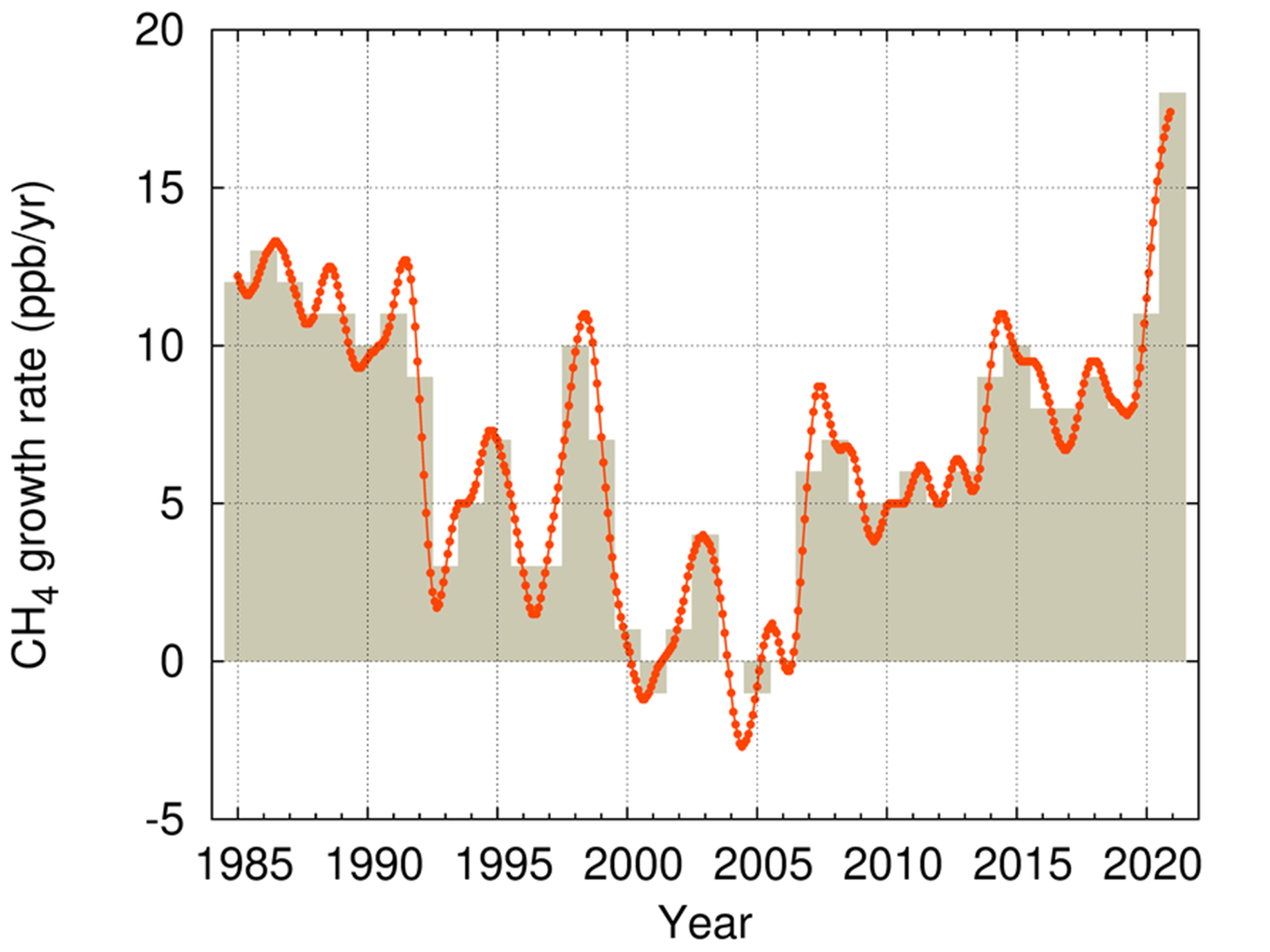
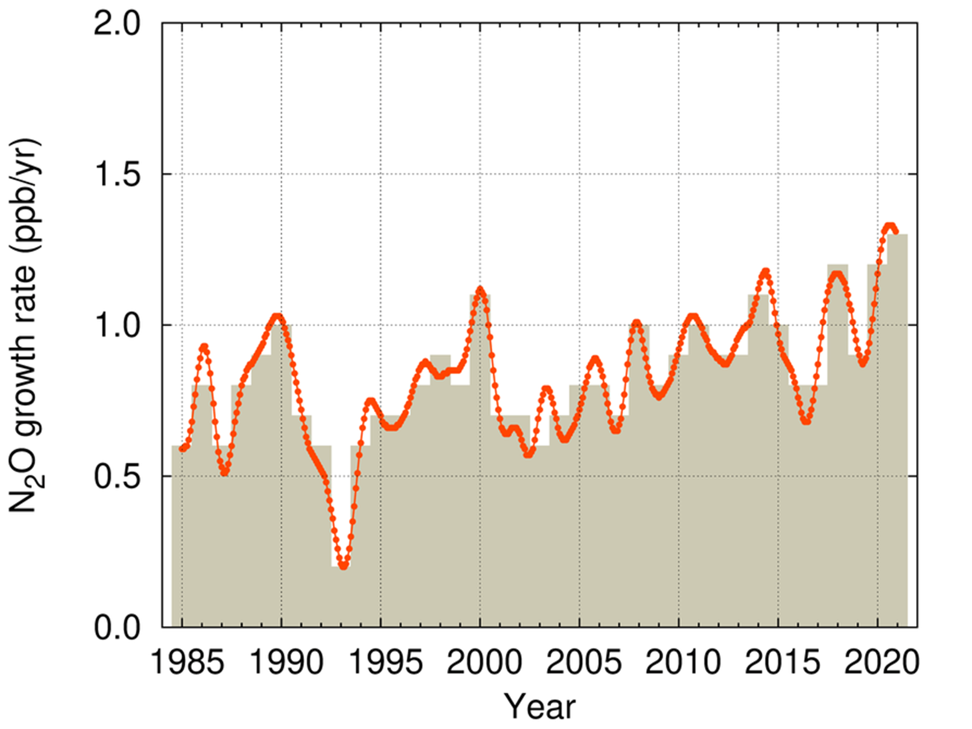
More bad news for the planet: greenhouse gas levels hit new highs: WMO records biggest increase in #methane concentrations since start of measurements — World Meteorological Organization #ActOnClimate #KeepItInTheGround
Click the link to read the article on the World Meterorological Organization website:
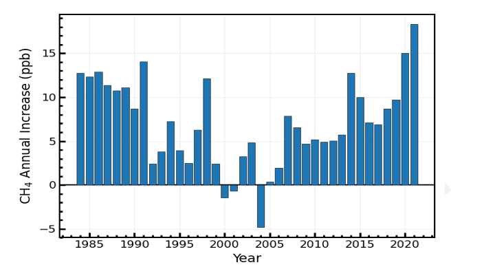
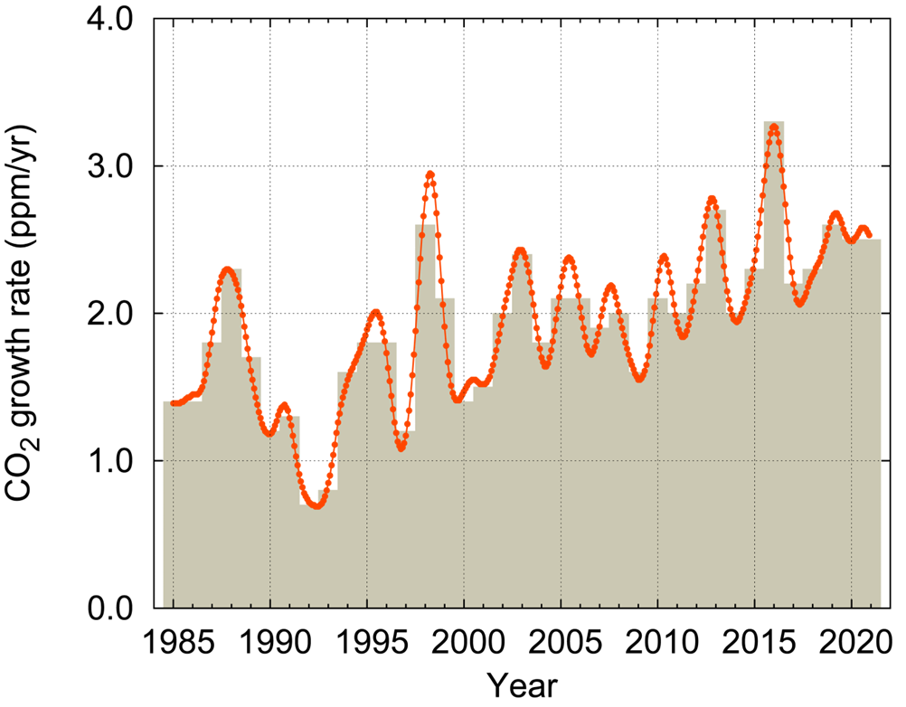
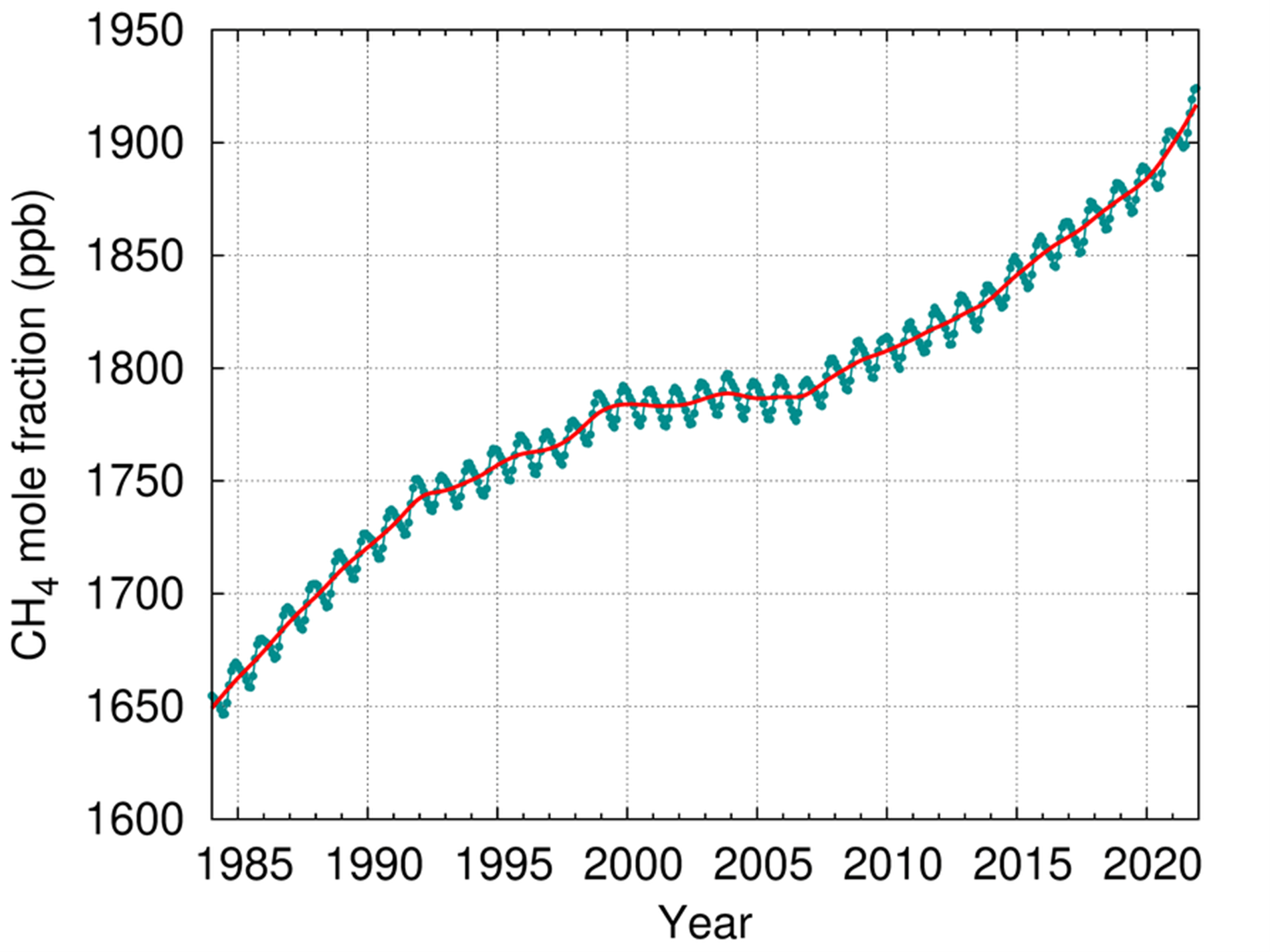
In yet another ominous climate change warning, atmospheric levels of the three main greenhouse gases – carbon dioxide, methane and nitrous oxide all reached new record highs in 2021, according to a new report from the World Meteorological Organization (WMO).
WMO’s Greenhouse Gas Bulletin reported the biggest year-on-year jump in methane concentrations in 2021 since systematic measurements began nearly 40 years ago. The reason for this exceptional increase is not clear, but seems to be a result of both biological and human-induced processes.
The increase in carbon dioxide levels from 2020 to 2021 was larger than the average annual growth rate over the last decade. Measurements from WMO’s Global Atmosphere Watch network stations show that these levels continues to rise in 2022 over the whole globe.
Between 1990 and 2021, the warming effect on our climate (known as radiative forcing) by long-lived greenhouse gases rose by nearly 50%, with carbon dioxide accounting for about 80% of this increase.
Carbon dioxide concentrations in 2021 were 415.7 parts per million (ppm), methane at 1908 parts per billion (ppb) and nitrous oxide at 334.5 ppb. These values constitute, respectively, 149%, 262% and 124% of pre-industrial levels before human activities started disrupting natural equilibrium of these gases in the atmosphere.
“WMO’s Greenhouse Gas Bulletin has underlined, once again, the enormous challenge – and the vital necessity – of urgent action to cut greenhouse gas emissions and prevent global temperatures rising even further in the future,” said WMO Secretary-General Prof. Petteri Taalas.
“The continuing rise in concentrations of the main heat-trapping gases, including the record acceleration in methane levels, shows that we are heading in the wrong direction,” he said.
“There are cost-effective strategies available to tackle methane emissions, especially from the fossil fuel sector, and we should implement these without delay. However, methane has a relatively short lifetime of less than 10 years and so its impact on climate is reversible. As the top and most urgent priority, we have to slash carbon dioxide emissions which are the main driver of climate change and associated extreme weather, and which will affect climate for thousands of years through polar ice loss, ocean warming and sea level rise,” said Prof. Taalas.
“We need to transform our industrial, energy and transport systems and whole way of life. The needed changes are economically affordable and technically possible. Time is running out,” said Prof. Taalas.
WMO UN Climate Change conference, COP27, in Egypt from 7-18 November. On the eve of the conference in Sharm-el-Sheikh it will present its provisional State of the Global Climate 2022 report, which will show how greenhouse gases continue to drive climate change and extreme weather. The years from 2015 to 2021 were the seven warmest on record.
The WMO reports seek to galvanize COP27 negotiators into more ambitious action decision makers to achieve the Paris Agreement goal to limit global warming to well below 2, preferably to 1.5 degrees Celsius, compared to pre-industrial levels. The average global temperature is now more than 1.1°C above the 1850–1900 pre-industrial average.
Given the need to strengthen the greenhouse gas information basis for decisions on climate mitigation efforts, WMO is working with the broader greenhouse gas community to develop a framework for sustained, internationally coordinated global greenhouse gas monitoring, including observing network design and international exchange and use of the resulting observations. It will engage with the broader scientific and international community, in particular regarding land surface and ocean observation and modelling.
WMO measures atmospheric concentrations of greenhouse gases – what remains in the atmosphere after gases are absorbed by sinks like the ocean and biosphere. This is not the same as emissions.
A separate and complementary Emissions Gap Report by UN Environment will be released on 27 October. The Emissions Gap report assesses the latest scientific studies on current and estimated future greenhouse gas emissions. This difference between “where we are likely to be and where we need to be” is known as the emissions gap.
As long as emissions continue, global temperature will continue to rise. Given the long life of CO2, the temperature level already observed will persist for decades even if emissions are rapidly reduced to net zero.
Highlights of the Bulletin
Carbon dioxide (CO2)
Atmospheric carbon dioxide reached 149% of the pre-industrial level in 2021, primarily because of emissions from the combustion of fossil fuels and cement production. Global emissions have rebounded since the COVID-related lockdowns in 2020. Of the total emissions from human activities during the 2011–2020 period, about 48% accumulated in the atmosphere, 26% in the ocean and 29% on land.
There is concern that the ability of land ecosystems and oceans to act as “sinks” may become less effective in future, thus reducing their ability to absorb carbon dioxide and act as a buffer against larger temperature increase. In some parts of the world the transition of the land sink into CO2 source is already happening.

Methane (CH4)
Atmospheric methane is the second largest contributor to climate change and consists of a diverse mix of overlapping sources and sinks, so it is difficult to quantify emissions by source type.
Since 2007, globally-averaged atmospheric methane concentration has been increasing at an accelerating rate. The annual increases in 2020 and 2021 (15 and 18 ppb respectively) are the largest since systematic record began in 1983.
Causes are still being investigated by the global greenhouse gas science community. Analysis indicates that the largest contribution to the renewed increase in methane since 2007 comes from biogenic sources, such as wetlands or rice paddies. It is not yet possible to say if the extreme increases in 2020 an 2021 represent a climate feedback – if it gets warmer, the organic material decomposes faster. If it decomposes in the water (without oxygen) this leads to methane emissions. Thus, if tropical wetlands become wetter and warmer, more emissions are possible.
The dramatic increase might also be because of natural interannual variability. The years 2020 and 2021 saw La Niña events which are associated with increased precipitation in tropics.
Nitrous oxide (N2O)
Nitrous oxide is the third most important greenhouse gas. It is emitted into the atmosphere from both natural sources (approximately 57%) and anthropogenic sources (approximately 43%), including oceans, soils, biomass burning, fertilizer use, and various industrial processes. The increase from 2020 to 2021 was slightly higher than that observed from 2019 to 2020 and higher than the average annual growth rate over the past 10 years.

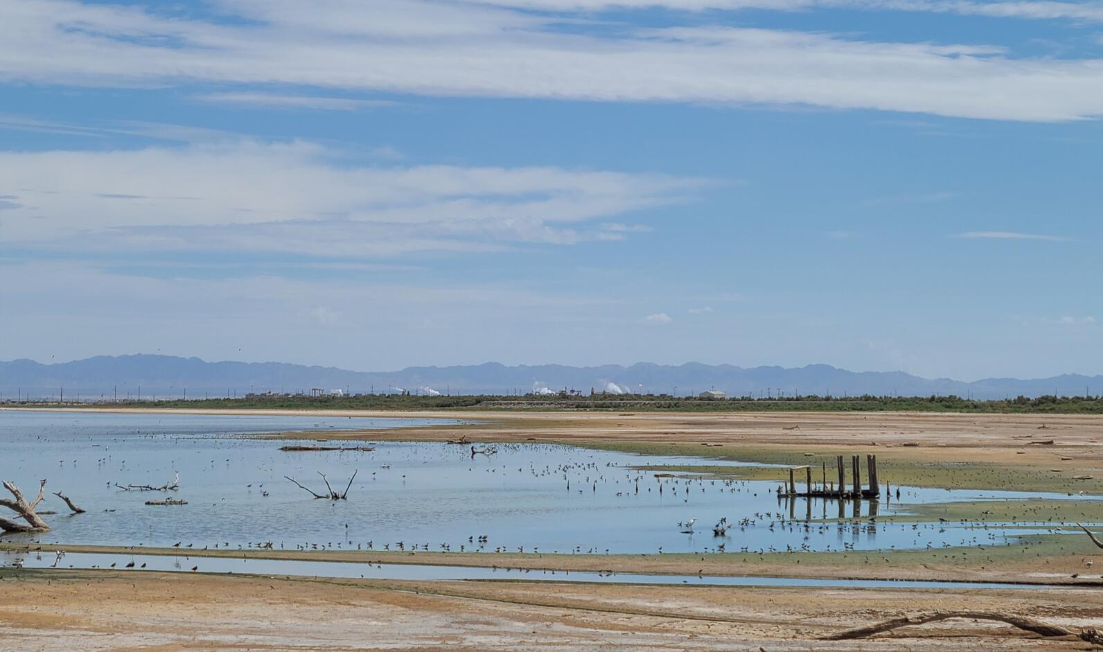
Shorebirds flock to the #SaltonSea: “…thousands upon thousands of Black-necked Stilts, Long-billed Curlews, and Least and Western Sandpipers” — Audubon #California
Click the link to read the article on the Audubon California website (Andrea Jones):
If it wasn’t for the sun low on the horizon or the sparrows singing quickly from nearby shrubs, one would barely realize it was morning. The heat along the Salton Sea, with some added humidity, already felt slightly oppressive. Our shorebird survey route included the shoreline along the State of California’s Species Conservation Habitat (SCH) 4,100 acre wetland remediation project on the southwest corner of the Sea, near the New River mouth. We found ourselves in a construction site, and after asking for access permission, were given hard hats and sent along our way to navigate a series of levees and dirt roads and look for birds.
It’s been 30 years since the last region-wide surveys for shorebirds in the Intermountain West, the mostly arid region between the Rockies and the Sierra, home to large, saline bodies of water including Great Salt Lake. National Audubon Society, in partnership with Point Blue Conservation Science, the US Fish & Wildlife Service, and state agency partners embarked on an effort this past August to resurvey freshwater wetlands and saline lakes across 11 states in the Intermountain West. The project’s goals are to complete a comprehensive surveys of wetland sites over the next 3 to 5 years, compare current distributions to historic surveys, and identify environmental- and human-related factors driving shorebird distributions.
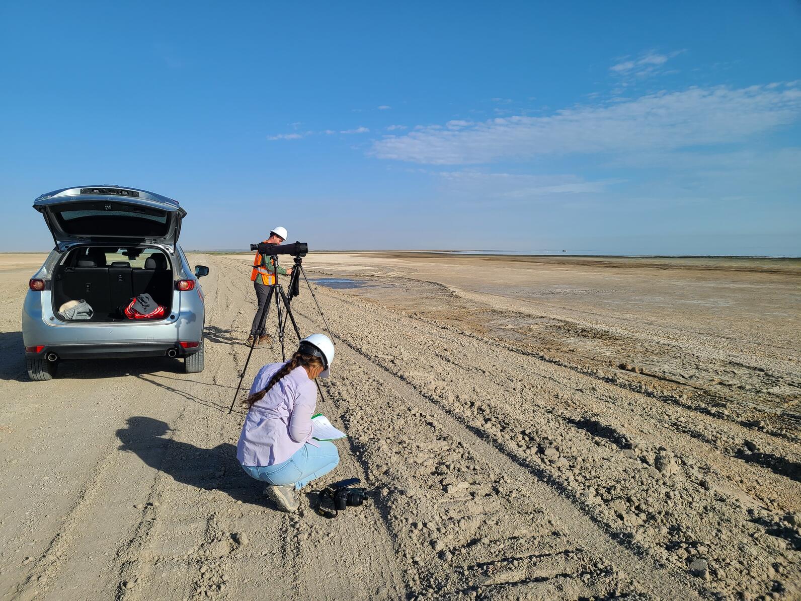
The Salton Sea is part of this effort, and a group of us set out to the Sea for shorebirds, section by section, on one hot August morning this summer. My group consisted of myself, Audubon’s Salton Sea Program Coordinator Camila Bautista, and Trevor Wimmer, Salton Sea bird survey contractor. Knowing that the temperatures would climb to or above 100 degrees, we started our survey at sunrise, when the temperature was already in the mid 80’s.
Despite the heat, an occasional noisy truck passing by, and the sweat dripping down my face from the hard hat, the view of shorebirds and many other species of waterbirds was hard to beat. The shorebirds didn’t seem to mind the heat or noise, either! We were pleasantly surprised to find ourselves counting thousands upon thousands of Black-necked Stilts, Long-billed Curlews, Least and Western Sandpipers and smaller but still significant numbers of Black-bellied and Snowy Plovers, Marbled Godwits, and less common Stilt Sandpipers. Among the shorebirds picking in the mud along the Sea’s edge were large groups of hundreds of Red-necked Phalaropes, shorebirds that spin in circles to churn up the water to reveal tasty morsels. These unusual shorebirds stop at saline lakes across the west before spending the winter out on the open oceans. The mudflats and shoreline were full of shorebirds in all directions, as far as the heat haze would allow our spotting scopes to see. The air was full of Black Terns, a beautifully elegant, little black and grey seabird that stops at the Sea post breeding before continuing its migratory journey for the winter to the Pacific Coast of Central and South America.
We poked our way along the edges of the Sea and construction zone, using our vehicle as the only shade in slight. In front of us, birds ringed the Sea, and behind us, trucks were working around the clock moving dirt in an endless maze of dirt roads and dirt pond bottoms, that, once flooded, would become future wetlands. I was relieved to still see so many birds still at the Sea, and wanted to assure them, if they could hear me, that when they come back in a year they will have so much additional new habitat to use as the Sea continues to recede. The SCH project is scheduled for completion fall of 2023, providing new habitats for waterbirds to help replace so much of what has been lost. Flooding this area will also help alleviate dust blown off the exposed lakebed.
The Salton Sea is an integral part of the migratory journey of so many species of waterbirds, and visiting the Sea during migration allowed me to see that shorebirds are still able to feed along the Sea’s muddy shoreline. It also gave me a first-hand look at the state’s progress on completing the first big wetland habitat project at the Sea. I look forward to returning next year to observe how birds make use of the new habitats being constructed. This month’s International Migratory Bird Day highlights the significant treks shorebirds take and how important it is for us to be stewards of their long journeys, ensuring that there is safety, food, shelter and water, every step along the way. To learn more about shorebird migration, visit Audubon’s new Bird Migration Explorer.
Interior Department Initiates Significant Action to Protect #ColoradoRiver System: Proposal to revise operating guidelines one of several decisive steps underway to protect the System #COriver #aridification #CRWUA2022

Click the link to read the release on the Reclamation website:
As collaborative work continues across the Colorado River Basin to address the ongoing drought crisis, the Department of the Interior today announced expedited steps to prepare new measures that, based on current and projected hydrologic conditions, are needed to improve and protect the long-term sustainability of the Colorado River System. To address the serious operational realities facing the System, the Bureau of Reclamation is initiating an expedited, supplemental process to revise the current interim operating guidelines for the operation of Glen Canyon and Hoover Dams in 2023 and 2024 in order to provide additional alternatives and measures needed to address the likelihood of continued low-runoff conditions across the Basin.
“The Interior Department continues to pursue a collaborative and consensus-based approach to addressing the drought crisis afflicting the West. At the same time, we are committed to taking prompt and decisive action necessary to protect the Colorado River System and all those who depend on it,” said Secretary Deb Haaland. “Revising the current interim operating guidelines for Glen Canyon and Hoover Dams represents one of many critical Departmental efforts underway to better protect the System in light of rapidly changing conditions in the Basin.”
Reclamation will publish a Notice of Intent (NOI) to prepare a Supplemental Environmental Impact Statement (SEIS), which will include proposed alternatives to revise the December 2007 Record of Decision associated with the Colorado River Interim Guidelines. The 2007 Interim Guidelines provide operating criteria for Lake Powell and Lake Mead, including provisions designed to provide a greater degree of certainty to water users about timing and volumes of potential water delivery reductions for the Lower Basin States, and additional operating flexibility to conserve and store water in the system.

The NOI outlines that, in order to ensure that Glen Canyon Dam continues to operate under its intended design, Reclamation may need to modify current operations and reduce Glen Canyon Dam downstream releases, thereby impacting downstream riparian areas and reservoir elevations at Lake Mead. Additionally, in order to protect Hoover Dam operations, system integrity, and public health and safety, Reclamation may need to also modify current operations and reduce Hoover Dam downstream releases.
“We are taking immediate steps now to revise the operating guidelines to protect the Colorado River System and stabilize rapidly declining reservoir storage elevations,” said Reclamation Commissioner Camille Calimlim Touton. “Today’s action brings new ideas and necessary measures to the table as we consider alternatives to revise operations to better protect Colorado River System in the near term while we also continue to develop long-term, sustainable plans that reflect the climate-driven realities facing the Colorado River Basin.”
As described in the NOI, this SEIS will analyze alternatives including:
- Framework Agreement Alternative: This alternative would be developed as an additional consensus-based set of actions that would build on the existing framework for Colorado River Operations. This alternative would build on commitments and obligations developed by the Basin States, Tribes and non-governmental organizations as part of the 2019 Colorado River Drought Contingency Plan (DCP) Authorization Act.
- Reservoir Operations Modification Alternative: This alternative would be developed by Reclamation as a set of actions and measures adopted pursuant to Secretarial authority under applicable federal law. This alternative would also consider how the Secretary’s authority could complement a consensus-based alternative that may not sufficiently mitigate current and projected risks to the Colorado River System reservoirs. [ed. emphasis mine]
- No Action: The No Action Alternative will describe the continued implementation of existing agreements that control operations of Glen Canyon and Hoover Dams. These include the 2007 Interim Guidelines and agreements adopted pursuant to the 2019 DCP. Intensive ongoing efforts to achieve water conservation actions in the Basin are underway through a number of programs, including the recent Inflation Reduction Act. Implementation and effectiveness of these efforts will inform the assessment of existing operations and agreements.
The action announced today builds on steps announced in August 2022 as part of Reclamation’s release of the Colorado River Basin August 2022 24-Month Study, as well as additional actions announced in September 2022 to reduce water consumption across the Basin in light of critically low water supplies and dire hydrological projections.
The Department also recently announced new drought mitigation funding opportunities to provide reliable, sustainable and equitable water and power supplies across the Basin. A newly created Lower Colorado River Basin System Conservation and Efficiency Program, funded with an initial allocation through the Inflation Reduction Act, will help increase water conservation, improve water efficiency, and prevent the System’s reservoirs from falling to critically low elevations that would threaten water deliveries and power production. The Inflation Reduction Act includes $4 billion in funding specifically for water management and conservation efforts in the Colorado River Basin and other areas experiencing similar levels of drought.
The NOI announced today to address immediate challenges does not interfere with Reclamation’s separate process for determining post-2026 Colorado River Operations.
Members of the public interested in providing input on the SEIS can do so through December 20, 2022, per instructions in the Federal Register that will be published in the coming days.

Click the link to read “Feds want the ability to cut back on Colorado River reservoir releases over the next two years” on the KUNC website (Alex Hager). Here’s an excerpt:
On Friday, the Interior Department began the process of revising existing guidelines for water management in the Colorado River basin. The river, which supplies 40 million people across the Southwest, is strained by a supply-demand imbalance and will likely shrink further due to climate change. The Bureau of Reclamation, which manages dams at those reservoirs, filed a Notice of Intent Friday to propose changes to water releases. An upcoming Environmental Impact Statement will contain the details of those changes. The Bureau’s plans will tweak river management rules drawn up in 2007 in response to declining reservoir levels at that time. Those rules, known as the “Interim Guidelines” were meant to last until 2025. These potential changes to water released from the dams will join a patchwork of temporary reductions and conservation agreements that have been deployed to pull the basin back from the brink of catastrophe. Ongoing dry conditions brought on by warming temperatures have worsened beyond the expectations of many water managers, and steady demand is sapping the shrinking supply. States that use water from the Colorado River are due to rewrite management guidelines by 2026, when the current set expires…
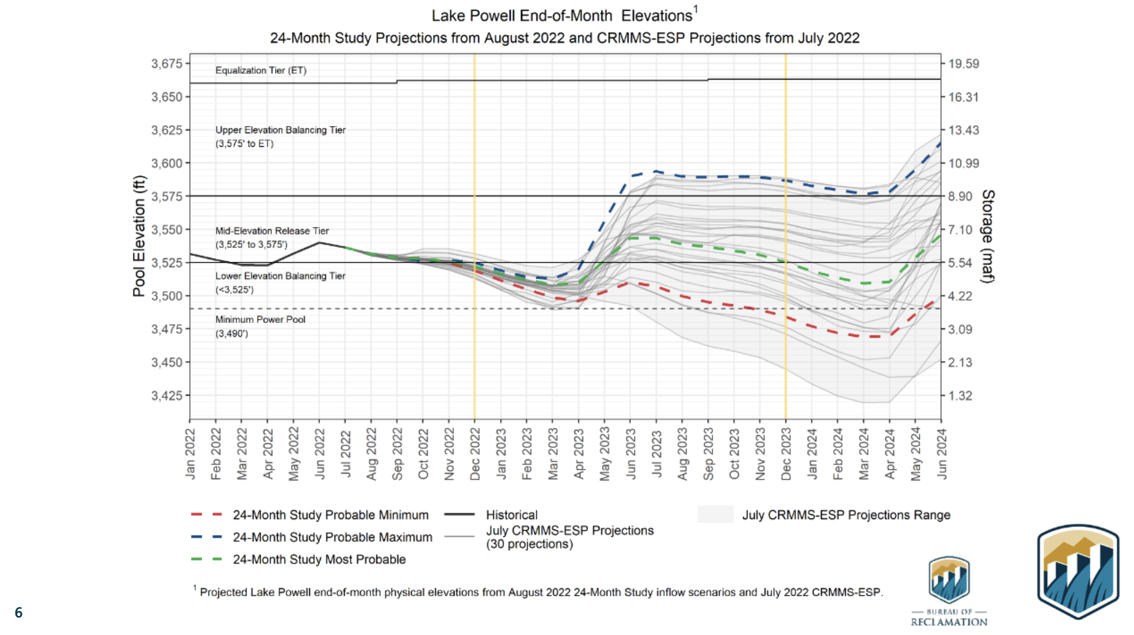
These tweaks are pitched as a means of making sure water can pass through Glen Canyon Dam normally. Dropping water levels in Lake Powell have threatened hydropower production at the dam, which supplies electricity to roughly 5 million people across seven nearby states. Lower levels mean lower power output, and if levels drop so low that air enters the hydroelectric turbines, they could be damaged.
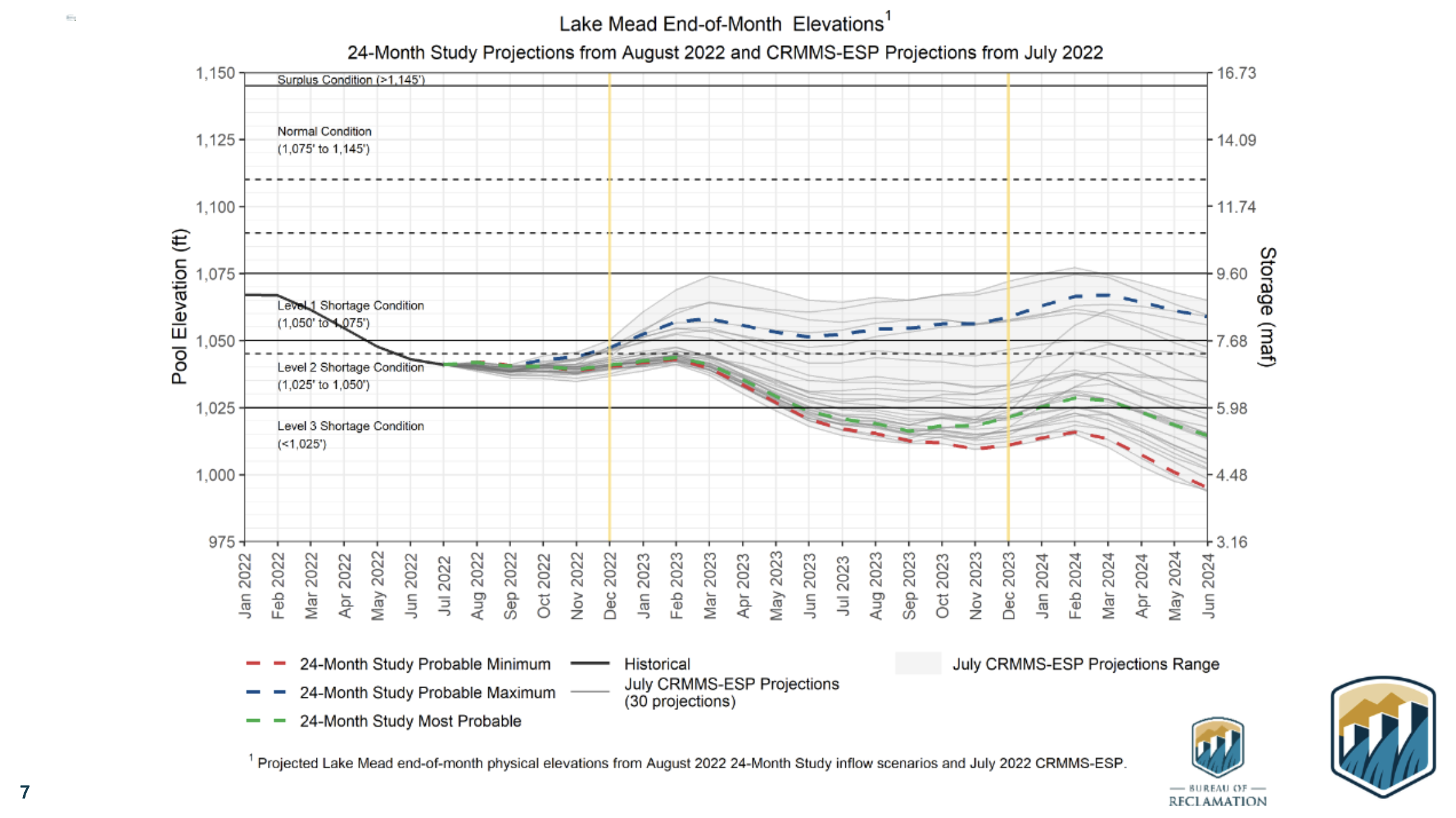
Beyond hydropower worries, some have raised concern that water from Lake Powell may soon be unable to pass through rarely-used pipes in its dam at a sufficient rate, jeopardizing the flow of water to millions of people who depend on it downstream. The lowest set of pipes — which would serve as the only exit route for water once levels fall past 3,430 feet in elevation — are not big enough to carry sufficient water for the Upper Basin states of Colorado, Wyoming, Utah and New Mexico to satisfy their legal obligation. Lake Powell was at 3,529 feet at the end of September.
Lake Mead, which stores water for the Lower Basin states of California, Arizona and Nevada, is filled with water released from Lake Powell. Because of that, any changes at Lake Powell would be felt at Lake Mead and the section of Colorado River between the two, which primarily flows through Grand Canyon National Park. Reclamation says it may modify releases at the Hoover Dam, which holds back Lake Mead, “in order to protect Hoover Dam operations, system integrity, and public health and safety.”

Click the link to read “New push to shore up shrinking Colorado River could reduce water flow to California” on The Los Angeles Times website (Ian James). Here’s an excerpt:
With water levels dropping at Lake Powell, the Interior Department said operators of Glen Canyon Dam may need to release less water, which would affect flows in the Grand Canyon and accelerate the decline of Lake Mead. In order to protect public health and safety and the integrity of the system, the department said releases from Hoover Dam may also need to be reduced — which would shrink the amounts of water flowing to California, Arizona and Mexico…
The Interior Department has the authority to step in and unilaterally impose larger cuts. But federal officials appear to be pushing for a consensus on shrinking the water take from the river rather than dictating reductions in ways that could further inflame tensions or lead to legal fights. This approach increases the pressure on the states to come up with a deal in the coming months or face federal intervention.
“The Interior Department continues to pursue a collaborative and consensus-based approach to addressing the drought crisis afflicting the West,” Interior Secretary Deb Haaland said in a news release. “At the same time, we are committed to taking prompt and decisive action necessary to protect the Colorado River System and all those who depend on it.”

Click the link to read “Feds start the clock on a plan that could deepen cuts on drought-stricken Colorado River” on the AZCentral.com website (Brandon Loomis). Here’s an excerpt:
The Interior Department and its dam managers at the Bureau of Reclamation said Friday they will complete an environmental review of options for keeping water in Lake Mead and Lake Powell, both of which in recent years have sped toward the point of losing hydropower production or even failing to flow through their respective dams. Reclamation already has reduced supplies to Arizona and Nevada based on operating guidelines approved in 2007. Those rules for shortage management have proved insufficient to halt plunging storage levels. They expire in 2026 and must be replaced by then, but the government’s announcement makes clear that emergency action is needed even sooner…
What happens to the reservoirs now also depends on how much snowpack the Rocky Mountains can pile up this winter to melt next spring. If the weather is especially poor, with flows less than half their long-term average over the next couple of years, the government’s projections now find worst-case scenarios that could dry up the river below Lake Mead before 2026, cutting off those who use the river in Arizona, California and Mexico. The Grand Canyon’s stretch of river is also at risk if Lake Powell continues to sink toward Glen Canyon Dam’s outlets.
“Reclamation is not going to let the states call its bluff any longer and realizes that the existing 2026 deadline is too far in the distance,” said Kyle Roerink, executive director of the Great Basin Water Network, a conservation group.
Doling out cuts from the river is complicated by 100 years of law and regulation meant to set how much water each of seven states can take. Arizona typically gets about a third of its total supply from the river, but has had to reduce its 2.8 million-acre share by 512,000 acre-feet, and will lose 80,000 more next year under terms of the 2007 guidelines.

Click the link to read “New US plan could lead to federal action on Colorado River” on the Associated Press website (Felicia Fonseca and Kathleen Ronayne). Here’s an excerpt:
The public has until Dec. 20 to weigh in on three options that seek to keep Lake Mead and Lake Powell from dropping so low they couldn’t produce power or provide the water that seven Western states, Mexico and tribes have relied on for decades. One of the options would allow the Interior Department’s U.S. Bureau of Reclamation to take unilateral action, as it threatened this summer when it asked states to come up with ways to significantly reduce their use beyond what they have already volunteered and were mandated to cut…
The announcement comes more than four months after Reclamation Commissioner Camille Touton told Congress that water use must be cut dramatically as drought and overuse tax the river — an essential supply of water for farmers, cities and tribes in the U.S. West, as well as Mexico. The seven states that tap the river failed to reach Touton’s August deadline and have been working ever since to reach a compromise. It now appears unlikely a grand deal will be reached. In the meantime, the bureau has offered up billions in federal money to pay farmers and cities to cut back. But Interior’s new action marks the first time it’s taking a clear step toward imposing its own, mandatory cuts. The agency anticipates changes to the conditions at which water shortages are declared in the river’s lower basin. Lake Mead and Lake Powell were about half full when the 2007 guidelines were approved and are now about one-quarter full.