Officials plan to truck 6,000 gallons of #water from #MissouriRiver across #Kansas — The #Missouri Independent #OgallalaAquifer

The dry bed of the Arkansas River near the Santa Fe Trail crossing at Cimarron, Kansas. The Ogallala aquifer groundwater levels in much of western Kansas started dropping in the 1950s as pumping increased, according to the Kansas Geological Survey. File Photo / Max McCoy

Click the link to read the article on the Missouri Independent webiste (Allison Kite):

The project is meant to prove that large transfers of water could be a tool to help save the disappearing Ogallala Aquifer, which provides irrigation and drinking water to western Kansas

An agency charged with conserving groundwater in arid western Kansas plans to truck thousands of gallons of water from the Missouri River nearly 400 miles almost to the Colorado border.

Half of the 6,000 gallons drawn from the river will be poured onto a property in Wichita County. The other half will be taken into Colorado.

Groundwater Management District 3, in southwestern Kansas, received a permit from state water authorities for the project, which is expected to cost the district $7,000. The district manager Mark Rude said it’s designed to prove large-scale movement of water could be a tool to keep the Ogallala Aquifer from drying up.

“Basically moving water from where it’s in excess to where it’s in short supply,” Rude said.

But other groundwater management officials say it’s a distraction from the far more urgent task of conserving water that’s quickly disappearing from under Kansans’ feet.

“For one, it’s a waste of water,” said Shannon Kenyon, who manages Groundwater Management District 4 in northwest Kansas.

She said: “Their idea instead of telling their producers, ‘You need to cut back,’ is to just dump water all over western Kansas.”

Ogallala Aquifer. Credit: Big Pivots

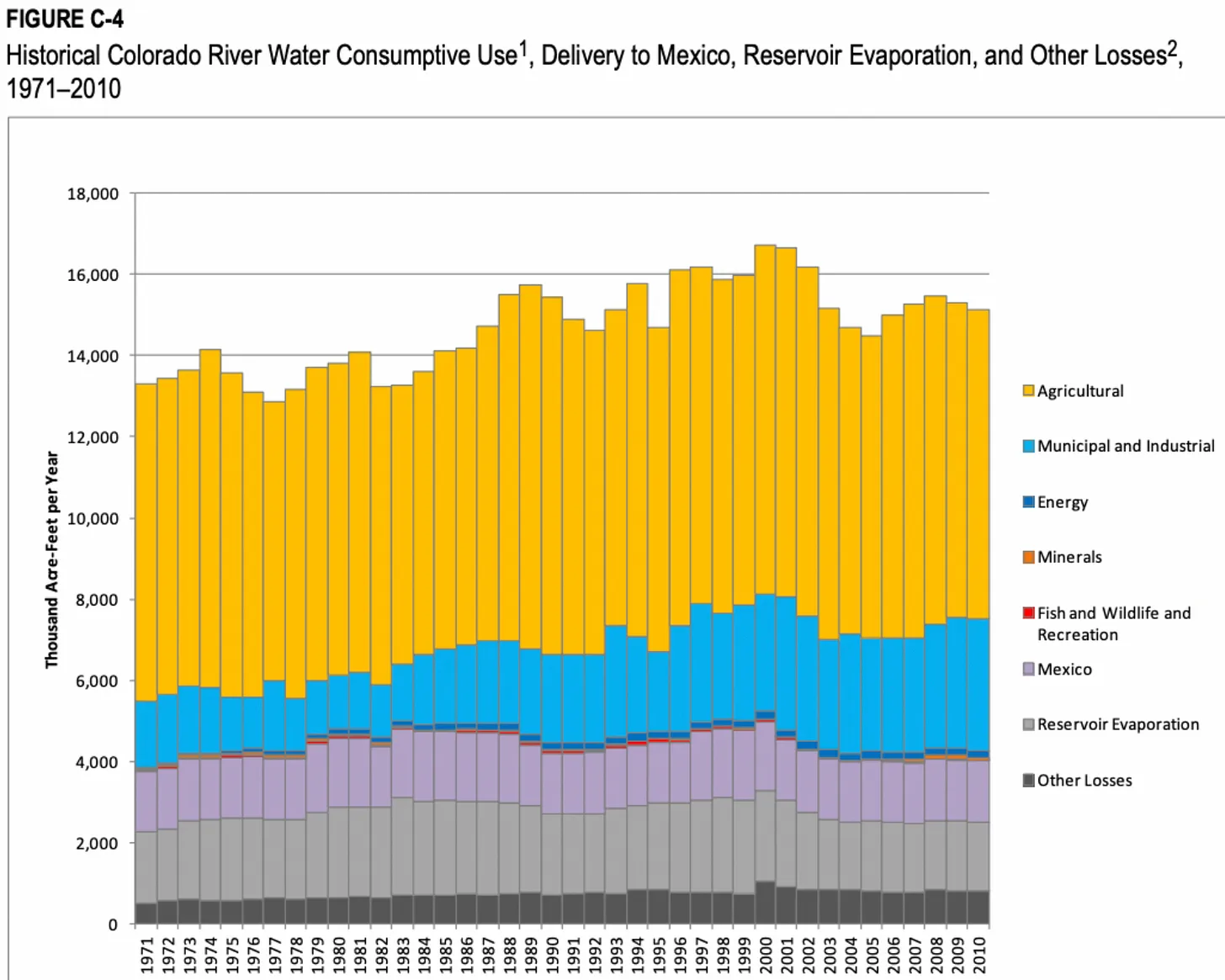
The Ogallala Aquifer, America’s largest underground reservoir, has been in decline for decades — since soon after farmers started pumping the underground water to cultivate crops following World War II. Some parts of the aquifer have half the water they had before irrigation on the aquifer began. In some areas, there’s only about 10 years of water left.

Loss of the aquifer would fundamentally alter life in western Kansas and destroy farmers’ livelihoods. There’s little surface water since streams that reliably flowed through the area in 1961 all but disappeared, according to the Kansas Geological Survey.

Officials have pursued a number of strategies to help the aquifer, including equipping farmers with probes to measure moisture under the ground to help them water their crops more conservatively without reducing their yield, and reaching agreements with farmers to cut their use.

Rude’s hope with the effort to truck water is to prove that transferring water from where it’s more plentiful or where an area has become flooded is feasible. One such idea is known as the Kansas Aqueduct, which would pump water uphill from the Missouri River at Kansas’ eastern border to western Kansas.

There are no formal efforts underway to make the longshot project a reality, Rude said, but his district’s website houses a presentation on the idea, and he has touted it to the Kansas Legislature in the past.

Rude said going through the regulatory process necessary to truck the water across the state helps walk water officials through the process in preparation for whatever larger project might come along.

“And so what’s the right project? Well, I don’t know. We don’t know yet,” Rude said. “… So you take steps and you evaluate and you learn, and this (proof of concept) is part of that process for the board of the Southwest Kansas Groundwater Management District.”

Earl Lewis, the state’s chief engineer, who signed off on the permit, said the state’s Division of Water Resources didn’t see the district’s project as comparable to a larger water transfer.

“You’re not really demonstrating that you could transfer a large amount of water by hauling 6,000 gallons of water across the state,” Lewis said. “I mean, that happens all the time in the state of Kansas.”

Kansas House Rep. Lindsay Vaughn, D-Overland Park, called it a “political stunt.”

“For the sake of local farmers and families, and for the future of our entire state, I hope GMD 3 starts to take its responsibility seriously, and soon,” she said. “Time is running out.”

Groundwater management districts 1 and 4, which are north of Rude’s near the Colorado border, are taking different approaches to saving the Ogallala. Shannon Kenyon in district 4 said western Kansas needs to focus on conserving water now while an aqueduct could take decades to get off the ground.

“Am I against it? No,” she said. “But do I think it’s fantasy? Yes.”

Katie Duhram, who manages Groundwater Management District 1, noted the district’s board chose not to participate in the project though the Wichita County farm that will receive 3,000 gallons of water lies in the district’s territory.

Durham said it’s always smart to look for projects that could help in the future.

“But I think it’s also important to take steps towards managing the resource that you have in order to address decline in the Ogallala in order to protect the local communities because again,” Durham said.

Both Durham and Kenyon’s districts have established local enhanced management areas, or LEMAs, which allow the GMD to enforce reductions in groundwater use. Durham’s district is working to establish a LEMA covering the whole district.

Rude said his district is conserving water by providing information to well owners on the amount they’ve pumped from the aquifer, how that compares to their neighbors and how they’re affecting the long-term health of the aquifer.

“That information is key for people in their voluntary conservation efforts as well as discussions for collective limits to further conserve the groundwater supply,” Rude said.

At this time, he said, there are no discussions about establishing a LEMA to require reductions.

Kansas Aqueduct route via Circle of Blue

#ColoradoRiver District General Manager: #California #water cut far from what is needed from that state — The #GrandJunction Daily Sentinel #COriver #aridification

The structural deficit refers to the consumption by Lower Basin states of more water than enters Lake Mead each year. The deficit, which includes losses from evaporation, is estimated at 1.2 million acre-feet a year. (Image: Central Arizona Project)

Click the link to read the article on The Grand Junction Daily Sentinel website (Dennis Webb). Here’s an excerpt:

The general manager of the West Slope’s Colorado River District says proposed cuts by California entities in river water use are much less than is needed from that state, and their implication that other states need to step up with similar reductions fails to account for uncompensated, naturally occurring cuts that already impact users in the river’s Upper Basin…He was reacting to an Oct. 5 letter by officials with California water entities using Colorado River water, including the Metropolitan Water District of Southern California and Imperial Irrigation District, proposing to conserve up to an additional 400,000 acre-feet of water in Lake Mead annually from 2023-36…

Mueller said in his memo, “California continues to take the position that it will do so only on a voluntary, temporary, compensated basis and that their participation is contingent upon the federal government paying their water users an acceptable level of compensation and the implementation of additional conservation measures from the other Basin States (including Colorado)…

Mueller and some other Colorado and Upper Basin water officials contend that while Lower Basin water users have been able to rely on water storage in Mead and Powell, Upper Basin water users are subject to varying hydrology that in some years results in users coping with cuts in use. In some years, such as 2014, water users in Colorado reduced consumption by a million acre-feet, or about 28%, Mueller says…

He says the California entities also don’t want the Bureau of Reclamation to start accounting for evaporation and transit loss in the Lower Basin that amounts to 1.2 million acre-feet a year. Reclamation has committed to address that, but Mueller thinks it is afraid to do so out of fear of litigation from Lower Basin states. At a recent river district water seminar in Grand Junction, he contended that while everyone in the basin needs to come up with solutions for reducing usage, the evaporation/transit losses must be addressed first.

The public trust doctrine prevented Mono Lake from drying up. Could it be used to save the #GreatSaltLake? — KSL

Tufa columns, Mono Lake, Eastern Sierra, California. By Vezoy (talk · contribs) – Own work, CC BY-SA 3.0, https://commons.wikimedia.org/w/index.php?curid=30004462

Click the link to read the article from The Salt Lake Tribune on the KSL website (Leia Larsen). Here’s an excerpt:

Owens Lake was one of the first cautionary tales about a salty lake with no outlet when it dried completely from human water consumption in Los Angeles. Lake Urmia in Iran and the Aral Sea in Central Asia followed, drained by scaled-up agriculture. All have since become sites of major dust storms. The Great Salt Lake finds itself heading down a similar path, overtapped by agriculture, cities and industry. But Mono (pronounced “moan-oh”) Lake has emerged as a success story of sorts. Alarmed by the lake’s decline when its tributary rivers were diverted away to L.A., environmental advocates fought back.

“We basically said, ‘Hey, the state is in charge of water rights and you gave [away] these water rights,” said Geoff McQuilkin, executive director of the Mono Lake Committee. “What we see [as a result] is Mono Lake being destroyed. That doesn’t meet the public trust obligation of the state to protect resources for future generations.”

They took their case all the way to the California Supreme Court in the 1980s using that public trust doctrine argument. And it worked. The concept of a public trust has its roots in English law, and may date as far back as the Roman Empire. Various courts in various states have applied the doctrine throughout U.S. history, mostly to settle issues of water access. The Mono Lake decision was the first time the public trust argument secured a lake’s right to exist. Now L.A.’s water utility has to scale back its diversions until Mono Lake reaches a sustainable level. So could someone apply the public trust doctrine in Utah to save the Great Salt Lake?

Some Utahns formed FRIENDS of Great Salt Lake in the 1990s after drawing inspiration from the Mono Lake Committee’s efforts. The group has a similar mission to educate and engage Utahns, helping them understand that the Great Salt Lake isn’t just a dead, empty sea. While the public trust doctrine hasn’t been applied to the Great Salt Lake so far, “certainly, the lake is deserving of this kind of justice,” said Lynn de Freitas, executive director of FRIENDS.

One complication is how, exactly, the public trust doctrine would solve the Great Salt Lake’s problems. At Mono Lake, the culprit depleting the lake was clear: a single utility in L.A. that could be obliged to reduce its consumption. In Utah, a patchwork of cities, towns, agricultural fields and industries across the watershed have dropped the Great Salt Lake by as much as 11 feet, according to a Utah State University analysis.

“So who do you target [in] a public trust challenge?” de Freitas wondered. “… I’m not quite sure.”

Satellite photo of the Great Salt Lake from August 2018 after years of drought, reaching near-record lows. The difference in colors between the northern and southern portions of the lake is the result of a railroad causeway. The image was acquired by the MSI sensor on the Sentinel-2B satellite. By Copernicus Sentinel-2, ESA – https://scihub.copernicus.eu/dhus/#/home, CC BY-SA 3.0 igo, https://commons.wikimedia.org/w/index.php?curid=77990895