
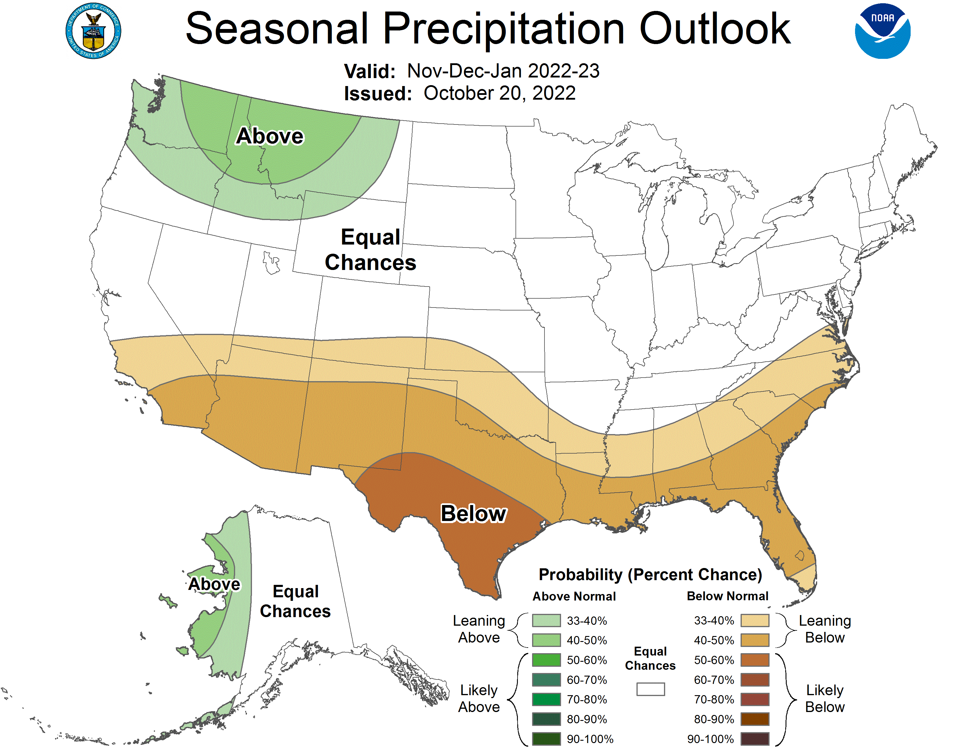
And just for grins here are the temperature and precipitation outlooks for February 1, 2023 through April 30, 2023 from the CPC.
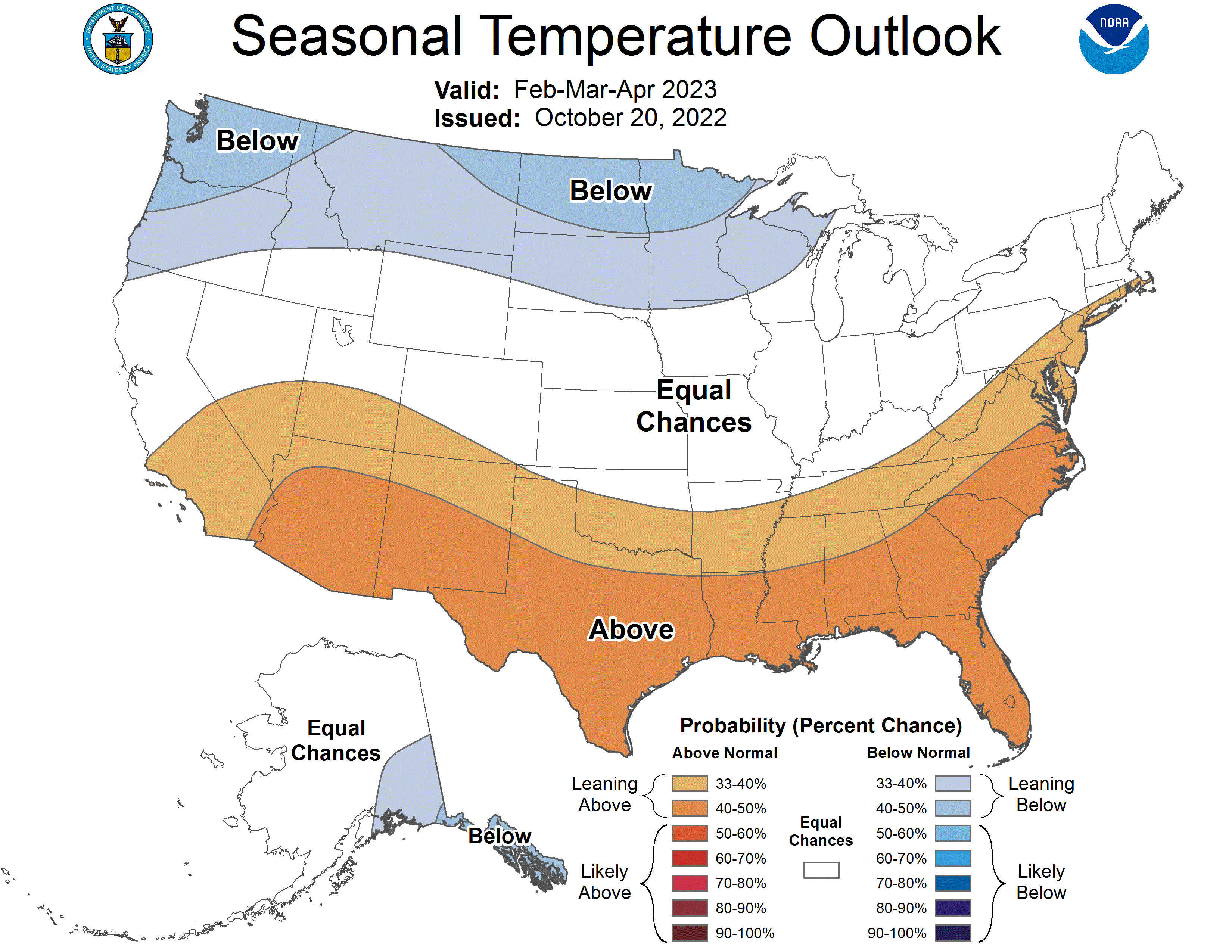
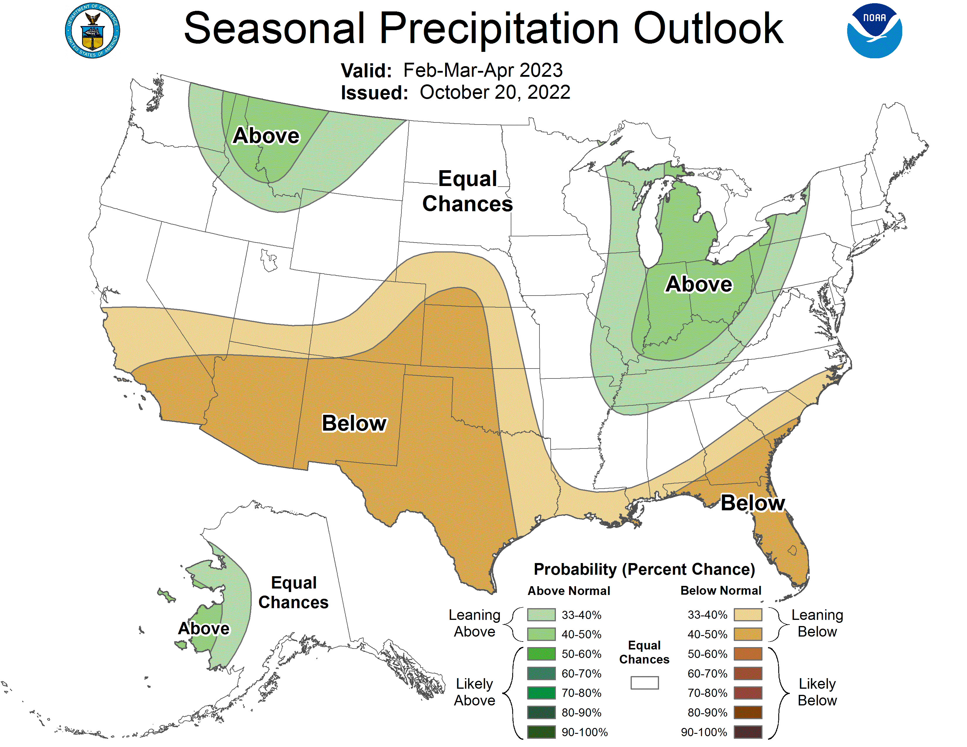

And just for grins here are the temperature and precipitation outlooks for February 1, 2023 through April 30, 2023 from the CPC.
Click on a thumbnail graphic to view a gallery of drought data from the US Drought Monitor website.

Click the link to go to the US Drought Monitor website. Here’s an excerpt:
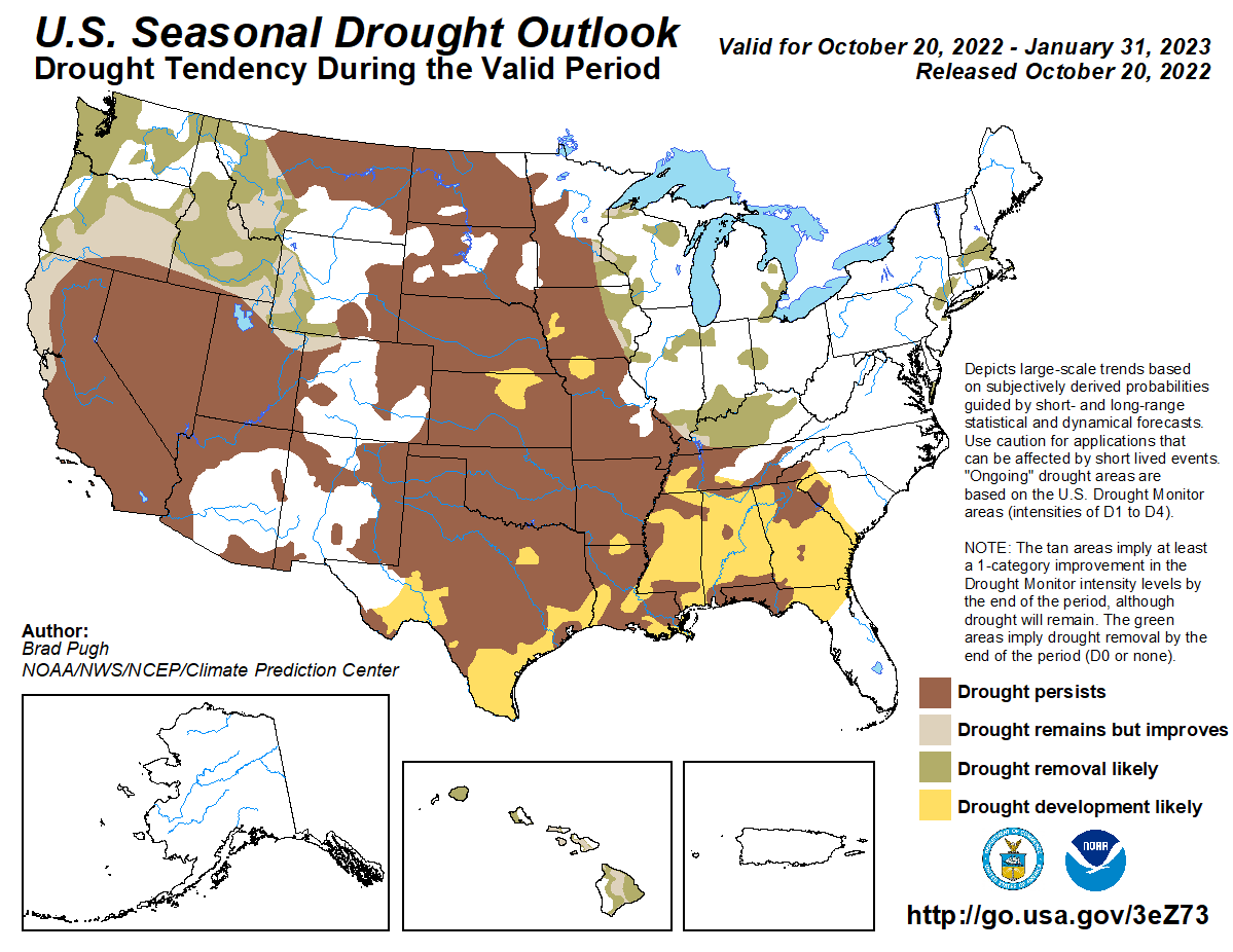
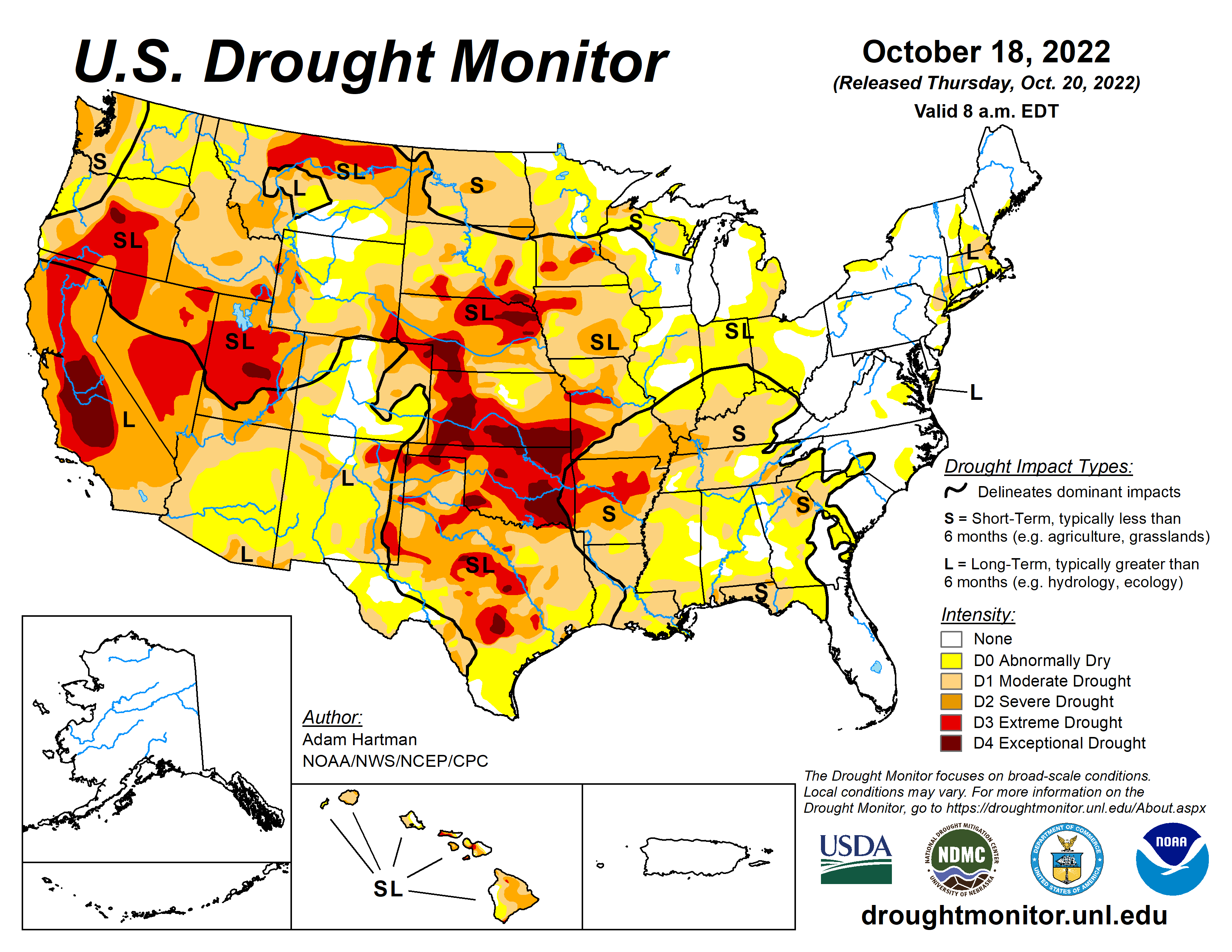
This Week’s Drought Summary
Much of the western half of the lower 48 states observed above-normal average temperatures this week. The Intermountain West and Pacific Northwest experienced the largest positive temperature anomalies, where widespread temperatures averaged 5°F to 10°F above-normal, with a few pockets exceeding 10°F above-normal for the week as whole. In addition to the above-normal temperatures, precipitation was also lacking for most areas from the Central and Northern Plains westward to the Pacific Coast, warranting drought deterioration. Parts of the Four Corners and Desert Southwest were the exception to this, as an area of low pressure meandered across the Southwest before being picked up by a frontal boundary dropping southward across the central U.S. This resulted in improvements to long-term drought conditions across parts of the Four Corners, with targeted improvements in the Southern Plains. Across the eastern half of the lower 48, frontal boundaries associated with a couple of strong low pressure systems in the Great Lakes brought heavy precipitation and cooler than normal temperatures to portions of the Great Lakes, Northeast, and Southeast. Therefore, a widespread mix of improvements and deterioration was warranted in many locations where the heaviest precipitation did and did not fall, respectively…
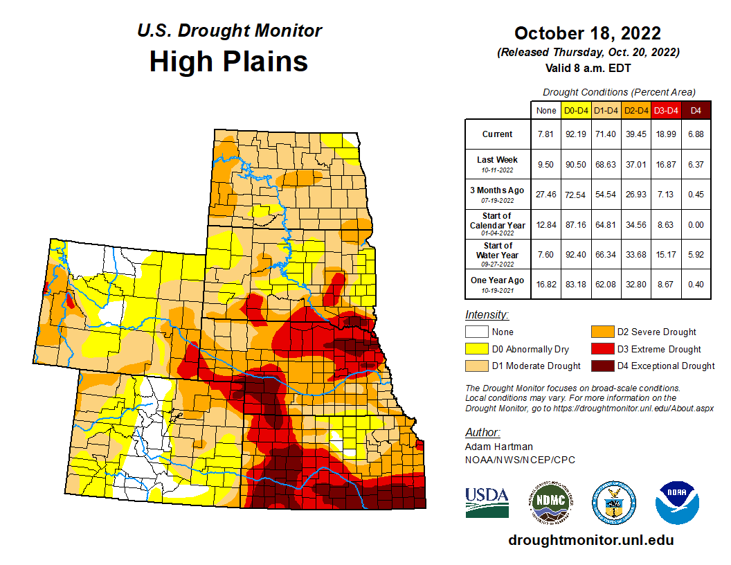
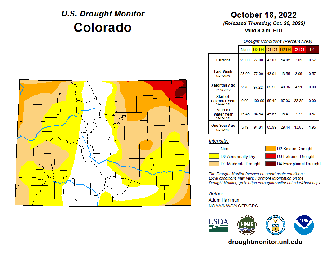
Despite the High Plains Region observing near to below-normal average temperatures this week, a combination of antecedent dryness, below-normal precipitation, and high winds resulted predominantly in continued degradation region-wide. The only exception was the southwestern corner of Colorado, where short and long-term drought indicators have shown continued improvement following a robust Southwest Monsoon season and a couple of additional episodes of precipitation, associated with cutoff areas of low pressure in the Southwest in recent weeks…

An upper-level low pressure system, coupled with a frontal boundary dropping southward across the central U.S. resulted in a good soaking this week for many areas from southeastern California eastward to the Rio Grande Valley. Given the lingering precipitation associated with this area of low pressure following the climatological end to a very robust Southwest Monsoon season in late September, this was another much-needed round of precipitation to further fuel ongoing improvements to long-term drought indicators, such as groundwater and 12 to 24-month SPIs. Soil moisture is in excellent shape as well coming out of the monsoon season across Arizona and New Mexico. Farther northward in the Western Region, degradation was the main story, as below-normal precipitation and above-normal average temperatures (in some cases record high temperatures for this time of year) were observed. High winds and above-normal temperatures resulted in targeted degradations across northern portions of the Intermountain West and the High Plains. In the Pacific Northwest, degradations were also warranted, with the addition of D2 (severe drought) across the parts of the Coastal Ranges and Northern Cascades in Washington, where 28-day average stream flows have dropped into the bottom 2 percent of the historical distribution. In addition, soil moisture ranks in the bottom 5 percent climatologically, vegetation indices are indicating widespread drought stress, groundwater levels are falling, and SPIs for all periods out to 120 days are D4-equivalent (exceptional drought). The Pacific Northwest is entering into a climatologically wetter time of year, so precipitation will need to come soon to halt further deterioration…
Frontal boundaries associated with a couple of strong low pressure systems over the Great Lakes brought heavy precipitation to parts of the Red River Valley of the South, the Ozarks, and the Tennessee Valley this week. Farther westward toward the Rio Grande Valley, a cutoff low pressure system became entrained into the second frontal boundary dropping southward across the central U.S. bringing heavy rainfall to parts of western and southern Texas. Improvements were generally warranted in areas receiving the heaviest rainfall (greater than 1 inch positive 7-day anomalies). However, antecedent 30-day dryness resulted in status quo depictions for several other locations receiving near to above-normal rainfall, as surface soil moisture has rapidly declined due to widespread 3 to 5 inch 30-day precipitation deficits and predominantly above-normal temperatures. This dryness also extends to 60 to 90 days for several areas across the Southern Plains and along the Gulf Coast, warranting 1-category deteriorations in the drought depiction for many locations not receiving rainfall this week…
Looking Ahead
During the next five days (October 20-24), the storm system over the Great Lakes is forecast to move northeastward into Canada, but bring some additional light precipitation to parts of the northern and eastern Great Lakes. Surface high pressure is expected to dominate much of the eastern lower 48. However, a storm system is predicted to spin up off the coast of the Carolinas bringing the potential for rainfall along portions of the Eastern Seaboard. In the West, an active storm pattern is expected, with the potential for upwards of 3 inches of precipitation for the higher elevations of the Pacific Northwest and upwards of 2 inches across portions of the Intermountain West. The first of two systems is expected to intensify over the central U.S. leading up to October 24, bringing increased precipitation chances to much of the Great Plains and the Mississippi Valley. Below-normal temperatures are expected to shift eastward from the West Coast to the Great Plains, associated with the storm system entering the West during the weekend. Ahead of this system, southerly flow is expected to keep temperatures near and above-normal, with the largest anomalies shifting eastward from the Great Plains to the eastern U.S.


Click the link to read the article on the Associated Press website (John Flescher). Here’s an excerpt:
As officials and community leaders prepared to celebrate the law’s 50th anniversary Tuesday [October 18, 2022] near the river mouth at Lake Erie, the Cuyahoga again is emblematic. This time, it represents progress toward restoring abused waterways — and challenges that remain after the act’s crackdown on industrial and municipal sewage discharges and years of cleanup work. A 1967 survey found not a single fish in the river between Akron and Cleveland. Now, there are more than 70 species including smallmouth bass, northern pike and muskellunge. Limits on eating them have been lifted. The Cuyahoga is popular with boaters. Parks and restaurants line its banks…
The Clean Water Act established ambitious goals: making the nation’s waters “fishable and swimmable” and restoring their “chemical, physical and biological integrity.” It gave the newly established U.S. Environmental Protection Agency broad authority to set and enforce regulations. Experts and activists agree many waterways are healthier than they were, and cleanups continue. The Biden administration’s 2021 infrastructure package includes $50 billion to upgrade drinking water and wastewater treatment systems, replace lead pipes and cleanse drinking water of toxic PFAS, known as “forever chemicals.”
But the law’s aims have been only “halfway met,” said Oday Salim, director of the University of Michigan’s Environmental Law and Sustainability Clinic. ”If you spoke to most clean water policy advocates today, they’d be pretty disappointed in how long it has taken to get halfway.”

Click the link to read the article on the AZCentral.com website (Brandon Loomis). Here’s an excerpt:
The Gila River Indian Community is the first Arizona water rights holder to publicly pursue the federal government’s new offer of compensation to leave Colorado River water in Lake Mead. Tribal Gov. Stephen Roe Lewis announced the plan on Monday at a gathering of Sen. Kyrsten Sinema’s water advisory council, which is reviewing ways to spend $4 billion of Inflation Reduction Act funds targeted at Colorado River drought relief, as well as funds approved in an infrastructure funding law.
While several participants in Sinema’s council praised the community’s proposal as a first step toward attracting others to rapidly conserve water, there were signs that getting significant buy-in from other Arizona farmers will be difficult. Yuma-area growers had sought $1,500 an acre-foot to forgo some irrigation, but the U.S. Bureau of Reclamation decided to offer $330, or up to $400 for multi-year deals. The Arizona Farm Bureau Federation’s president questioned the figure at the meeting, and a vice president later told The Arizona Republic it’s nowhere near enough to entice Yuma farmers.
“This is real water,” Farm Bureau President Stefanie Smallhouse said of what the farmers had offered. “It’s real value that is providing food for people.”
“The reality is we need a lot more than $4 billion,” Sinema conceded. But she said it’s important to spend the majority of the money now available on long-term efficiency gains and not primarily on emergency fallowing programs.

Click the link to read the article on The Deseret News website (Amy Joi O’Donoghue). Here’s an excerpt:
There was a time when raw sewage was dumped in the Jordan River in Utah. It was an industrial wasteland, and once named the most endangered river in the country by an advocacy group…
“The Clean Water Act really incorporated better technology for sampling and detection of contaminants in the drinking water and helped us reduce the levels of contaminants in the drinking water with new detection limits and with new filter technologies,” said Scott Paxman, general manager of the Weber Basin Water Conservancy District.
Technology and water: Paxman said the Clean Water Act prompted the district to replace three aging water treatment plants from the 1950s with state of the art technology to screen for and eliminate cryptosporidium, a microscopic parasite that can cause disease in humans, as well as Giardia, another parasite problematic for people. Paxman said the new plants in 2002 were a $5 million investment and use ozone and ultraviolet rays to eliminate the parasites. It was a heavy lift, but it means safer water for the residents the district serves.
Read more about the Laguna Dam on the Wikipedia website:
After the passage of the Reclamation Act by the US Congress in 1902, the U.S. Bureau of Reclamation began constructing the dam under the Yuma Project in 1903. This project was the first development of the U.S. Reclamation Service along the Lower Colorado River and featured the Laguna Diversion Dam, a pumping station and a series of canals. On July 6, 1905 the contract to build the dam was awarded to J. G. White and Company who started construction less than two weeks later. Deliveries of cement were a problem as they had to be delivered to Yuma by rail and to the construction site by wagons or steamboat. Poor rock quality at local quarries also posed a problem that consistently delayed construction, 50% of the weak rock was unusable. Even after their contract was supplemented to encompass the rock quality delays, J. G. White and Company still did not meet their deadline and the Bureau of Reclamation took over construction in early 1907.