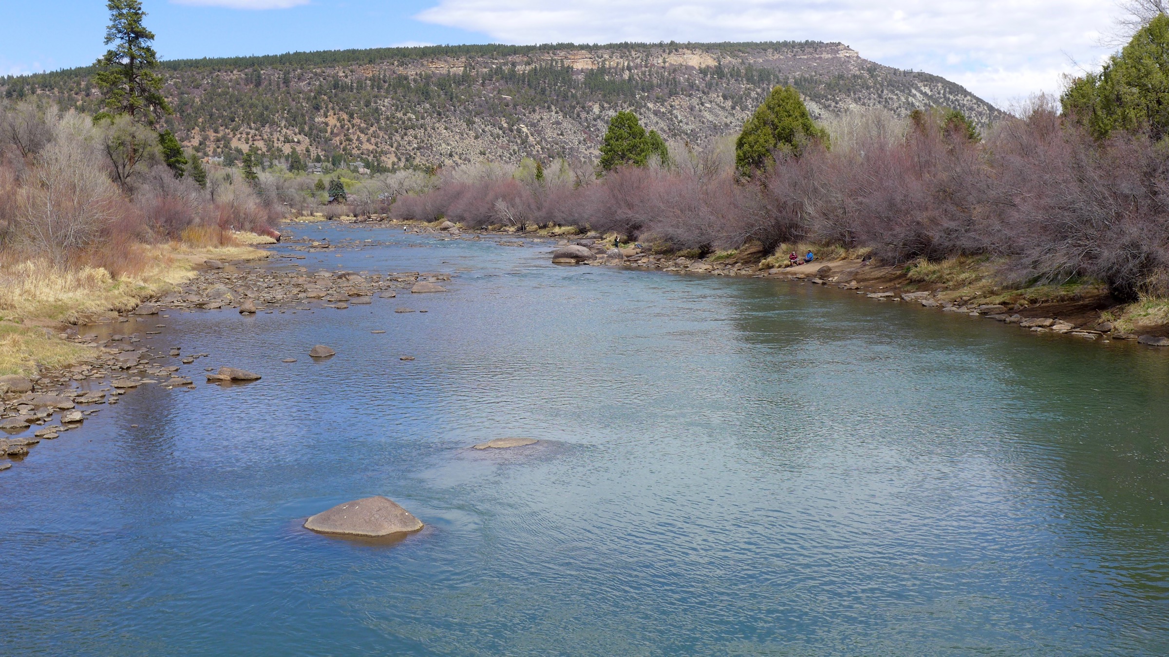
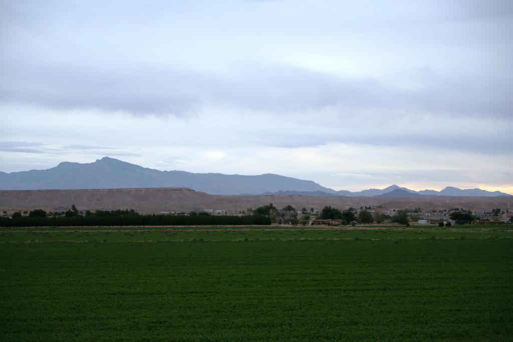
An unprecedented amount of people are moving to Durango and La Plata County, but with the increasing effects of drought across the region, is there enough water to support them all? For years, population growth and new development were already on the rise in Southwest Colorado, but the effects of the pandemic accelerated that buildup as more people left urban areas and sought out desirable mountain towns…
In just the past few weeks, a number of large-scale development projects have been proposed: 800 units south of town on the Isgar property near La Posta Road; another 500 apartments in Three Springs; and nearly 80 apartments and townhomes near the old Mercury Building. And that’s not to mention the onslaught of scattered development around town and in the county. All this raises a fair question: does the region, which has experienced a 23-year drought believed to be the worst since 800 AD, have enough water to sustain it all?
[…]
“Climate change is the big unknown,” Steve Wolff, general manager of the Southwest Water Conservation District, said. “We’ve already seen our overall available water supplies decline.”
One thing that’s for sure, the Durango migration can’t be turned off like a faucet.
“You can’t stop people from moving here; that’s not an option,” Kevin Reidy, Colorado Water Conservation Board’s water conservation specialist, said. “So we have to figure out the most water-efficient way to build new communities and start thinking about what rabbits we can pull out of a hat to make this work better.”
The Animas River is the City of Durango’s back up water plan when flows from its main source, the Florida River, aren’t sufficient. However, as we all know, the Animas is not 100% reliable, subject to low flows and mine blow outs. The Animas River in Durango, in April, 2018. Photo: Brent Gardner-Smith/Aspen Journalism
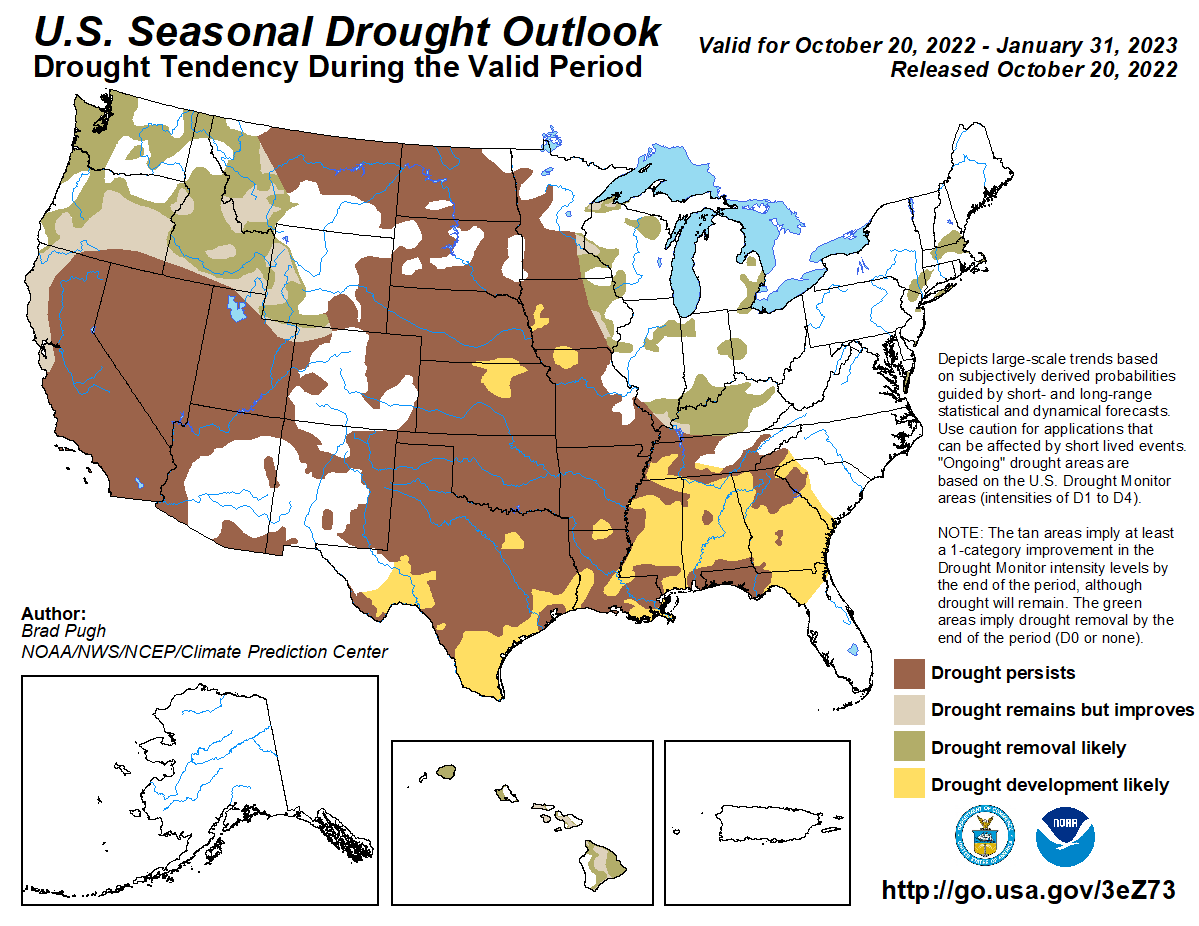
This animation scrolls through NOAA’s 2022-23 U.S. Winter Outlook maps. The first two show which parts of the country have the highest chances for a much wetter or drier than average winter and a much cooler or warmer than average winter. The third map shows the projected changes in drought conditions through the end of January 2023, and the final map shows drought conditions as of October 20. NOAA Climate.gov animation, based on data from NOAA Climate Prediction Center.
DETAILS
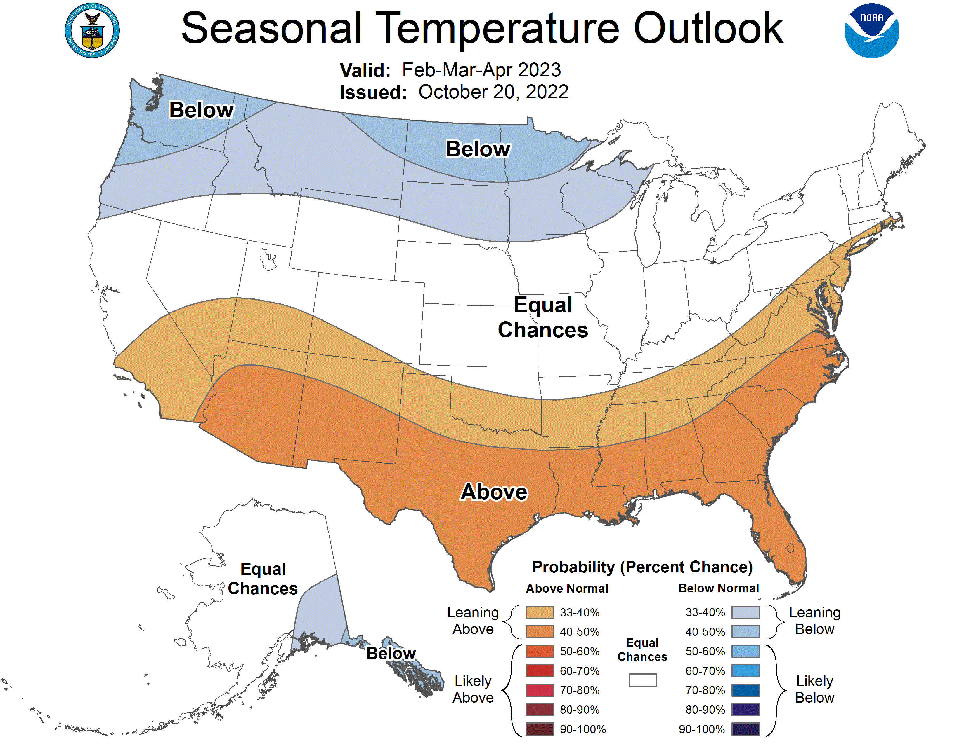
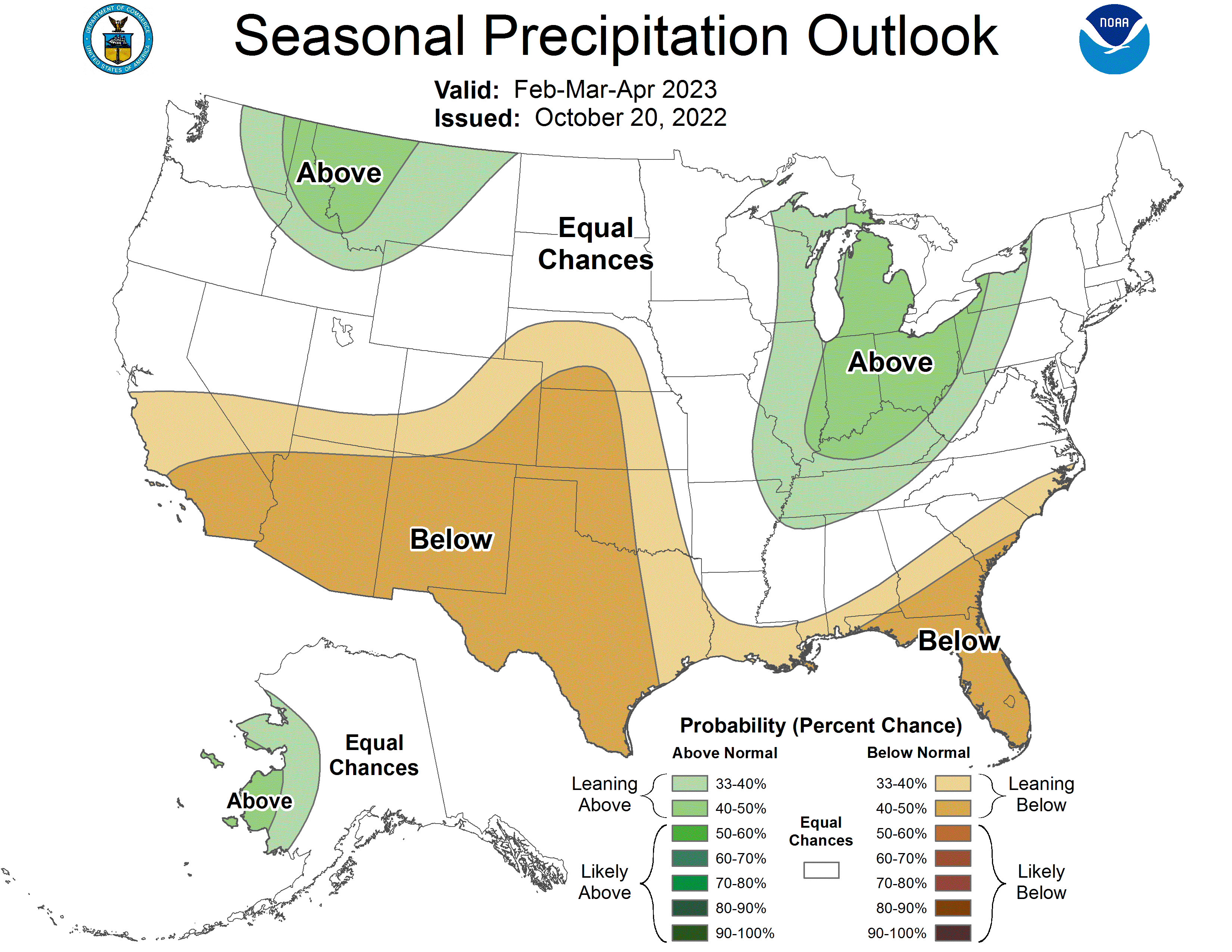
This year La Niña returns for the third consecutive winter, driving warmer-than-average temperatures for the Southwest and along the Gulf Coast and eastern seaboard, according to NOAA’s U.S. Winter Outlook released today by the Climate Prediction Center—a division of the National Weather Service. Starting in December 2022 through February 2023, NOAA predicts drier-than-average conditions across the South with wetter-than-average conditions for areas of the Ohio Valley, Great Lakes, northern Rockies and Pacific Northwest.
“Drought conditions are now present across approximately 59% of the country, but parts of the Western U.S and southern Great Plains will continue to be the hardest hit this winter,” said Jon Gottschalck, chief, Operational Prediction Branch, NOAA’s Climate Prediction Center. “With the La Niña climate pattern still in place, drought conditions may also expand to the Gulf Coast.”
Temperature
– The greatest chance for warmer-than-average conditions are in western Alaska, and the Central Great Basin and Southwest extending through the Southern Plains.
– Warmer-than-average temperatures are also favored in the Southeastern U.S. and along the Atlantic coast.
– Below-normal temperatures are favored from the Pacific Northwest eastward to the western Great Lakes and the Alaska Panhandle.
Click the link to read the article on the CIRES website:
Despite past thinking that drought is a slow process taking multiple seasons or years to fully develop, fast-evolving drying events are becoming increasingly common, according to new research led by CIRES’ North Central Climate Adaptation Science Center (NS CASC) and Earth Lab. The team, led by CIRES’ Virginia Iglesias, evaluated drought intensification rates for the contiguous United States. They found that, while typical drought (the statistical median drought) onset rates did not change significantly from 1951 – 2021, intensification rates of the faster-onset droughts have accelerated, especially in the last decade (2011 – 2021). In fact, their onset rates were the fastest in the last 70 years.
What drives these faster developing droughts? Changes in temperature and precipitation are key, but when coupled with atmosphere-ocean interactions, like El Niño in the equatorial Pacific Ocean, that can also drive soil moisture changes. While El Niño operates on the sub-decadal scale (every 3 – 5 years), other atmosphere-ocean interactions like the Pacific Decadal Oscillation, in the northern Pacific Ocean, and the Atlantic Multidecadal Oscillation, in the North Atlantic Ocean, can explain over half of the variance (how the data points vary from the average) in multidecadal drought frequency. In other words, what’s happening in the ocean can modulate the speed of continental drought development.
The results presented in this new research also suggest that warmer droughts, which tend to be worse, also set in faster. So while the development of droughts has sped up in the last few decades – and now set in even faster – the Earth’s warmer future almost certainly means more quick-onset droughts, events that can catch farmers, water managers and others off-guard. Iglesias and coauthor, CIRES’ WIlliam Travis said, “Faster droughts are not necessarily more intense events, but with a warmer atmosphere drying out the soil more quickly, future droughts are likely to set-in faster and become more intense.” Coupled with the difficulty of forecasting droughts, rapid onset of drought events will pose a bigger challenge to forecasters and resource managers as the climate warms.
This story was modified from an NS CASC research highlight. Continue reading here.
Click the link to read the article on Nevada’s only statewide nonprofit newsroom the Nevada Independent website (Daniel Rothberg):
In between the towns of Pioche and Caliente, pumps draw water from underground aquifers to irrigate crops. The water is heavy, and running those pumps depends on electricity — a lot of it.
For years, these Lincoln County farms received all of their energy from power generated miles away at Hoover Dam, which holds Lake Mead. But less water in the reservoir has meant less low-cost hydropower for rural towns, forcing them to purchase more expensive power in energy markets.
Lincoln County is not alone. Power from Hoover Dam — and other Colorado River dams — is delivered to about five million people across the Southwest. Many of the customers buying this power are small rural electric nonprofit utilities, tribal nations and local government agencies.
“Water is obviously a super important issue and deserves to be talked about,” said Dave Luttrell, general manager of Lincoln County Power District No. 1. “But sometimes I feel, as probably the most hydropower-dependent utility in the Southwest, and a small one at that, kind of the lone wolf out here saying ‘We need to pay attention to hydropower production.’”
Residents in Lincoln County and other rural communities across the state might not get their water from the Colorado River. Yet many rural communities rely on power created by the massive dams — from Wyoming to California — that hold back Colorado River water.
Many rural towns get their power from customer-owned cooperatives. Unlike investor-owned private utilities, rural co-ops operate as nonprofits and help bring energy to remote areas.
Over the past two decades, Lake Mead has dropped to historic lows amid a prolonged Colorado River drought, worsened by a warming climate. The crisis is now so severe that states across the Southwest are facing difficult negotiations over painful water cuts needed to stabilize Lake Mead, Lake Powell and an interconnected system of reservoirs along the Colorado River.
Even with Lake Mead at 28 percent capacity, Hoover Dam can physically continue to produce some hydropower. If Lincoln County is “lucky” next year, Luttrell said, it will get 60 percent of its Hoover Dam power allocation. But if the reservoir continues falling toward “dead pool” — the point at which no water can pass the dam — that slice of the pie will grow even smaller.
“Hydropower is not coming back,” Luttrell said. “The days of Lincoln County Power getting 100 percent of its need from hydropower are in the rearview mirror, and they’re never coming back.”
The immediate future, he and others said, is going to be one of less low-cost hydropower. And small rural utilities, with fewer resources than large investor-owned utilities, are looking for ways to adapt. There are solutions, but they can be expensive. And in some cases, these rural communities and tribal nations are feeling the shortage doubly hard.
With less hydropower, utilities have had to purchase more expensive power on the open market, where prices can peak to extremely high levels on hot days. Simultaneously, their contracts with the federal government, which sells the hydropower, keep them on the hook for fixed fees used to operate and maintain dams — as well as fund fish recovery programs on the Colorado River.
“You pay for what you don’t get, and you go buy more expensive stuff to replace it,” Luttrell said.
These contracts are signed with an important, if little known, federal agency: the Western Area Power Administration. The Department of Energy agency, known as WAPA, helps funnel power from the Colorado River’s dams to rural utilities and tribal communities across the West.
“The drought in the West is one of our largest concerns,” WAPA spokesperson Lisa Meiman said. “Each one of our projects is working with their customers to identify the best path forward.”
In Nevada, WAPA sells power to the Colorado River Commission, which in turn distributes the water to rural co-ops and other buyers. WAPA also contracts with the Nellis Air Force Base, the Nevada National Security Site, and four tribal communities: the Las Vegas Paiute Tribe, the Ely Shoshone Tribe, the Duckwater Shoshone Tribe and the Yomba Shoshone Tribe. But exactly where this hydropower comes from can vary, making the contracting very complicated.
Some have contracts to get their power from the Colorado River Storage Project, upstream of the Hoover Dam. The project includes Glen Canyon Dam, which holds back Lake Powell, a reservoir that fell below a critical threshold this summer. Others get their power from Hoover Dam. And some buy electricity from power plants at Parker and Davis dams downstream.
The terms of the contracts vary depending on where power is purchased, but in general, WAPA operates as an at-cost organization, Meiman said. About 95 percent of its funds come from the revenues generated off of power and transmission sales. That means it charges customers for expenses including operations and maintenance, investments and environmental compliance.
The structure seems to work when the water is there, even in cases where there are small shortages. Yet unprecedented water shortages on the river have strained the system, especially for customers who have generally seen an increase in hydropower rates. And it raises major questions about the future, with grim water forecasts for Lake Mead and Lake Powell.
Lake Powell, just upstream from Glen Canyon Dam. At the time of this photo, in May 2021, Lake Powell was 34% full. (Ted Wood/The Water Desk)
Upstream of Hoover Dam, for instance, costs for the Glen Canyon Dam and other projects are split among water and power customers. Right now, about 75 percent of the costs are borne by power users. Irrigators, for the most part, are expected to pick up the rest of the tab. But a provision in federal law says that power revenues could cover costs “beyond the irrigators’ ability to pay.” As a result, Meiman said, power revenues pay for about 90 percent of the upstream infrastructure.
Fixed costs are only one part of the equation. Less hydropower generation has a cascade of consequences. Energy experts stress that hydropower brings reliability to the grid in the West, especially when demand peaks in the summer. Power revenues have additionally helped to pay for environmental programs, including two recovery programs aimed at restoring fish species, including the humpback chub, bonytail chub, pikeminnow and razorback sucker.
For utility managers like Mendis Cooper, these impacts are hardly theoretical. Cooper, who leads Overton Power District No. 5, said most rural electric co-ops are operating without the flexibility that a big power provider might have. That means higher hydropower costs — and the need for replacement power — often have a large impact on rates, which are then passed along to rural businesses and farmers who are already operating on tight margins.
“All of us that are rural utilities are all not-for-profit,” he said. “We don’t have margins. We don’t have margins from previous years that we can carry over to make up for these types of things.”
Hydropower, Cooper said, accounts for about one-quarter of the power used by the Overton Power District, which serves the Moapa Valley, the Moapa Band of Paiutes and Mesquite. To mitigate an increase in rates, the power district can defer capital projects, but only for so long.
“Our rates keep going up and up,” he said.
The future — and what happens next — comes down to water. Cooper, who also serves as president of the Colorado River Energy Distributors Association, said he is watching the negotiations and efforts to stabilize Lake Mead, which sits just outside of Overton.
“We’ve seen this coming,” Cooper said of the water shortages. “We’ve seen the lake levels drop over the last 20 years. But it’s still amazing that something that big can go down that fast.”
In addition to buying replacement power on the open market, some rural electric utilities are looking for long-term alternatives to fill the gaps created by the drought. Lincoln County, for instance, has been working closely with Sen. Catherine Cortez Masto (D-Nevada) to help fund a multi-phase solar project, according to Luttrell, who runs the local utility.
“We feel like we’ve got to solve this problem ourselves,” Luttrell said.
Once built, the solar project could cover about half of the power district’s customer demand. Luttrell said Lincoln County is working with rural co-ops in Arizona to source some of its power from natural gas when neither hydropower nor solar is available. Similarly, the Overton Power District recently signed a contract to install a solar plant, hoping to offset the loss in hydropower.
Still, Cooper warns: “We cannot replace that role hydropower plays on the entire grid.”
The hydropower challenge “means that these utilities have to be creative,” said Carolyn Turner, executive director of the Nevada Rural Electric Association. Efforts to bring more power online, she noted, could be aided by the Inflation Reduction Act, which allows non-taxable entities, such as local governments, schools and nonprofit utilities, to take advantage of solar energy credits.
As more rural utilities grapple with this issue, a looming question remains — what role should the federal government play in replacing lost hydropower and preparing for a drier future? By law, the only power source WAPA markets is hydropower, Meiman said.
But, she added, the agency is working closely with the Bureau of Reclamation, which manages water along the Colorado River, to find long-term solutions and to make the current operations more efficient. Already, WAPA has pushed for changes to when water is released at dams, as it is more beneficial for power customers if water is released at times of peak electricity demand.
Today, Lincoln County has a population of about 4,500 residents, and farming is a key part of its economy. Bevan Lister, an irrigator, a county commissioner, and the president of the Nevada Farm Bureau, has watched Colorado River water use over the past three decades.
For farms that rely on groundwater, the electricity that drives their pumping can make up about 15 to 20 percent of the budget. The power district, Lister added, has done a good job of managing costs in the past. But he said that irrigators are looking at more expensive electricity rates next year.
Farming in Nevada, he said, “has a lot of challenges, both climate wise and cost wise. So any time those costs are increased, it challenges the viability of [farming] businesses.”
Water on the Colorado River, Lister argued, “has to be managed in a different way” to keep the reservoirs stable, and he said hydropower remains an important part of the equation.
“Hydroelectric power is extremely valuable to the agricultural industry, both in Lincoln County and across the West,” Lister said. “Dependable and cost-efficient electrical systems provide for a tremendous amount of our agricultural production in the West.”
The “power of place:” For years, renewable developers have looked to the Great Basin and Mojave Desert as prime land to site energy projects. The Public Utilities Commission of Nevada docket list is increasingly filled with notices of new developments. Many of these would go on public land, managed by the federal government. Where these projects go matters a great deal. The sprawling projects can conflict with sensitive habitats, migration corridors, recreation areas, culturally significant land and competing uses, including grazing rights and mineral claims.
Last week, The Nature Conservancy released a regional report looking at renewable project siting, and what it would take to avoid the most sensitive landscapes and ecosystems. The takeaway: It can be done, but it will require planning. The Los Angeles Times’ Sammy Roth took a look at the report in his newsletter earlier this month and what it might mean for the energy transition.
The federal government is launching a program to pay irrigators for conserving a portion of their Colorado River water. But will prices be enough of an incentive to move the needle? More from KUNC’s Alex Hager, who writes that “the funding represents a rare infusion of federal money for a climate change-fueled crisis that is plaguing the Southwest’s water supply.”
“We end up referring them out and sending them hundreds of miles out of their way just to get care that we should be able to provide here.” That’s a quote from Serrell Smokey, the chairman of the Washoe Tribe of Nevada and California in a recent story published by Kaiser Health News. Reporters Julie Appleby and Jazmin Orozco Rodriguez look at the ways in which wildfires, made worse by climate change, are affecting health care where access is limited.
Just how many mines are needed for the energy transition? That’s a question that Jael Holzman of E&E News looks at in a piece this week. This is a must-read for understanding the potential impact of the energy transition in mining-friendly jurisdictions, including Nevada.
Where the Las Vegas pipeline stands: Las Vegas Review-Journal reporter Colton Lochhead and photojournalist Ellen Schmidt produced an important story about the proposed Las Vegas pipeline now that the project has been shelved — and the relief it’s brought to eastern Nevada.
The AssociatedPress‘ Scott Sonner looks at the similaritiesbetween a case involving a rare toad in Dixie Valley and a landmark Endangered Species Actcase.
South Platte River near CSU Spur. Photo credit: Colorado State University
Register here. Click the link to read the release on the Colorado State University website (Anthony Lane):
This year’s CSU Spur Water in the West Symposium, to be held Nov. 2-3 in downtown Denver, will bring together policymakers, researchers, and experts from the business, nonprofit, and agriculture sectors to look globally for lessons and strategies with the potential to inform how Colorado and other western states respond to the region’s water challenges.
The event’s theme, “Global Water: Successes and Solutions,” underlies a program that includes panel discussions and keynote speeches aimed at starting conversations about how communities and the entire region can respond and adapt to the pressures created by a growing population within a changing environment.
“Water in the West, now in its fifth year, has always focused on creating opportunities for speakers and audience members to connect while exploring solutions from unexpected places and sectors,” said Jocelyn Hittle, the CSU System’s associate vice chancellor for CSU Spur and special projects. “This year, we are bringing speakers with wide-ranging expertise — from ag to business to investing — together from across the world to present solutions that might be useful here in the American West. We hope the CSU community and others from across the West will join us for a stellar speaker line-up, a solutions-oriented approach, and a chance to build new, and perhaps unexpected, connections.”
Speakers and panel discussions
Among the speakers at the 2022 Symposium is Jay Famiglietti, a water researcher who leads the Global Institute for Water Security at the University of Saskatchewan. Panel discussions on cities, agriculture, and innovation opportunities will seek to inform western water discussions by drawing on the experiences of experts from government agencies, private industry, and municipalities as far away as Portugal and Cape Town, South Africa.
Two additional panel discussions will examine lessons and opportunities related to international water agreements. One will focus on the Columbia River Treaty, which the United States and Canada signed in 1961 and governs the construction and operation of dams on a river that begins in the mountains of British Columbia, flows south through eastern Washington, and then turns west, defining the border between Oregon and Washington on its way to the Pacific. The other will explore solutions involving the United States and Mexico, both of which rely on water from two rivers, the Colorado and Rio Grande, that have their headwaters in Colorado.
In the future, the Water in the West Symposium will be held at the CSU Spur Hydro building, which opens in January 2023.
The Symposium switched to a virtual format in 2020 and 2021 because of COVID precautions. This year, attendees have the option of attending in-person sessions at the Seawell Ballroom or participating virtually. A combined reception at CSU Spur the evening of Wednesday, Nov. 2, will bring Symposium participants together with the ranchers, farmers, conservationists, land managers, scientists, and others attending Regenerate 2022, an annual conference focused on sharing knowledge and building a culture of resilience.
The event will take place just weeks before the Spur campus’s third building, Hydro, opens in January. In coming years, Hydro will house the Water in the West Symposium and a range of programs and initiatives focused on water research, conservation, and education. Among these will be Denver Water’s new water quality lab, which will serve to inform the public while providing capacity for more than 200,000 tests each year to monitor the quality of water before treatment and after it is prepared for distribution to customers across the metropolitan area.
Program details and registration information for the 2022 Water in the West Symposium are available at csuspur.org/witw/.
A newly created funding program is geared toward supporting initiatives that may help allow agricultural operations to adapt to reduced water supplies. The Colorado Ag Water Alliance effort will support the design and implementation of drought resilience and innovative water conservation projects with agricultural water users and water managers, the alliance says…
The alliance received more than $190,000 from the Colorado Water Conservation Board, a state agency, for the new funding program. Greg Peterson, the board’s executive director, said in an interview that additional funds came from groups such as the Nature Conservancy, the Colorado Master Irrigator program, the Colorado Cattlemen’s Association and the Colorado Association of Conservation Districts. The funding is intended to support development and implementation of innovative solutions to address ongoing drought and water-security issues in the state, according to a recent news release from alliance.
The outfall of the Bousted Tunnel, which delivers water from the Roaring Fork and Fryingpan rivers to the East Slope.
Click the link to read the article on the Ark Valley Voice website (Jan Wondra). Here’s an excerpt:
The Bureau of Reclamation (BoR) announced on Monday that it will direct $60 million in federal funding from the Infrastructure Investment and Jobs Act (IIJA) towards advancing the construction of the Arkansas Valley Conduit (AVC), a 130-mile pipeline project from Pueblo Reservoir east to Eads, Colorado that will deliver safe, clean drinking water to 50,000 people in 40 communities. The Colorado Water Conservation Board (CWCB) has supported this project with $100 million in grants and loans. The Arkansas Valley Conduit project is the final element of the larger Fryingpan-Arkansas Project, which Congress authorized in 1962. The project has literally been decades in the making.
“The SECWCD is thrilled with the announcement by the Bureau of Reclamation that $60 million from the bipartisan Infrastructure Investment and Jobs Act has been allocated for construction of the Arkansas Valley Conduit. This follows on the heels of the award of the first construction contract for the Boone reach,” said Southeastern Colorado Water Conservancy District Senior Policy and Issues Manager Chris Woodka.
“This commitment from BoR is a clear indication of their intent to move this project forward to completion, and to direct resources to it so that clean drinking water will be delivered sooner than originally planned,” he added. “We thank each and every one of you for your patience, and your ongoing support.”
The 5.5 mile Boustead Tunnel transports water from the Fryingpan River drainage into the Arkansas by way of Turquoise Lake (pictured here).
The Rio Grande Basin spans Colorado, New Mexico and Texas. Credit: Chas Chamberlin
Click the link to read the release on the Reclamation website (Mary Carlson):
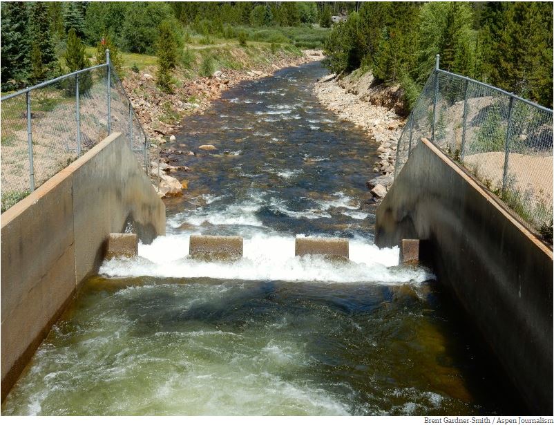
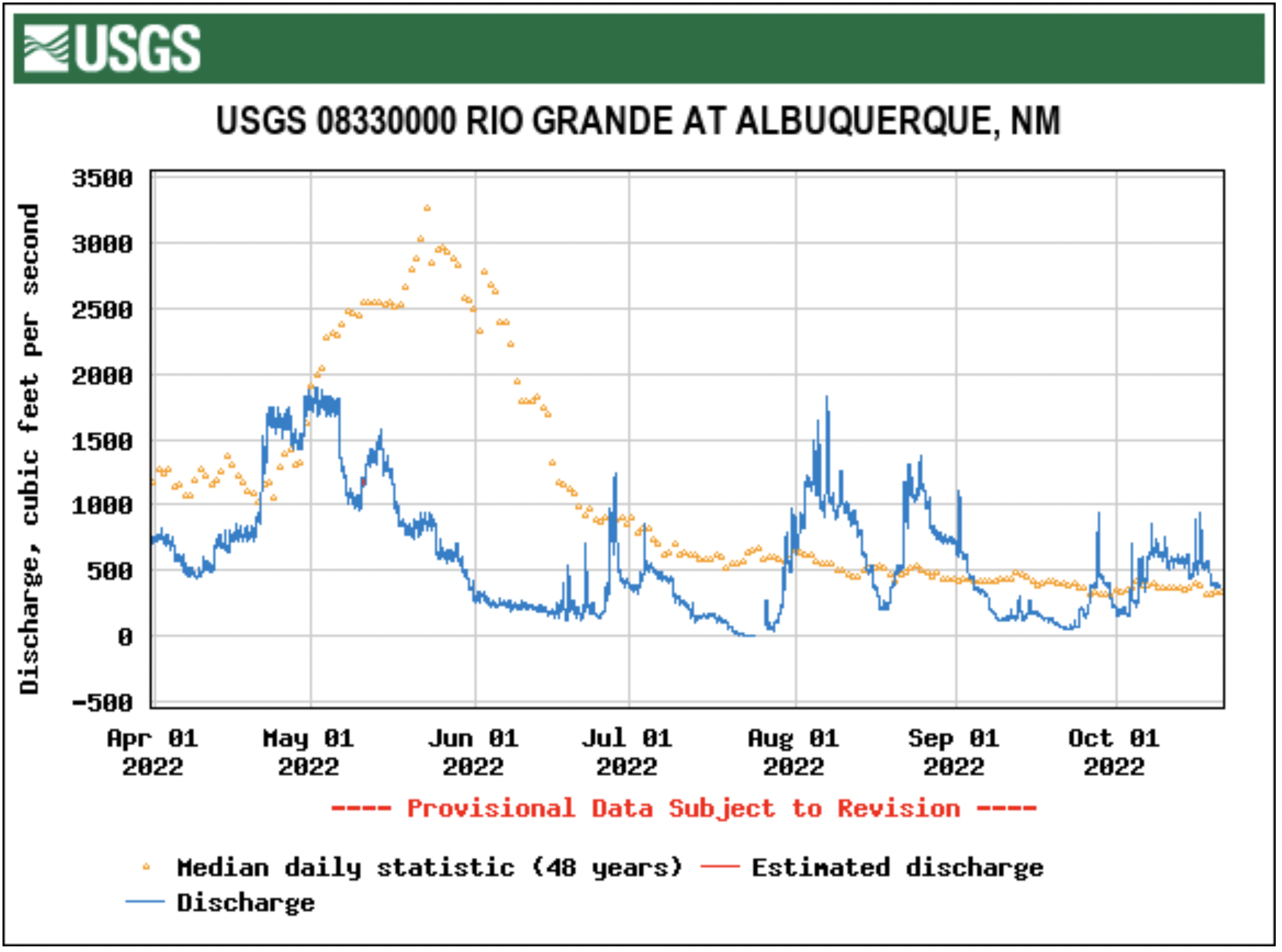
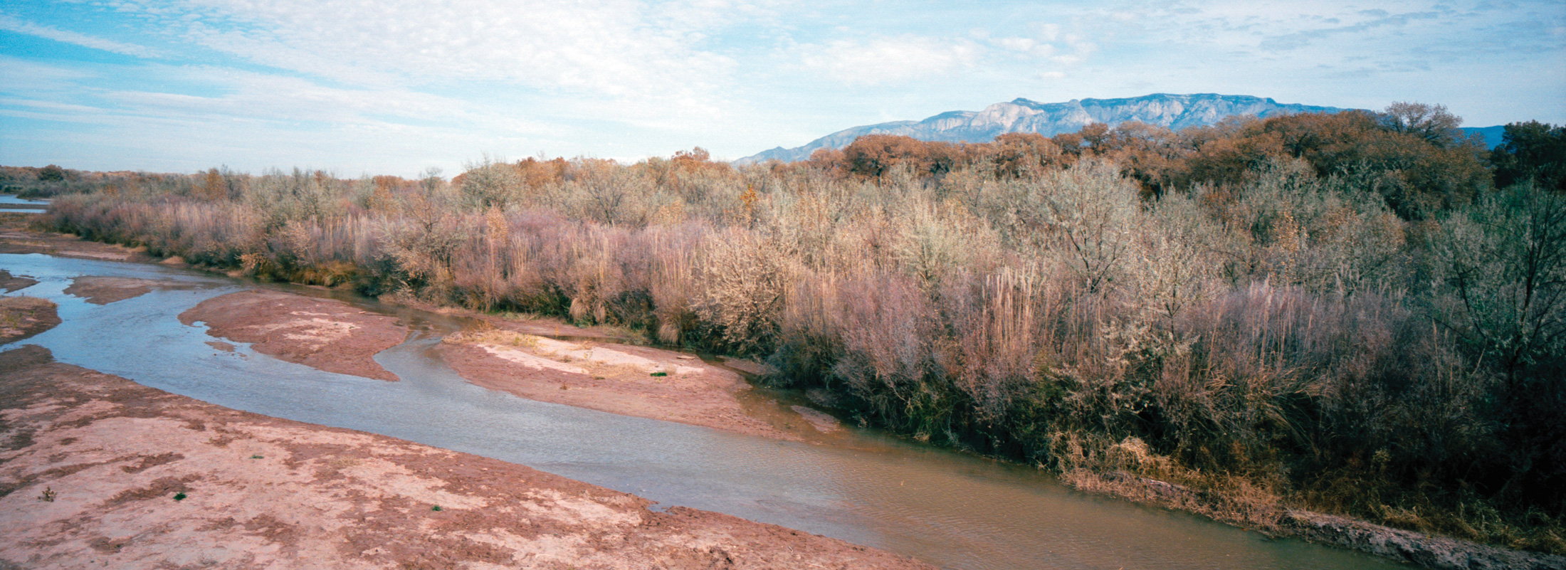
Careful management of limited water supplies and steady rainfall through much of the summer are being credited for helping keep the Rio Grande flowing.
Bureau of Reclamation water managers headed into the summer irrigation season knowing supplies in storage were extremely limited. This spring, an average snowpack for the third year in a row resulted in lower-than-average snowmelt water flows due to strong winds, warmer temperatures, and low soil moisture. El Vado Reservoir received about 62% of the median spring runoff volume, which was 24% less than was expected in April. The Rio Grande spring runoff peaked on May 2 in Albuquerque, nearly a month earlier than average.
“We are seeing higher temperatures that result in snow melting earlier than we’ve seen historically and a below average spring runoff in the Rio Grande Basin,” said Albuquerque Area Manager Jennifer Faler. “Managing the system accordingly during the prolonged drought will remain a top priority and we will continue to work with our partners towards solutions.”
Portions of the Rio Grande between Albuquerque and Elephant Butte Reservoir dried at different times this summer as temperatures spiked. For the first time since the 1980s, a portion of the river in the Albuquerque area also dried. Since the 1990s, Reclamation and our partners have taken significant measures to supplement the river flows and prevent drying in the Albuquerque area. However, without adequate water supplies in storage, it could not be prevented this year. June monsoons materialized and within days, the rainstorms began to help reconnect the river.
The Middle Rio Grande Conservancy District modified its operations early in the season in response to what looked to be dire conditions. River flow from rainstorms throughout the state, however, has allowed farmers to have a nearly full irrigation season.
As construction is underway at El Vado Dam in northern New Mexico, only a small pool of water is being held there. Construction is scheduled to continue through the winter and through the next irrigation season. Reclamation is able to run water through El Vado Dam to pass Rio Chama flows and San Juan-Chama Project releases from Heron Reservoir downstream. The San Juan-Chama Project has received about 61% of a full allocation so far this year.
Elephant Butte and Caballo reservoirs ended their irrigation seasons in late August with a combined storage of about 95,000 acre-feet, about 4% of capacity. Currently, due in large part to subsequent rain, total storage is at about 147,000 acre-feet, approximately 6% of capacity. The Elephant Butte Irrigation District received Rio Grande Project water for about 7 weeks, and Mexico for nearly 10 weeks. Mexico received about 24% of a full allocation. The El Paso County Water Improvement District No. 1 received project water for about 11 weeks.
On the Pecos River, rainfall also helped with storage at Brantley Reservoir, which ended irrigation season with 28,000 acre-feet in storage. Lake Sumner is ending the water year holding about 9,000 acre-feet. Carlsbad Irrigation District farmers received an allocation of 2.2 acre-feet this season. A full allocation of water would be 3.7 acre-feet of water per acre.
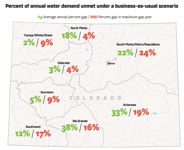
Coloradans want the state’s top water road map to mandate faster action, be more accountable, require equitable drought responses between the East and West slopes, and include the crisis on the rapidly drying Colorado River in its estimates of future water shortages.
More than 1,300 individuals and agencies submitted public comments on the draft update to the Colorado Water Plan, according to Russ Sands, chief of water supply planning for the Colorado Water Conservation Board (CWCB).
The public comment period ended Sept. 30. The CWCB is scheduled to finalize revisions to the plan in January 2023. {Editor’s note: The CWCB is a funder of Water Education Colorado, which is a sponsor of Fresh Water News.]
Commenters, including major water utilities, environmental groups, ranchers and farmers, and city and county officials, have asked for numerous changes.
“The plan lacks the language of urgency throughout. It should emphasize the scarcity of time and water to address the life-or-death reality of the drought and the climate crisis that the state of Colorado is facing,” Hispanics Enjoying Camping, Hunting and the Outdoors wrote in their submitted comments.
The CWCB is responsible for drafting and updating the plan and supporting its implementation. Championed by U.S. Senator John Hickenlooper when he served as governor, the state’s first water plan was approved in 2015 after years of public meetings and data gathering.
At the time, it was hailed as a breakthrough in grassroots water planning in the West because of its comprehensive effort to engage the public, analyze existing water use, future shortages, and potential solutions.
Since then, the CWCB has awarded more than $500 million in grants and loans to help communities develop water management plans, projects and other options locals believe are necessary to ensure their water futures.
But the plan was politically difficult to finalize even then because of conflicts between water utilities and environmentalists, pro-dam and anti-dam interests, and agricultural and urban water conflicts.
Regardless, water users across the state say that the water plan has spurred more cooperation than has ever existed before, with public roundtables in each of the state’s eight river basins making decisions and sharing information with one another, using the water plan as a roadmap.
Now, as the CWCB updates the plan and a 22-year megadrought drains the Colorado River system, pressure is building to act quickly.
For example, in their comments several individuals and agencies asked that the updated plan include more measurable goals with deadlines to improve accountability in addressing the state’s looming water shortages and environmental issues.
Business for Water Stewardship (BWS), a nonprofit that seeks to connect corporate funders with environmental initiatives, was among them.
“The water plan lacks specifics and accountability,” BWS wrote. “The plan should include metrics on conservation and storage and guidelines on how we balance competing needs. These metrics are necessary to measure progress on the plan’s goals and objectives.”
Forecasts show water supplies will not keep pace with demand by 2050 for agricultural (Ag) or municipal and industrial (M & I) needs if Colorado does not find new approaches. Source: 2019 Analysis and Technical Update to the Colorado Water Plan. Credit: Chas Chamberlin
Major water diversions between West Slope river basins and Front Range cities were also a topic of concern.
Roughly 80% of the state’s water supplies originate in West Slope mountain snowpacks, while much of that water is moved to the thirsty Front Range in pipelines and canals known as transmountain diversions or TMDs.
The Colorado River District and other West Slope interests want the state to require that when the West Slope is facing ultra-dry conditions and forced to deal with water restrictions and cutbacks, as it often is just because of its geography, urban cities who are using that West Slope water, live under the same rules. The district represents 15 West Slope counties and is responsible for managing the Colorado River within state boundaries.
For years, West Slope communities whose rivers have been subject to severe drying due to drought and climate change, have complained about urban indifference to their plight.
This year, for instance, some West Slope river basins saw runoff that was well below average, while many Front Range communities, thanks to big reservoirs and better runoff from local rivers, saw normal conditions. There were water restrictions to the west, but few if any to the east.
“The river district recommends a stronger stance towards water conservation and a recommendation that communities reliant on TMD supplies tailor conservation needs when any watershed with their source water is undergoing drought conditions. This is particularly important when the end-use basin is undergoing less severe drought conditions than their TMD source watersheds,” the river district wrote.
The CWCB’s Sands said the state has limited ability to act on a request like this one, given that it has no statewide authority to impose drought restrictions.
Still another major topic of concern among several commenters is the ongoing crisis on the Colorado River. The river begins in the Never Summer Mountains in Rocky Mountain National Park and by the time it makes its way west to the Utah state line, it has generated the majority of the entire seven-state river system’s water.
With the river in crisis and lakes Powell and Mead at historic low levels, Arizona, California and Nevada have begun taking cutbacks, a situation that eventually could occur in Colorado, where major metropolitan areas rely on the river for roughly 50% of their supplies.
And while the draft plan acknowledges the impact of climate change and uncertainties regarding future supplies, commenters say it should include more specifics on how the crisis could affect Colorado’s own water future.
The Sierra Club called release of the draft plan premature, because it did not adequately address the Colorado River crisis. Larimer County, the City of Fort Collins and the Colorado Agricultural Water Alliance, also asked that the draft plan include more specifics on the river’s dicey future.
“Adding the Colorado River crisis” to Colorado’s already well known water problems, “is like adding an overactive bull into an already somewhat ramshackle china shop,” the Sierra Club wrote. “Having the draft plan revision out at this time is premature given the likely need to stop about 30% of Colorado’s present use of Colorado River water.”
Here too, Sands said, because the plan is focused solely on intrastate water issues, rather than interstate issues, there is little more the water plan can do with data on the crisis.
The CWCB is scheduled to address which public requests for additions to the water plan will be included in the final draft at its November meeting, Sands said.
In the meantime, several commenters expressed hope that the revised water plan will create the energy and vision the state needs to address its complicated water future.
Said Colorado Springs Utilities, “The water plan is a formative document that outlines meaningful goals and actions for addressing the water supply gap in a time of increasing water scarcity. It will take political courage to ensure this plan has the impact Colorado requires.”
Jerd Smith is editor of Fresh Water News. She can be reached at 720-398-6474, via email at jerd@wateredco.org or @jerd_smith.
Colorado transmountain diversions via the State Engineer’s office
A reminder of the choices that global society has to make about the climate:
Delaying action on reducing emissions commits the world to live with severe consequences.
Rapid action now means a more habitable world for all.
There is no going back. Choose wisely. Credit: Ed Hawkins via via his Twitter feed
Interior Secretary Deb Haaland, left, and Sen Joe Manchin participated in a roundtable event hosted by the White House Interagency Working Group on Coal and Power Plant Communities, on March 18, 2022. (Interior Department via Flickr/Public domain)
Interior Secretary Deb Haaland has moved forward with proposing that nearly 225,000 acres stretching from the Glenwood Springs area south to Crested Butte and east of Crawford be withdrawn from new federal oil and gas leasing and mining claims for 20 years. Haaland acted on a petition announced by the Biden administration last week as President Biden also created the new Camp Hale-Continental Divide National Monument during a visit to the Camp Hale World War II training grounds outside Leadville. Haaland approved a petition by the U.S. Forest Service and Bureau of Land Management to file the withdrawal application…
Her approval, announced in a Federal Register notice Monday [October 17, 2022], automatically kicks off a two-year period when new mining claims and new federal mineral leases will be prohibited on parts of the White River National Forest, the Grand Mesa, Uncompahgre and Gunnison National Forests, and BLM lands, while the agencies consider moving forward with the 20-year withdrawal in those same areas. Private lands and existing rights, including current oil and gas leases, aren’t affected by the two-year action, and the 20-year withdrawal likewise wouldn’t apply to them. Haaland’s action also kicks off a 90-day public comment period on the proposed withdrawal.
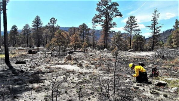
Santa Fe National Forest Hermits Peak fire April 2022. Photo credit: Jim O’Donnell
Click the link to read the article on the ensia website (Jim O’Donnell):
After megafires in the region, some forest systems may never return to their pre-fire conditions. Now, ecologists are redefining how forest ecosystems might be restored in a way that increases resiliency.
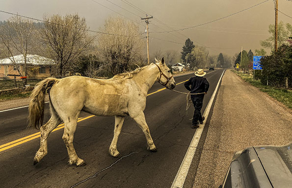
On April 6, 2022, a prescribed fire driven by unusually strong spring winds jumped a control line northwest of Las Vegas, New Mexico. About two weeks later, the same dry winds rekindled embers from another nearby prescribed burn. Driven by 60-mile-per-hour (27-meter-per-second) winds with gusts reaching upwards of 80 miles per hour (36 meters per second), the two fires merged, and the Calf Canyon/Hermits Peak complex became the largest in New Mexico history. By the time the U.S. Forest Service (USFS) declared the fire contained in late August, almost 350,000 acres (141,600 hectares), an area greater than the size of Los Angeles, had burned. Nearly 1,000 structures were destroyed and thousands of people were displaced. Post-fire flooding killed multiple area residents and caused extensive damage.
While fire is an integral part of Southwest forest ecosystems, a century of policies geared toward fire suppression in the American West that has led to a lack of diversity is colliding with climate change, upending the rules. Historically, a mature forest would burn, then, over time, return to a healthy, recognizable state. Today, however, an unprecedented decades-long drought, rising temperatures and massive insect outbreaks are hammering forests across the region, creating ideal conditions for megafires like the Calf Canyon/Hermits Peak inferno.
Thanks to climate change, experts say many southwestern forests destroyed by megafires may never return. Conditions across the region have become too hot and too dry for normal forest succession, and wildfires such as Calf Canyon/Hermits Peak are a catalyst for rapid change to an entirely different ecosystem. Forests can become fire- and flood-prone shrubland, and shrubland can become grassland dominated by invasive species such as cheat grass that likes to burn.
“All bets are off,” says Thomas Swetnam, Regents’ Professor Emeritus of Dendrochronology at the University of Arizona. “I hate to sound apocalyptic, but these are shocking, extraordinary events. The forests we had are not going to come back.”
Residents of Mora, New Mexico, evacuate in May 2022 as the Calf Canyon/Hermits Peak fire crests a ridge less than a mile to the southeast. Forest-dependent communities across northern New Mexico have been dramatically impacted by recent megafires. Photo courtesy of Jim O’Donnell
Healthy forests, especially higher up in the watershed, increase groundwater storage, regulate stream flows and improve overall water quality by holding sediments and other contaminants. “These forest areas are our water storage system,” says Swetnam. “The only way to protect that system is with forest.”
Now, impacted communities, land managers and forest ecologists are all asking the same questions: What do we do next? Is forest restoration possible? Is it desirable? And how do we even define “forest restoration” in the age of climate change?
To answer those questions, researchers are looking at a range of potential solutions. Here’s a look at three that may prove applicable throughout the American West.
Where to Focus
Matthew Hurteau, professor of biology at the University of New Mexico, says that restoring every square acre of burned forest after megafires is neither practical nor necessary.
Even a fire the size and ferocity of the Calf Canyon/Hermits Peak burn is not a complete ecological catastrophe. For much of the forest, it is an opportunity for rebirth and renewal. Most of the acreage burned in the spring of 2022 burned in what forest ecologists consider the “right way.” That is, the fire wasn’t hot enough to cause 100% tree mortality. Instead, the fire swept through, sticking low to the ground, clearing out the forest, laying down beneficial beds of fertilizing ash and triggering germination of native species adapted to fire. Just two months after the burn, many areas were covered in swaths of emerald as grasses and flowers rose through the ash. These areas, says Hurteau, don’t need active, human restoration. They just need time.
A U.S. Forest Service Burned Area Emergency Response soil scientist evaluates soil burn severity. Photo courtesy of InciWeb
Other locations, however, are cause for worry. Tens of thousands of acres burned so ferociously that every tree, shrub, flower and blade of grass is dead, including seeds that may have been waiting in the soil for years. “These high-intensity fires can sterilize the soil, making regeneration impossible. It’s these areas that will need our help,” says Hurteau. “We want to recapture as much of this forest as possible.”
To do so, Hurteau and his colleagues use a mathematical model they created to figure out where post-fire restoration will have the biggest impact and the greatest chance of success.
Utilizing 1 meter (3.3 foot) resolution digital elevation models, solar radiation indices and high-resolution topography models, Hurteau and team first identify areas where natural reseeding is likely and where trees will never be able to grow again. These they set aside. Next, they zero in on areas where reforestation is both important and possible but that were too severely burned to naturally reseed. These include wetter and shadier locations and higher elevation areas vital for watershed protection.
“Site specificity matters,” Hurteau explains. “In a drier zone that gets more sun we might do a mix of seedlings that includes drought-tolerant species like ponderosa pine, while a higher, wetter location might get a mix of other conifers.”
As harsh spring winds drove the Calf Canyon/Hermits Peak megafire, the fierce burn generated a pyrocumulous cloud towering tens of thousands of feet into the sky southeast of Taos, New Mexico. Photo courtesy of Jim O’Donnell
This is a process Hurteau calls “nucleation.” The idea is to create a nucleus of carefully selected seedlings suited for this harsh new environment. Researchers at the New Mexico State University John T. Harrington Forest Research Center in the northern New Mexico village of Mora select hardy, drought-tolerant species for restoration work in the highly impacted areas. The seedlings are drought-stressed in the nursery to acclimate and strengthen them, helping increase the chances they survive.
While a recent article in the journal Forest Ecology and Management found that, typically, survival rates for seedlings hovers around 20%, Hurteau says his team has been able to boost that rate to over 60% using the site-specific modeling tools. Instead of spending 10 to 15 years reforesting an area, 5 years might do it, Hurteau says.
“We might also consider bringing in non-natives to reforest key watershed areas instead of turning it over to fire-prone shrubs,” says Swetnam. Certain pines from the mountains of Mexico not only are adapted to hotter, drier conditions than those in New Mexico, Arizona and Colorado but also may be resistant to crown fires, which spread along the tops of trees. “Protecting our watersheds is vital going forward, and the best way to do that is with forest cover.”
New Mexico state forester Laura McCarthy is open to the idea. “It isn’t my first choice, but I say we follow the science and if the science tells us to do it, then let’s do it.”
A Patchwork Quilt
Returning diversity to southwestern forests is another tool forest ecologists say will reduce the possibility of future wildfires while protecting the headwaters of vital watersheds.
It is the higher elevation spruce-fir forests that keep McCarthy up at night. Much like the lower elevation ponderosa pine forests, spruce-fir ecosystems are naturally fire adapted, historically seeing stand-replacing fires about every 200 to 300 years.
These historic fires were destructive, but in the decades after such fires, stands of aspen rapidly filled in the burned areas, creating a natural spruce-fir ecosystem that was a mosaic of different aged spruce-fir stands, vast tracks of aspen and open meadows, somewhat like a patchwork quilt. That patchiness slowed and redirected subsequent fires, resulting in smaller burns that reinforced the pattern. Fires rejuvenated the forest diversity, creating a resilient system.
The historic fire regime of Southwestern forests began to change with grazing and wood gathering by local communities in the early 1800s. In 1910, federal forest management policy in the West turned toward total fire suppression, putting out every fire almost as soon as it began. This “10 a.m. policy” (meaning every fire should be suppressed by 10 a.m. the day following its initial report) resulted in massive swaths of landscape dominated almost exclusively by spruce-fir. The diversity that protected the overall system is gone and, without fire, the spruce-fir forest is taking over areas that were previously dominated by Douglas fir, making for a more flammable forest and further reducing diversity.
Burn scars from the Calf Canyon/Hermits Peak fire line the landscape. Photo courtesy of Matthew.kowal, licensed under CC BY-SA 4.0
“Continuous unbroken canopy becomes prone to highly destructive burns,” McCarthy says. “When you think about forests of the future, we want to lose the uniformity. Forest resilience is rooted in the patchiness, the diversity.”
To regain that diversity in the spruce-fir forests, the New Mexico State Forestry Division is working with both private landowners and the USFS on thinning and burning projects designed to encourage the return of aspen to the mix.
True Climate Change Engineer
When Emily Fairfax, assistant professor of Environmental Science and Resource Management at California State University and Utah State University, pored over satellite images of landscapes that had seen massive wildfires in recent summers, she noticed a different type of landscape diversity. Green oases burst from the images, contrasting with the surrounding charred landscape. These were wetlands created by families of beavers damming local streams.
Beavers are an important tool for future forest restoration, Fairfax says. A true climate change engineer, beavers construct dams that slow destructive floods often seen in burn scars, help replenish groundwater, filter ash that can harm fish populations and serve as seed banks to help regrow the surrounding ecosystem post-fire.
“It feels obvious,” Fairfax says. “If beavers were there before the fire, support them in recovery. If there weren’t beavers in the area, encourage them to repopulate the area after a fire. And the best part? Beavers work for free.”
Slow the Impacts
The near-term impacts of climate change are irreversible. The question facing communities throughout the world is how to adapt. In the American Southwest, forest-dependent communities are thinking about how to protect their homes and watersheds in the face of a rapidly changing climate.
“Natural systems are unstable,” Hurteau says. “Things move around and conditions change. That’s normal. But the rate of change these days is so rapid it is making it difficult, if not impossible, for forest species to adapt. We want to slow down the rate of change, slow down the climate impacts.”
It’s a common story: Candace McNatt of Durango, in southern Colorado, kept losing bidding wars to buy a house. She finally settled on a tiny home of just 350 square feet.
McNatt works as an operating room nurse and is a single mother of two teenagers, one about to go to college. Though she landed on the homeownership ladder at one of its lower rungs, she’s relieved. “But this is not how I saw myself approaching the age of 40,” she muses.
The rent on her home lot is $650; her mortgage just $604. Combined, that’s about half of what she had been paying to rent an apartment in Durango.
These days, real estate prices in Durango, as in so many Western towns, have outrun most workers’ ability to buy or even rent modest digs. McNatt, for example, makes $85,000 annually, which places her at over 90% of the area median income in Durango.
A two-year-old study by Root Policy, a Denver consulting firm, showed that single- and two-parent households have begun leaving Durango and southwestern Colorado in droves. Replacing them are retirees and wealthy non-working people. That means businesses struggle to find workers as 80% of people moving into La Plata County don’t work in the region.
Adding to the housing crisis is the boom in short-term rentals, compounded by second-home owners snatching up houses once rented to students at the local Fort Lewis College. Fort Lewis has been scrambling for housing. Starting in 2019, demand for on-campus living skyrocketed, and this August, the college of 3,856 students placed 93 kids in hotel rooms. Thirty more were quadruple-bunked in off-off-campus apartments.
The town thrums with stories of scores of students living in cars and scouting for “safe parking,” meaning places where police won’t roust them out. Others camp out on public lands.
The city of Durango, population 19,400, has tried to help by limiting short-term rentals within city limits, and hiring housing expert Eva Henson to figure out how to create workforce housing.
At a Durango council meeting last month, Henson said that only 169 housing units are under construction, while a thousand more are planned. Finished units for the first nine months of 2022 totaled 59. Meanwhile, a ballyhooed Accessory Dwelling Unit (ADU) regulation, which would allow homeowners to add “granny flats,” fizzled. Just two were completed this year, and potential builders complain that restrictions remain tight.
According to the Root Policy study, Southwestern Colorado’s overall housing deficit is 2,500 housing units. “Every town is short on housing,” agrees Nicole Killian, a community development director for the Durango bedroom community of Bayfield. Killian says developers plan to build 800 homes over the next decade, a 75% increase in housing units.
What everyone can agree on is that the area’s housing shortage began in Durango, the biggest and most attractive town, then radiated out to every other town within 50 miles.
“Durango has had a sales tax that funded parks and recreation,” says Mayor Barbara Noseworthy. “Now we need to redirect some of that money toward housing.” But the council is divided, with some members favoring a free market approach.
So far, the free market wants only million-dollar homes. McNatt tells the story of two clinical experts at the hospital, each making $160,000, who “have looked for a house forever. And he’s like, I refuse to pay $1 million for a house.” In the end, “they paid over $1 million and are now house-poor.”
One result of the housing crunch, says Mayor Noseworthy, is finding people for essential jobs: “We have difficulty getting math teachers. If you can’t get a high school math teacher, who’s going to live here?”
Meanwhile, one housing solution in Durango has been Chris Hall’s Hermosa Orchards Village of 22 tiny owner-occupied homes, a gem of collegiality. Many of its residents commute to Purgatory Ski Area or Silverton seasonally, and given their small inside spaces, tend to congregate outside on their stoops.
On Nov. 8, there is hope for affordable housing, thanks to Proposition 123 on the ballot. The measure would give grants and loans to local nonprofits to build workforce housing, and provide mortgage assistance to people like McNatt.
At the end of my interview with McNatt, she took me to meet a friend who lives in a storage unit. The box-like space was narrow, his sleeping bag on a foam pad just fitting between a snow blower and a leaf blower. He said he was glad he’d found it.
Dave Marston is the publisher of Writers on the Range, writersontherange.org, an independent nonprofit dedicated to spurring lively conversation about the West. He lives in Durango, CO.
Lake Nighthorse and Durango March 2016 photo via Greg Hobbs.
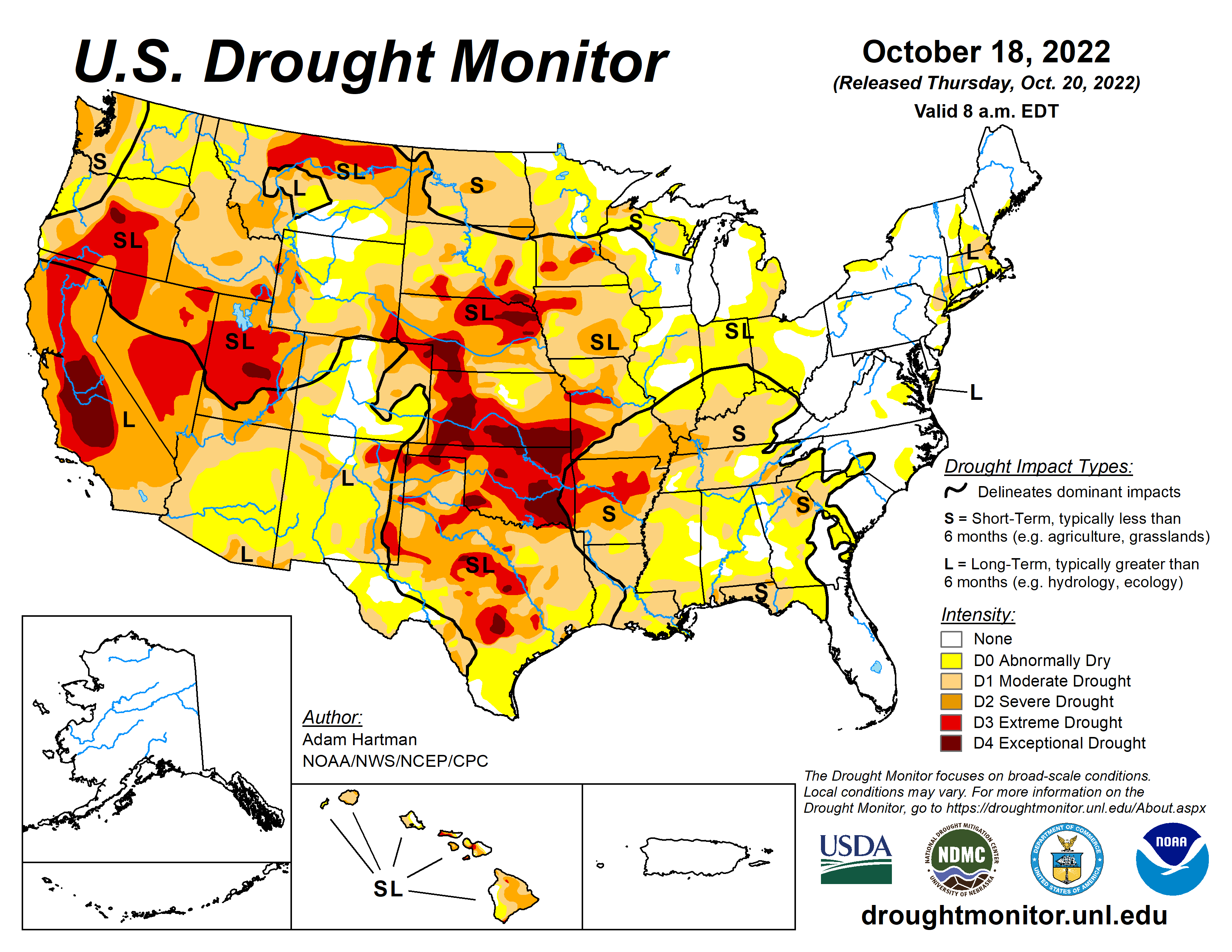
Much of the western half of the lower 48 states observed above-normal average temperatures this week. The Intermountain West and Pacific Northwest experienced the largest positive temperature anomalies, where widespread temperatures averaged 5°F to 10°F above-normal, with a few pockets exceeding 10°F above-normal for the week as whole. In addition to the above-normal temperatures, precipitation was also lacking for most areas from the Central and Northern Plains westward to the Pacific Coast, warranting drought deterioration. Parts of the Four Corners and Desert Southwest were the exception to this, as an area of low pressure meandered across the Southwest before being picked up by a frontal boundary dropping southward across the central U.S. This resulted in improvements to long-term drought conditions across parts of the Four Corners, with targeted improvements in the Southern Plains. Across the eastern half of the lower 48, frontal boundaries associated with a couple of strong low pressure systems in the Great Lakes brought heavy precipitation and cooler than normal temperatures to portions of the Great Lakes, Northeast, and Southeast. Therefore, a widespread mix of improvements and deterioration was warranted in many locations where the heaviest precipitation did and did not fall, respectively…
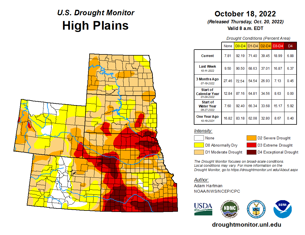
Despite the High Plains Region observing near to below-normal average temperatures this week, a combination of antecedent dryness, below-normal precipitation, and high winds resulted predominantly in continued degradation region-wide. The only exception was the southwestern corner of Colorado, where short and long-term drought indicators have shown continued improvement following a robust Southwest Monsoon season and a couple of additional episodes of precipitation, associated with cutoff areas of low pressure in the Southwest in recent weeks…
Colorado Drought Monitor one week change map ending October 18, 2022.
An upper-level low pressure system, coupled with a frontal boundary dropping southward across the central U.S. resulted in a good soaking this week for many areas from southeastern California eastward to the Rio Grande Valley. Given the lingering precipitation associated with this area of low pressure following the climatological end to a very robust Southwest Monsoon season in late September, this was another much-needed round of precipitation to further fuel ongoing improvements to long-term drought indicators, such as groundwater and 12 to 24-month SPIs. Soil moisture is in excellent shape as well coming out of the monsoon season across Arizona and New Mexico. Farther northward in the Western Region, degradation was the main story, as below-normal precipitation and above-normal average temperatures (in some cases record high temperatures for this time of year) were observed. High winds and above-normal temperatures resulted in targeted degradations across northern portions of the Intermountain West and the High Plains. In the Pacific Northwest, degradations were also warranted, with the addition of D2 (severe drought) across the parts of the Coastal Ranges and Northern Cascades in Washington, where 28-day average stream flows have dropped into the bottom 2 percent of the historical distribution. In addition, soil moisture ranks in the bottom 5 percent climatologically, vegetation indices are indicating widespread drought stress, groundwater levels are falling, and SPIs for all periods out to 120 days are D4-equivalent (exceptional drought). The Pacific Northwest is entering into a climatologically wetter time of year, so precipitation will need to come soon to halt further deterioration…
Frontal boundaries associated with a couple of strong low pressure systems over the Great Lakes brought heavy precipitation to parts of the Red River Valley of the South, the Ozarks, and the Tennessee Valley this week. Farther westward toward the Rio Grande Valley, a cutoff low pressure system became entrained into the second frontal boundary dropping southward across the central U.S. bringing heavy rainfall to parts of western and southern Texas. Improvements were generally warranted in areas receiving the heaviest rainfall (greater than 1 inch positive 7-day anomalies). However, antecedent 30-day dryness resulted in status quo depictions for several other locations receiving near to above-normal rainfall, as surface soil moisture has rapidly declined due to widespread 3 to 5 inch 30-day precipitation deficits and predominantly above-normal temperatures. This dryness also extends to 60 to 90 days for several areas across the Southern Plains and along the Gulf Coast, warranting 1-category deteriorations in the drought depiction for many locations not receiving rainfall this week…
Looking Ahead
During the next five days (October 20-24), the storm system over the Great Lakes is forecast to move northeastward into Canada, but bring some additional light precipitation to parts of the northern and eastern Great Lakes. Surface high pressure is expected to dominate much of the eastern lower 48. However, a storm system is predicted to spin up off the coast of the Carolinas bringing the potential for rainfall along portions of the Eastern Seaboard. In the West, an active storm pattern is expected, with the potential for upwards of 3 inches of precipitation for the higher elevations of the Pacific Northwest and upwards of 2 inches across portions of the Intermountain West. The first of two systems is expected to intensify over the central U.S. leading up to October 24, bringing increased precipitation chances to much of the Great Plains and the Mississippi Valley. Below-normal temperatures are expected to shift eastward from the West Coast to the Great Plains, associated with the storm system entering the West during the weekend. Ahead of this system, southerly flow is expected to keep temperatures near and above-normal, with the largest anomalies shifting eastward from the Great Plains to the eastern U.S.
US Drought Monitor one week change map ending October 18, 2022.
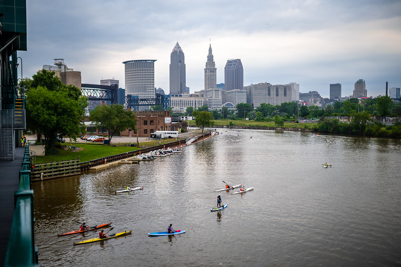
Kayakers on the Cuyahoga River in downtown Cleveland, Ohio. Photo: Erik Drost (CC BY 2.0)
Click the link to read the article on the Associated Press website (John Flescher). Here’s an excerpt:
As officials and community leaders prepared to celebrate the law’s 50th anniversary Tuesday [October 18, 2022] near the river mouth at Lake Erie, the Cuyahoga again is emblematic. This time, it represents progress toward restoring abused waterways — and challenges that remain after the act’s crackdown on industrial and municipal sewage discharges and years of cleanup work. A 1967 survey found not a single fish in the river between Akron and Cleveland. Now, there are more than 70 species including smallmouth bass, northern pike and muskellunge. Limits on eating them have been lifted. The Cuyahoga is popular with boaters. Parks and restaurants line its banks…
The Clean Water Act established ambitious goals: making the nation’s waters “fishable and swimmable” and restoring their “chemical, physical and biological integrity.” It gave the newly established U.S. Environmental Protection Agency broad authority to set and enforce regulations. Experts and activists agree many waterways are healthier than they were, and cleanups continue. The Biden administration’s 2021 infrastructure package includes $50 billion to upgrade drinking water and wastewater treatment systems, replace lead pipes and cleanse drinking water of toxic PFAS, known as “forever chemicals.”
But the law’s aims have been only “halfway met,” said Oday Salim, director of the University of Michigan’s Environmental Law and Sustainability Clinic. ”If you spoke to most clean water policy advocates today, they’d be pretty disappointed in how long it has taken to get halfway.”
Screen shot from episode of “Tom Talks” April 2020.
Click the link to read the article on the AZCentral.com website (Brandon Loomis). Here’s an excerpt:
The Gila River Indian Community is the first Arizona water rights holder to publicly pursue the federal government’s new offer of compensation to leave Colorado River water in Lake Mead. Tribal Gov. Stephen Roe Lewis announced the plan on Monday at a gathering of Sen. Kyrsten Sinema’s water advisory council, which is reviewing ways to spend $4 billion of Inflation Reduction Act funds targeted at Colorado River drought relief, as well as funds approved in an infrastructure funding law.
While several participants in Sinema’s council praised the community’s proposal as a first step toward attracting others to rapidly conserve water, there were signs that getting significant buy-in from other Arizona farmers will be difficult. Yuma-area growers had sought $1,500 an acre-foot to forgo some irrigation, but the U.S. Bureau of Reclamation decided to offer $330, or up to $400 for multi-year deals. The Arizona Farm Bureau Federation’s president questioned the figure at the meeting, and a vice president later told The Arizona Republic it’s nowhere near enough to entice Yuma farmers.
“This is real water,” Farm Bureau President Stefanie Smallhouse said of what the farmers had offered. “It’s real value that is providing food for people.”
“The reality is we need a lot more than $4 billion,” Sinema conceded. But she said it’s important to spend the majority of the money now available on long-term efficiency gains and not primarily on emergency fallowing programs.
A map of the Jordan River watershed. Rivers and creeks are in blue. Canals are in gray. By Bgwhite Jordan River (Utah) Watershed map, and David Benbennick for Utah locator map, composite by Ruhrfisch (talk) – File created by Own work, with map from JPL OnEarth and vector data from Utah GIS Portal., CC BY-SA 3.0, https://commons.wikimedia.org/w/index.php?curid=10811624
Click the link to read the article on The Deseret News website (Amy Joi O’Donoghue). Here’s an excerpt:
There was a time when raw sewage was dumped in the Jordan River in Utah. It was an industrial wasteland, and once named the most endangered river in the country by an advocacy group…
“The Clean Water Act really incorporated better technology for sampling and detection of contaminants in the drinking water and helped us reduce the levels of contaminants in the drinking water with new detection limits and with new filter technologies,” said Scott Paxman, general manager of the Weber Basin Water Conservancy District.
Technology and water: Paxman said the Clean Water Act prompted the district to replace three aging water treatment plants from the 1950s with state of the art technology to screen for and eliminate cryptosporidium, a microscopic parasite that can cause disease in humans, as well as Giardia, another parasite problematic for people. Paxman said the new plants in 2002 were a $5 million investment and use ozone and ultraviolet rays to eliminate the parasites. It was a heavy lift, but it means safer water for the residents the district serves.
Amazing vintage infrastructure: The first dam built on the Colorado River, Laguna Dam (1905) ended navigation above Yuma Valley and diverted water for the Yuma Project. The spillway is usually dry but bc of recent rains, there are currently some ‘excess flows’ spilling to Mexico. pic.twitter.com/wEbNMCsIrS
After the passage of the Reclamation Act by the US Congress in 1902, the U.S. Bureau of Reclamation began constructing the dam under the Yuma Project in 1903. This project was the first development of the U.S. Reclamation Service along the Lower Colorado River and featured the Laguna Diversion Dam, a pumping station and a series of canals. On July 6, 1905 the contract to build the dam was awarded to J. G. White and Company who started construction less than two weeks later. Deliveries of cement were a problem as they had to be delivered to Yuma by rail and to the construction site by wagons or steamboat. Poor rock quality at local quarries also posed a problem that consistently delayed construction, 50% of the weak rock was unusable. Even after their contract was supplemented to encompass the rock quality delays, J. G. White and Company still did not meet their deadline and the Bureau of Reclamation took over construction in early 1907.
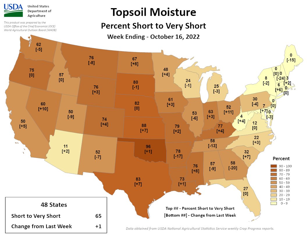
A 1% rise means for the second week in a row we’ve reached a 6-year high in Topsoil S/VS at 65%. For individual states, Oklahoma (96% VS/S) continues to lead (in a bad way). KS is next at 88%.
The Department of the Interior today announced $210 million from President Biden’s Bipartisan Infrastructure Law that will bring clean, reliable drinking water to communities across the West through water storage and conveyance projects.
The projects are expected to develop over 1.7 million acre-feet of additional water storage capacity, enough water to support 6.8 million people for a year. The funding will also invest in two feasibility studies that could advance water storage capacity further once completed.
“In the wake of severe drought across the West, the Department is putting funding from President Biden’s Bipartisan Infrastructure Law to work to expand access to clean, reliable water and mitigate the impacts of this crisis,” said Secretary Deb Haaland. “Water is essential to every community – for feeding families, growing crops, powering agricultural businesses, and sustaining wildlife and our environment. Through the investments we are announcing today, we will advance water storage and conveyance supporting local water management agencies, farmers, families and wildlife.”
“Through the Bipartisan Infrastructure Law, the Biden-Harris administration is dramatically advancing our mission at the Bureau of Reclamation to deliver water and power in an environmentally and economically sustainable manner for the American West,” said Bureau of Reclamation Commissioner Camille Calimlim Touton. “Our investment in these projects will increase water storage capacity and lay conveyance pipeline to deliver reliable and safe drinking water and build resiliency for communities most impacted by drought.”
The Bipartisan Infrastructure Law allocates $8.3 billion for Bureau of Reclamation water infrastructure projects over the next five years to advance drought resilience and expand access to clean water for families, farmers, and wildlife. The investment will repair aging water delivery systems, secure dams, and complete rural water projects, and protect aquatic ecosystems. The funding announced today is part of the $1.05 billion in Water Storage, Groundwater Storage and Conveyance Projects provided by the Law.
The selected projects are:
Arizona:
Verde River near Clarkdale along Sycamore Canyon Road. Photo credit: Wikimedia
– Verde River Sediment Mitigation Study: $5 million to provide the federal cost share for conducting the Verde River Sedimentation feasibility study, which would identify alternatives to restore at least 46,000 acre-feet of water storage lost due to accumulation of sediment at Horseshoe Reservoir. It would also determine a plan for future management of sediment at Horseshoe and Bartlett Reservoirs and investigate potential operational flexibilities created with increased storage capacity to assist in mitigating impacts of drought and climate change on water availability. An appraisal study was completed in 2021.
B.F. Sisk Dam is a 380-foot-high zoned compacted earthfill embankment located on the west side of California’s Central Valley 12 miles west of Los Banos, California. The dam is more than 3.5 miles long and impounds San Luis Reservoir which has a total capacity of more than 2 million acre-feet.
The dam was built between 1963 and 1967 to provide supplemental irrigation water storage for the federal Central Valley Project (CVP) and municipal and industrial water for the California State Water Project (SWP). Water is lifted into the reservoir for storage by the Gianelli Pumping – Generating Plant from the California Aqueduct and from the Delta-Mendota Canal via O’Neill Forebay.
B.F. Sisk Dam, also known as San Luis Dam, is owned by the Bureau of Reclamation and operated by the California Department of Water Resources (DWR). Reservoir storage space is allotted 55% state and 45% federal. Photo credit: Reclamation
California:
– B.F. Sisk Dam Raise and Reservoir Expansion Project: $25 million to the San Luis and Delta-Mendota Authority, to pursue the B.F. Sisk Dam Raise and Reservoir Expansion Project. The project is associated with the B.F. Sisk Safety of Dams Modification Project. Once complete, the project will develop approximately 130,000 acre-feet of additional storage.
– North of Delta Off Stream Storage (Sites Reservoir Project): $30 million to pursue off stream storage capable for up to 1.5 million acre-feet of water in the Sacramento River system located in the Coast range mountains west of Maxwell, California. The reservoir would utilize new and existing facilities to move water into and out of the reservoir, with ultimate release to the Sacramento River system via existing canals, a new pipeline near Dunnigan, and the Colusa Basin Drain.
– Los Vaqueros Reservoir Expansion Phase II: $82 million to efficiently integrate approximately 115,000 acre-feet of additional storage through new conveyance facilities with existing facilities to allow Delta water supplies to be safely diverted, stored and delivered to beneficiaries.
Arkansas Valley Conduit map via the Southeastern Colorado Water Conservancy District (Chris Woodka) June 2021.
Colorado
– Arkansas Valley Conduit: $60 million to continue the facilitation of supplying a safe, long-term water supply to an estimated 50,000 people in 40 rural communities along the Arkansas River. Once complete the project will replace current groundwater sources contaminated with radionuclides and help communities comply with Environmental Protection Act drinking water regulations through more than 230 miles of pipelines designed to deliver up to about 7,500 acre-feet per year from Pueblo Reservoir.
Montana
– Dry Redwater Regional Water System Feasibility Study: $3 million to provide the authorized federal cost-share for finishing the Dry Redwater Regional Water System Feasibility Study.
– Cle Elum Pool Raise: $5 million to increase the reservoir’s capacity an additional 14,600 acre-feet to be managed for instream flows for fish. Additional efforts include shoreline protection that will provide mitigation for the pool raise.
The Department also recently announced new steps for drought mitigation in the Colorado River Basin supported by the Inflation Reduction Act, releasing a request for proposals for water system conservation measures as part of the newly created Lower Colorado River Basin System Conservation and Efficiency Program. The Act provides $4 billion in funding for water management and conservation in the Colorado River Basin, including at least $500 million for projects in the Upper Basin states that will result in water conservation throughout the system.
Click the link to read the release on the Reclamation website (Doug Hendrix):
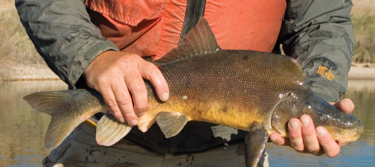
The Bureau of Reclamation is lowering water levels in Lake Mohave to aid in harvesting razorback suckers (Xyrauchen texanus) from lakeside rearing ponds. The fish is an endangered species native to the Colorado River, and the drawdown is part of annual river operations which are timed to coincide with conservation activities for the fish. Lake Mohave will steadily lower from its current elevation of 637 feet above mean sea level (msl) to an elevation of about 633 feet msl by the week of Oct. 24 and will remain at approximately the same elevation for about one week. The lake level will begin to rise at the end of October and is estimated to reach an elevation of 639 feet msl by the end of November. Boaters should use caution when navigating the lake, as areas, especially downstream of Hoover Dam, will be shallower than normal.
Each year, Reclamation’s Lower Colorado River Multi-Species Conservation Program (LCR MSCP) gathers tens of thousands of newly hatched razorback sucker larvae from Lake Mohave and transfers the larvae to state and federal hatcheries throughout the Southwest. After an initial growth period in these hatcheries, many of the fish are placed in lakeside rearing ponds around Lake Mohave, where they continue to grow and learn how to forage for food. In the fall, these fish are harvested from the lakeside ponds, tagged with microchips, and released back into Lake Mohave.
The project is part of Reclamation’s continuing collaboration with the U.S. Fish and Wildlife Service in cooperation with the National Park Service, Arizona Game and Fish Department, Nevada Department of Wildlife, and other interested parties. The LCR MSCP is a multi-agency effort to accommodate water and power needs while conserving species and their habitats along the river. More information about conservation efforts for razorback suckers is available at https://www.lcrmscp.gov/fish/razorback_sucker.html.
Lake Mohave is located above Davis Dam on the Colorado River near Laughlin, Nevada. Updated information on water levels at Lake Mohave and other Lower Colorado River reservoirs is located at https://www.usbr.gov/lc/riverops.html under Current Conditions. For current recreational information, visit the National Park Service website at https://www.nps.gov/lake/learn/news/lakeconditions.html.
As the first installment of the Summit County government’s new County 101 series, community members gathered to hear from local water leaders about the state of the Colorado River drought and how it affects local headwaters. Representatives from the Colorado District, Colorado Division of Water Resources, Blue River Watershed Group and High Country Conservation Center gave presentations about local waters and how community members can understand recent reporting about drought across the river basin…
On Oct. 12, the Biden administration designated at least $500 million from the Inflation Reduction Act to go toward the Upper Colorado River Basin, which includes Colorado, for “investments in conservation and long-term system efficiency,” according to a release from the White House.
Brad Udall: Here’s the latest version of my 4-Panel plot thru Water Year (Oct-Sep) of 2021 of the Colorado River big reservoirs, natural flows, precipitation, and temperature. Data (PRISM) goes back or 1906 (or 1935 for reservoirs.) This updates previous work with @GreatLakesPeck. Credit: Brad Udall via Twitter
“(Drought and climate change are) something here in the headwaters we live with — our hydrology. We see it happening. We see less snow. We see the dry soils that are absorbing what runoff we do have,” said Marielle Cowdin, director of public relations at the Colorado River District. “For every 1 degree Fahrenheit rise in average temperature, stream flow is reduced between 3% to 9%, with most studies actually leaning toward that 9%.”
Like other parts of the Upper Colorado River Basin, the Blue River has faced changes in the past decade as a result of climate. This includes less snowpack for spring runoff, drier soils and warmer summer temperatures.
“It’s my belief that these bigger-picture issues that are brought up and that we’re all facing, they’re coming down the pike,” Troy Wineland, water commissioner for Summit County, said. “And believe me, they’re coming. We’ve got two of the largest reservoirs in the country sitting about 24% capacity. If that’s not the kind of writing on the walls, I don’t know what it is. So outreach and education to me is critical.”
Part of the memorial to Wayne Aspinall in Palisade. Aspinall, a Democrat, is a legend in the water sector, and is the namesake of the annual award given by the Colorado Water Congress. Photo: Brent Gardner-Smith/Aspen Journalism
From email from Reclamation (Erik Knight):
Releases from the Aspinall Unit will be decreased from 1050 cfs to 950 cfs on Thursday, October 20th. Releases are being decreased due to reduced demand at the Gunnison Tunnel.
Flows in the lower Gunnison River are currently above the baseflow target of 790 cfs. River flows are expected to remain above the baseflow target for the foreseeable future.
Pursuant to the Aspinall Unit Operations Record of Decision (ROD), the baseflow target in the lower Gunnison River, as measured at the Whitewater gage, is 790 cfs for October and November.
Currently, Gunnison Tunnel diversions are 700 cfs and flows in the Gunnison River through the Black Canyon are around 340 cfs. After this release change Gunnison Tunnel diversions will be around 600 cfs and flows in the Gunnison River through the Black Canyon will still be near 340 cfs. Current flow information is obtained from provisional data that may undergo revision subsequent to review.
Click through to Twitter to view the docs from Chris Lopez.
At the quarterly meeting of the Rio Grande Water Conservation District. The board gets these latest charts on the unconfined aquifer of the Upper Rio Grande Basin. You can see in September the unconfined aquifer recorded close to its lowest level. #SanLuisValley#UpperRioGrandepic.twitter.com/kStO4jiAkV
Satellite photo of the Great Salt Lake from August 2018 after years of drought, reaching near-record lows. The difference in colors between the northern and southern portions of the lake is the result of a railroad causeway. The image was acquired by the MSI sensor on the Sentinel-2B satellite. By Copernicus Sentinel-2, ESA – https://scihub.copernicus.eu/dhus/#/home, CC BY-SA 3.0 igo, https://commons.wikimedia.org/w/index.php?curid=77990895
Utah House Speaker Brad Wilson on Thursday announced that the Weber Basin and Jordan Valley water conservancy districts will send an additional 30,000 acre feet of water to the lake, above and beyond what they’re otherwise expected to let loose. The Weber Basin Water Conservancy District, one of several water providers around the state, serves Weber County and taps into the Pineview Reservoir, among others…Moreover, Wilson unveiled plans to seek creation of a new public-private venture called Utah Water Ways, which would be overseen by a coalition of Utah business leaders who would spearhead grant programming and a publicity campaign to save water. It’s modeled after the Utah Clean Air Partnership, or UCAIR, focused on fighting air pollution by involving the broader public…
The 30,000 acre feet in extra water coming from the two water conservancy districts, to be released over the coming winter, is just a fraction of what the lake needs to get back to normal. But Wilson, a Kaysville Republican, hopes for more such allocations and said fixing the problem will require numerous incremental measures…Meantime, the Utah Water Ways initiative, which sprang from Wilson’s office, will require passage of enabling legislation when lawmakers meet in the 2023 session early next year. But he’s already organized a coalition of partners to aid in the process and provide funding. They are Rio Tinto, the mining group; Intermountain Healthcare, the nonprofit health care provider; Zion’s Bank; Ivory Homes; and the Larry H. Miller Co., a consortium of companies.
Click the link to read the article on the NOAA website (Emily Becker):
For what seems like the 247th month in a row, La Niña is still in charge in the tropical Pacific. It’s really only been about a year with continuous La Niña, as it took a break summer 2021 and re-developed October 2021, but it seems like longer! There’s a 75% chance La Niña will be present this winter (December–February); forecasters favor a transition to neutral during February–April 2023.
3 Musketeers
Call it what you like—triple-dip, three-peat, three-bean salad—we are facing the third La Niña winter in a row. This is the third time in our historical record of ENSO (El Niño-Southern Oscillation, the whole El Niño and La Niña system), which dates back to 1950, that we have had three La Niña winters in a row. That’s a lot of threes! The other stretches were 1973–1976 and 1998–2001.
Three-year history of sea surface temperatures in the Niño-3.4 region of the tropical Pacific for 8 previous double-dip La Niña events. The color of the line shows the ENSO state in the third winter (red: El Niño, darker blue: La Niña, lighter blue: neutral). The black line shows the current event. Monthly Niño-3.4 index is from CPC using ERSSTv5. Time series comparison was created by Michelle L’Heureux, and modified by Climate.gov.
As I mentioned, La Niña conditions took a vacation last summer, but the Niño-3.4 index has been negative since mid-2020. The Niño-3.4 index, our primary measurement for ENSO, measures the difference between current and long-term average sea surface temperature in a specific region in the tropical Pacific, where long-term is currently 1991–2020. According to ERSSTv5, our favorite sea surface temperature dataset, the Niño-3.4 index ticked slightly more negative to -1.1°C in September 2022. This is approximately tied with 1999 for the 6th most negative Niño-3.4 index on record for the month of September.
Kit Kat
Forecasters are very confident that La Niña will continue through the end of the year: the probability of La Niña through October–December is 95%. I got into detail about the sources behind the high level of confidence last month, and they remain the same this month. First, there’s that Niño-3.4 index, substantially exceeding the La Niña threshold of cooler than -0.5°C.
Also, the La Niña atmospheric response is clearly locked in, shown by stronger-than-average near-surface winds along the equatorial Pacific Ocean (the trade winds), less rain than average over the central tropical Pacific, and more rain over Indonesia. All these factors illustrate an enhanced Walker circulation. One of the ways that we measure the Walker circulation is the Southern Oscillation Index (SOI), which relates the surface air pressure over Darwin, Australia to the pressure over Tahiti.
Location of the stations used for the Southern Oscillation Index (Tahiti and Darwin, black dots), the Equatorial Southern Oscillation Index (eastern equatorial Pacific and Indonesia regions, outlined in blue-green), and the Niño3.4 region in the east-central tropical Pacific Ocean for sea surface temperature (red dashed line). NOAA Climate.gov image by Fiona Martin.
September 2022 was the 4th strongest September SOI since 1950. Another measurement is the Equatorial Southern Oscillation Index, measuring the surface pressure relationship between the eastern and western equatorial Pacific. By this measure, September 2022 was tied for 10th strongest September since 1949. Not quite as impressive, but still a solid indication of the amped-up Walker circulation.
A third factor providing confidence is that there is still a substantial amount of cooler-than-average water under the surface of the tropical Pacific. Our records for the subsurface ocean temperature go back to 1979, and September 2022 is tied for 8th coolest September subsurface. Not a staggering record or anything, but enough to further bolster the forecast confidence. Yet more confidence comes from the computer model forecasts, nearly all of which predict La Niña will linger through the Northern Hemisphere winter.
Skittles
We spend so much time and energy studying La Niña and El Niño because they affect global atmospheric circulation, changing climate patterns in somewhat predictable ways. Check the second half of last month’s post for a collection of La Niña’s potential effect on North American and global weather and climate.
There are many different things that go into a seasonal forecast, but the two biggies are ENSO and recent trends, meaning the tendency of temperature and rain/snow over the recent 10 or 15 years. Tom described how the recent trends work, so take a look at that post for details.
November–January average temperature (top) and precipitation (bottom) compared to the long-term average for the combination of historical La Niña events and climate trends. Data is based on the CPC ENSO composites and modified by Climate.gov.
Clearly, when you combine the characteristic temperature pattern of La Niña with recent trends, you end up with a warmer-than-average pattern during November–January over nearly the entire contiguous U.S. (You can see maps with La Niña and trends separated here.) Also, the southern plains tend to be drier than average, with more rain and snow falling in the northwest. (Separated maps here.) The Climate Prediction Center’s updated outlook for the November–January and upcoming winter will be released next Thursday.
Board supports permanent ban of grass that is not regularly used for recreation, other purposes
With drought and climate change stressing water availability, the Metropolitan Water District is taking steps to eliminate an all-too-common sight in Southern California that uses up valuable water resources – ornamental grass that serves no recreational or community purpose – grass known as non-functional turf.
Metropolitan’s Board of Directors last Tuesday (Oct. 11) adopted a resolution that strongly recommends cities and water agencies across Southern California pass ordinances permanently prohibiting the installation and irrigation of non-functional turf. The board’s call is largely directed at both existing and new commercial, industrial and public properties, as well as HOAs, rather than residential properties. It does, however, call for local regulations that don’t allow installation of non-functional turf in new home construction.
“More than half of all water used in Southern California is used outdoors for irrigation, much of it for grass that is not walked or played on or used in any meaningful way. Sustaining ornamental grass is not a good use of our precious water resources,” Metropolitan General Manager Adel Hagekhalil said.
Metropolitan has for more than a decade incentivized residents and businesses to replace their grass lawns with more water-efficient landscaping. That turf replacement program, which today offers a base rebate of $2 per square foot of grass replaced, has directly resulted in the removal of more than 200 million square feet of grass, saving enough water to serve 62,000 homes annually. In addition, a recent study found that for every 100 homes that converted their yards using a Metropolitan rebate, an additional 132 nearby homes were inspired to convert their own grass without receiving a rebate to help fund the projects. This “multiplier effect” more than doubled the value of Metropolitan’s $351 million investment in making Southern California more sustainable.
“Through our turf rebate and California Friendly® and native plant gardening education programs, we’ve jumpstarted the movement to change the landscape of Southern California. But we must do more,” Chairwoman Gloria D. Gray said.
“We are experiencing unprecedented drought conditions in California and on the Colorado River – straining both of our imported water supplies. And the reality of climate change means that these alarming conditions are likely to become more common and more severe. We need to find ways to permanently live with less water,” she added.
California is in the midst of the driest three years on record, resulting in the lowest-ever deliveries from the State Water Project, which on average supplies 30 percent of the water used in Southern California. The constraints on that supply have left 6 million people in the region without enough water to meet normal demands, requiring unprecedented mandatory conservation.
On the Colorado River – Southern California’s other principal imported water supply – a decades-long drought has left the system’s reservoirs at their lowest-ever levels. The federal government has responded with a call for immediate and dramatic cutbacks in water use.
Elimination of non-functional turf is becoming an increasingly valuable tool to quickly and permanently decrease water use. In response to California’s drought, the State Water Resources Control Board issued an emergency regulation temporarily banning the irrigation of non-functional turf with potable water from June 2022 to June 2023. And in August, Metropolitan joined urban water agencies across the Colorado River Basin to sign a Memorandum of Understanding committing to reducing non-functional turf.
“We need to permanently reduce the amount of water used on non-functional turf. That is why we are calling on cities and agencies to adopt relevant ordinances that will work with the particular circumstances of their communities,” Hagekhalil said. “At the same time, Metropolitan will continue providing cash incentives so that grass is not simply paved over, rather it is replaced with water-efficient landscaping to ensure our trees continue thriving and our communities remain beautiful and ecologically diverse.”
The resolution approved Tuesday specifically calls for cities and agencies to pass ordinances that permanently: prohibit the use of potable water to irrigate non-functional turf in existing and new non-residential properties; prohibit the installation of non-functional turf in non-residential and new residential properties; and require the removal of all non-functional turf in non-residential properties by a certain date. Non-functional turf is defined as specific kinds of grasses irrigated by potable water that are not regularly used for human recreational purposes or for civic or community events.
Cache la Poudre River drop structure. Photo credit: Northern Water
From email from Northern Water (Jeff Stahla):
Northern Water’s Board of Directors has set the initial 2023 quota for the Colorado-Big Thompson Project at 40 percent.
At its meeting on Thursday, Oct. 13, the Board voted to set the quota at 40 percent in light of uncertainty regarding Colorado River Basin hydrology and Northern Water’s commitment to system resiliency. In recent years, the initial quota had been set at 50 percent.
“This is what we need to do to protect the system for the long term,” said President Mike Applegate.
Quotas are expressed as a percentage of 310,000 acre-feet, the amount of water the C-BT Project was initially envisioned to deliver to allottees each year. A 40 percent initial quota means that the Board is making 0.4 acre-feet of water available at the beginning of the water year (Nov. 1) for each of the 310,000 C-BT Project units. In April, the Board will assess conditions such as available local water storage levels, soil moisture, mountain snowpack and more to adjust the quota for the 2023 peak water-use season.
Water from the C-BT Project supplements other sources for 33 cities and towns, 120 agricultural irrigation companies, various industries and other water users within Northern Water’s 1.6 million-acre service area. According to recent census figures, more than 1 million residents now live inside Northern Water’s boundaries. To learn more about Northern Water and the C-BT quota, visit www.northernwater.org.
Screenshot of the Colorado-Big Thompson Project boundaries via Northern Water’s interactive mapping tool , June 5, 2019.
The federal government plans to pay farmers that draw water from the Colorado River to take less, one piece of a multi-pronged plan to reduce usage.
The U.S. Department of the Interior announced a new program that will draw on $4 billion in Inflation Reduction Act funding approved for water management and drought mitigation in the Colorado River Basin. Called the Lower Colorado River Basin System Conservation and Efficiency Program, it will be run by the U.S. Bureau of Reclamation. Through the program’s three components, it will select conservation proposals from Colorado River water delivery contracts and entitlement holders, typically farmers using the water to grow crops.
The first component emphasizes drought mitigation, water and power reliability, and natural resource conservation efforts that improve Lake Mead’s water level. It will allow applicants to request payback terms of $330 per acre-foot for one year, $365 per acre-foot for two years, or $400 per acre-foot for three years.
Proposals must also include amounts of water expected to be conserved, methods of verification, and an economic justification, the Bureau of Reclamation told potential applicants.
The second component will seek applicant proposals for other water conservation projects at different pricing amounts, and the third component, which will open in early 2023, will deal with long-term efficiency improvement projects.
Applications are open for the first two components now through Nov. 21, 2022.
While this announcement focuses on “near-term actions,” the Interior Department says it is still looking to invest in long-term systems that will improve efficiency. Similar programs in Upper Basin states are also under consideration and will include at least $500 million in investments in Colorado, Utah, Wyoming, and New Mexico.
“The prolonged drought afflicting the West is one of the most significant challenges facing our country,” Interior Secretary Deb Haaland said in a statement. “I have seen firsthand how climate change is exacerbating the drought crisis and putting pressure on the communities who live across Western landscapes.”
“Thanks to historic funding from the Inflation Reduction Act, the Interior Department is committed to using every resource available to conserve water and ensure that irrigators, Tribes and adjoining communities receive adequate assistance and support to build resilient communities and protect our water supplies,” she continued.
Bureau of Reclamation Commissioner Camille Touton said in July that Colorado River Basin states should figure out how to conserve between 2 and 4 million more acre-feet of water by 2023
U.S. Sens. Catherine Cortez Masto, D-Nev., Michael Bennet, D-Colo., and Mark Kelly, D-Ariz., advocated for the $4 billion in drought funding during the passage of the IRA.
“The Western United States is experiencing an unprecedented drought, and it is essential that we have the resources we need to support our states’ efforts to combat climate change, conserve water resources, and protect the Colorado River Basin,” they wrote in an August 5 statement. “This funding in the Inflation Reduction Act will serve as an important resource for Nevada, Arizona, and Colorado, and the work we’ve done to include it will help secure the West’s water future.”
Today [October 17, 2022], Colorado U.S. Senators Michael Bennet and John Hickenlooper welcomed an announcement from the Bureau of Reclamation (BOR) of the distribution of $60 million in funds from the Bipartisan Infrastructure Law to support the completion of the Arkansas Valley Conduit (AVC), providing Coloradans with a secure and safe supply of water. In July, the senators and U.S. Colorado Representative Ken Buck urged the Office of Management and Budget (OMB) and BOR to allocate funds from the infrastructure law for the AVC. The Weeminuche Construction Authority, an enterprise of the Ute Mountain Ute Tribe, has been awarded the contract for this phase of construction of the AVC.
“Sixty years ago, President Kennedy came to Pueblo and promised to build the Arkansas Valley Conduit to deliver clean drinking water to families in Southeastern Colorado. Since I’ve been in the Senate, I’ve fought to ensure the federal government keeps its word to Colorado and finishes this vital infrastructure project,” said Bennet. “One of the first bills I passed helped to jumpstart and fund construction on the Arkansas Valley Conduit, and with this announcement, we’ve delivered more than $140 million to help complete construction and deliver on this decades-old promise.”
“Thanks to the Bipartisan Infrastructure Act, long-stalled projects like the Ark Valley Conduit are moving forward. Today, we’re bringing this 60 year project over the finish line,” said Hickenlooper.
Arkansas Valley Conduit map via the Southeastern Colorado Water Conservancy District (Chris Woodka) June 2021.
The AVC is a planned 130-mile water-delivery system from the Pueblo Dam to communities throughout the Arkansas River Valley in Southeast Colorado. This funding will expedite the construction timeline for the Conduit and allow for federal drinking water standards to be met more quickly. The Conduit is the final phase of the Fryingpan-Arkansas Project, which Congress authorized in 1962.
Bennet and Hickenlooper have consistently advocated for increased funding for the AVC. In May, the senators sent a letter to the Appropriations Committee to include funding for the AVC in the FY23 spending bill. In March, Bennet and Hickenlooper helped secure $12 million for the Conduit from the FY22 omnibus bill. Bennet and Hickenlooper will continue working in Washington to ensure communities have the resources needed to complete this vital project for the region.
“We have been working hard to move this project from planning to construction. This announcement follows the first construction contract award, and is a clear indication that the District and Reclamation will continue to partner in this long-time effort to bring clean drinking water to the Lower Arkansas Valley. Our Senators were key to obtaining more than $8 billion for the Bureau in the IIJA, and our delegation’s long-standing bipartisan support along with support from the State of Colorado have put the conduit on Reclamation’s front line for construction,” said Southeastern Colorado Water Conservancy District board president Bill Long.
“The Ute Mountain Ute Tribe and its construction enterprise are honored to be a partner in delivering safe drinking water to the Lower Arkansas Valley. Like other projects Weeminuche Construction Authority has been a part of, the Arkansas Valley Conduit has been a long time coming, but will provide enormous benefit. The infrastructure dollars for the Bureau of Reclamation, making this possible, are a credit to Senator Bennet’s efforts to build support for Western water infrastructure,” said Michael Preston, Board President, Weenuch-u’ Development Corporation of the Ute Mountain Ute Tribe.
“As a regional leader in water issues in southern Colorado, Pueblo Water is proud to help push the Arkansas Valley Conduit forward. Our strong relationship with the Southeastern Colorado Water Conservancy District, the Bureau of Reclamation, and other partners helped make it possible for this project to come to fruition. Through this partnership, communities in Southeastern Colorado will have access to clean water faster than thought possible,” said Seth Clayton, Executive Director of Pueblo Water.
Background:
Prior to this announcement, Bennet has helped secure over $80 million for the AVC.
In 2009, Congress passed legislation written by Bennet and former U.S. Senator Mark Udall (D-Colo.) to authorize a federal cost share and the construction of the Arkansas Valley Conduit. Bennet then worked to secure $5 million in federal funding for the project.
In 2013, Bennet and his colleagues sent a letter to the BOR to quickly approve the Conduit’s Environmental Impact Study (EIS) in order to expedite the project’s completion. In 2014, following Bennet and Udall’s efforts to urge the BOR to quickly approve the Conduit’s EIS, the Record of Decision was signed in February. After President Obama’s budget included an insufficient level of funding for the project, Bennet led a bipartisan letter urging the administration and the House and Senate Appropriations Committees to allow the Conduit’s construction to move ahead as planned. Bennet successfully urged the Department of Interior to designate $2 million in reprogrammed funding from FY14 for the Conduit. Bennet secured language in the FY15 Senate Energy and Water Development Appropriations Act that sent a clear signal to the BOR that the Conduit should be a priority project.
In 2016, Bennet secured $2 million from the BOR’s reprogrammed funding for FY16, after the project had initially received only $500,000. Bennet then secured $3 million for the AVC as part of the FY17 spending bill. Bennet secured $3 million for the Conduit for FY18.
In April 2019, Bennet and former U.S. Senator Cory Gardner (R-Colo.) wrote to then-Senate Appropriations Committee Chairman Lamar Alexander (R-Tenn.) and Ranking Member Feinstein, urging them to provide funding for the Conduit. Bennet, Gardner, former U.S. Congressman Scott Tipton (R-Colo.), and Buck wrote to the Department of the Interior urging the Department to support the project. Bennet secured approximately $10 million each year for the Conduit in the FY19 and FY20 spending bills. In 2020, Bennet welcomed $28 million from the BOR to begin construction on the AVC to help bring clean drinking water to Colorado communities. He secured $11 million for the AVC in FY21. He joined the ground breaking in October 2020.
Arkansas River Basin via The Encyclopedia of Earth
Rocky Mountain Metropolitan Airport, Thornton’s Ascent Solar and Westminster’s Ambassador Printing are all sites called out in a new interactive map that identifies places across the country contaminated by “forever chemicals.” […] The map calls out places that have tested positive for having PFAS onsite as well as “presumption contamination” from things such as firefighting foam and industrial chemicals. The sites in Northglenn, Thornton and Westminster are all listed among the sites with presumed contamination…[Alissa Cordner] said the tool’s purpose is to provide regulators, decision-makers and public health officials more information regarding potential risks to their communities. Places with contamination or presumptive contamination do not imply direct exposure or ingestion…
In 2020, the Colorado Department of Public Health and Environment tested 400 Colorado water systems, 15 firefighting districts and 43 streams and found 34% of drinking water systems tested had some level of PFAS in the water. A 2020 survey from the Colorado Health Department found 71 surface water samples had concentrations as high as 257 parts per trillion for 18 different kinds of PFAS. The state health department released a report in April indicating that bodies of water in El Paso, Adams and Jefferson counties were contaminated with PFAS. CDPHE collected 49 fish representing 10 different species from Willow Springs Pond in El Paso County, Tabor Lake in Jefferson County and Mann-Nyholt Lake at Adams County’s Riverdale Regional Park. They found PFAS in 100% of the fish they collected.
United Lithium Corp. (CSE: ULTH; OTC: ULTHF; FWB: 0ULA) (“ULTH” or the “Company”) ispleased to announce that it has established a large land position in a historic lithium-beryllium producing area of Gunnison County of Colorado. The Company has completed staking of over 300 unpatented lode claims covering more than 9 square miles (nearly 25 square kilometers) near Ohio City, Colorado, surrounding the Black Wonder granite. The “Patriot Lithium Project” hosts numerous pegmatite bodies, several of which have been mined for Li-Be. United Lithium’s claim block covers or surround all past LCT (lithium, cesium, tantalum) pegmatite production in the Ohio City area.
A reconnaissance rock chip sampling program was carried out in conjunction with the staking program to identify new areas for detailed field work. Samples have been submitted to the laboratory and assays are awaited.
Michael Dehn, CEO of United Lithium stated, “We are planning an integrated exploration program to evaluate the Ohio City area land holdings. The program will include local area detailed geologic mapping and additional rock chip sampling. With anomalies well-defined, targets with be drilled in the coming year when permits and contracts are in place.”
A general outline of the United Lithium claims is presented below. The area staked covers the public lands administered by the U.S. Forest Service (USFS). There are private property holdings within the USFS lands and the claims are positioned and located to recognize the pre-existing, titled ownership rights.
Map 1 Patriot Lithium Project Lode Claims (red), Gunnison County, Colorado, USA. Credit United Lithium
Historic Lithium – Beryllium Pegmatite Mining in the Ohio City Area
The Patriot Lithium project is part of the Quartz Creek pegmatite field. It is located 17 miles due east of City of Gunnison, in Gunnison County. The Patriot Lithium Project comprises three blocks of claims that are located between Parlin and Ohio City, Colorado and illustrated on Map 1. The two northern “Ohio City” claim blocks are separated by privately owned lands and a highway right-of-way. A sequence of younger, Paleozoic rocks separate the Ohio City claims from the southern “Parlin” claimblock. More than 1,800 individual pegmatite bodies were mapped around the Black Wonder granite by the US Geological Survey. The mapped pegmatites demonstrate zonation where the pegmatites closest to the Black Wonder granite are less evolved while the more distalpegmatites are geochemically evolved and commonly enriched in lithophile elements like Li, Be, Sn, Cs, Rb, etc. The more evolved pegmatites hosted lithium and beryllium former mines and occurrences, including the well-known Brown Derby pegmatite mine, as well as the Bazooka, White Spar and Opportunity pegmatites.
Reconnaissance Rock Chip Geochemical Sampling
A geological crew worked in conjunction with the staking crew in the Ohio City – Parlin areas, highlighting areas for coverage, and more importantly, collecting 243 surface rock chip samples from many pegmatite outcrops for geochemical analysis. Lithium minerals were identified in a number of the outcrop samples, including abundant lepidolite, spodumene and tourmaline (elbaite), while beryl was the chief beryllium mineral. Other minerals reported in the pegmatites from this area, but not recognized in hand specimens, include monazite, columbite, tantalite, microlite, rynersonite, gahnite, zircon, allanite, amblygolite, pollucite and stibiotantalite.
The pegmatites of the Ohio City- Parlin area contributed to the economic development of the region and contributed significantly to the war efforts of the 1940s and 1950s. The Brown Derby pegmatite mines were of particular note for their Li and Be production as well as a locale for several collectible mineral species.
Map 2 Location of the major lithium-rich mines and occurrences in the Quartz Creek pegmatite district. : From Hanley et al 1950.
Photo 1 The Brown Derby pegmatite, main gallery in July 1980. From 2015 Conference Paper – Quartz Creek pegmatite field, Gunnison County, Colorado: geology and mineralogy by Mark Ivan Jacobson, Mines Museum of Earth Science, Colorado School of Mines
Map 3 The Bazooka Spodumene Prospect, Quartz Creek Pegmatite District: From Staatz et al, 1955
Large lepidolite crystals in pegmatite near the brown derby deposit unitied lithium.jpg
All claims still require final approvals from the Bureau of Land Management.
Mark Saxon (FAusMM), Technical Advisor to the Company, is a qualified person as defined by National Instrument 43-101 (Standards of Disclosure or Mineral Projects) and has prepared or reviewed the scientific and technical information in this press release.
References
Jacobson, M. A. 2015. Quartz Creek pegmatite field, Gunnison County, Colorado: geology and mineralogy, Conference Paper
Staatz, M. H. and A. F. Trites, Jr. 1955, Geology of the Quartz Creek pegmatite district, Gunnison County, Colorado: U.S. Geological Survey Professional Paper 265, 111 pp.
Hanley, J. B., E. W. Heinrich and L. R. Page. 1950. Pegmatite investigations in Colorado, Wyoming, and Utah, 1942-1944: U.S. Geological Survey Professional Paper 227, 125 pp.
“Swamp Cedars” (Juniperus scopulorum) and associated pond, wetland and meadow in Spring Valley, White Pine County, Nevada. Photograph by Dennis Ghiglieri from NV.gov
A proposal to pump groundwater from rural Nevada to Las Vegas is dead, bringing relief to a coalition of odd bedfellows who fought it for more than 30 years. But concerns linger that the pipeline may one day return.
For more than 30 years, Southern Nevada water officials had a simple plan to fuel the valley’s explosive growth: pump groundwater from rural valleys in eastern Nevada to Las Vegas. The water would make a 300-mile trip from arid basins in rural Nevada through a pipeline to Las Vegas. But for three decades, a group of odd bedfellows that included rural ranchers, environmentalists, Native American tribes and even the Church of Jesus Christ of Latter-day Saints fought the project at every turn — before a judge finally dealt it a fatal blow in March 2020.
To its opponents, the pipeline was a looming threat that would have devastated ranching communities, high desert ecosystems, Native American sacred sites and more. But for Southern Nevada, the pipeline was a key backup plan should Lake Mead ever start to dry up — something once talked about as only a remote possibility decades down the line, but which now stands as a reality staring the Southwest square in the face. Conditions along the Colorado River have deteriorated far more rapidly than predicted, with eroding hydrology, climate change and chronic overuse all taking a toll during a two-decades-long drought…
The outlook was clear to [Pat] Mulroy in the early days of the drought, though. The water levels at Lake Mead and Lake Powell started what would be their two-decades long fall in the early 2000s, and Mulroy knew that climate change would progressively worsen that decline as the years went on. The authority at one point applied for the rights to pump as much as 180,000 acre-feet of water per year from those valleys to Las Vegas — what would have been a significant addition to Nevada’s annual 300,000 acre-foot allocation from the Colorado River. Mulroy said the project to pump billions of gallons of water from the eastern edge of the state to its most populated urban hub was planned “for conditions like they exist today.”
Map of Nevada’s major rivers and streams via Geology.com.
The extreme weather that has battered much of the U.S. in 2022 doesn’t just affect humans. Heat waves, wildfires, droughts and storms also threaten many wild species – including some that already face other stresses.
I’ve been researching bee health for over 10 years, with a focus on honey bees. In 2021, I began hearing for the first time from beekeepers about how extreme drought and rainfall were affecting bee colony health.
In both cases, managed colonies – hives that humans keep for honey production or commercial pollination – were starving. Beekeepers had to feed their bees more supplements of sugar water and pollen than they usually would to keep their colonies alive. Some beekeepers who had been in business for decades shared that they lost 50% to 70% of their colonies over the winter of 2021-2022.
These weather conditions likely also affected wild and native bees. And unlike managed colonies, these important species did not receive supplements to buffer them through harsh conditions.
Each year, the U.S. Department of Agriculture and the Environmental Protection Agency host federal pollinator experts to share the latest scientific findings on bee and pollinator health, and assess the status of these important insects, birds, bats and other species. One clear takeaway from this year’s meeting was that climate change has become a new and formidable stressor for bees, potentially amplifying previously known issues in ways that scientists can’t yet predict but need to prepare for.
Millions of bees and countless hectares of habitat have been destroyed in Australia by recent unprecedented bushfires and drought. Australian honey may soon be imported and the vital pollinators will be in short supply for agriculture. A third of the world’s food relies on bee pollination.
The scourge of Varroa mites
Pollinators contribute an estimated US$235 billion to $577 billion yearly to global agriculture, based on the value of the crops they pollinate. Understanding and mitigating the impacts of climate change on pollinators is key for supporting healthy ecosystems and sustainable agriculture.
Bee health first attracted widespread attention in 2006 with the emergence of Colony Collapse Disorder, a phenomenon where the majority of adult worker bees in a colony disappeared, leaving their honey and pollen stores and some nurse bees behind to care for the queen and remaining immature bees. In the past five years, reported cases have declined substantially. Now, researchers are focusing on what beekeepers call the “four Ps”: parasites, pathogens, pesticides and poor nutrition, as well as habitat loss for wild and native bees.
One of the most severe threats to honey bees over the past several decades has been Varroa destructor, a crablike parasitic mite that feeds on honey bees’ fat body tissue. The fat body is a nutrient-dense organ that functions much like the liver in mammals. It helps bees maintain a strong immune system, metabolize pesticides and survive through the winter.
These are vital functions, so controlling mite infestations is essential for bee health. Varroa can also transmit deadly pathogens to honey bees, such as deformed wing virus.
Here you have a honey bee and two mites upon that honey bee. Both are varroa mites, one by the leg is feeding on the bee and the other is hitching a ride after leaving another bee. This drama was provided by Krisztina Christmon at the University of Maryland where she studies the life history of mites and bees. Photo credit: USGS
Controlling mite populations is challenging. It requires using an insecticide in an insect colony, or as beekeepers say, “trying to kill a bug on a bug.” It’s hard to find a formula strong enough to kill mites without harming the bees.
Monitoring Varroa takes significant skill and labor, and mites can build up resistance to treatments over time. Researchers and beekeepers are working hard to breed Varroa-resistant bees, but mites continue to plague the industry.
However, it can be hard to document and understand sublethal toxicity. Many factors affect how bees react to agrochemicals, including whether they are exposed as larvae or as adult bees, the mixture of chemicals bees are exposed to, the weather at the time of application and how healthy a bee colony is pre-exposure.
A ground-nesting bee (Colletes inaqualis) emerging from its burrow. Rob Cruickshank/Flickr, Creative Commons
Junk food diets
Like many other species, bees are losing the habitat and food sources that they depend on. This is happening for many reasons.
For example, uncultivated lands are being converted to farmland or developed worldwide. Large-scale agriculture focuses on mass production of a few commodity crops, which reduces the amount of nesting habitat and forage available for bees.
As diverse and healthy bee forage disappears, beekeepers feed their bees more supplements, such as sugar water and pollen substitutes, which are not as nutritious as the nectar and pollen bees get from flowers.
Climate change is a force multiplier
Researchers don’t know exactly how climate change will affect bee health. But they suspect it will add to existing stresses.
For example, if pest pressures mount for farmers, bees will be exposed to more pesticides. Extreme rainfall can disrupt bees’ foraging patterns. Wildfires and floods may destroy bee habitat and food sources. Drought may also reduce available forage and discourage land managers from planting new areas for bees as water becomes less readily available.
After the widespread devastation brought by Hurricane Michael, bee populations in the Florida Panhandle have struggled to survive. With food supplies virtually wiped out, entire bee colonies are starving to death. pic.twitter.com/FF9VEyZ2sC
Climate change could also increase the spread of Varroa and other pathogens. Warmer fall and winter temperatures extend the period when bees forage. Varroa travel on foraging bees, so longer foraging provides a larger time window for mites and the viruses they carry to spread among colonies. Higher mite populations on bee colonies heading into winter will likely cripple colony health and increase winter losses.
Studies have already shown that climate change is disrupting seasonal connections between bees and flowers. As spring arrives earlier in the year, flowers bloom earlier or in different regions, but bees may not be present to feed on them. Even if flowers bloom at their usual times and locations, they may produce less-nutritious pollen and nectar under extreme weather conditions.
Research that analyzes the nutritional profiles of bee forage plants and how they change under different climate scenarios will help land managers plant climate-resilient plants for different regions.
Creating safe bee spaces
There are many ways to support bees and pollinators. Planting pollinator gardens with regional plants that bloom throughout the year can provide much-needed forage.
Ground-nesting native bees need patches of exposed and undisturbed soil, free of mulch or other ground covers. Gardeners can clear some ground in a sunny, well-drained area to create dedicated spaces for bees to dig nests.
Another important step is using integrated pest management, a land management approach that minimizes the use of chemical pesticides. And anyone who wants to help monitor native bees can join community science projects and use phone apps to submit data.
Most importantly, educating people and communities about bees and their importance to our food system can help create a more pollinator-friendly world.
Initiative in the Rio Grande basin intends to thwart catastrophic wildfires that wreck watersheds.
The drying American West needs all the high-quality water it can get. It also needs adequate funds to protect its forests, the wellsprings of the region’s rivers.
But massively destructive, high-intensity megafires that now burn millions of acres and inundate the West’s rivers with ash and debris are punishing the beneficial relationship between forests and watersheds.
Here in the mountains surrounding this tiny community in northern New Mexico’s Rio Grande basin, fresh approaches to water management, fire, forest health, and project funding have converged to present an effective solution.
One of the West’s iconic waterways, the Rio Grande stretches nearly 1,900 miles from Colorado to the Gulf of Mexico. But the river stopped flowing for five miles through Albuquerque in July, the first time it ran dry in that reach in four decades.
The Rio Grande as seen from Albuquerque, New Mexico, in the Middle Rio Grande region. Quantifying water rights through litigation or settlement is a lengthy process, one that could easily outlast our lifetime, according to Richard Hughes, an Indian law and civil litigation attorney. What it could mean, if adjudicated, is that the rights of the Middle Rio Grande pueblos would finally be defined — inarguably — as superior to non-Native entities and governments. “It would completely turn the whole water-rights situation in the basin on its head,” Hughes said.
Kalen Goodluck/High Country News
Forest health is part of the reason, experts say. National forests are only 19 percent of the region’s land area but they supply 46 percent of its surface water while also filtering pollutants. Federal and state foresters now recognize what Indigenous land managers have long known: that forests in the Southwest — stands of ponderosa pine, white pine, Douglas fir — need low-intensity fire to rejuvenate. Several generations of fire suppression, together with a warming climate, have instead produced the conditions for catastrophic combustion that harms water supply.
In January, the U.S. Forest Service acknowledged its past mistakes and charted a new course for correcting the dire circumstances its forebears helped create. The agency issued a new wildfire strategy that aims to accelerate and expand the area for “prescribed burning” at four times the current rate. That means deliberately setting managed fires on an additional 20 million acres of U.S. Forest Service land over the next 10 years. The strategy anticipates treatments on another 30 million acres of other federal, state, tribal, and private lands. Central to this work is managing the “fireshed” — forest and rangeland units of roughly 250,000 acres that, if wildfire erupted, could damage homes, watersheds, water supplies, utility lines, and other critical infrastructure.
The U.S. Forest Service will soon have more resources to pay for the work. The Bipartisan Infrastructure Law, signed last November, provided $3.5 billion for programs to prepare communities for wildfire and to reduce surplus trees, brush, and understory. The Inflation Reduction Act, signed in August, added $1.8 billion more.
It’s an important step by Congress and the Biden administration to correct a century of wrongs in forest fire management. But it’s still not enough to pay sufficient numbers of workers needed to manage millions of acres of the West’s perilously dry forests. The government needs partners.
That’s the entry point for an ambitious eight-year-old forest restoration initiative called the Rio Grande Water Fund. Inspired by the principles of collaborative resource management and catalyzed by a wildfire in 2011 that shut down Albuquerque’s use of the Rio Grande for drinking water for more than two months, the Rio Grande Water Fund channels public and private dollars into forest restoration projects in southern Colorado and northern New Mexico that reduce the risk of catastrophic fires in the state’s largest and most essential watershed.
Those risk-reduction principles were on display this summer on a hot, windy day in Carson National Forest, just north of El Rito.
The high-severity Midnight fire, ignited by lightning on June 9, was sprinting through stands of handsome but tightly packed ponderosa pine in a mountainous area an hour north of Santa Fe. The weather that afternoon was “nightmarish,” Mary Steuver recalled: a blustery red flag day with single-digit humidity — the sort of hair dryer conditions that set a forester’s nerves on edge. Moderating rains from the Southwest monsoon, which sweeps through the region in July and August, had yet to arrive. New Mexico was coming off its sixth driest spring in the last 128 years. The forest, overgrown and dehydrated, was primed to burn.
Cheerful and forthright, Stuever is the Chama District Ranger for the New Mexico Forestry Division. Fresh on her mind was the Hermits Peak/Calf Canyon fire, which had ignited two months earlier but was still smoldering in Santa Fe National Forest, east of Santa Fe. Hermits Peak/Calf Canyon ended up burning 341,314 acres, in the process becoming the largest fire in state history. Monsoon rains then added to the misery, flushing ash and debris from burn scars into the Gallinas River watershed, wrecking the water filtration system for the city of Las Vegas, where residents have spent months using bottled water. Mayor Louie Trujillo told the New York Times that building a new system, if it comes to that, would cost $100 million.
Stuever and colleagues from local, state, and federal agencies worried that the Midnight fire had the potential to do similar damage in Carson National Forest. “I didn’t believe we’d get it under control,” she said while standing at the edge of the fire line on a bluebird day in September.
And yet, despite the adverse weather, the Midnight fire was corralled by the end of June, and less than 5,000 acres had burned. This result was not just a stroke of luck. Fire crews were able to wrangle the Midnight fire because of foresight and planning. Prescribed fires and a carefully managed natural fire in recent years helped to halt the Midnight fire before it could morph into a land-wrecking colossus.
The landscape, in other words, was prepared. The Midnight fire burned in a northeasterly direction, right into the path of an earlier lightning ignition, the Francisquito fire. The U.S. Forest Service had allowed it to burn in 2019 because conditions at the time were favorable for letting fire do what fire naturally does in ponderosa forests: clear out surplus trees and allow the forest to rejuvenate. The U.S. Forest Service, in turn, let the Francisquito fire burn because it bordered an area where crews had purposefully used prescribed burns enabled by the Rio Grande Water Fund in 2018.
In effect, nature and human intervention combined to reduce the fuel load that would have fed a massive fire. Brent Davidson, the deputy fire staff officer for Carson National Forest affirmed the benefits. “Without the stacked burns in front of the Midnight fire, it would have been a much larger fire,” he said.
The outcome validated the objectives of the Rio Grande Water Fund, a Nature Conservancy project that bundles money from governments, businesses, and utilities and directs it to forest restoration in the headwaters of the Rio Grande and San Juan-Chama basins. Collectively those rivers provide drinking water to a million people in the state and support endangered species like the silvery minnow.
Though it is neither the largest nor first of its kind, what distinguishes the Rio Grande Water Fund is the breadth of its partnerships — from pueblos and federal agencies to private landowners, soil districts, and city water utilities. At a time of deep drought, increasing aridity, and severe disruptions to water supply in the American West, 100 organizations in New Mexico have pledged support for the fund.
From its launch in 2014 through 2021, the Rio Grande Water Fund has shepherded $52.8 million in public funding, not only from the U.S. Forest Service, but also from the Albuquerque Bernalillo County Water Utility Authority, the Middle Rio Grande Conservancy District, and other agencies. It has combined that with $5.2 million in private dollars. Those funds have supported thinning and prescribed burns on 148,905 acres in the watershed.
“It is the seminal water fund in the sense of having the public-private partnership at scale,” said Cal Joyner, who was the head of the U.S. Forest Service’s southwestern region from 2013 to 2020 and served on the fund’s executive committee.
By thinning and burning dense stands of ponderosa pine and mixed conifer and restoring the water-storage capacity of floodplains, the goal of the collaborative venture is to reduce fire risk on 600,000 acres of forest over 20 years.
“What is the water fund?” said Matt Piccarello, who now manages the project for The Nature Conservancy. “In one way it’s downstream users paying for the upstream treatments because that’s where the faucet is.”
Other projects also link downstream water users with upstream watershed protection. In California, the Placer County Water Agency and Yuba Water Agency have embarked on similar projects. Denver has been active in the U.S. Forest Service’s Forests to Faucets program after the Hayman fire, in 2002, loaded a reservoir with debris. Flagstaff voters, in 2012, approved a $10 million bond for 10,000 acres of forest restoration work across two watersheds that supply the city. That work is part of the larger Four Forest Restoration Initiative, which is targeting 1.2 million acres for restoration work in northern Arizona watersheds.
An Idea Is Planted
Thanks to his U.S. Forest Service role, Joyner had a front-row seat to watch the Rio Grande Water Fund develop. The fund’s architect is Laura McCarthy, a former wildland firefighter who is director of the New Mexico Forestry Division. At the time she started the fund McCarthy worked on government relations for The Nature Conservancy out of its Santa Fe office.
McCarthy drew her inspiration from Conservancy’s work abroad. She read an article in the organization’s magazine about an ambitious conservation finance model in Ecuador. Established in 2000, the Fund for the Protection of Water aimed to protect the high-altitude watersheds that supply 2.6 million people in Quito with drinking water.
FONAG, as it is known in Spanish, was also distinguished by the diversity of its partners and its watershed approach. As non-governmental organizations, the Nature Conservancy and the Antisana Foundation were cornerstones of the project. So were the Swiss Agency for Development and Cooperation and the U.S. Agency for International Development. They were joined by local utilities — the Quito Electrical Company and the Municipal Drinking Water and Sewerage Company of Quito — that raised money from user fees. The basic idea was watershed unity. Since water flows downstream, money to protect it should move the opposite direction.
Though it took several years to build capital before it could initiate projects, FONAG has evolved into an influential financial model for conservation and restoration of water-producing wetlands, forests, and grasslands at risk of degradation from urban growth, grazing, and fire.
McCarthy recognized a model that could be transplanted to the Southwest. Santa Fe, she thought, would be an ideal test bed. The municipal watershed was relatively small and contained mostly lands managed by the U.S. Forest Service. Plus, the city owned the water utility and it already had an environmental impact statement in place for forest thinning.
In 2011, the first year of a four-year contract, Santa Fe spent $700,000 in a fifty-fifty cost share with the U.S. Forest Service for restoration work in the Santa Fe watershed. Proof of concept in hand, McCarthy knew she had a winning idea. The contract has been renewed ever since.
“It’s been a hugely successful project,” said Alan Hook, Santa Fe’s water resources coordinator and manager of the municipal watershed program. He added: “It’s the fire-water relationship in the Southwest. With low-intensity fire you are getting a healthier forest and better water quality.”
But a piecemeal approach targeting small watersheds would not remedy a statewide forest crisis. The window had to widen. “The problems that we’re solving today you have to have a systems approach or you’re not going to solve anything,” McCarthy said. “You’re just going to whack down one mole only for another one to pop up.”
The Rio Grande watershed was an obvious choice for expansion. Cleaving the state lengthwise, the river and its tributaries provide drinking water to half of New Mexico’s people, including residents of Albuquerque and Santa Fe. Big, high-intensity fires in the watershed produce smoke, spew carbon emission, destroy houses, and take lives. They also fundamentally change how the watershed functions.
Academic work confirms McCarthy’s concerns. A group of notable researchers in climate, hydrology, and forest ecology recently investigated the consequences of large-scale wildfires in the western United States. Published in February, the study measured changes in river flow in forested basins after big fires. Though the basins they analyzed were mostly small, the results were striking, showing that more fires are “unhinging” post-fire watersheds from their historical behavior.
Water runoff increased by 30 percent in severely burned forests where more than 20 percent of the basin was torched. This was the case for roughly six years after the fire. Why the change? Trees that cycled moisture from ground to air were dead, their biophysical rhythms eliminated. Canopies that used to intercept water were gone. Soils that had absorbed moisture and released it slowly into rivers now repelled it.
From one angle, this outcome could be perceived as a benefit: more water in a parched region means fuller reservoirs. But the drawbacks of a radically altered hydrology are just as prominent, not only for physical assets like roads and drinking water infrastructure but also for ecosystems. As in Las Vegas, New Mexico after the Hermits Peak/Calf Canyon fire, turbid, high-volume runoff laden with debris and sediment has damaged water intakes, clogged reservoirs and road culverts, triggered harmful algal blooms, increased landslide risk, and compromised the water treatment process.
Just look at Carson National Forest: weeks after the Midnight fire, the area was pelted by heavy monsoon rains. Debris plugged culverts and forest roads were washed out. The evidence — uprooted sagebrush and mudflows drying by the roadside — was still present a month later. “This ground wants to move,” Davidson said.
Basic assumptions about how the watershed functions — things like flood risk and bridge design standards — come undone after a big fire. Coupled with an altered climate, the past is no longer a guiding light.
“When the whole watershed goes, that’s when you end up with dramatic, almost overnight hydrological changes,” McCarthy said. “Because you’ve got vast areas that cannot hold water anymore.”
New Mexicans have witnessed such destruction. More than a decade ago, the Las Conchas fire raced across the mountain flanks northwest of Albuquerque. It catalyzed the creation of the Rio Grande Water Fund. Locals also remember it as the time when rivers ran black.
Cochiti Pueblo between c. 1871-c. 1907. By John K. Hillers, 1843-1925, Photographer (NARA record: 3028457) – U.S. National Archives and Records Administration, Public Domain, https://commons.wikimedia.org/w/index.php?curid=17208641
The Catalyst
On a warm, Sunday afternoon in early September, the East Fork of the Jemez River is teeming with leisure. On the day before Labor Day, families picnic along grassy streambanks shaded by rock pinnacles. Halfway up the pinnacles, rock climbers test their strength and flexibility.
The scene was much less benign in June 2011. Just over the ridge to the south, the Las Conchas fire ignited on the southwest flanks of Valles Caldera, a remnant volcano that is now a national preserve. The fire burned 156,593 acres, with one-quarter of the damage done in the first 24 hours. At the time, it was the largest wildfire in state history. Now it ranks fourth.
That August the monsoon arrived, uncorking floods on the newly denuded slopes. Black water poured into Cochiti Reservoir and the Rio Grande. Albuquerque Bernalillo County Water Utility Authority shut down its drinking water intake from the river for 64 days, relying instead on groundwater.
The aftermath of Las Conchas, in retrospect, was the push that Laura McCarthy needed for the Rio Grande Water Fund.
“It was the precipitating event for these conversations,” observed Kimery Wiltshire, the executive director of Confluence West, a nonprofit that works to solve complex environmental challenges in the western states. The organization held a convening in 2014 that brought together many of the water fund’s initial partners.
Albuquerque Bernalillo County Water Utility Authority provides $200,000 dollars a year to the water fund. The authority’s board recently signed an agreement to commit to that funding level for the next decade.
The water utility’s funds are earmarked for forest restoration work in the headwaters of the San Juan River, a watershed in southern Colorado from which there is a diversion to the Rio Grande. Before that diversion Albuquerque relied on a shrinking aquifer for its water supply. Now it has a surface water source that it wants to protect.
“There’s needs all up and down the river, but we’ve chosen to prioritize those areas, because that’s where all our surface water comes from,” said Mark Kelly, the utility’s water resources division manager. “It’s really important that we be able to use this surface water treatment plant. It’s bad enough that we have climate change altering how much we can use it. If we can prevent fires and have the healthiest watershed up there, then that’s what we want to do, too.”
Beyond dollars, acres, and signatories, environmental outcomes from the fund’s projects are meticulously tracked. Fuel loads are monitored, along with changes in water quality. Aerial photos before and after a fire show where crown fires dropped to the ground, becoming less severe. The Nature Conservancy is in the process of compiling these data into an assessment report.
But even with successes there are challenges.
The U.S. Forest Service has never been completely trusted in the region, especially among Hispanic and native groups who chafe at restrictive policies that can hinder their traditional use of forests for collecting wood for home heating, construction, and fence building. Smoke from prescribed burns can also irritate a public that is not adequately prepared for them.
Luis Torres, who has worked in forests in northern New Mexico for more than 50 years, said that the agency needs to improve its community outreach. Ernie Atencio, who planned projects for the Rio Grande Water Fund in 2015-16, said that conservation organizations need to continue their shift away from transactional relationships with local groups and move toward “true reciprocal collaboration” that goes beyond a single project.
Terrible missteps by the U.S. Forest Service this spring may have widened the rift. The Hermits Peak fire was sparked by an agency prescribed burn in April that grew out of control. Randy Moore, the U.S. Forest Service chief, paused prescribed burns in national forests nationwide while reviewing the incident. Agency guidance released in September allows prescribed burns to resume, but under stricter regulation.
Even seemingly insignificant bureaucratic details can be a hurdle when incorporating agencies from multiple levels of government. Simple things like mismatched fiscal years. New Mexico turns the page on its accounting calendar on July 1 each year. The federal government does so three months later, on October 1. The misalignment means that federal agencies are closing out their projects while state agencies are ramping up. There is the risk that work stops in the interim and contractors leave for other work.
Private funds, in this case, provide a source of much needed flexibility to bridge the calendars and keep workers on the job. It’s “plug the gap money,” McCarthy said.
Other schedules are out of whack, too. October is typically prime time for prescribed fire work in New Mexico. Temperatures have started to drop, and the monsoon has just ended, moistening the landscape. That month also happens to be prime firefighting season in the rest of the West. The result: the U.S. Forest Service often does not have the budget or the workers to do both. Firefighting takes priority.
The Rio Grande Water Fund uses its relationships to fill that gap. The All Hands All Lands team, which assisted with the prescribed burn in Carson National Forest that calmed the Midnight fire, is a project of the Forest Stewards Guild, which is financially supported by the Rio Grande Water Fund. An agreement facilitated by The Nature Conservancy also allows the All Hands All Lands team to work with the U.S. Forest Service on prescribed burns.
“It’s become apparent it’s necessary to work on a landscape scale,” said Esmé Cadiente, the Southwest regional director for the Forest Stewards Guild. “The partners share the same objective. With the mechanisms now in place it’s easier to collaborate.”
Building a coalition is one task. Maintaining it is another. McCarthy said her approach followed a simple mantra: “don’t be boring.” In meetings she would use a timer or cut people off if the pace lagged. Presenters were told to bring slides and McCarthy would proof them beforehand. “I think the water fund came to be known as a place to show up, because you are going to benefit from it personally,” she said. “You are going to learn stuff, you are going to meet interesting people, and you are going to get to advance your own work.”
The pandemic has been hard, said McCarthy, who also serves on the water fund’s executive committee, which is in charge of selecting projects for funding. “You can’t sustain that kind of energy without having some face-to-face time.”
Coalition maintenance and growth is now the task of Matt Piccarello, who took on the role at The Nature Conservancy in May. Piccarello came to the position from the Forest Stewards Guild, where he was the Southwest regional director and worked with many of the water fund partners.
Piccarello said the fund has reached a point where the partners have a sense of each other’s capabilities. They are more comfortable asking for assistance. When the U.S. Forest Service calls us, he said, “That’s success.”
The Rio Grande Water Fund is just one network in an assemblage of land management partnerships within the waters and forests of New Mexico and its greater watersheds. There are U.S. Forest Service restoration programs in the Rio Chama and Jemez River watersheds, as well as the 2-3-2 Partnership, which extends into the forests of Colorado. Local forest councils are part of the mix, too.
It’s all part of an American West that is evolving in response to imposing environmental change. Politicians like to promote dams, canals, and machinery to remove salt from sea water as solutions to the region’s water problems. Those may have their place. But just as important is the social infrastructure that builds relationships. The Rio Grande Water Fund channels dollars to forest restoration. It also connects people.
In Cal Joyner’s mind, that lesson ought to be broadcast to the region’s water and land managers. As with the wildfire crisis, problems like the shrinking Colorado River cannot be managed from spheres of isolation.
“You’re starting to link together the cities,” he said, “the farmers, the ranchers, everybody’s coming together, saying, ‘If we collectively work on this, none of us has to suffer too much. If we don’t collectively work on it, we’re all going to suffer some and some people are really going to be flat out of luck.’”
River guide John Saunders paddles a boat down the Yampa River in May 2021. Colorado’s recreation community is asking the state for more inclusion in the updated Water Plan, a final draft of which is scheduled to be released in early January. Photo via Aspen Journalism
Colorado’s river recreation community is asking for more recognition in the update to the state’s Water Plan.
In a Sept. 30 comment letter addressed to the Colorado Water Conservation Board Director Rebecca Mitchell and Gov. Jared Polis, a group of recreation, environmental conservation organizations and local businesses ask for river recreation to play a more prominent role in the roadmap for Colorado’s water future.
“Adequate flows to sustain recreation and environmental water needs must be a top priority for CWCB,” the letter reads. “As the update notes, climate change and aridification will contribute to significant temperature-driven river flow declines, disproportionately impacting recreation and river health.”
State officials in July released the second iteration of the Colorado Water Plan, a 239-page document that lays out four interconnected areas for action: vibrant communities, robust agriculture, thriving watersheds and resilient planning. The update to the original 2015 plan is a roadmap for how to manage Colorado’s water under future climate change and drought scenarios. CWCB staff said they are currently reviewing the 1,376 comments with about 2,000 observations and suggested revisions they received during the 90-day public comment period, which ended Sept. 30.
In the Colorado water world, recreation usually is lumped together with the environment as a “non-consumptive” use since both seek to keep water in the stream. But signatories to the letter say that grouping overlooks the importance of recreation to the economy.
“We are always talking about environment and recreation together because they are so interconnected, but in doing so we miss out on the larger picture of the importance of recreation and really the economic development aspect of it,” said Hattie Johnson, southern Rockies stewardship director of American Whitewater. “There is special care and special consideration that require a different way of looking at recreation that we feel is still lacking in the update.”
The letter gives six recommendations to better integrate recreation into the Water Plan: reaffirm that water-based recreation is not in conflict with other water uses; include the Colorado Outdoor Recreation Industry Office (OREC) as a collaborating agency; add a CWCB recreation liaison; address recreation flows and temperatures; include recreation in watershed planning; and approach storage and water development in a way that won’t negatively impact flows for recreation.
Despite its contribution to Colorado’s outdoor culture, tourism economy and lifestyle, recreation has struggled to find a foothold in the state’s system of water rights, which was established over a century ago and still reflects the values of that time. Colorado water law prioritizes the oldest water rights, which usually belong to agriculture and cities.
As coal mines close, some communities like Craig are turning toward healthy rivers as a way to transition from extractive industries to an outdoor-recreation-based economy.
“It’s important to note that recreation is a pretty important stream use for a lot of communities on the Front Range and West Slope,” said Bart Miller, healthy rivers program director for Western Resource Advocates. “Just having vibrant rivers running through town not just for people to go and float on, but for businesses and boardwalks and the heart of town for a lot of places.”
The update to the Water Plan recognizes that climate change presents a threat to the long-term viability of water-based outdoor recreation. Some communities like Steamboat Springs, where the Yampa River through town has been closed to recreation in recent summers due to high temperatures exacerbated by low flows, are already feeling the effects. Recreation proponents asked CWCB to address this issue.
“We recommend that the final update include specific actions CWCB will take to address recreation flows, including mitigating summer recreation closures caused by high water temperatures and better quantifying the gap for recreational and environmental flow needs,” the letter reads.
The upstream wave at the Roaring Fork Whitewater Park in Basalt is tied to a recreational in-channel diversion water right. As the only way to ensure a water right for recreation, it is an imperfect tool with some drawbacks.
CREDIT: HEATHER SACKETT/ASPEN JOURNALISM
RICDs are imperfect tool
Neither of two recent proposals from recreation proponents — one that would have tied water rights to a natural stream feature and one that would have designated stream reaches for recreation, allowing them to lease water to boost flows — gained wide support from water users or legislators.
Currently the only way to keep water in rivers for boaters is for a local government to get a recreational in-channel diversion (RICD) water right for a human-made wave or whitewater park. But recreation proponents say this method is an imperfect tool. The process of securing the rights can be met with opposition and take years in water court. RICD water rights also sometimes end up making concessions to future water development.
Building the wave features is expensive, meaning a RICD water right may be out of reach for less-affluent communities. Pitkin County has spent more than $3 million on constructing and subsequently fixing its two waves with a RICD water right in the Roaring Fork River near Basalt; the project had an initial budget of $770,000.
The letter also suggests adding a staff position at CWCB to focus on solving the flows challenge and guiding the RICD program.
“A big idea we included was this idea of a recreation liaison,” said Alex Funk, director of water resources and senior counsel at the Theodore Roosevelt Conservation Partnership. “Having someone at CWCB that’s basically your recreation expert, someone that can handle the RICD program, work with the OREC office, someone who is more dedicated to that community and thinking through those things.”
The letter also recommends that recreation be included into watershed planning, specifically by including environmental and recreation flow target recommendations in stream management plans. The 2015 Water Plan had a goal of covering at least 80% of the state’s priority streams with SMPs. And although one of the original goals of these SMPs was to identify flow needs for recreational water uses, only 1% of the plans completed so far did so. In some cases, the SMP process was taken over by agricultural interests, watering down what was supposed to be a tool specifically for the benefit of non-consumptive water uses.
A kayaker runs the 6-foot drop of Slaughterhouse Falls on the Roaring Fork River near Aspen in June 2021. Recreation proponents gave six recommendations to the CWCB to better elevate recreation in the update to Colorado’s Water Plan. CREDIT: BRENT GARDNER-SMITH/ASPEN JOURNALISM
Coalition letter
The comment letter from recreation proponents was an add-on to a more-lengthy submission from the Water for Colorado coalition, which is made up of representatives of environmental advocacy groups including American Rivers, Audubon Rockies, The Nature Conservancy, Trout Unlimited and others.
Recreation was one of three key areas the 40-page letter focused its recommendations on. The letter lays out the criticism that environment and recreation are a secondary focus of the plan and that watershed health is merely “considered” in state water resource planning.
“While we agree that should be a minimum requirement, it doesn’t go nearly far enough,” the letter reads. “Environmental flows and watershed health must also be a coequal goal of state water resource planning itself — not just a secondary consideration.”
The update to the Water Plan lays out projected future “gaps” — the shortage between supply and demand — for agriculture and cities, but not for recreation or the environment.
“There’s not much detail about the volumes of water that are missing or needed,” Miller said. “We’ve got plenty of streams around the state that are short, and we will need to figure out how to improve their health through creative ways of reducing out-of-stream uses.”
CWCB Section Chief for Water Supply Planning Russ Sands said staff appreciates the in-depth feedback from the recreation community.
Sands acknowledged that although there are several locations across Colorado where non-consumptive streamflow needs have been identified, they have not been quantified statewide in the same way as they have been for agricultural or municipal demands. CWCB may revisit addressing those gaps during the next update to the Water Plan, he said.
Sands emphasized the fundamental need for the Water Plan to promote projects that benefit multiple water user groups: agriculture, the environment, recreation and cities.
“Climate change presents a long-term threat to the viability of all sectors of water use,” he said in an emailed statement. “The most promising tool to address this is radical collaboration.”
The final draft of the updated Water Plan is expected by early January.
Aspen Journalism covers water and rivers in collaboration with The Aspen Times.
Dan McGrath, an assistant professor in Colorado State University’s Department of Geosciences, explained that no single year should set off alarms. Glaciers must be analyzed in the context of much longer periods of time. Having said that, the past couple summers have not been encouraging.
“For these last two summers for Colorado glaciers, the fact that there has been bare ice — they’re obviously thinning and they’re retreating. That’s concerning,” McGrath said. “We want to monitor them in the long run, understand how they’re changing.”
As listed by the USGS, Colorado’s official glaciers are:
Click the link to read the article on the NOAA website:
Earth’s warming trend continued last month, with September 2022 tying with 2021 as the fifth-warmest September in 143 years.
The tropics also heated up, with an above-average number of tropical cyclones spinning around the globe, according to scientists at NOAA’s National Centers for Environmental Information (NCEI).
Below are more highlights from NOAA’s September global climate report:
Climate by the numbers
September 2022
The average global temperature for September was 1.58 degrees F (0.88 of a degree C) above the 20th-century average of 59.0 degrees F (15.0 degrees C), tying September 2021 as the fifth-warmest September since 1880.
Regionally, North America had its warmest September on record, besting the previous record set in 2019 by 0.54 of a degree F (0.30 of a degree C). Asia and Africa had their fifth and sixth-warmest Septembers, respectively. Despite having above-average temperatures, South America and Europe had their coolest Septembers since 2013.
September 2022 marked the 46th-consecutive September and the 453rd-consecutive month with temperatures above the 20th-century average.
The year to date (YTD, January through September 2022)
The YTD average global temperature was the sixth warmest on record at 1.55 degrees F (0.86 of a degree C) above the 20th-century average.
According to NCEI’s Global Annual Temperature Outlook, there is a greater than 99% chance that 2022 will rank among the 10-warmest years on record, but less than a 5% chance that it will rank among the top five.
A map of the world plotted with some of the most significant climate events that occurred during September 2022. Please see the story below as well as more details in the report summary from NOAA NCEI at http://bit.ly/Global202209offsite link
Other notable climate events
Sea ice coverage was below average: Globally, September 2022 had the eighth-lowest September sea ice extent (coverage) on record. Last month’s Arctic sea ice extent averaged 1.88 million square miles — about 595,000 square miles below the 1981-2010 average — tying September 2010 as the 11th-smallest September extent in the 44-year record. Antarctica had its fifth-smallest September sea ice extent on record at 6.95 million square miles — 190,000 square miles below average.
A busy month in the tropics: Global tropical cyclone activity was above average in September, with a total of 20 named storms. Twelve of those storms reached tropical cyclone strength (winds of 74 mph or higher), with six of the 12 reaching major tropical cyclone intensity (winds of 111 mph or higher). Following no hurricanes or tropical storms in August, the Atlantic basin saw six named storms in September, four of which became hurricanes, including two major hurricanes, Fiona and Ian.
The East Pacific and the West Pacific basins also saw above-average tropical cyclone activity during the month. The West Pacific had seven storms, all of which reached typhoon strength (winds of 74 mph or higher) — tying with 1956 and 1996 as the most typhoons in September since 1981. One storm in particular, Super Typhoon Noru, rapidly intensified into the second Category 5 tropical cyclone of 2022 before making landfall in the northern Philippines as a Category 4 storm.
New forms of fish protection technology are bolstering #hydropower technology by lessening impact on aquatic life. Watch this video to discover more about these innovations from the winners of the Fish Protection Prize and see how their work is advancing the #hydropower sector! pic.twitter.com/DPDCemAZ2O
Sand Creek Massacre National Historic Site. Photo credit: Allen Best/Big Pivots
Click the link to read the article on the Big Pivots website (Allen Best):
Our heartburn about the name Evans appears to be nearing resolution. The Colorado Geographic Naming Advisory Board this week heard testimony about the role of John Evans, then the territorial governor, in the Sand Creek Massacre of 1864.
The evidence presented by representatives of Cheyenne and Arapahoe tribes, the primary victims of the massacre, was not new, but it was damning. Can there be any doubt that Colorado’s 14th highest mountain, dominant on Denver’s western skyline, should have a different name? Blue Sky and Cheyenne-Arapaho are among the names formally proposed.
The board will likely adopt a recommendation to Gov. Jared Polis in January or February. Polis will in turn report to the U.S. Board of Geographic Names, the final arbiter.
Other names assigned our mountains, streets and schools may cause indigestion if you examine the historical footnotes. Just how much more geographic cleansing do we need to address those wrongs?
Coyote Gulch’s Leaf in Byers Canyon on the way to Steamboat Springs August 21, 2017.
Take William Byers, a frontier newspaperman who encouraged and then defended the bloodletting. That most lovely triangle of a 12,804-foot peak overlooking Fraser bears his name as does an orange-hued canyon of the Colorado River.
Then there’s Irving Howbert, whose name adorns an elementary school. Then 18, Howbert was among the 3rd Regiment soldiers nearing the end of their 100-day volunteer enlistments. They methodically killed between 150 and 230 people, mostly women and older men but also children and babies. Victims also included several Anglo-Indian “half breeds.” In camping peacefully along Sand Creek, they believed they had been afforded protection from the attack by the U.S. Army. They held up their end of the deal. Howbert, later a founder of Colorado Springs, never apologized.
Evans is the namesake for much in Colorado, including a town in Weld County, a street in Denver and, in Louisville, a court.
And what to do with Downing, one of Denver’s most prominent streets, named after Jacob Downing, who participated in the massacre. Later, he helped create Denver’s City Park. Like many others, including Evans, who also did much good, his story is not a simple one.
Blame comes easily in the case of John Chivington, the commander of the volunteers. He was blatantly driven by aspirations for glory, likely aspiring to elevated military rank and ultimately high political office.
Evans has been a more difficult case. Abraham Lincoln had also appointed him as Indian agent, giving him responsibility for looking after the best interests of the tribes. He did not, as a report issued in 2014 by a Northwestern University panel made clear. A University of Denver report the same year, the 150th anniversary, delivered a more stinging conclusion, putting Evans on the same high shelf of culpability as Chivington. The report found that Evans, through his actions, “did the equivalent of giving Colonel Chivington a loaded gun.”
Both institutions were founded by Evans.
George “Tink” Tinker, an American Indian scholar-activist who contributed to that DU report, told advisory board members that discussions were “much more radical than the final report was.”
Said Ryan Ortiz, a descendant of White Antelope, an Arapaho chief killed and mutilated at Sand Creek: “The most prominent peak in Colorado should not be named after a man who (was) comfortable with the massacre of other human beings.”
As for Byers, no proposal has been filed for shedding his name from Grand County, the site of the peak and the canyon. As editor of the Rocky Mountain News, the mining camp’s first newspaper, Byers had habitually inflamed local fears with “stories that focused on Indian war, atrocities, and depredations, greatly exaggerating the actual threat locally,” says the Northwestern University report. “This press campaign made already apprehensive settlers think that Indians might set upon them at any moment.”
The meadow along the Fraser River, about 70 miles northwest of Denver, with Byers Peak in the background. 2007 photo Allen Best
Like Evans, Byers refused to condemn the massacre even decades later. Instead, he argued that it had “saved Colorado and taught the Indians the most salutary lesson they had ever learned,” according to Ari Kelman’s “A Misplaced Massacre,” one of several dozen books about Sand Creek.
Oddly, while two congressional committees and a military commission that investigated Sand Creek pronounced it an unprovoked massacre, Colorado did not. Until it was toppled by protesters in 2020, a statue honoring veterans located at the Colorado Capitol referred to the “Sand Creek Battle.”
At History Colorado, visitors are asked their thoughts that are provoked by a statue in front of the Colorado Capitol that was toppled during 2020 protests.
That statue now stands several blocks away in History Colorado, where museum visitors are asked: “Do we need monuments?”
Museums, yes, but not monuments, one person answered. But here we are, stuck in 21st century Colorado with a lot of names of 19th century men on our maps. Some seem not to offend, but those associated with the massacre assuredly do.
An Evans-Byers house stands near the Denver Art Museum. The names have been scrubbed from the sign, though. I suspect in time we’ll do the same with our mountains.
Signs on the perimeter of the”mansion” once called the Byers-Evans house no longer advertise the former inhabitants.
Allen Best is a Colorado-based journalist who publishes an e-magazine called Big Pivots. Reach him at allen.best@comcast.net or 720.415.9308.
At considerable risk, Arapaho and Cheyenne Indians traveled to Denver in September 1864 to seek an understanding of peace. Front row, on left, John Wynkoop, the commander at Fort Lyon, in southeastern Colorado, and Silas Soule. Behind Wynkoop was Black Kettle. Photo via The Mountain Town News
On November 29, 1864, Captain Soule and Lieutenant Joseph Cramer and the Companies they commanded were at Sand Creek, Colorado. Colonel John Chivington ordered the Third Colorado Cavalry to attack Black Kettle‘s encampment of Cheyenne. However, Soule saw that the Cheyennes were flying the Union flag as a sign of peace, and when told to attack, he and Cramer[6] ordered their men to hold their fire and stay put. Most of the other Third Colorado Cavalry however, attacked the encampment. The resulting action became known as the Sand Creek Massacre, one of the most notorious acts of mass murder in U.S. history. Soule described what followed in a letter to his former commanding officer and friend, Major Edward W. Wynkoop:
“I refused to fire, and swore that none but a coward would, for by this time hundreds of women and children were coming towards us, and getting on their knees for mercy. I tell you Ned it was hard to see little children on their knees have their brains beat out by men professing to be civilized. … I saw two Indians hold one of another’s hands, chased until they were exhausted, when they kneeled down, and clasped each other around the neck and were both shot together. They were all scalped, and as high as half a dozen taken from one head. They were all horribly mutilated. One woman was cut open and a child taken out of her, and scalped. … Squaw’s snatches were cut out for trophies. You would think it impossible for white men to butcher and mutilate human beings as they did there.”
In the spring of 1951, a 31-year-old Texan geologist by the name of Charlie Steen staked 11 mining claims in the Lisbon Valley in southeastern Utah. He was guided to the spot not by a Geiger counter’s reading—he couldn’t afford one of those—but by intuition and his geological knowledge. He was convinced that the Valley, which follows a salt anticline between Moab and Monticello, contained rich uranium ore some 200 feet below the surface.
Steen finally was able to rustle up the funds to explore the claims in July of the following year. And as he drilled into the earth on his Mi Vida claim, he hit a dark gray rock: It turned out to be pitchblende, or high grade uranium ore.
Steen would ultimately become a millionaire, his find would lure prospectors from all over the nation to the Colorado Plateau, and Moab would be transformed from a sleepy Mormon town with a touch of tourism to a boisterous uranium boom town where, according to one account, millionaires were sleeping in Cadillacs and offering hundreds of dollars for lodging in the county jail.
Credit: The Land Desk
As demand for the minerals used in electric vehicles and other clean energy application soars and federal efforts to bolster domestic supply chains intensify, prospectors are again converging on the Western U.S. in search of the next big find. Some are sampling subterranean brines for lithium, others are reviving old copper mines, and still others—banking on geopolitical tensions driving up the price of uranium—are going after their own Mi Vida-like strike.
Passage from a story in the Moab Times-Independent, July 1956, referring to the way the Steen-inspired prospecting frenzy died off within a few years because making millions off uranium mining proved more difficult than it appeared from afar.
To get a sense of if and how this rush might be playing out in the Four Corners region, the Land Desk delved into a year’s worth of new mining claims staked in southeastern Utah and western Colorado. I limited the geographical scope so as not to be overwhelmed by the sheer number of claims, which turned out to be a wise choice: More than 1,200 mining claims were filed with the Bureau of Land Management in Utah’s San Juan and Grand Counties alone over the past 12 months.
My research led me to two conclusions. One is that in a sort of rerun of the 1950s, the Lisbon Valley of southeastern Utah will be a focal point for this 21st century land rush. The other is that Bears Ears National Monument were restored just in the nick of time, as many of the new claims push right up against its boundaries.
While a few individual mining claims were staked, most of the filings were in bulk, where a single claimant located as many as 500 claims at one time. I focused on those for this report. Let’s get into the biggest ones filed between Oct. 13, 2021 and Oct. 13, 2022:
URANIUM
Recoupment Exploration Co. LLC—a wholly owned subsidiary of Atomic Minerals Corporation—filed 324 claims totaling 6,500 acres on Harts Point, which borders Indian Creek outside the Needles District of Canyonlands National Park. The tribal nations that originally proposed the establishment of Bears Ears National Monument wanted Harts Point to be included. But the Obama administration ultimately left it out, most likely as a concession to uranium and oil and gas interests. Now it forms a sort of peninsula of un-protected land reaching into the national monument where mining claims and oil and gas leasing can continue. In an Atomic Minerals press release, CEO Clive Massey remarked: “The Harts Point area is an excellent exploration target. We staked the ground based on historical drill data indicating Chinle Formation sandstones with significant gamma ray kicks in three holes … ”
White Canyon UraniumLLC filed 33 lode claims of 20.66 acres each on Wingate Mesa in San Juan County, Utah, just southwest of Fry Canyon. These claims lie just outside Bears Ears National Monument. This is another area that was proposed for national monument protection but did not receive it.
While White Canyon Uranium lists a Salt Lake City law firm’s address on its claim filings, it appears to be a branch of Consolidated Uranium (which in August 2021 registered CUR White Canyon Uranium, LLC with the state of Utah). Canada-based Consolidated Uranium, according to its website, recently “completed a transformational strategic acquisition and alliance with Energy Fuels Inc. … and acquired a portfolio of permitted, past-producing conventional uranium and vanadium mines in Utah and Colorado.”
That acquisition included the Daneros Mine, which is in the same area as the new claims. Energy Fuels runs the White Mesa Mill and lobbied both the Obama and Trump administrations to move or shrink the boundaries of Bears Ears National Monument.
Consolidated Uranium Sage Plain LLC filed 84 lode claims at 20.66 acres each in San Juan County. These are mostly on a mesa between Monticello and the Lisbon Valley and seem to be aimed at adding acreage to an existing Sage Plain and Rim Mine projects. Consolidated Uranium, which is allied with Energy Fuels, also owns the Tony M Mine at the foot of the Henry Mountains and the Daneros Mine in the White Canyon area.
Clean Nuclear Energy Corp stakes 300 lode claims, each 20.66 acres, in San Juan County, for a total of 6,219 acres. The claims are on Wray Mesa, which is on the southern toe of the La Sal Mountains near the community of La Sal. A few months after the claims were filed, Basin Uranium entered into a letter of intent to acquire 100% interest in the Wray Mesa project. In its news release, Basin noted: “The Property is contiguous to and adjoins Energy Fuel’s fully-permitted and production-ready La Sal projects which includes a number of past-producing uranium and vanadium mines.” Energy Fuels owns the White Mesa Mill. The Vancouver-based company announced in September they received permits to begin exploratory drilling at the project.
Kimmerle Mining LLC out of Moab, which gained notoriety for staking uranium mining claims within Bears Ears National Monument after Trump shrunk the boundaries, filed 47 claims in San Juan and Grand Counties. The claims are scattered about, and some seem to be following or anticipating some of the big bulk claims noted here. At least one is on the northeast slope of the La Sal Mountains, others are west of the town of La Sal, and still others are in the Lisbon Valley. Kimmerle has claims all over the area and has leased some out and worked others in the past.
LITHIUM
Boxscore Brands of Las Vegas, Nevada, file 102 placer claims, at 20 acres each (2,040 acres total) in the Lisbon Valley in San Juan County, Utah. Boxscore Brands is “An American Lithium and New Energy Company” that is looking to extract lithium—used in EV and grid-scale batteries—from ancient subterranean brine deposits. They say their method is “environmentally friendly.” They are probably referring to a form of direct lithium extraction, which pulls geothermal brine from deep underground, filters out the lithium, then re-injects the water. The method requires no strip-mining or evaporation ponds.
The claims were staked for its Lisbon Valley Project, which is in the pre-exploration stages. The company’s website notes: “This asset provides access to the targeted brine deposits. Historical data show a substantial commercially viable concentration of lithium brine.” Read the technical report for the project.
The oil and gas industry is also active in the Lisbon Valley and a copper mine is being revived there, too.
Blackstone Resources Corp. of Midvale, Utah, filed 294 lode claims, at 20.66 acres each, between Moab and Green River south of Dead Horse Point in Grand County. We weren’t able to find much reliable information on Blackstone, in part because it’s a very common name for companies. But it shares a Las Vegas address with A1 Lithium, which is the same as Anson Resources, which recently embarked on a lithium exploration project in the same area. These claims appear to add to existing claims owned by A1/Anson that are part of its Paradox Basin Lithium Project. Anson’s plan can be found here. The odd thing is that these lithium projects typically file placer claims, not lode claims.
OTHER/UNKNOWN
American Potash LLC (based in Vancouver BC) filed128 placer claims in Grand County, Utah, between Moab and Green River. These claims are an extension of the company’s Green River Project.
Potash evaporation ponds in the red rock outside Moab, Utah. Source: Google Earth.
Geobrines International filed 18 claims in Grand County, Utah, near the town of Thompson Springs (which is right off of I-70). Geobrines is a Colorado-based company that says it specializes in providing geothermally sourced brines for use for minerals extraction and geothermal energy applications. Plus, they do something with carbon capture and sequestration. I’m guessing they’re looking to do some lithium extraction on these claims.
TAKEAWAYS
By my estimates, this adds up to more than 20,000 acres of public land that has been “claimed” by corporations for potential mining. But it’s not a reason to panic. At least not yet. It’s so easy and cheap ($165 maintenance fee) to stake a mining claim, thanks to the 1872 Mining Law that still applies, that companies or individuals can literally do so just for the heck of it. And they can’t do much without getting permits first.
That said, this apparent land rush on lithium- and uranium-bearing lands is an indicator in where the industry may be headed (more mining) and which regions it may be targeting (the West). It’s a wake-up call, in other words.
But it’s also incomplete. I found very few new claims in western Colorado, even in the Uravan Mineral Belt. That’s not due to a lack of interest. To the contrary, much of the prime mining land there has already been claimed and even patented, so it can’t be claimed again (only bought or sold, which is something that wouldn’t appear in BLM records). Also, uranium-bearing lands have been withdrawn from the public domain and put under the Department of Energy’s leasing program—those lands can’t be “claimed” under the 1872 Mining Law.
The most emphatic conclusion here is that the 1872 Mining Law should be scrapped and replaced with modern regulations. It’s unconscionable that an individual or corporation can simply claim public land without any advance notice, opportunity for public comment, or tribal consultation and that it can be done for a measly $165. It’s illogical and unfair that companies can rip open the land, extract and profit off Americans’ minerals, and not pay a cent in royalties. Even the inadequate 122-year-old Mineral Leasing Act, which governs oil and gas and coal development on public lands, is an improvement.
A modern mining upsurge is already underway. Isn’t it time to bring mining regulations into the 21st century?
The front sign of the White Mesa Mill located south of Blanding, Utah. It is a uranium ore processing facility operated by Energy Fuels Resources. Photograph taken on 2019-01-22T19:36:57Z. Steven Baltakatei Sandoval – Own work
The San Juan Water Conservation District (SJWCD) Board of Directors began consideration of updates to its strategic plan at its Sept. 19 special meeting. The updates are being considered in light of the results from a recently commissioned study by Wilson Water Group(WWG)which forecasted the supply and demand of water through 2050 in the Upper San Juan River Basin…
The study, which calculated potential future municipal, agricultural and recreational water demand and shortages in ranges based on population and climate projections, suggested that a 1,600 acre-feet reservoir would be need- ed to meet low demand and a 10,000 acre-feet reservoir would be needed to meet mid-range demand. It concluded that no feasible reservoir could meet the highest demand calculated…
Board members suggested a deeper look into private property owners and existing or planned water wells; a deeper understanding of population projections and municipal water demand; more data on the agricultural demand analysis due to the limitations of the WWG study; and a cost-benefit analysis of a potential reservoir, factoring in recreational demands. They also made it a long-term goal to continually monitor water data emerging from other entities, especially given the limited economic resources available to the SJWCD to commission large data analyses.
San Juan Mountains December 19, 2016. Photo credit: Allen Best
Chapter 1: An introduction to sustainability within the car industry
We hear a lot about sustainability – how to live more sustainably, how to make more sustainable decisions and how to buy sustainable products. But what role does sustainability play in the car industry?
Well, sustainability focuses around the idea that we need to meet our current needs without compromising the ability of future generations to do the same. This means that goods should be produced in a way that causes little (or no) damage to the environment.
We’ve seen a growing focus on sustainability across industries. It’s much easier to buy products made from recycled and/or recyclable materials, find information on where goods are sourced from, and have access to a greater choice of ethical services.
These are all things that we appreciate. An IBM study found that 57% of consumers are willing to change their purchasing habits to help reduce negative environmental impact. While recycling more or shopping locally are smaller decisions than purchasing a car, they are all important steps in the right direction. These changing habits signal a shift in priorities towards increasingly sustainable choices.
Experts predict that value and ease will continue to be the largest factors in buying decisions for some time, but rounding up the top three will be sustainability.
For the automotive industry, it can be a tough balancing act. But one thing is clear: sustainability is a strategic priority that’s here to stay. In a Capgemini Research Institute survey of 500 large automotive organisations, as well as 300 related experts, it was found that:
Synopsis: There is a 75% chance of La Niña during the Northern Hemisphere winter (December–February) 2022-23, with a 54% chance for ENSO-neutral in February-April 2023.
Pacific Ocean during September. Most of the Niño indices decreased during the past month, with the latest weekly index values spanning – 0.8C to-1.6C. For the last couple of months, negative subsurface temperature anomalies remained mostly unchanged, reflecting the persistence of below-average temperatures across the eastern Pacific Ocean. Low-level easterly wind anomalies and upper-level westerly wind anomalies prevailed across most of the equatorial Pacific. Convection was suppressed over the western and central tropical Pacific and was enhanced over Indonesia. Overall, the coupled ocean-atmosphere system continued to reflect La Niña.
The most recent IRI plume forecast of the Niño-3.4 SST index indicates La Niña will persist into the Northern Hemisphere winter 2022-23, and then transition to ENSO-neutral in January-March 2023. The forecaster consensus for this month favors a slightly later transition to ENSO-neutral, during February-April 2023, which is consistent with the latest North American Multi-Model Ensemble (NMME). However, predicting the timing of transitions is challenging, and there continues to be uncertainty over how long La Niña may last. In summary, there is a 75% chance of La Niña during the Northern Hemisphere winter (December-February) 2022-23, with a 54% chance for ENSO-neutral in February-April 2023.
Water levels are approaching their lowest in a generation, forcing emergency dredging to keep commerce flowing
Areas of persistent and developing drought stretch across much of the Mississippi basin, which itself covers 41 percent of the contiguous United States. Though record-setting storms caused catastrophic flooding in parts of the watershed this summer, the past few months have been among the driest on record in parts of the Heartland, at a time of year when river levels are normally hitting their low points. And long-term forecasts suggest that unusually dry weather is likely to continue. At some spots, gauges reported the Mississippi’s river stages — a measure of water height normally used to evaluate flood conditions — with negative values, an indication of how far below normal levels the waters have receded…
There’s also a risk for drinking water. The relative trickle that is reaching the river’s mouth in Louisiana’s outlying Plaquemines Parish is allowing salt water to intrude up the Mississippi from the Gulf of Mexico, threatening to taint drinking water drawn from the river and requiring emergency action by the Army Corps of Engineers.
Repeatedly over the past week, water levels have become too low for barges to float, requiring the corps to halt maritime traffic on the river and dredge channels deep enough even for barges carrying lighter-than-normal loads. Days after a queue of stalled river traffic grew to more than 1,700 barges during emergency dredging near Vicksburg, Miss., a separate 24-hour dredging closure began Tuesday near Memphis. More dredging, which routinely costs billions of dollars a year, could be needed if barges continue to run aground.
The main acequia, Elche Oasis, Vallongas, Elche, Valencia, Spain in May 2012. Water Alternatives Photos, CC BY 2.0 , via Wikimedia Commons
Click the link to read the article on the BBC website (Kira Walker). Here’s an excerpt:
An ancient Moorish invention has been providing water to the Sierra Nevada mountains for more than 1,000 years, making life possible in one of Europe’s driest regions.
For over a millennium, this acequia – from the Arabic as-saqiya, meaning “water conduit” or “water bearer” – has provided irrigation and drinking water to Mecina-Bombarón, enabling survival and agricultural prosperity in the semi-arid environment. The methods used by acequieros – people with expert skills in water catchment and allocation – to tend the channels today differ little from those used in the Middle Ages…The Islamic water management techniques introduced from the east transformed the landscape and agriculture in what was then Al-Andalus. Acequias made life possible for agrarian communities, conserving and distributing scant and seasonal water resources throughout the rugged mountains. In the newly fertile conditions, the abundance of crops introduced by the Moors thrived, among them almonds, artichokes, chickpeas, aubergine (eggplant), lemons, pomegranates, spinach, quince, walnuts and watermelon.
Though ancient, this traditional water management system is sustainable, efficient and resilient. As climate change worsens, the network will become even more important for helping communities in the Sierra Nevada cope and equitably share an increasingly scarce and unpredictable resource. While this ancient system is needed now more than ever, it’s threatened like never before. As traditional irrigation systems struggle with a lack of profitability compared with intensive agriculture and the rural exodus continues, increasingly few people still hold the skills and knowledge required to maintain acequias.
San Luis People’s Ditch March 17, 2018. Photo credit: Greg Hobbs
Click the link to read the article on the Deseret News website (Amy Joi O’Donoghue). Here’s an excerpt:
Owens Lake is surrounded by those monitors that measure PM10 pollution, but in Utah there has not been that much regulatory focus on examining dust levels whipped up from the 800 square miles of exposed lakebed of the Great Salt Lake. There have, however, been academic studies that point to the Great Salt Lake as a significant contributor of dust — as much as 30% — to the northern Wasatch Front. But a state regulatory authority like the Utah Division of Air Quality can’t manage what is not being actively measured. House Speaker Brad Wilson, R-Kaysville, does not think the Great Salt Lake is at the point where it needs its own monitoring system or a regulatory authority — yet — but it could be coming if lake levels keep dropping.
Smog blankets Salt Lake City. Photo credit Wikimedia Commons.
Greg Carling, an associate professor in Brigham Young University’s Department of Geological Sciences, asserts more could be done via the Division of Air Quality or refined academic research when it comes to dust off the Great Salt Lake.
“We need monitors east and north of the lake because that is where the dust is going to come from these southerly winds,” he said. “I think that would be the prudent thing to do.”
The issue is whether the state wants to open the door to more regulatory oversight on pollution problems that are already a headache in other areas, like PM2.5, or fine particulate matter. What would it look like to invite extra controls?