Whatever happened to the September swoon? — @DenverWater

Click the link to read the article on the Denver Water website (Todd Hartman):

Weather forecasters consider September the start of “meteorological fall.” And even without the fancy term, most of us think of the month as the unofficial kickoff to autumn.

School starts, football season is underway, and temperatures begin a welcome cool down.

Well, about that last part: September is not as cool as it used to be. 

A car thermometer registers another hot September day. Photo credit: Denver Water.

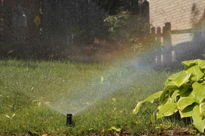
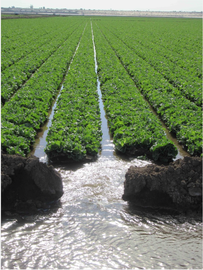
And that means customers are watering their yards later into the year, creating more demand for water and making things trickier for Denver Water’s water supply managers. 

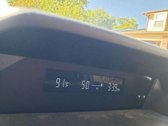
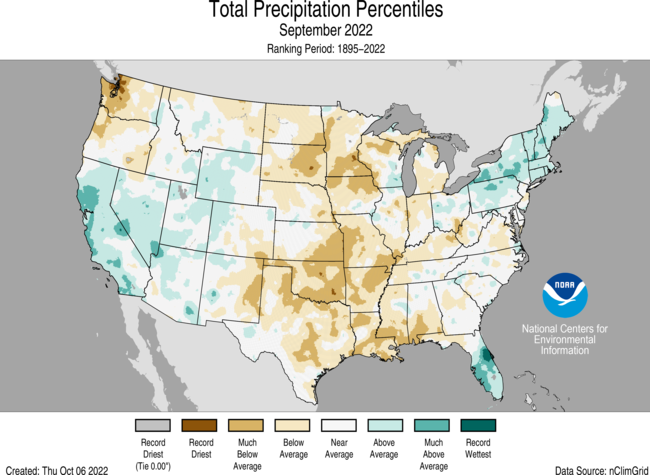
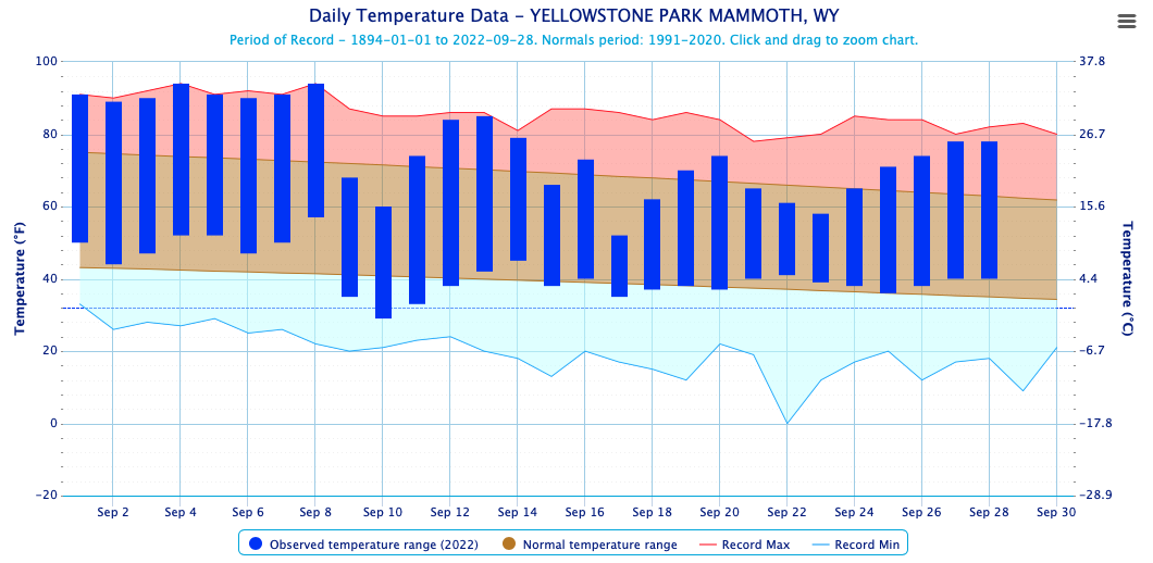
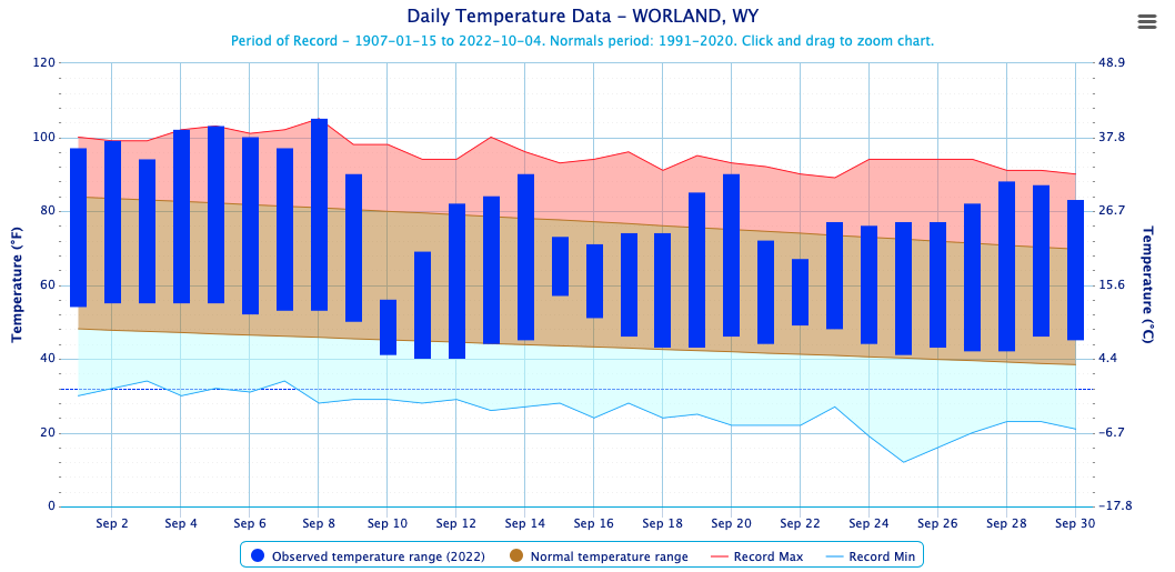
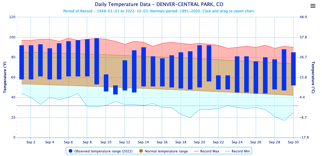
Just recall the way September started this year, with a string of days in the mid-to-upper 90s, including back-to-back 99-degree days in the Denver area. (Denver Water’s downtown weather station hit 100.) 

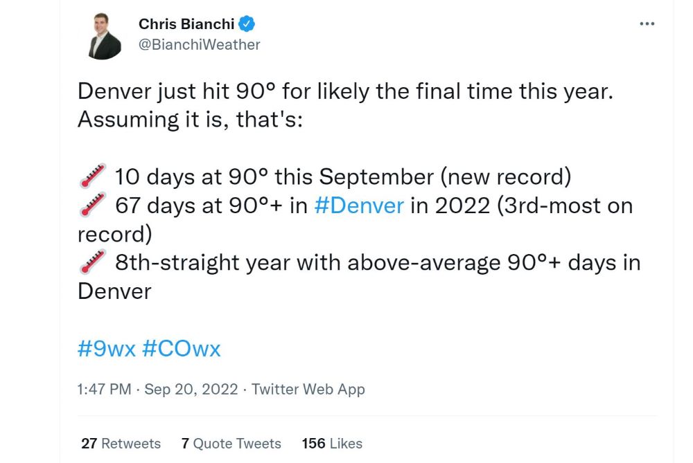
In fact, as 9News meteorologist Chris Bianchi reported on Twitter, Denver broke a record for number of 90-degree days (10) in a single September this year. 

A wave of heat-related records were broken across the West this year, including here in the Denver metro area. Image credit: Chris Bianchi via Twitter.

The phenomenon was also well-documented by 9News meteorologist Cory Reppenhagen in his Sept. 5 report on how unusual heat records in Denver notched during September’s first week are part of the metro area’s rising September heat trend. 

All told, toasty Septembers appear to be one more element of a changing and warming climate.

A screenshot from a Sept. 5, 2022, report by 9News meteorologist Cory Reppenhagen about September’s changing weather patterns in the Denver metro area. Image credit: 9News meteorologist Cory Reppenhagen.

“We have a pretty good idea of what water demand in the summer months will look like, but September is becoming a wild card,” said Nathan Elder, the utility’s water supply manager. 

“We have seen higher demand and increased reservoir releases in recent Septembers,” he added. “But we also know we can see snow during the month, which makes planning for the month and setting up winter operations difficult.” 

Stay up to date on water issues (plus tips to save water) by signing up for TAP’s free, weekly email

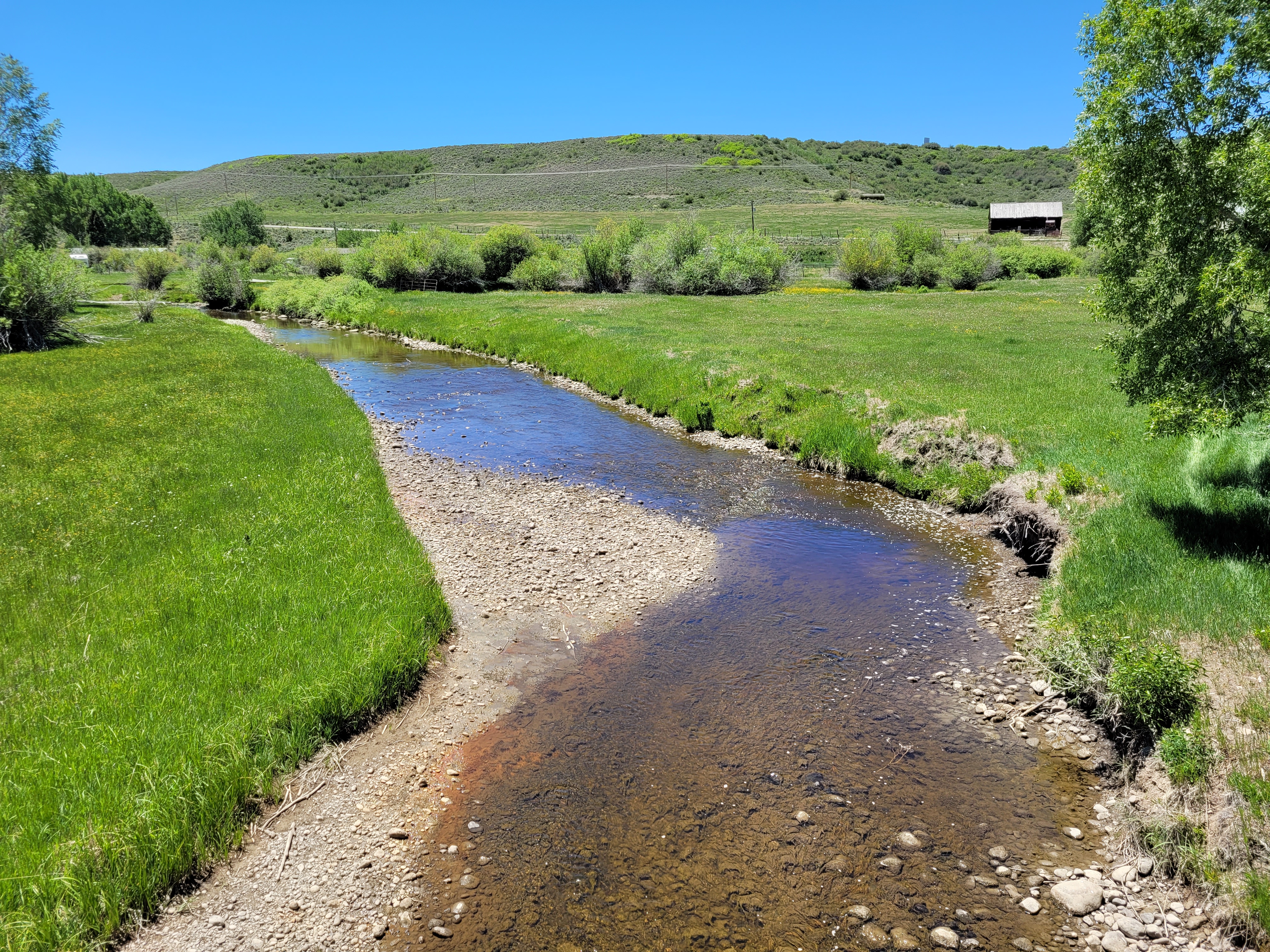
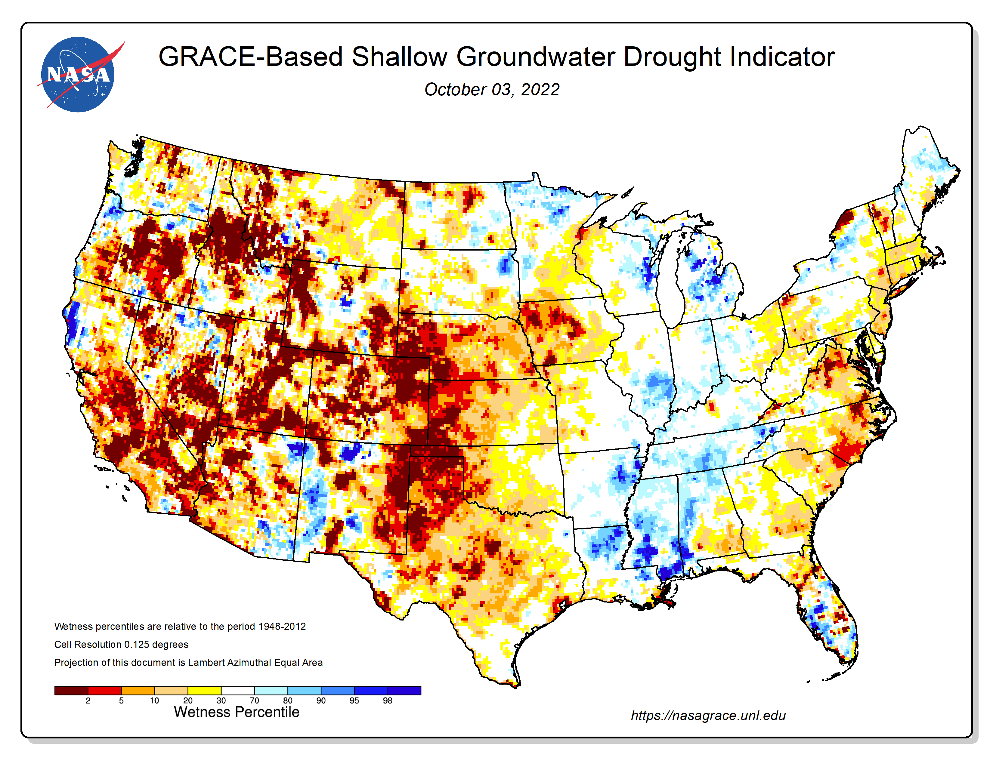
Additionally, Elder said, warmer fall temperatures can dry soil in the collection system, which means more snow is needed the following winter to fill reservoirs. 

“This is a trend we are really keeping our eye on because it can have significant impacts on water supply late in the season and going into the next spring,” Elder said.

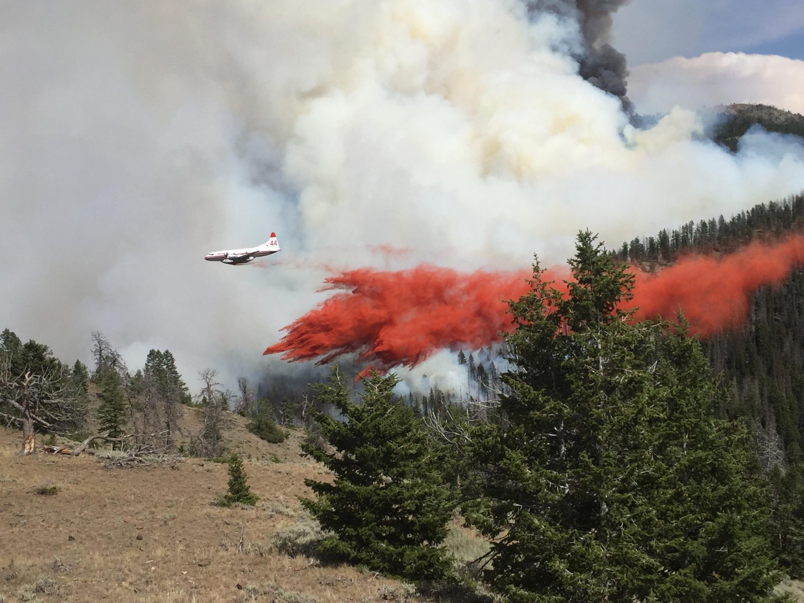
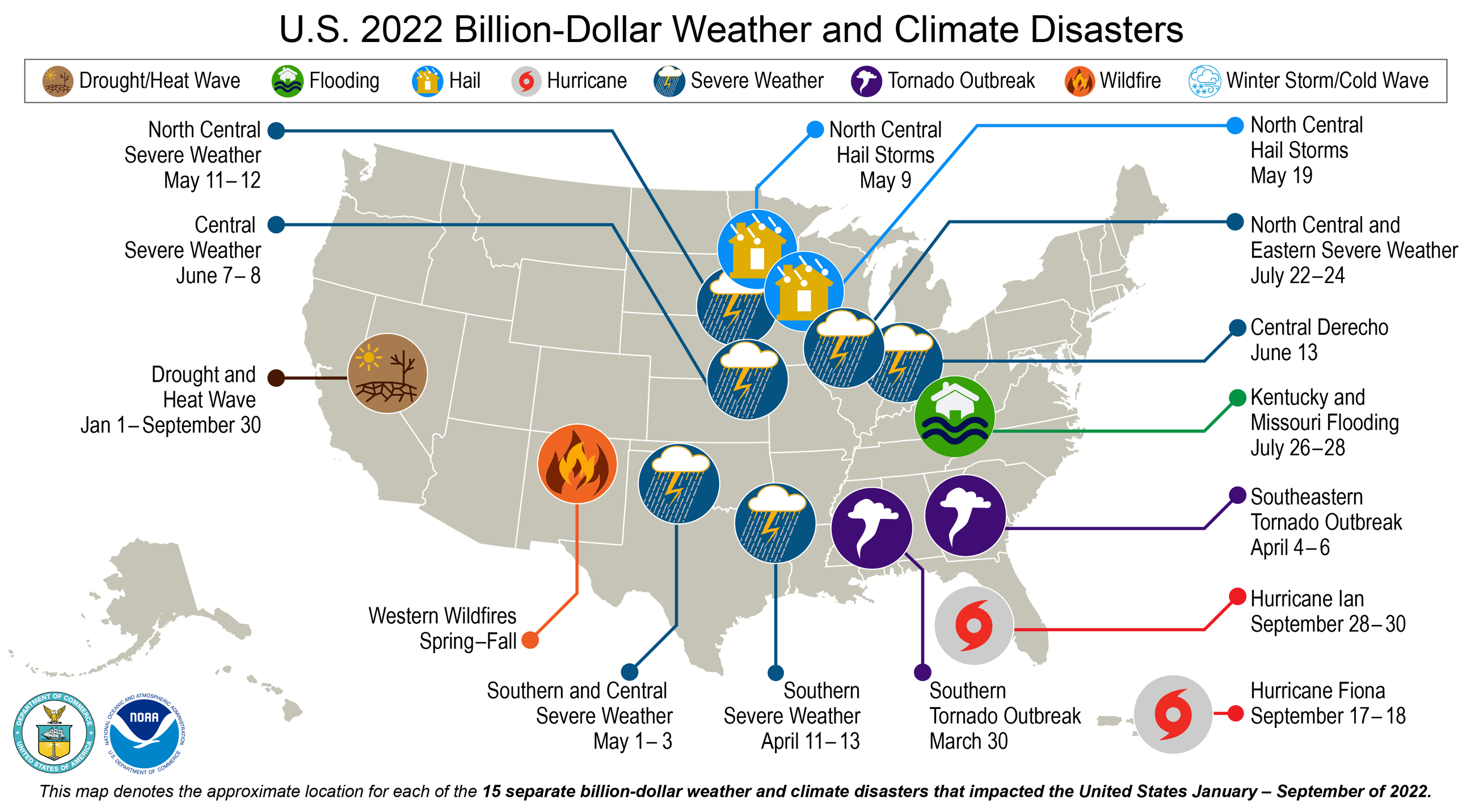
One other challenge tied to warmer Septembers: a longer fire season, such as in 2020, when the state’s two largest-ever fires exploded late in the year, including the East Troublesome Fire that roared through Grand Lake in mid-October.

Dillon Reservoir is Denver Water’s largest reservoir. It sends water to the Front Range via the 23-mile-long Roberts Tunnel under the Continental Divide. Photo credit: Denver Water.

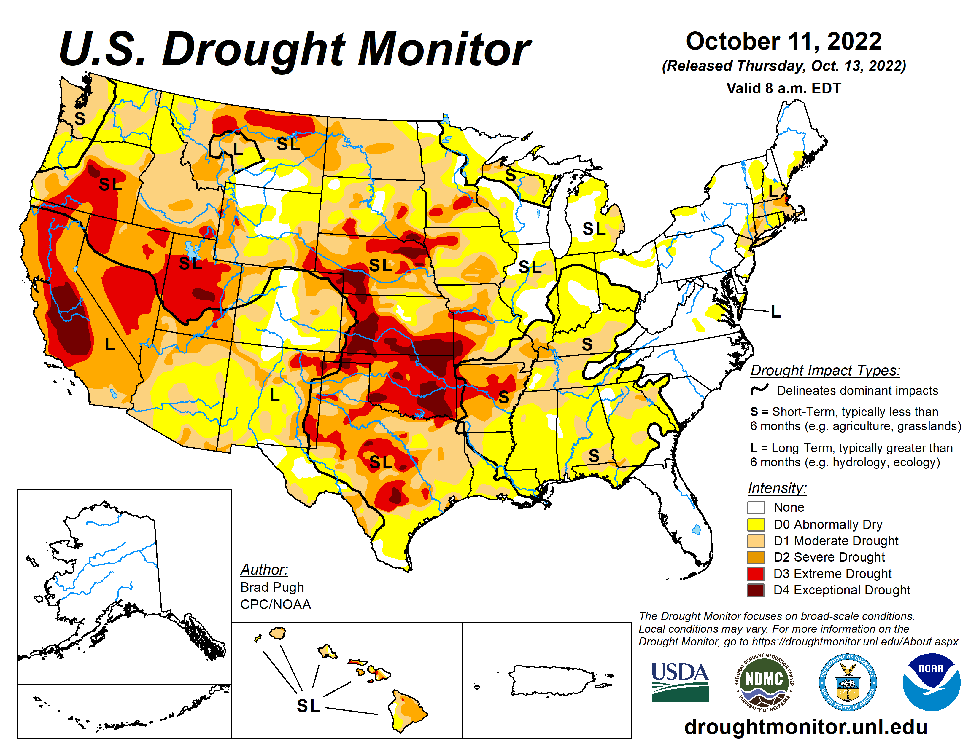
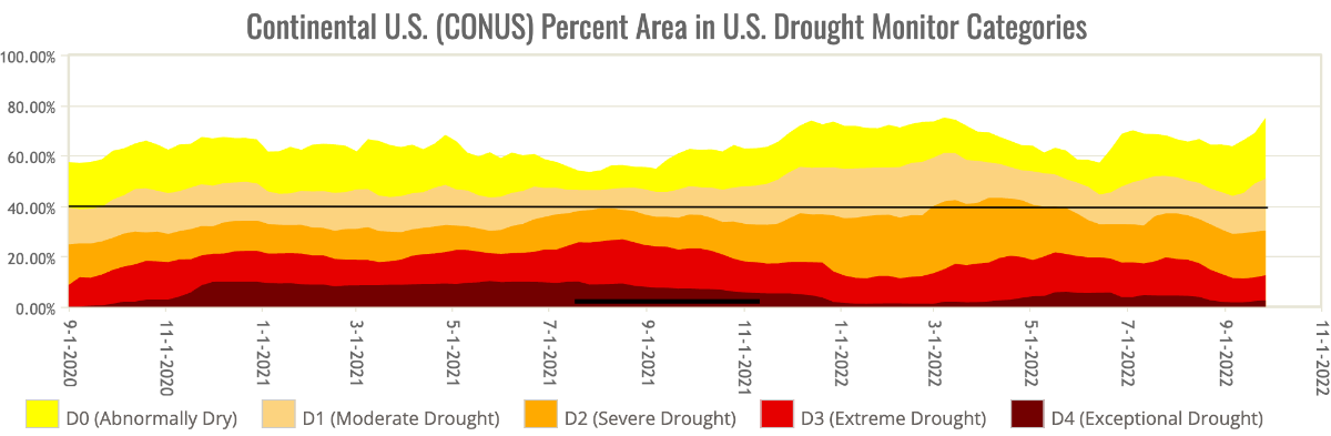
Some numbers that tell the story: 

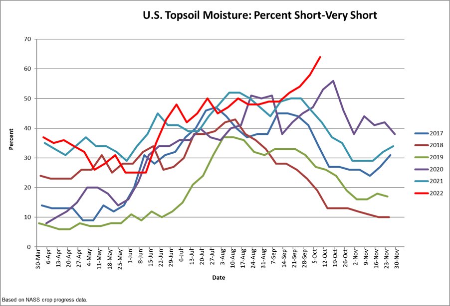
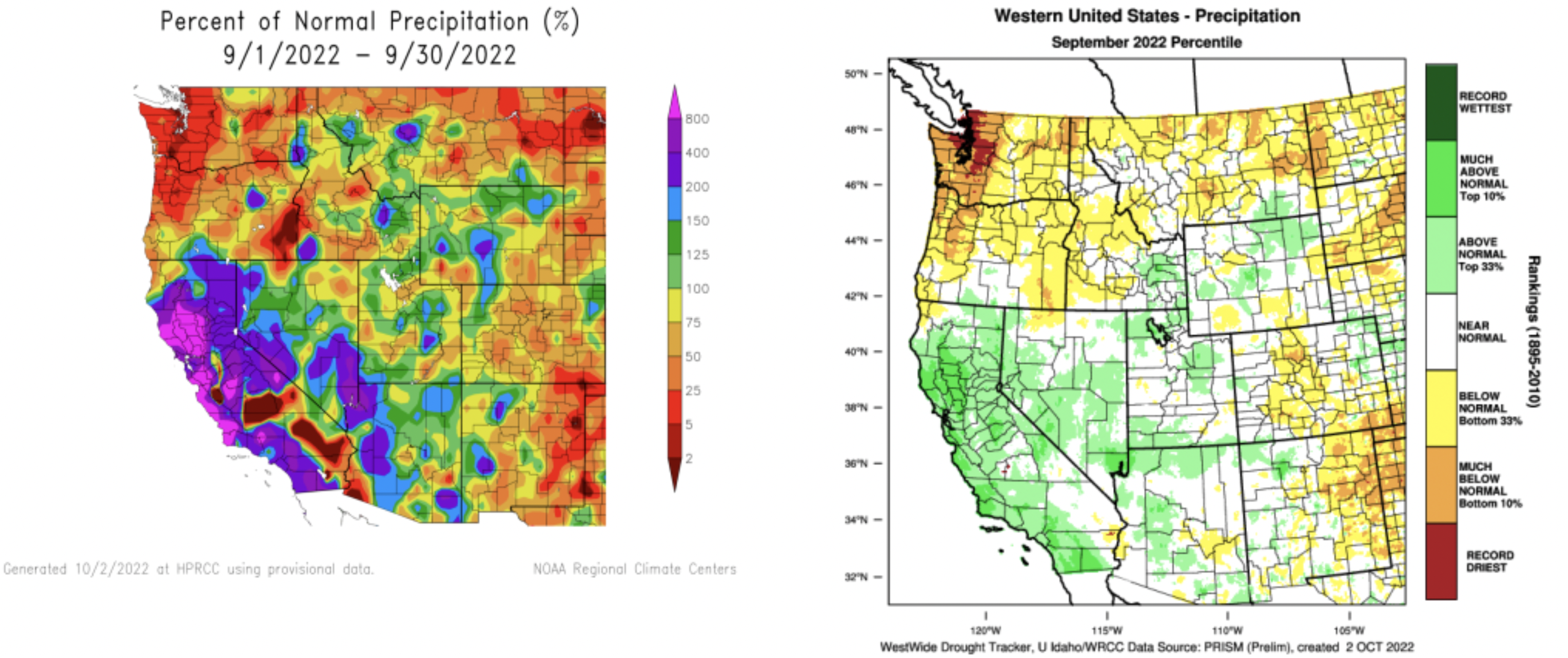
– Denver Water is seeing more demand for water in September. Last year, demand was about 30 million gallons per day above the 30-year average. In 2022, the volume was 15 million gallons over the same average. The difference between the two years can be attributed to the fact that precipitation in 2022 was closer to normal and 2021 was drier.

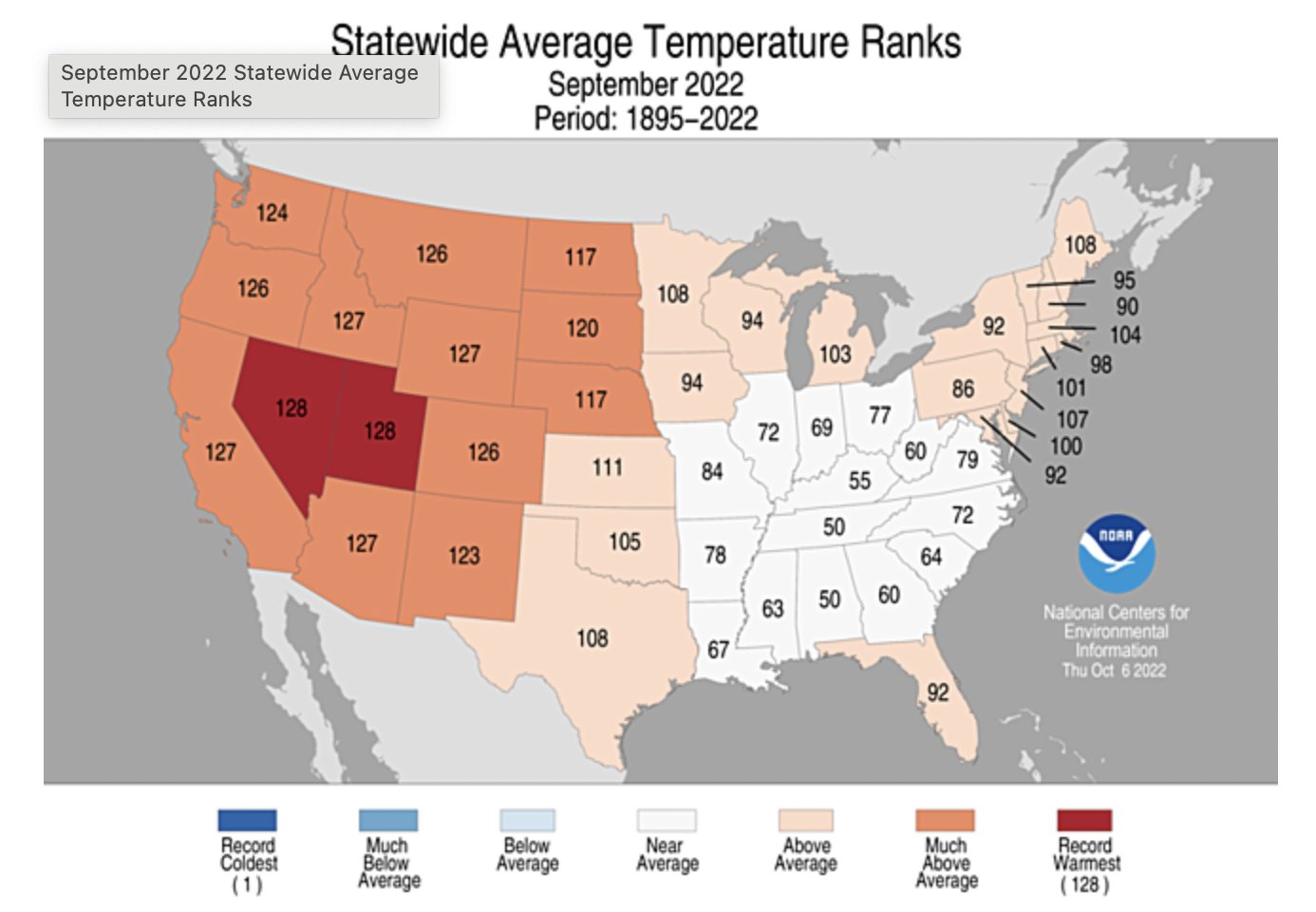
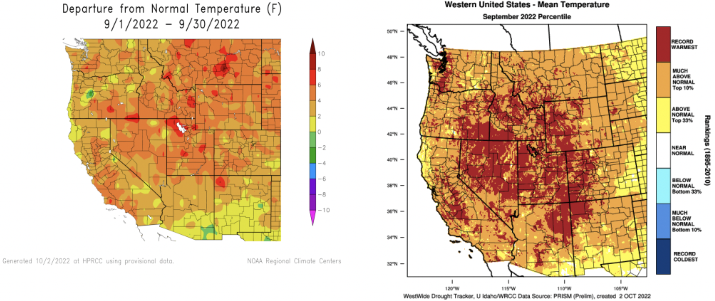
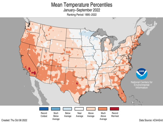
– September 2022 was Denver’s third-warmest on record, at an average of 69 degrees, surpassed only by 2015 and 2019, according to National Weather Service data highlighted by Bianchi, the 9News meteorologist.

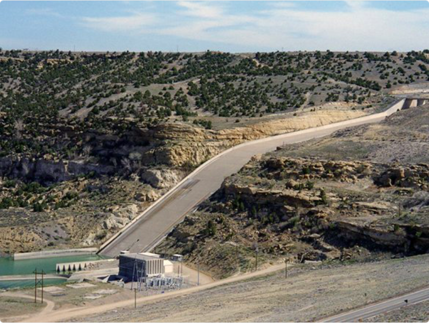
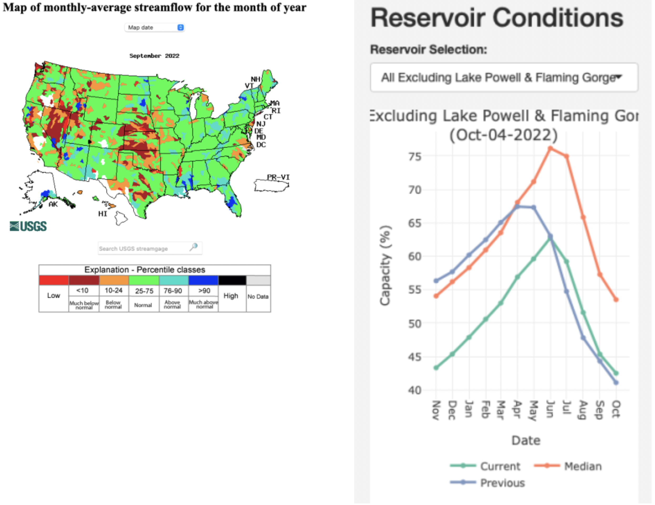
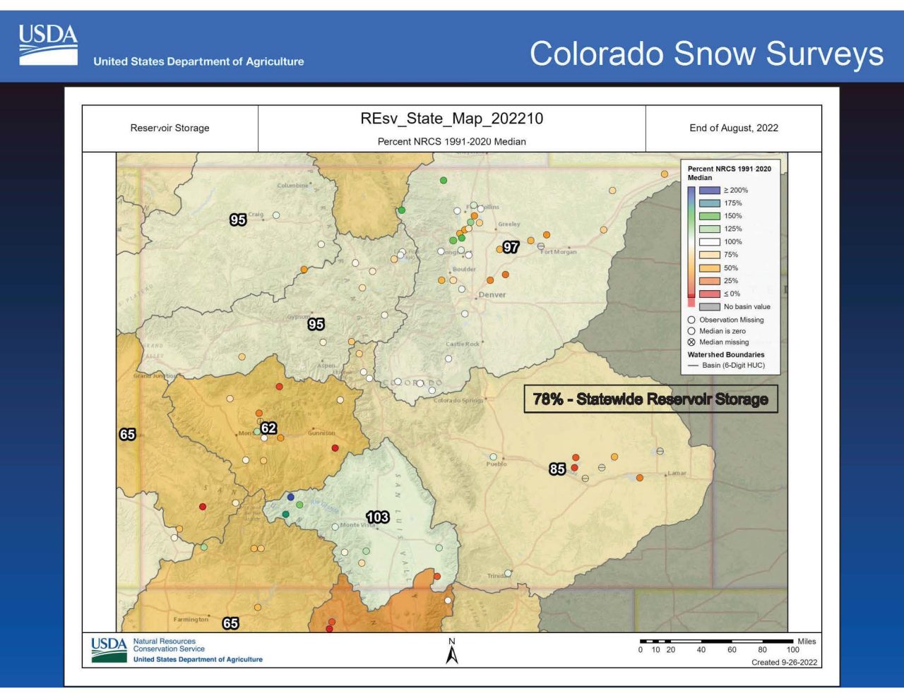
– Flows in the Roberts Tunnel, which delivers water from Dillon Reservoir to the Front Range, are rising in September, with 260 cubic feet per second seen in recent years versus the long-term average of 160 cfs. That’s a sign Denver Water needs to send more water to the metro area to meet the higher September demand. 

That doesn’t mean, however, that Denver Water is pulling more water from its West Slope reservoirs. In fact, overall water movement through the Roberts Tunnel over the course of a year is flat, as lower winter demand and tunnel shutoffs have helped balance out that September bump.

Warmer-than-normal temperatures during the day and at night raise the overall average temperature of the month. Image credit: Chris Bianchi via Twitter.

Overall, September reservoir releases across the system have been higher than average in recent years, a sign that Denver Water must rely more on storage to meet higher late-summer demand.

Cheesman Reservoir on the South Platte River system serves as one example, with average September releases during the last five years of 286 cfs versus the longer-term average of 211 cfs. 

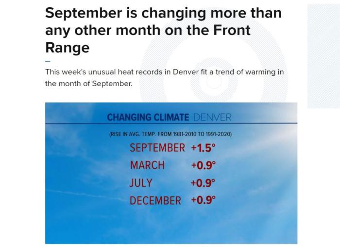
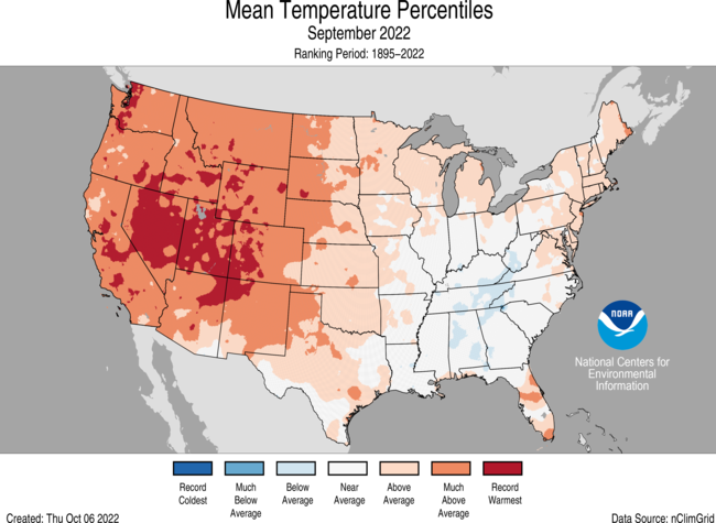
Denver Water’s records show September is warming at a higher rate than any other month during the watering season. And Reppenhagen’s reporting found that “September (weather) is changing the most out of all the months, warming by 1.5 degrees compared to the previous 30-year period of record.”

As Reppenhagen points out, warmer Septembers are extending the summer growing season, a development that he notes was predicted by some of the earliest computer modeling examining the effect of rising carbon dioxide in the atmosphere.

Denver Water customers are using more water later in the year as Septembers warm. Photo credit: Denver Water.

That is borne out by water use. 

Outdoor demand in September has grown about 23% when comparing the recent-five year stretch of 2017-2021 to the period between 2000 and 2016. In the same five-year span, September use has only been 3% below June levels.

From a practical standpoint, warmer Septembers make work tougher for Denver Water’s planners.

When that extra pull on reservoirs in September is combined with lower soil moisture, it means the utility has to lean even harder on the winter months to provide enough snowpack to fill reservoirs the following spring. 

The shift also means planners are relying less on historical water demand models and focusing far more on data from more recent years to get a better idea of how much water Denver Water customers will need in September. 

Overall, Denver Water customers have been good at conserving. Demand is generally flat or even declining during most months of the year. September is an outlier: as noted above, the five-year average for the month is actually on the rise.

Adjusting your sprinkler control system to account for weather and the time of year can save water. Cooler nights send a signal to your landscape that it’s time to wrap things up for the winter and it doesn’t need as much water. Photo credit: Denver Water.

But a reminder to customers: Even with a warmer September, the need for outdoor watering declines because nighttime is cooler, and grass can get by with less water. 

As Denver Water takes many steps to adapt to a warming climate, it will incorporate these late-summer temperature increases into its many-faceted approach to ensure it can supply the Denver region with water. 

In the shorter term, Elder has a more visceral suggestion: “September should be kicked out of fall,” he said. “Move it permanently to summer.”

$500,000 grant supports Custer County reservoir project — Heart of the Rockies Radio

Photos by Allen Tian, The Colorado Independent, and courtesy of Dark Skies Inc of the Wet Mountain Valley.

Click the link to read the article on the Heart of the Rockies Radio website (Joe Stone):

The Colorado Water Conservation Board awarded a $500,000 grant to the Upper Arkansas Water Conservancy District and Round Mountain Water and Sanitation District for construction of a new reservoir near Westcliffe.

Upper Ark Project Manager Gracy Goodwin reported the grant award during the Thursday meeting of the Upper Ark board of directors in Salida.

Upper Ark General Manager Terry Scanga said the total cost of the project is estimated at $3 million and that the Upper Ark District is responsible for a third of the cost under its agreement with Round Mountain.

Round Mountain provides water water and sanitation services to the towns of Westcliffe and Silver Cliff, serving a population of approximately 1,000.

As previously reported, the Upper Ark District and Round Mountain began collaborating on the project to address the need for a source of augmentation water on Grape Creek upstream from DeWeese Reservoir. The 7-acre reservoir will have a storage capacity of approximately 150 acre-feet.

Goodwin reported that Engineering Analytics, the firm hired to design the reservoir, recently completed a topographic survey for the intake infrastructure and the dam. The company is also finalizing the reservoir design and starting work on the construction drawings.

The Colorado Water Conservation Board also provided funding for an initial feasibility study and the design work, and Goodwin said Upper Ark staff are investigating additional sources of funding to help pay for construction costs.

In addition to its augmentation water needs, Round Mountain faces significant wastewater treatment challenges.

Citing an “overtaxed wastewater treatment plant” that “cannot adequately process additional effluent,” the Round Mountain board of directors enacted a moratorium on the sale of water and sewer taps Jan. 1., effectively halting new construction in Westcliffe and Silver Cliff.

Information on the Round Mountain website indicates the district’s wastewater treatment plant “is 46 years old, built with a technology that cannot meet current environmental standards and receiving considerably more sewage than it can fully process.”

The proposed Round Mountain Reservoir would provide a much-needed source of augmentation water in Custer County.

The topsoil moisture rated short to very short is highest in #Oklahoma and #Arkansas at 95% — @DroughtDenise

Across the U.S., 64% of topsoil being short to very short is the highest in the past two-year #drought, per Brad Rippey of the USDA.

Report says many utilities are slow-walking clean energy goals: Xcel Energy in #Colorado with B grade performing comparatively well according to Sierra Club — #Colorado Newsline #ActOnClimate

A view of Xcel Energy’s retired fossil fuel-fired Zuni Generating Station at Zuni Street and West 13th Avenue in Denver on Aug. 6, 2022. (Quentin Young/Colorado Newsline)

Click the link to read the article on the Colorado Newsline website (Robert Zullo):

A report released last week by the Sierra Club faults dozens of utilities that provide a major chunk of U.S. electric generation for failing to speed up their decarbonization efforts. 

“For the sake of our communities and planet, we must do everything in our power to create a clean, renewable electric grid by 2030,” the Sierra’s Club’s “Dirty Truth” report says. “Utilities must lead this transition, but our research shows they are wholly unprepared to do their part. Clean energy is reliable and affordable; electric utilities have no excuse to delay and no time left to waste.”

The report is an update of a 2021 study the group did. The Sierra Club analyzed plans of 77 utilities that collectively supply about 40% of U.S. electric generation and gave out letter grades based on how well utilities, many with their own clean energy goals, were working to decarbonize.

“Most are still not on the path to achieve 80% clean electricity by 2030. Of the 77 utilities we studied, nearly half of them (44%) made no progress or received a lower score than in our previous report,” the Sierra Club said. “This disappointing inaction occurred despite a tumultuous 18 months of grid reliability crises, blackouts, energy price spikes and extreme weather events; many of these trace their roots in large part to utilities’ stubborn reliance on expensive and unreliable fossil fuels.”

To determine the grades, the Sierra Club looked at the latest versions of the utilities’ integrated resource plans, documents that lay out how they will meet future electric demand, evaluating how quickly they intend to retire coal plants and penalizing them for plans that include building new gas generation.

“If a company includes multiple scenarios in their IRP, we use the scenario they denote as their preferred scenario,” said Cara Bottorff, a Sierra Club managing senior analyst. “If they do not denote a preferred scenario, we use the scenario that is the worst case for gas (i.e., the one that would add the most gas) to demonstrate the largest amount of gas that the company is considering building.”

Xcel Energy, Colorado’s largest energy provider, received a B grade in the report. It performed comparatively well next to the other utilities analyzed in the report, and it achieved one of the most dramatic improvements from the 2021 version of the report, when it received a D score. The report notes that it plans to replace 60% of existing coal and natural gas energy generation with clean energy by 2030.

Xcel plans to retire all its coal units by the end of 2030 in Colorado and Upper Midwest states, and its goal is to provide “net-zero” energy by 2050, noted Xcel spokesperson Michelle Aguayo.

“We were the first major U.S. energy provider in December 2018 to set ambitious and progressive voluntary goals for delivering 100% carbon-free electricity by 2050 and reducing carbon emissions 80% by 2030” from 2005 levels, Aguayo wrote to Newsline in an email.

The report also analyzed Westminster-based power wholesaler Tri-State Generation and Transmission Association, which also received a B grade. Tri-State plans to replace 70% of existing fossil fuel energy generation with clean energy by 2030, according to the report.

“Our cooperative’s high grade from Sierra Club recognizes Tri-State’s increasing renewable energy resources and decreasing emissions, and our robust planning to continue progress,” Tri-State CEO Duane Highley said in a statement to Newsline.

Tri-State in 2020 announced the retirement of all its coal generation in Colorado and New Mexico by 2030.

Xcel truck at Shoshone plant. Photo credit: Brent Gardner-Smith/Aspen Journalism

Overall, 56% of the utilities examined in the report improved their scores, 9% made no progress and 35% got worse grades. You can check how your local utility did here.

The Edison Electric Institute, an association that represents investor-owned utilities, called the metrics “arbitrary” and dismissed the report as a “messaging document.” 

“The reality is that existing nuclear generation and the flexibility provided by natural gas generation are what enabled the U.S. electric power industry to deploy 27 gigawatts of new renewables, reliably and cost-effectively, last year,” said Brian Reil, an EEI spokesman. 

“The emissions reductions goals set by America’s investor-owned electric companies are firmly grounded in our current understanding of technology and economics, and they also reflect our responsibility to prioritize customer affordability and reliability.”

Reil noted that more than 40% of U.S. electricity is now generated by carbon-free resources and said electric utilities are investing in new technologies to deliver more. 

“If the Sierra Club truly wants to accelerate the deployment of clean energy, they should consider joining the other environmental, industry and government leaders who are working together constructively to identify ways to overcome the barriers to building the transmission and other clean energy infrastructure we clearly need in order to deliver more resilient clean energy to customers,” he said. 

At the Experience POWER conference for energy industry professionals last week in Denver, the pace of the renewable energy transition was a major theme. Highley — the CEO of Tri-State, a not-for-profit cooperative supplier which operates in New Mexico, Colorado, Wyoming and Nebraska and includes 42 electric distribution cooperatives and public power districts that provide power to more than a million consumers — used an old George Carlin comedy bit about driving to illustrate the competing tensions on utilities and electric co-ops trying to decarbonize without risking reliability.

Anybody driving slower than you is an idiot, Carlin said, while anybody going faster is a maniac.

“We’re being pulled between those people who think we are going too fast and those who think we are going too slow,” he said, noting that two states his co-op operates in, New Mexico and Colorado, are much more green-energy oriented than the other two: Nebraska and Wyoming.

“There’s no map for this,” he said. “We’re in uncharted territory.” 

He said the ability to generate electricity from fuel oil helped bail out Tri-State during the 2021 winter storm that caused the grid to collapse in Texas, resulting in an estimated 246 deaths. That makes it hard for utilities to ditch the reliability benefits of certain kinds of fossil fuel generation as quickly as some would like. 

“We can make this happen and it is happening,” Highley said. He added that Tri-State, which got a B grade on the Sierra Club report, is on pace to have 50% of the electricity used by its members come from renewable sources by 2024 thanks to bountiful wind and solar resources, with an eventual goal of getting to 80% decarbonization, though that will still require some fossil fuel generation to stay in the mix. 

“We’re going to clean up the grid and then we’re going to electrify everything,” he said.

Quentin Young contributed to this report. Robert Zullo can be reached at rzullo@statesnewsroom.com

Study finds #ClimateChange is bringing more intense rains to the U.S. — The Washington Post

Click the link to read the article on The Washington Post website (Matthew Cappucci). Here’s an excerpt:

A paper published Tuesday in the journal Geophysical Research Lettersfinds that it’s raining harder in most of the United States. The study, written by researchers at Northwestern University, tied the results to climate change and to warmer air’s ability to hold more water. The findings echo the fundamental laws of physics and thermodynamics, as well as the evidence from decades of research, and highlight the real-time effect that humans are having on the weather and climate. The research offers confirmation of what atmospheric scientists have been warning of for years: a warmer world is, on balance, a wetter world. And as global temperatures continue to rise, an uptick in precipitation extremes is expected. What the study finds is consistent with a basic tenet of atmospheric physics: For every degree Fahrenheit that air temperature rises, the atmosphere can hold 4 percent more water; this is known as the Clausius-Clapeyron relationship. Where storm clouds develop and the atmosphere is sufficiently moist, it means a warmer climate will support more intense rainfall.

Click the link to read “It’s raining harder in the U.S.: New study finds rainfall is becoming more intense across most of the United States” on the Northwestern University website (Amanda Morris):

Just like the old adage says: When it rains, it pours.

That turns out to be increasingly true for much of the United States, according to Northwestern University researchers.

In a new study, researchers compared observed rainfall from two climatologically distinct time periods and across 17 different climate regions in the U.S. They found that when it’s rained in recent decades, it’s rained more. In most regions, the intensity of the rainfall has shifted from lighter to more moderate and often heavy deluges.

When it rained east of the Rocky Mountains in recent decades, about 5% more precipitation fell. When it rained over the Pacific Coast or Rocky Mountains, however, no intensity changes were observed. Climate model simulations have previously predicted increases in precipitation intensity, particularly during extreme events, but the Northwestern study examined historically observed precipitation data across all intensities — and found a systematic shift in precipitation intensity in many parts of the country.

The study was published today (Oct. 11) in the Geophysical Research Letters.

“When people study how climate change has affected weather, they often look at extreme weather events like floods, heatwaves and droughts,” said Northwestern’s Daniel Horton, the study’s senior author. “For this particular study, we wanted to look at the non-extreme events, which are, by definition, much more common. What we found is pretty simple: When it rains now, it rains more.” 

Horton is an assistant professor of Earth and planetary sciences in Northwestern’s Weinberg College of Arts and Sciences, where he also leads the Climate Change Research GroupRyan Harp, an Ubben Postdoctoral Research Fellow at the Institute for Sustainability and Energy at Northwestern, is the paper’s first author.

Arizona monsoon cloud with lightning striking the beautiful Sonoran desert in North Scottsdale. Photo by James Bo Insogna. Title: Arizona Monsoon Thunderstorm. Taken on August 15, 2016. Used under a Creative Commons license.

Changing intensities of daily rainfall

To conduct the study, Harp and Horton compared two climatologically distinct time periods: 1951-1980 and 1991-2020. For each time period, they used historical precipitation data from the Global Historical Climatology Network, a publicly available database maintained by the National Oceanic and Atmospheric Administration.

Then, the researchers analyzed the observations within 17 distinct climate regions in the United States. These regions reflect differences in temperature, precipitation, vegetation and ecosystem dynamics.

After analyzing data from two time periods across regions, Harp and Horton discovered that precipitation intensity (including rain and snow) had increased across much of the United States, particularly in the East, South and Midwest. Changes in the western United States were not detected.

“Not only do we see increasing precipitation intensity for regions east of the Rockies,” Harp said, “but the intensities are becoming more variable as well, making water resource management even more challenging.”

CO2 trend: This graph shows the monthly mean abundance of carbon dioxide globally averaged over marine surface sites since 1980. (NOAA Global Monitoring Laboratory)

Consequences of climate change

In this study, Harp and Horton narrowed their focus to examine how much precipitation falls during each rain or snowfall event. For their next study, they plan to investigate if annual precipitation is becoming more variable and if precipitation events are becoming more or less frequent. Although this study does not attribute the changes in precipitation rates to climate change, Harp said the findings are consistent with human-caused global warming and climate model predictions.

“Warmer air holds more moisture,” he explained. “For every one degree Celsius the atmosphere warms, it holds 7% more water vapor. So these observations are consistent with the predicted effects of human-caused global warming.”

Increased precipitation intensities affect many sectors, including agriculture and infrastructure, as well as lead to increased risks of landslides and flooding. Horton hopes the study findings can be used by resource managers, policy makers and urban planners to design infrastructure that is more resilient to changing weather patterns.

Flooded corn crop September 2013.

“You don’t need an extreme weather event to produce flooding,” Horton said. “Sometimes you just need an intense rainstorm. And, if every time it rains, it rains a little bit more, then the risk of flooding goes up.”

The paper, “Observed changes in daily precipitation intensity in the United States,” was supported by the Ubben Program for Carbon and Climate Science at Northwestern University.

Feds are putting a price tag on water in the #ColoradoRiver basin to spur farmers to conserve — Aspen Public Radio #COriver #aridification

A field of produce destined for grocery stores is irrigated near Yuma, Ariz., a few days before Christmas 2015. Photo/Allen Best – See more at: http://mountaintownnews.net/2016/02/09/drying-out-of-the-american-southwest/#sthash.7xXVYcLv.dpuf

Click the link to read the article on the Aspen Public Radio website (Alex Hager). Here’s an excerpt:

The federal government is designating $4 billion from the Inflation Reduction Act for drought mitigation work in the Colorado River basin. On Wednesday, the Department of the Interior announced that total, indicating that $500 million will go to efficiency upgrades in the river’s Upper Basin states of Colorado, Utah, New Mexico, and Wyoming. Another chunk of IRA money will be set aside for direct payments to farmers and ranchers to forgo water deliveries from Lake Mead in the river’s Lower Basin, primarily in Arizona and California. Federal officials are not specifying how much money will be available for that first round of payments. The funding represents a rare infusion of federal money for a climate change-fueled crisis that is plaguing the Southwest’s water supply. About 40 million people rely on water from the Colorado River, which is being strained by warming temperatures and steady demand. Colorado River governance is typically left to the states, which have historically produced stopgap measures to avoid catastrophe, but have failed to conserve enough water to prop up the river’s biggest reservoirs. Over the summer, talks among the states turned to interstate finger pointing

Water policy experts often point to “buy and dry” or fallowing programs as an important step in freeing up water for the parched region. Nearly 80% of the Colorado River’s water is used by the agriculture sector, and paying growers to temporarily fallow their fields would allow water managers to leave more in reservoirs, where dropping levels have served as visual barometers for the river’s rapid drying. But farm groups warn that if fallowing is done too rapidly or haphazardly, rural economies throughout the region will suffer. The IRA funding will be used for a “system conservation” program in which growers can apply for federal payouts. The federal government will pay $330 per acre-foot for a one-year agreement with a grower, $365 per acre-foot for two years, and $400 for a three year commitment. The first opening for proposals began Wednesday and will last until Nov. 22. The Bureau of Reclamation, the federal agency which operates major dams and reservoirs around the basin, said applicants should include a description of their fallowing plans, the amount of water they’d be conserving, and a plan to measure and document the amount they’re cutting back…

John Boelts, owner of a fruit and vegetable farm in Yuma, Arizona, said he’s seen estimates that price an acre-foot of water at $1,200 to $2,200, so the federal payouts might not be big enough to convince farmers to forfeit some of their water…A group of farmers near Yuma recently proposed a water conservation plan in which they would be paid about $1500 per acre-foot of water saved, according to Axios. Boelts called the program a “start in the right direction,” but said he doubts that new federal payments will be enough for farmers in his circles.

Investing $2.3 billion into the system serving 1.5 million people: How @DenverWater is protecting the #water system now — and preparing for the future

Denver Water’s 2023 big projects

Click the link to read the article on the Denver Water website (Cathy Proctor and Jay Adams):

Ensuring a system that is providing clean, safe water to 25% of the state’s population will continue delivering requires taking the long view when it comes to maintenance and upgrades. 

At Denver Water, projects from replacing water mains to building a new treatment plant are carefully vetted to ensure they will bolster the system as it exists today and for the decades ahead. 

“Our mission is to deliver a clean, safe, reliable water supply to 1.5 million people, and also to sustain our vibrant communities for years to come,” said Jim Lochhead, the CEO/Manager of Denver Water.

To do that, the utility expects to invest about $2.3 billion into the system during the next 10 years, from large projects to regular inspection and maintenance programs designed to ensure the system is flexible, resilient and efficient. 

Denver Water’s approach has been recognized repeatedly by its peers in the water industry and others.

Denver Water’s administration building is powered by solar panels. Photo credit: Denver Water.

The American Water Works Association, the largest organization of water supply professionals in the world, named Denver Water the recipient of its 2022 AWWA Innovation Award for the Northwater Treatment Plant, which is under construction north of Golden.

The awards committee specifically called out the utility’s sustainable, scalable and streamlined design approach to the project, which leaves room at the site for future expansions as needed. 

The redevelopment of its Operations Complex near downtown has won several awards since its completion a few years ago, including a LEED Platinum certification for the utility’s Administration Building, just one of many the project received for its sustainable aspects. The building includes solar power panels on its roof and parking structures, a highly efficient radiant heating and cooling system and an on-site wastewater recycling system that treats water for reuse flushing toilets and irrigation. 

Read how customers help invest in their water system.

Here’s an overview of some of Denver Water’s work: 

The graphic shows the existing dam and water level and how high the new dam will rise above the current water level. Image credit: Denver Water.

Water storage

Work on the Gross Reservoir Expansion Project, the subject of more than 20 years of planning, got underway in April. Expected to be complete in 2027, the project will raise the height of the existing dam by 131 feet. 

The higher dam will nearly triple the amount of water that can be stored in Gross Reservoir, providing Denver Water with more flexibility to manage its water supply in the face of increasingly variable weather and snowpack patterns. 

The additional storage capacity also will provide a greater balance between Denver Water’s separate north and south water collection areas. 

Much of the work done on the expansion during 2022 and 2023 will be site preparation for the on-site quarry and concrete production plant and removing rock from the sides and bottom of the existing dam to make room for the new concrete. Workers also have been hydroblasting the face of the dam, removing a few inches of concrete, to leave a rougher surface for the new concrete to adhere to. 

At the height of construction, there will be as many as 400 workers on-site and when complete, the dam will be the tallest in Colorado. 

Get more details about the history behind the Gross Reservoir Expansion Project.

Lead Reduction Program

A major part of Denver Water’s investment forecast is the Lead Reduction Program, which launched in January 2020.

The water Denver Water delivers to customers is lead-free, but lead can get into drinking water as the water passes through old lead service lines that carry water from the water main in the street into the home. 

The program reduces the risk of lead getting into drinking water by replacing the estimated 64,000 to 84,000 old, customer-owned lead service lines at no direct cost to the customer. Households enrolled in the program are provided with water pitchers and filters certified to remove lead to use for cooking, drinking and preparing infant formula until six months after their lead service line is replaced.

It’s the biggest public health campaign in the utility’s history and through the end of September, more than 14,000 lead service lines have been replaced. 

Learn more about how a higher pH level protects customers from lead getting into drinking water. 

The program aims to replace about 4,500 lead service lines every year, and the utility is working through final approvals to accept federal funding. The money will allow the utility to replace an additional number of lead service lines (at no direct cost to the customer) above the 4,500 currently slated for replacement in 2023. This additional funding will help speed up the replacement program while keeping rates as low as possible for customers. 

In March 2020, Denver Water also raised the pH of the water it delivers to customers to help reduce the risk of lead getting into water as it passes through customers’ internal plumbing that may contain lead.

Northwater Treatment Plant

Work on Denver Water’s new, state-of-the-art Northwater Treatment Plant next to Ralston Reservoir north of Golden this year passed a milestone, with 2.5 million hours of work poured into its design and construction since 2016. 

The treatment plant, scheduled for completion in 2024, will include 14 buildings and be able to clean 75 million gallons of water per day. Its design left room for the plant to be expanded to clean up to 150 million gallons of water per day in the future as needed. 

During this last year, roofs have been placed on buildings, allowing workers to start installing electrical lines and HVAC equipment. 

Construction also has continued on the two giant water storage tanks, which will be mostly buried underground when complete. Each tank is capable of holding 10 million gallons of clean, safe drinking water. 

A new water quality laboratory

In early January 2023, the Hydro building on Colorado State University’s Spur campus at the National Western Center north of downtown will open. 

It will house Denver Water’s new water quality laboratory, expected to become fully operational during 2023, and replaces a facility that has been tucked into the Marston Treatment Plant south of U.S. Highway 285 and South Wadsworth Boulevard, on the south side of Denver Water’s service area.

Denver Water’s new water quality laboratory, expected to be operational in 2023, is inside the Hydro building at the CSU Spur campus at the National Western Center north of downtown. Photo credit: Denver Water.

Locating Denver Water’s water quality laboratory in the midst of CSU’s new Spur campus ensures the utility’s water experts will be working near researchers, scientists and others tackling issues surrounding water, agriculture and public health that are important to the metro area, state and region. 

Two other buildings are at the CSU Spur campus, Vida, which opened in January 2022 and focuses on life and public health, and Terra, which opened earlier this year and focuses on land and food. 

With the completion of the Hydro building, the campus will house experts dedicated to exploring how the three disciplines intersect — and interact — with each other. 

Ongoing investments

As the metro area grows and changes, its often an opportunity for Denver Water to upgrade older elements of its system — before new development takes place. 

That was exactly the situation at Loretto Heights in the southwest part of Denver. 

Upgrades to infrastructure that delivers water to downtown Denver took place before development of a new neighborhood at Loretto Heights. Photo credit: Denver Water.

The site is best known for the historic tower built in the 1890s as part of a boarding school and college. But buried under that same hill is a 575-foot-long concrete tunnel, 7 feet in diameter, used to deliver water from the Marston Treatment Plant in southwest Denver to the downtown area. 

Before construction on a new residential development at Loretto Heights began, Denver Water worked with the developer to do needed upgrades and repairs at the site before homes were built — and to avoid disrupting the new neighborhood later. 

Earlier this year, crews dug down to uncover pipes and valves installed a century ago, removed the four original valves, placed new pipes, installed a single new valve and repaired cracks inside the tunnel. 

Watch a video of the Loretto Heights project. 

Denver Water also is continuing its investment in replacing its water mains under streets and installing new ones where needed. The utility has more than 3,000 miles of pipe in its system, enough to stretch from Seattle to Orlando.

The utility is working toward a goal of replacing 1% of its installed water mains every year, or more than 145,000 feet of pipe. 

And in recognition that the drought in the Colorado River Basin affects us all, Denver Water and several large water providers from across the basin have committed to substantially expanding existing efforts to conserve water. 

Among the goals is replacing 30% of the nonfunctional grass in our communities — like that found in traffic medians —with trees and landscapes that have more benefits for our climate, wildlife and the environment.

Parking lot medians are no place for grass. Water-wise landscaping can offer beauty and save water. Photo credit: Denver Water.

Denver Water is working with partners — including local governments, fellow water providers, and experts in water use and landscapes — to develop programs that will help transform our landscapes and expand our indoor and outdoor conservation efforts. 

Being financially responsible 

Denver Water has a long been proactive with maintaining and improving its vast network of dams, pipes, canals and treatment plants — and planning ahead for the future.

And that work extends to the financial side of the utility. 

Denver Water doesn’t receive tax dollars or make a profit. Its infrastructure projects, day-to-day operations and emergency expenses, like water main breaks, are funded by a mixture of water rates, bond sales, cash reserves, hydropower sales and fees for new service (called System Development Charges).

And in this area too, Denver Water has received high marks. 

For a recent bond sale, which brought in about $200 million to invest into the system, rating agencies extended Denver Water’s existing triple-A credit rating, the highest available. The agencies cited multiple factors, including the utility’s strong financial management for the rating. 

The rating was just another example of how at Denver Water, sustainability isn’t just a word, it’s embedded throughout the organization, from its long-range planning for a warmer future to the training it provides to inspire its employees to go the extra mile for customers. 

Forest Service Employees for Environmental Ethics Sues Forest Service Over Fire Retardant

Dropping fire retardant on wildfire. Photo credit: Forest Service Employees for Environmental Ethics

Click the link to read the release on the Forest Service Employees for Environmental Ethics website:

Discharging chemicals into waterways violates the Clean Water Act.

Sixty days have passed since FSEEE delivered a notice of intent to file a lawsuit against the U.S. Forest Service for its use of fire retardant in violation of the Clean Water Act (CWA). The Forest Service has not responded, so we have filed a lawsuit in U.S. District Court in Missoula, Montana.

The CWA prohibits the discharge of pollutants into U.S. waters without a permit, yet the Forest Service has discharged hundreds of millions gallons of fire retardant without a permit since 2012. In a draft environmental impact statement (EIS), the Forest Service admits that it and its contractors discharged retardant from aircraft directly into U.S. waterways on at least 376 occasions between 2012 and 2019.

Fire retardant is a pollutant, and the agency’s use of retardant is ongoing and increasing, putting additional waters at risk from these illegal chemical dumps. The Forest Service draft EIS states that fire retardant “may affect” 57 threatened and endangered aquatic species and is “likely to adversely affect” an additional 32 aquatic species, further acknowledging that the Forest Service regularly discharges a chemical pollutant into waterways.

The Forest Service has taken the position that a June 23, 2011, letter from the U.S. Environmental Protection Agency (EPA) excuses its failure to obtain a permit. Nonetheless, an EPA opinion cannot amend an act of Congress, and the CWA requires a National Pollutant Discharge Elimination System (NPDES) permit for the discharge of fire retardant from aircraft into waterways.

In our notice of intent, FSEEE expressed a willingness to discuss effective remedies for these CWA violations, but since the 60-day notice period passed without any response from the Forest Service, FSEEE’s lawsuit seeks “injunctive relief to compel the Forest Service to comply with applicable environmental statutes.”

#Colorado State University professors bring #sustainability awareness to #FortCollins — The Rocky Mountain Collegian #ActOnClimate

Graphic credit: City of Cornwall Council

Click the link to read the article on the Rocky Mountain Collegian website (Taylor Paumen):

On Sept. 21, a group of Colorado State University professors came together to inform the Fort Collins community about “the overconsumption of natural resources,” as stated on the CSU School of Global Environmental Sustainability website

Avogadro’s Number, a bar and restaurant near campus, hosted the “Managing the Planet: Over Consumption What Can We Do?” event. The panel was composed of experienced professors, including Susan Golicic, management department chair and professor; Joe Scalia, civil and environmental engineering associate professor; Meagan Schipanski, soil and crop sciences associate professor; Terry Yan, design and merchandising professor; and Gene Kelly, moderator and SoGES faculty research liaison and deputy director of the Agricultural Experiment Station and associate dean of CSU Extension. 

Questions came from a few of the audience members, starting with a professor of environmental economics at Front Range Community College, who asked how changing manufacturing processes could lessen impact on the environment.

“Anywhere from 30-35% of all our waste is packaging,” Golicic said, but there are a few companies that are working hard to convert to being more efficient and sustainable. 

This first question essentially sparked a core idea that it “comes down to the orientation and the belief system of the upper management of the individual companies,”Golicic said. Companies that recognize their impact on the environment tend to fall under merchandising and the food industry, like Patagonia, which was mentioned several times throughout the panel on their success in sustainability.

Patagonia allows customers to send back some of their products to get them repaired if needed to reduce the act of overconsumption. However, industries like oil and mining that can have a harsh effect on surrounding ecosystems tend to turn their heads. 

The Bingham Canyon open-pit copper mine in Utah has operated since 1903. David Guthrie/Flickr, CC via Colorado State University

“A good grade of copper today is 3%, which means we’re generating 97% waste,”Scalia said pertaining to the mining of copper being an unfortunate culprit in adding to waste.

“To get to a circular economy, we need to be really critically thinking about what we’re consuming,” Scalia said in his support of increased mining. “I would hope that we see a flurry of … effectively mining, … and then we stop needing more inputs.”

An additional action that has been practiced to help the movement of sustainability has been in textile science, which “is very innovative … by really focusing on how they can utilize more natural fiber or how they can recycle more polyester or to really bring the next level of the materials to use that could be more sustainable,” Yan said.

The downside of these practices is companies might also have to use unsustainable chemicals within their products to keep up with demand of the consumers. Corporations like Ball work diligently to replace plastic cups with aluminum but “can’t produce their products fast enough,” Golicic said.

A common issue in remaining sustainable is the consumer’s demand. To close out the event, Kelly asked the question, “If there was one thing in your discipline that you think is sort of the biggest lever that could be changed, … what would it be?”

“In managing the supply chain, the biggest issue is transportation,” Golicic said. “Transportation is really expensive, and it’s gotten more expensive because of the delays in the supply chain.”

“What we really need is more mining in the U.S. that’s local — that’s not requiring us to transport commodities all over the world,” Scalia said, adding to the transportation issue discussion.

There are many factors to consider with overproduction and waste, like global food insecurity from an agricultural perspective. 

“I think we need to be more humble and realize it’s many levers,” Schipanski said. “If we can get away from the overproduction mindset, I think we’ll be better on conservation.”

But there are local practices individuals can slowly try to apply to their daily lives as consumers in any industry.

“Buy better, buy less and also buy secondhand if you can,” Yan said, taking the approach of advice around the overconsumption of clothing.

Overall, the battle for global sustainability will become more of an apparent issue than ever before if consumers don’t change their demand habits, in addition to companies’ upper management considering putting more sustainable practices in place.

Reach Taylor Paumen at life@collegian.com or on Twitter @TayTayPau.

The new Water Cycle map is now available: See how humans affect the water cycle — USGS #ActOnClimate

Diagram credit: USGS

Click the link to read about the water cycle on the USGS website:

The water cycle describes where water is on Earth and how it moves. Human water use, land use, and climate change all impact the water cycle. By understanding these impacts, we can work toward using water sustainably. 

What is the water cycle?

The water cycle describes where water is on Earth and how it moves. Water is stored in the atmosphere, on the land surface, and below the ground. It can be a liquid, a solid, or a gas. Liquid water can be fresh or saline (salty). Water moves between the places it is stored. Water moves at large scales, through watersheds, the atmosphere, and below the Earth’s surface. Water moves at very small scales too. It is in us, plants, and other organisms. Human activities impact the water cycle, affecting where water is stored, how it moves, and how clean it is.

Pools store water 

Oceans store 96% of all water on Earth. Ocean water is saline, meaning it’s salty. On land, saline water is stored in saline lakes. The rest of the water on Earth is fresh water. Fresh water is stored in liquid form in freshwater lakes, artificial reservoirs, rivers, and wetlands. Water is stored in solid, frozen form in ice sheets and glaciers, and in snowpack at high elevations or near Earth’s poles. Water vapor is a gas and is stored as atmospheric moisture over the ocean and land. In the soil, frozen water is stored as permafrost and liquid water is stored as soil moisture. Deeper below ground, liquid water is stored as groundwater in aquifers. Water in groundwater aquifers is found within cracks and pores in the rock. 

Fluxes move water between pools 

As it moves, water can change form between liquid, solid, and gas. Circulation mixes water in the oceans and transports water vapor in the atmosphere. Water moves between the atmosphere and the surface through evaporationevapotranspiration, and precipitation. Water moves across the surface through snowmeltrunoff, and streamflow. Water moves into the ground through infiltration and groundwater recharge. Underground, groundwater flows within aquifers. Groundwater can return to the surface through natural discharge into rivers, the ocean, and from springs

A high desert thunderstorm lights up the sky behind Glen Canyon Dam — Photo USBR

What drives the water cycle? 

Water moves naturally and because of human actions. Energy from the sun and the force of gravity drive the continual movement of water between pools. The sun’s energy causes liquid water to evaporate into water vapor. Evapotranspiration is the main way water moves into the atmosphere from the land surface and oceans. Gravity causes water to flow downward on land. It causes rain, snow, and hail to fall from clouds. 

Greeley Irrigation Ditch No. 3 construction via Greeley Water

Humans alter the water cycle 

In addition to natural processes, human water use affects where water is stored and how water moves. We redirect rivers. We build dams to store water. We drain water from wetlands for development. We use water from rivers, lakes, reservoirs, and groundwater aquifers. We use that water to supply our homes and communities. We use it for agricultural irrigation and grazing livestock. We use it in industrial activities like thermoelectric power generationmining, and aquaculture

We also affect water quality. In agricultural and urban areas, irrigation and precipitation wash fertilizers and pesticides into rivers and groundwater. Power plants and factories return heated and contaminated water to rivers. Runoff carries chemicals, sediment, and sewage into rivers and lakes. Downstream from these sources, contaminated water can cause harmful algal blooms, spread diseases, and harm habitats for wildlife. 

The water cycle and climate change 

Climate change is actively affecting the water cycle. It is impacting water quantity and timing. Precipitation patterns are changing. The frequency, intensity, and length of extreme weather events, like floods or droughts, are also changing. Ocean sea levels are rising, leading to coastal flooding. Climate change is also impacting water quality. It is causing ocean acidification which damages the shells and skeletons of many marine organisms. Climate change increases the likelihood and intensity of wildfires, which introduces unwanted pollutants from soot and ash into nearby lakes and streams.

What determines water availability? 

Humans and other organisms rely on water for life. The amount of water that is available depends on how much water there is in each pool (water quantity). Water availability also depends on when and how fast water moves (water timing) through the water cycle. Finally, water availability depends on how clean the water is (water quality). By understanding human impacts on the water cycle, we can work toward using water sustainably. 

Read more about the components of the water cycle in more detail: 

Atmosphere  ·  Condensation  ·  Evaporation  ·  Evapotranspiration  ·  Freshwater lakes and rivers  ·  Groundwater flow  ·  Groundwater storage  ·  Ice and snow  ·  Infiltration  ·  Oceans  ·  Precipitation  ·  Snowmelt  ·  Springs  ·  Streamflow  ·  Sublimation  ·  Surface runoff 

September 27, 2022 Water Availability Task Force Summary — @CWCB_DNR/@DWR_CO #CWCBWATF

Colorado Drought Monitor map October 11, 2022.

Click the link to read the summary on the Colorado Water Conservation Board website (Ben Wade):

Observed temperature
This summer has been the 6th warmest summer on record, and the 2nd warmest summer on record for Colorado in terms of average low temperatures due to consistent warm nights. While warm nights indicate more humidity and less evaporative demand, they put stress on people and livestock. September continued the trend of above average temperatures.

Observed precipitation and drought conditions
September precipitation was normal to above normal in all but the northern part of the state due to the early onset of the monsoon, particularly in southern Colorado. This summer was the 34th wettest summer on record, and the first above average summer since 2015. However much of this precipitation occurred in the southern part of the state, while the Northeast was very dry.

According to the U.S. Drought Monitor, much of Colorado experienced drought condition improvement with parts of central Colorado moving out of drought altogether. About 45% of the state remains in drought conditions (D1 and above), and 15% of the state has no level of drought. Persistent drought conditions still continue in the northeast portion of the state, whereas conditions have improved along the Continental Divide and in southern CO. Water year to date precipitation statewide is just above the median, picking up in mid-June after a dry spring. Most basins are near the long term average for the water year, though the northeast corner and Baca county remain dry. Portions of Phillips and Sedgwick Counties are now in exceptional drought. Summer of 2022 was warm and wet, with above average precipitation in most of the state and temperature 1.5 degrees warmer than average. According to the Drought Monitor, Weld and Yuma counties have been in D3 for 13 consecutive weeks,
Yuma for 11 weeks, Phillips and Sedgwick have been in D4 for 7 weeks, and Montezuma County was in D3/D4 for 122 consecutive weeks.

Observed streamflows
Even though higher than normal precipitation in the southern part of the state slightly improved streamflows, below normal streamflows were observed across most of the state for the April-July time period.

Snowpack and reservoir storage
Reservoir storage remains below normal in most of the state as a result of lower than expected stream flows attributable to dry soils, as well as warm, dry conditions over several years. The statewide average sits at 78% of normal. The Rio Grande and South Platte basins have the most plentiful storage at 103 and 97 percent, respectively. Reservoir storage is especially low in the Gunnison basin, due predominantly to releases from Blue Mesa, and in the southwest part of the state.

Seasonal outlook
La Niña looks likely to continue through fall and into the winter, and the Climate Prediction Center indicates Colorado is more likely to experience warmer than average conditions through the end of the calendar year. While precipitation outlook is less certain, the outlook leans toward drier than average conditions.

#Drought news (October 13, 2022): Expansion of abnormal dryness (D0) and moderate drought (D1) was made to S.E. #Colorado…rainfall (1 to 2 inches) since the beginning of October prompted a 1-category improvement for parts of S.W #CO

Click on a thumbnail graphic below to view gallery of drought data from US Drought Monitor website.

Click the link to go to the US Drought Monitor website. Here’s an excerpt:

This Week’s Drought Summary

Following a drier-than-normal September for a majority of the contiguous U.S., this dry pattern continued into early October for many areas. Therefore, drought coverage increased and intensified throughout the Pacific Northwest, Great Plains, Ohio River Valley, and Southeast. From October 4-10, heavy rainfall (1 to 3 inches) was limited to the northern Mid-Atlantic, southern New England, and parts of the Southwest. New Mexico was especially wet this past week and this much above-normal precipitation extended eastward into west Texas. 7-day temperatures, ending on October 10, averaged above-normal across the West. Cooler-than-normal temperatures were observed from the Mississippi Valley to the East Coast with the first freeze of the season affecting parts of the Midwest…

High Plains

30 to 120-day SPI along with soil moisture indicators supported expansion of moderate drought (D1) throughout northern and eastern North Dakota. Based on a consensus of indicators, severe drought (D2) was added to central North Dakota. Severe (D2) to extreme (D3) drought was expanded slightly across east-central Nebraska based on SPI at multiple time scales and soil moisture. Likewise, these indicators supported a 1-category degradation in parts of south-central and southwestern South Dakota. Impact reports from these areas of South Dakota include: zero soil moisture down to three feet on several fields and low stock ponds. The most widespread degradations made to Kansas were in northeast and east-central parts of the state, consistent with 90 to 120-day SPEI along with soil moisture indicators. An expansion of abnormal dryness (D0) and moderate drought (D1) was made to southeastern Colorado, based on 30-day SPIs, declining soil moisture and streamflows, and very dry VegDRI. Conversely, heavy rainfall (1 to 2 inches) since the beginning of October prompted a 1-category improvement for parts of southwestern Colorado. Slight improvements were justified across northwestern Wyoming, due to positive values of 30 to 90-day SPI and favorable soil moisture response from recent precipitation…

Colorado Drought Monitor one week change map ending October 11, 2022.

West

Increasing 90-day precipitation deficits of more than 6 inches and above-normal temperatures during September resulted in the continued expansion of moderate drought (D1) across western Washington and northwest Oregon. SPI values, soil moisture indicators, and 28-day streamflows strongly support D1 in these areas. According to the NCEI statewide rankings, Montana had its warmest July-August-September on record. Based on the 90-day SPEI along with 24-month SPI, extreme drought (D3) was expanded across northern Montana. D3 was eliminated in parts of eastern Montana due to the lack of support from SPI and SPEI values at various time scales. Based on longer-term SPIs and local feedback, 1-category improvements were made to parts of Utah along with bordering northeast Nevada…

South

Widespread, heavy precipitation (1 to 3 inches) during early October along with a wet 2022 Monsoon supported large-scale improvements across New Mexico. These improving drought conditions extended eastward to include western Texas. During the past week, rainfall amounts ranged from 2 to 4 inches, locally more, across the Davis Mountains, Trans Pecos, and southern Permian Basin of western Texas. Farther to the east across central and eastern Texas, another week of degradations were made. Based on 120-day, soil moisture, and impact reports, the coverage of D3 (extreme) to D4 (exceptional) drought was expanded across parts of Oklahoma. Rainfall was not enough to justify any improvements in southwestern Oklahoma with little to no response in soil moisture. Increasing 30-day deficits resulted in a 1-category degradation across parts of Arkansas, Louisiana, Mississippi, and Tennessee. The expanding D3 area in Arkansas was based on 30 to 60-day SPI and soil moisture indicators…

Looking Ahead

From October 13 to 17, a series of cold fronts are forecast to progress southeastward across the central and eastern U.S. The heaviest precipitation (more than one inch), through Oct 17, is forecast across the Northeast and also extending from the lower Mississippi Valley west to New Mexico. Mostly dry weather is likely to persist across the north-central U.S. and Pacific Northwest. Above-normal temperatures are forecast to continue throughout the northwestern quarter of the U.S., while below-normal temperatures expand from the northern Plains to the Corn Belt and Ohio Valley.

Spanish The Climate Prediction Center’s 6-10 day outlook (valid October 18-23, 2022) strongly favors below-normal temperatures across the eastern and south-central U.S. with a persistence of above-normal temperatures over the West. A majority of the contiguous U.S. is likely to experience drier-than-normal conditions with the largest probabilities (50 percent) for below-normal precipitation forecast across the north-central Great Plains. Elevated probabilities for above-normal precipitation are limited to the Southwest.

US Drought Monitor one week change map ending October 11, 2022.

#Colorado OKs drinking treated #wastewater; now to convince the public it’s a good idea — @WaterEdCO

Filtration pipes at Metropolitan Water District of Southern California’s wastewater recycling demonstration plant. (Source: Metropolitan Water District of Southern California)

Click the link to read the article on the Water Education Colorado website (Jerd Smith):

Colorado regulators, after years of study, negotiations and testing, approved a new rule that clears the way for drinking treated wastewater this week, one of only a handful of states in the country to do so.

The action came in a unanimous vote of the Colorado Water Quality Control Commission Oct. 11.

Direct potable reuse (DPR) involves sophisticated filtering and disinfection of sewage water for drinking water purposes, with no environmental buffer, such as a wetland or river, between the wastewater treatment plant and drinking water treatment plant. That water is then sent out through the city’s drinking water system.

Colorado joins Ohio, South Carolina and New Mexico in setting up a regulated DPR system, with California, Florida and Arizona working to develop a similar regulatory scheme, according to Laura Belanger, a water reuse specialist and policy advisor at Western Resource Advocates.

Ron Falco, safe drinking water program manager for the Colorado Department of Public Health and Environment (CDPHE), said the new regulation would provide communities across the state important access to a new, safe source of drinking water, a critical factor in a water-short state.

“This is going to be a need in Colorado and we want to be prepared,” he said. “Can DPR be done safely? Our answer to that is yes.”

Aurora has had a reuse system in place for more than a decade that also uses treated wastewater. But Aurora’s water is treated and released from the wastewater treatment plant into the South Platte River, where it flows through the river’s alluvial aquifer, before Aurora pumps it out through groundwater wells. Aurora then mixes it with raw mountain water before treating it and distributing it to customers. That practice is known as indirect potable reuse — there’s an environmental buffer between the wastewater plant and the drinking water plant, in Aurora’s case, that’s the river. Indirect potable reuse is used by several big cities nationwide, including San Diego.

Graphic by Chas Chamberlin, Source: Western Resource Advocates

Under Colorado’s new regulation, water providers will be required to show they have the technical, managerial and financial resources needed to successfully treat wastewater.

Communities will also be required to show how they will remove contaminants in their watersheds before the water reaches rivers and streams.

Wastewater intended for drinking will require extensive disinfection and filtration, among other techniques, all of which are intended to eliminate pathogens like viruses and bacteria, and remove drugs and chemicals to safe and/or non-detectable levels, according to CDPHE.

And any community that seeks to add treated wastewater to its drinking water system will have to set up extensive public communication programs to show the public its process and to help educate residents about this new water source.

Communities will also have to collect a year’s worth of wastewater samples and prove that they can be successfully treated to meet the new standards.

Western Resource Advocates’ Belanger, who has long advocated for the use of DPR, said the approval has been a long time coming and is cause for celebration.

“We believe DPR is a very important water supply for our communities now and into the future. We feel [this new regulation] is robust and protective of public health.”

But key to tapping the new water source will be helping the public get over the “ick factor,” officials said.

Jason Rogers, vice chair of the Water Quality Control Commission who is also Commerce City’s director of community development, said public outreach should be carefully monitored to ensure it is actually reaching people in all communities and that it is being well-received.

“When thinking about that public meeting, where does it occur? People in some of these communities may have a high reliance on multi-modal transportation, it may not allow for that meaningful engagement,” Rogers said. “And if it isn’t being well received, we need to have them go out and do more public engagement.”

With a mega drought continuing to grip the Colorado River Basin and other Western regions, Colorado’s multi-year process to develop a sturdy new drinking water regulation drew widespread attention, said Tyson Ingels, the head drinking water engineer at the state’s Water Quality Control Division.

Ingels said Utah and Arizona participated in Colorado’s work sessions, demonstrating the interest in what could become an important new water source in the West. Arizona is just now kicking off its own rulemaking process, Ingels said, and Utah, while not yet regulating DPR, has seen a handful of communities proposing to use DPR.

Colorado’s rulemaking process, which dates back to 2015, was at times fractious, with water providers and wastewater operators concerned that the proposed regulation would interfere with what they’re doing already and could add burdensome costs to efforts to develop new water sources.

Ingels said the addition of a third-party facilitator was essential to resolving everyone’s concerns.

Jeni Arndt, a former lawmaker who also serves on the water quality commission, said finalizing the groundbreaking new regulation signaled an important step forward in navigating difficult public policy issues. [Editor’s note: Arndt is a former board member of Water Education Colorado, which sponsors Fresh Water News.]

“Gone are the days when we were struggling to come to agreement,” Arndt said. “I’m very excited to move forward into a new era.”

On Tuesday, several water utilities spoke in favor of the new regulation, including the Cherokee Metropolitan District, Castle Rock, and the City of Aurora.

Matt Benak, Castle Rock’s water resources manager, said the regulation will give his town the certainty it needs to move forward developing new water supplies. “DPR is a critical tool for sustainable water resources. Creating this regulation will allow water providers like us to plan and to potentially implement DPR,” he said.

Tuesday’s approval was contingent on fixing minor clerical errors in the regulation. Commissioners will give final formal approval of the regulation at its November meeting.

Jerd Smith is editor of Fresh Water News. She can be reached at 720-398-6474, via email at jerd@wateredco.org or @jerd_smith.

Prairie Waters schematic via Aurora Water.

30 Ways Environmentalists Can Participate in Democracy: Voting on election day is job one, but the planet needs your civic commitment every other day of the year, too — The Revelator

Click the link to read the article on The Revalator website (John R. Platt):

Wolves and frogs can’t vote, a lake or river can’t call their elected representatives, and a polluted ravine can’t blow the whistle on a toxic coal plant.

But you can do all those things — and more.

The trouble is, not enough people who care about climate change, the extinction crisis or environmental justice make themselves known to the people who can make a systemic difference.

“The truth is the environmental movement needs more political power,” says Nathaniel Stinnett, executive director of the Environmental Voter Project. “We can’t rely on politicians doing the right thing. Instead, we need to get more political power so that they lead on our issues because it’s politically smart.”

So how do environmentalists get that power, especially in an age when so many feel powerless? One route starts by engaging in democracy — not just by voting in the midterms or general elections, but by participating in our civic systems year-round, at the federal and local levels, on an ongoing basis.

“Voting isn’t important just because you can elect the right people,” Stinnett says. “It’s also important because in between elections is when policy is made.”

Ocean Biology Processing Group at NASA’s Goddard Space Flight Center, public domain

It’s hard to influence policy, though, if people don’t participate in the political system. And if people don’t feel they have a voice, it can create a feedback loop that makes them even less likely to vote.

“In certain states, the number of unlikely voters who list climate and the environment as their top priority is twice as large as the number of likely voters,” Stinnett says. “You can see that data and get frustrated, or you can see it as an enormous opportunity.”

That opportunity comes from getting more people who care about the environment to vote and otherwise engage — something those who are already active on those fronts can encourage by being public about their environmental concerns and what they’re doing about them.

That will help build support for issues that, ironically, people already care about but don’t speak of in political contexts.

“Human beings are social animals,” Stinnett adds. “One of the most impactful things environmentalists can do in the civic sphere and the political sphere is to be loud and proud about being an environmental voter and a political activist. Your friends and colleagues look to you for cues as to what is good behavior, and it’s up to everyone who cares about the environment to model that voting is part of what makes a good environmentalist.”

Kathleen Hall Jamieson, director of the Annenberg Public Policy Center at the University of Pennsylvania, says the most important thing beyond voting itself is to speak proudly about your environmental commitments. “One of the ways in which we could increase the likelihood that we perceive that climate action itself is normative is for us to speak out more as individuals and find ways to represent our climate commitments as a form of almost personal witness.”

Our personal achievements and goals have another benefit: They work as an antidote to the feeling of helplessness that pervades society and erodes trust in our institutions.

“Your vote is an expression of your commitments to things, and that has an impact,” says Jamieson.

So let’s increase that impact. Here are 30 ways environmentalists can participate in democracy to better themselves, their communities and the planet throughout the year.

1. Vote. That’s job one, in every election, no matter how big or how small, and whether it’s national or local. Too many environmentalists don’t vote, and that means their voices get lost.

“The simple truth is that politicians don’t care about the priorities of non-voters,” says Stinnett. “Politicians don’t poll unlikely voters. They don’t poll the people who stay at home. So simply by voting, you become a first-class citizen. You make sure that your policy preferences and your policy priorities drive decision-making.”

2. Encourage others to vote. Are your friends, family members and neighbors registered? They can check their registration status at Vote.org, where they can also make a pledge to vote. Come to think of it, you can do that, too.

3. Help others vote. Sometimes just getting to the polls can be an overwhelming challenge. You can help by freeing up peoples’ time — for example, by offering free babysitting — or volunteering to drive someone who lacks access to transportation or has health issues that prevent them from driving. Your community may already have initiatives you can volunteer through, or you can find people in need through Carpool Vote. (Need a ride? You can also find one there.) And of course, carpooling is always a greener option than each person driving.

4. Demand a plan and an accounting. Insist that political candidates and elected officials publish their proposed and current climate policies — then take that idea much further and make it broader. “I want everybody to have a climate action plan for themselves and for every community and organization,” says Jamieson. Each climate action plan, she says, should be “real and accountable, with demonstrated benchmarks.”

And this isn’t just about government. Jamieson says we should expect the same from our employers, our kids’ schools, our places of worship, and the companies with which we do business.

5. Keep track. Once people and organizations make their climate plans known, hold them to it. “We know when people make public commitments, you increase the likelihood they act on those commitments,” says Jamieson. “They’re going to be accountable.”

6. Learn how to sort fact from fiction during election season. The News Literacy Project and the League of Women Voters will host three webinars about disinformation over the next few weeks.

7. Be a good boss. Got employees? Give them paid time off to vote. Maybe close your business to the public for half a day so you can all go together. (Got a boss? Ask for time off yourself.)

8. Sign up to be a poll worker. Anyone can volunteer to do this essential job, not just retired folx (and unfortunately the need has never been greater due to ongoing threats against election workers). The website Stacker has compiled details on how to become a poll worker and what to expect from the experience.

9. Support voting-rights organizations. Think voter suppression doesn’t affect you? Think again.

“The people who are most likely to care deeply about climate and other environmental issues are young, lower income and people of color — and they also happen to be the three groups that are always the objective of voter-suppression efforts,” says Stinnett. Volunteering or donating to groups like Fair Fight, the ACLUVoting Rights Lab or the NAACP Legal Defense Fund can help ensure everyone can always freely elect their representatives and shape environmental policy.

10. Support ranked-choice voting. As we discussed in a recent op-ed, this is a great way to weed out extremist candidates and balance bipartisanship.

A notable victory took place this year in Australia, where ranked-choice voting helped push coal-supporting politicians out of power — even with the country’s media dominated by notoriously climate-denying publications owned by Rupert Murdoch. “I really love that it made a difference in Australia,” says Jamieson. “They basically managed to defeat the Murdoch anti-climate agenda with ranked-choice voting.”

11. Support environmental groups. Whether you donate or volunteer, they’ll amplify the collective voices of people advocating for better environmental laws and policies.

Coastal redwood trees in Humboldt, California. (Photo by trevorklatko, CC BY-NC 2.0)

12. Advocate for or against specific regulations, either by yourself or as part of a broader grassroots environmental effort. Rules and opportunities vary by state, so check with the groups and experts in your area.

13. Run for office (or encourage a friend to run). You don’t need to run for president to make a difference. Local offices like city councils, parks commissions, utilities and school boards — a particular target of extremist takeover attempts — can have tremendous impact on a region’s environmental policies.

14. Volunteer for local positions. Nonelected government and community positions need climate expertise. Is there a role for you and your environmental perspective on your local planning commission, library board, arts council, parks and recreation committee, PTA, homeowners’ association, Rotary Club or other institution?

15. Write to elected officials. Your opinions matter year-round, so drop your senator, mayor, governor or other representative a line to discuss what matters to you or how they’re doing. (You can do this on social media or through their official phone and email channels, which tend to have more impact.)

16. Sign petitions. Amplify your voice through collective impact. Whenever possible, focus on petitions organized by groups that actively collect and deliver your signatures.

17. Submit public comments on proposed regulations and projects. You may be surprised how few people do this, and you don’t want anti-environmental advocates to have the only say. You can find open calls for comment on the federal level at Regulations.gov, or do a web search for your state or county for more local opportunities (which you may find listed under multiple agencies).

18. Join lawful protests. The bigger, the better. The media notices, and so do politicians.

Denver School Strike for Climate, September 20, 2019.

19. Read banned and challenged books — and share what you learn from them with friends, colleagues and elected officials. Nothing scares authoritarians and corporatists more than independent thinking and dangerous ideas — well, dangerous to them, anyway.

20. Take a civics class. It’s probably been a few years; we could all use a refresher. You can find some great, free, self-paced online classes on U.S. government and civics from Khan AcademyHarvard Law School, the Bill of Rights Institute and the Center for Civic Education.

21. Support a free press. Read, share, subscribe, give gift subscriptions, buy ads, donate — especially local news publications, which have really suffered in recent years, and in too many cases stopped publishing. This has given rise to dangerous news deserts — regions without an effective Fourth Estate — an important issue for democracy. Studies show that informed civic participation goes down as news deserts emerge. And when civic participation goes down, corporate malfeasance goes up and government accountability declines.

Upper Basin States vs. Lower Basin circa 1925 via CSU Water Resources Archives

22. Send local story tips to the media or share ideas for environmental coverage with the bigger outlets. Journalists depend on an active populace, and you should never underestimate the power of a good whistleblower. (Hint: We like tips.)

23. Have discussions. Not everyone fully understands the threats of climate change or biodiversity loss or comprehends the systemic causes of environmental injustice. Sometimes that means breaking through their sources of disinformation (Skeptical Science can help with that). Other times it requires some back and forth. The First Amendment Museum offers tips on having a civil conversation that will change someone’s mind, while Psyche magazine offers advice on how to have better arguments.

24. Avoid the cult of personality. Talk about issues and the effectiveness/ineffectiveness of specific environmental legislation rather than individual candidates. (And if your preferred candidate doesn’t win, don’t take it personally or get dissuaded.)

25. Show up and speak at town halls, planning board meetings, school board meetings — anywhere the public can help shape policy. The Earth can’t speak for itself, so someone needs to — especially since proponents of development or other destructive projects will certainly show up.

26. Propose ballot initiatives or their local equivalents. The process and nature of these types of initiatives, which allow citizens to vote directly on major issues, vary by state and municipality, so check with your local experts to see what you can do.

27. Self-advertise. Those ubiquitous “I voted” stickers on election day serve multiple purposes: They display our pride and remind others to get to the polls. But why limit that to one day a year? Buttons, bumper stickers, social-media icons and even memes can remind people year-round of the need to vote or otherwise participate — and hold you up as an example of someone who does.

Photo: Phil Roeder (CC BY 2.0)

28. Support libraries, museums, community centers and local organizations that themselves support an engaged, educated community. Encourage them to set up displays on environmental topics, organize speakers, conduct outreach efforts, or whatever best fits their mission.

29. Spread the news about the ways democracy is in peril. Attacks on voting, the right to protest, the media, LGBTQ+ rights and other freedoms are symptoms of the worldwide rise in authoritarian forces. And as authoritarian governments rise, environmental protections fall. (Nazi Germany and modern-day Russia are notable examples.) Keep track of these threats, especially the home-grown kind, and spread the word about the dangers they pose. (There’s no single source devoted to tracking this, so it may require keeping your eyes open. A good starting place, though, is these newsletters from Democracy Docket.)

30. Have (and share) a contingency plan. In our age of ever-increasing climate disasters, far too many people every year find themselves displaced by fire, smoke, flood or other kinds of crisis. Don’t let that interfere with your ability to vote and otherwise participate. Do your research early so you know how to contact your representatives or election officials in case something forces you to flee your community. And share what you learned with your neighbors so others aren’t disenfranchised.

And finally, keep going. You can find many more ideas for encouraging systemic change in our 30-day climate action plan.

Bear 747 is the 2022 #FatBearWeek Champion

Queen – We Are The Champions (Live Aid 1985)

Navajo Dam operations update (October 13, 2022): Bumping up to 600 cfs #SanJuanRiver #ColoradoRiver #COriver #aridification

Navajo Dam spillway via Reclamation.

From email from Reclamation (Susan Novak Behery):

In response to dry weather and decreasing flows in the critical habitat reach, the Bureau of Reclamation has scheduled an increase in the release from Navajo Dam from 450 cubic feet per second (cfs) to 600 cfs for tomorrow, October 13th, at 4:00 AM.

Releases are made for the authorized purposes of the Navajo Unit, and to attempt to maintain a target base flow through the endangered fish critical habitat reach of the San Juan River (Farmington to Lake Powell).  The San Juan River Basin Recovery Implementation Program recommends a target base flow of between 500 cfs and 1,000 cfs through the critical habitat area.  The target base flow is calculated as the weekly average of gaged flows throughout the critical habitat area from Farmington to Lake Powell. 

#Colorado Issues Suncor Permit But Also Demands Tougher Monitoring — The North #Denver News

Suncor Refinery with Sand Creek in the foreground July 9, 2022. Photo credit: Allen Best/Big Pivots

Click the link to read the article on The North Denver News website (James Python). Here’s an excerpt:

Colorado air pollution regulators have issued one of the Suncor refinery’s two long-delayed permit renewals, while also strengthening rules on how the company must carry out a new air monitoring law to protect neighbors. The EPA also signaled it no longer objects to the Plant 2 permit for Suncor after the state made some revisions. But clean air advocates who have long fought Suncor’s high-pollution presence in Commerce City just north of Denver said they will renew efforts to block the permit…

Suncor has two permits from the Air Pollution Control Division. Suncor submitted a renewal application for Plants 1 and 3 in 2008, and that is still under review by the division. Many Colorado polluters are allowed to continue operating under the conditions of expired permits while the state works through a backlog of dozens of applications and renewals. Suncor, which primarily refines gasoline and asphalt from petroleum at the Commerce City complex, is one of the largest emitters of greenhouse gases in Colorado. The state-issued permit also has specific limits on individual pollutants such as nitrogen oxide or sulfur dioxide. The state on Aug. 18 said after incorporating public comments and staff reviews, it was sending the required air monitoring plan back to Suncor with additional requirements. Colorado is demanding Suncor report data on 14 different compounds emitted beyond the borders of the plant, in addition to the three required in the 2021 law that targeted Suncor and a handful of other emitters of toxic substances. The three chemicals originally targeted by the law were benzene, hydrogen cyanide and hydrogen sulfide.

Other changes Colorado wants from Suncor to stiffen the air monitoring include:

– Additional monitoring resources to fully encompass the refinery complex, and to make air monitoring continuous. The new requirement includes an additional monitor along Brighton Boulevard, and more advanced equipment to detect hydrogen sulfide at lower levels.

– Updating online emissions data every five minutes.

– Using lower thresholds of emissions that would prompt public emergency notifications.

– Add more nonemergency notifications that are for “informational purposes.”

– There will be two tiers of notifications under the state’s demands for Suncor: An emergency level, which will go out to all citizens with cellphones, though the public can choose to turn off those notifications; and an optional level, with much lower thresholds well below those with health impacts, where residents can opt in for the alerts. Suncor has until Nov. 1 to address the state’s demands for the additional monitoring provisions.

The blistering #heat of the summer continued into the fall. Last month was the 5th warmest September on record for the Lower 48 says @NOAA — @DroughtCenter

Nevada and Utah had their warmest September in 128 years. Every western state was in the top 10. Over 73% of the region is in #drought.

Assessing the U.S. #Climate in September 2022: Fifth-warmest September on record; heatwave brought record temperatures to the West — NOAA

Click the link to read the assessment on the NOAA website:

Key Points:

– The average temperature of the contiguous U.S. in September was 68.1°F, which is 3.2°F above average, ranking fifth warmest in the 128-year record. Generally temperatures were above average in the Great Lakes to Northeast with record warmth across much of the West.

September precipitationfor the contiguous U.S. was 1.83 inches, 0.66 inch below average, ranking 10th driest on record.Precipitationwas above average across the Northeast, Florida, and much of the central Rockies to California. Precipitation was below average across the Pacific Northwest, Plains to Mississippi Valley, Great Lakes and parts of the Southeast.

– The U.S. has experienced 15 weather and climate disasters each incurring losses that exceeded $1 billion this year. This is also a record eighth-consecutive year where the U.S. experienced 10 or more billion-dollar disasters.

Hurricane Ian made landfall in Florida on September 28 as a strong Category 4 hurricane resulting in major flooding, damage and loss of life. Ian created additional damage as it made landfall in South Carolina as a Category 1 hurricane.

– Hurricane Fiona brought massive flooding and structural damage to Puerto Rico on September 18, with some areas receiving 12-18 inches of rain.

– Remnants of Typhoon Merbok pounded Alaska’s western coast on September 17, becoming the strongest storm to enter the Bering Sea during September in 70 years.

– In early September, nearly 1,000 heat records were broken over the western United States.

– According to the September 27U.S. Drought Monitor report, about 50.9% of the contiguous United States was in drought. Severe to exceptional drought was widespread from the Great Basin to the Pacific Coast, across portions of the Great Plains, and in Hawaii, with moderate to severe drought in parts of the Northeast.

Other Highlights:

Temperature 

For the month of September, Nevada and Utah ranked warmest on record. In addition to this record warmth, near-record temperatures were widespread across the West. CaliforniaIdahoWyoming and Arizona each had their second warmest September, with four additional states experiencing a top-five warmest September on record.

For the July-September period, the average contiguous U.S. temperature was 73.0°F, 2.8°F above average, ranking as warmest on record for this 3-month period. Temperatures were above average across most of the contiguous U.S. with record warmth blanketing much of the West. CaliforniaNevadaOregonWashingtonIdahoMontanaWyomingColorado and Utah each had their warmest July-September period on record. Seven additional states experienced a top-five warmest event for this three-month period. 

For the January-September period, the average contiguous U.S. temperature was 56.8°F, 1.7°F above average, ranking in the warmest third of the record.Temperatureswere above average from the West Coast to the Gulf Coast and from the Gulf to New England.Californiaranked third warmest and Florida ranked fourth warmest on record for this period. Temperatures were near average across parts of the Upper Midwest and northern Plains.

The Alaska statewide September temperature was 43.0°F, 2.4°F above the long-term average. This ranked in the warmest third of the 98-year period of record for the state.Temperatureswere above average across much of the state with portions of southwest Alaska experiencing near-average conditions for the month.

The Alaska January-September temperature was 32.6°F, 2.5°F above the long-term average, ranking in the warmest third of the record for the state.Above-average temperatures were observed across much of the state with portions of the North Slope and eastern interior regions experiencing near-average conditions for this nine-month period.

Precipitation 

Dry conditions across the central U.S. resulted in Oklahoma ranking fifth driest while Mississippi had its eighth-driest September on record. ArkansasMissouri and South Dakota each had their 10th driest September on record. No state experienced a top-10 wettest September. 

The January-September precipitation total for the contiguous U.S. was 21.53 inches, 1.67 inches below average, ranking in the driest third of the historical record.Precipitationwas above average across parts of the Northeast, Appalachian Mountains, Ohio and Tennessee River valleys, lower Mississippi Valley, and parts of the Great Lakes, Southwest and Northwest. Precipitation was below average across much of the West, central and southern Plains and parts of the East Coast during the January-September period. California ranked driest on record while Nebraska ranked sixth driest and Texas ranked eighth driest for this nine-month period.

Monthly precipitation averaged across the state of Alaska was 6.76 inches, 2.19 inches above average, ranking as the third-wettest September in the 98-year record.Much of the state was wetter-than-average, with portions of the Aluetians and lower Panhandle experiencing near-average conditions during the month. 

The January-September precipitation ranked wettest on record for Alaska, with above-average precipitation observed across all but the northeast Interior and Aleutian regions.

Other Notable Events

September had several notable storms that brought destruction and flooding to portions of the United States and its territories:

– On September 9, Tropical Storm Kay impacted California with gusty winds and heavy rains causing mudslides.

– The powerful remnants of Typhoon Merbok pounded Alaska’s western coast on September 17, pushing homes off their foundations and tearing apart protective berms as water flooded communities. This was the strongest storm to enter the Bering Sea during September in 70 years.

– On September 18, Hurricane Fiona brought massive flooding to Puerto Rico with some areas receiving 12-18 inches of rain. One station reported 27.14 inches of rain in a 24-hour period.

– Hurricane Ian, with 150 mph sustained winds, made landfall in southwest Florida as a strong Category 4 hurricane on September 28, resulting in major flooding, damage and loss of life.

– On September 30, Ian, with 85 mph sustained winds, created additional damage as it made landfall in South Carolina as a Category 1 hurricane. 

– A heatwave settled over the West the first week of September and brought scorching temperatures that set all-time record highs. By September 9, nearly 1,000 heat records were broken.

– As of October 5, there were 57 active wildfires in the Pacific Northwest (Idaho, Montana and Oregon) that burned over 660,000 acres to date across the region.

Drought

According to the September 27 U.S. Drought Monitor report, about 50.9 percent of the contiguous United States was in drought, up about 5.4 percent from the end of August. Drought conditions expanded or intensified across portions of the Mississippi Valley, central and northern Plains, Northwest, Southeast and parts of the Great Lakes. Drought contracted or was eliminated across portions of the Southwest, southern Plains, Northeast and Puerto Rico.

Billion-Dollar Weather and Climate Disasters

From January through the end of September, the U.S. experienced 15 weather and climate disasters each incurring losses that exceeded $1 billion. These disasters included: 10 severe storms, two tropical cyclones, one flooding event, one combined drought and heat wave and one regional wildfire event.

Six new events have been added since the mid-year update including: Hurricanes Ian and Fiona, the Western wildfires, the Kentucky/Missouri flooding and two severe storm events.

The loss of human life this year from these disaster events exceeds 340 people, with assessments ongoing due to recent hurricane impacts in Florida and Puerto Rico. There were more than 100 lives lost in both Hurricane Ian and from the summer heatwaves in the Western U.S.

Total loss due to property and infrastructure damage to-date is up to $29.3 billion—but this does not yet include the costs for Hurricane Ian, the Western Wildfires and Hurricane Fiona, which may push the 2022 total closer to $100 billion, a total reached in four of the last five years.

This is also a record eighth-consecutive year where the U.S. experienced 10 or more billion-dollar disasters.

The U.S. has sustained 338 weather and climate disasters since 1980 where overall damages/costs reached or exceeded $1 billion (including CPI adjustment to 2022). The total cost of these 338 events exceeds $2.295 trillion.

Monthly Outlook

According to the September 30 One-Month Outlook from the Climate Prediction Center, much of the contiguous U.S. from Florida to the West Coast, as well as much of Alaska, have the greatest chance of seeing above-normal monthly temperatures in October, whereas the greatest chance for below-normal temperatures is projected to occur across portions of the Mid-Atlantic. Portions of the Southwest, Mid-Atlantic and Alaska are projected to have the greatest chance of above-normal monthly total precipitation, while the greatest chance for below-normal precipitation is favored to occur from the Gulf of Mexico to the northern Plains and into New England. Drought is likely to persist across much of the West, central Plains and Hawaii with some improvement and/or drought removal likely along the Mid-Atlantic coastline. Drought development is likely from the southern Plains to the southern Mississippi Valley, as well as across portions of the central and northern Plains.

According to the One-Month Outlook issued on October 1 from the National Interagency Fire Center, southwest California, Hawaii and portions of the southern Plains and Mississippi Valley have above normal significant wildland fire potential during October

U.S. 2022-2027 Global #Water Strategy — U.S. Department of State

(Click to enlarge)

Click the link to read the strategy on the Department of State website:

The global water crisis threatens U.S. national security and prosperity. Water insecurity endangers public health, undermines economic growth, deepens inequalities, and increases the likelihood of conflict and state failure. Strong water, sanitation, and hygiene services, finance, governance, and institutions are critical to increasing resilience in the face of global shocks and stressors, such as the COVID-19 pandemic and climate change.

The 2014 Water for the World Act requires that USAID and the Department of State deliver a whole-of-government Global Water Strategy to Congress, beginning in 2017 and refreshing it every five years until 2032 (see the 2017 Global Water Strategy). The 2022 strategy will operationalize the first-ever White House Action Plan on Global Water Security that Vice President Kamala Harris launched in June 2022.

Strategic Objectives

Under this strategy, the U.S. government will work through four interconnected and mutually reinforcing strategic objectives:

– Strengthen sector governance, financing, institutions, and markets;   

– Increase equitable access to safe, sustainable, and climate-resilient water and sanitation services, and the adoption of key hygiene behaviors; 

– Improve climate-resilient conservation and management of freshwater resources and associated ecosystems; and

– Anticipate and reduce conflict and fragility related to water.

New Priorities

This strategy advances new priorities, such as:

– Going beyond community-managed services for a comprehensive, professionalized, and scalable approach;

– Prioritizing local leadership of water and sanitation systems and services;

– Integrating climate resilience to respond to the growing threat that climate change poses to water security; and

– Increasing coherent implementation across humanitarian, development, and peacebuilding contexts.

Affordable Housing a Winner, Psychedelics a Loser — The Buzz @FloydCiruli

Click the link to read the post on The Buzz website (Floyd Ciruli):

Colorado voters will pick their way through 11 ballot issues. With inflation and crime top issues, affordable housing may become the most and psychedelic drugs the least popular propositions.

Cornerstone Residences at St. Francis Center is a 50-unit community offering one and two bedroom apartments with a “project-based” housing subsidy attached to each residence provided through Denver Housing Authority. Photo credit: Archway Communities

The last decade in Colorado increased the urban, youth and independent (unaffiliated) vote. Polls show among these groups affordable housing, a sub-set of inflation, is a primary issue. It could benefit Proposition 123 that creates a fund to “reduce rents, purchase land for affordable housing developments,” address homelessness, etc. Its passage would put the issue on the state-wide political map.

An initiative (Proposition 122) to decriminalize psychedelic drugs, will likely lose as a victim of the Fentanyl crime scare. Its defeat will signal a retreat from Colorado’s drug decriminalization phase begun in 2012 with marijuana.

Opinion: Let Good Samaritans help with abandoned mine cleanups: Acid mine drainage in the #Colorado mountains damages waterways throughout the state — Colorado Newsline

Prior to mining, snowmelt and rain seep into natural cracks and fractures, eventually emerging as a freshwater spring (usually). Graphic credit: Jonathan Thompson

Click the link to read the guest column on the Colorado Newsline website (Martin Saunders):

In the West and around the country, tens of thousands of abandoned mines — an estimated 23,000 in Colorado alone — dot the landscape, many of them fouling waterways and harming aquatic ecosystems.

Seven years ago in the mountains above Durango, workers for the Environmental Protection Agency dislodged rock while inspecting the Gold King Mine. Water that had built up in the mine suddenly gushed forth and 3 million gallons of liquid tainted with heavy metals, including lead and arsenic, flowed into Cement Creek, then the Animas, the San Juan and on to Lake Powell. As bad as it was, that spill represented just a trickle of the millions of gallons of tainted water that flow from abandoned mines — big and small — every year nationwide.

This image was taken during the peak outflow from the Gold King Mine spill at 10:57 a.m. Aug. 5, 2015. The waste-rock dump can be seen eroding on the right. Federal investigators placed blame for the blowout squarely on engineering errors made by the Environmental Protection Agency’s-contracted company in a 132-page report released Thursday [October 22, 2015]

The Gold King helped shine a brief spotlight on a major issue.

As imposing as they may seem, Colorado’s mountains are not rock solid. Beneath those peaks are thousands of miles of old mine tunnels, many of them discharging acidic, metal-laden water that kills insects and fish, taints drinking and agricultural water and damages waterways throughout the state. A 2017 study commissioned by then-Gov. John Hickenlooper estimated that more than 1,800 miles of streams in Colorado are polluted by that water — known as acid mine drainage.

But thanks to bipartisan legislation in the U.S. Senate, help could be on the way.

Colorado Sens. Michael Bennet and John Hickenlooper are two of the 14 bipartisan cosponsors of S. 3571, the Good Samaritan Remediation of Abandoned Hardrock Mines Act of 2022Introduced by Sens. Martin Heinrich (D-N.M.) and James Risch (R-Idaho), the bill would establish a new pilot program administered by the EPA that would help spur abandoned mine cleanups.

It is estimated that it could cost at least $54 billion to clean up abandoned mines in the West. Currently those costs fall on underfunded government agencies, so there’s never enough money. While the recently passed Infrastructure Investment and Jobs Act established a new abandoned hardrock mine remediation program, that “fund” has yet to be funded. State agencies and non-governmental parties want to help fill this resource gap and add horsepower to federal cleanup efforts, but substantial legal liability obstacles severely limit the work these entities — called Good Samaritans — can do.

The “Bonita Peak Mining District” superfund site. Map via the Environmental Protection Agency

At present, the only legal mechanism to address these leaking, abandoned mines is a federal Superfund cleanup, a program that is ironically also underfunded. Moreover, Superfund only addresses the worst cases and is not well-suited for the thousands of smaller discharges and waste rock piles impacting Western waterways.

Without a legal mechanism authorizing state agencies and private organizations to add to federal cleanup capacity and take on smaller remediation projects, these sites will bleed and bleed, decade after decade. Thus, incremental water quality improvements are hamstrung by provisions in the Clean Water Act and Superfund law that treat those who want to clean up abandoned mines as if they themselves are polluters.

That is why the Good Samaritan bill co-sponsored by Bennet and Hickenlooper is so important.

State agencies and non-governmental organizations, such as Trout Unlimited, that have no legal or financial responsibility or connection to a project — true Good Samaritans — want to help fill the gap between Superfund and the immense need to remediate abandoned mine sites. Complex projects like the Gold King would be off the table, but there are thousands of smaller, low-risk cleanups where Good Samaritans could substantially improve water quality.

By cleaning up sites that pose a low risk for accidents, cost-effective Good Samaritan cleanups would improve water quality. But, conservation organizations, state agencies, and watershed groups can’t help clean up draining abandoned mines unless Congress makes minor, targeted changes in law to provide Good Samaritans with conditional liability relief.

The Good Samaritan bill enables willing and well-qualified Good Samaritans to provide badly needed help.

It is time to empower volunteers who want to clean up abandoned mines — it’s time to solve a problem that has been more than a century in the making.

The saline lakes of the Great Basin and why they are in trouble: The West’s Great Basin reveals its challenges with dying lakes — The Deseret News

Sunset from the western shore of Antelope Island State Park, Great Salt Lake, Utah, United States.. Sunset viewed from White Rock Bay, on the western shore of Antelope Island. Carrington Island is visible in the distance. By Ccmdav – Own work, Public Domain, https://commons.wikimedia.org/w/index.php?curid=2032320

Click the link to read the article on The Deseret News website (Amy Joi O’Donoghue). Here’s an excerpt:

Like its “sister” lakes in the sprawling Great Basin that cover 200,000 square miles, Utah’s Great Salt Lake appears to be on a collision course withnature plagued by diversions, drought and climate change. It has lost close to half its volume, and more than 800 square miles of lakebed are now exposed, vulnerable to wind-whipped storms that spread toxic dust along the Wasatch Front.

Ski resorts are an important part of Utah’s economy bringing in $10 billion in revenue to the state in 2019. Photo credit: Joe Guetzloff.

These saline lakes in the Great Basin are terminal, meaning they are fed by rivers and are a hydrologic endpoint. When the rivers start to dry up or are diverted, the lakes’ levels of salinity increase. The saline lakes of the Great Basin are remnants of the ice age and are echoes of Lake Bonneville and Lake Lahontan, another large endorheic Pleistocene lake that covered modern northwestern Nevada and extended into northeastern California and southern Oregon. That concern [the long-term viability of the lakes], O’Leary added, is what is leading to a multitude of studies to better understand the hydrological challenges faced by these systems. There is modeling that is focused on groundwater and surface water.

“There are limited resources and money that go into these decisions, but those decisions will involve these lakes that affect people’s livelihoods and communities,” he said. “The hope is that, with the science, we can make informed, intelligent decisions moving forward.”

Blowing Alkali Dust at Owens Lake, California. Photo credit: Eeekster (Richard Ellis) via Wikimedia

“We know a lot already. We’ve seen what happened with Owens Lake. We know that dust is a huge problem. We know that there’s a high level of arsenic that could be put into our air along the Wasatch Front, and we don’t want that,” [Blake] Moore said. “It’s a matter of really pinpointing the severity of it. We want to use the study to help do that and then take best practices and come up with new innovative ideas on how to address the issue.”

Will Ticket Splitters Save Colorado Republicans? — The Buzz (@FloydCiruli)

Click the link to read the post on The Buzz website (Floyd Ciruli):

After some early optimism about Republican Joe O’Dea’s election chances, new bipartisan polls show the race about 9 to 10 points in favor the incumbent Democrat Michael Bennet ( Keating, Magellan poll 46-36 Bennet – 10/2/22). Although it’s still a month out and the economy is deteriorating, the race does not appear close. The governor’s race is even worse with Heidi Ganahl polling an average of 13 points behind Jared Polis.

Hence, the question, will ticket splitters help Republicans in two other statewide races for Secretary of State and Treasurer? Although ticket splitting has declined both nationally and in Colorado in recent years, the state does have many unaffiliated voters and Republicans have nominated strong candidate for the positions. If they fail it will solidify Colorado’s reputation as a blue state and suggest that the Republican Party’s relationship with controversial views on abortion and Trump’s big lie has damaged their reputation even in down ballot races.

@DenverWater on schedule for lead pipe replacement, awaiting additional federal approval — The #Denver Post

Denver Water crews dug up old lead service lines from customers’ homes for years of study that led to the utility’s Lead Reduction Program. Photo credit: Denver Water.

Click the link to read the article on The Denver Post website (Conrad Swanson). Here’s an excerpt:

The Environmental Protection Agency said the utility has succeeded in its three-year trial program and should be allowed to finish its 15-year program

Denver Water’s plan to replace tens of thousands of lead pipes connecting homes to the city’s water supply is working well enough to move past the trial phase, federal officials said. Environmental Protection Agency officials gave the utility three years in late 2019 to try its unique approach of replacing lead service lines, home by home, while changing the chemistry of its water supply to keep lead levels low. In that time, Denver Water has replaced thousands of lead service lines and kept levels of the toxic, heavy metal in its water supply at a fraction of the allowable federal limits, Sarah Bahrman, chief of the EPA’s Safe Drinking Water Branch, said. Bahrman said EPA officials are recommending that Denver Water be allowed to finish the remaining 12 years of its replacement plan, a decision that EPA Region 8 Administrator KC Becker is expected to make in the coming weeks.

Denver Water officials originally estimated that between 64,000 and 84,000 homes received water through lead service lines and that replacing them would cost about $500 million and take 15 years. Considering inflation, supply chain shortages and more, Alexis Woodrow, the utility’s lead reduction program manager, said the new cost estimate for the life of the program is more likely to be $681 million…

Denver Water needed approval from the EPA because CEO and Manager Jim Lochhead pushed back on a mandate from the Colorado Department of Public Health and Environment, which originally ordered the utility to inject a nutrient – orthophosphate – into its water system. Lochhead argued that orthophosphate could pose a health risk for metro residents and downstream communities. Instead he proposed to send water filters to homes that might have lead service lines, replace the service lines themselves and to slightly boost the water’s alkalinity to stop the heavy metal from breaking off into the water supply.

Opinion: Federal Funding to Ease Western #Water Shortage Offers Historic #Conservation Opportunity — The Walton Family Foundation #ColoradoRiver #COriver #aridification

The Colorado River is a source of irrigation, hydropower and drinking water for 40 million people in seven Western states. Source: The Water Desk via the Water Education Foundation

Click the link to read the article on the Walton Family Foundation website (Caryl M. Stern, Kate Gallego):

Spending should focus on long-term solutions for water security, write foundation executive director Caryl M. Stern and Phoenix Mayor Kate Gallego

The Western United States is experiencing the worst megadrought in more than 1,200 years, impacting everything from water supplies in major cities to the survival of farms vital to the nation’s food supply.

Navigating this crisis requires that we treat it as a long-term challenge we adapt to and manage, not a short-term issue we attempt to fix.

The recently signed Inflation Reduction Act (IRA) directing billions of dollars to ongoing drought and water shortages in the Colorado River basin creates an historic opportunity to improve water security in the region for generations.

Success requires that we set an objective and transparent funding process that prioritizes permanent, shared conservation solutions over temporary political expediency.

The same day that the IRA was signed into law, the U.S. Bureau of Reclamation announced major, mandatory cuts to the amount of water Arizona, Nevada and Mexico can draw from the Colorado River.

These cuts follow another recent directive for basin states to develop a plan to reduce water use from the river by an additional 2 to 4 million acre-feet per year. For context, Arizona’s entire annual share from the Colorado River is 2.8 million acre-feet.

Change of this magnitude requires fundamentally rethinking how we manage water and resources in the basin. Put more plainly: the systems that have brought us to this point – often the result of water agreements brokered behind closed doors – will not be enough.

Every water user, regardless of their state or historic legal entitlement, will need to be part of the solution.

The good news is that we have resources.

The IRA allocates $4 billion for Western drought and $20 billion for climate-smart agriculture throughout the nation. Coupled with the $8.3 billion for Western water issues in the Infrastructure Investment and Jobs Act, this funding can make the difference between the river’s long-term sustainability or eventual collapse – if we invest it wisely and transparently.

The IRA itself does not offer specific or detailed guidance for how federal dollars should be spent. To have the impact needed, the Bureau of Reclamation must set clear and publicly vetted criteria for evaluating projects.

At a time when states are in tense negotiations to determine how to make difficult cuts to their water use, transparency is essential. It will also ensure that funding isn’t allocated for political gain and instead supports projects with the greatest long-term, shared benefit.

Objective criteria for evaluating projects should prioritize multiyear water conservation efforts. Investing in nature-based solutions can protect, restore and sustainably manage existing water systems.

These strategies include:

– water recycling;

– reconnecting floodplains and rivers to naturally regulate floodwaters;

– managing forests to reduce wildfires; and

– helping farms switch to more drought-tolerant, higher value crops.

Funded at scale, projects like these can create more a sustainable water supply in basin states for decades to come.

The criteria established by the Bureau of Reclamation should also include a deliberate focus on communities that have been disproportionately impacted by drought, climate change, and water shortages.

Households in tribal nations are 19 times more likely than white households to lack indoor plumbing. Despite having the oldest water rights in the basin, they have historically been left out of key water decision-making bodies and need to have a seat at the table.

As the economic and population centers of the West, cities like Phoenix should have a prominent and direct role in decisions affecting the drinking water for millions of residents and the industries that support our national economy and national security, such as semiconductor and medical device manufacturing.

Cities, along with irrigation districts and other water suppliers, must be able to apply for funding directly and be evaluated by the same transparent criteria so resources quickly get where they are needed most.

The Colorado River basin is facing unprecedented risk, but we also have unprecedented resources. Managed effectively, we have a once-in-a-generation opportunity to provide a safe and secure water supply for decades to come.

This article originally appeared in the Arizona Republic on October 3, 2022.

Summit County 101 Series Kicks Off October 11th with Expert Panel Discussion on #Water Issues #BlueRiver #ColoradoRiver #COriver #aridification

Click the link to read the announcement on the Summit County website:

Summit County announced the kickoff of its public series, County 101, with a panel discussion titled “Understanding Colorado’s Water Challenges,” taking place on October 11th at the Summit County Community and Senior Center in Frisco.

“Our goal with County 101 is to keep us connected to our community and help bring more understanding to issues that are important to our residents but often fly under the radar,” said Summit County Commissioner Joshua Blanchard.

The County 101 series will be combination of in-person discussions and online events open to the public.

The first event’s panel discussion includes several experts in water resource management, including the Colorado River Water District, Blue River Watershed Group, and High Country Conservation Center.

“Water is a complex subject involving several agencies and organizations, yet it’s our lifeblood,” said Blanchard. “I’m really looking forward to this panel of experts to help our community understand how our Summit County contributes to and is impacted by the challenge of maintaining this critical resource.”

The community is invited to bring questions for the panel, and refreshments will be provided.

###

Media Contact: David Rossi, 970-453-3428

A Future With Little to No Snow? What That Means for the West — The Revelator

The April 1, 2021 snow survey at Phillips Station in the Sierra Nevada Mountains. Photo: Florence Low / California Department of Water Resources

Click the link to read the article on the Revelator website (Tara Lohan):

[An October 26, 2021] study hopes to inspire water managers — and the rest of us — to begin planning for how climate change will dramatically reduce snowpack.

It’s that time of year in the West. Winter enthusiasts have started waxing their skis and crossing their fingers for a plentiful snowpack — something that’s been in short supply of late. Of course, it’s not just recreation at stake, as a sweeping drought still has a hold over a region that needs a lot more water to replenish depleted reservoirs and ecosystems.

While tourists watch the weekend weather reports, scientists also have their eye on winter conditions further ahead.

new study in Nature Reviews Earth & Environment sounds the alarm about mounting research showing the West is on track for a future where little to no snow becomes a regular winter occurrence. If greenhouse gas emissions aren’t reduced, models show significant reductions in snowpack in the West’s mountains over the next 35 to 60 years — with far-reaching implications for ecosystems, agriculture and communities.

Erica Siirila-Woodburn, a research scientist at Lawrence Berkeley National Laboratory and one of the study’s lead authors, says these findings shouldn’t come as too much of a surprise. The April 1 snow-water equivalent — a common measurement to determine the amount of water in snowpack — has already declined by 20% since the mid-1950s.

“This isn’t a future problem. This is something that’s already happening,” she says.

While things aren’t great now, they’re likely to get much worse during the second half of the century, the study explains.

During the second half of the century, the models predict that most years in the West — from 78-94% of winters — will see little to no snow. California will experience this shift first. Five consecutive years with less than half the usual snowpack could occur as early as the late 2040s, compared to the 2060s for other mountain basins in the West.

Despite these troubling predictions, the issue of snowpack declines still doesn’t get enough attention in discussions about climate change, says study co-author Alan Rhoades, a hydroclimate research scientist at Lawrence Berkeley.

“We wanted to elevate the urgency of snow loss to the level of some other climate impacts that we often see in the news, like sea-level rise, wildfires and extreme weather events,” he says. “We view this as one of the central issues for the Western U.S. in terms of water supply, reliability and ecosystem health.”

A significant decline in winter snowpack is likely to have “multibillion-dollar implications,” the study explains.

The West’s water system was built around reliance on a snowpack that builds up over the winter months and then melts in the late spring or summer, helping to fill reservoirs and irrigate farmland at the driest times of the year.

The accumulation of snow in the mountains function like giant reservoirs — and big ones.

Snow runoff near the California Department of Water Resources snow survey site at Phillips Station in the Sierra Nevada Mountains. The site is approximately 90 miles east of Sacramento off Highway 50 in El Dorado County. Photo taken February 27, 2020. Jonathan Wong / California Department of Water Resources

“The April 1st snow-water equivalent in the Sierra Nevada roughly doubles the surface reservoir storage of California,” explains Rhoades. “Not only that, snow is this bridge between when precipitation starts to shut off — like when we start to stop getting atmospheric rivers or these major storm events that drive precipitation — and then when peak demand occurs.”

But warmer temperatures from our burning of fossil fuels are changing how much snow falls. It’s also leading to runoff occurring earlier in the year, which may not align with when it’s needed most by people — or plants and animals.

Warming temperatures also mean that even less water may reach downstream reservoirs because it’s being absorbed by thirstier soil and plants along the way — further diminishing water supply.

Sometimes even a seemingly small reduction in snow can have large effects on water availability when combined with higher temperatures and drought conditions — as was the case recently in the Colorado River basin.

“Last year [2020], there was 83% snowpack in the Colorado Rockies that really turned into about 30% hydrology, meaning that by the time the snow melted, only 30% of it actually went into hydrology — into the river and down the basin,” Randy Lavasseur, acting superintendent of the Lake Mead National Recreation Area, told the Camas-Washougal Post-Record.  “The rest of it, the soils were so dry, it just absorbed in the soil.”

Less water available for ecosystems could change what kinds of plants are able to grow. Drier vegetation can also increase wildfire risk. And decreased water in rivers and wetlands could harm a host of aquatic species. Already many species of salmon are struggling to survive in rivers where low flows become too warm in summer months for the cold-water loving fish — a scenario that’s likely to get much worse with a diminishing snowpack.

People, too, will feel the pinch.

A major reduction in water supply could dry up millions of acres of irrigated agricultural land and reduce the drinking water available to rural residents and urban dwellers alike, while also reducing power from hydroelectric generation.

While the most significant reductions in snowpack are still decades ahead, planning for potential changes to water availability should start happening right away, the study’s authors say.

“The climate is projected to change pretty dramatically over the next 50 years,” says Rhoades. “So if we do need more infrastructure or we need to alter how we manage our infrastructure, how do we take into account the changing hydro-climate?”

We’ll need to get creative with ways to reduce how much water we use and stretch water supplies further. Conservation and efficiency will be needed across households and industries. Groundwater reservoirs can be actively managed to increase storage capacity to take better advantage of surplus water when it occurs. And new technologies can help better manage reservoirs, treat polluted water, or transform wastewater into potable water.

Whatever solutions are employed, though, they’ll need to be done with the long-term climate picture in mind and other ecological considerations, like preserving biodiversity.

“Decisions and investments made today will extend multiple generations, operate for half-centuries or more, and need to function within rapidly changing hydroclimatic conditions,” the researchers write.

Employing different demand and supply-side solutions will also take time, money and a lot of collaboration — which is why the study’s authors urge action right away. And not just from water managers. Everyone from academics to stakeholders and policymakers need to get out of their traditional “silos” and work together to address the problem.

“I think partnership shouldn’t be overlooked,” says Siirila-Woodburn.

With an entire water infrastructure system built across the West “based on the assumption of an abundant snowpack,” he says, “there hasn’t been a lot of proactive thought in a concerted way on what we do about that changing.”

The time to begin that proactive planning, Siirila-Woodburn says, is now.

“This needs to be an urgent consideration.”

Photo from http://trmurf.com/about/

Stream restoration projects focused on beavers present ‘unsettled’ issue: Some fear perceived harm to downstream water users could prompt push for water rights — @AspenJournalism

This beaver dam analogue, with posts across the creek and soft, woody material woven across, was built by environmental restoration group EcoMetrics, keeps water on the landscape by mimicking beaver activity. Some water rights holders worry that these types of projects could negatively impact them. CREDIT: JACKIE CORDAY

Click the link to read the article on the Aspen Journalism website (Heather Sackett):

State officials are working to address a tension that has arisen alongside the growing popularity of stream restoration projects that aim to keep water on the landscape by mimicking beaver activity.

American beaver, he was happily sitting back and munching on something. and munching, and munching. By Steve from washington, dc, usa – American Beaver, CC BY-SA 2.0, https://commons.wikimedia.org/w/index.php?curid=3963858

There’s no doubt that North America’s largest rodent is good for riparian ecosystems. By building dams that pool water, beavers can transform channelized streams into sprawling, soggy floodplains that recharge groundwater, improve water quality and create areas resistant to wildfires and climate change. Beavers create natural storage ponds in the headwaters which slows the rate that water is released and can help boost late-summer base flows and prevent downstream flash flooding. Basically, beavers rehydrate a dry sponge.

The engineers of the forest are so good at what they do that environmental groups sometimes copy beaver activity in stream restoration projects, building what are called beaver dam analogues. These temporary wood structures usually consist of posts driven into the streambed with willows and other soft materials woven across the channel between the posts. The idea is that by creating appealing habitat in areas that historically had beavers, the animals will recolonize and continue maintaining the health of the stream.

These types of low-tech, process-based restoration projects have been growing more popular in recent years in part because they are relatively cheap and because beavers — which were once hunted almost to extinction — are having a moment as more people recognize their many benefits to an ecosystem. But there is a growing concern that these projects, which often take place on small, headwaters streams, could negatively impact downstream irrigators.

Under Colorado water law, older water rights have first use of the river, and if these stream restoration projects prevent them from getting their full amount, it could be problematic. Some are concerned that if the projects create numerous ponds in the headwaters, it could slow the rate of peak spring runoff or create more surface area for evaporation, which could negatively affect downstream water users.

According to Kelly Romero-Heaney, assistant director of water policy for the Colorado Department of Natural Resources, some water rights holders are concerned that projects that mimic beaver activity could be considered an out-of-priority diversion of water.

“If that’s a diversion, then it would potentially need a water right or a plan of augmentation,” Romero-Heaney said. “I would say both the water rights community and river health community are collectively unsettled over the issue.”

This concept, taken to its logical extreme, raises the question: Could beavers need a water right?

This stream restoration project on Trail Creek, in the headwaters of the Gunnison River, mimics beaver activity. Some worry that projects like this have the potential to negatively impact downstream water rights. CREDIT: JACKIE CORDAY

Reducing barriers, protecting water rights

The issue cropped up at the Colorado Water Congress summer conference in Steamboat Springs in August during the meeting of the Interim Water Resources Committee, part of the Colorado state legislature. Terry Scanga, general manager of the Upper Arkansas Water Conservancy District, presented an overview of the issue to lawmakers. His district is home to a pilot project that aims to explore the risks of these stream restoration efforts to water rights holders.

“One of the big concerns is that in these types of stream restoration projects, as important as they are to the habitat and so forth, they can still cause impacts to water rights that are negative and actually depleting water to downstream users,” he said.

Sen. Jeff Bridges, who represents Arapahoe County, called the presentation strange and surreal.

“Who are we taking to water court in these cases if beavers move in?” he asked. “It seems to me beavers would probably have the most senior water rights of anyone in the state.”

DNR is currently working on a solution — which could take the form of legislation — to address the issue. The goal would be to reduce barriers to stream restoration projects while still being protective of water rights. If project proponents were required to spend years in water court securing a water right and spend money on an expensive augmentation plan, in which water is released to replace depletions caused by the project, it could have a major chilling effect on projects that nearly everyone agrees are beneficial to the environment.

“I think DNR’s concern is that if stream restoration projects end up routinely needing a plan of augmentation, that could be an insurmountable barrier, particularly for the low budget, low tech projects that are high in the watershed far from diversions downstream,” Romero-Heaney said.

Under current guidelines from the state Department of Water Resources, division engineers could issue orders to discontinue a diversion, release water that has been stored or clear streams of dams that restrict the flow of water if a project is causing injury to water rights.

A beaver dam on Maroon Creek near Aspen. The state of Colorado is working on a solution to resolve tension between stream restoration projects that mimic beaver activity and downstream water rights holders. Photo credit: Brent Gardner-Smith/Aspen Journalism

No measurable harm

Jackie Corday, a natural resources consultant and former head of water resources for Colorado Parks and Wildlife, has been working on a study to engage West Slope agriculture in headwaters restoration. The study, commissioned by environmental group American Rivers, was funded in 2021 by a Colorado Water Conservation Board Water Plan grant.

According to a draft of a white paper Corday wrote as part of the study, her research did not find any documented cases where process-based restoration projects resulted in measurable harm to water rights from increased evaporation or riparian vegetation sucking up the water.

The goal of process-based restoration projects is to return conditions in the headwaters to what they were before waterways were harmed by mining, cattle grazing, road building and other human activities that may have confined the river to a narrow channel and disconnected it from its floodplain.

There are ways to ensure a project is done right and won’t harm downstream water users, Corday said. These include using aerial photography to make sure a project stays within the floodplain’s historic footprint and doesn’t create new wetlands; doing projects only on the upper reaches of small tributaries; making sure the structures are porous and will allow water to still flow through them; and creating transparency around the project by including local stakeholders and addressing their concerns.

“All indications thus far are that if properly done and in the right location, with the right design, no it does not decrease the streamflow to a degree that you could measure it at the stream gauge downstream of the project,” Corday said.

For now, DNR staff is continuing to gather information from stakeholders who have expressed interest in the topic, like environmental groups and Front Range cities, and deciding how to move forward. It’s very unlikely Colorado will see a beaver in water court. But there is a sense of urgency to resolve the issue, Romero-Heaney said.

Water managers are starting to see worsening impacts of climate change and wildfires on watersheds and water supplies, and how restoration projects can lessen those impacts. The western U.S. is also poised to receive money dedicated to headwaters restoration work from the federal infrastructure bill and the Inflation Reduction Act.

“That funding won’t be around forever,” Romero-Heaney said. “That’s where we have that sense of urgency of managing the barriers to stream restoration work in Colorado.”

Aspen Journalism covers water and rivers in collaboration with The Aspen Times.

Restoration beaver dam San Antonio Creek. Photo credit: WildEarth Guardians

Opinion: #ClimateChange and the threat to civilization — PNAS

Click the link to read the opinion piece on the PNAS website (Daniel SteelC. Tyler DesRoches, and Kian Mintz-Woo). Here’s an excerpt:

In a speech about climate change from April 4th of this year, UN General Secretary António Guterres lambasted “the empty pledges that put us on track to an unlivable world” and warned that “we are on a fast track to climate disaster”. Although stark, Guterres’ statements were not novel. Guterres has made similar remarks on previous occasions, as have other public figures, including Sir David Attenborough, who warned in 2018 that inaction on climate change could lead to “the collapse of our civilizations”. In their article, “World Scientists’ Warning of a Climate Emergency 2021”—which now has more than 14,700 signatories from 158 countries—William J. Ripple and colleagues state that climate change could “cause significant disruptions to ecosystems, society, and economies, potentially making large areas of Earth uninhabitable”.

Because civilization cannot exist in unlivable or uninhabitable places, all of the above warnings can be understood as asserting the potential for anthropogenic climate change to cause civilization collapse (or “climate collapse”) to a greater or lesser extent. Yet despite discussing many adverse impacts, climate science literature, as synthesized for instance by assessment reports of the Intergovernmental Panel on Climate Change (IPCC), has little at all to say about whether or under which conditions climate change might threaten civilization. Although a body of scientific research exists on historical and archeological cases of collapse, discussions of mechanisms whereby climate change might cause the collapse of current civilizations has mostly been the province of journalists, philosophers, novelists, and filmmakers. We believe that this should change.

Here we call for treating the mechanisms and uncertainties associated with climate collapse as a critically important topic for scientific inquiry. Doing so requires clarifying what “civilization collapse” means and explaining how it connects to topics addressed in climate science, such as increased risks from both fast- and slow-onset extreme weather events. This kind of information, we claim, is crucial for the public and for policymakers alike, for whom climate collapse may be a serious concern. Our analysis builds on the latest research, including Kemp et al.’s PNAS Perspective, which drew attention to the importance of scientifically exploring the ways that climate outcomes can impact complex socioeconomic systems. We go further by providing greater detail about societal collapse, for instance, distinguishing three progressively more severe scenarios. Moreover, we emphasize avoiding doom-saying bias and recommend studying collapse mechanisms in conjunction with successful adaptation and resilience, seeing these as two sides of the same coin.

#Aurora commits to water-conservation measures, reducing “nonfunctional turf” by 30%: City Council also gave the final OK on the proposal limiting cool-weather grasses — The #Denver Post

Aurora Reservoir via Active Rain

Click the link to read the article on The Denver Post website (Saja Hindi). Here’s an excerpt:

The Aurora City Council tackled several water issues Monday night, giving the final stamp of approval to the mayor’s proposal that would prohibit cool-weather grass for new golf courses and reduce the amount of grass in new developments. The City Council had to vote on the proposal again, despite passing it last month, because of a typo in the first reading that required the additional vote. The ordinance aimed at conserving water dictates where and how much “cool-season turf” or grasses, including Kentucky bluegrass and Fescue, can be placed in new developments. Ornamental water features would also be banned…In addition to eliminating the use of cool-season turf on new golf courses, the ordinance removes turf in residential front yards, curbside or median landscape areas, multifamily and commercial landscape areas that are not active recreation areas and spray irrigation in medians. It restricts using the grasses to 45% or 500 square feet of backyards, whichever is less…Site plans approved before Jan. 1, 2023, would be exempt from the new rules. Additionally, alley-load areas where small backyard sizes don’t allow for the installation of turf can have either 45% or 500 square feet, whichever is less, of front-yard turf.

The City Council also approved on Monday night a resolution supporting a “water conservation memorandum of understanding” among Colorado River Basin Water providers…In the memorandum, Aurora pledged to continue water conservation programs, introduce a new program to reduce nonfunctional turf by 30% (with a full plan brought forward next year), increase water and recycling programs and collaborate with other water users in the Colorado River Basin. But agriculture will have to be part of the solution because “we could turn off water in every state in the basin, every municipality, and it wouldn’t address the issue. It’s agriculture,” Council member Dustin Zvonek said.

Without settlement, #RioGrande Supreme Court case returns to trial

The Rio Grande Basin spans Colorado, New Mexico and Texas. Credit: Chas Chamberlin

by Danielle Prokop, El Paso Matters, Source New Mexico

September 28, 2022

The Texas and New Mexico fight over Rio Grande water is headed to court in Iowa early next year unless a settlement can be reached within weeks — a shrinking prospect attorneys said as they prepare for trial.

“Settlement was not successful,” Lee Leininger, an attorney with the U.S. Department of Justice, said of the monthslong confidential talks at a hearing Tuesday in the U.S. Western District of Texas in El Paso.

Settlement deadline looms in Rio Grande Supreme Court case

Former Judge Arthur Boylan, the appointed mediator in the case, said the remaining issues between the federal government and the states of New Mexico and Colorado are “dealbreakers, but are not insurmountable.” He could not speak to the specifics of the disagreements, since the negotiations are confidential, but attorneys for Colorado and New Mexico have raised concerns on the federal government’s role in the dispute. Colorado is named as a defendant in the case.

Boylan said a settlement could be possible.

Jeff Wechsler, attorney for New Mexico, said the state was ready for trial, but was “still open” for settlement possibilities.

Lawyers for the irrigation districts, who are “amici curiae” or “friends of the court,” asked for more time for a settlement and a later trial date.

Samantha Barncastle, who represents the Elephant Butte Irrigation District, urged Judge Michel Melloy, the special master overseeing the case, to delay the trial to March or April. She said a settlement would offer “better relief that’s longer-lasting” than a trial, but that attorneys could not negotiate and prepare arguments at the same time.

“We’re almost there,” she said. “If you set the trial in January, we will not get there.”

Barncastle said going to trial would cost millions more taxpayer dollars and take another three to five years before a decree could be handed down.

Texas attorney Stuart Somach said the remaining settlement issues were out of his hands and between other parties. He disagreed on pushing back the trial further, saying there has to be a limit on the time taken.

“We filed this in 2013,” he said. “In 10 years, we haven’t been able to even finish the trial.” White pelicans fly over the Elephant Butte Reservoir on Friday, Sept. 23. (Photo by Corrie Boudreaux / El Paso Matters)

On Tuesday, Melloy ordered the trial to start on Jan. 17, 2023, but also urged the parties to take advantage of the further settlement talks, saying negotiation would better solve issues between them.

The in-person trial is expected to delve into expert testimony and would be a continuation of an October 2021 virtual trial which provided witness testimony. Melloy estimated the trial could last between four to six weeks.

Since January, the states and the federal government have been in negotiations to bring an end to the 9-year-old lawsuit before the Supreme Court. Officially called Original No. 141 Texas v. New Mexico and Colorado, the legal fight has cost New Mexico and Texas taxpayers more than $30 million combined.

Trial starts in Rio Grande Supreme Court water lawsuit between New Mexico and Texas

The litigation stems from allegations that New Mexico is shorting Texas’ Rio Grande portion by groundwater pumping below Elephant Butte Reservoir, violating the 1938 Rio Grande Compact. The compact lays out how the states should split the waters. Colorado is named as a defendant since it is a signatory on the compact, but is not presenting a case on the allegations.

The fight in the Supreme Court is the culmination of decades of lawsuits over the management of the river.

A series of lawsuits erupted in the early 2000s between irrigation districts in Southern New Mexico and Far West Texas and the federal government over water management. Negotiations produced an eleventh-hour settlement called the 2008 Operating Agreement signed by Elephant Butte Irrigation District, El Paso County Water Improvement District No.1 and the U.S. Bureau of Reclamation to change. The agreement explains the method of splitting the water and how balances for each of the districts are carried over. Neither Texas nor New Mexico were included in the agreement.

In 2011, the state of New Mexico sued in federal court, claiming the agreement allowed the federal government to short New Mexico on river water and gave too much to Texas. That lawsuit is on hold after Texas filed its claim in the Supreme Court, alleging New Mexico pumping removed tens of thousands of acre-feet of water from the river, water that was allocated downstream in Texas.  Texas filed the lawsuit in 2013, and was joined by the federal government, which agreed that New Mexico’s pumping was threatening both the compact, and the U.S. treaty obligations to deliver Rio Grande water to Mexico.

This article first appeared on El Paso Matters and is republished here under a Creative Commons license.

Source New Mexico is part of States Newsroom, a network of news bureaus supported by grants and a coalition of donors as a 501c(3) public charity. Source New Mexico maintains editorial independence. Contact Editor Marisa Demarco for questions: info@sourcenm.com. Follow Source New Mexico on Facebook and Twitter.

Grant Awarded to @Northern_Water-Supported Initiative Aimed at Improving #ColoradoRiver Headwaters Health #COriver #aridification

Kawuneeche Valley Ecosystem Restoration Collaboartive Leadership Tour, July 2022. Photo credit: Northern Water

Click the link to read the release on the Northern Water website:

A multi-agency collaboration looking to restore critical elements of the Colorado River’s headwaters ecosystem recently received a significant funding boost that will help participants launch various aspects of the project. Grand County, on behalf of the Kawuneeche Valley Ecosystem Restoration Collaborative (KVERC), was awarded a $48,500 grant this month from the Colorado River District’s Accelerator Grant Program. 

Northern Water is a partner in KVERC, along with Grand County, Rocky Mountain National Park, U.S. Forest Service, The Nature Conservancy, Colorado River District, Town of Grand Lake and Colorado State University. The Kawuneeche Valley ecosystem depends on functioning wetlands along the headwaters of the Colorado River to flow from Rocky Mountain National Park into Shadow Mountain Reservoir. Along with Lake Granby and Grand Lake, these three bodies of water move Colorado-Big Thompson and Windy Gap project water to the Alva B. Adams Tunnel where it flows underneath Rocky Mountain National Park to more than 1 million water users in Northeastern Colorado. 

In 2020, KVERC was formed to facilitate planning, outreach and the implementation of restoration projects in the North Fork Colorado River watershed. The Kawuneeche Valley, at the headwaters of the Colorado River, has a history of human use and ecological change, which has increased erosion and channel incision, disconnected the floodplain, and impacted the once observed riparian and wetland vegetation. Additionally, the 2020 East Troublesome Fire, which burned within the southern half of the project area, will likely further exacerbate the sediment and nutrient impacts. 

The KVERC partners will use the Accelerator grant funds to complete assessments, surveys, outreach and final design for phase one of the project. River District support will also be leveraged to submit competitive federal grant applications for this and future project phases.

This video – featuring Northern Water’s Esther Vincent, Mark Coleman and Kimberly Mihelich, along with representatives of the other partner organizations – provides a 5-minute snapshot of this collaborative effort and the ultimate goals of the group.

How #California’s #SaltonSea went from vacation destination to toxic nightmare — Grist

Rising salinity levels have had a detrimental impact on wildlife at the Salton Sea. (Source: California Department of Water Resources)

Click the link to read the article on the Grist website (Zoya Teirstein):

This story is part of the Grist series Parched, an in-depth look at how climate change-fueled drought is reshaping communities, economies, and ecosystems.

Southern Pacific passenger train crosses to Salton Sea, August 1906. Photo via USBR.

In the spring of 1905, the Colorado River, bursting with seasonal rain, topped an irrigation canal and flooded the site of a dried lake bed in Southern California. The flooding, which continued for two years before engineers sealed up the busted channel, created an unexpected gem in the middle of the arid California landscape: the Salton Sea. In the decades that followed, vacationers, water skiers, and speed boat enthusiasts flocked to the body of water. The Beach Boys and the Marx Brothers docked their boats at the North Shore Beach and Yacht Club, which opened in 1959. At the time, it seemed like the Salton Sea, and the vibrant communities that had sprung up around it, would be there for centuries to come. 

But the sea’s heyday was short-lived. Cut off from the life source that created it — the Colorado River — and sustained mainly by limited agricultural runoff from nearby farms, the landlocked waterbody began to evaporate. The water that remained became increasingly salty and toxic. Tourism dried up. The scent of rotten eggs, from high levels of hydrogen sulfide in the sea, filled the air. Fish died in droves from lack of oxygen, their bones washing up on the beach like sand. 

By the 1980s, the rich, white vacationers had fled. Today, the community is made up of predominantly Latino agricultural workers who labor in nearby fields in Imperial County, among the poorest counties in California, and Indigenous tribes that have called the region home for millennia. They suffer from a unique cocktail of health threats that stem from the Salton Sea. 

The waterbody is fed by about 50 agricultural channels, carrying limited amounts of water infused with pesticides, nitrogen, fertilizers, and other agricultural byproducts. As a result, the briny lake’s sediment is laced with toxins like lead, chromium, and DDT. Climate change and the prolonged megadrought gripping the western United States are only compounding these problems. The Salton Sea is projected to lose three quarters of its volume by the end of this decade; declining water levels could expose an additional 100,000 acres of lake bottom. The sea’s surface has already shrunk roughly 38 square miles since 2003.

More from Parched:

How Colorado River Basin tribes are managing water amid historic drought

Federal government announces historic water cuts as Colorado River falls to new lows

How climate change spurs megadroughts

As the sea dries and more shoreline is exposed, the strong winds that plague this part of California kick up chemical-laced dust and blow it into nearby communities, where roughly 650,000 people live. Residents complain of headaches, nosebleeds, asthma, and other health problems. 

“It’s a huge environmental justice issue,” Jenny Binstock, a senior campaign representative at the Sierra Club, told Grist. “It leads to increased asthma attacks, bronchitis, lung disease.” Hospitalization rates for children with asthma in facilities near the sea are nearly double the state average.

Beyond dust, Ryan Sinclair, an environmental microbiologist at the Loma Linda University School of Public Health in California, is concerned about bioaerosols — tiny airborne particles that come from plants and animals — that can develop from algae or bacteria in the sea’s shallow, tepid waters. 

“Algae produce algal toxins and bacteria can produce endotoxins,” he said, “and both of those can aerosolize and blow into nearby communities.” When researchers exposed mice to aerosolized Salton Sea water, the mice developed a “unique type of asthma,” Sinclair noted. He’s currently working with communities around the Salton Sea to measure and document levels of nutrients and algae in the water, something that is not currently being done by state or federal agencies. “Something needs to be done about this,” he said. 

But solutions are limited. The dust that gets kicked up can be suppressed, to some extent, with habitat restoration projects. The first-ever large-scale restoration project for the Salton Sea, a network of ponds on 30,000 acres of lake bed, is proposed to start this year. But the project is no substitute for the obvious: The sea is rapidly shrinking and it needs a fresh infusion of water to survive. “A perfect solution for the Salton Sea — in a world where we have an abundance of water and more reliable hydrological cycles — is we would just fill that thing back up,” Binstock, from the Sierra Club, said. 

But there’s no water to be had. One proposal is to ship saltwater in from Mexico’s Sea of Cortez, 125 miles south, but Binstock isn’t so sure the positives of that plan outweigh the negatives. “The tremendous investments in hard infrastructure, the disturbance of playa, and the public health and environmental impacts, the costs are just … it’s pretty bananas to think about,” she said. 

Last week, an independent review panel appointed by the state to assess viable, long-term dust suppression options for the Salton Sea advised against importing water from the Sea of Cortez or any other nearby body of saltwater. Instead, the panel recommended the state build a desalination plant next to the sea to gradually filter out some of the lake’s salinity. It also suggested paying Imperial County farmers not to plant their fields, which would allow more water to reach the sea from the Colorado River instead of getting siphoned off by farmers. Both strategies would slowly replenish the sea with fresh water, revive its aquatic ecosystems, and allow the sea to “return to being a jewel in the Californian desert, and a place others will want to visit and live next to again,” the panel’s summary report said. 

Mariela Loera, a policy advocate at the California-based Leadership Counsel for Justice and Accountability, doesn’t see an adequate, long-term solution to the problem. She has been doing work with communities surrounding the Salton Sea for years. Dust suppression efforts and habitat restoration projects are a useful bandaid, she said, “but ideally, there’s a long-term, clean water solution.” 

Meanwhile, the Salton Sea’s copious brine presents an unexpected opportunity: a bonanza of lithium, the highly sought-after metal. 

Lithium is the key ingredient in electric vehicles batteries and clean energy storage, but it is also in short supply. Lithium prices shot up some 400 percent this year as the global appetite for EVs rose and companies became increasingly desperate to find new sources of the metal. The state of California estimates that the Salton Sea has enough lithium to supply America’s entire appetite, now and in the future, and 40 percent of the globe’s demand on top of that. 

Loera and other local groups recognize the importance of the sea’s lithium stores, but they say communities affected by the region’s toxic dust and algae blooms need justice before extraction can begin. “A lot of residents have questions about potential impacts,” Loera said. Lithium mining requires copious amounts of water. Would that water come from the sea’s own limited supply? And what impacts would mining have on the state’s ongoing habitat restoration and dust suppression efforts? Those questions and others raised by the community haven’t been adequately answered yet. “There’s a lack of community engagement in the decision making process to date,” she said. “We need to have that conversation:  How are we going to continue this green transition, but in an environmentally just way?”

The President and Congress Deliver $11 Billion for Abandoned Mine Cleanups — @CircleofBlue

The abandoned Horse Creek Mine near Pinckeyville, Illinois. Photo © Department of the Interior

Click the link to read the article on the Circle of Blue website (Laura Gersony):

Part one of two in Circle of Blue’s series on abandoned coal mines.

Dan Fisher’s father was a coal miner. So was his grandfather. So was his wife’s father and grandfather. So was just about everyone’s grandfather in Gillespie, Illinois, a town that was born to power the Great Chicago & North Western railway system.

West of the Appalachian shadow, the Midwest isn’t thought of as coal country. But until about half a century ago, coal was king in southern Illinois. Home to the largest deposit of steelmaking metallurgical coal in the country, Illinois was one of the cradles of the nation’s labor movement. It employed hundreds of thousands of people at its peak in the 1920s. And though the number of Illinois mines has dwindled to double digits, it remains the fourth-largest coal producing state in the U.S.

Spoiled lands and waters was the cost of doing business. Coal companies routinely walked away from gaping chasms in the land, polluted streams, and deforestation. As hotspots for this early, unregulated mining, the three states which make up the Illinois coal basin — Illinois, Kentucky, and Indiana — have some of the highest environmental burdens from abandoned mines.

For the last 45 years, the U.S. chipped away at these cumulative environmental damages. Since the country began regulating abandoned mines in 1977 under the Abandoned Mine Land program, the country spent $5 billion, and about $400 million in the Illinois basin, to repair clogged and polluted streams, recontour steep highwalls, and reforest denuded landscapes.

But the program, funded by a per-ton tax on coal extraction that was not tied to inflation, was never going to be enough. The Illinois basin still has over 30,000 acres of unreclaimed land and waters, joining over 3 million acres nationwide.

(A separate program regulates mines abandoned after 1977, the subject of the next article in this series.)

In 2021, the Biden administration and Congress responded to the deficit. The infrastructure package enacted earlier this year adds $11 billion into the pre-1977 mine cleanup program to be spent over the next 15 years to finish the job. It joins the Inflation Reduction Act, enacted last month, in a renewed commitment by the country to address systemic ecological challenges and economic stress in former energy strongholds.

The latest infusion into the program, the largest in its history by far, could be enough to reclaim the vast majority of remaining pre-1977 abandoned mine sites. Accompanied by other federal and state jobs programs, it could breathe new life into affected communities, and the land and waters they depend on.

“This is huge. It is a historic investment in restoring the land, eliminating the hazards in coal country,” said Joe Pizarchik, former head of the federal Office of Surface Mining and Reclamation Enforcement. “There’s been only five or six billion dollars put into reclamation over the previous 40-something years. Now you’ve got 11 billion coming in in 15 years.”

Nearly half a century after its start, the AML program produced measurable accomplishments. The program spent $4.5 billion cleaning up 5 million acres of land. 

But 3 million acres—with an estimated $11 billion in damages—are still unreclaimed. Illinois has a total backlog of about 9,000 acres of reclamation, with 4,000 more in Indiana, and roughly 18,000 in western Kentucky, according to federal AML data

Some environmental harms have been long-term and diffuse. Many old mines were retired without modern-day flooding techniques. An estimated 10 percent of emissions of methane — a gas with 34 times more planet-warming potential than carbon dioxide — come from active or abandoned coal mines. One mine in White County, Illinois that just closed is one of the country’s top 5 methane emitters.

About a third of the nation’s 4,000 hazardous water bodies on the AML list are still unreclaimed. So are 6,000 miles of clogged streams, according to federal data.

Other harms are more proximate. Disheveled land, without either the thrum of industry or the solace of the environment, represents a liability for a community struggling to find its footing as coal fades. 

“When industry closes, it’s not like it packs up and leaves. You gotta deal with whatever’s left behind, like a bad divorce,” said Dan Fisher, the resident of Gillespie in Macoupin County, Illinois, a former coal stronghold.

It’s a story that Paul Robinson, a reclamation expert at the Southwest Research and Information Center in New Mexico, has seen across the country and across extractive sectors: “the company is getting the gold, the community is left with the shaft and the empty hole in the ground worth nothing.”

As former head of the federal Office of Surface Mining and Reclamation Enforcement during the Obama administration Joseph Pizarchik knows well that state regulators’ experience with the program has long been defined by triage.

“States were constantly having to make difficult choices about which AML problems to address,” he said. “Based on the numbers that were coming in from the Energy Information Administration, there was never going to be enough money for states to finish reclaiming their most dangerous mines,” 

Acid mine drainage at the Lead Queen Mine tunnel in Arizona. Photo © U.S. Geological Survey

Change in Fund Financing – From Private to Public

The infrastructure act’s use of taxpayer dollars to finance the AML fund marks an abandonment of the intention of the mine cleanup law. The original law made coal companies pay for the industry’s past environmental harms. It exacted a per-ton fee on coal, and funneled tax revenue to state agencies to reclaim land and waters that were damaged before the 1977 law was passed.

The roots of the deficit that soon emerged reach back to the birth of the AML program, with the Surface Mining Control and Reclamation Act. After an era when land and water degradation was treated by polluters as externalities, SMCRA was on the cutting edge of environmental legislation that sought to internalize the costs of environmental damage.

“SMCRA focused on surface restoration: establishment of approximate original contour and post-mining land use,” said Robinson. “Those were innovative and aggressive, and derived from the concerns of people who lived in and near mines.”

The program made slow but steady progress, cleaning up about a hundred thousand acres every year. It was designed to be reauthorized every few years as needed, to finish the job.

But as market trends started signaling trouble for the coal industry, lawmakers began to demand less and less from coal companies and rely more on taxpayers to keep the fund afloat.

In recent rounds of reauthorization, Congress reduced the AML fee: the 2006 reauthorization reduced the fee by 10 percent in 2008, and another 10 percent  in 2013. Accounting for inflation, the AML fee was equivalent to one-quarter of its original value, or less than half of the inflation-adjusted value of coal per ton, according to a 2020 report by the Appalachian Citizens Law Center. In 2021, the fee was lowered by an additional 20 percent.

The mid-2000s also marked a turning point in relying on taxpayers and not the AML fund to pay for cleanup. The political story behind this change in financing has a main character: the Wyoming congressional delegation. Appalachian and Midwest coal peaked decades earlier than in Wyoming’s Powder River Basin, which became the nation’s largest source of coal. Wyoming lawmakers represented state coal mine operators who objected to paying into the AML fund because Wyoming has few abandoned mines eligible for AML funds.

“That disconnect between who’s paying a large share of the fee, versus where fees are used, creates an imbalance,” said Shannon Anderson, of the Powder River Basin Resource Council, a community group.

A regular tug-of-war ensued. In 2006, the Wyoming delegation pushed for an amendment, which established a new, taxpayer-funded AML revenue stream for a handful of states. In 2012, though, lawmakers from other states placed a cap on Wyoming’s AML funds after news broke that AML dollars were seen as a funding source to upgrade the University of Wyoming’s athletic facilities. 

The program never scaled up again to meet demand. In recent years, the closing of coal-power electric plants contributed to the deficit of the AML program. While markets for Powder River Basin and certain Illinois coal are still strong, the shift away from coal in Appalachia and the Midwest caused overall production nationally to fall to 577 million tons last year. That’s half of total US production in 2008, when production peaked at nearly 1.2 billion tons. It’s simple math: less coal means less AML revenue. 

Coal production has been in precipitous decline since 2008. Photo © U.S. Energy Information Administration

“The Best Social Binding Agent We Have”

Dan Fisher’s home town of Gillespie has been spared the downturn of the last few years: the last coal mine there closed in 1968, so Gillespie absorbed the job losses about 50 years ago. Because of reclamation law, former mine sites are now soccer fields or home to new manufacturing. 

But the nation’s coal-based energy overhaul will not be as kind to other communities further south in Illinois’ heartland, where most of the state’s AML acres are located, and where a prolonged dependence on coal still prevents economic diversification: Saline County in southern Illinois is one of the 25 counties hardest hit by job losses, hemorrhaging thousands of jobs in the last decade. 

Economic numbers suggest that the opportunity offered by mine reclamation is substantial. In addition to neutralizing the threat of dangers, reclaimed lands are an economic asset. Analyzing data from the Department of Interior, one study by the Appalachian Citizens Law Center estimated that the AML program, on net, supported about 4,700 jobs across the country in 2013, and added half a billion dollars to the U.S. economy that year: a 137 percent return on investment.

Even more difficult might be the socioeconomic piece of the puzzle. Fisher’s interest in abandoned mine cleanup stems mostly from his role as the founder and president of Grow Gillespie, a civic group interested in revitalizing their hometown. In conversation, Fisher comes across not with the tunnel-mindedness of most issue activists, but as something of a town historian. With a keen awareness of local history and community, he knows that mine cleanup programs could provide more than just jobs: they rebuild the culture, history, and sense of community that coal once provided.

“This is an industry in which there is a social and cultural context to it,” he said. “A melting pot of European immigrants formed this area. Coal mining was the bond that tied everyone together.”

One newer feature of AML is the Economic Revitalization program, established during the Obama Administration. It funds local investments, with the goal of “sustainable long-term rehabilitation of coalfield economies.”  Things like restoring parkland to attract tourism, fixing up industrial sites to attract manufacturing, or building music and event venues. With a total budget of just over $120 million, the plan currently focuses only on Appalachian states, though advocates on Capitol Hill are pushing for its expansion to other regions. 

In Illinois, new transition funding from Illinois’ recent Climate and Equitable Jobs Act has a similar goal of creating training and employment programs for displaced coal workers. Likewise, the 2021 infrastructure bill funding includes a nonbinding recommendation that states and tribes use their AML cleanup dollars to put former coal miners to work.

Coal country advocates say this is a good, if modest, start.

“Brick and mortar projects are some of the best social binding agents we have. It’s like getting a new suit, or a haircut: you just feel better about yourself, and better about your community,” said Fisher. “It’s not an accident that all of these things — the legislation, social activism, et cetera — those were by-products of the coal mines. You’ve gotta find that other thing that acts as a social engine.”


Laura Gersony

Laura Gersony covers water policy, infrastructure, and energy for Circle of Blue. She also writes FRESH, Circle of Blue’s biweekly digest of Great Lakes policy news, and HotSpots H2O, a monthly column about the regions and populations most at-risk for water-related hazards and conflict. She is an Environmental Studies and Political Science major at the University of Chicago and an avid Lake Michigan swimmer.

Prior to mining, snowmelt and rain seep into natural cracks and fractures, eventually emerging as a freshwater spring (usually). Graphic credit: Jonathan Thompson

#GrandCanyon beach restoration program at risk because of #drought — KNAU #ColoradoRiver #COriver #aridification

A rare sight: Water shoots out of Glen Canyon Dam’s river outlets or “jet tubes” during a high-flow experimental release in 2013. Typically all of the dam’s outflows go through penstocks to turn the turbines on the hydroelectric plant. The outlets are only used during these experiments, meant to redistribute sediment downstream, and when lake levels get too high. Spillways are used as a last, last resort. The river outlets may be used again in the not so distant future: Once Lake Powell’s surface level drops below 3,490 feet, or minimum power pool, water can no longer be run through the turbines and can only be sent to the river below via the outlets. This is cause for concern because the river outlets were not built for long-term use. Jonathan P. Thompson photo.

Click the link to read the article on the KNAU website (Melissa Sevigny). Here’s an excerpt:

In the autumn of 2012, a flood swept through the Grand Canyon. Not one provided by nature, but by the engineers who cranked open the bypass tubes at the base of Glen Canyon Dam. It was the start of a program heralded by many as a triumph. Fall floods happened again in 2013, 2014, 2016, 2018.

“And then,” says hydrologist Paul Grams, “we hit these drought conditions.”

The program is in trouble. Lake Powell is three quarters empty and just 40 feet above the level where hydropower production stops. It’s risky now to release floods.

“So we have a condition now, where it’s been four years since the last high flow and the sandbars have eroded a lot,” Grams explains…

Chapman says the beaches are vital: they create backwaters for native fish and habitat for plants and animals. And for more than 20,000 river runners in the Grand Canyon every year, Chapman says, “The sandbars themselves are the only durable, nonfragile environment that everyone can camp on; you don’t have to go bushwacking to find a place to camp.” Some scientists want to save the program by switching floods to spring, when snowmelt bolsters Lake Powell’s level. That could help balance the need for floods with the demand for hydropower.

Legal concerns for Douglas County remain unchanged, #water attorney says — @AlamosaCitizen #SanLuisValley #RioGrande

Potential Water Delivery Routes. Since this water will be exported from the San Luis Valley, the water will be fully reusable. In addition to being a renewable water supply, this is an important component of the RWR water supply and delivery plan. Reuse allows first-use water to be used to extinction, which means that this water, after first use, can be reused multiple times. Graphic credit: Renewable Water Resources

Click the link to read the article on The Alamosa Citizen website (Chris Lopez):

THE water attorney Douglas County hired to advise it on the proposed San Luis Valley water exportation project by former Colorado Gov. Bill Owens and his Renewable Water Resources group said “many hurdles” remain and that his legal concerns are unchanged.

Stephen Leonhardt, Douglas County’s lead water attorney consultant, made his concerns known in a Sept. 13 closed-door meeting with the three Douglas County commissioners. An executive summary of that meeting was made available to Alamosa Citizen on Friday following a Colorado Open Records request.

Leonhardt, engineer Bruce Lytle and water attorney Glenn Porzak – all Douglas County consultants – met with John Kim of Renewable Water Resources on July 26, according to the memo, as a follow up to an outline of issues and concerns Leonhardt earlier presented to Douglas County following a “deep dive” into the RWR proposal.

“While it was a good meeting, the discussion did not alter my initial analysis and conclusions and there remain many hurdles to a successful project, which are not resolved at this time,” Leonhardt wrote in a Sept. 28 executive summary released to The Citizen. “The legal concerns with the project remain unchanged.”

Douglas County Commissioner Lora Thomas has been pushing her fellow commissioners, Abe Laydon and George Teal, to release more details from their executive session meetings with Leonhardt. She said Friday on Twitter, “I remain OPPOSED for @douglascounty continuing to spend time and resources on taking water from the San Luis Valley when none of the water providers in Dougco are interested in participation with the concept.”

Laydon is facing re-election against challenger Kari Solberg in November. For Douglas County to continue showing interest in the Owens-led plan, RWR needs Laydon to earn a second term in the commissioners’ chambers.

But even then, the RWR water exportation concept faces major barriers, not the least of which is complying with state groundwater pumping rules that govern water in the San Luis Valley and the confined and unconfined aquifers of the Upper Rio Grande Basin.

State Sen. Cleave Simpson of Alamosa is already gearing up to knock back any legislative push Renewable Water Resources attempts to make in an effort to amend state rules governing groundwater pumping. He said RWR has lobbyists in place, and he expects the group to begin a lobbying process.

“I’ve always said they’ll be at the legislature at some point, going, ‘This is so important to the state we shouldn’t have to follow the same rules and regs,’” Simpson said. 

He said he’s heard recently that RWR might approach the legislature with this plan in the 2023 session, which would align with RWR telling Leonhardt that it was developing a “legislative strategy” when he first outlined the problems. 

“Why would they do that? They have zero chance of being successful, but that’s why they’ve hired lobbyists,” Simpson said.

“They don’t need a lobbyist if they’re just going to follow the rules as written,” Simpson said, alluding to RWR’s own statements in its proposal.

Heather Dutton, manager of the San Luis Valley Water Conservancy District, said, “The last line of the memo says it all. The Douglas County Commissioners should take the extensive review provided by their independent water counsel to heart and move on from RWR. The legal issues with RWR’s proposal are insurmountable. In my opinion, any continued discussions or study of the RWR proposal is simply a waste of taxpayer dollars.”

The plan Douglas County has been reviewing would pump 22,000-acre feet a year from the northern end of the Valley in Saguache County and Subdistrict 4 of the Rio Grande Water Conservation District.

One monumental task RWR faces is getting a state water court-approved augmentation plan in place that would demonstrate to the court that RWR has a portfolio of replacement water on the injured streams under a worst-case scenario.

How water augmentation works in the San Luis Valley

Leonhardt has raised the required augmentation plan as a major barrier. “In the San Luis Valley, an augmentation plan for wells must not only prevent injury to water rights on the stream system, but must also maintain the sustainability of both the Confined Aquifer and the Unconfined Aquifer,” he wrote in his bulleted May memorandum to Douglas County Commissioners.

“This requires, at a minimum, providing one-for-one replacement for all water pumped, either by retiring historical well pumping or by recharging the aquifer.”

The attorney said back in May that not only does the RWR proposal lack a developed augmentation plan but…it cannot meet the state rule that requires “one-for-one replacement within the same Response Area.

He hasn’t changed his mind.

@GretaThunberg on the #climate delusion: ‘We’ve been greenwashed out of our senses. It’s time to stand our ground’ — The Guardian

Greta Thunberg via her Twitter Feed

Click the link to read the guest column on The Guardian website (Greta Thunberg). Here’s an excerpt:

Governments may say they’re doing all they can to halt the climate crisis. Don’t fall for it – then we might still have time to turn things around

Maybe it is the name that is the problem. Climate change. It doesn’t sound that bad. The word “change” resonates quite pleasantly in our restless world. No matter how fortunate we are, there is always room for the appealing possibility of improvement. Then there is the “climate” part. Again, it does not sound so bad. If you live in many of the high-emitting nations of the global north, the idea of a “changing climate” could well be interpreted as the very opposite of scary and dangerous. A changing world. A warming planet. What’s not to like?

Perhaps that is partly why so many people still think of climate change as a slow, linear and even rather harmless process. But the climate is not just changing. It is destabilising. It is breaking down. The delicately balanced natural patterns and cycles that are a vital part of the systems that sustain life on Earth are being disrupted, and the consequences could be catastrophic. Because there are negative tipping points, points of no return. And we do not know exactly when we might cross them. What we do know, however, is that they are getting awfully close, even the really big ones. Transformation often starts slowly, but then it begins to accelerate.

The German oceanographer and climatologist Stefan Rahmstorf writes: “We have enough ice on Earth to raise sea levels by 65 metres – about the height of a 20-storey building – and, at the end of the last ice age, sea levels rose by 120 metres as a result of about 5C of warming.” Taken together, these figures give us a perspective on the powers we are dealing with. Sea-level rise will not remain a question of centimetres for very long.

The Greenland ice sheet is melting, as are the “doomsday glaciers” of west Antarctica. Recent reports have stated that the tipping points for these two events have already been passed. Other reports say they are imminent. That means we might already have inflicted so much built-in warming that the melting process can no longer be stopped, or that we are very close to that point. Either way, we must do everything in our power to stop the process because, once that invisible line has been crossed, there might be no going back. We can slow it down, but once the snowball has been set in motion it will just keep going…

“This is the new normal” is a phrase we often hear when the rapid changes in our daily weather patterns – wildfires, hurricanes, heatwaves, floods, storms, droughts and so on – are being discussed. These weather events aren’t just increasing in frequency, they are becoming more and more extreme. The weather seems to be on steroids, and natural disasters increasingly appear less and less natural. But this is not the “new normal”. What we are seeing now is only the very beginning of a changing climate, caused by human emissions of greenhouse gases. Until now, Earth’s natural systems have been acting as a shock absorber, smoothing out the dramatic transformations that are taking place. But the planetary resilience that has been so vital to us will not last for ever, and the evidence seems to suggest more and more clearly that we are entering a new era of more dramatic change.

Climate change has become a crisis sooner than expected. So many of the researchers I’ve spoken to have said that they were shocked to witness how quickly it is escalating.

Inaugural #ColoradoRiver Water Leaders class releases recommendations for post 2026 river operating guidelines — Water Education Foundation #COriver #aridification

Water Education Foundation Inaugural ColoradoRiver Water Leaders class with their suggested 2026 operating guidelines for the river basin. Photo credit: The Water Education Foundation

Click the link to read the announcement from the Water Education Foundation website:

Our inaugural 2022 Colorado River Water Leaders class completed its six-month program with a report outlining key policy recommendations for managing the Colorado River after existing operating guidelines expire in 2026.

The class of 13 up-and-coming leaders included engineers, lawyers, resource specialists, scientists and others working for public, private and nongovernmental organizations from across the river’s basin. The class had full editorial control to choose its recommendations.

Class members presented their recommendations at the Foundation’s biennial Colorado River Symposium, an invitation-only event in Santa Fe, N.M., whose audience included key water managers, state and federal officials, tribal leaders and other interested groups from throughout the Colorado River Basin.

The biennial Colorado River Water Leaders program is modeled after our California Water Leaders program, which allows participants to deepen their knowledge on water, enhance individual leadership skills and prepare participants to take an active, cooperative approach to decision-making about water resource issues. Leading experts and top policymakers served as mentors to class members. Our next Colorado River Water Leaders class will be in 2024.

Among the Colorado River Water Leaders’ key recommendations:

– Improve the planning process through increased frequency, communication and engagement with water interests

Brad Udall: Here’s the latest version of my 4-Panel plot thru Water Year (Oct-Sep) of 2021 of the Colorado River big reservoirs, natural flows, precipitation, and temperature. Data (PRISM) goes back or 1906 (or 1935 for reservoirs.) This updates previous work with @GreatLakesPeck. Credit: Brad Udall via Twitter

– Establish a more holistic approach to systems management that balances water use with available supply and inflows that provides flexibility and allows the system to recover and build resilience.

Colorado River Allocations: Credit: The Congressional Research Service

– Leverage the political power of the Colorado River Basin to push Congress for large-scale, predictable federal investment.

Colorado River “Beginnings”. Photo: Brent Gardner-Smith/Aspen Journalism

– Incorporate the environment in the next round of Colorado River operating guidelines.

High temperatures exacerbated by #climatechange made 2022 Northern Hemisphere droughts more likely: “The models analysed also show that soil moisture #drought will continue to increase with additional #globalwarming” — World Weather Attribution #ActOnClimate

Yampa River at Phippsburg June 14, 2022. Photo credit: Scott Hummer

Click the link to read the release on the World Weather Attribution website:

Western Central Europe, North America, China, and other parts of the Northern Hemisphere faced water shortages, extreme heat, and soil moisture drought conditions throughout the summer of 2022

Water shortages, extensive fires, high food prices and severe crop losses were among the most important impacts of one of the hottest European summers on record, with heat waves and exceptionally low rainfall across the Northern Hemisphere. These conditions led to very dry soils particularly in France, Germany and other central European countries (called West-Central Europe in the following); mainland China also experienced exceptionally high temperatures and dryness. These deficits in soil moisture led to poor harvests in the affected regions, increased fire risk, and, in combination with already very high food prices, is expected to threaten food security across the world.

Scientists from Switzerland, India, the Netherlands, France, the United States of America and the United Kingdom, collaborated to assess to what extent human-induced climate change altered the likelihood and intensity of the low soil moisture, both at the surface and the root zones for most crops.

Figure 1: a) Anomaly in the June to August average root zone soil moisture w.r.t 1950-2022 climate over the northern hemisphere so-called ‘extratropics’ (NHET) region (full domain shown) based on the ERA5-Land dataset. The smaller region West-Central Europe (WCE) is highlighted by the red box. (b) same as (a) for surface soil moisture.

Main findings

– Heat and low rainfall in West-Central Europe had far reaching impacts on a variety of sectors including human health, energy, agriculture, and municipal water supply. It was exacerbated by e.g. poor water infrastructure and leakages, and it came at a time when food and energy prices were already high resulting in compounding social and economic impacts.

– In this study, we particularly focus on the dry soils which caused severe economic and ecological impacts across the Northern Hemisphere (excluding the tropical regions) and were particularly severe in West-Central Europe. We therefore focus on these two regions, North-Hemisphere extratropics and West-Central Europe, to analyse the agricultural and ecological drought from June to August 2022.

– Observation-driven land surface models show that very low summer surface and root-zone soil moisture, such as observed in 2022, happens about once in 20 years in today’s climate in both regions.

– While the magnitude of historical trends vary between different observation-based soil moisture products, all agree that the dry conditions observed in 2022 over both regions would have been less likely to occur at the beginning of the 20th century.

– To determine the role of climate change in these observed changes, we combine the observation-based datasets with climate models and conclude that human-induced climate change increased the likelihood of the observed soil moisture drought events. The change in likelihood is larger in the observation-based data compared to the models.

– We also assessed the role of climate change in temperature and rainfall in these regions and found that the strong increase in high temperatures is the main reason for the increased drought.

– Combining all lines of evidence we find for West-Central Europe that human-induced climate change made the 2022 root zone soil moisture drought about 3-4 times more likely,  and the surface soil moisture drought about 5-6 times more likely.

– For the Northern Hemisphere extratropics, human-induced climate change made the observed soil moisture drought much more likely, by a factor of at least 20 for the root zone soil moisture and at least 5 for the surface soil moisture, but as is usually the case with hard to observe quantities, the exact numbers are uncertain.

– The models analysed also show that soil moisture drought will continue to increase with additional global warming, which is consistent with projected long-term trends in climate models as reported e.g., in the IPCC AR6.

#California is going to take 9% less #water from the #ColoradoRiver — National Public Radio #COriver #aridification

Southern California water agencies have agreed on a deal to cut back on the amount of water they use for the Colorado River, some of which is used to grow crops in the Imperial Valley. Ted Wood/The Water Desk

Click the link to read the article on the National Public Radio website (Juana Summers/Alex Hager). Here’s an excerpt:

SUMMERS: Thanks for being here. So this summer, the federal government told the states that share the Colorado River that they needed to write plans to take significantly less water due to the decade-long drought. California has now been the first to respond. How do they plan to meet this goal?

HAGER: Yeah, Southern California is proposing to cut back by about 9%. And they’re still sorting out the details of who exactly will give up how much water, but this is a deal that’s bringing together suppliers for farms and cities alike. So the four agencies involved kind of have the ability to spread out the impact of those cuts. And this announcement comes amid mounting pressure for them to use less. The federal government asked the states that share the river to conserve. And, you know, a lot of those states responded by pointing fingers at California, which uses by far the most water from the river. So now this is California’s response. They’re coming out with the first major water conservation deal since the feds asked for cuts.

SUMMERS: OK. But what are they asking for in return?

HAGER: The California group is asking for federal money to help with the Salton Sea. It’s this big, salty lake that gets filled with irrigation runoff from nearby farms. But when there’s less water heading to California, that lake dries up. And then all the salt and dust that’s left behind – it’s causing an ecological and health crisis for the area.

Brad Udall: Here’s the latest version of my 4-Panel plot thru Water Year (Oct-Sep) of 2021 of the Colorado River big reservoirs, natural flows, precipitation, and temperature. Data (PRISM) goes back or 1906 (or 1935 for reservoirs.) This updates previous work with @GreatLakesPeck. Credit: Brad Udall via Twitter

Click the link to read “More water restrictions likely as California pledges to cut use of Colorado River supply” on The Los Angeles Times website (Ian James). Here’s an excerpt:

With the Colorado River in crisis and reservoir levels continuing to decline, some California water agencies are planning to significantly reduce the amount they take from the river starting next year. As a result, officials with the Metropolitan Water District of Southern California said they plan to endorse mandatory conservation measures to begin rationing water for cities and local agencies that supply 19 million people across six counties…Four water districts and the state’s Colorado River Board said in a letter to the federal government on Wednesday that they are proposing to reduce water use by up to 400,000 acre-feet per year. That would amount to about 9% of the state’s total water allotment from the river for the next four years, through 2026…

The All American Canal carries water from the Colorado River to farms in California’s Imperial Valley. The Imperial Irrigation District holds more rights to Colorado River water than any other user in the basin. Photo credit: Adam Dubrowa, FEMA/Wikipedia.

“California is stepping up and leading the way on addressing this situation with action and making significant reductions,” said J.B. Hamby, a board member of the Imperial Irrigation District…

Hamby said the reductions “are going to involve serious sacrifice within California, but it’s necessary in order to prevent the system from crashing.”

California water agencies have been under pressure to shoulder substantial water cutbacks. Federal officials in June called for the seven states that rely on the Colorado River to come up with plans to drastically reduce annual water diversions by 2 million to 4 million acre-feet. But negotiations among the states grew tense and acrimonious, and didn’t produce a deal.

The @CWCB_DNR “Confluence Newsletter October 2022” is hot off the presses

Click the link to read the news letter on the Colorado Water Conservation Board website. Here’s an excerpt:

Federal Technical Assistance Grants for Colorado Water Projects

As part of the American Rescue Plan Act, a total of $5 million in federal funding has been allocated for technical assistance grants that will enable eligible entities to work with the Colorado Water Conservation Board (CWCB) contractors or to hire contractors to expand their capacity and expertise, in pursuit of federal funding opportunities that directly support the Colorado Water Plan objectives. The allowable uses of this grant funding are broad in scope, to allow for the wide range of federal opportunities available. Funding can be used for: preliminary project planning and design, preliminary permitting, development of estimated project costs, navigation of available federal opportunities, grant writing, and federal grant application submittal. A minimum of 25% matching funds is required. Grants will be awarded on a rolling basis through December 2024; grant funds must be fully expended by December 2026.

There are two categories of technical assistance for federal grants:

  1. Local Capacity Grants: There is $2.5 million total available for technical assistance for local water projects in which local grantees hire their own contractor(s) to assist with the application process. This funding is currently available.
  2. CWCB Technical Assistance: The remaining $2.5 million is available for technical assistance for local water projects in which the Colorado Water Conservation Board (CWCB) provides selected contractors to support the application process. NOTE: This option for technical assistance is not yet available. Information will be provided on this webpage as it becomes available.

For a list of potential federal grant opportunities, visit the Water Funding Opportunity Navigator.

Clean Heat Plan Emissions Calculation Guidance and Calculation Workbook — #Colorado #AirPollution Control Division #ActOnClimate

From email from the Colorado AirPollution Control Division:

The Air Pollution Control Division has published the Clean Heat Plan Emissions Calculation Guidance and CHP Calculation Workbook. The published documents can be found HERE. The Division has created these documents through a technical stakeholder process to develop a consistent approach to evaluating the emissions reduction projections from Clean Heat Plans required by Senate Bill 21-264.

Background: To address climate change and meet requirements from Senate Bill 21-264, the Air Pollution Control Division has consulted with the Public Utilities Commission related to the calculation methodology for evaluating clean heat plans for gas utilities. Starting in 2023, gas utilities are required to submit clean heat plans to the Public Utilities Commission or the Division to verify that they are designed to meet greenhouse gas reduction targets.

The Four Corners methane hotspot is yet another environmental climate and public health disaster served to our community by industry. But now that we’ve identified the sources we can begin to hold those responsible accountable for cleaning up after themselves. The BLM methane rule and EPA methane rule are more clearly essential than ever. Photo credit: San Juan Citizens Alliance (2018)

Navajo Dam operations update (October 8, 2022): Bumping releases down to 450 cfs #SanJuanRiver #ColoradoRiver #aridification

From email from Reclamation (Susan Novak Behery):

In response to wet weather and sufficient flows in the critical habitat reach, the Bureau of Reclamation has scheduled a decrease in the release from Navajo Dam from 550 cubic feet per second (cfs) to 450 cfs for tomorrow, October 8th, at 4:00 AM.

Releases are made for the authorized purposes of the Navajo Unit, and to attempt to maintain a target base flow through the endangered fish critical habitat reach of the San Juan River (Farmington to Lake Powell).  The San Juan River Basin Recovery Implementation Program recommends a target base flow of between 500 cfs and 1,000 cfs through the critical habitat area.  The target base flow is calculated as the weekly average of gaged flows throughout the critical habitat area from Farmington to Lake Powell.

The San Juan Generating Station in mid-June of 2022 The two middle units (#2 and #3) were shut down in 2017 to help the plant comply with air pollution limits. Unit #1 shut down mid-June 2022 and #4 was shut down on September 30, 2022. Jonathan P. Thompson photo.

The latest briefing is hot off the presses from Western Water Assessment

Click the link to read the briefing on the Western Water Assessment website:

October 5, 2022 – CO, UT, WY

Precipitation during September was near-to-above average in Utah and Wyoming, but below average in much of Colorado. September temperatures were the hottest on record in much of Utah, western Colorado and western Wyoming. Consistent monsoonal precipitation throughout the summer left most regional rivers flowing at near-average levels but below average reservoir storage remains throughout most of the region, especially in Colorado and Utah. Coverage of drought decreased slightly during September, but still covers 64% of the region. La Niña conditions are expected to persist through most of winter and conditions during fall are likely to be warm and dry. 

September precipitation was near-to-above average in much of Utah and Wyoming and below average for most of Colorado. Southwestern Utah, central Utah and central Wyoming and northeastern Wyoming received greater than 150% of normal September precipitation. The majority of Colorado and southeastern Wyoming received less than 75% of normal September precipitation. The remnants of Hurricane Kay, at one point a category 2 storm, impacted Utah, Wyoming and Colorado on September 13-16 and monsoonal flow brought rain to the region during the last ten days of the month.

September temperatures were at least 2-4 degrees above normal throughout the entire region. Much of Utah and Wyoming experienced temperatures that were 4-6 degrees above normal in September. The regional hot spot during September was the Great Salt Lake Basin where temperatures were 6-8 degrees above normal. An early September heat wave was a major contributor to regional high temperatures. Above average monthly temperatures were driven by a significant regional heat wave from September 1-8 and much of Utah, western Colorado and western Wyoming experienced the hottest September on record.

September streamflow in most regional rivers was near-normal. Below-to-much-below streamflow was observed in northwestern and central Utah and a few other isolated reaches of rivers in Colorado and Wyoming. Reservoir storage is below average for the entire region. Reservoirs in Utah, excluding Lake Powell and Flaming Gorge, are just over 40% full which is about 75% of median October 1st water storage. In Colorado, reservoirs are 54% full which is 76% of median October 1st water storage. Wyoming reservoirs in the Bighorn, Green, Lower North Platte, Shoshone and Wind River basins are relatively full (85-100% of median storage). Reservoir storage in the Upper North Platte is at 63% of median and Jackson Lake on the Snake River is nearly empty. The large reservoirs on the Colorado River system are relatively lower than statewide storage; Flaming Gorge is 71% full (84% of median storage), Blue Mesa Reservoir is 35% full (46% median) and Lake Powell is 24% full (40% median).

Drought conditions cover 64% of the Intermountain West, a slight decrease from last month. Approximately half of Colorado and Wyoming and all of Utah are currently in drought. Drought conditions improved by one category in the Four Corners region and central Wyoming; D3 drought was removed from southeastern Utah. In southeastern Wyoming, D3 drought expanded during September.

West Drought Monitor map October 4, 2022.

La Niña conditions continue in the eastern Pacific Ocean as sea surface temperatures were 1-2 degrees Celsius below normal during September. There is a 60-90% probability of La Niña continuing through mid-winter 2023. NOAA seasonal forecasts suggest an increased probability of above average temperatures from October to December for the entire region. There is an increased probability of above average precipitation during October for Colorado, Utah and southern Wyoming. In Colorado, much of Utah and southeastern Wyoming, there is an increased probability for below average October-December precipitation.

Significant September weather event. Extreme September heat. A major heat wave impacted the region from September 1-8. Utah was most strongly impacted by the heat wave, but Colorado and Wyoming also saw significant impacts. The early September heat wave was perhaps the hottest September heat wave in recorded in the Intermountain West. In Salt Lake City, the all-time high temperature of 107º was tied on 9/9 for the second time this year. The first 7 days of September exceeded 100ºF in Salt Lake City and along with the last two days of August, the 9 consecutive days of 100ºF temperatures was the second-longest streak on record. Salt Lake City set the record for number of days with 100ºF temperatures in 2022 at 35 days, smashing the old record of 23 days. Elsewhere in Utah, temperatures were still extremely hot. Daily records were set at 30-60% of sites with at least 50 years of data on each day from September 1-8. Temperatures reached 112ºF in St. George on September 7. All-time September maximum temperatures were set at 55% of sites in Utah with at least 50 years of data.

The heat wave also impacted Wyoming from September 1-8. On each day from September 4-8, 30-50% weather monitoring sites in set daily record high temperatures. Similar to Utah, 53% of sites in Wyoming with at least 50 years of data set all-time record high temperatures for September. Northwest Wyoming was a hot spot with sites in Yellowstone and Teton National Park setting all-time monthly high temperatures and 100ºF was exceeded in many locations, including Casper, Cody, Sheridan, Thermopolis, Weston and Worland. Temperatures reached 106ºF in Weston, 105ºF in Worland and 104ºF in Sheridan and Thermopolis, nearly reaching all-time record high temperatures. Colorado was less severely impacted by the heat wave, but all-time September high temperatures were set at 26% of sites in Colorado with at least 50 years of data. Temperatures exceeded 100ºF in Grand Junction, Akron and Yuma and reached 99ºF in Denver and Cortez during the heat wave.

#Gunnison armed with ‘strong and resilient’ #water rights — The Gunnison Country Times

Map of the Gunnison River drainage basin in Colorado, USA. Made using public domain USGS data. By Shannon1 – Own work, CC BY-SA 4.0, https://commons.wikimedia.org/w/index.php?curid=69257550

Click the link to read the article on The Gunnison Country Times website (Bella Biondini). Here’s an excerpt:

The risk of water curtailments throughout the state is growing as the Upper and Lower basin states continue to negotiate a way to deal with extensive drought conditions along the Colorado River — a system under significant stress as the West dries up.  On Sept. 27, the City of Gunnison’s water attorney, Jennifer DiLalla, provided council with an update on the standings of its water rights. She focused on the city’s preparedness to maintain water security as Colorado discusses how it will handle a potential “compact call,” which could reduce the water supply of more junior users throughout the state. The Colorado River Compact is a 1922 agreement allocating water use rights between basin states. While the Lower Basin states of Nevada, Arizona and California are already dealing with compact-related reductions to their water use to boost the levels of Lake Powell, the Upper Basin states of Colorado, Wyoming, Utah and New Mexico, have not yet been faced with a compact call. A call would result from the Upper Basin’s inability to meet its delivery obligations to the Lower Basin, requiring water cuts upstream to make up for the deficit. Water planners in Colorado evaluate their portfolios based on whether the water rights that make up their water supply are junior or senior to the compact…

According to DiLalla, the city is well positioned based on the pre-compact priorities of its “workhorse” water rights. The town ditch, which is one of the city’s primary water sources, is decreed for 64 cubic feet per second (cfs) out of the Gunnison River — which accounts for almost 42 million gallons per day — with an 1880 priority date. For the 10-year period between 2012 and 2022, the ditch was never out of priority. While it can only be utilized between May and September, the water can be stored and is critical for long-term planning, she said. The town pipeline, another significant diversion, has an 1883 appropriation and priority date with no seasonal limits — making it available for municipal use when the ditch isn’t running…Despite what DiLalla called a “strong and resilient” portfolio, she still recommended that city staff draft risk mitigation strategies to protect against severe and long-term drought, events that could ultimately trigger a compact call along the Colorado. Storage will be critical, she said.

Summer rains boost soil moisture to 8-year high, but #Colorado water forecast “tenuous” — @WaterEdCO

Credit: NASA GRACE

Click the link to read the article on the Water Education Colorado website (Jerd Smith):

This year’s return of summer rains provided much relief to ultra-dry soils across Colorado and helped break the heat, but the state’s streams and reservoirs remain quite low, causing concern about the upcoming water year.

Western states that rely on mountain snows monitor supplies based on a calendar that begins Oct. 1 and runs through the critical snow and spring runoff seasons. The 12-month period is known as a water year.

Soil moisture levels are the highest they’ve been since 2014, and that could improve next year’s spring runoff season, water officials said last week at a meeting of the state’s Water Availability Task Force.

Since May, the summer rainy season increased precipitation dramatically, with river basins across the state measuring precipitation that ranged from 110% to 160% of normal, according to the Natural Resources Conservation Service (NRCS).

Credit: NRCS

“The big thing is how much better the summer precipitation has been and even coming into fall. That is going to make a huge difference in the soil moisture statewide,” said Karl Wetlaufer, assistant snow survey supervisor for the NRCS. “The last two to three years we’ve started winter with such dry soil moisture. But we got a really strong monsoon season and it should really, really help boost soil moisture values and that will boost runoff next spring.”

Generally, when soil moisture levels are low, more precipitation soaks into the ground, decreasing runoff. But though the wetter soils mean Colorado could derive more water when the mountain snows melt, it is unlikely to improve the water supply situation in the new water year by much.

“It’s still a very tenuous situation,” said Becky Bolinger, assistant state climatologist. “It’s not a great start to the water year.”

Credit: NRCS

Despite the rains, reservoir storage is low, sitting at 78% of normal statewide. Some regions, such as the South Platte River Basin, still have near normal amounts of water in storage — the South Platte Basin sits at 97% of normal — but other regions of the state, including the southwest corner have reservoir storage that is just 65% of normal.

Streamflows too remain low. A look at the state’s eight major river basins shows that most are well below where they should be at this time of year, with the San Juan and San Miguel basins registering at just 65% of average. Streamflows in the Arkansas Basin were the healthiest, registering 102% of average.

Credit: NRCS

Colorado’s situation is mirrored across the parched, seven-state Colorado River Basin.

According to the U.S. Bureau of Reclamation, the drought-strapped river system is likely to generate only 86% of its supplies, or 8.3 million acre-feet, as compared to the 30-year average, in the new water year. But the minimum probable forecast is just 49% of average, with the river system generating just 4.7 million acre-feet of water.

That is due in part to weather forecasts indicating that the fall is likely to be warm and dry again, according to Bolinger.

“The seasonal forecasts are showing that for the October, November, December time period we are likely to have a warmer than average pattern and leaning toward a drier than average pattern. It’s a big hurdle to overcome … we could quickly and easily get back into a really bad drought and low water supply situation.”

Jerd Smith is editor of Fresh Water News. She can be reached at 720-398-6474, via email at jerd@wateredco.org or @jerd_smith.

Interior Secretary Haaland, Partners Celebrate #GreatSandDunes National Park Land  Acquisition During #Colorado Visit

Zapata Ranch. Photo credit: The Nature Conservancy

Click the link to read the release on the U.S. Department of Interior website:

 Secretary of the Interior Deb Haaland and National Park Service (NPS) Director Chuck Sams today celebrated the transfer of approximately 9,362 acres of the Medano Ranch from The Nature Conservancy (TNC) to Great Sand Dunes National Park. The acquisition was made possible through funding from the Land and Water Conservation Fund (LWCF). This enhancement of the national park will allow for more holistic management as a connected landscape and provides long-term protection areas that contribute to the formation of the dune field. 

“Great Sand Dunes and The Nature Conservancy have built a model for collaboration that will help guarantee that future generations have access to this special place,” said Secretary Haaland. “This acquisition underscores the central role that locally led conservation efforts play in the Biden-Harris administration’s America the Beautiful initiative and our ongoing efforts to conserve, connect and restore public lands and waters.”

Great Sand Dunes National Park was established as a national monument in 1932 and redesignated as a national park and preserve in 2000 to protect the tallest dunes in North America for current and future generations. The dunes are the centerpiece in a diverse landscape of grasslands, wetlands, forests, alpine lakes and tundra. Last year, more than 603,000 visitors came to experience the singular dunes and starry skies,and learn about the cultural history. In 2021, park visitors spent an estimated $41.3 million in local gateway regions while visiting Great Sand Dunes National Park & Preserve, supporting more than 530 jobs.

“The lands being transferred to the Park contain important springs and wetlands that support a rich diversity of life,” said Great Sand Dunes National Park Superintendent Pamela Rice. “This acquisition marks an important step toward completing the plan for Great Sand Dunes National Park that was established in 2004.”

“We are excited to complete this project and add to the spectacular Great Sand Dunes National Park,” said Nancy Fishbein, director of resilient lands for The Nature Conservancy in Colorado. “Protecting the Medano-Zapata Ranch and contributing to the creation of the national park are among the most significant successes in the history of TNC in Colorado.”

Currently, TNC operates a bison herd on the ranch property through a permit from NPS. This operation will continue for up to seven years following the current acquisition while TNC determines future plans for their conservation herd. TNC will continue to own and manage the 20,000-acre Zapata property that is adjacent to the national park.

This acquisition continues a long-standing partnership between NPS and TNC to expand Great Sand Dunes. TNC purchased the Medano-Zapata Ranch in 1999 and soon after developed the plan to transfer some of the acquired land for the creation of Great Sand Dunes National Park. In November 2000, the Great Sand Dunes National Park and Preserve Act passed, which more than quadrupled the size of Great Sand Dunes. Since that time, TNC has worked collaboratively with NPS to manage the inholdings with the hope that the additional parcels would eventually be transferred to the Park. Approximately 12,498 acres of the Medano Ranch lie within the boundaries of Great Sand Dunes National Park; TNC plans to transfer the remaining 3,192 acres in the future. 

The LWCF was established by Congress in 1964 to fulfill a bipartisan commitment to safeguard natural areas, water resources and cultural heritage, and to provide recreation opportunities to all Americans. The Great American Outdoors Act authorized permanent funding of LWCF at $900 million annually to improve recreational opportunities on public lands, protect watersheds and wildlife, and preserve ecosystem benefits for local communities. The LWCF has funded $4 billion worth of projects in every county in the country for over 50 years.

Secretary Haaland also visited Browns Canyon National Monument in Chaffee County, Colorado. The Secretary met with local leaders as well as Bureau of Land Management and Colorado Parks and Wildlife staff to discuss how the 2015 national monument designation has helped strengthen the local economy and elevated the area as a magnet for outdoor recreation. They also highlighted recent fire management strategies that have led to reduced wildland fuels in Chaffee County and surrounding areas in the Arkansas River Valley region.

Sandhill Cranes West of Dunes by NPS/Patrick Myers

#Colorado #water: You get what you pay for — Colorado Water Trust

Yampa River below Oakton Ditch June 14, 2021. Photo credit: Scott Hummer

Click the link to read the article on the Colorado Water Trust website (Kate Ryan):

Water in Colorado is owned by the people of Colorado. But the right to use that water is property, which can be bought and sold on the market by all sorts of people for all sorts of reasons. So why aren’t we – the people of Colorado – buying those rights when they are on the market?

Nineteenth century miners, farmers and ranchers built our initial ditch and reservoir systems. Since then, cities and suburbs on the Front Range have claimed much of the water leftover, and over time the water in our streams and rivers has, for the most part, been fully claimed. So whereas homesteaders were able to claim water rights by constructing diversions to their fields and homes more than a century ago, these days if you are part of a growing municipality or a new business without water service, you need go out and buy existing water rights—if you can afford them.

But where does that leave rivers and streams?

There were few people interested in using water to directly sustain wildlife and aquatic ecosystems prior to the environmental movement in the 1970s. There was also little focus on the longevity of rural communities, just the beginnings of widespread agricultural dry-up, and minimal fear that our state might be cut short of water for purposes of compliance with the Colorado River Compact. In order for reliable, significant volume water rights to be put to use for these purposes, those of us who care about the issues described above will have to buy them.

The state does have a small coffer for water right purchases, housed in the Colorado Water Conservation Board’s Instream Flow section. But that amount taps out at $1 million annually, which has to be stretched not only for permanent water right acquisitions, but also temporary leases and programmatic support.  A million dollars does not go far towards the purchase of water rights placed on the market in the range of $5 to $10 million, of which there have been several lately.

How would we find the money to acquire strategic, senior water rights on rivers like the Colorado, the Yampa, the Gunnison, and their tributaries?

One solution might be a special district—let’s call this one the Colorado Water Security Partnership for now, because its purpose would be to provide water security for rural communities and Front Range municipal water users and aquatic ecosystems.

A special district is voter-approved governmental unit that performs a specific function— in this instance, collecting a modest property tax to buy water rights, and relying on a board of representatives from each region in the district to decide what water to buy and allocate that water where it is needed most. The mill levy would truly be modest. Back of crumpled-envelope math tells me that if property owners from the Colorado River Basin (west slope) and those portions of the state served by Denver Water, Colorado Springs and Northern Colorado Water Conservancy District and the other utilities that use water diverted from the Colorado River Basin were to join together, households could contribute a few dollars per year to afford those water rights in the $5 or $10 million range.

If the Colorado Water Security Partnership could buy water rights to support the environment and rural communities, and offset Colorado River Compact delivery requirements, east and west slope would gain a host of side benefits.

Colorado has seen an influx of outside investment in water rights that leaves us feeling uncertain at best—why not beat the outside competition and buy water ourselves, give selling water right owners opportunity to direct water rights they want to sell towards a good end, and know that this water won’t be a tool of financial speculation? West slope agricultural producers are being asked to conserve and even fallow—why not take some pressure off and operate water rights on behalf of all Colorado River basin water users? And finally, why not support the environment and recreational opportunities on the West Slope that our entire state is so fortunate to enjoy?

Rural communities are struggling as agriculture dries up and coal moves out; rivers flow so low that we can’t fish in them without killing the sport; and junior diversions to urban and suburban Colorado, which have grown to rely on the supply, are threatened by increased pressures and decreasing flows on the Colorado River. Front Range Colorado may not fully realize how closely its fate is tied to the success of Western Colorado. But not only do those of us on the east side of the Continental Divide love the mountain playgrounds and incredible produce of the west slope, our economies and environments are literally intertwined.

The beauty of a special district is that we are all in this together – we pay together, and we prosper together.

We’re going to get what we pay for when it comes to Colorado water, and if we pool our resources together to be managed collaboratively, we can help to secure a future that we all want.

What do you think about the idea of a Special District for Colorado Water Security? [ed. Click through to comment on this idea on the Colorado Water Trust website.]

In a summer for the record books, the U.S. hits 106 weeks straight with more than 40% of the Lower 48 in #drought — National Drought Mitigation Center

As of the latest Drought Monitor on Oct. 4, 44% of the U.S. and Puerto Rico, and almost 53% of the contiguous U.S., is in moderate drought or worse. It’s been 106 straight weeks with more than 40% of the Lower 48 in drought.

Click the link to read the article on the National Drought Mitigation website (Leah Campbell):

This summer has been one for the books with heat and rainfall records toppling around the U.S. The country experienced several “1-in-1,000” storm events in the span of just a few months, leading to devastating flooding from Kentucky to Montana. Mississippi had its wettest August on record. Nebraska had its second driest. Nineteen states had Julys that were amongst their 10 hottest in terms of average temperature, including Texas, which had its warmest July going back more than 100 years.

Drought records have also been made and broken in the last few months. In mid-September, Puerto Rico broke a streak of 91 consecutive weeks of drought when Hurricane Fiona dumped over 30 inches of rain in some places. At the end of August, over 90% of Hawaii was in drought for the first time, which continued for four weeks.

The country as a whole recently hit another sobering record: more than two years with over 40% of the contiguous U.S. in moderate drought or worse, what the U.S. Drought Monitor classifies as D1 or above. As of the latest USDM map on Oct. 4, it’s been 106 straight weeks. The last time the extent of drought in the Lower 48 dipped below 40% was on Sept. 29, 2020 (when it was a close 39.7%).

The current streak of widespread drought marks the longest such streak since the USDM began in 2000. The second longest streak, from June 2012 to October 2013, was only 68 weeks. After that is a 65-week stretch from March 2002 to June 2003. Both of those earlier periods are recognized as some of the most severe droughts on record in the U.S.

According to Brad Rippey, a meteorologist with the U.S. Department of Agriculture, the percentile ranking methodology of the USDM — where moderate drought is classified as a once per 5- to 10-year occurrence — would suggest that, statistically, drought coverage should be closer to 20% this time of year. Instead, as of the Oct. 4 map, nearly 53% of the contiguous U.S. and over 44% of the entire country and its territories, was in D1 or worse condition.

“I’ve been involved with the Drought Monitor since the beginning and have seen a lot of U.S. droughts come and go,” said Rippey. “The drought of 2020-2022 really stands out for its longevity. In 2012-2013, we were done with the worst of it in a little over a year.”

Rippey ascribes the longevity and extent of the current drought in part to back-to-back-to-back La Niña events. That “triple dip,” as Rippey calls it, has happened only two other times in the modern record, first in the mid-1970s and then the late 1990s.

La Niña and its counterpart El Niño are periodic global phenomena related to sea surface temperatures. During La Niña, the Pacific Ocean along the South American coast is cooler than normal near the equator. Meanwhile, warmer surface water is driven across the Pacific toward Asia. The movement of all that heat has significant and complex impacts on weather across the planet.

“In a general sense, when it comes to the U.S., La Niña is a drought-maker, while El Niño is a drought-breaker,” said Rippey. The current and ongoing La Niña, he explains, developed during the second half of 2020 and has generally persisted since then. The National Oceanic and Atmospheric Administration predicts that La Niña is likely to continue in the Northern Hemisphere through the end of the year at least.

Long-lasting, Extensive and Extreme

The current drought, though, isn’t just noteworthy for how long it’s lasted. It’s also been particularly widespread, fast-emerging and intense. Coverage peaked for the summer on July 12 with just shy of 45% of the entire U.S. and Puerto Rico in drought. For the contiguous U.S., it peaked closer to 52% a few weeks later. For three weeks through mid-August, in fact, 44 states across the country were at least partially in drought. Only Ohio hasn’t recorded any drought thus far this year.

(Looking at the year as a whole, drought coverage peaked back in early March at 51% and 61% for the entire U.S. and the contiguous U.S., respectively. In both cases, that’s just a few percentage points shy of the USDM record set during the 2012-2013 drought.)

In terms of speed, several states in the Southern Plains this summer had to confront what’s called “flash drought.” Through July, Arkansas, Missouri and Oklahoma all experienced a one-category-per-week degradation in drought conditions, what Brian Fuchs, a Drought Monitor author and climatologist at the National Drought Mitigation Center, says is “lightning speed by the standards of drought.” While drought tends to be a slow-onset crisis, intense heat can contribute to faster-emerging dry conditions. Indeed, Oklahoma experienced its fifth hottest July on record this year, in terms of average temperature, and Arkansas its seventh.

In Arkansas, drought coverage was not even 2% at the end of June. Just four weeks later, 89% of the state was in drought, and over a fifth was in extreme drought or D3 according to the USDM. Though conditions then began to improve, back to less than half the state in drought less than two months later, conditions degraded again in the second half of September.

These kinds of rapid changes can create significant hardship for communities and for livestock and agricultural producers. That concern is evident in the number of observations submitted to CMOR, the NDMC’s database of crowdsourced, geo-located conditions reports. As of the end of September, over 3,300 observations have been submitted to CMOR this year. Over 1,300 were from July alone, from just the three states most affected by the flash drought. In comparison, only 1,200 observations were submitted to CMOR for all of 2019 from across the whole country.

Rapid changes can also cause headaches for Drought Monitor authors trying to make sense of different environmental datasets.   

“One of the most challenging things this summer from a drought monitoring perspective has been keeping up with the different time scales drought has been occurring in different places,” said Curtis Riganti, a climatologist with the NDMC and a Drought Monitor author.

Riganti explains that they’ve been getting a lot of “mixed signals” this summer. “In the Southern Plains, there’s been flash drought over relatively wet conditions earlier in the year,” said Riganti. “In the Southwest, we’ve had the opposite problem, and it’s been a challenge to balance long-term groundwater, precipitation and reservoir deficits with the fact that it’s been a wet summer.”

With an active North American Monsoon season, drought signals in the Southwest have been particularly complex. Nevada had its third wettest August on record, and Aug. 5 was the wettest day ever in Death Valley, California, which received about three quarters of its annual rainfall in a matter of hours. Yet, years of severe drought across the region mean that water supplies are still concerningly low. On the Utah-Arizona border, for example, Lake Powell is only 25% full as of the end of September, with water levels down 16 feet from last year.

Unrelenting Heat and Hardship

Part of why drought was so intense and extensive this summer, and so difficult to deal with, was that temperatures have been sweltering in many places these last few months. Nationally, this summer was the third hottest June-August period on record, and, at the state level, several heat records were broken.

This June was the tenth hottest June on record. July was even worse. It was the third hottest July on record nationally, and almost every Western state hit top-10 records for heat for the month. The Southeast and the Midwest got some relief in August, but it was unrelenting elsewhere. Eight states in the Northeast and the Northwest all recorded their hottest August on record. In California, which had its second-hottest August, an extreme heat wave gripped the state at the end of the month, with several cities breaking records (on Sept. 5, Livermore, California hit 116 degrees, setting an all-time record for the Bay Area).

This kind of extreme heat not only drives drought, but also exacerbates its various impacts, making dry conditions more challenging. As of the latest USDM map on Oct. 4, over 126 million people across the U.S. were affected by drought. For just the contiguous U.S., the number affected was over 125 million, almost 40% of the entire population of the Lower 48. 

From the start of the year, through the end of September, the NDMC added more than 3,300 records to the Drought Impact Reporter, the center’s database of drought impacts. Each record represents a county, city or state confronting a specific challenge related to drought and dry conditions, from water restrictions and burn bans to low water levels, losses of recreation and algae blooms. Combined with the summer’s soaring inflation and rising costs for irrigation water, fuel and livestock feed, it’s been a particularly hard year for agricultural producers who have had to confront crop losses, reduced yields and insect infestations.

“Clearly something is happening to U.S. and global weather and climate patterns before our very eyes,” said Rippey. “It’s a very exciting time, but also a scary time to be a meteorologist. We may not know exactly what will happen, but all evidence says we can expect more extremes, including drought, going forward.”