The City of Thornton will not appeal Colorado’s Court of Appeals’ decision denying their permit to construct a water pipeline in Weld County, the city said on Oct. 6.
“After thorough consideration of its options, the City of Thornton has decided against filing a petition with the Colorado Supreme Court in its lawsuit against Larimer County,” the city announced in a statement.
The statement said the decision is about time. The time waiting for a potential Supreme Court decision is better spent working with Larimer County and its community…
Weld County landowners were influential opponents of Thornton when the city went through the permit application process. In 2019, the Weld County Planning Commission recommended approval of the project, but protests from landowners caused the planning commission to reverse its recommendation in 2020. Residents’ complaints were also cited by commissioners as a reason for denying the permit at a hearing on May 5, 2021.
Thornton Water Project route map via ThorntonWaterProject.com
Click the link to read “Thornton will not appeal its case against Larimer County over pipeline to Colorado Supreme Court” on the Fort Collins Coloradoan website (Bethany Osborn). Here’s an excerpt:
The announcement comes over a month after the state Court of Appeals upheld a decision from 8th Judicial District Judge Stephen Jouard, who ruled that Larimer County was within its right to deny the permit, though there were some exceptions. Larimer County commissioners originally denied Thornton a 1041 permit to construct 12 miles of a pipeline through unincorporated parts of the county in 2018 and again in 2019. Larimer County commissioners said both times that Thornton’s proposed project failed to meet several criteria required under 1041 permit and would significantly impact residents who lived along the proposed construction route. Commissioners said the city of Thornton failed to explore other options like running the water through the Poudre River, but both the district and appeals court said commissioners did not have the right to deny the permit for that reason alone…
Larimer County has been a major roadblock for the city’s plans to transport water from several farms in Larimer and Weld counties the city purchased over 30 years ago. Thornton hopes to be able to use the water to accommodate its growing population by 2025. The denial from county commissioners doesn’t appear to be halting progress on the project. According to the project website, 7 miles of the pipeline have already been installed.
Thornton officials said in the press release their preferred outcome is “an agreed upon solution between Thornton and Larimer County.” And “finding solutions to the benefit of the Coloradans living in both communities.”
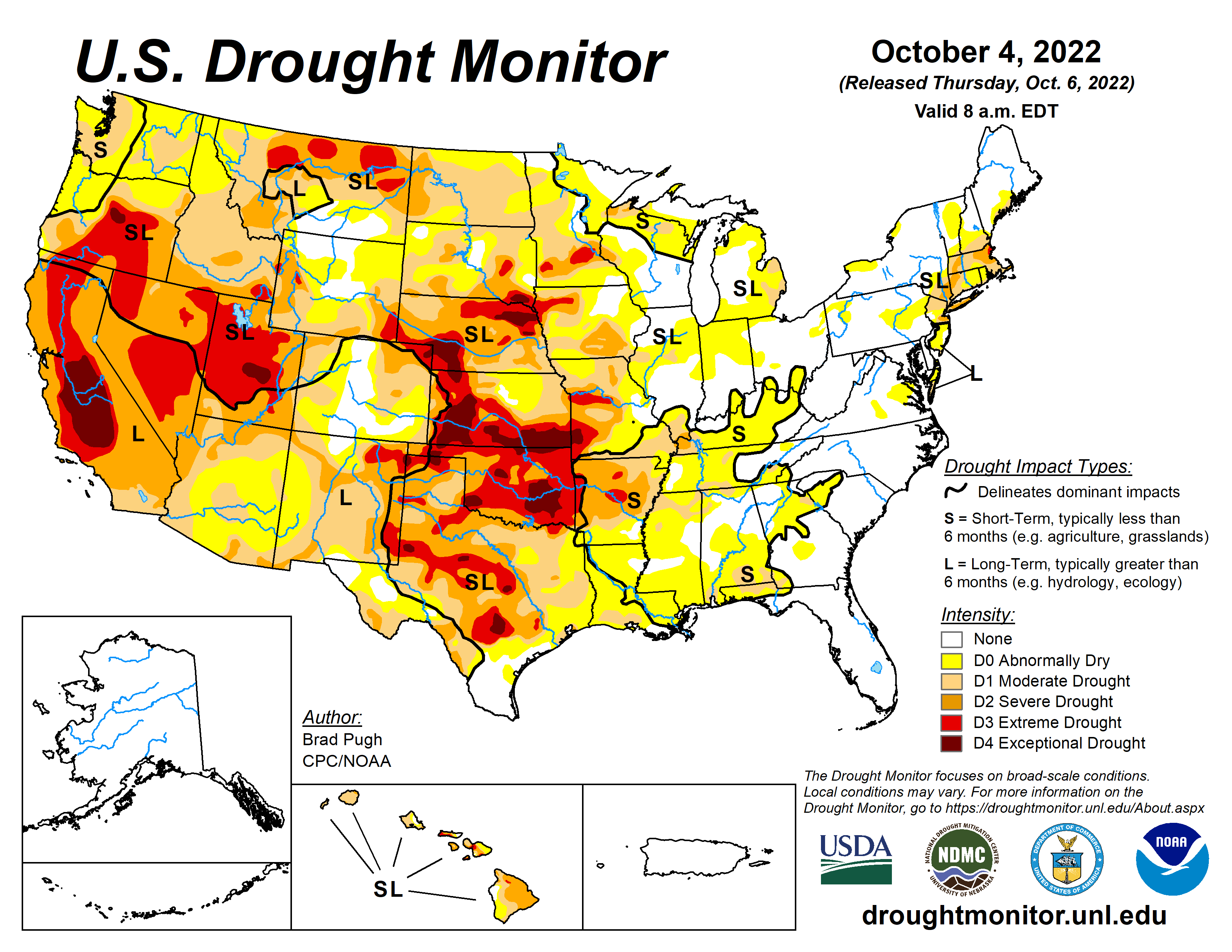
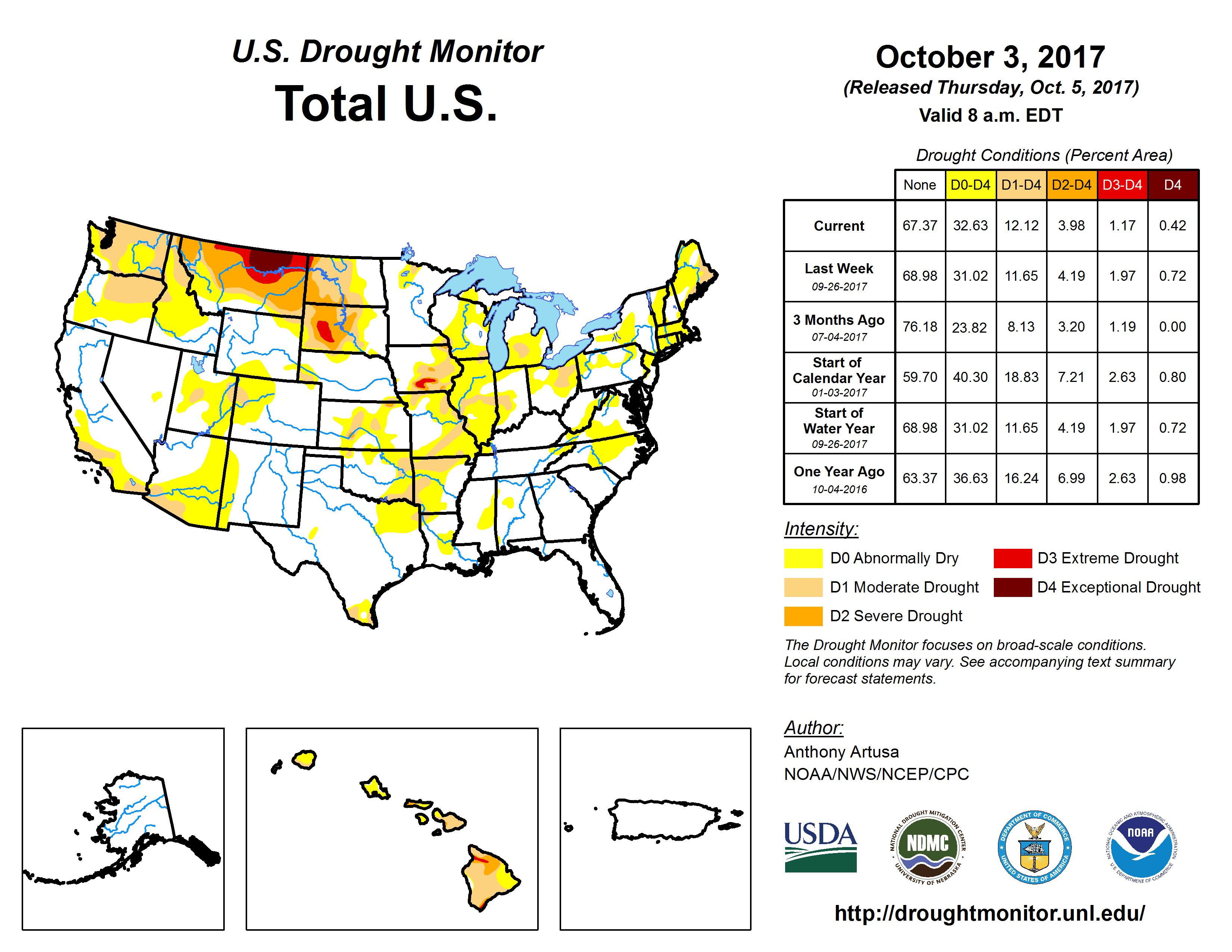
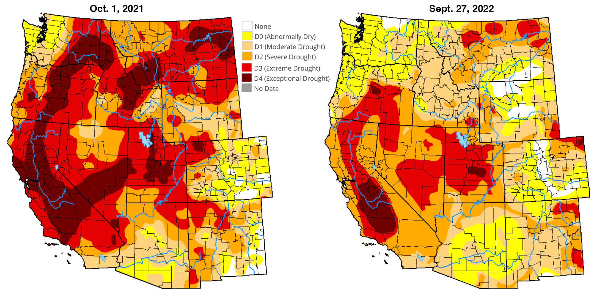
Major Hurricane Ian made landfall in southwestern Florida on September 28 and then reemerged offshore of the Atlantic coast, with another landfall near Georgetown, South Carolina two days later. Excessive rainfall (more than 10 inches) caused widespread inland flooding throughout the central Florida Peninsula and heavy rainfall overspread the Carolinas, Mid-Atlantic, and central Appalachians. After a mid-level low pressure system tracked inland from the northeastern Pacific and became stationary over the interior West, heavy precipitation (1 to 3 inches) occurred across northern Idaho along with the north-central Rockies. Therefore, improvements were made across much of the East and north-central Rockies. Conversely, a dry week resulted in an expansion of abnormal dryness (D0) and moderate drought (D1) along with intensifying drought conditions across much of the Great Plains, Mississippi Valley, and Midwest. D1 was added to parts of the Pacific Northwest. A mix of improvements and degradations were made to Hawaii, while Alaska and Puerto Rico remain drought-free…
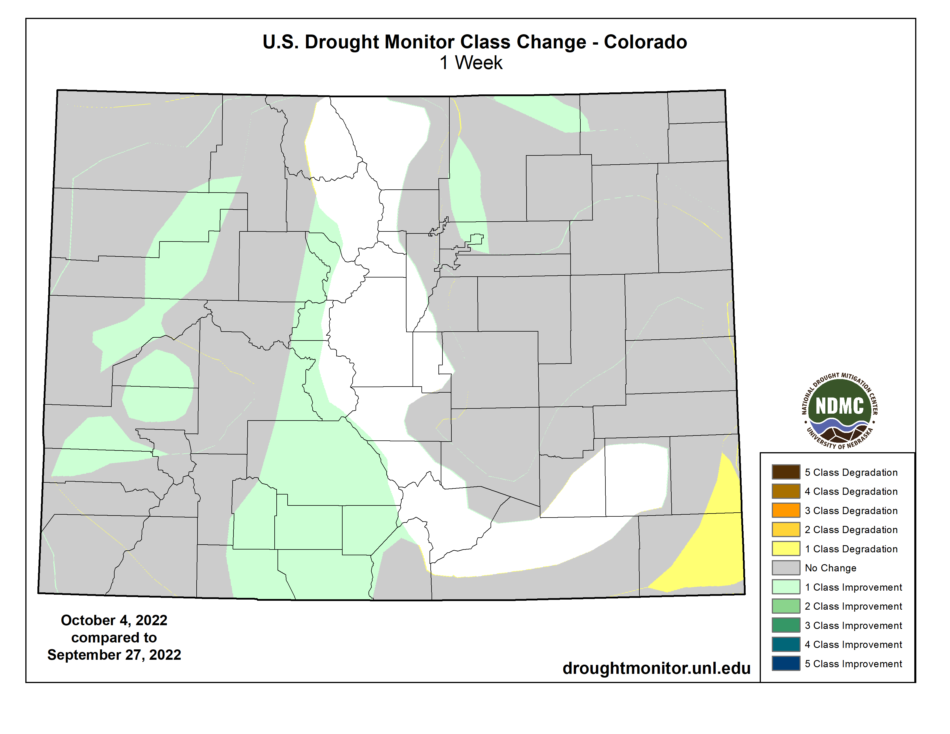
Short and long-term NDMC blends, SPIs, soil moisture, and crop conditions support a 1-category degradation for southern South Dakota, southwestern Nebraska, and parts of Kansas. Pond levels are low in Kansas and limited soil moisture is available for winter wheat planting. Abundant recent precipitation (locally more than 2 inches) prompted improvements along the western slopes of the Colorado Rockies. Improvements were also made to northeastern Colorado due to relatively significant precipitation (more than 0.5 inch) this past week. Following heavy precipitation during early August, little to no rainfall for a six week period resulted in an increase in D1 across southeastern Colorado. Beneficial precipitation during the past 30 to 60 days along with improving soil moisture conditions prompted improvements across parts of Wyoming…
Colorado Drought Monitor one week change map ending October 4, 2022.
Late summer heat and increasing 90-day precipitation deficits of more than 6 inches resulted in the addition of short-term moderate drought (D1) to parts of northwest Oregon and western Washington. This new D1 area is supported by 30 to 120-day SPI values, near record low 28-day streamflows for this time of year, and declining soil moisture. Conversely, heavy precipitation (1 to 4 inches) supported a broad 1-category improvement across parts of west-central Montana and the impact was changed from SL to L only. 12 to 24-month SPI values continue to support D1+ throughout western Montana. Based in part on above-normal temperatures during August and September, 1-category degradations were made to parts of southern Idaho. Farther to the north, beneficial precipitation during the past week resulted in a 1-cateogry improvement to northern Idaho. Although Arizona and much of New Mexico were status quo this week, this region will be reevaluated next week as many areas received more than 0.5 inch of rainfall from September 27 to October 3 and it was a wet Monsoon for the Southwest…
Due to a very dry pattern during the past month along with periods of above-normal temperatures, a 1-category degradation was necessary for parts of the Ozarks, lower Mississippi Valley, western Gulf Coast, and southern Great Plains. 30-day precipitation deficits exceed 4 inches in eastern Oklahoma and northwestern Arkansas. Much of these areas along with interior portions of southeastern Texas have received less than 0.10 inch of rainfall during the past 30 days. 30-day SPI/SPEI along with NLDAS and NASA SPoRT soil moisture were the primary indicators used in depicting these degradations along with recommendations from regional partners. Low to dry ponds, poor pastures, and cattle selloffs continue to be major impacts for Arkansas and Oklahoma. Although moderate drought (D1) was added to southwestern Louisiana, a broader D1 coverage was not designated this week due to a strong wet signal at 60 days and lack of support from soil moisture indicators. A couple of small D1 areas were added to Tennessee (near Nashville and northeast of Chattanooga), based on SPI/SPEIs and declining soil moisture…
Looking Ahead
From October 6 to 10, mid-level low pressure, the tail end of a front, and enhanced moisture from the East Pacific are expected to bring widespread rainfall (1 to 3 inches) to eastern Arizona, New Mexico, and the northern Texas Panhandle. Elsewhere, across the contiguous United States, little to no precipitation is forecast. Behind a cold front, below-normal temperatures are forecast to shift southeastward across the central and eastern U.S. The first frost or light freeze of the season may affect the Corn Belt. Above-normal temperatures are likely to persist throughout the northwestern U.S.
The Climate Prediction Center’s 6-10 day outlook (valid October 11-15, 2022) expects a variable temperature pattern during this 5-day period. Below-normal temperatures are most likely across the Rockies and Southwest, while above normal temperatures are favored for the Pacific Northwest and lower to middle Mississippi Valley. Probabilities for above-normal precipitation are elevated across the southwestern and south-central U.S. with a likely continuation of a drier-than-normal pattern for the Pacific Northwest.
US Drought Monitor one week change map ending October 4, 2022.
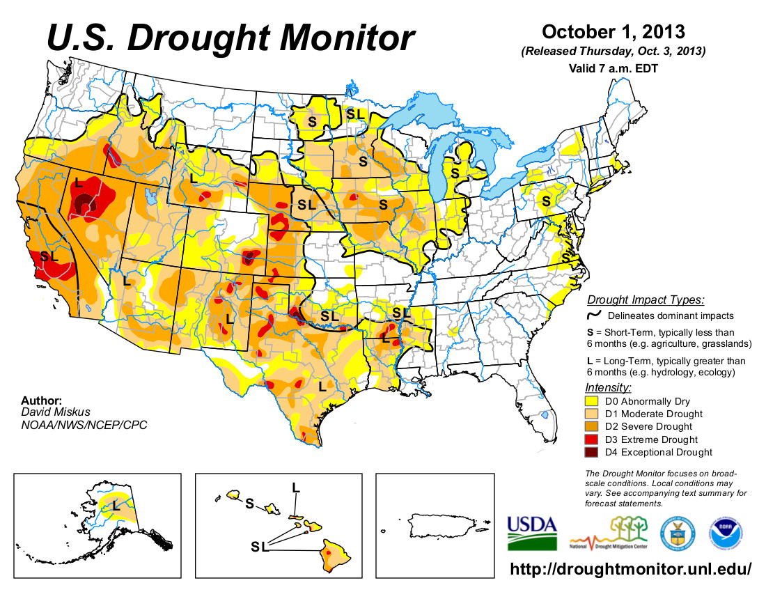
Just for grins (maybe grimaces) here’s a gallery of early October US Drought Monitor maps for the past few years.
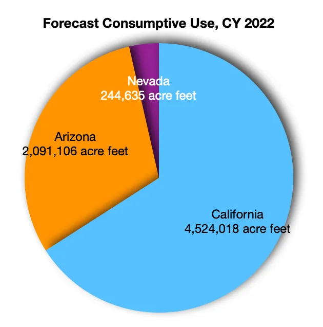
Southern California water agencies have agreed on a deal to cut back on the amount of water they use for the Colorado River, some of which is used to grow crops in the Imperial Valley. Ted Wood/The Water Desk
Click the link to read the article on the KUNC website (Alex Hager). Here’s an excerpt:
Water agencies in southern California announced a new agreement to voluntarily cut back on their total water from the Colorado River use by 9%. The deal is a rare instance of collaboration between water departments representing cities and farms, and comes amid federal pressure to conserve water in the face of historic drought…California’s contribution represents the first public commitment to conserve a specific volume of water among the Colorado River’s basin states since the mid-August deadline passed…The new plan from California proposes a 400,000 acre-foot reduction in water use each year, beginning in 2023 and lasting through 2026. The agencies involved – Metropolitan Water District of Southern California, Imperial Irrigation District, Coachella Valley Water District and Palo Verde Irrigation District – said it’s an effort to help boost low levels in Lake Mead, the nation’s largest reservoir…
The California agencies said they will only take voluntary cutbacks if the federal government provides “funding and commitments on the Salton Sea.” The lake is kept full by irrigation runoff from neighboring agricultural areas. As farmers conserve more water in the Imperial and Coachella valleys, the lake declines causing public health and ecological crises for that valley. Its future has been at the heart of fractious debates in California about its use of Colorado River water.
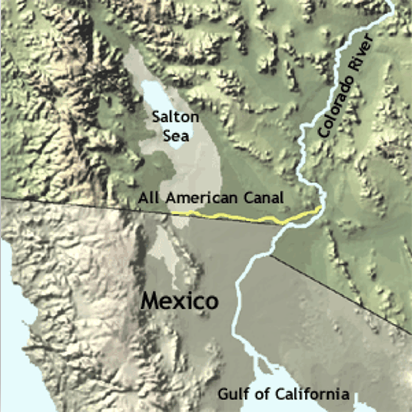
The All American Canal diverts water from the Lower Colorado River to irrigate crops in California’s Imperial Valley and supply 9 cities. Graphic credit: USGS
Click the link to read “California agencies float Colorado River water cuts proposal” on the Associated Press website (Kathleen Ronayne). Here’s an excerpt:
The agencies, which supply water to farmers and millions of people in Southern California, laid out their proposal in a letter to the U.S. Department of the Interior. It comes as drought exacerbated by climate change continues to diminish the river, and months after the U.S. Bureau of Reclamation first called on users to voluntarily limit their reliance on it. California shares the river’s water with six other states, tribes and Mexico. It has rights to the single largest share and is the last to lose water in times of shortage…California has been under pressure from other states to figure out how to use less as river reservoirs drop so low they risk losing the ability to generate hydropower and deliver water…
Four California agencies use the river’s water: The Metropolitan Water District of Southern California, the Imperial Irrigation District, the Palo Verde Irrigation District and the Coachella Valley Water District. The proposed cuts are contingent on the water agencies getting money from the $4 billion in drought relief included in the Inflation Reduction Act, as well as a commitment by the federal government to help clean up the Salton Sea, a drying lake fed by diminishing runoff from Imperial Valley farms. The letter was scant on details. The agencies said they have “a collection of proposed water conservation and water use reduction opportunities” that would help keep more water in Lake Mead, one of the river’s key reservoirs…It did not list any specific projects, or specify the rate of payment the agencies are expecting. But the federal government has previously said the $4 billion could be used for short-term conservation measures, like paying farmers to leave their fields unplanted, and long-term efficiency projects such as lining canals to prevent water loss.
The Imperial Irrigation District receives a larger share of the river than any other entity. It’s the only source of water for crops in California’s southeastern desert, where many of the nation’s winter vegetables, like broccoli, as well as feed crops like alfalfa are grown.
Colorado River Allocations: Credit: The Congressional Research Service
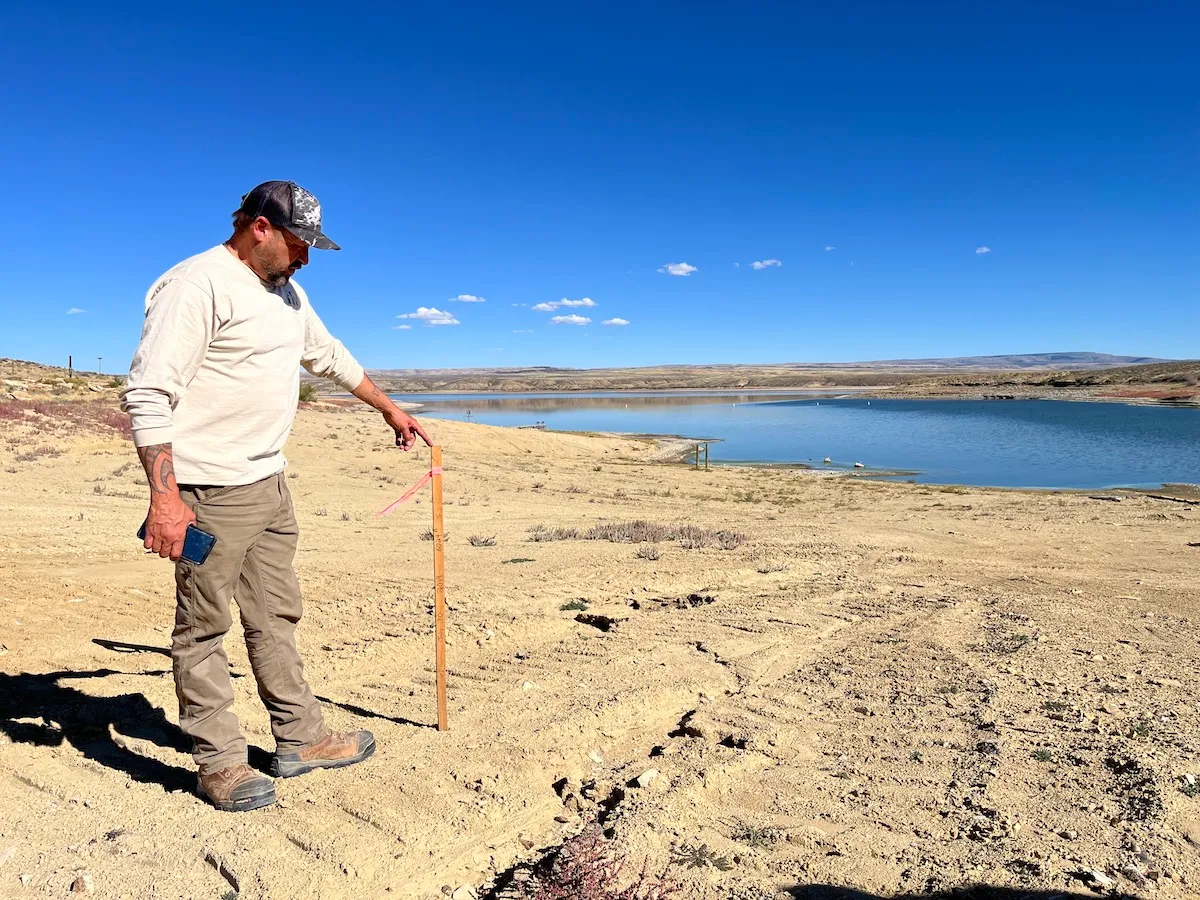
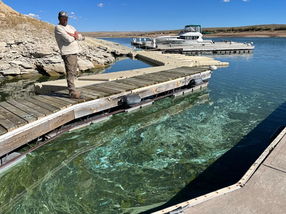
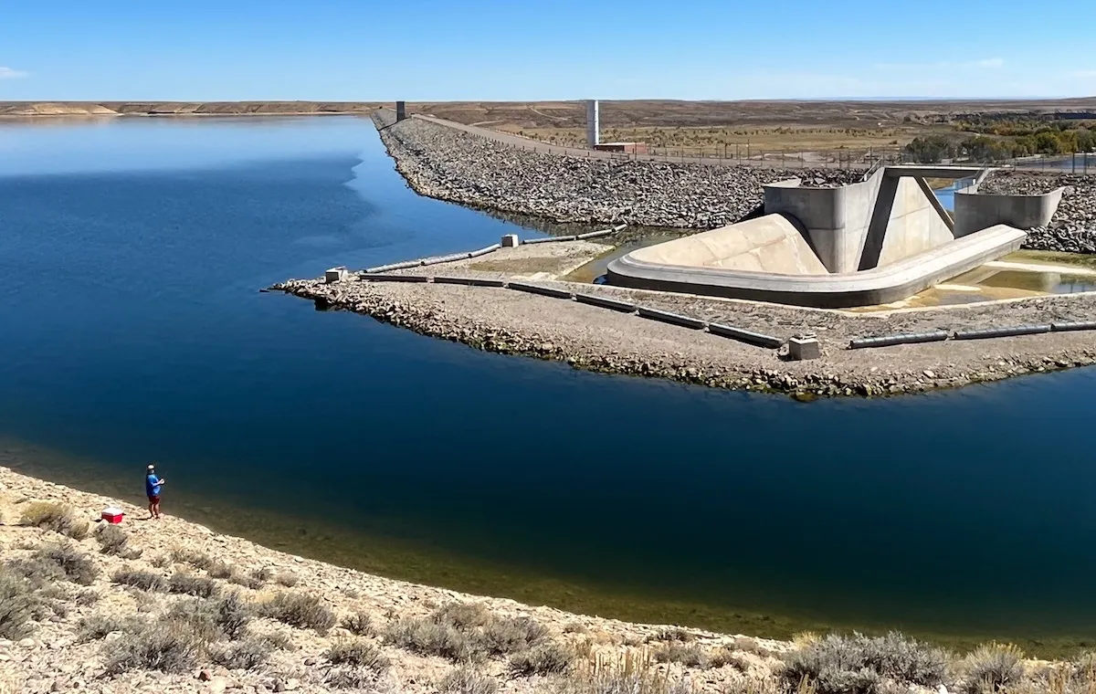
Buckboard Marina owner Tony Valdez stands next to a stake that indicates the extent of lowering water levels at Flaming Gorge Reservoir Sept. 26, 2022. (Dustin Bleizeffer/WyoFile)
Click the link to read the article on the WyoFile website (Dustin Bleizeffer):
The shoreline of this large reservoir on the Wyoming-Utah border has steadily receded this summer as the Bureau of Reclamation pumped more water out to help maintain critical water levels 500 miles away at Lake Powell.
The water shrunk from boat ramps and forced marinas to scoot docks ever inward. By September, 6 feet of vertical drop in the water level translated into vast areas of exposed lakebed, leaving many boat ramps on the northern reaches of the reservoir high and dry. All told, the reservoir’s elevation is about 12 feet lower today than two years ago, according to the U.S. Geological Survey. Thousands of acres that had been underwater for 58 years now comprise a rainbow of boggy sediment, grasses and invasive plants.
Buckboard Marina owner Tony Valdez and his staff scrambled all summer to keep boat docks in the water, but they couldn’t always keep up. Two large floating docks near a drop-off sank so low that their access ramps became too steep to safely walk. Toxic cyanobacterial blooms have also migrated further down the lake.
Buckboard Marina owner Tony Valdez observes toxic cyanobacteria blooms at Flaming Gorge Reservoir Sept. 26, 2022. (Dustin Bleizeffer/WyoFile)
“I can’t take my grandkids or my dogs to the water,” Valdez said, motioning to big green globs and sheets of muck as he stood on a boat dock. “We’re losing our marina. It will be gone after next year.”
When Valdez bought the marina in 2019, he immediately began making renovations. It was a solid investment, he believed, for a popular service at the largest recreational draw in southwest Wyoming.
The BOR had maintained seasonably stable water levels at Flaming Gorge since 1964 when the dam was completed. Businesses in Wyoming and Utah built an economy around the fishermen, boaters, bird-watchers and others drawn to the massive impoundment.
Things began to change, however. Valdez first noticed that vehicles and boat trailers with plates from California, Arizona and other southwestern states became increasingly prevalent at the marina, he said, as reservoirs along the Colorado River began drying up.
Campers, seen here Sept. 26, 2022, are set up in areas previously under water across the bay from the Buckboard Marina at Flaming Gorge Reservoir. (Dustin Bleizeffer/WyoFile)
More than 20 years of drought — intensified by human-caused climate change — have pushed the Colorado River Basin and the 40 million people who depend on it into a water crisis. The system’s two largest reservoirs, Powell and Lake Mead, sank below 30% capacity this summer — the lowest levels since they were constructed. If the situation worsens, Powell and Mead could reach “deadpool” status at which the reservoirs would no longer release water downstream into the Colorado River.
The crisis is traveling upstream to places like Flaming Gorge, where it has implications for everything from riparian ecosystems to economic livelihoods. Currently, Flaming Gorge is at about 74% storage capacity, according to the U.S. Geological Survey. Whether the reservoir shrinks further depends on whether the BOR will continue to tap Flaming Gorge and how quickly it might be naturally replenished.
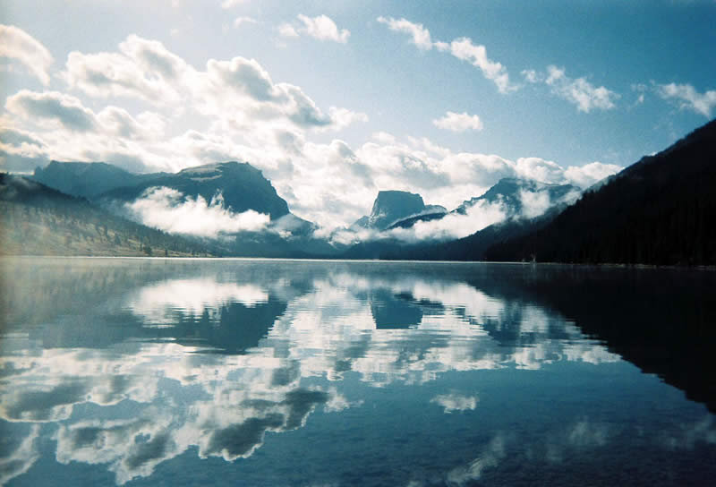
Lower Green River Lake
Emergency water supply
In a legal sense, Flaming Gorge Reservoir, which is fed by headwaters in western Wyoming, was created for a moment like this. Its primary purpose, according to federal officials and Colorado River Compact scholars, is to serve as a backup water bank to help maintain the Colorado River system. Specifically, Flaming Gorge and a handful of other reservoirs in the upper Colorado River Basin states of Wyoming, Colorado, Utah and New Mexico are key to ensuring a minimum flow of 7.5 million acre-feet of water at Lees Ferry just downstream of Powell on a running 10-year average.
So far, the upper basin states have met the threshold. Nonetheless, when Powell and Mead saw drastic lows in 2021, the BOR drew an extra 125,000 acre-feet of water from Flaming Gorge. This past spring when the situation in the lower basin states became even more dire, the BOR initiated a draw of an additional 500,000 acre-feet, estimating a 15-foot vertical drop in the reservoir over the water season ending in April 2023.
The Drought Response Operations Agreement, signed by Colorado River Compact stakeholders in 2019, authorizes the BOR to make those, and possibly additional emergency draws from Flaming Gorge, to help maintain critical water levels and hydropower generation at Powell and Mead. If this summer is any indication, continual draws from the reservoir might drastically alter an aquatic ecosystem and fishery that local businesses have relied on for decades.
Map credit: AGU
“This has been held at a premium, high-water mark, recreational lake for [58] years,” Valedz said. “Why wasn’t this addressed 15 years ago if we knew this was coming?”
The BOR is expected to decide whether to implement another “extra” draw from Flaming Gorge in April 2023.
Flaming Gorge fishery
Kokanee salmon and trophy-sized lake trout draw tens of thousands of visitors to Flaming Gorge each year, supporting a recreational economy in southwest Wyoming and northeast Utah. But as the lake is drawn down, water recedes from shallow shorelines and fish are forced into a smaller space, essentially shrinking the fishery toward the dam side of the reservoir.
Fishing guides and Wyoming Game and Fish have cooperated to maintain an appropriate balance to the predator-prey relationship between lake trout and kokanee, according to Recon Angling owner Shane DuBois. Now, the decreasing water levels threaten to drastically alter that balance and may require shifting management strategies.
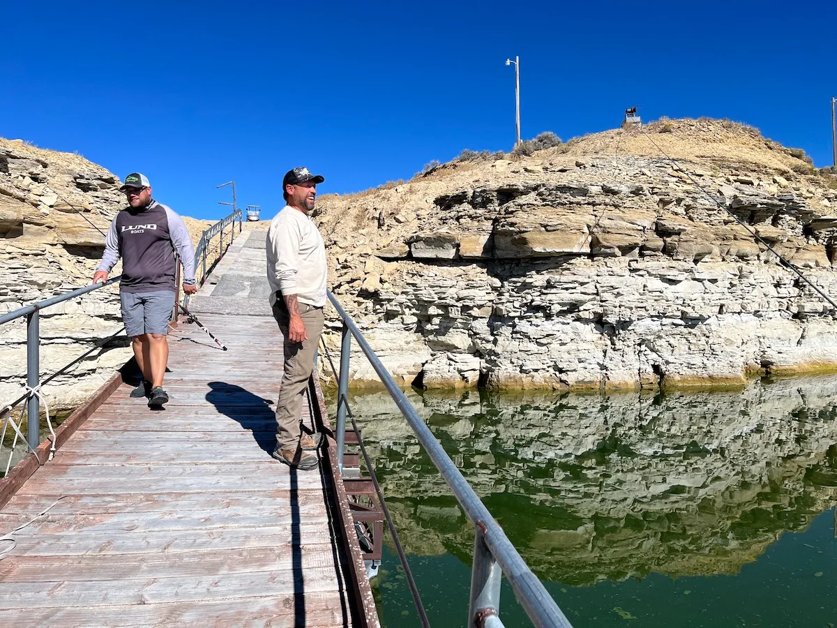
Recon Angling owner Shane Dubois (left) and Buckboard Marina owner Tony Valdez observe water levels at Flaming Gorge Reservoir Sept. 26, 2022. (Dustin Bleizeffer/WyoFile)
Kokanee spawning beds have been exposed, which will force the fish to spawn in areas covered in silt, reducing the reproduction success rate, according to Wyoming Game and Fish Regional Fisheries Supervisor Robert Keith. If Flaming Gorge’s normal water levels are restored, the episode will likely improve traditional spawning beds, Keith said. However, if BOR withdrawals from Flaming Gorge substantially outpace natural inflows for several more years, the fishery will suffer.
“That’s going to be an economic impact to communities around the reservoir that depend on the anglers showing up,” Keith said. “And If we don’t have any ramps in Wyoming that anglers can launch from, then they’re all going to launch further down the reservoir and those dollars are going to be spent down in Utah.”
The BOR is in consultation with the Wyoming State Engineer’s office and local recreation and fishery managers regarding drawdowns at Flaming Gorge. The Flaming Gorge National Recreation Area — managed by the U.S. Forest Service — as well as Wyoming Game and Fish, can apply for federal funds set aside to aid in the Colorado River Basin water crisis. But maintaining critical water levels at Powell and Mead remains a priority, while projects involving reconstructing boat ramps and shifting fishery management would take years.
For DuBois, who depends on both a healthy fishery at Flaming Gorge and functional boat ramps, the situation threatens his livelihood. He recently invested tens of thousands of dollars in a new fishing boat and hopes it pays off.
“How does the Bureau of Reclamation not know [the recent drawdown] would leave most boat ramps unusable?” DuBois asked.
As he continues to relocate and reconstruct boat docks to adjust to lower water levels, Valdez is considering how to expand his scope of clientele to make up for losses.
“I didn’t buy this place to come up here and watch this go to shit,” Valdez said.
Q: Why are we in this situation, with the Colorado River and its reservoirs shrinking so quickly?
A: Truth is, we saw this coming. We use more water than the river provides. The only reason we got away with it for so long was because the reservoirs were full when the climate’s shift to hotter temperatures and reduced river flows began 22 years ago. We did not reduce the amount of water we used until recently, and it has not been enough in the face of drought exacerbated by climate change.
Brad Udall: Here’s the latest version of my 4-Panel plot thru Water Year (Oct-Sep) of 2021 of the Colorado River big reservoirs, natural flows, precipitation, and temperature. Data (PRISM) goes back or 1906 (or 1935 for reservoirs.) This updates previous work with @GreatLakesPeck. Credit: Brad Udall via Twitter
Q: What happens if we stick with the status quo?
A: If we keep doing what we’re doing, and take water out of the reservoirs—not because it’s wise but because the law allows it—our system as we know it would crash. Water could not be released from Lakes Powell or Mead. A “Day Zero.” This is bad for ALL water users in the Colorado River basin.
There is also the dreadful possibility of no water flowing through the Grand Canyon, or through the Lower Colorado River along the Arizona-California border. That would mean no Colorado River water for tens of millions of people, including numerous sovereign Tribes. No Colorado River water for drinking, bathing, or growing crops, and no water for essential habitats, birds, and other wildlife.
Q: Why does this matter for birds?
A: A future without a running Colorado River would impact 400 bird species including California Condors, Bald Eagles, Southwestern Willow Flycatchers, and countless fish species and other wildlife that reside in and migrate through the Colorado River basin. The Colorado River Delta alone provides habitat for 17 million birds during spring migration and 14 million in the fall, from American White Pelicans and Double-breasted Cormorants to Tree Swallows and Orange-crowned Warblers.
And because the Delta acts as a “bottleneck” for migrating birds—meaning concentrations of bird populations are significantly higher inside its geographical boundaries than outside of them—changes to water availability or habitat in the Delta could have outsized impacts on tens of millions birds. These impacts could be seen on a global scale.
Environmental water delivery in the Colorado River Delta is timed during the late spring and summer to help native trees germinate. The cottonwood seeds were evident. Photo: Jennifer Pitt/Audubon
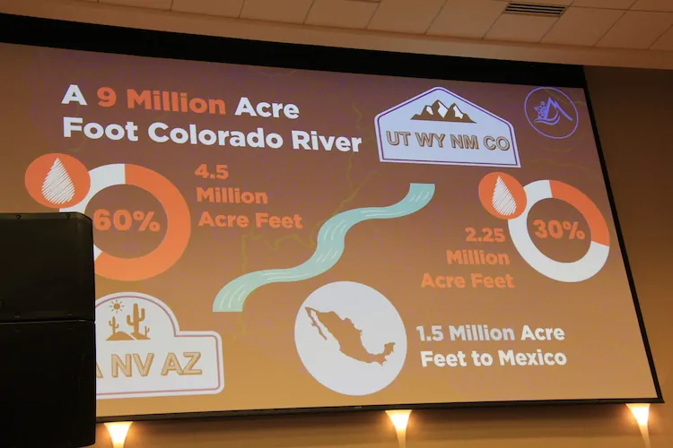
Q: Water users need to reduce use by 2-4 million acre feet for 2023, and possibly for 2024 and 2025, according to the U.S. Bureau of Reclamation (USBR). How will the seven Colorado River Basin states (Arizona, California, Colorado, Nevada, New Mexico, Utah, and Wyoming), Tribes, other water users, and the federal government agree to the water reductions necessary to stabilize the river and reservoir system?
A: The short answer: we don’t know.
A deadline set by USBR came and went this past August. It’s unclear whether the seven states and water users will reach their own agreement on how to use less water, if federal officials will decide, or, likely the worst-case scenario, if the courts will be the ultimate decision-makers. In the past, the states, Tribes, and other water useres have managed to come up with agreements on how they will use less. Presently, the Upper Basin states (CO, NM, UT, and WY) have agreed to reopen a program that pays water users to use less water. They have also agreed to examine how releases of water stored behind dams in the Upper Basin can help stem the decline of downstream reservoirs such as Lake Powell. The trouble now is water levels are dropping so quickly in our two largest reservoirs—Lake Powell and Lake Mead—and water managers as a whole have not been able to come to agreements fast enough.
All water users could agree to use less. That means cities, farms, and businesses could all agree to reduce the amount of water they use so that the difficult task of stabilizing the system is distributed more evenly.
Q: Why aren’t we all doing that right now—using less?
A: Presently, the Upper Basin states use far less water than the Lower Basin States. Upper Basin states have agreed to reopen a program that pays water users to use less water, and have agreed to release water stored behind dams in the Upper Basin, all to help stem the decline of Lake Powell. However, the Upper Basin States should not—and cannot—shoulder the crisis alone.
Part of the reason more water users are not cutting back is because of the current way water is managed. Water management in the Colorado River Basin is based on a seniority system of water rights. First come, first served. This means those with junior rights would have their water reduced completely before a senior water rights holder would see their water reduced at all. While this has been the way the system has operated for more than 100 years, it is wearing thin in the face of 20+ years of drought and a shrinking river.
In the 1960s, Arizona accepted junior priority rights on a portion of its Colorado River water in exchange for federal funding for the Central Arizona Project (or CAP, the 336-mile long canal that delivers Colorado River water to the central, populous parts of the state). As such, Arizona has stepped up and taken water cuts, sooner than originally anticipated. That’s a good thing. But if Arizona is forced to bear the entire shortage burden in the Lower Colorado River Basin, the impacts to millions of people, including vulnerable communities, will be considerable.
In the face of a shifting climate—reduced snowpack in the mountains due to hotter temperatures and thirstier, drier soils, resulting in less water in rivers—previous efforts to reduce use and save water in Lake Mead, such as the Drought Contingency Plan and the 500+ plan, have not been enough to prevent the Colorado River system from crashing.
Q: What are specific ideas for using less water and improving the outlook of this dire situation?
A: We could pay people to use less water as well improve the health of the ecosystems and watersheds on which we all rely. Recent federal legislation such as the Inflation Reduction Act allocates $4 billion across the West to do just that. We want to see wise use of this funding—through multi-year agreements and durable projects that reduce water use and improve the health of our rivers and watersheds.
How will we get there?
– Upgrade on-farm irrigation methods and equipment to grow crops on less water.
– Provide incentives for farmers to shift from water-thirsty crops like cotton and alfalfa to drought-tolerant crops like guayule and sorghum.
– Restore degraded meadows and streams to allow for more water retention in the mountains.
– Forest management to prevent catastrophic wildfires. Burned watersheds degrade water quality and erode soils, impairing the ability for the watershed to function properly.
– Increase the reuse of water. Wastewater can be captured, purified, and reused for outdoor irrigation, groundwater recharge, river restoration, or even drinking water.
– Boost water conservation efforts from cities and businesses, through eliminating unnecessary grass; upgrading plumbing; saving water on outdoor landscaping; and industrial cooling water efficiency upgrades.
– Deploy funding to mitigate the impacts of less water flowing into affected communities and to improve habitat. Funding should prioritize multiple benefit projects and move beyond one-year water deals.
There is also plenty of work to do just within the state of Arizona to improve our water outlook. We must do everything we can to use the water we do have as wisely as possible. Audubon and our partners in the Water for Arizona Coalition developed the Arizona Water Security Plan, which outlines six critical steps the state of Arizona could take to get our own water house in order.
Q: What should we be watching out for in Arizona?
A: Given the circumstances, with less Colorado River water coming into Arizona, some may want to rely more heavily on groundwater and weaken existing laws that protect it in the populous parts of the state. Weakening existing groundwater protections just so Arizona can continue to grow without changing how we use and manage water would be irresponsible and short-sighted. We should be closely watching the next legislative session to ensure that doesn’t happen.
Furthermore, Arizona has failed to pass meaningful groundwater protections in the rural parts of the state where none currently exist. We cannot allow Arizona’s rural groundwater to meet the same fate as the Colorado River–especially as rural leaders plead for change. For the benefit of all people in the state, lawmakers must allow rural communities to protect their groundwater supplies. And the better we manage all of our water resources, the more credible a partner Arizona is with other states in ongoing Colorado River negotiations.
Colorado River Allocations: Credit: The Congressional Research Service
A precipitation rollercoaster across much of the West helped soothe drought conditions in most of the region, especially the Interior. California, however, remains dry. National Drought Monitor via The Land Desk
Click the link to read the article on The Land Desk website (Jonathan Thompson):
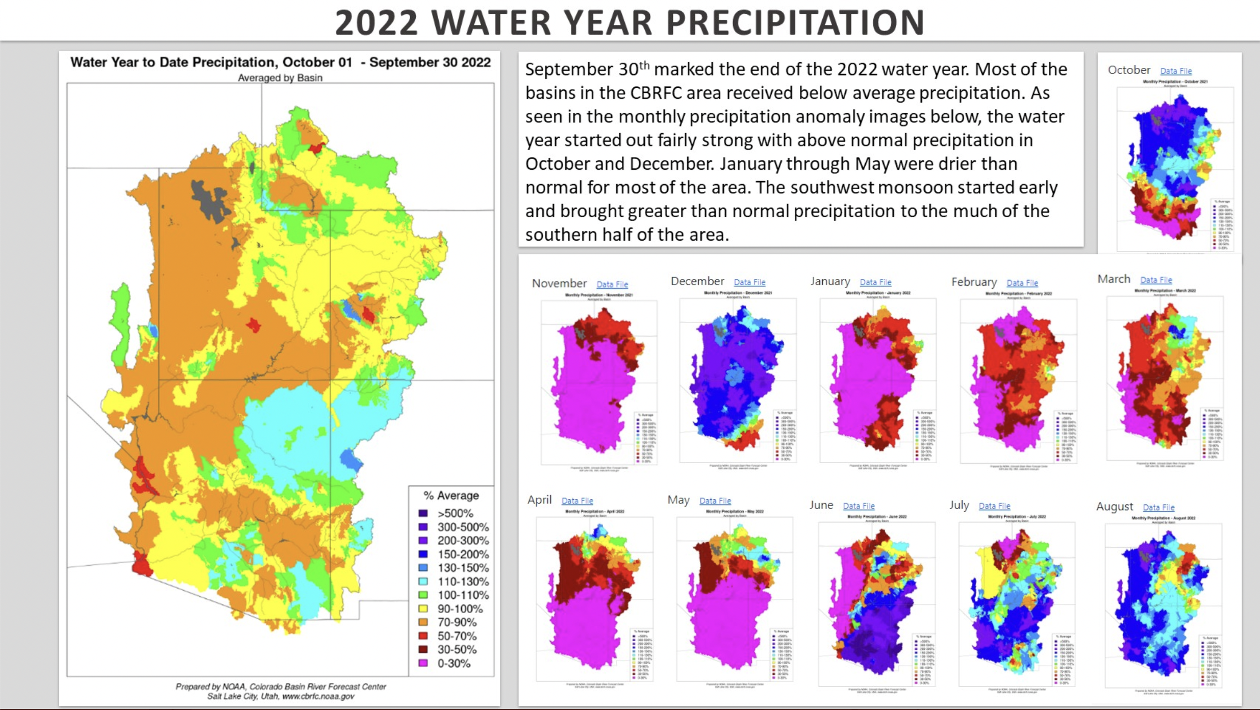
Happy New Water Year! The first day of October is also when folks restart their precipitation and snowpack meters and river gages. It is a time of hope (please give us more snow this time!) and reflection (last year was bonkers!). I’m going to stick with the reflection here.
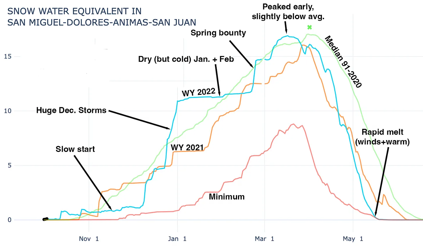
The 2022 Water Year, which ended Sept. 30, was quite the rollercoaster ride. It started out looking grim in much of the West: Many ski areas weren’t able to hit their traditional Thanksgiving weekend opening and in some areas the end of November snowpack was in worse shape even than in 2002, the winter of everyone’s discontent.
Graphic credit: Jonathan Thompson/The Land Desk
Then came the December dumps, at least to some regions. California’s Sierras got hammered by record-breaking snowfall (193 inches in December). Southwestern Colorado went from parched to chest-deep-powder in a matter of weeks. Heavy traffic to ski areas snarled roadways.
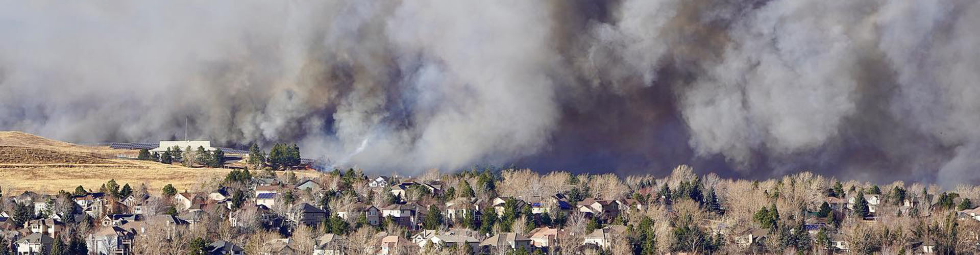
Marshall Fire December 30, 2021. Photo credit: Boulder County
To be sure, the bounty was spread out unevenly. Even as Front Range ski resorts were getting hammered, the Denver-Boulder metro area remained dry, warm, and windy as hell. The flammable combination ultimately led to the devastating Marshall Fire, which was sparked in the grasslands near South Boulder before tearing through suburbia and destroying more than 1,000 homes. It was finally extinguished by the season’s first real snowfall on New Year’s Eve.
The rollercoaster ride continued after that, with long, dry cold spells followed by big storms followed by unusually warm periods. Dry and wet offset each other in many areas, with snowpack peaking early, but at just-below to near-average levels across much of the West.
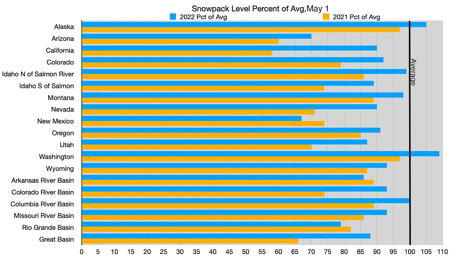
Alaska and the Northwest had average to above-average winters in terms of snowfall, but the rest of the West ended up below average, again. Still, 2022 was far healthier than 2021 in just about every area except for New Mexico. This is the level as of May 1; peak snowpack used to come later in almost every region, but lately it is more likely to occur in April in most areas. Source: SNOTEL.
Summer followed in kind as hot and dry alternated with gully-busting storms. And despite all the flooding, monsoon precipitation amounts were about average in the Southwest.
And that kind of sums up Water Year 2022: It was full of superlatives, yet ended up more or less average, precipitation-wise. But in these days of aridification and warming temperatures, and following on the heels of two decades of drought, average just doesn’t cut it.
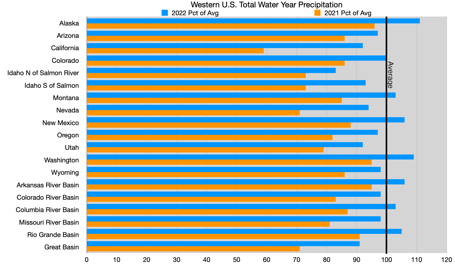
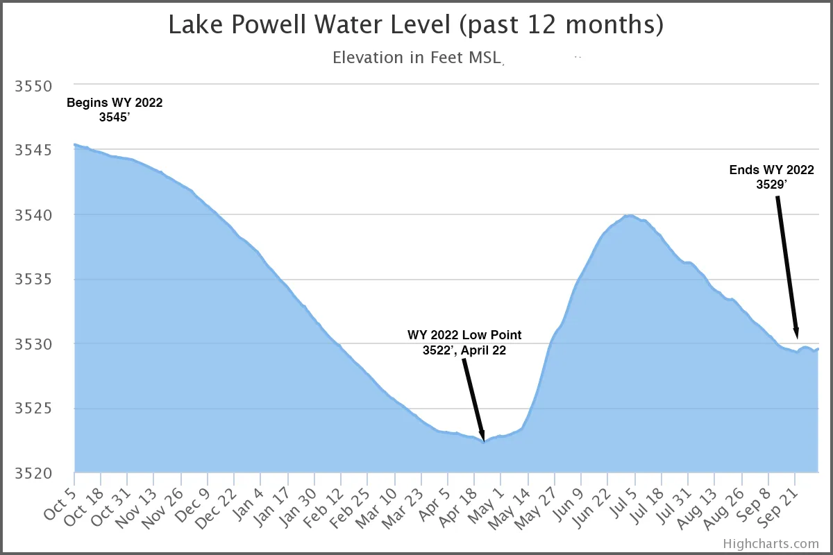
Water Year precipitation from Oct. 1 through Sept. 30. After a slim winter an abundant monsoon helped most areas’ precipitation levels recover.
Despite near-average precipitation levels in the Colorado Basin, Lake Powell continued its steady decline, finishing the water year about 16 feet lower than the end of Water Year 2021.
To summarize: It was a year of more or less average precipitation and above average temperatures. While drought eased in some areas, aridification continues just about everywhere.
Click the link to read the article on the KTIC website (Bryce Anderson). Here’s an excerpt:
A post on social media from Haskell County, Kansas, pointed to a stark example of the impact of extreme drought and high crop irrigation demand in the 2022 year. “(The) well is basically out of water now. Been very limited for the last 7 years. Down to 100 gallons per minute and the well is pumping a lot of sand,” the producer wrote. The water table at an index well in Haskell County, Kansas, dropped to almost 400 feet below the surface in late summer 2022. (Kansas Geological Survey graphic)
A check with Kansas water and climate experts confirms that the account of wells running dry is valid and happened this year to more than just one grower here and there. “It has been a very difficult year; one that rivals what we saw in 2011 and 2012,” said data scientist Blake B. Wilson of the Kansas Geological Survey (KGS) in an email to DTN. The years 2011 and 2012 were also bad drought years, and there is a straight connection between drought and the wells going dry. “Since irrigation accounts for 95%+ of the (water) usage, it is highly correlated to precip,” he said. “As precipitation goes, so does pumping, and in turn, the rates of declines in the aquifer.”
Ogallala Aquifer. Credit: Big Pivots
The aquifer in question is the Ogallala Aquifer, the source of much irrigation water and the lifeblood of row-crop agriculture in the southwestern Plains. Aquifer level declines during the farming year are sharply revealed in analysis of index wells, where the depth to find water is monitored and recorded. A review of an index well in Haskell County shows that by late August, the distance from ground surface to the aquifer had deepened to almost 400 feet. KGS’s Wilson has seen that before, “… where the water table drops 100 feet during the irrigation season,” he said.
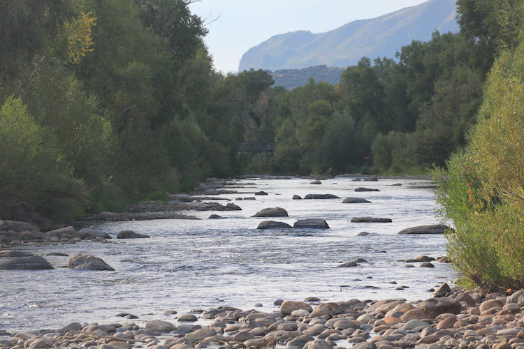
While the Yampa River has not closed quite as much this year as it did last year, local fishermen lost out on most of July and August and a chunk of September in 2022…
“There’s three criteria that would determine a closure or trigger a closure,” [Johnny] Spillane said. “One is water temperature, another is water flow meaning (cubic feet per second) and the third criteria is dissolved oxygen in the river. If any of those three criteria are not being met, that will trigger a closure and that seems to be fairly common in the last five, six or seven years.”
As far as the rain’s effect on fish behavior, Spillane says it is complicated but mostly acts as a good thing for the fish and therefore a good thing for those fishing.
Yampa River. Photo credit: Allen Best/The Mountain Town News
Ephemeral streams are streams that do not always flow. They are above the groundwater reservoir and appear after precipitation in the area. Via Socratic.org
The Supreme Court opened its new term on Monday by hearing a property rights appeal that calls for limiting the government’s power to protect millions of acres of wetlands from development. At issue is whether the Clean Water Act forbids polluting wetlands and marshes that are near — but not strictly part of — waterways.
Justice Ketanji Brown Jackson in her first day on the bench led the way in questioning why the court should move to limit the protection for wetlands. She said Congress in 1977 determined that wetlands “adjacent” to rivers and bays should be protected. Why should the law be narrowed, she asked, “when the objective of the statute is to ensure the chemical, physical, and biological integrity of the nation’s waters? Are you saying that neighboring wetlands can’t impact the quality of navigable waters?” Justices Elena Kagan and Brett M. Kavanaugh said they agreed with that view. Kavanaugh said that seven administrations — Republican and Democratic — had taken the view that wetlands were protected if they were near a waterway.
Damien Schiff, an attorney for Pacific Legal Foundation, agreed that some wetlands can be protected, but he argued property owners should not be blocked from developing their land simply because it has a marshy area. His argument won favor with several of the court’s conservatives who questioned how property owners of land near a waterway or a wetland would know if they were subject to federal regulation. Jackson noted that the prior owners of the Idaho land were told it included protected wetlands.
“You keep talking about fair notice and property owners, about not being able to tell or know about this issue,” she told Schiff. But with respect to the Idaho couple, “there seems to have been a prior determination that the land was a wetland before they bought it, and whether or not they know, they could have known, I presume.”
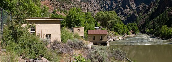
East Portal Gunnison Tunnel gate and equipment houses provide for the workings of the tunnel.
Lisa Lynch/NPS
From email from Reclamation (Erik Knight):
Releases from the Aspinall Unit will be decreased from 1250 cfs to 1050 cfs on Monday, October 3rd. Releases are being decreased due to the heavy rainfall that occurred over the weekend which has reduced demand at the Gunnison Tunnel.
Flows in the lower Gunnison River are currently above the baseflow target of 790 cfs. River flows are expected to remain above the baseflow target for the foreseeable future.
Pursuant to the Aspinall Unit Operations Record of Decision (ROD), the baseflow target in the lower Gunnison River, as measured at the Whitewater gage, is 790 cfs for October.
Currently, Gunnison Tunnel diversions are 950 cfs and flows in the Gunnison River through the Black Canyon are around 350 cfs. After this release change Gunnison Tunnel diversions will be around 750 cfs and flows in the Gunnison River through the Black Canyon will still be near 350 cfs. Current flow information is obtained from provisional data that may undergo revision subsequent to review.
Potential Water Delivery Routes. Since this water will be exported from the San Luis Valley, the water will be fully reusable. In addition to being a renewable water supply, this is an important component of the RWR water supply and delivery plan. Reuse allows first-use water to be used to extinction, which means that this water, after first use, can be reused multiple times. Graphic credit: Renewable Water Resources
Douglas County plans to release an executive summary of its most recent closed-door water briefing from attorney Steve Leonhardt, who met Sept. 13 with the county commissioners to update them on his latest talks with Renewable Water Resources.
Leonhardt told Douglas County officials that he wasn’t comfortable releasing his full notes from the meeting he held with Douglas County Commissioners and county administrators. Douglas County Commissioner Lora Thomas continues to push for full transparency and release of all the information from Leonhardt’s most recent discussions with RWR.
On Tuesday [September 27, 2022] during a county commissioner work session, Douglas County Commissioner Abe Laydon, who chairs the three-member board, said it would be appropriate for Douglas County to provide an executive summary of the Sept. 13 executive session given the ongoing public interest in the RWR discussions.
Douglas County Attorney Lance Ingalls told the commissioners he would work on an executive summary for review and in essence it would say, “Mr. Leonhardt’s conclusion is that the issues remain. That they have some ideas how to address them, they have some ideas of what’s bigger than others, but the bottom line of his followup with RWR is that issues remain. They still need to be resolved.”
Ingalls is stepping down from his position on Oct. 3. Douglas County said it has a national search underway for his replacement. He’s been overseeing the work of Leonhardt and other water attorneys Douglas County has hired to advise it in its talks with Renewable Water Resources.
Douglas County remains interested in the idea of moving water from the Upper Rio Grande Basin’s confined aquifer in the San Luis Valley for residential use in Douglas County, and has Leonhardt working with RWR to resolve a host of issues that Leonhardt previously identified as problematic for Douglas County. Here’s his two-part memorandum to the Douglas County commissioners back in May when he told Douglas County that there are too many holes in the RWR plan for Douglas County to make an investment.
Commissioner Thomas has called for a full public briefing of the Sept. 13 meeting, but Christopher Pratt, formerly the assistant county attorney and now acting county attorney with Ingalls pending departure, said Leonhardt is opposed to releasing full notes.
“He felt very strongly that he does not want that released,” Pratt told the county commissioners. “Those were his notes from the meeting. It’s not really something he generated for public dissemination.”
As Ingalls later stated to the commissioners, Leonhardt has been working to address the issues at a high level on behalf of Douglas County and that he still sees major problems for Douglas County to get involved with the RWR plan. How those are being addressed will remain between Douglas County and its attorneys for now.
“We’re talking about spending a significant amount of taxpayer money and I think the taxpayers have a right to know what’s going on,” Thomas said.
Click the link to read the announcement on The Buzz website (Floyd Ciruli):
Who Controls Congress? Did Republicans Recover In Colorado?
The Denver Press Club will host a post-election panel of Colorado political experts to examine the November 8 election results—surprises and the expected and how it affects 2024.
Political analyst Floyd Ciruli will moderate the panel at 6:30 PM on Thursday, November 10, at the Denver Press Club on 1330 Glenarm Place across from the DAC.
Glen Canyon Dam, seen here in May 2022, was a major electrical generation but has produced less as volumes in Lake Powell have declined. Photo credit: Allen Best/Big Pivots
Click the link to read the article on the Big Pivots website (Allen Best):
New study says that as electrical output from Colorado River dams declines benefits with a Southwest Power Pool alignment grow
For water geeks, first a bit of alphabet soup from energy geeks:
RTO stands for regional transmission organization, a way of sharing electricity across a broad region to better match demand with renewable energy supplies.
SPP stands for Southwest Power Pool, which provides some of this energy sharing across several Midwestern states. It is trying to provide something similar in Colorado and adjoining Rocky Mountain states. It began offering the first small step, something called the Western Energy Imbalance Service.
Three of Colorado’s four largest utilities have already joined, as have several others of relevance to Colorado, including the Western Area Power Administration and the Municipal Energy Agency of Nebraska. Conspicuously absent is the David of Colorado, i.e. Xcel Energy, which sells more than 50% of electricity consumed in the state.
Now, to the news. A new study by Brattle Group finds the benefits of joining an RTO operated by SPP would yield significantly more benefits, somewhere between $55 million and $73 million per year, depending on hydrologic conditions.
The savings increase to $89 million per year under severe drought conditions. The modeling for reduced hydroelectric production was among several differences from a similar study conducted in 2020. See the report here.
A press release from Tri-State Generation and Transmission, Colorado’s largest electrical supplier after Xcel, also notes potential operational and reliability benefits provided by RTO participants.
Throwing their lot with the Southwest Power Pool, at least in its incipient alignment, are not only Tri-State but also Colorado Springs Utilities and Platte River Power Authority. Not incidentally, all depend upon purchases of hydroelectricity from the Western Area Power Administration which distributes power from Glen Canyon Dam and other federal hydroelectric facilities. As a privately owned utility, Xcel is ineligible to receive what was traditionally extremely low-priced electricity from the federal dams.
Colorado transmountain diversions via the State Engineer’s office
Click the link to read the newsletter “The Runoff” on the Aspen Journalism website (Heather Sackett):
Colorado River Water Conservation District board members and staff discussed the comments they plan to submit on the updated version of the Colorado Water Plan at a Sept. 15 meeting. A main concern of theirs remains the very reason the River District was formed in 1937: transmountain diversions. Director of Technical Advocacy Brenden Langenhuizen said there is still a disconnect in the Water Plan between the basin of origin (the Colorado) and the place of use (the Front Range). The River District would like the Water Plan to include more context about TMDs and to address their long-term economic and environmental impacts. A point the River District continues to make is that many of the water quality issues in headwaters communities (algae, high water temperatures) are actually a water quantity issue — a result of reduced flows from TMDs taking water to the Front Range. “Water quality is not discussed as thoroughly as we think it needs to be,” Langenhuizen said. CWCB officials told Aspen Journalism in July when the new Water Plan was released that it stopped short of a detailed analysis of TMDs because of ongoing litigation and permitting processes, but promised to revisit the issue before the next update to the plan.
A rendering of the RESTORE Passive House designed for Marshall fire victims. Designers hope the new home proves green homes can hit an affordable price point for middle-class families. Courtesy of Passive House: https://www.passivhaus.city/
Record-high construction prices and low insurance payouts have squeezed Marshall fire victims trying to rebuild in Boulder County. The few local companies offering to build passive homes wouldn’t work within the [Peter and Michelle Ruprecht’s] budget. That all changed with a link posted in an online community group. It directed Peter Ruprecht to a web page for the RESTORE Passive Home, a three-bedroom, three-bathroom house designed for the Marshall fire burn area. The designers promised a $550,000 price tag after government incentives, which fell in line with the construction quotes the family had received from other commercial builders. The couple is now the first to sign up to build the home…
Debates over construction costs and climate-minded building standards have supercharged local politics in the aftermath of the Marshall fire. Earlier this year, Louisville and Superior — the two communities hit hardest by the disaster — faced intense pressure from fire victims worried mandatory green building codes would further boost construction prices. Both local governments ended up allowing those families to rebuild to earlier, less-stringent standards. The RESTORE Passive Home attempts to prove green homes can fit within middle-class budgets. The task could prove critical as governments push to reduce the climate impact of buildings, which account for 13 percent of U.S. greenhouse gas emissions and 20 percent of Colorado emissions — largely due to natural gas appliances and an electricity grid dominated by fossil fuels. Passive homes could also help insulate families from climate threats like poor air quality and future fires. Andrew Michler, a passive house designer behind the new project, said the task requires a major shift in his industry. Instead of one-off homes built for committed environmentalists, passive home designers need to start building for the mass market. He said only about 20 homes in Colorado have met international passive home standards.
In 2017, majority owner and operator Public Service Company of New Mexico (PNM) announced that the coal-fired San Juan Generating Station was too expensive to operate and that the last two of the plant’s four units would be retired in 2022, rather than operating until 2053. On-the-ground communities and advocates had long since called attention to the plant’s expense as well as its damage to health, air and our climate.
In 2019, New Mexico passed the Energy Transition Act (ETA) to build on PNM and Tucson Electric’s closure decisions by enabling use of low-interest bonds to save customers money and provide economic transition benefits to plant and mine workers and the community. About $40 million in funding through the Energy Transition Act has been or will be disbursed to plant and mine workers and the impacted community. Four Corners residents encouraged state agencies to act urgently to use the $20 million earmarked for community funding to invest in local, sustainable projects that move the region forward.
As PNM and the other owners retire the plant (which was shuttered sometime early this morning, when the coal stockpile ran out), community organizations issued the following statements:
“The plant closure has significant positive and negative implications. One positive impact is the anticipated release of ETA funds to help secure the self-sustenance of communities that were impacted by the plant,” said Duane “Chili” Yazzie of ToohBAA, a Shiprock Farmers Cooperative. “Our farmers group in Shiprock applied for the funds in the hope that it will help address one of the great needs that our farmers have, with the provision of skilled labor. With the funds, we expect to acquire equipment operators, diesel mechanics, planners and administrators who will help organize our farming activity to optimize our agricultural potential. We look forward to an expedited release of those funds.”
Community organizations also focused on the need to properly reclaim, decommission and clean up the plant, rather than allowing it to continue to pollute under Enchant, which has failed to obtain the permits, buyers or funding to operate with carbon capture, a technology that has failed in every commercial coal plant where it has been tried. At its peak, San Juan Generating Station used more water than the entire city of Santa Fe. Some of the water rights from the plant have now been allocated to run in the San Juan River.
“We now have an opportunity to protect and manage water sources in the Four Corners region,” said Jessica Keetso of Tó Nizhóni Aní, Navajo Nation. “A transition to solar, wind, renewable, clean-energy investments helps eliminate the waste and misuse of water. Precious water sources have been used to feed giant power plants all over the Four Corners region for over half a century. These water sources are limited and have been compromised in many regions. It’s time to make sure that transition and cleanup happen in an organized and speedy manner, and that ETA investments bring an opportunity for coal-impacted communities to drive economic diversification.”
“As Four Corners residents, we want to see the negotiated replacement power, solar and energy storage, and we want the ETA implementation money to go to the impacted coal workers and communities,” said Mike Eisenfeld of San Juan Citizens Alliance. “Enchant Energy has been disingenuous and unaccountable on the progress of their project, which joins a long list of failed carbon-capture and sequestration projects funded through the Department of Energy. City of Farmington has expended nearly $2 million in legal fees supporting Enchant’s failed project with timelines now extending to 2027. We’re looking at the immediate need for past and current owners to carry out their decommissioning and reclamation responsibilities within 90 days of SJGS and San Juan Mine closure.”
“Today marks a pivotal moment in our Four Corners region with the decline of fossil-fuel production. We regard this moment as a transformation for the environment in less CO2, methane, NOx, VOCs, coal ash, and other toxic pollutants. We welcome a return of cleaner air and water for the health of tribal communities and climate,” said Ahtza Chavez, Executive Director of Naeva.
“Abandonment and remediation will be difficult. Over 50 years of damage was done to the environment,” said Norman Norvelle, former San Juan Generating Station plant chemist and Farmington resident. “From releasing plant wastewater effluent into the Shumway arroyo, to air pollutants and mercury into the San Juan River watershed and the fish of quality waters. Also, plant solid and liquid waste disposal into unlined surface mine pits. Even after the plant is shut down there will be need for extensive cleanup and monitoring to verify cleanup of the contaminants. Sampling and monitoring should be done by 3 or 4 different organizations to assure completeness and honesty.”
“If not done adequately, the San Juan Generating Station chemical contaminants will go into the San Juan River near the Hogback. All of the contaminants from the plant plus the biological contaminants from San Juan County, such as fecal bacteria, will flow into the San Juan River Basin onto the Navajo Reservation to Lake Powell,” Norvelle said.
“The San Juan Generating Station has been a source of jobs and revenues in Four Corners for more than half a century, but it can no longer be operated in a manner that is fiscally and environmentally responsible,” said Cydney Beadles, Managing Senior Staff Attorney of Western Resource Advocates’ Clean Energy Program. “The Energy Transition Act helps mitigate the impacts on local workers and communities and ensures that ratepayers get the cost savings that come from shutting down an inefficient coal plant, and the Public Regulation Commission issued an order requiring bill credits upon abandonment. Unfortunately, those credits have been temporarily suspended by the state Supreme Court at PNM’s request, but we remain hopeful that the court will soon lift that stay.”
“The solar and storage replacement power approved in 2020 will provide $1 billion in investment in the communities most impacted by San Juan,” added Camilla Feibelman, Sierra Club Rio Grande Chapter Director. “With pandemic supply-chain and other delays, it is incumbent upon PNM to work with developers of the solar and storage replacement power to overcome these obstacles and get those projects online as soon as possible. Analyses showed that the San Juan Solar project, to be sited in the same school district, will replace 100% of the property-tax base of San Juan.”
The western United States is, famously, in the grips of its worst megadrought in a millennium. The Colorado River, which supplies water to more than 40 million Americans and supports food production for the rest of the country, is in imminent peril. The levels in the nation’s largest freshwater reservoir, Lake Mead, behind the Hoover Dam and a fulcrum of the Colorado River basin, have dropped to around 25% of capacity. The Bureau of Reclamation, which governs lakes Mead and Powell and water distribution for the southern end of the river, has issued an ultimatum: The seven states that draw from the Colorado must find ways to cut their consumption — by as much as 40% — or the federal government will do it for them. Last week those states failed to agree on new conservation measures by deadline. Meanwhile, next door, California, which draws from the Colorado, faces its own additional crises, with snowpack and water levels in both its reservoirs and aquifers all experiencing a steady, historic and climate-driven decline. It’s a national emergency, but not a surprise, as scientists and leaders have been warning for a generation that warming plus overuse of water in a fast-growing West would lead those states to run out.
I recently sat down with Jay Famiglietti, the executive director of the Global Institute for Water Security at the University of Saskatchewan, to talk about what comes next and what the public still doesn’t understand about water scarcity in the United States. Before moving to Canada, Famiglietti was a lead researcher at NASA’s water science program at the Jet Propulsion Laboratory in Pasadena, California, and a member of the faculty at the University of California, Irvine. He pioneered the use of the Gravity Recovery and Climate Experiment satellites to peer into the earth’s mass and measure changes in its underground water supplies. The Colorado River crisis is urgent, Famiglietti said, but the hidden, underground water crisis is even worse. We talked about what U.S. leaders either won’t acknowledge or don’t understand and about how bad things are about to get.
Our conversation has been edited for length and clarity.
Let’s start with the Colorado River because it’s in the news. The federal government has put some extraordinary numbers out there, suggesting water users cut between 2 and 4 million acre-feet of water usage starting this year — roughly 40% of the entire river’s recent flow. How could that possibly happen?
It’s going to be really hard. We’re looking at drastically reduced food production and the migration of agriculture to other parts of the country and real limits on growth, especially in desert cities like Phoenix. My fear is that groundwater will, as usual, be left out of the discussion — groundwater is mostly unprotected, and it’s going to be a real shit show.
Remind us how that happens. States and farmers cut back on the Colorado River, and California and Arizona just start pumping all the water out of their aquifers?
Yeah. This started with the drought contingency plan [the 2018 legal agreement among the states on the Colorado River]. Arizona had to cut nearly 20% of its Colorado River water. To placate the farmers, the deal was that they would have free access to the groundwater. In fact, something like $20 million was allocated to help them dig more wells. So, it was just a direct transfer from surface water to groundwater. Right away, you could see that the groundwater depletion was accelerating. With this latest round, I’m afraid we’re just going to see more of that.
Some of that groundwater actually gets used to grow feed for cattle in the Middle East or China, right? There’s Saudi-owned agriculture firms planting alfalfa, which uses more water than just about anything, and it’s not for American food supply. Do I have that right?
There’s been other buyers from other countries coming in, buying up that land, land grabbing and grabbing the water rights. That’s happening in Arizona.
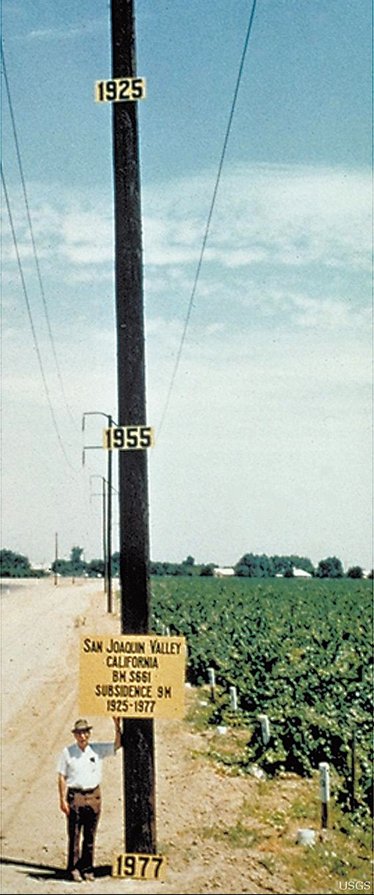
San Joaquin Valley Subsidence. Photo credit: USGS
What about in California? Groundwater depletion has caused the earth to sink in on itself. Parts of the Central Valley are 28 feet lower today than they were a century ago.
California passed the Sustainable Groundwater Management Act in 2014, which mandated an extraordinarily long time horizon: two years to form the Groundwater Sustainability Agencies and then five years for each GSA to come up with its sustainability plan. So that’s now: 2022. And then 20 years to come into sustainability. My fear is that the slow implementation will allow for too much groundwater depletion to happen. It’s sort of the same old, same old.
But could it work?
I don’t think we’re talking about sustainability. I think we’re talking about managed depletion. Because it’s impossible to keep growing the food that we grow in California. It’s agriculture that uses most of the groundwater. The math just isn’t there to have sustainable groundwater management. If you think of sustainability as input equals output — don’t withdraw more than is being replenished on an annual basis — that’s impossible in most of California.
Will we run out of water? Are we talking about 10 years or 100 years?
Yes. We are on target to. Parts of the Central Valley have already run out of water. Before SGMA, there were places in the southern part of the valley where I would say within 40 to 50 years we would run out or the water is so saline or so deep that it’s just too expensive to extract. SGMA may slow that down — or it may not. I don’t think the outlook is really good. Our own research is showing that groundwater depletion there has accelerated in the last three years.
Then what happens? What does California or Arizona look like after that?
It looks pretty dry. Even among water users, there’s an element that doesn’t understand that this is going to be the end for a lot of farming. Farmers are trying to be really efficient but also magically want the supply of water to be sustained.
We focus on the big cities like Phoenix and Las Vegas, but it’s farms that use 80% of water. They grow crops that provide huge amounts of the winter fruits and vegetables and nuts for the entire country. Is there any way that farming in California and Arizona can continue even remotely close to how it is today?
I don’t think so. It has to drastically change. We’ll need wholesale conversion to efficient irrigation and different pricing structures so that water is better valued. We’ll need different crops that are bred to be more drought tolerant and more saline-water tolerant. And we’ll probably have a lot less production.
What does that mean for the country’s food supply?
This is the big question. I don’t want to be flippant, but people don’t understand the food-water nexus. Do we try to bring more water to the southern high plains, to Arizona, to California, because if the food system’s optimized, maybe that’s the cheapest thing to do? Or does agriculture move to where the water is? Does it migrate north and east? It’s not just food production. What about the workers? Transportation? If we were to move all of our agriculture to northern California, into Idaho, into North Dakota over the next decade, that’s a major upheaval for millions and millions of people who work in the ag industry.
It’s really interconnected, isn’t it? The nation essentially expanded West beginning in the 19th century in order to build a food system that could support East Coast growth. The Homestead Act, the expansion of the railroads, was partially to put a system in place to bring stock back to the meat houses in Chicago and to expand farming to supply the urban growth in the East.
I don’t think a lot of people really realize that, right? When I go to the grocery store in Saskatoon, my berries are coming from Watsonville, California. The lettuce is coming from Salinas, California.
Farmers in the West are fiercely independent. So, in California, Arizona, do they lose the ability to choose what to plant?
Right now, there’s freedom to plant whatever you want. But when we look out a few decades, if the water cannot be managed sustainably, I don’t actually know. At some point we will need discussions and interventions about what are the needs of the country? What kind of food? What do we need for our food security?
Let’s discuss California. Its governor, Gavin Newsom, has advanced a lot of progressive climate policies, but he replaced the water board leader, who pushed for groundwater management across the state, and last month the agency’s long-serving climate change manager resigned in protest of the state’s lax water conservation efforts. What does it mean if a liberal, climate-active governor can’t make the hard decisions? What does that say about the bigger picture?
There has been a drop off from the Jerry Brown administration to the Newsom administration. Water has taken a step lower in priority.
Is that a sign that these problems are intractable?
No. It’s a sign that it’s just not as high a priority. There are tough decisions to be made in California, and some of them won’t be popular. You can see the difference between someone like Brown, who was sort of end-of-career and just like, “Screw it, man, I’m just going to do this because it needs to be done,” and someone like Newsom, who clearly has aspirations for higher office and is making more of a political play. We’re not going to solve California’s water problem, but we could make it a lot more manageable for decades and decades and decades. (Newsom’s office has rejected the criticism and has said the governor is doing more than any other state to adapt to climate change. On Aug. 11 his administration announced new water recycling, storage and conservation measures.)
Water wars. It’s an idea that gets batted around a whole bunch. Once, negotiating water use more than a century ago, California and Arizona amassed armed state guard troops on opposite banks of the Colorado River. Is this hyperbole or reality for the future?
Well, it’s already happening. Florida and Georgia were in court as was Tennessee. There’s the dispute between Texas and New Mexico. Even within California they’re still arguing environment versus agriculture, farmers versus fish, north versus south. Sadly, we’re at a point in our history where people are not afraid to express their extreme points of view in ways that are violent. That’s the trajectory that we’re on. When you put those things together, especially in the southern half or the southwestern United States, I think it’s more of a tinderbox than it ever has been.
That’s hopeful.
You’re not going to get any hope out of me. The best you’re going to get out of me is we can manage our way through. I don’t think we’re going to really slow global change. We have to do what we’re doing because we’re talking about the future. But a certain number of degrees warming and a certain amount of sea level rise is already locked in, and all that’s happening in our lifetimes. The best you’re going to hear from me is that we need to do the best we can now to slow down the rates of warming that directly impacts the availability of water. We’re talking about the future of humanity. I think people don’t realize that we’re making those decisions now by our water policies and by our climate change policy.
When people think about water, they think of it as a Western problem, but there’s water shortages across the High Plains and into the South, too.
I don’t think most people understand that scarcity in many places is getting more pronounced. Nationally, let’s look at the positives: It’s a big country, and within its boundaries, we have enough water to be water secure and to be food secure and to do it in an environmentally sustainable way. A lot of countries don’t have that. That’s a positive, though we still have the same problems that everyone else has with increasing flooding and drought. What I really think we need is more attention to a national water policy and more attention to the food, water and energy nexus. Because those are things that are going to define how well we do as a country.
What would a national water policy look like?
It recognizes where people live, and it recognizes where we have water, and then it decides how we want to deal with that. Maybe it’s more like a national water/food policy. Moving water over long distances is not really feasible right now — it’s incredibly expensive. Does the government want to subsidize that? These are the kind of things that need to be discussed, because we’re on a collision course with reality — and the reality is those places where we grow food, where a lot of people live, are running out of water, and there are other parts of the country that have a lot of water. So that’s a national-level discussion that has to happen, because when you think about it, the food problem is a national problem. It’s not a California problem. It’s not a Southern, High Plains, Ogallala, Texas Panhandle problem. It’s a national problem. It needs a national solution.
Is this a climate czar? A new agency?
Something like that. We’re failing right now. We’re failing to have any vision for how that would happen. In Canada, we’re talking about a Canadian water agency and a national water policy. That could be something that we need in the United States — a national water agency to deal with these problems.
In the Inflation Reduction Act we finally have some legislation that will help cut emissions. There’s plenty of other talk about infrastructure and adaptation — seawalls and strengthening housing and building codes and all of those sorts of things. Where would you rank the priority of a national water policy?
It’s an absolute top priority. I like to say that water’s next, right after carbon. Water is the messenger that’s delivering the bad news about climate change to your city, to your front door.
We don’t usually mix concern over drought with concern over contamination, but there was a recent study about the presence of “forever” chemicals in rainfall and salt washing off the roads in Washington, D.C., and contaminating drinking water. Can these remain separate challenges in a hotter future?
It doesn’t get discussed much, but we’re seeing more and more the links between water quality and climate change. We’ve got water treatment facilities and sewers close to coasts. During drought, discharge of contaminants is less diluted. The water quality community and the water climate communities don’t really overlap. We’ve done a terrible job as stewards where water is concerned.
Globally, what do you want Americans to think about when they read this?
The United States is kind of a snapshot of what’s happening in the rest of the world. There’s no place we can run to. Things are happening really, really fast and in a very large scale. We as a society, as a country or as a global society are not responding with the urgency, with the pace and the scale that’s required. I am specifically talking about rapid changes that are happening with freshwater availability that most people don’t know about. The problems are often larger than one country. A lot of it is transboundary. And we’re just not moving fast enough.
News flash.
Around the world the water levels have just continued to drop. In the Middle East or India. In fact, they’re getting faster. It’s actually a steeper slope.
So, the Colorado River is the least of our worries.
Globally? It’s not even as bad as the others. Arizona doesn’t really show up as much compared to some of these places.
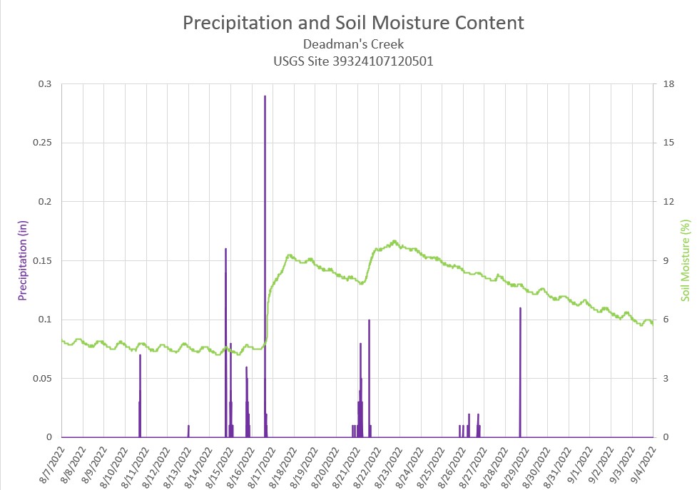
The precipitation gages within the canyon have been up and running all summer, reporting rainfall every five minutes. In mid-June, soil moisture sensors were collocated with 4 of the rain gages.
The chart below shows the precipitation and soil moisture from the Deadman’s Creek location. Prior to the rainfall the week of August 14, the soil moisture content was not reactive to the smaller rain events. Several storms during the week of August 14 dropped significant rain at the Deadman’s Creek rain gage. The final storm on August 16 dropped enough water to finally infiltrate down to the depth of the soil moisture sensor and cause a measurable change in the soil moisture content.
The storm events on August 20 through August 21 again increased the soil moisture at Deadman’s Creek. So far, no debris flow events have been triggered due to over saturated soil conditions.
Turbidity remained high through summer in Colorado River and returns to normal levels second half of September
Since the end of August, the turbidity in the Colorado River has slowly been trending downwards. With no major debris flow events the last week of August or in September, the turbidity has remained under 200 FNU.
The turbidity has finally returned below 20 FNU in the last two weeks of September. While we do not know exactly why the base level of turbidity in the water has remained elevated all season, it may be due to continuous re-mobilization of sediment from previous debris flow piles and from sediment that has settled previously within the riverbed.
A nearly $43 million contract was awarded to a Colorado construction company marking the “first giant step” in the Arkansas Valley Conduit project designed to bring clean drinking water to eastern Pueblo County and southeastern Colorado. The federal Bureau of Reclamation awarded the inaugural contract for the conduit to WCA Construction LLC, for $42.9 million to cover construction of the first 6-mile section of the 30-inch trunk line that extends from the eastern end of Pueblo Water’s system toward Boone. Located in Towaoc, the construction company is owned by the Ute Mountain Ute Tribe and as a tribal enterprise the company employs a workforce that is 70% indigenous…
Since 2020 the federal government has appropriated $51 million toward the project, with those funds paying for the trunk line construction. Pueblo County has awarded $1.2 million in American Rescue Plan Act funding to connect the communities of Avondale and Boone to the trunk line, Woodka said. Work under the initial contract will begin in the spring of 2023 and is expected to be completed in 2024. “We are now in the process of designing those connection lines, then we will be putting those lines in. We hope everything is connected to Boone and Avondale by the end of 2024,” [Chris] Woodka said. That will bring water to about 1,600 Avondale residents and 230 Boone residents. Currently, many people in the areas that will be served by the conduit rely on groundwater supplies that may be contaminated by naturally occurring radionuclides, such as radium and uranium, or use shallow wells that contain harmful microorganisms and pollutants.
“Every day we see violence increasing, Indigenous Peoples being murdered and the destruction of our territories happening at an accelerated rate,” said Dinaman Tuxá, Executive Coordinator at Articulation of Indigenous Peoples of Brazil (APIB), a national organization that unites Indigenous communities in support of their rights. “We demand the immediate demarcation of our lands and full protection of our rights and lives, as this is the only way in which we can continue to contribute to the fight against the climate crisis.”
APIB members focused their attention on President Jair Bolsonaro, who is in New York to make an address before the General Assembly and has pushed for development of the Amazon at the expense of Indigenous people. From 2019, when Bolsonaro took office, to 2021, Brazil lost over 13,000 square miles of Amazon forest. In just the first six months of this year, 1,500 square miles of forest were destroyed, the highest ever for that time period. Bolsonaro’s policies have also led to increasing violence against Indigenous land defenders–last year at least 27 people were killed protecting their territories. “Further allowing deforestation puts biodiversity, the lives of Indigenous Peoples and traditional communities, and the global climate at risk,” said Carol Pasquali, Executive Director at Greenpeace Brazil, which helped organize the protest. “World leaders must be accountable and put people and the planet first always.”
Filipino groups, including the Kalikasan People’s Network for the Environment, gathered in front of the Philippine Consulate to protest President Ferdinand “Bongbong” Marcos Jr. ahead of his speech at the U.N. Indigenous leaders are concerned that Marcos Jr.’s government will continue the nation’s history of directing violence toward Indigenous people. The protest also marked the 50th anniversary of Marcos Sr. declaring martial law and starting a years-long campaign during which over 3,000 people were killed, 70,000 imprisoned, and 34,000 tortured.
Indigenous activists are also using this week to push world leaders on concrete climate actions. Led by the Pacific Islands Students Fighting Climate Change (PISFCC), boats filled with activists sailed down the Hudson and East Rivers in New York to call on world leaders to support their calls for climate justice.
Indigenous people from Pacific Islands are often the most affected by rising sea levels and other climate impacts despite minimal contributions to the crisis, but have limited influence on the international level. “Our traditional knowledge is interrelated with our lands and this climate change is threatening to take this away, but we in Vanuatu will not be passive victims,” said Arnold Kiel Loughman, Attorney General of the Republic of Vanuatu, an island nation in the South Pacific Ocean. “We will do everything we can to defend the human rights of our people.”
Vanuatu and PISFCC are calling for the International Court of Justice (ICJ) to issue an advisory opinion on climate change – non-binding legal advice provided to the United Nations which carries significant weight internationally. As of 2017, only 28 advisory opinions have been requested, on subjects ranging from use of nuclear weapons to United Nations expenses. To date, the International Court has never heard a case on climate change.
Advocates say the issuing of an opinion would put pressure on member states to review their policies and commitments, including strengthening the Paris Agreement by clarifying state’s obligations toward climate goals, and affirming Indigenous rights in the fight against climate change. For that to happen, the General Assembly must vote to send the case to the ICJ, which organizers believe is likely. Vanuatu and PSIFCC are calling for that vote and rallying support among countries through both diplomatic channels and public campaigning.
“The [International Court of Justice Advisory Opinion] campaign was born out of this sense of urgency,”said Vishal Prasad, a campaigner with PSIFCC. “We are campaigning for an advisory opinion that seeks to bring together human rights and impacts of climate change on future generations.”
International financing for projects like oil pipelines and deforestation that harm the environment and violate Indigenous rights are also the target of activists this week. Indigenous groups, including the Global Alliance of Territorial Communities, staged a die-in in front of the New York Stock Exchange on Monday. “We start the week in Wall Street to ask decision makers what kind of projects they are supporting. We don’t want continued investment into the destruction of the Earth,” said Gustavo Sanchez, from Alianza Bosques. “We will all die if we continue like this.”
A coalition of Indigenous groups from Peru, including the Autonomous Territorial Government of the Wampis Nation, are calling on banks to divest from companies that destroy the Amazon, including Petroperú, a company they say is trying to build an oil pipeline on Indigenous land. The coalition presented a risk assessment to bank representatives that shows the environmental, financial, and moral cost to continuing with these investments.
“We all know global action has been significantly lacking,” Vishal Prasad said. “We are not just fighting for the rights of people now, but those that come after us.”
The state has neither the legal right, nor inclination, to preemptively curtail water use in the ongoing Colorado River crisis, according to Chris Brown, senior assistant attorney general for the state engineer’s water division. Only a determination by the Upper Colorado River Commission can result in a water curtailment order for Wyoming users subject to the Colorado River Compact, he said.
The earliest a curtailment order might happen, in Brown’s estimation, is 2025, if drought conditions persist and Colorado River flows at Lees Ferry downstream of Lake Powell in Arizona fall below a certain threshold. If that happens, the Wyoming State Engineer’s Office will implement water restrictions.
“The way things are going, it’s coming,” Brown told a crowd of more than 100 at the Sublette County Public Library in Pinedale Tuesday afternoon.
Exactly when and how much water Wyoming might be asked to conserve due to the Colorado River crisis depends on myriad factors — none more important, from a legal standpoint, than Wyoming’s obligation to the Colorado River Compact, according to Brown. And that “ends at Lees Ferry,” he said.
Chris Brown of the Wyoming Attorney General’s Office discusses the implications of the Colorado River Compact with water users in Pinedale Sept. 27, 2022. (Dustin Bleizeffer/WyoFile)
Wyoming and the other upper Colorado River Basin states — Utah, Colorado and New Mexico — are obligated to send 7.5 million acre-feet of water to Lees Ferry annually, on a running 10-year average. Modeling by the federal Bureau of Reclamation suggests flows could fall below the threshold by 2025 or 2028. Much also depends on how the BOR regulates flows out of Lake Powell, Brown said.
Ultimately, all seven Colorado River Basin states — along with the federal government, tribes and Mexico — have much to negotiate. Meantime, the state engineer’s office is initiating conversations with irrigators, municipalities and industrial water users about how they can use less water and still meet their needs. Voluntary and compensated conservation measures — backed by $4 billion from the Inflation Reduction Act — will be key to minimizing disruptions when there is a curtailment order, Brown said.
“How can you do more with less water?” Brown asked the Pinedale audience. “And what can we do to help you do your work with less water?”
Who’s vulnerable
In the event of a curtailment, Wyoming is only held responsible for its actual use, which averages about 600,000 acre-feet of water annually. Irrigated agriculture accounts for nearly 84% of the state’s consumptive use, according to the engineer’s office.
Other water users are also considered vulnerable, however, including trona processing plants, coal-burning power plants and municipalities. The City of Cheyenne, for example, relies on a water collection system that diverts otherwise Colorado River Basin-bound water for 70% of its municipal water supply. These water users are among some of the most “junior” in the pecking order of water rights, and therefore could be among the first ordered to reduce consumption.
A pump pulls water from the Green River at a Sweetwater County-managed recreation area Sept. 27, 2022. (Dustin Bleizeffer/WyoFile)
Water rights in Wyoming are appropriated within the first-in-time, first-in-right doctrine. The earlier a water right was obtained, the more senior, the later are most junior. A curtailment order would be applied to those with the most junior water rights and work back in time until the curtailment volume is met. However, the Colorado River Compact, struck in 1922, does not apply to those with water rights appropriated before 1922. No matter how much water Wyoming might be asked to curtail under the compact, it would only apply to those with water rights adjudicated after 1922, according to Brown.
One audience member asked Brown, “What if you’re one of the [junior] water rights holders and everything you have is going to get cut — are we just SOL?”
“You could be SOL,” Brown answered.
However, the Interior Department is expanding existing programs, and initiating new ones, to support trading, buying and leasing water allocations to encourage balance among users. Another irrigator at the meeting, George Kahrl, said he’s interested in forgoing some of his normal water use to help those with more junior rights — for compensation.
Ideally, those who benefit monetarily from voluntarily reducing their water use will invest that money into more efficient operations so they can maintain their agriculture operations with less water, Brown said.
Wyoming ag operators need assurance that that’s how such programs will actually work out, Rep. Albert Sommers (R-Pinedale) said. “I don’t know what those programs are or what they’re going to pay for, but we have to [maintain agricultural production] or we’re going to get hurt.”
At its [September 8, 2022] meeting, the Pagosa Area Water and Sanitation District (PAWSD) discussed a proposal from Canterbury Construction Management Services for an independent cost assessment for the planned Snowball water treatment plant expansion. PAWSD District Manager Justin Ramsey opened the discussion by mentioning that, at the last PAWSD meeting on Aug. 18, the district had received a cost estimate from PCL Construction, the construction manager at risk for the plant, placing the cost at approximately $38 million, while the initial engineering estimate by SGM Engineering had placed the cost at approximately $25 million. Ramsey explained that the Canterbury proposal would include an analysis of whether the costs suggested by PCL are accurate and would cost $36,200…
Ramsey commented that building a smaller, expandable plant would be viable and could be included in the Canterbury assessment…The board then unanimously approved contracting with Canterbury to perform the cost assessment and examine the possibility of an expandable plant.
Click the link to read the article on the Pagosa Springs Sun website (Josh Pike). Here’s an excerpt:
At its [September 8, 2022] meeting, the Pagosa Area Water and Sanitation District (PAWSD) Board of Directors dis- cussed a potential lease extension for Weber Sand and Gravel Inc. on Running Iron Ranch, the site of the Dry Gulch reservoir.
In the Aug. 25 letter proposing the renegotiate or extend the lease at the extension, addressed to both PAWSD board chair Jim Smith and San Juan Water Conservancy District president Al Pfister. Andy and Kathy Weber propose that the lease be extended for one year at a cost of $48,137.78 with the potential to renegotiate or extend the lease at the end of the year.
Pagosa Springs Panorama. Photo credit: Gmhatfield via Wikimedia Commons
Indigenous Peoples have long embraced a special responsibility to care for all living beings and steward their lands consistent with cultural, spiritual, and economic traditions. Fawn Sharp will share her perspectives on the relationship between human rights and climate justice, as well as advocacy under the UN Declaration on the Rights of Indigenous Peoples, comparative experiences among Indigenous Peoples around the world, and local needs of tribal leaders and communities in the U.S.
Fawn R. Sharp Quinault President, National Congress of American Indians
Thursday, October 13, 2022 6:00 p.m. Wolf Law Building, Wittemyer Courtroom Livestream/Zoom option available
Fawn R. Sharp (Quinault) Fawn R. Sharp, a five-term President of the Quinault Indian Nation, now serves as President of the National Congress of American Indians (NCAI), the oldest and largest American Indian and Alaska Native tribal government organization in the country. A leading voice in the global movement to address climate change, President Sharp has delivered presentations and published articles on this topic in venues throughout the United States and around the world. In 2021, President Sharp became the first Indigenous leader to be credentialed by the U.S. State Department to attend the United Nations Climate Change Conference of the Parties (COP26), and she regularly advises UN bodies on the human rights of Indigenous Peoples. President Sharp’s international advocacy on climate change issues is informed by her experience as an elected tribal leader in the Northwest where environmental disasters have deeply affected Indigenous Peoples, lands, and resources.
Sharp graduated with a Bachelor of Arts from Gonzaga University in Spokane Washington at the age of 19, and received her Juris Doctorate from the University of Washington in 1995. She has been honored by the National Judicial College at the University of Nevada and the International Human Rights Law program at Oxford University.
Thursday, October 13, 2022 6:00 p.m. Wolf Law Building, Wittemyer Courtroom Livestream/Zoom option available
The Ruth Wright Distinguished Lecture is free and open to the public, but registration is required to attend and/or receive the livestream link.
During registration, please indicate your intent to join in person or remotely. On campus parking will be provided for in person attendees.
Presented by the Getches-Wilkinson Center and the Colorado Environmental Law Journal
The 2022 Ruth Wright Distinguished Lecture is free and open to the public, but registration is required to attend and/or receive the livestream link. During registration, please indicate your intent to join in person or remotely. On campus parking will be provided for in person attendees.
A special thanks to the Christensen Fund for their support of this important event.
Please accept this message from our friends at CSU’s, Salazar Center
Join the Salazar Center for the International Symposium on Conservation Impact
This year, the symposium will focus on transboundary conservation, specifically across the US-Mexico border, which spans nearly 2,000 miles across six distinct ecoregions and shapes a landscape that is home to more than 15 million people. The region represents a unique opportunity to explore how to improve conservation outcomes for both people and ecosystems – and how to do so in the context of multinational, transboundary collaboration.
Click the link to read the post on The Buzz website (Floyd Ciruli):
In a recent interview I said the Republican running in Colorado’s redesigned 7th Congressional district needs to “go on the offensive” with crime and inflation if he was to win. A new Fox News poll agrees. It reports inflation (59%), future of democracy (50%), abortion policy (45%) and high crime rates (43%), the top issues with inflation and crime rates helping Republicans, and abortion and democracy helping Democrats.
Lake Mead. Photo credit: U.S. Department of Interior
Click the link to read the article on the KUNC website (Luke Runyon). Here’s an excerpt:
During a September Colorado River symposium held in Santa Fe, both Interior Department Secretary Deb Haaland and Bureau of Reclamation Commissioner Camille Calimlim Touton told attendees that the issue of evaporation and transit loss in the Lower Colorado River Basin were short-term priorities for their respective agencies. More than 10% of the river’s water is lost to evaporation from reservoirs, seepage and other losses, according to Haaland’s prepared remarks…
Accounting for evaporation has become a tension point among the river’s users in recent months. States in the river’s Upper Basin — Colorado, Utah, New Mexico and Wyoming — are already charged for evaporation from federally-managed reservoirs. An historical quirk left Lower Basin users without that same responsibility. Lower Basin users rely on court decrees that followed the Supreme Court decision in Arizona v. California as some of their governing documents. Those decrees never required accounting of evaporation from Lake Mead, the nation’s largest reservoir. If federal officials push to change the accounting practices, the result would force a significant amount of water conservation on Lower Colorado River users. Total evaporation and transit losses in the Lower Basin fluctuate annually, but often surpass 1 million acre-feet, roughly equivalent to the amount of water the entire state of Utah uses from the river each year. Forcing users to account for the losses would tighten current water budgets in states that have come to depend on it, said John Fleck, a University of New Mexico water policy professor.
“It would be a huge change in how water is administered in the lower Colorado River,” Fleck said. “The states, especially California and Arizona, had come to depend on really big allotments that were only possible because we ignored the laws of physics and didn’t account for evaporation and system losses.”
Aviation currently represents 8 percent of U.S transportation-related emissions. Scientists at the National Renewable Energy Laboratory (NREL) are helping U.S. airlines develop and validate new, net-zero-carbon fuels designed to slash carbon emissions. Using an innovative combination of fuel property measurements, molecular-level chemistry models, and high-performance computing simulations, NREL identifies cleaner, cost-competitive drop-in fuel solutions for this sector. From accelerating market-ready sustainable fuels to decreasing greenhouse gas emissions, and improving safety, NREL is enabling a cleaner aviation sector to take flight. To learn more, visit https://www.nrel.gov/transportation/s…. For a text version of the video, visit https://bit.ly/3QzIjoG.
A photo from August 2022 shows the streambank stabilization project area near the Marble airstrip. The Army Corps of Engineers sent a letter of non-compliance to the property manager because they determined the work falls outside of what’s allowed under the project’s permit. CREDIT: COURTESY PHOTO via Aspen Journalism
A streambank stabilization project on the Crystal River just west of Marble is on hold after the U.S. Army Corps of Engineers determined that the work undertaken this past summer fell outside what is allowed by the project’s permit.
The corps sent a letter of noncompliance, dated Sept. 27, to Susan Blue, longtime manager of the Marble airstrip, regarding work on the Crystal River as it runs through the property. Corps staff determined that the activities did not fall within the parameters of the project’s Nationwide Permit 3, which covers maintenance, according to Tucker Feyder, a regulatory project manager for the corps who signed the letter.
“If they were just doing maintenance on that section that was previously authorized, it could have fit a Nationwide Permit 3,” Feyder said. “The current project went a little above and beyond that.”
A Nationwide Permit 3 authorizes streambank restoration work covering up to 450 linear feet, but the current project “appears to extend significantly beyond what was previously authorized,” the letter reads.
Feyder said the noncompliance did not rise to the level of a violation of the Clean Water Act. A Clean Water Act violation would typically occur when a project has no permit at all from the corps, he said.
“They made a good-faith effort to work under a nationwide permit, and unfortunately, it got away from the intent of Permit 3,” Feyder said. “So we are viewing it as a noncompliance at the moment.”
ERO, a natural resources consultant with an office in Hotchkiss, is leading the project for the property owner, Marble Airfield LLC.
Marble Airfield LLC was, until Sept. 8, registered to the same post office box in Bentonville, Ark., as Walton Enterprises LLC. According to its LinkedIn page, “Walton Enterprises is a family-led, private family office supporting the personal, philanthropic and business activity for multiple generations of Sam & Helen Walton’s family.” Sam Walton was the founder of Walmart. (Aspen Journalism’s water desk is supported by a grant from Catena Foundation, a Carbondale-based philanthropic organization tied to Sam R. Walton, a grandson of Sam and Helen Walton’s.) On Sept. 8, the address to which Marble Airfield LLC was registered was changed to a location in Medford, Ore., according to the Colorado secretary of state website.
The letter says Marble Airfield has 30 days to provide a plan on how to bring the project into compliance. There are three options: They can argue that the work does fall under the Nationwide Permit 3 classification; they can apply for a different permit; or they could voluntarily restore the site. In addition, the property owners must provide information on the work that has been completed; information on the work that still needs to be completed; an updated map of the work site; and a description of any proposed mitigation.
This past summer, ERO contractors began work to restore the streambank along the Crystal River near the airstrip, which is about 1 mile long and was installed in the 1950s and ’60s. Annual maintenance of the riverbank has been required to prevent damage to the airstrip, according to ERO.
“Extreme weather events during the 2021 monsoon season and ongoing spring runoff have resulted in extensive erosion of the adjacent (eastern) riverbank and opposite (western) riverbank, causing many large conifer trees to topple into the river, ponding water and pushing river flows toward the airstrip,” ERO president Aleta Powers wrote in a memo to Gunnison County officials on Aug. 26.
This past summer, contractors began the work, which the corps had said in December was covered under the Nationwide Permit 3. But heavy machinery along the river attracted the attention of neighbors who contacted local environmental group Crystal Valley Environmental Protection Association. CVEPA alerted Gunnison County, which issued a stop-work order on Aug. 12.
“We really believed at first report and as the information came in that this far exceeded the Nationwide Permit 3 for bank stabilization,” said CVEPA president John Armstrong. “We are happy the corps is taking action, but we are not necessarily pleased with the consequences.”
A photo from August shows the streambank stabilization project area near the Marble airstrip. The Army Corps of Engineers sent a letter of non-compliance to the property manager because they determined the work falls outside of what’s allowed under the project’s permit. CREDIT: COURTESY PHOTO via Aspen Journalsim
County violation
ERO is also working to resolve violations of the Gunnison County Land Use Resolution that led the county to issue the stop-work order. The county said the project violated its restrictive buffer for protection of water quality and standards for development in sensitive wildlife-habitat areas. The county also said the project needed a floodplain development permit.
In response to the stop-work order, ERO on Aug. 26 submitted a memo and reclamation plan to the county. In the memo, ERO said the project was exempt from county regulations because it had a federal permit from the corps and because there are exemptions from county regulations for projects designed primarily for enhancement, protections, and/or restoration of water body banks or channels.
ERO said the project includes removal of fallen timber caused by bank erosion, reestablishment of the deepest part of the river, revegetation of the bank, and reshaping native river cobble into jetties, all of which they say is exempt from the county’s standards for protecting water quality. ERO also asserted the project is in compliance with the county’s standards for development in sensitive wildlife-habitat areas.
This map shows the streambank stabilization work along the Crystal River near the Marble airstrip. The project managers are working to resolve violations of the Gunnison County land use code.
CREDIT: MAP BY ERO via Aspen Journalism
“ERO is committed to assist Marble Airfield LLC in demonstrating full compliance with the Gunnison County LUR, and to assist Marble Airfield LLC with ensuring the protection and preservation of the natural environment and wildlife,” the memo reads.
Gunnison County has requested additional information from the property owners, including a wetlands delineation and the floodplain-development application.
“We need additional information from the property owners in order to figure out next steps and determine a path towards compliance,” Gunnison County Building and Environmental Health official Crystal Lambert said in an email. “I imagine that this will take a lot more time, at least weeks, if not months.”
To comply with Gunnison County, Powers from ERO said they will submit a floodplain-development permit application and have already submitted a reclamation permit application. She said they will also submit a preconstruction notification for a new permit from the corps per their requirement.
On a day in late May [2022] when wildfire smoke obscured the throat of an ancient volcano called Shiprock in the distance, I visited the Ute Mountain Ute farming and ranching operation in the southwestern corner of Colorado. Photo credit: Allen Best/Big Pivots
Click the link to read the article on the Big Pivots website (Allen Best):
The river is in deep doo-doo, and worse may very well come. So why such a sluggish reaction?
On a day in late May when wildfire smoke obscured the throat of an ancient volcano called Shiprock in the distance, I visited the Ute Mountain Ute farming and ranching operation in the southwestern corner of Colorado. It was my first visit.
Turning off the paved highway, I drove about 10 miles around the toe of Sleeping Ute Mountain, past a few irrigation ditches, one carrying water, and a lot of fields and center-pivot sprinklers. I knew the runoff the San Juan Mountains, the source of water for the 7,700-acre farming operations by the Utes, was bad. I didn’t realize just how bad it was.
Unlike many tribal rights in the Colorado River Basin, the water rights of the two Ute tribes in Colorado were negotiated in 1986. The agreement resulted in delivery of water to Towaoc, where I ate at the casino restaurant twice on that trip. Before, potable water had to be trucked in.
Mike Preston, filling in for a Ute leader at the Colorado Water Center conference this week, remembers a time before that delivery of water. “There were stock tanks sitting in people’s yards, and a water truck would back up and fill those tanks, and people would go out with buckets to get their potable water.”
The Utes got other infrastructure, too, including water from the Dolores River stored in the new McPhee Reservoir that allows the Utes to create a profitable farm enterprise. But to get the use of McPhee water, the Utes conceded the seniority of their water rights. It worked well for a lot of years, but now in a warmer, drier climate, it leaves the Utes in a hard, dry place: They got 10% of their full allocation in 2021 and 40% this year.
They have been forced to adapt. Instead of planting alfalfa, they planted corn and other crops that use less water and can be fed to cattle. They culled cattle from their herd of 650. The tribe – as are others in Colorado – is exploring the viability of kernza, a new perennial grain created at The Land Institute in Kansas.
Still, some adaptation is impossible. The agricultural enterprise has laid off about half of its employees. And last year, despite securing all available government grants created to allow farmers to make it through hard times, the operation lost $2 million.
On a day in late May when wildfire smoke obscured the throat of an ancient volcano called Shiprock in the distance, I visited the Ute Mountain Ute farming and ranching operation in the southwestern corner of Colorado. Photo credit: Allen Best/Big Pivots
Listening to that story related by Preston in a video feed to the conference on the campus of Colorado State University, I wondered whether this was a metaphor for what faces the 40 million people who, in one way or another, depend upon water from the Colorado River.
During this same conference, “Living with the Colorado River Compact: Past, Present and Future,” I heard allusions to hospital emergency wards and over-drafted bank accounts. The latter came from Jim Lochhead, who had several decades of Colorado River experience before arriving at Denver Water as chief executive in 2010.
“No wonder Lakes Powell and Mead are in the condition that they are in today,” he said after accounting the over-drafting of the two big reservoirs, now down to 24% and 26% of storage respectively. “The bank account has been drawn down,” he said, “and we’re looking at a zero balance with no line of credit.”
By now, the 21st century story of the Colorado River has become familiar in its broadest outlines, part of the national narrative of despair. The pivoting reality came on hard in 2002, when the Colorado River carried just 4.5 million acre-feet of water.
Brad Udall: Here’s the latest version of my 4-Panel plot thru Water Year (Oct-Sep) of 2021 of the Colorado River big reservoirs, natural flows, precipitation, and temperature. Data (PRISM) goes back or 1906 (or 1935 for reservoirs.) This updates previous work with @GreatLakesPeck. Credit: Brad Udall via Twitter
To put that into perspective, as Eric Kuhn, co-author of “Science Be Dammed,” did at this conference, those who framed the Colorado River Compact in 1922 assumed 20.5 million acre-feet as they went about apportioning the river’s flows. In the 21st century, the river has averaged 13 million acre-feet.
Alarm has been sounded but…
Now, scientists are warning that river managers should plan for no more than 11 million acre-feet, a reflection of the new hotter, and in some places, drier climate. Some think that figure is overly optimistic.
The seven basin states – particularly the thirsty states of California and Arizona – have cinched their belts with various agreements. But they have not responded in ways proportionate to the risk they now face. There is a very real danger of the reservoirs dropping to just puddles of dead pool, too little to be released downstream. Imagine the Grand Canyon without water. Imagine no water below Hoover Dam. Do these images leave you dumbstruck?
A public official on the Western Slope recently confided to me that he and others had grown weary of what they called “drought, dust and dystopia” stories. That troubled me, leaving me to wonder how my own stories are being received.
At the conference this week on the campus of Colorado State University in Fort Collins, I heard something of the same self-doubt.
“With all due respect to my fellow panelists, I live in an area where some of the topics that are mentioned, we’re not uniformly and broadly received,” said Perry Cabot, the lead researcher at Colorado’s State University’s Western Colorado Research Center near Grand Junction. “I think as researchers, we tend to believe that just more educating is going to change the dynamics of the narrative.”
Other panelists agreed with Cabot’s observation that new narratives, not just information, would better convey the gravity of the situation.
“I think the scientific community has gotten its head handed to itself,” said Brad Udall, who has dome some of the pioneering research that shows that “aridification” – as much or more than drought itself – is driving the reduced flows. Drought ends, but aridification resulting from atmospheric greenhouse gases? Not any time soon.
That has gone against the grain of water managers. A decade ago, there was still skepticism about climate change, and water always has been variable. Surely, good winters would return in the mountains of Colorado and other upper basin states that produce 90% of the river’s flows. Colorado alone is responsible for 60%.
After all, every batter goes through slumps, every best-selling author can tell of rejection slips.
By now, however, a clear trend has become evident. Even in good snow years, the runoff lags.
Andy Mueller, general manager of the Colorado River Water Conservation District, described various outcomes of a river with continued declines in flows. Photo/Allen Best
At the Colorado River Water Conservation District’s annual seminar in Grand Junction, Brendon Langenhuizen offered no hope for refilling the glass that is now far less than half-full in the coming year. It will be the third La Nina in a row, he pointed out, likely producing above-average temperatures and hence below-average precipitation.
Even so-so precipitation has been coming up as something worse. For example, the snowpack in the Gunnison River watershed last year was 87% of average, but the runoff was only 64%.
Dry soils have sopped up moisture, and then there is the heat. The last year has been among the six warmest in the last century in Colorado, said Langenhuizen, a water resources engineer for the River District. Summer rains the last two years have helped. Still, the reservoir levels drop, the seven basin states so far unable to apportion demand to match supply. After all, there’s money in the bank, and for probably a year more, enough water in the reservoirs to generate electricity.
At water meetings, an element of collegiality has remained, at least until recently. Testiness has crept in, an element of what Andy Mueller, the general manager of the Glenwood Springs-based River District, calls finger-pointing.
Colorado water officials, Mueller included, are doing some of that themselves.
They point out that Colorado and the other upper-basin states get nicked for 1.2 million acre-feet in evaporative losses in their delivery of water to Lake Mead, outside of Las Vegas. California, Arizona, and Nevada do not. “It’s like running two sets of books,” said Mueller.
Mueller was negotiating with the U.S. Bureau of Reclamation on the day of the conference in Fort Collins. His stand-in, Dave Kanzer, explained that the Law of the River —the Colorado River Compact and other agreements – don’t necessarily apply anymore. It is “based on long-term stable water supply, and we no longer have that,” he said.
Herbert Hoover presides over the signing of the Colorado River Compact in November 1922. Members of the Colorado River Commission stood together at the signing of the Colorado River Compact on November 24, 1922. The signing took place at the Palace of the Governors in Santa Fe, New Mexico, with Secretary of Commerce Herbert Hoover presiding (seated). (Courtesy U.S. Department of Interior, Bureau of Reclamation)
Renegotiate the compact?
The Colorado River Compact assumed too much water and also used precise numbers when ratios would have been better, Mueller has observed. Instead, those who gathered in Santa Fe in November 1922 apportioned
7.5 million acre-feet to each of the two basins, upper and lower. In practice, the lower-basin states have been using twice as much water as Colorado and other upper-basin states.
Colorado’s average annual consumption from the Colorado River and its tributaries is 2.5 million acre-feet. In terms of the compact, what mattes entirely is when the diversion began, before or after the compact.
About 1.6 million-acre feet- mostly older agriculture rights – are pre-compact, but 900,000 acre-feet came later. This includes water for Western Slopes cities and the nearly all of the 500,000 acre-feet diverted across the Continental Divide to cities along the Front Range and farms in the South Platte and Arkansas River valleys. This water is most imperiled.
Kuhn, the former general manager of the Colorado River District, said he does not believe it’s practical to attempt to amend or renegotiate the Colorado River Compact.
“But within a few years, maybe after we have figured out how to get out of the current crisis, we’re going to essentially ignore all of the provisions of the compact except perhaps article one, which defines the purpose and the signatures page.”
Lochhead has much the same opinion about the much-disputed element of the compact about the obligations of Colorado and other upper basin states to deliver water. It really won’t matter, he said. The real problem is that the basin states need to align demand with supply that, during the last few years, has been close to 11 million acre-feet. (Keep in mind, the compact assumed more than 20 million acre-feet).
“We’re literally in a situation of triage,” said Lochhead. “Something needs to be done in the very near term to lay a foundation for actions that can be taken in the medium and longer term to manage the river to a sustainable condition.”
The feds need to step up
Lochhead outlined three possibly overlapping alternatives.
First: involuntary regulations and restrictions. The federal government – although it has been using it with restraint – does indeed have authority to regulate use of water that enters into Mead. The U.S. Supreme Court has characterized its power as such. The Bureau of Reclamation must be seen as delivering a coherent threat.
“That gives the U.S. government enormous authority over what happens in the lower basin,” Lochhead said. This is unlikely to happen until after the November election, he said, but it absolutely must happen.
Voluntary agreements must also occur. The Bureau of Reclamation imposed an August 2022 deadline for agreements. If the deadline had been a hard one, the states would have failed. Lochhead said it came down to finger pointing. Arizona and California “stared across the river at each other, seeing who’s going to blink first.”
The federal government has now put $4 billion on the table – through the Inflation Reduction Act —to “grease” the skids in terms of voluntary agreements. (Think, perhaps voluntary retirement of water rights). “They’re going to have to buy down demands in the lower basin,” said Lochhead, conjecturing on deals involving the Imperial Irrigation District, the giant ag producer just north of the border with Mexico.
We will need to sort through what grasses we want and can afford, both in residential settings and in pubic areas, such as Colorado Mesa University, above. That will extend to grasses grown to feed livestock. Top, the Colorado River at Silt, Colo. on Sept. 17. Photo/Allen Best
Lochhead also described the need for reductions in water use in the municipal sectors. Denver Water and several other water agencies in Colorado – but also in Nevada and California and Arizona—announced an agreement in August in which they will try to pare their consumption. For example, Denver wants to end irrigation of medians along roads and highways and crimp the amount of water used for turf. But Denver and other cities need to continue to have trees, said Lochhead.
More cities will join this pact to reduce water use for residential consumption in coming weeks and months, Lochhead said.
But he said Colorado may need state legislation to ensure that real-estate developers can’t create landscaping in the future that requires lots of water, offsetting these gains.
That brings me back to the Ute Mountain Ute lands that I visited in May. By virtue of their 1986 agreement, reality has smacked them hard. There is pain, but there is also adjustment. They have had to adjust.
Something of the same thing must occur in the broader Colorado River Basin. So far, it’s easier to postpone action. But another so-so year – or worse? While the states are trying to make the cuts necessary for a river that is delivering 12 million acre-feet per year, Mueller warns that the plans must contemplate a 9 million acre-foot river, as some scientists have said may come to pass.
But in Grand Junction, one of the scientists pointed out to me that it’s just possible the river may deliver 7 million acre-feet – and that could be next year and the year after.
Then, we may need a new metaphor, something worse than an empty bank account.