Ted Cooke and Tom Buschatzke: Photo credit: Arizona Department of Water Resources
Arizona’s water leaders on Friday, November 4, 2022, outlined the state of negotiations over delivery cutbacks to stabilize the Colorado River system.
Even as the days tick ever closer to the start of the 2023 water year, they reported, the Colorado River States and the Department of the Interior appear to have made scant progress toward an outcome that would leave between the 2-4 million acre-feet that the system needs to keep from descending to unstable levels.
Speaking about the on-going discussions among the states about conservation contributions, Arizona Department of Water Resources Director Tom Buschatzke conceded that “there was no certainty that we would get to even 1 million acre-feet (MAF).”
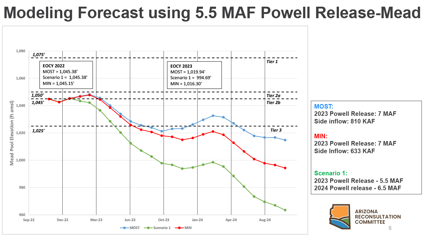
Director Buschatzke and Central Arizona Project General Manager Ted Cooke made their presentation to the Arizona Reconsultation Committee, the organization of water users and providers from across Arizona that helps develop an Arizona perspective on new long-term management guidelines for the Colorado River that are expected to go into effect before the end of 2026.
As a result of existing agreements, Arizona will leave 592,000 acre-feet of its 2.8 MAF allocation – 21 percent – in Lake Mead in 2023 to help keep the reservoir from descending to critical levels.
Including mandatory and voluntary contributions from a variety of in-state sources, Arizona will have left roughly 840,000 acre-feet in the troubled reservoir in 2022.
As reported by Buschatzke and Cooke, the states are struggling to come up with a plan to secure equitable voluntary commitments to conserve the additional 2-4 MAF.
Bureau of Reclamation Commissioner Camille Touton announced earlier this year that the system needed to conserve that stunning amount of water in Lake Mead and Lake Powell to avoid potential catastrophe. The Bureau’s efforts since then have focused on winning voluntary contribution commitments from the states. The ARC co-chairs said the discussions have not proved fruitful thus far.
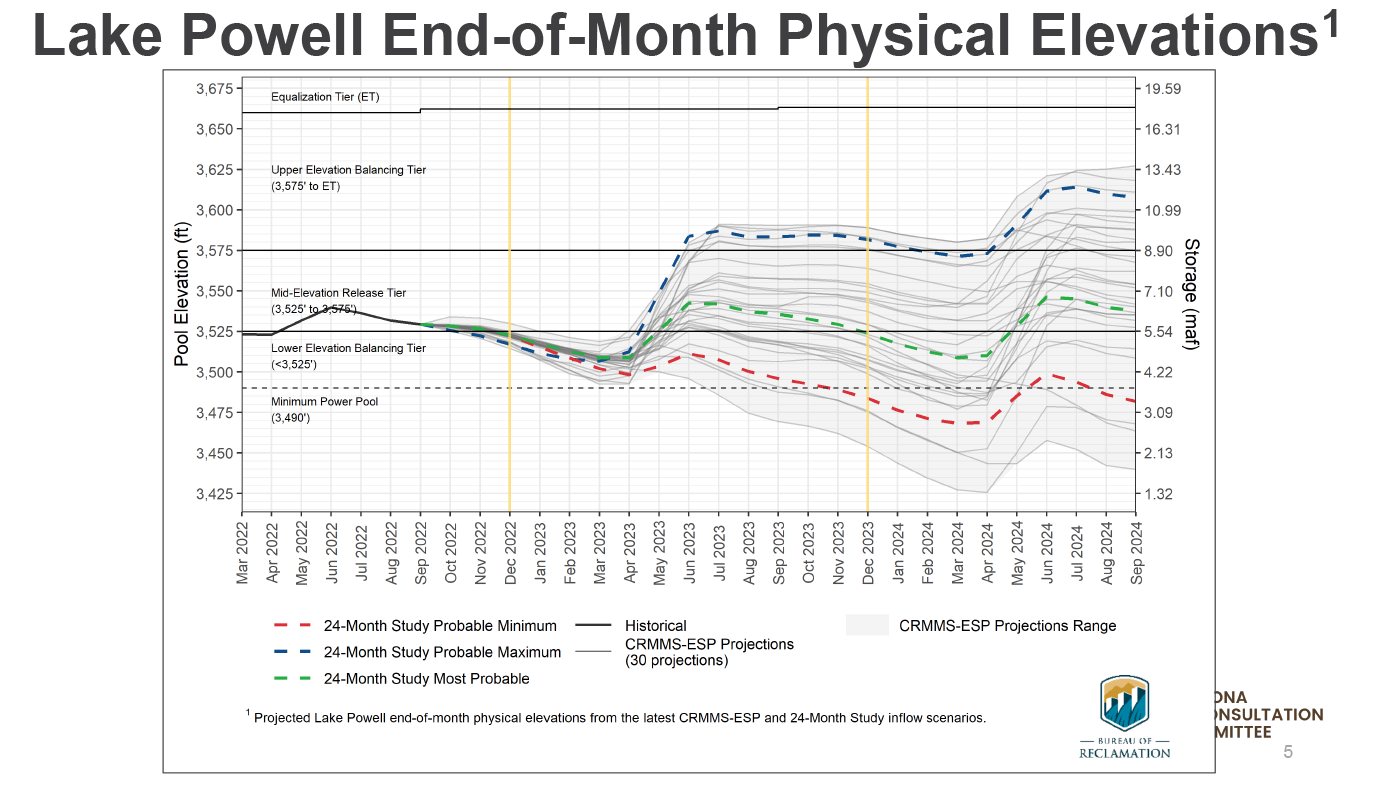
Buschatzke also described one of the more under-appreciated issues facing the Colorado River system: The ability of Glen Canyon Dam to funnel water downstream if water levels in Lake Powell descend below the eight power-producing intake valves.
Below those eight massive valves are just four “bypass tubes” that, comparatively, are “basically four garden hoses” compared to the eight intake valves.
Much of the discussion at the ARC meeting focused on one of the more controversial long-term options for dealing with chronic overuse of Colorado River water – creating a system that assesses users for system losses due to evaporation, seepage and other losses. Accounting for those losses, said Buschatzke, “will go a long way” toward getting to the 2-4 MAF needed to protect the system.
“Everyone… diverting water should own a piece of that evaporation and system loss,” said Buschatzke. [ed. emphasis mine]
The Director acknowledged that winning support for such an accounting among users and providers in Arizona, much less among the other states, “is not a certainty.”
The back of Glen Canyon Dam circa 1964, not long after the reservoir had begun filling up. Here the water level is above dead pool, meaning water can be released via the river outlets, but it is below minimum power pool, so water cannot yet enter the penstocks to generate electricity. Bureau of Reclamation photo.
When Cheyenne’s municipal water board approved a deal in October to supply up to 14,500 acre-feet of water over 15 years for a proposed gold mine west of town, attorneys insisted on inserting a clause in the contract. It retained the right to cut water deliveries if the city itself has to curtail its water use due to the Colorado River crisis.
“The majority of our water comes from the Colorado River [basin] and if that call [requiring upstream users to cut consumption] comes in, we’re in big trouble,” Cheyenne Mayor Patrick Collins said.
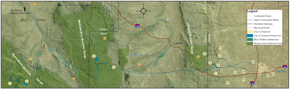
About 70% of the city’s municipal water supply originates 150 miles west in the Little Snake River drainage, a part of the Colorado River Basin. A complex “trans-basin” system of pumps, tunnels and pipelines transports the water under the Continental Divide in the Medicine Bow Routt National Forest to the city.
Cheyenne’s legal claims to the Colorado River Basin water were appropriated from 1954 to 1982 — making it a relatively new user in the system. If there is a curtailment, it would be applied to the newest or most “junior” appropriations, then work back in time to the 1922 Colorado River Compact. That means, depending on how far back in time a curtailment extends, 70% of the city’s water supply could be shut off — an action that could come as soon as 2028 if hydrological conditions keep trending for the worse, according to the Wyoming State Engineer’s office.
This map depicts Cheyenne’s municipal water supply system, which funnels in water from the Little Snake River Basin. (Cheyenne Board of Public Utilities)
“If we lose 100% of our Colorado River Compact water, we’re upside down,” Collins said, adding that about 80,000 people rely on the city’s municipal water system. “We wouldn’t have enough water to meet our current needs.”
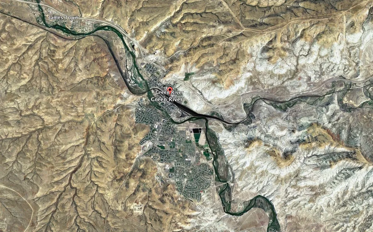
For now, Cheyenne, Baggs, Rock Springs, Green River, Pinedale and a handful of other towns that depend on water from the Little Snake and Green River basins in Wyoming are assessing where they stand in the pecking order of appropriated water rights in the event of a curtailment. Although municipalities make up a small percentage of Wyoming water users under the Colorado River Compact and associated laws, their legal claims to the water are among the most vulnerable.
First in time, first in right
If the Upper Colorado River Basin Commission issues a curtailment for Wyoming, it would not necessarily force all water users subject to the compact to close their spigots completely.
There’s no curtailment priority in terms of use — whether it’s irrigation for cattle and alfalfa fields, water consumed for cooling at the Jim Bridger coal-fired power plant or water piped to homes for domestic use. Instead, a curtailment would be applied based on the first-in-time, first-in-right water appropriations doctrine: Those who gained their water appropriation latest in time would be the first ordered to shut off their water.
For example, if the state had to curtail 100,000 acre-feet of water — approximately one-sixth of its annual Colorado River Basin consumptive water use — the state engineer would begin with the newest appropriations and work back in time until the 100,000 acre-feet of consumptive water use curtailment was met.
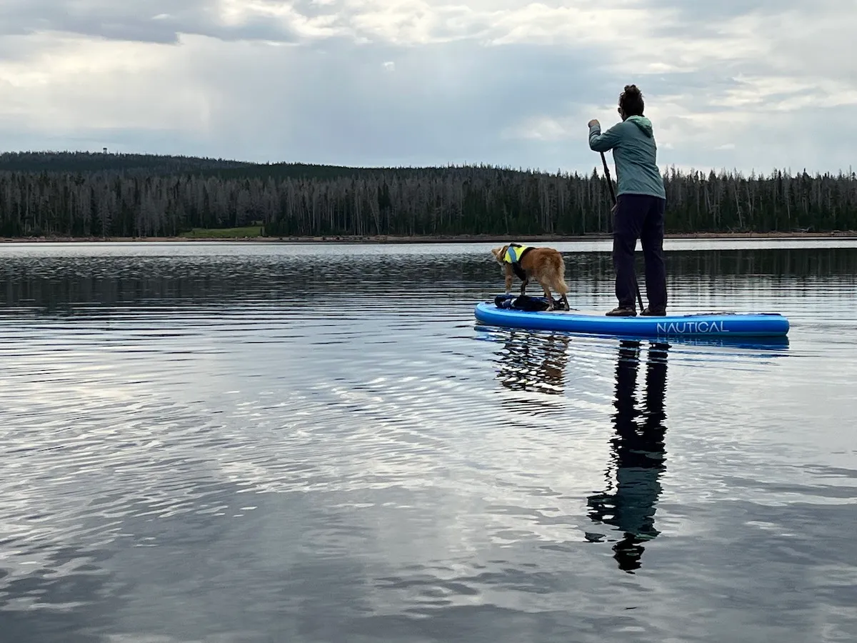
Shauna Gray and her dog, Lula Mae, paddle at Rob Roy Reservoir July 31, 2022. The reservoir is part of a trans-basin water system that supplies water to Cheyenne. (Dustin Bleizeffer/WyoFile)
If, let’s say, that required turning off all Colorado River Basin water appropriations back to 1970, that would choke off all water appropriated since then — whether for industrial, municipal or agricultural use. The cities of Rock Springs and Green River, which share a municipal water system that serves some 39,000 residents, would lose access to 75% of their Green River water appropriation. The towns would still be allowed to tap the 4,343-acre-feet-per-year appropriation they secured in 1928 and the 2,895-acre-feet-per-year appropriation that predates the 1922 compact. The rest — 75% — was appropriated in 1971 and after.
This type of variable vulnerability applies to many Colorado River Basin water users with appropriated rights that were obtained at different times. The exact order for how a curtailment would be applied is well documented and under continual review, according to the state engineer’s office.
Small straw, big vulnerability
Agriculture accounts for 83.7% of Wyoming’s consumptive use of water in the Colorado River system, according to the SEO. Municipal water use accounts for about 2.8% — or 3.3% if you include rural domestic water use. Industry — trona facilities, coal power plants, oil and natural gas processing — make up most of the remaining 13%.
Approximately 70% of agricultural irrigation water rights in Wyoming were appropriated before 1922. Those pre-1922 appropriations are not subject to the Colorado River Compact and cannot be shut off under a curtailment. The pre-1922 protection applies to all Colorado River Basin water users.
A majority of Colorado River Basin water appropriations held by Wyoming municipal water authorities, however, are post-1922. That means some 125,000 urban Wyoming residents and businesses are vulnerable to a curtailment.
Given the curtailment clause in Cheyenne’s water contract, gold mine developer Gold King Corp. is shopping around to secure alternative water resources, according to Mayor Collins. The city of Cheyenne — as well as Green River, Rock Springs and others — are doing the same.
“There is the possibility that we would not be able to collect any water from the Little Snake System if [a] curtailment call goes below 1954,” Cheyenne Board of Public Utilities Administrator Brad Brooks told WyoFile. “We are looking for additional water to mitigate this possibility and planning for the worst case that our Little Snake water will not be available.”
Green River and Rock Springs are in the same boat. Their joint municipal water system collects 100% of its water from the Green River and its tributaries to serve some 39,000 residents in and around the two cities. Only 10% of their Colorado River Basin water appropriations pre-date the 1922 compact.
Green River. (Google Earth)
Although the cities don’t rely on the full volume of their legal claims to Colorado River Basin water, the time to plan for supplemental water sources is now; 2028, the year Wyoming might first see a curtailment, isn’t far away, Green River/Rock Springs Joint Powers Board General Manager Bryan Seppie said.
“Understand, [a curtailment] probably isn’t a one-year event,” Seppie told WyoFile, adding that much depends on what Mother Nature has in store. “We’ve got to secure other water resources to serve as replacement water if [a curtailment] were to happen. Conservation is a tool, but with these types of curtailments, conservation is not going to get you out of it.”
Backup water
Part of the Gold King deal provides Cheyenne’s Board of Public Utilities approximately $5 million in fees that would help cover the cost to expand Cheyenne’s groundwater capacity. The city’s water board is also seeking up to $10.5 million in grants from the Wyoming Water Development Commission for its Borie wellfield expansion project. The expansion would add approximately 3,300 acre-feet of water per year to the city’s water portfolio, according to the board.
That would boost Cheyenne’s non-Colorado River Compact water source portfolio to 9,900 acre-feet per year. But the city would still be in trouble in the event of a curtailment because its average annual use is about 14,000 acre-feet.
“We are actively pursuing possibilities” for additional water resources, Brooks of the city’s BOPU said.
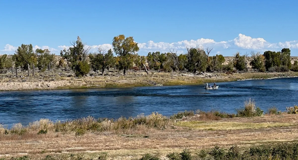
Anglers try their luck on the Green River at Seedskadee National Wildlife Refuge on Sept. 27, 2022. (Dustin Bleizeffer/WyoFile)
Expanding groundwater capacity, however, isn’t an affordable option for Rock Springs and Green River, according to Seppie. Instead, the cities are looking to those in the state with pre-1922 appropriations to share some water.
The federal System Conservation Program pays water users to curb consumption. Congress recently re-appropriated funding for the program, while the Inflation Reduction Act includes some $4 billion for efforts to modernize Colorado River Basin infrastructure and water management practices. Another $8.3 billion from the bipartisan Infrastructure law is available to address water and drought challenges throughout the U.S.
The SCP is an attractive option, Seppie said, for both ag irrigators and municipalities. Ag irrigators who volunteer for the program can use payments to upgrade their irrigation systems to waste less water.
“It’s a voluntary thing. It’s preemptive, and it’s benefiting the entire system,” Seppie said. “We haven’t gotten to a point where we’re having those discussions [with city officials]. But we have somewhat of a timeframe; 2028 is not all that far off.”
Click the link to read the post on the InkStain website (Eric Kuhn and John Fleck):
As the Colorado River Compact Commission’s negotiators returned to their task on the morning of Nov. 13, 1922, the shape of the compact was beginning to emerge into view.
Colorado Compact Commission Chairman Herbert Hoover opened the meeting by returning to the unresolved question from the previous evening – “whether we could accept a general principle of a division between the upper and lower states of the primary basis of compact?”
Arizona’s Winfried Norviel responded in the affirmative: “We in Arizona are perfectly willing to accept in principle the division of the basin into two divisions.” He went on to make it very clear that in accepting a two-basin compact, Arizona was not accepting a “fifty-fifty partition of the waters,” adding that “I think the fifty-fifty proposition is infeasible and impossible as a matter of exactitude.”
WHERE TO DRAW THE LINE BETWEEN AN “UPPER” AND “LOWER” BASIN
The discussion then turned to the point of division and the status of the Paria River. Carpenter explained that in his compact proposal, he had assumed the division would be the “old Lee’s Ferry.” Norviel the pointed out that Lee’s Ferry is just upstream of the confluence with the Paria and because of the steep canyon terrain, there were no practical gaging locations below the confluence. After a bit more discussion about gaging, Utah’s Caldwell concluded that from his perspective, the Paria River was an upper division tributary and that there was no problem with using two gages, one on the main Colorado River and a separate gage on the Paria (the situation we still have today). Hoover summarized the consensus as follows; the dividing point between the basins would be the proximate location of Lee’s Ferry, but include the Paria River, and the details would be left to a drafting committee.
BUT HOW MUCH WATER SHOULD PASS THE CHOSEN POINT?
Hoover then turned the Commission’s attention to the question of the upper river’s delivery at Lee’s Ferry. (Note that, at this point in the negotiations, the terms “Upper Basin” and “Lower Basin” were not being routinely used. They used several similar terms interchangeably – upper and lower divisions, upper and lower territories, and upper and lower river or states.)
Hoover put it this way – “the question is whether there be a positive delivery every year, or whether there should be only a delivery of a total over ten years or over three years or over five years or any other period.”
The discussion that followed was largely a two-way dialogue between Norviel and Carpenter, interrupted occasionally by Hoover to summarize or refocus the discussion, and by Arthur Powell Davis and R.E. Caldwell to add or clarify technical points. Carpenter detailed why he picked ten years. He thought it was the “sweet spot” – neither too short to be a problem for the upper river nor too long to be a problem for the lower river.
Carpenter explained that Norviel’s concern that a ten-year average would allow the upper river to deliver nothing for a year or more was not realistic and that development in the upper river would naturally flatten the hydrograph, a point the engineers in the room generally agreed with. Arizona’s Norviel remained skeptical, never agreeing to any period greater than three years The combination of a ten-year flow plus an annual minimum remained an attractive option for the others, especially Nevada’s James Scrugham and Wyoming’s Frank C. Emerson. Carpenter agreed in concept but opposed a suggestion the minimum be set at five million acre-feet per year.
Hoover recessed the meeting, suggesting they take a long lunch, noting it was hard to sit for two-and one-half hours. The Commission adjourned until 3 PM.
THAT “CRACKPOT” MAXWELL
The Commission reconvened at 3 PM. The meeting began with Secretary Stetson submitting a long letter to the record from George H. Maxwell, Executive Director of the National Reclamation Association (now the National Water Resources Association). Maxwell demanded that they delay negotiating a compact and instead turn their attention to the construction of flood control storage facilities to protect the Yuma and Imperial Valley projects. Maxwell, whom Hoover considered a “crackpot,” was one of the people he wanted to keep out of the negotiations. The Commission had adopted a policy of voting on who could join their meetings as advisors. After accepting the Maxwell letter for the record, they voted to admit L. Ward Bannister, a water attorney from Denver, as an advisor to Carpenter.
During the remainder of the afternoon, the Commission exchanged views on several topics, including the term of the compact, the status of the Gila River, and the concept of a minimum annual flow at Lee’s Ferry. Carpenter stressed his view that any minimum flow should be tied to drought in the upper river and “should result in the penalty of drought being equally distributed over the entire river system.” The meeting adjourned at 6 PM to be resumed on Tuesday morning at 10 AM.