#Snowpack off to a good start across #ColoradoRiver basin — KNAU #COriver #aridification #CRWUA2022

Westwide SNOTEL basin-filled map November 22, 2022 via the NRCS.

Click the link to read the article on the KNAU website (Alex Hager). Here’s an excerpt:

This year’s snowpack is off to a good start, but the basin would need years of back-to-back wet conditions to help erase drought.

“We’ve had a few rough years,” Becky Bolinger, Colorado’s assistant state climatologist, said. “And so to get to get us back into a more comfortable spot, we really need above average peak and a nice, slow, sustained melting season in the spring.”

To keep up those higher-than-average totals, Bolinger says the mountains need consistent snow every week until the spring. Snowpack in Arizona is much higher than in many other parts of the mountain west. Most regions that collect data in the state are showing more than 200% of the average for this time of year.

#Northglenn increasing #water rates — The Northglenn/Thorton Sentinel

Webster Lake in Northglenn February 14, 2020, Winter Bike to Work Day 2020.

Click the link to read the article on the Northglenn/Thornton Sentinel website (Luke Zarzecki). Here’s an excerpt:

The increase is part of a long-term plan for the city to be able to meet the funding and service requirements of water operations. In 2017, the city contracted Stantec Consulting to do a rate study. 

“The study determined that to meet the funding and service requirements of water and wastewater operations, revenue collections would need to increase approximately 3.6% to 6.7%  annually in each of the subsequent 10 years beginning in 2018,” the agenda read.

Future projects are the main drivers of the increase. From 2025 to 2027, there will be $37 million needed in repairs and another $37 million from 2028 to 2031.  Rates will slowly increase between Jan. 1, 2023 and Jan. 1, 2027. The first 3,000 gallons will go from $4.24 to $4.59; 3,000 to 10,000 gallons will increase from $5.31 to $5.75; 10,000 gallons to 20,000 gallons will jump from $6.64 to $7.19; and over $20,000 gallons will creep up from $9.96 to $10.78.  City Councilor Rich Kondo asked if there were any rhyme or reason to establishing the tiers. Director of Finance Jason Loveland said they were established a long time ago to encourage conservation.  The average winter consumption for Northglenn residents is about 5,000 gallons, which will go from costing $66.76 in 2022 to $69.09 in 2023. Summer months are higher: the average usage is 15,000 gallons. The price tag will increase from $125.36 to $128.84. 

Five key lessons as world’s biggest dam removal project will soon begin on the Klamath River: After more than 100 years of being dammed, the lower #KlamathRiver will flow free once again — American Rivers

Click the link to read the release on the American Rivers website (Brian Graber):

To be able to make that statement, it has taken decades of advocacy by Tribes who depend on a living Klamath River for their cultural identity and for their food security. It has also taken years of effort by the Tribes, the states of California and Oregon, the dams’ owner, federal agencies, and several nonprofits, including American Rivers, to navigate the lengthy planning, fundraising, regulatory and project design processes. But finally on November 17, the Federal Energy Regulatory Commission (FERC) approved the hydropower License Surrender to remove four dams from the Klamath River. The License Surrender follows from earlier this year, when FERC issued a Final Environmental Impact Statement recommending that the dams be removed due to their cultural and environmental impacts. There are more steps that need to be taken, including additional regulatory steps, before deconstruction can begin in 2023, but a project that has been decades of struggle and seemed to be falling apart as recently as two years ago, now feels inevitable.

The Klamath River basin is home to the Karuk, Yurok, Hoopa, and other Tribes. Salmon are both a food source and a focal point for their cultural identity. The Klamath was once a highly productive salmon river with one million fish returning to the river each year. Largely because of the four dams, there are no longer enough fish for the Tribes to have Klamath salmon as a primary food source.

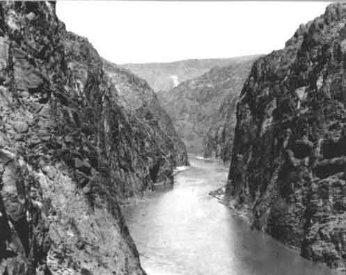
In 1918, the Copco 1 Dam was completed, cutting Klamath salmon off from the upper part of the basin. Over the next 44 years, three more dams were built (Iron Gate, Copco 2, and J.C. Boyle dams) on the river in California and Oregon, effectively closing off 400 miles of habitat to salmon and steelhead, ultimately resulting in dramatic fish population declines.

Perhaps even more devastating to life in the river, the dams’ reservoirs became breeding grounds for cyanobacteria. It is a substance that looks like a blue-green algae and is toxic to aquatic life, to humans, to livestock, and to pets. The Karuk tribe measured a Klamath toxicity content that exceeded World Health Organization guidelines by almost 4,000 times. There are warning signs near the water. When you look at the reservoirs, they look wrong, a color that makes you instantly cringe when you see it. The phosphorescent film also traps heat and depletes the oxygen content in the water. As a result, 90% of the small number of salmon that return to the river become seriously ill. Between habitat fragmentation and terrible water quality, the fish do not stand much of a chance with the dams in place.

Removing the dams will end these problems. The fish will be able to return to habitat they have not seen for a century. Cyanobacteria will be no longer be a problem – it does not persist in flowing water. The beautiful Klamath River will be better able to sustain life.

Now that the Klamath project is closer to the end than it is to the beginning, I wanted to share a few reflections on things I have learned through the project and how the project resonates nationally:

1. We need to do better for tribes and justice and food sovereignty.

The Klamath story is one that is too common for Indigenous people. While the outcome on the Klamath will be positive, the path to get there has been a struggle. In 1864, the Klamath Tribes negotiated a treaty with the United States that affirmed their sovereignty and included rights to fish for salmon. It was signed and ratified by President Ulysses S. Grant in 1870. Over the next century, U.S. companies built dams on the Klamath River that wiped out two species of salmon and brought the populations of the remaining salmon to 5% of what they were. The tribes had the right to fish, but the fish were nearly gone. In 2000, when the dam owner, PacifiCorp, did not include provisions for fish passage in their initial bid to relicense the dams, tribal members went all the way to Scotland to protest to PacifiCorp’s parent company. Later, when Warren Buffet’s Berkshire Hathaway acquired PacifiCorp, tribal members went to Nebraska multiple times to protest at the company’s annual meetings. A real turning point in the project happened in 2020 when Berkshire Hathaway executives accepted the tribes’ offer to visit the dams and meet with tribal members on the river. The tribes’ advocacy made these dam removals possible, but it should not have taken this much for the tribes to retain a cultural focus that they have had since time immemorial – that the Klamath River is free to sustain life.

2. Dam removal makes economic sense.

In ultimately deciding to decommission the dams, PacifiCorp made a sound economic decision.An early draft FERC report estimated that the dams would lose $20 million per year including expenses to operate the dams and expenses to address the dams’ water quality impacts. The California and Oregon Public Utility Commissions confirmed this, determining that dam removal would result in cheaper energy costs for their ratepayers than relicensing the dams, so much so that ratepayers are contributing hundreds of millions of dollars to remove the dams. Paying to eliminate underperforming infrastructure is a sound fiscal decision. What’s more, the power from the dams can be replaced with clean renewables and efficiency, without contributing to climate change.

3. We need to make it easier to decommission hydropower dams.

PacifiCorp originally agreed in principle to remove the dams in 2010 as part of the Klamath Hydroelectric Settlement Agreement (KHSA). In 2016 the KHSA was amended with a more defined plan to transfer the dams for removal to a new nonprofit entity, the Klamath River Renewal Corporation (KRRC). But then, in 2020, FERC denied the initial license transfer from PacifiCorp to the KRRC. The states of Oregon and California stepped in and agreed to become co-licensees, an unprecedented step that rescued the project. With the new license transfer structure in place, FERC was able to issue the Final License Surrender Order. It took 12 years after PacifiCorp agreed to remove the dams in principle, and 22 years after they first started the relicensing process, to finally determine the fate of the hydropower license and the dams. As is usually the case with dam removals, the dams will come down faster than the process to get to removal. American Rivers will continue to advocate for improvements in the processes that allow dam owners who consent to removal to remove their dams.

4. The States of California and Oregon continue to prioritize river restoration.

Through various programs, both California and Oregon provide millions of dollars each year for river and wetland restoration projects. Along with rescuing the Klamath project during the license transfer process, both states have supported the Klamath Dam removals from the beginning. Their restoration ethic should serve as models for states throughout the country.

5. The approach to develop a new nonprofit to implement a complex project has worked (again).

The Klamath River Renewal Corporation was modeled after the Penobscot River Restoration Trust, a similar structure developed to remove hydropower dams in Maine. In both cases, very complex projects were well managed by skilled staff hired for the purpose. The staff at the KRRC and their consultants (Resource Environmental Solutions (RES) and Kiewit Infrastructure West) are making the nuts and bolts of the Klamath project possible. There is no better example of that than the Final Environmental Impact Statement issued by FERC. It includes hundreds of pages of challenging issues, from cultural resources to sediment management to engineering design to public safety issues, that all need to be managed in a complex project like this. Every one of them has a clear statement of how they will be managed, demonstrating the level of thought and analysis and engineering that the KRRC has put into the project. I have seen reports on similar projects stating the impossibility of managing this much complexity. KRRC is making it all possible and clarifying that while there are many issues , they can all be reasonably managed.

This effort on the Klamath River will make history: never before have four dams of this magnitude been removed at once. The Klamath dams are large structures, ranging in height from 33 feet to 172 feet. Every successfully completed project makes the next project easier. I hope that the Klamath projects will serve as models to complete more large-scale river restoration projects throughout the country.

The Klamath dam removals will begin in 2023 and will be completed in 2024.

Klamath River Basin. Map credit: American Rivers

#Water managers add, improve temperature gauges in #YampaRiver — Steamboat Pilot & Today

The Yampa River Core Trail runs right through downtown Steamboat. Photo credit City of Steamboat Springs.

Click the link to read the article on the Steamboat Pilot & Today website (Suzie Romig). Here’s an excerpt:

The recent trends of 75-plus degrees for high summer water temperature are about 10 to 15 degrees warmer than most stream fish prefer, said Billy Atkinson, aquatic biologist for Colorado Parks and Wildlife. The Fifth Street gauge is an expensive station that includes temperature monitoring. It is also one key to deciding about timing and amounts for upstream water reservoir releases and recreational river closures. Thirty other temperature gauges of varying quality and permanence exist on the Yampa River from above Stagecoach Reservoir to Deerlodge Park in Dinosaur National Monument, according to Julie Baxter, Steamboat Springs water resources manager…

The city and partners such as Friends of the Yampa, Upper Yampa Water Conservancy District and U.S. Geological Survey have recently or are installing new temperature monitoring locations in the river based on the gaps and priorities identified in the recently completed Yampa Integrated Water Management Plan. More and improved temperature monitoring will help water managers make better decisions long term. Some of the city’s past temperature loggers have been lost from washing downstream during disturbances, Baxter said, and she supervised a small committee and consultant to move forward on a recommendation from management plan. The plan was released in September and is available online at YampaWhiteGreen.com/iwmp

The conservancy district added temperature measurement to the USGS gauge above Stagecoach Reservoir. Friends of the Yampa installed temperature loggers in several tributaries and downstream of the hot springs. The city contracted with an engineering firm to install more permanent, continuous, real-time temperature monitoring above and below the Wastewater Treatment facility. After the temperature gauges are added or improved, the goal is to post as much real-time temperature information as possible on the forthcoming Yampa River Dashboard, which is another of the 20 management plan‘s recommendations. The conservation district along with the Colorado Water Trust and nonprofit Friends of the Yampa are working to establish the online dashboard by late 2023. The dashboard would provide stakeholders a one-stop location for information related to water management such as snowpack, current climate conditions, temperatures and soil moisture.

100th Commemoration of 1922 #ColoradoRiver Compact – Dr. David Raff (USBR) #COriver #CRWUA2022

Reclamation’s Chief Engineer Dr. David Raff goes more into depth about the Lower and Upper Basins of the Colorado River Compact.

Colorado River Allocations: Credit: The Congressional Research Service

A century ago in #ColoradoRiver Compact negotiations: A path to solving the #Arizona problem? — InkStain @jfleck @R_Eric_Kuhn #COriver #CRWUA2022

Click the link to read the article on the InkStain website (Eric Kuhn and John Fleck):

Nevada’s James Scrugham. Photo via InkStain

As Chairman Herbert Hoover gaveled the 21st meeting of the Colorado River Commission to order on the morning of Nov. 20, 1922, they faced two big issues: Arizona’s concerns that the proposal on the table would not provide enough water for Lower Basin water users, and the question of whether to include construction of a dam as part of the Compact’s language. Hoover understood that unless they could find acceptable solutions to both topics, ratification of the compact by all seven states was doubtful.

First, however, Hoover suggested they “take up one or two of these subsidiary articles and see if we can’t clear them out of the way.” After that he needed to focus the discussion back to the two major issues where there was still no agreement.

TRIBAL WATER, AND REMEDIES

The first order of business was to revisit the issue of how to address Indian water rights. Hoover suggested an alternative the original provision that failed had failed to get approval from Wyoming’s Frank Emerson. Hoover’s new article read “Nothing in this compact shall be construed as affecting the obligations of the United States to Indian tribes.” The term “rights” had been removed. This satisfied Emerson, but he still questioned the need to include the provision in the compact. Hoover responded that the article’s purpose was to remove a potential objection to the compact by Congress.

With the Indian article (now Article VII) passed, the Commission went on to the next subject, an article drafted by Steven Davis on remedies. After some wordsmithing the article passed (now Article IX) – “Nothing herein contained shall be construed to prevent or limit any state from initiating and maintaining any action or proceeding legal or equitable for the protection of any right under this compact, or the enforcement of any of the provisions thereof.”  This short discussion was the closest the Commission ever got to discussing what today is commonly referred to as a “compact call.”

Colorado River, Black Canyon back in the day, site of Hoover Dam

PROTECTING IMPERIAL

After a bit more discussion of subsidiary articles, California’s W. F. McClure, its commissioner and state engineer, asked Hoover if he could raise an issue he considered “very vital.” Of the seven state commissioners, McClure had until now, been the quietest, rarely participating in the active dialogue. Now he needed their attention. He went on to say that his constituents in California understood the need for a legal document allocating water between the divisions, but there was a similar need for the basin states to support the construction of a storage reservoir to protect the Imperial Valley from flooding. McClure reiterated his request that the compact not become effective until the construction of “a dam to be built in Boulder Canyon.” For the Californians, especially the large contingent from the Imperial Valley, storage was their core issue. The upper river states had now twice blocked the Congressional authorization of storage because there was no compact protecting their rights. Now they feared the Upper Basin states would get their compact but leave California hanging with no assurance that they would support the Boulder Canyon Project. It was a difficult problem. The individual commissioners or for that matter, their governors, or their local legislators had little control over what Congress might do.

Colorado’s Delph Carpenter was unmoved. He again expressed his conceptual support for the construction of storage to protect the Imperial Valley but refused to accept a provision that would make the compact contingent upon the construction of storage. This time he had the full support of his three upper river colleagues. Carpenter offered a resolution from the Commission as an alternative. From the first meeting of the Commission ten months ago, Hoover had been an advocate for including storage in the compact, but Colorado’s Carpenter had been just as consistent in his opposition to it. Now, as they were close to completing their task of writing a compact, it was time to end the verbal debate and find a practical way to deal with the issue that would allow the compact to be ratified by all seven state legislatures.

Hoover then planted the seeds for a potential path forward, pointing out that the Imperial Irrigation District had existing perfected water rights. Under the recent Laramie River case, they might be entitled to what he called a minimum flow. He added “they feel that this pact will destroy any rights which they have for the maintenance of minimum flows.” The implication was that the compact would protect water users in the upper river that now had rights junior to the Imperial Valley with or without storage, but only storage would protect the Imperial Valley. The solution to this problem might be a general agreement on a legal principle that the compact could not impact or impair rights that existed before the compact until storage was built. In Hoover’s view this would generate significant pressure on the Upper Basin to support the Boulder Canyon Project. During the discussion Hoover warned the others that “unless these people are given some protection, they will suspend confirmation of this compact.” The matter was left unresolved, but the door was left open after Hoover’s suggested that New Mexico’s Steven Davis draft language, which McClure agreed to.

ARIZONA’S LINGERING QUESTIONS

The Commission then turned to Arizona’s Winfield Norviel’s concerns with Article III, the apportionment provision. He was now more convinced that 7.5 million acre-feet was not enough for the Lower Basin. Hoover reminded the commissioners that they had concluded they did not have sufficient data to make “an equitable division of the waters” thus, “there should be made by us a preliminary division to be followed by a revision at some subsequent date.” Norviel responded that based on the information they did have from the table prepared by Reclamation’s Arthur Powell Davis, the annual needs of the Upper Basin were 6.5 million and for the Lower Basin 7.68 million, which included the Gila and Little Colorado Rivers. Therefore, the split should be 44.5% for Upper Basin and 55.5% for the Lower Basin.

Note for the reader: The Minutes do not include the table that Norviel was referring to. Elsewhere in the minutes Davis estimated that the Lower Basin’s uses would total 7.45 million acre-feet per year including the Lower Basin tributaries. He also estimated that evaporative losses on a Boulder Canyon Project (Lake Mead) would be 240,000 acre-feet per year, a total of 7.69 million. The problem is that his 240,000 acre-feet estimate is far too low. Evaporation off a full Lake Mead is closer to a million acre-feet per year. Figures from the Fall-Davis Report which Davis often used as the technical resource for the negotiations, show the total Lower Basin evaporation could have been up to 1.5 million acre-feet per year on the Boulder Canyon, Bullhead (now Davis Dam), and Parker Dam- all three reservoirs (or their predecessors) were included in the technical section of the report. Whether Davis was simply mistaken or intentionally low-balled the estimate is a matter of speculation, but the implications remain with us today. Not considering the evaporation data that was available has contributed to the overuse of water in the Lower Basin.

Attributing the proposal to Nevada’s James Scrugham, Hoover described four options the Commission should consider:

  • Stay with a permanent 7.5 million acre-feet appropriation limit for each basin which includes present and future uses, if this is not enough for the Lower Basin, a future commission can deal with it during the next apportionment round. Norviel was already on the record as opposed to this one.
  • Limit each Basin to 8.5 million acre-feet, and during the next round, the basin with the lesser development would be given a preferential right to develop up to 8.5 million. The next round would only apportion the remainder over 17 million acre-feet.
  • Limit each Basin to 8.5 million acre-feet, during the next round if a basin had not reached 8.5 million acre-feet, the amount not being used over 7.5 million would be available to either basin.
  • Limit each basin to 7.5 million acre-feet but allow the Lower Basin to increase its use by one million acre-feet per year for a total of 8.5 million. The amount available for apportionment in the next round would be the water available over 16 million (plus any water provided to Mexico).

Hoover suggested that the Lower Basin caucus first and decide which alternative they preferred then take that to the Upper Basin. He also appointed a small drafting committee to put each option into compact language.

Hoover adjourned the meeting but did not set a time and date for the next regular meeting. He knew for at least the next day he would be very busy working with each caucus. Plus, he would need to meet with some very upset Californians.

Delph Carpenter’s original map showing a reservoir at Glen Canyon and one at Black Canyon via Greg Hobbs