Thank you veterans

Click the link to read the article on the Summit Daily website. Here’s an excerpt:
Thanks to recent snow storms in the mountains, the Blue River watershed remains above the 30-year median, and the Colorado River headwaters have had the best start to the water year since the fall of 2019. According to data from the Natural Resources Conservation Service, the Blue River currently has about 1.9 inches of snow-water equivalent — about half an inch above the median. Snow began to fall in Summit County on Thursday and continued into the weekend, bringing more inches of snow to ski areas and communities in the county.
Over the weekend, OpenSnow reported that about 6 inches fell at Loveland Ski Area, and 5 inches was recorded for Copper Mountain Resort. About 4 inches fell at Arapahoe Basin Ski Area, and another 4 inches fell at Breckenridge Ski Resort. Just over 2 inches fell at Keystone Resort.
Across the headwaters, Natural Resources Conservation Service data shows that the Colorado River is at 129% of the 30-year median. Currently, that is better than the past two water years. Last year, snow water equivalent was at about 1.7 inches, and in 2020, the headwaters had a very slow start, totaling below 1 inch by the beginning of November.

Click the link to read the article on the NGWA website:
NGWA submitted comments on November 7, 2022 to the U.S. Environmental Protection Agency on its recently proposed rule to designate PFOA (perfluorooctanoic acid) and PFOS (perfluorooctanesulfonic acid) as hazardous substances under the Comprehensive Environmental Response, Compensation and Liability Act (CERCLA), which is commonly referred to as “Superfund.”
This rulemaking, if finalized, would increase transparency around the release of these chemicals and prompt regulatory actions regarding their cleanup and disposal. The proposed rule is the EPA’s latest action as part of its PFAS Strategic Roadmap, which outlines the agency’s strategy to address PFAS (per- and polyfluoroalkyl substances) nationwide.
In its submitted comments, NGWA states the proposed rule lacks information on the impact of the designations on the groundwater industry. The Association also states the rule is unclear on how it may impact other chemical control statutes such as the Clean Water Act.
“A key concern is that the proposed rule does not address important information regarding the effect of this designation on the regulatory processes of other existing chemical constituent control statutes such as the Resource Conservation and Recovery Act, Safe Drinking Water Act, and Clean Water Act that would also regulate PFOA and PFOS and affect the groundwater industry,” said Chuck Job, NGWA’s regulatory affairs manager. “NGWA comments are directed toward a more holistic regulatory approach to PFAS contaminants. Additionally, the proposed rule raises many questions about how the measurement of a reportable amount of hazardous substance would occur.”
Click here to read NGWA’s comments.
NGWA has long been an industry leader in providing PFAS research, education, and resources to the public and scientific communities. Learn more by visiting NGWA.org/PFAS, which is a complete resource center about the groundwater contaminants featuring a recently updated top-10 facts sheet, a position paper, and more.
Also found there is Groundwater and PFAS: State of Knowledge and Practice, which NGWA published in 2017 and is one of the first PFAS guidance documents to be released. The Association recently hosted its second conference in Westerville, Ohio, focused entirely on PFAS science and remediation.
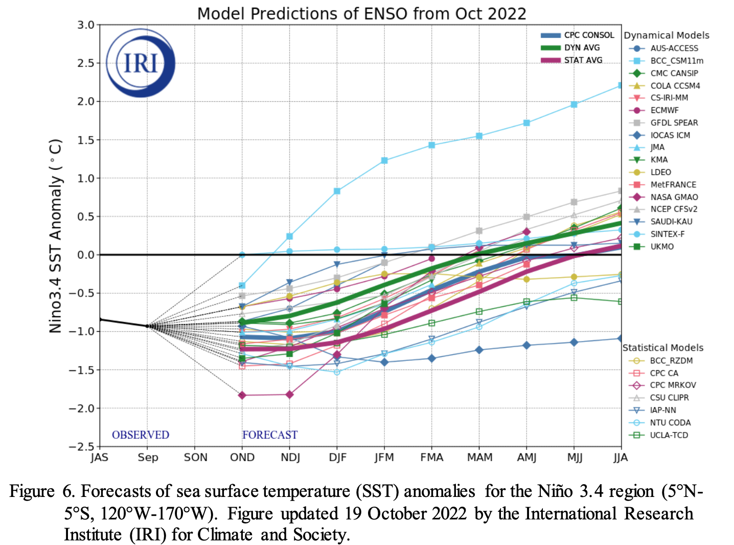
Click the link to read the discussion on the Climate Prediction Center website:
ENSO Alert System Status: La Niña Advisory
Synopsis: There is a 76% chance of LaNiña during the Northern Hemisphere winter (December- February) 2022-23, with a transition to ENSO-neutral favored in February-April 2023 (57% chance).
Below-average sea surface temperatures (SSTs) strengthened in the east-central Pacific Ocean during the past month. All of the latest weekly Niño index values were near -1.0oC, with the exception of Niño-1+2 which was at -1.8oC. Since late July 2022, negative subsurface temperature anomalies have been quite persistent, reflecting the stationary pattern of below- average temperatures across the eastern Pacific Ocean. For the monthly average, low-level easterly wind anomalies and upper-level westerly wind anomalies were evident across most of the equatorialPacific. However, in the last week, the low-level trade winds weakened in association with sub-seasonal tropical variability. Convection remained suppressed over the western and central tropical Pacific and enhanced over Indonesia. Overall, the coupled ocean-atmosphere system continued to reflect La Niña.
The most recent IRI plume forecast of the Niño-3.4 SST index indicates La Niña will persist into the Northern Hemisphere winter 2022-23, and then transition to ENSO-neutral in February-April 2023. The forecaster consensus, which also considers the North American Multi-Model Ensemble (NMME), is in agreement with the timing of this transition. The recent weakening of the trade winds suggest below-average SSTs may be near their minimum, though considerable uncertainty remains over how gradually the anomalies will decay. In summary, there is a 76% chance of La Niña during the Northern Hemisphere winter (December-February) 2022-23, with a transition to ENSO-neutral favored in February-April 2023 (57% chance).
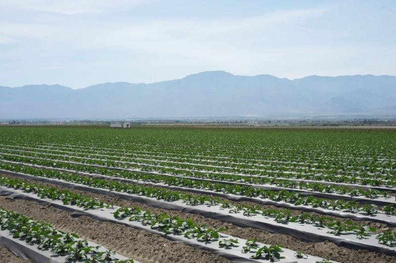
Click the link to read the release on the Coachella Valley Water District website:
Coachella Valley Water District (CVWD) Board of Directors took action to execute an agreement with the U.S. Bureau of Reclamation (USBR) to conserve Colorado River water by curtailing replenishment at its Thomas E. Levy Groundwater Replenishment Facility (Levy) for the remainder of 2022.
Understanding the need for action, the board also approved submittal of two proposals to USBR to participate in the Lower Colorado Conservation and Efficiency Program (LC Conservation Program) for up to three calendar years (CY 2023 through 2025) with combined conservation up to 35,000 acre-feet per year (af/yr) between the two voluntary, temporary, and compensated programs listed below. Under the agreement, conserved water would be reimbursed at $400 per acre-foot (af).
Program 1: The Colorado River Water (CRW) Conservation Program seeks to enroll canal water users who can demonstrate a reduction in water use. The CRW Conservation Program was previously approved by CVWD’s Board in June to be administered under the 500+ Plan, but due to external issues with funding partners delayed the program’s implementation. Under the revised program, participants will be paid up to $340/af if they are enrolled for the maximum duration of three years.
Program 2: The Thomas E. Levy Replenishment Facility (TEL) Recharge Curtailment Program (TEL Curtailment Program) will conserve between 25,000 and 35,000 af/yr. The TEL Curtailment Program would be used to supplement the CRW Conservation Program. For example, if the CRW Conservation Program can achieve 10,000 af/yr of water reduction, the TEL Curtailment Program would provide 25,000 af/yr to achieve a total water reduction of 35,000 af/yr. It is contemplated that deliveries to other replenishment facilities could be curtailed as part of this effort to better manage the impacts of the reduced deliveries to only one facility.
“Although delivering water to the Levy Facility is important for CVWD’s groundwater management, temporarily suspending delivery to the facility will allow CVWD to achieve the goal of contributing materially to the River,” said CVWD General Manager Jim Barrett. “CVWD is fortunate to have a diversified water portfolio available to meet the needs of our local communities.”
Discussions are ongoing on what additional demand management actions within CVWD’s service area might be taken to help offset the reduction in recharge at the Levy facility. The water conservation regulations enacted by the State in June required all urban water suppliers to implement conservation actions under Level 2 of their Water Shortage Contingency Plan (WSCP), which are meant to reduce demand up to 20%. Based on recent groundwater production by CVWD and other urban water suppliers, successful implementation of Level 2 actions could offset suspending delivery to the Levy facility for the remainder of CY 2022.
“California water agencies are working in real time to build on previous water-saving actions and conserve significant volumes of water each year beginning in 2022 through 2025. We are eager to partner with the Bureau of Reclamation to enable reductions in water use. California calls on our basin partners to join us in finding ways to preserve the health of the Colorado River,” said CVWD Board Director and Chair of the California Colorado River Board, Peter Nelson.
CVWD is well positioned to do its part to conserve water as the conditions worsen on the Colorado River. CVWD has historically taken steps to increase water efficiency on its canal system and to store water for future dry years.
Major conservation actions taken by CVWD include:
- Investment in its irrigation delivery system to minimize system losses through the use of pipes and also metering 100% of properties served.
- Use of drip irrigation in about 60% of CVWD’s service area, which allows the average water application to be less than 3.8 acre feet per acre.
- Lining of a 49-mile section of the Coachella Canal saves 132,000 af/yr.
- Lining of the remaining 35-mile section of Coachella Canal (in conjunction with San Diego County Water Authority (SDCWA) and San Luis Rey Band of Indians), saves 26,000 af/yr (which is transferred to SDCWA).
CVWD’s federal Colorado River water order is 399,000 af for 2022, which is about 9% of the state’s allocation. About 260,000 af of this is delivered to local farms, and the balance is delivered for environmental mitigation, groundwater replenishment, large landscape irrigation, and for use by other agencies.
Coachella Valley Water District is a public agency governed by a five-member board of directors. The district provides domestic and irrigation water, agricultural drainage, wastewater treatment and reclamation services, regional stormwater protection, groundwater management and water conservation. It serves approximately 113,000 residential and business customers across 1,000 square miles located primarily in Riverside County, but also in portions of Imperial and San Diego counties.
d

Click the link to read the release on the Utah Geological Survey website:
The Utah Geological Survey (UGS) has been awarded a federal grant for critical minerals research on the unique West Desert deposit in western Juab County. West Desert is the only established resource of indium in the United States. Indium, in the form of indium tin oxide (ITO), is an essential material used to create touchscreens on a range of consumer devices, such as smartphones and display panels, and for other industrial applications, such as windshields and solar panels.
No indium was produced in the United States in 2021. The West Desert deposit is the only domestically established resource of indium, currently estimated to contain enough to supply all demand in the United States for nearly 10 years. Resources of zinc, an essential component for many metal alloys and considered a critical mineral, and copper, one of the most essential commodities for electric vehicles and efficient energy grids, are also found at West Desert.
“We are excited for the opportunity to study the unique geology of this deposit and learn more about why so many important critical mineral resources are concentrated here,” said Dr. Stephanie Mills, senior geologist with the UGS and principal investigator of this study.
UGS funding comes from the U.S. Geological Survey Earth Mapping Resource Initiative (Earth MRI) program, which is dedicated to improving geological knowledge about domestic critical mineral resources. The project, which will run over three years, is being conducted in collaboration with American West Metals Ltd., which is currently developing the West Desert deposit. American West is a mining company focused on developing low-footprint resources to support the global energy transition. The collaboration will allow UGS unprecedented access to geological materials and data related to West Desert and support research into how this important deposit formed.

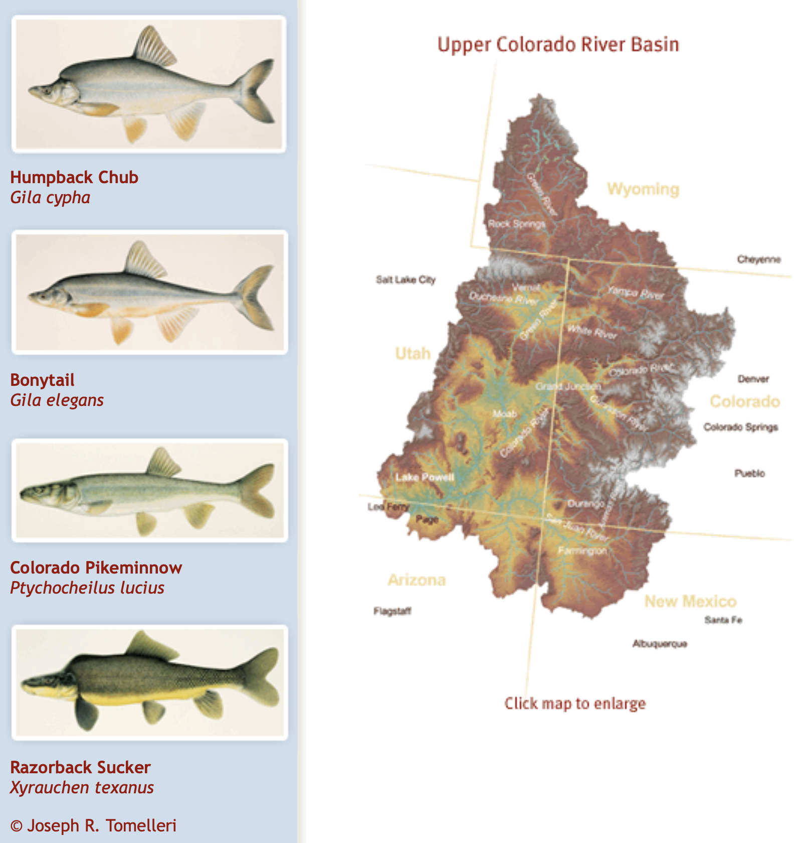
Click the link to read the release on the Reclamation website (Mary Carlson):
The Bureau of Reclamation today announced $20 million in funding from President Biden’s Bipartisan Infrastructure Law for endangered species recovery and conservation in the Colorado River Basin. Project funding will support the Upper Colorado River Endangered Fish Recovery Program, San Juan River Basin Recovery Implementation Program and Lower Colorado River Multi-Species Conservation Program.
“Our mission is to protect and manage water in an environmentally sound manner,” said Bureau of Reclamation Commissioner Camille Calimlim Touton. “This funding will help each of these programs to advance or complete projects to help protect species that are also feeling the impacts of drought.”
The Upper Colorado River Endangered Fish Recovery Program and San Juan River Basin Recovery Implementation Program work to recover endangered and threatened fish in the Upper Colorado River Basin while water development proceeds in accordance with Federal and state laws and interstate compacts. The Lower Colorado River Multi-Species Conservation Program was created to balance the use of the Colorado River water resources in Arizona, California and Nevada with the conservation of native species and their habitats.
The selected projects are:
- Colorado: $6.4 million for the Upper Colorado River Endangered Fish Recovery Program and partner Grand Valley Irrigation Company to install a fish screen to reduce or prevent entrainment of fish species into the canal system. Rehabilitation efforts will increase the survival of threatened and endangered fish species while providing more reliable deliveries for water users.
- Utah: $2.8 million for the Upper Colorado River Endangered Fish Recovery Program to address needed repairs that will improve performance and efficiency of fish hatcheries in order to enhance production of threatened and endangered fish for stocking purposes.
- Utah, Colorado, New Mexico: $800,000 for the Upper Colorado River Endangered Fish Recovery Program to improve and expand endangered fish monitoring capabilities.
- New Mexico: $3 million for the San Juan River Basin Recovery Implementation Program to provide expansion and enrichment facilities at Navajo Agricultural Products Industry Ponds and the Southwestern Native Aquatic Resources Recovery Center, which will allow the Program to meet stocking objectives for endangered fish.
- Arizona, California: $6 million for the Lower Colorado River Multi-Species Conservation Program to provide for dredging activities and equipment rental within the Section 26 Conservation Area and the design work for a power line extension needed within the Beal Lake Conservation Area. Funding will also provide for equipment needed for backwater and marsh construction at both.
The Bipartisan Infrastructure Law allocates $8.3 billion for Bureau of Reclamation water infrastructure projects over the next five years to repair aging water delivery systems, secure dams, complete rural water projects, and protect aquatic ecosystems. In August, Reclamation announced an $8.5 million investment for the Lake Mead State Fish Hatchery as part of Colorado River endangered species recovery efforts.
Click the link to read the article on The Salt Lake Tribune website (Leia Larsen). Here’s an excerpt:
Scientists note changes to the food web they’ve never seen before, which could lead to endangered species listings and other disasters at Utah’s famous natural wonder
The lake is known for thick, black clusters of brine flies by the billions, which pupate in its salty water then gather in dense mats to reproduce on shore. The insectile masses occasionally gross out beachgoers, but the bugs are harmless to humans. Crucially, they provide a nutrient-rich feast for millions of migrating birds. This year, however, the fly swarms are gone. And something’s off about the few bugs that remain. Scientists say it’s a sign the lake’s ecological demise is here…
“We don’t have clouds of flies around our ankles anymore,” biology professor Bonnie Baxter, who helms Westminster College’s Great Salt Lake Institute, told a group of researchers and lake-based industry experts late last month. “The flies don’t look right. They’re small. They’re behaving funny.”
Brine flies and brine shrimp are saline lakes’ most unique and charismatic endemic critters. They draw more than 10 million migrating shorebirds and waterfowl to the Great Salt Lake every year, from phalaropes to ducks to gulls to avocets. Now, the fly food web is all but gone, and things aren’t looking good for the shrimp, either.