Strong winds blew across mountain slopes after a record-setting warm, dry summer. Small fires began to blow up into huge conflagrations. Towns in crisis scrambled to escape as fires bore down.
This could describe any number of recent events, in places as disparate as Colorado, California, Canada and Hawaii. But this fire disaster happened over 110 years ago in the Northern Rocky Mountains of Idaho and Montana.
The “Big Burn” of 1910 still holds the record for the largest fire season in the Northern Rockies. Hundreds of fires burned over 3 million acres – roughly the size of Connecticut – most in just two days. The fires destroyed towns, killed 86 people and galvanized public policies committed to putting out every fire.
Many residents of Wallace, Idaho, fled on trains ahead of the 1910 blaze. Volunteers who stayed saved part of the town, but about a third of it burned. R.H. McKay/U.S. Forest Service archive, CC BY
Today, as the climate warms, fire seasons like in 1910 are becoming more likely. The 2020 fire season was an example. But are extreme fire seasons like these really that unusual in the context of history? And, when fire activity begins to surpass anything experienced in thousands of years – as research suggests is happening in the Southern Rockies – what will happen to the forests?
As paleoecologists, we study how and why ecosystems changed in the past. In a multiyear project, highlighted in two newpublications, we tracked how often forest fires occurred in high-elevation forests in the Rocky Mountains over the past 2,500 years, how those fires varied with the climate and how they affected ecosystems. This long view provides both hopeful and concerning lessons for making sense of today’s extreme fire events and impacts on forests.
Lakes record history going back millennia
When a high-elevation forest burns, fires consume tree needles and small branches, killing most trees and lofting charcoal in the air. Some of that charcoal lands on lakes and sinks to the bottom, where it is preserved in layers as sediment accumulates.
After the fire, trees regrow and also leave evidence of their existence in the form of pollen grains that fall on the lake and sink to the bottom.
By extracting a tube of those lake sediments, like a straw pushed into a layer cake from above, we were able to measure the amounts of charcoal and pollen in each layer and reconstruct the history of fire and forest recovery around a dozen lakes across the footprint of the 1910 fires.
Author Kyra Clark-Wolf holds a sediment core pulled from a lake containing evidence of fires over thousands of years. Philip HigueraResearchers at the University of Montana examine a sediment core from a high-elevation lake in the Rocky Mountains. Each core is sliced into half-centimeter sections, reflecting around 10 years each, and variations in charcoal within the core are used to reconstruct a timeline of past wildfires. University of Montana
Lessons from Rockies’ long history with fire
The lake sediments revealed that high-elevation, or subalpine, forests in the Northern Rockies in Montana and Idaho have consistently bounced back after fires, even during periods of drier climate and more frequent burning than we saw in the 20th century.
High-elevation forests only burn about once every 100 to 250 or more years on average. We found that the amount of burning in subalpine forests of the Northern Rockies over the 20th and 21st centuries remained within the bounds of what those forests experienced over the previous 2,500 years. Even today, the Northern Rockies show resilience to wildfires, including early signs of recovery after extensive fires in 2017.
Long-term changes in climate, forest density and fire frequency over the past 4,800 years in one high-elevation forest in the Northern Rockies, reconstructed from lake sediments. The red dots reflect timing of past fires. Kyra Clark-Wolf
But similar research in high-elevation forests of the Southern Rockies in Colorado and Wyoming tells a different story.
The record-setting 2020 fire season, with three of Colorado’s largest fires, helped push the rate of burning in high-elevation forests in Colorado and Wyoming into uncharted territory relative to the past 2,000 years.
Climate change is also having bigger impacts on whether and how forests recover after wildfires in warmer, drier regions of the West, including the Southern Rockies, the Southwest and California. When fires are followed by especially warm, dry summers, seedlings can’t establish and forests struggle to regenerate. In some places, shrubby or grassy vegetation replace trees altogether.
Fire history reconstructions from 20 high-elevation lakes in the Southern Rockies show that historically, fires burned every 230 years on average. That has increased significantly in the 21st century. Philip Higuera, CC BY-ND
Changes happening now in the Southern Rockies could serve as an early warning for what to expect further down the road in the Northern Rockies.
Warmer climate, greater fire activity, higher risks
Looking back thousands of years, it’s hard to ignore the consistent links between the climate and the prevalence of wildfires.
Warmer, drier springs and summers load the dice to make extensive fire seasons more likely. This was the case in 1910 in the Northern Rockies and in 2020 in the Southern Rockies.
When, where and how climate change will push the rate of burning in the rest of the Rockies into uncharted territory is harder to anticipate. The difference between 1910 and 2020 was that 1910 was followed by decades with low fire activity, whereas 2020 was part of an overall trend of increasing fire activity linked with global warming. Just one fire like 1910’s Big Burn in the coming decades, in the context of 21st-century fire activity, would push the Northern Rockies beyond any known records.
A lodgepole pine tree seedling begins to grow one year after the October 2020 East Troublesome Fire in Rocky Mountain National Park. Recovery in high-elevation forests takes decades. Philip Higuera
The Big Burn of 1910 left a lasting impression because of the devastating impacts on lives and homes and, as in the 2020 fire season and many other recent fire disasters, because of the role humans played in igniting them.
Reframing the challenge of living with wildfire – building with fire-resistant materials, reducing accidental ignitions and increasing preparedness for extreme events – can help minimize damage while maintaining the critical role that fires have played in forests across the Rocky Mountains for millennia.
We found that the average age of farmers was fairly consistent across the country, even though the general population’s age varies quite a bit from place to place.
To be fair, we did find some local differences. For example, in New York County – better known as Manhattan – the average farmer is just north of 31. Next door in Hudson County, New Jersey, the average farmer is more than 72.
On the whole, though, America’s farming workforce is getting older. If the country doesn’t recruit new farmers or adapt to having fewer, older ones, it could put the nation’s food supply at risk. Before panicking, though, it’s worth asking: Why is this happening?
A tough field to break into
To start, there are real barriers to entry for young people – at least those who weren’t born into multigenerational farming families. It takes money to buy the land, equipment and other stuff you need to run a farm, and younger people have less wealth than older ones.
Young people born into family farms may have fewer opportunities to take them over due to consolidation in agriculture. And those who do have the chance may not seize it, since they often report that rural life is more challenging than living in a city or suburb.
The overall stress of the agriculture industry is also a concern: Farmers are often at the mercy of weather, supply shortages, volatile markets and other factors entirely out of their control. https://player.vimeo.com/video/693568425 The ups and downs of farm life take center stage in “On the Farm,” a docuseries produced by Mississippi State University.
In addition to understanding why fewer younger people want to go into agriculture, it’s important to consider aging farmers’ needs. Without younger people to leave the work to, farmers are left with intense labor — physically and mentally – to accomplish, on top of the ordinary challenges of aging.
In other words, the U.S. needs to increase opportunities for younger farmers while also supporting farmers as they age.
Congress could do just that when it reauthorizes the farm bill – a package of laws covering a wide range of food – and agriculture-related programs that get passed roughly every five years.
Also in 2024, the USDA will release its next Census of Agriculture, giving researchers new insight into America’s farming workforce. We expect it will show that the average age of U.S. farmers has reached a new all-time high.
If you believe otherwise – well, we wouldn’t bet the farm.
San Luis Valley center pivot. Photo credit: Chris Lopez/Alamosa Citizen
From email from the Alamosa Citizen (Chris Lopez):
When it meets this week, the Rio Grande Water Conservation District Board will announce it has closed on its first two deals with crop producers to purchase groundwater wells that will be permanently retired. The deals are part of the $30 million earmarked to the Rio Grande Water Conservation District under state Senate Bill 28, which was adopted to pay Valley irrigators for their groundwater wells as part of Colorado’s efforts to reduce groundwater usage among Valley farmers and save the Rio Grande Basin. The Rio Grande Water Conservation District is paying $1.2 million to two crop producers in the first of the deals. The district opened up a second-round of applications on Oct. 10 that allows crop producers to submit a proposal for the state dollars. The second-round application period ends on Dec. 29.
The 2023 water year ended Sept. 30, and wow was it a weird one. It was snowy, then wet, then warm, then dry. It was La Niña acting like El Niño, then El Niño acting a bit like La Niña (there’s a gender-bending quip in there somewhere, but I’ll refrain). When the whopper of a winter ended, it really looked like we’d have a near-record water year.
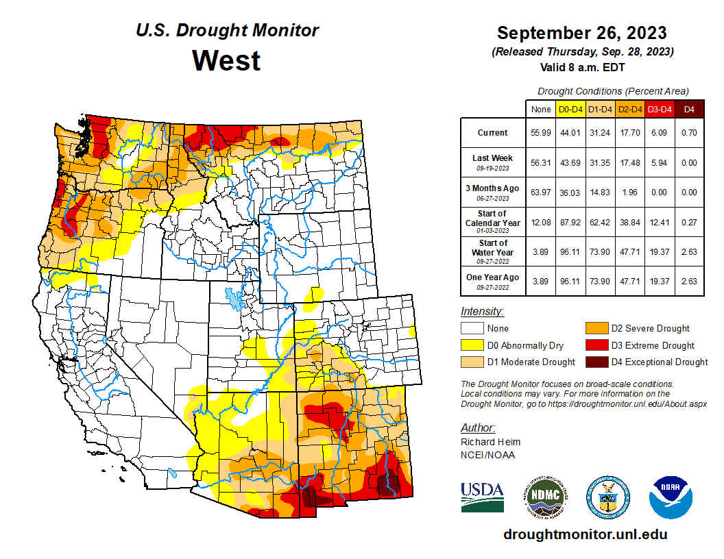
But in the Southwest, after a relatively cool June, someone cranked up the regional thermostat and turned off those waterspouts — bringing the drought back into regions that had been saturated at the end of the winter. In most places hopes for a strong — if late — monsoon were dashed. Phoenix experienced its driest monsoon on record (.15” precipitation compared to the 2.43” average), during a record-breaking summer for heat (56 110+ F days so far, breaking the 2020 record of 53 days). Tucson fared better, with a slightly below-average-precipitation monsoon, but it was also its hottest monsoon on record, with an average high of 103.7 degrees Fahrenheit. Arizona was almost drought-free in early July; now nearly the whole state is plagued by abnormal dryness.
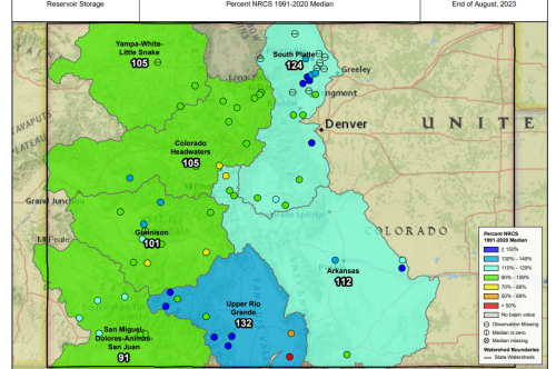
Further north, things are looking better. The precipitation graphs for the water year in southwestern Colorado show the bountiful winter followed by the dry summer. But most high-country weather stations still ended the year with above normal precipitation amounts.
Credit: NRCS/Jonathan Thompson
Public Lands Monitor
Something interesting has been happening over the last several months at the field office level of the Bureau of Land Management. The agency — often referred to as the Bureau of Mining and Livestock — has released long-term plans that actually prioritize conservation and land stewardship over extraction. It’s an indication that even as the Biden administration approves a few big oil and gas projects, like ConocoPhillips’ Willow in Alaska, it is also taking enduring action to reduce extractive industries’ impacts on public lands. For example:
The Grand Junction and Colorado River Valley field offices’ resource management plan’s preferred alternative would block future oil and gas leasing on nearly 1.6 million acres in Western Colorado. The land in question isn’t in the oil and gas hotspots such as the Piceance Basin; it’s designated as merely low to medium oil and gas potential, meaning maybe it wouldn’t have been drilled anyway. Still, it’s big enough to rile the industry and, of course, Rep. Lauren Boebert, who took time off from vaping and groping her fellow theatre-goer in public to condemn the “land grab” because, well, she’s outraged about all that groping and grabbing, apparently. And, you know, because she’s Boebert. You’ve got a few more weeks to comment and maybe offset some of that lunacy.
Up in Wyoming, the Rock Springs field office issued its own plan for about 3.6 million acres in the southern part of the state, including the Red Desert. There’s a lot here, but just to distill it down to a couple of eye-poppers, the preferred alternative includes:
1.6 million acres of ACECs, or areas of critical environmental concern, which are given an extra layer of protections and restrictions on development;
2.19 million acres closed to oil and gas development);
1.99 million acres withdrawn from hardrock mining claims;
2.48 million acres closed to wind and solar.
225,537 acres closed to all off-highway vehicles, with OHVs limited to designated roads and trails on 3.37 million acres, leaving about 13,000 acres open to OHVs.
3.58 million acres open to livestock grazing, following in the Biden administration’s pattern of favoring livestock operations over other extractive uses.
Environmental groups generally lauded the plan, with the Wyoming Outdoor Council calling it “extremely favorable to conservation,” especially of the treasured Red Desert. And then there was the response from the Dipsh%* Society …. errr certain extremist Wyoming lawmakers. State Rep. John Bear, for example, said the plan would “take away the livelihood of hundreds of ranchers.” Bear apparently didn’t make it past the cover photo of the document to see that 99.9% of the area in question would remain open to grazing. Meanwhile, Rep. Bill Allemand, not wanting to lose his seat as Mayor of Crazytown, called the RMP (along with Biden’s other environmental policies) “probably the biggest disaster in the history of the United States,” and said it would affect more people than “the Civil War, Pearl Harbor, and 9/11 combined.” Seriously? Where do they find these people? Weigh in by sending your thoughts to the BLM.
And, finally, on a related (but slightly different) note, the BLM’s Moab field office released its final 🏍️ motorized travel management plan 🛻 for the 300,000-acre Labyrinth Canyon and Gemini Bridges area. Previously there were more than 1,000 miles of routes open to off-highway vehicles in the planning area, which lies between Green River (the town) and Dead Horse Point (on the north and south ends) and the Green River and Hwy. 191. Under the new plan there are about 800 miles open to OHVs, about 100 miles of which are limited.
Miles of routes open and closed to OHVs under the BLM’s new Labyrinth Canyon/Gemini Bridges travel management plan. “Alt. A” was the existing situation. “Selected Network” is the new situation under the record of decision. Source: BLM.
Utah environmentalists generally are pleased. “Visitors will finally be able to experience stunning Labyrinth Canyon without the noise, dust, and damage that accompanies motorized recreation,” said Laura Peterson, staff attorney with the Southern Utah Wilderness Alliance. “For too long, the BLM has prioritized off-road vehicle use at the expense of Utah’s incredible natural and cultural resources. The Labyrinth Canyon plan represents an important step forward to guide the management of Utah’s public lands and reduce the impacts of off-road vehicle routes in this area.”
Oil and Gas Tracker
Some 163 barrels of crude and 6,430 barrels of oil and gas wastewater spilled from a tank battery into Alvey Wash outside Escalante, Utah, in September. The material then flowed 17 miles down the drainage, crossing a portion of Grand Staircase-Escalante National Monument in the process. Citation Oil and Gas, the operator of the facility, apparently has a slimy history in the region, racking up at least 20 spills in the last 25 years. Erica Walz got the scoop on the story for The Insider, and the Deseret News’ Kyle Dunphey followed up with Citation’s sordid track record.
***
Wyoming Gov. Mark Gordon just turned down $5 million in federal funds aimed at helping oil and gas operators plug and reclaim low-producing “stripper” wells. This program, which is purely voluntary, would reduce emissions of methane and volatile organic compounds and other nasty stuff now, and prevent these wells from being abandoned and orphaned in the future, as stripper wells often are. And it wouldn’t affect production all that much because, well, these are low producing wells. But nope, Gordon — who used to be far more reasonable than he is now — doesn’t want it because it might harm the industry and might marginally reduce oil and gas tax revenues. Such is the state of petro-politics today (i.e. positively nutty).
Colorado’s fast-growing clean energy sector today employs more than twice as many workers statewide as the fossil fuel industry, a report released this week by a trade association found.
The Clean Jobs Colorado report, released annually by clean energy business group E2, analyzed 2022 federal employment data and counted nearly 64,000 Coloradans employed across a range of categories including energy efficiency, renewable electricity generation and clean vehicles. That’s more than double the roughly 30,000 Coloradans directly employed by coal, oil and natural gas, according to E2’s analysis.
“Clean energy jobs are not only critical to the health of the energy industry but also increasingly important driving Colorado’s overall economy forward,” Susan Nedell, E2’s Mountain West advocate, said in a press release. “And this trend will only increase in the coming years as clean energy jobs make up more and more of new jobs.”
Clean energy employers in Colorado aded 2,700 jobs last year, and employment has grown about 11% faster within the industry than in the state’s economy as a whole since 2020.
“If our lawmakers want to keep and continue attracting these good paying jobs to Colorado we need their support for policies that can ensure Colorado workers and businesses reap the economic benefits from the clean energy transition,” Nedell added.
Amid a push by Gov. Jared Polis and Democratic lawmakers to accelerate the transition to 100% renewable energy, Colorado is one of only six states in the country to have more than 5,000 workers employed in both solar and wind energy, and ranks 7th nationwide in total renewable generation jobs.
The energy efficiency sector, which includes both traditional HVAC services and renewable or high-efficiency alternatives, accounted for about half of Colorado’s total clean energy jobs in 2022, according to E2’s analysis.
Though hardly a traditional car manufacturing hub, Colorado now has nearly 5,000 workers in the clean vehicle sector. State leaders have touted the jobs created by new and expanded facilities planned by EV battery manufacturers, including a lithium-ion factory in Brighton and an innovative solid-state battery plant in Thornton.
“Proven by these new numbers, Colorado remains one of the most promising regions for renewable energy and energy storage development,” said Mike Kruger, president of the Colorado Solar and Storage Association. “And as the new clean energy projects announced in the past year have shown, Colorado is proving it can compete with anyone for future workers and investment.”
One of the large bodies of water in Douglas County, the Rueter-Hess Reservoir is a drinking-water storage facility owned and operated by the Parker Water and Sanitation District, the entity that provides drinking water to much of Parker and some nearby areas. Photo credit: Parker Water & Sanitation
More than 50 people applied to serve on the Douglas County Water Commission, a new entity that is expected to help shape the future of water supply in a continually growing county. After county leaders narrowed the pool of applicants down to 12 whom they wanted to bring in for interviews, the applicants fielded questions, including ones about their connections and any conflicts of interest they might carry. The water commission is expected to help create a plan regarding water supply and conservation, among other aspects of water in the county. It’ll consist of unpaid volunteers, according to the county’s elected leaders.
The forming of the new body comes against the backdrop of a controversial proposal to pump about 22,000 acre-feet of water per year to Douglas County from the San Luis Valley, a region of Southern Colorado. Renewable Water Resources is the private company that proposed the project. Last year, county leaders Laydon and Lora Thomas joined together in deciding not to move forward with that project, while county leader George Teal has continued to support it.
Potential Water Delivery Routes. Since this water will be exported from the San Luis Valley, the water will be fully reusable. In addition to being a renewable water supply, this is an important component of the RWR water supply and delivery plan. Reuse allows first-use water to be used to extinction, which means that this water, after first use, can be reused multiple times. Graphic credit: Renewable Water Resources
Rows of soybean plants grow in the fields at Seidenstricker Farms, owned by Robert and Cathy Seidenstricker, in De Valls Bluff, Arkansas, on June 25, 2019. (USDA photo by Lance Cheung)
WASHINGTON — As Congress faces another pressing deadline to fund the government and the U.S. House grinds to a halt without a speaker, the reauthorization of the nation’s agriculture and hunger programs has taken a back seat.
But lawmakers tasked with shepherding the new version maintain their progress is “in good shape.”
The previous farm bill expired Sept. 30 and its renewal, a process that occurs every five years, remains “in the drafting stage,” said Sen. John Boozman, the Arkansas GOP lawmaker and ranking member of the Senate Committee on Agriculture, Nutrition and Forestry.
“I know myself and Sen. Stabenow, our teams are working together to try and get ideas in the text. And so we’re moving forward,” Boozman told reporters Wednesday.
Stabenow of Michigan chairs the committee.
“It’s been difficult because the appropriations process has kind of sucked all the wind out. But we’re in good shape. We don’t need an extension until the first of the year. If we do need an extension, I think we’ll be looking in the November time frame as we do the CR.”
The CR, or continuing resolution, is the funding compromise Congress struck last weekend just hours before a partial government shutdown. The temporary spending measure expires Nov. 17.
The farm bill and long-term government funding are completely different processes, but GOP House majority infighting over appropriations has stalled other priorities.
And, with the ouster of former House Speaker and California Republican Kevin McCarthy by a handful of far-right party members and all House Democrats, the lower chamber is frozen.
“As with every Farm Bill, there are forces and circumstances out of our control. What is always a complicated process has become a little more complicated, but our work continues to produce an effective Farm Bill,” said Pennsylvania GOP Rep. Glenn “GT” Thompson, who chairs the House Committee on Agriculture, in an emailed statement.
Worries over lack of progress
Thompson and fellow lawmakers have spent thousands of hours over the past two years collecting feedback from constituents on what they want to see in the multi-year bill, which is forecast to cost $1.5 trillion.
But some constituents say despite reassurance that the farm bill is progressing, they remain concerned about its delay, as well as funding for several of its programs, including the Supplemental Nutrition Assistance Program, or SNAP, formerly known as food stamps.
As a mandatory program, SNAP will continue as long as Congress approves either temporary or long-term government funding.
“The delay in considering important legislation, such as agriculture appropriations and the farm bill, creates a great deal of uncertainty for farmers and ranchers. The 2018 farm bill already expired,” Sam Kieffer, the American Farm Bureau Federation’s vice president of public policy, said in a statement.
“All families, including those in rural America, face rising interest rates, high inflation and turbulence in the marketplace,” he continued. “The farm bill provides certainty to those who grow this nation’s food, fuel and fiber and is crucial to ensuring a safe and affordable food supply. Congress has always come through on a farm bill, and they must do it again. Every family in America is counting on it.”
The 2018 farm bill was not signed into law until Dec. 20 of that year.
The expansive agricultural and food policy bill covers farmer safety net programs, conservation and sustainability incentives, international trade, rural area development, and food and nutrition programs for low-income earners — the last of which accounts for the largest portion of the bill. The legislation is one of Congress’ omnibus packages, meaning it’s made up of numerous provisions from many lawmakers.
Kansas Reflector is part of States Newsroom, a network of news bureaus supported by grants and a coalition of donors as a 501c(3) public charity. Kansas Reflector maintains editorial independence. Contact Editor Sherman Smith for questions: info@kansasreflector.com. Follow Kansas Reflector on Facebook and Twitter.
In August 2023, residents of Juneau, Alaska, watched as the Mendenhall River swelled to historic levels in a matter of hours. The rushing water undercut the riverbank and swallowed whole stands of trees and multiple buildings.
The source for the flood was not heavy rainfall – it was a small glacial lake located in a side valley next to the Mendenhall Glacier.
Glacier-dammed lakes like this are abundant in Alaska. They form when a side valley loses its ice faster than the main valley, leaving an ice-free basin that can fill with water. These lakes may remain stable for years, but often they reach a tipping point, when high water pressure opens a channel underneath the glacier.
Glacial lake outburst floods have destroyed homes, infrastructure and human life around the world. They have killed hundreds of people in Europe and thousands of people in both South America and central Asia. Globally, an estimated 15 million people live downstream from these lakes, with those in Asia’s high mountains at greatest risk.
Flooding from a glacial lake in the Himalayas on Oct. 5, 2023, left dozens of people dead in India as water swept away bridges, damaged a hydropower station and flooded small towns. Satellite images showed that the lake level dropped markedly within hours.
I study Alaska’s glacial lakes and the hazards that glacier-dammed lakes in particular can create. Our latest research shows how these lakes are changing as global temperatures rise.
When glaciers hold back lakes
Some glacial lakes are dammed by moraines – mounds of rock and debris that are left behind as a glacier retreats. Too much pressure from extreme rainfall or an avalanche or landslide into the lake can burst these dams, triggering a devastating flood. Officials say that’s likely what happened when the Himalayas’ Lhonak Lake flooded towns in India in October 2023.
Glacier-dammed lakes, like Suicide Basin off of Mendenhall Glacier, are instead dammed by the glacier itself.
These glacial lakes tend to repeatedly fill and drain due to a cyclic opening and closing of a drainage path under the ice. The fill-and-drain cycles can create hazards every couple of years or multiple times a year.
In a new study, we identified 120 glacier-dammed lakes in Alaska, 106 of which have drained at least once since 1985.
These lakes have collectively drained 1,150 times over 35 years. That is an average of 33 events every year where a lake drains its contents, sending a pulse of water downstream and creating potentially hazardous conditions.
Many of these lakes are in remote locations and often go undetected, while others are much closer to communities, such as Suicide Basin, which is within 5 miles of the state capital and has frequently drained over the past decade. https://www.youtube.com/embed/3nfiH1IB_Tk?wmode=transparent&start=0 Time-lapse video shows how a glacier-dammed lake at Mendenhall Glacier drained over two days in early August 2023.
Our study found that, as a whole, glacier-dammed lakes in Alaska have decreased in volume since 1985, while the frequency of outbursts remains unchanged. This suggests a regional decline in the potential hazards from glacier-dammed lakes because less stored water is available, a trend that has been documented for glacier-dammed lakes worldwide.
To better understand this trend, imagine a bathtub. The higher the sides of the tub, the more water it can hold. For a glacier-dammed lake, the glacier acts as a side of the bathtub. Warming air temperatures are causing glaciers to melt and thin, lowering the tub walls and therefore accommodating less water. That reduces the total volume of water available for a potential glacial lake outburst flood.
Smaller lakes, however, have had less significant change in area over time. As the August 2023 event clearly illustrated, even small lakes can have significant effects downstream. https://www.youtube.com/embed/bKVdDkfbHUo?wmode=transparent&start=4 Drone video shows some of the damage after a glacial lake drained into the Mendenhall River near Juneau, Alaska.
Alaskans witnessed a new record of destruction in Juneau from the flood. The water reached nearly 15 feet at the Mendenhall River gauge – 3 feet above its previous record.
In summer 2023 alone, Alaskans saw record or near-record flooding from multiple glacier-dammed lakes near populated areas or infrastructure, such as Suicide Basin, near Juneau; Skilak Glacier-Dammed Lake, which affects the Kenai River; and Snow Lake, which impacts the Snow River. These lakes have remained about the same volume but have produced some larger floods in recent years.
One possible explanation is that with a thinner and weaker ice dam, the water can drain much more quickly, though further research is needed to understand the mechanics. Regardless, it’s a reminder that these lakes and events are unpredictable.
How will rising temperatures affect these lakes?
Glacier loss in Alaska is accelerating as temperatures rise. Due to the large volume of glaciers and the many intersecting valleys filled with ice in Alaska, there is a high probability that new lakes will develop as side valleys deglaciate, introducing new potential hazards.
Many of these lakes are likely to develop in remote locations, and their presence may only be noticed in satellite images that reveal changes over time.
Given the abundance of glacial lakes and their potential threat to human lives, early warning and monitoring systems are worryingly sparse. Efforts are underway, such as those in the Himalayas and Chile, but further research is needed to develop reliable, low-cost monitoring systems and to improve our understanding of these evolving hazards.
New research shows that these ecosystem engineers can be an “ally in stopping the decline of biodiversity.”
Researchers in Poland have found another reason to love beavers: They benefit wintering birds.
The rodents, once maligned as destructive pests, have been getting a lot of positive press lately. And for good reason. Beavers are ecosystem engineers. As they gather trees and dam waterways, they create wetlands, increase soil moisture, and allow more light to reach the ground. That drives the growth of herbaceous and shrubby vegetation, which benefits numerous animals.
Bats, who enjoy the buffet of insects found along beaver ponds, are among the beneficiaries. So too are butterflies who come for the diversity of flowering plants in the meadows beavers create.
Some previous research has found that this helping hand also extends to birds. For example, a 2008 study in the western United States showed that the vegetation that grows along beaver-influenced streams provided needed habitat for migratory songbirds, many of whom are in decline.
A beaver dam in Bierbza Marshes, Poland. Photo: Francesco Veronesi (CC BY-SA 2.0)
The new study published in the journal Forest Ecology and Management found further evidence by focusing on birds in winter. The researchers looked at assemblages of wintering birds on 65 beaver sites and 65 reference sites in a range of temperate forest habitat across Poland. Winter can be a challenging time for birds in that environment, as they need to reduce energy expenditures in the cold weather and find habitat that has high-quality food and roosting sites.
Wintering birds, it turns out, find those qualities near beaver habitat.
The researchers found a greater abundance of birds and more species richness near areas where beavers had modified waterways. Both were highest closest to the shores of beaver ponds.
One of the reasons that birds are attracted to these areas in winter has to do with warmth: The open tree canopy caused by flooding and tree diebacks lets in more sun, and ice-free beaver ponds can release heat, previous research has found.
The changes beavers make to the landscape also provide for different kinds of birds. Standing dead wood caused by flooding is sought after by woodpeckers, and then by secondary cavity nesters that follow. The diversity of plants that grow in beaver areas produce fruits and attract insects — and therefore frugivorous and insectivorous birds.
“All beaver-induced modifications of the existing habitat may have influence on bird assemblage,” says Michal Ciach, a study co-author and a professor in the department of Forest Biodiversity at the University of Agriculture in Krakow, Poland. “But different bird species may rely on different habitat traits that emerge due to beaver activity. It’s like a supermarket.”
Just how far into the forest do beavers’ benefits extend?
While the study found that the number of bird species and the number of individuals were significantly higher in the study areas closest to beaver ponds, “for some species this tendency also held in forests growing at some distance from beaver wetlands,” the researchers wrote.
The Eurasian beaver. Photo: Per Harald Olsen/NTNU (CC BY 2.0)
Those instances, though, weren’t statistically significant. But Ciach says beaver effects can be far-reaching in other cases. He’s the coauthor of a study published last year that found a greater number of wintering mammal species near beaver ponds, which extended nearly 200 feet from the edges of ponds.
And it’s likely that what’s good for birds may be good for many other species, too.
“Birds are commonly considered a good indicator of biodiversity,” he says. “If they positively respond to beaver presence, one may expect that such patterns will be followed by other groups of organisms. At this moment we are sure it works for wintering mammals. Other groups of organisms need investigation, but I’m quite sure many other organisms will do the same.”
The growing research about beavers suggests a greater need to protect their habitat and understand their important role in the ecosystem.
“Beaver sites should be treated as small nature reserves,” says Ciach. “The beaver, like no other species, is our ally in stopping the decline of biodiversity.”
North American beaver (Castor canadensis)A beaver dam on the Gunnison River. Photo: Brent Gardner-Smith/Aspen JournalismA beaver dam along the Crystal River as it runs through a property that a private owner is seeking to donate for conservation purposes. Also visible in this photo is a Canada goose island nesting site with a large beaver lodge.
CREDIT: COURTESY PHOTO BY ALEX MENARDAmerican beaver, he was happily sitting back and munching on something. and munching, and munching. By Steve from washington, dc, usa – American Beaver, CC BY-SA 2.0, https://commons.wikimedia.org/w/index.php?curid=3963858A European Beaver in Norway. The Eurasian beaver is one of 20 species that could have a significant impact on restoring the world’s ecosystems if reintroduced. By Per Harald Olsen – User made., CC BY-SA 3.0, https://commons.wikimedia.org/w/index.php?curid=944464Beaver dam. Photo credit the Walton Family FoundationPhoto Credit: Sarah MarshallAs the restored area has increased and water presence has been permanent in the last two years, beaver (Castor canadensis) sightings are more common. Beavers feed on cottonwoods (Populus sp.) at Laguna Grande restoration site. Image credit: Guadalupe Fonseca, Sonoran InstituteBeavers have constructed a network of dams and lodges on this Woody Creek property. Pitkin County is betting big on beavers, funding projects that may eventually reintroduce the animals to suitable habitat on public lands. CREDIT: HEATHER SACKETT/ASPEN JOURNALISM
Colorado and Wyoming are collaborating to support a regional team working to power innovative pathways toward climate resiliency by utilizing data, predictive modeling and cutting edge technology to address key challenges. The Colorado-Wyoming Regional Innovation Engine (CO-WY Engine) is one of 16 finalists in the first-ever National Science Foundation (NSF) Regional Innovation Engines Competition, which will award up to $160 million in funding over the next ten years.
Officials in both states recognize the opportunity to secure federal funding that will transform the region into a national leader in developing climate-resilient and sustainable technologies and expand economic opportunities and workforce development in these key areas.
To elevate the CO-WY Engine, Colorado and Wyoming have both committed to align resources that will support the Engine’s goals, including increased engagement of the business community with the region’s research institutions and Federal Labs; attracting more funding to support the commercialization and monetization of new technologies; and growing diversity within the region’s workforce to include rural communities.
“We are thrilled to partner with Wyoming on this plan as Colorado is leading our country on environmental tech to help address climate challenges. This funding will grow the work of our universities and federal labs while creating more jobs,” said Gov. Jared Polis.
“The pathway to a prosperous global future will be paved with adequate, affordable energy and a rigorous commitment to a healthy environment,” Gov. Gordon said. “Wyoming understands the urgency of addressing climate challenges. Our unequaled leadership in innovating and developing needed technologies supports Wyoming’s all-of-the-above energy strategy. This approach will grow our economy, develop our workforce and support thriving communities.”
The CO-WY Engine, spearheaded by Innosphere Ventures, looks to transform the region into a leader in the development and commercialization of climate-resilient and sustainable technologies. These technologies will support communities across the region and the country to monitor, mitigate and adapt to climate impacts. They are expected to have direct applications to water resource management, agriculture technology, and extreme weather, including wildfires and flooding.
“We can solve so many climate-related challenges with technology-driven solutions, and NSF funding will dramatically increase what we can accomplish,” said Mike Freeman, CEO of Innosphere Ventures and lead of the CO-WY Engine’s proposal to the NSF. “We are pleased to have the support of both Colorado and Wyoming, which have such a strong history of collaboration and share our commitment to creating an inclusive, nationally and internationally relevant Engine that employs a diverse workforce and benefits rural and urban communities alike.”
Among the initiatives being explored by Colorado and Wyoming, the Wyoming Business Council, Wyoming Venture Capital, the Colorado Office of Economic Development and International Trade, and Colorado’s Venture Capital Authority are assessing the possibility of a venture capital fund or funds that will invest in startups commercializing technologies that emerge from the CO-WY Engine.
These commitments build upon existing collaboration between the two states, including a four state Memorandum of Understanding (MoU) with New Mexico and Utah to create the Western Inter-State Hydrogen Hub to advance a regional hydrogen economy. Colorado and Wyoming have also signed an MoU outlining the states’ commitments to explore the development of direct air capture to reduce carbon dioxide in the atmosphere.
“Across the Midwest and Mountain States, Wyoming and Colorado rise to the top as one of only a handful of regions that have the talented workforce, collaborative business ecosystem, and research and development capabilities to become a national leader in developing climate resilient technologies. NSF funding will accelerate that growth exponentially, and we are committed to working with Colorado to seize this opportunity,” said Josh Dorrell, CEO of the Wyoming Business Council.
“In Wyoming, Colorado has found a nimble partner equally committed to growing a strong, diversified economy, engaging urban and rural communities alike, and leveraging our regional strengths to create new commercial opportunities that also create climate resiliency. Elevating shared priorities and resources like a regional venture capital fund will directly support the development of the CO-WY Engine as a national and global leader in climate-resilient technologies,” said Eve Lieberman, OEDIT Executive Director. The NSF Engines program envisions supporting multiple flourishing regional innovation ecosystems across the U.S., spurring economic growth in regions that have not fully participated in the technology boom of the past few decades.The NSF is expected to announce successful Regional Innovation Engines this fall.
The plant now meets all new and existing state and federal regulations, while also ensuring the continued protection of local rivers. The improvements — which started in 2019 — cost $35.5 million and took more than 200,000 work hours to complete, according to a release by the City of Greeley. Construction stayed on schedule and on budget, and the plant operated without any service disruptions throughout. The city also spread out the cost over several years to reduce the burden on ratepayers.
As global temperatures shattered records and reached dangerous new highs over and over the past few months, my climate scientist colleagues and I have just about run out of adjectives to describe what we have seen. Data from Berkeley Earth released on Wednesday shows that September was an astounding 0.5 degree Celsius (almost a full degree Fahrenheit) hotter than the prior record, and July and August were around 0.3 degree Celsius (0.5 degree Fahrenheit) hotter. 2023 is almost certain to be the hottest year since reliable global records began in the mid-1800s and probably for the past 2,000 years (and well before that).
While natural weather patterns, including a growing El Niño event, are playing an important role, the record global temperatures we have experienced this year could not have occurred without the approximately 1.3 degrees Celsius (2.3 degrees Fahrenheit) of warming to date from human sources of carbon dioxide and other greenhouse gas emissions. And while many experts have been cautious about acknowledging it, there is increasing evidence that global warming has accelerated over the past 15 years rather than continued at a gradual, steady pace. That acceleration means that the effects of climate change we are already seeing — extreme heat waves, wildfires, rainfall and sea level rise — will only grow more severe in the coming years.
A two-year dam rehabilitation construction project at South Catamount Reservoir will begin October 15th when the North Slope Recreation Area (NSRA) closes for its season. This planned work and closure will continue through Spring 2026. This construction project will result in the closure of all public motor vehicle access to South Catamount and North Catamount due to the use of heavy machinery on the roadway. In addition, access to the public through permitted guided recreational activities, such as fishing and paddle boarding, will not be allowed and their future is uncertain. Hiking access to North Catamount Reservoir will be available during the project but is subject to construction project planning. Crystal Creek Reservoir reopened to the public this summer following similar rehabilitation work to its dam. It will remain open for public recreation for the 2024-2025 seasons. For more information, please email Colorado Springs Utilities at engage@csu.org or call 719-668-7765.
The month’s shocking surge is likely to make 2023 the hottest year on record and drive extreme impact around the globe. It could also be a harbinger of even higher temperatures next year.
September’s stunning rise of the average global temperature is all but certain to make 2023 the warmest year on record, and 2024 is likely to be even hotter, edging close to the “red line” of 1.5 degrees Celsius of warming above the pre-industrial level that the 2015 Paris climate agreement is striving to avoid.
As of Oct. 10, the daily average Northern Hemisphere temperature had been at a record high for 100 consecutive days. At least 65 countries recorded their warmest Septembers on record, and even after record heat in July and August, the September spike was a shock, said Carlo Buontempo, director of the European Union’s Copernicus climate change service.
“The truth is that I think many climate scientists were absolutely flabbergasted by the plot,” he said of September’s worldwide temperature reading as Copernicus released its monthly global climate report. “This is just beyond anything we’ve ever seen. The anomaly is so incredibly large. You can call it a global heatwave.”
September’s sudden spike to 1.7 degrees Celsius above the pre-industrial global temperature for the month is so far above the trend of rising temperatures and previous records for the month that Buontempo expressed concern that it could indicate a more rapid shift of the climate system to a warmer state.
“I’m not saying that has happened, but I’m saying it is an indication of a process that may not actually be linear at all,” he said.
Many climate scientists say they don’t know exactly why Earth’s fever suddenly spiked so high in September, and there “may never be a clear attribution” to a specific cause, said Gavin Schmidt, director of NASA’s Goddard Institute for Space Studies. Most likely, it’s a combination of factors, he said, a climate recipe with “a little bit of everything combining in ways we haven’t seen before.”
The uncertainty sent a shiver of unease through parts of the climate science community, especially about extremes like droughts, floods and heatwaves that might be unleashed in the coming year if even warmer temperatures materialize.
The explanations for the temperature surge range from the shift to the warm, El Niño phase in a Pacific ocean cycle, to a continued drop in the concentration of tiny sulfur-based particles of pollution called aerosols.
The scramble to explain the September readings even resulted in scientists at least partly contradicting one another about the possible causes; in some cases scientists who have authored important climate science research together. A few even discounted each other’s explanations, which may reflect a growing climate debate between two camps.
On one side are self-described climate realists—sometimes pejoratively called doomers—who say we’re already in a worst-case warming scenario leading toward existential challenges for civilization. The others subscribe to what could still be described as the mainstream belief that current and future policies will be enough to reach global climate goals.
Pushing the Upper Edge of Climate Projections
The steady long-term warming trend of the past half century is clearly caused by carbon dioxide emissions from burning fossil fuels, said Stefan Rahmstorf, a climate expert at the Potsdam Institute for Climate Impact Research.
“For four decades it’s been going as predicted,” he wrote on X (the platform formerly known as Twitter). “But we don’t understand the surprise upward leap that is happening now. And that worries me.”
But the September reading doesn’t mean the countries of the world have failed in the effort to cap global warming at 1.5 degrees Celsius, said Michael Mann, a climate scientist at the University of Pennsylvania. The Paris Agreement is aimed at preventing warming from staying above that mark for the long-term, defined by “something like a 20-year running average, or something to that effect,” he said. If greenhouse gas emissions continue on their current trajectory, that would happen in about 15 years. But a permanent breach of the 1.5 degree threshold could be avoided by cutting emissions 50 percent by 2030 and reaching zero emissions by 2050, Mann said.
A few months, or even a year, barely above the line “does not, in any way, imply that the warming trend has crossed the 1.5C warming threshold, which is what policy efforts address,” he said.
Some of the confusion over when the limit would be breached is because “there is no official definition” of what crossing the 1.5 degree Celsius threshold means, said Robert Rohde, a climate scientist with Berkeley Earth, an independent climate think tank. “Scientists and others sometimes create precise definitions for the purpose of analysis, but the Paris Agreement itself is imprecise on how the threshold is defined,” he said.
In 2021, the United Nations Framework Convention on Climate Change sharpened the definition to make it clear that it’s based on multidecadal average, “So at least 20 years,” said Andrew Ferrone, a co-coordinator of the European Union negotiation team on science issues for the United Nations Framework Convention on Climate Change.
The September temperature spike is eye-catching, and “certainly pushing the boundaries of model expectations,” Berkeley Earth climate scientist Zeke Hausfather wrote on X, posting a graph showing the monthly temperature soaring well above the range projected by some climate models.
Mann said the focus should be on annual average temperatures and noted that 2023 “is almost certain to be within the range predicted by the models,” he said. “I’m frustrated by the hyperventilating going on over this. It’s frustrating that so many continue to miscommunicate about that and mislead the public as to where we are. The truth is bad enough.”
Many other climate scientists expressed their astonishment at September’s global temperature reading in social media posts, including Mika Rantanen, a climate researcher with the Finnish Meteorological Institute, who wrote, “I’m still struggling to comprehend how a single year can jump so much compared to previous years. Just by adding the latest data point, the linear warming trend since 1979 increased by 10%.”
ERA5 September 2023 monthly data are out.
I'm still struggling to comprehend how a single year can jump so much compared to previous years.
Just by adding the latest data point, the linear warming trend since 1979 increased by 10%. pic.twitter.com/AnNAbyUQwY
Hansen Points to Aerosols, and a “Helluva a Ride” to Come
The September temperature spike is at the very highest edge of what recent climate models projected as possible, and even absent intentional miscommunication, there are divergent views about how fast Earth will warm during the next few decades. That’s partly because even the newest climate models don’t include some of the climate feed backs that amplify warming, like the huge surge of greenhouse gas emissions from wildfires.
And it’s also because scientists haven’t been able to study some of the most important atmospheric processes that will determine the pace of climate change, like the interaction between clouds and tiny particles called aerosols that come from industrial sources, primarily from burning fossil fuels, as well as natural sources, said James Hansen, the former NASA climate scientist whose 1988 testimony to Congress put climate change in the political spotlight.
In 2021, Hansen warned that the rate of warming could double over the next 25 years, heating the planet by somewhere close to 2 degrees Celsius over pre-industrial levels (3.6 degrees Fahrenheit) by 2050.
Aerosols affect cloud particle size, cloud cover and cloud brightness, which, in turn, affect how much heat energy the atmosphere absorbs. Even without directly measuring the climate effect of aerosols, Hansen said other satellite data, including from NASA’s CERES program, show changes in clouds that account for the rapidly increasing energy imbalance in the climate system, with increasing amounts of heat staying in the atmosphere.
Hansen said those measurements show that greenhouse gases can be ruled out as the main cause of September’s anomalous temperature increase.
“The data are all consistent with aerosol reduction being the cause of accelerated global warming,” he said, reiterating his recent warnings about a sudden spike of global warming . “So hang onto your hat. We are in for a helluva ride. Global warming will rise above 1.5 degrees Celsius within several months and above 2 degrees Celsius within a couple of decades, unless we take purposeful actions to restore Earth’s energy balance and climate, in addition to phasing down fossil fuel emissions as rapidly as practical.”
Those actions include geoengineering and nature restoration, as well as technologies to remove CO2 from the atmosphere, he said.
“We need to research, urgently, all of the above because plausible emission reductions will not be enough,” he said. “We have a very limited time to avoid locking in consequences for today’s young people that they will consider unacceptable, and we have allowed the problem to reach a magnitude such that strong actions will be required.”
Preemptively ruling out any method of mitigating climate change “would be the height of irresponsibility” with regard to young people and must be rejected, he said.
Other Possible Causes and Impacts
Schmidt, the NASA climate scientist, said the September temperature increase can at least partly be attributed to the emerging El Niño, when a big slice of Pacific Ocean around the equator heats up between 1 and 2 degrees Celsius above normal, which also raises the global average. But that doesn’t completely explain it, he said.
It usually takes about three to six months for an El Niño to “really make a difference to the global mean,” he said. The full impacts will be felt next year, affecting the global average by about .1 degrees Celsius, depending on how strong the El Niño becomes.
“The drivers of the current spike are going to be a little of everything in ways that we haven’t really seen before,” he said. “We may not ever have a clean attribution though.”
He said most of this year’s global temperature sets will still “all be substantially below” 1.5 degrees Celsius warming compared to the late 19th century.
“Even with the El Niño boost next year, that’s likely to be true then as well,” he said.
Kevin Trenberth, formerly with the climate analysis team at the National Center for Atmospheric Research in Boulder, Colorado, said El Niño may also be a factor in the September temperature surge because it increases the amount of heat-trapping water vapor in the atmosphere.
During El Nino, he said, the warming equatorial Pacific dissipates its heat through evaporation, ”adding more water vapor to the atmosphere that eventually finds its ways into storms and it pours with rain while releasing the latent heat,” he said. “That is what really gives the mini-global warming with El Nino.”
Regardless of the exact cause, the surging average global temperature is cause for concern, because even small increments of warming can exponentially increase the risk of some climate extremes, such as with recent heatwaves and floods, sometimes in the same place.
As the global average temperature increase approaches 1.5 degrees Celsius, studies show that increasingly large swaths of the planet will experience heat waves that will kill unprotected people after several hours of exposure. Other research identifies clear climate tipping points between 1.5 and 2 degrees Celsius that will wipe most coral reefs and nearly all mountain glaciers and raise sea level rapidly by melting ice sheets in Greenland and Antarctica.
During recent El Niños, there have also been megafires in Indonesia that emitted massive quantities of carbon dioxide, and such fires have already started this year. In January 2018, Cape Town, South Africa, nearly ran out of water, which climate researchers attributed to a combination of an El Niño that preceded the dry spell and climate change. And this year has already been disastrously bad for mountain glaciers. Switzerland’s glaciers may have lost as much as 10 percent of their mass during the past year alone, according to recent survey results.
“The standard impacts of El Nino are pretty well known of course and I do expect many of these to appear,” he said. “But on top of the current levels of warming, we’re clearly also in for some surprises.”
Sunset from the western shore of Antelope Island State Park, Great Salt Lake, Utah, United States.. Sunset viewed from White Rock Bay, on the western shore of Antelope Island. Carrington Island is visible in the distance. By Ccmdav – Own work, Public Domain, https://commons.wikimedia.org/w/index.php?curid=2032320
Synopsis: El Niño is anticipated to continue through the Northern Hemisphere spring(with an 80% chance during March-May 2024).
In September, equatorial sea surface temperatures (SSTs) were above average, though positive anomalies weakened in the eastern Pacific. All of the latest weekly Niño index values remained in excess of +1.0ºC: Niño-4 was +1.2ºC, Niño-3.4 was +1.5ºC, Niño-3 was +1.9ºC, and Niño1+2 was +2.6ºC. Area-averaged subsurface temperatures anomalies decreased, but remained above-average, consistent with elevated subsurface temperatures across the central and eastern equatorial Pacific Ocean. Tropical atmospheric anomalies were consistent with El Niño. In areas of the central Pacific, low-level winds were anomalously westerly, while upper-level winds were anomalously easterly. Convection was enhanced around the International Date Line, stretching into the eastern Pacific, just north of the equator. Convection was suppressed near Indonesia. The equatorial Southern Oscillation Index (SOI) and the traditional station-based SOI were both significantly negative. Collectively, the coupled ocean-atmosphere system reflected El Niño.
The most recent IRI plume favors El Niño to continue through the Northern Hemisphere spring 2024. Also considering recent observations and the NMME, the team favors at least a “strong” event with a 75-85% chance through November-January (≥1.5°C for the seasonal average in Niño-3.4). There is a 3 in 10 chance of a “historically strong” event that rivals 2015-16 and 1997-98 (seasonal average ≥ 2.0°C). Stronger El Niño events increase the likelihood of El Niño-related climate anomalies, but do not necessarily equate to strong impacts locally. Consider consulting CPC seasonal outlooks for probabilities of temperature and precipitation in the coming seasons. In summary, El Niño is anticipated to continue through the Northern Hemisphere spring (with an 80% chance during March-May 2024).
Winter is still weeks away, but meteorologists are already talking about a snowy winter ahead in the southern Rockies and the Sierra Nevada. They anticipate more storms in the U.S. South and Northeast, and warmer, drier conditions across the already dry Pacific Northwest and the upper Midwest.
One phrase comes up repeatedly with these projections: a strong El Niño is coming.
During a normal year, the warmest sea surface temperatures are in the western Pacific and the Indian Ocean, in what’s known as the Indo-Western Pacific warm pool.
But every few years, the trade winds that blow from east to west weaken, allowing that warm water to slosh eastward and pile up along the equator. The warm water causes the air above it to warm and rise, fueling precipitation in the central Pacific and shifting atmospheric circulation patterns across the basin.
The box shows the Niño 3.4 region as El Niño begins to develop in the tropical Pacific, from January to June 2023. NOAA Climate.gov
A strong El Niño, in the most basic definition, occurs once the average sea surface temperature in the equatorial Pacific is at least 1.5 degrees Celsius (2.7 Fahrenheit) warmer than normal. It’s measured in an imaginary box along the equator, roughly south of Hawaii, known as the Nino 3.4 Index.
But El Niño is a coupled ocean-atmosphere phenomenon, and the atmosphere also plays a crucial role.
What has been surprising about this year’s El Niño – and still is – is that the atmosphere hasn’t responded as much as we would have expected based on the rising sea surface temperatures.
Is that why El Niño didn’t affect the 2023 hurricane season the way forecasts expected?
The 2023 Atlantic hurricane season is a good example. Forecasters often use El Niño as a predictor of wind shear, which can tear apart Atlantic hurricanes. But with the atmosphere not responding to the warmer water right away, the impact on Atlantic hurricanes was lessened and it turned out to be a busy season.
The rising and sinking creates giant loops in the atmosphere called the Walker Circulation. When the warm pool’s water shifts eastward, that also shifts where the rising and sinking motions happen. The atmosphere reacts to this change like ripples in a pond when you throw a stone in. These ripples affect the jet stream, which steers weather patterns in the U.S.
This year, in comparison with other large El Niño events – such as 1982-83, 1997-98 and 2015-16 – we’re not seeing the same change in where the precipitation is happening. It’s taking much longer to develop, and it’s not as strong.
How El Niño will change with global warming is a big and open question. El Niño only happens every few years, and there’s a fair amount of variability between events, so just getting a baseline is tough.
What does a strong El Niño typically mean for US weather?
During a typical El Niño winter, the U.S. South and Southwest are cooler and wetter, and the Northwest is warmer and drier. The upper Midwest tends to be drier, while the Northeast tends to be a little wetter.
The likelihood and the intensity generally scale with the strength of the El Niño event.
El Niño has traditionally been good for the mountain snowpack in California, which the state relies for a large percentage of its water. But it is often not so good for the Pacific Northwest snowpack.
The jet stream takes a very different path in a typical El Niño vs. La Niña winter weather pattern. But these patterns have a great deal of variability. Not every El Niño or La Niña year is the same. NOAA Climate.gov
The jet stream plays a role in that shift. When the polar jet stream is either displaced very far northward or southward, storms that would normally move through Washington or British Columbia are steered to California and Oregon instead.
What do the forecasts show for 2023?
Whether forecasters think a strong El Niño will develop depends on whose forecast model they trust.
This past spring, the dynamical forecast models were already very confident about the potential for a strong El Niño developing. These are big models that solve basic physics equations, starting with current oceanic and atmospheric conditions.
However, statistical models, which use statistical predictors of El Niño calculated from historical observations, were less certain.
Even in the most recent forecast model outlook, the dynamical forecast models were predicting a stronger El Niño than the statistical models were.
If you go by just a sea surface temperature-based El Niño index, the forecast is for a fairly strong El Niño.
But the indices that incorporate the atmosphere are not responding in the same way. We’ve seen atmospheric anomalies – as measured by cloud height monitored by satellites or sea-level pressure at monitoring stations – on and off in the Pacific since May and June, but not in a very robust fashion. Even in September, they were nowhere near as large as they were in 1982, in terms of overall magnitude.
We’ll see if the atmosphere catches up by wintertime, when El Niño peaks.
How long do El Niños last?
Often during El Niño events – particularly strong El Niño events – the sea surface temperature anomalies collapse really quickly during the Northern Hemisphere spring. Almost all end in April or May.
The surface can stay warm for a while, but once the heat from the subsurface is gone and the trade winds return, the El Niño event collapses. At the end of past El Niño events, the sea surface anomaly dropped very fast and we saw conditions typically switch to La Niña – El Niño’s cooler opposite.
GRAND JUNCTION, Colo. – Colorado Parks and Wildlife has finalized a new plan to eradicate zebra mussels at Highline Lake State Park after five adult mussels were found while removing buoys on Sunday, Oct. 1.
“We did not make this decision lightly or in haste,” said Invasive Species Program Manager Robert Walters. “Over the past year we have had numerous discussions with CPW’s Northwest Region aquatic, regional, and state park staff, and we have come up with a plan that builds upon that work that was performed last spring.”
The new plan will once again be a phased approach. The first phase will begin late 2023, with the second phase taking place gradually over 2024. During the first phase, CPW staff will apply a higher concentration of EarthTec QZ, the same EPA-registered copper-based molluscicide that was applied to the lake in March. The goal of this application is to suppress the population to minimize reproductive potential in 2024.
“While the efforts in early 2023 did not achieve our ultimate goal of eradicating zebra mussels, we believe it helped to keep population numbers at a manageable level,” said Walters. “A single female zebra mussel can produce more than 30,000 eggs per reproductive cycle. Any mussel we can keep from reproducing in the immediate future increases the probability of our success next fall.”
In early 2024, CPW will begin slowly lowering Highline Lake with an anticipated complete emptying of the lake by the end of the year.
With the lower water levels, CPW is announcing Highline Lake will be closed to all motorized boating for the 2024 boating season.
“We understand that this isn’t ideal for our boating and angling community,” said Alan Martinez, Highline Lake State Park Manager. “What we hope is that people see this and understand how serious this problem is, and that it can be avoided by simply cleaning, draining, and drying your boat or any equipment that comes in contact with the water in between each and every use.”
Unfortunately, CPW cannot move fish out of Highline Lake into other waters prior to draining due to the risk of moving viable mussels on or inside fish. In this case, the only option is to reduce fish loss by removing bag and possession limits.
Anglers are reminded, effective Monday, Oct. 9, that an emergency fish salvage is in place at Highline Lake until further notice. All bag and possession limits for the reservoir are removed for the duration of the salvage. Anglers can keep all of the fish they catch from the shoreline utilizing the lawful angling methods currently allowed at the lake. CPW reminds anglers that all fish must be dead prior to transport away from the lake.
“Eradication of zebra mussels has been, and will continue to be, our goal at Highline Lake,” said Ben Felt, Northwest Region Senior Aquatic Biologist. “Earlier this year, we pursued an option that had the potential to eradicate the mussels while maintaining the fishery. Based on this recent discovery, we recognize achieving both is not feasible. To do nothing would be detrimental to Highline Lake and would put fisheries across the state at risk. CPW is committed to rebuilding the Highline Lake fishery once the zebra mussel eradication project is complete.”
A strong cold front resulted in moderate to heavy precipitation across the Great Plains, Ozarks, and western Gulf Coast during the first week of October. The most widespread improvements were made to southern Arkansas, northwestern Louisiana, southeastern Oklahoma, and eastern to central Texas where more than 2 inches of precipitation was observed this past week. Following anomalous heat across the central U.S. to start October, the cold front ushered in much cooler temperatures from October 5 to 7. The first frost or freeze of the fall affected the Northern to Central Great Plains on October 7. As the cold front progressed eastward, drought-easing rainfall overspread parts of Illinois, northern Indiana, southern Michigan, and western New York. Father to the south, short-term drought continued to expand north and east across the Southeast. Following a wet September, minor improvements were warranted for parts of Washington. Heavy rainfall, associated with Tropical Storm Philippe, resulted in improving drought for eastern Puerto Rico. Drought continues to intensify across parts of Maui and the Big Island…
A 1-category improvement was made to northwestern North Dakota and northeastern South Dakota where more than 1 inch of precipitation occurred this past week. Small improvements were also warranted in central Nebraska with the wet start to October. Although parts of eastern Nebraska also received heavier precipitation, NDMC’s long-term blend supports D2+ levels of drought. Based on drier-than-normal conditions during the past 60 days and soil moisture, abnormal dryness (D0) was expanded across the southwestern corner of Nebraska. 60-day SPI, soil moisture, and NDMC’s short-term blend supported an increase in D0 and the addition of D1 across southern Wyoming. The suppressed 2023 Monsoon and the 6-month SPEI supported an expansion of D2 in southwestern Colorado, while increasing short-term dryness led to increasing D0 coverage across northwestern Colorado…
Colorado Drought Monitor one week change map ending October 10, 2023.
A 1-category improvement was made to northeastern Montana where more than 1 inch of precipitation occurred this past week. Precipitation during the past two weeks along with long-term SPIs supported the removal of extreme drought (D3) in north-central Montana. Based on SPI at multiple time scales, severe drought (D2) was added to eastern Arizona while there was an expansion of moderate drought (D1) in western Arizona. Improving 28-day streamflows along with support from NDMC’s short to long-term blends led to a 1-category improvement for the Puget Sound of Washington along with southeastern parts of the state. Abnormal dryness (D0) was expanded across northeastern Utah due to increasing short-term dryness during the past one to three months and this was also consistent with changes made to adjacent Colorado and Wyoming…
A broad 1-category improvement was made to southern Arkansas, northwestern Louisiana, southeastern Oklahoma, and eastern to central Texas where more than 1.5 inches of precipitation occurred this past week. SPIs at multiple time scales, soil moisture, and 28-day average streamflows were also factors in determining where to depict the improvements. For areas that received more than 3 inches of precipitation and there was support from the NDMC’s drought blends, a 2-category improvement was justified across southwestern Arkansas, northeastern Texas, and the Texas Gulf Coast. Drought coverage and intensity across Texas peaked in early September when 85.68 percent of the state was covered with drought (D1 or higher) and two-thirds of the state was designated with severe (D2) to exceptional (D4) drought. Based on 90-day SPEI, an expansion of D2-D4 was made to parts of Mississippi. Impacts in Mississippi include poor pasture conditions, soybean and peanut losses, and cattle sell offs. The 90-day SPEI also supported an expansion of D4 across northeastern Louisiana. Increasing short-term dryness led to an expansion of abnormal dryness (D0) and moderate drought (D1) across Tennessee…
Looking Ahead
During the next five days (October 12-16, 2023), an intense low pressure system is forecast to track from the Central Rockies and Great Plains eastward to the Midwest and Central Appalachians. A swath of heavy precipitation (1 to 3 inches) is likely to accompany this surface low. On October 12th, a vigorous area of mid-level low pressure is expected to bring heavy snow (6 to 12 inches) to the higher elevations of Wyoming. A low pressure system is forecast to move offshore of the Southeast by October 13th after it brings widespread precipitation to parts of the Southeast. Mostly dry weather is forecast to persist across the Tennessee Valley, while much drier weather prevails across the Southern Great Plains. Periods of light to moderate precipitation are expected for the coastal Pacific Northwest.
The Climate Prediction Center’s 6-10 day outlook (valid October 17-21, 2023) favors near to below-normal precipitation throughout much of the contiguous U.S. with above-normal precipitation most likely across southeastern Alaska. Increased probabilities for above-normal temperatures are forecast across the West and Northern to Central Great Plains, while below-normal temperatures are likely for the Mid-Atlantic and Southeast.
US Drought Monitor one week change map ending October 10, 2023.
Just for grins here’s a slideshow of US Drought Monitor maps from early October for the past few years.
Colorado River “Beginnings”. Photo: Brent Gardner-Smith/Aspen Journalism
Click the link to read the article on the InkStain website (John Fleck):
Editor’s note: Today (Oct. 11, 2023) is the 75th anniversary of the signing of the Upper Colorado River Basin Compact. The following is an excerpt from Revisiting the Upper Colorado River Basin Compact on its Diamond Anniversary, a forthcoming analysis by Eric Kuhn and John Fleck, co-authors of the book Science Be Dammed: How Ignoring Inconvenient Science Drained the Colorado River.
BY ERIC KUHN AND JOHN FLECK
The Upper Colorado River Basin Compact was signed by representatives from Arizona, Colorado, New Mexico, Utah, and Wyoming on October 11, 1948, after over two years of negotiations. It was an attempt to resolve the allocation of water among the five states, and for three quarters of a century it performed that task well.
But as we approach the middle of the third decade of the 21st century, the challenges of overallocation of Colorado River, over-appropriation of the water we have, and climate change reducing the river’s flows, the Upper Basin Compact and the extended body of rules in which it is embedded are showing their age.
At its simplest, the Upper Basin Compact divided the water use available from the 7.5 million acre-feet per year apportioned to the Upper Basin by the 1922 Colorado River Compact. The compact accomplished two major tasks:
It apportioned the consumptive use of water among the Upper Basin states using percentage allocations. Colorado received 51.75%, New Mexico 11.25%, Utah 23%, and Wyoming 14% of the water available for use in the Upper Basin. Arizona received a fixed 50,000 acre-feet per year.
It defined the obligations of the Upper Division states (Colorado, New Mexico, Utah, and Wyoming) to deliver water to the Lower Basin at Lee Ferry to satisfy the requirements of the Colorado River Compact.
In pursuing a new set of post-2026 Colorado River Operating rules, major water agencies and state leaders have insisted that the “Law of the River” – the suite of rules dating to the 1922 Colorado River Compact and including the Upper Basin Compact – should be a fundamental guiding principle of future river management. “The Post-2026 Operations should reside in a framework consistent with a reasonable interpretation of the Law of the River,” the Central Arizona Project wrote, to cite one example among many.[1] But a careful review of the history of the Upper Basin Compact shows how tenuous a foundation the Law of the River provides, and how uncertain any attempt at “reasonable interpretation” might be, because of fundamental uncertainties about what the Law actually says.
When the Upper Basin compact was signed there was agreement on the definition of the “what” to which the percentage allocations apply. Water use in the Upper Basin was limited by water availability after meeting the Colorado River Compact’s Lee Ferry delivery requirements. Today, because of the impacts of climate change on flows, there is no such agreement and there are claims that the intent of the compact was to provide an equal amount of water for use to each basin. This creates deep uncertainty in the actual volumes of water available to each state.
There is still no consensus on how to measure consumptive use basin-wide. The Upper and Lower Basins use different methods, and Lower Basin tributary use is neither well understood nor quantified. This makes managing the river system challenging.
The Upper Division States claim overuse by the Lower Basin based by using one measurement method, while using a different method for their own uses. There is valid dispute over these theories and methodologies.
Tribal water rights remain unresolved and limited in some cases by provisions aimed at preventing tribes from using their full legal entitlements.
Native America in the Colorado River Basin. Credit: USBR
In negotiating the Upper Basin Compact, the states made key decisions on critical compact issues that continue to echo through 21st century water management.
STREAM DEPLETION
Colorado River management has always suffered under controversy and ambiguity around the question of how to measure consumptive use. The Colorado River Compact did not include a definition of “beneficial consumptive use.” In the century since it was signed, two competing (and conflicting) methods have been used: diversions less return flow, and stream depletion. On some scales, they may look the same. But on large enough scales, they do not, in ways that have profound implications for 21st century river management decisions.
Under the stream depletion theory, each basin’s consumptive use is measured as the net reduction in natural flows caused by man-made activities. For example, the Upper Basin’s consumptive use would be calculated as the amount that upstream uses deplete the natural flow of the river at Lee Ferry.
During the Upper Basin Compact negotiations, Colorado and Arizona were the main proponents of this theory. It was ultimately adopted in Article VI of the Upper Basin compact as the method for measuring consumptive use.
But the stream depletion theory is not universally used in river management today. It is, for example, used to quantify reservoir evaporation in the Upper Basin, but not the Lower Basin. It is not used to measure Lower Basin mainstream uses, where the “diversions minus return flows” method is used instead. Uses on the Lower Basin tributaries, which are included in the compact definition of “Colorado River System” are currently not measured at all – using either theory.
ALLOCATING STATE WATER BY PERCENTAGES RATHER THAN ABSOLUTE AMOUNT
The Upper Basin Compact is frequently praised for state-by-state allocations based on percentages (except Arizona), rather than absolute numbers, thus avoiding the mistake in the Colorado River Compact that over-allocated the river’s water.
But modern policy discussions are unsettled on a central issue – percentage of what? On their own, the percentages are meaningless without reference to some sort of underlying total amount of water available to be shared among the states.
When negotiating the Upper Basin Compact, the states’ representatives were clear on what they intended as the basis for using the percentages. They intended to apply the percentages to the amount of water available for consumptive use in the Upper Basin after meeting what they viewed as their compact “delivery obligations” at Lee Ferry.
Updated Colorado River 4-Panel plot thru Water Year 2022 showing reservoirs, flows, temperatures and precipitation. All trends are in the wrong direction. Since original 2017 plot, conditions have deteriorated significantly. Brad Udall via Twitter: https://twitter.com/bradudall/status/1593316262041436160
Today, there is no such consensus. Climate change has altered the river’s hydrology, putting the burden of impacts on the Upper Basin. Its leaders have responded by arguing that the compact’s negotiator’s intention was to equally divide the water available to each basin for use. Since climate change is causing a decline in natural flows, whatever Lee Ferry obligations the Upper Division States have must now be adjusted to reflect the new hydrologic reality.
Resolving this issue requires either litigation, negotiated settlement, or collectively agreeing on a modified approach – one that appropriately factors in climate change and maintains the benefits of the 1948 flexible percentage allocations.
TRIBAL WATER
While large Native American water needs and legal entitlements were identified before the Upper Basin Compact was negotiated, Tribal communities were excluded from the negotiations. Instead, Indian water use, which the negotiators knew was legally perfected long before 1922, was lumped into state allocations, with each state being responsible for meeting tribal needs from its share of the water. This gamble set up a potential conflict between the apportionments made by the Upper Basin Compact and the protections provided Indian rights under the Colorado River Compact.
A decade after the compact was signed, this conflict became real. In response, Upper Basin leaders took steps to limit tribal water rights and prevent full use of tribal entitlements, by inserting provisions in project authorizing legislation. The implications today are a legacy of intentional discrimination against tribes, unresolved legal questions around tribal water rights, and provisions that treat Native Americans as second-class citizens.
[1] Brenda Burman letter to Bureau of Reclamation, Aug. 15, 2023. See also comments by the state of Wyoming, the Salt River Project, the state of Colorado and the Upper Colorado River Commission.
Ranchers and farmers across the Colorado River Basin, who control roughly 80% of the drought-strapped river’s flows, are reluctant to sign up for voluntary, government-funded water conservation programs for a variety of reasons identified in a new report.
Chief among them are a fear of losing their water rights, seeing their water use reduced, and engaging with far-off bureaucracies that they believe aren’t qualified to help.
“Agricultural Water Users’ Preferences for Addressing Water Shortages in the Colorado River Basin” is a study conducted by the Western Lands Alliance (WLA) in partnership with the Ruckelshaus Institute at the University of Wyoming in Laramie. Released late last month, it includes survey responses from more than 1,000 ranchers and farmers in six Colorado River Basin states, as well as interviews with producers. The WLA represents landowners and agricultural producers across the West.
The WLA launched the research effort to better understand how agricultural water users in the region view different water conservation efforts and what it would take to convince them to participate. Hallie Mahowald, a co-author of the report and chief programs officer at the WLA, said in a webinar in September that the landowners will be key to finding solutions to the growing shortages on the river because they control so much of its water.
“We feel it is critical to understand landowner perspective and to solicit landowner input if we are going to develop successful strategies to address Western water shortages,” she said.
Updated Colorado River 4-Panel plot thru Water Year 2022 showing reservoirs, flows, temperatures and precipitation. All trends are in the wrong direction. Since original 2017 plot, conditions have deteriorated significantly. Brad Udall via Twitter: https://twitter.com/bradudall/status/1593316262041436160
The report comes as the river basin remains mired in a long-running drought that has come close to crippling lakes Powell and Mead and experiences ongoing shortages as climate change continues to sap its flows.
At the same time, hundreds of millions of dollars in federal funding is being made available to help the Colorado River Basin states better manage the river, reduce water use, and develop programs to sustain the basin’s cities and farms as the region continues to warm.
Drew Bennett, MacMillan Professor of Practice in Private Lands Stewardship at the University of Wyoming in Laramie, said the survey results show a disconnect between ranchers and farmers and the agencies who are charged with overseeing Colorado River Basin water management. In fact, more than 85% of those surveyed said they did not trust the water agencies that help manage the giant river system.
“We need to build additional trust…it will be absolutely critical moving forward,” Bennett said.
And while more than 50% of those surveyed are engaging in at least limited conservation practices, they are not interested in doing more if their water rights aren’t strongly protected, if they are not adequately compensated, and if the programs aren’t administered locally.
This lack of trust, the report says, “may create a barrier to gaining buy-in for new water management strategies, even if they are supported by significant funding from state and federal government agencies.”
The river basin spans seven states. The Upper Basin includes Colorado, New Mexico, Utah and Wyoming, and the Lower Basin includes Arizona, California and Nevada.
Researchers broke out survey responses based on which basin a grower operates in. Key findings of the report include:
97% of Upper Basin growers (Colorado, New Mexico, Wyoming and Utah) and 96% of Lower Basin growers (Arizona, California and Nevada) are worried about coming shortage-related changes in water policy and new constraints on their water use.
Just 14% of Upper Basin growers and 13% of Lower Basin growers believe that existing water policies and management practices are adequate to address coming shortages.
69% of Upper Basin and 74% of Lower Basin growers have implemented at least one water conservation practice, largely in response to local water shortages.
56% of growers in both basins would engage in programs to improve their water delivery systems if funding is provided.
Just 8% of Upper Basin and 18% of Lower Basin growers would participate in programs that would fallow, or cease production, on the same field for multiple years.
And just 13% of Upper Basin and 14% of Lower Basin growers said there was a high level of trust between water users and water management agencies.
In Colorado, the Colorado Ag Water Alliance has been working to help producers use water more efficiently to prepare for future droughts and manage with less water. But CAWA’s Executive Director Greg Peterson said it’s a difficult task.
“Our goal is to help these people survive. People [who don’t farm] don’t actually understand that there are few opportunities to reduce water use in an agricultural setting,” Peterson said. “You might be able to reduce water use by 5% or maybe 10% without reducing yields. But it’s not easy to do.”
Wyoming and other basin states have begun installing sophisticated new technologies that help determine how much water crops consume, known as consumptive use, and how much water runs off and returns to the river or natural environment after a field has been irrigated. This is a critical measurement because it is only the consumptive use portion of irrigation water that can be administratively “saved” as water left in the river system.
Jeff Cowley is administrator for interstate streams in the Wyoming State Engineer’s Office, the top water regulator in the state. Cowley is implementing new conservation technologies and working with growers who are already participating in one of the new federal programs known as the System Conservation Pilot Program.
Homing in on how much water is saved and left in the river is a complicated question whose answer differs from field to field and crop to crop. When water was plentiful, before the drought and climate change, there was enough water that this kind of precision wasn’t required. But that is no longer the case.
Cowley said this new level of precision is another critical factor in working with skeptical farmers and ranchers because it provides some certainty on what impact programs could have on their water supplies.
“Folks are attached to their water,” Cowley said. “They are willing to try new things, but not on their own dime.”
And any given year, he said, “there is not a lot of room for mistakes.”
Fresh Water News is an independent, nonpartisan news initiative of Water Education Colorado. WEco is funded by multiple donors. Our editorial policy and donor list can be viewed at wateredco.org.
More by Jerd Smith Jerd Smith is editor of Fresh Water News. She can be reached at 720-398-6474, via email at jerd@wateredco.org or @jerd_smith.
Click here to download the report. (Bennett, D., Lewis, M., Mahowald, H., Collins, M., Brammer, T., Byerly Flint, H., Thorsness, L., Eaton, W., Hansen, K., Burbach, M., and Koebele, E. 2023.). Here’s the executive summary:
Executive Summary The Colorado River Basin is in crisis. There is no longer enough water for all of those who depend on it. The agricultural sector is the largest water user in the Colorado River Basin, meaning that farmers and ranchers are central to both the impacts of and solutions to water shortages. Their involvement will be key to developing effective policy solutions to today’s water crisis.
We surveyed 1,020 agricultural water users throughout six states in the Colorado River Basin to understand their perspectives on the present crisis, their current water conservation practices, and their preferences for strategies to address water shortages going forward. Agricultural water users were primarily concerned about how the current situation could impact water policy, constrain irrigators’ own water use, and constrain other agricultural water users. We also conducted qualitative research to capture preferences for local approaches to managing water and provide additional context on dynamics in the Colorado River Basin, including interviews with 12 agricultural producers and water experts and a focus group with 10 agricultural water users in Colorado.
Perhaps unsurprisingly, we found agricultural water users are already responding to water shortages. Roughly 70% of surveyed agricultural water users have already adopted one or more water conservation practices or adaptation strategies. Importantly, many would consider adopting additional practices. Despite this, few respondents participated in or were aware of formal programs to support water conservation. One exception, however, was the Natural Resources Conservation Service’s Environmental Quality Incentives Program (EQIP). A third of respondents currently or previously participated in EQIP and an additional 37% were aware of the program. Information gathered from interviews and the focus group identified multiple burdens to participation in EQIP and similar programs, and several participants thought the benefits were not worth the effort. These insights suggest an opportunity for revisiting how formal programs meant to incentivize water conservation connect with water users.
Most survey respondents were unlikely to adopt water conservation practices as part of formal demand management or system conservation programs to address water shortages. Only one of eight practices included in the survey – enhancing water delivery systems – had a majority of respondents state that they were likely to adopt the practice. The remaining seven practices had a considerably lower likelihood of adoption. Respondents were also generally opposed to water transfers as a solution to shortages. Opposition was strongest to permanent transfers broadly, as well as to temporary transfers from agricultural to non-agricultural uses. Only temporary transfers from agricultural water users to other agricultural water users had less than 50% opposition. Major barriers to supporting water transfers included concerns about losing water rights, even in temporary transfer arrangements, as well as insufficient financial compensation. Addressing these concerns will be critical to increase participation of agricultural water users in demand management or system conservation. Still, although support for temporary water transfers and demand management practices was low, even equivalently low participation (e.g., 10% to 20%) could help address water shortages as part of a portfolio of strategies for the Colorado River Basin.
We also documented an overwhelming preference for local approaches to managing water shortages and a trust gap with non-local agencies. This was evidenced by respondents’ preference for the local management of formal programs, such as some of the demand management and system conservation programs under consideration, as well as for the administration of funding for water conservation and other programs. Qualitative research participants communicated that strategies to address water shortages must account for the diversity of local contexts across the Colorado River Basin. These strategies could therefore be best implemented at the local level through existing delivery infrastructure and by managers with track records of success. State and federal water managers and agencies involved in program delivery should emphasize building trust with agricultural water users and gaining knowledge about unique features of local contexts. Simply providing additional funding for formal water conservation programs may be inadequate to meet the diversity of challenges across an area of 246,000 square miles. Developing opportunities for dialogue and listening can help foster relationships and improve trust among key stakeholders.
Given the importance of agriculture as the primary water user in the Colorado River Basin, proactively engaging agricultural communities will be critical to successfully managing water shortages. Understanding the perspectives and preferences of agricultural water users, as documented in this report, can help guide the development of solutions that work for producers and other users in the Basin.
Map of the Colorado River drainage basin, created using USGS data. By Shannon1 Creative Commons Attribution-Share Alike 4.0
DENVER — Wednesday, Oct. 11, 2023 — The Denver Board of Water Commissioners on Wednesday, Oct. 11, adopted rate changes to help pay for important upgrades, projects and ongoing maintenance and repair work to keep its system operating efficiently while keeping rates as low as good service will allow.
The new rates take effect Jan. 1, 2024, and for typical single-family residential customers who receive a bill from Denver Water, if they use the same amount of water in 2024 as they did in 2023, the new rates will increase their monthly bill by an average of $1.60 to $2.30 over the course of the year, depending on where they live.
“Denver Water is at a pivot point. These are historic times and we’ll be affected, just as the communities we serve will be affected, by climate change, population growth, variability in the economy, inflation and supply chains,” said Alan Salazar, Denver Water’s CEO/Manager who joined the organization in August.
“Water is a crucial resource that supports all of us. You can’t have civilization without it. Continuing to maintain and invest in the system that supports our water supply will ensure we — Denver Water as well as our customers — are ready for what lies ahead, while keeping rates as low as good service will allow.”
Denver Water expects to invest $1.9 billion over the next 10 years in projects that will maintain, repair, protect and upgrade the system and make it more resilient and flexible in the future. The utility is committed to ensuring the system can reliably deliver safe, clean and affordable water to its customers while mitigating the effects of the economy, from inflation to supply chain issues, on its costs.
More details on the rate increase can be found at these links:
Water rates to rise slightly in 2024 — Provides details on Denver Water’s rate structure and how the increase impacts customer bills, including an infographic visually highlighting the impacts to customers inside and outside of Denver.
Major investment on tap — Highlights what water rates help pay for with an overview of some of the projects that make up the utility’s 10-year forecast for an estimated $1.9 billion investment into the system that supports about 25% of the state’s population, including Colorado’s capital city. The story includes a video highlighting some of the current projects including the expansion of Gross Reservoir, the Lead Reduction Program that is replacing customer-owned lead service lines at no direct cost to the customer, the new Northwater Treatment Plant under construction north of Golden and the new water quality laboratory now operational at the National Western Center near downtown. The investment forecast also includes improving and replacing aging water mains under the streets and improving the overall flexibility and resiliency of the system and our communities.
Since January 2020, Denver Water has replaced more than 20,000 customer-owned lead service lines at no direct cost to the customers.
The utility in 2022 signed a Memorandum of Understanding with several water utilities across the West to reduce the use of water-intensive Kentucky bluegrass in places where it’s purely decorative, such as traffic medians.
Click the link to read the article on the NOAA website:
Key Points:
Hurricane Lee, Tropical Storm Ophelia and a slow-moving coastal low brought record-breaking precipitation and widespread flooding across parts of the East Coast.
Near-record to record-warm temperatures were observed across much of the southern Plains and Upper Midwest this month.
Year-to-date averages across the eastern U.S. have been warmer than average throughout 2023 with 30 states experiencing a top-10 warmest January–September.
September 2023 was the seventh-warmest September on record for the nation, and precipitation ranked in the driest third of the historical record for the month.
Other Highlights:
Temperature
The average temperature of the contiguous U.S. in September was 67.8°F, 2.9°F above average, ranking seventh warmest in the 129-year record. Generally, September temperatures were above average across much of the contiguous U.S., with below-normal temperatures in southern parts of the West Coast and in parts of the Southeast. New Mexico and Texas ranked warmest on record for September while Minnesota ranked second warmest on record. An additional 10 states ranked among their top-10 warmest September on record.
The Alaska statewide September temperature was 40.6°F, ranking near normal in the 99-year period of record for the state. Near-normal temperatures were observed across much of the state with above-normal temperatures observed in parts of North Slope, the Aleutians and Panhandle, while below-normal temperatures were observed in parts of the Interior and southwest Alaska.
For the January–September period, the average contiguous U.S. temperature was 57.0°F, 1.9°F above average, ranking 10th warmest on record for this period. Temperatures were above average from parts of the Southwest to the East Coast and along parts of the Northern Tier, with near- to below-average temperatures from parts of the northern Plains to the West Coast. Texas, Louisiana, Mississippi and Florida each ranked warmest on record while Delaware and Maryland each ranked second warmest for the January–September period. An additional 24 states had a top-10 warmest year-to-date period. No state experienced a top-10 coldest event for this nine-month period.
The Alaska January–September temperature was 31.9°F, 1.8°F above the long-term average, ranking in the warmest third of the historical record for the state. Much of the state was above normal for the nine-month period while temperatures were near average across much of western Alaska and in parts of the Interior.
Precipitation
September precipitation for the contiguous U.S. was 2.10 inches, 0.39 inch below average, ranking in the driest third of the historical record. Precipitation was below average across much of the Mississippi Valley, Great Lakes and Ohio and Tennessee valleys as well as in parts of the Southwest, southern Plains and Southeast. Precipitation was above average across much of the West and northern Plains and along parts of the East Coast. Connecticut had its third-wettest September on record, while two additional states ranked among their top-10 wettest for this period. On the dry side, Ohio ranked fifth driest on record for the month with two additional states ranking among their top-10 driest September on record.
Across the state of Alaska, the average monthly precipitation was 5.05 inches, ranking in the middle third of the historical record. Precipitation was near average across much of the state while wetter-than-average conditions were observed across parts of the North Slope, eastern Interior and Panhandle. Below-normal precipitation was observed in parts of Southwest Alaska, including parts of the Aleutians, during the month.
The January–September precipitation total for the contiguous U.S. was 23.32 inches, 0.12 inch above average, ranking in the middle third of the 129-year record. Precipitation was near to above average from California to the western Great Plains, in the Northeast and in parts of the Mid-Mississippi Valley, northern Great Lakes and Southeast. Massachusetts ranked second wettest, while Connecticut ranked third wettest on record for this year-to-date period. Six additional states ranked among their top-10 wettest for this period. Conversely, precipitation was below average along parts of the Northern Tier, from parts of the Southwest to the Gulf of Mexico and in parts of the upper and central Mississippi Valley and Mid-Atlantic during the January–September period. Iowa ranked 10th driest for this nine-month period.
The January–September precipitation ranked 14th wettest in the 99-year record for Alaska, with above-average precipitation observed across much of the state. Near- to below-normal precipitation was observed along parts of the Gulf of Alaska, while parts of the Aleutians experienced below-average precipitation during this period.
Billion-Dollar Disasters
One new billion-dollar weather and climate disaster was confirmed this month after a drought and heatwave event that affected portions of the Southern and Midwestern U.S. this year.
There have been 24 confirmed weather and climate disaster events this year, each with losses exceeding $1 billion. These disasters consisted of 18 severe storm events, two flooding events, one tropical cyclone, one winter storm, one wildfire and one drought and heatwave event. For this year-to-date period, the first nine months of 2023 rank highest for disaster count, ahead of those of 2017 and 2020 which both saw 17 disasters. The total cost of the 2023 events exceeds $67.1 billion, and they have resulted in 373 direct and indirect fatalities.
The U.S. has sustained 372 separate weather and climate disasters since 1980 where overall damages/costs reached or exceeded $1 billion (including CPI adjustment to 2023). The total cost of these 372 events exceeds $2.630 trillion.
Other Notable Events
Persistent heat brought record-breaking temperatures to portions of the U.S. during September:
It was the warmest September on record for Texas by nearly 0.3°F, and New Mexico tied with 2015 and 2019 as the warmest September on record.
A total of 111 counties had their warmest September on record while an additional 582 counties ranked in the top-10 warmest for the month. For the January–September period, 317 counties were record warm while an additional 1,450 counties ranked in the top-10 for this year-to-date period. There are 3,143 counties in the U.S.
Record-high temperatures have persisted across much of Puerto Rico and the U.S. Virgin Islands during the month of September. San Juan reported a monthly average temperature of 85.8°F, making it the hottest month on record. Also, on St. Croix, Rohlsen Airport had their warmest September on record.
Warm temperatures and lack of rainfall resulted in persistent drought across parts of the Midwest, leading to near-record low water levels along parts of the Mississippi River and creating saltwater intrusion concerns in southern Louisiana.
Several notable storms impacted portions of the U.S. in September:
Hurricane Lee brought catastrophic flash flooding and damage to portions of New England.
On September 23, Tropical Storm Ophelia made landfall in eastern North Carolina and moved north along the East Coast. Ophelia brought heavy rainfall and flooding from North Carolina to Massachusetts, resulting in significant damage and power outages.
On September 24-26, a bomb cyclone brought heavy precipitation to much of the Pacific Northwest. Seattle had three of their five wettest days so far this year—the precipitation total was more than double of what the city received over the entire summer season.
On September 29, a slow-moving storm brought heavy rainfall to New York City, grounding flights, flooding roads and subways and trapping residents in their homes. Parts of Brooklyn reported more than 7 inches of rainfall, while John F. Kennedy Airport received 8.65 inches—setting a new 24-hour precipitation record for the month which was previously set by Hurricane Donna in 1960.
Drought
According to the October 3 U.S. Drought Monitor report, about 40.1% of the contiguous U.S. was in drought, up about 5.8% from the end of August. Moderate to exceptional drought was widespread across much of the Great Plains, Lower Mississippi Valley and Southwest, with moderate to extreme drought along the Northern Tier and in parts of the Florida Peninsula and Hawaii. Moderate to severe drought was present in parts of the Mid-Atlantic and New York, as well as moderate drought in parts of the Ohio Valley, Southeast and Puerto Rico.
Drought conditions expanded or intensified across much of the Ohio and Tennessee valleys and Lower Mississippi Valley, and in parts of the Northwest, Southwest, eastern Plains, Hawaii and Puerto Rico this month. Drought contracted or was reduced in intensity across portions of the Northern Tier, western Plains, Upper Midwest and Mid-Atlantic.
Monthly Outlook
According to the September 30 One-Month Outlook from the Climate Prediction Center, much of the contiguous U.S. and much of Alaska favor above-normal monthly average temperatures in October, with the greatest odds in parts of north-central U.S. and northern Alaska. Below-normal temperatures are not forecasted for any parts of the contiguous U.S. or Alaska this month. Large portions of the West and Alaska are favored to see above-normal monthly total precipitation while below-normal precipitation is most likely to occur from the Mississippi Valley to the East Coast and in small parts of the Northwest. Drought improvement or removal is forecast in parts of the Plains, Florida Peninsula and Puerto Rico, while persistence is more likely across the Northern Tier, Southwest, Mississippi Valley, Ohio Valley, Mid-Atlantic and Hawaii. Drought development is likely in parts of the Northwest and Southeast.
According to the One-Month Outlook issued on October 1 from the National Interagency Fire Center, Hawaii and from the Lower Mississippi Valley to parts of the Mid-Atlantic have above-normal significant wildland fire potential during October, while parts of southern coast of California are expected to have below-normal potential for the month.
This monthly summary from NOAA’s National Centers for Environmental Information is part of the suite of climate services NOAA provides to government, business, academia and the public to support informed decision-making. For more detailed climate information, check out our comprehensive September 2023 U.S. Climate Report scheduled for release on October 13, 2023. For additional information on the statistics provided here, visit the Climate at a Glance and National Maps webpages.
Denver Parks and Recreation is replacing the Kentucky bluegrass in four medians along Quebec Street in Denver and turning it into a prairie grass meadow. The project will save millions of gallons of water every year. Denver Water and the Colorado Water Conservation Board are helping fund the project. Learn about the project in this video
It’s not often that a median in the middle of a street gets a lot of attention, and that makes it a perfect candidate for a landscape makeover.
For decades, the four medians separating the north and southbound lanes of Quebec Street, just south of Interstate 70 between Smith Road and Martin Luther King Jr. Boulevard, have featured 10 acres of thirsty Kentucky bluegrass.
Now, the Denver Parks and Recreation department is transforming the grass fields into prairie grass meadows that will be home to a more appropriate type of ColoradoScape that needs significantly less water to thrive.
“The medians had what we call ‘nonfunctional grass,’ which means the grass was not being used for any type of activity. That made it a perfect location for landscape transformation,” said Ian Schillinger-Brokaw, a Denver Parks and Recreation urban ecology planner.
“We were using around 9 million gallons of water every year to keep grass green that no one used, so it was really not a good use of water.”
Sprinklers irrigate the old, water-intensive Kentucky bluegrass fields before the project in June 2023. The bluegrass on the Quebec Street medians required additional irrigation to stay green during the summer. Photo credit: Denver Water.
The landscape transformation project on the four medians is being done in partnership with Denver Water, which is helping to fund the work.
During summer 2023, the city shut off the sprinklers and let the bluegrass die. Then in September, landscape crews from Western States Reclamation planted more than 60 species of prairie grasses and wildflower seeds through the remains of the dead bluegrass.
After the seeds were in the ground, workers sprayed the field with “hydromulch,” which is the process of spraying water mixed with small particles of wood fiber on top of the seeds, so they don’t blow away or get eaten by birds.
The field will be watered over the next two to three years to help the seeds grow. Depending on the weather, some grasses will sprout this fall, while others will begin to grow next spring and summer.
It will take roughly three years for the new plants to become established.
A tractor plants seeds across the Quebec Street medians in September. It will take about three years for the plants to be fully established. Photo credit: Denver Water.
“The field will have a variety of grasses with different heights, colors and textures and the wildflowers will provide an added boost of color,” Schillinger-Brokaw said.
The wide variety of plants will help the new prairie meadows thrive in different weather conditions. For example, some grasses and flowers will do better in dry years, while others will grow better in wet years.
Workers spray hydromulch on the field after seeding. The hydromulch is a mix of water and tiny wood particles that will protect the seeds from blowing away and improve germination. Photo credit: Denver Water.
“By adding a variety of grass species, we’re ensuring that each season the field will have plants that are in good shape,” he said.
“The field will look very similar to some of our other parks and open spaces in the area, such as Westerly Creek and Prairie Meadows parks.”
Schillinger-Brokaw said the landscape will keep safety in mind by making sure plants around the corners of the medians will be shorter, so they won’t impact drivers’ ability to see other cars and make safe turns at the intersections.
The Quebec Street medians will have a native prairie grass look similar to the landscape at Westerly Creek Park in northeast Denver. Photo credit: Denver Water.
The new prairie meadow will feature a variety of wildflowers with different colors and bloom times. Photo credit: Denver Water.
Water savings
Before the landscape conversion, the field required roughly 9 million gallons of extra water every year to keep the Kentucky bluegrass green. By transitioning to a prairie meadow, the goal is to eventually stop watering the field and let Mother Nature provide all the moisture the plants need to survive, Shillinger-Brokaw explained.
The Denver Parks and Recreation department will continue to water the trees on the medians. However, by eliminating the extra irrigation that the bluegrass needed, the overall water use for the medians could be reduced by roughly 8.5 million gallons each year once the plants are established.
Carpio-Sanguinette Park near the National Western Center in Denver features native prairie grasses and wildflowers that use 70% less water than fields of water-intensive Kentucky bluegrass. Photo credit: Denver Water.
“Kentucky bluegrass has been used as the default form of landscaping for decades across many parts of Colorado, but it requires a lot of water,” said Austin Krcmarik, a water efficiency planner at Denver Water.
“With water being such a scarce resource across the West, it’s great to see Denver Parks and Recreation switching to landscaping that fits our climate.”
Additional benefits
The new medians full of prairie grasses and wildflowers are an example of ColoradoScaping, which is landscaping that features low-water-use plants that thrive in our state’s semi-arid climate.
Along with water savings, ColoradoScaping provides additional benefits for Denver’s parks, such as:
Providing more resilient landscapes that can cope with extreme weather, such as drought.
Adding biodiversity to the city with new habitats for pollinators such as birds and bees.
Establishing areas that improve stormwater drainage and improve water quality.
Eliminating the need for mowing the medians regularly throughout the summer.
Saving money on water bills that can be used for other park improvements. (The water savings on the Quebec Street project will save Denver Parks and Recreation roughly $20,000 each year.)
ColoradoScaping helps improve the biodiversity of the city. Adding new habitats in the Quebec Street medians provides “fuel stops” for birds and bees as they move around the city. Photo credit: Denver Water.
Saving water across the West
Water-saving projects like the Quebec Street median turf conversion are critical because Denver Water gets half of its water supply from the Colorado River Basin, which has seen drought conditions over much of the last 23 years.
“Denver Water and other utilities across the West are actively promoting and working with cities and park districts to look for areas of nonfunctional Kentucky bluegrass and see if other types of landscaping is a better fit to help save water,” Krcmarik said.
It’s In Denver’s Nature
The transformation of the Quebec Street medians is an example of Denver Parks and Recreation implementing the Game Plan for a Healthy City.
The comprehensive plan serves as a roadmap to the future of Denver’s park system. A key aspect is investing in the fight against climate change through conserving water, transforming landscapes, growing the urban canopy and protecting habitats.
A mix of seeds from more than 60 kinds of flowers and grasses will ensure that the medians, once a bland, expanse of water-intensive Kentucky bluegrass, will be home to a wide variety of prairie grasses and wildflowers sporting different textures and colors. Photo credit: Denver Water.
As part of the plan, in April 2023, Denver Parks and Recreation changed its policy of using thirsty turfgrass, like Kentucky bluegrass, as its primary landscaping groundcover in areas with no recreational value. The Quebec Street medians are an example of how the city is using drought-tolerant and ecosystem-friendly plants instead of turfgrass.
“We’re doing a lot across the city to reduce our water footprint and the Quebec Street medians project is one of the biggest landscape transformation projects we’ve done,” Shillinger-Brokaw said.
“We ask for patience as these new grasses grow, and we’re excited to see the new look coming soon to this part of the city.”
Click the link to read the article on The Denver Post website (Elise Schmelzer). Here’s an excerpt:
…driving all over Costilla County and manually opening and closing gates or placing tarps to direct water is time intensive — especially since Lobato and his family all work other full-time jobs in addition to farming.
“You have to work a day job to afford to farm or ranch,” he said.
The Lobatos are one of the first farming families in the state to try a new, Colorado-grown technology aimed at reducing farmers’ workload and managing Colorado’s shrinking water supply more efficiently. The Auto Tarp allows farmers to remotely drop irrigation gates and monitor weather and soil conditions from their phones. The 3D-printed gadget was created in a garage outside Gunnison by a rancher who decided water users without lots of money should also have access to water efficiency tools…Three ranchers and farmers have adopted the technology so far as state and regional authorities work to help agricultural water users cut their water use or use water more efficiently as Colorado and the West endure two decades of drought and prepare for long-term projected aridification…
Creating more water-efficient and labor-saving irrigation systems is crucial in the West, said Perry Cabot, a research scientist at Colorado State University’s Colorado Water Center. Cabot is working on a project that would use artificial intelligence to monitor and water fields…Kruthaupt started working on the tool in his garage several years ago. The device uses a powerful magnet to hold an irrigation gate open until a user remotely tells the Auto Tarp to release the magnet. When the magnet is released, the gate drops into the ditch and blocks the water’s flow, causing water to spill out of the ditch and flood nearby fields. Other people had attempted to create a similar device — one involved a wind-up mechanical timer — but nothing had made it to the market, he said. The U.S. Department of Agriculture awarded Trout Unlimited a three-year Natural Resources Conservation Service Conservation Innovation Grant to continue to develop the technology.
From left, Turnabout Ranch owner Brendan Doran, ranch hand Eric Tarala, engineer with Lotic Hydrological Jessica Mason and Roaring Fork Conservancy ecologist Andrea Tupy talk about the project site at the ranch. The ranch is one of four test sites that will receive soil treatments like aeration and biochar. CREDIT: HEATHER SACKETT/ASPEN JOURNALISM
Local ranchers are hoping a soil health experiment will reveal clues about how they can better manage their land under dry conditions as the Colorado River basin continues to struggle under the effects of climate change and historic drought.
Four sites are participating in the project, which is being administered by the Roaring Fork Conservancy. Each of the participating grass and alfalfa fields will have six test plots: Two are controls that get no special soil treatments; two will be mechanically aerated, which involves perforating the soil with small holes so that plant roots can better receive water and nutrients; and two will receive aeration plus a layer of carbon-rich organic matter known as biochar.
Then, one plot from each treatment category will receive a normal amount of irrigation water and the other three will be watered only in the beginning of the irrigation season to mimic drought conditions.
The goal is to see if the soil treatments can maintain crop yield even when fields receive less water. Scientists and engineers from the conservancy and Carbondale-based engineering firm Lotic Hydrological took grass and soil baseline samples this season and will do so again next season after the treatments and compare them. If the soil treatment techniques work and are able to be scaled up, they could be part of the solution for drought-stressed crops and ranchers throughout the state.
Carbondale’s Turnabout Ranch, which gets its water from Prince Creek via the Mount Sopris Ditch, is participating in the project. Owner Brendan Doran, a ski pro at Aspen Skiing Co., says that bad snowpack conditions carry over from the winter.
“Being in skiing in the wintertime and having hard snow years, we have the same thing in agriculture,” he said. “And there’s a way to prepare ourselves for it. … Moving forward, we can have a better idea of how to manage things and keep the yield the same.”
Mike Spayd — another skier-turned-first-generation-rancher who works at Aspen Highlands — is participating in the project on ground he leases near his home in Missouri Heights. Junior water rights from the Spring Park Reservoir and Mountain Meadow Ditch irrigate the 90 acres of grass and alfalfa that gets a single cutting a year.
“We are dependent on a good runoff every year to fill that water right, and drought resiliency is an important part of farming no matter what your water rights are,” Spayd said. “Being able to make the most out of any water we have and develop drought resiliency is pretty important to me.”
Doran and Spayd use sprinkler systems to irrigate and say they want to improve the soil health of their land. The other two projects are on a Pitkin County-owned, 36-acre parcel in Emma known as the Shippee Open Space and a ranch near Basalt.
Mike Spayd points out the soil health project area on ground he leases in Missouri Heights. The project is aimed at exploring ways ranchers can maintain crop yields with less water.
CREDIT: HEATHER SACKETT/ASPEN JOURNALISM
More state funding scales up program
Conservancy staff are overseeing the project, which is one of 31 drought-resiliency projects across the state under the umbrella of the Colorado Ag Water Alliance (CAWA) and partially funded with a grant from the Colorado Water Conservation Board (CWCB). In addition to soil health, other projects around the state focus on growing more drought-resistant forage crops, irrigation efficiency and livestock.
The CWCB granted $183,700 in funding for the initial statewide program in 2022. The Pitkin County soil treatments project received $18,862, plus additional funding from The Nature Conservancy and Atlantic Aviation. The state grant money is funneled through CAWA to the conservancy and other local entities around the state that carry out the projects.
The Roaring Fork Conservancy is a Basalt-based nonprofit that focuses on watershed science and education programs, policy, stream management and restoration. Heather Lewin, conservancy director of watershed science and policy, said water is inextricably tied to agriculture — and that’s why the conservancy decided to do this project.
“We think agriculture brings value to our community,” she said. “There’s local food production, economic value, open space, wildlife passage, migration corridors, stewardship. … As you look at the future with less water available, are there ways for a water organization like ours to partner with people on the ground to see if agriculture can stay productive and continue to provide the benefits to the community.”
CAWA is expanding the drought-resiliency projects for next year and is accepting applications for the 2024 season. In September, the CWCB awarded nearly $1 million in funding to scale up the program. CAWA Executive Director Greg Peterson said next year’s program funding is also coming from Front Range water providers Denver Water, Aurora Water, Northern Water, Colorado Springs Utilities and the Walton Family Foundation.
The program is intended for projects that are small, innovative and unproven. Projects that can be scaled up and could have relevant findings for a lot of agricultural producers will be given top priority, Peterson said.
“There’s a lot of need to experiment and try out new ideas,” Peterson said. “You have to be able to make sure it’s not as risky financially for a farmer or rancher to try one of these projects.”
Doran and his wife, Sarah Willeman Doran, bought the Turnabout Ranch (formerly the Tybar Ranch) in 2021. The land needs a lot of love, he said, after years of drought and cattle grazing. His family’s vision for the 450 acres doesn’t include herds of cows, but they do plan on an equestrian facility for healing work with horses, in addition to growing hay.
“Once we get the test results back, we will be able to take the fields and make them more productive, more sustainable,” Doran said. “I think we’re just excited to participate and keep evolving the way that our environment is evolving.”
Members of the Comanche nation travel to the Medicine Lodge Treaty site in October 1867, as depicted in an engraving in “Leslie’s Illustrated.” (Library of Congress)
Often have I stood on the plains of western Kansas and heard the voices of the past come to me on the incessant wind, whispers of lives that were spent between the great bowl of the sky and the unforgiving earth. They aren’t real voices, of course, but a product of my mind, a kind of auditory hallucination informed by history and sharpened by the vastness of the prairie.
Nowhere have I had this sensation stronger than at Fort Larned National Historic Site, along the old Santa Fe Trail in Pawnee County.
I’ve never stayed long at the fort because those voices give me the chills. The fort is a fine national historic site with excellent interpretive material, but my autonomous nervous system goes on alert. On this Indigenous Peoples’ Day weekend, I can’t help but think of the role the fort played in the pageant of brutality that was the West. It is a story of bad faith and broken treaties.
I don’t presume to speak for the actors in these events, whether they were First Peoples or white soldiers, nor do I condone the brutality practiced by either side, but the facts remind me of how uncomfortable it is sometimes to be an American.
And discomfort is useful in studying the past if we are to learn from it.
The Third U.S. Infantry photographed in 1867 at Fort Larned, Kansas. Image: National Park Service.
Stanley’s dispatches
The national historic site, six miles west of the city of Larned, has nine restored sandstone buildings, including barracks and arsenal, and is among the best-preserved forts of the period. At its peak, Fort Larned housed about 500 troops and provided administrative and material support to the Medicine Lodge Treaty of October 1867.
The fort’s link to the Medicine Lodge Treaty (which was actually three treaties) was made clear by a correspondent for the Missouri Democrat, a young reporter named Henry Morton Stanley who would later be remembered for uttering, “Dr. Livingstone, I presume?” He was dispatched to the fort and points south along with the seven-member Indian Peace Commission, and from the dispatches he left I suspect he may have heard voices, too.
“Generations after generations have been swept away,” Stanley wrote in one story, “mingling their dust with the common mother, and leaving to their successors their traditions and usages, as well as their darkness and barbarism. The Indians of the present day hunt the buffalo and the antelope over this lone and level land, as freely as their ancestors, except where the white man has erected a fort.”
Silas Soule, who commanded a company of the Colorado volunteers that attacked the peaceful encampment near today’s town of Eads, in southeastern Colorado (Sand Creek Massacre). Soule withheld his soldiers from the attack and later testified against John Chivington, the commanding officer. Soule was assassinated in Denver the following April. Photo credit: Allen Best
Stanley’s remarks about “darkness and barbarism” are a reflection of the bias of his time, but he could have said the same about the military and government officials in whose company he traveled. In 1864, the U.S. Army (over the objections and refusal of some officers and men to participate) had massacred 160 women and children at a Cheyenne and Arapaho encampment at Sand Creek in Colorado Territory. Before the slaughter, Chief Black Kettle had been flying an American flag from his tipi.
“After Sand Creek the Indians were at war everywhere, mostly on the Platte,” Stanley told his readers. Gen. Winfield S. Hancock, a hero of Gettysburg, attempted to force the plains nations into submission. On Hancock’s orders, George Armstrong Custer burned a Cheyenne-Lakota village west of Fort Larned.
A series of fights followed, including one in which an entire detachment of cavalry was killed near present-day Goodland. By the end of the summer of 1867, Hancock was transferred to another command and a new plan came from Washington — diplomacy, because the fighting in the west was growing too expensive.
The Medicine Lodge treaties that followed were held at a sacred spot for the Kiowa and Cheyenne, on the Medicine Lodge River near the mouth of Elm Creek, about 100 miles south of Larned. The fort supplied the provisions for the council, including food for all of the former combatants.
It may have been one of the largest assemblies of First Peoples on the plains, with contemporary estimates ranging up to 15,000 individuals. The nations represented included the Cheyenne, Arapaho, Kiowa, Comanche and Apache. Probably the most famous — and most feared by the whites — among the native people was Satanta, a Kiowa chief known for both his fighting skills and his soaring oratory.
The Indian Peace Commission was escorted to Medicine Lodge by 500 troops of the Seventh Cavalry, but George Armstrong Custer wasn’t among them — he had been court-martialed for being absent without leave and for ordering the shooting of deserters. His punishment was a year’s suspension without pay.
“We hope now that a better time has come,” Satanta said through an interpreter, according to a 1938 magazine piece recounting the event. “If all would talk and then do as they talk, the sun of peace would forever shine. We have warred against the white man, but never because it gave us pleasure. Before the day of apprehension came, no white man came to our village and went away hungry.”
Satanta said he was ready for peace.
The 1938 piece may be apocryphal, as I cannot readily find another source for it. There is nothing similar in Stanley’s dispatches. But it matches the spirit of what Satanta likely believed. In an earlier speech, before the peace council, Stanley had reported that the chief was done with fighting. “There are no longer any buffaloes around here,” Satanta said, “nor anything we can kill to live on; but I am striving for peace now.
Henry Morton Stanley was a correspondent for the Missouri Democrat aduring the Medicine Lodge Treaty of October 1867. Photo: National Library of Wales
From the plains to the reservations
From Oct. 21 to 29, 1867, three separate treaties were signed at Medicine Lodge that collectively reduced the area set aside for the plains nations by 60,000 square miles. In exchange, the First Peoples nations were given reservations in the southwestern corner of Oklahoma and allowances for food, clothing and other provisions.
The Indian Peace Commission would continue through 1868, negotiating other treaties with northern plains nations, and in time would deliver a report to a Congress that was still struggling to define its relationship to America’s indigenous peoples. It took until July 1868 for the Senate to ratify the treaties, and some details that were understood during the October meetings were dropped in legislation, including a promise there would be sufficient buffalo on the new reservations.
Also, the U.S. government misunderstood the collective nature of political power among the plains tribes. While a chief might affix a signature to a treaty, it was not understood as necessarily binding all members of his nation to the document. While the treaties called for three-quarters of the males of a tribe to ratify them, that does not appear to have happened.
Not long after the peace commission’s gifts of beads, buttons, knives, cloth and pistols had been taken home, discontent was again brewing among the plains nations. Reservation life, restricted geographically and tied to government allotments of food and supplies, was an unsatisfactory substitute for the nomadic culture the plains nations had previously known.
Brutal raids into the old hunting grounds of western Kansas resumed.
By 1871, Satanta was attacking wagon trains in Texas, was eventually captured, and became among the first Native American leaders to be tried in a U.S. court. After serving a couple of years in prison, he was released but violated his parole by being present at the Second Battle of Adobe Walls. He was captured and sentenced to life in prison at Huntsville, Texas. He died at age 62 of a fall from a high window of the prison’s hospital on Oct. 11, 1878.
Sa-tan-ta, celebrated Chief of the Kiowas (pencil notation reads “Wm. S. Soule”). By William S. Soule – U.S. National Archives and Records Administration, Public Domain, https://commons.wikimedia.org/w/index.php?curid=17068906
Another broken treaty
The peace commission was the U.S. government’s last attempt to negotiate a peaceful settlement with the First Peoples, according to the National Archives. While the goal was peace, the result was the opposite. In its final report, the commission recommended that the Bureau of Indian Affairs should be transferred from the Interior Department to the Department of War.
By 1868, Custer had served his punishment and had been summoned to active duty to participate in a new campaign against the plains nations. In November he attacked a Southern Cheyenne camp on the banks of the Washita River in Oklahoma, and killed 50, including Chief Black Kettle, who had been at Sand Creek and was a signatory at Medicine Lodge. Fifty-three women and children were taken prisoner by the Seventh Cavalry.
In 1874, Custer led an Army expedition to the Black Hills, in which gold was found. Faced with an influx of fortune hunters onto land that had been given to the Sioux, the government violated the 1868 Fort Laramie Treaty, a deal that had been brokered by the same Indian Peace Commission that had been at Medicine Lodge. Settlers poured in, and the northern plains nations resisted.
Custer would meet his end at the Battle of the Greasy Grass in the Little Bighorn Valley of Montana Territory. On June 25, 1867, he led five companies of the Seventh Cavalry against a village he had badly underestimated the size of. Custer and 267 of his command would be killed by the combined forces of thousands of Lakota, Dakota, Northern Cheyenne and Arapaho warriors.
Troops under the command of George Armstrong Custer burn a Native American village west of Fort Larned in 1867, as depicted in this engraving in “Leslie’s Illustrated.” Image: National Park Service
‘An ignorant and dependent race’
Despite winning the biggest battle against a celebrated enemy, the plains nations could not withstand increased pressure from the U.S. military and white settlement. The decades-long conflict ended Dec. 29, 1890, at Wounded Knee, Dakota Territory, where 300 Lakota people were massacred by the U.S. Army in a campaign to suppress the Ghost Dance religion. Based on the visions of a Paiute holy man called Wovoka, followers believed the buffalo and the ghosts of ancestors would return to earth — and the whites would be swallowed up — by ritual dancing.
While the fighting had ended with Wounded Knee, the battle over the Medicine Lodge and other treaties continued in the courts. From the reservation in Oklahoma, Kiowa leader Lone Wolf sued Secretary of the Interior E.A. Hitchcock in a case which boiled down to a single question: Could Congress unilaterally break treaties? The answer from the Supreme Court, in 1903, was a unanimous yes.
“These Indian tribes are wards of the nations,” the decision said, consisting of weak and helpless communities wholly dependent on the federal government. The court presumed that Congress would be guided in its treatment of “an ignorant and dependent race” by Christian values.
Lone Wolf v. Hitchcock was the rule of law for most of the Twentieth Century. It granted Congress plenary power over the plains nations, meaning that its power was absolute, with no review or limitations. Although reversed in large part by United States v. Sioux Nation of Indians in 1980, the shadow of Lone Wolf continues to leave a foul taste in our collective mouths, a bad decision that has been compared by historians to the Dred Scott decision.
“The young Plains culture of the Kiowas withered and died like grass that is burned in the prairie wind,” wrote N. Scott Momaday in his 1969 book, “The Way to Rainy Mountain.” Momaday is a Kiowa author and a descendant of Lone Wolf, and his novel is about his ancestors’ path to the reservation. “There came a day like destiny; in every direction, as far as the eye could see, carrion lay out in the land.”
It is time for Kansas to adopt Indigenous Peoples’ Day as a state holiday. About a dozen states have already done so, including Oklahoma. Both the cities of Wichita and Lawrence celebrate it, although the Kansas Legislature was unmoved after hearings in 2019 and 2021. But considering our state’s pivotal role in the war against the plains nations, and the many contributions of Kansans of indigenous heritage, it would be a small but corrective move toward celebrating a culture we nearly destroyed.
Listen to the voices on the wind.
Max McCoy is an award-winning author and journalist. Through its opinion section, the Kansas Reflector works to amplify the voices of people who are affected by public policies or excluded from public debate. Find information, including how to submit your own commentary, here.
Native land loss 1776 to 1930. Credit: Alvin Chang/Ranjani Chakraborty
Often a month of weather transitions, early September brought the last monsoonal storms of the season and by mid-month, the first snows fell over the region’s highest peaks. Overall, regional precipitation was a mix of wet and dry with the wettest conditions in Utah, southeastern Colorado and northeastern Wyoming. September temperatures were generally near average in the western portion of the region and above average in eastern Colorado and much of Wyoming. Regionally, drought conditions improved slightly, now covering 8% of the region with drought conditions present in eastern Utah and western Colorado. A moderate El Niño is expected to continue through spring, but does not provide any long-term guidance on winter precipitation. NOAA seasonal forecasts for October-December suggest equal chances of above or below average precipitation.
Regional precipitation during September was a mix of much-above normal and much-below normal. Both monsoonal thunderstorms and colder fall storms occurred during September. Greater than 150% of average precipitation was observed in southeastern Colorado, western Utah and northeastern Wyoming. Below average September precipitation was observed over most of Colorado, eastern Utah and southern Wyoming.
Temperatures in the Intermountain West were mostly near-normal in August, with above normal temperatures scattered throughout, particularly in Colorado. Near-normal temperatures were observed in almost the entirety of Utah and Wyoming. Exceptions include pockets of above normal temperatures in eastern Utah and western Wyoming and pockets of below normal temperatures in western Utah where temperatures were up to 4-6°F below normal at the western edge of Tooele and Box Elder Counties. Colorado also experienced near-normal temperatures throughout much of the state; however, temperatures were 2-4°F above normal in the central to southern mountains.
The first accumulating snow fell across many mountain locations above 10,000 feet during two late September storms. [ed. emphasis mine] Snowfall from the September 22-23 storm quickly melted at all SNOTEL sites, but may remain for winter at the highest elevation north-facing locations in Colorado. A larger and colder storm that began on September 30, again caused accumulating snow at locations above 10,000 feet. Snow continued through the first two days of October; October weather will determine whether high elevation snow is here for the winter or merely a reminder of the upcoming seasonal change.
At the end of September, drought covered 8% of the region, a slight decrease from late August. Wyoming remains drought-free and regional drought is isolated to western Colorado and eastern Utah. In Utah, there was a 1-2 category improvement in drought conditions. In western Colorado, some locations experience a 1 category worsening of drought conditions. Regional drought conditions improved in most locations during summer; drought was removed from Wyoming, eastern Colorado and most of Utah. Summer was dry in eastern Utah and western Colorado; drought re-developed in this region after long-term drought was removed during late winter.
West Drought Monitor map October 3, 2023.
After much-above average winter precipitation and a wet summer in much of the region, regional rivers were generally flowing at near-normal levels during September. On a river-basin scale, September streamflow was normal or above normal in all river basins except the Upper Rio Grande River and Eagle River basin where September flows were below average.
An El Niño advisory remained in place during September as eastern Pacific Ocean sea-surface temperatures warmed to the level of moderate El Niño conditions. El Niño conditions are projected to remain in place through late spring; there is greater than a 75% chance of El Niño conditions continuing through the March-May forecast period. The NOAA monthly outlook for October suggests an increased probability of above average precipitation and above average temperatures for the entire region. The NOAA seasonal outlook for October-December suggests an increased probability of above average temperatures for the western portion of the region. Considering the presence of a moderate El Niño, it is somewhat surprising that the NOAA seasonal forecast suggests equal chances of above or below average precipitation for the entire region. El Niño conditions often bring above winter-average precipitation to southern Utah and southwestern Colorado.
September weather event. Labor Day monsoonal moisture. A surge of monsoonal moisture impacted Utah over Labor Day weekend (9/1-9/4), especially southwestern Utah. Three-day rainfall totals in southwestern Utah ranged from 1.5-4”. St. George received 3.83” of rain during the first three days of September. By month’s end, the 2023 water year in St. George was the wettest on record with 15.83” of precipitation, surpassing the 15.77” of precipitation that fell in 1932. The monsoonal thunderstorms pushed into northern Utah on 9/4 where up to 1.9” of rain fell and daily records were broken at 19 locations with at least 50 years of weather data. Looking back at the 2023 monsoon season (July-September), the western two-thirds of Utah and most of Wyoming experienced above average precipitation. Monsoonal precipitation was below average over most of Colorado and Montrose saw its driest July-September on record. Elsewhere in the Southwest, monsoonal precipitation was very low in most of Arizona and New Mexico; July-September 2023 was the driest on record for Phoenix. Tropical Storm Hilary was a major contributor to much-above normal July-September precipitation in southern California, Nevada, northwestern Utah and southern Idaho.
…at the beginning of last year. Speaking to the Nebraska Legislature, then-Gov. Pete Ricketts outlined a plan.
“To secure Nebraska’s water supply I am recommending $500 million to construct a canal and water reservoir system from the South Platte River. Access to this water enables our farmers and ranchers to produce. It provides for quality drinking water, and keeps electric generation costs manageable,” Ricketts said.
That $500 million proposal has now grown to $628 million. To put that in perspective, that’s nearly twice the cost of the new prison Nebraska is planning to build. In a news conference, Ricketts claimed Colorado was violating an interstate compact with Nebraska.
“During the non-irrigation season, Colorado has not been providing us the water that is called for under the Compact. Their near-term goals show that going down, and should all the long-term goals be effected, they would reduce the amount of water flows coming to the state of Nebraska by 90 percent,” he said.
Responding to Ricketts, Colorado Gov. Jared Polis insisted that state is fulfilling its obligations to Nebraska. Speaking to members of the Colorado General Assembly, he struck a defiant note, as reported by CBS News Colorado.
“Know this: We will continue to protect and aggressively assert Colorado’s water rights under all existing water compacts,” Polis said.
A Polis spokesman described the Perkins proposal as a “canal to nowhere” and a “boondoggle.” Whether the canal is a good idea or not, it’s one that’s been around for a long time. Perkins County farmers actually started digging an irrigation canal in Colorado in 1894, but gave up within a year after promoters ran out of money.
People work on the Perkins County Canal in the 1890s. The project eventually was abandoned due to financial troubles. But remnants are still visible near Julesburg.
Perkins County Historical Society
An oil pump jack is pictured in the middle of a traffic circle at a new residential development in Weld County, Colo. on June 24, 2020. (Andy Bosselman for Newsline)
Across the globe, people are turning to the courts to combat the worsening climate emergency. Since 2015, cases around the world have doubled to over 2,000, according to a recent United Nations report.
In a landmark trial in Montana, a judge ruled this summer that the state had violated the young plaintiffs’ “right to a clean and healthful environment” — a fundamental right enshrined in the Montana Constitution.
The case, Held v. Montana, is the first constitutional climate suit in U.S. history to make it to trial. The nonprofit law firm Our Children’s Trust brought the legal challenge on behalf of 16 young people, ranging in age from five to 22, against the state’s pro-fossil fuel policies.
They argued that Montana’s energy policy had harmed Montana’s environment and failed to protect their rights, citing a law that prevented state agencies from considering climate impacts when approving projects. The court sided with the plaintiffs and held that this restriction violated the state’s constitution.
Throughout the trial, experts testified to the public health threats from climate change. And the plaintiffs, many of them children, provided impactful testimonies on how Montana’s changing climate had hurt them both physically and mentally.
Some described experiencing severe allergies and respiratory illnesses due to increased air pollution and wildfire smoke. Others had witnessed their homes damaged by floods, suffered isolation from not being able to safely recreate outside, and expressed anguish over their futures knowing that glaciers are melting in the state they call home.
The Montana court set an important precedent by recognizing that a safe and stable climate is integral to the enjoyment of all other rights. This decision can inform other cases seeking to hold governments — along with fossil fuel companies — accountable for harms caused by climate change.
Young people are also pursuing constitutional climate cases in Hawaii, Virginia, and Utah.
Other states like Massachusetts and Rhode Island, along with cities like Boulder and Baltimore, Maryland, are suing for damages from Big Oil for allegedly concealing or misrepresenting the dangers of burning fossil fuels.
California filed suit this September against five of the largest oil and gas companies in the world for engaging in a “decades-long campaign of deception” about climate change. California is the largest oil-producing state and economy to take such legal action against Big Oil.
The lawsuit alleges that Exxon Mobil, Shell, Chevron, BP, ConocoPhillips, and their trade association, the American Petroleum Institute, have all known for more than 50 years that burning fossil fuels would lead to global warming.
Yet rather than warn the public, the complaint details how the companies chose to publicly downplay and deny the dangers to the environment while aggressively promoting their products in California.
Through this lawsuit, California Attorney General Rob Bonta seeks to hold the fossil fuel companies financially responsible for contributing to climate-related damages in the state, create a fund to finance climate mitigation, and prevent these companies from further misleading the public. This approach is similar to that used against the tobacco industry.
Climate-related lawsuits face complex legal obstacles, like proving causality between fossil fuel industry practices and resulting harms. But if successful, they can make Big Oil pay for its well-documented role in the climate disaster — and ultimately transform how these companies do business.
Litigation alone won’t solve the climate emergency. The environmental justice movement will need to keep sustained pressure on our elected officials, many of whom have either enabled this crisis or been far too reluctant to act on it.
Together, this combination of litigation and grassroots advocacy sends a powerful message to policymakers that, in the words of Montana plaintiff Rikki Held, “We can’t keep passing on the climate crisis to future generations.”
Kelsee Hurshman, harmful cyanobacteria program coordinator for the Wyoming Department of Environmental Quality, lunges to grab a sample of potentially toxic water from a cove of Upper Brooks Lake in September 2023. Seasonal blooms of dense algae plague the small subalpine watershed that’s butted up against the Continental Divide. (Mike Koshmrl/WyoFile)
SHOSHONE NATIONAL FOREST—Kelsee Hurshman stepped carefully into the shallows of subalpine Upper Brooks Lake high in the Absaroka Range.
The lake bottom was muck, and the water looked nasty — pea soup colored, with a bunch of floating thingies. The green, detritus-filled cove was nothing a healthy person would think of drinking from, but a thirsty dog probably wouldn’t hesitate. And this is just what the Wyoming Department of Environmental Quality employee from Cheyenne was looking for.
The 9,100-foot-high backcountry basin has a history of harmful cyanobacterial — commonly called blue-green algae — blooms. Officials advised the public of a bloom, starting on Aug. 24. Wading in about a month later, Hurshman sought to see if the water contained enough cyanobacteria-associated toxins to warrant an additional advisory.
“I’m collecting a few different samples,” said Hurshman, DEQ’s harmful cyanobacteria coordinator. Quickly and quietly, she bottled up the algae-choked water.
The remnants of a potentially toxic cyanobacteria bloom linger in a cove of Upper Brooks Lake in September 2023. (Mike Koshmrl/WyoFile)
It was Sept. 20, and Hurshman was sampling with a couple DEQ colleagues and Shoshone National Forest hydrologist Gwen Gerber. The team logged the species of cyanobacteria present, where it was in the water column (the surface) and its color (green).
Over the course of the day, they’d hike by all the named lakes in the small watershed pressed up against the Continental Divide: first, Brooks Lake, then Upper Brooks, Rainbow and Lower and Upper Jade lakes.
Rimmed by Sublette Peak, the Breccia Cliffs and the Pinnacle Buttes, the stunning chain of lakes lies entirely in the national forest. They are remote, usually free from human presence and appear pristine. At a glance, one would never associate these picture-postcard-worthy high-altitude lakes with contamination. Yet they are dogged by nutrient problems and cyanobacteria blooms.
“All of the named lakes have had blooms over advisory levels,” Gerber said, “and two of them have had toxins over advisory levels.”
Many unknowns
A mysterious environmental influence — or combination of factors — is believed to be triggering the blooms. There are theories, but DEQ employee Ron Steg, who leads the agency’s Lander office, is clear: There’s no saying exactly why cyanobacteria are striking this area every summer.
“This particular watershed, the geology is high in phosphate,” Steg said. “It could be atmospheric deposition. We don’t know, and that’s why we are studying this.”
Shoshone National Forest hydrologist Gwen Gerber and Wyoming Department of Environmental Quality staffers Kelsee Hurshman, Ron Steg and Jillian Scott check out the shoreline of Brooks Lake Creek just below the outflow from Upper Brooks Lake. Although the water flows through a remote, wild, high-altitude landscape, the watershed is plagued by potentially harmful algal blooms. (Mike Koshmrl/WyoFile)
The DEQ is specifically examining what’s going on in the Brooks Lake watershed in detail because its 234-acre namesake lake has struggled with algal blooms that, on the worst occasions, have been implicated in fish kills so severe that fish went belly up miles downstream in the Wind River. Since 2018, Brooks Lake has occupied a slot on the Wyoming DEQ’s “impaired list.” At one time, fingers were pointed at Brooks Lake Lodge and its formerly surface-discharging sewage lagoon, but problems with nutrients and cyanobacterial blooms higher in the watershed have led to a more holistic investigation.
The Brooks Lake watershed, however, isn’t the only place in Wyoming where people and their pets are finding harmful cyanobacteria blooms in unlikely places.
Late last October, the Wyoming Department of Health issued a recreation advisory for the Wind River after a 10-pound puppy died within minutes of drinking flowing river water near the Upper Wind River Campground. Campers be forewarned: there are fall 2023 cyanobacteria toxin advisories in place for both the upper and lower Wind River campgrounds, plus in the Wind River immediately below Boysen Reservoir and two areas in the reservoir itself.
“It sounded like the animal wasn’t taken to the vet because the dog died so quickly,” Lindsay Patterson, DEQ’s surface water quality standards coordinator, said of the 2022 puppy death.
A species of cyanobacteria that resembles grass clippings floats in the water near the Brooks Lake boat ramp in September 2023. (Mike Koshmrl/WyoFile)
Those types of fast-acting cyanobacteria dog deaths can happen when canines ingest chunks of “mat-forming blooms.” Water quality specialists don’t know if one of the harmful mats came off Boysen Reservoir, flowed past the dam and stayed intact enough to still be deadly when the puppy encountered it a mile downstream, or if the mat formed in the Wind River itself.
Late summer and early fall are typically when cyanobacterial blooms are most likely to occur, but that’s not always the case.
In December of 2021, ice fisherman augering through a frozen-over Keyhole Reservoir came into a blue-green algae bloom. Three months later DEQ officials were still able to sample cyanobacteria in densities that exceeded the recreational standard.
“We went back and looked at the satellite imagery from before and it looked really, really bad,” Hurshman said. “We suspect it may have persisted.”
Then there’s the backcountry. Cyanobacteria blooms are often associated with abundances of nutrients, like fertilizer from agriculture, and warm water typically found at lower elevations. So why are blooms showing up in places like Togwotee Pass?
Shoshone National Forest hydrologist Gwen Gerber leads Wyoming Department of Environmental Quality staffers Kelsee Hurshman, Ron Steg and Jillian Scott past Brooks Lake on the hike to Upper Brooks Lake, part of a years-long investigation into nutrient imbalances and seasonal algal blooms that plague the high-elevation watershed. (Mike Koshmrl/WyoFile)
In response to claims by principals of Renewable Water Resources, officials this week with the Colorado Division of Water Resources reiterated that the Upper Rio Grande Basin is over-appropriated and has no surface or groundwater available for a new appropriation.
The reply from state water officials came in response to questions from Alamosa Citizen after the Douglas County Future Fund made a series of claims in a recent newsletter it publishes to influence decision-makers in Douglas County.
RWR principals, who include former Colorado Gov. Bill Owens and political strategist Sean Tonner, have been working to convince Douglas County commissioners that there is water available in Rio Grande Basin that Douglas County could own and pump into the Front Range bedroom community.
The search for a future water source by suburban communities like Douglas County is one of the pitched battles of the climate-influenced 21st century. The storyline goes like this: Sprawling suburban communities that blew up during the 1980s and ’90s and first decades of the 21st century are on the hunt for new water sources as periods of extreme drought and intensified changes to surface temperatures reduce the availability of water as a natural resource.
The agricultural corridors of America, meanwhile, are working to reduce their own consumption of water through technological advances and through reducing the amount of acreage used to grow crops.
Potential Water Delivery Routes. Since this water will be exported from the San Luis Valley, the water will be fully reusable. In addition to being a renewable water supply, this is an important component of the RWR water supply and delivery plan. Reuse allows first-use water to be used to extinction, which means that this water, after first use, can be reused multiple times. Graphic credit: Renewable Water Resources
It’s a classic new battle: population centers vs. rural regions, and there is no clearer example of the conflict than Renewable Water Resources and its efforts to export 22,000 acre-feet of water from the Upper Rio Grande Basin to Colorado’s Front Range on a perpetual basis.
“The San Luis Valley has 1.02 billion acres of unused water, because it sits over the second-largest aquifer in the United States,” is one of the claims RWR made in a Douglas County Future Fund newsletter in September.
Another claim it made as fact: “The RWR project proposes to use 22,000 acre-feet. This water would come from the confined aquifer in the San Luis Valley, which is fully renewable within five days of runoff from the San Luis Valley mountain ranges.”
Neither is the case and both claims fly in the face of state groundwater rules governing irrigators’ use of water in the Valley. The lack of recharge and dropping levels of the confined and unconfined aquifers of the Rio Grande Basin have pushed state water engineers to develop specific groundwater usage rules in an effort to restore the aquifers and save the Rio Grande Basin. Each irrigation season, the state curtails water usage along the Rio Grande Basin, which impacts farming and ranching production in the Valley as Colorado works to control the water availability and meet its own obligations to New Mexico and Texas under the Rio Grande Compact.
“At this time the Division of Water Resources is not going to comment on the specific details included in the newsletter produced by the Douglas County Future Fund. However, due to the over-appropriated nature of our water system, there is no surface or groundwater available for a new appropriation in Water Division 3, the Rio Grande Basin in Colorado,” said state water Division 3 Engineer Craig Cotten.
Douglas County recently created a 12-member water commission to advise it on water issues. The new committee includes Tonner, who uses the Douglas County Future Fund newsletter to make the case for Renewable Water Resources’ water exportation proposal.
The Douglas County water commission members include:
District 1 Merlin Klotz, James Myers, Donald Lagley
District 2 Clark Hammelman, James Maras, Roger Hudson
District 3 Frank Johns, Evan Ela, Kurt Walker, Harold Smethillis
At-large Seats Sean Tonner, Tricia Bernhard
Water managers on the Rio Grande Basin continue to monitor the efforts in Douglas County. The county government in Douglas County is not set up to be a water provider and is dealing with its own conflicts.
The Douglas County commissioners have been advised by attorneys that the Renewable Water Resource concept is littered with problems and would have difficulty gaining traction in state district water court.
Any effort to export water from the San Luis Valley would get tied up for years in state water court. The six counties in the San Luis Valley also recently banded together to create local planning rules that local officials believe would block a water exportation plan from moving forward.
The Brooklyn Mine, northwest of Silverton, is among the worst polluters in the Animas River watershed. An innovative restoration project successfully planted 900 trees on a mine waste rock pile to help repair the landscape./ Courtesy of U.S. Forest Service
In 2016, Gretchen Fitzgerald, a forester then with the San Juan National Forest, had a rather unconventional idea: What if we planted trees in a pile of mine waste? As the restoration forester for the district, Fitzgerald identified one of the many areas around Silverton impacted by legacy mining in the San Juan Mountains, a site known as the Brooklyn Mine, just northwest of town.
“Looking around that site, I saw some seedlings naturally creeping around from the side,” Fitzgerald said in an interview with The Durango Telegraph this week. “So I said, ‘Let’s try it.’”
[…]
Now, five years later, Fitzgerald has since moved onto the Sequoia National Park in California. Her trees, however, are doing remarkably well. This summer, in the first monitoring of the site since 2019, it was confirmed that nearly 100% of the trees survived and are thriving.
“It’s exciting,” Fitzgerald said. “There’s a lot of mines around there. We could expand this and do more work.”
The “Bonita Peak Mining District” superfund site. Map via the Environmental Protection Agency
It was the wettest summer on record for Wyoming – and that record began in 1895. The moisture had huge short term impacts on the drought that began in 2020…[Michael] Natoli said it wasn’t necessarily the wettest summer on record for every single town and city, but it was for the state as a whole.
West Drought Monitor map June 6, 2023.
He said at the start of summer over half of the state was ‘abnormally dry’ and about 30 percent of the state was in ‘drought.’
“By August 22 of this year, we were completely drought free across the state,” Natoli said. He means drought free from the one that began in 2020…
While the snowy winter and wet summer helped, the impacts from the megadrought are far from resolved. Just last year, water reservoirs in western states were being drained at alarming rates. That didn’t happen this year due to the snowy winter and wet summer, but is expected in the years to come. Western states are currently trying to figure out the best way to address the impending water scarcities.
Browns Canyon National Monument protects a stunning section of Colorado’s upper Arkansas River Valley. The area is a beacon to white water rafters and anglers looking to test their skills at catching brown and rainbow trout. Photo by Bob Wick / @BLMNational
Click the link to read the article on the Ark Valley Voice website (Jan Wondra). Here’s an excerpt:
By way of overview, the CWCB is involved in an amazing number of activities. It oversees the interstate compact compliance on water usage. It works on watershed protection, flood planning, and mitigation. It oversees stream and lake protection, as well as conservation and drought planning. The CWCB oversees water project loans and grants, water use modeling, and water supply planning focused on appropriate stewardship of the state’s water resources; which contrary to the public’s perceptions, is not an infinite resource.
The agendas for these every-other-month sessions are extensive. After moving through the director’s reports, it dived into 18 water plan grants. They ranged from a Colorado Cattlemen’s Association grant to scale up agriculture water education and funding outreach, to a San Luis Valley Rye Resurgence project, to the Blue River Watershed groups habitat restoration project to the Bernhardt Reservoir Water Storage Project for the Central Colorado Water Conservancy District.
Moving from water grants to water project loans, a big topic was a water supply reserve fund application from the Colorado Ag Water Alliance covering nine river basins: Arkansas, Colorado, Gunnison, Metro, North Platte, Rio Grande, South Platte, Southwest, and the Yampa/White/Green basin. Its purpose is to improve agricultural drought resilience and support innovative water conservation.
Near the end of the two-day meeting, the group moved into an executive session to dive into the critical post-2026 Colorado River negotiations. As a Colorado River Upper Basin state, the long-term division of this critical western water resource is becoming contentious, as Upper Basin states remind California, Nevada, and Arizona that they have been using far more than their share.
The rapid onset and intensification of drought continued across the South with drought expanding northeast from the Lower Mississippi Valley to the Tennessee Valley and Southern Appalachians. A drier-than-normal September led to an expansion of abnormal dryness (D0) and moderate short-term drought (D1) across the Upper Ohio Valley, Eastern Corn Belt, and western parts of Pennsylvania, New York, and West Virginia. Drought of varying intensity persists across the Middle to Upper Mississippi Valley and parts of the Great Plains. However, heavy rainfall at the beginning of October resulted in improvement for the Southern High Plains. A suppressed 2023 Monsoon led to intensifying drought across Arizona and western New Mexico. Early fall precipitation began to ease drought along the coastal Pacific Northwest. Drought continues to worsen along the leeward side of Maui…
Increasing 30 to 60-day deficits along with support from SPIs at various time scales and the NDMC’s short-term drought blend, a 1-category degradation was made to northeastern Kansas and southeastern Nebraska. Despite a mostly dry week across southern South Dakota, a reassessment of current indicators such as NDMC’s drought blends supported a decrease in abnormal dryness (D0) and moderate drought (D1) in that area. A 1-category degradation was made to northwestern Colorado, based on SPEIs at multiple time scales along with support from soil moisture and vegetation indicators…
Colorado Drought Monitor one week change map ending October 3, 2023.
Following the drier-than-normal Monsoon, a 1-category degradation was warranted for parts of Arizona and western New Mexico. Conversely, heavy rainfall (more than 2 inches) on October 2nd led to a 1-category improvement for parts of eastern New Mexico. NDMC’s short-term blend and soil moisture supported a 1-category degradation in eastern Utah. Extreme drought (D3) was improved to severe drought (D2) in parts of northern Montana based on indicators dating back 12 months. In addition, 28-day average streamflows are above the 5th percentile in northwestern Montana. During the past two weeks, coastal Oregon and the Puget Sound of Washington received 3 to 6 inches of precipitation which supported a 1-category improvement…
A broad 1-category degradation was made to the Lower Mississippi Valley and Tennessee Valley as 30-60 day SPI/SPEI, NDMC short-term blend, soil moisture, and impacts supported expanding/intensifying drought. Impacts in Mississippi include poor pasture conditions, soybean and peanut losses, and cattle sell offs. Severe (D2) to exceptional (D4) drought persists across much of Mississippi and Louisiana, while drought of varying intensity affects the Southern Great Plains. Heavy rainfall (more than 2 inches) on October 2nd supported a 1-category improvement across the Oklahoma Panhandle and western Texas. Based on state recommendations and consistent with the NDMC drought blends, the extreme drought (D3) was slightly reduced across western Texas…
Looking Ahead
During the next five days (October 5-9, 2023), a strong cold front is forecast to progress across the central and eastern U.S. with precipitation amounts of an inch or less across the Ohio Valley with heavier amounts (locally more than 2 inches) for southeastern Oklahoma and eastern Texas. The remnants of Tropical Storm Philippe may become entrained within this eastward-advancing cold front and bring heavy rain and flooding to New England on October 7 and 8. Mostly dry weather is forecast throughout the Southeast. By the second week of October, enhanced onshore flow with associated periods of precipitation are forecast to return to the Pacific Northwest. A major temperature pattern change is likely during this 5-day period as cooler-than-normal temperatures overspread the central and eastern U.S.
The Climate Prediction Center’s 6-10 day outlook (valid October 10-14, 2023) favors above-normal precipitation along the Gulf and East Coasts. Increased probabilities for above-normal precipitation are also forecast for the Pacific Northwest and Northern Rockies. Below-normal precipitation is most likely across the Central to Southern Great Plains and Southwest. Below-normal temperatures are favored for most of the Northeast, while above-normal temperature probabilities are enhanced from the West Coast to the Mississippi Valley.
US Drought Monitor one week change map ending October 3, 2023.
Lorelei Cloud, Vice-chair of the Southern Ute Tribal Council, and Southwest Colorado’s representative of the Colorado Water Conservation Board, which addresses most water issues in Colorado. Photo via Sibley’s Rivers
Click the link to read the article on the Sibley’s Rivers website (George Sibley):
To summarize the last three posts on this site – we have been looking at the generally ambiguous relationships between the United States federal government, the seven not-very-united states in the Colorado River region, and 30 recognized First People nations who inhabit the Colorado River Basin. The 30 nations, still primarily using Stone Age technology, were overrun, conquered and thoroughly dominated by the global Holocene expansion of European peoples with much superior technology and firepower – plus some nasty diseases that moved out ahead of the invaders, eliminating maybe as much as two-thirds or three-fourths of the First People populations.
The overrunning of the First Peoples was not done through any long-standing animus, as against ancient enemies; the hundreds of First People nations were just in the way. The Euro-Americans came in waves of ‘settlers’ who wanted to settle in and farm the land, and ‘unsettlers’ who wanted to rip into the land for the minerals, trees, grasses and waters that were the substance of a kind of wealth. To their ostensibly civilized perspective, the First Peoples wandering over those landscapes hunting and gathering what they could under a policy of usufruct (own the fruits but not their sources) were inefficient wastrels.
The spectrum of options for getting the post-pandemic remnant First Peoples off the land ranged from just killing them all – never really the official policy, although it was a practice mostly excused when the lunatic fringe took that bit in their teeth – to finally concentrating First Peoples forcibly on out-of-the-way reservations that were a fraction of their former land, or maybe even moving them on to a new place beyond the settlement frontier, thus freeing up most or all of their former land for the settlers and unsettlers of the ever-expanding urban-industrial civilization.
This reservation policy was accomplished under the guise of a paternalistic ‘trust’ arrangement, whereby the government would provide the supplies and education for ‘civilizing’ the First Peoples – ultimately a process of forced assimilation: ‘kill the Indian’ modified to ‘kill the Indian culture to save its people.’ This was often carried out through official policies like breaking the reservations up into individual allotments to teach a proper European respect for private property; it was also contracted to zealous faith-based organizations collecting souls for Jesus, and private sector suppliers collecting wealth for themselves, resulting in practices like pretty literally starving the First Peoples’ communal cultures on the reservation, and removing all the children to boarding schools where they were force-fed Christian-industrial culture.
These practices prevailed more or less unchallenged into the 1960s, until the Second People began to take a deeper look at their own consequences on the land, where the finally unignorable and increasingly deadly ‘smell of money’ – the air and water pollution, the forest-land erosion, the hidden or buried barrels of chemical wastes, all excused as the unavoidable consequences of wealth generation – caused growing doubts about the manifested destiny of the American way. And that led to a growing interest in exploring alternatives, including nostalgic reflections on Indian ways. The limited success of the American Indian Movement of the late 1960s and 1970s probably depended more on popular support from the Second People than from the First Peoples themselves.
Many of the reservations remain impoverished messes today – rural slums with high unemployment, high drug and alcohol abuse, domestic violence, physical and mental health challenges, and a general air of hopelessness and despair. At best the paternalist trust relationship has mostly been an embarrassment of inattention and indifference; at worst it has been at least passively corrupt, allowing leasing to outside companies of resource development on the reservations with little oversight, poor bookkeeping and wrongful diversion of funds, cheating the First Peoples out of billions in royalties.
Nonetheless, at this point in time, I think it can be said that most of the remaining 700-plus First Peoples in the United States have survived the centuries of efforts to kill their cultures – and have survived as still culturally distinct ‘nations.’ Their spiritual, economic and political heritages have been modified in many respects by the global overwhelm of industrial culture everywhere, but they are still relatively small and tight communal societies with internal spiritual bonding that helps them to resist some of the pressures of the mass society and industrial culture. The most successful tribal nations have taken control of their own futures (and resources), and become successful as much in spite of as on account of their Great Father trustees.
There’s probably no better example than the Southern Ute People, descendants of the Muache and Capota Ute bands who had ranged over the southern San Juan mountains and the San Juan River basin, but were finally confined around the turn of the 20th century to a 75 mile by 15 mile reservation in the extreme southwestern corner of Colorado. The Utes were one of the First Peoples who had responded to the Holocene ‘trauma of success’ – population growth and its pressure on traditional territories – by rejecting the turn toward farming (defensive concentration of food supplies), and instead had chosen to fight for their hunter-forager way of life, pitting their bands against bands of Comanches and Apaches, and Navajos after they arrived, who also rejected the conversion to farming – and then against the Spanish when they tried to move into El Norte, and finally against the mass of Euro-Americans moving westward.
Once they had stolen or otherwise ‘found’ the Spanish horses, these retro hunter-foragers developed a serious warrior culture, raiding and terrorizing the farming Peoples, and the Spanish land-grant settlers. But their main battles appear to have been against each other, all wanting to expand their old territories into each other’s territories; they often formed shifting alliances to gang up on each other.
Only the massive unstoppable wave of Euro-Americans from the east – the U.S. Army first, backed by the army of settlers and unsettlers – managed to gradually wear down, contain and eventually confine the remnants of the warrior Peoples to reservations. The Ute reservation for all their bands went from basically everything west of the Continental Divide in an 1850s agreement through several shrinking short-lived ‘in perpetuity’ treaties, to the small strip of land in southwestern Colorado for the Muache and Capota bands, an even smaller adjacent block of land (Ute Mountain Ute Reservation) for the Wiemenuche band, and the Uintah and Ouray Reservation in eastern Utah for all the northern Ute bands. The Southern Utes today have a total tribal membership between 1,500-2,000, with about two-thirds living on the reservation; the Ute Mountain Utes have around 2,000 members, about half on the reservation; the Uintah Reservation is home for about half the tribal membership around 3,000.
The Southern Ute Reservation, however, turned out to be one of those pieces of worthless land given to the First Peoples that had significant resources hidden underground – fossil fuels, mostly natural gas and coalbed methane. In its paternalistic way – the Great Father from Washington taking care of his children – the Bureau of Indian Affairs began leasing access to those resources to outside interests, collecting royalties they then distributed to the members of the tribe – sums on the order of $1,000 a year plus or minus.
But the Southern Utes still had enough of their fighting spirit to question the accounting of the companies and the BIA’s oversight on the companies, and in the 1960s, in the spirit of the American Indian Movement, they set about taking control of the development of the reservation’s resources themselves, under the leadership of tribal chairman Leonard Burch. I haven’t the space here to give a detailed account of how the Southern Ute People did that; Jonathan Thompson did a good job of that in a High Country News article, for those interested in pursuing it further.
Suffice it to say, over the decades since Burch’s leadership, the tribal council has succeeded in taking control of the People’s destiny, with help from friends among the Second People – notably a Durango attorney, Sam Maynes, and his protege Tom Shipps who still works with the tribe, as well as a number of hired consultants and managers with experience in the gas industry. A lawsuit against the government by the neighboring Jicarilla Apaches established a tribal right to negotiate directly on royalties with the outside companies – which quickly resulted in the Southern Utes discovering that the companies had been shorting the tribe, with lackadaisical oversight from the BIA as the most charitable explanation.
Then in the 1990s, the council decided there was no reason they couldn’t do as well as the outside companies in developing their own resources, again with a little help from knowledgeable outsiders, and they set up the Red Willow Production Company to put tribal members to work drilling and piping for new wells; they began buying up existing wells, and created Red Cedar Company to ‘gather’ their produced gas and get it into the regional distribution pipelines.
This became a big enough business so it was becoming a bit hamstrung by being run by the tribal council, which as a democratic body, changed members frequently, and had too many other responsibilities to be also managing a growing corporate structure, so Red Willow was set up as a separate corporation, owned by the tribe but free to operate as an independent business with ultimate tribal council oversight. Its substantial earnings were divided between two funds: a Growth Fund under management of the corporation, and a Permanent Fund administered by the tribal council, essentially an endowment generating income from investment sufficient for tribal community governance. The Growth Fund pays annual dividends to every tribe member aged 26-59 and retirement benefits for those over 60 – substantially larger payments than the $1,000 plus or minus under BIA administration. The tribe gives out no information on the sums, but bits of information picked up by Thompson in his research put them in the middle tens-of-thousands of dollars. The Permanent Fund builds medical facilities and provides health care for the people. The Utes believe education is important and take schools seriously; they like the Montessori system for their young children. But they are still – or maybe it’s once again, with no ‘trustee’ resistance – raising the children as Utes, learning the language and doing the annual Bear Dance and other traditional festivals with the adults. And – sustaining a cross-cultural balance – anyone who wants to go to college gets a full-ride scholarship.
Realizing that they wanted to sustain the tribe well beyond the depletion of their unsustainable gas reserves, Growth Fund earnings beyond the direct distribution to the People are being invested in a variety of other activities, including oil and gas production on other reservations, a substantial investment in deepwater drilling in the Gulf of Mexico, a wide range of real estate investments as far away as San Diego, and a private equity division that buys struggling companies to improve them (one hopes, rather than gutting them) and resell them. It is also into some more exploratory environmental things like carbon-reduction forest restoration work in the area’s ponderosa stands (part of the reservation extends into San Juan National Forest), using new technology to shred rather than burn thinned biomass and mixing it with sludge from sewage plants, creating a compost to return to the land; the tribe hopes that this plus some other strategies will help move them toward carbon-neutral status.
There is a minority in the tribe that worries that the Red Willow Production corporation is taking a turn toward the dark side – too much investment in gas and oil at a time when an environmental sensibility argues that responsible governments should be cutting back on that and investing in renewables. And the practices of private equity organizations have generally earned a bad reputation among anyone concerned about true cultura; equity. Is the tribal council still really in control, or is the tail wagging the dog? Our mainstream American experience of being politically and economically dominated by too-big corporations suggests that’s a question the Southern Utes should confront soon.
Still – anyone with a true democratic sensibility cannot look at this melding of First People communal culture and 20th-century industrial capitalism without a twinge of longing. The Southern Utes have a true ‘commonwealth’ – the land is a commons and its wealth belongs to everyone on the land. Those who work for Red Willow or the tribal government obviously get paid according to their level of responsibility and skill, above and beyond the Growth Fund dividends, but the dividends provide a well-woven safety net, their helth care is not an impenetrable mess, and no one has to assume a lifetime debt to get the education they need to pursue their personal vision.
One tries to imagine what we might be today if we had not allowed a comparative handful of We the People to keep almost all of the wealth extracted from the nation’s commons, but had instead invested it in We the People through a Ute-like form of social capitalism rather than mainstream American private capitalism…. One wonders, at this point, who should be learning civilized living from whom.
“But – where’s the water, the river that runs through it all? Next time back to that – another problem of western living in which the Utes look pretty good. Civilized means citified, trained, faithful to some regimen deliberately instituted. Civilization might be taken as a purely descriptive term, like Kultur, rather than a eulogistic one; it might simply indicate the possession of instruments,material and social, for accomplishing all sorts of things,whether those things were worth accomplishing or not.” – George Santayana, ‘Marginal Notes on Civilization in the U.S.’
Native land loss 1776 to 1930. Credit: Alvin Chang/Ranjani Chakraborty
This alfalfa field is irrigated with water from the Crystal River via the East Mesa Ditch. Sinkholes have caused the ditch to collapse, cutting water to about one-third of the acres irrigated with ditch water. CREDIT: HEATHER SACKETT/ASPEN JOURNALISM
A Carbondale ditch company is looking for sources of funding after 30-foot-deep sinkholes caused the ditch to collapse in early September, cutting off water to downstream irrigators.
The East Mesa Ditch pulls water from the Crystal River mostly to irrigate about 740 acres of hay and alfalfa south of Carbondale. The ditch operator, East Mesa Water Co., received approval Sept. 20 for an emergency loan up to $418,140 from the Colorado Water Conservation Board to pipe the ditch and relocate it away from the area prone to sinkholes. The piped section will include a siphon and be about 1,500 feet long.
According to the CWCB memo, about 34% of the acres irrigated by the East Mesa Ditch are currently without water. The ditch is able to pull 41.8 cubic feet per second from the Crystal River using two water rights, the oldest of which dates to 1902.
East Mesa Water Co.’s secretary and treasurer, Richard McIntyre, said at the Pitkin County Healthy Rivers board meeting in September that the company would like to repair the ditch as soon as possible — definitely before next irrigation season — but first, they have to do a geophysical investigation so that they can avoid more sinkhole issues in the future. The ditch company, which has 12 shareholders, also plans to ask for grant money from the Colorado River Water Conservation District’s Community Funding Partnership as well as the Healthy Rivers program.
McIntyre and water company president Tim Nieslanik gave a presentation during the Healthy Rivers board meeting, held Sept. 21, but declined to speak further with Aspen Journalism. They have not yet asked Healthy Rivers for a specific amount of money.
“That is really going to depend on what the geophysicist discovers in this mesa and where the stable ground is,” McIntyre said. “You guys know water is kind of the lifeline for the ranchers here. Without it, we’re washed up, so to speak.”
Some Pitkin County Healthy Rivers board members see the East Mesa Ditch repair project as not only an opportunity to help local agricultural producers but a chance to potentially benefit the Crystal River.
“We are excited about opportunities where we can both help out the ranchers and farmers that are being hurt by this damage to the canal but also set ourselves up for a partnership in the future where we can look at opportunities for water savings that can potentially be returned to the environment or ways to manage the ditch in a way that benefits the Crystal River more so than it has in its current state,” Healthy Rivers board vice chair Kirstin Neff said.
On the Western Slope, agriculture efficiency infrastructure projects — such as upgrading headgates and diversion structures, lining and piping ditches, and replacing flood-irrigated meadows with sprinkler systems — are often funded with grants from public entities and environmental organizations. Pitkin County Healthy Rivers also helped to fund repairs to the East Mesa Ditch in 2016.
The idea is that when irrigators have more-efficient systems, they don’t need to take as much water from the river, leaving more for the benefit of the environment and recreation. But whether these agricultural efficiency projects actually result in more water in the river is unclear. Some say it’s likely that if irrigators can more easily access their full water right, they will use more — unless they are paid not to do so.
At the Sept. 21 meeting, Neff asked how the project would support Healthy Rivers’ mission, which is to improve the water quality and quantity in the Roaring Fork River watershed.
Nieslanik responded that the East Mesa Water Company is interested in leasing some of their water for the benefit of the environment. An example of this is a program that allows irrigators to temporarily loan water to the state’s instream flow program. Colorado water law was tweaked in 2020 to make it more attractive to water-rights holders and effective as a conservation tool, and ranchers in the Gunnison River basin are leasing their water through this program.
“We’d actually like to lease water to help pay back these loans,” Nieslanik said. “We have water at certain periods of time in the year after second cutting. … We would like to consider the ways that our additional water could be a monetary source for us, as well as maybe a safety net for municipalities.”
Representatives of the East Mesa Water Co. have said in the past they would be open to leaving water in the river. Also, they have let other water users borrow some of the ditch’s flow in the past. During an August 2018 first-ever call on the Crystal River, the East Mesa Ditch loaned 1 cfs to the town of Carbondale under an emergency substitute water supply plan.
“We bailed them out. They kindly sent us a check six months later for $10,000,” Nieslanik said. “We would love to do something the same way with you guys if you can help us fund this somehow.”
Nieslanik added that the company would like to get more irrigators to use sprinkler systems, which are more efficient than flood irrigation.
Finding creative arrangements with irrigators to boost streamflows on the Crystal during dry periods has long been a desire of some Healthy Rivers board members. So far, there has been just one such nondiversion agreement between rancher Bill Fales and the Colorado Water Trust that aims to leave more water in the Crystal River that he would usually divert using the Helms Ditch late in the irrigation season of dry years.
At the Sept. 21 meeting, Pitkin County Attorney John Ely voiced his approval for the county’s funding the East Mesa Ditch piping project. With agricultural water users laying claim to 86% of the water used in Colorado, many water managers who are focused on the environment agree that working with them instead of against them is the best way forward.
“The question is: How can we stay true to our charter of maintaining streamflow while helping somebody divert water from the river?,” Ely said. “You simply can’t preserve water in the river at all without someone you can work with and someone who holds a relatively senior water right. … You can’t solve the riddle of how to protect streamflow without working with agriculture.”
October 3, 2023 — Colorado Governor Jared Polis announced the appointment of Rebecca Mitchell, the State of Colorado’s Commissioner to the Upper Colorado River Commission, as Director of Compact Negotiations of the Interbasin Compact Committee (IBCC).
As IBCC Director, Commissioner Mitchell will directly link input from the Basin Roundtables and IBCC to the interstate Colorado River negotiations. She will also continue to engage with the Colorado Water Conservation Board (CWCB) through bimonthly IBCC Director’s Reports and Colorado River updates at CWCB meetings.
In this role, Commissioner Mitchell will chair the IBCC, a 27-member committee that includes representatives from the nine Basin Roundtables, Colorado Senate and House Agriculture Committee representatives, and six Governor appointees from geographically diverse parts of the state.
Commissioner Mitchell’s new role will strengthen and integrate water policy discussions happening across the state, the Colorado River Basin, and the American West.
“I am grateful for the opportunity,” said Commissioner Rebecca Mitchell. “As Colorado’s representative on Colorado River matters, this will provide a clear conduit for input and communication. It’s an important link for Coloradans—and it’s an important link for me, so I can continue to represent the entire state on the interstate stage.”
The Department of Natural Resources Executive Director, Dan Gibbs, will step down as the current IBCC Director. “Becky will be an amazing IBCC Director,” Director Gibbs said. “I am confident that she will bring a relationship-oriented approach to the IBCC just as she did as CWCB Director, while also bringing the IBCC’s feedback into our interstate Colorado River discussions.”
Basin roundtable boundaries
The IBCC was created in 2005 as directed by the Colorado Water for the 21st Century Act. Since then, the IBCC has provided an important, diverse, and balanced forum for policy input across Colorado and has helped shape numerous state planning initiatives through a focused discourse on the major policy challenges within and across the state and the nine Basin Roundtables. Its members provide expertise in water-related environmental, recreational, local governmental, industrial, and agricultural policy matters and it serves as a venue for consensus-building.
A double rainbow arches over the Painted Wall in Black Canyon at Gunnison National Park.
Photo Credit: Dave Showalter
From email from Reclamation (Erik Knight):
Releases from the Aspinall Unit will be decreased from 1400 cfs to 1050 cfs on Wednesday, October 4th. Releases are being decreased in response to declining inflow forecasts for the Aspinall Unit.
Flows in the lower Gunnison River are currently above the baseflow target of 1050 cfs. River flows are expected to remain above the baseflow target for the foreseeable future.
Pursuant to the Aspinall Unit Operations Record of Decision (ROD), the baseflow target in the lower Gunnison River, as measured at the Whitewater gage, will be 1050 cfs for October through December.
Currently, Gunnison Tunnel diversions are 700 cfs and flows in the Gunnison River through the Black Canyon are around 700 cfs. After this release change Gunnison Tunnel diversions will still be 700 cfs and flows in the Gunnison River through the Black Canyon will be near 350 cfs. River flows will increase next week as part of a flow request for the trout fishery survey in the Gunnison Gorge. Current flow information is obtained from provisional data that may undergo revision subsequent to review.
Early analyses show global warmth surged far above previous records in September — even further than what scientists said seemed like astonishing increases in July and August. The planet’s average temperature shattered the previous September record by more than half a degree Celsius (0.9 degrees Fahrenheit), which is the largest monthly margin ever observed. Temperatures around the world last month were at levels closer to normal for July according to separate data analyses by European and Japanese climate scientists. September’s average temperature was about 0.88 degrees Celsius (1.6 degrees Fahrenheit) above 1991-2020 levels — or about 1.7 degrees Celsius (3.2 degrees Fahrenheit) above normal from before industrialization and the widespread use of fossil fuels.
Click the link to read the article on the USBR website (Chelsea Kennedy):
Sep 28, 2023
WASHINGTON – Reclamation is awarding $11 million in federal funding to 15 projects to support the advancement of the use of snow monitoring technologies for water supply forecasting.
Reclamation’s Research and Development Office sought proposals for projects that demonstrate and/or deploy technologies in emerging snow monitoring, deploy existing snow monitoring technologies in underserved areas, or improve the use of snow monitoring data to enhance water supply forecasts.
Projects awarded include $11 million in federal funding and $6.2 million in cost share funding, totaling over $17 million in investment for snow monitoring.
Projects awarded funding include:
Applied Research Team, Inc.: Mapping Snow Water Equivalent with Weather Radar.
Colorado River Authority of Utah: Flakes, Flights, and Forecasts: Snowpack Measurement Enhancements in the Uinta Mountain Headwaters
Colorado State University:
Integrating field, remote sensing, and physics-based models to improve water supply forecasts in wildfire-impacted basins in the Western United States.
Demonstration and evaluation of a Cosmic Ray Neutron Rover as an emerging snow monitoring technology.
Hydroinnova LLC: Cosmic-ray snow gauges for monitoring snow water equivalent.
Montana State University: Emerging UAV gamma-ray and LiDAR snow observations for improved water supply modeling in the Missouri headwaters.
Mountain Hydrology LLC: Airborne Snow Surveys for Water Supply Forecasting in the Wind River Range, WY.
Northern Colorado Water Conservancy District: Watersheds through Adapting Blended SWE and Snow Albedo Products
The Desert Research Institute: Developing a Cooperative Snow Temperature Survey.
The University of Colorado:
Does integration of airborne lidar with existing snow monitoring technologies improve water supply forecasts in the western United States?
Snow water equivalent data fusion for the Western U.S. to support water resources management.
Truckee-Carson Irrigation District: Airborne Snow Observatory Driven Forecasting in the Truckee-Carson Basins.
University of Arizona: Improving Water Supply Forecasting in the Colorado Basin with 40+ years of Gridded Snowpack Data.
University of Oklahoma: Improving the skill of reservoir inflow forecasts over the Colorado River basin using high-resolution snow monitoring data and Explainable Artificial Intelligence models.
University of Wyoming: Seasonal Snow Water Supply Forecast guided by the Climatic Oscillation using the Non-Gaussian Information Metrics for the Inland Basins.
For more information on each project visit the program website. Reclamation’s Snow Water Supply Forecast Program aims to enhance snow monitoring and advance emerging technologies in snow monitoring for the benefit of water supply forecasting. The program activities stand to build climate change resilience by enabling improved water management.
Fraser River at gage below Winter Park ski area. Photo credit: Colorado Water Trust
Here’s the release from the Colorado Water Trust (Tony LaGreca and Mike Holmes):
Granby, Co., (Sept 18, 2023) – On September 18, 2023, the Grand County Irrigated Land Company (GCILC) started releasing water from Meadow Creek Reservoir to boost instream flows in the Upper Fraser River. Releases from the reservoir will be picked up by the Moffat Collection system and in exchange Denver Water will reduce diversions at the Jim Creek collection point. This will boost flows in the Upper Fraser River through the Town of Winter Park and on downstream. This project is part of a one-year agreement between GCILC and Colorado Water Trust (the Water Trust). Both parties hope it can be the first year of a longer-term solution to low flows of the Fraser River.
The added flow from the project, estimated at 3 cfs (cubic feet per second), is intended to support river health during times of low flow. The Water Trust analysis shows that flows in the reach of the Fraser River from Crooked Creek to the Town of Winter Park are regularly below the 8 cfs necessary to preserve the natural environment; and that low flows are most common in September.
To implement this project GCILC and the Water Trust obtained approval for a Water Conservation Program from the Colorado River District. This program allows GCILC to release the stored water for an environmental benefit without impacting the use records associated with those storage rights. GCILC worked with the Learning By Doing group to decide which stream reach would benefit from the project and with Denver Water to move the water through the Moffat collection system to the Upper Fraser.
“Historically the Upper Fraser River near Winter Park has seen low flows, particularly in August and September when resident trout are starting their fall spawning migration. Boosting flows at this time can help those fish have successful spawning runs and keep this valuable recreational fishery healthy. We are fortunate to have an excellent partner in GCILC and we look forward to working with them long into the future to keep the Fraser River flowing strong,” Tony LaGreca, Project Manager, Colorado Water Trust.
“By partnering with the Water Trust, GCILC hopes the releases of water from Meadow Creek Reservoir will, in a small way, help to mitigate the impacts to the watershed from the trans mountain diversions, and beconsistent with the Colorado River Cooperative Agreement,” Mike Holmes, Grand County Irrigated Land Company.
Under state statute, Water Conservation Programs can operate in 5 years out of a 10-year period. This is the first year of operation for this project. The parties plan on evaluating the success of this first year of operation before applying for future years of operation.
This is a true, broad collaboration between a local irrigation company (GCILC), a statewide Colorado nonprofit (The Water Trust), and international and national companies providing the funding to help make it all possible (The Coca-Cola Company and Swire Coca-Cola). Thanks to the financial support of the two companies, the Water Trust will reimburse the GCILC for the environmental flow releases.
ABOUT COLORADO WATER TRUST: Colorado Water Trust is a private, nonprofit organization that restores water to Colorado’s rivers by developing and implementing voluntary, water sharing agreements. Since 2001, the Water Trust has restored nearly 21 billion gallons of water to 600 miles of Colorado’s rivers and streams.
ABOUT THE COCA-COLA COMPANY: The Coca-Cola Company (NYSE: KO) is a total beverage company with products sold in more than 200 countries and territories. Our company’s purpose is to refresh the world and make a difference. We sell multiple billion-dollar brands across several beverage categories worldwide. Our portfolio of sparkling soft drink brands includes Coca-Cola, Sprite and Fanta. Our water, sports, coffee and tea brands include Dasani, Smartwater, vitaminwater, Topo Chico, BODYARMOR, Powerade, Costa, Georgia, Gold Peak and Ayataka. Our juice, value-added dairy and plant-based beverage brands include Minute Maid, Simply, Innocent, Del Valle, Fairlife and AdeS. We’re constantly transforming our portfolio, from reducing sugar in our drinks to bringing innovative new products to market. We seek to positively impact people’s lives, communities and the planet through water replenishment, packaging recycling, sustainable sourcing practices and carbon emissions reductions across our value chain. Together with our bottling partners, we employ more than 700,000 people, helping bring economic opportunity to local communities worldwide. Learn more at http://www.coca- colacompany.com and follow us on Instagram, Facebook and LinkedIn.
ABOUT SWIRE COCA-COLA: With revenues of $3 billion, Swire Coca-Cola, produces, sells and distributes Coca-Cola and other beverages in 13 states across the American West. The company’s territory includes parts of Arizona, California, Colorado, Idaho, Kansas, Nebraska, Nevada, New Mexico, Oregon, South Dakota, Utah, Washington, and Wyoming. Employing more than 7,200 associates the company’s headquarters is in Draper, Utah.
Meadow Creek Reservoir. Photo credit: Colorado Water Trust
Confluence of the Little Colorado River and the Colorado River. Climate change is affecting western streams by diminishing snowpack and accelerating evaporation. The Colorado River’s flows and reservoirs are being impacted by climate change, and environmental groups are concerned about the status of the native fish in the river. Photo credit: DMY at Hebrew Wikipedia [Public domain]
Colorado River officials plan to expand a conservation program next year that pays farmers and ranchers to use less water. But questions remain about some of the proposed ideas and the program’s overall efficacy.
The state initially launched the System Conservation Pilot Program in 2015 as a part of a multistate effort to conserve water from the Colorado River, which provides water for millions of residents throughout seven states as well as Mexico. The effort was designed to see if conservation efforts could stabilize the water levels in critical reservoirs along the river, like Lake Powell.
While there have been some challenges, the project is set to expand in 2024, Colorado Water Conservation Board Director Lauren Ris said during the National Community Reinvestment Coalition’s Just Economy conference in Denver on Sept. 27.
Some of the changes the CWCB is planning to implement include making it easier for farmers and ranchers to apply for the federally-funded program, creating a transparent pricing mechanism, and encouraging participants to recommend new technology solutions.
These new efforts could help preserve water resources for about 40 million people across multiple states in the Southwest as they face population increases and the need to build more housing. And Colorado is in a unique position to drive that change because of its status as a headwater state, Ris said.
“We really rely on water from mother nature. We don’t have the ability to draw water from somewhere else,” she added.
An unparalleled challenge
When the conservation pilot program began in 2015, concerns about the Colorado River’s declining water levels, largely due to human-caused climate change, were already well established. More than a decade of declining snowfall in the Rocky Mountains created record low water levels in Lake Powell and Lake Mead, which are two of the nation’s largest reservoirs. They also provide water and hydroelectric power to millions of Americans.
To address the issue, Colorado spent about $8.5 million to conserve 47,200 acre-feet of water between 2015 and 2018, according to data shared about the pilot program during the CWCB’s board meeting on Sept. 21. That’s roughly $180 per acre-foot. One acre-foot can support up to two households for a year.
But then the program went dark until 2022 when water levels in the Colorado River reached historic lows. The federal government initially asked several Western states including Colorado to reduce their water consumption by up to 4 million acre-feet per year before deciding to allow the states to work out their own agreement.
From left, New Mexico Community Capital’s Jeff Atencio, Central Arizona Water Conservation Board’s Ylenia Aguilar, Colorado Water Conservation Board’s Lauren Ris, and CPR’s Michael Sakas prepare for a panel on the Colorado River at the National Community Reinvestment Coalition’s Just Economy conference in Denver on Sept. 27, 2023. (Robert Davis for Colorado Newsline)
By June 2022, the four … Upper Basin states — Colorado, New Mexico, Utah and Wyoming—had put together a five-point water conservation plan. The first point of the plan was to restart the SCPP.
In December, the federal government reauthorized the program and allocated up to $125 million from the Inflation Reduction Act for the Upper Basin states to spend on water conservation efforts between 2023 and 2026.
As of this month, the SCPP has supported 64 projects across the Upper Basin states and conserved about 38,000 acre-feet of water, Amy Ostidek, the water conservation board’s interstate, federal, and water section chief, said during the Sept. 21 meeting. Twenty-two of those projects were in Colorado and they conserved a total of roughly 2,500 acre-feet of water.
Conserving the future
But the program’s re-launch wasn’t as smooth as many had hoped, Ostidek lamented.
“Getting things kicked-off in December just wasn’t tenable for water users trying to make decisions about their operations,” Ostidek said. “And, frankly, that put all of us in a crunch to do things very quickly, and maybe not as well as they could have been done if we had more time.”
To address these issues, the SCPP will open applications for the 2024 program starting in October. Ris said this will help provide some “operational certainty” for water users.
Another aspect that will be revised is the pricing mechanism. This year’s SCPP is paying ranchers and farmers about $150 per acre-foot of water saved, which was based on the median payments allocated under the pilot program, The Colorado Sun reported. However, ranchers and farmers have been getting paid nearly $394 per acre-foot on average.
The program is also looking to incorporate more technology to address data and efficiency gaps in the system. Some target areas include creating drought-resilience tools and implementing conservation strategies that address the needs of rural communities along the lower Colorado River Basin, like in northern Arizona.
“At the end of the day, the people who are most impacted by these decisions are often the most vulnerable members of our communities and the most underserved,” Central Arizona Water Conservation Board member Ylenia Aguilar said.
Chatfield Reservoir is among those statewide that are reaching highs not seen in three years. Credit: Mitch Tobin, Water Desk, LightHawk aerial photography
Thanks to an exceptional year of deep winter snows and frequent summer rains, Colorado’s drought-stricken reservoirs have reached a three-year high, with the statewide average standing at 102% of normal, up from 78% at this time last year.
“Statewide [reservoir levels] increased to above normal for the first time in three years,” said Karl Wetlaufer, a hydrologist and assistant snow survey supervisor for the Natural Resources Conservation Service (NRCS) in Lakewood. “We’ve seen really significant increases in every individual river basin as well as statewide.”
Wetlaufer’s comments came last week at a meeting of the state’s Water Availability Task Force, which monitors rain and snow, weather forecasts, and stream and soil conditions statewide. Wetlaufer is a member of the task force.
The numbers don’t mean all the state’s reservoirs are full, but that their “fullness” at this time is above average for this time of year. Reservoirs are tracked in each of Colorado’s eight major river basins, with the South Platte and Arkansas basins seeing the biggest gains, Wetlaufer said.
Colorado derives the majority of its drinking and farm water supplies from mountain snows that are collected in reservoirs, and as a result, reservoir levels are closely watched.
Colorado reservoirs have reached their highest levels in three years, with the statewide average reaching 102% of normal, according to the Natural Resources Conservation Service.
Hydrologists track water throughout a period of time known as the water year, which begins Oct. 1 and ends Sept. 30.
Water year 2023 has given Colorado and other Western states a major reprieve from a 22-plus-year drought cycle that is considered the worst in more than 1,200 years. Precipitation registered at 108% of normal.
The year “has been wetter than average for a lot of areas around the state,” said Becky Bolinger, assistant state climatologist at Colorado State University’s Climate Center who is also a member of the task force.
This year is giving the whole state a much-needed leg up on moisture going into the winter.
West Drought Monitor map September 26, 2023.
This doesn’t mean that the megadrought is over, though for a two-week period in July, the state was actually drought free, Bolinger said. But since then low levels of drought have returned to the southwest and south-central part of the state, including the San Luis Valley, where Alamosa had its driest summer on record, receiving just 4.32 inches of rain, down from a norm of 7.5 to 8 inches.
Looking ahead, the water picture remains healthy. An El Niño weather pattern that is expected to arrive shortly and continue into the winter and next spring will bring with it wet snows for much of Colorado, with the exception of the northwest mountains.
That same weather pattern means the danger of ultra-dry conditions returning in the next six months is slim, Bolinger said.
“Overall I am not seeing any indicators over the next six months that things are going to turn bad, but in the next year a lot will change. The area I will probably watch is the northern mountains. That is an area that could be at risk for developing drought,” she said.
Still water utilities, coming off a summer when rains kept lawn sprinklers turned down and helped bolster those reservoir levels, are pleased with the situation.
“The South Platte Basin has had a really good summer which translates into lower demand on our system,” said Swithin Dick, water resources administrator for the Centennial Water and Sanitation District in Highlands Ranch. “It’s looking good going into the winter.”
Grand opening of the Gunnison Tunnel in Colorado 1909. Photo credit USBR.
From email from Reclamation (Erik Knight):
Releases from the Aspinall Unit will be decreased from 1750 cfs to 1400 cfs on Monday, October 2nd. Releases are being decreased in response to a reduction in diversions at the Gunnison Tunnel.
Flows in the lower Gunnison River are currently above the baseflow target of 1050 cfs. River flows are expected to remain above the baseflow target for the foreseeable future.
Pursuant to the Aspinall Unit Operations Record of Decision (ROD), the baseflow target in the lower Gunnison River, as measured at the Whitewater gage, will be 1050 cfs for October through December.
Currently, Gunnison Tunnel diversions are 1050 cfs and flows in the Gunnison River through the Black Canyon are around 700 cfs. After this release change Gunnison Tunnel diversions will be 700 cfs and flows in the Gunnison River through the Black Canyon will still be near 700 cfs. Current flow information is obtained from provisional data that may undergo revision subsequent to review.
Xcel Energy building in downtown Denver. Photo credit: Allen Best/Big Pivots
Click the link to read the article on the Big Pivots website (Allen Best):
A lot of money, of course, and a lot of new transmission in and around metropolitan Denver. What else is there in this package?
What an exciting time for Colorado.
We’re reinventing energy at a brisk pace that puts us in the front tier of states engaged — and also guiding — this necessary and critical transition.
And now we have specifics of what our largest electrical utility, Xcel Energy, with 1.6 million customers, prefers to do in meeting expanding demands for electricity while complying with a raft of state laws adopted beginning in 2019.
“This plan is transformational,” says Xcel in its filing from Monday night with the Colorado Public Utilities Commission. Yep.
You can download the report, “Our Energy Future: Destination 2030” Or go to the PUC e-files in proceeding 21A-0141E and look for Public 2021 ERP & DCEP.. There are several dozen related documents in the docket.
You’ve probably read the about this in the Denver Post or elsewhere. Lots of statistics. The most important one in 184 pages of statistics is this:
Xcel expects to be at 80% to 85% emissions-free energy by 2030. That not just a reduction as compared to 2005 levels. The law adopted in 2019 required it to achieve 80% reduction. This plan, if adopted and executed, goes higher. This is more than reduction. It goes roughly 10% higher.
The company says it can deliver this with a rate impact of about 2.25% annually. This compares with the projected rate of inflation of 2.3% during the remainder of the 2020s.
Too much? Well, Xcel does look out after its own financial interests. Robert Kenney, the president of Xcel’s Colorado division, made the case for reward for capital invested in an exchange Tuesday night with self-appointed and dedicated Xcel watchdog Leslie Glustrom at Empower Hour.
“I do believe we have seen the investor-owned utilities (around the country) spur innovation for nascent technologies into maturity,” said Kenney, who before his arrival in Colorado in June 2022 spent seven years with PG&E in California and, before that, as a PUC commissioner in Missouri for six years.
Xcel is moving boldly with the $14 billion in energy investments identified in this plan, but it may not even be the most impressive feat in Colorado. Holy Cross still says it expects to be at 100% emissions-free energy by 2030. And Tri-State, too long the epitome of a drag-your-feet G&T, is not terribly far behind — if it can keep its members. But that’s another story.
Xcel was reluctant to go forward with its first major wind farm, completed in 2004, but now has much wind — and will add far more in the next few yeas. Photo near Cheyenne Wells, Allen Best
Keep in mind, this is not just fuel switching. It’s also fuel expansion. We will need double or triple the electricity as we electrify buildings and transportation. We’ve barely begun.
This is on top of population expansion within metro Denver, the primary market for Xcel Energy. Xcel projects increased demand (called load, in the terminology of electrical providers) at 300 megawatts by 2026.
Xcel’s report notes that the population growth in the Denver metro area has consistently outpaced the national rate in every decade since the 1930s.
That said, much in Xcel’s preferred plan was unsurprising. It lays out a broad program for 6,545 megawatts of new renewable projects, broken down in this way:
3,400 megawatts for wind;
1,100 megawatts of solar;
1,400 megawatts of solar combined with storage;
19 megawatts of biomass (forest trees at a plant in Hayden);
600 megawatts of standalone storage.
And to think, aside from the 340-megawatt Cabin Creek pumped-storage hydro at Georgetown, Colorado’s largest battery storage facility last winter was still only 5 megawatt-hours (at the Holy Cross project between Glenwood Springs and Basalt).
This year, Xcel has added 225 megawatts of battery storage to Front Range locations. That was the result of a 2016 resource plan. These things do take time.
Xcel said it proposes six times more storage as compared to its contemplation earlier in this process — a result directly of incentives provided by the Inflation Reduction Act of 2022.
That federal package also delivers other benefits. It will, says Xcel, bring “billions of dollars in federal support to Colorado.” It estimates $10 billion in IRA benefits to customers.
Big investment in transmission
Transmission figures prominently in this plan.
PUC commissioners last fall approved the Power Pathway Project, a $1.7 billion string of high-voltage transmission lines looping 560 miles from near the Pawnee power plant at Brush and around the eastern plains and back to the Front Range. Construction began in June.
Xcel says its “existing transmission system is capable of reliably serving our customers today, but the energy transition cannot be accomplished with only minor changes to the transmission system.”
This plan proposes an additional $2.82 billion in transmission investments.
Part of that is the May Valley-Longhorn extension from the May Valley substation north of Lamar to Baca County, in the state’s southeastern corner. The 50-mile extension, called Longhorn — as most everything is called in the Springfield area — would cost $252 million. It figures prominently in Xcel’s plans because, as this report explains, Xcel finds the wind to be of low cost and its characteristics complementary to wind in other locations.
“Wind generation in the southeast portion of Colorado exhibits materially different generation patterns and will thus be a useful improvement to our system in adding geographic diversity to our overall renewable generation portfolio.”
Or, to paraphrase what I heard from locals in a visit there last week: the wind always blows in Baca County. They can describe the different winds with the expertise that a wine connoisseur might apply to various vintages.
Xcel says the Longhorn transmission extension will deliver 1,206 megawatts of wind. It also says that this wind will save the company – and hence consumers – a great deal of money: $282 million.
That deserves a wow!
However, if that Baca County wind were excluded, there would be more solar and storage.
The San Luis Valley also stands to get transmission upgrades. Appendix Q in the filings says this:
“The area has rough, remote, and challenging geography and weather, significant permitting issues due to a patch work of state and federal land use designations (conservation easements, U.S. Forest Service-managed land, National Park Service managed lands, and multiple state-protected areas).”
Electrical deliveries arrive almost entirely via three transmission lines crossing Poncha Pass. The valley residents are served by both Xcel and by Tri-State members. Both utilities have tried to create solutions since a 1998 study identified the problems. Some Band-Aids have helped.
Xcel proposes to spend $176 million to improve the situation in the San Luis Valley. Additional transmission would also open the door to development of new solar.
Most surprising to me — likely because I do not read the filings on the PUC dockets religiously – is how much Xcel believes it needs to spend in metro Denver: $2.146 billion.
It justifies the expense with this explanation.
“The company’s analysis shows that a new phase of the transition is emerging – reliably managing power transmission within and around the metropolitan area,” says the report. (Page 33).
“Delivery of remote resources is still an important consideration of transmission planning, as evidenced by the critical role that the CPP (Colorado Power Pathway) plays in enabling the preferred plan. However, as the company moves toward a grid powered primarily by renewable resources, and less reliant on legacy urban power plants, transmission investments are increasingly focused on enhancing the capacity and resiliency of the entire transmission grid —including those parts of the grid located closest to our customers’ homes and businesses.”
Why so much money for transmission upgrades in metro Denver? In part, says Xcel, it’s because of the lack of bids for resources within the metro area. The report and an accompanying appendix do not discuss reasons why the company failed to get those close-in resources.
That takes us to natural gas —and the related issue of how well Xcel can meet peak demands caused by extreme weather. The environmental community has been insistent that Xcel needs to reduce or eliminate its investment in natural gas generation. Xcel has maintained that natural gas must remain part of the equation, at least in this planning period, because alternatives have not yet been firmed up.
The company proposes to have 628 megawatts of capacity. This, it says, will solve the “reliability and resiliency variables” of a hot period in the summer of 2028.
In short, Xcel has to prepare for hot summers and cold winters. The base case is a hot spell in July 2022 and Winter Storm Uri of 2021. At both times, renewables underperformed. (I might have thought reference cases to a much hotter time of the future would have been used, but maybe I’m missing something).
What enables Xcel to meet the peak demands for cooling or heating? It could add on even more proven storage, altogether 3,700 megawatts worth, and over 13,000 megawatts of renewables, but at a cost of $5.4 billion more than this plan.
Instead, Xcel sees natural gas being the answer. The company emphasizes modeling that shows the new 400 megawatts of natural gas-created electricity will be needed only 5% of the time. Most of the time, they will sit idle. But, when needed, some can ramp up in a matter of 2 to 10 minutes, others as long as 30 minutes. This compares with coal plants, which mostly took 18 hours to ramp up.
Xcel is proposing a reserve margin of 18%. That’s how much capacity it plans on top of what it thinks it needs. All utilities have some reserve margins.
Game changers in next few years?
Storage is a major component of this part of this Xcel pivot and energy transition story altogether.
“The availability of cost-competitive utility-scale storage is reducing, but not eliminating, the need for new carbon emitting capacity resources – namely in inclement weather and during long-duration high-load situations,” says Xcel.
Will we get a break-through that will change the narrative?
Xcel plans a demonstration project at Pueblo that it expects to get underway in late 2024 to test the efficacy of a new storage technology called iron-rust that the developers believe can store energy for up to 100 hours. Along with its partner, Form Energy, it received a $20 million grant in April from the Breakthrough Energy Catalyst. This week, Xcel announced a grant of up to $70 million from the U.S. Department of Energy. Both grants are to be split between the Pueblo project and a parallel project in Minnesota.
If this proves out, does this change the ball game, largely eliminating the need for natural gas?
Xcel nods at this question, pointing to modeling results that “Highlighting the need for further advancements in technology and a more diverse portfolio of resources may be needed to help economically reach our clean energy goals in the future.”
It also talks about using fuels other than natural gas – think hydrogen and ammonia and biogas —in these plans.
This natural gas component will be the most hotly disputed element of the Xcel plan—as it has been for the last two years.
Also raising my eyebrows in this 120-day report:
New technologies
A recent Colorado law sought to nudge utilities into accelerating new technology. The rule-making by the PUC in regard to this Section 123 provision specified that the resources must be “new, innovative, and not commercialized technology, and provide unique, scalable and beneficiation attributes as to future costs, emissions, reduction, or reliability benefits.” “Wind, solar or lithium-ion based battery storage,” concluded the PUC, do not qualify.
Xcel solicited bids and got a variety of proposals, including:
a plant in the San Luis Valley that could burn a variety of clean fuels including hydrogen and ammonia;
a hydrogen fuel cell project near Brush that would use salt-storage caverns to deliver 10-hour storage;
a 5-megawatt geothermal power plant in Weld County that would mine the 135 degree C (275 degrees F) non-potable water found deep underground.
Xcel found all of these proposals from bidders wanting for one reason or another. However, that’s not a solid no in all the cases, the company added.
Xcel Energy proposes a small biomass at Hayden, site of the current Hayden Generating Station. It says skill sets can transition relatively easily. Photo/Allen Best
Biomass at Hayden
The company proposes a 19-megawatt biomass plant at Hayden, burning dead trees from northwest Colorado to produce electricity. Colorado has an existing biomass plant at Gypsum, which is a little smaller, 11.5 megawatts, in capacity. It burns wood from as far away as the Blue River Valley between Silverthorne and Kremmling.
Workforce transition
The company points out that it has closed 18 generating units across its service territory during the last 15 years without any forced workforce reductions.
It says it will leverage natural attrition and worker retirements, and the remaining workers will be “up-skilled to operate and maintain the new clean energy assets or, if they choose, relocated and or transited and reskilled into another job.”
For example, it says, workers at the Hayden coal-burning plant have 80% of the skills, on average, needed to operate and maintain a biomass unit. The company says it will work with the biomass unit vendor, Colorado Northwestern Community College, and others to identify the additional training needed.
Pueblo solicitation
As part of its plans for Pueblo, where the Comanche 3 coal-burning plant is scheduled for retirement by 2031, Xcel plans to solicit bids that will fill out what the company needs in that final segment of 2028-2030.
The projects need to help out Pueblo County economically, even though Xcel has already committed to paying taxes on Comanche 3 in lieu of its operation until 2040.
Will it be nuclear? Xcel has not ruled out nuclear, but neither does it see nuclear as an option for 2030.
Xcel Energy Colorado’s CEO Kenney, in his remarks at Empower Hour, said the company sees small modular reactors and related technology under development as having promise.” But, he added, “It is unlikely such technologies will be trued up on a timeline to replace Comanche 3. But it will absolutely be a technology that we will continue to explore.”
Social cost of carbon
The planning considerations for this are so much more complex than those of the past. Decisions must be filtered through the social cost of carbon and also the social cost of methane. There are considerations about disproportionately impacted communities. And, as noted above, we have “just transition” as a consideration.
The simile of a triathlon race
Such documents are not ordinarily noted for their literary flourishes, and this one is no exception. But it must be noticed that aa simile found on page 62 is worth calling out:
“Getting to this point is like training to get to the starting line of a triathlon. We are excited, we have a support team at the ready, we understand the challenges, and we are looking forward to taking them on with a good plan in place. But that does not mean that implementation and execution of the plan will be easy, and unknown challenges lie ahead given the breadth of generation and transmission development contemplated by this plan.”
Colorado Green, located between Springfield and Lamar, was Colorado’s first, large wind farm. Photo/Allen Best
At the Board of County Commisioners work session earlier that day, County Attorney Todd Weaver explained that Archuleta County was approached by a coali- tion of counties about contributing $1,000 for the conservation of the Rio Grande trout, Rio Grande chub and Rio Grande sucker in the Rio Grande watershed. He noted that the coalition represents local interests in efforts to enhance the environment for these fish with the goal of preventing them from becoming threatened or endangered, which Weaver stated would trigger a variety of requirements and restrictions.

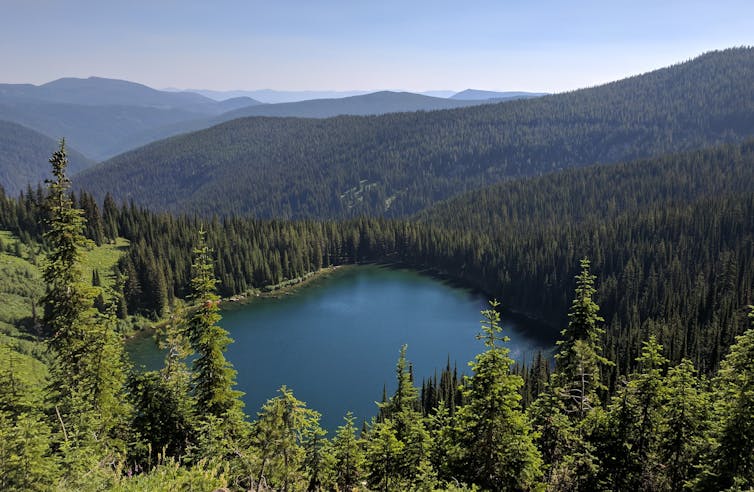
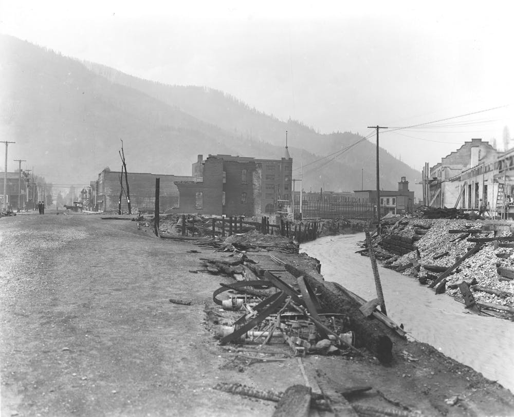
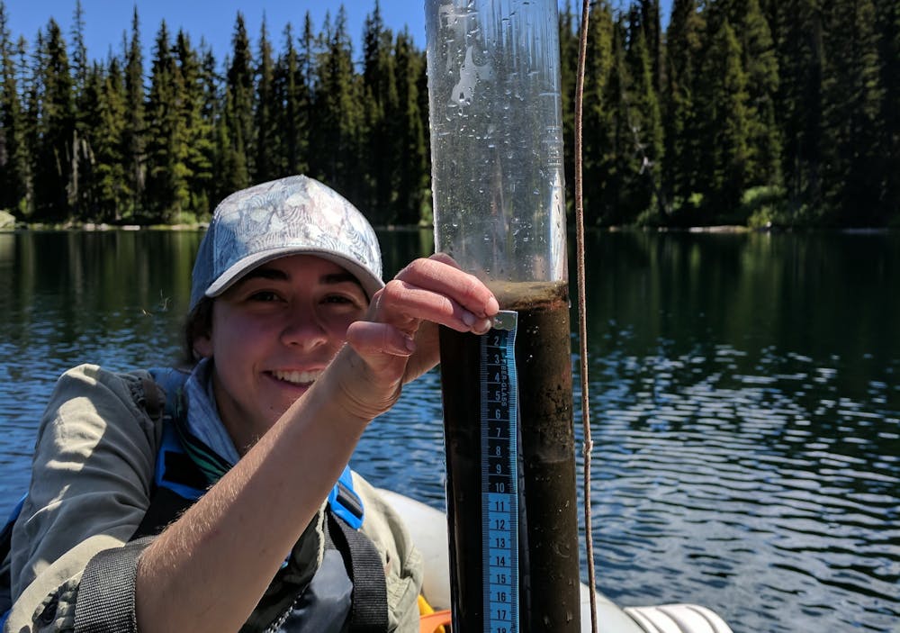
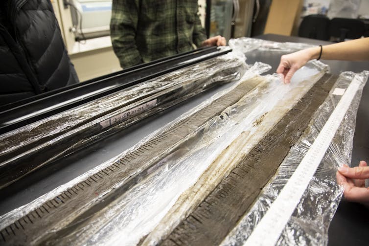
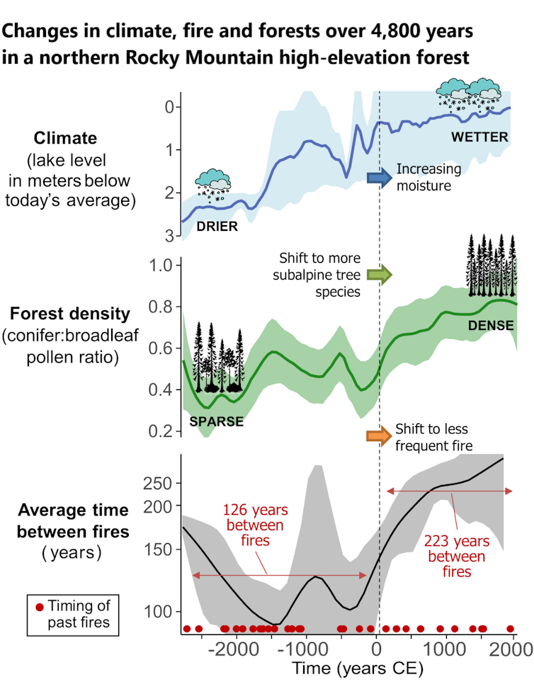
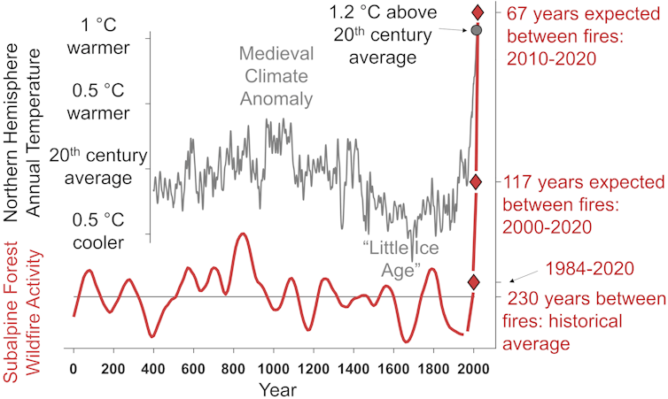
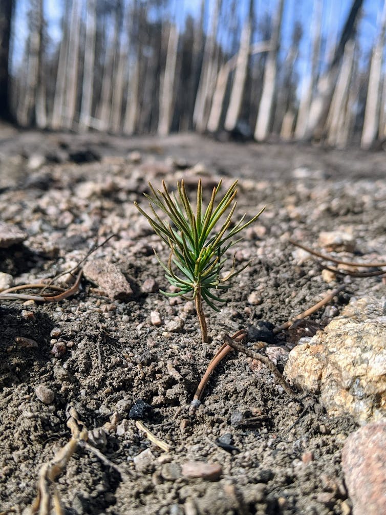
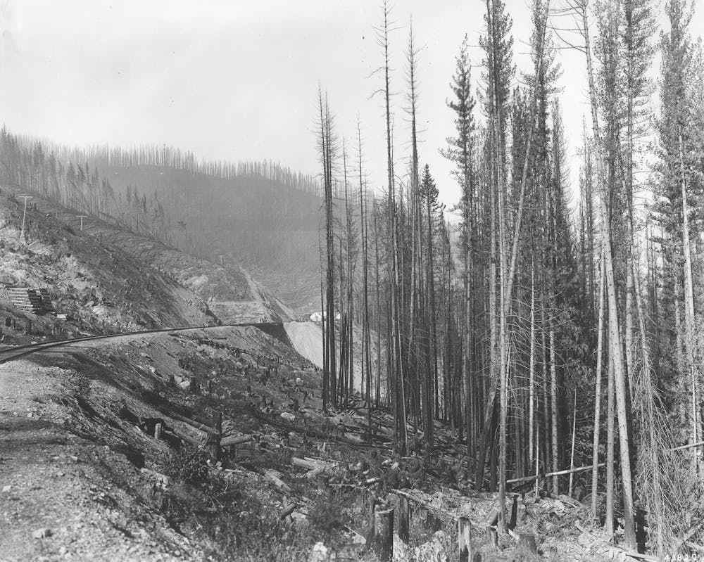
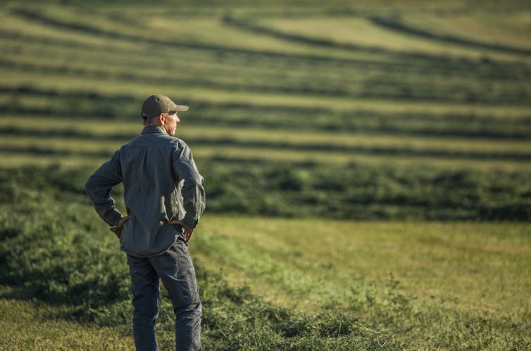

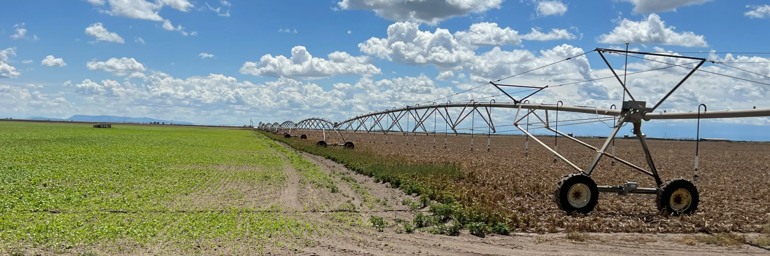
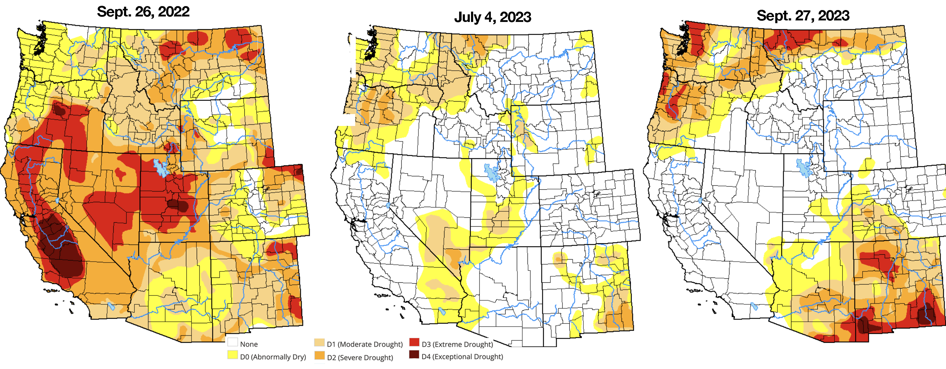
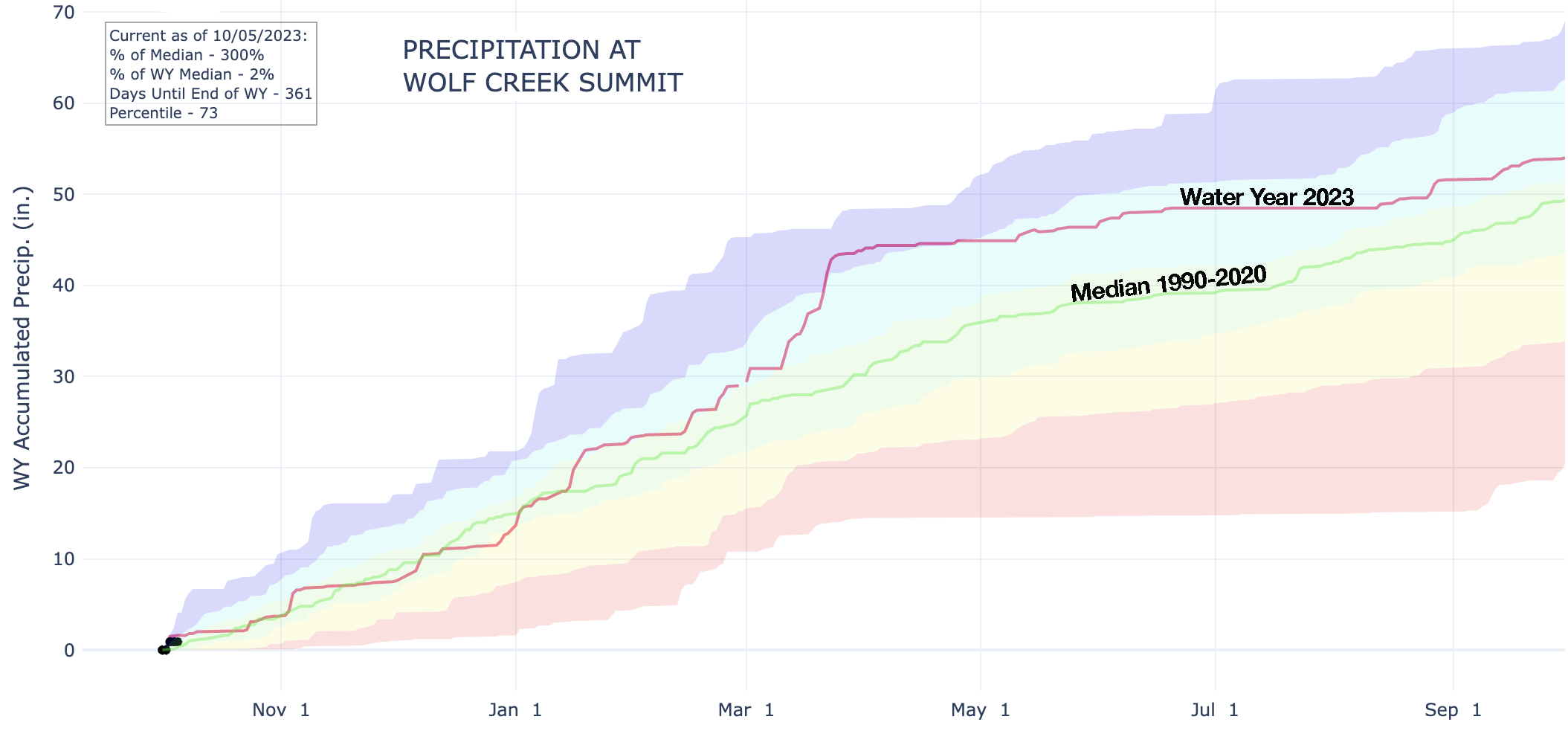


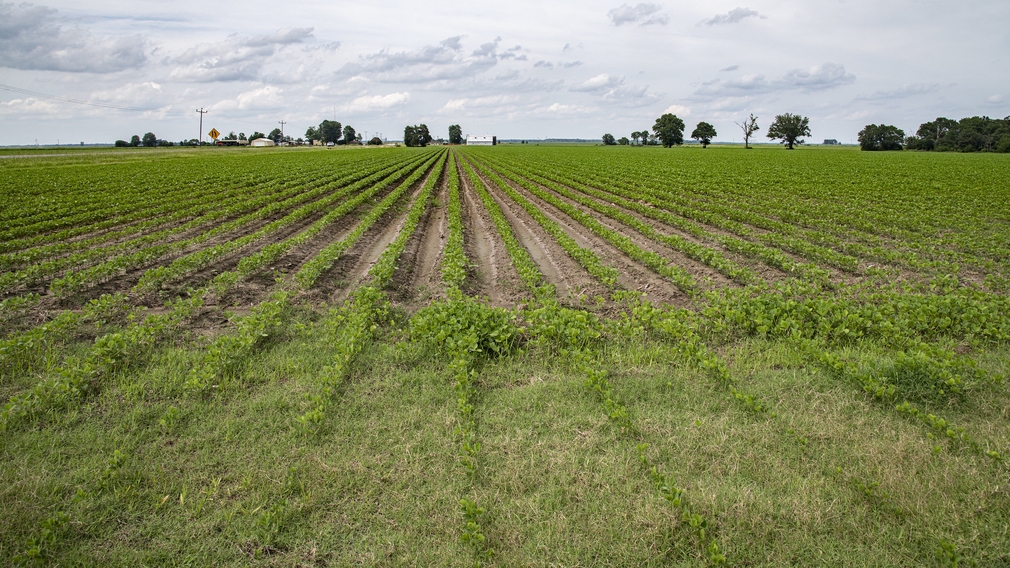
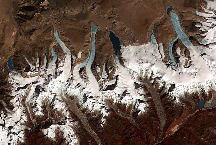
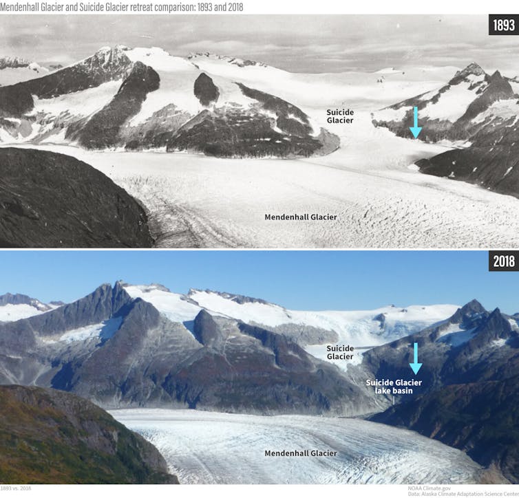
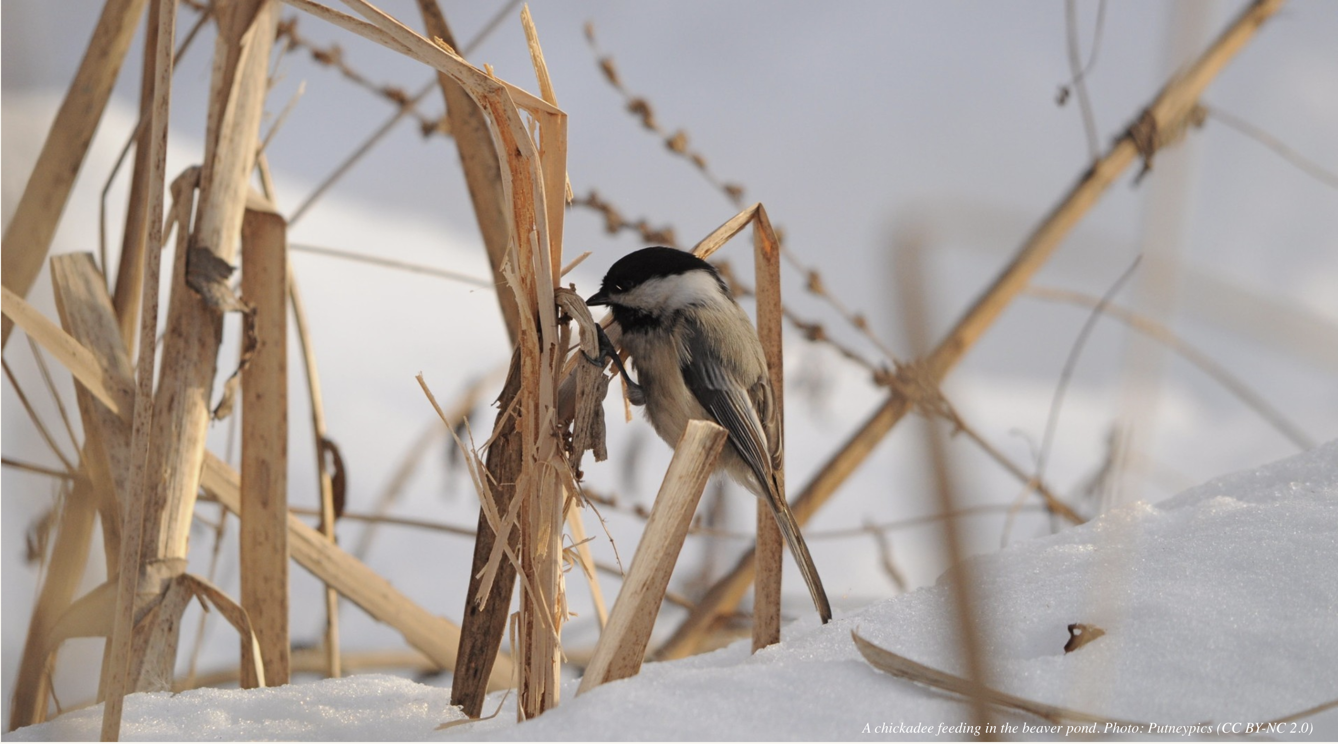
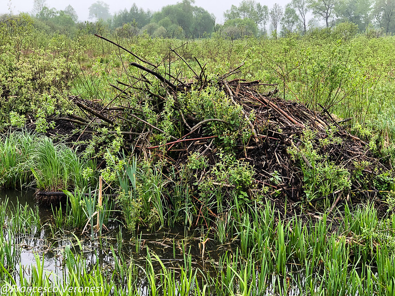


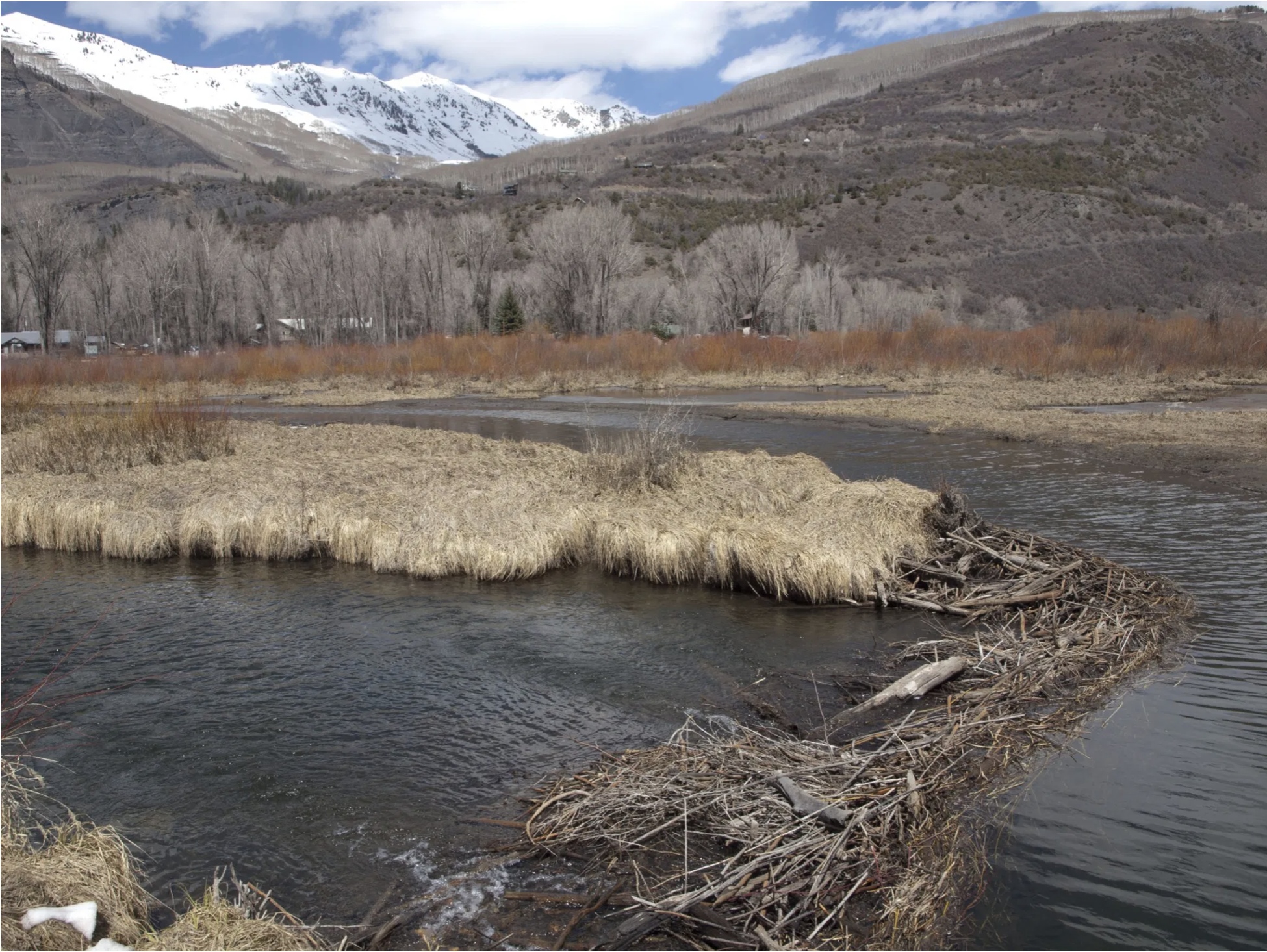


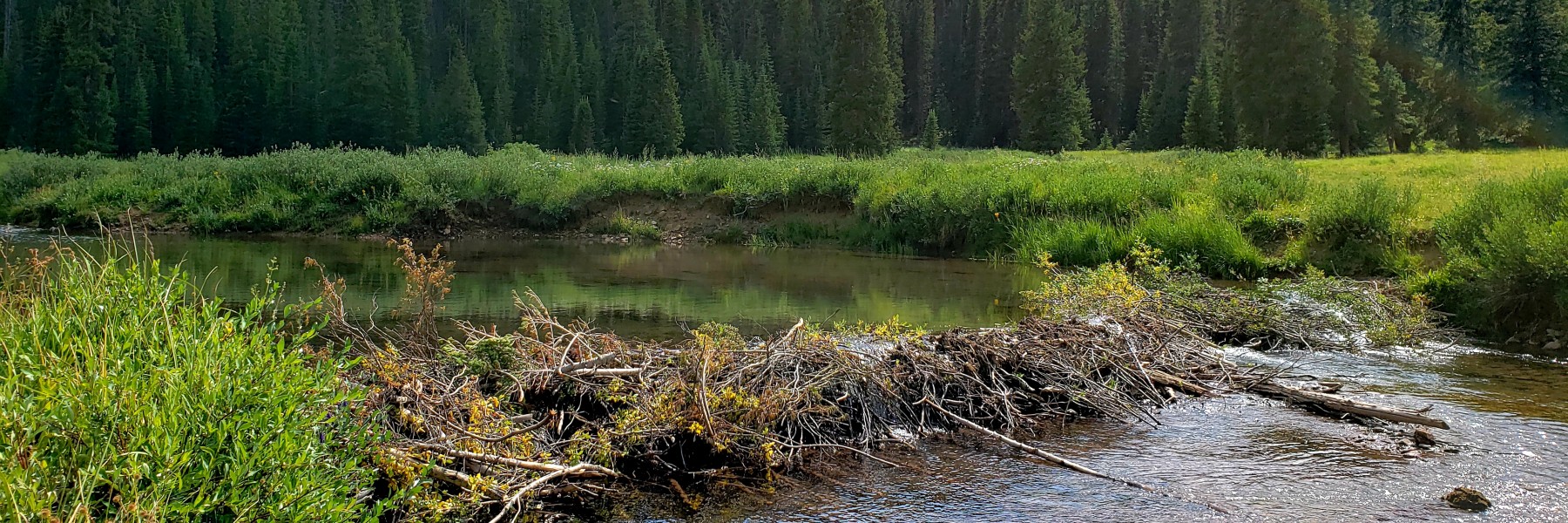
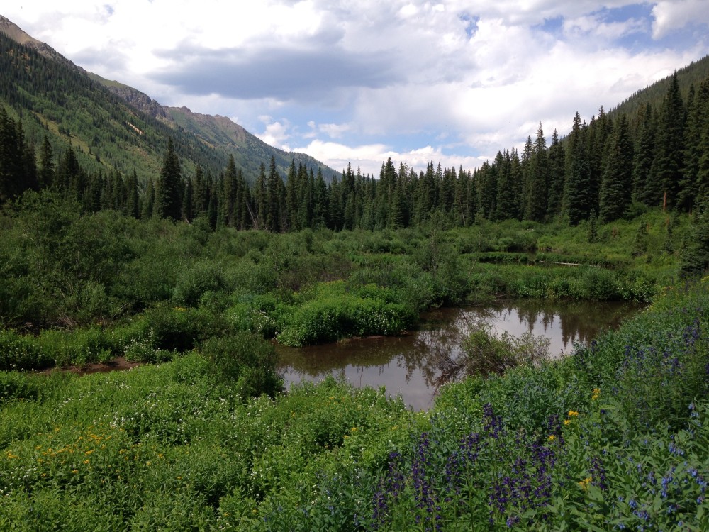


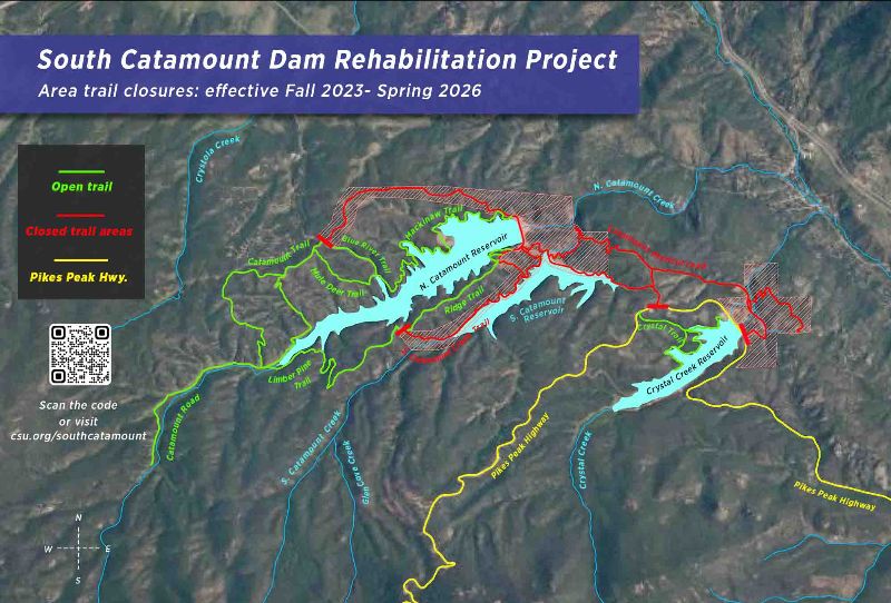

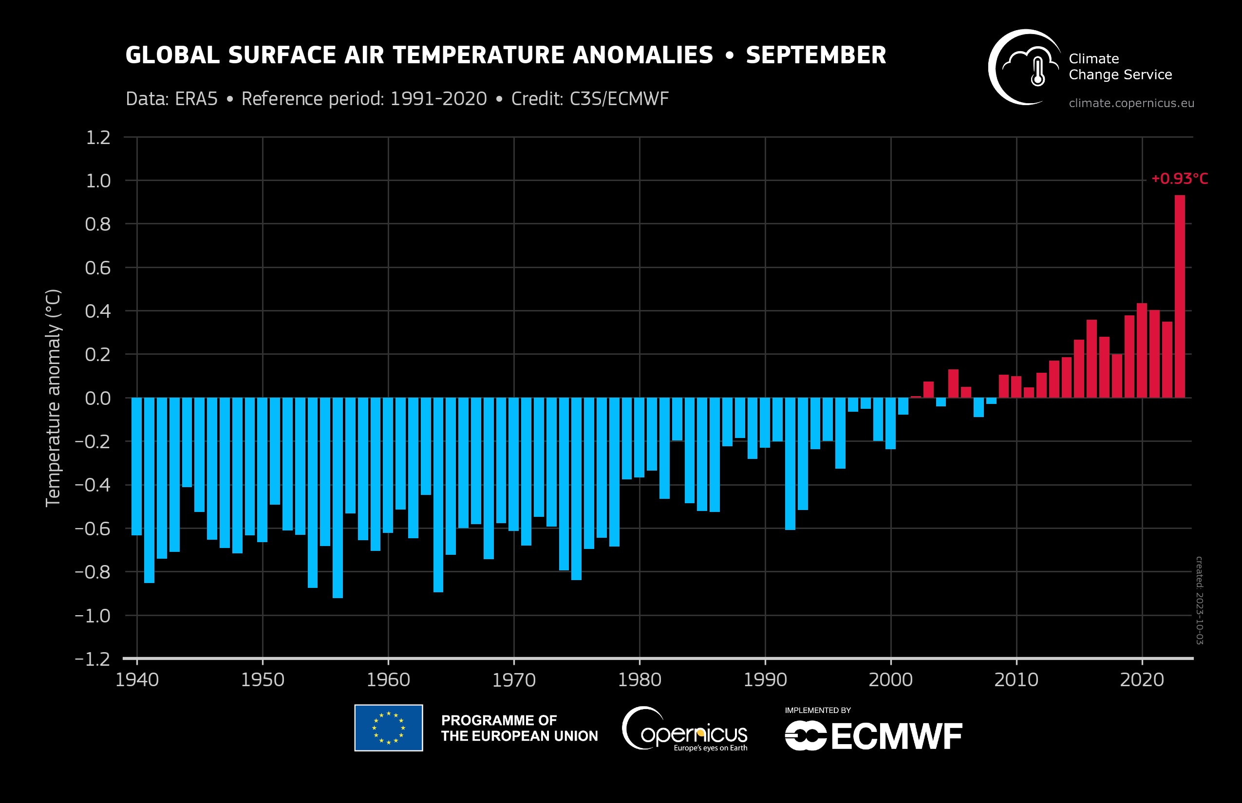


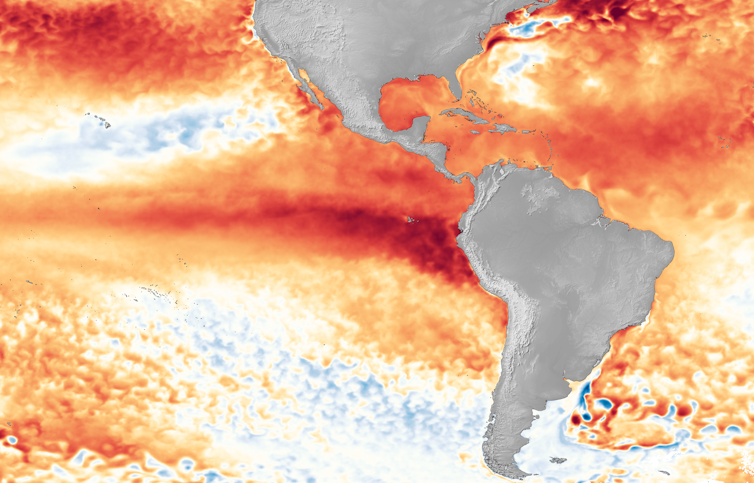
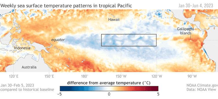
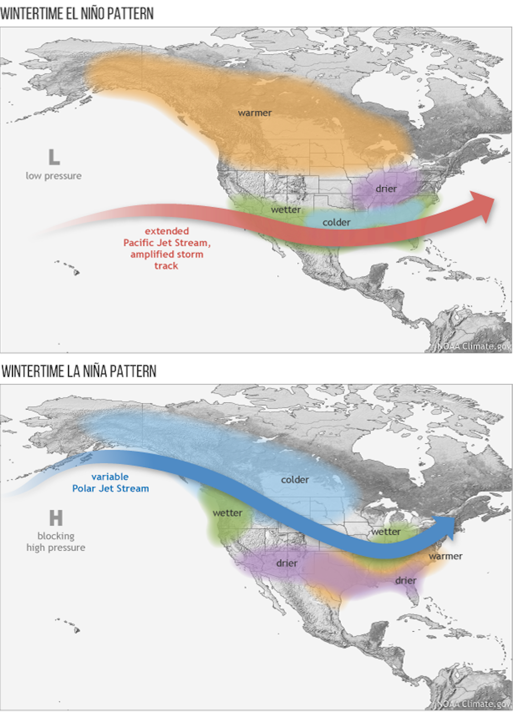


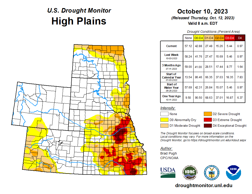
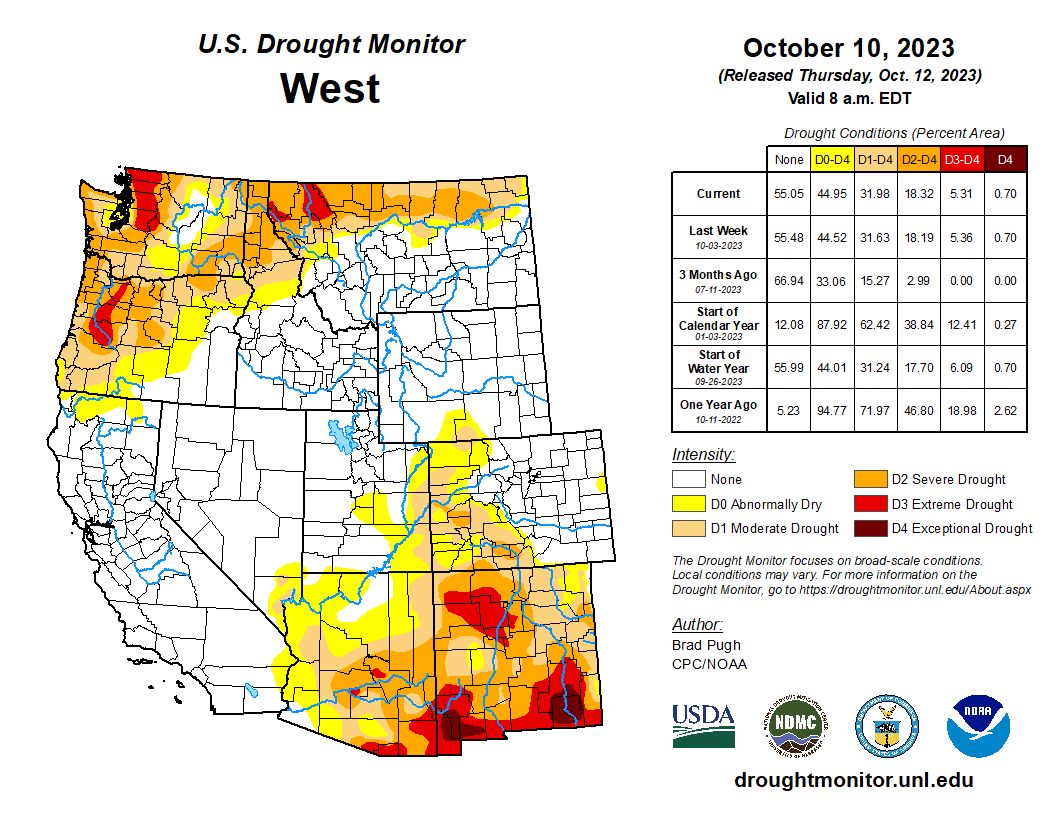
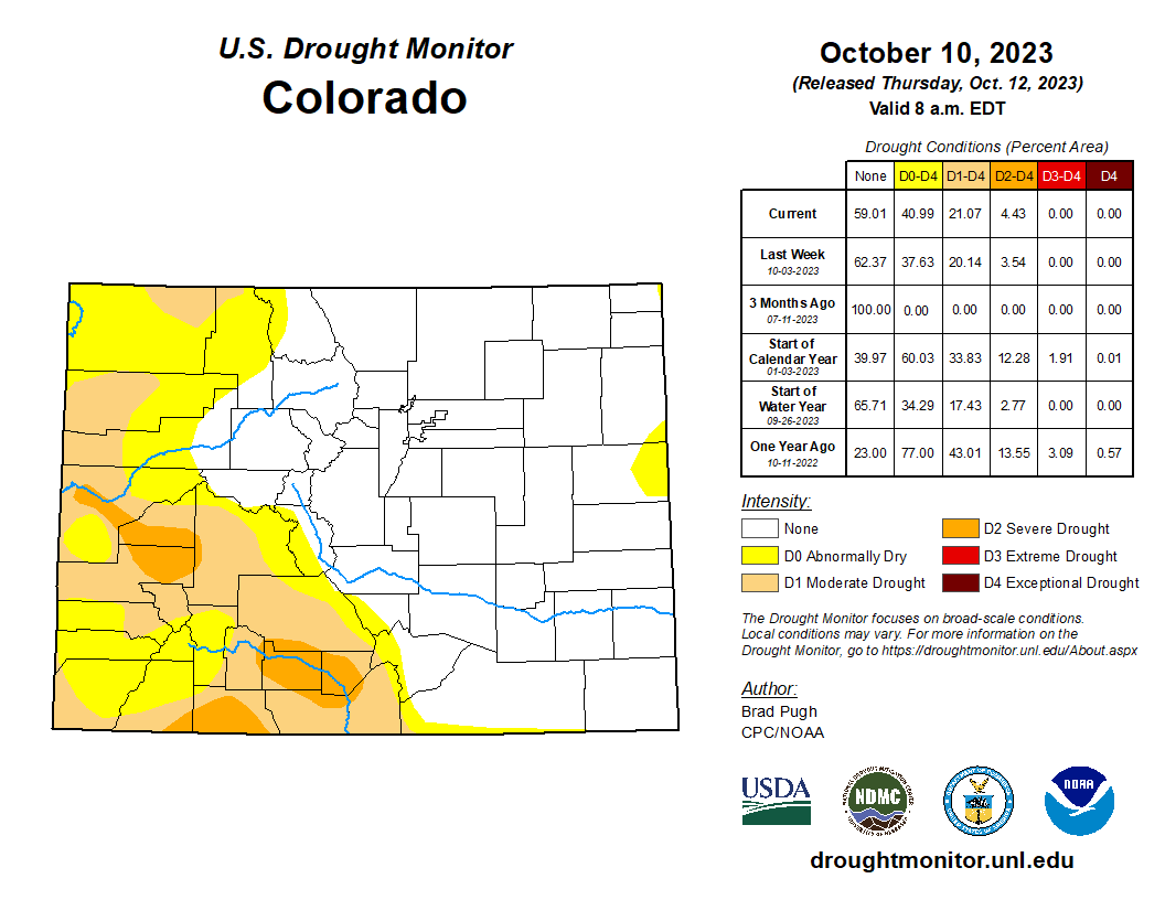
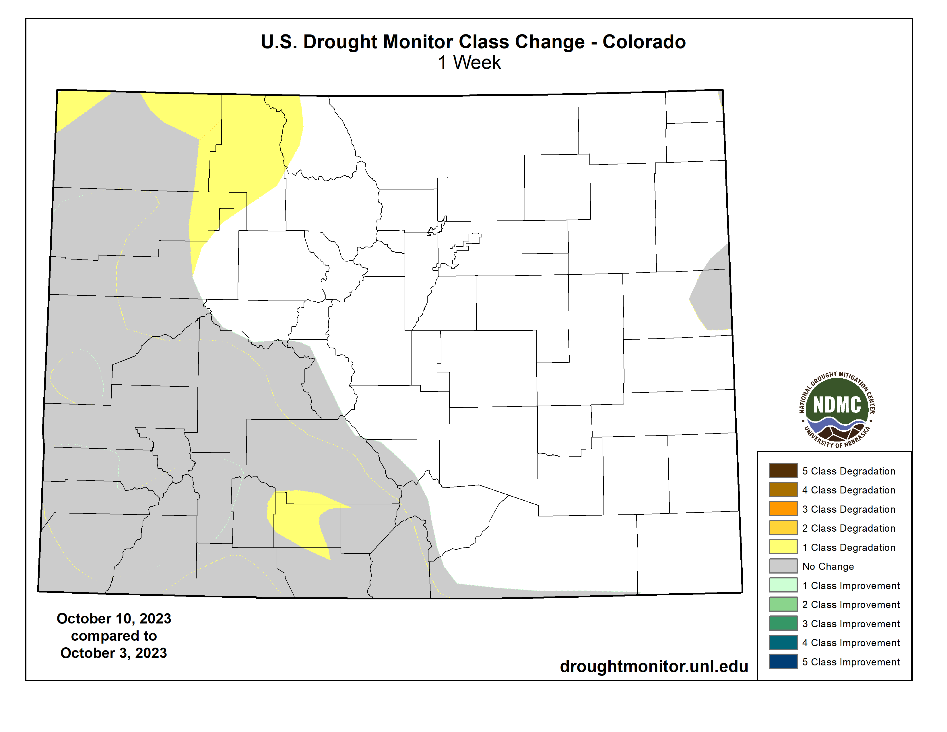

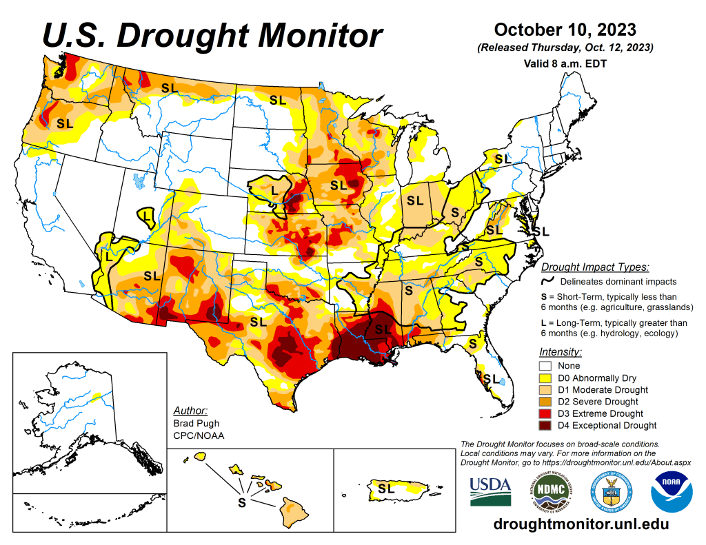
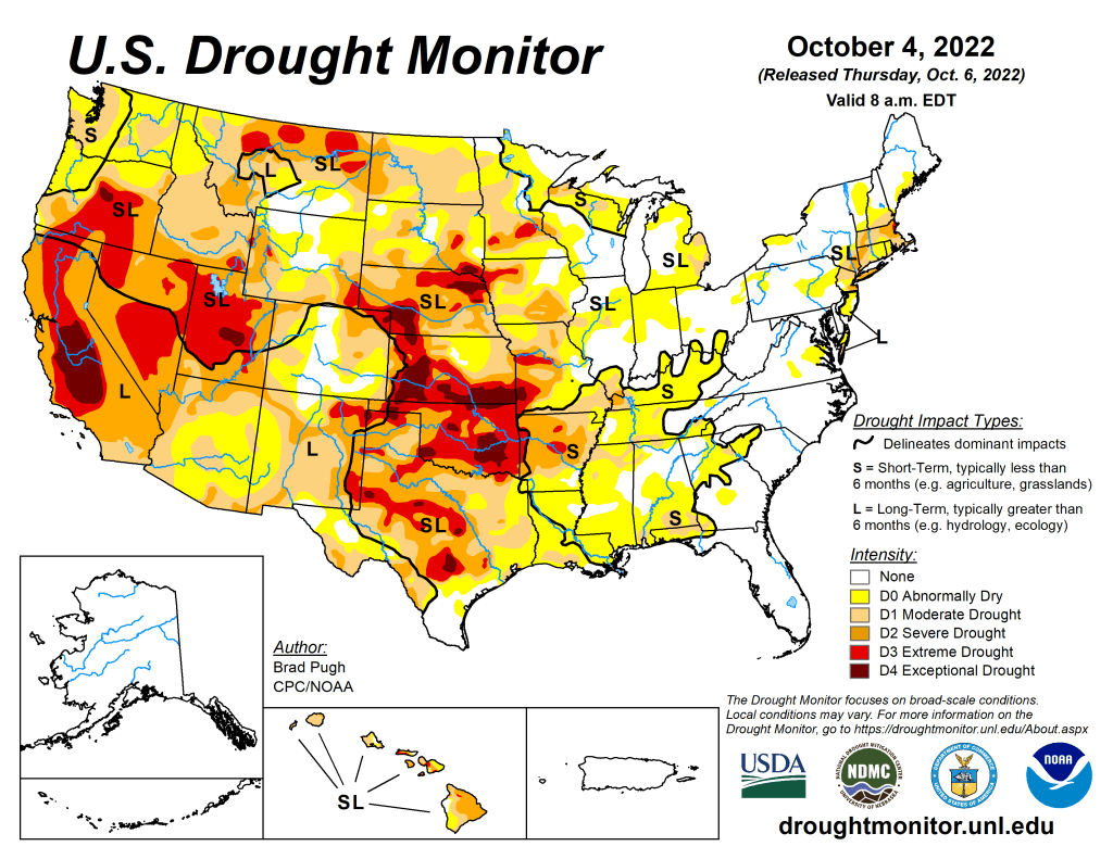

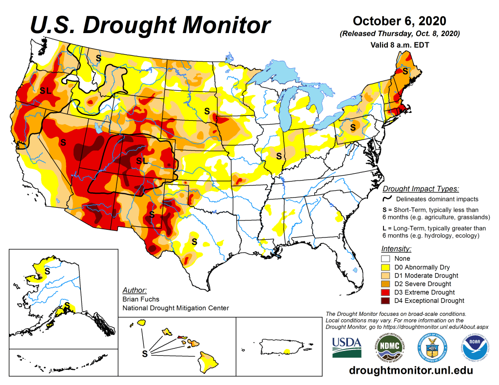

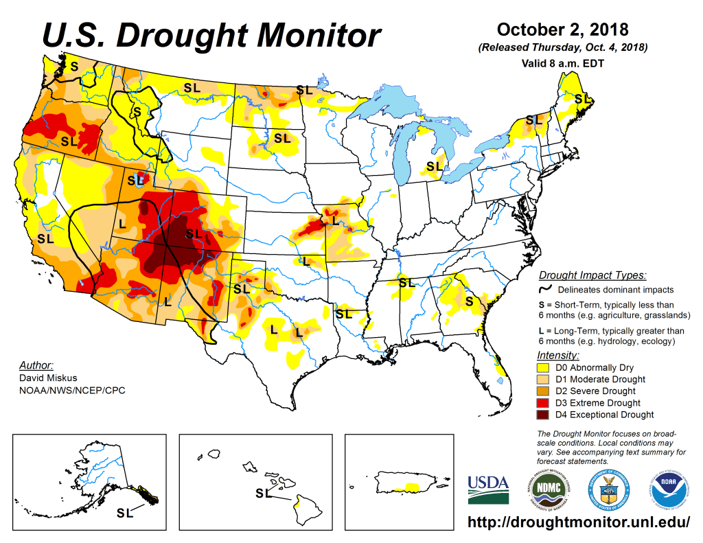
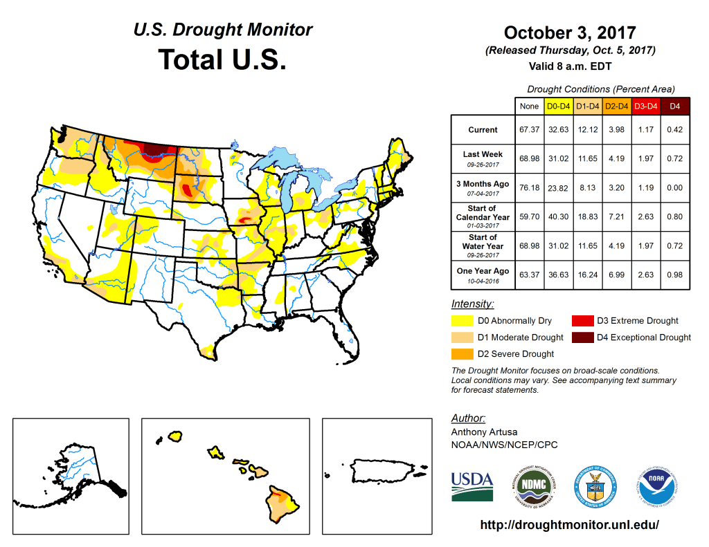


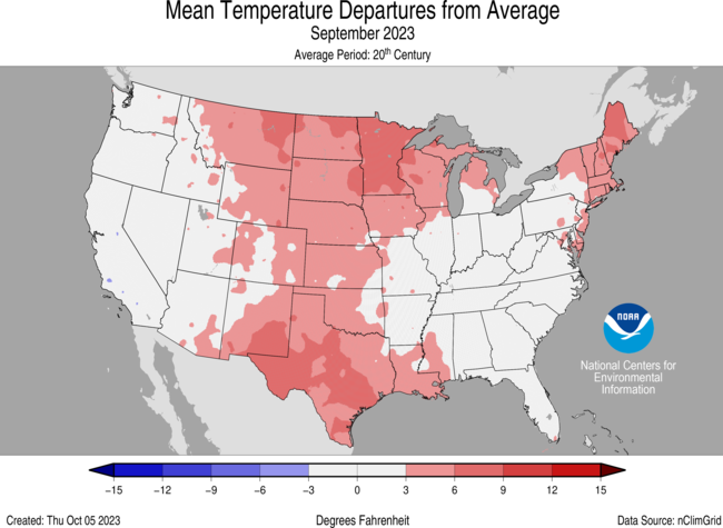
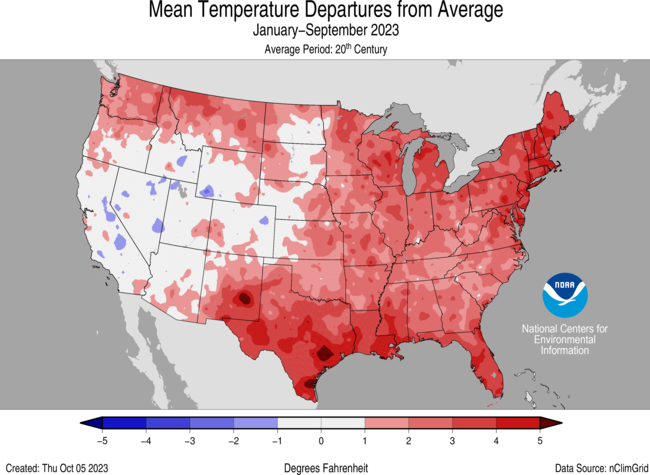
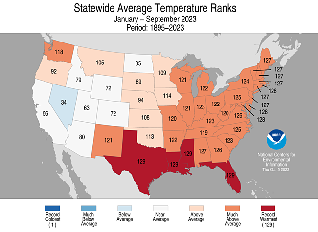
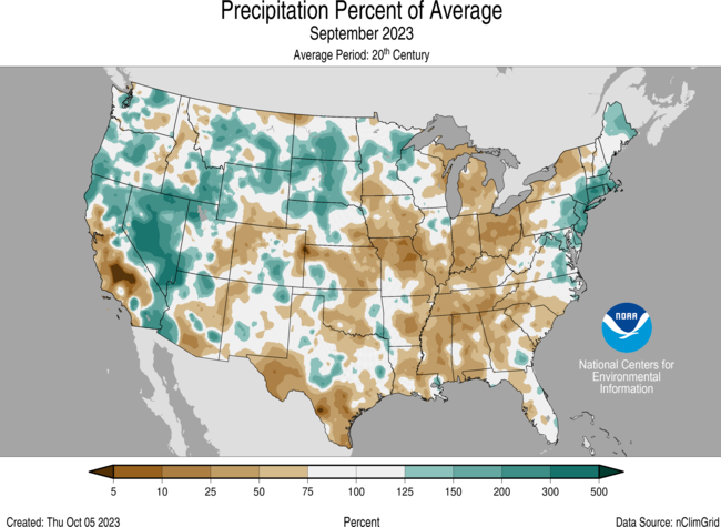
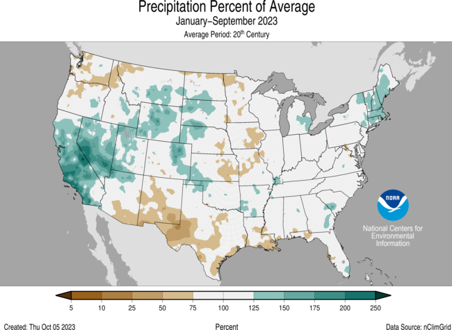
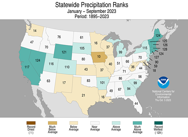
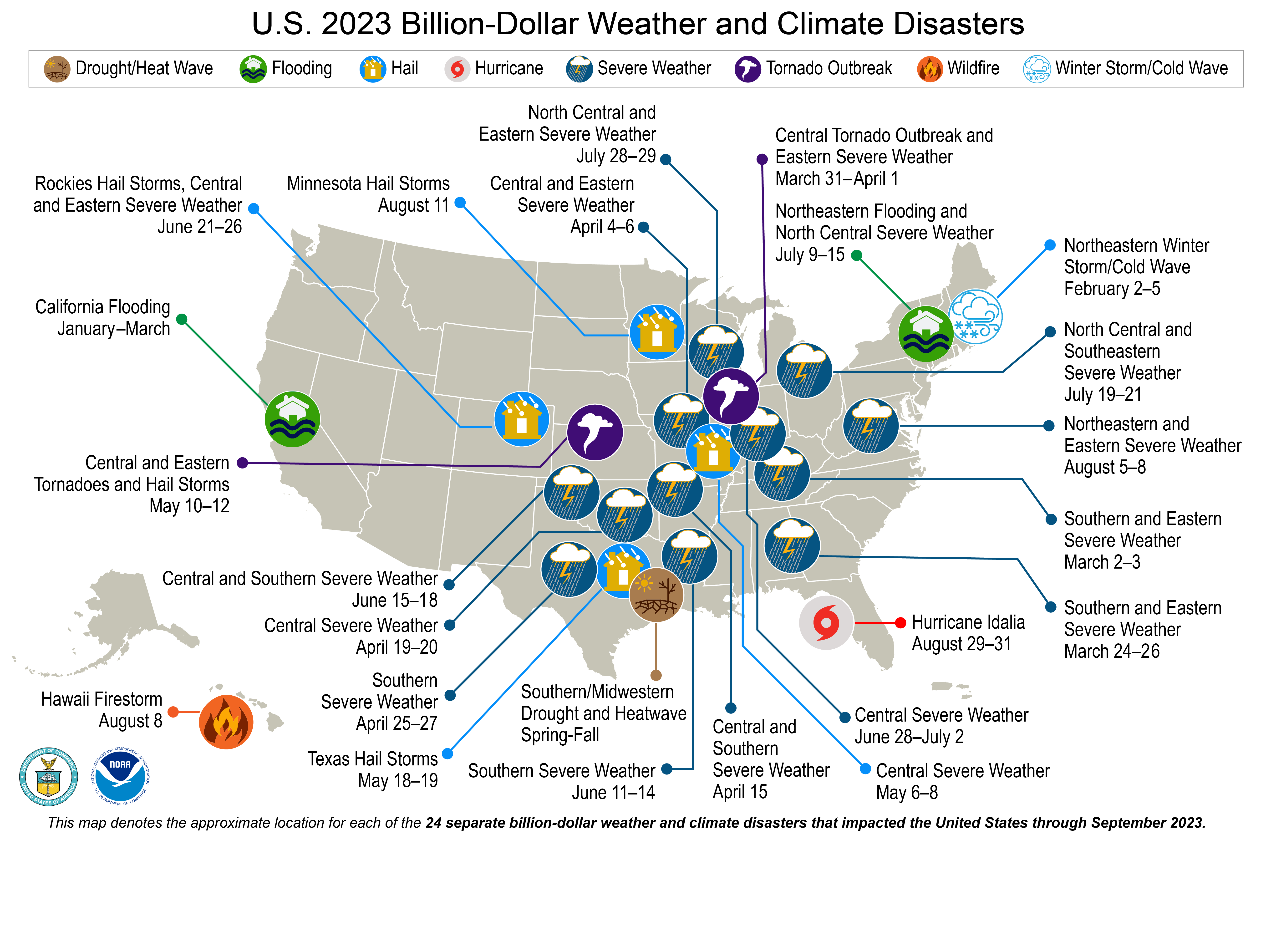


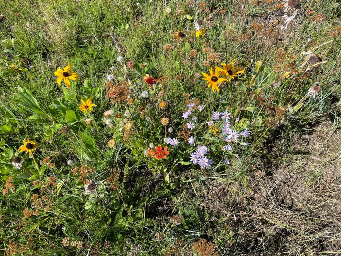
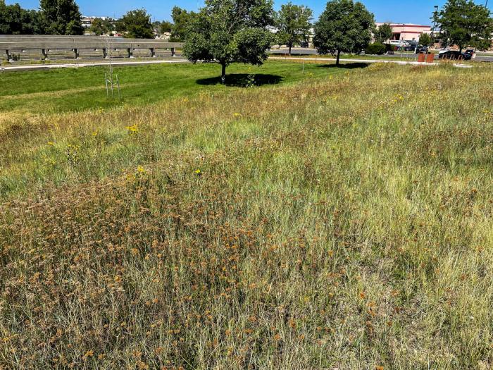
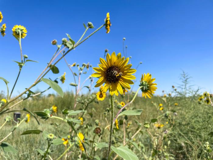
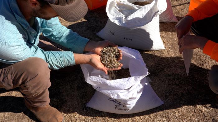
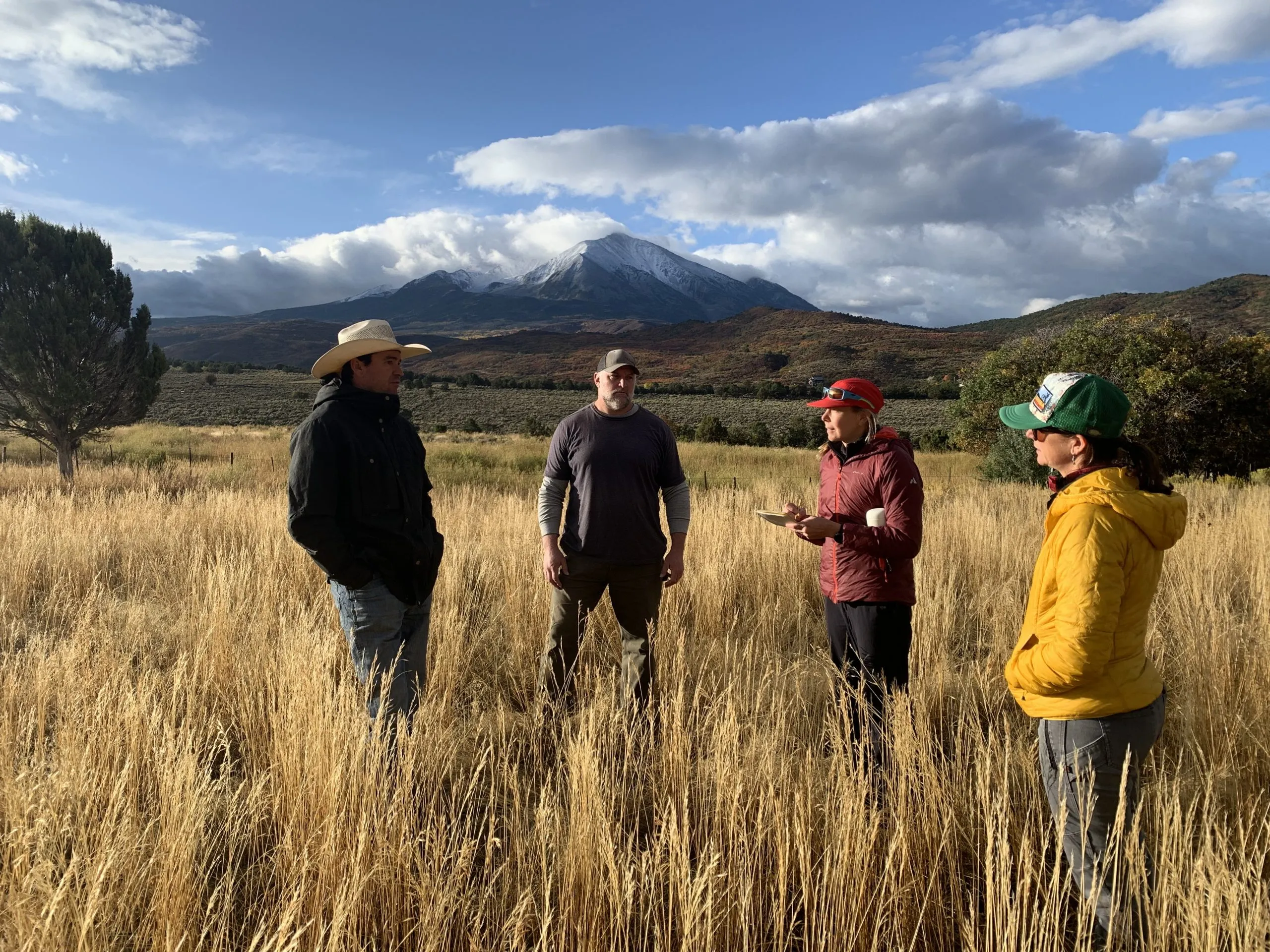


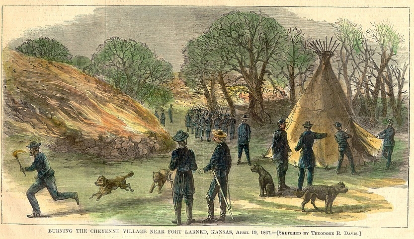

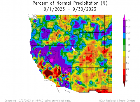
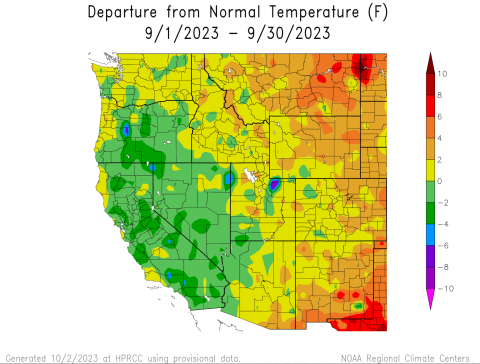
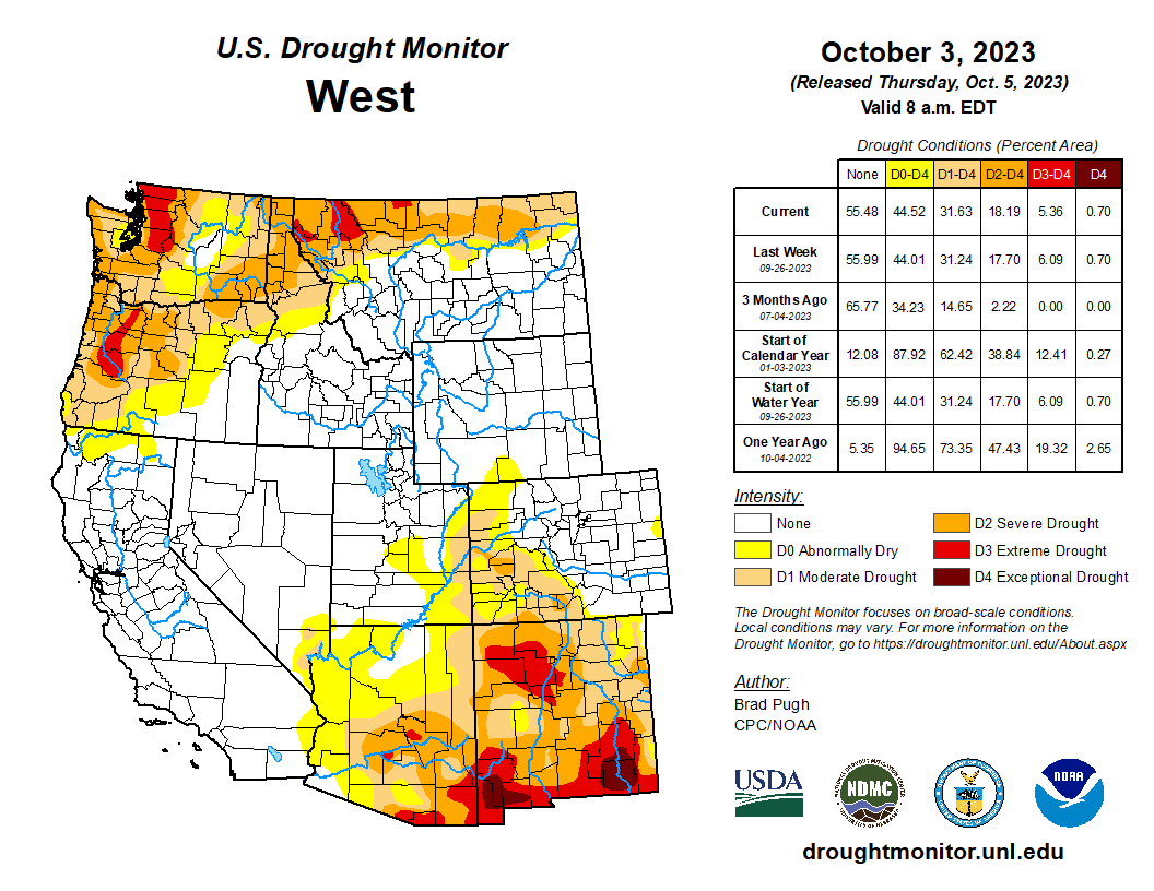
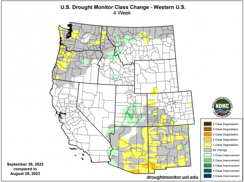
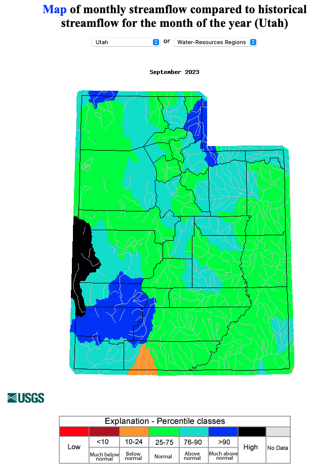
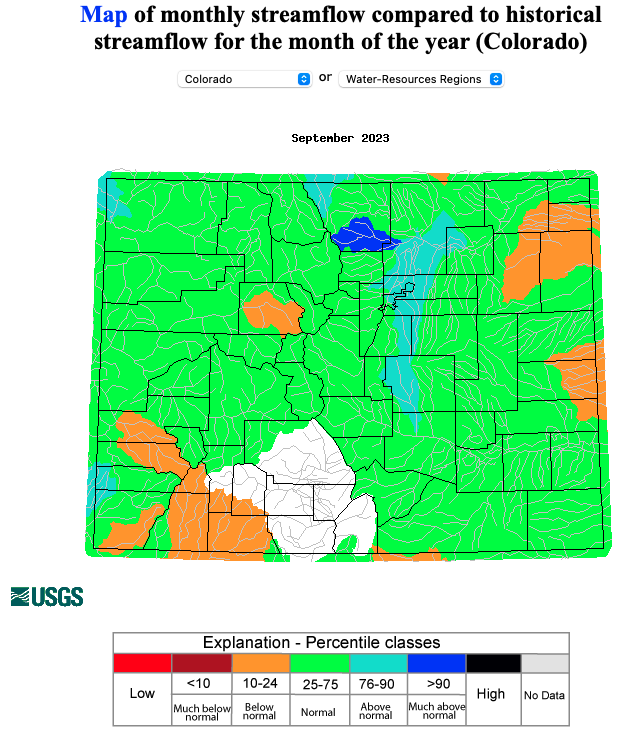


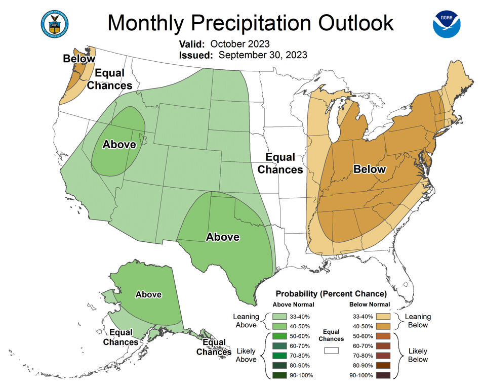
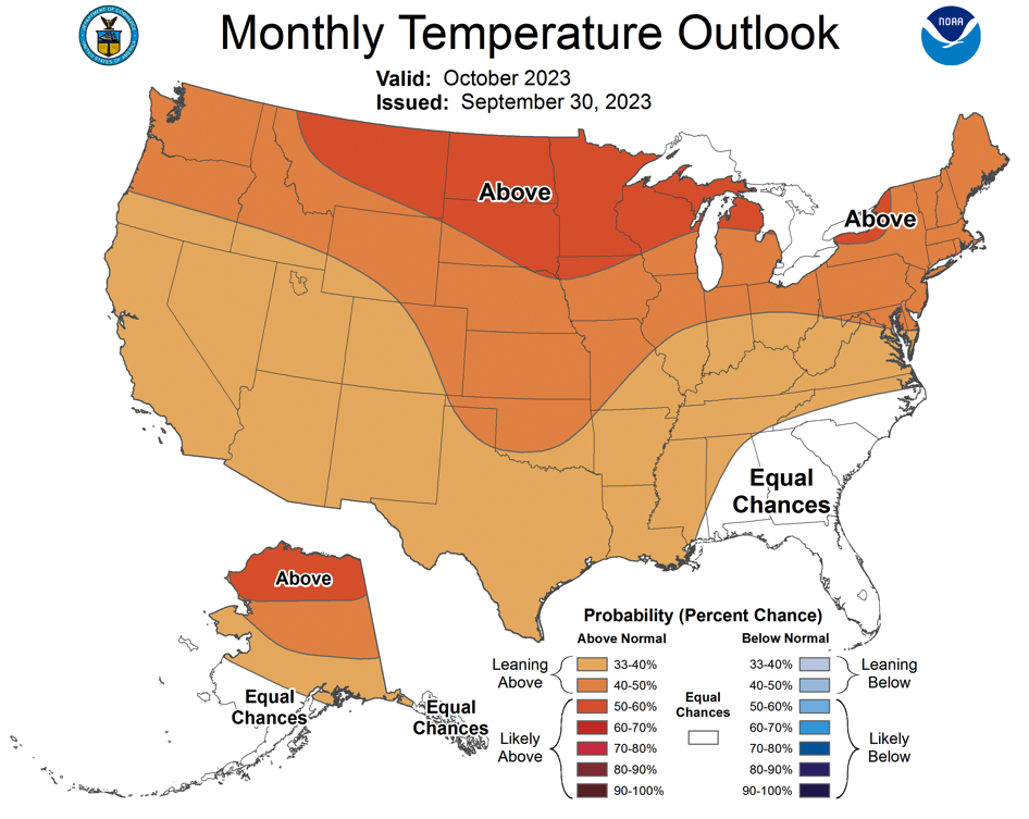
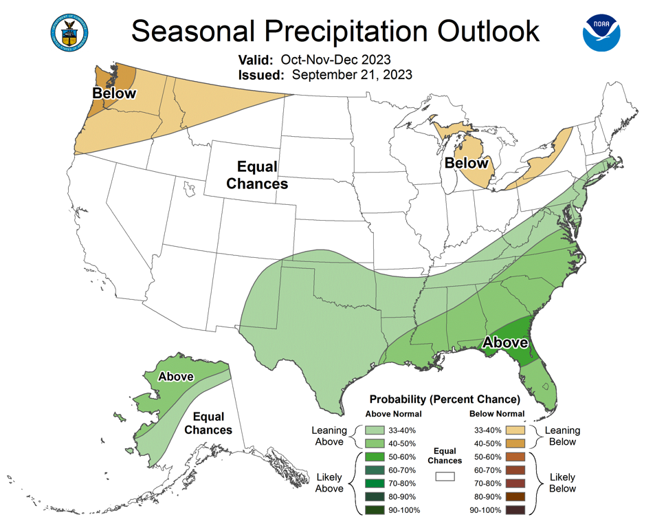
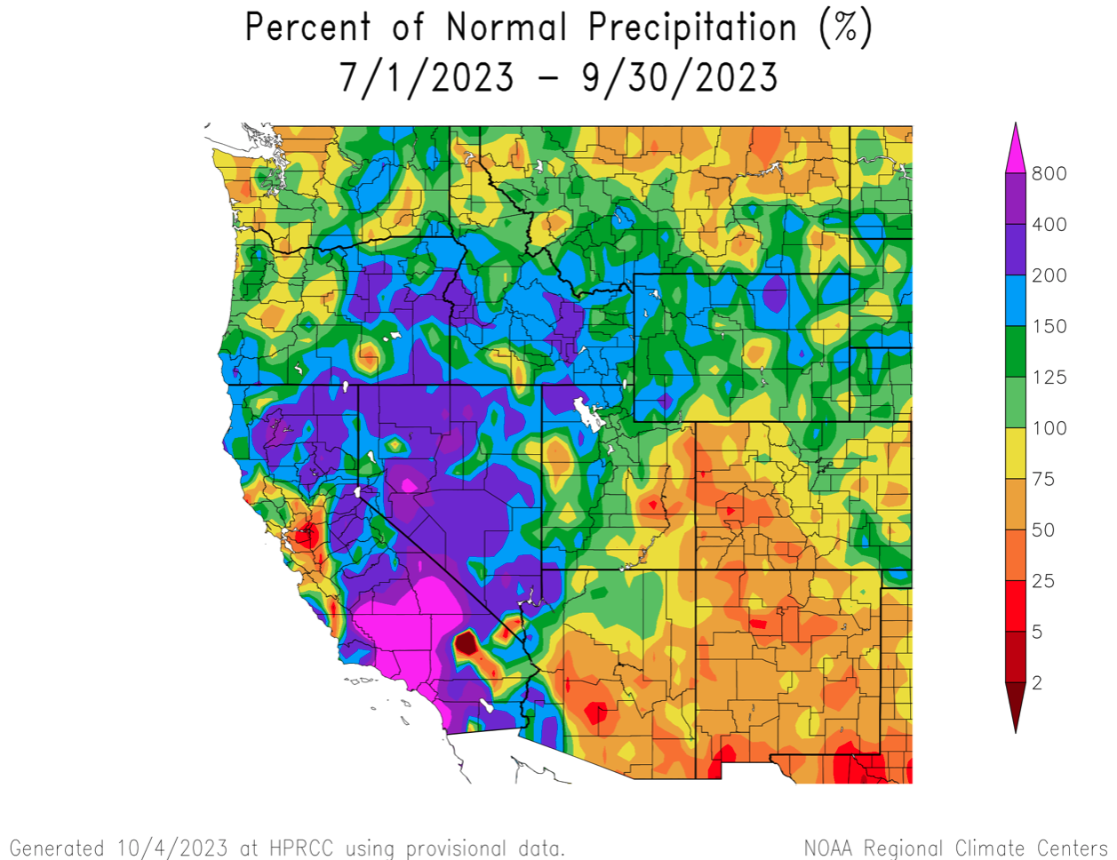
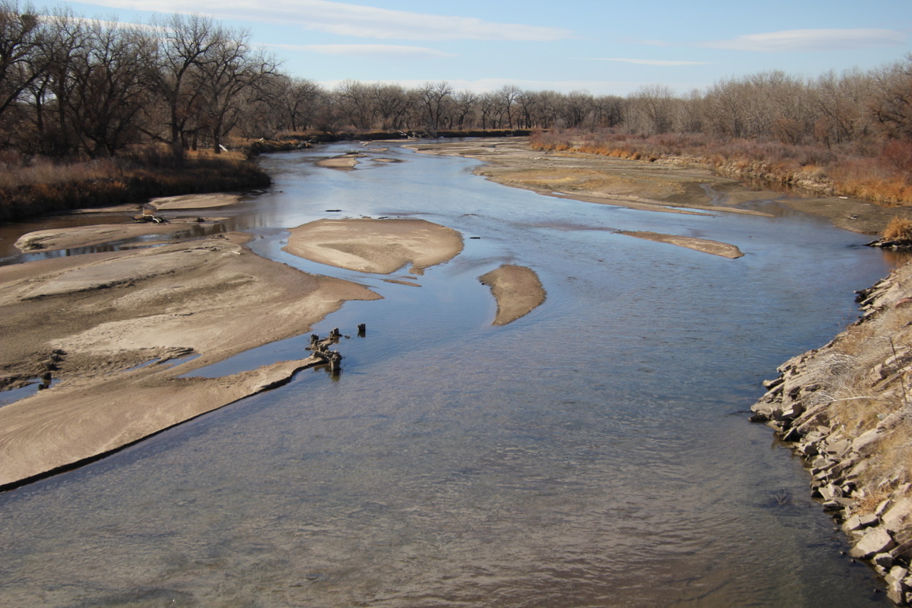

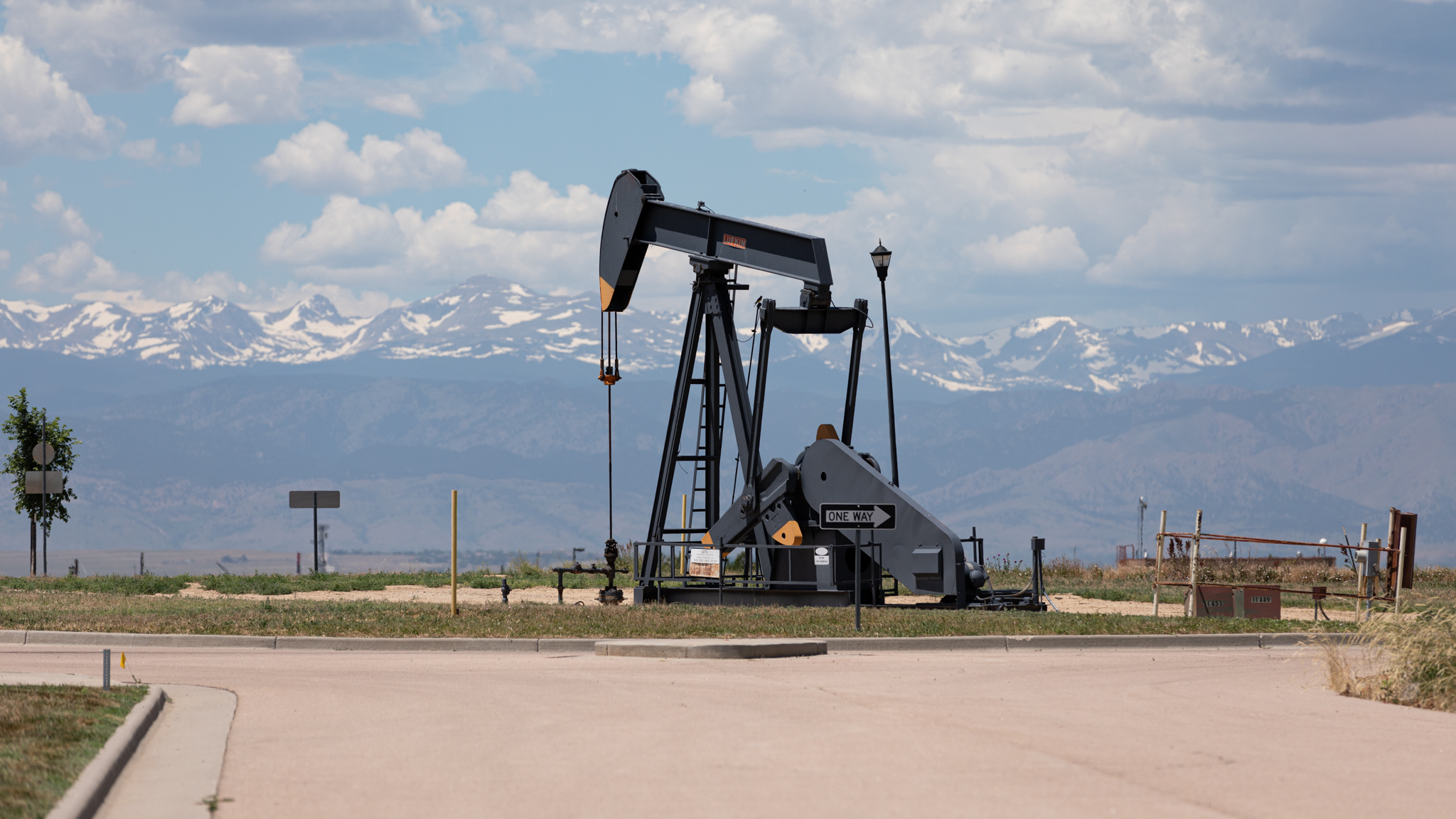
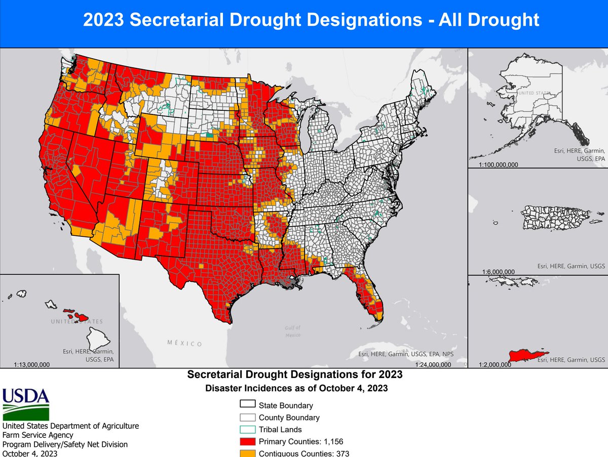


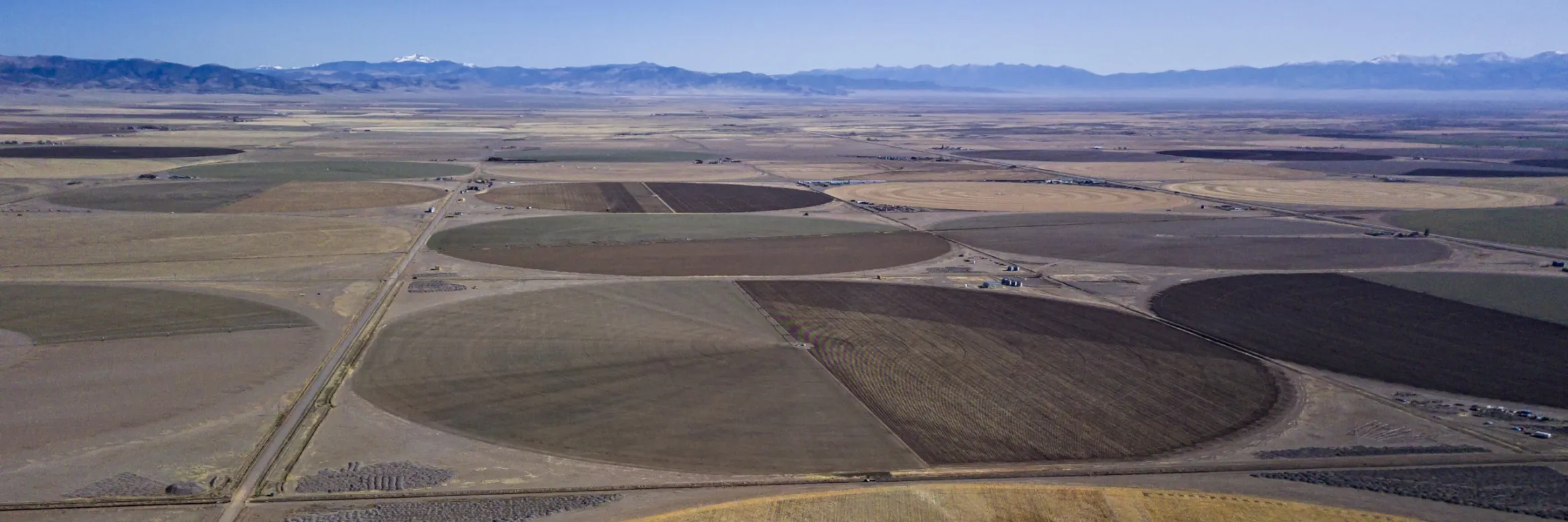


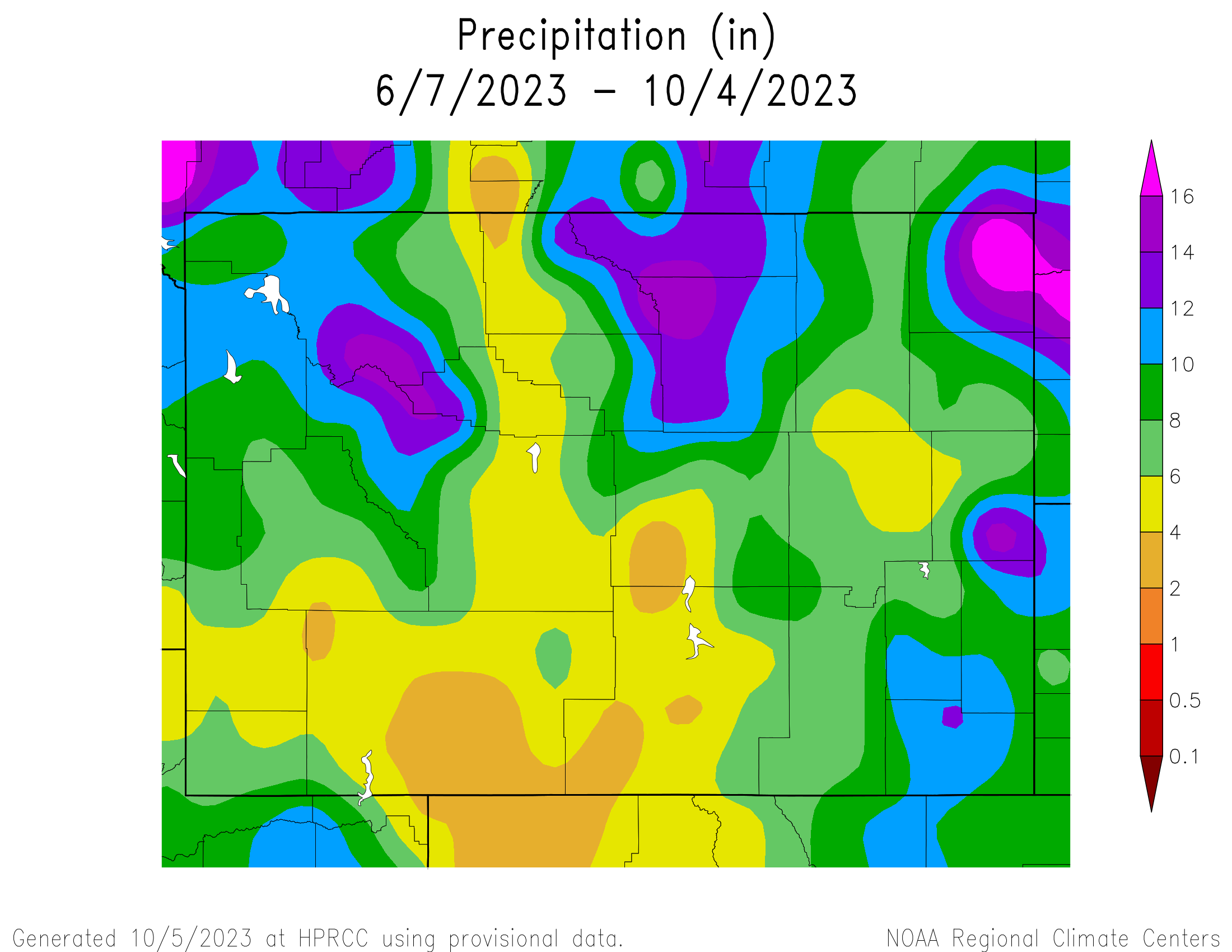
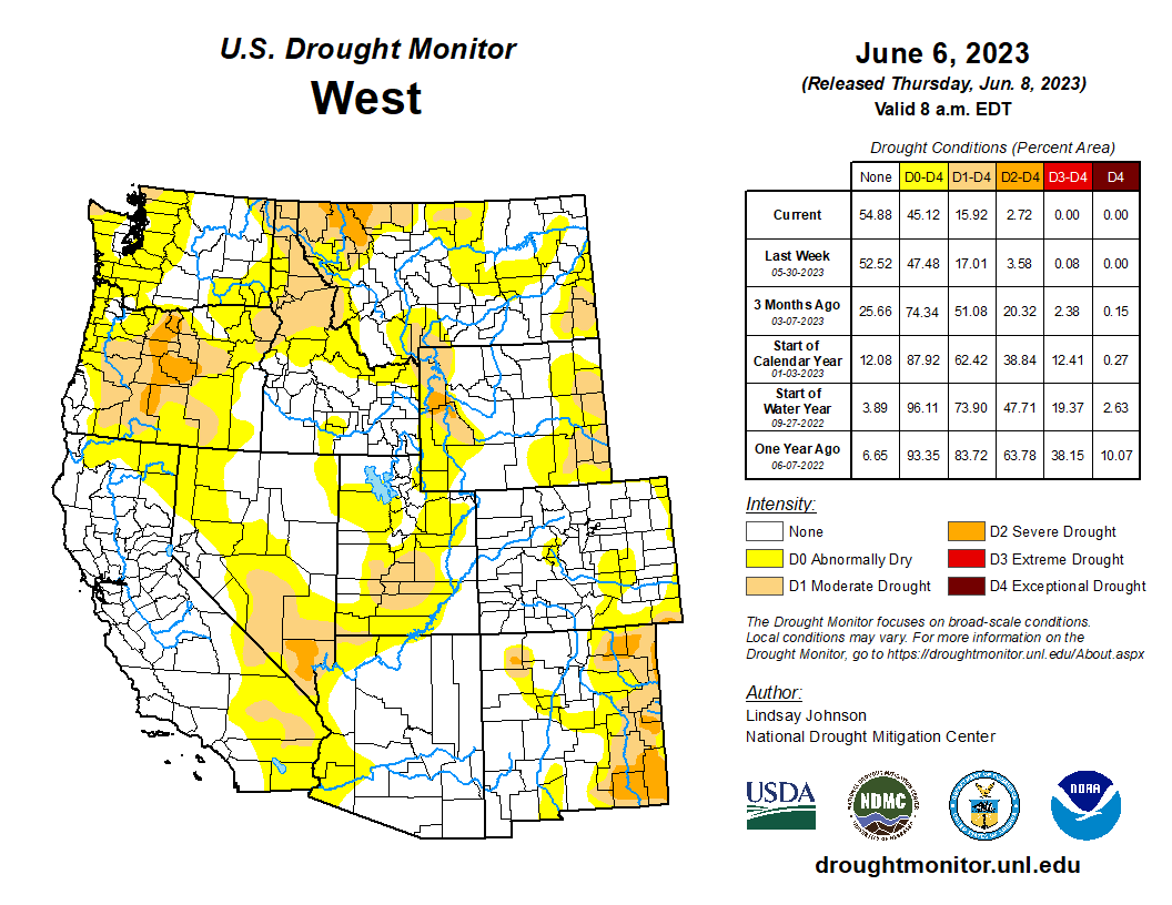
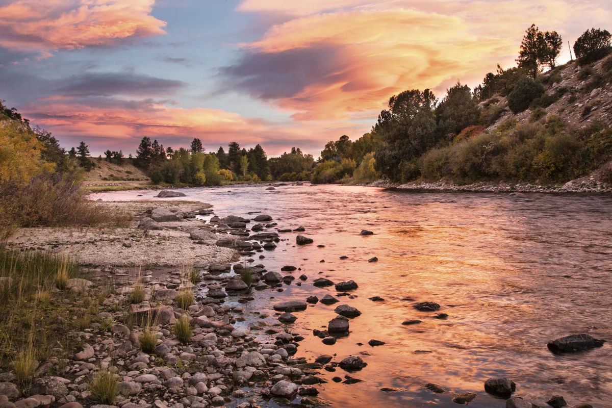
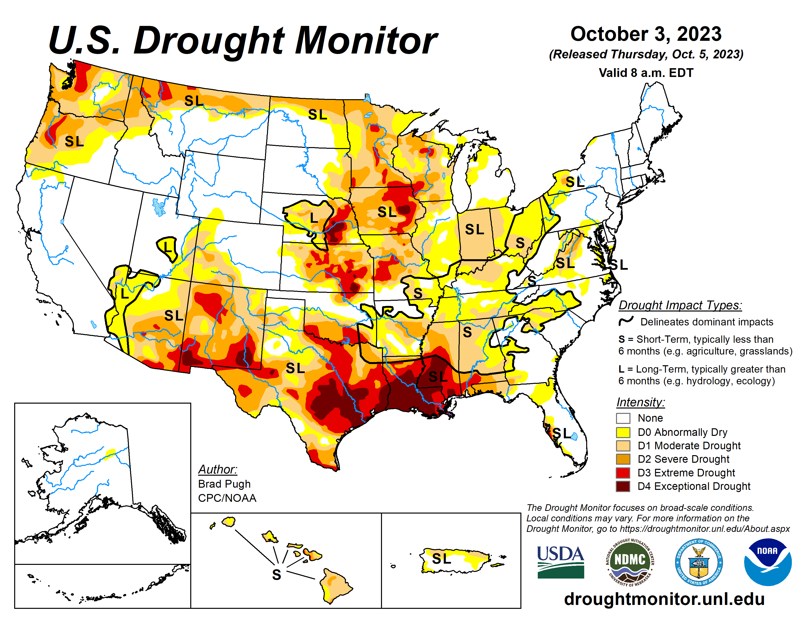

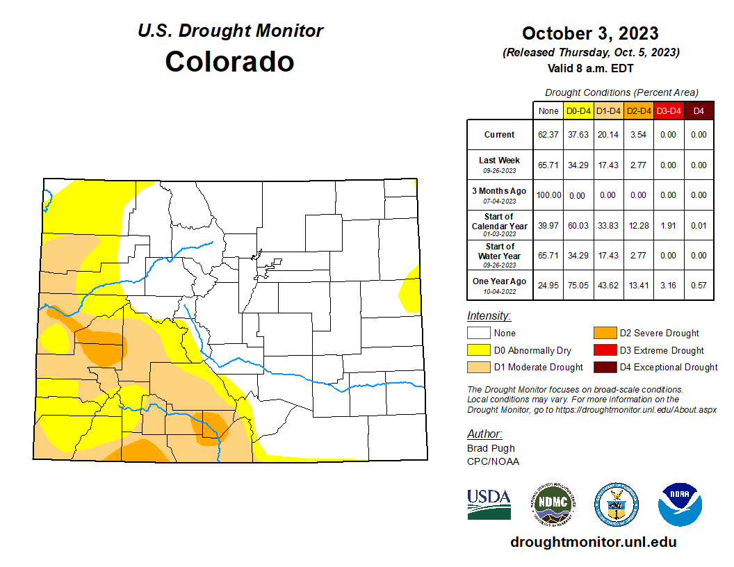
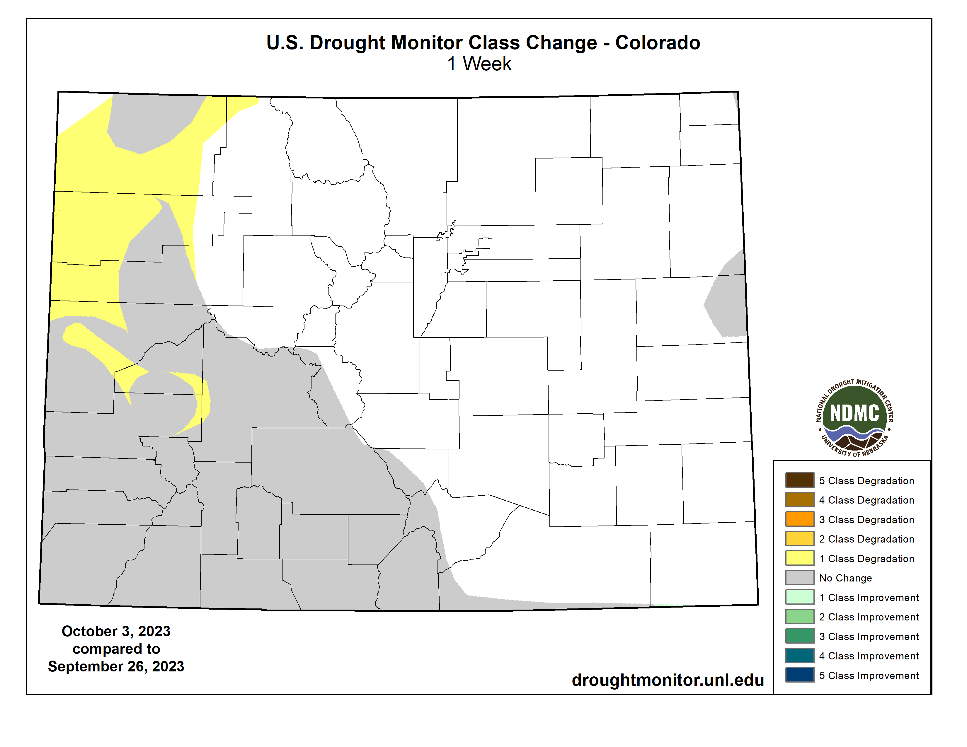
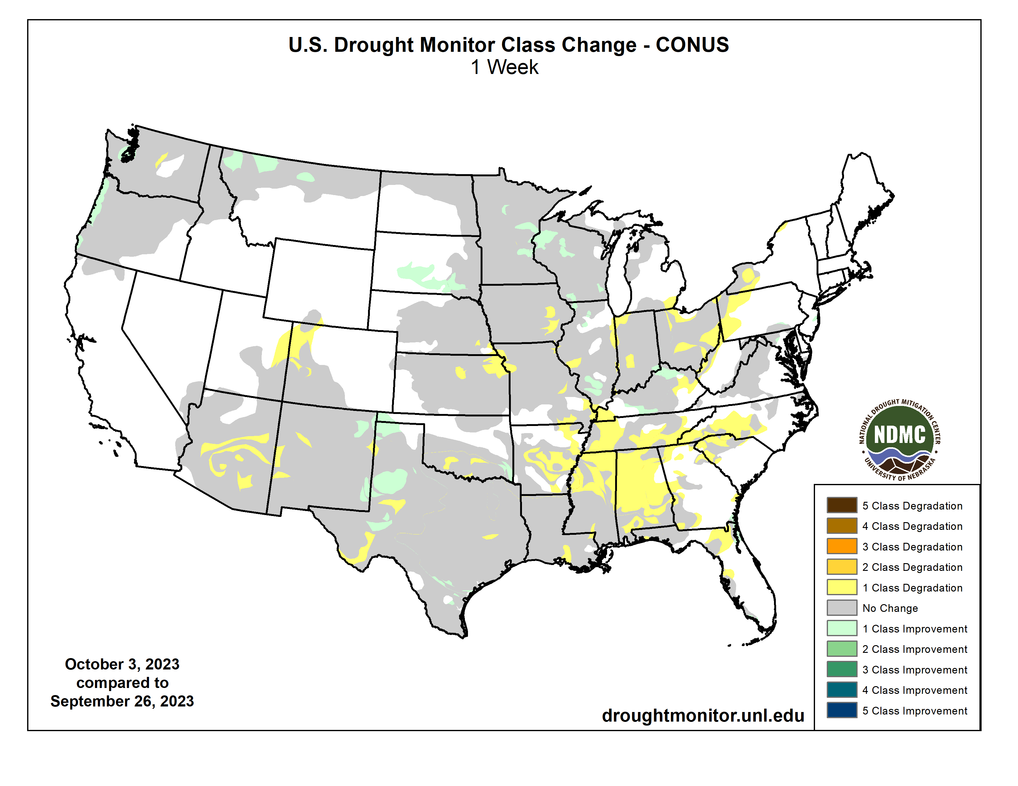

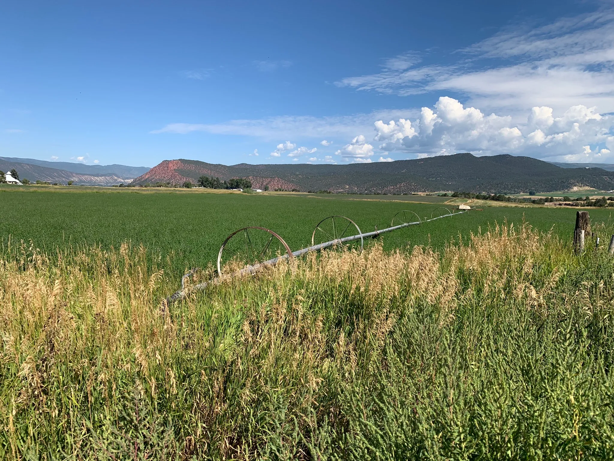
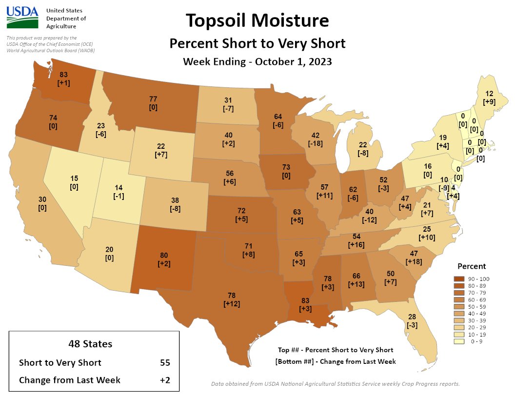
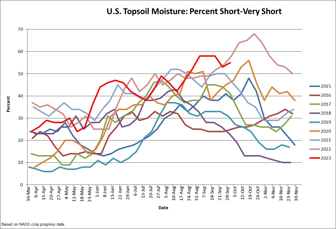


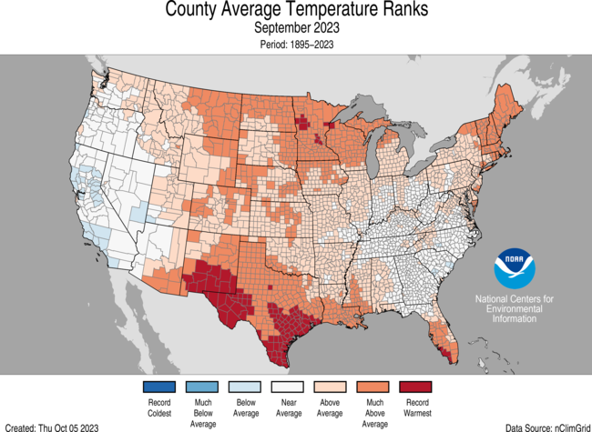