Click on a thumbnail graphic to view a gallery of drought data from the US Drought Monitor website.
Click the link to go to the US Drought Monitor website. Here’s an excerpt:
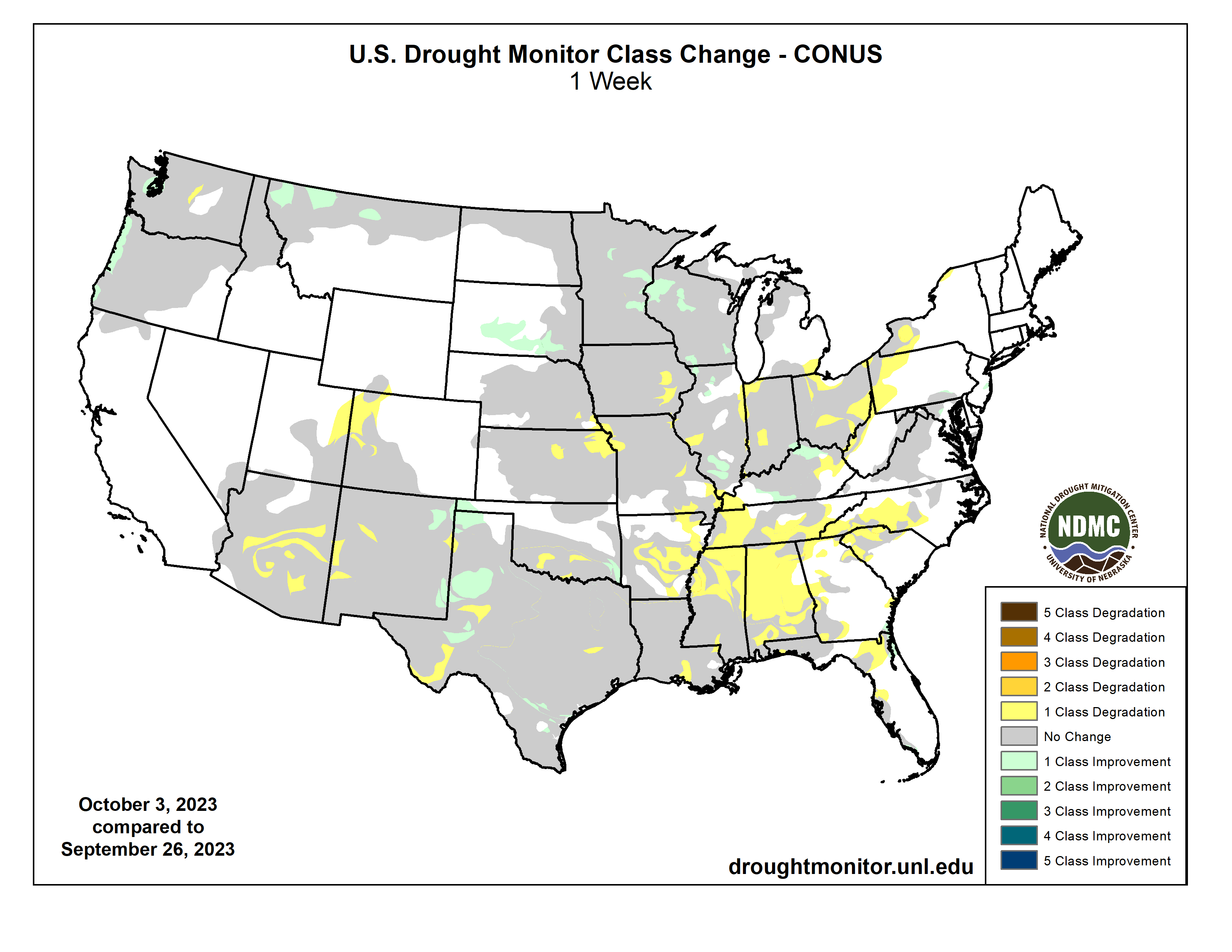
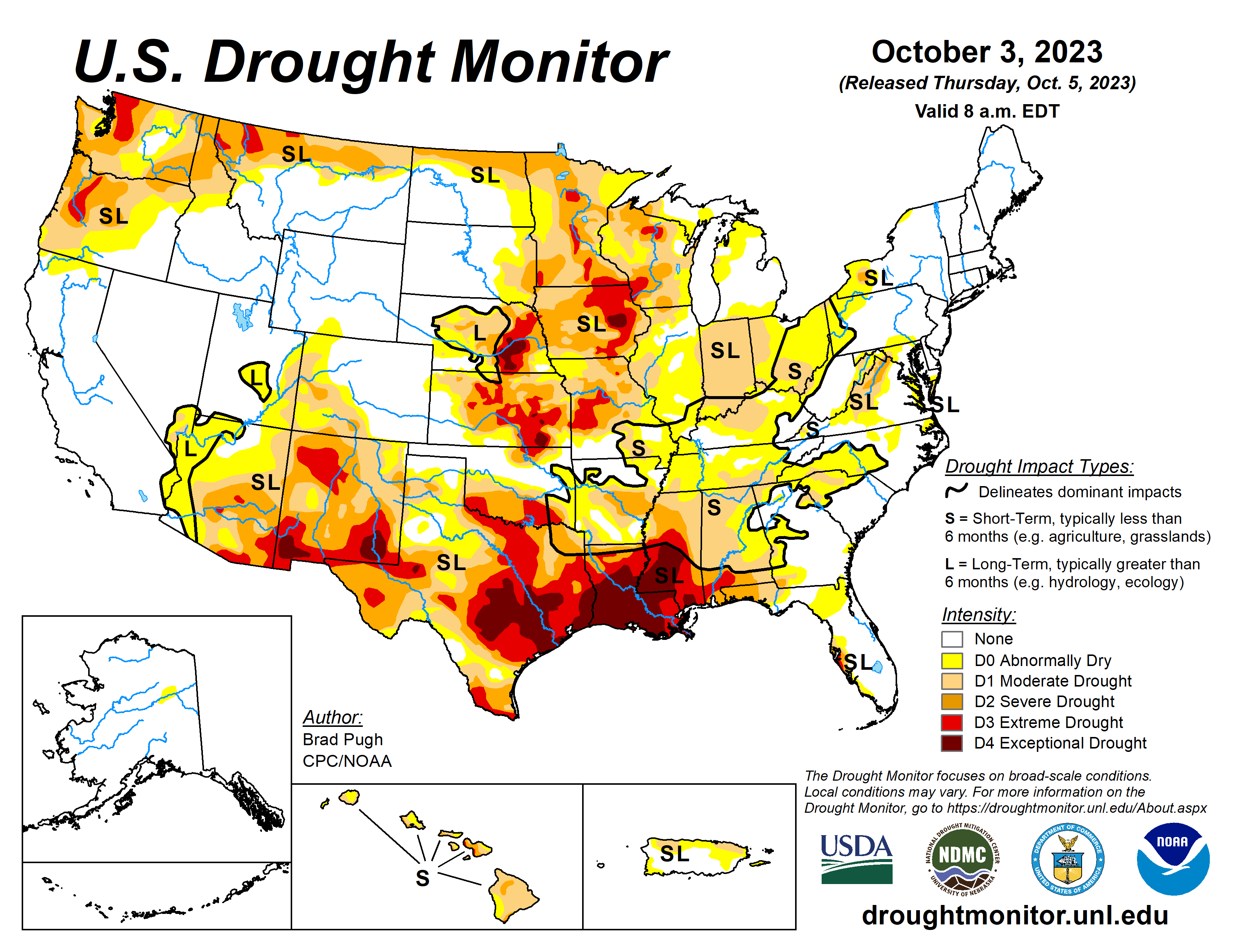
This Week’s Drought Summary
The rapid onset and intensification of drought continued across the South with drought expanding northeast from the Lower Mississippi Valley to the Tennessee Valley and Southern Appalachians. A drier-than-normal September led to an expansion of abnormal dryness (D0) and moderate short-term drought (D1) across the Upper Ohio Valley, Eastern Corn Belt, and western parts of Pennsylvania, New York, and West Virginia. Drought of varying intensity persists across the Middle to Upper Mississippi Valley and parts of the Great Plains. However, heavy rainfall at the beginning of October resulted in improvement for the Southern High Plains. A suppressed 2023 Monsoon led to intensifying drought across Arizona and western New Mexico. Early fall precipitation began to ease drought along the coastal Pacific Northwest. Drought continues to worsen along the leeward side of Maui…
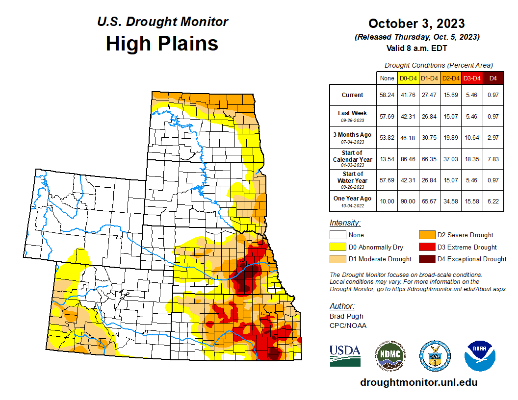
High Plains
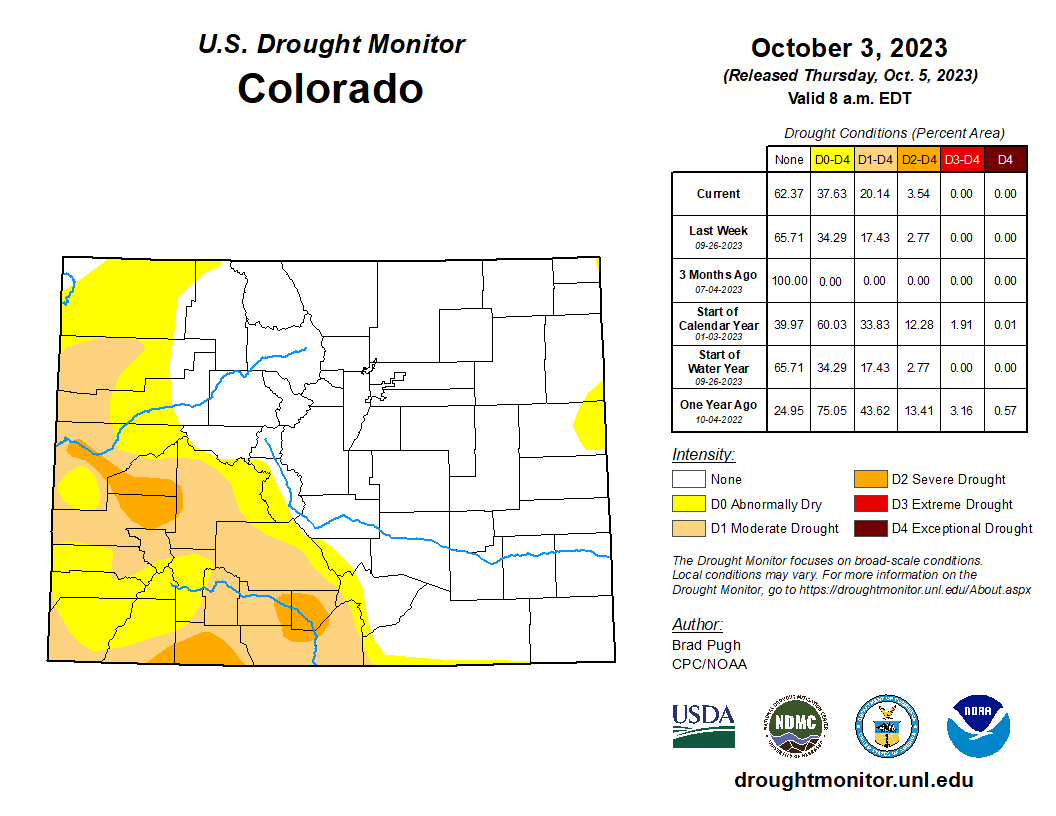
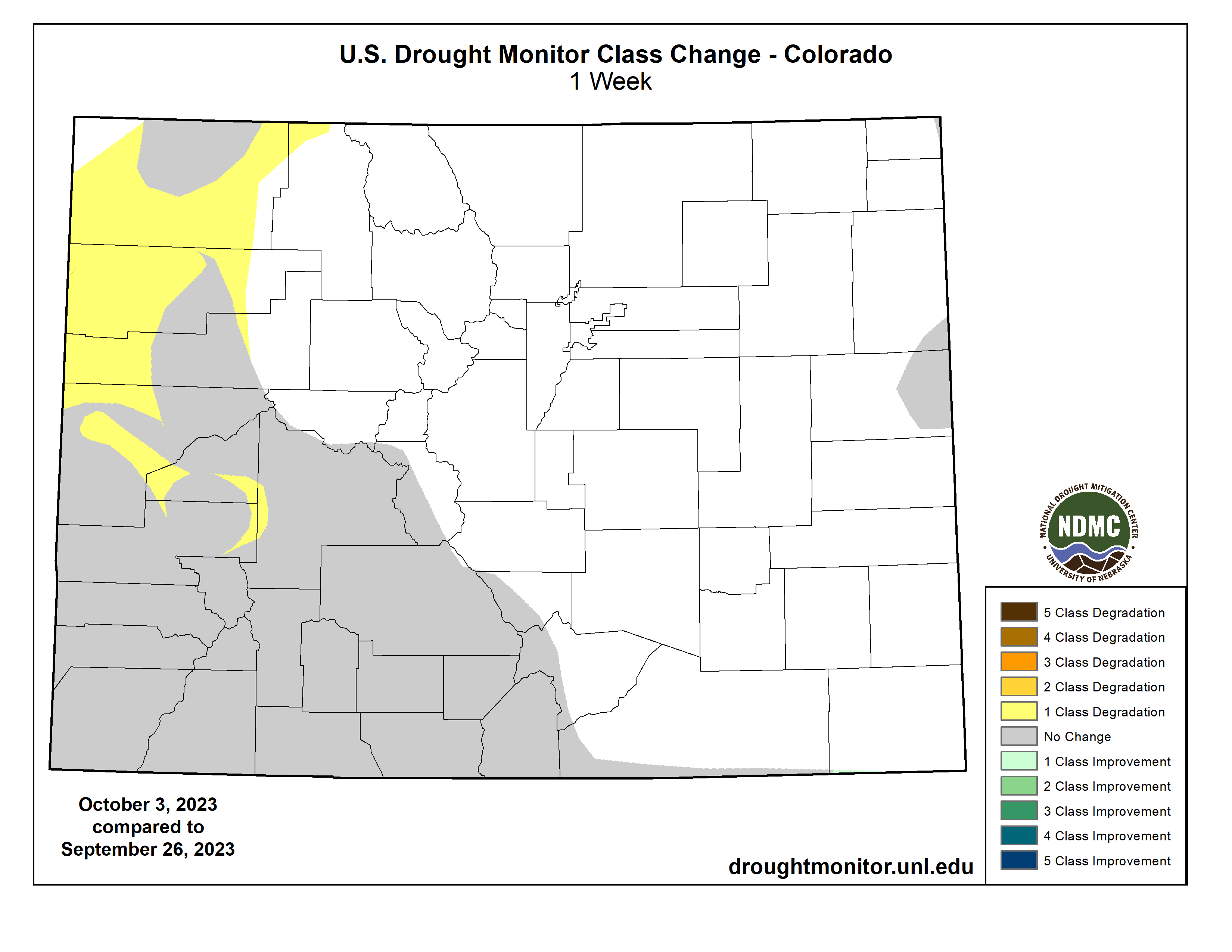
Increasing 30 to 60-day deficits along with support from SPIs at various time scales and the NDMC’s short-term drought blend, a 1-category degradation was made to northeastern Kansas and southeastern Nebraska. Despite a mostly dry week across southern South Dakota, a reassessment of current indicators such as NDMC’s drought blends supported a decrease in abnormal dryness (D0) and moderate drought (D1) in that area. A 1-category degradation was made to northwestern Colorado, based on SPEIs at multiple time scales along with support from soil moisture and vegetation indicators…
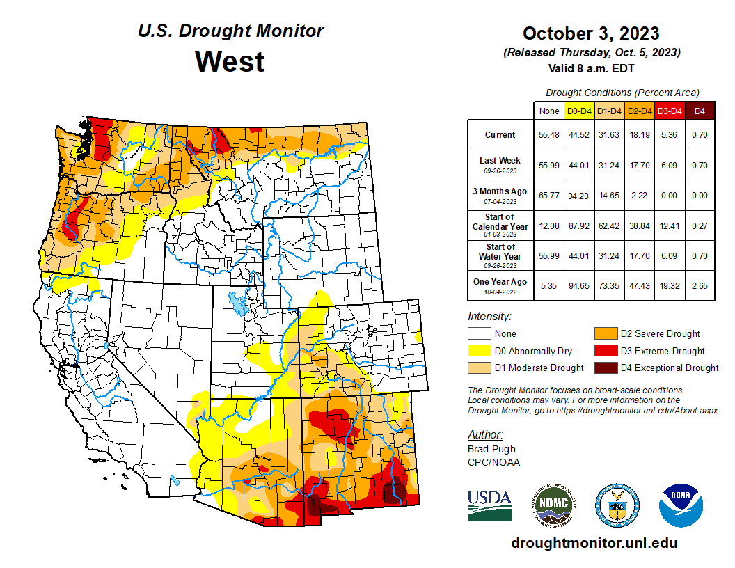
West
Following the drier-than-normal Monsoon, a 1-category degradation was warranted for parts of Arizona and western New Mexico. Conversely, heavy rainfall (more than 2 inches) on October 2nd led to a 1-category improvement for parts of eastern New Mexico. NDMC’s short-term blend and soil moisture supported a 1-category degradation in eastern Utah. Extreme drought (D3) was improved to severe drought (D2) in parts of northern Montana based on indicators dating back 12 months. In addition, 28-day average streamflows are above the 5th percentile in northwestern Montana. During the past two weeks, coastal Oregon and the Puget Sound of Washington received 3 to 6 inches of precipitation which supported a 1-category improvement…
South
A broad 1-category degradation was made to the Lower Mississippi Valley and Tennessee Valley as 30-60 day SPI/SPEI, NDMC short-term blend, soil moisture, and impacts supported expanding/intensifying drought. Impacts in Mississippi include poor pasture conditions, soybean and peanut losses, and cattle sell offs. Severe (D2) to exceptional (D4) drought persists across much of Mississippi and Louisiana, while drought of varying intensity affects the Southern Great Plains. Heavy rainfall (more than 2 inches) on October 2nd supported a 1-category improvement across the Oklahoma Panhandle and western Texas. Based on state recommendations and consistent with the NDMC drought blends, the extreme drought (D3) was slightly reduced across western Texas…
Looking Ahead
During the next five days (October 5-9, 2023), a strong cold front is forecast to progress across the central and eastern U.S. with precipitation amounts of an inch or less across the Ohio Valley with heavier amounts (locally more than 2 inches) for southeastern Oklahoma and eastern Texas. The remnants of Tropical Storm Philippe may become entrained within this eastward-advancing cold front and bring heavy rain and flooding to New England on October 7 and 8. Mostly dry weather is forecast throughout the Southeast. By the second week of October, enhanced onshore flow with associated periods of precipitation are forecast to return to the Pacific Northwest. A major temperature pattern change is likely during this 5-day period as cooler-than-normal temperatures overspread the central and eastern U.S.
The Climate Prediction Center’s 6-10 day outlook (valid October 10-14, 2023) favors above-normal precipitation along the Gulf and East Coasts. Increased probabilities for above-normal precipitation are also forecast for the Pacific Northwest and Northern Rockies. Below-normal precipitation is most likely across the Central to Southern Great Plains and Southwest. Below-normal temperatures are favored for most of the Northeast, while above-normal temperature probabilities are enhanced from the West Coast to the Mississippi Valley.