Scientists Disagree About Drivers of September’s Global Temperature Spike, but It Has Most of Them Worried — Inside #Climate News #ActOnClimate

Credit: World Meteorological Organization

Click the link to read the article on the Inside Climate News website (Bob Berwyn):

The month’s shocking surge is likely to make 2023 the hottest year on record and drive extreme impact around the globe. It could also be a harbinger of even higher temperatures next year.

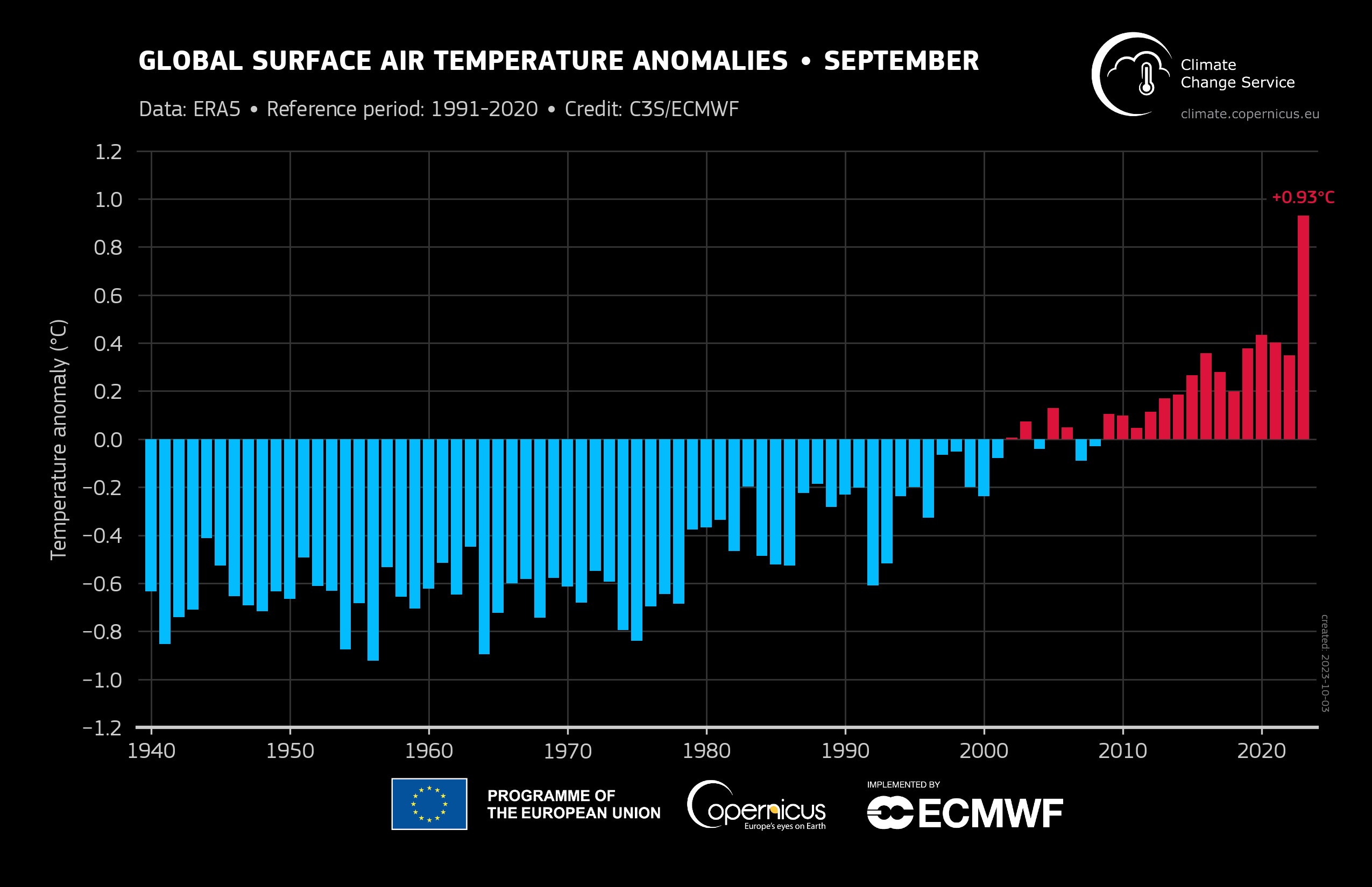
September’s stunning rise of the average global temperature is all but certain to make 2023 the warmest year on record, and 2024 is likely to be even hotter, edging close to the “red line” of 1.5 degrees Celsius of warming above the pre-industrial level that the 2015 Paris climate agreement is striving to avoid. 

As of Oct. 10, the daily average Northern Hemisphere temperature had been at a record high for 100 consecutive days. At least 65 countries recorded their warmest Septembers on record, and even after record heat in July and August, the September spike was a shock, said Carlo Buontempo, director of the European Union’s Copernicus climate change service.

The truth is that I think many climate scientists were absolutely flabbergasted by the plot,” he said of September’s worldwide temperature reading as Copernicus released its monthly global climate report. “This is just beyond anything we’ve ever seen. The anomaly is so incredibly large. You can call it a global heatwave.”

September’s sudden spike to 1.7 degrees Celsius above the pre-industrial global temperature for the month is so far above the trend of rising temperatures and previous records for the month that Buontempo expressed concern that it could indicate a more rapid shift of the climate system to a warmer state.

“I’m not saying that has happened, but I’m saying it is an indication of a process that may not actually be linear at all,” he said.

Many climate scientists say they don’t know exactly why Earth’s fever suddenly spiked so high in September, and there “may never be a clear attribution” to a specific cause, said Gavin Schmidt, director of NASA’s Goddard Institute for Space Studies. Most likely, it’s a combination of factors, he said, a climate recipe with “a little bit of everything combining in ways we haven’t seen before.”

 The uncertainty sent a shiver of unease through parts of the climate science community, especially about extremes like droughts, floods and heatwaves that might be unleashed in the coming year if even warmer temperatures materialize.

The explanations for the temperature surge range from the shift to the warm, El Niño phase in a Pacific ocean cycle, to a continued drop in the concentration of tiny sulfur-based particles of pollution called aerosols.

The scramble to explain the September readings even resulted in scientists at least partly contradicting one another about the possible causes; in some cases scientists who have authored important climate science research together. A few even discounted each other’s explanations, which may reflect a growing climate debate between two camps. 

On one side are self-described climate realists—sometimes pejoratively called doomers—who say we’re already in a worst-case warming scenario leading toward existential challenges for civilization. The others subscribe to what could still be described as the mainstream belief that current and future policies will be enough to reach global climate goals. 

Pushing the Upper Edge of Climate Projections

The steady long-term warming trend of the past half century is clearly caused by carbon dioxide emissions from burning fossil fuels, said Stefan Rahmstorf, a climate expert at the Potsdam Institute for Climate Impact Research.

“For four decades it’s been going as predicted,” he wrote on X (the platform formerly known as Twitter). “But we don’t understand the surprise upward leap that is happening now. And that worries me.”

But the September reading doesn’t mean the countries of the world have failed in the effort to cap global warming at 1.5 degrees Celsius, said Michael Mann, a climate scientist at the University of Pennsylvania. The Paris Agreement is aimed at preventing warming from staying above that mark for the long-term, defined by “something like a 20-year running average, or something to that effect,” he said. If greenhouse gas emissions continue on their current trajectory, that would happen in about 15 years. But a permanent breach of the 1.5 degree threshold could be avoided by cutting emissions 50 percent by 2030 and reaching zero emissions by 2050, Mann said.

A few months, or even a year, barely above the line “does not, in any way, imply that the warming trend has crossed the 1.5C warming threshold, which is what policy efforts address,” he said. 

Some of the confusion over when the limit would be breached is because “there is no official definition” of what crossing the 1.5 degree Celsius threshold means, said Robert Rohde, a climate scientist with Berkeley Earth, an independent climate think tank. “Scientists and others sometimes create precise definitions for the purpose of analysis, but the Paris Agreement itself is imprecise on how the threshold is defined,” he said.

In 2021, the United Nations Framework Convention on Climate Change sharpened the definition to make it clear that it’s based on multidecadal average, “So at least 20 years,” said Andrew Ferrone, a co-coordinator of the European Union negotiation team on science issues for the United Nations Framework Convention on Climate Change.

The September temperature spike is eye-catching, and “certainly pushing the boundaries of model expectations,” Berkeley Earth climate scientist Zeke Hausfather wrote on X, posting a graph showing the monthly temperature soaring well above the range projected by some climate models.

Mann said the focus should be on annual average temperatures and noted that 2023 “is almost certain to be within the range predicted by the models,” he said. “I’m frustrated by the hyperventilating going on over this. It’s frustrating that so many continue to miscommunicate about that and mislead the public as to where we are. The truth is bad enough.”

Many other climate scientists expressed their astonishment at September’s global temperature reading in social media posts, including Mika Rantanen, a climate researcher with the Finnish Meteorological Institute, who wrote, “I’m still struggling to comprehend how a single year can jump so much compared to previous years. Just by adding the latest data point, the linear warming trend since 1979 increased by 10%.”

Hansen Points to Aerosols, and a “Helluva a Ride” to Come

The September temperature spike is at the very highest edge of what recent climate models projected as possible, and even absent intentional miscommunication, there are divergent views about how fast Earth will warm during the next few decades. That’s partly because even the newest climate models don’t include some of the climate feed backs that amplify warming, like the huge surge of greenhouse gas emissions from wildfires. 

And it’s also because scientists haven’t been able to study some of the most important atmospheric processes that will determine the pace of climate change, like the interaction between clouds and tiny particles called aerosols that come from industrial sources, primarily from burning fossil fuels, as well as natural sources, said James Hansen, the former NASA climate scientist whose 1988 testimony to Congress put climate change in the political spotlight. 

In 2021, Hansen warned that the rate of warming could double over the next 25 years, heating the planet by somewhere close to 2 degrees Celsius over pre-industrial levels (3.6 degrees Fahrenheit) by 2050. 

Aerosols affect cloud particle size, cloud cover and cloud brightness, which, in turn, affect how much heat energy the atmosphere absorbs. Even without directly measuring the climate effect of aerosols, Hansen said other satellite data, including from NASA’s CERES program, show changes in clouds that account for the rapidly increasing energy imbalance in the climate system, with increasing amounts of heat staying in the atmosphere.

Hansen said those measurements show that greenhouse gases can be ruled out as the main cause of September’s anomalous temperature increase.

“The data are all consistent with aerosol reduction being the cause of accelerated global warming,” he said, reiterating his recent warnings about a sudden spike of global warming . “So hang onto your hat. We are in for a helluva ride. Global warming will rise above 1.5 degrees Celsius within several months and above 2 degrees Celsius within a couple of decades, unless we take purposeful actions to restore Earth’s energy balance and climate, in addition to phasing down fossil fuel emissions as rapidly as practical.”

Those actions include geoengineering and nature restoration, as well as technologies to remove CO2 from the atmosphere, he said.

“We need to research, urgently, all of the above because plausible emission reductions will not be enough,” he said. “We have a very limited time to avoid locking in consequences for today’s young people that they will consider unacceptable, and we have allowed the problem to reach a magnitude such that strong actions will be required.”

Preemptively ruling out any method of mitigating climate change “would be the height of irresponsibility” with regard to young people and must be rejected, he said. 

Other Possible Causes and Impacts

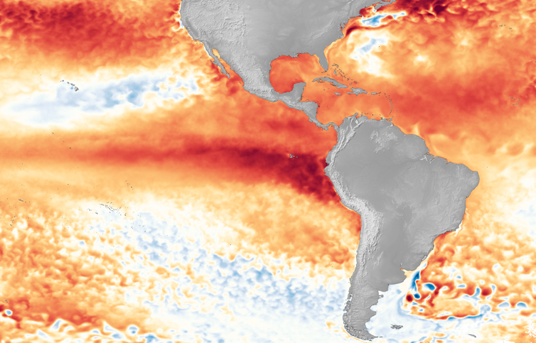
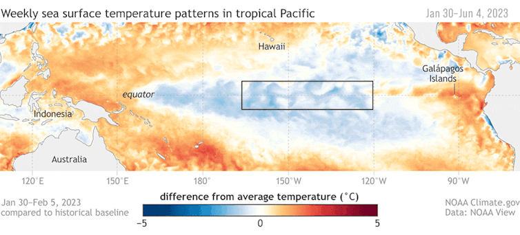
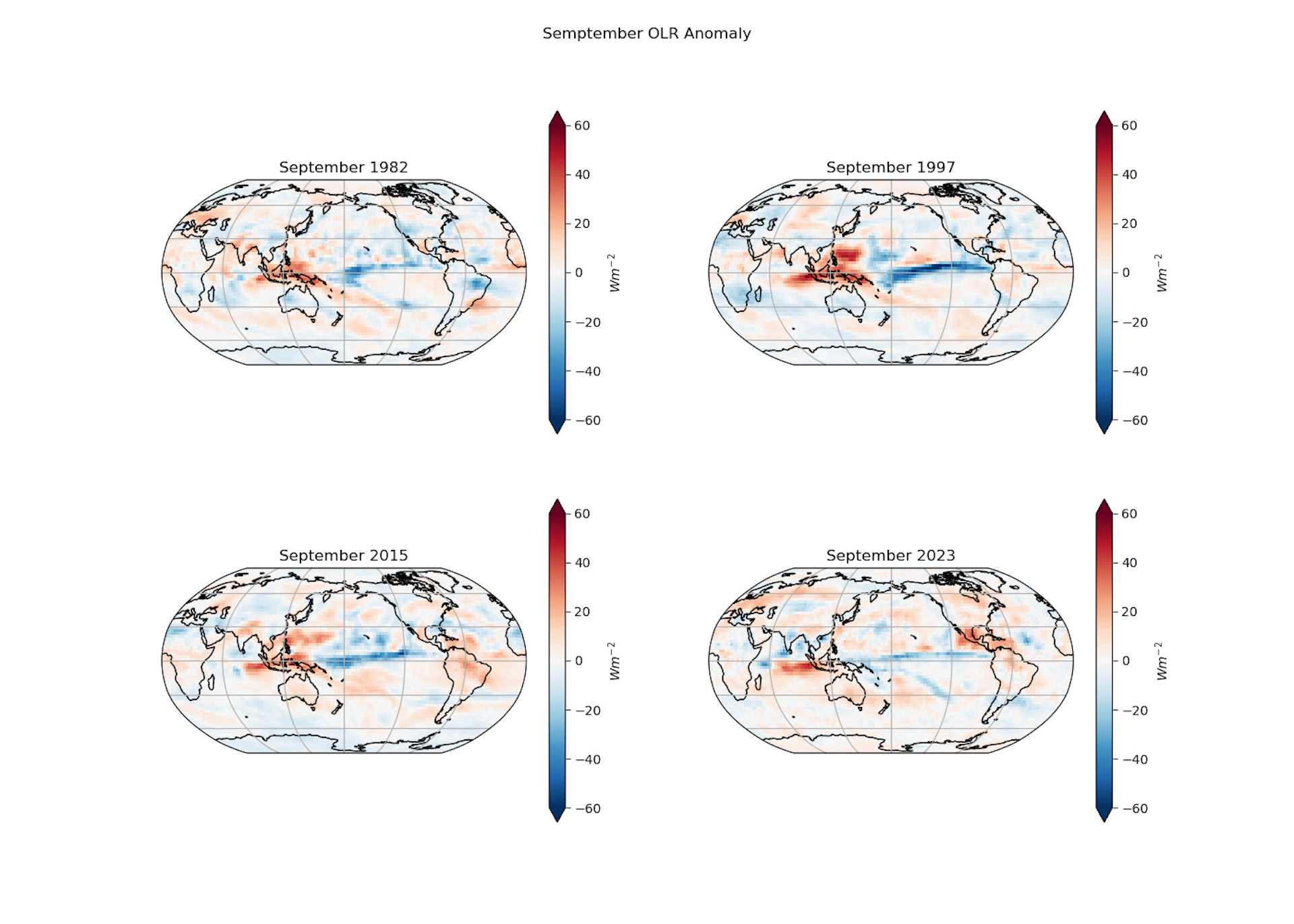
Schmidt, the NASA climate scientist, said the September temperature increase can at least partly be attributed to the emerging El Niño, when a big slice of Pacific Ocean around the equator heats up between 1 and 2 degrees Celsius above normal, which also raises the global average. But that doesn’t completely explain it, he said.

It usually takes about three to six months for an El Niño to “really make a difference to the global mean,” he said. The full impacts will be felt next year, affecting the global average by about .1 degrees Celsius, depending on how strong the El Niño becomes.

“The drivers of the current spike are going to be a little of everything in ways that we haven’t really seen before,” he said. “We may not ever have a clean attribution though.”

He said most of this year’s global temperature sets will still “all be substantially below” 1.5 degrees Celsius warming compared to the late 19th century. 

“Even with the El Niño boost next year, that’s likely to be true then as well,” he said.

Kevin Trenberth, formerly with the climate analysis team at the National Center for Atmospheric Research in Boulder, Colorado, said El Niño may also be a factor in the September temperature surge because it increases the amount of heat-trapping water vapor in the atmosphere.

During El Nino, he said, the warming equatorial Pacific dissipates its heat through evaporation, ”adding more water vapor to the atmosphere that eventually finds its ways into storms and it pours with rain while releasing the latent heat,” he said. “That is what really gives the mini-global warming with El Nino.”

Regardless of the exact cause, the surging average global temperature is cause for concern, because even small increments of warming can exponentially increase the risk of some climate extremes, such as with recent heatwaves and floods, sometimes in the same place

As the global average temperature increase approaches 1.5 degrees Celsius, studies show that increasingly large swaths of the planet will experience heat waves that will kill unprotected people after several hours of exposure. Other research identifies clear climate tipping points between 1.5 and 2 degrees Celsius that will wipe most coral reefs and nearly all mountain glaciers and raise sea level rapidly by melting ice sheets in Greenland and Antarctica. 

The incremental additional warming from El Niño raises more specific concerns, since observations and research show regional extreme impacts, including drought in the Amazon rainforest and across parts of Africa

During recent El Niños, there have also been megafires in Indonesia that emitted massive quantities of carbon dioxide, and such fires have already started this year. In January 2018, Cape Town, South Africa, nearly ran out of water, which climate researchers attributed to a combination of an El Niño that preceded the dry spell and climate change. And this year has already been disastrously bad for mountain glaciers. Switzerland’s glaciers may have lost as much as 10 percent of their mass during the past year alone, according to recent survey results.

But even though patterns of regional El Niño impacts are documented, the current level of warming puts the planet in “uncharted waters,” said Maarten Van Aalst, director of the Royal Netherlands Meteorological Institute.

“The standard impacts of El Nino are pretty well known of course and I do expect many of these to appear,” he said. “But on top of the current levels of warming, we’re clearly also in for some surprises.”

Sunset from the western shore of Antelope Island State Park, Great Salt Lake, Utah, United States.. Sunset viewed from White Rock Bay, on the western shore of Antelope Island. Carrington Island is visible in the distance. By Ccmdav – Own work, Public Domain, https://commons.wikimedia.org/w/index.php?curid=2032320

The latest #ElNiño/Southern Oscillation (#ENSO) discussion is hot off the presses from the #Climate Prediction Center

Click the link to read the discussion on the Climate Prediction Center website:

ENSO Alert System Status: El Niño Advisory

Synopsis: El Niño is anticipated to continue through the Northern Hemisphere spring (with an 80% chance during March-May 2024).

In September, equatorial sea surface temperatures (SSTs) were above average, though positive anomalies weakened in the eastern Pacific. All of the latest weekly Niño index values remained in excess of +1.0ºC: Niño-4 was +1.2ºC, Niño-3.4 was +1.5ºC, Niño-3 was +1.9ºC, and Niño1+2 was +2.6ºC. Area-averaged subsurface temperatures anomalies decreased, but remained above-average, consistent with elevated subsurface temperatures across the central and eastern equatorial Pacific Ocean. Tropical atmospheric anomalies were consistent with El Niño. In areas of the central Pacific, low-level winds were anomalously westerly, while upper-level winds were anomalously easterly. Convection was enhanced around the International Date Line, stretching into the eastern Pacific, just north of the equator. Convection was suppressed near Indonesia. The equatorial Southern Oscillation Index (SOI) and the traditional station-based SOI were both significantly negative. Collectively, the coupled ocean-atmosphere system reflected El Niño.

The most recent IRI plume favors El Niño to continue through the Northern Hemisphere spring 2024. Also considering recent observations and the NMME, the team favors at least a “strong” event with a 75-85% chance through November-January (≥1.5°C for the seasonal average in Niño-3.4). There is a 3 in 10 chance of a “historically strong” event that rivals 2015-16 and 1997-98 (seasonal average ≥ 2.0°C). Stronger El Niño events increase the likelihood of El Niño-related climate anomalies, but do not necessarily equate to strong impacts locally. Consider consulting CPC seasonal outlooks for probabilities of temperature and precipitation in the coming seasons. In summary, El Niño is anticipated to continue through the Northern Hemisphere spring (with an 80% chance during March-May 2024).

What is a strong El Niño? Meteorologists anticipate a big impact in winter 2023, but the forecasts don’t all agree — The Conversation #ENSO

The El Niño pattern stands out in the warm sea surface temperature anomalies in the Pacific in 2023. NOAA Climate.gov

Aaron Levine, University of Washington

Winter is still weeks away, but meteorologists are already talking about a snowy winter ahead in the southern Rockies and the Sierra Nevada. They anticipate more storms in the U.S. South and Northeast, and warmer, drier conditions across the already dry Pacific Northwest and the upper Midwest.

One phrase comes up repeatedly with these projections: a strong El Niño is coming.

It sounds ominous. But what does that actually mean? We asked Aaron Levine, an atmospheric scientist at the University of Washington whose research focuses on El Niño. https://www.youtube.com/embed/wVlfyhs64IY?wmode=transparent&start=0 NOAA explains in animations how El Niño forms.

What is a strong El Niño?

During a normal year, the warmest sea surface temperatures are in the western Pacific and the Indian Ocean, in what’s known as the Indo-Western Pacific warm pool.

But every few years, the trade winds that blow from east to west weaken, allowing that warm water to slosh eastward and pile up along the equator. The warm water causes the air above it to warm and rise, fueling precipitation in the central Pacific and shifting atmospheric circulation patterns across the basin.

This pattern is known as El Niño, and it can affect weather around the world.

An animation shows how warm water builds up along the equator off South America. The box where temperatures are measured is south of Hawaii.
The box shows the Niño 3.4 region as El Niño begins to develop in the tropical Pacific, from January to June 2023. NOAA Climate.gov

A strong El Niño, in the most basic definition, occurs once the average sea surface temperature in the equatorial Pacific is at least 1.5 degrees Celsius (2.7 Fahrenheit) warmer than normal. It’s measured in an imaginary box along the equator, roughly south of Hawaii, known as the Nino 3.4 Index.

But El Niño is a coupled ocean-atmosphere phenomenon, and the atmosphere also plays a crucial role.

What has been surprising about this year’s El Niño – and still is – is that the atmosphere hasn’t responded as much as we would have expected based on the rising sea surface temperatures.

Is that why El Niño didn’t affect the 2023 hurricane season the way forecasts expected?

The 2023 Atlantic hurricane season is a good example. Forecasters often use El Niño as a predictor of wind shear, which can tear apart Atlantic hurricanes. But with the atmosphere not responding to the warmer water right away, the impact on Atlantic hurricanes was lessened and it turned out to be a busy season.

The atmosphere is what transmits El Niño’s impact. Heat from the warm ocean water causes the air above it to warm and rise, which fuels precipitation. That air sinks again over cooler water.

The rising and sinking creates giant loops in the atmosphere called the Walker Circulation. When the warm pool’s water shifts eastward, that also shifts where the rising and sinking motions happen. The atmosphere reacts to this change like ripples in a pond when you throw a stone in. These ripples affect the jet stream, which steers weather patterns in the U.S.

This year, in comparison with other large El Niño events – such as 1982-83, 1997-98 and 2015-16 – we’re not seeing the same change in where the precipitation is happening. It’s taking much longer to develop, and it’s not as strong.

Part of that, presumably, is related to the whole tropics being very, very warm. But this is still an emerging field of research.

How El Niño will change with global warming is a big and open question. El Niño only happens every few years, and there’s a fair amount of variability between events, so just getting a baseline is tough.

What does a strong El Niño typically mean for US weather?

During a typical El Niño winter, the U.S. South and Southwest are cooler and wetter, and the Northwest is warmer and drier. The upper Midwest tends to be drier, while the Northeast tends to be a little wetter.

The likelihood and the intensity generally scale with the strength of the El Niño event.

El Niño has traditionally been good for the mountain snowpack in California, which the state relies for a large percentage of its water. But it is often not so good for the Pacific Northwest snowpack.

Two maps showing wetter, cooler weather in the Southeast and drier warmer air in the north during El Nino.
The jet stream takes a very different path in a typical El Niño vs. La Niña winter weather pattern. But these patterns have a great deal of variability. Not every El Niño or La Niña year is the same. NOAA Climate.gov

The jet stream plays a role in that shift. When the polar jet stream is either displaced very far northward or southward, storms that would normally move through Washington or British Columbia are steered to California and Oregon instead.

What do the forecasts show for 2023?

Whether forecasters think a strong El Niño will develop depends on whose forecast model they trust.

This past spring, the dynamical forecast models were already very confident about the potential for a strong El Niño developing. These are big models that solve basic physics equations, starting with current oceanic and atmospheric conditions.

However, statistical models, which use statistical predictors of El Niño calculated from historical observations, were less certain.

Even in the most recent forecast model outlook, the dynamical forecast models were predicting a stronger El Niño than the statistical models were.

If you go by just a sea surface temperature-based El Niño index, the forecast is for a fairly strong El Niño.

But the indices that incorporate the atmosphere are not responding in the same way. We’ve seen atmospheric anomalies – as measured by cloud height monitored by satellites or sea-level pressure at monitoring stations – on and off in the Pacific since May and June, but not in a very robust fashion. Even in September, they were nowhere near as large as they were in 1982, in terms of overall magnitude.

We’ll see if the atmosphere catches up by wintertime, when El Niño peaks.

How long do El Niños last?

Often during El Niño events – particularly strong El Niño events – the sea surface temperature anomalies collapse really quickly during the Northern Hemisphere spring. Almost all end in April or May.

One reason is that El Niño sows the seeds of its own demise. When El Niño happens, it uses up that warm water and the warm water volume shrinks. Eventually, it has eroded its fuel.

#Colorado Parks & Wildlife announces plan to eradicate zebra mussels from Highline Lake

Highline Lake. Photo credit: Colorado Parks & Wildlife

Click the link to read the release from the Colorado Parks & Wildlife website (Rachael Gonzales):

GRAND JUNCTION, Colo. – Colorado Parks and Wildlife has finalized a new plan to eradicate zebra mussels at Highline Lake State Park after five adult mussels were found while removing buoys on Sunday, Oct. 1.

“We did not make this decision lightly or in haste,” said Invasive Species Program Manager Robert Walters. “Over the past year we have had numerous discussions with CPW’s Northwest Region aquatic, regional, and state park staff, and we have come up with a plan that builds upon that work that was performed last spring.” 

The new plan will once again be a phased approach. The first phase will begin late 2023, with the second phase taking place gradually over 2024. During the first phase, CPW staff will apply a higher concentration of EarthTec QZ, the same EPA-registered copper-based molluscicide that was applied to the lake in March. The goal of this application is to suppress the population to minimize reproductive potential in 2024.

“While the efforts in early 2023 did not achieve our ultimate goal of eradicating zebra mussels, we believe it helped to keep population numbers at a manageable level,” said Walters. “A single female zebra mussel can produce more than 30,000 eggs per reproductive cycle. Any mussel we can keep from reproducing in the immediate future increases the probability of our success next fall.”

In early 2024, CPW will begin slowly lowering Highline Lake with an anticipated complete emptying of the lake by the end of the year.

With the lower water levels, CPW is announcing Highline Lake will be closed to all motorized boating for the 2024 boating season.  

“We understand that this isn’t ideal for our boating and angling community,” said Alan Martinez, Highline Lake State Park Manager. “What we hope is that people see this and understand how serious this problem is, and that it can be avoided by simply cleaning, draining, and drying your boat or any equipment that comes in contact with the water in between each and every use.”

Unfortunately, CPW cannot move fish out of Highline Lake into other waters prior to draining due to the risk of moving viable mussels on or inside fish. In this case, the only option is to reduce fish loss by removing bag and possession limits. 

Anglers are reminded, effective Monday, Oct. 9, that an emergency fish salvage is in place at Highline Lake until further notice. All bag and possession limits for the reservoir are removed for the duration of the salvage. Anglers can keep all of the fish they catch from the shoreline utilizing the lawful angling methods currently allowed at the lake. CPW reminds anglers that all fish must be dead prior to transport away from the lake. 

“Eradication of zebra mussels has been, and will continue to be, our goal at Highline Lake,” said Ben Felt, Northwest Region Senior Aquatic Biologist. “Earlier this year, we pursued an option that had the potential to eradicate the mussels while maintaining the fishery. Based on this recent discovery, we recognize achieving both is not feasible. To do nothing would be detrimental to Highline Lake and would put fisheries across the state at risk. CPW is committed to rebuilding the Highline Lake fishery once the zebra mussel eradication project is complete.”

Zebra and Quagga Mussels