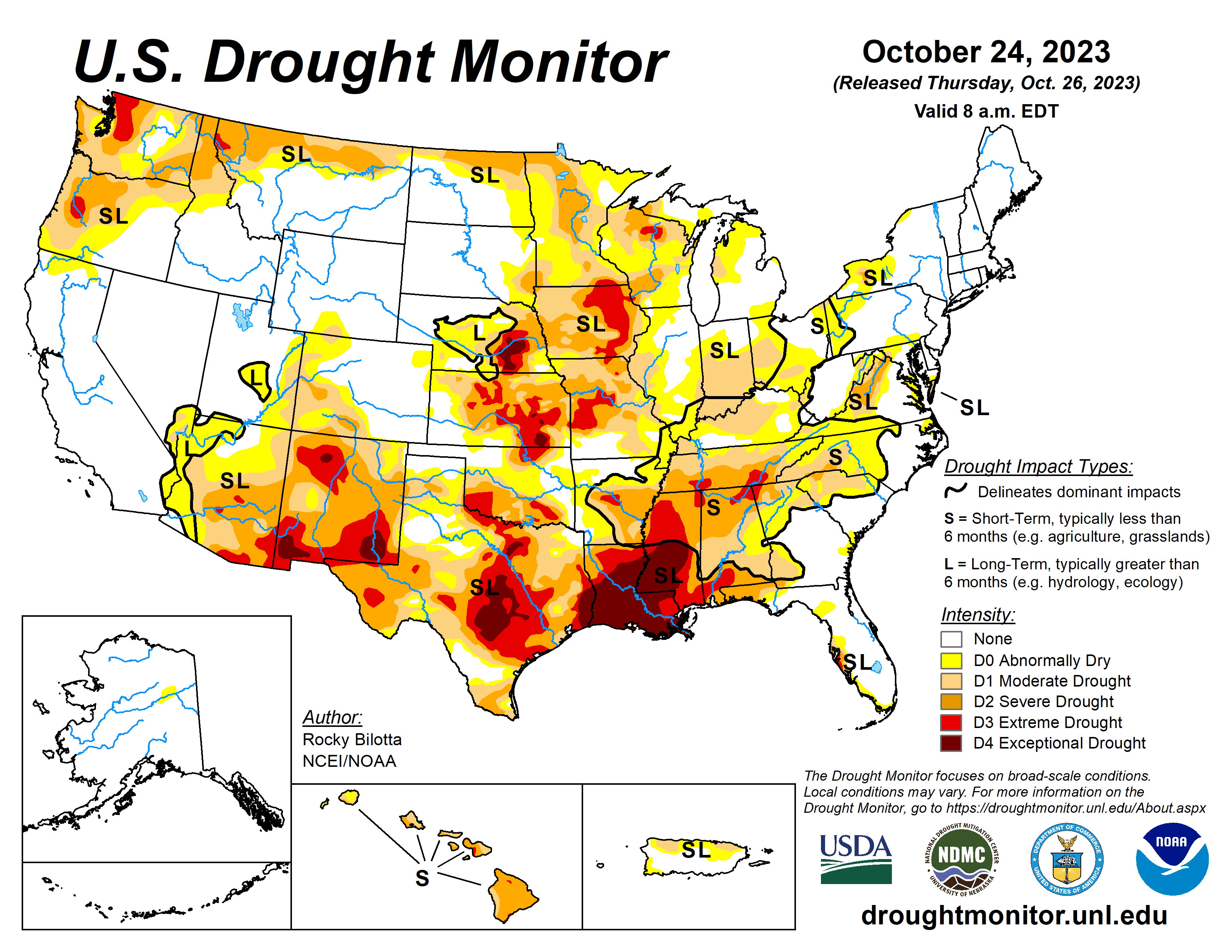
A strong upper-level ridge dominated much of the western U.S., providing anomalously warm temperatures, by as much as 20 degrees above average, and dry conditions over the central and western parts of the country. While a front extending from the Great Lakes to the Gulf Coast produced rain over parts of Ohio Valley and Great Lakes before moving eastward and bringing rain to parts of the Northeast and Southeast. The most widespread improvements were made to parts of eastern Texas, central Wisconsin and in parts of the Ohio River Valley, where above-normal precipitation was observed this past week. Dry conditions continued across much of the Southern region, with widespread degradations occurring across the Tennessee Valley, central Mississippi Valley and northern parts of the Southeast. In the Southwest, near- to record-warm temperatures coupled with below-normal precipitation for the month, resulted in degradation in the southern parts of the region. In Hawaii, drought continues to intensify across all islands, while no changes occurred on Kauai…
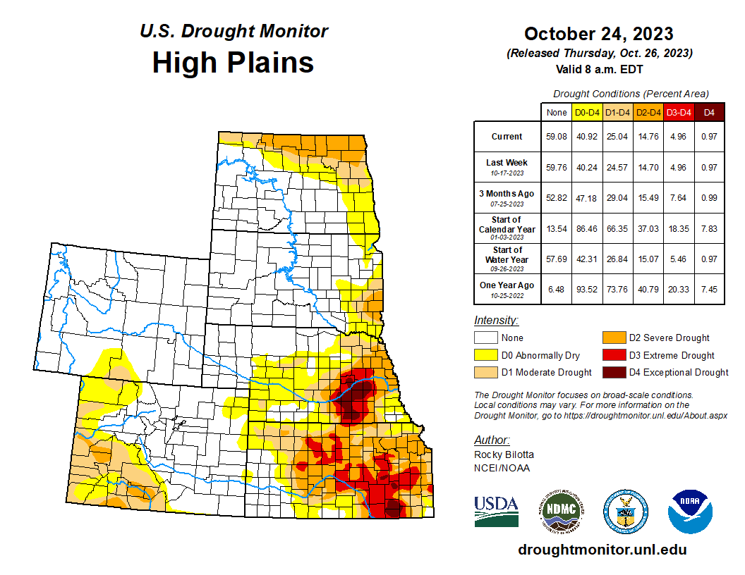
Precipitation fell over the northern and eastern parts of the region, with much of the rain falling outside of the drought areas. For this reason, much of the High Plains remained as status quo this week. Little to no precipitation fell over most of Nebraska, Kansas, Colorado and southern Wyoming. This coupled with above-normal temperatures (around 10-15°F above normal), along with deteriorating conditions shown in short-term SPI/SPEI, streamflow and soil moisture data, justified slight degradations across these states. Severe drought (D2) was expanded in northeast Kansas, while moderate drought (D1) was expanded in the southeast part of the state. D1 was also expanded in parts of southwest Wyoming, while abnormal dryness (D0) was expanded from southwest Nebraska into northeast Wyoming and D0 was introduced along the central border of Kansas and Wyoming…
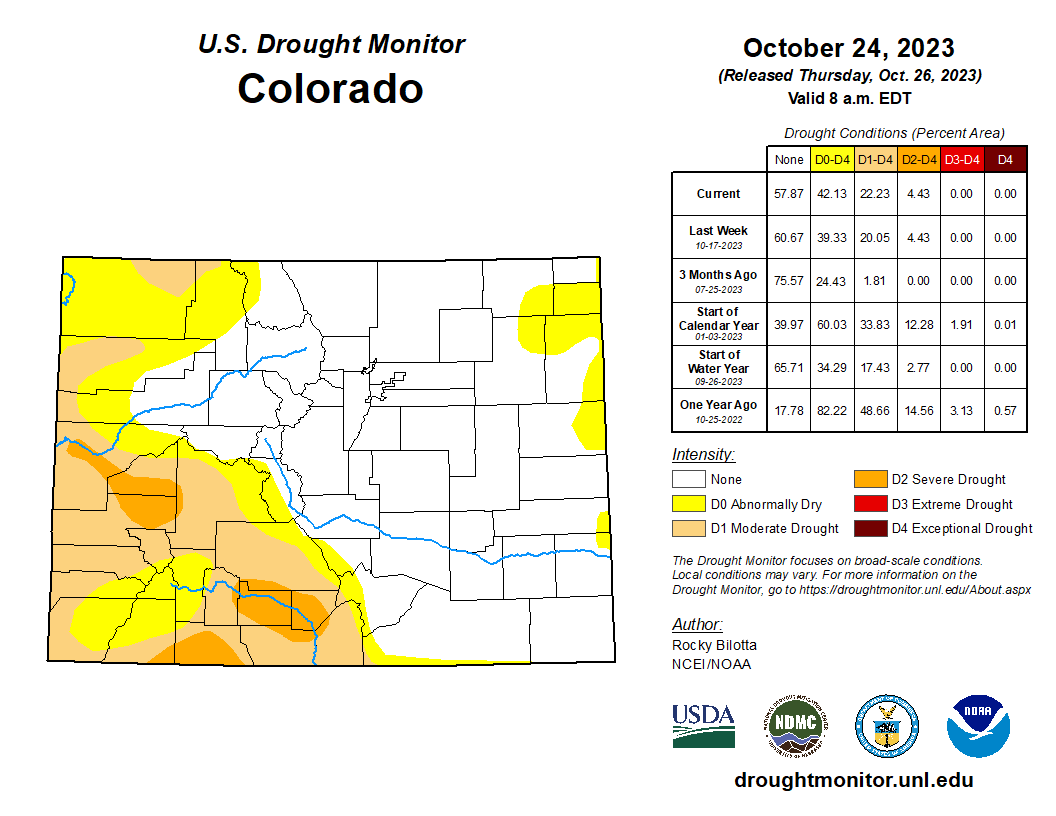
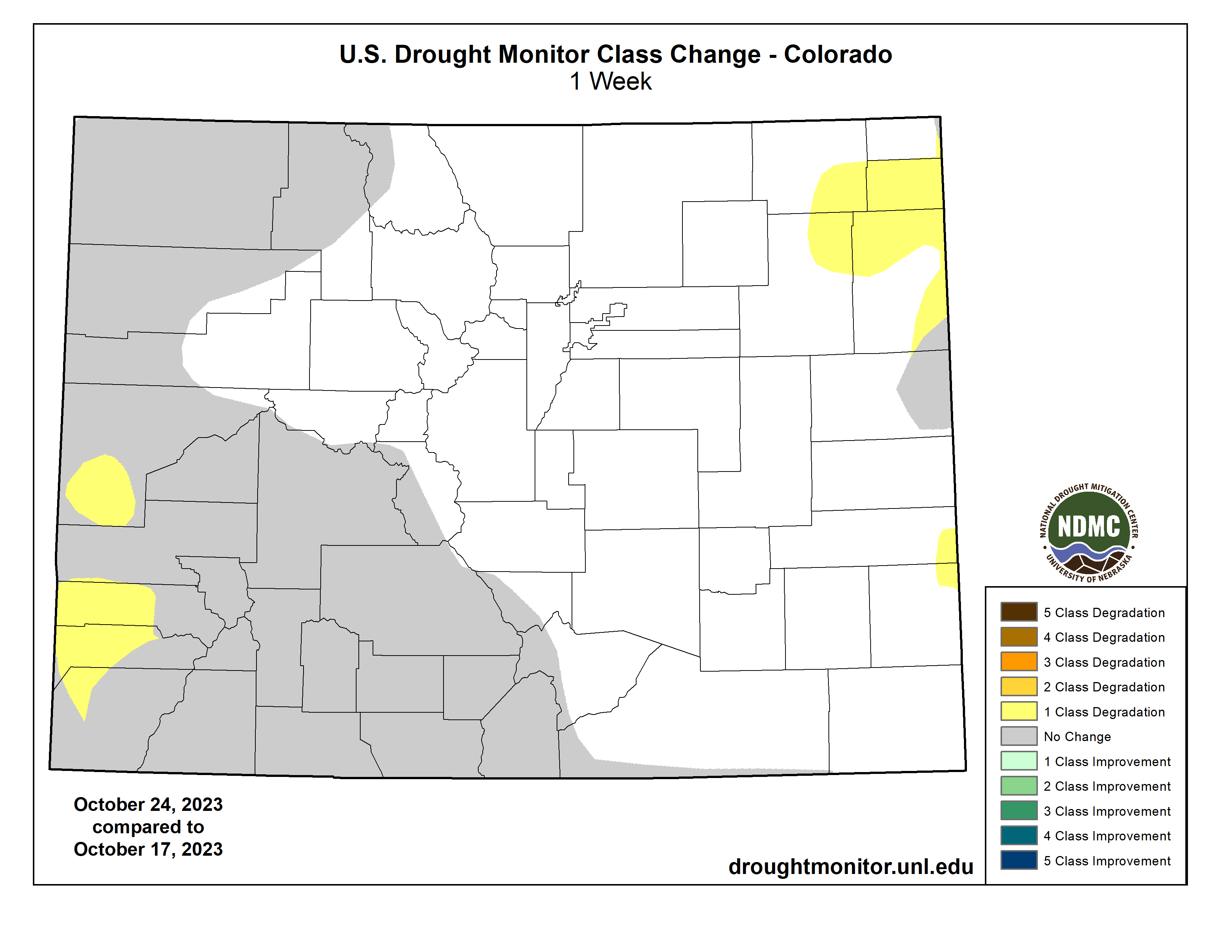
Colorado Drought Monitor one week change map ending October 24, 2023.
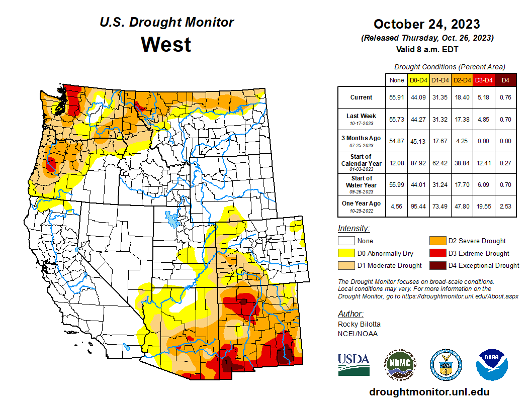
Much of the West remained as status quo this week. Precipitation fell across much of the region, which was enough to prevent further degradation but not enough to warrant large improvements. Heavier precipitation fell across parts of Montana, with rain totals up to 300-400% above normal, over the past week. This beneficial rainfall, along with precipitation percentiles and short-term SPI/SPEI, soil moisture and streamflow data, resulted in abnormal dryness (D0) and moderate (D1) to severe (D2) drought improvements along the northern parts of Montana. As for temperature, much of the region was well above normal with temperatures up to 15°F above normal. Parts of the Southwest are experiencing record warm temperatures for this month-to-date period, while Phoenix, AZ, reached 105°F on October 16th and 104°F on October 19th and 20th, setting the three hottest temperatures on record for this time of the year. These above-normal temperatures coupled with below-normal precipitation resulted in the expansion of D1 and D2 in southern Arizona and across the state of New Mexico. Introduction of D3 was also added to northwest New Mexico based on precipitation deficits and short-term SPI/SPEI and soil moisture data…
Dry conditions continued across much of the Southern region this week while heavy precipitation fell over parts of eastern Texas to southern Oklahoma. Portions of the Texas Panhandle received up to 4 inches of rainfall (up to 600% above normal) this week, resulting in removal of exceptional drought (D4) while extreme drought (D3) and severe drought (D2) conditions were improved in this region. On the dry side, a broad 1-category degradation was made to Arkansas, Tennessee and in northern parts of Mississippi and Louisiana, where little to no precipitation fell. Extreme drought was expanded in southeast Louisiana, while D3 was expanded in northern Louisiana, northern Mississippi and introduced in parts of central Arkansas and southern Tennessee. Precipitation in these areas are around 2-3 inches below normal for the month. The drought expansion and intensification was based on short-term SPI/SPEI, NDMC’s short-term blend, streamflow and soil moisture data…
Looking Ahead
During the next five days (October 24-28, 2023), remnant energy and moisture from Tropical Storm Norma could stream northward to spread heavy rainfall to parts of the southern and central U.S. early to mid-next week, while chances of snow increase in the northern Rockies and into parts of the northern Plains late next week. The Weather Prediction Center has highlighted a slight risk of excessive rainfall for parts of northern Texas and west-central Oklahoma due to potential flash flooding. Well above normal temperatures will spread from the Midwest into the East (15-20 degrees above normal), while daytime maximum temperatures for the northern portions of the Rockies and Plains could be 10-20 degrees below normal.
The Climate Prediction Center’s 6-10 day outlook (valid October 28-November 2, 2023) favors near to above-normal precipitation throughout much of contiguous U.S., and Alaska with below-normal precipitation most likely from the Pacific Northwest to the northern Plains, across much of Hawaii and in parts of southeast Alaska. Increased probabilities for below-normal temperatures are forecast for much of the contiguous U.S. while above-normal temperatures are likely from Louisiana to New England, as well as much of Alaska and Hawaii.
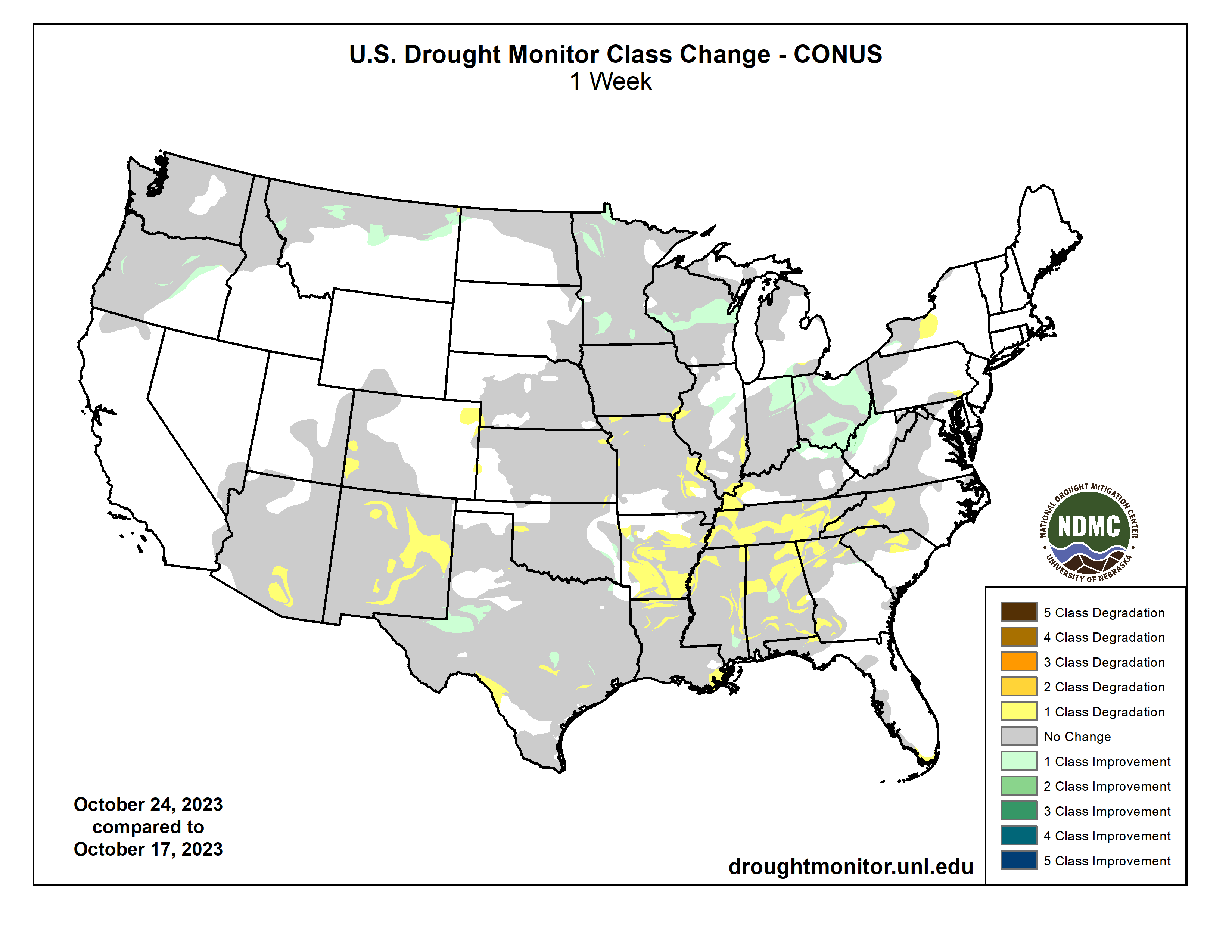
US Drought Monitor one week change map ending October 24, 2023.
We’re seeing not just being at the table, but actually having an influence on the agenda. We’re looking at the next step – because you can have a seat at the table, but not be taken seriously. And tribes, especially now in regards to water,we have to be taken seriously. – Stephen Roe Lewis, Governor Gila Indian River Community
In the last post, I took a closer look at one of the Colorado River Basin’s 30 First People tribes in the Colorado River’s natural basin, the Southern Utes, and the way in which the Ute bands adapted to the civilization that had overrun them. A warrior culture at the time they were overrun and eventually confined to a reservation, they did not take up farming like the Bureau of Indian Affairs trustees wanted them to, although some did engage in cattle and sheep ranching – herding being the least traumatic (agri)cultural transformation from the hunter-forager way of life.
But what really caught the Ute imagination was the idea of taking over the development of their gas and oil reserves, a leap over the usual agricultural transition, right into industrial culture, a competitive field that may have spoken to their residual warrior spirit. They chose, however, to plunge into capital development their way, the ‘Indian way,’ essentially a ‘one for all and all for one’ social capitalism rather than the mainstream’s ‘rugged individualist’ route of private capitalism – enabling them to collectively accumulate wealth from the fat years for the coming lean years.
But what about the other First Peoples in the Colorado River Basin – how have they adapted? Some of the other warrior Peoples retained their lack of enthusiasm for the farming way of life. The Navajo Indian Irrigation Project (NIIP), a system of canals and laterals to irrigate ultimately around 110,000 acres from the Navajo Reservoir on the San Juan River, was begun in the 1960s to facilitate a transition to farming; but when the first allotments of the NIIP land were ready for farming, not very many Navajo were interested. They had come from the far north with herds of sheep, and liked the herding way of life. So what the Navajo leaders decided to do with their irrigated land was to also jump straight to the ‘civilization’ stage. Like the Southern Utes with their fossil fuels, they hired Euro-American consultants and managers to create an agribusiness operation on the reservation, raising food for regional, even national markets as well as themselves. Today, the reservation’s community colleges prepare young Navajos for those management positions in the tribe’s agribusiness, with dividends distributed to the people. Meanwhile many of the Navajo People have individually continued small-scale family herding as their accommodation to agricultural adaptation.
Native America in the Colorado River Basin. Credit: USBR
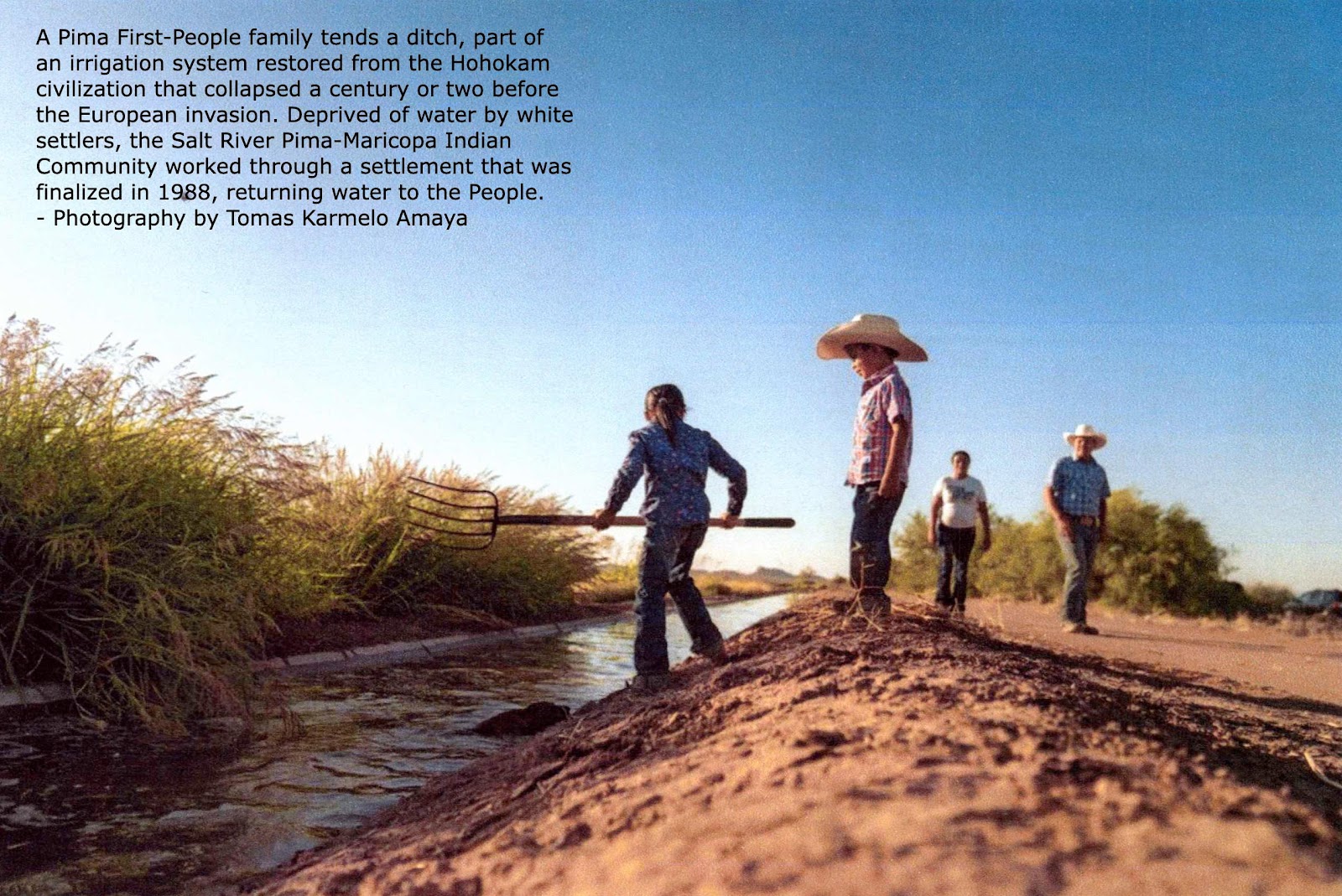
Many of the other desert-based First Peoples, however, were willing to embrace the farming life – but most of them were already farming Peoples long before the Euro-Americans arrived. This is especially true of some of the First Peoples in Arizona – the Basin state most blessed with First Peoples, 23 of the 30 groups. A large number of those tribal groups could actually be called ‘post-civilization’ farmers, especially the ones in the valleys of central Arizona’s Gila and Salt River Basin: groups now known as the Salt River Pima-Maricopa Indian Community, the Gila River Indian Community, the Ak-Chin Indian Community and the Tohono O’odham Nation. These Peoples all claim descent from the Hohokam (or Huhugam) People, an advanced irrigation culture probably comparable at its peak to the early civilizations of Asia Minor’s Fertile Crescent.
The story of the Hohokam – what we can deduce about it – was probably a classic illustration of the Holocene ‘trauma of success’ cycle: population growth driving a transition from hunter-forager to either warrior cultures fighting over territory and food, or ‘defensive agriculture’ to create defensible food supplies. That transition in turn led to farming surpluses feeding more population growth and forcing them into ever more urbanized and industrialized cultures: the ‘civilization’ stage that eventually, like all civilizations so far, imploded from too much density, complexity, and inequity between managing and working classes.
Screen shot from episode of “Tom Talks” April 2020.
As best the archaeologists and surviving tribal peoples can estimate, the Hohokam culture probably reached its civilized peak in the 13th and 14th centuries by the European calendar, having spread through the entire Gila River Basin in southern Arizona, with more than 150 miles of canal works good enough to have been cleaned out and reused by early Euro-American settlers, and highly developed towns and cities in the Sonoran Desert with multi-story buildings, probably resulting from cross-fertilization with the master builders of the Ancestral Puebloan civilization in the San Juan River and Mogollon Rim regions. The division of labor to keep everyone busy extended to supporting artists creating beautiful pottery and other ‘high culture’ activities. All accounts of the Hohokam mention their ‘ball courts’; one imagines a kind of ‘professional’ NFL among the Hohokam centers. But by the mid-15th century, barely a century before the Spanish entrada, it all fell apart, probably triggered by a major drought on top of the constant problem of silted canals, and also probably the usual challenges of density, complexity and class inequity.
Gila River watershed. Graphic credit: Wikimedia
Groups that survived the conflict, chaos and starvation following the collapse, went back to local community subsidence farming, still irrigating from the Gila River and its tributaries. But within the following century, the European invasion commenced, with the new European diseases moving out ahead of the waves of Second Peoples, clearing out half to three-fourths of the First Peoples who were otherwise in the way of the manifest march of Christian industrial civilization.
Most of the Spanish entrada split around the subtropical Mojave and Sonora deserts, moving up into ‘Alta California’ and into the less forbidding high deserts of the Rio Grande Basin, thus only impacting the Colorado River Basin relatively lightly. But with the end of the War with Mexico, and the Mexican Cession that turned ‘El Norte’ into ‘the American West,’ the pace picked up; the basin became both a highway and stopping-point for gold-rush unsettlers and agrarian settlers.
That was the period when confining the tribal Peoples to reservations began in a serious way in the Colorado River region – get’em outa the way. With the warrior Peoples, the reservations were regarded by both sides as prisons – in 1863 the U.S. Army, angered by the Navajo’s raiding, launched a massive attack on them, burning every village they could find and rounding up the Navajo, putting them on a death march to a barren place in eastern New Mexico far from their adopted homeland. They were prisoners of war, and treated as such, until they were transferred in the late 1860s from care and keeping of the War Department to the new Office of Indian Affairs, and the surviving Navajo were marched back to a piece of their old homeland.
But at that same time – in 1864 – a group of First Peoples who were trying to farm in the floodplain of the Colorado River went to Charles Poston, an Indian agent, and requested that he get the government to create reservations for them. This group, since known collectively as the ‘Colorado River Indian Tribes,’ felt they were going to be pushed out of their homeland by white homesteaders and gold prospectors claiming land and water under laws never really explained to the First People. They were willing to give up their traditional hunting grounds upland from the river if they could be assured that they could continue to have the floodplains for farming. Poston arranged for that, and the People named a village on their reservation for him.
Wheat fields along the Colorado River at the Colorado River Indian Tribes Reservation. Wheat, alfalfa and melons are among the most important crops here. By Maunus at English Wikipedia, CC BY-SA 3.0, https://commons.wikimedia.org/w/index.php?curid=47854613
Things did not go entirely smoothly for the Colorado River Indian Tribes, however, after their reservations were created; the BIA started crowding them by moving in portions of other tribes – and during World War II, 17,000 Japanese-Americans were held there as part of the shameful internment policy. The Colorado River Tribes were compensated for all that, however, by getting a weir, Headgate Rock Dam, built across the river to keep water in their canals – both dam and canal being built with Japanese labor during the war. I don’t know whether it is ironic or just interesting to note that one of the few domestic projects built during a time of war production rationing of everything, was a dam for a group of Indians.
But by the time the dust of the Euro-American invasion across the continent had settled after the turn of the 20th century, the First Peoples found themselves – from their perspective – either confined on reservations or protected by the reservation, depending on the life they had lived before the advent of the Second People.
Either way, though, they found themselves with limited or no legal access to essential water, despite the 1908 Supreme Court Winters decision saying they had ‘federal reserved water rights’ dating from the creation date of their reservation. But during the decades before and after that decision, the Euro-Americans had essentially appropriated most of the West’s water for their own agriculture, towns and cities, and industries under Euro-American laws – at a time when the federal policy on the trust responsibility was to ‘civilize the Indians’ through forced cultural assimilation and dispersion from the reservations into the general populace, thus (they hoped) eliminating any reservation water issues.
But by the 1970s, after the American Indian Movement had gained more popular support for the First Peoples than for the government agencies trying to control them, it was clear that forced assimilation was not going to work. The government was faced with the fact that the trust relationship obligated them to help the First Peoples carry out the initial purposes of the reservations.
On the western reservations, this meant getting enough water on the land to nurture ‘civilizing’ agriculture. The federal response to this obligation ran a political spectrum from outright denial of the responsibility (as reflected just this past summer in the Supremes’ decision that the Interior Department had no treaty-specified responsibility for helping the Navajo determine their water rights), to efforts to actually provide water access through projects like the Navajo Indian Irrigation Project – but with no resolution of total reservation water rights. Ambiguity reigned.
Often left to their own devices, the First Peoples knew they could go to court in the wake of the Winters decision and sue for what they believed would be an appropriate quantity of water. But neither the Euro-American courts nor the federal bureaucrats had any appetite for telling other Euro-Americans that they had to give up some or all of their water for the People there first. The court process was usually lengthy, often decades, and tilted toward those already using the water – as the Jicarillo Apaches learned when the court awarded them only a sixth of what they needed. As a Justice Department lawyer put it, ‘When an economy has grown up premised upon the use of Indian waters, the Indians are confronted with the virtual impossibility of having awarded to them the waters of which they have been illegally deprived.’
There was the further fact that the courts would only quantify a water right – ‘paper water,’ useless until systems existed to put it to use. So the First Peoples went to an alternative: to sit down with all involved parties, the feds, the state, the current water users, and work something out – with the lurking threat that, if negotiations didn’t work, then everyone should plan to spend a lot of time and money in court. The People knew they would have to give up some of the water they deserved, but would hope to get out of the process some help in developing what water they could get. The ‘bird in hand’ strategy: an acre-foot of ‘wet water’ running to a field is better than two acre-feet of ‘paper water’ in the courthouse.
The settlement process began in the 1970s; by the 1990s, the Interior Department had made it a formalized process, and encouraged it over going to court. Congressional approval of most settlements is required, especially when appropriations are involved for new physical structures or payouts to Second-People farmers or communities who lost water to the tribal Peoples in a settlement. Some of the costs are to be shared by the states, individuals and tribes involved, and the cost of a settlement to the government is supposed to be no greater than a reasonable estimate of the cost of adjudication if it went to the courts.
To date, Colorado River Basin First Peoples have worked through 14 different water rights settlements, most of them in the Gila-Salt-Verde River Basin; the settlements range in size and expense from 1,550 acre-feet of water for the Yavapai-Prescott People near the Verde River with total settlement costs of $200,000, to 653,500 acre-feet for the Gila River Indian Community (including most of Southern Arizona’s Tonono O’odham Nation) at a settlement cost of more than $2 billion. For those interested in pursuing this in more depth, the Congressional Research Service has a good report on ‘Indian Water Rights Settlements.’
What most interests me, however, is how ‘civilized’ this process appears to be: to realize there’s not enough water for everyone to get all they would like, but rather than deciding it on the basis of ‘I was here first,’ or ‘my use is more important than your use’ – let those things be said, but then go on to figure out how to equitably make do with what you all have. Maybe with some new structures, maybe some new efficiencies, maybe general conservation, maybe paying for some water now to avoid paying a lawyer later. But at the end of it all, there’s a settlement that works somewhat for all parties for at least the time being. It seems too simplistic to call such settlements ‘win-win’; a durable settlement will be one in which the parties feel their losses do not exceed by too much what they’ve gained. And that may be as good as it’s going to get in the Anthropocene.
Teresa Pijoan, a Pueblo-raised Indian story-teller, told me years ago that most stories of the First Peoples end with a sense of balance either created or restored. Stories of the Second People, on the other hand, tend to end in a win for the good guys; if they don’t, the story is a tragedy. The seven basin states – each its own idea of ‘the good guys’ – have a history of working for the win; the current efforts to negotiate a new or modified management scheme for post-2026 already have opening positions promising to ‘focus on making our own state stronger’ (Colorado water leader). With the river already reduced by a third from the good old days of the Colorado River Compact, no state is likely to come out ‘stronger’; but we might all come out better (if only ‘better people’) if we work from a whole-river perspective, to balance equitably the losses inevitable in facing Anthropocene realities. I think we need the First People at that table; they already understand negotiation in a harsh environment.
Next post – probably a look at how the ‘2026 project’ is, or isn’t, shaping up, and some unsolicited thoughts that are probably not going to happen, given ‘the way we do things,’ otherwise known as ‘Western Civilization’.….
Updated Colorado River 4-Panel plot thru Water Year 2022 showing reservoirs, flows, temperatures and precipitation. All trends are in the wrong direction. Since original 2017 plot, conditions have deteriorated significantly. Brad Udall via Twitter: https://twitter.com/bradudall/status/1593316262041436160
Brome grass, treated with a herbicide, stands dead in the Kelly hayfields region of Grand Teton National Park. Next year, the land will be tilled and reseeded with a mix of native species that includes sagebrush. (Mike Koshmrl/WyoFile)
Click the link to read the article on the WyoFile website (Mike Koshmrl):
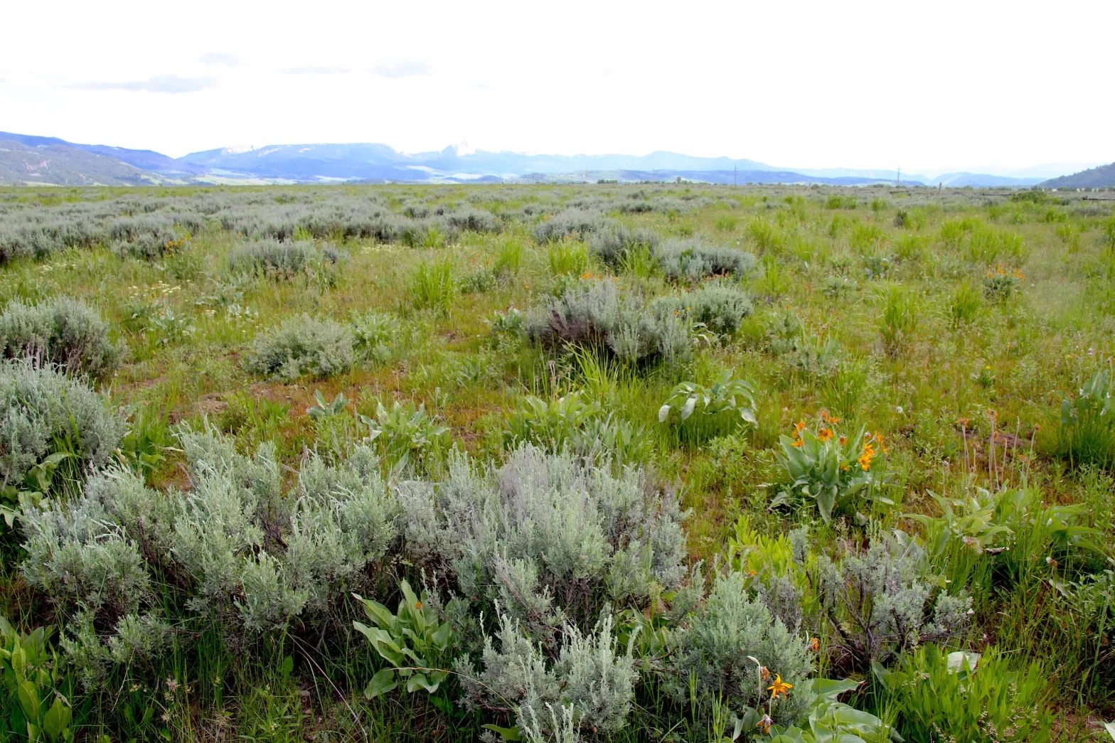
Sagebrush-steppe — the ecological backbone for iconic species like pronghorn and sage grouse — is in decline. How to restore it depends on where you are and who you ask.
GRAND TETON NATIONAL PARK—Laura Jones spoke from the grassy flats at the base of Blacktail Butte, a place where Mormon settlers made a go at homesteading the 6,600-foot-high heart of Jackson Hole nearly a century and a half ago.
A vegetation ecologist for the National Park Service, Jones was showcasing Teton Park’s long-running effort to do away with one undesired relic of the homesteading era: non-native smooth brome grasses planted by the cattle-raising newcomers who plowed up this slice of the valley. Park managers are trying to go back to what was, reestablishing the natural sagebrush-steppe plant community that elk, bison and other native species evolved alongside over millennia.
Laura Jones, Grand Teton National Park vegetation ecologist, guides Second Gentleman Doug Emhoff through native sagebrush habitat in Grand Teton National Park in August 2023. (Angus M. Thuermer Jr./WyoFile)
Their task isn’t straightforward or easy.
“There’s no blueprint,” Jones told the Park Service’s regional director, Kate Hammond, and a host of others for a Wyldlife for Tomorrow promotional field trip in late June. “What works? We don’t really know that. Some say, ‘It’s not rocket science — it’s harder.’”
Weeks later, members of Wyoming’s Sage Grouse Implementation Team, who met 70 miles away in Pinedale, spoke confidently about developing a “white paper roadmap” for successful sagebrush restoration. The process, team leader Bob Budd said, starts with ensuring healthy soils, reestablishing perennial flowers and grasses and then waiting patiently for sagebrush and other native shrubs to reemerge.
Bob Budd, who chairs Wyoming’s Sage Grouse Implementation Team, addresses a Sublette County audience during a July 2023 meeting to gather public feedback on sage grouse core area revisions. (Mike Koshmrl/WyoFile)
“That will be a game-changer for us, because now we’re looking at areas of the state where we can go in and do restoration,” Budd told residents who gathered for a sage grouse-focused meeting. “I think [the blueprint] is going to be a big step forward for us as far as reclamation and restoration.”
Which is it? Harder than rocket science or a simple process that requires patience? WyoFile asked around and found that land managers in Wyoming have had markedly different experiences attempting to bring back sagebrush-steppe where the embattled ecosystem has been degraded or lost, whether it was from a historic cattle pasture or expansive natural gas fields.
In the uninterrupted sagebrush sea of the Green River Basin, which remains dominated by native species, reviving tracts of sage lost to well pads and other industrial activity has come somewhat easier than it has in Teton Park, where millions of annual visitors potentially fling nonnative seeds from mud caked to their tires. Regardless, it’s unlikely that sagebrush restoration is the silver bullet solution to holding the line of a biome that’s in decline, along with its inhabitants.
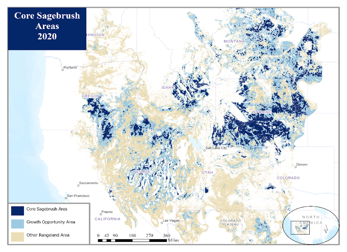
Sagebrush-steppe within 13 western states is disappearing and degrading at a rate of 1.3 million acres a year, recent research has found. There’s no better place to preserve what’s left than Wyoming.
“The core of the biome is Wyoming,” said Matt Cahill, who directs The Nature Conservancy’s sagebrush sea program. “It has the largest, most intact, least disturbed expanse of productive, resilient sagebrush sea, period.”
Sagebrush-dominated landscapes, home to 350 species of conservation concern, are declining in the West at a rate of 1.3 million acres per year. Wyoming is a stronghold for remaining sagebrush. (U.S. Fish and Wildlife Service)
Wyoming’s prized, still-uncompromised sagebrush expanse could benefit from more “preventative restoration,” he said. That includes measures like controlling the spread of cheatgrass. “We’ve got to get comfortable with the uncomfortable story of using chemicals to protect biodiversity,” Cahill said.
But Cahill was less convinced that “intensive traditional restoration” — putting seeds in the ground — is so important today in Wyoming on the landscape level. “There isn’t a huge footprint in Wyoming right now that needs those kinds of tools,” he said, “because there aren’t big expanses that are fully degraded.”
While Wyoming’s sagebrush range is impressively intact, there are places where the biome was decimated or retreated, like in Grand Teton National Park. Along the eastern edge of the park, roughly 4,500 acres — about 7 square miles — of sagebrush was eliminated and replaced with non-native pasture grass a century or so ago.
Teton Park ecologists have made progress scrubbing out brome and other exotic plants from the Kelly hayfields, as that part of the park is known. But the process has proven costly, long-lasting, labor-intensive and full of ecological wrinkles. Since making hayfield restoration a goal in a 2007 bison and elk management plan, roughly 1,400 acres have been reseeded. That means about a third of the project has been completed some 16 years into the effort, putting it on pace for a half-century completion time.
The fence line separating sagebrush and historic pastureland marks the north end of of the state of Wyoming’s school trust parcel in Grand Teton National Park, a tract known as the Kelly Parcel. (Mike Koshmrl/WyoFile)
There’s no one reason why Teton Park’s sagebrush restoration efforts have been so slow going. Typically, between 50 and 100 acres are being restored annually. But one constraining factor is the availability of native seeds. There’s no commercial market for buying native forb, grass and shrub seeds, and even if there was, Jones isn’t convinced it’d be wise to bring in seedstock from outside the region.
“We take our seeds, we hand collect it, we grow it out just for us,” Jones said. “It’s expensive.”
Grand Teton National Park harvests by hand the native seed mix used to replant pastureland that’s being slowly converted to native sagebrush-steppe. (Mike Koshmrl/WyoFile)
Teton Park does get outside help on the costs. The Wyldife for Tomorrow program — which lets businesses chip in to support environmental causes — has chipped in about $25,000, according to its website. And the Grand Teton National Park Foundation has been a steady supporter, partnering on the project since 2016 and providing nearly $1 million to date, communications manager Maddy Johnson said.
Still, the most recent annual budget for the restoration program eclipsed $350,000, meaning it’s running tens of thousands of dollars per acre to bring sagebrush back in Grand Teton Park.
However slowly, the remnant pastureland is gaining more semblance to what would have otherwise grown there, if not for the cattle-rearing residents of the park’s ghost town, once called Grosvont.
“It’s really difficult to do, but at the same time these fields of brome aren’t going to replace themselves,” said University of Wyoming botany professor Dan Laughlin, who’s experimenting with tilling and other techniques to try to get more sagebrush established.
Where Jones and Laughlin stood at the park’s “Slough South 1” restoration site, brome had been killed off with a herbicide, the ground tilled and the soil subsequently reseeded with the park’s native seed mix.
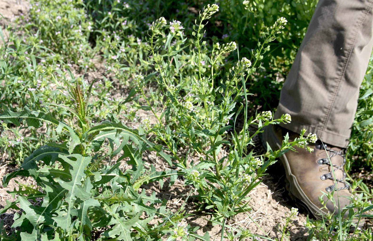
Oftentimes the first plants that emerge from treated, plowed and seeded hayfields in Grand Teton National Park aren’t the desired species. Instead, non-native plants like prickly lettuce and pennycress can dominate during the early years of sagebrush restoration. (Mike Koshmrl/WyoFile)
In places the native species were indeed coming back, but mostly the bare ground was sprouting with non-native plants that weren’t in the Park Service’s seed mix, like prickly lettuce and pennycress. Those “low priority” species aren’t particularly noxious, and they’re largely left to live and even dominate plots in the early years of restoration.
“They’re so interspersed that you’d be hard pressed to treat them,” Jones said. “That would be expected — that you’re going to have these ‘first arrivers.’”
Meanwhile in gas country
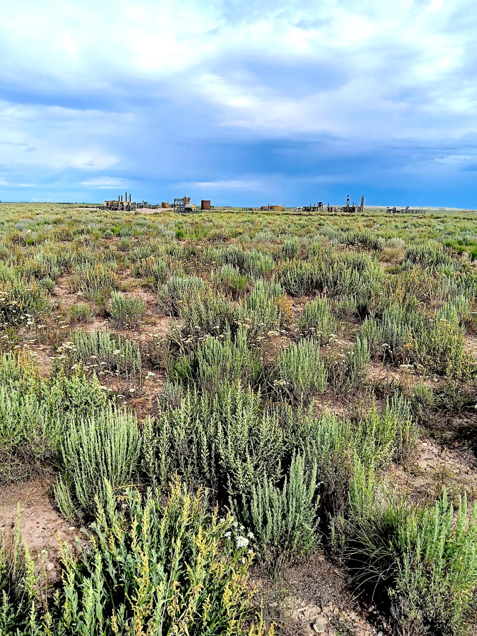
The spread of unwanted plants that aren’t in the seed mix has been less of a factor in the Green River basin, a sagebrush sea stronghold where restoration goes hand-in-hand with natural gas extraction.
“We’ve been very successful in the Sublette County gas fields at getting sagebrush reestablished,” said Mike Curran, an ecologist who’s worked with Jonah Energy and other companies on restoration research. “The good thing there is we don’t really have a lot of non-natives in that system to begin with.”
Reclamation teams have had success reestablishing sagebrush on gas pads in the Green River basin, like this site pictured. (Mike Curran)
Curran, who’s studied how insect communities have responded to reclaimed gas pads, said that industry reclamation teams have found success steering early successional plant communities, especially with one native flower called Rocky Mountain bee plant. Those flowers, which thrive in disturbed soil, fade as sagebrush sprouts and matures — which has happened relatively rapidly in places like the Jonah Field’s reclaimed pads, he said.
“We’ll see sagebrush come up in year one, year two, but it’s year three, four, five when you actually see it put on height and mass,” Curran said. “By year seven, eight, we have pretty good stands.”
About 91% of the plant cover in reclaimed swaths of the Jonah Field is taken up by native species, Curran said. Another 8% are non-natives that aren’t particularly concerning, like Russian thistle, he said, and the remaining percent or so are “invasive weeds.”
“So that’s pretty darn good, I think,” Curran said.
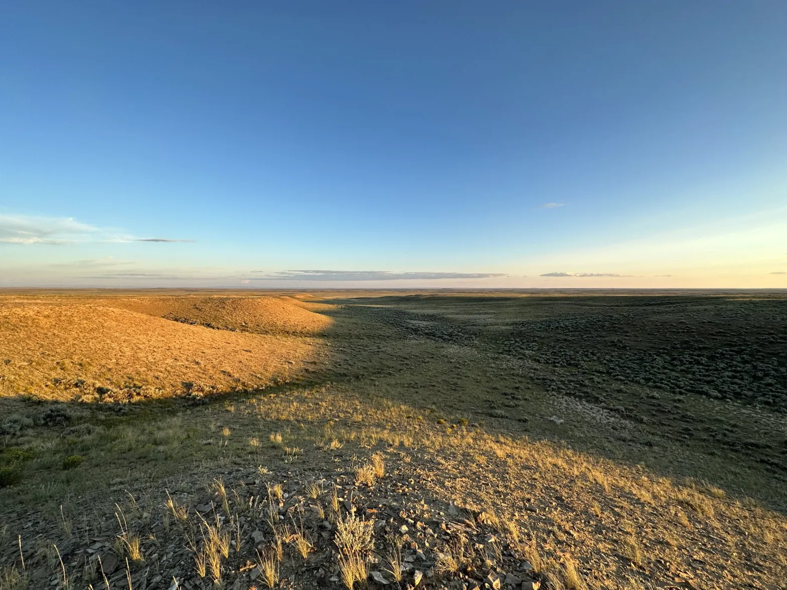
Tracts of unbroken sagebrush in the Green River basin, pictured, are part of the core of the biome. Restoration efforts have gone relatively smoothly in areas like Sublette County where non-native species haven’t gained major ground. (Mike Koshmrl/WyoFile)
Curran, who’s spearheading the in-the-works restoration white paper for the Wyoming Sage Grouse Implementation Team, is optimistic that sagebrush restoration is a tool that can be deployed widely to help hold the line of a declining ecosystem. About half of the shrubland biome has been eliminated from North America since the European settlement era, and roughly 14 million acres of what remains has been lost in the last quarter century, according to a 2022 multi-agency research report.
“The Green River basin, that is one of the harshest environments in the Lower 48,” Curran said. “We’re getting less than 50 frost-free days a year and 4 to 7 inches of precip on average down in the Jonah [Field]. If we’re able to do it there, I feel like it should be easier to do it in places like Colorado and Nevada, which are at a lower latitude and have longer growing seasons.”
Room for improvement
Wyoming has also been the setting for ongoing experiments intended to optimize sagebrush restoration. Maggie Eshleman, a restoration scientist for The Nature Conservancy’s Wyoming office, has spent years working with the Wyoming Department of Environmental Quality and Bureau of Land Management on seed technologies and habitat modifications to improve sagebrush establishment.
“There’s a bunch of areas throughout Wyoming that have been reclaimed, and generally speaking grass comes back pretty well, and sagebrush hasn’t,” Eshleman said. “Are there ways we can make grass less competitive in those areas so that we can get sagebrush to establish?”
Sagebrush seeds are “super small, really weak, and love to fail,” said Cahill, Eshleman’s Nature Conservancy colleague.
And what Eshleman and others are trying to do is give sagebrush seeds a leg up in the race to establish amid grasses and weeds in soils with limited water and nutrients. They are experimenting with packaging small amounts of fertilizer with small amounts of seeds, ideally so that the added nutrients benefit the sagebrush plant and its root systems without stimulating weeds. It worked in the lab, but less so in their field sites: reclaimed mine land in the Gas Hills east of Riverton.
The trouble has been getting sagebrush seeds to emerge from their fertilizer-based pellet encasement: “Sagebrush needs light to germinate, and when they do germinate, they don’t have a lot of push-power to break out of anything,” Eshleman said.
Sagebrush seeds germinated better when seeds were bathed in a thin fertilizer film, she said, but that method couldn’t really deliver enough nutrients to stimulate germination and emergence.
Sagebrush has succesfully matured in one of Grand Teton National Park’s oldest reclamation sites, pictured. (Mike Koshmrl/WyoFile)
The latest method being tested uses “fertilizer balls.” Seeds are essentially painted onto the outside, so they don’t have to break out of anything and have access to light. Results are pending: the sagebrush seed-coated balls are going into the soil this fall.
“We’ll have some results next summer when we go on our hands and knees and look at tiny sagebrush seedlings that could be there or not,” Eshleman said. “But it could be that next spring and summer there is a horrible drought and then you don’t have seedlings.”
Then they’ll have to try again.
Whatever Eshleman and her partners devise could someday help improve restoration outcomes in Grand Teton National Park or any number of places in Wyoming. Although Cahill is emphasizing preservation and “preventative restoration” to ensure the persistence of Wyoming sagebrush — the “core of the biome” — he said there are places where more intensive, traditional restoration could play an important role. Sagebrush resources in the Bighorn Basin, for example, are in rough shape and under siege by cheatgrass.
“It looks like Nevada,” Cahill said. “People aren’t necessarily thinking proactively about what is the risk to the rest of the state? What is the risk to Pinedale, or the Bear River valley?
It’s worthwhile, Cahill said, to think about putting seeds in the ground in the “connecting corridors” that bridge and buffer compromised areas like the Bighorn Basin from the sagebrush-steppe biome’s intact core. Potential areas to consider, he said, include the Atlantic Rim and the Owl Creek Mountains.
“You’re going to put a ton of money on a few acres,” Cahill said. “So make sure that those [restoration] acres are just absolutely critical to a much bigger landscape strategy. I think Wyoming has those options in spades.”
Leaders sprout from a sagebrush plant on the flats east of Washakie Reservoir on the Wind River Indian Reservation. (Mike Koshmrl/WyoFile)