The clean-energy transition may be inevitable, but may not happen fast enough, IEA says
The flagship annual report from the International Energy Agency, dubbed the World Energy Outlook, offers a rosy prediction of the growth of clean-energy technologies around the world. It portrays the decline of fossil fuels, the main driver of rising global temperatures, as all but inevitable.
“The transition to clean energy is happening worldwide and it’s unstoppable,” IEA executive director Fatih Birol said in a statement. “It’s not a question of ‘if’, it’s just a matter of ‘how soon’ — and the sooner the better for all of us.”
[…]
The IEA envisions green technologies such as solar panels, wind turbines and electric cars taking off in the coming years, thanks to both supportive governmental policies and market forces. By 2030, it predicts:
Renewables’ share of the global electricity mix will approach 50 percent, up from around 30 percent today.
Three times as much investment will flow to offshore wind projects as to new coal- and gas-fired power plants.
The share of fossil fuels in the global energy supply will fall to 73 percent, down from about 80 percent today.
Still, demand for fossil fuels will remain too high for humanity to meet the goal of the Paris climate accord: limiting global temperature rise to 1.5 degrees Celsius (2.7 degrees Fahrenheit) above preindustrial levels, the report says. On the supply side, the United States is churning out record amounts of oil. Yet negotiators at this fall’s United Nations climate summit, known as COP28, can make certain commitments that help keep the Paris target within reach, the IEA said. They include pledges to triple global renewable energy capacity and double the rate of energy efficiency improvements.
The shiny new cold-weather air source heat pump installed summer 2023 at Coyote Gulch Manor.
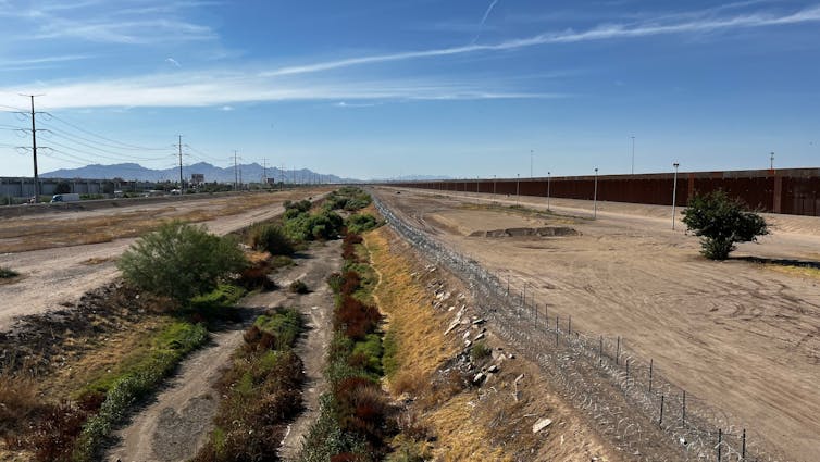
The Rio Grande is one of the longest rivers in North America, running some 1,900 miles (3,060 kilometers) from the Colorado Rockies southeast to the Gulf of Mexico. It provides fresh water for seven U.S. and Mexican states, and forms the border between Texas and Mexico, where it is known as the Río Bravo del Norte.
The river’s English and Spanish names mean, respectively, “large” and “rough.” But viewed from the Zaragoza International Bridge, which connects the cities of El Paso, Texas, and Ciudad Juárez, Mexico, what was once mighty is now a dry riverbed, lined ominously with barbed wire.
The Rio Grande is one of the largest rivers in the southwest U.S. and northern Mexico. Because of drought and overuse, sections of the river frequently run dry. Kmusser/Wikipedia, CC BY-SA
In the U.S., people often think of the Rio Grande mainly as a political border that features in negotiations over immigration, narcotics smuggling and trade. But there’s another crisis on the river that receives far less attention. The river is in decline, suffering from overuse, drought and contentious water rights negotiations.
Urban and rural border communities with poor infrastructure, known in Spanish as colonias, are particularly vulnerable to the water crisis. Farmers and cities in southern Texas and northern Mexico are also affected. As researchers who study hydrology and transboundary water management, we believe managing this important resource requires closer cooperation between the U.S. and Mexico.
A hidden water crisis
For nearly 80 years, the U.S. and Mexico have managed and distributed water from the Colorado River and the Lower Rio Grande – from Fort Quitman, Texas, to the Gulf of Mexico – under the 1944 Water Treaty, signed by presidents Franklin D. Roosevelt and Manuel Avila Camacho. The Colorado River was the central focus of treaty negotiations because officials believed the Colorado basin would have more economic activity and population growth, so it would need more water. In fact, however, the Rio Grande basin has also seen significant growth.
For the Rio Grande, the treaty allocates specific shares of water to the U.S. and Mexico from both the river’s main stem and its tributaries in Texas and Mexico. Delivery of water from six Mexican tributaries has become the source of contention. One-third of this flow is allocated to the U.S., and must total some 76 million cubic feet (2.2 million cubic meters) over each five-year period.
The treaty allows Mexico to roll any accrued deficits at the end of a five-year cycle over to the next cycle. Deficits can only be rolled over once, and they must be made up along with the required deliveries for the following five-year period. https://www.youtube.com/embed/Ym6m2rZeXPw?wmode=transparent&start=0 Farmers as far north as Colorado rely on water from the Rio Grande for irrigation.
These five-year periods, called cycles, are numbered. Cycles 25 (1992-1997) and 26 (1997-2002) were the first time that two consecutive cycles ended in deficit. Like the Colorado River, the Rio Grande has become over-allocated: The 1944 treaty promises users more water than there is in the river. The main causes are persistent drought and increased water demand on both sides of the border.
Much of this demand was generated by the 1992 North American Free Trade Agreement, which eliminated most border tariffs between Canada, the U.S. and Mexico. From 1993 through 2007, agricultural imports and exports between the U.S. and Mexico quadrupled, and there was extensive expansion of maquiladoras – assembly plants along the border. This growth increased water demand.
Ultimately, Mexico delivered more than the required amount for Cycle 27 (2002-2007), plus its incurred deficit from cycles 25 and 26, by transferring water from its reservoirs. This outcome appeased Texas users but left Mexico vulnerable. Since then, Mexico has continued to struggle to meet its treaty responsibilities and has experienced chronic water shortages.
In 2020, a confrontation erupted in the state of Chihuahua between the Mexican National Guard and farmers who believed delivery to Texas of water from the Rio Conchos – one of the six tributaries regulated under the 1944 treaty – threatened their survival. In 2022, people lined up at water distribution sites in the Mexican city of Monterrey, where the population had doubled since 1990. As of 2023, halfway through Cycle 36, Mexico has only delivered some 25% of its targeted amount.
Border politics overshadow water shortages
As climate change makes the Southwest hotter and drier, scientists predict that water shortages on the Rio Grande will intensify. In this context, the 1944 treaty pits humanitarian needs for water in the U.S. against those in Mexico.
It also pits the needs of different sectors against one another. Agriculture is the dominant water consumer in the region, followed by residential use. When there is a drought, however, the treaty prioritizes residential water use over agriculture.
The Rio Grande is affected by nearly the same hydroclimate conditions as the Colorado River, which flows mainly through the southwest U.S. but ends in Mexico. However, drought and water shortages in the Colorado River basin receive much more public attention than the same problems on the Rio Grande. U.S. media outlets cover the Rio Grande almost exclusively when it figures in stories about immigration and river crossings, such as Texas Gov. Greg Abbott’s 2023 decision to install floating barriers in the river at widely used crossing points.
The compact that governs use of Colorado River water has widely recognized flaws: The agreement is 100 years old, allocates more rights to water than the river holds, and completely excludes Native American tribes. However, negotiations over the Colorado between compact states and the U.S. and Mexico are much more focused than decision-making about Rio Grande water, which has to compete with many other bilateral issues.
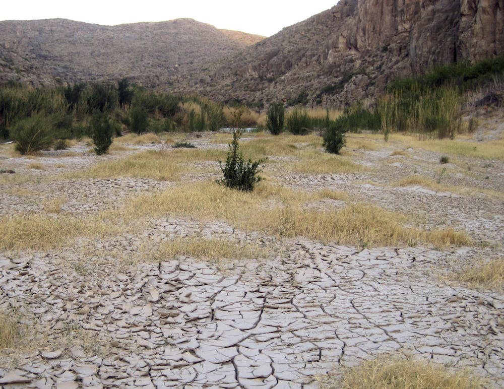
Dry, cracked mud along the banks of the Rio Grande at Big Bend National Park in Texas, March 25, 2011. In the spring and early summer of 2022, up to 75 miles of the river went dry in the park. AP Photo/Mike Graczyk
Adapting to the future
As we see it, the 1944 water treaty is inadequate to solve the complex social, economic, hydrological and political challenges that exist today in the Rio Grande basin. We believe it needs revision to reflect modern conditions.
This can be done through the minute process, which permits Mexico and the U.S. to adopt legally binding amendments without having to renegotiate the entire agreement. The two countries have already used this process to update the treaty as it pertains to the Colorado River in 2012 and again in 2017.
These steps allowed the U.S. to adjust its deliveries of Colorado River water to Mexico based on water levels in Lake Mead, the Colorado’s largest reservoir, in ways that proportionally distributed drought impacts between the two countries. In the Rio Grande basin, Mexico does not have similar flexibility.
The U.S. also has the ability to proportionally reduce deliveries under a separate 1906 agreement that outlines water delivery from El Paso to Ciudad Juarez. In 2013, for example, Mexico received only 6% of the water it was due under the 1906 Convention.
Enabling Mexico to proportionally reduce Rio Grande deliveries according to drought conditions would distribute drought and climate change impacts more fairly between both countries. As we see it, this kind of cooperation would deliver human, ecological and political benefits in a complex and contentious region.
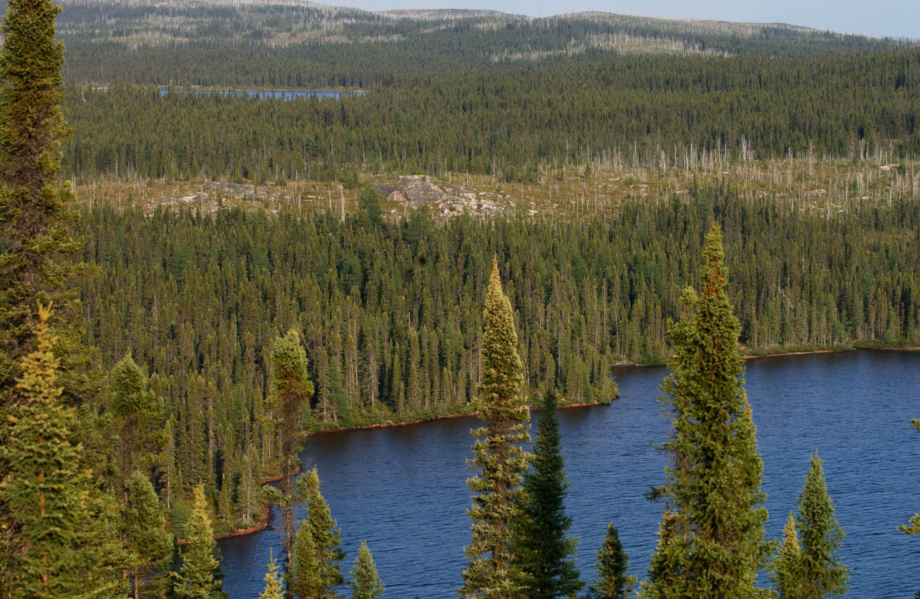
Deciduous tree cover is expected to increase in North American boreal forests with climate warming and wildfire. This shift in composition has the potential to generate biophysical cooling via increased land surface albedo. Here we use Landsat-derived maps of continuous tree canopy cover and deciduous fractional composition to assess albedo change over recent decades. We find, on average, a small net decrease in deciduous fraction from 2000 to 2015 across boreal North America and from 1992 to 2015 across Canada, despite extensive fire disturbance that locally increased deciduous vegetation. We further find near-neutral net biophysical change in radiative forcing associated with albedo when aggregated across the domain. Thus, while there have been widespread changes in forest composition over the past several decades, the net changes in composition and associated post-fire radiative forcing have not induced systematic negative feedbacks to climate warming over the spatial and temporal scope of our study.
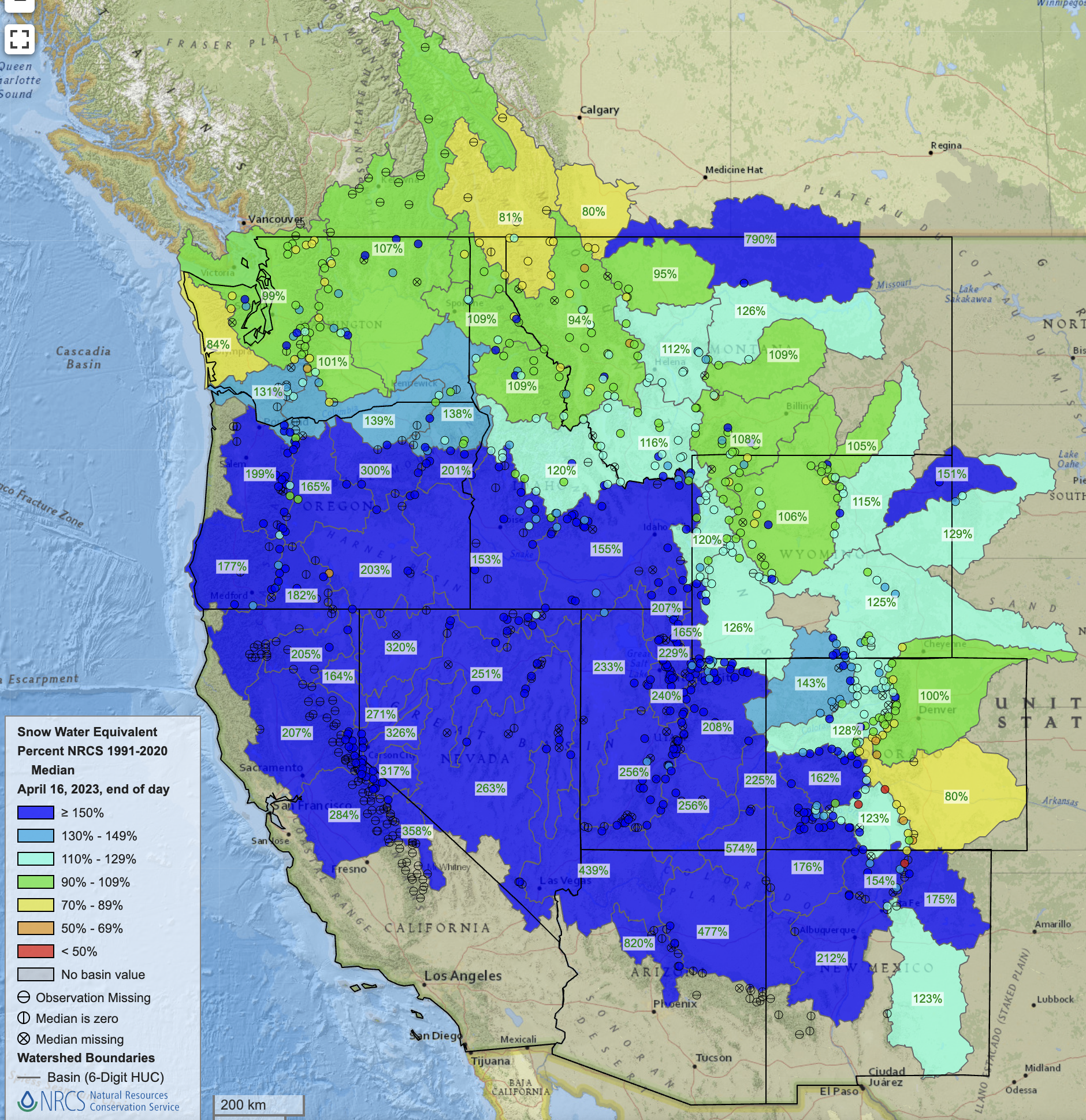
A record-breaking winter snowpack last year halted a precipitous downward spiral on the river and raised water levels at the nation’s two largest reservoirs, Lakes Mead and Powell. But something else is also at play this year – farmers, cities and Native tribes are simply using less. Arizona, California and Nevada’s usage of Colorado River water has hit new lows, state officials and US Bureau of Reclamation Commissioner Camille Calimlim Touton told CNN in an interview.
“The record conservation is already seeing its impact within the reservoirs,” Touton said. “It’s easy to see our success within the levels of the reservoirs we manage.” Lake Powell has risen 52 feet since hitting a low point in February of this year, while Mead has risen nearly 23 feet since November…
Part of the reason is last winter’s blockbuster precipitation, which helped replenish levels in reservoirs across the West. In California, southern cities like Los Angeles that are normally more dependent on Colorado River water have been able to pull more from its own refilled reservoirs like Lake Oroville…
[Bill] Hasencamp told CNN the three lower-basin states have only used 5.8 million acre-feet this year of the 7.5 million acre-feet they are allotted annually.
“We’re pretty much at a sustainable level,” Hasencamp said. “It really gives hope for the future. Despite it being a wet winter, we’re going to do everything we can to reduce use and work with the feds.”
Updated Colorado River 4-Panel plot thru Water Year 2022 showing reservoirs, flows, temperatures and precipitation. All trends are in the wrong direction. Since original 2017 plot, conditions have deteriorated significantly. Brad Udall via Twitter: https://twitter.com/bradudall/status/1593316262041436160
Northern Water has created a beta version of a water savings estimate calculator to assist residents of Northern Colorado to estimate how much water can be saved through landscape conversions. The Excel spreadsheet uses data from Northern Water’s weather network to estimate a given type of landscape’s water need and compare it against that of a proposed landscape to determine approximate water savings. Actual water savings will vary based on several factors including irrigation efficiency, maintenance, and weather. To request a copy of the tool, please email your request using the button below.
Check out the quick screen recording video to see how easy it is to complete the calculator tool.


