President Trump’s administration thaws frozen IRA money: But will #Colorado’s electric cooperatives get all the money they were promised? The answer remains unclear — Allen Best (BigPivots.com)

The main street in Nucla, located in western Montrose County. Photo credit: Allen Best/Big Pivots

Click the link to read the article on the Big Pivots website (Allen Best):

March 28, 2025

Electrical cooperatives in Colorado were informed before Joe Biden left the White House that they would be getting about $3.5 billion from the federal government via programs funded by the Inflation Reduction Act of 2022.

Will they? U.S. Secretary of Agriculture Brooke Rollins announced Tuesday that her department was releasing funds previously committed but also described a “course correction.” Just what constitutes a “course correction” will likely not become fully apparent for weeks, perhaps months.

The release said that electrical cooperatives must first revise their project plans to “remove harmful DEIA and far-left climate features.” DEIA stands for diversity, equity, inclusion and accessibility.

The announcement by the USDA —the department houses the Rural Utility Services, the agency that works with cooperatives — also said electrical cooperatives would be asked several questions and would need to provide a short narrative description of any proposed changes in their projects.

The revised projects must also align with an executive order issued by President Donald Trump on Jan. 20 called “Unleashing American Energy.” Just exactly what those revisions need to look like remains unclear. In that executive order Trump rescinded a long list of executive orders issued by former President Joe Biden, including 10 that had to do with climate change.

Trump’s order made no mention of renewable energy but did order agency heads to identify actions that “impose an undue burden on the identification, development, or use of domestic energy resources – with particular attention to oil, natural gas, coal, hydropower, biofuels, critical mineral, and nuclear energy resources…”

“We are as interested to find out as you are,” replied Alex Shelley, who has the public information job at San Miguel Power Association, when I called him Wednesday afternoon. San Miguel expected to get a $9.8 million grant from the New ERA program to construct a 20-megawatt solar project in western Montrose County. That area of Montrose County includes Nucla, Naturita, and Uravan. Tri-State Generation and Transmission Association operated Nucla Station, a coal burning plant, until 2019.

In a statement posted on Jan. 23, Brad Zaporski, the chief executive of San Miguel Power, called the project a “shining example of partnership in action to help bolster our rural communities.”

The project, said Shelley, is to be on private land that is not useful for agriculture or anything other than light industry.

Brighton-based United Power was to get $262 million for six solar projects in its service territory in northern Colorado and one other project involving hydroelectricity. About 40% of the service territory is in Wattenberg Field, Colorado’s primary oil and gas producing area.

“I think the story is that the RUS wants to get the money moving to help rural communities,” said Mark Gabriel, the chief executive. “We were given the opportunity to make any edits or resubmit, and we chose not to (make changes to our application).”

The original application, he added, made no mention of diversity or inclusion. It asserted the desire to make United’s members more reliant on local resources and with lower-cost electricity.

Tri-State G&T has the most skin in this game. It provides wholesale electricity for 40 electric cooperatives in a four-state area, including 15 in Colorado. Tri-State in 2024 said it was getting a financial package worth $2.5 billion, most of that in loans of less than 2%. Those low-interest loans will allow it to get out from under higher-interest financing as it prepares to close its coal units in Colorado and Arizona during coming years.

In an October announcement, Tri-State said New ERA funding would support financing for 1,280 megawatts of energy from solar, wind and wind-storage projects, and more than 100 megawatts of stand-alone energy storage.

The company also plans a natural gas plant, preferably in northwest Colorado or conceivably southwest Wyoming.

Tri State expects to reach 70% clean energy by 2030. Within Colorado, this will be an 89% reduction as compared to a 2005 baseline.

“We appreciate the work of Secretary Rollins and her team to advance the program, and we will be reviewing the USDA’s guidance and look forward to continuing our work through their process,” said Tri-State CEO Duane Highley in a statement posted on Wednesday.

In Fort Collins, Jeff Wadsworth was cautious about what the final tally will look like. He’s the chief executive of Poudre Valley REA, which is in line to get $9 million to help pay for two solar-and-storage projects. The grant was through Powering Affordable Clean Energy, or PACE, another program funded by the IRA.

“We are thrilled about this development and look forward to collaborating with the dedicated team at the USDA,” he said initially when asked for a response. In a telephone conversation the next day, however, he said that the full story remains to be written.

Wadsworth is optimistic that Poudre Valley will get its money. Demand for electricity has continued to grow for multiple reasons, and these projects will help Poudre Valley meet that demand. But this grant is not the end-all, be-all for Poudre Valley as it moves forward, he said.

“It helps our ratepayers, who are part of rural Colorado, We are excited about that,” said Wadsworth. “But our path is pretty clear as we move forward.”

Still another perspective comes from Eric Frankowski, the executive director of the Western Clean Energy Campaign.  He believes that despite the “problematic” language of the announcement, the guidance that RUS has issued for the cooperatives has eased a lot of concerns.

“It appears that the process is completely voluntary and that co-ops do not need to do anything. The language says that RUS will NOT approve proposed modifications ‘that affect the scoring of projects that were competitively scored.’ Since community benefits, decarbonization and lowering rates were all integral to how proposals were evaluated, I think we can take that as a good sign,” he wrote in an e-mail.

That guidance can be found here.

“The guidance also says that if awardees do not respond within 30 days requesting a revision, ‘it will be considered that they do not wish to make changes to their proposals, and disbursements and other actions will resume after the 30 days.’ (emphasis added) It also says that awardees can respond that they are not changing their proposal and processing of payments will begin immediately. Also good signs,” said Frankowski.

“There doesn’t seem to be a pathway where co-ops are punished for staying the course on their clean energy plans,” he added. “Who knows what happens after the 30-day window, but things seem good for now.”

Granby-based Mountain Parks Electric in January announced that it had executed a letter of commitment with the U.S. Department of Agriculture for a grant prog ram of $100 million across the next 20 years. The announcement said that the money will be used to help procure power through power-purchase agreements and to advance and promote scholarships and apprenticeship programs. The announcement was made two weeks before Mountain Parks left Tri-State and began getting its wholesale power from Guzman Energy in a 20-year agreement.

Sedalia-based CORE Electric Cooperative hopes for $225 million and Steamboat Springs-based Yampa Valley Electric $50 million. Grand Junction-based Grand Valley Power Lines also expected to get federal funds.

In his statement, Highley credited the work of U.S. Representatives Jeff Hurd, Gabe Evans, Lauren Boebert, all from Colorado, and Gabe Vasquez, of New Mexico, as well as Colorado Senators John Hickenlooper and Michael Bennet. Bennet, in particular, had gone to bat for the New ERA provision for cooperatives in the IRA. He spoke in October at Tri-State’s headquarters when a finalized announcement was made.

#Colorado Basin River Forecast Center Water Supply Forecast Discussion April 1, 2025 #ColoradoRiver #COriver #aridification

Click the link to read the discussion on the Colorado Basin River Forecast Center website:

The Colorado Basin River Forecast Center (CBRFC) geographic forecast area includes the Upper Colorado River Basin (UCRB), Lower Colorado River Basin (LCRB), and Eastern Great Basin (GB).

Water Supply Forecasts

April 1 water supply forecasts across the CRB and GB are generally below to well below normal and summarized in the figure and table below. Snowpack, soil moisture, and future weather are the primary hydrologic conditions that impact the water supply outlook.

April 1, 2025 seasonal water supply forecast summary. Credit: Colorado Basin River Forecast Center

March Weather

March brought stretches of both active and quiet weather for the CBRFC area. Overall, conditions were neither extremely wet nor extremely dry, and most of the significant runoff areas ended the month within 30% of average March precipitation. Generally, the storm track benefitted the western side of the CBRFC area (mountains of UT and central/western AZ) more than the eastern side. Most of the systems were cold in nature with precipitation falling as snow over the high terrain.

In the LCRB, March featured this season’s wettest period of weather to-date. For context, Flagstaff, AZ experienced its 16th snowiest March on record (out of 126 years) with 35.6 inches of snow. However, if the season were to end today, it would also rank as the 22nd least snowy water year on record. A similar story can be applied to much of the rest of the LCRB — while March was beneficially wet, the season as a whole remains historically dry.

Toward the end of the month, a strong ridge of high pressure resulted in well above normal temperatures for the region. Numerous record high maximum and minimum temperatures were observed. This period of warm, sunny weather led to snowmelt in many lower and middle elevation locations. A cold storm system arrived during the final days of the month that reduced snowmelt rates and brought additional snow to higher elevations.

Snowpack Conditions

Snow water equivalent (SWE) conditions as a percent of normal remained relatively steady during the past month due to near normal March precipitation. UCRB April 1 SWE conditions range between 60-110% of normal and are most favorable across northern areas including the Upper Green, White/Yampa, and Colorado River headwaters. SWE conditions across southern basins including the Dolores and San Juan are well below normal, with April 1 SWE at several SNOTEL stations ranked in the driest three on record. UCRB April 1 snow covered area is around 103% of the 2001-2024 median <superscript>1</superscript> LCRB SWE conditions this season have been at or near record low across southwest UT, central AZ, and west-central NM as a result of near record dry winter weather. GB April 1 SWE conditions range between 45-105% of normal and generally improve from south to north.

SWE is near normal across most of the GB, with the least favorable snowpack conditions in the Sevier River Basin, where April 1 SWE ranks in the driest three on record at several SNOTEL stations. UT snow covered area is around 125% of the 2001-2024 median. <superscript>1</superscript> SWE conditions are summarized in the figure and table below.

Left: April 1, 2025 SWE – NRCS SNOTEL observed (squares) and CBRFC hydrologic model. Right: CBRFC hydrologic model SWE conditions summary.

Soil Moisture

CBRFC hydrologic model fall (antecedent) soil moisture conditions impact water supply forecasts and the efficiency of spring runoff. Basins with above average soil moisture conditions can be expected to experience more efficient runoff from rainfall or snowmelt while basins with below average soil moisture conditions can be expected to have lower runoff efficiency until soil moisture deficits are fulfilled. The timing and magnitude of spring runoff is impacted by snowpack conditions, spring weather, and soil moisture conditions.

A very dry June-October 2024 across southwest WY and UT resulted in soil moisture conditions that are below normal and worse compared to a year ago. NW CO soil moisture conditions are near to below normal and similar compared to a year ago. SW CO soil moisture conditions are closer to average and improved from a year ago due to a wetter than normal monsoon (mid-June through September). Monsoon precipitation was near/below normal across the LCRB, where soil moisture conditions are below average and similar compared to last year. CBRFC hydrologic model soil moisture conditions are shown in the figures below.

November 2024 CBRFC hydrologic model soil moisture conditions – as a percent of the 1991-2020 average (left) and compared to November 2023 (right).

Upcoming Weather

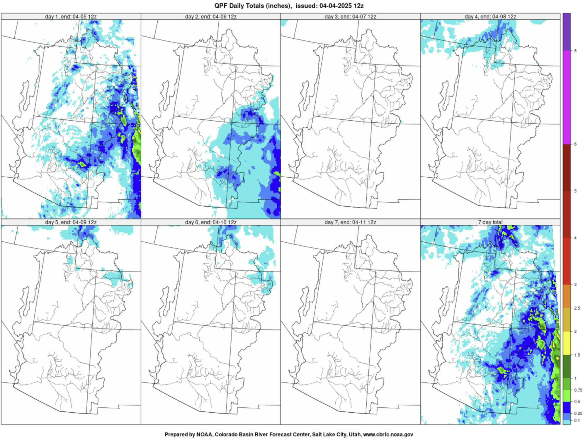
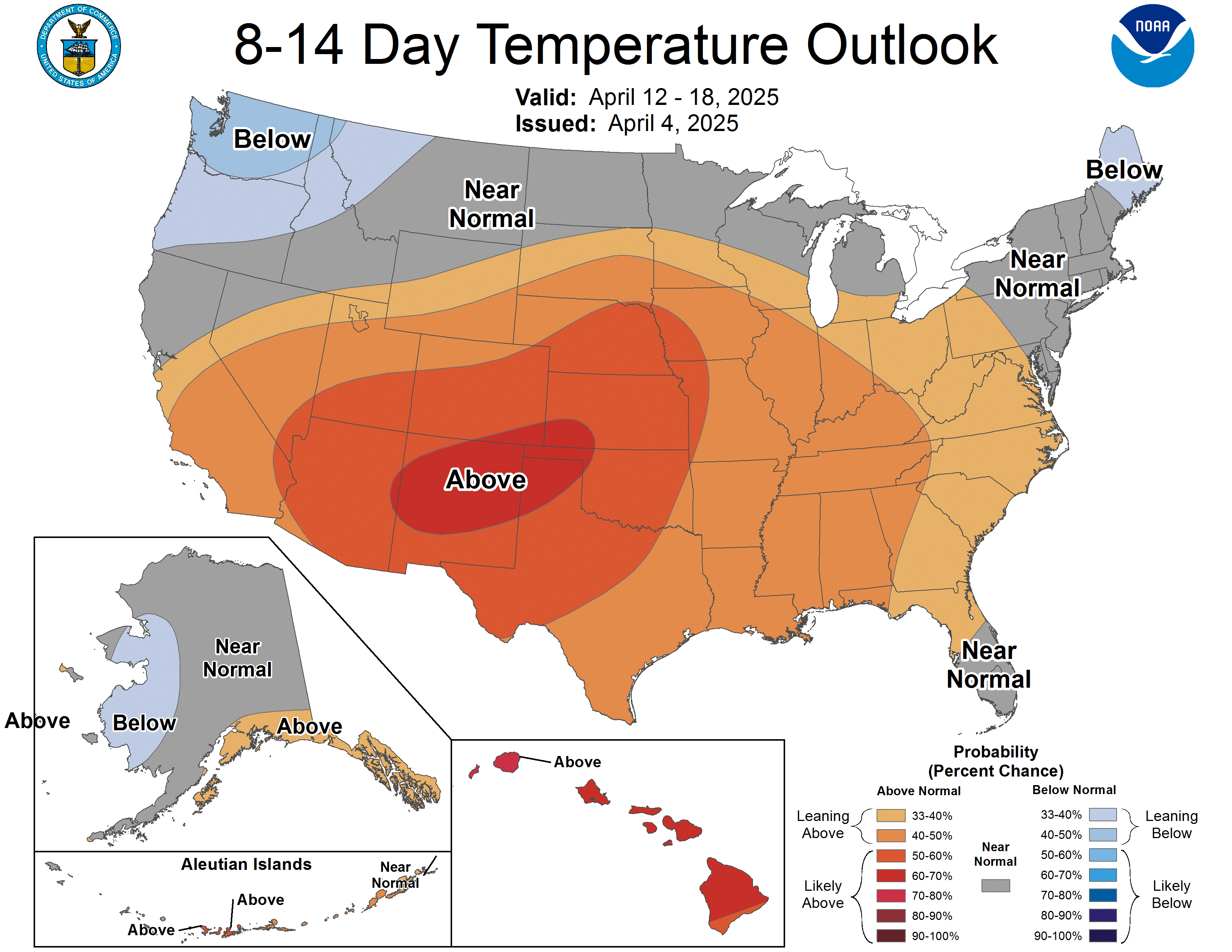
The next two days (April 4-5) will continue to bring cool and unsettled weather across much of the region before a warming and drying trend takes hold at the beginning of next week. Precipitation amounts through Sunday, April 6, will be highest along the Continental Divide and into eastern portions of the Mogollon Rim in AZ, however, maximum precipitation totals will likely be less than an inch. Temperatures across the region are expected to warm to around 10 degrees above normal by the middle of next week, with mostly dry conditions. The only exception to this will be the far northern portions of the GB and UCRB, where a passing disturbance will bring a chance of light precipitation to higher terrain. Above average temperatures and drier than normal conditions are expected to persist into mid-April.

7-day precipitation forecast for April 4 – 11, 2025.
Climate Prediction Center precipitation probability forecast for April 12–18, 2025.
Climate Prediction Center temperature probability forecast for April 12–18, 2025.

Judge orders Denver Water to halt expansion of Gross Reservoir over flawed environmental permitting: Water provider’s $531 million project has been underway in Boulder County since 2022 — The #Denver Post #ColoradoRiver #SouthPlatteRiver

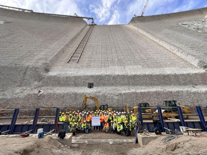
Workers from Denver Water and contractor Kiewit Barnard stand in front of Gross Dam in May 2024 to mark the start of the dam raise process. Photo credit: Denver Water.

Click the link to read the article on The Denver Post website (Elise Schmelzer). Here’s an excerpt:

April 4, 2025

Colorado’s largest water provider must stop construction on a $531 million dam expansion already underway in Boulder County after a federal judge found that assessments of how the project would impact the environment were flawed. U.S. District Court Judge Christine Arguello in an order late Thursday blocked Denver Water from enlarging Gross Reservoir east of Nederland until major federal environmental permitting processes are redone. The judge found that allowing the reservoir expansion to continue without redoing the permits would cause irreparable environmental damage that cannot be compensated for by monetary payments. That harm would outweigh any financial costs Denver Water would incur from halting construction, she wrote.

“Environmental injury is often the very definition of irreparable harm — often permanent or at least of long duration,” Arguello wrote. “All parties agree that there will be environmental harm resulting from completion of the Moffat Collection System Project, including the destruction of 500,000 trees, water diversion from several creeks, and impacts to wildlife by the sudden loss of land.”

She issued a preliminary injunction ordering Denver Water to halt construction on the dam until a further hearing when engineers can explain how much further construction is needed to make the partially built dam safe and structurally sound. Denver Water planned to raise the height of the dam by 131 feet, allowing the utility to store more water. She will then issue a permanent injunction on how much more construction will be allowed. The order is a huge victory for environmental groups that for years have opposed the controversial project. A coalition of environmental groups first filed suit in 2018 to stop the expansion of the reservoir, which they say would harm the health of the Colorado River system — where the reservoir’s water is sourced.

President Trump’s U.S. Secretary of Energy Chris Wright during #Golden lab visit doubles down on minimizing #ClimateChange — Lindsey Toomer (ColoradoNewsline.com)

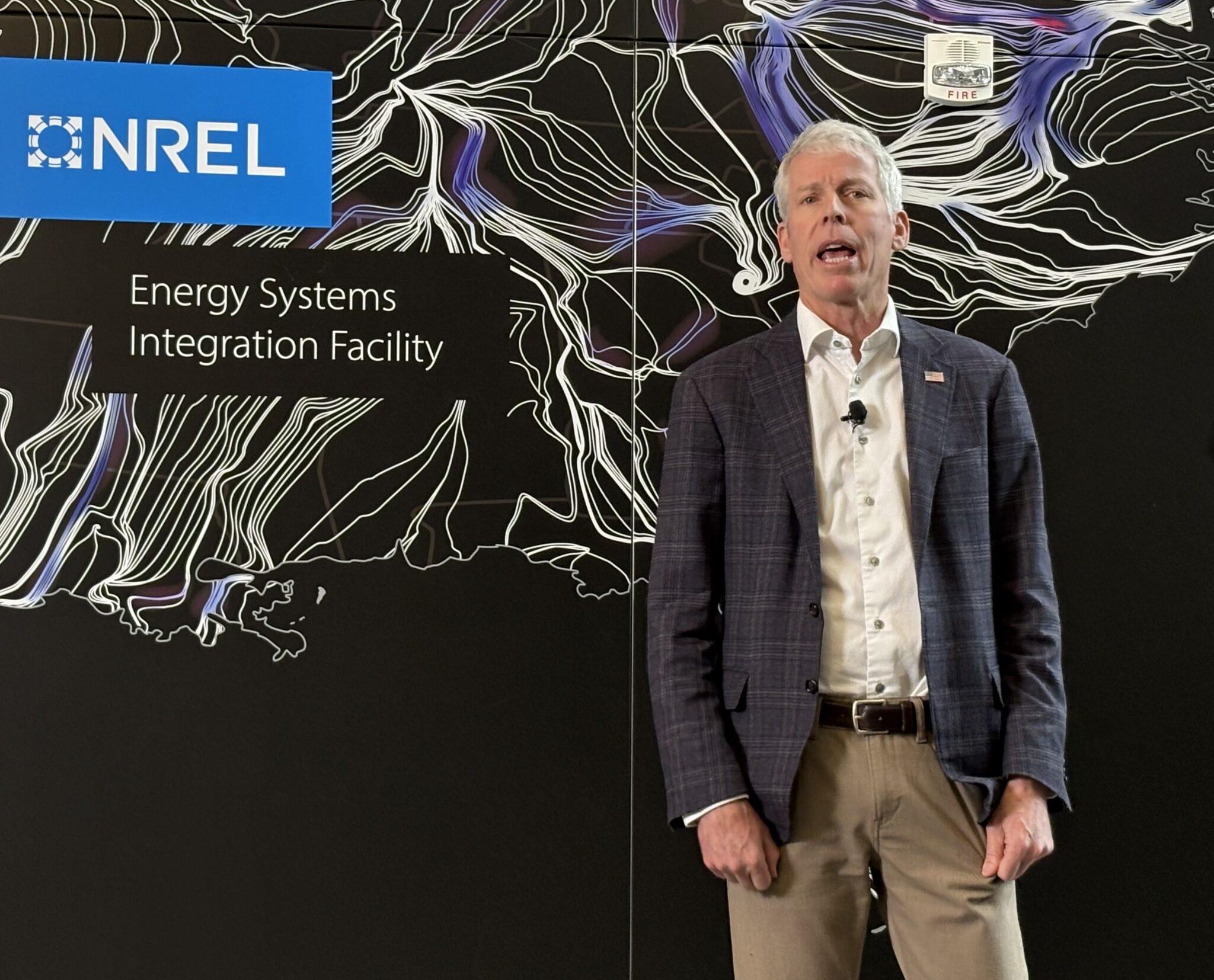
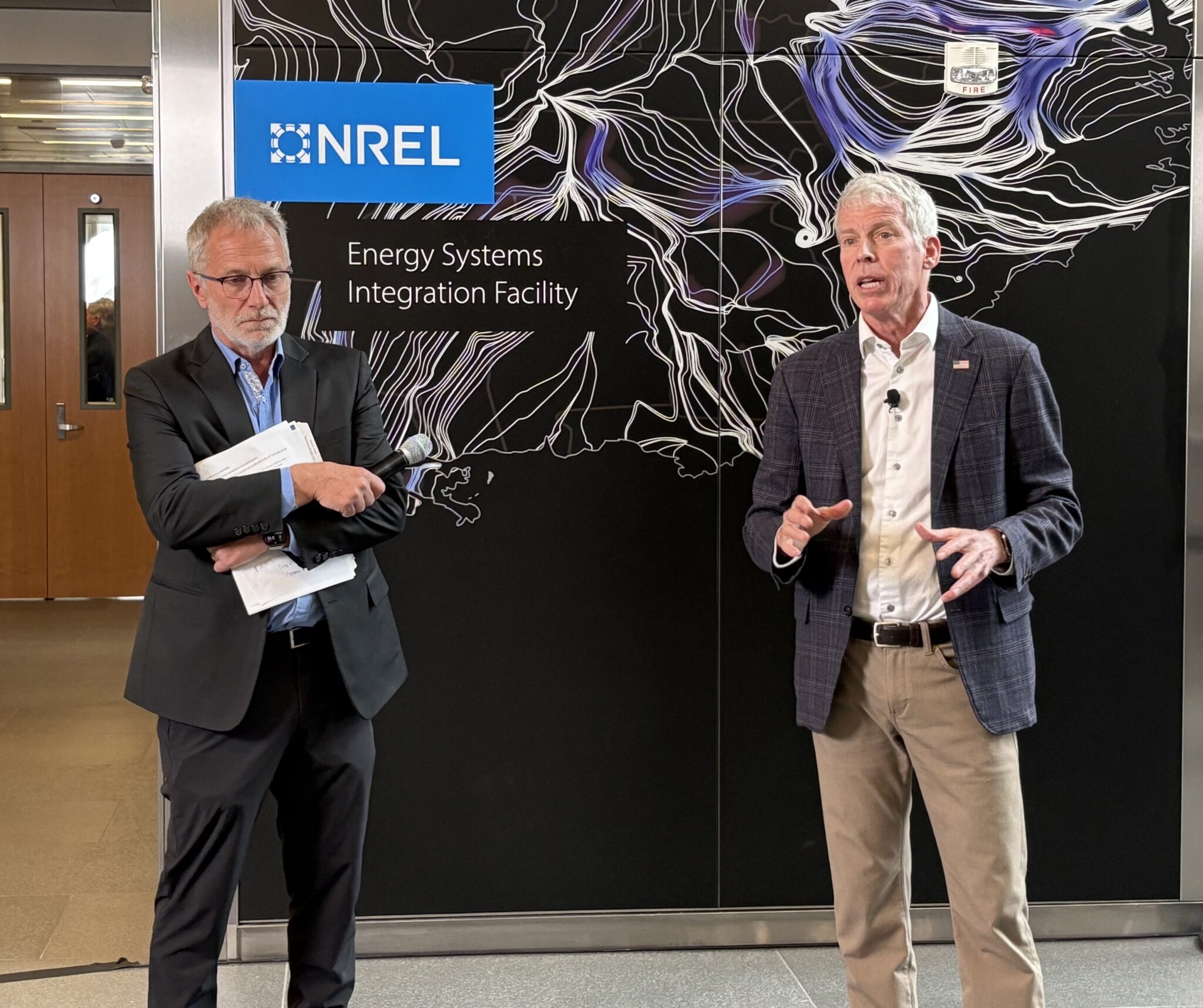
U.S. Energy Secretary Chris Wright talks to reporters on April 3, 2025, at the National Renewable Energy Laboratory in Golden. (Lindsey Toomer/Colorado Newsline)

Click the link to read the article on the Colorado Newsline website (Lindsey Toomer):

April 3, 2025

Chris Wright said blaming Marshall Fire on climate change is ‘simply to not look at the data’

U.S. Secretary of Energy Chris Wright, returning to the Denver area Thursday after he was confirmed as a member of President Donald Trump’s cabinet, repeatedly minimized the consequences of climate change when speaking to reporters during a press conference. 

Wright, founder of Denver-based fracking services company Liberty Energy, spoke to employees at the Department of Energy’s National Renewable Energy Laboratory in Golden for less than 10 minutes, touching on powering artificial intelligence, electricity production and growth, and supporting national labs. 

Talking to reporters after he spoke to staff, Wright said “emotional, not-fact-based stuff” like targeting hydrocarbons — the main components of climate change-causing fossil fuels — for reductions is “disruptive” and led to higher electricity and energy prices during the Biden administration. 

Wright said that attributing the Marshall Fire — which in 2021 destroyed more than 1,000 homes in Boulder County, burned over 6,000 acres, caused more than $2 billion in property damage and killed two people — to climate change is “simply to not look at the data.” He said wildfires “peaked over 100 years ago” and that the U.S. government could better manage wildfire devastation through forest management to control wood fuels. 

“Calling climate change a crisis is just to say ‘I’m not going to look at the science, I’m not going to look at the economics, I’m just going to run with the politics,’” Wright said. 

Drier and hotter conditions in Colorado are widely viewed as having contributed to the severity of the Marshall Fire, making the potential for loss greater. Investigators said one of the fire’s origins was a spark from an Xcel Energy power line, and the utility company has since faced several lawsuits.

Wright has previously expressed deep skepticism of the scientific consensus that climate change is a global crisis.

Department layoffs

The Department of Energy, along with many other federal agencies, laid off probationary staff members, and a judge then ordered the department reinstate them. The Trump administration asked all department heads to plan for additional cuts through a “reduction in force” process. 

Wright did not say how many more employees within his department could expect to lose their jobs, but he said downsizing is an “ongoing process” and that “it would be downright irresponsible if we weren’t doing this.” He said department staff grew by 20% over the four years before he took over, and “what we got out of it was a little bit more restrictions in energy production around the country.” 

Energy Department leadership told workers this week it will undergo “restructuring.” Wright said each department will undergo “a very detailed organization, bottom up.” 

“Every part of the government, we have to look at, how can we make government services as good as they are today or better, but at lower cost,” Wright said. “Like I do with my business, we have to look carefully at the business of where we are today and how can we deliver services at least as good as we are today at lower cost.”

In Wright’s talk to staff at the NREL, he applauded the work and dedication of the employees he spoke with and said their work is “critical.”

“The range of stuff I saw today, different people that spoke on different technologies, incredibly impressive, passionate, smart people that you can see from their heart that believe in what they’re doing, that love what they’re doing,” Wright said. 

U.S. Energy Secretary Chris Wright, right, talks to reporters alongside National Renewable Energy Laboratory Director Martin Keller on April 3, 2025, at the NREL campus in Golden. (Lindsey Toomer/Colorado Newsline)

After he was appointed, Wright said one of his first moves was to bring together leaders of the national labs from around the country to ask what they needed to make their work more efficient. Last week, he issued a secretarial order making changes he said resulted from those conversations. 

Artificial intelligence is “the next energy-intensive manufacturing industry,” Wright said in Golden, and the U.S. should not outsource that energy production to other countries. He said he issued a request for information Thursday to gauge developer interest in building on DOE land around the country to power AI.  

“We have land at all of our national labs and DOE sites around the country — who wants to come build a data center, build (a) nearby energy system, use the technology and smarts we got at the national lab … Maybe donate some computing power to us, or some lease money for the lands that’ll help fund our research,” Wright said. “We’re trying to find different ways to make the labs faster, smarter, better and more self-sufficient, more funding from other sources as well.” 

Wright said he would make “a commercial arrangement” with private data center companies that want to use federal land, because “that’s where the capital is.” 

NREL is responsible for researching and developing renewable energy systems and improving energy efficiency in the U.S. It has another campus in Arvada, as well as one in Alaska and in Washington, D.C., with 3,675 employees across the four locations.

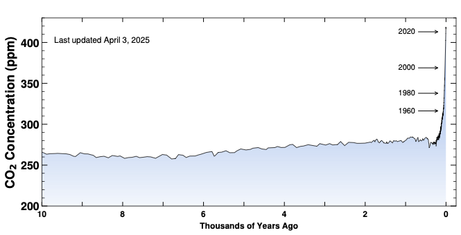
10,000 years of CO2, during the time that human civilization arose. Credit: https://keelingcurve.ucsd.edu/

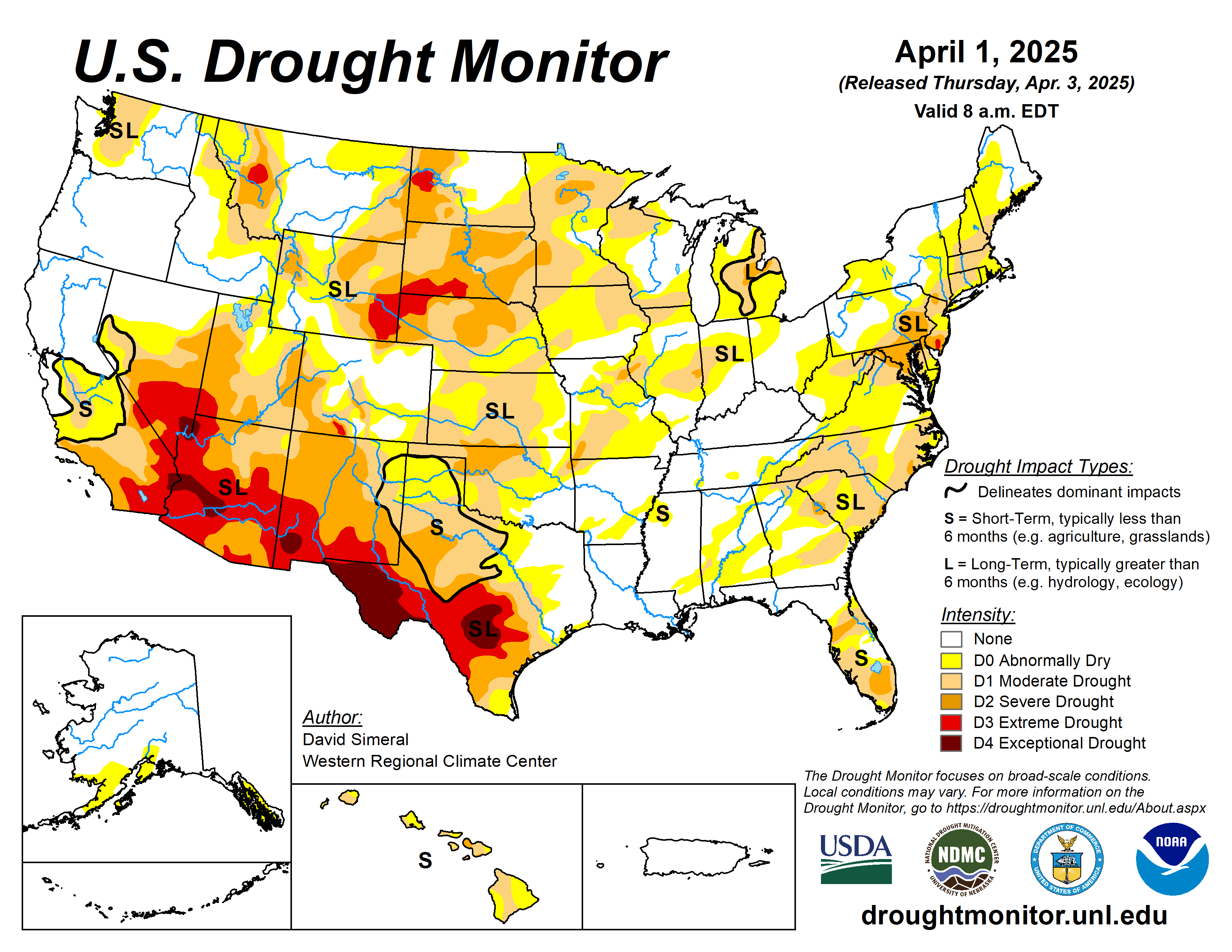
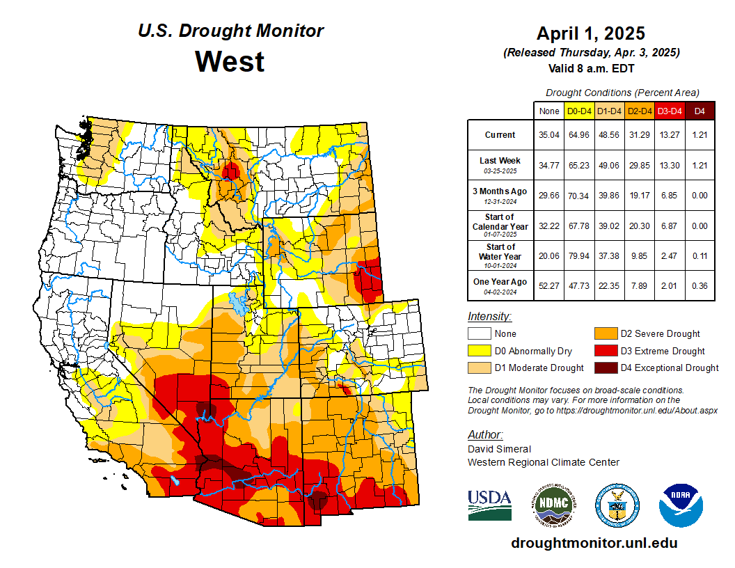
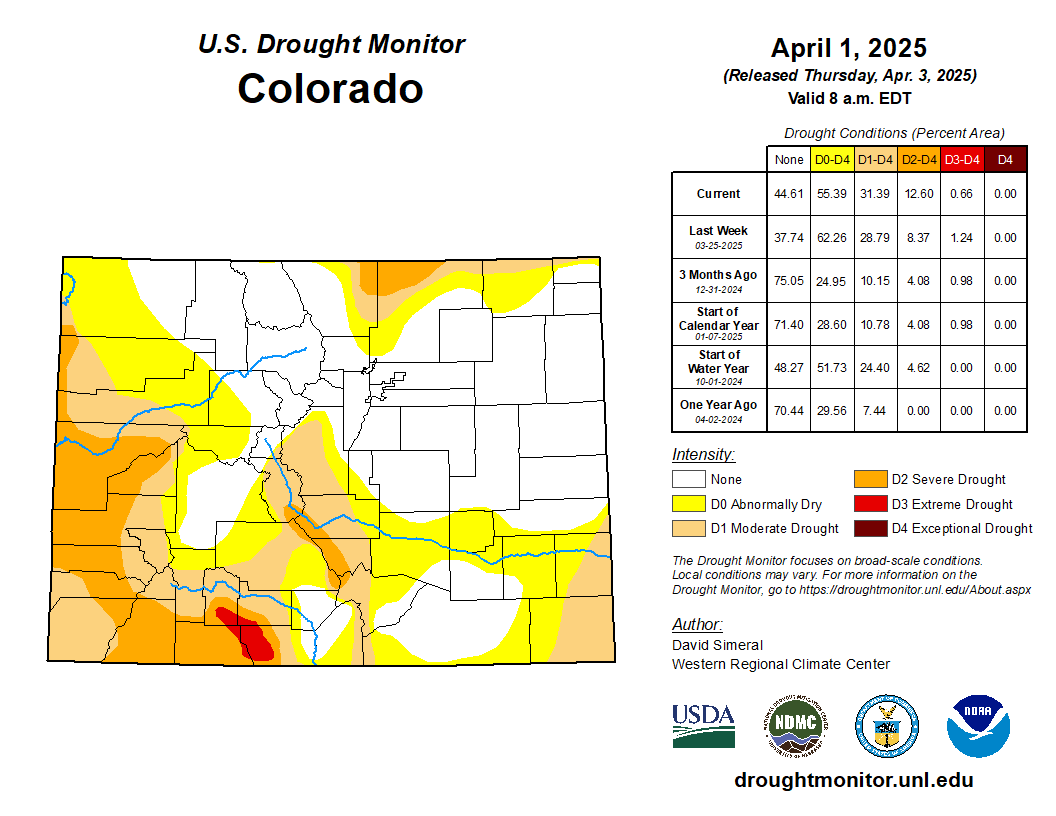
#Drought news April 3, 2025: In areas of southwestern and south-central #Colorado, degradations were made on the map where snowpack conditions at numerous NRCS SNOTEL stations are reporting well below-normal SWE levels.

Click on a thumbnail graphic to view a gallery of drought data from the US Drought Monitor website.

Click the link to go to the US Drought Monitor website. Here’s an excerpt:

This Week’s Drought Summary

This U.S. Drought Monitor (USDM) week saw improvement in drought-related conditions across areas of the Intermountain West, High Plains, South, Upper Midwest, and Southeast. Meanwhile, conditions degraded on the map in the Southwest, Lower Midwest, and the Mid-Atlantic. Out West, a series of Pacific storms delivered significant rainfall to the lower elevation coastal areas and heavy mountain snow in the Klamath Mountains, Cascades, and Sierra Nevada ranges, as well as to the higher elevations of the Great Basin and the central and northern Rocky Mountains. In the coast ranges of Northern California, 7-day rainfall totals exceeded 10+ inches in some areas, according to preliminary data from the National Weather Service (NWS) California-Nevada River Forecast Center. The series of storms provided a late-season boost to mountain snowpack levels including in California, where the statewide snowpack (April 1) was 96% of normal, according to the California Department of Water Resources. In the Southwest, drought expanded and intensified across areas of southeastern and northeastern Arizona, northeastern New Mexico, and southwestern Colorado, where snowpack levels are below normal in the San Juan and Sangre de Cristo ranges. In the South, southern Texas received record-breaking rainfall (12+ inches) leading to widespread improvements in drought-related conditions. In the Upper Midwest, an ice storm impacted northeastern Wisconsin and northern Michigan, leading to widespread power outages. Precipitation from the storm event led to improvements on the map in those areas. In parts of the Northeast, some improvements occurred in response to a combination of factors, including normal to above-normal precipitation (past 30-60 days), increased streamflows, and some recovery in groundwater levels. In the Southeast, short-term dryness expanded areas of drought from North Carolina to Georgia, while Florida saw some minor improvement in drought conditions in response to recent rainfall events.

In terms of reservoir storage in areas of the West, California’s reservoirs continue to be at or above historical averages for the date (April 1), with the state’s two largest reservoirs, Lake Shasta and Lake Oroville, at 113% and 121% of average, respectively. In the Southwest, as of March 31, Lake Powell is 32% full (55% of typical storage level), Lake Mead is 34% full (54% of average), and the total Lower Colorado system is 41% full (compared to 42% full at the same time last year), according to the U.S. Bureau of Reclamation. In Arizona, the Salt River Project is reporting the Salt River system reservoirs 72% full, the Verde River system 53% full, and the total reservoir system 70% full (compared to 89% full one year ago). In New Mexico, the state’s largest reservoir along the Rio Grande is currently 14% full (30% of average). In the Pacific Northwest, Washington’s Franklin D. Roosevelt Lake is 81% full (148% of average for the date), Idaho’s American Falls Reservoir on the Snake River is 96% full (108% of average), and Hungry Horse Reservoir in northwestern Montana is 72% full (108% of average)…

High Plains

On this week’s map, only minor changes were made in the region, namely in western Nebraska and areas of Kansas. In the Sand Hills of Nebraska, precipitation during the past 7-day period (1 to 2 inches) led to 1-category improvements in areas of Severe (D2) and Extreme (D3) drought. In Kansas, short-term dry conditions (past 30-60 days) led to the expansion of isolated areas of drought in the southwestern and northeastern parts of the state. Generally dry conditions prevailed across much of the region for the week, with some small accumulations (0.5 to 1 inch liquid) observed in southern and eastern South Dakota, northern Nebraska, and southeastern Kansas. In terms of temperatures, near-normal average temperatures were logged across the region…

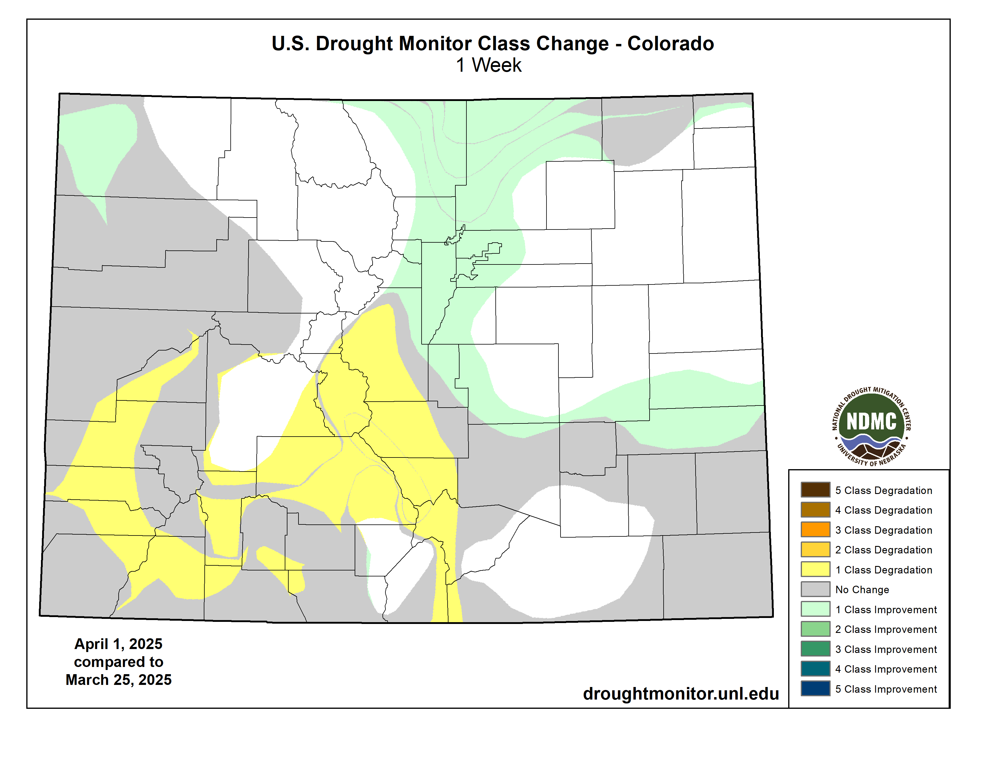
Colorado Drought Monitor one week change map ending April 1, 2025.

West

Out West, a series of Pacific storms delivered heavy rain to the lower elevations and snow to the higher elevations of the Pacific Northwest and Northern California. In the Lake Tahoe area, 7-day snowfall totals ranged from 1 to 2+ feet, while areas of the Klamath Mountains of northwestern California received totals up to 3 feet. Other mountain regions, including the Cascades of Oregon, the Wasatch and Uintas of Utah, and the northern Rockies, received accumulations ranging from 6 to 24 inches. Looking at the regional snowpack, the NRCS SNOTEL network is reporting (April 1) the following region-level (2-digit HUC) SWE levels: Pacific Northwest 104%, Missouri 98%, Upper Colorado 89%, Great Basin 103%, Lower Colorado 49%, and Rio Grande 49%. In the Desert Southwest, areas of Extreme Drought (D3) expanded in northeastern and southeastern Arizona in response to very low streamflows and below-normal precipitation since the beginning of the Water Year (Oct 1). In areas of southwestern and south-central Colorado, degradations were made on the map where snowpack conditions at numerous NRCS SNOTEL stations are reporting well below-normal SWE levels. Likewise, poor snowpack conditions have been observed in the mountain ranges of southern Utah, northern Arizona, and northern New Mexico…

South

Generally dry conditions prevailed across areas of the region including Oklahoma, western Texas, Arkansas, and southern Mississippi. Conversely, the Gulf Coast regions of Texas and Louisiana received very heavy rainfall in some areas (5 to 15 inches based on radar estimates), with the highest accumulations observed along the southern Gulf Coast region of Texas and the South Texas Plains. The deluge of rainfall led to life-threatening flooding and loss of lives. The rains also led to significant improvements in drought-related conditions, with multiple category improvements made on the map. In contrast, short-term dry conditions continued in Arkansas, although heavy rains are expected to impact the state over the next week. For the week, average temperatures were well above normal, with anomalies ranging from 4 to 10+ degrees F. Looking at reservoir conditions in Texas, statewide reservoirs are reported to be 75.3% full, with many reservoirs in the eastern part of the state in good condition, while numerous reservoirs in the western portion of the state continue to experience below-normal levels, according to Water for Texas (April 2)…

Looking Ahead

The NWS Weather Prediction Center (WPC) 7-Day Quantitative Precipitation Forecast (QPF) calls for moderate-to-heavy precipitation accumulations ranging from 3 to 10+ inches (liquid) across areas of the South, Lower Midwest, and the Pacific Northwest (Washington), with the heaviest accumulations expected in the Middle Mississippi Valley and Ohio River Valley regions. Light-to-moderate accumulations are expected in areas of the Southeast, Mid-Atlantic, Upper Midwest, and central and southern Plains. In the central and southern Rocky Mountains, mountain snowfall is expected. The Climate Prediction Center (CPC) 6-10-day Outlook calls for a moderate-to-high probability of above-normal temperatures across the Western U.S. and Plains, while below-normal temperatures are expected across the Midwest and Eastern Tier. In terms of precipitation, there is a moderate-to-high probability of below-normal precipitation across most of the West, Plains, South, and the Midwest. Elsewhere, above-normal precipitation is expected across the Eastern Seaboard and in the Pacific Northwest (Washington).

US Drought Monitor one week change map ending April 1, 2025.

Feds unfreeze $50M grant for #GreatSaltLake projects ahead of uncertain #runoff: Lake should get a boost again this year, conservation experts say — The Deseret News

Figure 1. A bridge where the Bear River used to flow into Great Salt Lake. Photo: EcoFlight.

Click the link to read the article on The Deseret News website (Carter Williams). Here’s an excerpt:

March 26, 2025

Water levels at the Great Salt Lake’s southern arm remain a foot below where they were this time last year as the gap between it and its northern arm shrinks. The state agency tasked with managing the massive body of water is hopeful for a good spring runoff from a “remarkably average” snowpack collection season that’s nearing an end.

“We are sitting … better than I would have expected (with) where we were a month ago,” Great Salt Lake Commissioner Brian Steed said as he provided an update on lake conditions to reporters on Tuesday. “We’ve just had … a ‘miracle’ March, and we’re happy to have that ‘miracle March’ and get water levels back up where they need to be.”

The Great Salt Lake’s southern arm is now up to 4,193.3 feet in elevation, per U.S. Geological Survey data; its northern arm is at 4,192.4 feet in elevation. While the southern arm is a foot below its level this time last year, the northern arm is up about 1½ feet because more water has flowed into it since last year. It’s expected to receive a boost from the basin’s snowpack, which is up to 18.6 inches of snow-water equivalent, about 95% of its annual median average, according to the Natural Resources Conservation Service. At least one more storm is projected later this week, while long-range outlooks also favor a wet start to April, which could elevate the basin to its third straight above-normal season.

The conservation service estimates the lake will rise another 0.5 to 1.5 feet this spring, but several variables could factor into how much…On the other hand, the lake could also receive another boost from controlled releases. Utah’s reservoir system remains 82% full — about a percentage point higher than last year and well above normal before the spring snowmelt — which means there’s less water needed from spring runoff to refill the system.

A federal funding freeze is causing delays on a #BlueRiver habitat restoration project in Silverthorne — Summit Daily

Map of the Blue River drainage basin in Colorado, USA. Made using USGS data. By Shannon1 – Own work, CC BY-SA 4.0, https://commons.wikimedia.org/w/index.php?curid=69327693

Click the link to read the article on the Summit Daily website (Ryan Spencer). Here’s an excerpt:

March 29, 2025

While a federal judge has ordered the Trump Administration to unfreeze federal funds, the National Council of Nonprofits says its continues to receive reports of nonprofits struggling to access federal grant money

A habitat restoration project aimed at restoring Gold Medal fishing status along a stretch of the Blue River that flows through Silverthorne is being impacted by a federal funding freeze. The Blue River Watershed Group — a local nonprofit that received $1.8 million in grant federal funding for the restoration project in December 2023 — told the Silverthorne Town Council earlier this month that the federal government has paused disbursement of those funds.

“Grant funding for this project through the Bureau of Reclamation’s WaterSMART Aquatic Ecosystem Project grant is affected by the recent pauses in federal grant funding,” Blue River Watershed Group executive director Vanessa Logsdon said in a statement Thursday, March 28.

The Blue River Watershed Group has partnered with Trout Unlimited and the town of Silverthorne, which has provided $150,000, on the project. The $1.8 million federal grant is to complete the engineering and design for the habitat restoration project, which focuses on the stretch of the Blue River from the Dillon Reservoir to the Columbine Campground north of Silverthorne. Studies have shown that that stretch of river is impacted by unnatural temperatures from dam releases that can be too warm in the winter and too cold in the summer, disrupting the life cycles of aquatic organisms such as trout. The project aims to get the Blue River back to a more natural cycle and restore the Gold Medal fishing status that stretch of river lost in 2016.

Predictions for 2025 river flows, reservoir levels slightly below last year — Steamboat Pilot & Today #snowpack #runoff

Click the link to read the article on the Steamboat Pilot & Today website (Suzie Romig). Here’s an excerpt:

March 27, 2025

State officials at the Division of Water Resources office in Steamboat Springs are predicting river flows and reservoir levels — which are key for agricultural, municipal and recreational uses — to land this year slightly below conditions of 2024. That means, based on current snowpack and water supply forecasts, the water season for 2025 should land about in the middle, or at median, of the past 34 years of record keeping of water flows down the Yampa River, said William Summers, water resources assistant division engineer in Steamboat…

Last year, Stillwater, Yamcolo, Stagecoach, Fish Creek and Elkhead reservoirs all filled to capacity. However this year, Stillwater, Yamcolo and Stagecoach reservoirs in southern Routt County “are a little uncertain, probably pretty close,” Summers said. The engineer noted Fish Creek Reservoir east of Steamboat Springs and Elkhead Reservoir on the border of Routt and Moffat counties “pretty much fill every year.”

[…]

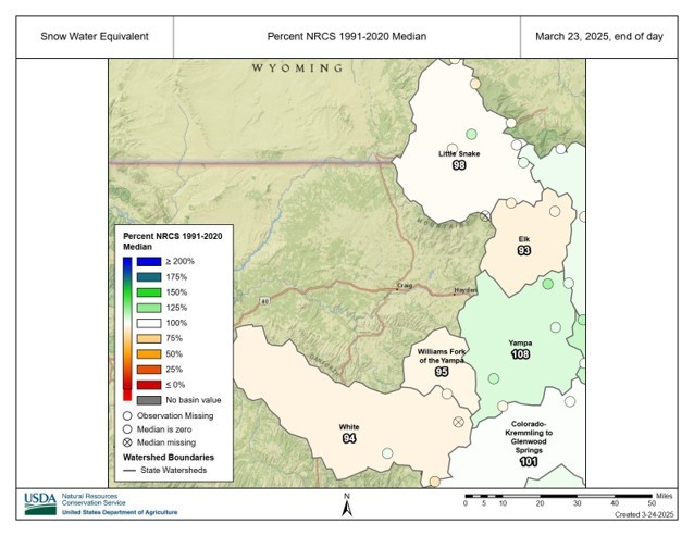
SNOTEL stations for snow telemetry information record snow water equivalent amounts in the area for March 23, 2025. Credit: NRCS

The Yampa-White-Little Snake River basins currently sit at 101% of median snowpack water equivalent based on Natural Resources Conservation Service data from 1991 to 2020. The data is collected by eight area snow telemetry stations, or SNOTEL, that help forecast water supply and drought conditions. Looking more closely at individual SNOTEL stations on March 23, Dry Lake SNOTEL near Buffalo Pass registered 120% of median, while on the lower end Bear River SNOTEL by Stillwater Reservoir was at 95% of median.

Yampa River Basin via Wikimedia.

On President Trump & tirades; April 1 #snowpack update; Also, Oil executives blast White House econ policies — Jonathan P. Thompson (LandDesk.org)

Horse near Aneth. Photo illustration by Jonathan P. Thompson

Click the link to read the article on the Land Desk website (Jonathan P. Thompson):

April 1, 2025

🤯 Trump Ticker 😱

Last week, one of the Land Desk’s more conservative readers cancelled his paid subscription. He wrote that he appreciated my passion for public lands, but was no longer interested in reading what he called a “tirade against Trump.”

This type of thing happens all the time in this business, and, unlike Elon Musk, I’m not looking for your pity. But I was a bit saddened, given that this person had been a paid subscriber since the Land Desk was launched, and because I really do appreciate having readers and commenters from across the political spectrum.

Besides, while I’m prone to a rant now and then, I do think “tirade” is taking it a little too far. Anyway, my point in telling y’all this is to let you know that writing about Trump’s shenanigans every dispatch is just about the last thing I want to be doing with my time. I’d much rather be delving into old maps, getting into the nuances of Western water, exploring the history of floods and droughts and wildfires, taking contrarian views on the housing crisis, or dissecting the contradictions of oil and gas markets. And I will continue to do all of that.

At the same time, it’s impossible for me to ignore the barrage of destruction, corruption, chaos, authoritarianism, and incompetence emanating from the White House. My passion for public lands — and for justice, truth, reason, morality, decency, intelligence, and kindness — demands that I document these egregious acts, and do my part to resist them, even if it is just by informing my readership about what’s happening.

I am not impartial, not by any means. I am partial to the planet and its survival, toward my fellow human beings, toward peace and justice and compassion and truth. [ed. emphasis mine] I am not, however, partisan: I will scrutinize Democrats and Republicans equally, fact-check the left and the right, and give credit where credit is due — even to Donald Trump.

***

Hopi tribal members cross Havasu Creek. Photo credit: From the Earth Studio

And on that note: The Trump administration appears to have unfrozen nearly $4.2 million in federal funding to help the Hopi Tribe build a solar-powered microgrid to run two remote wells and associated infrastructure that will provide water to Upper and Lower Moenkopi. The funding was approved by the Biden Energy Department, Trump froze it as part of a larger stop on Infrastructure and Inflation Reduction law money, but now it has been released. So good on you, Donny!

Now, how about you direct your Environmental Protection Agency to release funding for the Walker River Paiute Tribe to expand access to clean water and electric power infrastructure, and for Navajo Power’s program to bring solar to off-grid homes.

***

Though it may be inadvertent, Trump’s economic policies may ultimately benefit the environment in some ways. The haphazard, on-again, off-again tariffs, for example, along with the gutting of the federal government’s workforce, have sent the stock market into a tailspin. Meanwhile, the tariffs — along with reciprocal tariffs levied by the U.S.’s trading partners — will increase prices on most consumer goods. People will buy less, travel less, which will mean less pollution and environmental impacts.

***

And yet more kudos for Trump! Seriously. Despite all of his bluster, Trump has managed to really piss off oil and gas executives — the same ones that were throwing money at his campaign just a few months ago — and possibly dampen drilling on public lands.

See, the thing about tariffs is that they very well may raise the price you pay for gasoline (depending on where your local refinery gets its crude oil), but the economy-dampening part of tariffs actually brings down the price of oil, while also raising the cost of steel pipes and other supplies. That’s no bueno for petroleum companies, whose profit margins are directly proportional to the price of crude.

Many of these folks won’t criticize Trump in public, given his vindictive and authoritarian leanings, but give them the cover of anonymity, as a Dallas Federal Reserve survey did, and they go off on the White House’s herky-jerky non-policies. Here’s a sampling:

There was only one mention of regulations getting in the way of the oil business, and that wasn’t federal rules, but state ones:

Well, there you have it, folks.

***

Oh, and these oil companies might also be angry that the MAGAs are all buying Teslas — or at least pretending to — in order to “own the libs.” Which is pretty funny, given the amount of gibberish Trump devoted to dissing electric vehicles during his campaign rallies. Tesla also stands to benefit the most from Trump’s tariffs, another dig at the internal combustion fans.

***

Maybe the national parks will be a bit less crowded this summer, as well, as international travel ebbs.

Anyone who’s traveled the Western national park service knows that they are popular with overseas visitors. On a single grocery run at the Page, Arizona, Safeway recently, I heard no fewer than three different languages spoken, in addition to Navajo and English, and that was in the off-season. In 2018 (the last year that data is available), more than 14 million international travelers visited U.S. national parks and monuments. About 14% of the Grand Canyon National Parks’ visitors were from overseas, with about 6% of Zion’s visitation from overseas.

Tourism Economics is predicting that international travel to the U.S. will be down significantly this year, thanks not only to the administration’s hostile economic moves, but also “polarizing Trump administration policies and rhetoric.” Also, there’s that thing where travelers have been detained at the border, even thrown in jail, simply for trying to get a visa. This decline undoubtedly will impact Western U.S. tourism and national park and monument visitation numbers. Not good for the tourism economy, but it might give the parks a much needed rest.

🥵 Aridification Watch 🐫

It’s first-of-the-month snowpack update time again, and this will likely be the last of the season barring some freak climatic shift over the next several weeks. Snowpack levels typically peak in mid-elevation areas in mid- to late-March, and in the high country in mid- to late-April, meaning we are now headed into spring runoff season.

Generally speaking, it’s looking like runoff will be average to paltry, depending on which side of the snow-divide your watershed falls. It is a very jagged line, by the way, with places in the west and north having average to above average snowpack, while the southern-Interior West generally had a super dry winter. But even within those areas there are sort of outliers: The Grand Traverse ski race between Aspen and Crested Butte was canceled due to lack of snow for the first time in its 26-year history.

And there’s big variations over short distances. Red Mountain Pass is still just below median, for example, while the southern San Juan Mountains, just a few dozen miles away, are experiencing a severely dry winter.

Before I get to the graphics, however, a quick note. The snowpack and precipitation plots I run here come from the USDA’s Natural Resources Conservation Service. It’s just one of the valuable services they provide. I haven’t found any stats on whether DOGE has gone after NRCS’s staff, yet. But the DOGE website says it has or will cancel the leases for the following NRCS offices. Whether they and their staffs will simply go away, be absorbed into another facility, or what, isn’t disclosed.

  • Natural Resource Conservation Service offices slated for lease cancellations: Missoula, Montana; Wasilla and Fairbanks, Alaska; Logan, Utah; Gallup and Raton, New Mexico; Yuma, Arizona; Dayton, Puyallup, and Renton, Washington; Portland, Oregon; and Woodland, Yreka, Salinas, Oxnard, and Blythe, California.

Hopefully the staff of these offices and services they provide will endure.

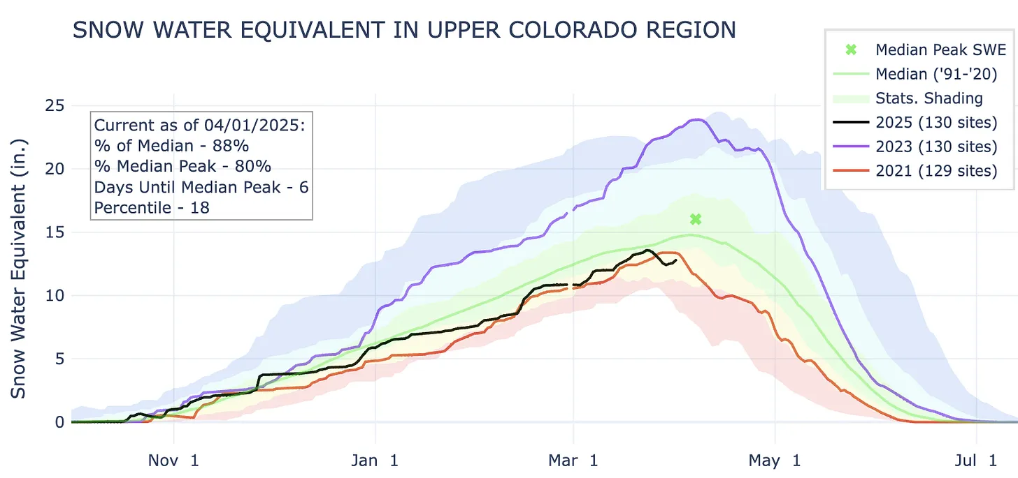
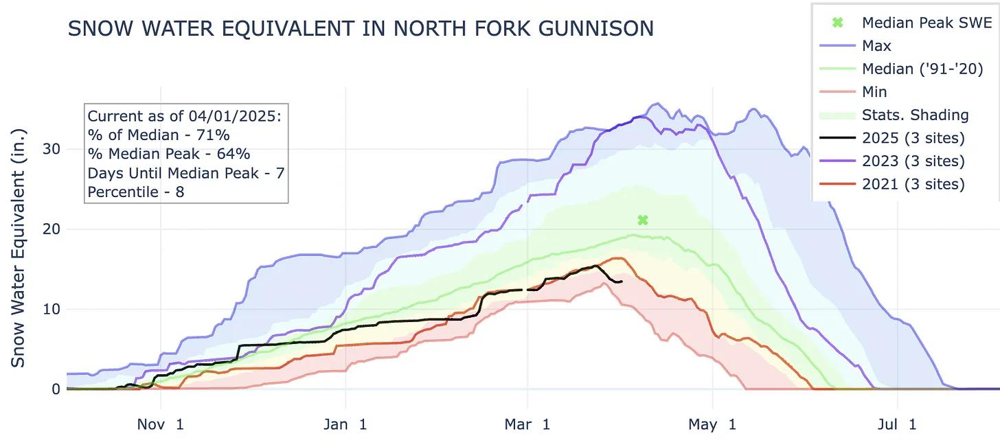
Now to the snowpack plots. I included the plots for 2021 and 2023 because those were the most recent big and crappy years for snowpack.

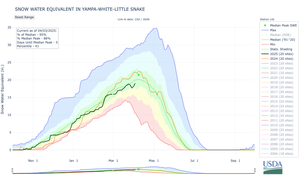
The watersheds that feed Lake Powell are not in terrible shape, sitting at 88% of the median just six days before the typical peak. However, levels are lower than they were in 2021 at this time, and 2021 was not a good year for the Colorado River. Source: NRCS.
The North Fork of the Gunnison has followed a snow accumulation pattern similar to the Upper Colorado River’s.
Red Mountain Pass is one of the few bright spots in the Four Corners region. Snow levels have tracked right around normal for most of the winter. Though it’s now down to 90% of median, there are potentially still over three weeks left in the snow accumulation season, meaning an above-average season is still possible; snow is forecast for much of this week there.
This SNOTEL site, in the San Francisco Peaks north of Flagstaff, is the comeback story of the year, rebounding from ultra-dry to average over the course of several weeks. It’s one of the only sites in Arizona that received measurable snow accumulation this season.
The drought has spread and intensified over the last year.
And it doesn’t look like it will get better anytime soon …

If you want to know more about the drought and the Colorado River basin, I’d suggest checking out the Wright-Ingraham Institute’s interactive Drought Interfaces app. It’s super cool and informative.

Dwindling water supply, legal questions push #ColoradoRiver into ‘wildly uncharted territory’: Threat of compact call hangs over seven-state talks — Heather Sackett (AspenJournalism.org) #COriver #aridification

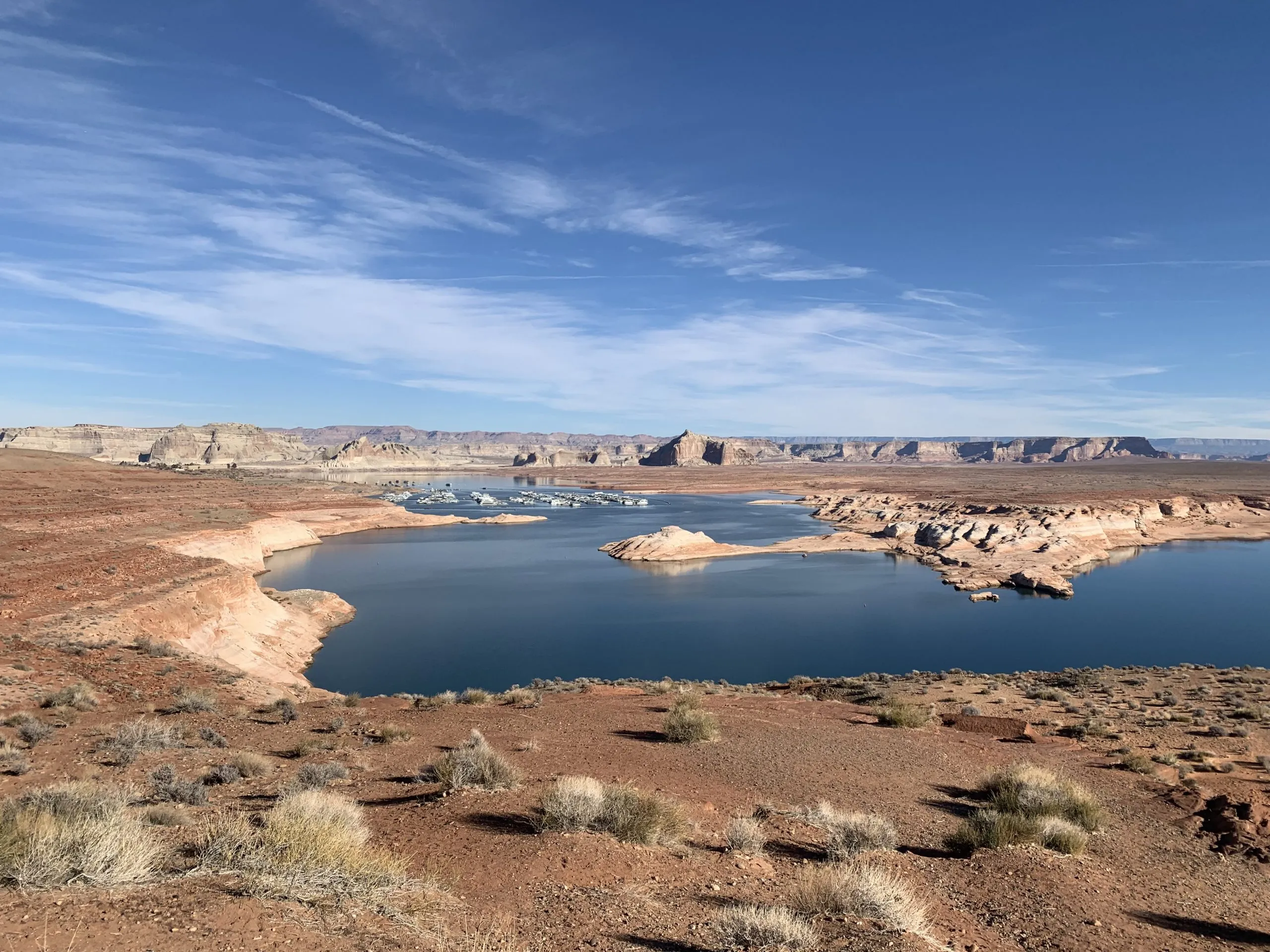
Lake Powell at Wahweap Marina as seen in December 2021. Dwindling streamflows and falling reservoir levels have made it more likely that what some experts call a Colorado River Compact “tripwire” will be hit in 2027. Credit: Heather Sackett/Aspen Journalism

Click the link to read the article on the Aspen Journalism website (Heather Sackett):

April 1, 2025

Time is ticking for states that share the shrinking Colorado River to negotiate a new set of governing rules. One major sticking point, which has the potential to thrust the parties into a protracted legal battle, hinges on differing interpretations of a few sentences in a century-old agreement. 

In a recent letter, the river’s Lower Basin states – California, Nevada and Arizona – asked federal officials to analyze the effects of a hypothetical legal concept known as a “compact call.” 

The problem? The 1922 Colorado River Compact says nothing about a compact call. And although the phrase often looms like a threat over Colorado River discussions, there is no agreed-upon definition of the term, what would trigger a compact call nor how one would play out. In fact, the Upper Basin states – Colorado, New Mexico, Utah and Wyoming – don’t believe the laws governing the river even contemplate it.

The February letter comes as water managers from all seven Colorado River Basin states are in the midst of deciding how Lake Powell and Lake Mead will be operated and cuts will be shared after 2026 when the current guidelines expire. In March 2024, each basin submitted competing proposals to the U.S. Bureau of Reclamation. In January, federal officials with the outgoing Biden administration released their analysis of five different potential ways forward and did not include either basin’s proposal, but a “basin hybrid” that incorporated elements from both. 

In essence, the Lower Basin states have identified a potential opening with the Trump administration, and asked new leaders at the Interior Department to adopt the Lower Basin’s view on some of the most contentious and disagreed-about parts of Colorado River management.

“I believe that under the law, the compact requires delivery of 7.5 million acre-feet of water on a 10-year rolling average, plus one-half of the Mexico Treaty obligation to the Lower Basin,” said Tom Buschatzke, director of Arizona’s Department of Water Resources. “So we want to see Reclamation, as our request indicated, incorporate that outcome into the modeling for any alternative to look at. That includes how reductions in the Upper Basin states might have to occur.”

Members of the Colorado River Commission, in Santa Fe in 1922, after signing the Colorado River Compact. From left, W. S. Norviel (Arizona), Delph E. Carpenter (Colorado), Herbert Hoover (Secretary of Commerce and Chairman of Commission), R. E. Caldwell (Utah), Clarence C. Stetson (Executive Secretary of Commission), Stephen B. Davis, Jr. (New Mexico), Frank C. Emerson (Wyoming), W. F. McClure (California), and James G. Scrugham (Nevada) CREDIT: COLORADO STATE UNIVERSITY WATER RESOURCES ARCHIVE via Aspen Journalism

Over a century ago, the compact split the river’s water evenly, with half (7.5 million acre-feet a year) going to the Upper Basin and half to the Lower Basin. Another 1.5 million acre-feet a year was later allocated to Mexico.  

The crux of the dispute comes from how the Upper Basin states and the Lower Basin states each interpret a key phrase in the compact: “The States of the Upper Division will not cause the flow of the river at Lee Ferry to be depleted below an aggregate of 75,000,000 acre-feet for any period of ten consecutive years…”

To the Upper Basin states, “will not cause” means that their use won’t be the reason the Lower Basin doesn’t get its allocation. They see it as a “non-depletion” obligation. 

According to Colorado officials, they’re not delivering water downstream, but rather  they’re not causing the flows to be depleted. 

“What this means is that if the flows were to drop below 75 million acre-feet over a ten-year period, there would be an inquiry into what caused that to occur,” Michael Elizabeth Sakas, Colorado River communications specialist with the Colorado Water Conservation Board said in a written response to questions from Aspen Journalism.  

On the other hand, the Lower Basin states say they’re owed the water, with the Upper Basin states required to send the 75 million acre-feet over 10 years, plus half of the Mexico Treaty obligation (which works out to 82.5 million acre-feet every 10 years) downstream to the Lower Basin. 

Compact “tripwire” threatens to complicate

Colorado River expert Eric Kuhn says that the latest report from the U.S. Bureau of Reclamation is a major caution sign for the basin. An anemic snowpack this past winter could be setting the basin on the road to a compact call (as defined by the Lower Basin). The most recent federal forecast predicts that in 2027, the 10-year cumulative flow at Lee Ferry could drop below 82.5 million acre-feet, a threshold Kuhn calls the first “tripwire” for a compact call. 

“If flows were to go below 82.5 million, then that’s the first time, in theory, the lower division states could point to the Upper Basin and say, ‘You’re not complying with your compact obligations,’” Kuhn said. “This is not going to sneak up on us. I think most of the modeling shows that it’s almost inevitable we will drop below 82.5 in the next three or four years.” 

But Upper Basin officials disagree. In their interpretation, this tripwire doesn’t exist. A compact call is a concept recognized only by the Lower Basin. 

They also point out that calls for water apply to situations where there is a senior rights holder and a junior rights holder. Under the prior appropriation system, the oldest water rights get first use of the river, and senior rights can force junior rights to stop using water so seniors can get the full amount they are entitled to. But Upper Basin officials say there is no priority between the two basins; they are on equal standing. [ed. emphasis mine]

That may be true, but the three Lower Basin states are also home to the basin’s biggest water users and cities, with more political power than the sparsely populated Upper Basin states.

Navajo Bridge spans the Colorado River downstream from Lake Powell near Lee Ferry, the dividing line between the upper and lower basin. Some federal forecasts predict that in 2027, the flow at Lee Ferry could drop below a critical threshold that some experts call a “compact tripwire.”

River headed for “wildly uncharted territory”

So what would happen if and when the river shrinks enough to trigger the first compact tripwire?

In practice, a compact call could mean the Lower Basin states would sue the federal government to get them to send more water downstream from Lake Powell. (The U.S. Bureau of Reclamation is responsible for making releases from Lake Powell and Lake Mead.) The Lower Basin states could also demand that the Upper Basin states implement cuts to get more water into Lake Powell. But the Upper Basin states will almost certainly argue they are in compliance with the compact and don’t need to make cuts. The Supreme Court could then decide whether the Upper Basin states are in compliance with the compact.

“It’s wildly uncharted territory,” said Chuck Cullom, the executive director of the Upper Colorado River Commision. “It’s not a straightforward path to say: ‘We need you to release more water out of Glen Canyon Dam and curtail uses.’”

Udall/Overpeck 4-panel Figure Colorado River temperature/precipitation/natural flows with trend. Lake Mead and Lake Powell storage. Updated through Water Year 2024. Credit: Brad Udall

The Upper Basin’s argument hinges on what is causing the flows at Lee Ferry to drop. The four states say it’s not their fault, because they only use between 3.5 and 4.5 million acre-feet a year, far less than their allocation of 7.5 million acre-feet. The culprit, they say, is climate change, which according to scientists has contributed to a 20% decline in flows from the 20th century average. They have also shown that every 1 degree Celsius of warming results in a 9% reduction in flows. 

With a fixed number for how the river is shared, and a slowly dwindling amount of water available, the Upper Basin has been bearing the brunt of the effects of climate change, a phenomenon that Kuhn calls the “Upper Basin squeeze.” But the climate change argument could open a can of worms.

“There are numerous other water compacts between states,” Kuhn said. “Are we reopening every one of those? It could mean that other states do not have to comply with their compact obligations.That would be a precedent decision that would affect every compact in the western United States.”

How would cuts work?

Water users on Colorado’s Western Slope are eager to know how cuts could play out and over the past few years they have asked state officials repeatedly for more clarity on this issue. One reason is because most of the big transmountain diversions that take water from the mountainous headwaters of the Colorado to Front Range cities date to after the 1922 compact, meaning they would likely be cut first. But as the population centers and economic engines of the state, it’s unlikely a plan to cut water use would include turning off the taps to Denver.  

In a crisis situation where cuts are mandatory, the strict prior appropriation system would probably not hold.

“They’re going to have to make hard decisions, and they are going to primarily meet the human health and safety needs of people first,” Kuhn said. “It’s an open secret that the priority system works under normal conditions; it doesn’t work in emergencies.”

Western Slope water users also want to know the state’s plan for cuts, because some areas may be more at risk of forced cutbacks than others. The Yampa/White/Green River basin in the northwest corner of the state, for example, developed later than other places, with lots of more junior water rights. Would they be first on the chopping block? 

“We believe that regardless of where things stand on the river, clarity can’t hurt water users,” said Peter Fleming, general counsel with the Colorado River Water Conservation District. “In the long run, clarity will help people to plan better.”

But state officials have been reluctant to provide clarity about how cuts could be implemented, saying now is not the time to plan for it and that the Upper Basin states have always been in compliance with the compact.

“Colorado is not at risk of any compact curtailment scenario in the near future,” Sakas said in a written response to Aspen Journalism. “For the last 20 years, the Upper Basin has been using half of what we are allowed to use under the 1922 Compact while our downstream neighbors use significantly more than their apportionment.”

Figuring out who would be the first to take cuts and tracking that water to the state line would not be an easy task, said Colorado River expert Jennifer Gimbel. Gimbel is the senior water policy scholar at the Colorado State University Water Center and is the former director of the Colorado Water Conservation Board. 

“It would be a tremendous headache and a huge undertaking,” she said. “But I don’t know if that means we shouldn’t be doing it.”

The Colorado Division of Water Resources, in a first step, has been developing measurement rules and requiring measurement devices for water users across the Western Slope. According to state officials, the goal of this effort is to accurately measure diversions so that if necessary, Colorado sends downstream only the water that is required to maintain compact compliance and not a drop more. 

From left, J.B. Hamby, chair of the Colorado River Board of California, Tom Buschatzke, Arizona Department of Water Resources; Becky Mitchell, Colorado representative to the Upper Colorado River Commission at the Colorado River Water Users Association Conference in 2023. Water managers from all seven Colorado River Basin states are in the midst of deciding how Lake Powell and Lake Mead will be operated and cuts will be shared after 2026Credit: Tom Yulsman/Water Desk, University of Colorado, Boulder

Trying to stay out of court

One thing most water managers agree on is that finding a seven-state consensus is better than the potentially protracted litigation possible under some kind of compact call scenario. Some are hoping for the best but preparing for the worst. The Arizona Department of Water Resources requested about $1 million last year for Colorado River litigation from the state budget. Buschatzke said the Upper Basin states might fare worse under a compact call than they would by adopting the Lower Basin proposal.

“Because there are a lot of moving parts, litigation — a compact call — is a possibility,” he said. “It’s not a possibility I want to see occur. But I’ll have to do what I have to do to protect the state of Arizona.”

If the states can come up with new guidelines that fairly share the river, the threat of a compact call, which has long hung over Colorado River management discussions, could evaporate like water from the surface of Lake Mead. Cullom said that in 2007 when the seven states implemented the soon-to-expire guidelines that are currently in place, they agreed that if the two basins made good on their commitments outlined in those guidelines, they would set aside the issue of compact compliance — at least until after 2026.

“If they can figure out a way to live within the means of the river in such a manner that both the Upper Basin and Lower Basin agree, hopefully addressing a compact call again won’t be needed because it’s been addressed,” Gimbel said. 

This story was produced by Aspen Journalism, in partnership with The Water Desk at the University of Colorado’s Center for Environmental Journalism. 

Map of the Colorado River drainage basin, created using USGS data. By Shannon1 Creative Commons Attribution-Share Alike 4.0

Polluted discharge from the Moffat Tunnel continues to be released into the #FraserRiver — Sky-Hi Daily News

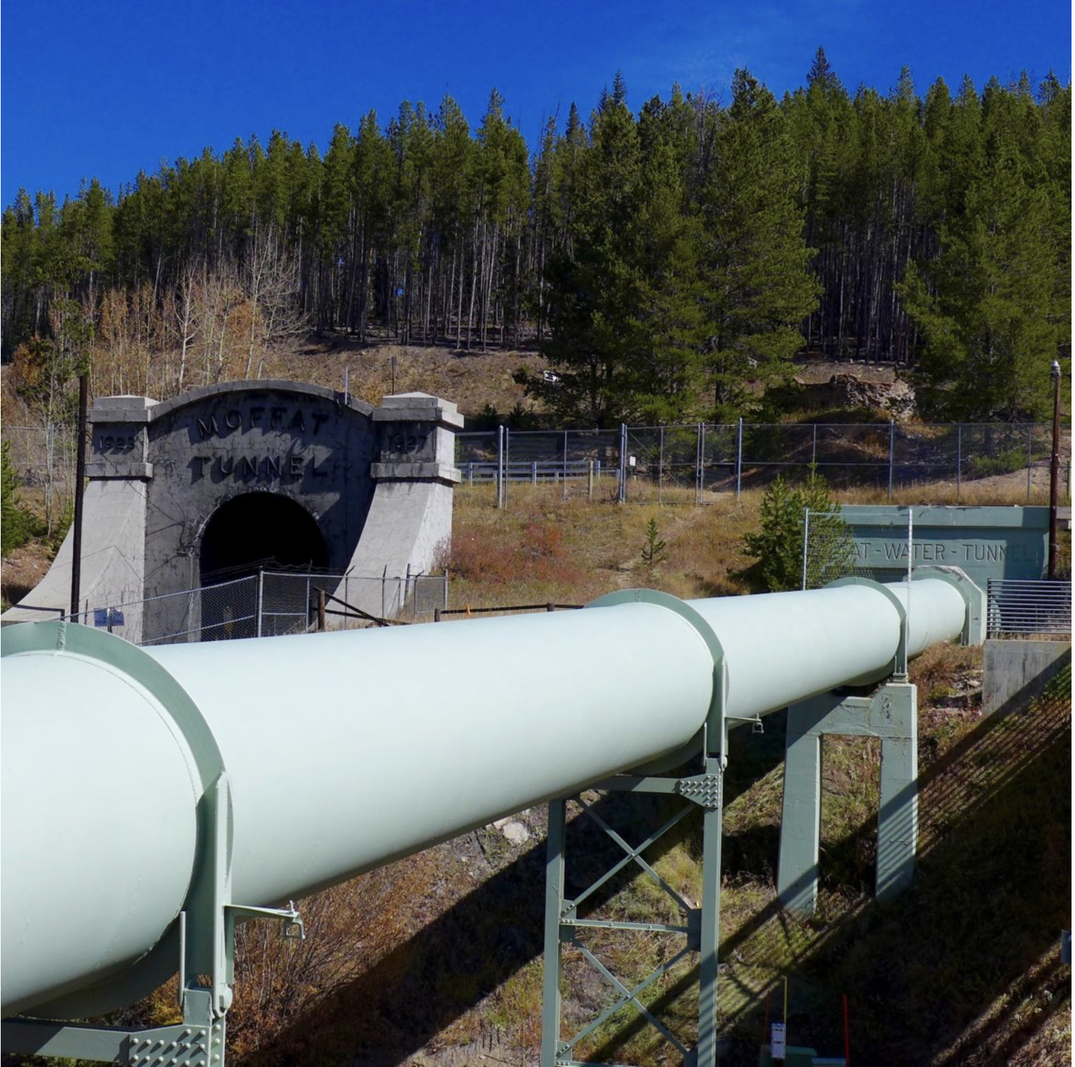
The pipeline, at the base of the Winter Park ski area, that moves water as part of the existing Moffat Collection System Project. The portal of the railroad tunnel is behind the pipeline, in this view. Photo credit: Brent Gardner-Smith/Aspen Journalism

Click the link to read the article on the Sky-Hi Daily News website (Meg Soyars Van Hauen). Here’s an excerpt:

March 25, 2025

According to Grand County Water Quality Manager Katherine Morris, polluted discharge from the Moffat Tunnel has adversely impacted the Fraser River. The Grand County water quality team recently wrote two letters to the Colorado Department of Public Health & Environment, outlining its concerns with violations by Union Pacific Railroad, which manages the tunnel. During a Grand County Board of Commissioners meeting March 11, 2025 Morris explained that polluted water from the tunnel enters the nearby Fraser River, which is a main tributary of the Colorado River. This ongoing problem began after the tunnel was completed, and Grand County government began advocating to fix the problem nearly two decades ago…

James Peak via ColoradoWildAreas.com

In the early 2000s, residents and governmental officials raised alarm about pollutants and increased turbidity (or clarity issues) in the Fraser River when water was discharged from the tunnel. The tunnel bores through James Peak. Groundwater from cracks in the mountain rock seeps into the tunnel, and that water needs a way out. Coal dust, heavy metals and other particulate matter can travel into the Fraser River through the runoff. At the time, a water treatment plant existed on the east portal of the tunnel but not on the west portal at Winter Park. People questioned why there was no treatment plant to protect Grand County, home to the headwaters of the Colorado River. Over the years, Union Pacific received fines and a cease-and-desist order. The railroad finally built a treatment plant in 2017, but issues have continued — even worsened in some cases, Morris said. A water centrifuge at the plant is designed to separate solids from the water, creating a sludge-like “centrifuge cake” that is put in a drum and disposed of in Utah. (This disposal has raised its own concerns.) The remaining water is discharged into the river.

Tourism increases pressure on wastewater plant: Biological processes at city wastewater treatment plant impacted by tourism swings — Steamboat Pilot & Today #YampaRiver

Wastewater Treatment Process

Click the link to read the article on the Steamboat Pilot & Today website (Suzie Romig). Here’s an excerpt:

March 13, 2025

When the flow of visitors in Steamboat Springs rises during heavy tourism times, so too does the waste, making management of the Steamboat Springs Wastewater Treatment Plant a challenging and often smelly job.

“It’s significantly harder to run a wastewater treatment plant in a resort town that sees a big influx of visitors than in a city where your population is static,” said Jon Snyder, the public works director for Steamboat Springs. “Consistent population makes a biological process easier to manage.”

The plant’s operational status averages 60% capacity, but utilization can range from 26% during “mud season” when Steamboat sees fewer people in town to a record high of 72% in January 2022, explained Gilbert Anderson, plant superintendent. The maximum 24-hour flow into the plant can fluctuate widely during the year; for example, the flow in 2024 peaked at 7.14 million gallons per day on April 5 and was the lowest at 1.87 million gallons per day on Oct. 16, Anderson reported. During specific atmospheric conditions such as on cold mornings with temperature inversions — especially during the busy holiday times of Christmas, New Year’s and Presidents’ Day — the waste smells may be most noticeable to nearby homeowners, Snyder said. The vintage 1980 plant maintains a six-step process inside buildings to try to contain as much odor as possible, Snyder said. Yet, residents say the wastewater smells can be noticed at homes downwind and in nearby neighborhoods

Aspinall Unit operations / #GunnisonRiver flow change — Erik Knight (USBR) #UncompahgreRiver

Grand opening of the Gunnison Tunnel in Colorado 1909. Photo credit USBR.

From email from Reclamation (Erik Knight):

March 17, 2025

Releases from the Aspinall Unit will be increased from 700 cfs to 1200 cfs Tuesday, March 18th.  Releases are being increased to coincide with the start of diversions at the Gunnison Tunnel.

Flows in the lower Gunnison River are currently above the baseflow target of 1050 cfs. After this release change river flows are expected to remain above the baseflow target for the foreseeable future.

Pursuant to the Aspinall Unit Operations Record of Decision (ROD), the baseflow target in the lower Gunnison River, as measured at the Whitewater gage, is 1050 cfs for March through May.

Currently, Gunnison Tunnel diversions are 0 cfs and flows in the Gunnison River through the Black Canyon are around 650 cfs. After this release change Gunnison Tunnel diversions will be 450 cfs and flows in the Gunnison River through the Black Canyon will be around 700 cfs. Current flow information is obtained from provisional data that may undergo revision subsequent to review.

This scheduled release change is subject to changes in river flows and weather conditions. For questions or concerns regarding these operations contact:

Erik Knight at (970) 248-0629, e-mail eknight@usbr.gov

U.S. Representative Jeff Hurd working ‘behind the scenes’ to unfreeze funds for critical water rights purchase — #Colorado Public Radio #ColoradoRiver #COriver #aridification

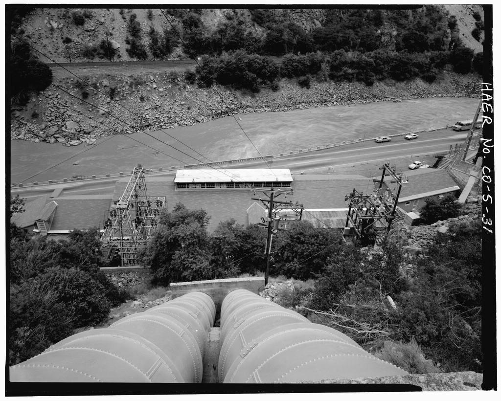
This historical photo shows the penstocks of the Shoshone power plant above the Colorado River. A coalition led by the Colorado River District is seeking to purchase the water rights associated with the plant. Credit: Library of Congress photo

Click the link to read the article on the Colorado Public Radio website (Tom Hesse). Here’s an excerpt:

March 16, 2025

Western Slope water leaders hope bipartisan support can thaw $40 million in frozen federal money aimed at securing some of the Colorado River’s oldest water rights. The Colorado River District is spearheading an effort to purchase senior rights from Xcel Energy used at the Shoshone hydroelectric plant in Glenwood Canyon. The water allocated by the rights passes through the facility and back into the river, making them “nonconsumptive” rights, but by purchasing them for $99 million Western Slope leaders hope to ensure that water can continue to flow downstream and avoid the possibility it could be rerouted to Front Range users. The effort to buy the rights raised more than $50 million between the state of Colorado, the River District and more than two dozen entities on the Western Slope. In January, the federal government announced $40 million worth of support to the project. Just days later, the Trump administration took over, and that money was put on hold. 

“I think that has been frozen,” Republican Congressman Jeff Hurd, who represents Colorado’s 3rd Congressional District, said in response to a question about the grant during a tele-town hall event on March 11. “Just know that we are working hard behind the scenes to see what we can do to make sure that that funding is allocated and completed.”

Andy Mueller, general manager for the Colorado River District, said the group anticipated delays in the funding from the start on account of the changing administrations. But, because the group has been working on pooling the money in advance, they’re not being left high-and-dry by the funding freeze just yet. 

“We’re one of the fortunate grantees, if you will, in that situation. I know there are a lot of grantees who were actually engaged in digging dirt and had hired staff in anticipation of grants,” Mueller said. He noted the deal is still pending a water court change case, giving the Shoshone purchase deal extra runway to haggle over the federal contribution.

Grant boosts the Ruth Powell Hutchins Water Center’s education, outreach efforts — The #GrandJunction Daily Sentinel

Ruth Powell Hutchins. Photo credit: Colorado Mesa University

Click the link to read the article on the Grand Junction Daily Sentinel website (Dennis Webb). Here’s an excerpt:

March 14, 2025

A $110,000 state grant is enabling Colorado Mesa University’s Ruth Powell Hutchins Water Center to expand its education and outreach program, including through a spring speaker series co-organized with CMU’s Environmental Science program. The center received the money from the Colorado Water Conservation Board last fall for two years of programs. According to a news release, Freddy Witarsa, the program’s interim director, will use the funds to facilitate programs to prepare students to join the water workforce and provide a platform for Western Colorado stakeholders to address the region’s water challenges…The water center facilitates research, education, outreach and dialogue to address the water issues in the region. The center has been led in recent years by interim directors. Witarsa also is an assistant professor of environmental science and technology at CMU. In January, the Colorado River District awarded the center $300,000 to support its efforts to grow over the next three years, including by hiring an executive director. That grant is being matched by a $300,000 grant from CMU.