#Drought news January 8, 2026: Moderate and severe drought expanded across southeast #Wyoming, western #Nebraska, northeast #Colorado, and southeast #Colorado.

Click on a thumbnail graphic to view a gallery of drought data from the US Drought Monitor website.

Click the link to go to the US Drought Monitor website. Here’s an excerpt:

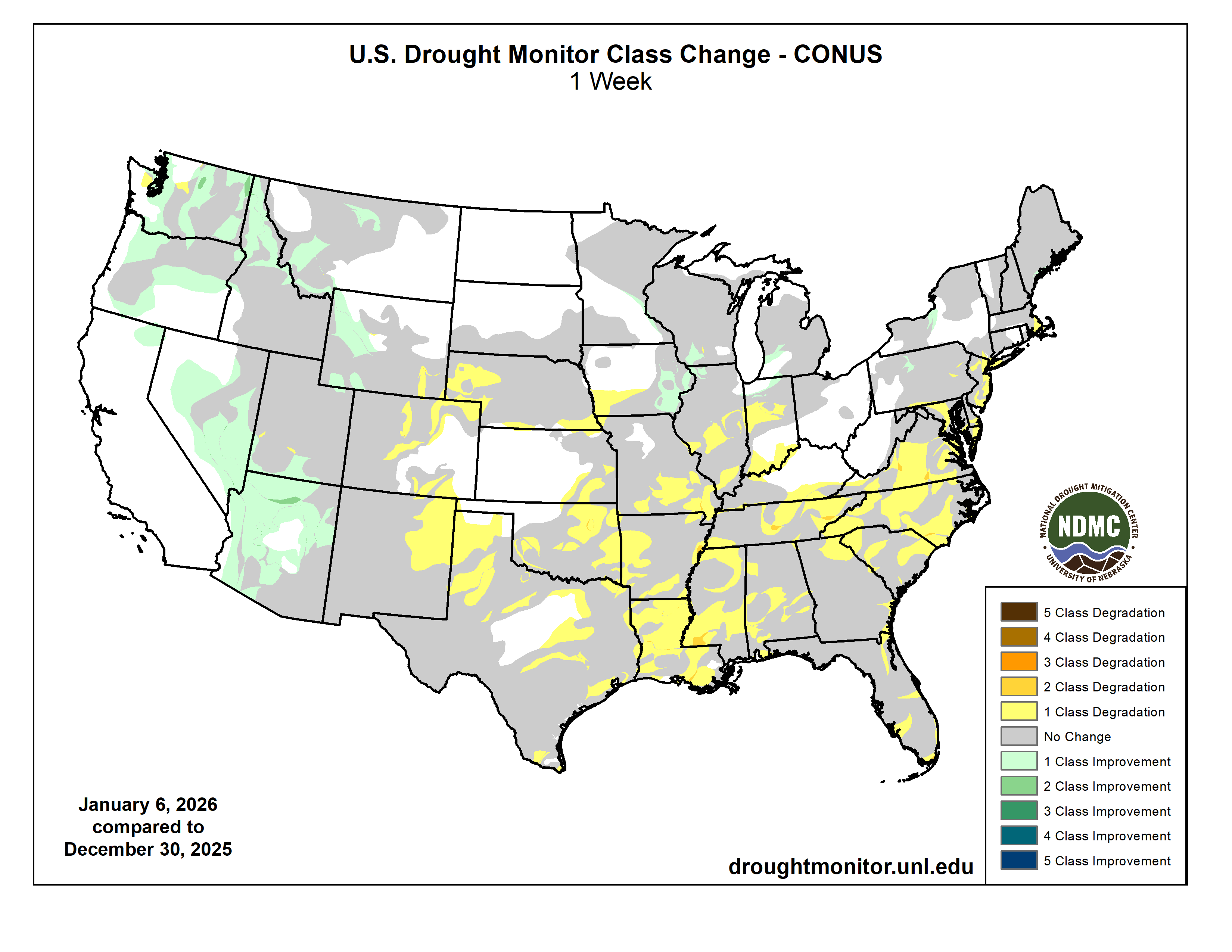
This Week’s Drought Summary

The past week featured above-normal temperatures across much of the western half of the U.S. Areas west of the Mississippi River generally experienced near- to above-normal temperatures, with portions of the northern Rocky Mountains running 15–20°F above normal for the week. These warm conditions favored rain over snow, which is critical for winter water supply in the West, and many locations continue to experience a slow start to the snow season.

In contrast, cooler-than-normal temperatures dominated the Florida Peninsula, with departures of 5–10°F below normal across southern Florida. Below-normal temperatures were also widespread from the Upper Midwest into the Northeast and Mid-Atlantic, where departures of 5°F or more below normal were common. Parts of New England were particularly cold, with temperatures 10–15°F below normal.

Outside of the West, above-normal precipitation was limited to pockets of the Southeast, Florida, and the Upper Midwest. Much of the West recorded more than 100% of normal precipitation for the week, with large portions of California receiving over 200% of normal…

High Plains

Warmer-than-normal temperatures dominated the region, with departures exceeding 15°F above normal across parts of western Nebraska, western Kansas, northeast Colorado, Wyoming, and southeast Montana. Precipitation was minimal, with the greatest totals confined to northeastern North Dakota.

The continued warm and dry winter has resulted in some areas experiencing their driest start to winter on record. Abnormally dry conditions expanded across southern Nebraska and northeast Kansas, as well as southeast Kansas, where moderate drought also increased. Moderate and severe drought expanded across southeast Wyoming, western Nebraska, northeast Colorado, and southeast Colorado…

Colorado Drought Monitor one week change map ending January 6, 2026.

West

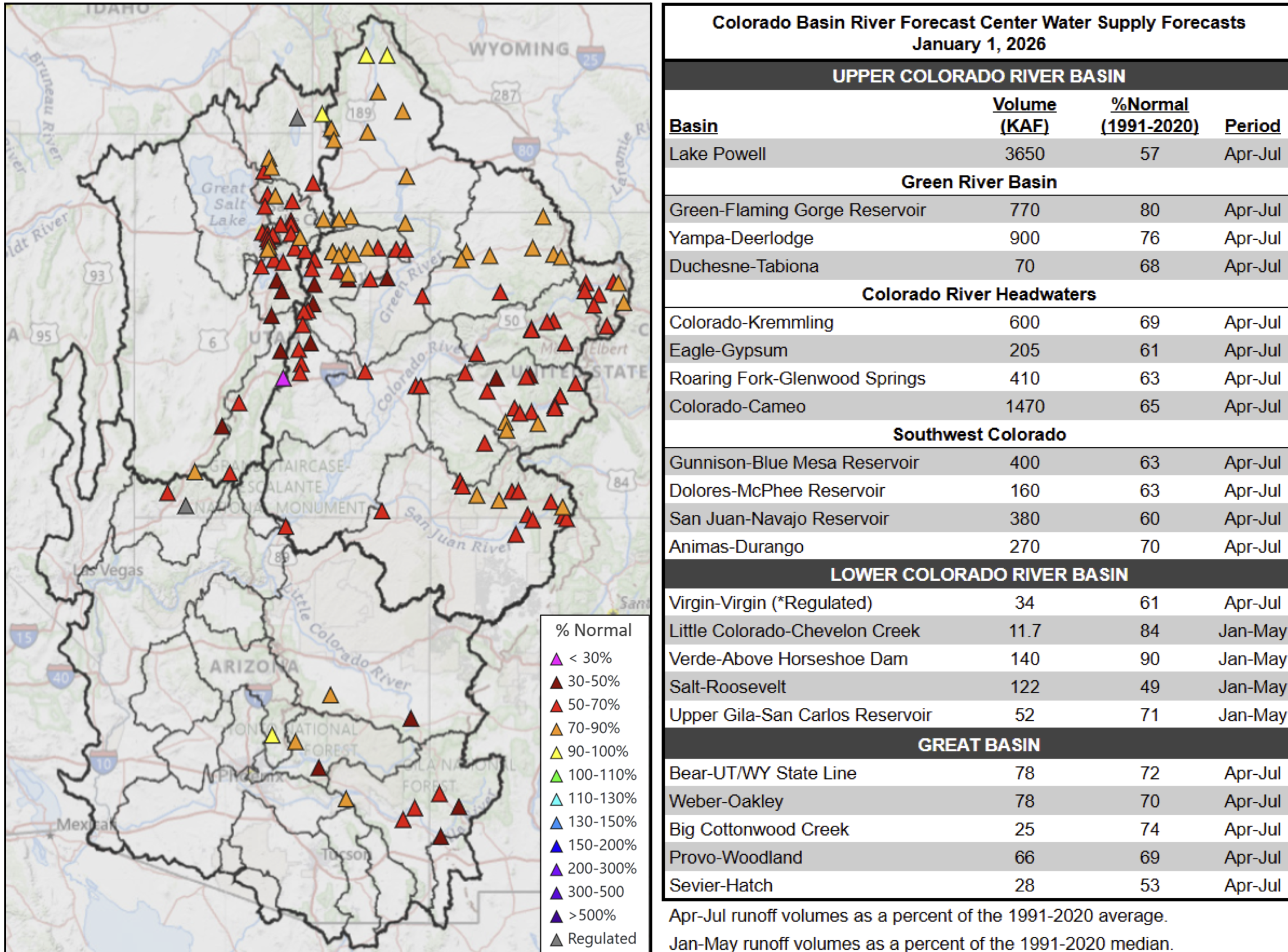
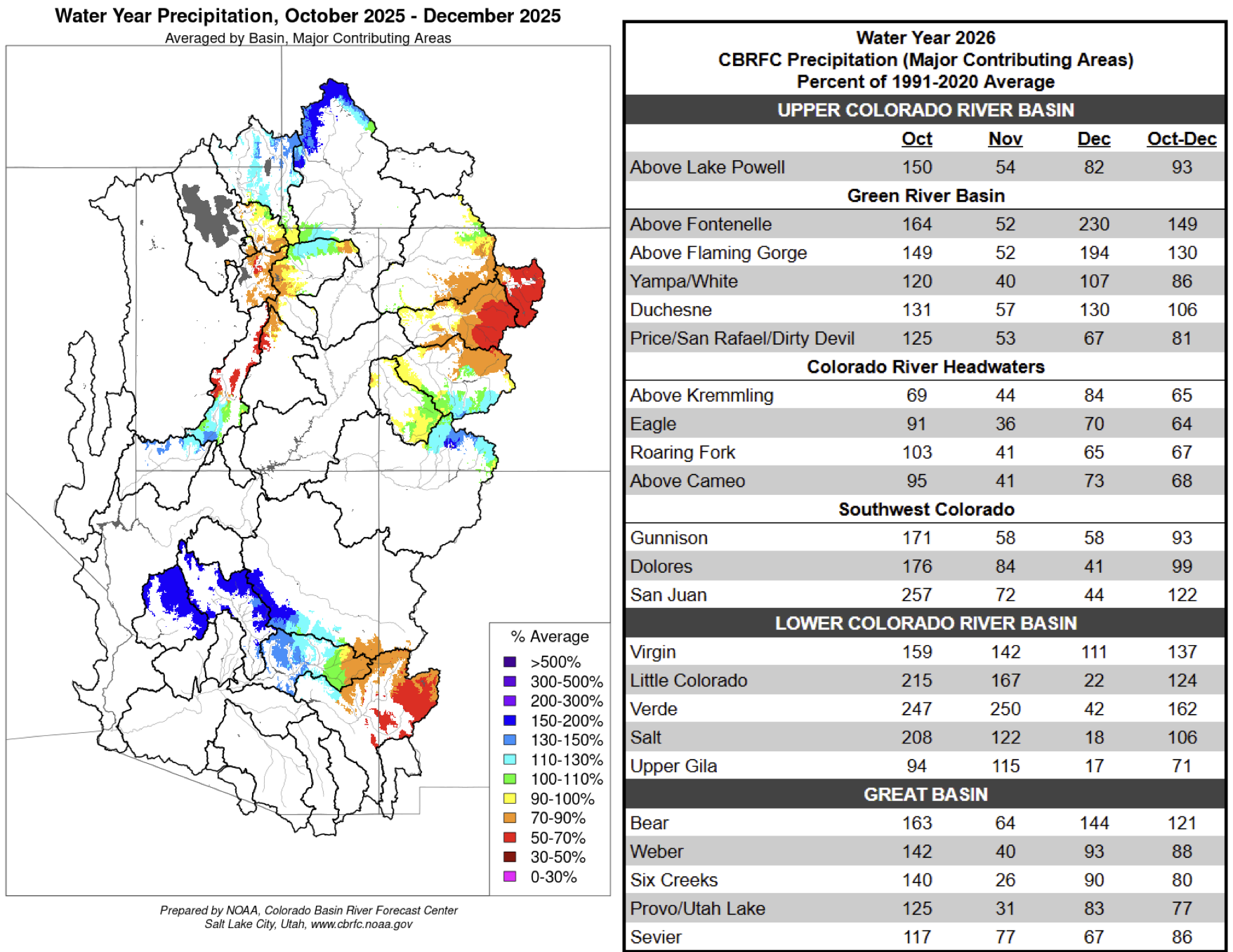
The largest positive temperature departures occurred in the West, with areas from central Montana into western Wyoming and northwest Colorado experiencing temperatures more than 15°F above normal. These warm conditions pushed snow to higher elevations and increased rainfall at lower elevations. While many areas received above-normal precipitation, snowpack remains critically low, and significant snow drought persists across numerous mountain ranges, including the Cascades, Oregon’s Blue Mountains, Idaho’s Bitterroot Range, and the central Rocky Mountains of Colorado.

It was a wet week for much of the region, with nearly all of California recording above-normal precipitation, along with much of Nevada and western Arizona. Above-normal precipitation also occurred across eastern Washington and Oregon, Idaho, western Utah, and Montana. Severe and extreme drought improved across northern Montana, with additional improvement to moderate drought in the southwest part of the state.

Continued wet conditions led to improvements in moderate and severe drought across Nevada, Arizona, eastern Oregon and Washington, and the Idaho Panhandle. Abnormally dry conditions expanded across northeast New Mexico, while extreme and exceptional drought expanded across central Colorado. Extreme drought was removed from southwest Wyoming, and moderate drought improved across western Wyoming. In Washington, abnormally dry conditions were adjusted to reflect recent precipitation while also accounting for persistent snow drought in the Cascades…

South

Nearly the entire region was dry, with only isolated precipitation observed in Mississippi and southwest Tennessee. Temperatures were above normal across most areas, with portions of the Texas and Oklahoma panhandles running more than 12°F above normal.

Drought conditions deteriorated across every state in the region. Moderate drought expanded across northern and southern Mississippi. Central and eastern Tennessee saw expansion of moderate and severe drought, while moderate drought increased in western Tennessee. Moderate and severe drought expanded across much of Louisiana and southern and western Arkansas. Severe drought expanded in northeast and northwest Arkansas and into northeast Oklahoma. Severe and extreme drought spread from southwest into central Oklahoma, while moderate drought continued to fill in across eastern Oklahoma.

Across Texas, moderate drought and abnormally dry conditions expanded over much of the Panhandle, while moderate and severe drought grew across east Texas and coastal southeast Texas. Drought conditions continued to intensify in far south Texas…

Looking Ahead

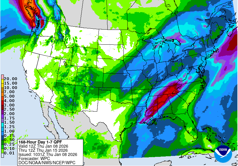
Over the next five to seven days, the pattern over the continental U.S. appears to be active with many areas showing a strong probability of precipitation. Areas from the Central Plains into the Midwest and Great Lakes areas are anticipated to receive up to an inch of precipitation. Further south, areas from Louisiana northeast into Kentucky are expected to receive the greatest amount of precipitation with several inches expected. From the Pacific Northwest into the Rocky Mountains and Southwest, widespread precipitation is anticipated. The driest areas are expected to be over the northern Great Plains, California, central and southern Texas and from the Carolinas into the Florida peninsula. Temperatures are expected to remain warmer than normal over much of the country. Only the areas along the southern tier of the U.S. will be near to below normal. The warmest departures are expected over the central to northern Plains, with some areas of Montana predicted to be 10-15 °F above normal.

The 6-10 day outlooks show that the likelihood of above-normal temperatures is projected over almost the entire U.S., with the exception of the Southeast and south Texas. The greatest chances of above-normal temperatures are over the West Coast, as well as the northern Plains and northern Rocky Mountains. The best chances of below-normal precipitation are over the Western U.S. and into the southern Plains. Above-normal chances of above-normal precipitation are anticipated over the central to northern Plains, Florida and along the coast of the Carolinas, as well as Alaska and Hawaii.

US Drought Monitor one week change map ending January 6, 2026.

#Colorado Basin River Forecast Center Water Supply Discussion January 1, 2026

Click the link to read the discussion on the CBRFC website:

The Colorado Basin River Forecast Center (CBRFC) geographic forecast area includes the Upper Colorado River Basin (UCRB), Lower Colorado River Basin (LCRB), and Eastern Great Basin (GB).

Water Supply Forecasts

January 1 water supply forecasts are generally well below normal and summarized in the figure and table below. Snowpack and soil moisture are the primary hydrologic conditions that impact the water supply outlook, while future weather is the primary source of forecast uncertainty.

January 1, 2026 seasonal water supply forecast summary.

Water Year Weather

The 2025–26 winter season has thus far featured record-setting warmth and limited precipitation, driven

by a persistent high-pressure ridge over the CBRFC area. Most of the major climate sites in and around the CBRFC area experienced their warmest (e.g. Salt Lake City, Phoenix, Tucson, Las Vegas, Pocatello) — or second warmest (e.g. Flagstaff, Grand Junction, Denver) — December on record. An active northern stream riding over the ridge has delivered above average precipitation to the northern fringes of the UCRB and GB, but given the warm maritime influence, snow accumulation has remained unimpressive.

The water year as a whole tells a different story. In October, several rounds of heavy rain tied to decaying tropical storms brought record flooding to portions of AZ, southern UT, and southwest CO — making it one of the wettest Octobers on record. November brought continued above average precipitation to the LCRB, but well below average precipitation was observed elsewhere. Water year 2026 precipitation is summarized in the figure and table below.

Water year 2026 precipitation summary.

Snowpack Conditions

UCRB January 1 snow water equivalent (SWE) conditions are highly variable and range between 35–100% of normal. Storm systems this winter have been warmer than normal with high snow levels resulting in much of the precipitation falling as rain rather than snow. SWE conditions are very poor across most of the UCRB, with numerous SNOTEL stations across western CO reporting January 1 SWE values at or near record low. The exception is the Upper Green headwaters, where SWE is near to above normal. UCRB January 1 snow covered area is around 28% of the 2001–2025 median, which is the lowest on record dating back to 2001. 1Ā LCRB January 1 SWE conditions are at or near record low across much of southwest UT, central AZ, and west-central NM.

GB January 1 SWE conditions are also very poor, ranging between 25–65% of normal. SWE at the majority of SNOTEL stations across UT are below the 10thĀ percentile, with several stations reporting record low January 1 SWE. January 1 snow covered area across UT is record low at just 15% of the 2001-2025 median.1Ā SWE conditions are summarized in the figure and table below.

Left: January 1, 2026 SWE – NRCS SNOTEL observed (squares) and CBRFC hydrologic model.
Right: CBRFC hydrologic model SWE condition summary.

Soil Moisture

CBRFC hydrologic model fall (antecedent) soil moisture conditions impact water supply forecasts and the efficiency of spring runoff. Basins with above average soil moisture conditions can be expected to experience more efficient runoff from rainfall or snowmelt while basins with below average soil moisture conditions can be expected to have lower runoff efficiency until soil moisture deficits are fulfilled. The timing and magnitude of spring runoff is impacted by snowpack conditions, spring weather, and soil moisture conditions.

Soil moisture conditions heading into the 2026 spring runoff season are below normal across most areas as a result of warmer and drier than normal weather during the 2025 water year. Water year 2025 precipitation was around 80% of average across the UCRB and GB and around 60% of average across the LCRB. The least favorable soil moisture conditions exist across central UT and the Colorado River headwaters. Soil moisture conditions across southwest CO and central AZ are exceptions, where very wet October–November weather led to improved soil moisture that is near or above average. CBRFC hydrologic model soil moisture conditions are shown in the figures below.

November 2025 CBRFC hydrologic model soil moisture conditions –
as a percent of the 1991–2020 average (left) and compared to November 2024 (right).

Upcoming Weather

After a cold and somewhat snowy system sweeps through the CBRFC area this week, high pressure looks to dominate the region for the foreseeable future, which will suppress any chances for significant precipitation. The 7-day precipitation forecast and the Climate Prediction Center (CPC) 8–14 day temperature and precipitation outlooks are shown in the figures below.

7-day precipitation forecast for January 7–13, 2026.
Climate Prediction Center precipitation probability forecast for January 15–21, 2026.
Climate Prediction Center temperature probability forecast for January 15–21, 2026.

References

1. Rittger, K., Lenard, S.J.P., Palomaki, R.T., Stephenson, L. (2026). Snow Today. Boulder, Colorado USA. National Snow and Ice Data Center. Data source: MODIS/Terra/SPIRES.

#Colorado adopts new rules to limit landfill methane emissions: State’s 59 landfills contribute more than 1% of its overall greenhouse gas emission — Chase Woodruff (ColoradoNewsline.com)

The Lowry Landfill superfund site east of Aurora in Arapahoe County is pictured on May 16, 2024. (Chase Woodruff/Colorado Newsline)

Click the link to read the article on the Colorado Newsline website (Chase Woodruff):

December 18, 2025

Colorado air quality regulators on Thursday adopted new rules aimed at limiting emissions of methane, a potent greenhouse gas, from the state’s landfills.

Members of the Air Quality Control Commission voted 6-0 to approve the new rules, concluding a yearlong rulemaking process that resulted in a compromise plan agreed to by environmental groups and public and private landfill operators.

Food waste and other organic material dumped in landfills produces methane and other pollutants as it decomposes. Colorado’s 59 landfills emit a combined 1.3 million tons ofĀ carbon-dioxide-equivalent emissions every year, a little over 1% of the state’s overall greenhouse gas emissions.

ā€œToday’s decision is a meaningful victory for the health of Colorado communities,ā€ Nikita Habermehl, a pediatrician and advocate with Healthy Air & Water Colorado, said in a statement. ā€œMethane is a powerful climate pollutant that also worsens the air quality issues driving asthma, respiratory illness, and other preventable health harms — especially for children and those living closest to landfills.ā€

The new rules approved Thursday will require landfill operators to take a variety of steps to limit their emissions, including increased monitoring for leaks and requirements on the amount and types of soil that can be used as landfill cover.

Under Environmental Protection Agency rules, 12 of Colorado’s largest landfills are required to maintain gas collection and control systems, which can capture the waste methane, or combust it in a flare system to convert it to carbon dioxide, a less potent greenhouse gas. The AQCC’s rule would extend those requirements to approximately 16 additional mid-sized landfills, though the state’s smallest operators would still be exempt. It also requires open flares to be phased out and replaced by more efficient enclosed alternatives by 2029.

ā€œThe rule approved by the commission is an important step forward on landfill emissions in Colorado,ā€ said Alexandra Schluntz, an attorney with environmental group Earthjustice. ā€œWhile this does not do everything we hoped to see, it will make a real difference for the health of surrounding communities.ā€

After the AQCC held a formal rulemaking hearing on the proposal in August, staff from the state’s Air Pollution Control Division last month submitted a series of revisions to the rule, weakening it at the request of waste industry groups and local governments that operate public landfills.

Prior to the vote, AQCC commissioner Jon Slutsky said the revised rule didn’t go far enough to meet the state’s greenhouse gas reduction goals, objecting to an increase in the emissions threshold that triggers monitoring requirements and corrective action, which he called the ā€œheart of the regulation.ā€ Slutsky moved to strike the revisions from the rule, but his fellow commissioners declined to discuss or second his motion.

ā€œIt’s always good to have a consensus,ā€ said commissioner Martha Rudolph. ā€œNot everybody likes what happens in a consensus, but I personally believe that the perfect should not be the enemy of the good.ā€