The city of Aurora, in collaboration with American Civil Constructors, will start work Jan. 30 on a multi-use trail to close the gap along the High Line Canal between Colfax Avenue and recent improvements constructed north of I-70.
The High Line Canal Trail construction project, which spans nearly two miles, will include:
A continuous 8-foot-wide concrete trail
Two pedestrian bridges (one to cross over the canal just south of Smith Road and one over I-70 just east of the Tower Road interchange)
An upgraded railroad crossing to promote pedestrian and cyclist safety
Access to the 71-mile High Line Canal Regional Trail within the metro area
Designed with community input, the new trail will provide close-to-home, accessible recreation opportunities within the community and serve a diverse population that may otherwise have limited opportunities to access natural areas. View additional details regarding the community input process, project files and more at EngageAurora.org/HLCT.
The city has been granted federal funds through the Denver Regional Council of Governments to help pay for the trail construction with city capital improvement funding used as a match amount. Additional funding partners consist of the Conservation Trust Fund, Adams County Open Space Grant, and the Adams County Open Space Tax Shareback.
Construction Updates
American Civil Constructors will begin work on the project’s south end and between East Colfax and East 19th avenues on the east side of Tower Road and along the canal.
Vehicular and pedestrian travelers can expect intermittent delays in these areas for the first two months. Alternate routes are recommended when possible.
The contractor also plans to start working on the bridge abutment just south of I-70 when the project kicks off.
Traffic impacts will be posted on this page as the project progresses.
Old cottonwoods line the banks and trails of the historic Highline Canal, which is being converted into an ultra modern stormwater system even as its trail systems continue to serve metro area residents. July 21, 2020 Credit: Jerd Smith via Water Education Colorado
Click the link to read the article on the NOAA website:
A series of nine atmospheric rivers starting in late December 2022 through mid-January 2023 dropped feet of rain and snow across California and other parts of the West Coast, according to a special drought update from Drought.gov. The tremendous amounts of precipitation caused major transportation issues, as well as landslides and flooding, but it also led to drought improvements across a large chunk of the western United States.
Percent of normal U.S. precipitation over the past 30 days (December 25, 2022, through January 23, 2023) after a series of weather events known as atmospheric rivers, fueled by tropical moisture, flooded the U.S. West with rain and snow. Places where precipitation was less than 100 percent of the 1991-2020 average are brown; places where precipitation was 300 percent or more than average are blue-green. NOAA Climate.gov image, based on analysis and data provided by the Climate Mapper website.
In just three weeks, 80 percent of the average seasonal snowpack fell in California, with 11.2 inches of precipitation being observed on average for the entire state. Said another way, almost half (46%) of the average statewide water-year precipitation fell in just three weeks.
No landscape can handle this much precipitation in so short a time period. Flooding, mudslides, debris flows and dangerous travel conditions were the norm for California at the start of 2023. But in positive news, the heavy rains and snows increased soil moisture and snowpack, and filled many reservoirs that were quite below-average heading into this year.
This moisture resulted in widespread improvement in drought conditions out West, especially in California. But the drought isn’t over in many places, where long-term impacts to groundwater, reservoirs, and ecosystems persist despite the recent downpours. According to the Drought.gov, 92 percent of California was still in some level of drought based on data through January 17. (The next update will be tomorrow, January 26). Long-term drought also still persists in areas like the Colorado River Basin.
The Bureau of Land Management and a nonprofit entity have teamed up once again on an acquisition by the federal agency of land along the lower Gunnison River, this time involving a 26.32-acre parcel in Mesa County. The BLM’s Grand Junction Field Office partnered with the Western Rivers Conservancy on the acquisition of the Meridian Junction property, on the east side of the river just north of the Mesa/Delta county line. The acquisition furthers partnership efforts to conserve and protect resources for future generations, the agency said in a news release. The land is within the Dominguez-Escalante National Conservation Area, and was bought with money from the federal Land and Water Conservation Fund.
The Salton Sea spreads across a remote valley in California’s lower Colorado Desert, 40 miles (65 kilometers) from the Mexican border. For birds migrating along the Pacific coast, it’s an avian Grand Central Station. In midwinter tens of thousands of snow geese, ducks, pelicans, gulls and other species forage on and around the lake. Hundreds of other species nest there year-round or use it as a rest stop during spring and fall migration.
At the dawn of the 20th century, this massive oasis didn’t even exist. It was created in 1905 when Colorado River floodwaters breached an irrigation canal under construction in Southern California and flowed into a basin that had flooded in the past. In earlier years, the sea covered roughly 40 square miles more than its current size of 343 square miles (890 square kilometers).
Now, however, this resource is in trouble. Wasteful irrigation practices that maintained the sea have been reduced, and excess water is now being transferred to thirsty coastal cities instead. The sea’s volume has declined to roughly 4.6 million acre-feet, losing nearly 3 million acre-feet since the mid-2000s. (An acre-foot is about 326,000 gallons – the amount of water required to cover an acre of land to a depth of one foot).
In November 2022, the federal government pledged US$250 million for environmental restoration and dust suppression at the Salton Sea. It’s a historic contribution, but experts agree that other critical steps are needed.
We just completed more than a year of service to the California Salton Sea Management Program’s Independent Review Panel, which was charged with evaluating proposals to import water to the sea. In our view, the panel’s recommendations represent the best path forward. They also reflect the complexity of managing water in the increasingly dry U.S. Southwest, where other water bodies, such as Utah’s Great Salt Lake, share the same general challenges of net water loss.
An ecosystem on the brink
There’s no question that the Salton Sea desperately needs a fix. Rising salinity threatens worms, crustaceans and other organisms that make up the base of the sea’s food web and has killed off many of its fish species. Without intervention, the sea’s entire ecosystem could collapse.
Without government intervention, the sea would reach a lower equilibrium size by 2045 that matches smaller inflows with evaporation losses. Even greater areas of playa would be exposed, potentially generating even more airborne dust. https://www.youtube.com/embed/KOcB0A3K_bw?wmode=transparent&start=13 Land managers and local residents explain how the Salton Sea’s decline is affecting people and wildlife.
These schemes called for building immense desalination plants along the Sea of Cortez, up to 10 times bigger than California’s Claude “Bud” Lewis plant in Carlsbad – the largest such facility in the United States.
The proposals could not overcome three significant problems. First, they were projected to cost many tens of billions of dollars and take more than 20 years to complete. Second, they threatened to inflict nasty environmental consequences on the Sea of Cortez, dumping huge quantities of brine into sensitive and protected marine ecosystems and turning pristine beaches into industrial zones. Third, Mexico would derive little benefit from building a huge desalination plant in a remote area, other than some jobs from building and running the plant. https://cdn.knightlab.com/libs/juxtapose/latest/embed/index.html?uid=1c70a2bc-9035-11ed-b5bd-6595d9b17862 These satellite photos show how the Salton Sea shrank between 1984 and 2015, exposing dry playa around its edges (move slider to compare years).
Focus on salinity, not size
Ultimately, the panel concluded that expanding the Salton Sea to its former size was less important than controlling its salinity. The panel made four recommendations that center on building a desalination plant at the Salton Sea to the treat water that’s already there.
This plant would remove 200 million gallons of high-salinity water daily from the Salton Sea and produce 100 million gallons per day of desalinated water, which would be returned to the Salton Sea. In short order, this exchange would begin to significantly lower its overall salinity.
A desalination plant using reverse osmosis generates a brine stream equal to approximately half the volume of the treated seawater. Accordingly, the panel called for California to negotiate a voluntary paid transfer program in which the state would pay farmers to transfer enough water to the Salton Sea to replace the volume of brine removed at the desalination plant. The net effect would keep the sea from becoming even smaller and hasten the process of lowering salinity.
The desalination plant would generate an immense quantity of salt, which would require careful disposal. The panel recommended drying out the brine in evaporation ponds and transferring dried salts from the ponds to landfills or industrial uses.
Finally, the panel called for California to step up support for an aggressive program to stabilize the exposed playa. Techniques could include planting vegetation on the playa and plowing long rows of furrows to reduce dust mobilization during wind storms. The estimated total cost for this plan is $63 billion, compared with $95 billion-$148 billion for various proposals to desalinate and import water from the Sea of Cortez.
Since 2020, the state has conducted pilot projects to reduce dust blowing off the playa, with promising early results. The federal government’s $250 million pledge will enable this work to move more quickly.
Stabilizing the playa is essential to address significant public health concerns associated with windborne dust, although more must be done regionally to fully address air quality problems.
Looking forward, not backward
This approach will not satisfy critics who want to restore the Salton Sea to its maximum volume. These advocates recall the mid-20th century when the sea was a tourism draw and would like to reconnect the few small towns that once bordered the sea, which are now separated by extensive playa. Expanding the sea to its original size also would address concerns about playa-sourced air pollution.
In our view, however, the panel’s recommendations offer a genuine opportunity to solve the main problems: blowing dust and increasing salinity. This solution is more likely to actually be implemented than an enormous binational desalination project. It would happen more quickly, at about half the cost of the binational importation options.
We believe that the sooner California officials accept the reality of a smaller Salton Sea, the sooner the state can move ahead, focusing on air quality improvement and ecological restoration.
Sources/Usage: Public Domain. Visit Media to see details.
Animation showing AR plumes over the Pacific during January 2012.
Click the link to read the article on the NIDIS website:
A Series of Atmospheric Rivers Have Hit Parts of the West. What Does This Mean for Drought?
Key Points
Starting on December 26, 2022, a series of 9 atmospheric rivers(ARs) brought significant amounts of rain, snow, and wind to California and other parts of the western United States over a 3-week period.
80% of a full seasonal snowpack was deposited in California during these storms. Statewide, precipitation over these 3 weeks was 11.2 inches, which is 46% of a full water year.
The AR events have been a big boost to mountain snowpack across the West, where snow water equivalent (SWE) totals are well above normal for this time of year except for many parts of the Cascades and the Northern Rockies, where accumulation has slowed since the beginning of January.
Given that it is still early in the snow accumulation season, water year totals could either be moderate if the rest of the winter and spring are dry, or relatively high if precipitation continues.
According to Natural Resources Conservation Service SNOTEL, as of end of day January 22, 2023, the snow water equivalent for the California Region is 215%, the Great Basin is 206%, and the Upper and Lower Colorado River Basins are 146% and 218%, respectively.
These recent storms improved drought conditions by increasing soil moisture throughout much of the West, especially in California. The amount of water stored in many reservoirs increased, but some are still well below historical averages for this time of year.
Despite the drought improvements in many areas, long-term drought persists in parts of the West. Reservoir storage deficits, such as those within the Colorado River system, and groundwater and soil moisture deficits (especially in the Northwest) that have built up over many months to years will require additional precipitation to overcome.
Pockets of extreme (D3) and exceptional (D4) drought continue to persist in Utah, Nevada, and central and eastern Oregon.
The long sequence of ARs that made landfall in California and the amounts of precipitation that fell over this relatively short period of time caused flooding, dangerous travel conditions, and debris flows.
The NOAA Climate Prediction Center’s Seasonal Outlook shows chances of drought removal or improvement for central and northern California, Oregon, Idaho, and the northern Rockies, with drought remaining in southern California, Nevada, and Utah. The current forecasts indicate AR activity could pick up again in early February, but the storm tracks are still uncertain.
West snowpack. basin-filled map January 28, 2023 via the NRCS.
GEM is an interactive web-based decision support system that allows users to locate areas with high suitability for clean power generation and potential energy transmission corridors in the United States. Browse and download data layers, or create a custom suitability model to identify areas for energy development.
While much of the country was relaxing over the winter holidays, federal lawmakers remained busy.
Before ending its session and swearing in new members, Congress passed a fiscal year 2023 budget with key provisions for water infrastructure and disaster recovery. That’s in addition to approving legislation that authorizes Army Corps of Engineers projects for flood protection, navigation, and environmental restoration.
Combined, the two bills run to more than 8,000 pages. Water sector advocates, though confounded by how some infrastructure funds are being allocated, were generally pleased with what the bills contain.
“Anybody who cares about water should be excited about what we accomplished at the end of last year,” Mae Stevens told Circle of Blue. Stevens, who works with environmental groups and utilities, is chair of the water practice at Banner Public Affairs, a lobby group.
The Water Resources Development Act, or WRDA, is the legislation that authorizes Army Corps of Engineers projects. The bill focuses on flood protection, commercial waterways, and improving community engagement, particularly with Native American tribes and communities historically burdened by pollution.
Major projects authorized or modified in WRDA include:
$1.8 billion Upper Barataria Basin project, a 30-mile levee to protect seven southeastern Louisiana parishes from storm surges.
$34.4 billion Coastal Texas Protection and Restoration project, a massive system of levees, flood gates, dunes, and marsh restoration to safeguard the Texas Gulf Coast from hurricane storm surges.
$3.2 billion for a larger lock at Soo Locks, a pivotal transit point for Great Lakes commercial shipping.
WRDA also made it easier for the Army Corps to deploy natural features such as marshes and dunes to guard against floods. And it authorized the Army Corps to study a second drinking water source or additional water storage for Washington, D.C.
The capital’s water supply is vulnerable, said Stevens, who worked on two previous WRDA bills as part of Sen. Ben Cardin’s staff. The Potomac River — the city’s sole drinking water source — could be compromised by industrial accidents, oil spills, or other incidents. Shutting down the Potomac water intake would put the city in a serious bind.
In an action separate from WRDA, the Army Corps issued final permits for a $2.3 billion environmental restoration project to rebuild eroding land along the Louisiana coast.
The Mid-Barataria Sediment Diversion, a state project, will provide an off-ramp for sediment-laden water from the Mississippi River. Those land-building particles will be diverted during periods of high flow. Exiting the river at a point south of New Orleans, the sediment will be funneled to the Barataria Basin, where it is intended to reestablish coastal wetlands and protect inland areas from storm surges.
WRDA authorizes projects but does not fund them. Allocating money is the purpose of the appropriations bill.
That bill identified water infrastructure priorities. It allocated $140 million to rebuild water treatment facilities in New Mexico that were affected by last year’s Hermit’s Peak/Calf Canyon fire, the largest in state history.
The bill maintained the Clean Water and Drinking Water State Revolving Funds at 2022 spending levels. These low-interest loan funds are two primary sources of federal funding for water infrastructure.
Funding this year for the Clean Water SRF is $1.6 billion, while the Drinking Water SRF is $1.1 billion. Both will get several billion dollars annually over the next four years in supplemental funding from the Infrastructure Investment and Jobs Act.
Water groups, however, are upset with operational changes to the funds. Earmarks, which returned to the budget process last year, are being subtracted from the SRF totals. For water infrastructure, earmarks amounted to roughly half of the total funding for the SRFs in this budget.
The remaining SRF dollars will be distributed to the states according to a standard formula. This creates winners and losers. If your senator was especially good at lobbying for dollars, your state gets more than its usual SRF share.
For utilities in losing states, the result is a scramble for the leftovers, Stevens said. There might not be enough money in the SRFs for projects that would have been funded in the past.
“It means that every utility now really, really, really needs to go and get earmarks because they can’t count on the SRF funding in the state to be high enough,” she said.
The reservoir would be a joint project between SJWCD and the PAWSD called the San Juan River Headwaters Project. In 2008, SJWCD and PAWSD collaborated on the purchase of the property, also known as Running Iron Ranch, with the goal to even- tually build a water storage facility on the parcel of land, which is more than 600 acres. The proposed reservoir would be an “off-channel” water storage facility being fed by a pre-existing agricultural ditch, Park Ditch…
According to the district’s strategic plan, “In 2004, the District and PAWSD applied for a junior water right for a larger reservoir in Dry Gulch, a refill right, and specific filling sources and rates for it. Trout Unlimited opposed those claims, leading to protracted litigation and new standards from the Colorado Supreme Court for evaluating conditional water rights owned by municipal providers. The District, PAWSD, and Trout Unlimited eventually stipulated to a decree providing for a maximum storage capacity of 11,000 acre-feet for Dry Gulch Reservoir and other limitations on its use.”
More recently, SJWCD sought more accurate information on projections for future water needs, hiring the Lakewood-based water consultant company Wilson Water Group to conduct the analysis. The resulting study was a 24- page “analysis of current and future water supply and demand through 2050 in the Upper San Juan River basin.”
Click the link to read the article on the Audubon website (Abby Burk):
Water is our most precious natural resource and life-sustaining force for Coloradans, birds, and other wildlife. On January 9, Colorado lawmakers headed to the Capitol to start the 120-day legislative session. As a centerpiece of the session, water will connect and unite lawmakers and constituents with ripple effects for years to come.
At a critical time for water, leadership from all three legislative chambers have commented on the importance of Colorado’s water to the sustainability and vitality of our state. “(Water) is the conversation, it will be the centerpiece of our agenda this year, if for no other reason than that Colorado has to be seen as a leader in this space,” said Speaker of the House Julie McCluskie. “The conversation around water is going to be a big one,” said Senate President Steve Fenberg.
On January 17, 2023, Governor Jared Polis, in the State of the State address, remarked: “Water is life in Colorado and the west, it’s as simple as that. But we’re at a crossroads. Increased demand, chronic and extreme drought, conflicts with other states, and devastating climate events are threatening this critical life source— and we’ve all seen the impacts. Wildfires have destroyed hundreds of thousands of acres and devastated entire communities. Farmers and ranchers across the state fear that Colorado won’t have the water resources to sustain the next generation of agricultural jobs… When Colorado is 150, I want our state to have the water resources necessary for our farms, communities, and industries to thrive, and the tools in place to protect our state’s waterways and defend our rights.”
Clearly, water is a legislative priority. Big water ideas are in the wind, but proponents need to share concepts broadly. Our decisions about water influence all areas of life for people and nature. We’re doing a better job of including and valuing a diversity of input in water decisions, but we need to do more. A diversity of water stakeholders must support legislative proposals that support multiple beneficial uses.
Audubon Rockies is busy working with lawmakers, agencies, and partners to prioritize healthy, functioning, and resilient watersheds and river systems for people and birds—the natural systems that we all depend upon. There are already seven bills on our water watch list, plus several draft bills. Here are three water priority areas for Audubon in the 2023 Colorado legislative session. Please make sure you’re signed up to hear about opportunities to engage with them.
Funds provided by grants and landowners near Kremmling, Colorado, have facilitated improvements such as this back stabilization project. (Source: Paul Bruchez)
Stream Health
Colorado’s ability to thrive depends upon the health and function of our natural stream systems. Healthy, functioning stream systems provide critical habitat to most of Colorado’s wildlife; improve wildfire resilience, drought mitigation, flood safety, water quality, forest health, riparian and aquatic habitat; and provide many other ecological benefits that are beneficial to all Coloradans.
Stream restoration practices have been successfully implemented across Colorado for more than 30 years by federal, state, and local agencies, conservation organizations, water providers, and private landowners. The projects are usually designed to address the environmental, public safety, infrastructure, and economic impacts of degraded river corridor conditions. However, recently there has been increased uncertainty about stream restoration practices in regards to water rights issues. Project proponents need a clear path to initiating and completing a stream restoration project.
Colorado Department of Natural Resources (DNR) is on track to introduce proposed 2023 legislation to provide clarity and certainty on where stream restoration projects may take place based on the historical footprint (the presence of a stream and its riparian corridor’s location before disturbance occurred) without being subject to water rights administration. Without a legislative solution, Colorado could miss out on the critical benefits of healthy functioning river corridors and the significant funding currently available for watershed restoration work through the federal Infrastructure Investment and Jobs Act and Inflation Reduction Act.
This stream restoration legislation is a top priority for Audubon. We have partnered with DNR to host a water legislator webinar series on this bill.
Join me on February 2, 8-8:45 AM for a bill orientation webinar with DNR leadership, bill sponsors, and leading experts. Register here.
Climate stripes through 2022. Credit: Ed Hawkins
Climate Resiliency
Despite near-term optimism from a snowy December and January, climate change and unprecedented drought conditions in recent years are threatening Colorado’s ability to satisfy water users, environmental needs, and potentially interstate obligations. We need more flexible ways to manage and deliver water to support the Colorado we love. The Colorado River Basin has been in an extended drought going on 24 years. There are real consequences for people, birds, and every other living thing that depends on rivers in this region. Colorado needs tools and resources to proactively respond to drought conditions and maximize the benefits to the state, its water users, and river systems from once-in-a-generation competitive federal funds that have recently been made available to address the Colorado River Basin drought. Audubon will be watching this session for legislation to support that will provide new innovative solutions to the water threats we face.
Water Funding & Projects
Governor Polis’ proposed budget request includes a historic $25.2 million to advance the state’s Water Plan implementation and expansion of staff and funding to capture competitive federal funds. These much-needed proposals should be well-received by lawmakers, given that water security, drought, and fire are on everyone’s mind for this legislative session. We must ensure that these funds are invested wisely in water projects and water resources management strategies. The strategies must be equitable and fair for vulnerable communities and improve the health of Colorado’s watersheds for people and nature. Funding and water projects that support our river ecosystems are intrinsically related to our public health, economy, and the Coloradan ways of life.
The first novel item on the [Carbondale Board of Trustees] agenda was a proposal from the Ruedi Water and Power Authority (RWAPA) for regional baseline watering standards. The proposition was developed through a grant from the WaterNow Alliance and stakeholder meetings with water suppliers in the Valley. RWAPA Executive Director April Long joined via Zoom to explain that the desire for comprehensive and regional education is complicated by disparate restrictions between jurisdictions in the watershed. “The entire point of baseline watering standards is just to give us initial footing … for an education and outreach campaign,” she stated.
An extensive memo provided by Public Works Director Kevin Schorzman explained that the town code currently recognizes few scenarios for restrictions: a water shortage or a water crisis. Conservation restrictions may be enacted during periods of peak demand, from May 15 to Oct. 15.
The proposed Valley-wide standards would make permanent no watering between 9 a.m. and 6 p.m. year-round, with odd addresses and even addresses alternating days and no watering on Mondays — with some exceptions.
Crystal River rancher Bill Fales stands at the headgate for the Helms Ditch, with Mount Sopris in the background. As part of an agreement with the Colorado Water Trust, Fales could be paid to reduce his diversions from the ditch when the river is low. CREDIT: HEATHER SACKETT/ASPEN JOURNALISM
Schorzman’s memo also explained that Carbondale’s system is unique, with treated water as well as an extensive ditch system supplying raw water for irrigation. The memo noted that Carbondale’s indoor water use per capita has trended downward in recent years and approximately 58% of “consumed” domestic water returns to the river as wastewater return flows. Long stated that ditch water should follow the same standards as treated water.
It is too early to draw definitive conclusions in terms of the Gunnison Basin’s water situation even given the consistent snowstorms we have experienced recently. But it is currently in a good spot. While the Gunnison Basin is recording snowpack that is significantly above average and is about even with where were last year at this time even after a 99-inch snowstorm barreled through the area in late 2021 and early 2022, it takes more than good December and January snow to ultimately fill the reservoirs.
“It’s too soon to say what our water year might look like,” cautioned Upper Gunnison River Water Conservation District (UGRWCD) general manager Sonja Chavez. “As we saw last year, we had a great snowpack through January and then it stopped snowing. We didn’t see any significant storm events the rest of the winter season. Then, wind and dust on the snowpack was a problem, and our snowpack disappeared before our eyes.”
According to UGRWCD water resource specialist Beverly Richards, last week the area in general was recording 140% above average snowpack and that has dropped a bit this week to 133%. The water content is at 129% of average, which is a good sign…
Billy Barr photo via Sotheby’s
“This winter is doing quite well especially after a very weak start,” he reported. “The snowpack is well above average, though the past week’s snow was much lighter in water than everything earlier. That means it is still settling and catching down to the average. But this is a good winter, if not anything overly special. Last year’s end of December storm was big, but that was pretty much the winter while this year has been steady, which is more like it tended to be in the past.”
Weeks of back-to-back storms in Southwestern Colorado have not lifted the area out of drought.
There’s still bright news, though: Those storms have beefed up the snow-water equivalent in the Gunnison River Basin to 142% of average for this time of year, as of Jan. 25. According to U.S. Bureau of Reclamation data, actual snow accumulation was only 67% of average in November of last year, but was 115% of average come December. Hydrologists didn’t celebrate — the previous December had been comparable, but January 2022 dried out considerably. This January, things are different.
“We are doing pretty well for snow so far,” said Bureau of Reclamation hydrologist Erik Knight. “That’s a good situation. … We were about 200% of average for the first two weeks.”
The first weeks’ snowfall this year is above what has been recorded for the entire month of January most years, he said…That was especially true at Snotel measurement sites near Butte and Schofield, where the snow-water equivalent came in at 4.9 inches and 9.7 inches, respectively, for January. The average, to-date SWE at those sites is 1.8 inches and 3.8 inches, while the average January total is 2.9 inches and 6.7 inches…
West snowpack basin-filled map January 27, 2023 via the NRCS.
Snow-water equivalent is above average in basins across the West, according to Saffell’s data. “We’re happy to see that. We’re hopeful it maintains. Do understand that this can change,” she said. Soil moisture percentages are a “good sign” that conditions will allow for efficient runoff as peak runoff time nears. Colorado’s peak melting time is usually in April – May. “We’re happy to see these kinds of things, allowing us to hold onto that water,” Saffell said.
Water users are urgently trying to keep Lake Powell on the Utah-Arizona border from dropping to a point where Glen Canyon Dam can no longer generate electricity. (Source: Bureau of Reclamation)
Another deadline to establish new cutbacks in water use in the seven-state Colorado River Basin is quickly approaching on January 31, 2023, as states continue their talks, as ordered by the U.S. Bureau of Reclamation.
In addition to the cutbacks, several other key decisions also lie ahead in the coming weeks, including how a $125 million, broad-based water conservation pilot program would operate, whether a permanent water conservation program known as demand management could work among the Upper Basin states, and how the third-year of an emergency drought plan, known as the Drought Response Operations Agreement, will function this spring and summer.
All are tied to reducing short-term and long-term demands on the drought-strapped river as part of a five-point plan put forward by the Upper Basin states last summer. In releasing that plan, the Upper Basin recognized its effectiveness would hinge on additional actions to reduce use in the Lower Basin.
The U.S. Bureau of Reclamation late last year had given the seven basin states until Jan. 31 to come up with a new agreement on water reductions, after an August deadline had passed.
Becky Mitchell, director of the Colorado Water Conservation Board who also represents Colorado on the Upper Colorado River Commission, said talks were continuing but that more work and specific plans from California, Arizona and Nevada would be necessary to reach an agreement and take action.
“The basin states, the federal government, and the tribes have been working collaboratively and tirelessly to find potential points of consensus on short-term actions to protect lakes Powell and Mead,” Mitchell said Monday at a meeting of the Colorado Water Conservation Board in Aurora.
“I continue to believe strongly that the Lower Basin states must take action to reduce their demands out of Lake Mead.
“We are moving forward on our commitments, but it is important to recognize that those commitments and that work alone mean nothing if the Lower Basin use continues as it has been,” she said. She also stressed the importance of considering what must occur in the Lower Basin before Colorado moves forward with widespread participation in the System Conservation Pilot Program.
Map credit: AGU
The basin is divided into two regions. The Upper Basin includes Colorado, New Mexico, Utah and Wyoming, while the Lower Basin covers Arizona, California and Nevada.
Last summer U.S. Bureau of Reclamation Commissioner Camille Touton ordered the states to figure out how to reduce water use by 2 million to 4 million acre-feet by August, but no agreements have been reached. Now the states, along with tribal leaders and the feds are aiming to agree to cuts by Jan. 31. If no consensus is reached next week, it leaves the possibility that the federal government will decide how to make the cuts in the coming weeks.
As lakes Powell and Mead have dwindled, all seven states have had to get by with less water and federal forecasts indicate that is likely to be the case for several more years.
West snowpack basin-filled map January 27, 2023 via the NRCS.
Since December, the water forecast has improved slightly thanks to heavy mountain snows in Utah and Colorado, according to Michelle Garrison, a water resources specialist at the Colorado Water Conservation Board.
“Snowpack and runoff in all of western Colorado and Utah is quite a bit above average … but from here on, it could get really dry just like it did last year. So folks need to be prepared to plan for a continued wet or a sudden drop to really dry or anything in between as they’re looking forward,” Garrison told the board.
Now 23 years into a megadrought widely believed to be the worst in 1,800 years, the highly developed river system is on the brink of collapse, with lakes Powell and Mead falling dangerously close to dead pool, a water level so low that, if it is reached, Powell won’t be able to produce hydropower and Mead won’t be able to serve the millions of people in the Lower Basin who rely on the river.
Colorado River headwaters tributary in Rocky Mountain National Park photo via Greg Hobbs.
The river begins in Colorado’s Never Summer Mountains, high in Rocky Mountain National Park. It gathers water from major tributaries in Colorado, such as the Yampa and Gunnison rivers, and throughout the Upper Basin, accumulating some 90% of the streamflow that it will provide throughout the seven-state river system thanks to the runoff from the Upper Basin’s deep mountain snows.
But since 2002, those mountain snowpacks have been shrinking, crushed by warming temperatures and fewer snow days.
Beginning in July of 2021, the U.S. Department of the Interior ordered, for the first time, emergency releases from Utah’s Flaming Gorge, Colorado’s Blue Mesa and New Mexico’s Navajo reservoirs. But that has done little to restore levels, although the releases are credited with providing some protection to the power supply.
While Lower Basin states have been forced to begin cutting back water use under a special set of operating guidelines and drought plans approved respectively in 2007 and 2019, negotiations in recent months have failed to achieve the federally ordered cutbacks. Upper Basin states are considering new programs and actions to further cut Upper Basin water use, but are hoping for additional Lower Basin commitments before taking additional water use reductions of their own.
West Drought Monitor map January 24, 2023.
At the same time, the drought has continued, and this winter could be dry once again, particularly in the Lower Basin. In response, last week, the federal government announced it would expedite negotiations on a new set of operating guidelines designed to protect lakes Powell and Mead to help restore the river.
Under the terms of the Colorado River Compact of 1922, the river’s supplies are divided equally between the Upper and Lower basins. But because the Upper Basin states have smaller and fewer reservoirs than the Lower Basin, users here have had to cut back their water use as the drought has continued. At the same time, Lower Basin users have been able to rely on stored supplies in Powell and Mead, at least until now.
Looking ahead, Jessica Brody, who represents the Metro Basin on the CWCB Board of Directors, said she would like to see more time taken before critical Upper Basin decisions are made, including participation in the $125 million System Conservation Pilot Program, which is accepting applications through Feb. 1.
“I’m a little bit concerned about the Feb. 1 deadline when we don’t yet know whether the Lower Basin will be able to come to the table in terms of reducing the demands in the Lower Basin,” Brody said.
Jerd Smith is editor of Fresh Water News. She can be reached at 720-398-6474, via email at jerd@wateredco.org or @jerd_smith.
UC Davis students, academics and members of the local Native American community take part in a collaborative cultural burn at the Tending and Gathering Garden at the Cache Creek Nature Preserve in Woodland, Calif. Photo: Alysha Beck/UC Davis
Indigenous-led prescribed fire is helping to restore depleted lands and long-suppressed cultural practices.
After more than 100 years of suppressing the West’s fires, land managers and government agencies are finally warming to the idea that fire can be beneficial — and necessary — for many landscapes.
This idea is far from new among Indigenous communities in the region. For many Tribes, the use of fire to manage plant communities was common practice until it was outlawed by colonizers.
Today, as climate change increases threats of more severe and more frequent large-scale wildfires, Tribes are re-engaging with the practice of Indigenous-led fire — also referred to as cultural burning. These smaller and lower intensity burns can help replenish soil nutrients that aid native plants and restore the land.
“There’s this inherent fear of fire right now that’s totally justifiable,” says Melinda Adams, who is studying the reclamation of cultural burns as a doctoral student in the department of Native American Studies at University of California, Davis. “So what we try to do as practitioners is to work on reestablishing that good relationship, that respectful relationship, because fire is a relative too.”
The Revelator spoke with Adams about how cultural burning changes the land, why attitudes about it are shifting, and what it can do for communities.
How did you become interested in cultural burning?
I come from a Tribe in Arizona, and I grew up in New Mexico, and I went to a Tribal college in Lawrence, Kansas. It was in the Midwest that I started being interested in fire through research with biochar. I’ve worked with pyrolysis and making soil amendments, creating them and putting them back into the soils to regenerate some of the more highly degraded soils that we have in the Midwest due to mining or over-usage by agriculture.
I did prairie burns, which are culturally significant to Tribes in the Midwest for food, medicine and basket materials.
Now at U.C. Davis my dissertation topic concentrates on land-stewardship practices that have been created and sustained by Indigenous peoples of what we now know as the United States, and specifically in what we know as California.
I am a trained ecologist and environmental scientist. I’m studying the physical and chemical soil responses of what we’re calling “good fire” — that’s cultural fire led by Native practitioners. These burns differ from what a government agency would consider a prescribed burn or a controlled burn because they are rooted in Indigenous knowledge and practices.
Being a Native person and taking up space in scientific fields, I also am called upon to talk about colonization, land dispossession, erasure of our histories, and our lived experiences. So with cultural fire, I use that as an entry point to talk about the history of California, of Native peoples of the United States, and how we’ve always held these land stewardship tools.
What’s different about cultural fire?
Cultural fire that’s a slow and low-intensity burn helps provide nutrients that native plants favor. Those chemical reactions from those lower-intensity burns provide better and more fertile areas for the plants, soil and microbes.
Cultural fire is also more guided. In the burns that I participate in, we tend to back away from using heavy fuels or machinery. With cultural fire, there’s more time spent getting ready for the burns and cleaning up afterwards than when fire is actually on the ground. That end care is huge and it makes a big difference.
I was at one of the practitioner’s properties and I could see where people didn’t prep the piles or they used fuels, and there’s white ash that looks like the ground has been scorched. There weren’t any plants coming back on that plot.
Then 100 feet to the right, I could see a cultural burn that was prepped — where we cut the plant materials, piled it and lead the burn. Then we went in after and mixed the soils. Native plants came back on that plot.
How are attitudes about cultural burning changing?
Most of the ways that [federal and state] agencies are trained to work with fire is suppression. And it’s been that way for a very long time. The very first piece of California state legislature in 1850 was to remove “Indian fire” based on very skewed misconceptions about Indigenous people’s relationship to the land.
When John Muir set foot here and saw these wonderful mosaics of different plants growing together, he didn’t give credit to Indigenous peoples for stewarding those lands and maintaining that biodiversity.
The California legislature prohibited small burns or family burns, and they’ve more or less been upheld until now, when legislation [in 2022] changed that. On top of physical violence to remove us from our lands, there was also the removal of stewardship practices, land tending, water care, and relationships with relatives other than humans. All of that was removed once colonizers arrived.
Today, in the West, an increase in the amount of catastrophic wildfire has been created because of the buildup of fuel and the under-utilization of prescribed burns. We’re feeling the effects of no-burn policies that have been upheld for close to 200 years now. And with climate change, when things burn, the large-scale wildfires are emitting greenhouse gases. And it’s creating higher-risk living areas where wildfire can consume entire homes, entire communities.
But we’re seeing some change [in practices] and more inclusion of voices that haven’t had a say in decision-making before. Biden just acknowledged traditional ecological knowledge that’s supposed to be in government training and working relationships with Tribes. It also helps that we have Secretary Deb Haaland as the head of the Department of Interior, who controls the vast majority of public lands.
There are shifts in perceptions of the intelligence and knowledge that our communities hold. And they’re being called upon now, although maybe not at the speed and scale that our communities have been waiting for since colonization.
Where is cultural burning taking place?
I’ve been a part of these cultural burn demonstrations since 2018, and we work with Chairman Ron Goode of the North Fork Mono Tribe near what we know as the Yosemite area. I also have partnerships and friendships with the Karuk, Yurok and Hoopa Tribes that are far north in California. They’re doing some amazing cultural fire work. They’re training people in the art and the science of good fire. They’re leading the way with a lot of the knowledge building and reclamation of larger-scale cultural fire.
Melinda Adams lights a field of deergrass on fire during the Tending and Gathering Garden Indigenous fire Wworkshop at the Cache Creek Nature Preserve in Woodland, Calif. Photo: Alysha Beck/UC Davis
I also work at the Cache Creek Nature Preserve, which has a small section that’s called Attending and Gathering Garden. That space came about specifically for Patwin practitioners, harvesters, traditional gatherers and Native peoples of the greater community to gather basketry materials.
It was envisioned 25 years ago by a geography student at U.C. Davis and the Native elders as a space to do cultural reclamation. The fires started to be planned and implemented more regularly when I came there in 2018.
What we’re burning is tule, a reed wetland species. It’s hollow on the inside and dry on the outside. So it’s the perfect igniter and the perfect carrier of fire. We don’t need propane and fuels. When we do our burns, we just use tule.
When we burn, it’s on an island and the water dries up [part of the year], so you can see the soil layers that these women have created — the rich, dark charred materials on the top, then some organic material underneath, and then some gray material from the water trickling in and out, and some orange from oxidation.
I love soil profiles and horizons. They’re amazing because as Native people, we’re storytellers, and you can see the story of the land if you look at the layers.
It’s also a former gravel-mining site with degraded soils that don’t hold nutrients very well. It makes it interesting to apply good fire to the space to replenish those soil nutrients. We have burned every year in that space, and I’m tracking the changes in soil and the yield in the plants.
What the practitioners who harvest these plants for basketry are seeing is that the plants are growing back taller, they’re growing back stronger, in more dense stands, and the color is more vibrant.
In addition, my qualitative data is telling me that there’s an increase of nitrogen, phosphorus, potassium — the big ones that you tend to need when you’re trying to grow anything.
I’m also measuring culturally significant plants for their aboveground yield over the course of a year. Because most of these are perennials, we’re looking at a snapshot of their regeneration.
What do you hope cultural burning can do?
The hope with this work is to rebuild our relationship with fire.
But this is also about more than fire. It’s about our time on the land and reclaiming parts of ourselves that were taken away a long time ago — and having the space to do that. The word that keeps coming up is healing. We’re healing these landscapes with fire, which is tied to water, animals and pollinators.
I’m participating in something that my ancestors did hundreds of years ago that was taken away. So that’s so powerful for me as a Native woman.
I just want people to know these are healing fires, they’re healing stewardship lessons — and not just for Native peoples. We’re privileged in the fact that it’s part of our culture, but there’s definitely space for allies, for people who are working towards improvement in our environment and the mitigation of climate change.
The practitioners that I work with are so excited to share their knowledge, their practices, their worldviews, and their time with allied scholars. This is climate hope. This is hope for our future actualized on the land and together.
Over the past few weeks, a series of atmospheric rivers brought significant amounts of rain and snow across parts of the West leading to improvements in soil moisture, streamflow, reservoirs levels and snowpack. This above-normal precipitation led to abnormal dryness and drought improvements in California, the Pacific Northwest, Great Basin and the central Rockies. Despite these improvements, long-term drought persists across much of the West. In the eastern United States, winter storms brought cooler temperatures and above-normal precipitation from the Mississippi Valley to the East Coast, leading to abnormal dryness and drought improvements in the Midwest, Northeast and Southeast. Meanwhile, persistent dryness led to the expansion of drought in the southern Plains and northern Rockies, while much of the Southern and High Plains regions remain largely unchanged…
West snowpack basin-filled map January 25, 2034 via the NRCS.
A half an inch or more of precipitation fell across parts of Kansas, eastern Colorado, southeast Wyoming and Nebraska. Parts of northwest Nebraska, western Colorado, Wyoming, South Dakota, and Montana received less than half an inch of precipitation. Moderate to extreme (D1-D3) drought and abnormal dryness (D0) was contracted in Kansas, Colorado and Wyoming where snowpack is above normal and soil moisture conditions are improving…
Colorado Drought Monitor one week change map ending January 24, 2023.
Half of an inch or more of precipitation fell in the Coastal and Cascade ranges of the Pacific Northwest, and southern Rockies while more southerly parts of the West, from southern Nevada to southern Arizona, received no precipitation. Moderate to severe (D1-D3) drought and abnormal dryness (D0) were trimmed in Washington, Oregon, Idaho, California, Nevada, Utah, and New Mexico. Extreme drought shrank in southern Oregon, Nevada and Utah. Some of the drought contraction was due to drought indicators showing slightly less severe conditions. In California, improvements were made based on multiple weeks of above normal precipitation and improving reservoirs, streamflow and indicators. In the drier areas of the West, severe drought was expanded in western Montana while moderate drought was expanded in eastern New Mexico. In Utah, much of the state has above normal snowpack but few improvements were made this week based on the current issues with groundwater and depleted reservoirs…
Precipitation fell across much of the South, halting most degradations or improvements this week. Up to two inches of precipitation fell from central Louisiana to southern Mississippi while much of Texas and Oklahoma received less than half an inch of rain. Precipitation over parts of southeast Oklahoma and eastern Texas were below normal, resulting in the expansion of abnormal dryness (D0) in this area. Severe (D2) drought and abnormal dryness was expanded in southern Texas in response to below-normal precipitation, declining streamflow and drying soils…
Looking Ahead
The National Weather Service Weather Prediction Center has forecasted a winter storm (valid January 25 – January 26) that will track through the eastern Great Lakes overnight. Bands of heavy snow are expected over northern New York and New England. A second area of low pressure will develop over Southern New England and move into the Gulf of Maine by early Thursday where over 10” of snow is forecasted for interior locations. Moving into next week (valid January 28 – February 1), the forecast calls persistently cold temperatures from the northern/central Rockies into the Upper Midwest, while the West will trend colder. the Southeast on the warmer side of normal, especially after the weekend. At 8 – 14 days, the Climate Prediction Center Outlook (valid February 2 – February 8) calls for below-normal temperatures over most of the country except for the Southeast and Alaska. Parts of the Northeast, southern Southwest and central Alaska can expect near-normal temperatures, while parts of the Southeast and western Alaska have the greatest probability of warmer-than-normal temperatures. Most of the U.S. can expect near- to slightly above-normal precipitation with the probability of near-normal precipitation occurring from the northern Plains to the Northeast and from southern California to the southern Plains, including western and southeast Alaska. Southern parts of the Southwest and Alaska have increased odds for below-normal precipitation.
US Drought Monitor one week change map ending January 24, 2023.
Watershed scientist Madelene McDonald started at Denver Water as an intern while wrapping up graduate school in 2019.
Just four years later, she’s representing the agency — and utilities across the West — as one of just 18 primary nonfederal members appointed to a nationwide commission advising Congress on reducing the threat of wildfire to land, water and communities.
It’s a big role.
Denver Water’s Madelene McDonald, one of the utility’s watershed scientists, takes part in a U.S. Forest Service prescribed burn near Bailey, Colorado, in 2021. Photo credit: Madelene McDonald.
McDonald is one of the 18 primary, nonfederal members. There also are an additional 18 members assigned as alternates should primary members be unavailable for a commission vote.
Their task: To spend a single year developing a list of recommendations for Congress to implement as it grapples with the increasing risk of wildfires amid rising temperatures and drought triggered by climate change.
The commission has been meeting virtually since late summer. This week, (Wednesday and Thursday) one of the commission’s three in-person meetings will be held at Denver Water’s Operations Complex.
The first in-person gathering was in Salt Lake City in September. McDonald has been leading organizational efforts for the gathering at Denver Water’s Three Stones building this week.
One big thing going for McDonald during the commission’s competitive application process: Denver Water has carved out a national reputation for its work protecting water resources from the impacts of wildfire via its From Forests to Faucets partnership. And McDonald also was one of very few utility specialists focused almost solely on addressing wildfire risks to water supplies.
Listen to Denver Water’s watershed scientist Christina Burri talk about why protecting forests protects our water supplies:
Asked her reaction when she learned she had been appointed to the commission, McDonald admitted: “I saved that voicemail for sure,” when she was phoned by federal officials last summer with the news.
She’s modest about the achievement, citing Denver Water’s long and high-profile experience with wildfire impacts as a key factor. She also credits her supervisor Christina Burri, who oversees Denver Water’s From Forests to Faucets partnership, with pushing her to apply for the commission and for Burri’s efforts to work across agencies to promote the importance of watershed protection.
McDonald said her appointment also suggests there’s a new, wider recognition of the threat wildfire poses to water supplies.
Madelene McDonald at a Colorado State Forest Service project called “Heavens.” The 2019 project was in the Upper South Platte River watershed near Conifer and inside an area that’s above Denver Water’s Strontia Springs Reservoir. The work was funded by the From Forests to Faucets partnership. Photo credit: Madelene McDonald.
Protecting communities, property and people have long been at the forefront of wildfire risk planning. But Denver Water’s own experiences with fires that threatened water supplies on the South Platte River in the late 1990s and early 2000s, along with threats to water in New Mexico and Arizona, have expanded the thinking on reducing wildfire risk.
“The wildfire community does understand now that water needs to be at the table,” she said.
The commission faces a tall order in developing wide-ranging recommendations in just a year’s time.
But McDonald, who calls the commission’s work “a once-in-a-generation opportunity to reshape federal wildfire management policy,” is impressed with the resolve and work ethic of her colleagues.
“Starting with that first gathering in Salt Lake City, I don’t think I’ve ever walked out of a meeting more encouraged that a group of people could tackle such big challenges,” she said. “The collective expertise that’s been assembled is outstanding. I do think this group is probably our best shot at solving some of these systemic barriers to more efficient wildfire policies.”
Denver Water’s watershed scientists hosted Denver Water board members and U.S. Forest Service personnel on a half-day tour of a From Forests to Faucets project south of Bailey on Aug. 26, 2022. Pictured from left: Alison Witheridge, Christina Burri, Denver Water Commissioner Craig Jones, Commissioner Dominique Gómez, Madelene McDonald, Commissioner Tyrone Gant.
McDonald serves on three of the 10 work groups that the commission formed to divide up the workload and said those work groups are moving at a “breakneck pace.”
The commission’s focus, she said, is on “sweeping, impactful actions,” that would provide direction for future legislation out of Congress. The commission will issue its first report on its efforts Jan. 31, when it provides recommendations for improvements to aerial firefighting.
McDonald, herself, is largely focused on recommendations that will take water supplies into greater account when considering federal approaches to fire prevention and post-fire rehabilitation work. She said even today, some federal policies focus solely on communities and property, without sufficient consideration to wildlife habitat, recreation, and reservoirs and the landscapes that impact them.
“Ensuring these recommendations take water supplies into greater account is one of my top priorities,” McDonald said.
With the commission nearing its halfway point, “I’ve got an Excel spreadsheet full of water-specific recommendations.”
Denver Water’s Three Stones building will host two major federal wildfire discussions the week of Jan. 23.
On Jan. 23-24, the Wildfire Resilience Interagency Working Group, a federal entity established by President Joe Biden in 2021, will meet for a workshop, along with federal, state and local partners from Colorado and New Mexico. The focus will be on learning from post-fire recovery work in Colorado and New Mexico
On Jan. 25-26, the federal Wildland Fire Mitigation and Management Commission, the group described in this TAP story, will hold one of its three in-person meetings slated for the commission’s 12-month project. The commission and its sub-groups meet virtually for most of its work but gather in person to take votes and have broader discussion.
Denver Water’s Madelene McDonald (right), with the group involved in a U.S. Forest Service prescribed burn near Bailey, Colorado, in 2021. Photo credit: Madelene McDonald.
Probably the most feasible option for bringing water from the Mississippi River basin would be to transfer water from Lake Sakakawea, a huge lake on the Missouri River in North Dakota, to the middle Rio Grande. The distance from Lake Sakakawea to the middle Rio Grande is approximately 1,000 miles. More importantly, it’s located at an elevation of 1,800 feet above sea level which greatly reduces pumping requirements.
A recent study done by the New Mexico Bureau of Geology and Mineral Resources suggests that water supply in the middle Rio Grande will decrease by about 30% over the next 50 years. That deficiency is approximately 300,000 acre-feet per year…Transferring 300,000 acre-feet of water from the Missouri River during six months of high flow each year, requires a flow of 830 cubic feet per second, similar to today’s flow in the Rio Grande at Albuquerque. This is far too much water for a pipe – it requires a canal 25 feet wide and eight feet deep. To pump this water, 650,000 horsepower or 500 megawatts of power will be needed. This is roughly half the power generated by a single unit at a nuclear power plant…
Transporting water from North Dakota to New Mexico would involve a canal that passes through or near seven states; North Dakota, Montana, South Dakota, Wyoming, Colorado, Kansas, and Oklahoma. Bringing water from Louisiana to the Colorado River will require passing through or near Louisiana, Texas, Oklahoma, New Mexico, Arizona, and Utah. Each of these states face serious water shortages. It is inconceivable to imagine that each of them won’t demand a proportionate share of water passing over or near their lands.
We must recognize that multistate interbasin transfers quickly become impractical when factoring in the water demands for all participants. The volumes of water in the Missouri River, Atchafalaya River and other North American rivers are large, but they are nowhere near sufficient to meet the demands of the arid West. We simply need to learn to live with what we’ve got, accept the fact that future shortages are inevitable, and then manage this most precious resource wisely and equitably.
Bruce Thomson, Ph.D., P.E., is a research professor in the Department of Civil, Construction and Environmental Engineering and in the Water Resources Program at the University of New Mexico.
An image of the Crystal River Valley from an EcoFlight mission in August 2022. The view is downvalley, toward Mount Sopris. A group is exploring a federal designation of wild and scenic for the Crystal River in Gunnison and Pitkin counties.
Courtesy of Ecoflight
The effort to explore getting a federal designation of wild and scenic for the Crystal River is about to get turned up a notch. The Wild and Scenic Feasibility Collaborative announced Monday it has selected Wellstone Collaborative Strategies and P2 Solutions to facilitate and lead a community engagement and stakeholder process. American Whitewater, a national nonprofit that advocates for the preservation and protection of whitewater rivers, will support Wellstone in the administration of its outreach efforts…
Denver-based Wellstone Collaborative Strategies and Loveland-based P2 Solutions were selected for their experience and competence in facilitation and community engagement. Both Jacob Bornstein, founder and principal of Wellstone Collaborative Strategies, and Wendy Lowe, owner of P2 Solutions, have demonstrated exceptional facilitation skills and experience shepherding broad community conversations to successful outcomes, according to a statement from the selection committee, according to an announcement. The principals in the businesses have strong backgrounds in natural resource issues and direct knowledge of the Crystal River…
With a goal of identifying long-lasting river protection, the collaborative envisions the creation of a stakeholder group that would engage in fact finding, identification of overlapping interests and concerns, and a robust discussion of shared goals and strategies. The initial phase of the stakeholder process will bring together a representative cross section of interested individuals to provide informed input; examine, explore and investigate river protection; access and rely on experts in river and riparian health; engage experts to provide factual information relevant to protective designations; agree upon rules of engagement; be a process grounded in the highest integrity and inclusiveness; and result in identification of shared principles for protection of the Crystal River.
Map of the Roaring Fork River drainage basin in western Colorado, USA. Made using USGS data. By Shannon1 – Own work, CC BY-SA 4.0, https://commons.wikimedia.org/w/index.php?curid=69290878The Crystal River just below Avalanche Creek on June 3. Streamflows near this location peaked on May 19 at 1,840 cfs according to data from the Colorado Basin River Forecast Center. CREDIT: HEATHER SACKETT/ASPEN JOURNALISMProtecting continued public access to these waterfalls along Yule Creek, just over the property line from a parcel set to be donated to a land conservation agency, is an ongoing priority for the CVEPA.
CREDIT: COURTESY PHOTO BY JOHN ARMSTRONGThe view looking upstream on the Crystal River below Avalanche Creek. A Pitkin County group wants to designate this section of the Crystal as Wild & Scenic.
CREDIT: CURTIS WACKERLE/ASPEN JOURNALISMThe Crystal River flows through the town of Marble just after its confluence with Yule Creek. Gunnison County, Pitkin County and local environmental groups want to see a marble mining company mitigate its illegal relocation of a creek by improving downstream riparian habitat. Photo credit: Heather Sackett/Aspen Journalism These marble blocks stamped with quarry owner’s name, Red Graniti, and operator’s initials, CSQ, line the banks of the Crystal River near the company’s load-out area in the town of Marble. The U.S. Army Corps of Engineers is considering whether to issue the operator a retroactive permit to allow it to move a stream. Photo credit: Heather Sackett/Aspen JournalismThe narrows on the Crystal River just below Placita where a dam big enough to store 62,009 acre-feet of water was once planned by the Colorado River District and the West Divide Water Conservancy District. The Pitkin County BOCC passed a resolution opposing the River District’s proposed tax increase. Photo credit: Brent Gardner-Smith/Aspen JournalismLooking upstream toward the confluence of the Roaring Fork River, left, and the Crystal River, right, just below Carbondale. More information about these and other rivers will be made available to the public with the help of a recent $37,000 state grant to the Roaring Fork Conservancy. Photo credit: Brent Gardner-SmithCrystal River near Redstone via Wikipedia CommonsCrystal River via Aspen JournalismCrystal River
Click the link to read the article on the NREL website (Caitlin McDermott-Murphy):
In April 2022, a team of engineers hiked into California’s Sierra Nevada mountains to hunt for snow. Instead, they found mostly bare, dry dirt and only a few of the snow patches that provide one-third of California’s water supply.
In the coming decades, water scarcity and insecurity are likely to intensify across much of the United States. In California, the Sierra Nevadas are expected to lose a staggering 65% of their snowpack over the next century, said Hariswaran (Hari) Sitaraman, a researcher at the National Renewable Energy Laboratory. That loss, plus political, economic, and other challenges, is making it essential for drought-prone states, like California, to tap alternative water sources such as brackish (or salty) waters and agricultural runoff.
And yet, the most common way to treat and reuse nontraditional water supplies is through a process called reverse osmosis, which can be both expensive and energy intensive.
As a water crisis looms, drought-prone states like California must adopt technologies that can treat and recycle alternative sources, like agricultural runoff or seawater. Now, two researchers have used supercomputers to study a common (but expensive and energy-intensive) water treatment method and discovered a way to significantly improve these valuable systems. Photo from Ross Stone, Unsplash
Now, Sitaraman and Ilenia Battiato, two members of the National Alliance for Water Innovation (NAWI) research consortium, have used supercomputers to study reverse osmosis systems as a whole—a first for both the type and scale of reverse osmosis research. With their new technique, the duo also discovered a new system design that could make these technologies about 40% more energy efficient—and therefore more cost-effective—while producing the same amount and quality of clean drinking water.
“Until now, people have been looking at a tiny piece of the entire reverse osmosis module and drawing conclusions from that,” Sitaraman said. “But we looked at the entire thing.”
Along with Battiato, an assistant professor of energy science and engineering at Stanford University, Sitaraman created a fluid dynamics solver—a numerical tool that can analyze how fluids, like salty water, flow into a reverse osmosis system, pass through several membrane filters, and come out clean on the other side.
With their solver, Sitaraman and Battiato studied reverse osmosis systems with high precision, enabling them to uncover any snags or inefficiencies. For example, to filter brackish waters, reverse osmosis systems use high pressure to push the water through several membranes, which, like sophisticated coffee filters, block salts and other minerals from passing through. That process cleans the water, but it also creates thin layers of salty buildup on the membranes. And that buildup can affect how well the water flows, potentially reducing the system’s efficiency.
“That thin layer needs to be measured correctly to understand how much pure water you get out of salt water,” Sitaraman said. “If you don’t capture that right, you cannot understand how much it costs to run a reverse osmosis plant.”
A more efficient reverse osmosis system is more cost-effective, too.
Yet, most reverse osmosis plant owners do not have a high-performance computer to replicate Sitaraman and Battiato’s high-fidelity simulations—which so accurately mimic real-life reverse osmosis technologies—to uncover snags in their own systems. So, Sitaraman performed the complex work of creating a simpler model equation that can predict a system’s mass transfer, estimating how much pure water can be filtered out of brackish water. With his model, engineers can now discover how to improve the efficiency (and cost) of their own systems.
“If the economics improve,” Sitaraman said, “then of course reverse osmosis systems will be more widely used. And if they’re more energy efficient, they will contribute less to greenhouse gas emissions and climate change.”
Hari Sitaraman and Ilenia Battiato have, for the first time, analyzed an entire reverse osmosis system, like the one seen here, with the greatest precision yet. With their simulations, the duo identified a new structural design that could improve the energy efficiency of these systems by a whopping 40%. Photo from Hari Sitaraman, NREL
That is a huge win, but Sitaraman and Battiato’s tools can benefit far more than reverse osmosis plant owners. Other researchers can build on their work to study the efficiency and cost of all kinds of reverse osmosis filtration technologies beyond those used to treat unconventional water sources. The food industry uses these filters to create highly concentrated fruit juices, more flavorful cheeses, and much more. Aquariums need them to remove harmful chemicals from their waters. And reverse osmosis systems can even extract valuable minerals and other substances that could be used to make cheap fertilizer or fuel.
One huge advantage of high-fidelity simulations, Battiato said, is the ability to study a vast range of reverse osmosis system configurations without investing the time and money required to build and experiment with real-life systems.
“We want the system to correctly capture the physics,” Battiato said, “but we are theoretically not constrained by manufacturing.”
With simulations, the team can quickly explore far more potential designs and home in on the best. That is how Battiato and Sitaraman identified their potentially more effective arrangement of spacers (which are bits within the reverse osmosis system that create turbulence and keep channels open to help water flow through). Their new spacer arrangement not only improves the system’s energy efficiency by 40%, but it also produces the same amount of equally pure water.
Although the duo’s simulations accurately replicate real-life systems, they are still theoretical. Sitaraman hopes another research team will build their design and evaluate how closely the real system matches their models. In the meantime, their higher-resolution (or more precise and comprehensive) simulations could help researchers avoid making inaccurate assumptions about how reverse osmosis systems work and, in so doing, learn how to improve the technologies.
Today, most engineers use trial and error to discover how to improve their reverse osmosis systems. But that process is slow, and water shortages are coming fast. With Battiato and Sitaraman’s simulations, engineers could speed up the development of more efficient and cost-effective technologies, so the country can access unconventional water sources when communities—like drought-stricken western towns—desperately need them.
“Water is a scarce resource,” Battiato said. “I don’t think we can afford to do coarse optimization anymore. We need to save every drop of water that we can.”
The National Alliance of Water Innovation is a public–private partnership that brings together a world-class team of industry and academic partners to examine the critical technical barriers and research needed to radically lower the cost and energy of desalination. The alliance is led by the U.S. Department of Energy’s Lawrence Berkeley National Laboratory in collaboration with the National Energy Technology Laboratory, the National Renewable Energy Laboratory, and Oak Ridge National Laboratory and is funded by the U.S. Department of Energy’s Industrial Efficiency and Decarbonization Office.
Click the link to read the article on The Deseret News website (Kyle Dumphey). Here’s an excerpt:
Utah’s Washington County is one of the fastest growing areas in the country, according to the U.S. Census Bureau, made possible by the Virgin River which supplies the region and its multiplying suburbs with water. But drought and population growth have long plagued the river, and the mayor of Ivins, a small, bedroom community of nearby St. George, did not mince words when addressing constituents this month.
“There’s good cause to be concerned about water,” said Mayor Chris Hart during an annual neighborhood meeting in January. “We are running out.”
Hart said the city has run out of water previously, dating back to the 1960s — “but there was always a solution, because we hadn’t fully developed the sources of water. That’s coming to an end.”
“We’ve just about used up all of the Virgin River drainage and our only hope is that we can convince enough of us to conserve better,” he continued…
Lake Powell Pipeline map via the Washington County Water Conservancy District, October 25, 2020.
Hart, who served on the Washington County Water Conservancy Board, said much of the region’s growth is predicated on construction of the Lake Powell Pipeline, a $3 billion project that would funnel 80,000 acre-feet of Utah’s Colorado River allotment from the Glen Canyon Dam to the St. George area.
Click the link to read the article on the Aspen Daily News website (Austin Corona). Here’s an excerpt:
An ongoing water case in Colorado’s Division Five water court in Glenwood Springs could impact a vital source of water for users across the Western Slope. The case developed from a dispute between the Snake River Water District in Summit County and the state’s Division 5 Engineers regarding administration of Green Mountain Reservoir’s Historic User Pool. The case could affect thousands of water users in Colorado’s portion of the Colorado River Basin, including many in the Roaring Fork Valley, who rely on releases from Green Mountain Reservoir. Snake River and the Division 5 Engineers of the Colorado Division of Water Resources disagree on whether Snake River can benefit from water in Green Mountain’s Historic User Pool. Snake River relies on water from the HUP to replace the water it removes from the Snake River system with several wells…
The HUP was created to compensate Western Slope users for water transferred out of the Colorado River Basin to the Front Range. While the HUP itself was only created in 1983, Western Slope water users have been relying on water from Green Mountain since the 1950s. The HUP, along with other allotments of water in the reservoir, were legally designated in order to ensure that Green Mountain would continue as a critical resource for the Western Slope. Snake River is one of thousands of Western Slope water users who rely on the HUP to replace water diverted from the Colorado River and its tributaries.
The Division 5 Engineers challenge Snake River’s ability to benefit from the HUP because Snake River also receives replacement water through an augmentation plan. Augmentation plans are court-approved plans that also replace water diverted by users, but they are not necessarily linked to Green Mountain, and using them is not free. Because Snake River can already replace its diversions during a call with augmentation water, the engineers say it cannot benefit from HUP coverage…Snake River sued the engineers in Colorado’s Division 5 water court in hopes of retaining its HUP benefits. If it loses its HUP coverage, Snake River claims it could cost $800,000 to rely exclusively on its augmentation plan. Snake River argues that coverage from an augmentation plan does not legally disqualify a water user from also being covered by the HUP.
In a packed Bud Werner Memorial Library Hall in Steamboat Springs on Thursday evening, Jan. 19, internationally known climate scientist Katharine Hayhoe kept the science simple and relatable but the emotional connection elevated…
Katharine Hayhoe. Photo credit: Allen Best
Hayhoe, Ph.D., noted that 73% of Routt County adults think that climate change is happening and that it will harm plants and animals. That percentage marks a slight uptick to the national averages, according to 2021 studies by the University of California Santa Barbara, Utah State University and Yale Program on Climate Change Communication. The studies show 71% of Routt County adults think global warming will harm people in developing countries; however, only 47% of county adults think global warming will harm them personally.
The climate scientist emphasized that climate change already is affecting Colorado mountain towns by creating weather that is more variable, adds more rain on snow days, shortens ski seasons, creates changes in total snowpack, facilitates more intense wildfires, endangers water resources and leads to economic stress. The average temperature in Colorado in the 1890s was 43.5 degrees compared to 46 degrees now, she said. She said the current strong snowpack is terrific for skiing and summer water conditions, yet the changing climate is based on the long-term average of weather across 20 to 30 years.
“Weather is a single tree, and climate is the forest,” Hayhoe illustrated. “Climate is changing faster than any time of humans on the planet.”
[…]
The studies show 45% of Routt County adults discuss global warming “at least occasionally,” which is higher than the national average of 35%. Hayhoe works to raise that level of conversation and the resulting action through her many outreach channels and her 2021 book “Saving us: A Climate Scientist’s Case for Hope and Healing in a Divided World.” A publisher asked the scientist to write the book based on her highly viewed TED talk called “The most important thing you can do to fight climate change: talk about it.”
On January 24, 2023, to meet Colorado’s most critical water challenges, the Colorado Water Conservation Board (CWCB) unanimously approved the finalized the 2023 Colorado Water Plan. First released in 2015, the Water Plan provides a comprehensive framework to guide collaborative action from water partners, agencies, and Coloradans. From securing supplies that provide safe drinking water to improving farm irrigation to rehabilitating streams—the 2023 Water Plan targets specific, key actions to contribute to a stronger, more water-resilient Colorado.
“In Colorado, water is life,” said Colorado Governor Jared Polis. “Colorado’s Water Plan sets a vision for vibrant communities, successful farming and ranching, thriving watersheds, and climate resilient planning. I’m excited to see how the updated plan supports a more resilient future here in Colorado for years to come.”
Governor Polis championed approval of $17 million this year to kick-start local-level implementation of the Water Plan and is proposing $25.2M, including $12.6M General Fund, for the Water Plan Grant Program, which supports statewide water projects by providing grants and loans in collaboration with local partners in his FY 2023-2024 budget.
The 2023 Colorado Water Plan builds on the successes that followed the initial release of the pioneer plan in November 2015. For example, in recent years: water conservation efforts have decreased statewide per capita water use by 5 percent, water outreach and messaging reached 2.7 million people, and in 2019 Colorado voters passed Proposition DD to dedicate funding for the Colorado Water Plan grants program.
“We are excited about this much-anticipated update. Seven years ago, the CWCB released the original Water Plan—and now, guided by state-of-the-art data and innovative tools, the 2023 Plan puts Colorado’s values into a set of actions that tackle the specific challenges and opportunities of our state,” said Becky Mitchell, CWCB Director. “The 2023 plan will spark the action we need across all sectors to build a better water future in Colorado, setting the stage for future decision-making and water resiliency.”
Now, the 2023 update maintains the values and priorities of the original plan, while reframing actions into four key areas: Vibrant Communities, Robust Agriculture, Thriving Watersheds, and Resilient Planning. Within these four interconnected areas, a list of approximately 50 actions for partners and 50 actions for the state aim to address themes such as equity, climate resilience, water conservation, land use, education, and more. The Water Plan Grant Program welcomes projects and programs that fall in five major funding categories: Water Storage and Supply, Conservation & Land Use, Engagement & Innovation, Agricultural projects, and Watershed Health & Recreation.
Colorado’s water challenges impact everyone from local leaders to stakeholders to families in their own backyards. The CWCB encourages people from all walks of life to get involved with Colorado’s Water Plan: whether that’s by practicing personal water conservation, getting involved in critical water initiatives—or applying for a Water Plan grant or encouraging local organizations to pursue a grant to advance projects that build water resilience.
Throughout the development of the Colorado Water Plan, engaging with the public has been critical for the CWCB. The team conducted a year-long public engagement phase to incorporate all Colorado’s voices, hosted a public comment period, held workshops, and encouraged Coloradans to share their own water conservation success stories and commit to actionthrough a water conservation pledge.
In total, the public comment period yielded over 528 pages of comments, 1,597 suggested edits to the plan and more than 2,000 observations. Comments came in a variety of formats including letters, emails, survey responses, feedback at events, and public listening sessions. Of those comments, about 60% were either already captured in the plan or were addressed by modifying the draft plan.
“I congratulate the Colorado Water Conservation Board, staff and all the Colorado water stakeholders who contributed to the 2023 Colorado Water Plan,” said Dan Gibbs, Executive Director, Colorado Department of Natural Resources. “The Plan provides an important vision and roadmap for Colorado’s water future which faces increased challenges from climate change, population growth and changing water demands. But working together we can meet these challenges and ensure our Colorado communities, agriculture and environment will continue to thrive for generations to come.”
CWCB will celebrate the release of the Water Plan on January 24, 2023, at Improper City in Denver from 5-9 p.m. The celebration is open to the public, and will feature speakers, live music, and recognition of 14 local water heroes who were instrumental in bringing the updated Plan to fruition. The Basin Water Heroes include Garret Varra (South Platte Basin), Bob Peters (Metro), Carl Trick (North Platte Basin), Daniel Boyes (Rio Grande Basin), Ken Brenner (Yampa/White/Green Basin), Mark Shea (Arkansas Basin), Carrie Padgett (Southwest Basin), Jason Turner (Colorado Basin), Kathleen Curry (Gunnison Basin); as well as the following Community Water Heroes: Ronda Lobato, Ernest House Jr., Jared Romero, CREA Results, and Water Education Colorado.
Great Salt Lake is the largest saline lake in the Western Hemisphere and the eighth largest in the world – boasting a rich web of relationships between people, land, water, food and survival. The lake contributes $1.9 billion to Utah’s economy (adjusted for inflation), provides over 7,700 jobs, supports 80% of Utah’s valuable wetlands, and provides a stopover for millions of birds to rest and refuel during migration each year. Lake effect snow also contributes 5-10% to Utah’s snowpack.
Drought, climate change and continued demand are threatening the lake
A drying Great Salt Lake has local and regional consequences and could result in increased dust, poor air quality, reduced snow, reduced lake access, habitat loss and negative economic consequences to the state. By protecting the lake, we help our economy, environment, wildlife and future.
Lake Powell, a key reservoir on the Colorado River, has seen water levels drop precipitously as a result of two decades of drought. (Source: The Water Desk and Lighthawk Conservation Flying)
Click the link to read the article on the Audubon website (Jennifer Pitt):
The massive dams on the Colorado River were supposed to protect us.
President Franklin Roosevelt at dedication of Boulder (now Hoover) Dam, September 30, 1935
Today, the water stored behind them is so diminished that the federal government has warned of “system collapse.” The two reservoirs are dangerously close to dead pool, the point at which the water level sinks below the dams’ intakes. At risk are the 40 million people who rely on the Colorado River water supply and a substantial share of the U.S. agricultural economy, not to mention the hundreds of bird species and every other living thing that depends on the basin’s rivers as habitat.
How did this happen? The river is legally overallocated, the basin is experiencing extended drought conditions, and climate warming is exacerbating the drought. Perhaps most significantly, consumptive water uses in the past 20 years have exceeded supply. Rather than reducing water uses a little bit year over year, those who control the river (water users, state and federal agencies) largely sustained consumptive uses by draining those reservoirs. Now that they are nearly emptied, that strategy won’t work anymore, and the region is in for a rough transition.
The federal Bureau of Reclamation has initiated a process to substantially reduce water releases from Hoover and Glen Canyon Dams as soon as next year (see “Notice of Intent to Prepare a Supplemental Environmental Impact Statement for the December 2007 Record of Decision Entitled Colorado River Interim Guidelines for Lower Basin Shortages and Coordinated Operations For Lake Powell and Lake Mead” as published in Federal Register Notice – 87 FR 69042 on November 17, 2022). This will allow Reclamation to change Colorado River operations in the near-term without having to enact “emergency measures” (read: not subject to environmental review) as they did in 2022. This is taking place at the same time that Reclamation is working with stakeholders on a longer-term process to revise Colorado River operating rules post-2026.
Sandhill Cranes and Snow Geese. Photo: Marti Phillips/Audubon Photography Awards
In response to Reclamation’s most recent request for public comment regarding near-term changes to Colorado River operations, Audubon submitted a letter asking for considerations for birds and other living things that depend on the river. We expect to comment again once Reclamation issues a draft plan, likely in March.
Updated Colorado River 4-Panel plot thru Water Year 2022 showing reservoirs, flows, temperatures and precipitation. All trends are in the wrong direction. Since original 2017 plot, conditions have deteriorated significantly. Brad Udall via Twitter: https://twitter.com/bradudall/status/1593316262041436160
Governments at all levels have stepped in to cut use in order to stabilize water levels [ed. in the U.S. West], but the ongoing and worsening crisis has revived discussions online and on newspaper opinion pages about dramatic proposals to pipe water into the region from elsewhere. Building a pipeline thousands of miles long to divert water from the Mississippi River to drought-stricken Southern California. Diverting a part of the Missouri River into an aqueduct that would supply water to the drylands of eastern Colorado and western Kansas…
That’s a prospect Sen. Tom Briese of Albion said he wants to prevent, at least in the Cornhusker state: “Water certainly is our most precious natural resource in Nebraska and it needs to be preserved and protected for future generations of Nebraskans.”
His bill (LB241) would prohibit the director of the Nebraska Department of Natural Resources from granting any permit “that would allow groundwater to be transported more than 10 miles outside this state,” unless it was to comply with an interstate compact or decree. Essentially, Briese’s idea would allow the Legislature a say on any project seeking to tap into the Ogallala Aquifer, a major geological feature underlying much of Nebraska.
A member of the public poses a question during a public meeting in Saratoga Jan. 12, 2023 regarding the proposed West Fork Dam and reservoir. (Dustin Bleizeffer/WyoFile)
The U.S. Natural Resource Conservation Service will likely request some $20 million for the West Fork Dam on the Colorado border, a potential new funding source for the contested project
The federal Natural Resources Conservation Service will likely request funding “in the over-$20-million range” to help finance a controversial dam proposed for the Little Snake River drainage, a federal official said last week.
The revelation emerged from a long-awaited series of public meetings in Craig, Colorado, Baggs and Saratoga during which project critics and proponents interrogated state and federal agency representatives and argued the merits of the West Fork Dam initiative.
Estimated in 2017 to cost $80 million, the 260-foot-high concrete structure and accompanying 130-acre reservoir in Carbon County near the confluence of Battle and Haggarty Creeks has become the latest skirmish line in the West’s interminable water wars.
Water developers and many in the local agricultural community hail the public work as a critical tool for mitigating the effects of deepening drought and a boon for wildlife, recreation and the local economy. Opponents describe it as an expensive boondoggle poised to benefit a small number of irrigators — many of whom aren’t even in Wyoming — while shifting negative environmental impacts downstream.
Following years of quiet agency maneuvering, legislative negotiating and campaigning from both sides, a framework for the potential deal has taken shape. It involves a state-federal land swap, complex “public benefit” calculations, a streamlined environmental review, majority funding from the state of Wyoming, minority contributions from water-users and now, apparently, a potentially skid-greasing influx of federal dollars.
The NRCS’s funding interest was “some new info,” according to a participant at one of last week’s public meetings.
The Natural Resources Conservation Service will request funding if it and other agencies approve construction, said Shawn Follum, state conservation engineer with the NRCS in Casper.
Funds aren’t guaranteed, he said; “We can’t commit Congress’ dollars in the future.” But the money could qualify as the required contribution from the Pothook Water Conservancy District of about two dozen irrigators in Colorado, according to discussions at the public meetings.
Wyoming may still face challenges funding the dam if federal officials approve it. In an unprecedented move in 2018, state legislators cut some $35 million from a water-construction bill and required lawmaker approval for any new funds for the West Fork Dam.
In an era of infrastructure and stimulus funding, however, more federal money might be available. “The reality is there are a variety of places where to find this … funding,” rancher Pat O’Toole, a project proponent and former state lawmaker, said.
Funding, however, is only one of many variables that need to be solved for if the complex public works proposal is to come to fruition. The terms of a land swap and parallel environmental review are also top of mind for stakeholders, as is an evaluation of who actually stands to benefit from the undertaking.
‘Somewhat befuddled’
Held over three evenings, the meetings drew about 150 people to hear how the NRCS and Medicine Bow National Forest might authorize the proposed dam on the West Fork of Battle Creek.
In what’s being called a “parallel process” The Medicine-Bow will decide whether to exchange land to enable the 130-acre reservoir that would hold 10,000 acre-feet, mostly for late-season irrigation. About 44 irrigators have expressed interest in buying the water, according to discussion at the meetings.
Pat O’Toole, who ranches in the Baggs area, was among participants at the Saratoga public meeting on the West Fork Dam on Jan. 12, 2023. Approximately 150 persons attended three sessions — also held in Baggs and Craig, Colorado — explaining how the Medicine Bow National Forest and U.S. Natural Resources Conservation Service will decide whether to authorize a 264-foot concrete structure. (Dustin Bleizeffer/WyoFile)
Participants called the bifurcated approvals confusing and criticized the process that, according to Wyoming officials, is designed to skirt more lengthy federal environmental reviews.
“A lot of questions are coming from people who deal with this [National Environmental Policy Act] process a lot and they’re somewhat befuddled,” said Jeb Steward an Encampment resident, former state representative and a former member of the Wyoming Water Development Commission who has worked as a water rights consultant in the area.
Meeting participant Soren Jespersen said officials had created a “very confusing process, and it’s difficult … for the public to know when and how to weigh in.”
Cindy McKee, a rancher who irrigates from a stream above the proposed dam, and grazes cattle on state land that’s offered in the swap, echoed those concerns. “We’ve been very disappointed in the lack of communication from the state, as singularly affected as we are both by the land trade and by the proposed water project,” she said. “We were never notified that our [grazing] lease was up for consideration for the land trade. Fourteen years ago when the dam was conceived, we didn’t know about it for two years.
“It’s been difficult, quite honestly, to find information,” McKee said. “Documents are usually released very shortly before an opportunity to public comment. It’s been frustrating and discouraging.”
Comments and public interest
Federal and state officials stressed that comments about the review’s scopeshould be made in writing to the NRCS by Feb. 13. Only persons and organizations that comment can later object to any decision.
An NRCS draft environmental impact statement is expected in September with a final version released in April 2024 and adoption scheduled for that May.
Today [January 23, 2023], Colorado U.S. Senators Michael Bennet and John Hickenlooper urged the Bureau of Reclamation (BOR) to consider allocating additional funding from the recent omnibus funding bill for Fiscal Year 2023 (FY23) or the Bipartisan Infrastructure Law (BIL) for the Arkansas Valley Conduit (AVC).
The AVC is a planned 130-mile water-delivery system from the Pueblo Reservoir to communities in Bent, Crowley, Kiowa, Otero, Prowers, and Pueblo counties. The Conduit is the final phase of the Fryingpan-Arkansas Project, which Congress authorized in 1962.
“[T]he Conduit has been one of Colorado’s top priorities for nearly six decades,” wrote the senators. “Continuing to invest in this project will allow the project’s stakeholders to plan for more effective construction and delivery of clean drinking water throughout Southeast Colorado.”
In the letter, the senators highlight the $60 million allocated for the construction of the AVC from the BIL last fall, and ask BOR to allocate additional funds, which could be immediately applied to help advance different components of the AVC.
“For years, this project languished due to insufficient funding and a prohibitive cost-share agreement,” continued the senators. “Congressional appropriations over the past decade coupled with BOR’s recent $60 million award will finally enable the construction of this long-promised project. More investment, from the FY23 omnibus or future BIL awards, would accelerate the construction timeline and improve planning efficiency.”
Bennet and Hickenlooper have consistently advocated for increased funding for the AVC. The FY23 omnibus spending bill, which was signed into law in December, included $10.1 million for the Conduit after Bennet and Hickenlooper urged the Senate Appropriations Committee to continue to fund the project last May. In October, the senators visited Pueblo to celebrate the announcement of $60 million in BIL funds for the Conduit. The senators and U.S. Representative Ken Buck (R-Colo.) urged the OMB and BOR in July to allocate these funds. In March, Bennet and Hickenlooper secured $12 million for the Conduit from the FY22 omnibus bill. Prior to FY22, Bennet helped secure more than $70 million for the AVC. Bennet and Hickenlooper will continue working in Washington to ensure Colorado has the resources needed to complete this vital project for the region.
In 2009, Congress passed legislation Bennet worked on with former U.S. Senator Mark Udall (D-Colo.) to authorize a federal cost share for the construction of the Arkansas Valley Conduit. In 2013, Bennet and his colleagues sent a letter to the BOR to quickly approve the Conduit’s Environmental Impact Study (EIS) in order to expedite the project’s pre-construction process. In 2014, following Bennet and Udall’s efforts to urge the BOR to quickly approve the Conduit’s EIS, the Record of Decision was signed in February. Bennet joined the groundbreaking for the project in October 2020.
The text of the letter is available HERE and below.
A herd of elk feast on a sprinkler-irrigated meadow in the Starwood subdivision. The area is irrigated with water from Hunter Creek via Red Mountain Ditch.
CREDIT: HEATHER SACKETT/ASPEN JOURNALISM
A Western Slope water conservation district has released a draft of the rules it plans to use to guide a program paying water users to cut back.
The Glenwood Springs-based Colorado River Water Conservation District Board of Directors discussed the policy at its quarterly meeting this week. In December, the Upper Colorado River Commission unveiled details of a rebooted water conservation program, which originally ran from 2015 to 2018 and paid water users to use less Colorado River water.
Along with state officials, it will be up to the River District to approve or deny applications for the restarted program within its 15-county boundary, with the aim of preventing speculation and permanent damage to the Western Slope’s agricultural communities.
“While we didn’t come up with the idea of system conservation and certainly didn’t ever endorse the idea that $125 million should be made available for this particular system conservation program, we recognize that we need to act to protect our communities and our water supply here,” said Andy Mueller, general manager of the River District.
According to the River District’s criteria, an applicant must prove saving water will not injure other water users. In a given year, no more than 30% of the land owned by a single person or entity can be dried up and no more than 30% of the irrigated land in any sub-basin can be dried up.
The policy says that Front Range water providers — which in total take about 500,000 acre-feet of Colorado River water each year across the Continental Divide to growing cities and for agriculture — must also contribute their fair share of water. The River District will only approve contracts so long as there are no new transmountain diversion projects or expansion of an existing TMD project — at all.
“We are not going to ask our water users to cut back when what that means is essentially making room for new transbasin diversions,” Mueller said.
The policy also recommends that if the farm operator is not the owner of the land, that 40% of the federal payments go to the operator.
“Should all the funds go to landowners and not the farm operators, we may see families leave the area or be forced to switch professions,” Mueller said. “That’s a real potential negative of a program like this.”
The restarted System Conservation Pilot Program — which the River District is referring to as just the System Conservation Program, dropping the “pilot” since it’s no longer new — will pay water users a starting price of $150 per acre-foot of saved water. It will be funded with $125 million of federal funding from the Inflation Reduction Act. The deadline to submit applications is Feb. 1 and the UCRC expects to award contracts in March to begin conserving water during the 2023 irrigation season.
The goal of the SCP is to reduce Colorado River water use in the upper basin states (Colorado, Wyoming, Utah and New Mexico) to lessen the impacts of long-term drought and depleted reservoirs. The program is one arm of the UCRC’s 5-Point Plan, released in July, which is aimed at protecting critical elevations at the nation’s two largest reservoirs, Lake Powell and Lake Mead.
Fueled by a two-decade drought and climate change, the reservoirs have fallen to historically low levels, threatening the ability to make hydro-electric power at the dams. Upper basin water managers have called on the lower basin (California, Arizona and Nevada) to bear the brunt of the cuts needed to sustain the system, given that the lower basin regularly uses its full annual appropriation of Colorado River water, while the upper basin uses far less overall.
River District board members will provide feedback on the policy and could approve a final draft at a meeting in two weeks.
The original SCPP saved about 47,000 acre-feet of water at a cost of about $8.6 million over four years. UCRC officials have repeatedly said they cannot put a number on how much water they expect to be conserved in the new iteration of the program.
The UCRC held a webinar on Wednesday [January 15, 2022] to provide additional information to applicants and walk through the review process and timeline. According to UCRC Executive Director Chuck Cullom, the webinar had more than 120 participants.
Cullom said the UCRC, which has just three employees, will be looking to contractors and state leaders to get the program up and running.
“In order to engage in something as regionally diverse as system conservation requires a team,” he said. “So we are engaging with a consultant who will provide technical and administrative support work as well as the leadership and work from each of the four states.”
Aspen Journalism covers water and rivers in collaboration with The Aspen Times.
Map of the Colorado River drainage basin, created using USGS data. By Shannon1 Creative Commons Attribution-Share Alike 4.0
Waterfalls along Yule Creek. CREDIT: COURTESY PHOTO BY JOHN ARMSTRONG
Click the link to read the guest column on the Aspen Times website (Stacy Standley). Here’s an excerpt:
Now is the time to take a giant step into the future with revolutionary ideas that transcend the parochial local interests of the Roaring Fork River Valley by recognizing that climate/weather change, along with population growth, has erased the boundaries of the Colorado River Basin…Aspen is now the pivotal headwaters of the Colorado River Basin, which has become a small, compacted irrigation canal instead of a great river system and has shrunk many hundreds of miles into but a few feet…
1. There should be 100% metering and billing of every drop of water: 7% of the Aspen distribution is unmetered and/or unbilled and unmetered, and this should be eliminated.
2. You can not distribute or control what you do not measure: Metering and billing should be by constant recorded, instantaneous, wifi-linked electronic services on all distribution points and reported to every customer and the Water Department on a instantaneous daily basis, with auto shutoffs for an aberration of usage by 1% or more.
3. All wastewater and storm water must be a fully-integrated part of the treated water-supply system by municipal recycling and/or irrigation and municipal water usage.
4. Downstream water flows that exceed minimum stream flow must be acquired and piped back into the upstream Aspen intake.
5. Aspen and Pitkin County must negotiate with Twin Lakes Canal and Reservoir Co. and the Fry-Ark project to create water savings for their service area and water that can be allowed to stay in the Roaring Fork River Valley.
6. Salvation Ditch, Red Mountain Ditch, and all other local irrigation systems should become a part of the Aspen water conservation and re-use ethic.
7. 100% of all leaks and water waste must be ended immediately.
8. Every tree, plant, and natural out-of-house improvement must be identified and the water usage calculated by Lysimeter and/or other instantaneous soil moisture storage measurement system and then a local research and development lab created to test, grow, and install water conserving plants and systems for out-of-house water management and control.
9. All local streets should be coated with bright reflective surfaces to maintain a cooler urban-heat island and, thus, improve out-of-house water usage.
10. Aspen should create its own bottled (no plastic) water supply for individual use from a high-quality spring and distribute at least 2 gallons per person per day inside of the city service area for drinking water usage at cost to increase the Aspen water supply.
11. Aspen should divert into vertically oriented pipeline coils (24 to 48 inch) in all area streams to capture water runoff that exceeds minimum stream flows and keep the vertical-coiled pipelines at or above the city base elevation for instantaneous “pipeline coil reservoir storage.”
12. Every new or remodeled home and business must have installed an on-site water-storage tank for at least three months of driest in-house water usage.
13. Aspen should participate individually and/or with other Colorado River Basin water users in regional ocean, salt flats, and poor quality oil field wastewater/produced water (i.e., Rangely Field and Utah Basin) purification desalination and urban wastewater recycling for earning water-use credits.
14. Aspen should negotiate with Colorado River Basin Native American tribes to create constructive water savings and water-credit system for the benefit of reservation and also Aspen water usage.
15. Aspen should negotiate to replace Colorado River Basin hydroelectric-power generation with renewable energy to earn water storage credits for regional reservoir.
Click the link to read the article on the KUNC website (Alex Hager). Here’s an excerpt:
“Everybody is so eager to make an early call on this,” said Brad Udall, a water and climate researcher at Colorado State University. “Invariably, you’ll get caught with your pants down if you think you know what’s going to happen.”
Meanwhile, mountain snow totals are off to a promising start. Around Snowmass, the snowpack is 130% above average for this time of the year. The Roaring Fork watershed, which includes Aspen and Snowmass, makes up only 0.5% of the landmass in the Colorado River basin but provides about 10% of its water. In other nearby mountain ranges, snow totals are between 140% and 160% above average. Even if those numbers persist until spring, the severity of the Colorado River’s drought means many more years of heavy snow are needed to make a serious dent.
“It’s great to see a big snowpack,” Udall said. “We would need five or six years at 150% snowpack to refill these reservoirs. And that is extremely unlikely.”
A string of wet years is unlikely because of rising temperatures driven by climate change, Udall said. Since 1970, temperatures in the Colorado River Basin have gone up by three degrees Fahrenheit. Those higher temperatures have already caused a 15% dropoff in streamflows across the region…Warming has driven a raft of worrying environmental changes across the region. In recent years, scientists have sounded the alarm about soils drying out. The ground has become parched and soaks up snowmelt before the water has a chance to reach the places where people divert and collect it. Already, Udall said, winters with 90% of average snowpack have led to springtimes with only 50% runoff because thirsty soil acts like a sponge.
Updated Colorado River 4-Panel plot thru Water Year 2022 showing reservoirs, flows, temperatures and precipitation. All trends are in the wrong direction. Since original 2017 plot, conditions have deteriorated significantly. Brad Udall via Twitter: https://twitter.com/bradudall/status/1593316262041436160
There is a critical connection between clean drinking water and forests. For 80 percent of Coloradans, their water starts in the state’s forests before making its way downstream to their taps.
Given this connection, it is important for Colorado to protect its forested watersheds from the ever-present threat of wildfire to ensure residents and communities have water for drinking, agriculture and other uses. The Colorado Legislature recognizes this need and passed House Bill 22-1379 during the 2022 legislative session to fund projects that reduce wildfire fuels around high-priority watersheds and water infrastructure.
Today, the Colorado State Forest Service announces three projects funded through HB22-1379 that will reduce the risk wildfire poses to water supplies for more than a million Coloradans.
“We are excited to put these funds provided by the legislature to work in high-priority areas where an uncharacteristic wildfire could significantly impact water supplies and infrastructure,” said Weston Toll, watershed program specialist at the CSFS. “All three projects connect to prior fuels reduction work completed by the CSFS and our partners, so we can make an impact on a large scale in our forests.”
The CSFS received $3 million through HB22-1379 to fund forest management in critical watersheds and has allocated $1 million each to three projects in these locations:
Staunton State Park, Colorado. CSFS Photo.
Staunton State Park, Park and Jefferson counties
The project in Staunton State Park will build upon more than 800 acres of prior fuels treatments to reduce the impact a wildfire could have to water resources, communities, outdoor recreation areas and wildlife habitat. Creeks running through the park feed into the North Fork South Platte River, which flows into Strontia Springs Reservoir. Eighty percent of Denver Water’s water supply moves through Strontia Springs Reservoir.
This area, about 6 miles west of Conifer, is noted as a priority for action in assessments by the CSFS, Denver Water, Upper South Platte Partnership, Elk Creek Fire Protection District and in local Community Wildfire Protection Plans. It is also in a focus area for the Rocky Mountain Restoration Initiative.
“This project will allow us to get into areas of the park we haven’t been able to treat yet,” said Staunton State Park Manager Zach Taylor, “to reduce the risk of a wildfire spreading from the park to adjacent neighborhoods. The project also reduces wildfire risk to creeks in the park and the entirety of the drainage.”
Taylor said that the park has worked alongside neighbors in the area, including private landowners and the U.S. Forest Service, to address wildfire fuels since the park was acquired in the 1980s.
“Staunton State Park lies between all of these communities,” he said. “This project could set up the park for the next 5 to 10 years in helping us meet our goals for fuels reduction.”
Teller County, Colorado. CSFS photo.
North Slope of Pikes Peak, Teller County
The project on the North Slope of Pikes Peak will help protect essential drinking water and water infrastructure for the City of Colorado Springs. Reservoirs on the North Slope provide about 15 percent of the city’s drinking water supply. Work there will add to more than 3,500 acres of prior fuels treatments on Colorado Springs Utilities’ municipal lands and fill an important gap in treated areas around North Catamount Reservoir and the headwaters of North Catamount Creek. It will also help protect infrastructure that conveys water from the utility’s Blue River collection system to the reservoir.
The Pikes Peak Watershed is noted as a high priority area in plans by the CSFS, U.S. Forest Service and Colorado Springs Utilities. It is also in a focus area for the Rocky Mountain Restoration Initiative.
“Colorado Springs Utilities’ 34-year-long partnership with the Colorado State Forest Service has enabled many beneficial forest management activities that reduce the risks and impacts of wildfire in and adjacent to our watersheds,” said Jeremy Taylor, forest program manager with Colorado Springs Utilities. “Through the Pikes Peak Good Neighbor Authority (GNA), we’ve expanded this collaboration to include the U.S. Forest Service for cross-boundary work, and we’re now embarking on the Big Blue project on the North Slope of Pikes Peak. It’s a valued partnership that prioritizes working together to improve forest health and protect our water resources, public lands and neighboring private lands.”
Sheep Mountain, Grand County, Colorado. CSFS Photo.
Fraser Valley, Grand County
The project in the Fraser Valley will lower the risk of wildfire to water supplies for Denver and the towns of Fraser and Winter Park by reducing fuels on U.S. Forest Service, Denver Water and private lands. It connects to several prior treatment areas to establish a connected, large-scale fuel break that could allow firefighters to engage a wildfire in the event of a fire. During the William’s Fork Fire in 2020, the project area was identified as where a wildfire could spread into the densely populated Fraser Valley.
The Grand County Wildfire Council identified the project area as a high priority through planning efforts by the CSFS, USFS, Bureau of Land Management, Denver Water, Grand County and local fire departments.
“These projects are critical for watershed health and source water protection for Denver Water and our 1.5 million customers. Healthy forests equal healthy watersheds,” said Christina Burri, watershed scientist with Denver Water. “Denver Water is so grateful for the partnerships and collaboration that make these projects possible.”
The CSFS expects work on these projects to begin in 2023 and will monitor the project work in future years to evaluate its impact and efficacy. All three projects allow the CSFS and its partners to achieve goals and enact strategies identified in the 2020 Colorado Forest Action Plan and are in areas identified as priorities in the plan.
“Governor Polis and the Colorado legislature have made tremendous investments to protect our watersheds from the increasing threat of wildfires and the Colorado State Forest Service is at the forefront in moving these projects forward”, said Dan Gibbs, executive director of the Colorado Department of Natural Resources. “The three projects announced today build on existing efforts to increase resiliency and make impactful investments in key watersheds to create healthier forests and reduce the threat of future wildfires.”
“Thank you to the Colorado Legislature for making the $3 million available for this important work and to our many partners for working alongside the Colorado State Forest Service on these projects,” Toll said. “Together, we are making a landscape-level impact and leveraging our collective resources toward the goal of lowering wildfire risk to water supplies and protecting one of our state’s most precious resources.”
Heavy snows came to Pagosa Country this week, causing Archuleta School District to call snow days on Jan. 17 and 18, among other disruptions. Sites in Archuleta County received between 22.4 and 35.6 inches of snow in the storms be- tween Saturday Jan. 11 and Jan. 18, according to the Community Collaborative Rain Hail and Snow Network website. Snowfall totals varied throughout the county, with the highest amount reported near Village Lake. A report from Wolf Creek Ski Area indicates that Wolf Creek had received 16 inches of snow in the previous 24 hours and 52 inches from the latest storm as of approxi- mately 6 a.m. Jan. 18, bringing the midway snow depth to 106 inches and the year-to-date snowfall total to 219 inches.
According to the U.S. Depart- ment of Agriculture National Water and Climate Center’s snowpack report, the Wolf Creek summit, at 11,000 feet of elevation, had 22.2 inches of snow water equivalent as of 11 a.m. on Wednesday, Jan. 18.
The Wolf Creek summit was at 131 percent of the Jan. 18 snowpack median.
The San Miguel, Dolores, Animas and San Juan river basins were at 152 percent of the Jan. 18 median in terms of snowpack.
On Dec. 21, 2022, the temperature at Denver International Airport dropped 37° F (from 42° to 5°) in one hour, the largest recorded hourly drop in Denver in the National Weather Service’stracking history.
A Colorado Times Recorder analysis of 85 news articles written about the record-breaking cold snap in Denver and surrounding areas found only four that mentioned climate change.
This is in spite of the fact that climatologists say such temperature dives are consistent with unusual weather patterns that are expected as part of a warming climate.
Click here to access the above spreadsheet, which includes links to the articles mentioned.
Our analysis reviewed articles written by local, statewide, and national publications that referenced the cold snap in Denver, even if the articles were not exclusively focused on the event. For example, an article in the Washington Post headlined “Winter storm to trigger dangerous blizzard, high winds and Arctic cold,” published on Dec. 21, served as a national roundup for many of the various extreme cold events in the U.S., but specifically mentioned Denver’s unusual cold rush. For that reason, we included articles like that from national outlets in our analysis. The Washington Post story did not mention climate change or global warming.
Of the four stories about the cold snap that reference climate change, three were published by the Denver Post. The other story was published by Axios and written by climate and energy reporter Andrew Freedman. The Axios story, headlined “’Historic’ winter storm and Arctic blast sweep across the U.S.” discussed the storm from a national perspective but did discuss the Denver cold snap as well as global warming’s impact on extreme weather.
The three Denver Post stories were written by reporters Bruce Finley and Sam Tabachnik, respectively, and were published between Dec. 21 and 22. Finley wrote two of the articles.
The Colorado Times Recorder asked Tabachnik why he decided to include a discussion on climate change’s effect on extreme weather events in his story.
“I think it’s important for reporters to mention climate change when they write about extreme weather to give readers the context that these events are more likely to occur as the planet warms,” Tabachnik said. “This is not a ‘both sides’ topic.”
In one of those stories, National Weather Service meteorologist Russell Danielson explained to the Denver Post that unusually warm air near the North Pole pushed cold air south towards Denver, which contributed to the cold snap along with other factors such as high-level wind.
“When you dislodge that cold air, it has to go somewhere,” Danielson told the Post in a December interview. “It is a teeter-totter. … It is quite amazing at the moment — definitely an anomalous pattern. With climate change, we do expect more weather extremes. They are one thing we can expect more of going forward.”
Extreme weather events have increased in recent years across the globe, mostly due to climate change caused by carbon pollution from humans — though scientists point out that it’s not possible to conclude that a single weather event, like an extreme cold snap, is caused by climate change. A report from the environmental advocacy group EarthJustice discussed research that found that while rising global temperatures are decreasing the length of winters, they are increasing the severity of winter storms.
Dec. 21’s cold snap ranks as one of the most severe in Colorado history. DIA plunged to -24° F at one point, just 18 hours after being 51° F. That 75° temperature swing is a state record over that amount of time. One Twitter user who took a video of the visible cold front coming into Denver claimed that where he was, the temperature dropped 30° F in just over five minutes.
Several articles from Colorado media outlets focused on issues migrants and members of the homeless population in the state faced during the cold snap, including providing information on warming shelters in the area. Studies have found that climate change disproportionally affects marginalized communities, the homeless, and citizens of the global south.
This question — asking how journalists should cover extreme weather events in relation to climate change — is not a new one in Colorado.
In 2020, Corey Hutchins, Colorado College journalism instructor and author of the Inside the News in Colorado newsletter, wrote about how Colorado media outlets covered that year’s devastating wildfire season. Specifically, Hutchins interviewed journalists who explained the difficult position they are placed in: how to break news about an emergency (Colorado wildfires) while also placing said emergency in a broader context (how global warming contributes to harsher wildfire seasons in Colorado).
The Colorado Times Recorder asked Angie Chuang, a former reporter and current journalism professor at the University of Colorado Boulder about this dynamic.
“While I can’t speak for all journalists and organizations, I think it’s safe to say that most U.S.-based mainstream organizations don’t find the fact that climate change is affecting or causing extreme weather events controversial,” Chuang said. “The impact is real, and the human costs are as well. However, as specific events are breaking, there usually isn’t real-time information about the degree to which scientists, meteorologists, etc., can discern exactly how much a storm, cold snap, disaster, etc., is due to climate change vs. other factors. In the absence of that information, some reporters may opt to not mention that larger context.”
Chuang also explained her resistance to extreme weather coverage that reduces climate change as something that caused a specific event, as well as her view that journalists try to not frame the issue as whether or not they mention climate change in an article (as we did in our media analysis).
“I’d suggest that journalists not frame the issue as mentioning climate change vs. not mentioning climate change because the dichotomy relies on some determination that may be difficult to make on deadline about the root causes of the severity of the weather event,” Chuang explained. “Also, if we make ‘mention climate change’ the default practice, then we risk just that — the issue is reduced to a mention, the news equivalent of a hashtag, without examining deeper issues. Instead, I’d suggest climate change as an essential piece of contextual reporting all reporters covering weather events should consider and fully investigate — if not on deadline, then in follow-up stories.”
Chuang had a suggestion for how journalists can handle the balancing act of covering a breaking news event with ensuring the climate change aspect is not ignored.
“Beyond mentions, I’d urge journalists to look at climate change as a broader phenomenon that continues to exist and affect people and the environment whether or not a single event is ‘due to’ it,” Chuang said. “So if we look at a cold snap, the contextual reporting should address, ‘as temperature extremes likely become more common, who will likely be most impacted?’ (Spoiler alert: People with the fewest resources, who are already vulnerable.) The question of whether the event is due to climate change likely should be reported in a more in-depth way that looks at extremes over time and their impact over time, rather than focusing on a single event. That ongoing reporting, ideally, can be referenced during breaking news events, but should allow journalists to provide more information than a simple mention.”
Covering Climate Now, which partners with over 500 news outlets worldwide, published an in-depth explainer for journalists and newsrooms to improve their climate crisis coverage. It contains tips on how to better incorporate climate change into their coverage of extreme weather events.
The explainer states that “extreme weather stories that fail to mention climate change should, in turn, be viewed as incomplete and perhaps inaccurate.”
West snowpack basin-filled map January 20, 2023 via the NRCS.
Click the link to read the article on the Colorado State University website (Anne Manning):
Becky Bolinger, assistant state climatologist and a drought specialist at CSU, contextualized what this storm did for anticipated snowpack this year, and how this January has compared to previous ones on record (it depends where you look).
SOURCE: What has this latest winter storm meant for snowpack for Colorado and the subsequent drought outlook?
Bolinger: Thanks to an active storm pattern throughout December and January, our statewide snowpack is currently (as of Jan. 18) at 134% of average. With the latest storm numbers still coming in, that number is likely to go up. Statewide, it is very likely that peak snowpack, which usually occurs in early April, will be near or above average. This is great news. Because of this consistent storm activity, we have seen improvements in drought conditions over our Colorado mountains for the past two months.
This latest storm has been very beneficial, particularly for our northern Front Range communities and northeast Colorado. It’s likely we will see improvement in the drought depiction for parts of northeast Colorado over the next week.
Unfortunately, southeast Colorado has been missing out on a lot of events lately, and this latest storm was no exception. Snowpack for the Arkansas basin is currently at 84% of average. It is the only basin below average at this time. The lower elevations of southeast Colorado have seen developing drought conditions over the past few months, with very dry conditions dominating.
SOURCE: Was the heaviness/wetness of the snow that we got anything to write home about?
Bolinger: While some snow totals may be less than some anticipated, this was still a great accumulating event. And the snow was a lot wetter than Coloradans might be used to. Definitely not common for January. Colorado is known for a dry and powdery snow – great for skiing on – especially during the winter months. A general rule-of-thumb meteorologists use is a 10-to-1 ratio – for every 10 inches of snow, you’ll get 1 inch of liquid. But for Colorado, especially near the middle of the snow season (December-February), that ratio tends to be higher. Getting into those warmer spring months of March and April, we expect that ratio to be a bit more representative.
SOURCE: Has this January been unusually snowy compared with previous years on record?
Bolinger: It depends on where in the state you look. For our higher elevations, January is a big time for snow. But for our lower elevations, January tends to be a lower snow total month, taking a back seat behind November, December, February and March. While this storm was hyped, many of our lower elevations haven’t had a lot of snowy days this January. In Fort Collins for example, our average snowfall from Jan. 1-17 is 3.5 inches — and before this storm, we were below average at 2.1 inches. So, this storm will bump us up above average, but it’s not anything spectacular. In northeast Colorado though, there are locations that have seen 10 inches this January so far, when their normal for the entire month is around 4 inches.
It turns out this was one of the biggest January snows for Denver in 30 years. So, while January as a whole hasn’t been incredibly snowy, this storm still stands out.
Figure 1. Western US peak SWE and precipitation anomalies, and US Drought Monitor maps and timeseries. (a) Percent of 1991–2020 median peak SWE in 2021 at SNOTEL stations. (b) Percent of 1991–2020 median precipitation in April 2021 at SNOTEL and Applied Climate Information System (ACIS) stations, (c) US Drought Monitor on 30 March 2021, (d) US Drought Monitor on 27 July 2021, (e) weekly timeseries of western US percent area in extreme drought or worse based on the US Drought Monitor. Timeseries data generated by https://droughtmonitor.unl.edu/.
Click the link to read the article on the IOP website (Daniel J McEvoy and Benjamin J Hatchett). Here’s the abstract:
Throughout the western US snow melted at an alarming rate in April 2021 and by May 1, hydrologic conditions were severely degraded with declining summer water supply forecasts compared to earlier in the winter. The objectives of this study are to (a) quantify the magnitude and climatological context of observed melt rates of snow water equivalent (SWE) and (b) underpin the hydrometeorological drivers during April 2021 based on atmospheric reanalysis and gridded meteorological data. Peak SWE indicated snow drought conditions were widespread (41% of stations between 5th and 20th percentile) but not necessarily extreme (only 9% of stations less than 5th percentile). Here, using observations from the Snow Telemetry (SNOTEL) network we found record 7 day snow melt rates (median of −99 mm; ±one standard deviation of 61 mm) occurred at 24% of SNOTEL sites and in all 11 Western states. Strong upper atmospheric ridging that began initially in the north Pacific with eastward propagation by mid-April to the Pacific Northwest Coast led to near-surface conditions across the western US conducive to rapid snow loss. One heat wave occurred inland across the Rockies the first week of April and then later in April, a second heat wave impacted the Cascades and northern California. We find that ripening of the snowpack by both record high surface solar radiation and air temperatures were factors in driving the rapid snow melt. Equatorial Pacific sea surface temperatures and the La Niña pattern that peaked in winter along with an eastward propagating and intensifying Madden–Julian Oscillation were likely responsible for driving the placement, strength, and progression of the north Pacific Ridge. This study documents the role of two extreme spring ‘sunny heat wave’ events on snowpack, and the cascading drought impacts which are anticipated to become more frequent in a warming world.
OWSI CSU Spur Hydro-WaterTAP diagram 1222, based on an initial graphic by hord, coplan, and macht and revised by the Walter Scott, Jr. College of Engineering, Colorado State University.
In a building dedicated to all things water is a first-of-its-kind lab dedicated to developing innovative ways to clean and reuse humanity’s most precious resource.
The Water Technology Acceleration Platform (Water TAP) lab is housed in the newly opened Hydro building on the CSU Spur campus. Here, a team of researchers led by CSU Civil and Environmental Engineering Professor Sybil Sharvelle will test a variety of water treatment technologies on six different sources.
The lab’s indoor and outdoor spaces won’t be fully operational until later this spring, but Sharvelle sat down with SOURCE to offer a glimpse of what will happen at Water TAP in the coming months.
SOURCE: What are the six types of water sources that will be used at the lab?
Sharvelle: Those sources are stormwater, graywater, roof runoff, wastewater, river water and water that is actually trucked in from a variety of different sources, which could encompass everything from hydrofracking waste to agricultural runoff to various industrial sources.
Hydro is the only building nationally – and maybe internationally – that has access to this many types of water. This is truly a unique facility, and something that we’ve envisioned for a decade.
The space has been designed to accommodate systems that process nearly 1,000 gallons per day of each source of water.
What happens after all this water gets to the lab?
We have tanks where the water is stored, and can pump it through a variety of different treatment systems. Those systems could include physical and chemical-based systems (e.g., membrane filtrations or ultraviolet treatment) as well as nature-based solutions. We can even test constructed wetlands that actually have plants incorporated in a growth media.
What’s a constructed wetland?
These are a lot like actual wetlands, where we’ll dig out a space for the water in the form of ponds where we grow plants that can be very effective for treatment.
For example, storm runoff from from Hydro’s roof could be collected and diverted into these ponds, and later used for irrigation.
The backyard of the Hydro facility will actually have multiple flexible plots where we can test nature-based solutions.
It’s also unique in that the facility is on the edge of the South Platte River, and we have the ability to test and treat water directly from this source.
Let’s take a bigger picture look at the research that is happening at Water TAP. What types of problems is this trying to solve?
We are trying to make use of local water sources so we can reduce the demand on imported and freshwater sources, like the Colorado River.
We’re figuring out ways to leave water in the environment and instead make use of water sources like stormwater, graywater and roof runoff – all of which are readily available in urban areas.
Of course, different water has different applications, and water used for flushing toilets doesn’t need to undergo the same treatment as water that’s used for drinking.
The whole purpose of the lab is to enable the testing of technology to move technology development and policy forward.
More than 3,500 students are expected to get out of the classroom and into the Cache la Poudre River National Heritage Area after the area received a grant from the National Park Foundation.
The foundation, the nonprofit partner of the National Park Service, awarded a $26,800 Open OutDoors for Kids grant to the national heritage area as part of the foundation’s Youth Engagement and Education Initiative.
The funding will support the heritage area’s Learning in Our Watershed program, providing scholarships to public, charter, home and online schools for field trips to locations throughout the heritage area. Scholarships are available for all grades, but fourth-grade classrooms from Title I schools receive priority.
On-site field trips for the program include the Poudre Learning Center, the Environmental Learning Center, Centennial Village Museum, the Fort Collins Museum of Discovery, the Windsor History Museum and Study Outdoors Learn Outdoors. Learning in Our Watershed has initiatives for learners of all ages.
Upper Colorado River Basin states, including Wyoming, are looking for agricultural irrigators, municipalities and other water users interested in a volunteer program that pays them to leave water in streams flowing to the troubled Colorado River.
But with just two weeks left to enroll in the System Conservation Pilot Program, water users still have myriad questions regarding eligibility, how water savings are measured and what participation in the program might mean to their operations.
Given the short timeframe, the Upper Colorado River Commission, and the Wyoming State Engineer’s Office, which oversees the program in Wyoming, are urging interested water users to submit project proposals by the Feb. 1 deadline, even if they’re unsure whether their water savings plans qualify.
“We can still take incomplete applications by Feb. 1, and we’ll work with you to complete those, finalize them and get you into the system,” UCRC Deputy Director Sara Larsen said during a public question-and-answer webinar Wednesday.
The UCRC staff, along with state-level water officials, will verify qualifications and otherwise help applicants complete their proposals — post-submission, if necessary — in order to enroll as many participants as possible, according to the commission.
Successful applicants for the 2023 program will be notified by the end of February.
Water conservation rush
The SCPP is one of five short-term strategies that Upper Colorado River Basin states — Wyoming, Colorado, Utah and New Mexico — have offered to help meet a challenge by federal officials to conserve 2 million to 4 million acre-feet of water in the over-taxed system this year.
The UCRC announced a call for SCPP proposals Dec. 14 with a filing deadline of Feb. 1.
Lake Powell, just upstream from Glen Canyon Dam. At the time of this photo, in May 2021, Lake Powell was 34% full. (Ted Wood/The Water Desk)
The quick turn-around stems from intensifying drought conditions that helped drain Lake Powell and Lake Mead — the two largest reservoirs on the Colorado River — to historic lows this past summer, threatening water availability for some 40 million people who depend on the river. Interior Department Assistant Secretary for Water and Science Tanya Trujillo announced drought response actions in May intended to maintain hydropower generation at Powell and Mead, which included taking extra releases from Flaming Gorge Reservoir on the Wyoming-Utah border.
“More needs to be done as the system reaches critically low water levels,” Trujillo testified before the U.S. Senate Committee on Energy and Natural Resources in June. “The system is at a tipping point.”
Though Wyoming and its upper basin partners didn’t commit specific water-saving volumes in response to the Interior Department’s call for conserving 2 million to 4 million acre-feet of water this year, the UCRC put forth a 5-point plan. The SCPP is the first to be implemented.
This diagram shows water levels among major reservoirs in the Upper Colorado River Basin as of Jan. 17, 2023. (Bureau of Reclamation)
“Upper [Colorado River Basin] states have made no commitment with regard to the number of [SCPP] projects or target volumes or anything other than adapting to the interest from willing partners among water users and tribes in the upper basin,” UCRC Executive Director Chuck Collum said during the Wednesday webinar.
Addressing the short turn-around for SCPP proposals, applications don’t “have to be perfect,” Collum said. “But it needs to be in the hopper [by Feb. 1] so we can work with you to refine it.”
The UCRC and Wyoming State Engineer’s Office, however, are not beginning from square one. Wyoming enrolled a couple dozen water users in the program’s initial iteration from 2015 through 2018, and found exponential interest among irrigators — particularly in the upper reaches of the Green River and its tributaries, according to state officials.
Yampa River Basin via Wikimedia.
How it works
To qualify for the SPCC in Wyoming, a water user must have a valid water right within the Little Snake or Green River basins and demonstrate that that right has been exercised in recent years, according to state officials. Participants are credited only for voluntary reductions of “consumptive use,” which is described as Colorado River-bound water “that can be estimated or measured,” according to the UCRC.
Flaming Gorge Reservoir, which receives water draining off 15,000 square miles of western Wyoming, was more than 30 feet below its maximum height in this December 2022 image. (Mike Koshmrl/WyoFile)
In the case of industrial and municipal water users, consumptive use is generally measured by determining how much water is diverted and not returned to the river system. Water reuse and recycling may qualify, however, according to the UCRC. For agricultural irrigation operations, consumptive use, generally, is measured by determining how much diverted water is consumed by crops.
For example, an irrigator might divert 10 acre-feet of water but 2 acre-feet returns to the system. Water officials would credit the irrigator for volumes of water allowed to flow downstream that would otherwise normally have been consumed.
For now, the UCRC envisions a “fixed term” compensation of $150 per acre-foot of water under the SCPP in 2023, although it may consider higher rates based on circumstances, according to the agency’s request for proposals. The UCRC secured $125 million from the Inflation Reduction Act to support the program — an amount that water officials say is more than enough to cover payments and expenses in 2023.
In the first iteration of the SCPP — from 2015 through 2018 — a total 23,886 acre-feet of water was conserved among 26 projects in Wyoming, according to a report by the upper basin commission. It paid water users a total $4,079,233 — about $171 per-acre foot.
Priority for SCPP proposals in 2023 will be given to “projects that are likely to mitigate impacts of the ongoing drought,” larger volumes of water to be conserved and the ability to verify water savings, according to the request for proposals.
Further details about how the program works in Wyoming and what qualifies can be found on the Colorado River Working Group’s website.
Ansel Adams The Tetons and the Snake River (1942) Grand Teton National Park, Wyoming. National Archives and Records Administration, Records of the National Park Service. (79-AAG-1). By Ansel Adams – This tag does not indicate the copyright status of the attached work. A normal copyright tag is still required. See Commons:Licensing., Public Domain, https://commons.wikimedia.org/w/index.php?curid=118192
The 1956 Colorado River Storage Project Act has had a significant impact on the development and management of water in the Upper Colorado River Basin. The 1956 act authorized construction of the Colorado River Storage Project (CRSP) which allowed for comprehensive development of the water resources of the Upper Basin states (Colorado, New Mexico, Utah, and Wyoming) by providing for long-term regulatory storage of water for purposes including, regulating the Colorado River, storing water for beneficial use, allowing Upper Basin States to utilize their Colorado River Compact apportionments, providing for the reclamation of arid lands, control of floods and generation of hydroelectric power. The Colorado River Storage Project is one of the most complex and extensive river resource developments in the world.
There are four initial storage units built as part of the CRSP:
and a number participating projects (16 of which have been completed or are in process of completion). The purposes of the CRSP identified in the 1956 act include regulating the flow of the Colorado River, storing water for beneficial consumptive use, providing for reclamation of arid and semi-arid lands, providing flood control, and generating hydropower. The CRSP also provides for recreation and improves conditions for fish and wildlife.
During the 1960’s and 1970’s, public concern over the environment resulted in new federal environmental laws. The enactment of the 1969 National Environmental Policy Act, the 1973 Endangered Species Act, and the 1992 Grand Canyon Protection Act outlined new requirements for the protection and enhancement of fish, wildlife, and the environment. Administration of these laws has modified the operation of CRSP facilities.
The dams of the CRSP main storage units have a combined live storage capacity of 30.6 million acre-feet and power generation capabilities to provide over five billion kilowatt-hours of energy annually. Glen Canyon Dam is the largest of the CRSP facilities and is the key unit for controlling water releases to the Lower Basin. In 1970, the Criteria for Coordinated Long-Range Operation of Colorado River Reservoirs (Operating Criteria) was established to provide for the coordinated operation of reservoirs in the Upper and Lower basins and set conditions for water releases from Lake Powell and Lake Mead. In accordance with the Operating Criteria, an objective release of 8.23 million acre-feet per year is targeted for downstream delivery.
The multipurpose CRSP has not only been integral to the development of the arid West, it has also played a vital sustaining role through extended periods of drought. The many benefits provided by the CRSP are essential to life in the West today.
Morrow Point Dam, on the Gunnison River. Photo: Brent Gardner-Smith/Aspen JournalismView below Flaming Gorge Dam from the Green River, eastern Utah. Photo credit: USGSNavajo Dam. Photo credit: ReclamationCrystal dam spilling May 2009Blue Mesa Dam. Photo credit: Reclamation
Click the link to read the guest column on The Denver Post website (John Fielder). Here’s an excerpt:
For 40 years, I have worked as a nature photographer and publisher to promote the protection of ranches, open spaces, and wildlands in Colorado and beyond. Humanity will not survive without the preservation of biodiversity on Earth, and I have been honored to use my photography to influence people and legislation to protect our natural and rural environments. I am humbled that these photos have spurred the passage of the 1992 Great Outdoors Colorado Trust Fund Initiative (GOCO) and Congress’s Colorado Wilderness Act of 1993 among other land protection projects across this state that I love.
I have decided to donate my life’s work of photography to you, the people of Colorado. As our state’s historical preservation arm, History Colorado will be the repository of this collection of more than 5,000 photos distilled from 200,000 made since 1973. Their digitization and exhibition development is made possible by a grant from the Telluray Foundation.
Broad-tailed hummingbird visits flowers of the dwarf larkspur. Photo courtesy of David Inouye
Click the link to read the article on the Big Pivots website (Allen Best):
Changing climates have started disrupting schedules of almost everything everywhere. As temperatures rise, spring snow in the Rocky Mountains melts earlier. How has this changed the dance between birds and bees, flowers and the trees?
Plenty, according to a new study of research conducted in Colorado during the last half-century, and in far more complex ways than you might think.
Published by the Proceedings of the Royal Society B, a scientific journal of papers in life sciences, the study examined the voluminous evidence accumulated by 15 scientists since 1975 at the Rocky Mountain Biological Laboratory near Crested Butte. The scientists have studied plants, insects, and birds in the outdoor laboratory amid the forest and meadows at an elevation of about 9,500 feet.
Gothic mountain shrouded in clouds behind several cabins. Site of the Surface Atmosphere Integrated Field Laboratory. Gothic, Colorado, USA. By Charlie DeTar – Own workby uploader, CC BY-SA 3.0, https://commons.wikimedia.org/w/index.php?curid=4795644
RMBL, pronounced “rumble,” also has a continuous record of temperature and other weather data beginning in 1975. Average summer temperatures at the lab, which is headquartered at the old mining hamlet of Gothic, have increased 0.4 degrees C each decade. Those in autumn rose 0.2 degrees per decade.
Something similar is happening with snowmelt. The date of bare ground has arrived an average of 2.4 days earlier per decade. With this earlier snowmelt, first spring activity advanced significantly across all the species examined except migratory birds. This makes sense because bird migration is determined by cues along their travel from winter grounds farther to the south and not solely by conditions in their breeding grounds in the Gunnison River Basin.
The study found that this shifting climate has not had uniform effects on the plants, insects, and birds that have been studied since Gerald Ford was president. Some interactions, such as those between particular wildflowers and pollinators, may no longer occur. Hummingbirds may no longer arrive while glaciers lilies are in bloom, for example. And, taking cues from the shifting climate, new species may be entering into the mix in different ways.
Rebecca M. Prather, one of four lead authors of the study, compares what has been observed at RMBL to the dining schedule of two people who had habitually gotten together for lunch at a restaurant for a long time. Suppose one of the patrons had a disruption, causing the person to cancel their noon get-togethers. The second person might take up with others, and the one with the disruption might instead arrive in evening.
In the natural world, the warming climate is changing the timing of interactions — or causing missed dates.
Prather explains that a specific flower can rely on a specific pollinator. And if the flower starts flowering before the insect arrives—well, the flower may not be able to reproduce, because it needs that insect to help it accomplish that task.
The study also emphasized the importance of examining which cues are driving a species’ entire distribution of seasonal activity. For example, first date of flowering by a wildflower may not be a good predictor of its peak flowering.
The study yielded some surprises, said Prather, a post-doctoral researcher at Florida State University’s Department of Biological Science who first studied the effects of changing climate on prairie ecosystems in Oklahoma.
Before the data collection began in 2021, she says, researchers assumed the earlier snowmelt in spring and the accompanying warmer temperatures mattered almost entirely in determining how the birds, insects, and plants interact. They do matter, but the study instead found that other things were also at play. For example, precipitation and temperatures from up to 18 months before can alter interactions among actors in the natural world.
“While we didn’t test the mechanisms for why climate in both short and longer time frames matters, we do know that cues can accumulate over time and interact with an organism’s physiological demands,” Prather explains.
“Extended lag times may be more common at high altitudes or latitudes because there is a shorter growing season, or time for organisms to obtain and store energy. An example that we use in the paper is that alpine bistort pre-forms its leaves and inflorescences four years prior to blooming.”
The study was not focused on quantity, such as the number of bees or flowering lilies, but only the timing of their interactions – and, on the flip side, non-interactions.
Scarlet gilia, blue flax, and other wildflowers make for a happy midsummer setting at the Rocky Mountain Biological Laboratory near Crested Butte. Photo courtesy of David Inouye
David Inouye, another of the study’s authors, began spending his summers at Gothic in 1971 studying bumblebees, flies, and hummingbirds, as well as their interactions with the plants that can, in extremely warm years, such as was the case in 2022, flower in the high mountain meadows into October.
Now living in semi-retirement in Paonia after a teaching career at the University of Maryland, Inouye similarly stresses the greater complexity of interactions that the study found. “Individual species do not all respond in the same way,” he says.
For example, migrating hummingbirds might arrive after the flowers, blooming earlier than before, have disappeared. Bumblebees wintering underground might also have jostled timings relative to their vegetative hosts.
“This points to a more complicated picture than we assumed at first,” he says. “It makes it more complicated, but also more interesting. It also points to the need for detailed long-term studies, to tease apart these interactions.”
Why might somebody in Boulder or Durango care about this?
“A lot of people, no matter where they live, have an appreciation for nature and a curiosity about how nature works and curiosity about how things are changing due to climate change,” he says.
“Anybody who spends time outdoors and has done that for a decade or more has a personal understanding that nature is changing. And I think they will also have an appreciation for learning some of the details about how it is changing that we have gained from decades-long studies like ours and with a variety of species.”
Ian Billick, executive director of RMBL, said the study demonstrates how the laboratory is uniquely positioned to provide a systems-level understanding of how ecosystems around the world will respond to a changing climate.
In terms of climate, the lab’s 45 years of data is but a glimpse. Other records go back much further, especially when considering ice cores and coral reefs.
“But from an organismal perspective, this is the gold standard,” he explains. “There are very few organismal studies that go back 50 years.”
Billick also emphasizes the importance of the study at two levels. If not the first such study, it nonetheless provides a “powerful example of how we can start to integrate across individual studies to develop and better predict how species will respond to climate change.”
Second, he says, this study will help climate scientists broaden their understanding of what lies ahead. Today’s climate change models focus on atmospheric conditions. They must also include earth-system models. In other words, they must incorporate what is happening on the ground—and underground, too—and the interaction with the atmosphere.
“Organisms are a huge driver of carbon cycles, and there are strong feedback loops between organisms and carbon/climate,” Billick explains. “We’ve made a lot of progress on climate models abstracting away the organismal component, but bringing biology back into those models will be very important to reducing uncertainty.”
This paper, while not focused on climate models predicting the future, “is a step in harnessing that complexity in the service of more predictive earth-system models,” he says.
Finally, after a 50-year effort, four massive dams on the Klamath River in northern California and Oregon will start coming down this July.
For the Yurok, Karuk, Hoopa, Shasta and Klamath tribes living along this river since time immemorial, there’s much to celebrate. They have long fought for the lives of the salmon that are harmed by these dams, and for their right to fish for them.
Even PacifiCorp, which marketed the electricity of the four hydroelectric-producing dams, will also have something to cheer about. PacifiCorp, which is owned by billionaire Warren Buffett, won’t have pricey fish ladders to install and its share of the cost of dam removal has been passed to ratepayers in both states.
Environmentalists are also hailing this latest victory for river-renewal, based on the Electric Consumers Protection Act of 1986. The law ordered operators of most federal dams to provide passages for fish so they could swim upstream to spawn.
For California and Oregon officials, along with farmers and others who had reached an agreement as far back in 2008, the dam removals signal that this long and emotional fight is finally over. And why has there been a settlement after all this time? A short answer is the growing reality of the West’s increasing aridity.
In 2001, yet another dry year in the upper Klamath, farmers woke up to find their headgates for irrigation water locked. It was done to preserve flows for endangered salmon, but for outraged farmers it meant their crops were ruined and they lost anywhere from $27 million to $47 million. Death threats followed, along with shootings and even a farmers’ cavalry charge.
The newly elected Bush administration reacted by making sure the farmers got their water, though this triggered one of the largest salmon die-offs in history. The Klamath Tribes were infuriated.
The Federal Energy Regulatory Commission started tackling the issue in 2007 by ordering PacifiCorp to install fish ladders on its four, fish-killing dams. After electric rates soared 1,000%, that left everybody mad and set the stage for a deal.
In a turnaround for the Bush administration, a pact was almost reached in 2008, when Interior Secretary Dirk Kempthorne, who had stubbornly opposed breaching dams, persuaded Oregon Democratic Gov. Ted Kulongoski and Republican California Gov. Arnold Schwarzenegger to reach an agreement.
The deal had something for everyone: The Klamath Tribes, with senior water rights, subordinated those rights for a large grant to purchase land. The federal government paid half the cost of removing the dams, and the state of California paid the other half.
Then a stumbling block intruded: Powerful Republicans opposed dam removal and the legislation that would have put the agreement into effect.
But negotiations continued, this time without the federal government picking up any of the costs. As 2022 ended, California Gov. Gavin Newsom joined Oregon Gov. Kate Brown, PacifiCorp, the Tribes and others to celebrate the Federal Energy Regulatory Commission’s approval of the dams coming down.
When they hold the big celebration this summer as the dams crumple, I hope people remember the courageous role of former Interior Secretary Kempthorne, who broke the impasse over the dams back in 2008.
When the very first American dam was destroyed, in 1999, I was in Augusta, Maine, to help celebrate. After the Edwards Dam was breached, the Kennebec River ran free for the first time since the novelist Nathaniel Hawthorne walked its banks 160 years before. On the south side of the river stood residents whose ancestors worked in the mills the dam had powered. Many were crying. It reminded me that change is never easy.
And in 2012, I celebrated with others when the first of two dams on western Washington’s Elwha River was breached. In both places, and as is true for most of the 1,200 dams that have been removed since then, rivers have quickly returned to life.
I look forward to seeing that same amazing burst of renewal after the four lower Snake River dams finally come down.
Rocky Barker is a contributor to Writers on the Range, writersontherange.org, an independent nonprofit dedicated to spurring lively conversation about the West. He is a longtime reporter about the Northwest.
Water users are urgently trying to keep Lake Powell on the Utah-Arizona border from dropping to a point where Glen Canyon Dam can no longer generate electricity. (Source: Bureau of Reclamation)
A Colorado nonprofit is one of three winners of the national Colorado River Basin Water Scarcity Challenge, a philanthropic initiative to spur creative solutions to water shortages in the crisis-ridden, seven-state Colorado River system.
The Denver-based Colorado Water Trust will spend the next year working with Quantified Ventures developing new models for securing funds and identifying valuable water rights that can be used to help restore riparian areas, aid streams and maintain agricultural water uses.
Founded in 2002, the Colorado Water Trust partners with existing entities, such as the Colorado Water Conservation Board, as well as environmental and farm groups, to acquire or lease water rights, keeping that water in the streams to stretch the amount of water available for fish and the environment, irrigators and industry even during dry times.
Quantified Ventures is a finance and consulting company that specializes in developing sustainable solutions to environmental problems.
Across the American West, water users, government agencies, regulators and environmental groups are scrambling to find ways to save the river. Crippled by a megadrought thought to be the worst in 1,200 years, and shifts in climate that are reducing the mountain snows on which it relies, the river system is on the brink of collapse.
The Colorado River Basin Scarcity Challenge is funded by a $500,000 donation from the Gates Family Foundation and the Walton Family Foundation, according to Quantified Ventures spokesman Matt Lindsay. [Editor’s note: Fresh Water News is an initiative of Water Education Colorado which receives support from the Gates and Walton foundations.] Winners were announced Jan. 12.
“The Colorado River is facing an unprecedented crisis that requires innovative thinking and investment at an equally historic scale,” said Morgan Snyder, in a prepared statement. Snyder is senior program officer for the Walton Family Foundation Environment Program. “Projects like these that move past outdated systems and instead find new ways to conserve, adapt, and become more resilient are essential to ensure a sustainable water supply for the millions who depend on the river.”
Kate Ryan, a senior attorney at the Colorado Water Trust, said winning the scarcity challenge will help her organization develop new relationships in the finance world and find ways to move more quickly in an arena in which deals can take years to finalize, allowing the water trust to accomplish more.
“This will allow us to become more nimble and potentially to meet new investors,” Ryan said. “We will also be looking at strategies for using water for additional sources of revenue, such as remarketing it downstream in a way that is complementary to our project partners. It will also help us recoup investment and turn that into operating revenue, or for funding new acquisitions or leases of water.”
The Tucson, Arizona-based Watershed Management Group is another winner. The Watershed Management Group will work with Quantified Ventures to develop new “green” infrastructure to improve the health of Tucson’s groundwater system, among other projects, with the goal of using less Colorado River water, according to Watershed Management Group’s Catlow Shipek.
“Our goal is to build hydro local resilience to reduce our dependence on Colorado River supplies,” Shipek said. “The idea is how do we restore our watershed but not at the expense of another watershed.”
The third winner, Ndrip, will use Quantified Ventures to evaluate how to increase the scale of its drip irrigation systems on tribal lands throughout the Colorado River Basin. Unlike other drip irrigation systems, Ndrip uses existing water distribution systems on farms and is gravity-based. These features help offset the high capital costs of more traditional drip irrigation systems, according to Ndrip’s website.
Ndrip, which has offices in Australia, Israel, South Africa and the U.S., could not be reached for comment.
Each of the scarcity challenge winners will spend roughly the next year with Quantified Ventures developing new solutions that will help improve the sustainability of the Colorado River system.
Jerd Smith is editor of Fresh Water News. She can be reached at 720-398-6474, via email at jerd@wateredco.org or @jerd_smith.
On July 7, 2020, we closed our headgate that takes water from the Little Cimarron for irrigation. The water in the above photo will now bypass our headgate and return to the river. Photo via the Colorado Water Trust.
Rate of recent changes is unprecedented in at least 2000 years for many climate metrics. These changes are not natural; they are primarily caused by the burning of fossil fuels.
Volunteers learn how to measure how much water is contained in the snowpack, known as snow-water equivalent (SWE) at the SNOTEL site at the top of McClure Pass in March 2018. Water managers are gaining a better understanding that what happens in the weeks after peak snowpack in the spring can have an outsize influence on the year’s water supply. CREDIT: HEATHER SACKETT/ASPEN JOURNALISM
Water managers in the Colorado River basin are gaining a better understanding that what happens in the weeks after peak snowpack — not just how much snow accumulated over the winter — can have an outsize influence on the year’s water supply.
Water year 2021 was historically bad, with an upper basin snowpack that peaked around 90% of average but translated to only 36% of average runoff into Lake Powell, according to the U.S. Bureau of Reclamation. It was the second-worst runoff on record after 2002. One of the culprits was exceptionally thirsty soils from 2020’s hot and dry summer and fall, which soaked up snowmelt before runoff made it to streams. But those dry soils are only part of the story.
A new paper from the Desert Research Institute, a nonprofit science arm of the Nevada university system, found that heat waves in April 2021 drove record snowmelt rates at about 25% of snow-telemetry (SNOTEL) sites looked at across the West. SNOTEL is a network of remote sensing stations throughout the West’s mountainous watersheds that collect weather and snowpack information.
A heat wave that was concentrated over the Rocky Mountains on April 1-7 contributed to record snowmelt at 74 stations, including areas that feed the Colorado River.
A few different agencies release monthly water-supply forecasts for April through July, including the National Resource Conservation Service, the Bureau of Reclamation and the Colorado Basin River Forecast Center. The April forecast is the first prediction of how streamflows will shape up for the year.
But according to the paper, in 2021, “rates of snowmelt throughout April were alarming and quickly worsened summer runoff outlooks which underscores that 1 April may no longer be a reliable benchmark for western water supply.”
The paper did not quantify what exactly the record melt speed meant for water supply, but paper author and associate research professor of climatology Dan McEvoy said it definitely contributed to the poor inflow into the nation’s second-largest reservoir in 2021. It also shows there are many more factors relevant to predicting the water supply than just how much water is in the snowpack, a metric known as snow-water equivalent (SWE), which is measured by SNOTEL sites.
“There was a combination of things that was contributing to this really low runoff in places like the Colorado River basin,” McEvoy said.
Some of these other factors include very little April precipitation and warm nighttime temperatures, which didn’t allow the snowpack to get into the daily freeze-thaw cycle that’s common in the spring. Persistent high pressure kept skies clear and sunny, which meant that more of the snowpack sublimated, evaporating instead of turning into liquid.
“When it’s sunnier and warmer, you can lose some of that water directly to the atmosphere,” McEvoy said. “It doesn’t even get to melt and go into the runoff.”
These rapid melting events could also help set up prime conditions for wildfires, he said, something he wants to continue studying.
“When you have the snow disappear earlier there’s more time with the ground exposed, which contributes to drying out the vegetation in the spring and summer and an earlier onset to wildfire season,” McEvoy said.
After peak snowpack
Climatologists at Colorado State University are working on a similar study that looks at how factors such as precipitation after peak snowpack affect spring runoff. Their findings underscore how important the conditions of the six to eight weeks after peak snowpack are for predicting streamflows.
“One of the things we found that was crystal clear from the study was that one of the major sources of water-supply forecast error is what happens after peak snowpack,” said Peter Bennett Goble, a climatologist at CSU who is working on the study. “Just knowing how much uncertainty is still out there on April 1 or even April 15 probably allows water managers to be a little more cautious, maybe hold a little bit more back, especially if it looks like it’s going to be an early runoff.”
Predicting whether reservoirs will fill — and therefore how much water to release to make room for the inflow — can be tricky. Some municipal water providers use the Colorado Airborne Snow Measurement Program — with its lidar-equipped planes — to more accurately measure snowpack. For example, Denver Water has used CASM to see how much snow is in the headwaters of the Blue River basin, which feeds Dillon Reservoir, its largest storage bucket.
But aside from this technology, which is expensive and not yet available everywhere, water managers rely heavily on data from the SNOTEL sites to make streamflow forecasts. This method has limitations, providing just a snapshot of conditions at one location.
These limitations can be seen in recent years’ forecasts for Ruedi Reservoir, on the Fryingpan River. Initial forecasts in April 2021 projected Ruedi could probably fill to its entire 102,373-acre-foot capacity, but the reservoir ended up only about 80% full that year. In 2020, each of the three main forecasting agencies also overpredicted Ruedi inflow for the months of April, May and June. (An acre-foot covers 1 acre to a depth of 1 foot.)
Tim Miller, a hydrologist with the U.S. Bureau of Reclamation who manages operations at Ruedi, said his models predicted a 2021 Ruedi inflow of 111,000 acre-feet, but only 77,000 acre-feet actually flowed in. That the models are based on historical SNOTEL data from past decades is a drawback as climate change progresses, but it’s the best we have, Miller said.
“It makes the assumption that what we have seen in the past is what we will see in the future, which is a really poor assumption when you’re in the middle of a change in the climate,” Miller said. “We will probably see events like we haven’t seen in the future and we are using what we’ve seen to predict them.”
Dave Kanzer, director of science and interstate matters for the Glenwood Springs-based Colorado River Water Conservation District, said people often look for a single explanation when streamflows don’t match predictions. The River District owns and operates Wolford Mountain Reservoir, near Kremmling, and stores water in Ruedi Reservoir. But there is often a whole host of compounding factors that water managers will have to begin weighing more heavily as the climate warms.
“It’s not just about soil moisture, it’s not just about solar radiation, it’s not just about temperatures, it’s not just about the winds — it’s everything,” Kanzer said. “In some cases, like 2021, you get what some people like to call the perfect storm.”
Aspen Journalism covers water and rivers in collaboration with The Aspen Times.

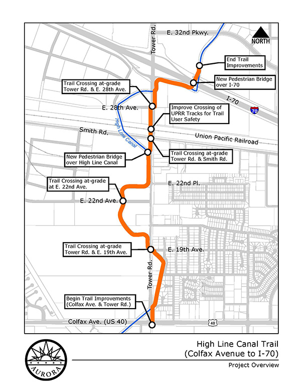
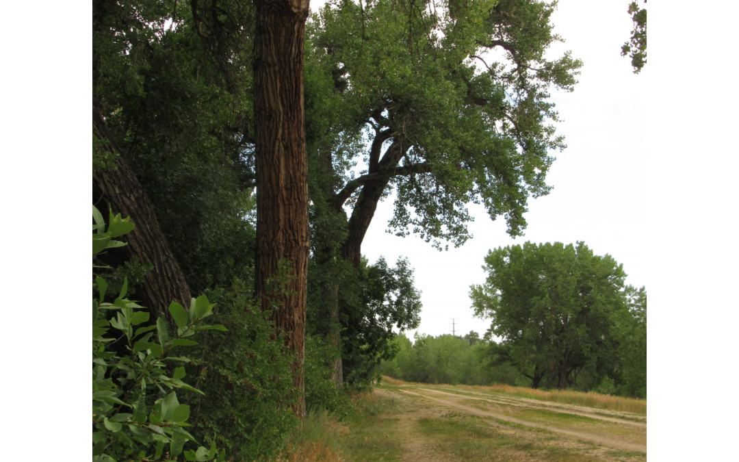
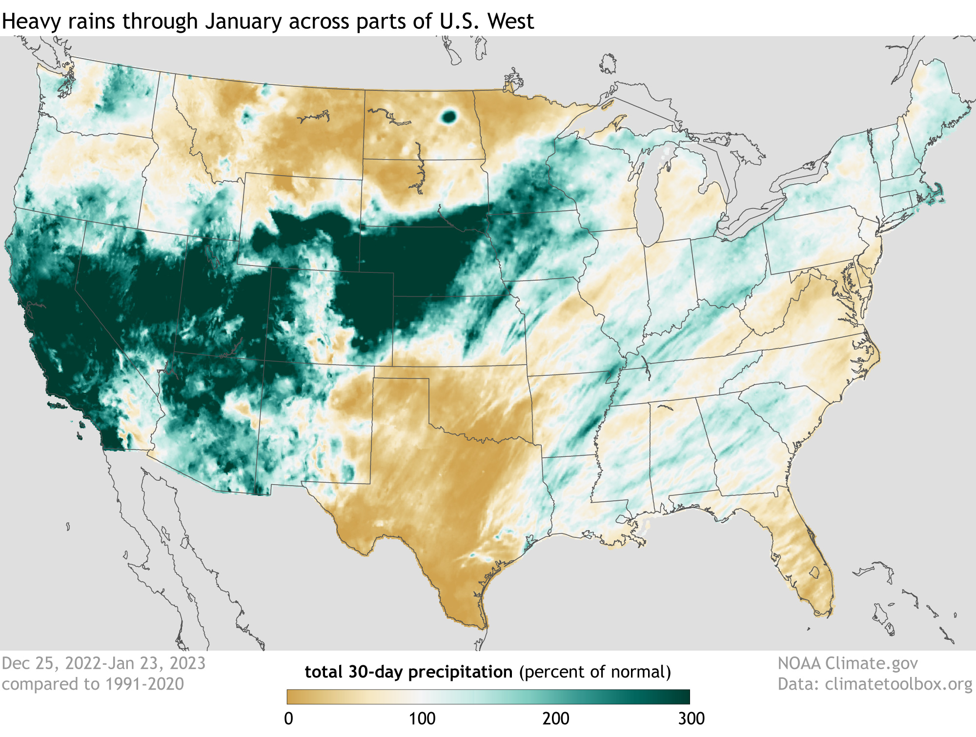

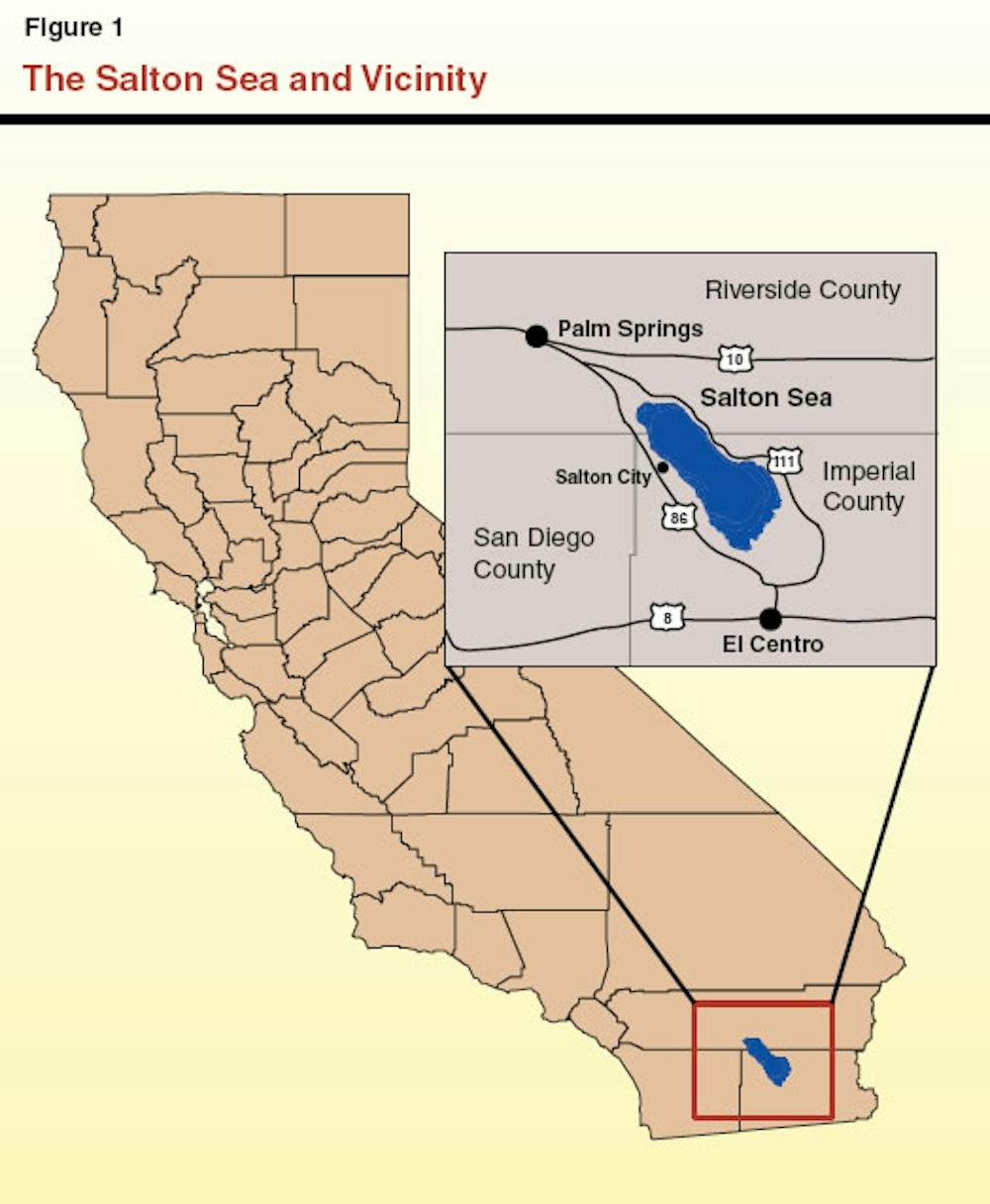
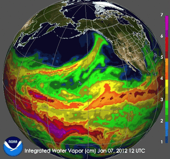


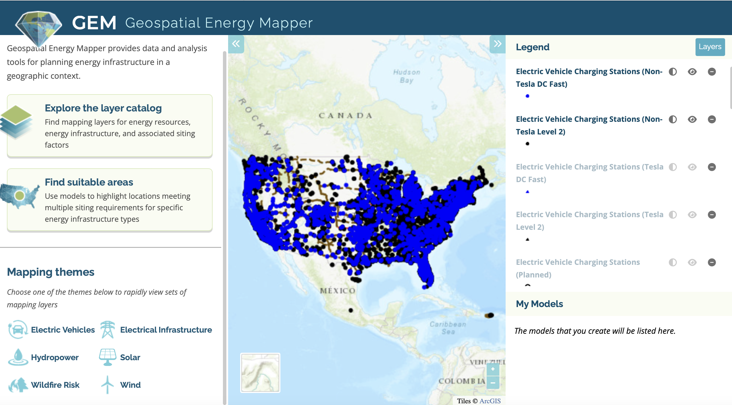

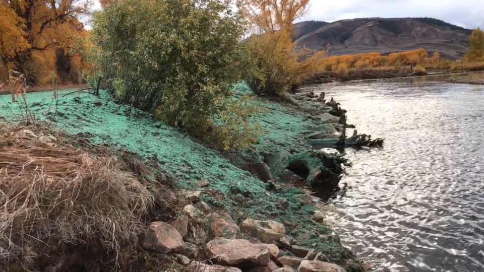


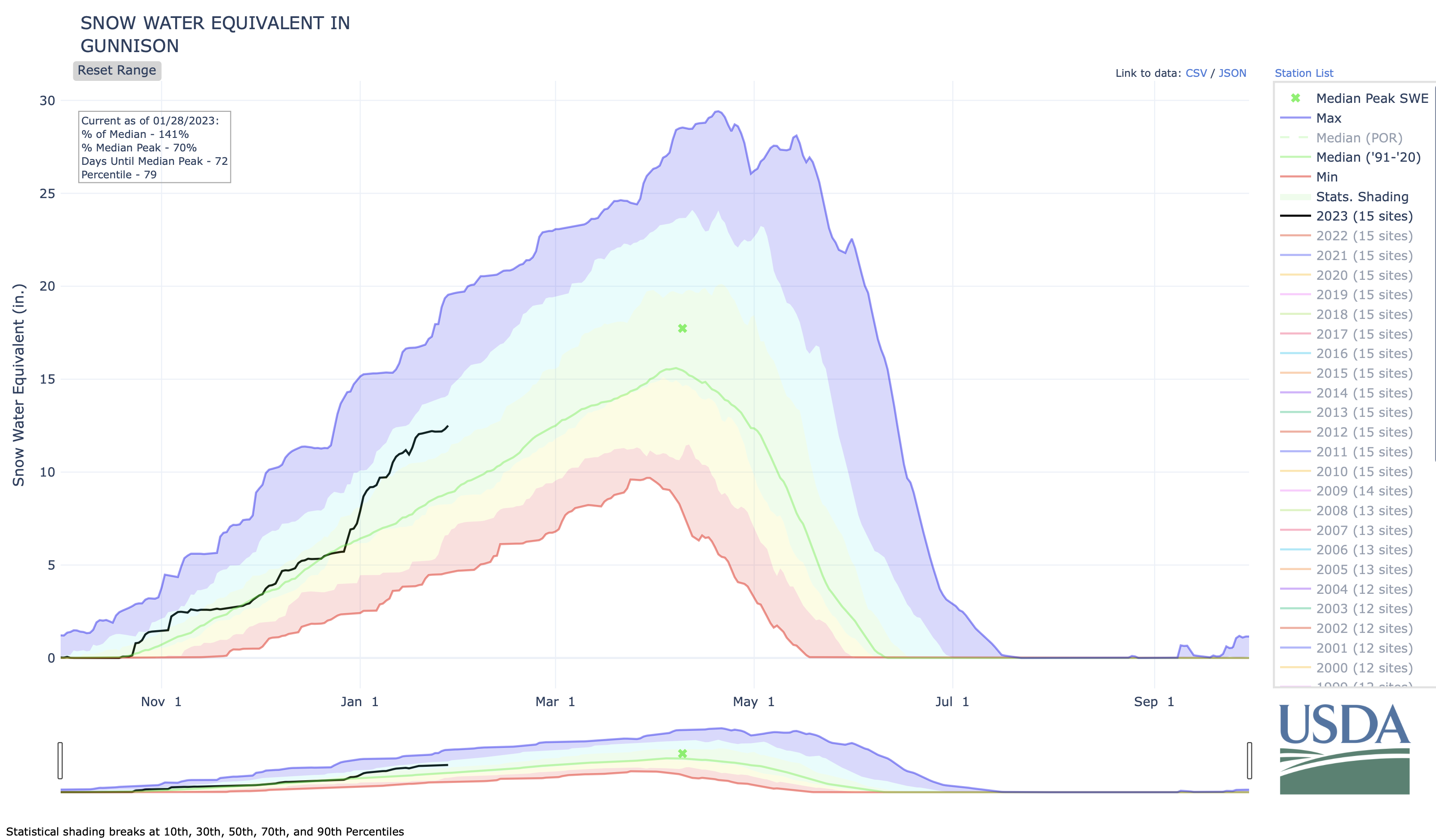
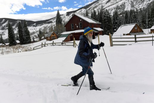
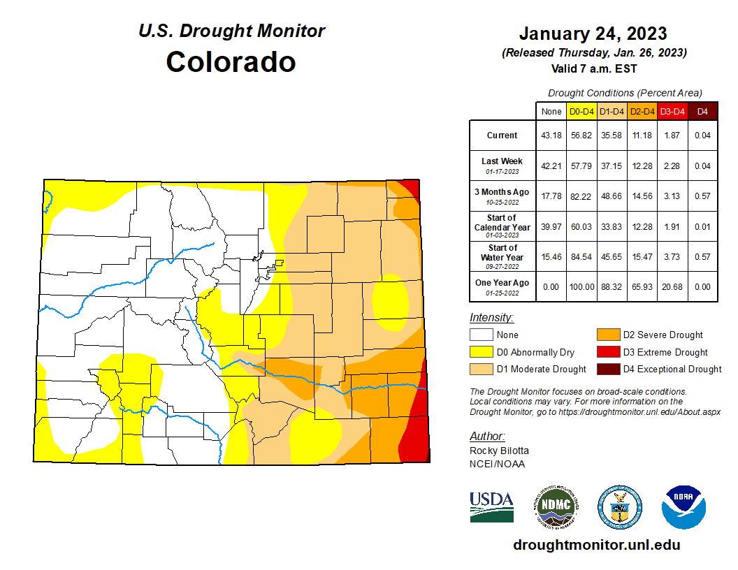
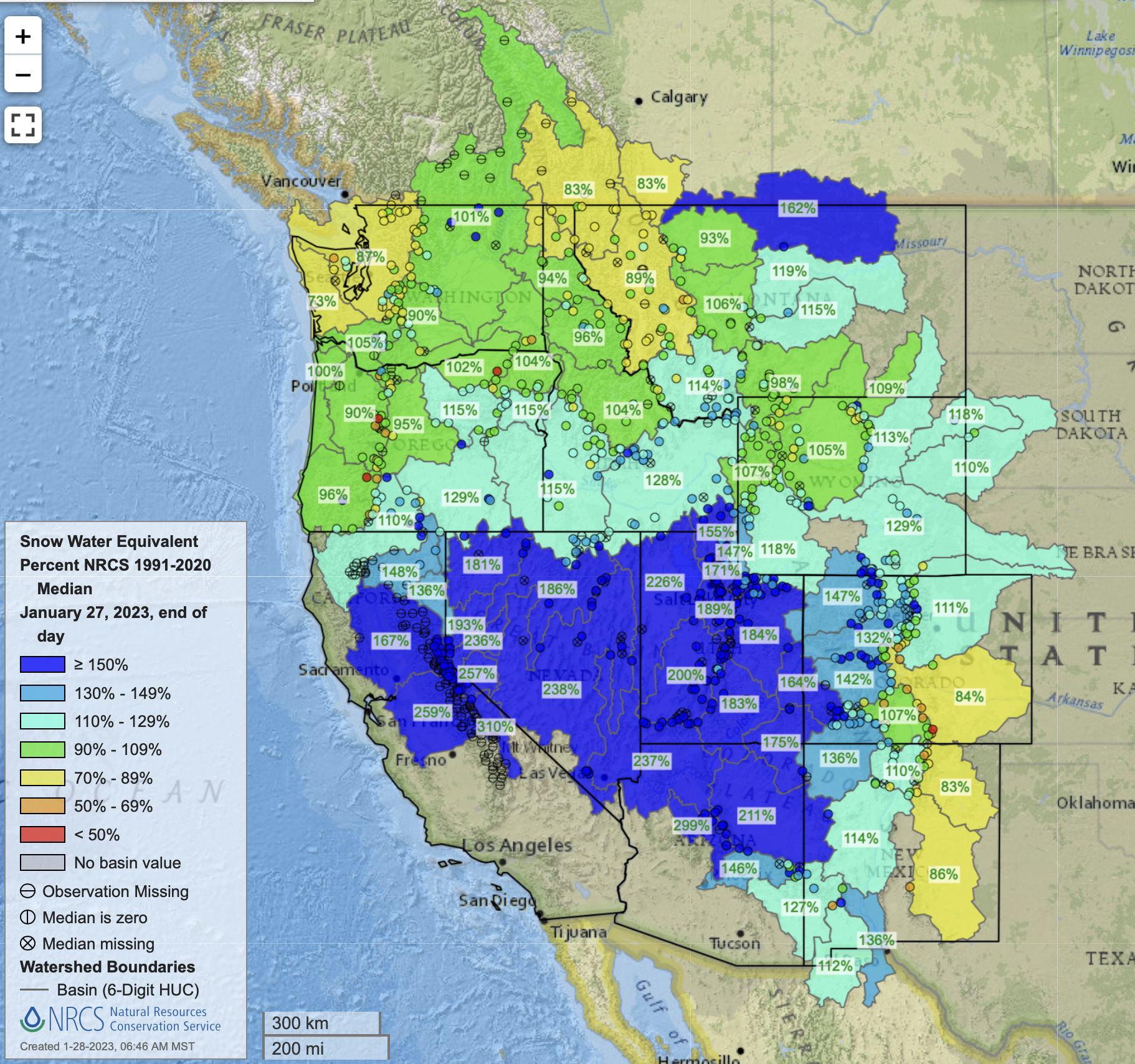


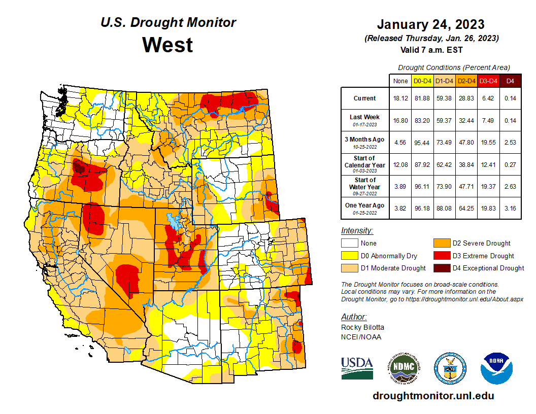
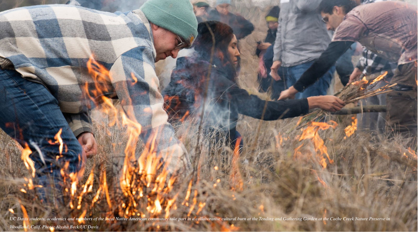
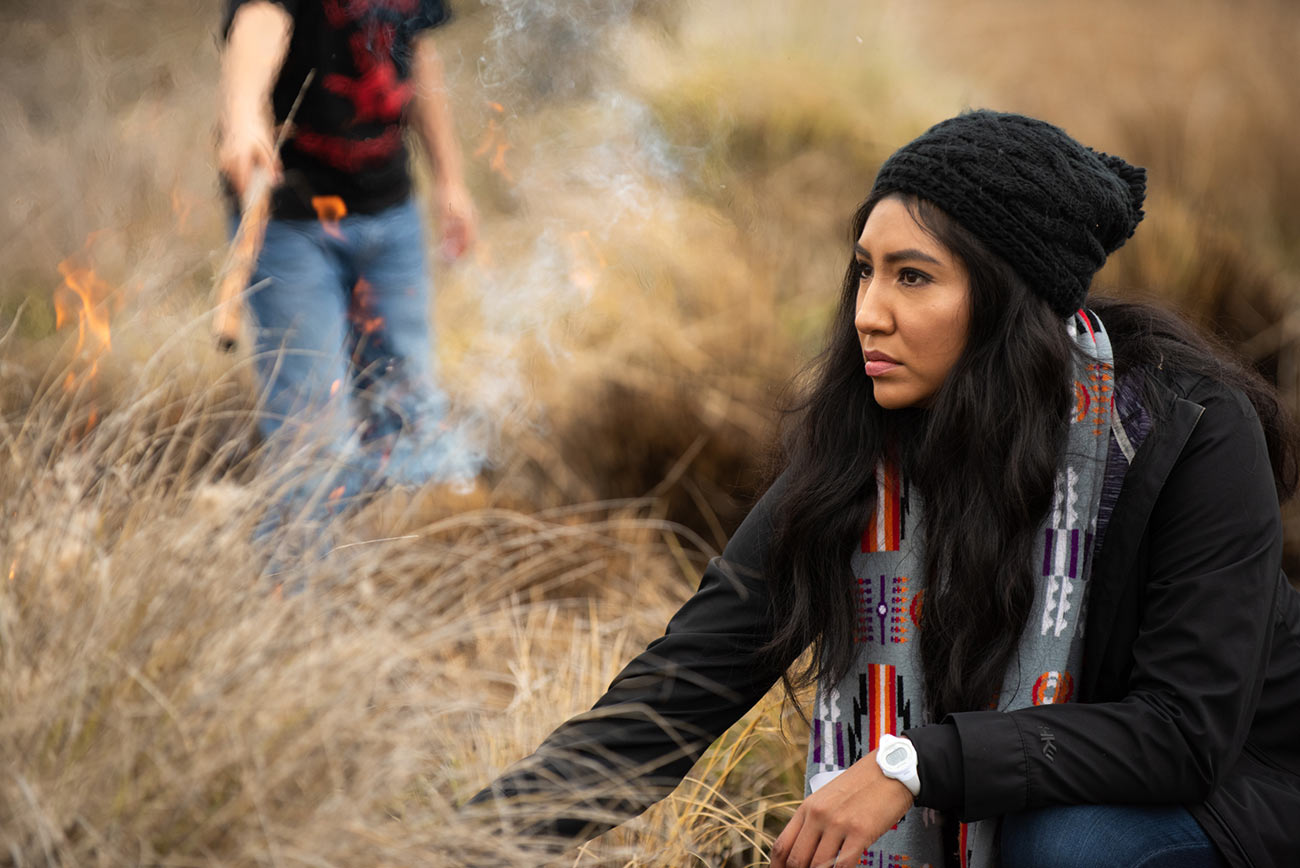
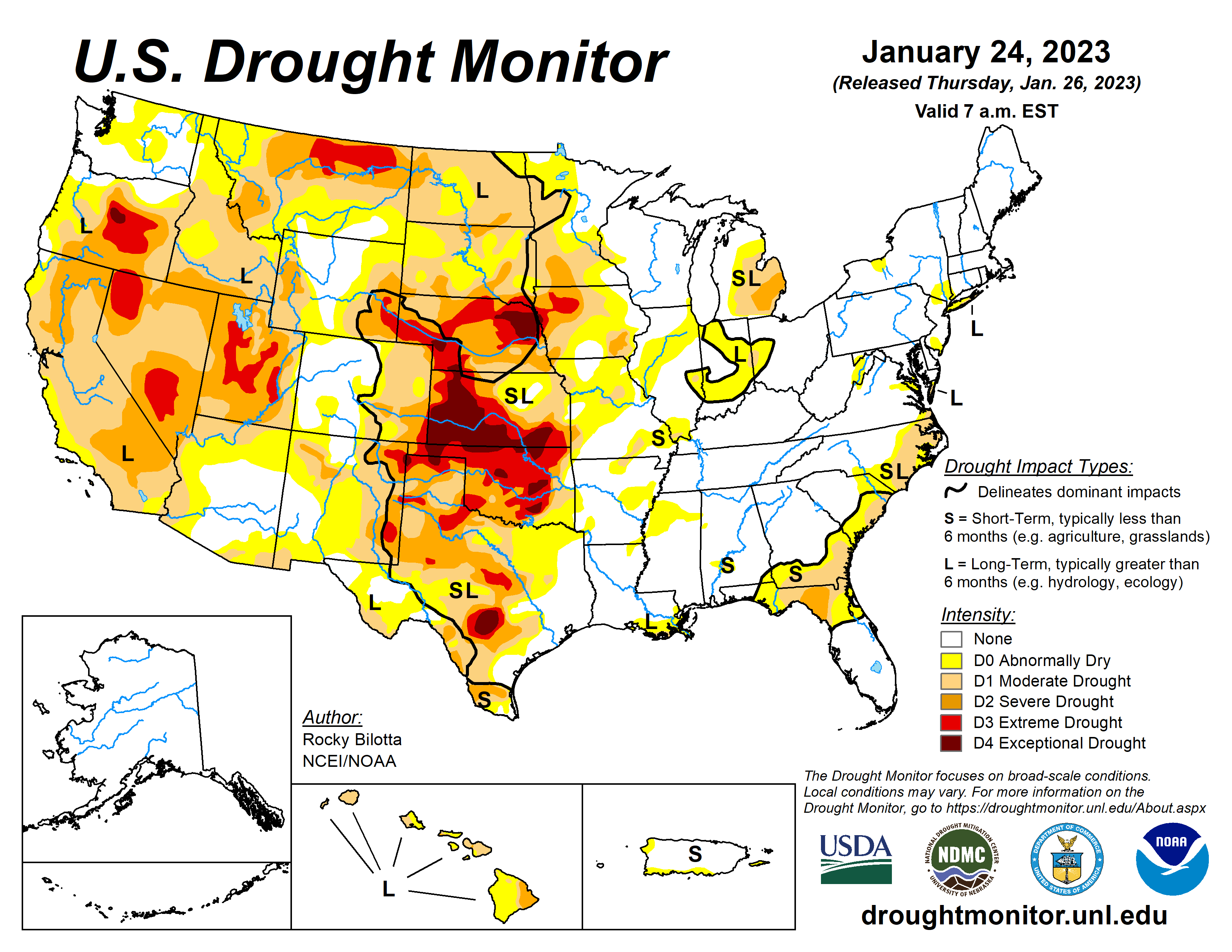
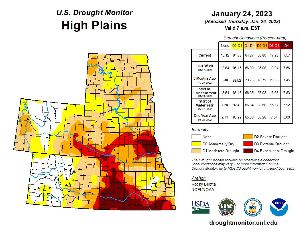
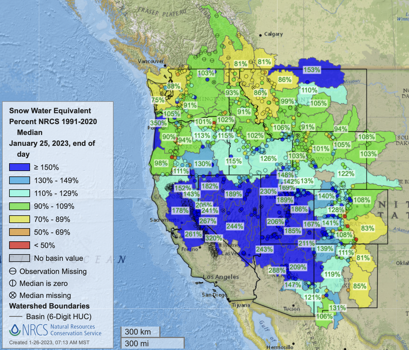
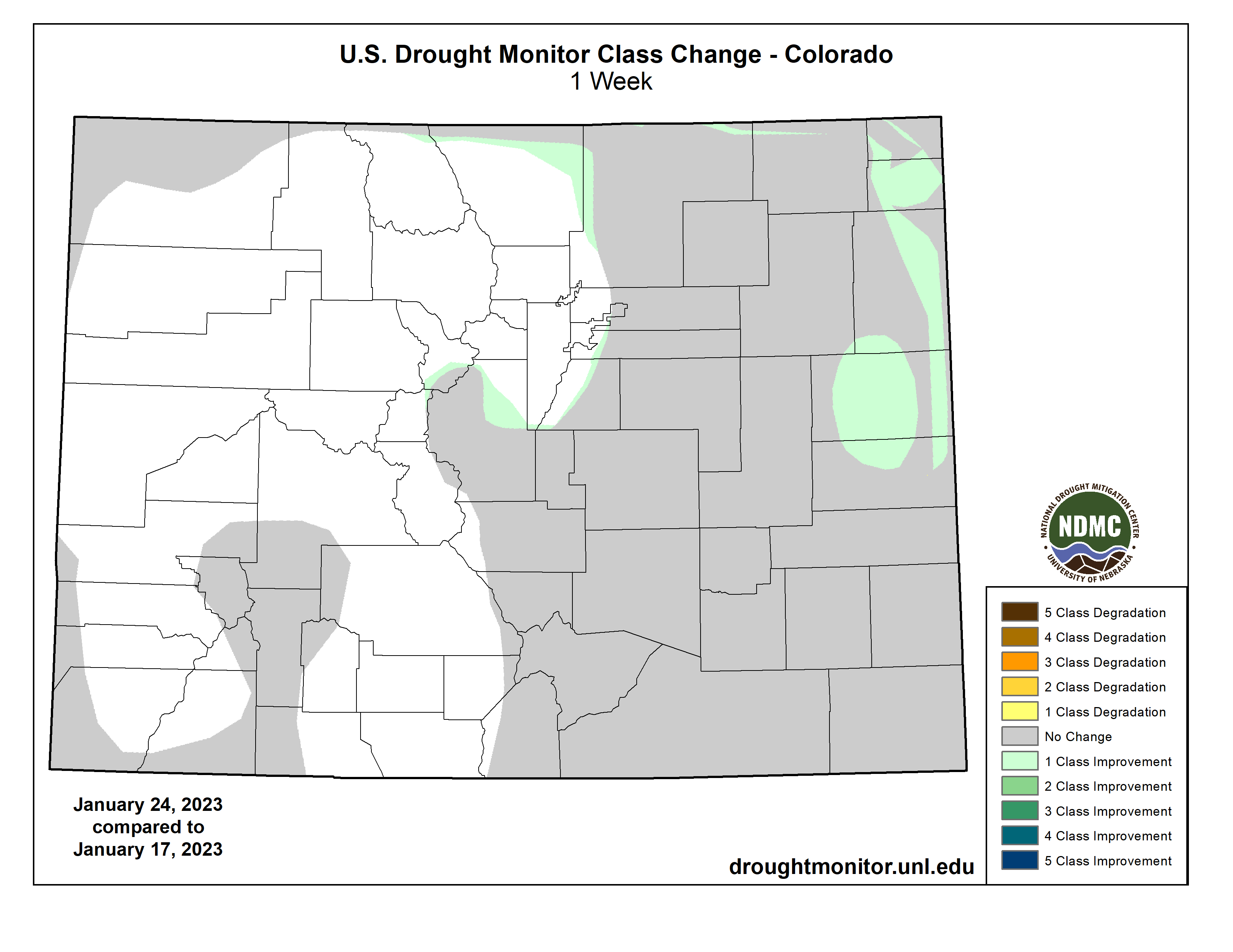
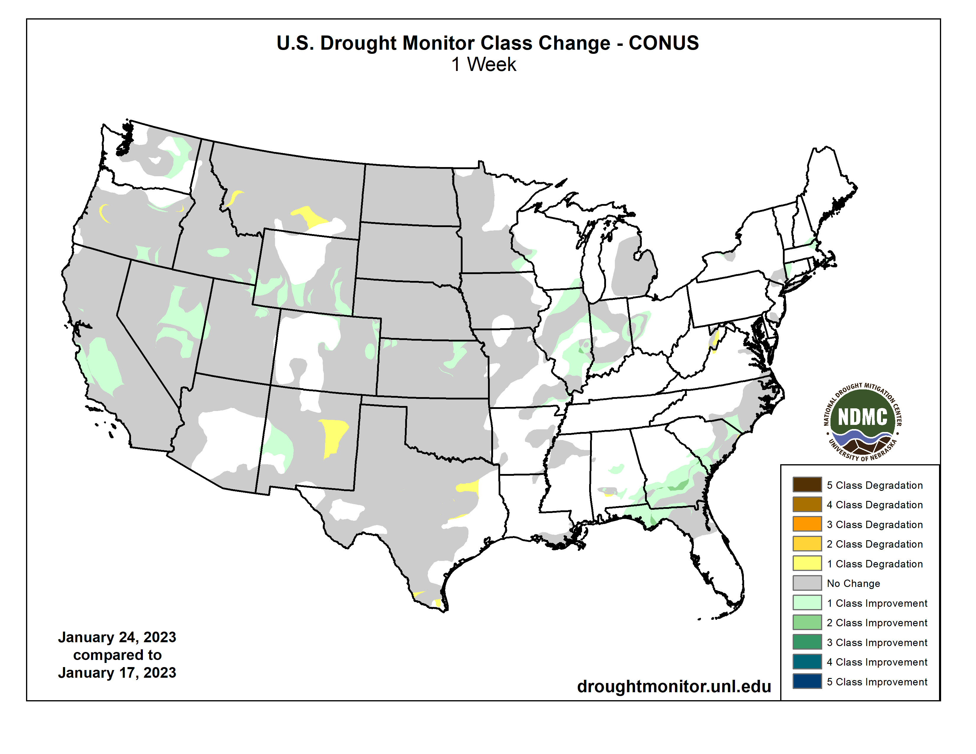
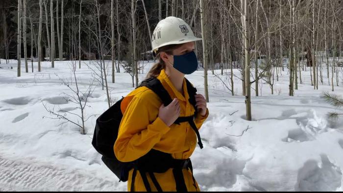
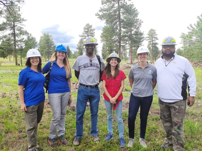
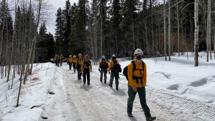


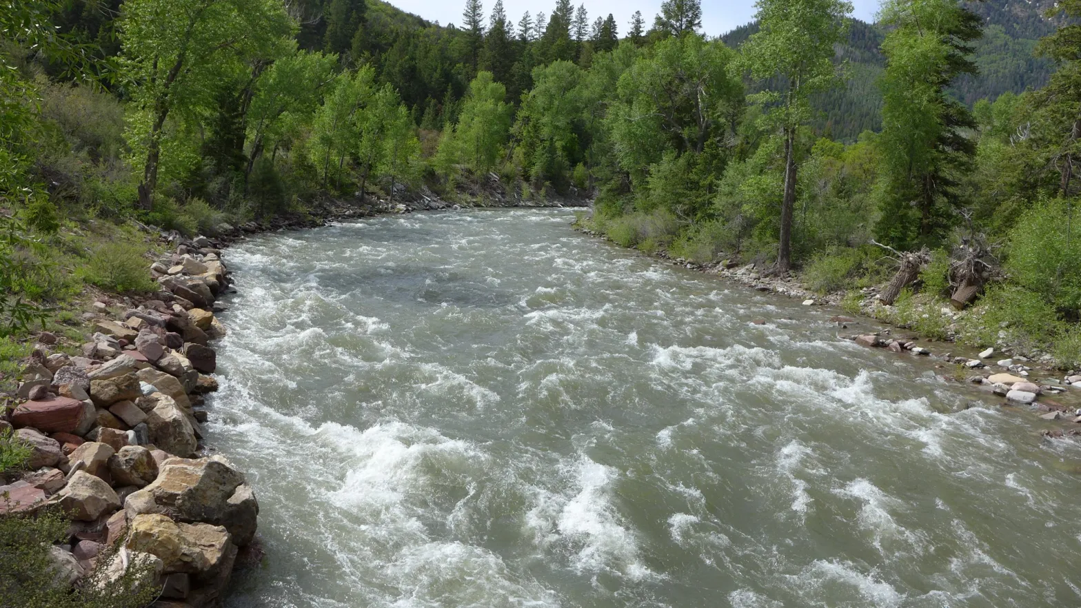

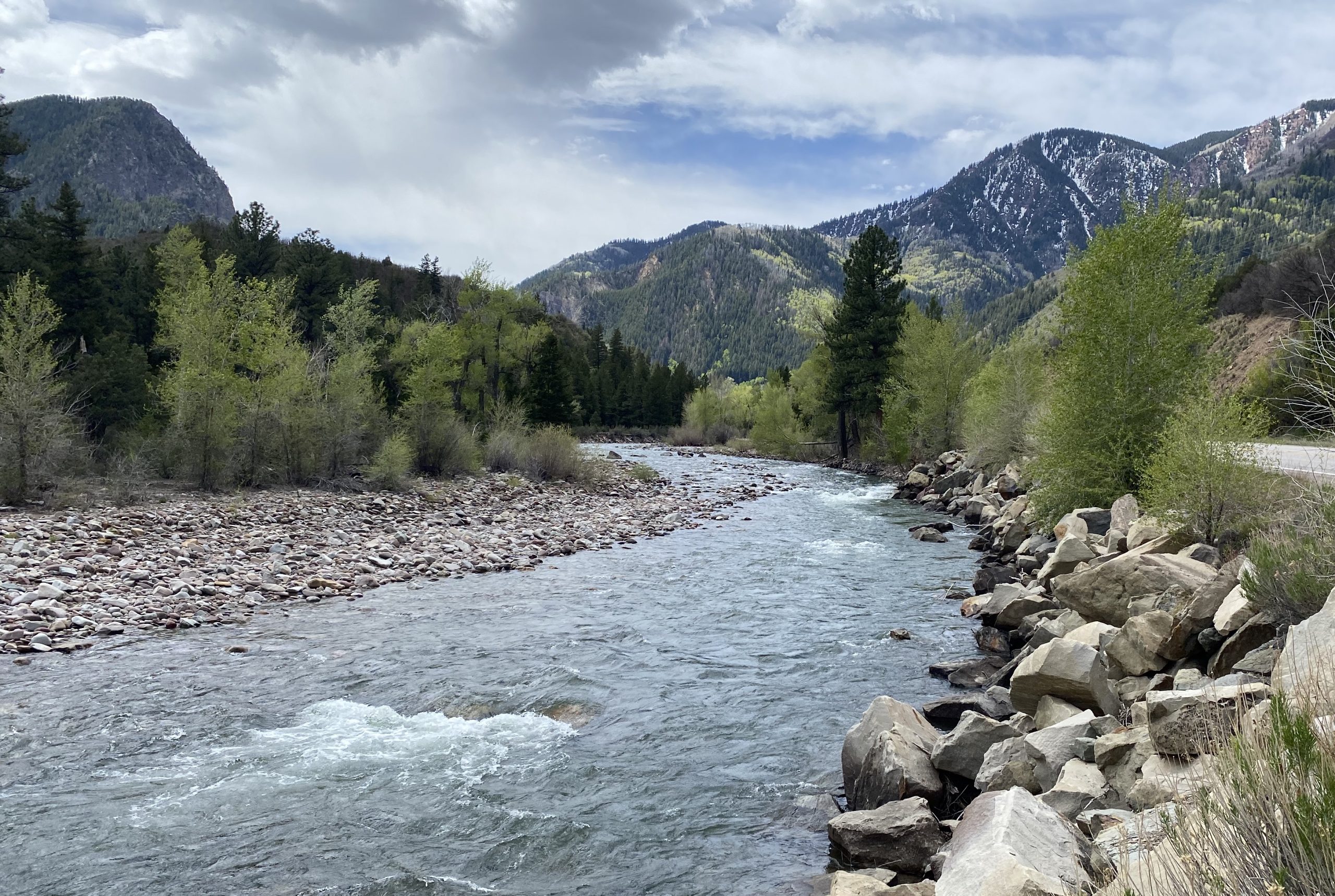
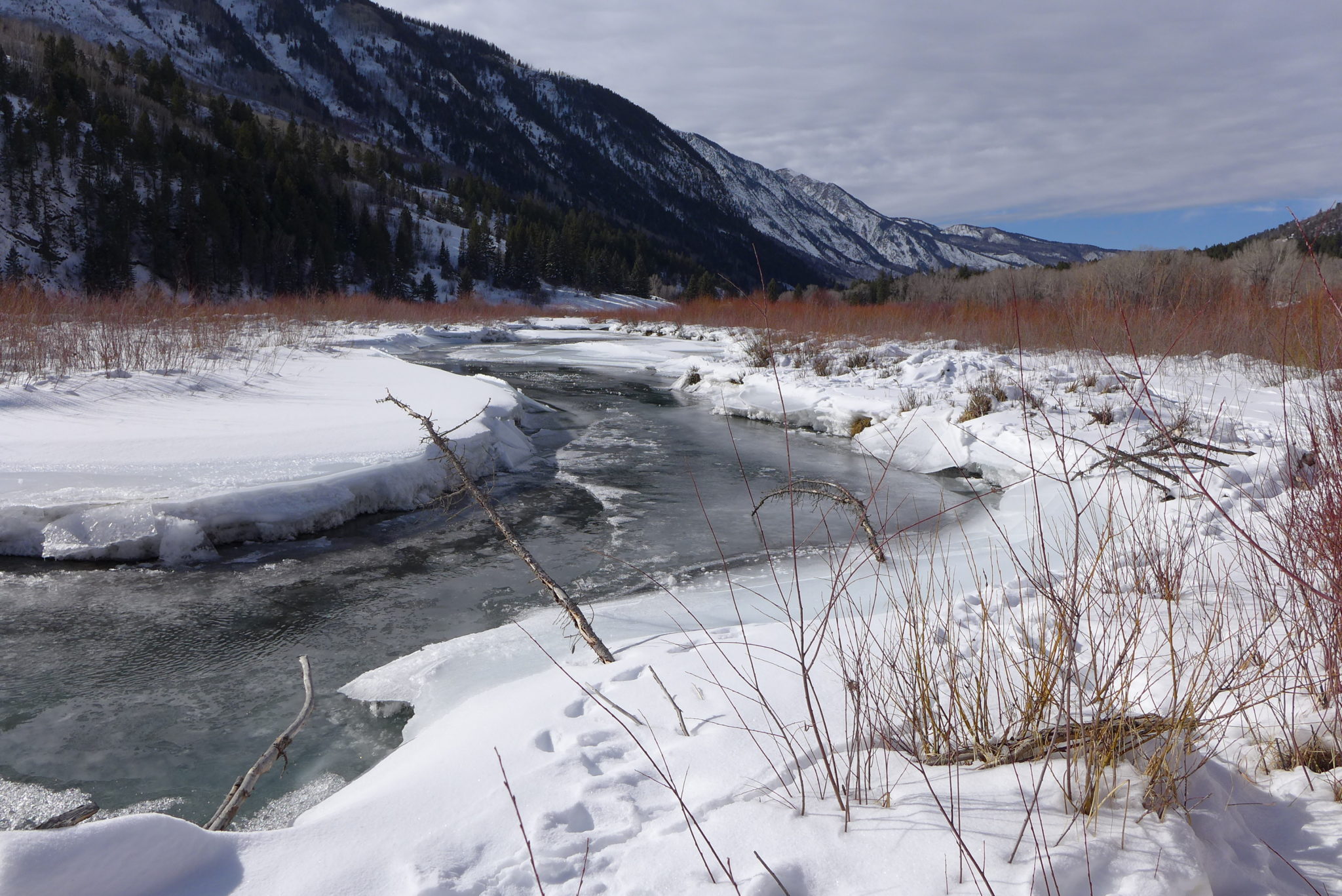
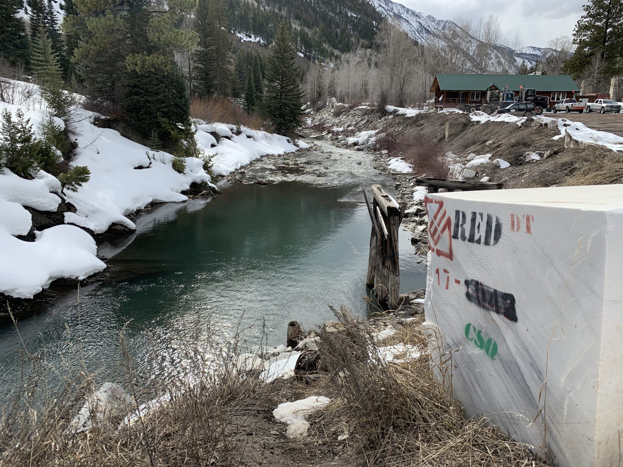

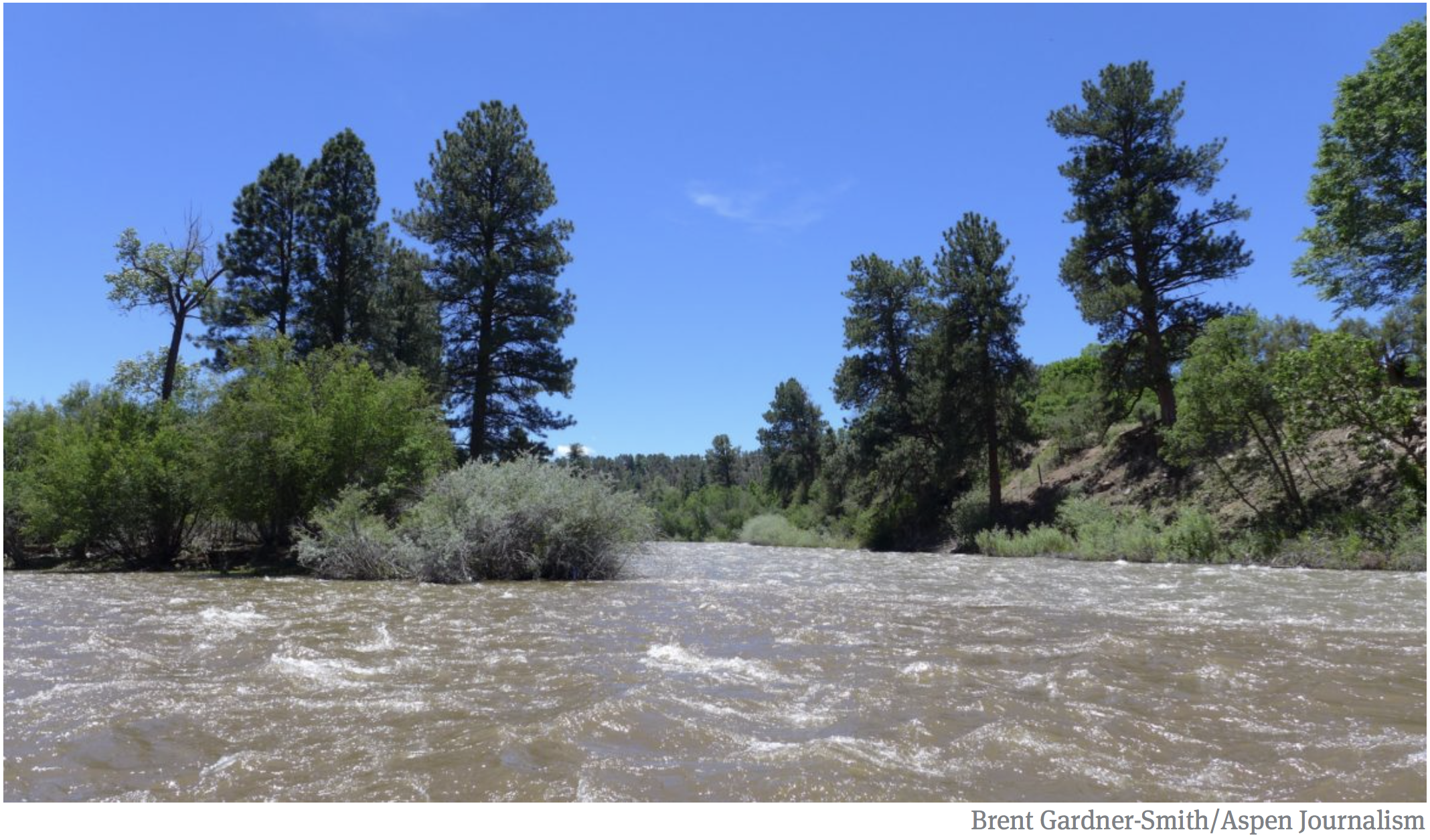
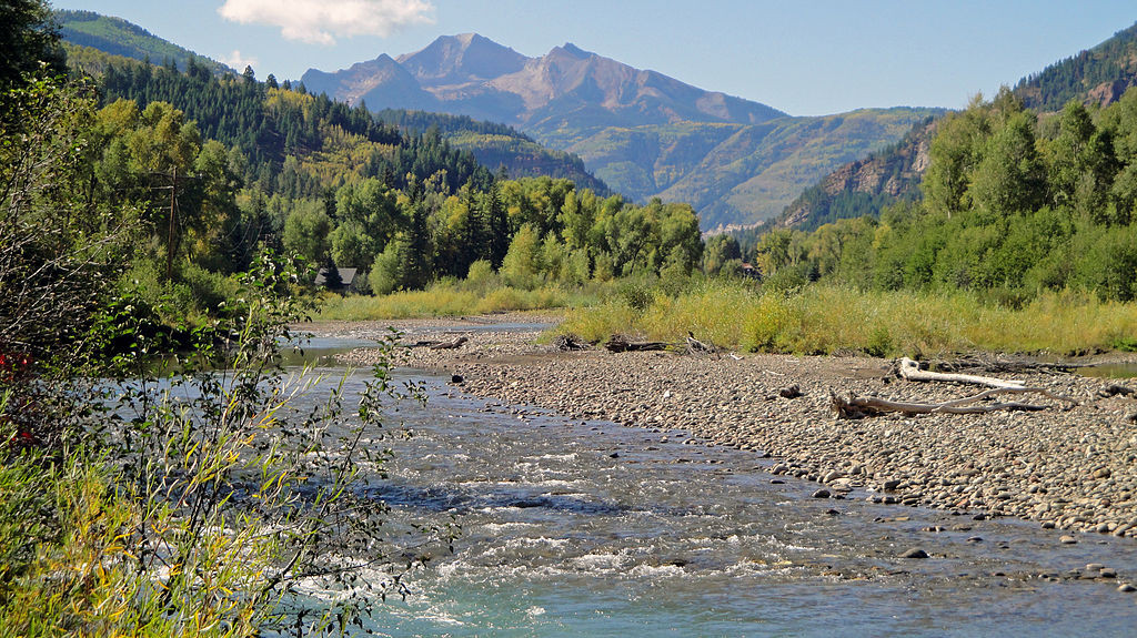


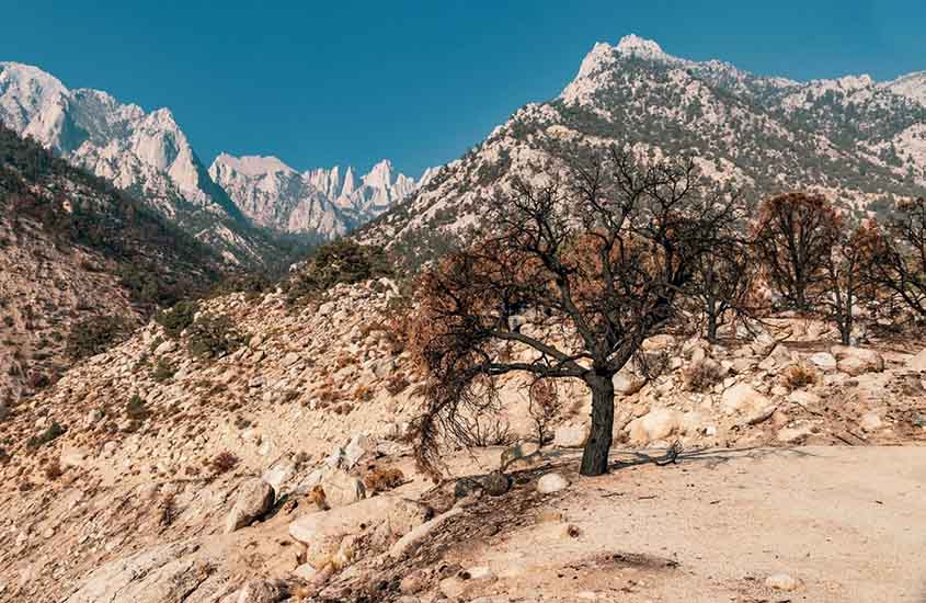


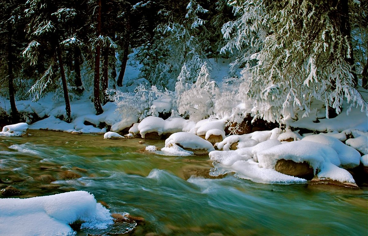


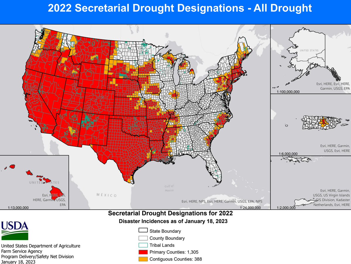
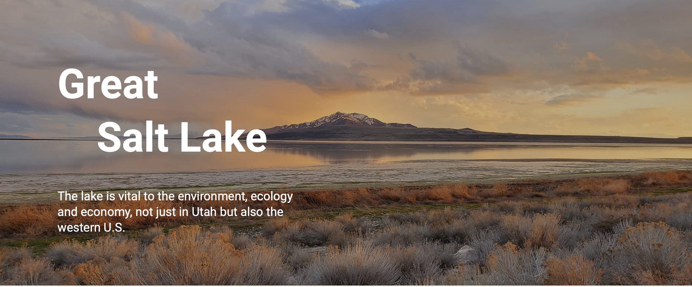
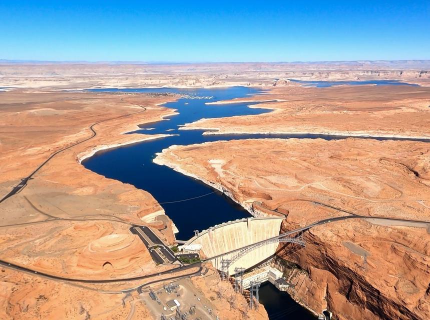

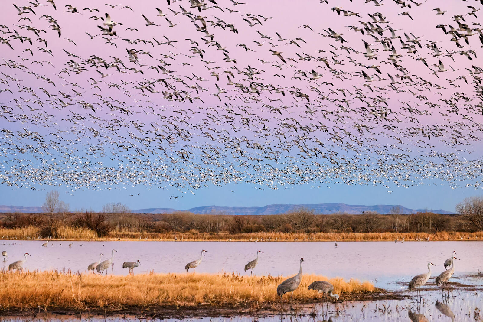


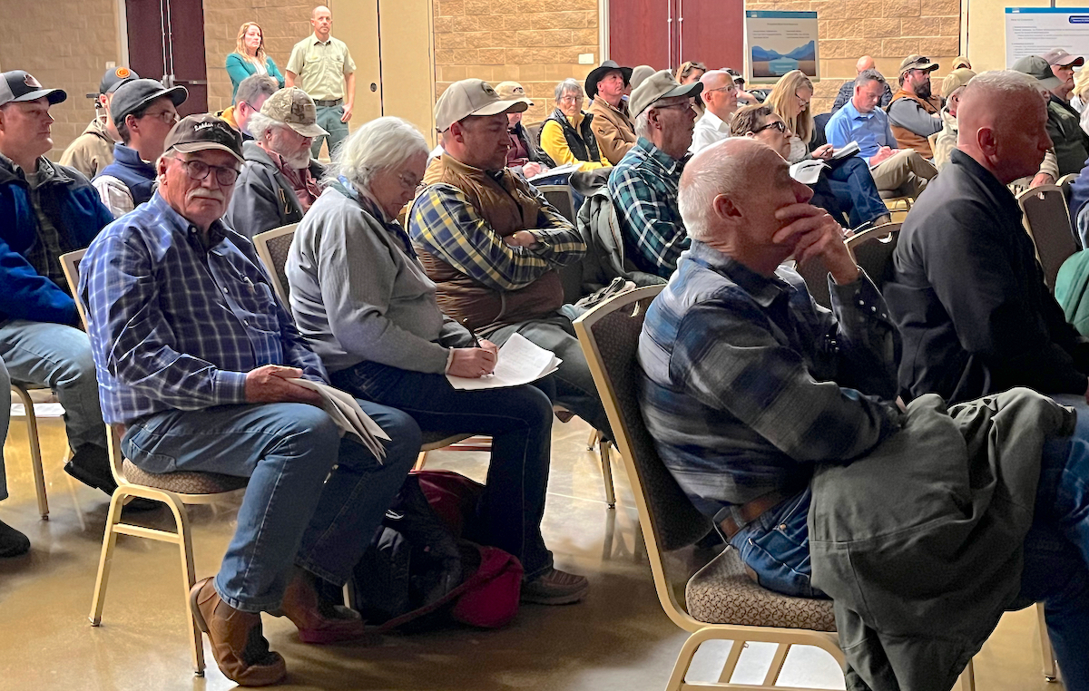


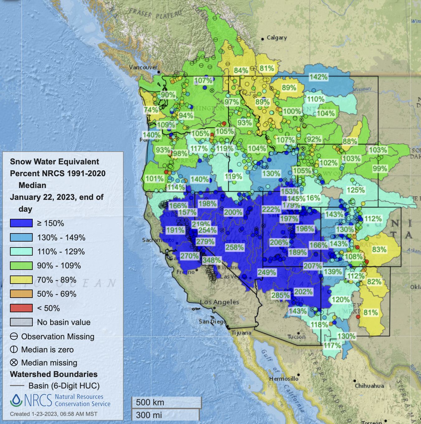
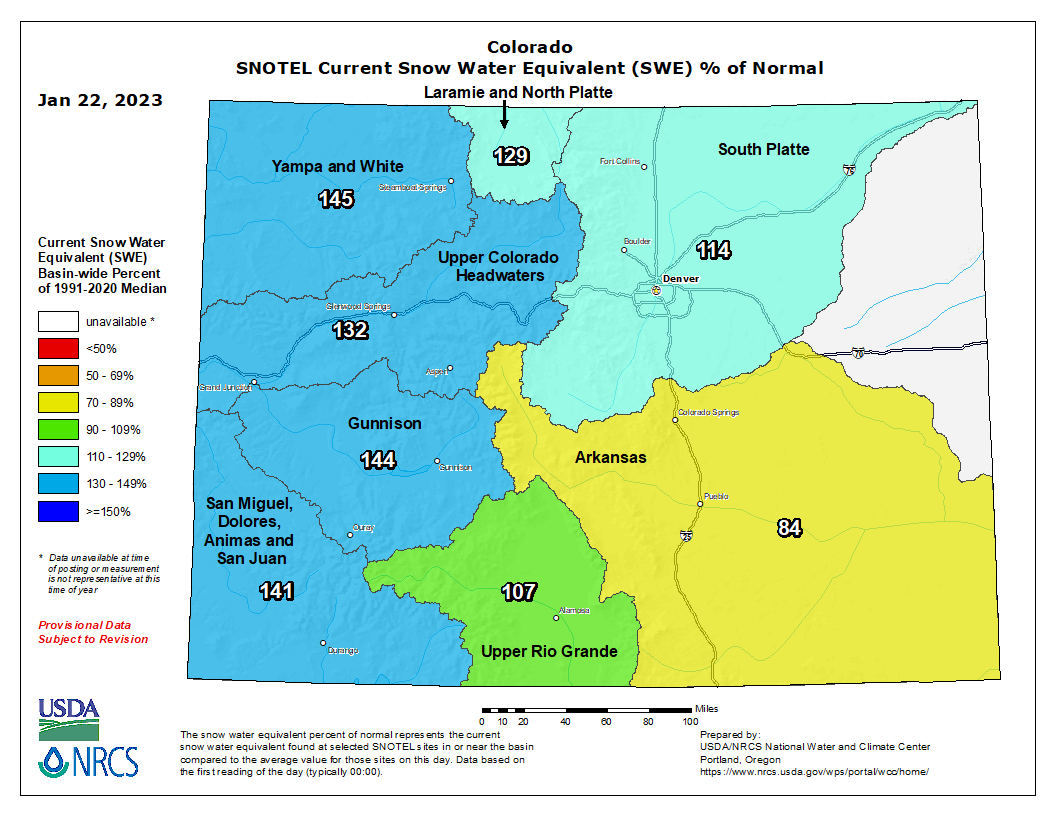
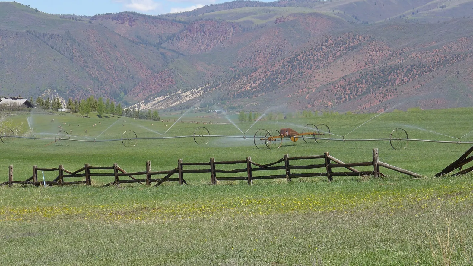

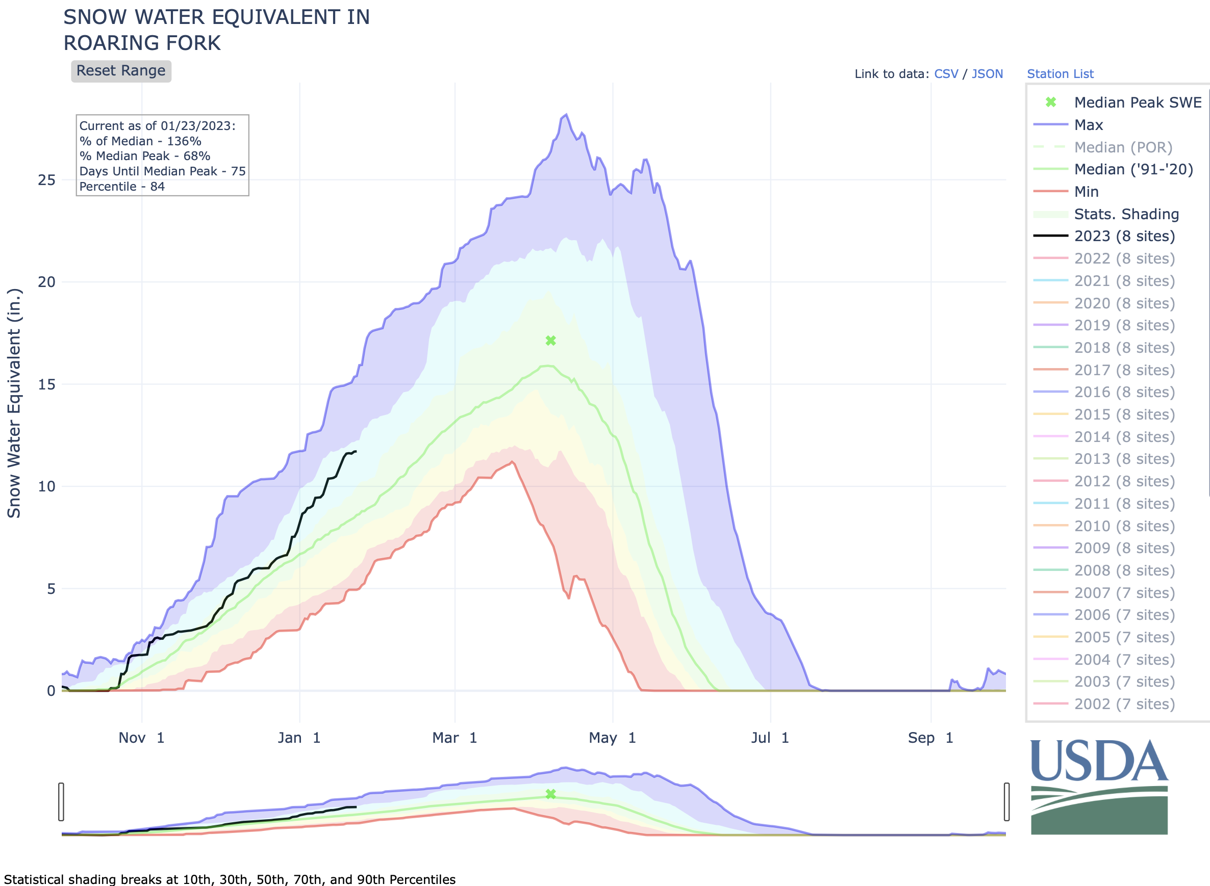

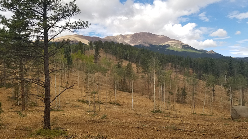


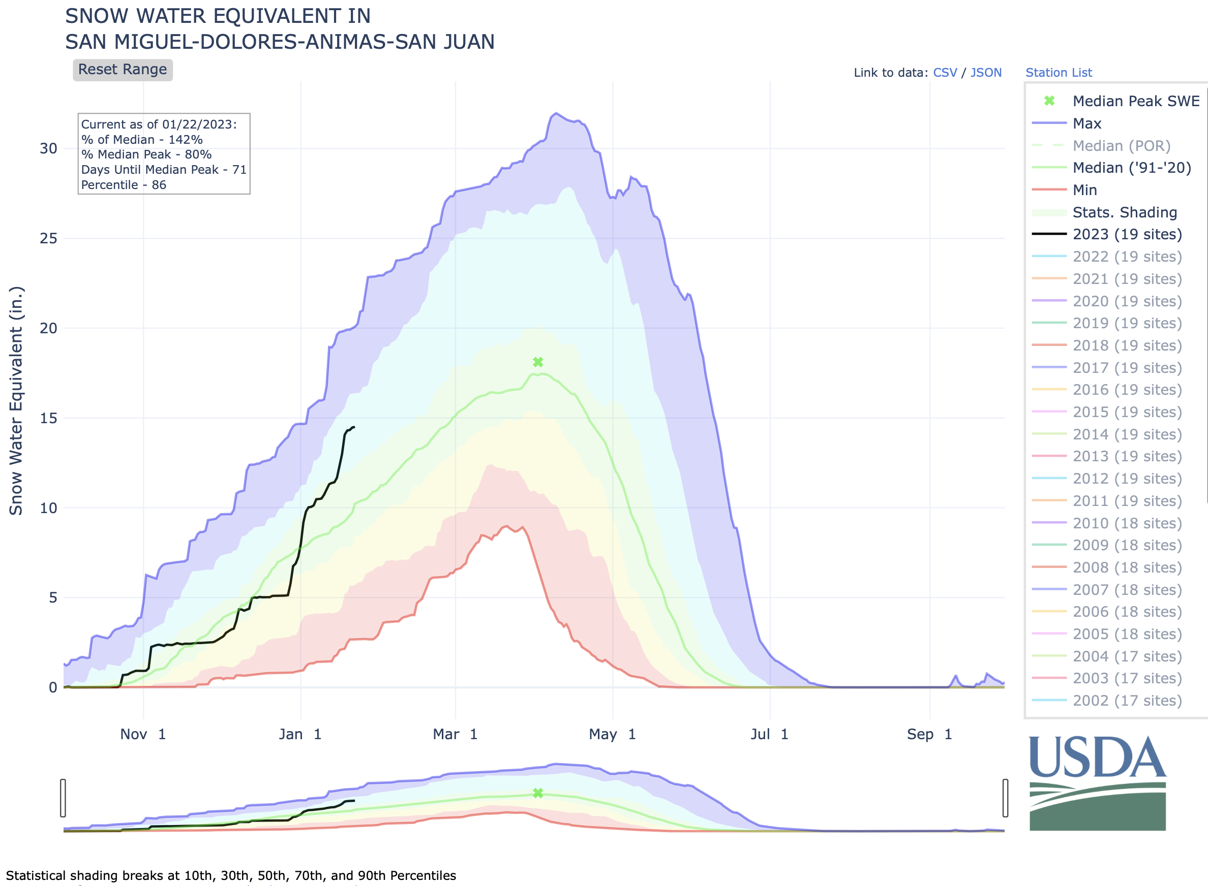
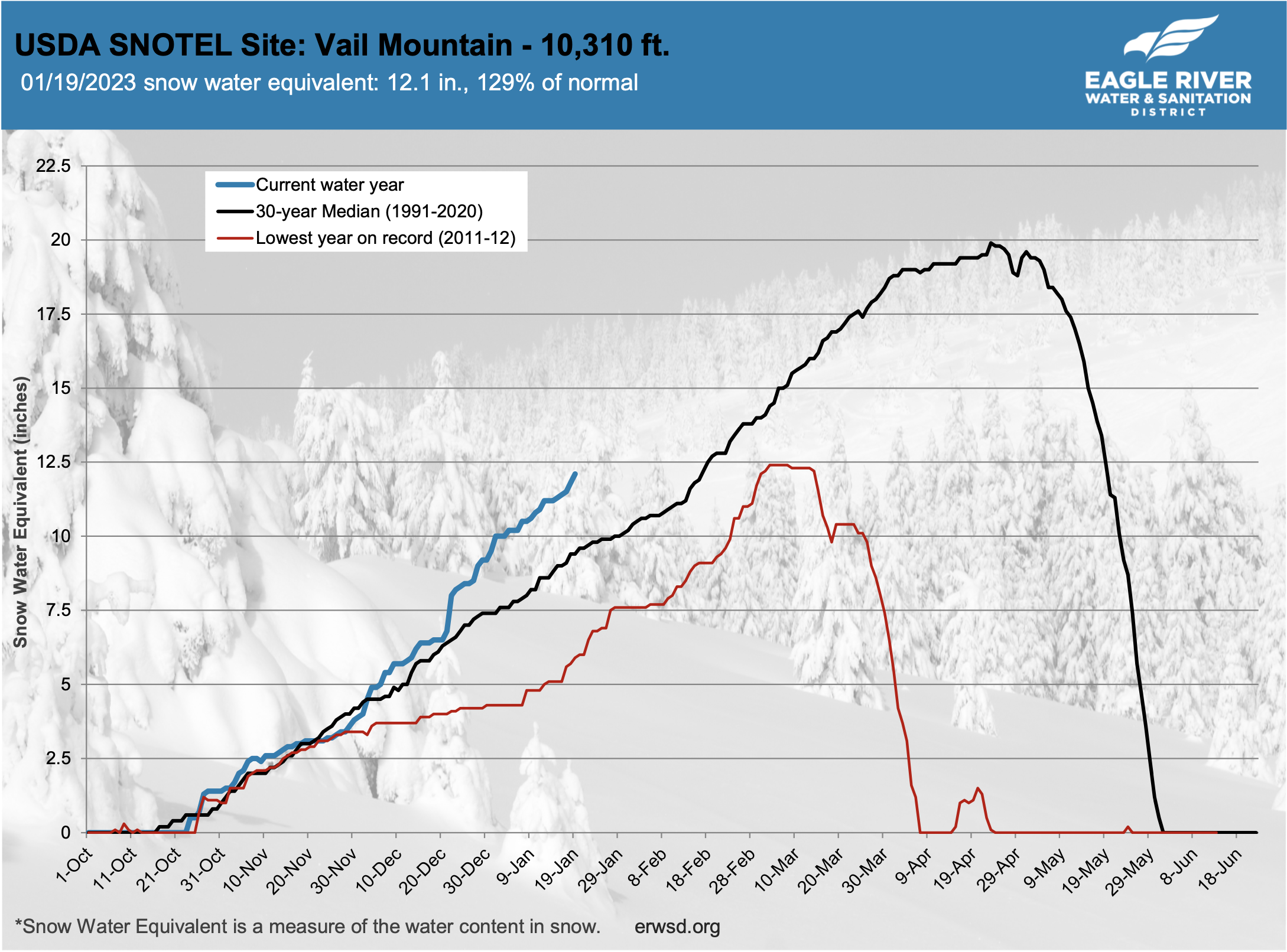

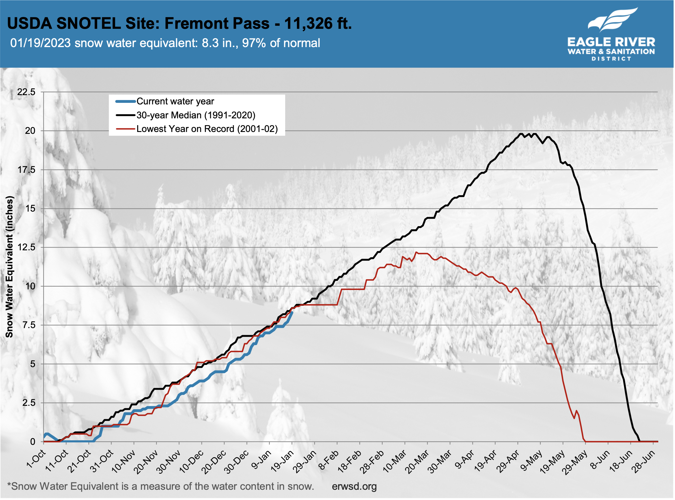
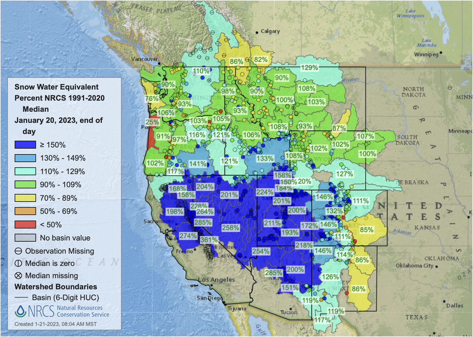
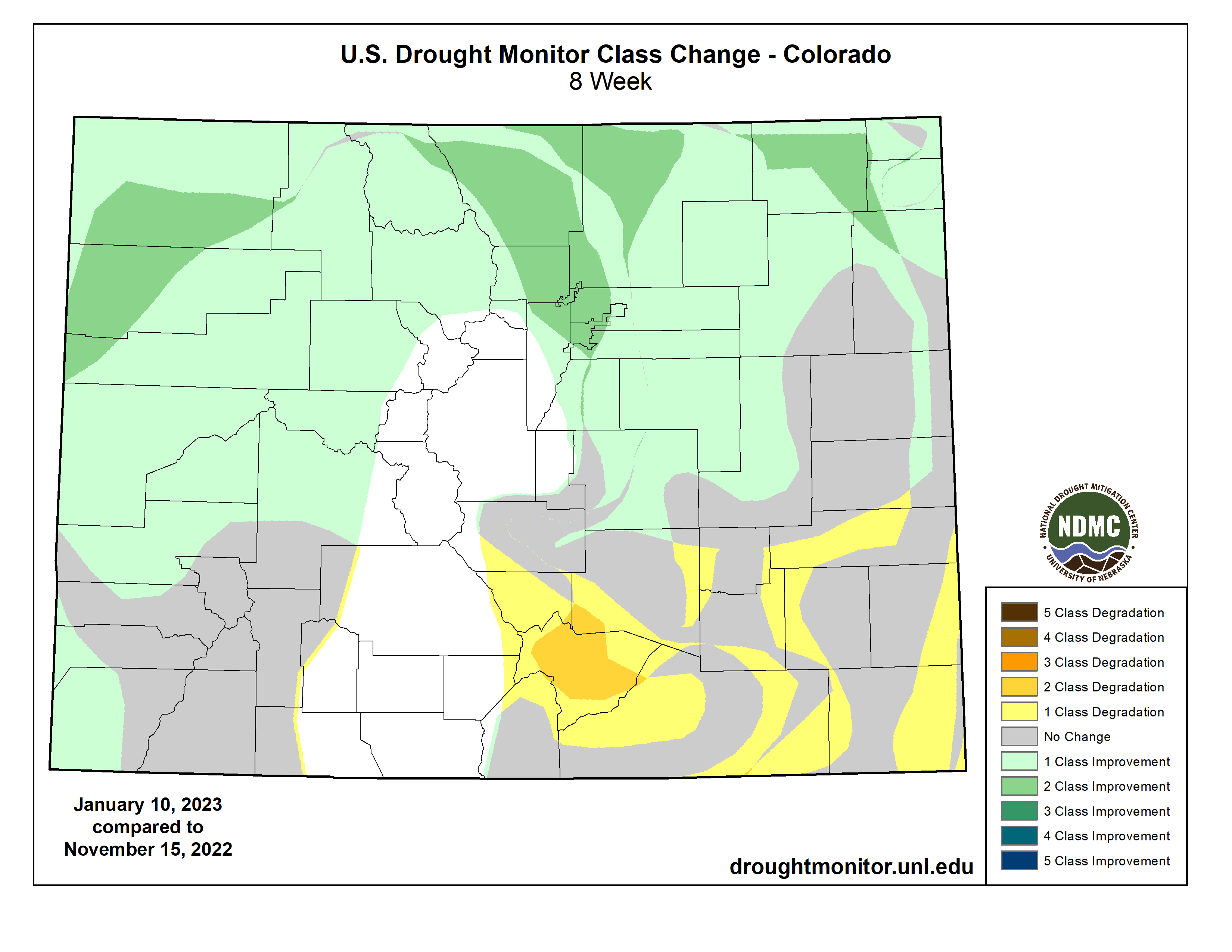
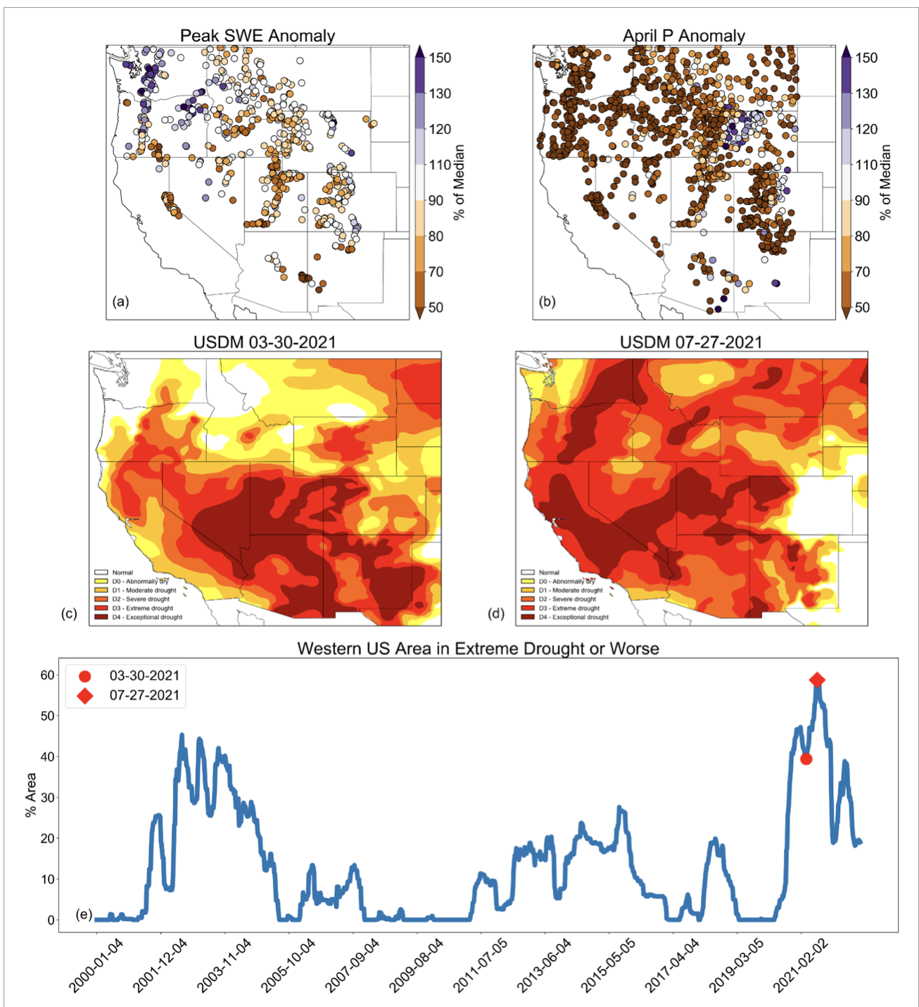


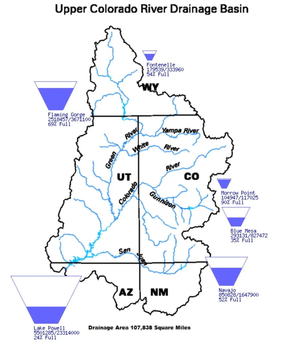


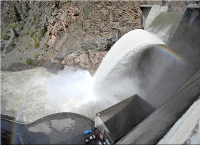

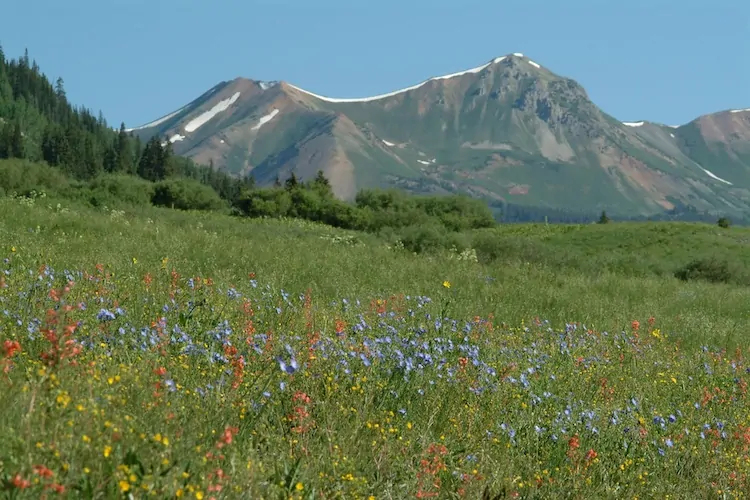


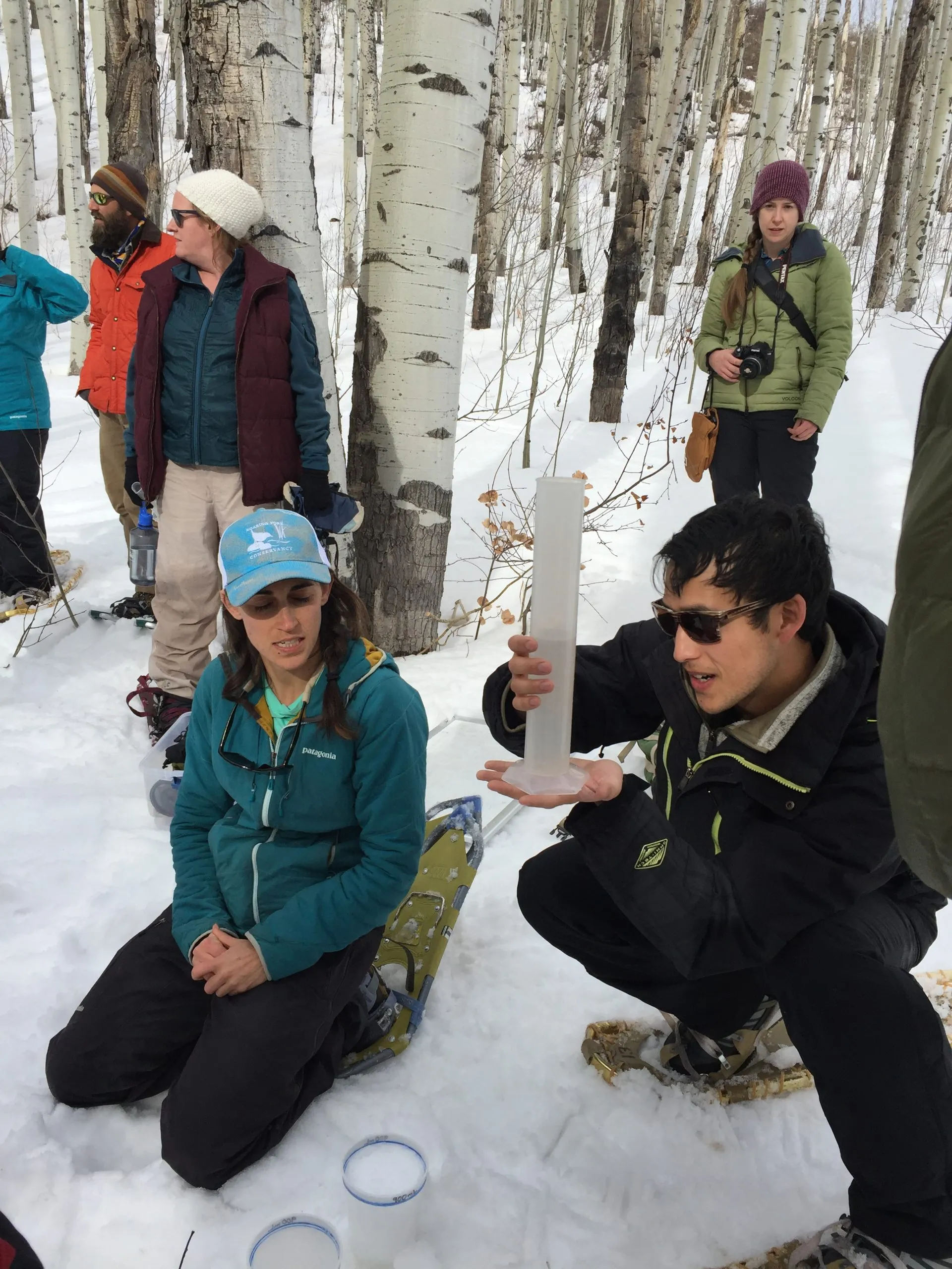

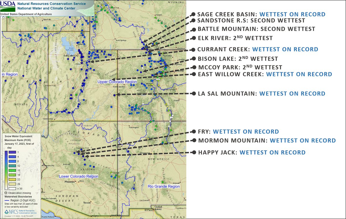