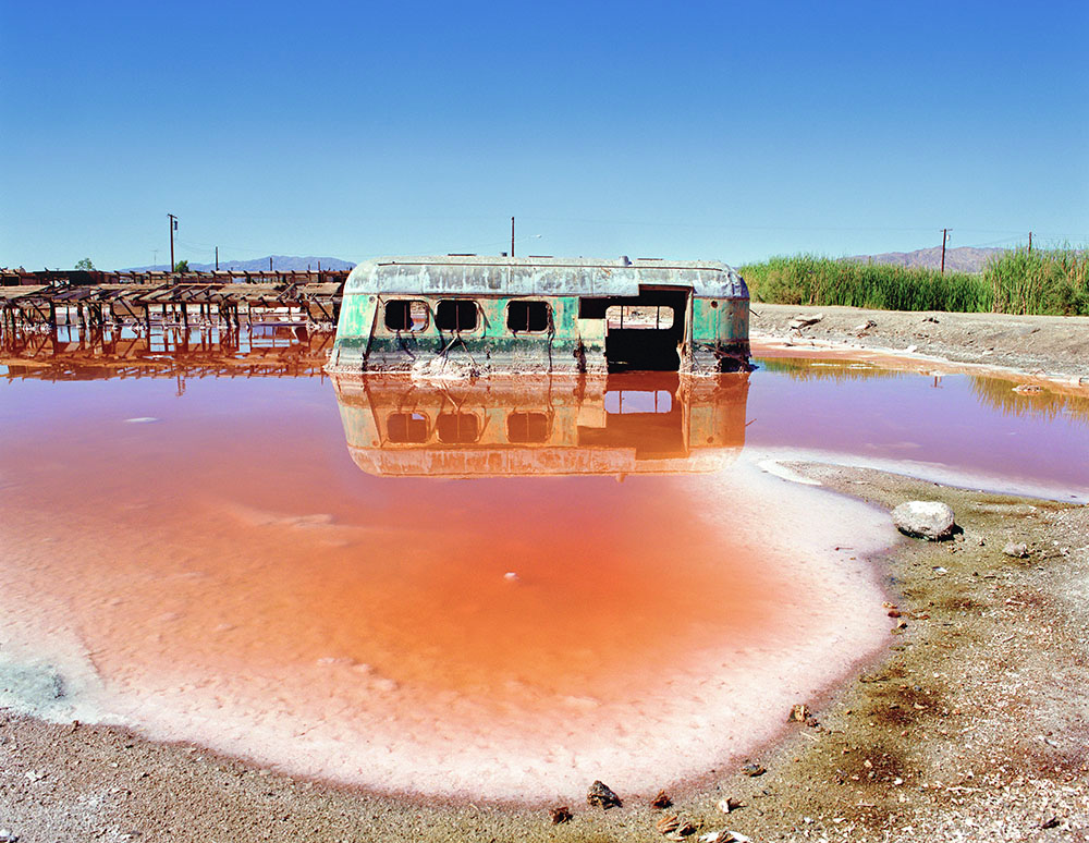
Fascinating and fetid, the Salton Sea in southern California lures me back, every year.
Driving south from Utah, I take bits of historic Highway 66 and then skirt Joshua Tree National Park to cruise through little known Box Canyon to Mecca, California. When the landscape opens up, I see the beautiful wreck of the Salton Sea, created by the collision of geology and bad luck.
Southern Pacific passenger train crosses to Salton Sea, August 1906. Photo via USBR.
The sea occupies a much smaller footprint of what used to be Lake Cahuilla, which disappeared in the late 1500s. Then, in a wild spring runoff in 1905, the Colorado River blew out a diversion dam and for three years, and the mighty Colorado drained into the Salton Sink. Agriculture runoff replenished the shallow lake over the following decades, though recently lined canals, courtesy of San Diego, in the Imperial Valley resulted in diminished flows. Its run as a bombing range ended in the 1970s.
If the lake were to completely dry up there would be a horror to behold. While at shrinking Lake Mead a few gangster cadavers showed up in the mud, the Salton Sea contains crashed planes and practice bombs, the targets simulations during the 1940s for the real atomic bombs dropped on Japan.
The lake is bracketed by opulent Palm Springs to the north and the arty squalor of Slab City to the south, home to about 150 full-time residents but temporary home to as many as 4,000 in the winter. In between there are hot springs RV resorts, date palm groves, geothermal energy plants and the town of Bombay Beach sitting atop the San Andreas fault.
Is the diminished sea worth saving? It’s too late to ask the question because, like the great Salt Lake, the cost of not saving it is likely higher than the rescue. Like many invasive species around the West, there is no easy way to get rid of it. Yet most of its fish are already dead and migrating birds have little to eat.
Dust is the issue, and most conservation programs attempt to mitigate dust.
The 1950s and 60s brought out the excesses of post-war revelers to the Salton Sea. You can see the salt-encrusted remains of former resorts and second homes of the Los Angeles fancy people. You can imagine the ghosts of boat races and cocktails.
Those folks even named the local wildlife refuge after swinging Sony Bono, but what came next was toxic salinity and decay as less water came in and the water that remained increased in salinity.
Still, the sea persists. Its salt-encrusted shores circle about 340 square miles of sea. A silo-full of conspiracy theories features the Salton Sea: The military may have accidently dropped a real bomb that did not explode, and the bomb might even be under the water along with hundreds of other dummy bombs and fallen planes. Bodies may still sit in the planes. We know for certain that Slab City is what’s left of a decommissioned military base built about 70 years ago.
Most of the people I meet around the lake seem happy. The place brings pleasure to pre-apocalyptic people like me and those creating outsider art on the actual beach near Bombay Beach. Thousands of Canadians migrate there each winter because the highest temperatures rarely top 80 degrees.
I look forward to my week at the hopefully named Fountain of Youth Spa RV Resort. I joke that I have been coming there since 1906 so it must be working.
It attracts so many Canadians that the resort hosts U.S. vs. Canada Games featuring geezer sports of pickleball, horseshoes, bocce and karaoke. Poutine and box wine flow freely, and people sometimes stay up into the double-digit hours of the evening.
Dennis Hinkamp. Photo credit: Writers on the Range
The Salton Sea will likely remain a curiosity and hiding place for the weird until some real monster beneath the sea emerges, which could be a rush to start mining lithium made by the sea.
On the other hand, the San Andreas fault might just swallow the whole thing in one glorious gulp. Meanwhile, it’s my refuge, my winter solace away from anxious headlines, and just strange enough to be hospitable.
Dennis Hinkamp is a contributor to Writers on the Range, writersontherange.org, the independent nonprofit dedicated to spurring lively conversation about the West. He writes in Utah.
Colorado River. For over 50 years, stakeholders throughout the Colorado River basin have worked to address challenges caused by salinity. Photo credit: Abby Burk via Audubon Rockies
Click the link to read the article on the Summit Daily website (Ali Longwell). Here’s an excerpt:
February 6, 2024
Since 1974, the seven Colorado River basin states — Arizona, California, Colorado, Nevada, New Mexico, Utah and Wyoming — have coordinated efforts to implement salinity control in the waterway as part of the Colorado River Basin Salinity Control Forum. The forum was created by the U.S. Congress, flowing funding through the Bureau of Reclamation to reduce the salt load in the river and research the issue…While salinity is naturally occurring, there are a few reasons that states and river stakeholders have long kept an eye on it.A baseline amount of salinity is OK. Too much salinity can have adverse effects on drinking water, water infrastructure and treatment, appliance wear, aquatic life, the productivity of certain agricultural crops (including wine grapes, peaches and other salt-sensitive products) and more. The U.S. Bureau of Reclamation estimates that salinity causes between $500 and $750 million annually in damages and could exceed $1.5 billion per year if future increases are not controlled…
Much of the Upper Basin geology — specifically Mancus and Mesa Verde shale formations — was created when it was covered by an inland sea, [David] Robbins added. Therefore, they contain salt deposits that through natural erosion and runoff, make their way to the rivers and downstream. In Colorado, natural salinity sources include the geothermal hot springs in Glenwood Springs; shale cliffs and evaporating salt deposits in the Eagle and Roaring Fork valleys; and the salt domes in Paradox Valley in Montrose County along the Dolores River. Human activity can also exacerbate challenges by accelerating the release of compounds from these natural geologic materials and increasing the salt load in the river and tributaries, according to the 2009 U.S. Geological Survey report. This includes activities like mining, farming, petroleum exploration and urban development. For example, with some agricultural irrigation practices, by adding more water to the soil that naturally contains salts, “increases the rate of dissolution above the natural signal,” [Dave] Kanzer said. The use of road salts — solid and liquid — to clear snow and ice can also lead to increased salt loads as the salt dissolves and makes its way into snowmelt and streams.
Click the link to read the article on the LandDesk.org website (Jonathan P. Thompson):
January 31, 2025
🌵 Public Lands 🌲
The Joe Lott-Fish Creek grazing allotment sprawls across nearly 78,000 acres of U.S. Forest Service land in western Utah. It contains a variety of ecosystems, ranging from arid juniper-piñon forests in the lower elevation sections that straddle I-70, to aspen and conifer glades, to 11,000-foot peaks, as well as several streams.
Until just over a decade ago, the primary grazing permittee was Missouri Flat LLC, which was allowed to run 744 cow-calf pairs on the land. Another rancher had a maximum herd of 40. The cattle were supported by 14 cattle ponds and troughs.
Sometime between 2013 and 2016, Missouri Flat’s permit was taken over by Pahvant Ensign Ranches. Over a period of about three years around the same time, the Fishlake National Forest upped the maximum number of cattle allowed to graze the allotment by 604, to a total of 1,388 cow-calf pairs, without notifying the public until 2021. The Forest Service said favorable conditions following the 2010 Twitchell Fire justified the increase, but they didn’t provide any scientific backing for the decision. Then, last April, the Forest Service approved a proposal to add 17 water troughs and 13 miles of new pipeline to the Pahvant Ensign allotment, granting the project a “categorical exclusion,” meaning it isn’t subjected to the usual environmental review.
“Functionally,” wrote Mary O’Brien, a botanist and longtime defender of public lands, ecosystems, and pollinators, “Joe Lott-Fish Creek Allotment is being transformed into a private ranch.”
O’Brien brought the story of the Joe Lott allotment to my attention several months ago. She wanted to show me, in part, that while environmentalists tend to focus on the Bureau of Land Management when pushing back on public lands livestock grazing, they shouldn’t forget that grazing is also widespread on Forest Service lands. And that the Forest Service is no better at managing it than the BLM.
I also find it to be a sort of snapshot of how public lands grazing — under any agency — has come to be the West’s untouchable sacred cow, something that neither Democrats nor Republicans dare to mess with or reform, no matter how obsolete the current regulations or how much harm is being done. I’m not just talking about the Biden or Trump administrations, either: This bipartisan inaction has been going on since the Taylor Grazing Act was passed in 1934.
When the white colonial-settlers invaded the Western U.S. in the 19th century, they brought along oodles of cattle and sheep. In some places, the settlers were even preceded by the giant herds of big-time cattle companies and their minders. A good portion of southeastern Utah, for example, was once blanketed by grass that reached an elk’s belly. But then the huge livestock operations, including New Mexico and Kansas Land and Cattle Company and the Carlisle outfit, brought in tens of thousands of head of sheep and cattle beginning in the 1870s. Before long the Hole-in-the-Rock Mormon settlers also got into the livestock business, pasturing their cows and sheep on Elk Ridge near the Bears Ears buttes.
By the 1890s, as many as 100,000 sheep and cattle were chomping their way across San Juan County, reducing large swaths of the formerly abundant grasslands to denuded, dusty, gullied, flash-flood-prone wastelands. Plus, the sheepmen and the cattlemen were constantly fighting over who got access to what portion of range, a conflict that had disastrous outcomes. At one point, allegedly out of spite, the Carlisle livestock concern turned out thousands of sheep on the upper branches of Montezuma Creek, Monticello’s source for drinking water. Bacteria from the sheep feces contaminated the water, leading to a typhoid outbreak in Monticello that killed eleven people.
This sort of free-for-all and its consequences was not unique to the region; it was being repeated all over the West. The destruction and chaos inspired the federal government to try to get a handle on things, and in 1891 Congress passed the Forest Reserve Act (which would later become the Forest Service), giving the president the authority to withdraw areas from the public domain where grazing and other activities would be regulated. In response to the typhoid outbreak, Monticello residents petitioned the feds to create a forest reserve in the La Sal and Abajo Mountains. This would become the Manti-La Sal National Forest.
That still left millions of acres in the virtually lawless public domain, where livestock operators continued to run cattle and sheep without restraint. Finally, in 1934 Congress passed the Taylor Grazing Act to “stop injury to the public grazing lands by preventing overgrazing and soil deterioration,” to impose order, and to stabilize the livestock industry. A new agency, the Grazing Service (which was merged with the General Land Office to become the BLM in 1946), would manage a permitting and fee system on about 140 million acres of land, mostly sagebrush country, in the arid West. The lands were divided into grazing districts, each of which had an advisory board mostly made up of ranchers within that district, thus giving it an element of home rule and easing concerns that the federal landlord was taking too much control.
Nearly 12 million animals were permitted to graze on Taylor Act land across the West that year, yielding just $1 million in revenue—meaning ranchers were paying, on average, just eight cents per year to fatten up each of their bovines or ungulates on taxpayer-owned grass. Seventy-five percent of the revenue went back to the states and grazing districts, where the advisory boards determined how it would be spent. Nearly all of the funds went to so-called range improvement projects, which ultimately benefitted the ranchers, such as killing predators and rodents and construction of stock trails and diversion dams.
Still, even though many ranchers were in denial regarding the true causes of the ruination of the range—they attributed it to drought—they were generally ambivalent towards the act because it imposed order on the chaos that resulted from competing uses of the public domain. But the good feelings would soon vanish as the cattlemen felt threatened by proposals to designate new national monuments on public lands, including on a 4.5-million-acre swath roughly following the Colorado River in southern Utah. Back then, after all, grazing was generally prohibited in national monuments and parks.
And in the mid-1940s, when the Bureau of Land Management endeavored to raise grazing fees, the National Wool Growers Association and the American National Livestock Association gathered in Salt Lake City and launched a revolt with the backing of Western lawmakers. They demanded not only that grazing fees be capped, and national monument and park designations be halted, but also that all of the lands governed by the Taylor Act be transferred to the states or privatized. It was an early version of the Sagebrush Rebellion that is now being repeated by Utah and Wyoming. In a 1947 Harpers column, Bernard DeVoto reminded his readers, “Cattlemen do not own the public range now; it belongs to you and me,” adding that because federal grazing fees were so much lower than those for private land, they amounted to a subsidy.
The land-grab legislation that grew out of this revolt died. And grazing fees were raised, jumping from the original five cents per animal-unit-month1 for cattle to eight cents. The revolt did halt the giant Utah national monument, however, and the BLM continued to bow to the demands of the livestock industry.
It looked like things might change in the 1970s, however, when Congress passed the Federal Lands Policy Management Act, or FLPMA, which required the BLM to manage public land for multiple uses, including recreation and conservation. And in 1977, then President Jimmy Carter named Cecil Andrus as Interior Secretary. Andrus came into office with a bang, noting in a 1977 speech: “The initials BLM no longer stand for Bureau of Livestock and Mining. The days when economic interests exercised control over decisions on the public domain are past. The public’s lands will be managed in the interest of all the people because they belong to all the people. For too long, much of the land where the deer and the antelope play has been managed primarily for livestock often to the detriment of wildlife.”
A sign on Cedar Mesa in Bears Ears National Monument illustrating the way one BLM field office sees livestock grazing. Photo courtesy of Rose Chilcoat.
And yet, public land grazing reform has been minimal, at best, in the ensuing five decades. The grazing fee, is only one small piece of the public lands grazing controversy, but it’s good proxy for the situation as a whole. In 1978, Congress established a formula for setting grazing fees, but also said they couldn’t drop below $1.35 per AUM (or $6.82 in 2024 dollars, if you were to adjust for inflation). While the fee climbed as high as $2.31 in 1981, it has remained at or near the minimum nearly every year since (in 2024 it was $1.35 once again). Nearly everyone agreed that the forage was worth far more than that, and the data made clear that fees would have to be substantially higher for the grazing program to pay for itself.
And yet, efforts to increase the fee and bring it in line with market rates have consistently flopped. The Clinton administration proposed upping the base charge to $3.96 per AUM (along with a host of other reforms). That sparked widespread outrage amongst ranchers and Western politicians, yet went nowhere. Obama wanted to tack an administrative charge on top of the regular fee. It never happened.
Early in its term, the Biden administration launched a review of and promised reforms to the public lands grazing program. For conservationists, this was an opportunity for the feds to re-implement environmental reviews before renewing lapsed grazing leases, to allow leases to be bought out and permanently retired, to use rangeland health to determine whether grazing can continue on a specific allotment, and to consider grazing’s impacts on climate change. While the administration made admirable moves to set aside public lands and regulate oil and gas drilling, it quietly smothered any effort to reform grazing.
Instead, the administration not only kept grazing fees at $1.35 during all four years, but it also included active grazing lands under its “30 by 30” program. And, in creating the management plans for Grand Staircase-Escalante and Bears Ears national monuments, it essentially leaves livestock grazing untouched. In fact, in the case of Bears Ears, the land may have had more protection from livestock before it became a monument. The same amount of land is available to grazing now, and the plan only makes vague prescriptions to manage grazing in a way that “ensures consistency with protection of monument objects.” It’s a good goal, but is totally subjective, and leaves plenty up to overworked monument managers and rangeland conservationists. That’s in spite of the fact that numerous studies have found that unfettered grazing not only damages soil, native plants, riparian areas, and wildlife habitat, but also takes a big toll on cultural and archaeological resources. If a national monument plan is not going to close all sensitive areas to grazing, it should at least set tangible, science-based minimum land health standards.
This same sort of willful ignorance of grazing’s impacts is repeated across BLM-managed national monuments, including Canyon of the Ancients in southwestern Colorado.
So why do politicians of all stripes bend over for these public lands ranchers? I suppose it could be that Big Beef is throwing around its financial and political heft and buying off policymakers in Washington D.C. Maybe. But I suspect the multi-administration inaction has more to do with culture and myth — the old Cowboy Myth, to be specific — and their leeriness of being seen as harming it.
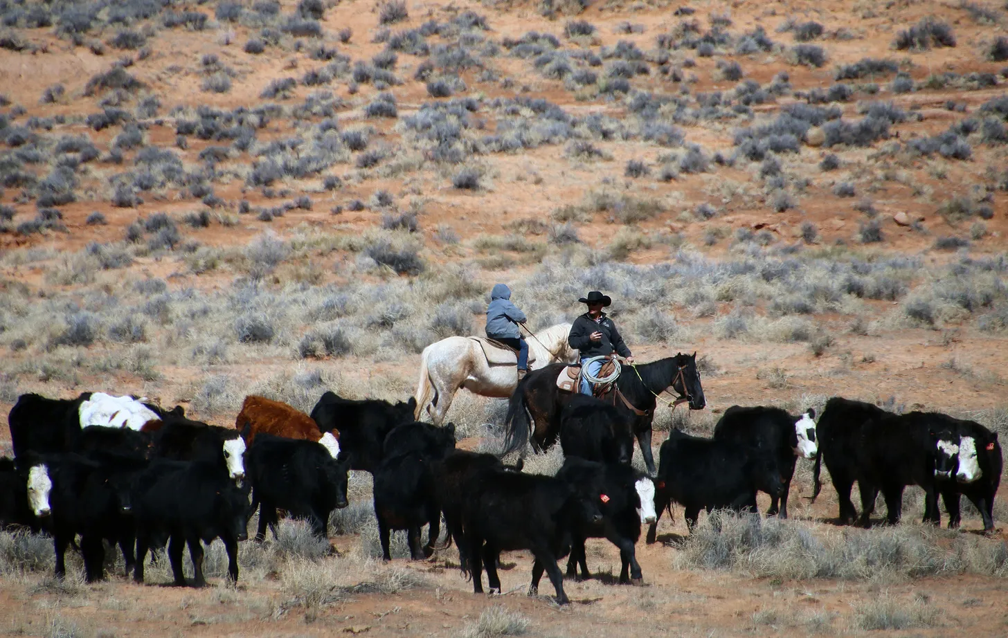
There’s a widespread perception — which is partly accurate — that the folks grazing their cattle on public lands are small-time family farmers who are carrying on a multi-generational tradition and livelihood and producing the nation’s food — even though only about 2% of U.S. beef comes from public lands cows. They’re also sustaining a certain rural culture, i.e. cowboy culture.
Running cattle in Bears Ears National Monument, where grazing will go on largely as it did before the monument was established. Jonathan P. Thompson photo.
Keeping federal grazing fees low, and regulations lax, is therefore a sort of social or cultural subsidy — socialism, if you will. It’s not meant to support the livestock industry, per se, or even food production. Rather, it supports a certain culture. A 1947 amendment to the Taylor Grazing Act appears to codify this concept, directing fees to be set partly according “to the extent to which such [grazing] districts yield public benefits over and above those accruing to the users of the forage resources for livestock purposes.” If you try to raise the fees to match private or state fees, you’ll make ranching too expensive for family ranchers, and make it an exclusive domain for the wealthy and corporations. If you look to make the program pay for itself, you’re monetizing public lands at the expense of rural culture and communities. Or so the argument goes.
For an Obama or Biden, who are already portrayed as coastal elites, to do anything that might be construed as damaging or stifling that culture or livelihood — or devaluing those “public benefits” — does not make for good optics. They instead have used their political capital to (hesitantly) push back against Big Oil, while trying to get folks to forget about grazing.
I’m all for this type of socialism, especially when it’s supporting family farmers, and for pushing back against the notion that public lands programs have to pay for themselves2. I also support the idea of considering public benefits above and beyond the value of the forage or anything else on public lands. But if you do, you also have to consider the public costs of whatever that use is, whether it’s a new trail, an oil and gas well, or a grazing lease renewal. And grazing’s costs on the land and climate can be every bit as high as an oil well or a surge in recreational use.
The Joe Lott-Fish Creek story I opened this piece with also demonstrates that the beneficiaries of the public lands grazing socialism and subsidies aren’t always struggling families. The biggest leaseholder on that allotment, Pahvant Ensign Ranches, is owned by the Ensign Group, which is in turn owned by the Freed and Robinson families. The Ensign Group is a Utah-based investment firm, whose stated mission is to “build and manage a portfolio of primarily real estate-based businesses that are profitable, durable, environmentally sensitive, and of high reputation in their respective fields.”
So, yes, we, the taxpayers, are subsidizing family farmers and ranchers. But our taxes are also helping out the Robinson-Freed families. They are the nation’s 33rd largest landholder, according to the Land Report, and own 350,000 acres in Utah, Idaho, and elsewhere, run more than 10,000 head of cattle, and hold grazing permits on more than 1 million acres of private and public lands.
1 The amount of forage required to feed a cow and her calf for one month.
2 If Elon Musk’s DOGE initiative is honest — and I’m not saying it is — it will seemingly have no choice but to kill the public lands grazing program, since it spends far more money on rangeland improvements (for grazers’ sake) than it brings in from grazing fees.
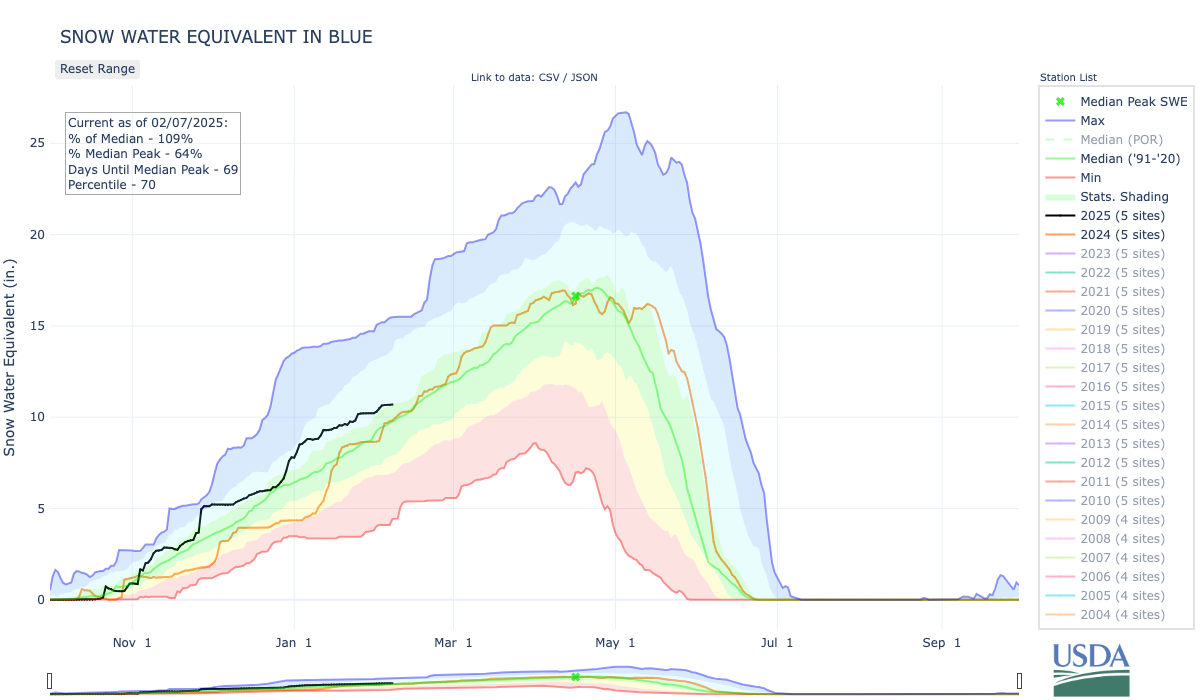
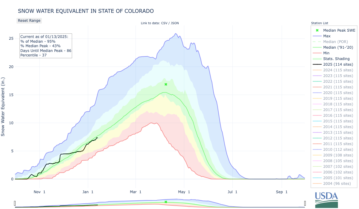
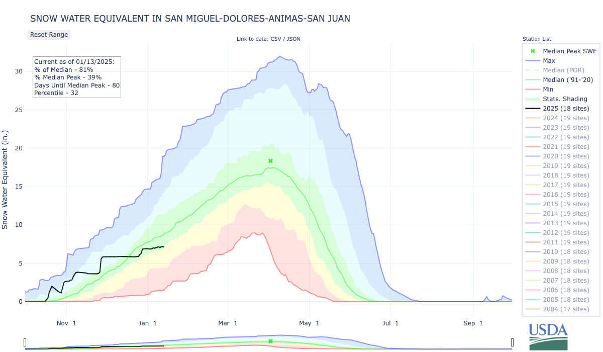
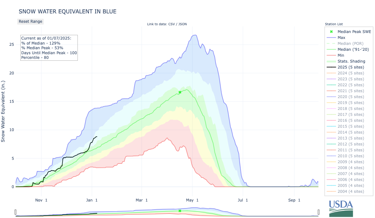
Snowpack levels in the Blue River Basin, which includes all of Summit County, are above normal. This winter’s levels are shown in black, last winter’s levels are shown in orange, the 2022-23 winter is shown in purple and the green line shows the 30-year median, or historic norm. U.S. Department of Agriculture/Courtesy illustration
Click the link to read the article on the Summit Daily website. Here’s an excerpt:
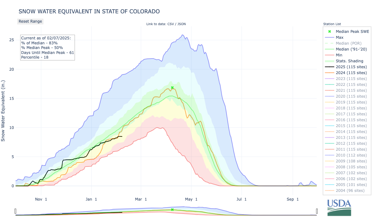
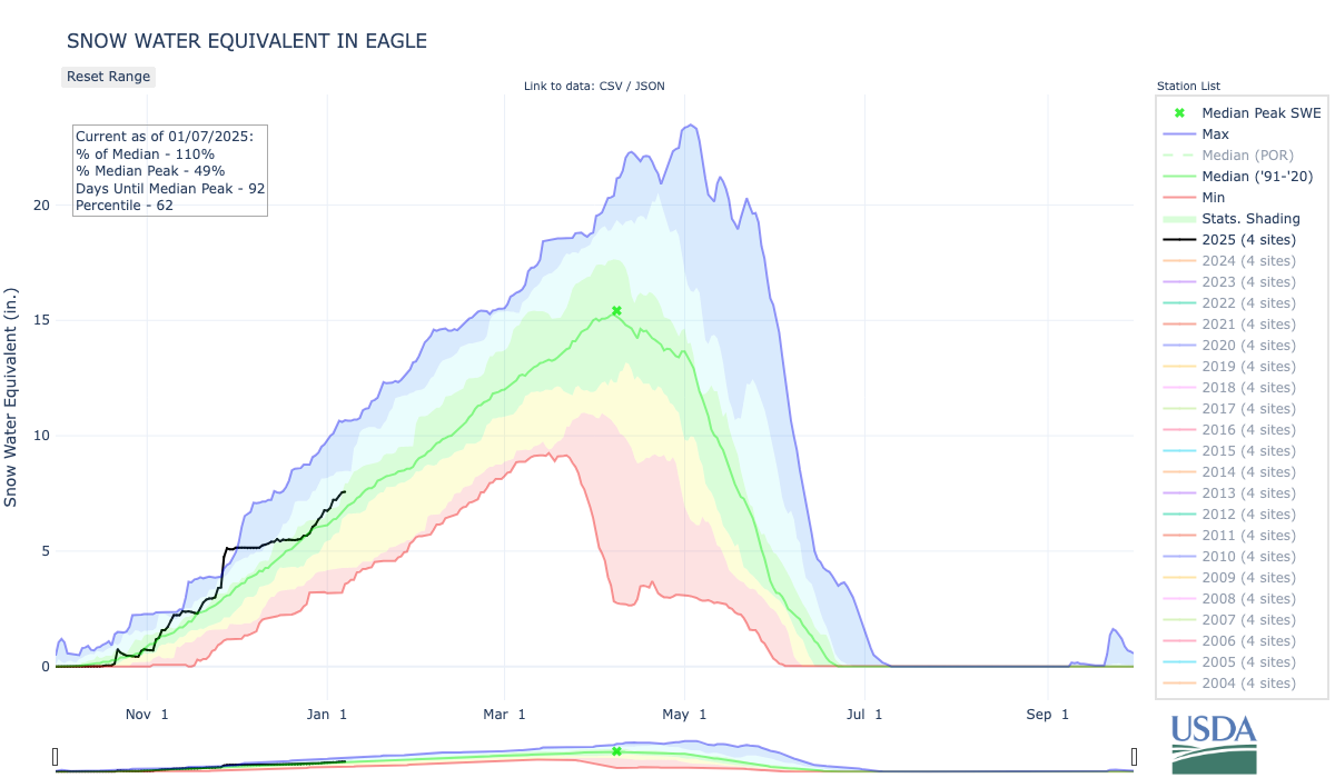
Snowpack levels across the entire state are currently below normal. This winter’s levels are shown in black, last winter’s levels are shown in orange, winter 2022-23 is shown in purple and the green line shows the 30-year median, or historic norm. U.S. Department of Agriculture/Courtesy illustration
While statewide snowpack levels are below normal, areas near Summit County are reporting above-normal levels, as indicated by the green and blue dots. U.S. Department of Agriculture/Courtesy illustration
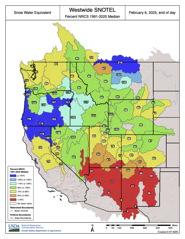
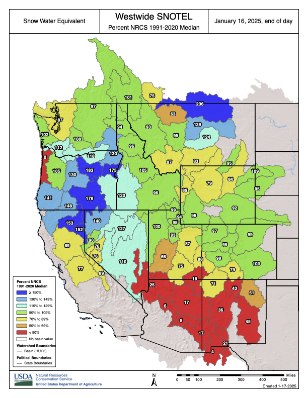
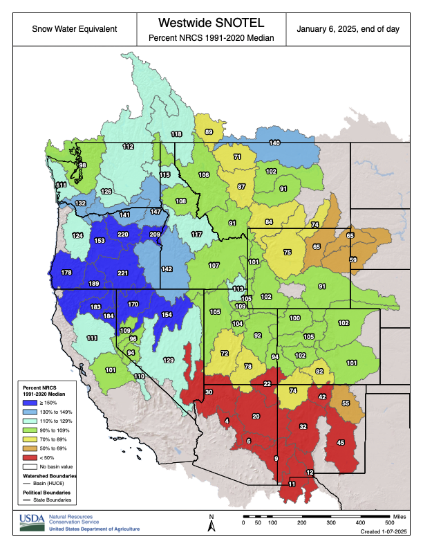
Westwide SNOTEL basin-filled map February 6, 2025 via the NRCS.
The Colorado Basin River Forecast Center (CBRFC) geographic forecast area includes the Upper Colorado River Basin (UCRB), Lower Colorado River Basin (LCRB), and Eastern Great Basin (GB).
Water Supply Forecasts
February 1 water supply forecasts across the CRB and GB are generally below to well below normal and summarized in the figure and table below. Snowpack, soil moisture, and future weather are the primary hydrologic conditions that impact the water supply outlook.
January Weather
Most of January 2025 featured a continuation of the relatively dry, northerly storm track that has dominated the winter season thus far. This pattern continued to favor northern portions of the GB and UCRB, although only limited areas received near to above normal January precipitation. The majority of the CBRFC area was very dry. Many locations in the LCRB have experienced their driest winter to-date on record. Adjacent basins in southern portions of the GB (Sevier) and UCRB (Dolores, San Juan) received near record or record low December–January precipitation amounts.
The large-scale weather pattern changed significantly at the end of January with the development of troughing over the West Coast. This funneled anomalously warm, moist, Pacific air into the Rockies, giving way to heavy precipitation in the northern reaches of the GB and UCRB into early February. Precipitation fell mostly as snow over the critical runoff areas, but given the oceanic origins of the air mass, snow levels became quite high (over 8,000 feet at times). At one point, an NWS employee observed rainfall in the Wasatch at elevations as high as 10,000 feet.
While this welcome pattern change has delivered beneficial precipitation to northern areas, southern portions of the GB, UCRB, and the entirety of the LCRB have yet to pick up any eye-catching precipitation this season. Precipitation is summarized in the figure and table below.
Snowpack Conditions
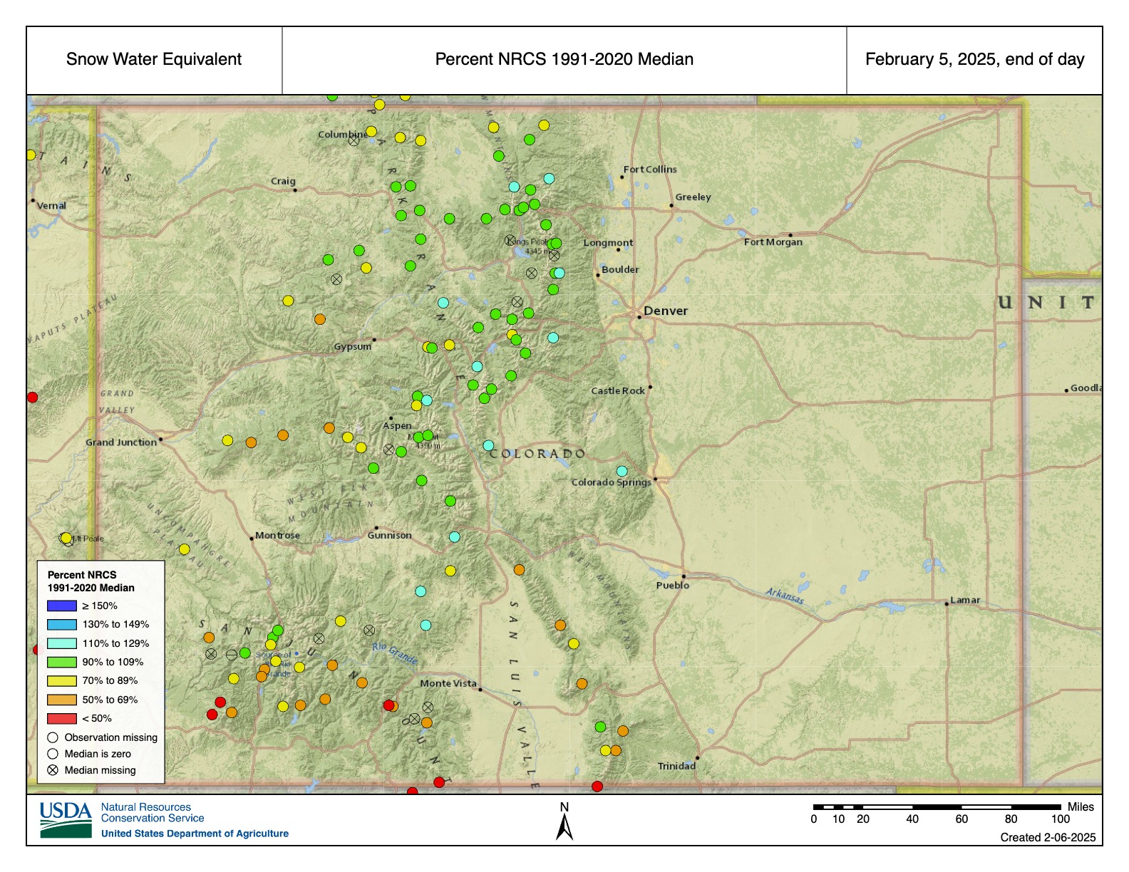
UCRB February 1 snow water equivalent (SWE) conditions range between 55-110% of normal and are most favorable across west-central CO areas including the White/Yampa, Colorado River headwaters, and Gunnison. SWE is below to well below normal elsewhere across the UCRB, with the least favorable conditions in the San Juan River Basin. UCRB February 1 snow covered area is around 65% of the 2001-2024 median. LCRB February 1 SWE conditions are at or near record low across southwest UT, central AZ, and west-central NM as a result of near record dry winter weather.
GB February 1 SWE conditions range between 50-85% of normal and generally improve from south to north. February 1 snow covered area across UT is around 45% of the 2001-2024 median. SWE conditions are summarized in the figure and table below.
Soil Moisture
CBRFC hydrologic model fall (antecedent) soil moisture conditions impact water supply forecasts and the efficiency of spring runoff. Basins with above average soil moisture conditions can be expected to experience more efficient runoff from rainfall or snowmelt while basins with below average soil moisture conditions can be expected to have lower runoff efficiency until soil moisture deficits are fulfilled. The timing and magnitude of spring runoff is impacted by snowpack conditions, spring weather, and soil moisture conditions.
A very dry June-October 2024 across southwest WY and UT resulted in soil moisture conditions that are below normal and worse compared to a year ago. NW CO soil moisture conditions are near to below normal and similar compared to a year ago. SW CO soil moisture conditions are closer to average and improved from a year ago due to a wetter than normal monsoon (mid-June through September). Monsoon precipitation was near/below normal across the LCRB, where soil moisture conditions are below average and similar compared to last year. CBRFC hydrologic model soil moisture conditions are shown in the figures below.
Upcoming Weather
The atmospheric river regime that arrived at the end of January is continuing into the first week of February. After a lull, confidence is growing in the return of a productive, southerly storm track around the middle of the month. The Climate Prediction Center’s (CPC) 8–14 day precipitation outlook is favoring increased chances of above normal precipitation across the western US during the February 14 20 period. It remains unclear where the focus of moisture will land, but it will likely benefit at least some portions of the CBRFC area. The best hope for the LCRB is that a series of storms tracks far enough south to soften the seasonal deficits. If that does not occur, the LCRB is well on its way to a record, or near record, dry season.
The Trumpster Rebellion – is it organized enough to call it a ‘Revolution’? – is making itself felt in the Colorado River Basin at this point by the hold being put on all federal funding from the two big infrastructure-related acts of the Biden administration. This included funding for the Upper Basin’s System Conservation Pilot Program, to pay farmers to leave some of their decreed water to flow down (it was hoped) to Powell Reservoirs; I believe it also included some of the money being used in the Lower Basin to pay farmers to leave a three million acre-feet of decreed water in Mead Reservoir for Water Years 2024-26. This is nothing ‘personal’ against Colorado River management; it is just collateral damage caught up in the president’s general vendetta against any achievement by the Biden administration.
We’ll see how all of this shakes out in the next few weeks, I guess, or months or years, as the legality or constitutionality of all this is worked out. On the cosmic justice level – Water Year 2025? The forecasters are saying, again, don’t get your hopes too high. But hope, that ‘thing with feathers,’ flies above that; surely we’re ripe for snow now after the longest, coldest, driest December and January in recent memory….
Members of the Colorado River Commission, in Santa Fe in 1922, after signing the Colorado River Compact. From left, W. S. Norviel (Arizona), Delph E. Carpenter (Colorado), Herbert Hoover (Secretary of Commerce and Chairman of Commission), R. E. Caldwell (Utah), Clarence C. Stetson (Executive Secretary of Commission), Stephen B. Davis, Jr. (New Mexico), Frank C. Emerson (Wyoming), W. F. McClure (California), and James G. Scrugham (Nevada)
CREDIT: COLORADO STATE UNIVERSITY WATER RESOURCES ARCHIVE via Aspen Journalism
Meanwhile, back in the bigger, longer picture…. In the last post, trying to heist myself up at least onto the edge of the ‘Compact Box’ – the box outside of which I think we all need to try to think, if only as a creative exercise – I raised the question: might it not be possible now to do what the seven Compact commissioners really wanted to do in 1922, when they gathered in Washington the last week of January, with U.S. Commerce Secretary Herbert Hoover?
Remember – they had come together to try to free themselves from an interstate appropriation competition over use of the waters of the Colorado River, by effecting what their Compact preamble called an ‘equitable division and apportionment of the use of the waters … to promote interstate comity (and) remove causes of present and future controversies.’
This was not strictly a ‘peace-making’ gathering; they knew they had to come to some kind of an agreement among themselves about the use of the river’s waters before the U.S. Congress would consider funding to ‘secure the expeditious agricultural and industrial development of the Colorado River Basin’ – the last goal listed in the Compact preamble, but it was probably first in their minds. Only the federal government had the resources and the authority to build the big structures necessary to store and deliver the interstate river’s water to the states, really unleashing development of the water, at least half of which was still being ‘wasted’ to the ocean in the annual spring floods of snowmelt.
So they spent the first three days of their Washington meetings in an ultimately frustrating attempt to calculate an ‘equitable’ seven-way division of the use of the waters, to avoid a seven-way appropriation horse-race between fast-growing states like California, already at the first turn, while slower-growing states like Wyoming were still trying to get out of the starting gate.
They were stymied in that effort – almost to the point of abandoning the idea of a compact. In the manner of early 20th-century Americans, enough water for all the optimistic future visions they all brought from their home states tallied well beyond even the Bureau of Reclamation’s overly optimistic guesstimates for the flow of the river – then in its ‘pluvial’ period of high flows, peaking even as the commissioners were working in 1922.
Only Chairman Hoover’s leadership skills – and his desire (an engineer by training) to see the big structures built – kept them from abandoning the idea of a compact in January. But he wasn’t able to get them back together for serious work until November 1922, when they convened for a do-it-or-drop-it retreat at a resort near Santa Fe to consider a new idea hatched between Hoover and Colorado Commissioner and water lawyer Delph Carpenter.
Map credit: AGU
In 18 transcribed meetings over 11 days, and who knows how many pre-meeting breakfast caucuses and post-meeting saloon and suite connivances, they assembled the Colorado River Compact that divided the Basin into a four-state Upper Basin above the river’s major canyons and a three-state Lower Basin below the canyons, each of which would get half of the river’s mainstem water to further divvy up in their own good time.
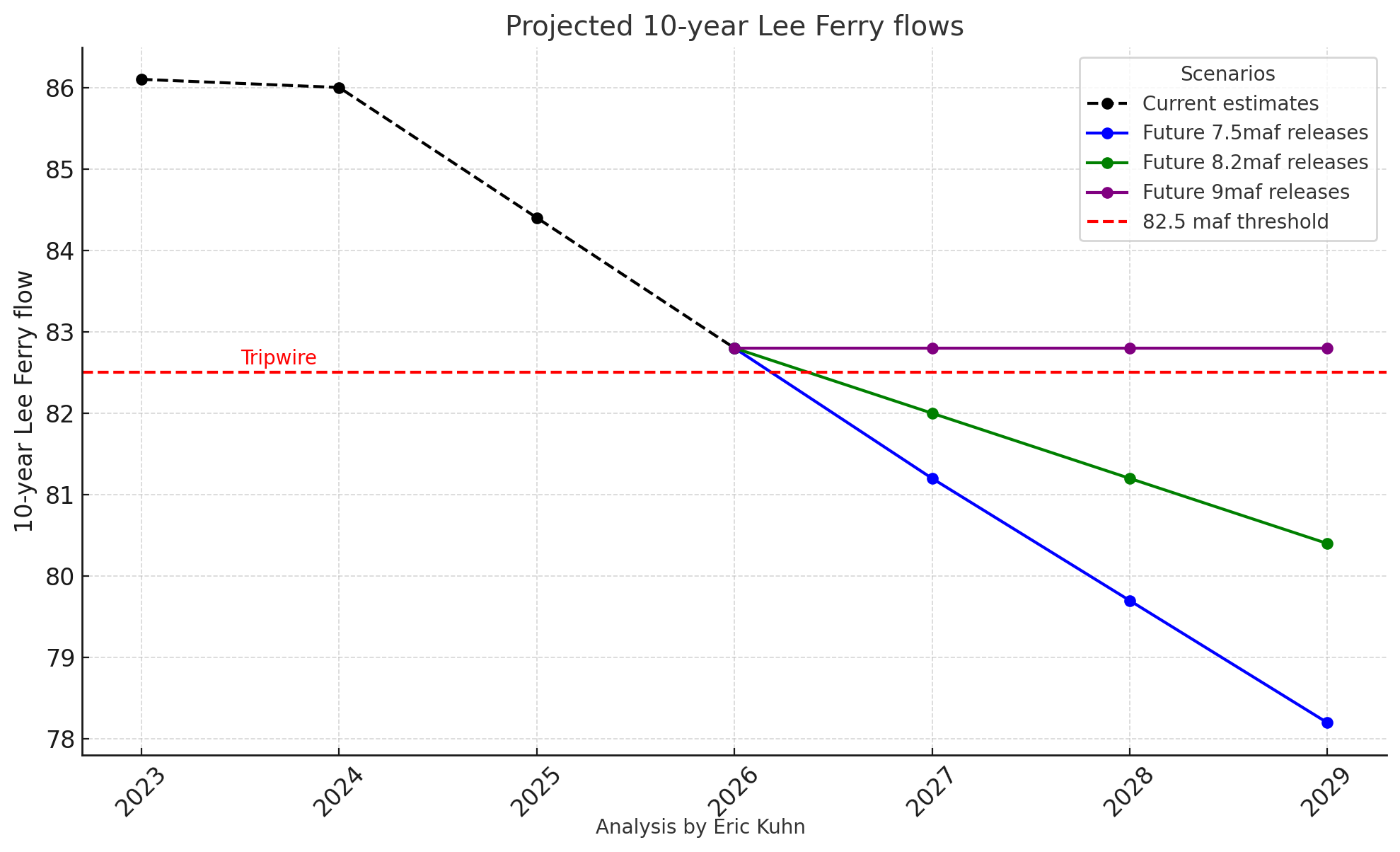
A hundred years later, we can see that this did very little, even at that time, ‘to promote interstate comity (and) remove causes of present and future controversies’ – Arizona would not even ratify it at the time, and it took several years for the other six states to ratify it since the mathematics of only 7.5 maf precluded some of their grand visions. And it didn’t take long for the Upper Basin states to realize that their 7.5 million acre-feet ‘half’ of the diminishing post-pluvial river was probably not there – yet the Compact committed them to making sure the Lower Basin got its ‘half.’ To halve, and have naught.
The U.S. Congress, on the other hand, was generally eager to see the river developed as part of the ongoing national drive to see the nation’s lands settled by farmers and unsettled by miners – metal miners, fuel miners, tree miners, grass miners – developing the nation’s resources, and in 1928 passed the Boulder Canyon Act that set in motion construction on Hoover Dam, the Imperial Weir Dam, and the All-American Canal – a trifecta that was completed during the Great Depression years, and by the eve of the Second World War, was turning Southern California into an economic powerhouse of wartime industry.
The Boulder Canyon Act also set the allotments for each of the Lower Basin states: 4.4 maf for California, 2.8 maf for Arizona, and 300 kaf for Nevada (most of whose development was on the Sierra side of the state, very little along its short Colorado River border). Arizona immediately sued California over those allotments, and the two states were in and out of court over that until Supreme Court decisions in 1963-64 affirmed the Compact numbers for the use of water in the river’s mainstream, but granted Arizona, and the Lower Basin states in general, full use of tributaries entering below Lee Ferry, the Upper-Lower division point, outside of mainstem accounting for the water everyone hoped would go past Lee Ferry.
Receding waters at Lone Rock in Lake Powell illustrate the impacts of megadrought. Hydroelectric generation will be endangered if the lake continues to shrink. Credit: Colorado State University
The Lower Basin – abetted by the Bureau – persisted in believing that there was enough water in the river so that they could continue to write off their system losses and their half of the Mexico obligation to ‘surplus water.’ They maintained this fiction until, the early 2020s, it became obvious that they were just depleting the reservoirs. They appear to be willing now to accept that their substantial system losses have to be taken out of their share, although agreement persists in how that should happen.
The Compact obligation means that the Upper Basin states were already absorbing their losses – along with absorbing the full brunt of nature’s variability while the Lower Basin got its water regardless of Upper Basin problems. The river itself had gone from its pluvial glory of the first quarter of the century into what was its most serious dry spell until the present one; and the worst fears of the Upper Basin water managers were confirmed: there would probably only occasionally be 7.5 maf of water for them after they passed the Compact obligation on to the Lower Basin.
After World War II, the Upper Basin knew it was their turn for some development work; but first they had to create their own compact for dividing their share of the water – whatever it was. The did this between 1946 and 1948, but they did not even bother to do a four-way division in acre-feet of their alleged 7.5 maf. Instead they did percentages of whatever water they would get after meeting the Compact obligation. Still hoping, like the Lower Basin, that there would be enough ‘surplus’ – above and beyond the 15.0 maf Compact division – to handle the Mexican allotment of 1.5 maf negotiated during WW II. There’s a complex story there too, but not today.
Graphic via Holly McClelland/High Country News.
The percentages they created for their individual shares were: 51.75% for Colorado (providing 60-70% of the river’s water), 23% for Utah, 13% for Wyoming, and 11.25% for New Mexico. Their completion of the Upper Colorado River Compact in 1948 allowed the Bureau of Reclamation and its advocates in Congress – led by Wayne Aspinall from Colorado’s West Slope – to begin the process of passing the Colorado River Storage Project. This was no longer a slam dunk for the Bureau, due to a shift in the urbanizing industrialized public, from regarding the West as raw resources, to thinking of it as a source of vacation wonder and outdoor recreation. This in turn shifted the romantic vision of the river from pedal-to-the-metal development to… environmental awareness. As America got wheels and gauranteed vacations and took to the roads, Theodore Roosevelt’s brand of conservation – respectful use without waste – shifted toward preservation of natural aesthetics. But the residual momentum of development eventually got the CRSP Act passed in 1956, and several large projects and a host of small irrigation project eventually got built. At which point, by the early1970s, not only were nearly all of the good dam sites occupied by a dam, but the Bureau began to worry that much more reservoir development would reach the point where evaporation losses were prohibitive.
By the turn of the 21st century, Justice Greg Hobbs of the Colorado Supreme Court could say publicly: ‘We have developed the resource; now we have to learn how to share it.’ Some of the readers here will remember Greg Hobbs – a poet/philosopher as well as a fine water lawyer. In this context, a poet who tried to imagine the peace the river and its users need.
Do you get the sense that, by now, a century after the Compact, with everyone in agreement that the river is not only committed but probably over-committed – we might be able to finally do the seven-way division of the waters the Compact commissioners originally wanted to do? With all seven states reluctantly, grudgingly, accepting the fact that a) the water they’ve been getting in recent years is as much water as they will ever be getting – and that b) the river flows will almost certainly be gradually declining over the rest of the century, since we are doing next to nothing to address the problem causing the decline.
How do we share this?
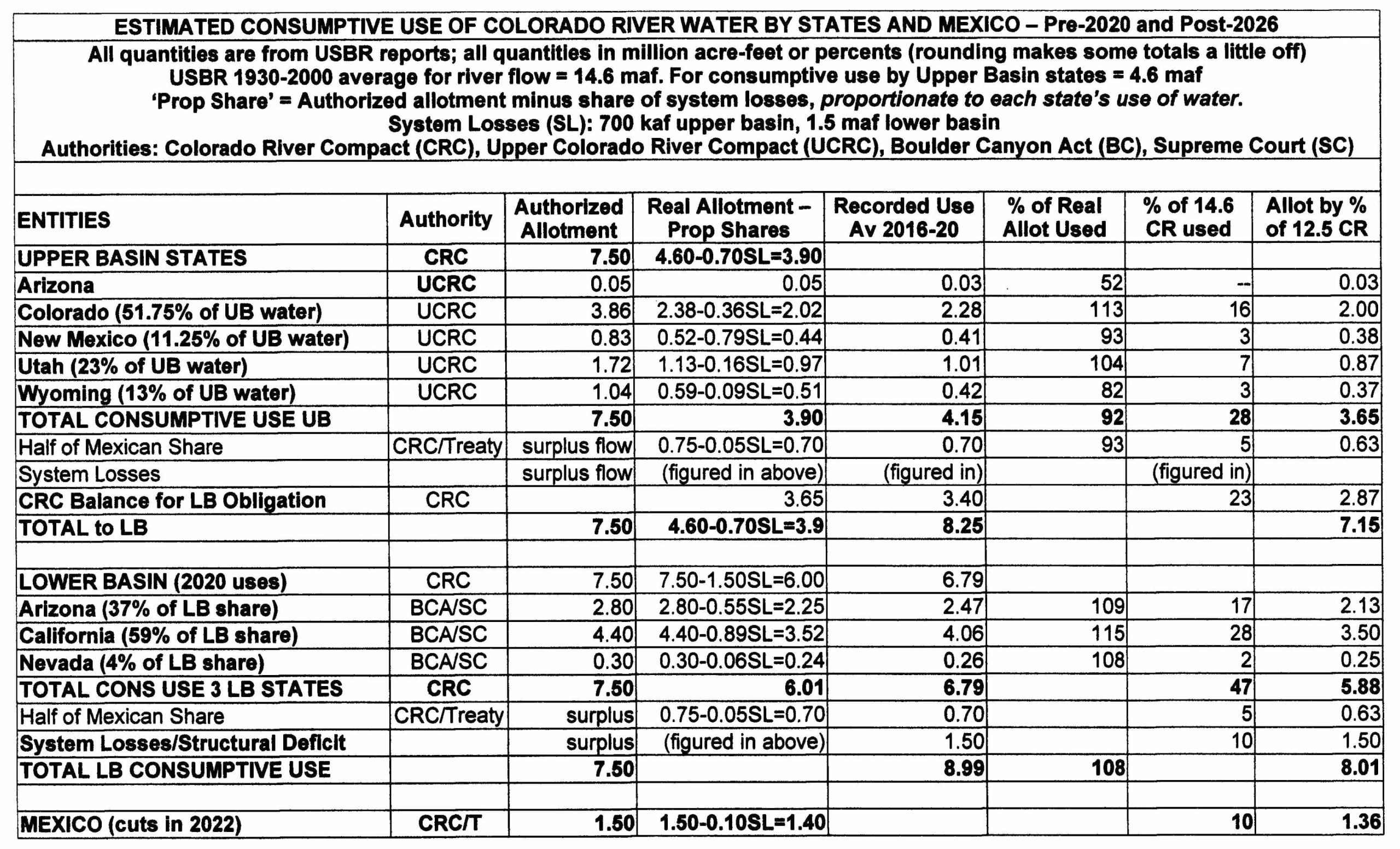
We can set it up in a table, with numbers taken from Bureau records. I know there will be disagreements over the rough calculations herein, but they will be modest differences that should not undermine the validity of the attempt – which is an attempt to say, peace, brothers, there’s nothing left to fight over; the fight is all shadow-boxing with ourselves from here on out…. Here is the table, explained below. Click on the table to get an enlargable version:
The first two columns are pretty sef-explanatory – the states in each Basin, and the authority setting their allotment for consumptive use of the Colorado River.
Third column: The allotment of the river’s water decreed to each state by the Colorado River Compact. With the river guessstimated to be running almost 18 maf/year, it was assumed that surplus flows above the allotted 15 maf would be sufficient to cover Mexico’s share and system losses (evaporation, riparian growth, et cetera).
Fourth column: The average real allotment each state got for the run of the post-Compact 20th century, minus a share of the system losses proportionate to their calculated allotment. The average flow of the river for that period ws 14.6 maf. The Lower Basin got its full Compact allotment, thanks to Article 11(d) of the Compact, while the Upper Basin calculated its ever-varying allotments in percentages of what was left after the Lower Basin obligation was discharged.
Fifth column: The measured (with some guesstimating) actual consumptive use of the river by each state and Basin circa 2020 (before the Panic of 2022).
Sixth column: The percent of theirreal allotment (Column 4) that each state actually used. Column 5 quantities divided by Column 4 quantities. We see that Colorado and Utah in the Upper Basin and all the states in the Lower Basin have used more than their allotments when system losses are factored in, while Wyoming is well below its allotment (a situation that may be changed by current discussions concerning the Little Snake River). But for this rough analysis, those numbers are what we will use fior projecting forward.
Seventh column: The percent of the total 14.6maf ‘20th-century’ river that each state was using consumptively. Given the diminishing flows of the river, a fair and just system for allotments for the post-2026 era would be these percentages for all states and Mexico. The sharing-out of a diminishing river should not, would not in a moral society, be done through appropriation seniority; if anything, the seniors who have been using the river longest should maybe bear the larger responsibility. The Upper Basin alone does not ‘cause the flow to be depleted’; every user, and the society in general all cause that depletion; justice decrees that the resulting pain should be shared by all, proportionate to the their use. (Greg Hobbs might not agree – wish he were here to ask.)
Eighth column: What these percentages would mean when applied to the 12.6 maf average flow of the river since 2000. Read’em and groan.
Final note, on the First People water rights: Thanks to the McCarran Amendment, those must be dealt with – and are being dealt with – at the state (and in some cases interstate) level, some through court decrees, but most of them through negotiated settlements (unfortunately requiring the approval of our dysfunctional Congress). The Upper Colorado River Commission recently committed to making sure this happens for Upper Basin nations.
And that is enough for this post, wouldn’t you say? I expect to hear a few cries of outrage that we should try to face reality in a fair and just manner.
Lincoln Creek was orange just downstream of the mineralized tributary in July 2024. A team of scientists from the University of Colorado Boulder found that a mineralized tributary is also contributing rare earth elements to Lincoln Creek, in addition to other metals like aluminum. Credit: HEATHER SACKETT/Aspen Journalis
Recent sampling shows that a high-alpine tributary of the Roaring Fork River, in addition to having high concentrations of certain metals, also contains rare earth elements. But what that means for human and aquatic health is unclear.
Scientists from the University of Colorado Boulder presented the preliminary results from water-quality sampling on Lincoln Creek over last summer at a public meeting hosted by the Roaring Fork Conservancy at the Basalt Regional Library on Thursday.
Occupying a lesser-known corner of the periodic table, rare earth elements (which, despite their name, are commonly occurring in Earth’s crust) are a set of 17 heavy metals that are used in making products such as cellphones, fiber-optic cables and computer monitors. With names such as yttrium, lanthanum and neodymium, they often turn up at sites in Colorado where there is acid rock drainage, such as upper Lincoln Creek.
“You get a phone’s worth of neodymium coming down the mineralized tributary about every 5½ minutes,” said Adam Odorisio, a graduate student and researcher at CU’s environmental engineering department. “This translates to 96,000 phones per year. And what I think is the most striking fact in this is that this is for one tributary. You multiply this across hundreds of acid mine sites in Colorado and potentially thousands across the Western U.S. and it’s very exciting for resource extraction.”
CU scientists are also monitoring other high alpine acid rock and mine drainage sites in Colorado, including the Snake River. Odorisio said the concentrations of rare earth elements in a mineralized tributary that feeds Lincoln Creek was in the middle of the pack when compared to other sites around the state.
Twin Lakes collection system
In addition to the potential for mining valuable rare earth metals, scientists are eager to learn more about their impacts to human health and aquatic environments. There are no state or federal water quality standards for rare earth elements. Lincoln Creek is a source of drinking water for Front Range cities, including Colorado Springs.
“This is just wide open as an unknown area,” said Diane McKnight, a professor at CU’s Institute of Arctic and Alpine Research. “It’s not clear that it’s something to worry about here. The water from (Lincoln Creek) that goes into the Twin Lakes system is highly diluted.”
Over nine days from June through October, the CU team collected 79 water samples from eight sites, took sediment core samples from the Grizzly Reservoir lakebed, and collected rock scrapings and bugs from the waterway. Early results also confirmed what the Environmental Protection Agency found in previous water-quality tests: The water is highly acidic, and concentrations of metals including zinc, copper and aluminum exceed standards for aquatic life. Scientists found that a groundwater source could also be adding metals to Lincoln Creek. They are still analyzing the data and plan to present more results at a spring meeting.
“For the greater scientific community, the fate of rare earth elements in aquatic systems is not well understood,” Odorisio said. “We are hoping to change that.”
The headwaters of Lincoln Creek upstream from the Ruby Mine and mineralized tributary. Recent water sampling by scientists from the University of Colorado Boulder found rare earth elements in the creek downstream, but implications for human health and aquatic impacts are unclear. Credit: HEATHER SACKETT/Aspen Journalism
The results may be of use to the Lincoln Creek workgroup, an ad hoc group – composed of officials from Pitkin County, Colorado Parks and Wildlife, the U.S. Forest Service, Colorado Department of Public Health and Environment, Independence Pass Foundation, Roaring Fork Conservancy and others – that is trying to understand how contaminants are impacting Lincoln Creek and the Roaring Fork River. The group has hired consultants LRE Water to compile water-quality data collected by several different agencies last summer and propose options to clean up the waterways.
“The rare earth metals is a group we haven’t really thought through,” said Kurt Dahl, Pitkin County’s environmental health manager. “That’s one of the things that we are talking through with the contractor, LRE Water.”
The water quality of Lincoln Creek has been under increased scrutiny in recent years as fish kills and discoloration of the water downstream of Grizzly Reservoir have become more frequent. In July, reservoir owner and operator Twin Lakes Reservoir & Canal Co. drained the reservoir for a planned dam-rehabilitation project, releasing an orange slug of sediment-laden water from the bottom of the reservoir downstream. Testing showed that the water had high levels of iron and aluminum, but not copper, which is toxic to fish.
An EPA report in 2023 determined that a “mineralized tributary,” which feeds into Lincoln Creek above the reservoir near the ghost town of Ruby, is the main source of the high concentrations of metals downstream.
Prior to mining, snowmelt and rain seep into natural cracks and fractures, eventually emerging as a freshwater spring (usually). Graphic credit: Jonathan Thompson
The process that causes metals leaching into streams can be both naturally occurring and caused by mining activities. In both cases, sulfide minerals in rock come into contact with oxygen and water, producing sulfuric acid. The acid can then leach the metals out of the rock and into a stream, a process known as acid rock drainage. The contamination from acid rock drainage seems to be increasing at other locations around Colorado and may be exacerbated by climate change as temperatures rise.
The recent water-quality-testing effort on Lincoln Creek is probably just the beginning of a long-term data-collection and monitoring program, Dahl said.
“I think there’s still a lot of energy around this,” Dahl said. “People are really invested in this, and it’s going to take a couple of years to get it characterized.”
Aspen Journalism, which is solely responsible for its editorial content, is supported by a grant from the Pitkin County Healthy Community Fund.
Click the link to read the article on the Land Desk website (Jonathan P. Thompson):
January 28, 2025
In the closing days of the Biden administration, the U.S. Geologic Survey released its National Water Availability Assessment Report, which is a whopper of a study not only on how much water Americans use and for what, but also on the quality of that water and whether and by how much demand is exceeding supply.
Most of what it says won’t be too surprising to Land Desk readers. Demand exceeds supply in swaths of the Southwest, and climate change threatens to exacerbate the imbalance. Irrigated agriculture is by far the biggest water guzzler nationwide, with Western farms consuming more than those in any other region. Municipal water consumption is staying fairly flat, even as populations increase. Thermoelectric power plants withdraw massive amounts of water, but then return much of it to the water body, keeping consumptive use relatively low.
I’m not going to try to sum up the report for you, though. Rather, I’ll give you a few of the more interesting morsels of data and maps and charts from the assessment, in no particular order, and you can make of them what you will.
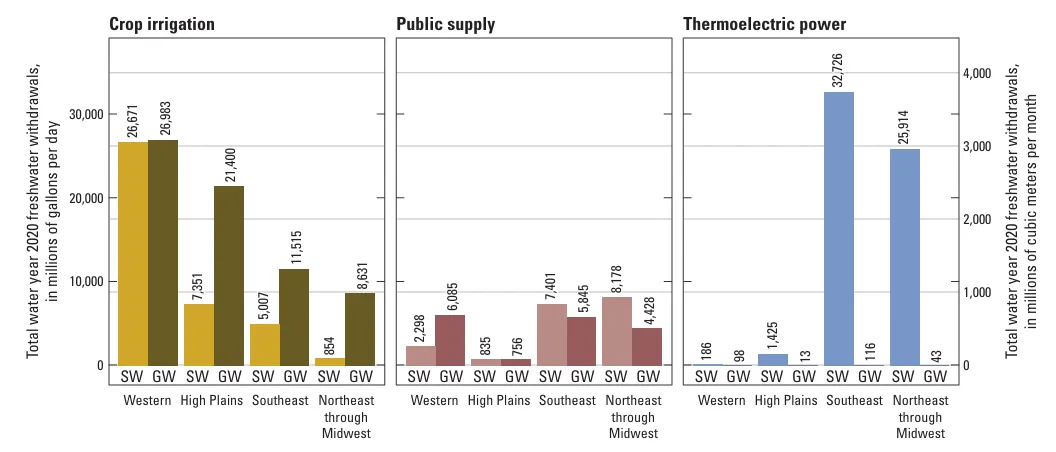
This little chart sums up most of the consumption part of the report. The most surprising thing to me about this was that, in the West, groundwater withdrawals in equal or exceed surface water withdrawals for irrigation and public supplies. That means that for every gallon sucked out of the Colorado River or its tributaries, there’s roughly another gallon being pumped up from wells — and in a lot of places, like parts of Arizona, groundwater use isn’t monitored or regulated. Note that these are withdrawals, not consumptive use (which is the difference between withdrawals and water that is returned to its source). Source: USGS
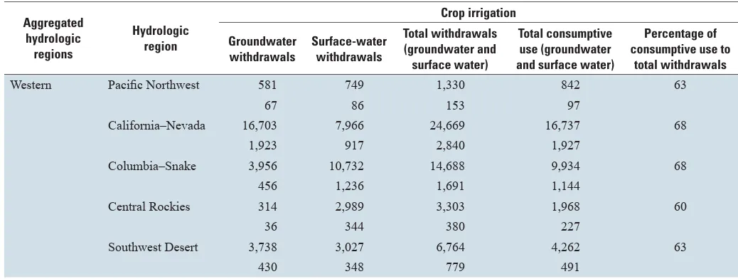
This is a more detailed breakdown of agricultural water use in the West. The top number in each area is millions of gallons per day; the bottom number is millions of cubic meters per month. Notice that about 60-70% of total withdrawals are counted as consumptive use, with the remainder being returned to the water system as runoff. Source: USGS
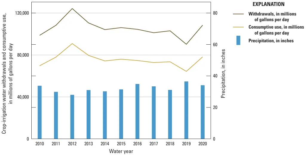
This is a good one because it clearly shows the effects of drought on water consumption, i.e. we tend to use more water when there’s less of it available.
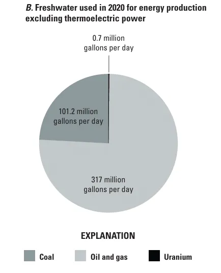
In this assessment, the USGS looked at how much water is used for coal and uranium mining and hydraulic fracturing oil and gas wells. They found that in 2020, fracking used about 317 million gallons per day. Since then drilling has increased, especially in the arid Permian Basin, so those numbers have likely shot up as well.
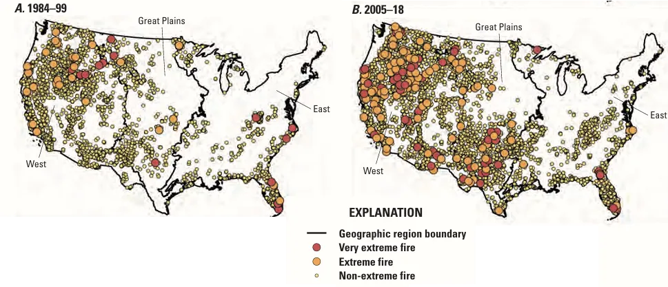
This is a striking one from the climate change chapter, showing how the number of extreme and very extreme fires has grown over time.
This is a striking one from the climate change chapter, showing how the number of extreme and very extreme fires has grown over time.
This is just a small sampling of what’s in the assessment. If you want to read more, check it out here.
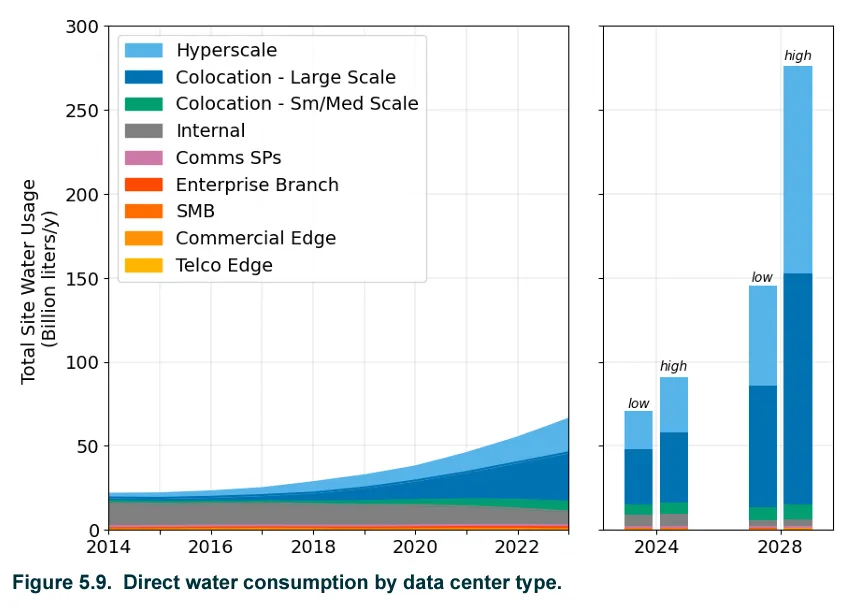
The USGS assessment doesn’t break out data centers’ water use, but I imagine if the agency survives the current administration intact, it may get there in a decade or so. The computer processing centers suck up massive amounts of electricity to process those Google searches, Facebook posts, Twitter rants, and, especially, AI queries — not to mention for “mining” cryptocurrency. Less known is that they also can use large quantities of water to keep the processors cool.
A new report out of the Berkeley Lab is mostly focused on quantifying current and forecasting future energy use by data centers. But it also talks water. And the numbers are alarming: In 2023, U.S. data centers directly1 consumed about 66 billion liters (or 17.4 billion gallons) of water. The report’s authors expect that figure to double — at least — by 2028.
Hyperscale data centers are the type that power AI. Source: 2024 United States Data Center Energy Usage Report, by Arman Shehabi et al, Lawrence Berkeley National Laboratory, December 2024.
That is a crap-ton of water, for sure, especially given the large number of data centers located in the Phoenix and Las Vegas areas, neither of which has a lot of liquid to spare. But some perspective is warranted here. As Len Necefer points out in an All At Once By Dr. Len dispatch warning against AI-alarmism, data centers still use a heck of a lot less water than, say, growing hay or fracking oil and gas wells.
66 billion liters is 53,507 acre-feet (sounds a lot less alarming, yeah?). For some context, alfalfa and other hay growing in the Great Salt Lake Basin alone consumes about 900,000 acre-feet per year, and hydraulic fracturing gulps up about 353,000 acre-feet (a little over Nevada’s total allotment of Colorado River water) annually.
I’m still frightened by the invasion of the data centers, however. In his last days in office, Biden signed an executive order opening up federal sites and public land to new AI data centers and accompanying “clean” energy installations (which includes nuclear and even natural gas and coal, so long as they capture carbon). And Trump is now encouraging data center developers — i.e. tech-broligarchs like Musk and Bezos — to burn coal to power their AI bots (and Trump and Melania both issued their own cryptocoins).
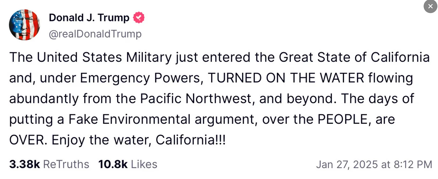
Look, I don’t like writing about Trump any more than you like reading about him. Believe me. But he is the president, and the things he does and says sometimes have consequences. He also just makes stuff up. Like this “Truth” Social post:
Whaaaaaaat!?! I guess all that water assessment stuff is irrelevant, now, eh? I mean, here we’ve all been fretting about the Colorado River, and little did we know that Trump could make it all irrelevant by sending the military in to turn some valve somewhere and deliver all the water from the Pacific Northwest directly to the fire hydrants of L.A.
The first person who sends me a genuine picture of the giant faucet and who can mark on a map where the military turned the water on and where the pipelines or canals that carry it go gets a free Land Desk t-shirt.
But, in all seriousness, as Dr. Genevieve Guenther pointed out on her BlueSky social media feed, it’s kind of scary what’s being implied here (aside from the pure fabrication): A president is suggesting sending the military into a blue state to force his policy preferences on them. Not good.
And, finally, even the commissioners of Garfield County — or at least two out of three of them — realized it was a really bad idea to rename the Burr Trail after Trump. After a heated public hearing, they voted not to name any road in the county after him, for now.
The Burr Trail as it approaches the western boundary of Capitol Reef National Park. Jonathan P. Thompson photo.
This hayfield near Rifle is irrigated with water from a tributary of the Colorado River. The future of Colorado River management is almost guaranteed to include a conservation program for the Upper Basin. CREDIT: HEATHER SACKETT/ASPEN JOURNALISM
After years of studying and experimenting with pilot programs, the future of Colorado River management will almost certainly include a permanent water conservation program for the Upper Basin states.
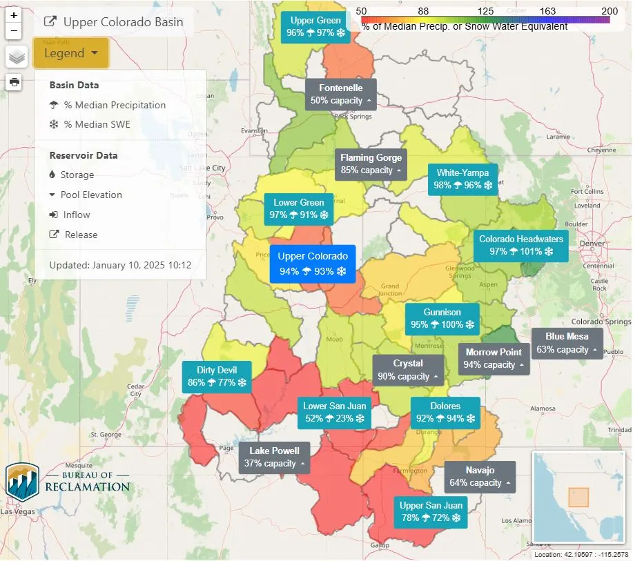
Upper Basin officials have submitted refinements to their March 2024 plan for how water should be released from Lake Powell and Lake Mead, and how shortages should be shared after the current guidelines expire in 2026. In it, they offer up the potential for up to 200,000 acre-feet per year of water conservation.
“The kind of conservation activities, I think the exact contours of that and how that would work, all that is yet to be determined,” said Amy Ostdiek, chief of the interstate, federal and water information section of the Colorado Water Conservation Board. “But conservation activities across the Upper Division states, in one way or another, I think, will likely continue.”
The proposal by the Upper Basin states (Colorado, New Mexico, Utah and Wyoming) now includes two water-savings accounts in Lake Powell. One is a Lake Powell Conservation Account that will store up to 200,000 acre-feet per year from conservation and from quantified and settled but unused tribal water. The second, a Lake Powell Protection Account, would store water released from upstream reservoirs — Flaming Gorge, Navajo and Blue Mesa — when Lake Powell drops below 3,535 feet in elevation.
These pools would be part of what the Upper Basin is calling “parallel activities,” and details would be hammered out in agreements separate from the new reservoir operation guidelines, which the seven Colorado River basin states are negotiating. Conservation is based on each year’s hydrology, with more water saved in wet years.
For the past several years, Upper Basin officials have pushed back on the notion that their states should contribute to cutbacks in water use since their water users already suffer shortages in dry years and the four states have never used their entire allocation of the river, while the Lower Basin (California, Arizona and Nevada) overuses its share. At the same time, however, the Upper Basin has been exploring programs that would pay water users to cut back. These programs include the System Conservation Pilot Program and the state of Colorado’s study of a demand management program.
In March, each basin submitted to the U.S. Bureau of Reclamation competing proposals for future river management, with the Lower Basin calling for cuts to be shared by the Upper Basin under the most critical conditions. For months, each basin dug in their heels, saying their alternative was best. The result was a stalemate when talks ground to a halt by the end of the year.
According to state officials, representatives of the seven basin states have recently resumed talks.
“I’m happy to report that the seven states are continuing discussions,” Becky Mitchell, a commissioner to the Upper Colorado River Commission and who represents Colorado in talks among the seven states, said at the Colorado Water Congress annual convention Thursday in Aurora. “We are working hard to identify potential areas of consensus.”
Colorado River expert and author Eric Kuhn said the Upper Basin’s proposal for the two water savings pools in Lake Powell is a sign of optimism.
“I kind of see it as a change in tone and putting something on the table that is closer to the Lower Basin’s proposal,” Kuhn said. “That seems like fairly significant progress to me.”
The watchwords for these types of conservation programs have always been “temporary, voluntary and compensated.” But in the face of a hotter, drier future with less water to go around, officials are acknowledging the inevitability of a more permanent Upper Basin water-conservation program.
“I think it’s almost guaranteed,” said Amy Haas, executive director of the Colorado River Authority of Utah.
Navajo Bridge spans the Colorado River downstream from Lake Powell near Lee Ferry, the dividing line between the upper and lower basin. Upper Basin officials have proposed up to 200,000 acre-feet of water conservation a year in Lake Powell. Photo credit: Aspen Journalism
Western Slope concerns remain
Paying water users to cut back is not a new concept in the Upper Basin.
In 2023, using federal money from the Inflation Reduction Act, the Upper Basin states rebooted the System Conservation Pilot Program, which first took place from 2015 to 2018. Over two years, the program saved 101,000 acre-feet of water at a cost of $45 million. SCPP has been criticized for a lack of transparency, for not tracking conserved water to Lake Powell and the high cost.
And although all water-use sectors — including agriculture, cities and industry — were invited to participate, in practice all the participating water users in the state of Colorado were Western Slope irrigators.
This disproportionate participation by one area of the state and the potential harm it could cause to rural agricultural communities has long been something the Glenwood Springs-based Colorado River Water Conservation District has warned against. The district, which leads in the protection, conservation, use and development of water across 15 Western Slope counties, had sought to play a role in setting criteria and approving applications for the SCPP. But in the end, the Upper Colorado River Commission had the sole authority for deciding who could participate.
Now that the Upper Basin seems poised for more permanent and robust conservation, the River District is reasserting the need for rules that protect the Western Slope.
“Our state and the three other Upper Basin states have put it on the table as a negotiating chip,” River District General Manager Andy Mueller said at the district’s regular board meeting Jan. 21. “We will see some form of program come out of this. The question is: When it gets operated inside of our state, can we influence how it gets operated? Can we create a situation where we avoid every drop of that water coming out of the West Slope?”
The River District board on Jan. 21 authorized writing a letter to state officials and Colorado’s congressional delegation about creating a conservation program that avoids disproportionate impacts to Western Slope water users. One of the River District’s fears is that Front Range cities — which have junior water rights from the Colorado River and have deep pockets — in a version of “buy and dry” could pay for water conservation in Western Slope agriculture and store the water in Lake Powell to protect themselves from future mandatory cutbacks.
“That’s not something we would be supportive of,” Mueller said. “That’s the kind of guidelines we want to see come out of the state for conditions on participating in a program.”
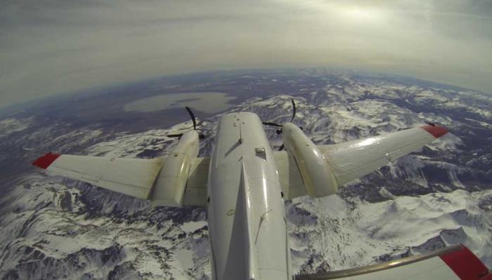
Lake Powell is seen in a November 2019 aerial photo from the nonprofit EcoFlight. The Upper Basin states are proposing two pools of stored water in Lake Powell: A Lake Powell protection account and a Lake Powell conservation account. Credit: EcoFlight
Utah demand management
The future of SCPP in 2025 is unclear, with federal funding authorization pending. But the state of Utah is not waiting for a basinwide program to materialize. With a $4 million appropriation, the state is funding a two-year demand-management pilot program, which will pay irrigators to take water off their fields, switch to more efficient irrigation methods or release downstream water stored in reservoirs. Haas said the program has received 26 applications for 2025.
A main goal of Utah’s conservation program is to track and account for the saved water in Lake Powell, something the SCPP has failed to do in its first years. The Upper Colorado River Commission recently penned an agreement with Reclamation that will allow Upper Basin water users to account for water saved through conservation programs in Lake Powell.
“Utah really believes that in order to put teeth on our commitments in the Upper Basin post-2026, we’ve got to be undertaking these conservation activities,” Haas said. “I think that’s why we are headed in this direction, and we are leading among the four Upper Division states in terms of piloting our own demand-management program.”
The state of Colorado did a two-year study of its own potential demand-management program beginning in 2019, but the state has since shelved that work.
Federal water managers also seem to be gravitating toward conservation in the Upper Basin. On Jan. 17, the Bureau of Reclamation released a report on five potential alternatives for reservoir operations and shortage sharing. Three of the four “action” alternatives include the provision for storing up to 200,000 acre-feet of water annually in Lake Powell. (The analysis also includes a “no-action” alternative as a formality, which is required by the National Environmental Policy Act.)
Even though the Upper Basin states will commit to some amount of future water conservation, officials say exactly how much will vary by year.
“That number is going to be driven by hydrology,” Ostdiek said. “We also know in the Upper Basin, our ability to store water in that type of account will probably be greater in wetter years. … It’s not an assumption that we would be able to do 200,000 acre-feet in every year.”
Udall/Overpeck 4-panel Figure Colorado River temperature/precipitation/natural flows with trend. Lake Mead and Lake Powell storage. Updated through Water Year 2024. Credit: Brad Udall
Change is the only constant, all around us at all times. In our natural, human, and political systems, the pace of change feels particularly intense right now. How will we participate in this change, appropriate to its scope and scale, to shape or be shaped by it?
For the past several years, the Colorado Farm & Food Alliance has focused on three broad “avenues” (or approaches) for local solutions regarding rural climate action. In each of these, the new federal administration and shift in Congress could impede or derail progress already made and potentially into the future.
Avenues for climate action that the CO Farm & Food Alliance has focused on are (1) meeting landscape-level conservation goals to secure water supplies and boost ecological and climate resilience; (2) producing more locally generated and community-centered clean energy; and (3) helping small-acreage agricultural producers benefit from and support the shift to more regenerative practices that increase climate mitigation and adaptation, and boost farm health.
In 2025, we expect ongoing attempts to rollback current environmental and conservation policy – based on stated intent from the new administration and Congress, along with early action and leadership changes in agencies and on committees – with a hard shift away from natural resource protection, environmental justice, and climate action.
The CO Farm & Food Alliance is troubled by this change in federal direction. We will work with partners to defend the progress made and seek opportunities to continue that progress.
With our model of local action and community-rooted solutions, the CO Farm & Food Alliance will work to prevent harm and continue to advance on all of these fronts in partnership with national and local allies.
meeting landscape-level conservation goals to secure our water supplies, wildlife, and quality of place
The Colorado Farm & Food Alliance began with the premise that healthy lands and clean water protect Colorado farms, food, and drink. At the time of our founding, we sought to unify as a local voice for farm and food leaders who supported the protection of the public lands and water source areas surrounding the North Fork Valley.
As our focus broadened to include food security and climate change, among other issues, we also recognized that land use, specifically the conservation and restoration of natural places and systems is a powerful way to help address climate anomalies.
The Colorado Farm & Food Alliance remains committed to working with our partners to secure and maintain protection for critical public and watershed lands in western Colorado. Protecting cherished places such as the Thompson Divide and Clear Fork area, the North Fork Valley, and Dolores Canyons enjoys broad public appeal.
Conservation also helps address the biodiversity crisis and makes watersheds and Colorado farms more resilient to drought. These iconic landscapes are foundational to the character of this place and its residents. They protect our water supplies, essential wildlife habitats, and popular hunting and recreation areas. This means we will join with others to defend public lands and conservation policies from rollbacks and other emerging threats in Washington. However, there will also be opportunities to champion the importance of public lands to Colorado and highlight their values.
producing more locally produced and community-centered clean energy
Rural communities’ powering of farms, businesses, and homes—and the growth of renewable energy projects in rural areas—can significantly improve people’s lives and livelihoods. However, rollbacks to clean energy, environmental justice, and other climate programs could set western Colorado back and be a “gut punch” we do not need.
The Colorado Farm & Food Alliance supports deploying more community-based renewable energy for farms and rural communities. We will closely monitor how Washington’s changes might impact local communities’ ability to develop their own home-grown power solutions.
For transitioning coal and power-plant communities, like the North Fork and other places in Colorado, environmental justice means supporting local solutions for front-line communities. This is recognized in climate funding laws passed during the last Congress, which directly benefit places like Craig, Naturita, and Pueblo, as well as communities in Delta County. However, a recent January 2025 White House Executive Order seeks to defund many of these programs.
Despite this, we will continue working with partners to help advance innovative community-based clean energy projects – like the Thistle Whistle Community Solar project. We will advocate for the preservation of funding that allows coal-mining and power-plant communities – whether rural or urban, red or blue – to envision and implement their own home-grown energy solutions.
The North Fork River valley. Photo credit: Colorado Farm & Food Alliance
supporting small-acreage agricultural producers in benefiting from a shift to more regenerative practices
The Farm Bill, which is central to agriculture in the United States, was recently extended for a third time. This has made a normally five-year bill into an eight-and-counting ordeal. It is not certain that it will be settled this year, but it will have a far-reaching impact when it is.
That’s because the Farm Bill touches many things, from nutrition to farming to clean energy. Even with an uncertain passage, the debate over this bill will continue in committees in both the House and the Senate, now under narrow Republican control.
The Farm Bill is one place rural renewables get funded, through the Rural Energy for America Program (REAP). This is another place where cuts might come to clean energy under a new Congress and priority shifts in the administration.
Clean energy is just one small part of the Farm Bill. Several vital programs funded by this legislation could be at risk of cuts or elimination. These include nutrition programs such as SNAP (“food stamps”) and Doubleup Foodbucks. This program, which could be targeted, addresses hunger in our communities and supports local farmers by increasing SNAP benefits at local farmers’ markets.
Farm and ranch conservation funding is another area likely to see proposed Farm Bill cuts. This includes helping small-acreage farmers implement more regenerative and climate-adapted practices. Programs that support small-acreage farmers are essential for conservation. In the U.S., the number of farmers is decreasing, but the average size of farms is increasing. Many small farms will be converted to other uses and will not stay in agriculture if farming becomes nonviable.
The loss of a farm is personally devastating and sends ripples through the local economy. It also limits the type and scope of nature-based climate solutions that can be implemented. In important headwaters and agricultural areas, like the Gunnison River basin, ensuring the viability of agriculture–which smaller and mid-sized farms and ranches dominate–and protecting our farm economies are critical strategies to support rural, farm-based climate action.
Conservation funding and nutrition programs that allow farmers to provide food directly into local markets are key tools that improve farm outputs, provide income, boost resilience, and address food insecurity in western Colorado.
The Colorado Farm & Food Alliance is sharing and we will continue to develop new and additional resources to help farmers and others navigate policy and program changes at the USDA and other agencies. We will also highlight growers and ranchers practicing techniques that make their farms and pastures more resilient, productive, and sustainable. Showcasing our successes and our shared work will be important in the years ahead.
A North Fork Orchard. Photo credit: Colorado Farm & Food Alliance
The Future is here: We are it.
Despite all these changes and challenges coming our way, we can find security in our community and shared endeavors. We can create something new, sustainable, and fair that emerges right here.
But first, we must persist. This means securing and defending what we have and value most. It means standing up for the vulnerable and those people and places that are targets of attack.
Still, that cannot be all we do. We should neither feel defeated nor content to just wait for a different time. We should imagine new ways to connect with each other now, to celebrate what we cherish and to replicate and share out what we do well.
The future is up to us, but we are mighty together. Now we must become the change we seek.
President Trump issues executive orders on energy production, water supplies, and climate change.
Other executive orders target foreign aid, FEMA, and the Paris agreement.
In settlement with EPA, California mobile home park operator agrees to fix failing water system.
Reclamation publishes a report detailing five options it will analyze for post-2026 Colorado River management.
And lastly, President Trump visits recent disaster zones in California and North Carolina.
“I wanted to go to Los Angeles and see what was going on with California, why they aren’t releasing the water. Millions and millions of gallons of water, they’re sending it out to the Pacific. Someday, somebody’s going to explain that one. In the meantime, they have no water in Los Angeles, where they had the problems.” – President Donald Trump, on January 24, while visiting Fletcher, North Carolina to see damage from Hurricane Helene before he flew to Los Angeles.
Trump’s comments displayed a misunderstanding of California water. Water flowing to the Pacific through the Golden Gate is necessary to prevent salt water from encroaching in the Sacramento-San Joaquin delta, a source of local drinking water and irrigation in addition to fish habitat. Hydrants in Los Angeles went dry in some areas during the fires because of the massive strain on the municipal water system from firefighting. Trump said he wanted to make disaster aid to California contingent on sending more water to the Central Valley and Southern California.
By the Numbers
12: Biden administration executive orders repealed in President Trump’s order on “Unleashing American Energy.” The repealed orders dealt with climate risk, forest protection, environmental justice, and clean energy.
News Briefs
The First Week President Donald Trump spent his first week in office beginning to unravel the energy and environment legacy of his predecessor.
In a flurry of executive orders, Trump made good on campaign promises to reject international entanglements and promote the fossil fuel industry while trimming America’s financial commitments to the rest of the world.
Trump withdrew from the Paris climate agreement and froze international spending on climate mitigation and adaptation. The Biden administration estimated U.S. climate finance for developing countries was $9.5 billion in 2023. The executive order intends to claw back unspent funds and revoke policies that support international climate action.
Other foreign spending is at risk. Trump paused, for 90 days, new “obligations and disbursements” of foreign aid, saying in the order that foreign aid is “not aligned with American interests and in many cases antithetical to American values.”
On the domestic side, another order directed the Commerce and Interior departments to begin the work to send more water from northern California to southern California via canals. In Trump’s view – supported by big farm groups that would benefit from the action – water that exits the Sacramento-San Joaquin delta is “wasted,” when in fact those flows are necessary to keep salt water out of the largest estuary on the West Coast. The order resurrects an attempt from the first Trump administration to rewrite water export policy. That attempt was halted by a federal district court.
In disaster policy, Trump signed an order to review FEMA’s mission and possibly eliminate the agency. A council of no more than 20 agency heads and people outside of government will make a recommendation. “I think, frankly, FEMA is not good,” Trump said while in North Carolina.
And in energy policy, Trump ordered a review of all policies that burden not only the development of domestic energy sources, but also their use. That means reviewing and possibly rescinding water and energy efficiency standards for appliances and showerheads. The order suspends Inflation Reduction Act funds for clean energy projects.
The order tells agencies to reconsider decisions that withdrew public lands from mineral exploration, such as mining leases near the Boundary Waters Canoe Area Wilderness.
Trump also revoked Biden administration orders that required agencies to account for the financial risks of climate change, consider the social cost of carbon, find opportunities to use nature-based solutions, protect old growth forests, and make climate change a foreign policy priority.
All told, the federal government’s priorities have been reordered, and agencies will evaluate future projects with new criteria for costs and benefits.
California Mobile Home Park The operator of Oasis Mobile Home Park, located in Riverside County, California, reached a settlement with the EPA to fix the community’s failing water system, which is contaminated with arsenic and sewage from leaking septic systems.
The agency noted the failures for years, including an administrative order in 2021, but the operators did not comply, the complaint states. In addition to the fixes, the operators will pay a $50,000 fine.
The park is located within the Torres Martinez Desert Cahuilla Indian Reservation, in Thermal, California.
Studies and Reports
Colorado River Management Options The Bureau of Reclamation published a report detailing the five options it will analyze when deciding how to manage the Colorado River after current guidelines expire in 2026.
The options present a range of water conservation plans and water release schedules that were submitted by states, tribes, and environmental groups in the basin.
On the Radar
Panama Canal Hearing On January 28, the Senate Committee on Commerce, Science, and Transportation will hold a hearing to discuss the Panama Canal’s influence on U.S. trade and national security.
President Trump has suggested that the U.S. try to take back the canal, which it handed over to Panama in 1999. House Republicans introduced a bill to authorize purchasing the canal.
RFK Jr. Confirmation Hearing On January 29, the Senate Finance Committee will hold a confirmation hearing for Robert F. Kennedy, Jr., to lead the Department of Health and Human Services.
An earlier version of this post incorrectly stated that the U.S. handed over the Panama Canal in 1978. The treaty authorizing the handover was ratified that year.
Federal Water Tap is a weekly digest spotting trends in U.S. government water policy. To get more water news, follow Circle of Blue on Twitter and sign up for our newsletter.
A bill advanced Tuesday by the Arizona House Committee on Natural Resources, Energy and Water aims to allocate $1 million to defend the Grand Canyon State’s water rights as part of the ongoing battle over the Colorado River. The bill, known as House Bill 2103, seeks to set aside the funds to support litigation in the event that negotiations among the seven states dependent on the river break down. Arizona is preparing for the possibility of legal action if the ongoing discussions fail to resolve water allocation disputes. The bill passed with unanimous support from the committee, though Democrats indicated they will propose an amendment to increase the allocation to $3 million, in line with Governor Katie Hobbs‘ proposed budget…
At the center of the debate are two factions: the Upper Basin states—Colorado, New Mexico, Utah and Wyoming—and the Lower Basin states, which include Arizona, California and Nevada…But as the clock ticks down toward 2026, when potential cuts could be enforced by the federal government, tensions are mounting over the distribution of the river’s limited water supply…Arizona’s position is clear: it wants to be able to fight its corner if necessary and needs funds to do it. The request for funds to potentially fight a legal battle was first proposed in September 2024 by Tom Buschatzke, the director of the Arizona Department of Water Resources.
Map of the Colorado River drainage basin, created using USGS data. By Shannon1 Creative Commons Attribution-Share Alike 4.0
It’s time for an agreement in the Colorado River Basin, Colorado water and climate experts say.
Colorado River officials are at odds over how to store and release water in the basin’s reservoirs when the current rules lapse in 2026. Publicly, state negotiators stick close to their original, competing proposals, released early in 2024. Colorado experts watching the process understand the difficulty — it’s painful to talk about cutting water use — but time is of the essence.
Jennifer Pitt, the National Audubon Society’s Colorado River program director, paddles a kayak through a restoration site. (Source: Jesus Salazar, Raise the River)
“I have no idea what’s going to get them to agreement,” said Jennifer Pitt, the Colorado River program director for the National Audubon Society. “To me, the biggest pressure seems like time is running out.”
But there seems to be a lack of trust between the state negotiators, said Jennifer Gimbel, senior water policy scholar at the Colorado Water Center at Colorado State University.
“Not only is there this lack of trust, but there almost seems to be this effort to promote your own proposals by denigrating other proposals,” Gimbel said. “That frustrated me to no end. It’s like they have these political rallies.” [ed. emphasis mine]
If states are going to propose a united plan, then they need to do it by the end of 2025, preferably sooner, experts said.
“We continue to stand firmly behind the Upper Division States’ Alternative, which performs best according to Reclamation’s own modeling and directly meets the purpose and need of this federal action,” Colorado’s negotiating team said in a prepared statement Tuesday.
The basin is also about to see new leadership at the federal level. Colorado water experts are waiting to know who President Donald Trump will appoint to key positions, like the commissioner of Reclamation and the assistant secretary for water and science.
“They’re in a really tough spot. I would understand that,” said John Berggren with the environmental group Western Resource Advocates. “I hope they’re continuing to negotiate and have productive conversations, and I hope they’re open to some more creative options.”
Planning for the extremes
So what options are they considering? In the absence of a seven-state agreement on how to manage the basin’s water supply, the Bureau of Reclamation outlined five possible plans in November:
No action: Included as a formality and shows the risk of doing nothing
Federal authorities: Includes maximum Lower Basin cuts of 3.5 million acre-feet in extremely dry years
Federal authorities hybrid: Includes maximum cuts of 3.5 million acre-feet in the Lower Basin and conserving up to 200,000 acre-feet in the Upper Basin
Cooperative conservation: Includes maximum cuts of 4 million acre-feet in the Lower Basin and conserving up to 200,000 acre-feet in the Upper Basin
Basin hybrid: Includes maximum cuts of 2.1 million acre-feet in the Lower Basin and conserving up to 100,000 acre-feet in the Upper Basin
Colorado experts want to make sure the federal planning process is broad enough to include the worst possible conditions.
Udall/Overpeck 4-panel Figure Colorado River temperature/precipitation/natural flows with trend. Lake Mead and Lake Powell storage. Updated through Water Year 2024. Credit: Brad Udall
The Colorado River Basin’s flows are about 20% lower now than in the 20th century, said Brad Udall, senior water and climate research scientist at the Colorado Water Center at Colorado State University. That’s a drop from about 15.2 million acre-feet per year to about 12.4 million acre-feet, he said.
That’s not enough for the 15 million acre-feet allotted to the seven U.S. states, much less the additional water owed to Mexico and tribal nations.
Udall wants to make sure officials are planning for scenarios in which the river’s flow drops by an additional 10%, or down to 11 million acre-feet.
“The question is … who takes the pain? Is it all Lower Basin? Is Upper Basin sharing that?” he said.
One new detail for the Colorado experts who reviewed the report was the duration of the next management plan: Reclamation wants it to last for at least 20 years after 2026. It is unlikely to be a short-term, interim plan to give negotiators more time to reach a unified agreement.
The revised proposal submitted by the Upper Basin states — Colorado, New Mexico, Utah and Wyoming — also highlighted conserving up to 200,000 acre-feet of water (depending on river conditions), which seemed to move the states closer to alignment with Reclamation, experts said…
The Upper Basin’s revised proposal, and the federal options, include different “pools” in Lake Powell on the Utah-Arizona border, which would function like savings accounts and could store water conserved by Upper Basin states. Colorado water experts are keeping a close eye on how these accounts might work.
“Putting water in Powell is a good thing, but nobody in the Upper Basin wants to send water to protect Powell that ultimately just runs downstream,” said Steve Wolff, general manager of the Southwestern Water Conservation District based in Durango.
The experts wanted to know more about how conservation pools would function; how federal authorities in the basin might expand; which reservoirs will be included in the plan; what the impacts to the Grand Canyon would be under the different plans; and ultimately, what plan will stabilize the system.
They’ll have to wait to find out: The bureau is expected to release a deeper analysis of how each alternative could impact water management in different conditions later this year.
The Bureau of Reclamation’s final selection will likely mix and match elements of the different alternatives, said Carly Jerla, senior water resource program manager with the Bureau of Reclamation in a December presentation in Las Vegas.
“It’s a shame we don’t have a combined Upper Basin and Lower Basin plan right now,” Udall said. “Once Reclamation does its modeling, we’ll learn a lot. But we need a combined plan.”
Click the link to read the release on the ADWR website (Doug MacEachern):
January 30, 2025
A breakdown of water-related investments included in the recently released Executive Budget proposal from Arizona Governor Katie Hobbs:
$14.6M Deposit to WIFA Water Conservation Grant Fund
Governor Hobbs has now allocated $14.6 million to the Water Conservation Grant Fund to enable the Water Infrastructure Finance Authority (WIFA) to continue investing in generational water conservation projects.
Thanks to $200 million awarded by the State in federal funds allocated through the American Rescue Plan Act, WIFA has been able to fund conservation-focused projects across Arizona. To date, WIFA has funded over 150 water conservation projects. The Governor’s 2025 Executive Budget proposal includes investments in current and future water solutions, including WIFA’s funding for rural water supply development and long-term augmentation.
These critical resources will help ensure that rural areas can invest in the infrastructure they need to be water resilient, statewide efforts continue their investment in the infrastructure Arizona needs to find sustainable, renewable water supplies for the future. These investments speak directly to the mission of WIFA, which has been to augment and expand Arizona’s water supplies.
$12M Grant for City of Buckeye Renewable Water Infrastructure
By enrolling in the new Alternative Designation of 100-year Assured Water Supply (ADAWS) Program, the City of Buckeye has committed to increasing the sustainability of its water resource portfolio, a major step forward toward creating sustainable growth. This allocation of $12 million will help Buckeye build infrastructure to reuse its effluent supplies and recover them from a hydrologically connected area; facilitating sustainable growth and increased use of renewable water supplies.
$7M Statewide Groundwater Monitoring and Data Collection
These allocations will provide ADWR with much needed additional tools to ensure that Arizona’s groundwater resources are properly managed and protected. Governor Hobbs has invested $7 million to ADWR to install groundwater monitoring index wells throughout rural Arizona to observe declining groundwater levels and inform ongoing groundwater protection efforts. Without these index wells, ADWR hydrologists are less able to accurately assess the health of groundwater supplies in rural areas.
$5.5M For ADWR Hydrogeologic Studies in Priority Groundwater Basins
To help rural communities understand and protect their groundwater supplies, ADWR hydrologists create groundwater models that help water managers and community leaders understand the conditions of their aquifers. This $5.5 million investment will allow ADWR hydrogeologists to collect key hydrogeologic information to build these critical models in groundwater basins experiencing severe water declines.
$3.45M ADWR Leading Edge Satellite Water Monitoring Systems & Equipment
This investment with ADWR funds the acquisition and use of cutting-edge technologies including absolute gravity survey equipment to monitor aquifer conditions, funding for the Arizona Continuously Operating Reference Stations (AZCORS) Network that provides critical GPS data for scientists, engineers, and surveyors throughout Arizona. It provides funds for satellite monitoring of statewide water demand, and funding for ADWR contractual partnerships with the US Geological Survey (USGS) to collect key water use data.
Lee Ferry, the dividing line between the upper and lower basin states of the Colorado River Basin. Photo credit: Allen Best
Click the link to read the article on the Big Pivots website (Allen Best):
January 28, 2025
It’s part of a theme. Does Colorado need to start planning for potential Colorado River curtailments?
Snow in southwestern Colorado has been scarce this winter. Archuleta County recently had a grass fire. A store manager at Terry’s Ace Hardware in Pagosa Springs tells me half as many snowblowers have been sold this winter despite new state rebates knocking 30% off the price of electric models.
Near Durango, snowplows normally used at a subdivision located at 8,000 feet remain unused. At Chapman Hill, the in-town ski area, all snow remains artificial, and it’s not enough to cover all the slopes. A little natural snow would help, but none is in the forecast.
Snow may yet arrive. Examining data collected on Wolf Creek Pass since 1936, the Pagosa Sun’s Josh Kurz found several winters that procrastinated until February. Even when snow arrived, though, the winter-end totals were far below average.
All this suggests another subpar runoff in the San Juan and Animas rivers. They contribute to Lake Powell, one of two big water bank accounts on the Colorado River. When I visited the reservoir in May 2022, water levels were dropping rapidly. The manager of Glen Canyon Dam pointed to a ledge below us that had been underwater since the mid-1960s. It had emerged only a few weeks before my visit.
That ledge at Powell was covered again after an above-average runoff in 2023. The reservoir has recovered to 35% of capacity.
A ledge that had been used in the construction of Glen Canyon Dam emerged in spring 2022 after about 50 years of being underwater. Photo May 2022/Allen Best
Will reservoir levels stay that high? Probably not, and that is a significant problem. Delegates who wrangled the Colorado River Compact in a lodge near Santa Fe in 1922 understood drought, at least somewhat. They did not contemplate the global warming now underway.
In apportioning the river flows, they also assumed an average 17.5 million acre-feet at Lee Ferry, the dividing line between the upper and lower basins. It’s a few miles downstream from Glen Canyon Dam and upstream from the Grand Canyon. Even during the 20th century the river was rarely that generous. This century it has become stingy, with average annual flows of 12.5 million acre-feet. Some worry that continued warming during coming decades may further cause declines to 9.5 million acre-feet.
Udall/Overpeck 4-panel Figure Colorado River temperature/precipitation/natural flows with trend. Lake Mead and Lake Powell storage. Updated through Water Year 2024. Credit: Brad Udall
Colorado State University’s Brad Udall and other scientists contend half of declining flows should be understood as resulting from warming temperatures. A 2024 study predicts droughts with the severity that formerly occurred once in 1,000 years will by mid-century become 1-in-60 year events.
How will the seven basin states share this diminished river? Viewpoints differ so dramatically that delegates from the upper- and lower-basin states loathed sharing space during an annual meeting in Las Vegas as had been their custom. Legal saber-rattling abounds. A critical issue is an ambiguous clause in the compact about releases of water downstream to Arizona and hence Nevada and California.
Colorado transmountain diversions via the State Engineer’s office
Might Colorado need to curtail its diversions from the Colorado River? That would be painful. Roughly half the water for cities along the Front Range, where 88% of Coloradans live, comes from the Colorado River and its tributaries. Transmountain diversions augment agriculture water in the South Platte and Arkansas River valleys. The vast majority of those water rights were adjudicated after the compact of 1922 and hence would be vulnerable to curtailment. Many water districts on the Western Slope also have water rights junior to the compact.
In Grand Junction last September, Andy Mueller, the general manager of the Colorado River Water Conservation District, the primary water policy agency for 15 of Western Slope counties, made the case that Colorado should plan for compact curtailments — just in case. The district had earlier sent a letter to Jason Ullmann, the state water engineer, asking him to please get moving with compact curtailment rules.
Eric Kuhn, Mueller’s predecessor at the district, who is now semi-retired, made the case for compact curtailment planning in the Spring 2024 issue of Colorado Environmental Law Review. Kuhn’s piece runs 15,000 words, all of them necessary to sort through the tangled complexities. Central is the compact clause that specifies the upper basin states must not cause the flow at Lee Ferry, just below today’s Glen Canyon Dam, to be depleted below an aggregate of 75 million acre-feet on a rolling 10-years basis.
That threshold has not yet been met — yet. Kuhn describes a “recipe for disaster” if it is. He foresees those with agriculture rights on the Western Slope being called upon to surrender rights. He and Mueller argue for precautionary planning. That planning “could be contentious,” Kuhn concedes, but the “advantages of being prepared for the consequences of a compact curtailment outweigh the concern.”
Last October, after Mueller’s remarks in Grand Junction, I solicited statements from Colorado state government. The Polis administration said it would be premature to plan compact curtailment. The two largest single transmountain diverters of Colorado River Water, Denver Water and Northern Water, concurred.
Front Range cities, including Berthoud, above, are highly reliant upon water imported from the Colorado River and its tributaries. December 2023 photo/Allen Best
Recently, I talked with Jim Lochhead. For 25 years he represented Colorado and its water users in interstate Colorado River matters. He ran the state’s Department of Natural Resources for four years in the 1990s and, ending in 2023, wrapped up 13 years as chief executive of Denver Water. Lochhead, who stressed that he spoke only for himself, similarly sees compact curtailment planning as premature.
“It just doesn’t make sense to go through that political brain damage until we really have to,” he said. “Hopefully we won’t have to, because (the upper and lower basins) will come up with a solution.”
Lochhead does believe that a negotiated solution remains possible, despite the surly words of recent years…
“We need to figure out ways to negotiate an essentially shared sacrifice for how we’re going to manage the system, so it can be sustainable into the future,” he said. This, he says, will take cooperation that so far has been absent, at least in public, and it will also take money.
Instead, we’ll have to slog along. The runoff in the Colorado River currently is predicted to be 81% of average. It fits with a theme. Unlike the children of Lake Wobegone, most runoffs in the 21st century have been below average.
Map of the Colorado River drainage basin, created using USGS data. By Shannon1 Creative Commons Attribution-Share Alike 4.0
Colorado Farm & Food Alliance leads effort to advance in Department of Energy Community Power Accelerator Prize
HOTCHKISS, CO (January 27, 2025) — The U.S. The Department of Energy (DOE) announced this month that a North Fork Valley solar partnership is one of four teams to win a national $200,000 Community Power Accelerator Prize. The North Fork based team now advances to the third and final round, and a $150,000 prize, in this community solar competition sponsored by the DOE National Solar Energy Technologies Office.
The Colorado Farm and Food Alliance-led team seeks to advance several community-based solar projects that prioritize agriculture, community benefit and renewable energy generation. The Accelerator Prize award will be used for engineering and other studies at Thistle Whistle Community Solar project near Hotchkiss and to study the feasibility of a second installation at a former coal mine site near Paonia. Both locations are in Delta County, Colorado.
Partners in developing these projects include Colorado Farm & Food Alliance, Thistle Whistle Community Solar, Mirasol Agrivoltaics and Switchback Restoration, along with community leaders. The award will help to advance at least two community solar projects, starting with a small agrivoltaic array at Thistle Whistle Farm near Hotchkiss. This innovative project will pair agricultural production with solar energy and provide clean power to local farms and residents through the Delta Montrose Electric Association (DMEA) grid.
“I am eager to see this project completed, to benefit my farm and to help provide energy cost savings to other local farms and households,” said Mark Waltermire, owner of Thistle Whistle Farm. “The Community Power prize has been vital in helping to keep this project moving forward.” Now completing pre-development, the Thistle Whistle Community Solar project will:
Generate clean, renewable energy for local communities
Preserve agricultural land through dual-use farming practices
Increase energy equity through community-solar, returning cost savings to system subscribers
Create new economic opportunities for local farmers
Support local food systems while advancing clean energy goals
Document best practices for agrivoltaic system design and lessons learned for community solar
Monitor wildlife corridors and habitat enhancement
Research water conservation benefits in dual-use systems
The second project is in early pre-development, but will help support mine-site remediation and climate harm reduction at a former coal mine as well as provide an additional community-solar benefit. “This recognition from the Department of Energy validates our vision for community-based rural renewables that support both our agricultural heritage and greater energy equity,” said Pete Kolbenschlag, with the Colorado Farm and Food Alliance and prize team captain. “These projects demonstrate how rural communities can lead the way in innovative clean energy solutions that preserve farmland, benefit residents and integrate with local livelihoods.” The North Fork Valley team is still participating in this national competition. In the third, and final, round teams must demonstrate that they have secured the funding necessary to develop their community solar projects. As part of the Phase 3 competition, the project team will be able to present their vision at the Community Power PitchFest event at the DOE Headquarters in Washington, D.C. on March 6,
The Community Power Accelerator Prize is part of the American Made Challenge program, with funding coming from the Bipartisan Infrastructure Law passed by Congress in 2021. As part of its mission, the Colorado Farm and Food Alliance provides a platform for rural leadership to develop and implement local solutions that model climate action and strengthen farm and food system resilience. It is the named partner of the Community Power Accelerator Prize.
Mirasol Agrivoltaics is a recently established Colorado nonprofit with a mission to educate about and to help develop community solar projects in the North Fork Valley. With this award it will be able to fill a new and needed leadership role in supporting clean energy, cost savings, and community-based solutions through the Thistle Whistle Community Solar and future projects.
Learning and demonstration gardens at Arbol Farm, Paonia, CO. Photo credit: Colorado Farm and Food Alliance
Colorado River “Beginnings”. Photo: Brent Gardner-Smith/Aspen Journalism
Click the link to read the article on the Getches-Wilkinson Center website (Oliver Skelly, Aidan Stearns, and Andrew Teegarden):
December 17, 2024
The Annual Colorado River Water Users Association (CRUWA) Conference in Las Vegas was one of the busiest in recent years. Part of the increased participation stems from the current impasse in negotiations for the Post-2026 Operating Guidelines for Lakes Powell and Mead. Tensions could be felt in the hallways and discussions by nearly 1,500 attendees.
Pressures came to a head during the Upper and Lower Basin Panels. Colorado’s lead negotiator, Becky Mitchell, noted it was disappointing that all seven of the basin states were in Las Vegas and were unable to set a meeting where potential compromises could be discussed. Another Upper Basin Negotiator, Brandon Gebhart, spoke out against the posturing and inability to compromise.
Others on the Lower Basin Panel, such as JB Hamby, struck a different chord; the Lower Basin has been taking steps to lower water use despite the massive population, agricultural economy, and climate change. These realities are extremely troubling because it seems to be further entrenching the states in their own positions and is reducing their ability to compromise. In fact, Arizona’s Governor Katie Hobbs has begun setting aside money within the state budget for potential litigation efforts on the Colorado River. However, litigation did not seem to be the preferred alternative to solve the current breakdown in negotiations. A separate panel talked about the realities of litigation which could take decades, cost millions of dollars, and put the power to decide the outcome in the hands of judges which cannot fully capture the complexity and needs of each community partner along the river.
Outside of the programming, the entire Getches-Wilkinson Center Staff was honored to attend the Water & Tribes Initiative Luncheon which kicked off the start of the conference. During the lunch, attendees discussed potential alternatives for the Bureau of Reclamation to consider which would provide operational flexibility and account for tribal water usage.
Another highlight was the ability to talk with other colleagues and peers in the water space. Networking at large conferences has been one of the best parts of these events because they allow for more understanding within the water community. Despite the tensions, the water community was able to come together and discuss how we can solve the problems on the Colorado River equitably.
Unfortunately, CRUWA did not result in any big break through or give the states more clarity on how the Colorado will be managed. Although, leaders painted a clear picture of how difficult litigation will become if we are unable to agree. Complex scenarios require complex solutions and until someone can capture and account for all of them, compromise may be difficult to obtain. Allowing compromise and the goal of a stable river basin to drive the creation of alternatives will bring us to a place where all who utilize the river feel heard. Negotiators can get there, but it will take more time and dedicated effort to do so.
Aidan Stearns current 3L at Colorado Law and GWC Research Assistant:
From December 4-6, a variety of Colorado River advocates including lawyers, engineers, legislators, scientists, and tribal representatives gathered at the Paris Hotel in Las Vegas, Nevada for the Colorado River Water Users Association (CRWUA) Conference. This year, which was my first time attending the conference, CRWUA was focused on post-2026 operations of the Colorado River. Negotiations over post-2026 operations have been contentious, to say the least. CRWUA served as an opportunity to share all the various points of view with the Colorado River community.
Since it was my first time attending CRWUA, I had one simple goal heading into the conference: listen. CRWUA further affirmed a belief I held when I started law school almost three years ago: that a degree in environmental engineering would be a beneficial foundation for legal practice. One of the first sessions I attended was about the risks of litigation, where attorneys representing various upper and lower basin interests discussed what the path of litigation may look like based on past precedent. Those panelists are often tasked with the challenge of applying modern engineering and scientific concepts to legal doctrine dating back to the 1800s, something I hope to pursue in my own legal career.
Outside of the conference sessions, my most impactful interactions came from meeting conference attendees and listening to their unique perspective on Colorado River water issues. I spoke to a range of individuals including attorneys who worked solely with upper basin agricultural water users to lower basin tribal councilmembers.
Despite the difficult conversations that were had at CRWUA regarding post-2026 operations, a thread of hope seemed to weave through every session. Julie Vano, the Research Director for Aspen Global Change Institute, emphasized in a panel on extreme weather events the importance of not becoming paralyzed by uncertainty when using models. Panelists also expressed that they felt hope because of the resilience of people. Panelists expressed that there is no one to blame but us, but in that, there is hope in the innovation and partnership that people are capable of. No one person is going to have the magic solution to managing water issues in the Colorado River Basin. The solution is going to come from collaboration along with being able to listen to and respect the perspectives that people bring to the table.
Oliver Skelly, current 3L at Colorado Law and GWC Conscience Bay Company Western Water Policy Fellow:
When the GWC invited me to spend the week before final exams with them in Las Vegas I could hardly contain my excitement: My first CRWUA! And what a time for it, with the ongoing negotiations over the post-2026 guidelines atop the agenda. Studying could wait.
As the conference unfolded, most of what I’d heard about CRWUA’s substance proved true: If you wanted platitudes, pay attention to the panels; if you wanted juicy hot takes, plug yourself into the hallway conversations. “The Upper Basin can’t just keep saying no to everything!” “Lots of snarky remarks from the Lower Basin today.” One attendee told me the words “climate change” were not even allowed in the agenda 10 years ago – a shocking and rather unnerving remark given where things stand now. (Fortunately for all involved, it’s allowed now.)
That said, the official events were not without their fireworks. The threat of litigation has entered the discourse as negotiations appear to be breaking down, and both basin panels made that abundantly clear. And the conference had many other panels discussing interesting ideas, including recent developments with tribal water rights, regenerative agriculture, urban water efficiency measures, and Kevin Fedarko discussing his new book about his walk through the Big Ditch. Still, the large, seemingly immovable rift between Upper and Lower Basin proposals remained center stage.
The ultimate takeaway is nothing new: The future of the Colorado River remains uncertain. But CRWUA lives on, and it has found itself a new repeat customer. Many thanks to the GWC and its sponsors for making this trip possible for me.
Map of the Colorado River drainage basin, created using USGS data. By Shannon1 Creative Commons Attribution-Share Alike 4.0
Click the link to read the article on the InkStain.net website (Eric Kuhn, John Fleck, and Jack Schmidt):
January 22, 2025
On January 16th, the Bureau of Reclamation released the January 2025 24-Month Study. Based on the January 1st runoff forecast into Lake Powell, the projected “most probable” annual release from Glen Canyon Dam for Water Year 2026 is now 7.48 maf. This needs to be taken as a significant caution sign because it shows that we are on a clear trajectory to hit what Colorado’s Jim Lochhead first called the 1922 Compact’s first “tripwire” (82.5 maf/10-year) as early as 2027. Given the current stalemate between the Upper and Lower Division States over how the reservoir system should be operated, it means the potential for basin-wide litigation is now in the “Red Zone.”
The January 24-Month study is the first in each water year to be based on a published forecast from the Colorado Basin River Forecast Center’s runoff model – the first to be based on actual snowpack. The January 1st runoff forecast for unregulated April-July inflow to Lake Powell was 5.15 maf (about 81% of average). This results in a projected 12/31/2025 elevation of Lake Powell of less than 3575’ making the annual release for Water Year 2026 7.48 maf. Of course, the forecast will change as the winter progresses. In fact, the January mid-month forecast dropped by 300,000 acre-feet to 4.85 maf. At this point in the winter our confidence in the “most probable” forecast is low and in recent years, the track record has been to overstate future runoff suggesting that the we should pay equal attention to the “minimum probable” forecast. (See Wang et al, Evaluating the Accuracy of Reclamation’s 24-Month Study Lake Powell Projections.) Also remember that the actual decision on the WY 2026 release is not made until the Spring runoff is over and the August 24-Month study is released.
Lee/Lee’s/Lees Ferry on the Colorado River. Photo by John Fleck
A 7.48 maf release from Glen Canyon Dam bodes trouble for the basin because it takes us very close to the tripwire. Simply put, the tripwire is the ten-year flow at Lee Ferry at which the Lower Division States can claim the Upper Division States are in violation of the 1922 Compact. Under the compact, the Upper Division States have two specific flow obligations at Lee Ferry: (1) to not cause the ten-year flow to be depleted below 75 maf every ten consecutive years, and (2) to deliver one half of the annual delivery to Mexico under the 1944 Treaty if the “surplus” is not sufficient. If there is no surplus and the delivery to Mexico is 1.5 maf/year, the Upper Division’s share is 750,000 af/year, resulting in a total ten-year delivery obligation of 82.5 maf. Since under Minute 323, Mexico shares in mainstem shortages, recent annual deliveries have been less than 1.5 maf. To keep the math simple, let’s call the current obligation (with no surplus) 82.0 maf. With a 7.48 maf release in WY 2026, the ten-year flow for 2017-2026 will be about 82.8 maf.
Keep in mind that the obligation of the Upper Division States to Mexico under the 1922 Compact has been a disputed issue since the Treaty was signed in 1944. The Lower Division believes there is no current surplus, thus the obligation is one half of the Treaty delivery. The Upper Division believes that since the Lower Basin is currently overusing its 1922 Compact apportionment, this overuse is surplus, and thus, must be delivered to Mexico. Following this thread, if the overuse is greater than 1.5 maf/year, the Upper Division would have no obligation to Mexico.
With an 82.8 maf ten-year flow at the end of Water Year 2026, the Upper Division States are still slightly above the tripwire with a cushion of about 800,000 af. The problem is what happens in the next one to three years. From 2015-2019 annual the annual Glen Canyon Dam releases were 9.0 maf/year. Note, the annual release from Glen Canyon Dam and the flow at Lee Ferry are not quite the same, the Paria River and leakage around the dam contribute another 100,000 -150,000 af/year to the flow at Lee Ferry (bonus flows). Because of the way the ten-year math works, at the end of WY 2027, the Lee Ferry flow for WY 2017 (~9.2 maf) will drop out and be replaced by the 2027 Lee Ferry flow, thus, to keep the ten-year flow greater than 82.0 maf, the 2027 flow will have to be at least 8.4 maf. AND, there are two more 9.0 maf releases in the pipeline, WYs2018 and 2019! That means that when those drop out of the sequence, the risk of the basin stumbling across the tripwire into litigation grows.
To stay above 82.0 maf, the total deliveries at Lee Ferry for the three-year period of 2027-2029, the annual release from Glen Canyon Dam will have to average about 8.8 maf/year (factoring in the bonus flows). Since 2012, the average unregulated inflow to Lake Powell is about 8.2 maf/year. After deducting 500,000 af/year of gross evaporation from the reservoir, the “net-of-evaporation” annual inflow is only about 7.7 maf/year. Going back to 2000, the net inflow is about 7.9 maf/year. Thus, to avoid going below the 82.0 maf tripwire, it will take either above average (post-2000) hydrology or continuing to draw down Lake Powell levels. If the hydrology is a bit drier than the post-2000 (or post-2012) levels, maintaining at least 82.0 maf/10-year may require drawing Lake Powell below minimum power. As Lake Powell levels approach minimum power, we approach environmental and power generation tripwires.
The fact that we’re on track for another year of below-average inflows to Lake Powell, another 7.48 maf/year annual release from Glen Canyon Dam, and on a trajectory to drop below a 1922 Compact tripwire adds another level of urgency for the basin states to break their current impasse over the how the system will be operated post-2026. The chances of Lee Ferry flows dropping below the 82 maf tripwire are high. The Colorado River Basin needs to be fully prepared before this occurs. With every 24-Month study, the basin’s litigation clock is getting closer and closer to that midnight hour.
Udall/Overpeck 4-panel Figure Colorado River temperature/precipitation/natural flows with trend. Lake Mead and Lake Powell storage. Updated through Water Year 2024. Credit: Brad Udall
The Colorado River flows through the Shoshone diversion structure on Jan. 29, 2024. A group trying to purchase Shoshone’s water was set to receive $40 million from the federal government. Their efforts, along with dozens of other projects across the West, will have to wait. Photo credit: Alex Hager/KUNC
Click the link to read the article on the KUNC.org website (Alex Hager):
January 27, 2024
This story is part of ongoing coverage of the Colorado River, produced by KUNC and supported by the Walton Family Foundation.
Payments to help Western states respond to drought are on pause after an order from President Donald Trump. A pool of $388.3 million from the Inflation Reduction Act had already been allocated to fund water conservation projects by the Biden administration, and its future now hangs in the balance.
The Colorado River supplies water for about 40 million people from Wyoming to Mexico, but its stretched thin. Climate change is cutting into supplies, and the cities and farms that depend on it are struggling to cut back on demand. Federal funding has been a pivotal part of Western states’ response to that reality, with billions of dollars from the Biden administration helping pay for a wide variety of programs – incentivizing farmers to use less water on their crops, improving wildlife habitat and much more.
This latest tranche of money was originally destined for projects in Colorado, Utah, Wyoming, New Mexico, and four different Native American tribes. A specific list of projects the Biden Administration wanted to fund was released in the waning days of its time in the White House. Days later, shortly after his inauguration, President Trump signed an executive order calling for the government to “immediately pause disbursement of funds appropriated under the Inflation Reduction Act.”
Those awaiting the federal funds hope that the pause is only temporary.
Steve Wolff, general manager of the Southwestern Water Conservation District in Durango, Colorado, is awaiting news on the fate of $25.6 million originally designated for his group to improve habitats in wetlands and streams.
“I just hope that both Democrats and Republicans across the West recognize the importance of this funding and what it does for local communities,” Wolff said. “And that they will be able to push the right political buttons in D.C. to make this money get distributed as it was presented by the Bureau of Reclamation.”
Officials with the Bureau of Reclamation, the federal agency which manages dams and reservoirs across the West, did not respond to KUNC’s request for comment.
A moose walks alongside the Green River in Sublette County, Wyoming on March 27, 2024. A project to improve riparian habitat along the Green River is among those awaiting details on $388.3 million in federal grants. Photo credit: Alex Hager/KUNC
The list of projects awaiting funding is long. Colorado alone accounts for 16 different projects, all of which are awaiting at least half a million dollars. Money was also allocated to ten projects in Utah, five in Wyoming, two in New Mexico, six on tribal land and three that span state lines.
Utah’s Division of Wildlife Resources would receive up to $37.2 million for five different projects. A spokeswoman for that agency told KUNC that its experts “seem confident” that the projects will still be funded, and the agency understands the federal pause on Inflation Reduction Act funding to be more focused on energy-related programs.
Shoshone Hydroelectric Plant back in the days before I-70 via Aspen Journalism
The single largest grant in the funding pool is for the Shoshone Water Rights Preservation Project in Colorado. The Colorado River District is in the midst of a yearslong push to buy water currently used by a hydroelectric plant and make sure it keeps flowing to Western Colorado. The plan would quell long-held anxieties that a fast-growing city in the Denver area could buy the water instead. The agency has been slowly pooling money from local governments towards its $99 million goal, but this federal grant of up to $40 million represents the biggest chunk of money it would put toward the purchase.
Alex Funk, a water policy expert at the Theodore Roosevelt Conservation Partnership, said the government typically has a lengthy review process for grants like these, and the Biden Administration reviewed and announced them extraordinarily quickly.
“We’re certainly anticipating a thoughtful review of some of these awards,” Funk said. “But we’re hoping that that momentum continues.”
Some of Funk’s work receives funding from the Walton Family Foundation, which also supports KUNC’s Colorado River coverage.
While Trump’s team has given relatively few indications about how it will deal with Colorado River matters, Interior Secretary nominee Doug Burgum spoke about them briefly during a Senate confirmation hearing. Funk called those comments “largely encouraging,” especially when it comes to the tense negotiations about water sharing between states that use the Colorado River.
“[Burgum] certainly signaled that he wanted his agency to be supportive of ongoing dialog and collaboration to keep that process on track,” Funk said.
Shortly after Trump won the 2024 election, top water negotiators said they did not expect the new president to shake up their talks, and said federal water policymakers have typically been technocrats, shielded from partisan turnover in Washington, D.C.
In December, a number of water policy experts expressed concern about the future of federal funding after the Biden Administration supplied Colorado River users with a “once-in-a-generation windfall.”
At the confluence of Canyon Creek and the Colorado River. Photo credit: Friends of Canyon Creek
Click the link to read the article on The Denver Post website (Elise Schmelzer). Here’s an excerpt:
The pilot program has paid water users — mostly farmers and ranchers — in the four states in the Colorado River’s Upper Basin to voluntarily use less river water than their water rights allow. Farmers from Wyoming, Colorado, New Mexico and Utah could choose not to irrigate some of their land or to grow a crop that uses less water. Over the last two years, the Upper Colorado River Commission has spent $44.6 million to conserve 101,441 acre-feet of water, enough water to supply more than 200,000 households with a year’s worth of water. But federal lawmakers late last year failed to pass a bill that would reauthorize the System Conservation Pilot Program, or SCPP. That lapse has forced the program’s managers to cancel plans to begin accepting applications early this month for 2025 projects and has jeopardized the effort’s near-term future. Congressional leaders from Colorado and other states in the drought-stricken river basin on Tuesday filed legislation that would restart the System Conservation Pilot Program. The bill — the Colorado River Basin System Conservation Extension Act — is sponsored by lawmakers from both political parties who represent Colorado, Wyoming and Utah…
President Donald Trump, on the first day of his new administration, issued an executive order freezing spending from the Inflation Reduction Act. That law was part of billions of dollars of investments by former President Joe Biden’s administration into clean energy and climate change-related projects, including $125 million for the SCPP. While more than $80 million remains allocated for the SCPP, the program cannot continue until Congress reauthorizes it and the administration allows Inflation Reduction Act spending again.
Stable isn’t good enough. Credit: Jack Schmidt/InkStain
Click the link to read the article on the InkStain.net website (John Fleck and Jack Schmidt):
January 14, 2025
Preliminary year-end Colorado River numbers are stark. Total basin-wide storage for the last two years has stabilized, oscillating between 30 and 27 maf (million acre-feet), where storage sits at the start of 2025[1]. That is lower than any sustained period since the River’s reservoirs were built (Fig. 1). Stable is better than declining, but we did not succeed in rebuilding reservoir storage during 2024’s excellent snowpack but modest inflow. Although reservoir storage significantly increased after the gangbuster 2023 snowmelt year, we have not protected the storage gained in 2024 when inflow to Lake Powell was ~85% of normal from a 130% of normal snowpack. We can’t rely on frequent repeats of 2023; we must do better at increasing storage in modest inflow years like 2024.
Why is this happening?
Less water. Credit: InkStain
The phrase “the new normal” can be misleading, suggesting a new, more stable state for the climate. It’s not gonna be stable. But by one reasonable measure – total estimated natural flow in the Colorado River at Lees Ferry – Calendar Year 2024 was typical of the first quarter of the 21st century, with a preliminary estimate of 12.1 million acre-feet “natural flow.” Thus, the calendar year average annual natural flow at Lees Ferry between 2000 and 2024 has been 12.4 maf/yr, down from 14.3 maf for the period 1930-1999. An additional 770,000 af/yr in side inflows between Lees Ferry and Lake Mead add to the available water supply[2].
That we made the cuts needed to stabilize reservoir levels with a natural flow at Lees Ferry as low as 12.1maf would have been a substantial achievement in the wetter “before times.” Now, it’s table stakes. The most important point is that we absolutely did not rebuild storage in 2024, despite a 130 percent snowpack. We must do better in reducing total basin consumptive use.
Once again in 2024, we saw substantial water use reductions among the states of the Lower Colorado River Basin. Total U.S. Lower Basin main stem use of 6.08 maf is the lowest since 1985 (meaning the lowest since the Central Arizona Project came on line). California’s use, based on preliminary numbers published by Reclamation seems to be the lowest since 1950, and use by the Imperial Irrigation District seems to be the absolute lowest in a dataset that goes back to 1941. These are important achievements, to be celebrated.
With regard to the other two major U.S. areas of use – Lower Basin tributaries and the Upper Basin as a whole – we have no idea what 2024 consumptive use was. This is a problem. Lower Basin main stem use is quantified through Reclamation’s annual accounting reports and reported on a nearly daily basis during the course of the water year. River flows and reservoir levels across the basin are similarly reported in public, transparent ways. That’s how we’re able to provide the data you see above. Anyone can download and crunch the numbers. The general public can’t readily do that for consumptive use in the Upper Basin or Lower Basin tributaries.
As Elinor Ostrom noted in her classic book Governing the Commons, shared understanding of the resource is crucial to successful water management. Increasingly, areas of uncertainty have become contested ground, as the genuine technical uncertainties collide with the motivated reasoning of political actors across the basin. [ed. emphasis mine]
With respect to the Upper Basin, we note that the rhetoric that Upper Basin water users suffer shortages in dry years has shifted to a broader claim that Upper Basin users always suffer shortages. We quote here from the Upper Basin states’ January 2 press release: “There are acute hydrologic shortages in the Upper Basin every year – there simply isn’t enough water in any year to satisfy current needs in the Upper Basin every year. The Upper Basin has made uncompensated cuts to their water users every year for the past 24 years.” Some of the data to support this assertion was presented at the December 2024 UCRC meeting, and we look forward to a more complete and transparent accounting of these data, because these data are crucial to a robust Colorado River management discussion. The Upper Basin’s experience of “acute hydrologic shortages … every year” is exactly what John Wesley Powell described in 1878 in the first edition of The Arid Lands Report. Nothing has changed, and the challenge of agriculture throughout the watershed has been well known for 150 years. We also note that consumptive use data throughout the basin has not been integrated with the important findings of Richter et al (2024) who documented the proportion of water used by different agricultural sectors. They estimated that 55% of all Colorado River water use supplies livestock feed.
We leave a discussion of Lower Basin tributary use for another post but note that in both the cases of the Upper Basin use and Lower Basin tributary use, the numbers are entangled in the current Upper Basin-Lower Basin feud, which makes serious efforts to think about how to manage water at the Basin scale, rather than simply defending parochial interests, much more difficult. It is important that the general public not employed by a state or water agency, and therefore not beholden to local parochial interests, help the basin community as a whole navigate these technical issues.
Conclusion
The stable reservoir levels at the end of 2024, despite another year of deep Lower Basin water use reductions, should be cause for alarm. Deeper cuts are needed. But without a shared understanding of water use elsewhere in the basin, we’re flying blind.
[1] Basin-wide reservoir storage reached a peak of 29.7 maf on 13 July 2023 and was subsequently drawn down to 27.5 maf by mid-April 2024. Inflow from 2024 snowmelt rebounded basin-wide storage to 30.0 maf on 6 July 2024, and storage was subsequently drawn down to 27.4 maf by 31 December 2024. Retention of storage in Lake Mead and Lake Powell has been somewhat better during the same period. Combined storage in Lake Mead and Lake Powell peaked in mid-July 2023 at 18.0 maf, declined to 17.1 maf by mid-May 2024, increased to 18.5 maf on 8 July 2024, and was 17.3 maf on 31 December 2024. Thus, storage in the two largest reservoirs at year’s end was slightly greater than it was at its spring 2024 minimum just before storage increased when significant snowmelt reached Lake Powell.
[2] This estimate is calculated as the difference between annual flow measured just upstream from Diamond Creek in western Grand Canyon and measured at Lees Ferry.
Udall/Overpeck 4-panel Figure Colorado River temperature/precipitation/natural flows with trend. Lake Mead and Lake Powell storage. Updated through Water Year 2024. Credit: Brad Udall
Yampa River near Deer Lodge Park. Photo credit: Allen Best/Big Pivots
Premiered Jan 22, 2025
Discover the magic of the Yampa, the last wild river in the Colorado River Basin, and learn how to build a movement to protect a wild river near you. Step 1: Be proactive… Since 2012, OARS has joined forces with American Rivers and Friends of the Yampa, to host an annual Yampa River Awareness Project (YRAP) river trip. This initiative invites key decision-makers, stakeholders, and activists on a transformative rafting journey along the free-flowing Yampa River, offering them the chance to experience firsthand what could be lost if the river is threatened by a major dam, diversion, or dewatering project. Filmed during the 2024 YRAP trip, A Guide to Fighting for Wild Rivers illustrates how immersing people in a river’s beauty and sharing its ecological significance fosters deep, personal connections that inspire long-term conservation. Each trip builds a growing network of passionate river defenders, united by a shared commitment to preserving the Yampa for future generations. Explore Yampa River rafting trips: https://bit.ly/49DoNCA The step-by-step conservation model shared in the film takes a cue from early river crusaders like David Brower, Bus Hatch, and Martin Litton, whose advocacy efforts helped achieve several major conservation wins for western rivers, galvanized by people’s love of a place.
Since the late 1980’s, this waterfall formed from interactions among Lake Powell reservoir levels and sedimentation that redirected the San Juan River over a 20-foot high sandstone ledge [Dominy Formation]. Until recently, little was known about its effect on two endangered fishes. Between 2015-2017, more than 1,000 razorback sucker and dozens of Colorado pikeminnow were detected downstream of the waterfall. Credit: Bureau of Reclamation
From email from Reclamation (Western Colorado Area Office):
Releases are made for the authorized purposes of the Navajo Unit, and to attempt to maintain a target base flow through the endangered fish critical habitat reach of the San Juan River (Farmington to Lake Powell). The San Juan River Basin Recovery Implementation Program recommends a target base flow of between 500 cfs and 1,000 cfs through the critical habitat area. The target base flow is calculated as the weekly average of gaged flows throughout the critical habitat area from Farmington to Lake Powell.
At the confluence of Canyon Creek and the Colorado River. Photo credit: Friends of Canyon Creek
From email from the Friends of Canyon Creek (Chuck Montera):
January 22, 2025
Members of the coalition Friends of Canyon Creek are in opposition to a planned unit development (PUD) that is set for a hearing before Garfield County Planning Commission on Wednesday, January 29 at 6 pm. Approval of the Nutrient Farms PUD would have a devastating effect to Canyon Creek and the surrounding community. Friends of Canyon Creek, comprised of citizens, water rights holders, landowners and environmental interests, oppose this PUD because of its source of water – a new draw out of Canyon Creek.
The Nutrient Farms PUD would divert nearly 9 cubic feet per second (cfs) of water (approximately 5 million gallons per day) from Canyon Creek, year-round, about 1.5 miles north of its confluence with the Colorado River. This water would be piped through the old Vulcan Ditch, through AVLT conservation easements, across dangerous and unstable hillside that burned and slid during the 2007 fire, under 6&24, and under I-70 and the railroad before even crossing the Colorado River to the south side. This is why the old Vulcan Ditch hasn’t carried water nor been maintained to cross the Colorado in decades; it’s unstable, dangerous and inefficient.
Friends of Canyon Creek formed to protect this watershed and ensure it flows for future generations.
We are opposed to the PUD as written for the following reasons:
Drying up the creek would have significant environmental consequences, including harming local trout populations and destroying riparian ecosystems.
FOCC’s legal counsel believes Nutrient Farms has no legal right to divert Canyon Creek. This issue is currently before the Colorado Water Court.
Last and perhaps most important, drying up Canyon Creek would hinder firefighting efforts and heighten risks for local property owners.
Nutrient Farms has the legal right to divert its water directly from the Colorado River, completely avoiding harm to Canyon Creek. They claim Colorado River is not high enough in quality to water crops. This is counter to the fact the Colorado River provides water to 40+ million people and irrigates 5.5 million acres of crops.
Our group does not oppose a new local farm, we oppose killing a creek to irrigate that farm.
We encourage concerned citizens to contact the Garfield County Planning Commission and BOCC and voice your opinions about this PUD. There will be a public comment period during the meeting if you want to speak out. For more information go to https://friendsofcanyoncreek.com.
Scenes from the Seeded and Natural Orographic Wintertime Clouds: The Idaho Experiment (SNOWIE) project, which was undertaken in Idaho’s Payette Basin in winter 2017. Credit: Joshua Aikins via Aspen Journalism
Click the link to read the article on the KUNC website (Alex Hager):
January 20, 2025
This story is part of ongoing coverage of the Colorado River, produced by KUNC in Colorado and supported by the Walton Family Foundation. KUNC is solely responsible for its editorial coverage.
It sounds like science fiction, but humans have the power to change the weather. What they don’t have, though, is enough data about how well it works.
That’s according to a new study from the Government Accountability Office, which recently released a report on cloud seeding – a technology that adds chemical compounds to existing clouds and can cause them to drop more rain or snow.
Cloud seeding can seem like an obvious solution for the drought-stricken Colorado River Basin, which gets most of its water from Rocky Mountain snowmelt and has seen a downward trend in annual supplies. Historically, policymakers have been slow to embrace the technology, choosing to focus more money and energy on reducing water demand rather than increasing water supply. Meanwhile, advocates for the practice say increased cloud seeding makes sense now.
The GAO’s study says reliable information on the effectiveness of cloud seeding could be standing in the way of a broader rollout, because policymakers don’t currently know if it’s worth the money.
“The people in charge of making those decisions have to consider return on investment,” said Karen Howard, the GAO’s director of science, technology assessment, and analytics. “When it’s not entirely clear what the effectiveness is, I think those decisions can be difficult to make.”
The GAO report identified a few other obstacles besides the limited data.
One of the most common methods of cloud seeding involves the addition of silver iodide to clouds. That chemical compound is considered safe, but the report says more testing is needed to make sure it’s still safe when applied across wider areas.
In its current capacity, Howard said, cloud seeding work could be useful to add more snow to an individual ski resort, but those efforts would need to get a lot bigger to make a significant impact on the amount of snowmelt that feeds major Western rivers.
“Almost all cloud seeding is very local in nature,” she said. “So you would need a lot of seeding operations in order to cover an entire mountain range.”
Snowy mountains loom over Colorado’s Lake Dillon reservoir on April 22, 2024. The Colorado River system gets the vast majority of its water from mountain snowmelt, so water managers eagerly watch high-altitude weather to build forecasts for water supply. Alex Hager/KUNC
Meanwhile, on the ground in Colorado, one of the state’s foremost cloud seeding experts says more funding is needed to expand the state’s work.
“Absolutely, I’m confident that it’s effective,” said Andrew Rickert, manager of the Colorado Water Conservation Board’s weather modification program. “That doesn’t mean that we can’t make it better.”
Rickert said he works with a roughly $1.5 million budget. That is relatively modest in comparison to the hundreds of millions of dollars spent on developing other solutions to the Colorado River’s supply-demand imbalance – such as paying farmers to use less water on their crops or developing technology that can recycle sewage back into drinking water. He also pointed to other state and private programs around the region that are quietly making advances to cloud seeding technology.
“We have the data that cloud seeding works,” he said. “We’ve been doing it since the early 1950s. I wish we had more funding to throw behind this.”
Cloud-seeding graphic via Science Matters
So, if the technology is effective and government agencies are spending billions to try and solve the Colorado River Crisis, why aren’t they doing more to boost cloud seeding?
“The problem is levels of magnitude above what any weather modification can fix,” said Amy Ostdiek, chief of the interstate, federal and water information section at the Colorado Water Conservation Board.
Ostdiek said cloud seeding is “one of the tools in the toolkit” for Colorado and other states dealing with dry conditions, and emphasized the importance of reining in water demand.
“We know [cloud seeding] is not going to solve all of the basin’s problems, but we know that it works for a limited purpose,” she said. “So it’s not as controversial or as sexy as all the other things going on in the basin. That doesn’t mean it doesn’t work, it’s just kind of chugging along.”
Rickert, who directs Colorado’s cloud seeding program, thinks it’s worth big investment even as policymakers focus on demand reductions.
“You have people like Elon Musk trying to get us to Mars, but you know, why wouldn’t he put serious money behind cloud seeding?” Rickert said. “You have like representative Marjorie Taylor Greene spouting all this stuff about geoengineering. Let’s put some real science and money behind this and show people that we can increase our water in a safe and efficient manner.”
Scenes from the Seeded and Natural Orographic Wintertime Clouds: The Idaho Experiment (SNOWIE) project, which was undertaken in Idaho’s Payette Basin in winter 2017. Credit: Joshua Aikins via Aspen Journalism
In December 2007 the Secretary of the Interior adopted coordinated operating guidelines for operation of Glen Canyon Dam and Hoover Dam for an interim period that expires in 2026.To address long-term Colorado River operations after the expiration of these guidelines, the United States Department of the Interior initiated a National Environmental Policy Act process on June 16, 2023, to develop and adopt successor domestic guidelines and agreements for the operation of Glen Canyon Dam and Hoover Dam to take effect in mid-2026, before the current operational framework expires. On November 20, 2024, the Bureau of Reclamation published the range of alternatives planned for analysis in the draft environmental impact statement and committed to providing additional information in a subsequent report. This report describes these alternatives and the process for developing them in more detail.
The alternatives were developed over the past year and incorporate considerable input received from the Colorado River Basin States, Colorado River Basin Tribes, conservation organizations, other federal agencies, and other stakeholders during that time. Throughout 2024, the Bureau of Reclamation worked extensively with these key partners to integrate their input into the range of alternatives. The alternatives identified in this report provide a reasonable and broad range of Colorado River operations that capture an appropriate range of potential environmental impacts from implementing new operational guidelines post-2026.
The five alternatives described in detail in this report are:
Udall/Overpeck 4-panel Figure Colorado River temperature/precipitation/natural flows with trend. Lake Mead and Lake Powell storage. Updated through Water Year 2024. Credit: Brad Udall
No Action Alternative – Included as a requirement of the National Environmental Policy Act, the No Action Alternative assumes Colorado River operations would revert to annual determinations announced through the Annual Operating Plan for Colorado River Reservoirs process and be based on operating guidance in place prior to the adoption of the 2007 Colorado River Interim Guidelines for Lower Basin Shortages and Coordinated Operations for Lake Powell and Lake Mead.
Federal Authorities Alternative – This alternative is designed to achieve protection of critical infrastructure within the Department of the Interior’s and Bureau of Reclamation’s current statutory authorities and absent new stakeholder agreements.
Federal Authorities Hybrid Alternative – This alternative is based on proposals and concepts from Tribes, federal agencies, and other stakeholders and is designed to achieve protection of critical infrastructure while benefitting key resources through an approach to distributing storage between Lake Powell and Lake Mead that enhances the reservoirs’ ability to support the Colorado River Basin.
Receding waters at Lone Rock in Lake Powell illustrate the impacts of megadrought. Hydroelectric generation will be endangered if the lake continues to shrink. Credit: Colorado State University
Cooperative Conservation Alternative – This alternative is informed by a proposal submitted by a consortium of conservation organizations with the goal of stabilizing system storage, integrating stewardship and mitigation strategies of Lake Powell and Lake Mead, maintaining opportunities for binational cooperative measures, incentivizing water conservation, and designing flexible water management strategies.
Hoover Dam with Lake Mead in the background December 3, 2024.
Basin Hybrid Alternative – This alternative reflects components of the proposals and concepts submitted by the Upper Division States, Lower Division States, and Colorado River Basin Tribes that could provide a basis for coordinated operations and may facilitate greater agreement across the Basin.
Releasing the Bureau of Reclamation’s intended approach to the alternatives in advance of publishing the draft environmental impact statement enhances transparency and public understanding of this important National Environmental Policy Act process and provides greater opportunities for collaboration. Information submitted following the November 20, 2024, publication of the range of alternatives has not been considered in this report. Following the publication of this report, the Bureau of Reclamation will continue its efforts working with Colorado River Basin partners and stakeholders and will analyze information submitted after November 20, 2024. The Bureau of Reclamation will also prepare the environmental impact analysis for the draft environmental impact statement.
Colorado River “Beginnings”. Photo: Brent Gardner-Smith/Aspen Journalism
A news release from the SWCD said the funding will support 17 projects aimed at supporting aquatic ecosystems during periods of drought across the Dolores and San Juan River Basins in Southwest Colorado. General Manager of SWCD, Steve Wolff, said the projects will address three broad categories: the removal of invasive plants, erosion control and habitat connectivity…One example Wolff provided was the rebuilding of headgates – structures at the tops of stream diversions that regulate water flow – to allow fish to move upstream and downstream during periods of drought. The projects were selected on their feasibility, readiness and level of local engagement, and had the support of 37 different federal, state, tribal and local entities representing regional and local stakeholders.
In 2023, the SWCD board of directors organized a partnership of over 30 regional groups in preparation for the B2E grant application after recognizing the need for rural stakeholders in Southwest Colorado to compete more effectively for federal funding. Southwest Colorado has always needed a lot of funding; it has numerous small conservation districts, irrigation districts and conservation groups that individually lack the capacity to prepare applications for large federal grants, Wolff said. The final grant contract isn’t expected to be executed until late 2025 or early 2026. All funding must be spent by Sept. 30, 2031.
Beavers have constructed a network of dams and lodges on this Woody Creek property. Pitkin County funded a two-year beaver inventory in the headwaters of the Roaring Fork and its tributaries. Credit: HEATHER SACKETT/Aspen Journalism
Thanks to Pitkin County, local land managers now have more information about beavers and their habitat, which could eventually lead to projects aimed at improving stream conditions.
Over the summers of 2023 and 2024, technicians with the U.S. Forest Service covered roughly 353,000 acres of land throughout the headwaters of the Roaring Fork River and its tributaries, surveying 296 randomly chosen sites on 66 streams for beavers, their dams and lodges or other signs they had once been there like chewed sticks. The surveys, which were funded with $100,000 from Pitkin County Healthy Rivers, found that 17% of the sites were currently occupied by beaver, 34% of the sites had some signs of beaver and 37% of sites had evidence of past beaver occupation.
Clay Ramey, a fisheries biologist with the White River National Forest, presented the findings of the two-year inventory to the Healthy Rivers board at its regular meeting Thursday evening.
“It would seem that while beaver were once common there, the vegetation has shifted from aspen to conifer and therefore that area doesn’t appear to have a lot of potential for beaver in its current state,” the inventory report reads.
Another interesting finding from the inventory is that there is less willow found in areas where cattle graze. But what that means for beavers is unclear.
“The beavers are occupying grazed areas and ungrazed areas basically to the same extent,” Ramey said. “So there was nothing to suggest that beavers are avoiding or being excluded from grazed areas.”
Samantha Alford, right, and Stephanie Lewis, technicians with the U.S. Forest Service, measure the slope and width of Conundrum Creek in summer 2023. A two-year inventory of beavers in the headwaters of the Roaring Fork watershed recorded where beavers currently live and where they lived in the past. Credit: HEATHER SACKETT/Aspen Journalism
The information gleaned from the inventory will now help the Forest Service decide where to do prescribed burns and stream restoration projects in an effort to create more and better beaver habitat. Ramey said the Forest Service is undergoing a National Environmental Protection Act process for projects on Fourmile Creek and Middle Thompson Creek. Both creeks had evidence of extensive use by beavers in the past, but Fourmile in particular is currently under-utilized by the animals, with only 3% of sites currently occupied by beavers. Growing more willows may entice beavers back.
Pitkin County Healthy Rivers, whose mission includes improving water quality and quantity, has been working over the past few years to educate the public about the benefits to the ecosystem of having North America’s largest rodent on the landscape. Funding the Forest Service beaver inventory is part of the organization’s “Bring Back Beavers” campaign.
Prized for their pelts by early trappers and later seen as a nuisance to farmers and ranchers, beavers were killed in large numbers and their populations have still not fully recovered. But there has been a growing recognition in recent years that beavers play a crucial role in the health of ecosystems. By building dams that pool water, the engineers of the forest can transform channelized streams into sprawling, soggy floodplains that recharge groundwater, create habitat for other species, improve water quality, and create areas resistant to wildfires and climate change.
Healthy Rivers Board Chair Kirstin Neff said the ultimate driver of the organization’s commitment to bringing back beavers is an interest in the health of the Roaring Fork watershed.
“Our goal is to get good habitat work done on the ground,” Neff said. “The things we’re concerned about are water availability for wildlife and downstream users and things like wildfire risk.”
Aspen Journalism, which is solely responsible for its editorial content, is supported by a grant from the Pitkin County Healthy Community Fund.
This story is provided by Aspen Journalism, a nonprofit, investigative news organization covering water, environment, social justice and more. Visit aspenjournalism.org.
View of Shoshone Hydroelectric Plant construction in Glenwood Canyon (Garfield County) Colorado; shows the Colorado River, the dam, sheds, a footbridge, and the workmen’s camp. Creator: McClure, Louis Charles, 1867-1957. Credit: Denver Public Library Digital Collections
January 17, 2025—The Bureau of Reclamation announced this week nearly $177 million in funding for water projects in the Upper Rio Grande and Upper Colorado River basins in Colorado. These funds—awarded from Bucket 2 Environmental Drought Mitigation (B2E) and Inflation Reduction Act programs—will help Colorado better address the impacts to our water supplies and aquatic ecosystems from a hotter, drier future. The Colorado Water Conservation Board (CWCB) shares the excitement of all the organizations receiving funding—the awards are a testament to their hard work. The CWCB is proud to have supported several of the awardees with matching funds and technical assistance while developing their applications.
“We are thrilled to see this funding go towards these critical projects in Colorado. We are particularly proud to have played a role in assisting these projects in securing funding through CWCB’s grant programs including our Federal Technical Assistance Grant Program, Projects Bill Grants Program and Wildfire Ready Watershed Grants Program,” said Lauren Ris, CWCB Director. “By building upon the capacity of our local partners, we provide resources and guidance to navigate complex federal funding processes.”
The funded projects span a diverse range of initiatives that deliver impactful outcomes for Colorado communities. CWCB funding supported applications for:
Upper Rio Grande Basin Drought Resiliency Activities: CWCB provided a $195,000 Local Capacity Grant to the Rio Grande Headwaters Restoration Foundation, which helped secure a $24.9 million IRA award through the Bureau of Reclamation’s “Other Basins” Program. These projects are essential to addressing the long-term drought and water security in the basin.
Addressing Drought Mitigation in Southwest Colorado: CWCB provided a $156,706 Local Capacity Grant to the San Juan Resource Conservation and Development Council (in partnership with Southwestern Water Conservation District) which helped secure up to $25.6 million in B2E funding to enhance drought resilience and habitat restoration efforts in southwest Colorado.
Orchard Mesa Irrigation District Conveyance Upgrades for 15-Mile Reach Flow Enhancement: CWCB provided a $73,250 Local Capacity Grant to Farmers Conservation Alliance (in partnership with Orchard Mesa Irrigation District) which helped secure up to $10.5 million in B2E funding to modernize irrigation systems and improve water efficiency.
Shoshone Water Rights Preservation Project: CWCB provided a $20 million Projects Bill Grant to the Colorado River Water Conservation District which helped secure up to $40 million in B2E funding to acquire the Shoshone water right.
Drought Resiliency on Western Colorado Conserved Lands: CWCB provided a $434,130 Local Capacity Grant to the Colorado River Water Conservation District (in partnership with Shavano Conservation District) which helped secure up to $4.6 million in B2E funding to address drought challenges in western Colorado.
Forest Resiliency in the Headwaters of the Colorado: CWCB provided a $93,850 Wildfire Ready Watersheds Grant to Grand County which supported the development of the “Grand County Wildfire Ready Action Plan,” which helped secure up to $32.6 million in multistate B2E funding for wildfire mitigation efforts.
CWCB is committed to continuing to be a partner of communities statewide so that they are best positioned to secure federal funding and implement lasting solutions for Colorado water challenges. The 2024 Federal Technical Assistance Grant cycle is completed, and more information about 2025 applications will be announced this Spring.
WASHINGTON — The Bureau of Reclamation today announced initial selections under the Upper Colorado River Basin Environmental Program for a $388.3 million investment from President Biden’s Investing in America agenda to improve wildlife and aquatic habitats, ecological stability and resilience against drought. The funding supports 42 projects in Colorado, New Mexico, Utah, Wyoming, as well as Tribal initiatives that will provide environmental benefits or the restoration of ecosystem and natural habitats. To view a full list of projects, visit Reclamation’s website. Individualized criteria for some projects are included in the descriptions at the link.
Additionally, Reclamation announced approximately $100 Million funding opportunity for the companion program in the Lower Basin, which seeks to fund projects that provide environmental benefits in Arizona, Nevada, and California.
“These historic environmental investments will restore and improve natural resources supporting the long-term sustainability of the Colorado River Basin, which includes nine National Parks across the seven states and is an essential habitat for more than a dozen endangered species,” Commissioner Camille Calimlim Touton said. “As we continue to develop the drought resiliency of the basin through investments in water conservation and efficiency projects, we can’t forget that a sustainable basin can only exist if there is a healthy environment.”
This is the first round of projects funded from the Upper Basin Environmental Drought Mitigation Program through the Inflation Reduction Act. More announcements are expected in the coming months, including projects from the most recent Upper Basin environmental announcement, which closed Jan. 10, 2025. Reclamation will begin negotiations with successful applicants to ensure funding conditions are met before funding is obligated. Funding for the Shoshone Water Rights Preservation Project will not be obligated until the Colorado water court enters a final decree; in addition, the agreement will contain provisions requiring Reclamation’s written consent for any water right changes. The conditions precedent set by the State of Colorado for their funding of the Shoshone Water Rights Preservation Project must also be met prior to the obligation of federal funds. Funding for the Pine River Environment Drought Mitigation Project is subject to negotiation concerning operation, maintenance and replacement costs and other appropriate considerations.
Reclamation’s new funding opportunity for proposed ecosystem restoration or improvements projects in the Lower Colorado River Basin is also funded by the Inflation Reduction Act, and will consider projects that provide environmental benefits, or ecosystem and habitat restoration projects that address issues directly caused by drought in the Lower Colorado Basin Region under Phase 3 of the Lower Colorado River Basin System Conservation and Efficiency Program. Reclamation expects to announce projects by spring 2025 and award approximately $100 million for planning, design, construction, and/or implementation of projects. Project and applicant eligibility information is available on the Bureau of Reclamation website.
The Biden-Harris administration has led a comprehensive effort to make Western communities more resilient to climate change and address the ongoing megadrought across the region by harnessing the full resources of President Biden’s historic Investing in America agenda. As climate change has accelerated over the past two decades, the Colorado River Basin experienced the driest period in over one thousand years. Together, the Inflation Reduction Act and Bipartisan Infrastructure Law provide the largest investment in climate resilience in our nation’s history, including $15.4 billion for Western water across federal agencies to enhance the West’s resilience to drought and deliver unprecedented resources to protect the Colorado River System for all whose lives and livelihoods depend on it. This includes $5.35 billion for over 577 projects in the Colorado River Basin states.
Projects in Colorado
Shoshone Water Rights Preservation Project: Up to approximately $40m
Funding is provided to permanently protect the Shoshone Water Rights in the Upper Colorado River Basin to ensure a reliable water supply for ecosystem, agricultural, municipal, and recreational uses. Key components include maintaining the historical flow regime, eliminating risks of abandonment due to plant decommissioning, and facilitating instream flow use by the Colorado Water Conservation Board. Funds will not be obligated or expended until a final Colorado water court decree is entered confirming water rights and the agreement will contain provisions requiring written consent of Reclamation on any water right changes. The conditions precedent set by the State of Colorado for their funding of the Shoshone Water Rights Preservation Project must also be met prior to the obligation of federal funds.
Addressing Drought Mitigation in Southwest Colorado: Up to approximately $25.6m
Funding is provided for restoring ecosystems and improving river and connection of waterways in southwestern Colorado. It involves a collaborative effort to enhance biodiversity and water resources while supporting local communities and endangered species.
Grand Mesa and Upper Gunnison Watershed Resiliency and Aquatic Connectivity Project: Up to approximately $24.3m
Funding is provided to implement watershed restoration actions to combat drought effects in western Colorado. Through a variety of strategies, it enhances water quality, habitat resilience, and connectivity for aquatic species.
Orchard Mesa Irrigation District Conveyance Upgrades for 15-Mile Reach Flow Enhancement: Up to approximately $10.5m
Funding is provided to convert open canals into pressurized pipelines, improving water delivery efficiency and reducing environmental stressors. This upgrade supports the recovery of endangered fish species by enhancing streamflow in the critical 15-mile reach of the Colorado River.
Enhancing Aquatic Habitat in Colorado River Headwaters: Up to approximately $7m
Funding is provided to restore stream habitats along the Fraser, Blue and Colorado rivers in Grand County, enhancing aquatic ecosystems through channel shaping and bank stabilization through collaboration with key conservation partners.
Yampa River/Walton Creek Confluence Restoration Project: Up to approximately $5m
Funding is provided to restore river and wetland ecosystems in Steamboat Springs through restoration of river and floodplain habitat and the rehabilitation of riparian and wetland area thereby enhancing ecological health and promoting biodiversity. It addresses drought impacts by improving water quality, habitat complexity, and community resilience.
Drought Resiliency on Western Colorado Conserved Lands: Up to approximately $4.6m
Funding is provided to implement various ecological restoration strategies, including the restoration of wetlands, reconnection of floodplains, the installation of erosion control structures to reduce sediment transport and enhance water quality, while promoting habitat restoration for at-risk species like the yellow-billed cuckoo and Gunnison sage-grouse.
Upper Colorado Basin Aquatic Organism Passage Program: Up to approximately $4.2m
Funding is provided to restore stream habitat in Grand County, promoting biodiversity and resilience against drought conditions while enhancing habitat connectivity and improving fish passage for native species, particularly Colorado River cutthroat trout.
Conversion of Wastewater Lagoons into Wetlands: Up to approximately $3m
Funding is provided to transform outdated sewer lagoons into wetlands, enhancing biodiversity and providing habitat for migratory waterfowl and endangered fish species in the town of [Palisade]. Once completed, the wetlands will improve water quality and increase native plant diversity, recharging groundwater and supporting up to 75% of commercially harvested fish.
Fruita Reservoir Dam Removal: Up to approximately $2.8m
Funding is provided to remove a dam on Pinon Mesa, restoring wetlands and enhancing biodiversity and wildlife habitat while ensuring ecological resilience through water pooling, pipeline removal and comprehensive habitat restoration efforts.
Monitoring and Quantifying the Effectiveness of Beaver Dam Analogs on Drought Influenced Streams in the Upper Colorado River Basin: Up to approximately $1.9m
Funding is provided to restore degraded headwater meadows by implementing structures that mimic the natural functions of beaver dams. These interventions enhance ecosystem resilience, improve water retention, and support native species.
Uncompahgre Tailwater Rehabilitation Project: Up to $1.8m
Funding is provided to address habitat degradation, enhancing ecological health and recreational opportunities through rehabilitation of river habitat, restoration aging structures, and implementation of bank stabilization techniques.
Eagle River Habitat Improvement, Gypsum Ponds State Wildlife Area: Up to approximately $1.5m
Funding is provided to enhance Eagle River in Eagle County, improving fish habitat and increasing resilience to low flows and drought while supporting local ecosystems and enhancing water quality.
Orchard Mesa and Grand Valley Metering Efficiency Project: Up to approximately $1.5m
Funding is provided to enhance water management in the Grand Valley through the installation of advanced metering technology and SCADA systems. This project addresses drought conditions by improving water use efficiency and supporting local aquatic ecosystems.
Habitat Restoration in the Gunnison Basin: Up to approximately $750k
Funding is provided to restore stream habitats in the Gunnison Basin, implementing low-tech restoration structures to enhance ecosystem resilience and support habitat for the endangered Gunnison Sage-Grouse.
Cyanobacteria Monitoring and Treatment for Drought-driven Blooms in a High Elevation, Upper Colorado Reservoir to save Ecosystem Function: Up to approximately $518k
Funding is provided to restore aquatic health at Williams Fork reservoir by deploying real-time water quality monitoring tools and implementing targeted hydrogen peroxide treatments to combat algal blooms. It enhances water quality management to protect ecosystems and support community recreational activities.
These hay bales stand ready to be collected on a ranch outside of Carbondale in July 2024. A program that pays irrigators in the Upper Colorado River Basin to cut back is facing uncertainty in 2025 because of Congressional delays. Credit: Heather Sackett/Aspen Journalism
A federally funded water conservation program in the Upper Colorado River Basin is facing uncertainty for 2025 after the bill to authorize funding for it stalled in Congress late last year.
On Friday, Upper Colorado River Commission Executive Director Chuck Cullom said the commission planned to communicate to participants in the 2024 System Conservation Pilot Program that the UCRC is not accepting applications at this time for a 2025 program. Officials will let people know later this month if and when the application process will open for 2025.
According to a post on the UCRC’s website, which has since been removed, applications were potentially going to be available Jan. 9, with a now-cancelled informational webinar scheduled for Jan. 10.
Officials are holding out hope that the program can still get federal authorization in time for water users — mostly farmers and ranchers — in Colorado, New Mexico, Utah and Wyoming to conserve water during the upcoming growing season.
“The commission recognizes that SCPP has been an important and useful tool for the Upper Basin to understand the opportunities and issues that conservation programs represent,” Cullom said. “We are hopeful we will have that tool available in 2025 and again in 2026.”
The System Conservation Pilot Program, which pays water users who volunteer to cut back, was restarted in 2023 as part of the Upper Basin’s 5-Point Plan, designed to protect critical infrastructure from plummeting reservoir levels. Over two years, the program spent about $45 million to save about 101,000 acre-feet of water. Funding for SCPP comes from $125 million allocated through the Inflation Reduction Act.
The U.S. Bureau of Reclamation’s authorization to spend this money expired in December and now must be renewed if the program is to continue.
Anthony Rivera-Rodriguez, a press secretary with the office of U.S. Sen. John Hickenlooper, D-Colo., said lawmakers plan to introduce a new bill for funding authorization in the next couple of weeks. He said funding for Western drought programs has not been controversial and has received bipartisan support. The authorization didn’t pass in December, he said, because lawmakers simply ran out of time before the end of the session. The Colorado Sun reported last month that the Senate passed the Colorado River Basin System Conservation Extension Act, but the House of Representatives “left it on the chopping block as lawmakers raced to pass legislation to avoid a government shutdown.”
“We are trying to get this authorized as soon as we possibly can,” Rivera-Rodriguez said.
SCPP has been dogged by controversy since it was rebooted in 2023. The program originally took place from 2015 to 2018.
SCPP has been criticized for a lack of transparency in the 2023 program, not measuring and tracking how much of the conserved water eventually makes it to Lake Powell, and for its potential negative impacts, in general, to the agricultural communities of the Western Slope and, in particular, to an irrigation company in the Grand Valley. In response to the second criticism, officials are working on how Upper Basin states could “get credit” for conserved water through a memorandum of understanding with the U.S. Bureau of Reclamation.
Delta County farmer Paul Kehmeier kneels by gated pipes in his family’s alfalfa field. Kehmeier participated in the 2024 System Conservation Pilot Program and said he would again in 2025 if funding is reauthorized by Congress. Credit: Natalie Keltner-McNeil/Aspen Journalism
Whether reauthorization will come quickly enough for Upper Basin agricultural producers to participate in the upcoming irrigation season remains to be seen. Short notice and a hasty rollout of SCPP for the 2023 growing season meant low participation numbers for that year, with just 66 water-saving projects and about 38,000 acre-feet conserved across the four Upper Basin states. The number of projects in 2024 jumped to 109, with about 64,000 acre-feet conserved.
A last-minute reprieve for the program wouldn’t be a problem for one Delta County rancher who participated in SCPP in 2024. Paul Kehmeier enrolled 58 acres of his ranch in the program last year and said he plans to participate again if the program is extended.
“There are two reasons that I’m planning to participate,” Kehmeier said. “One is that the money is very good, and second is that I don’t think we in the Upper Basin can stick our heads in the sand on all this big river stuff. … My irrigation season starts April 1, so anytime up until the last day of March, if I had a chance to participate, I would jump at the chance.”
The reauthorization of System Conservation comes at a pivotal moment for water users on the Colorado River. Negotiations between the Upper Basin states and the Lower Basin states (California, Arizona, Nevada) on how shortages will be shared after 2026 have ground to a halt. Lower Basin water managers say all seven states that use the Colorado River must share cuts under the driest conditions, while Upper Basin officials maintain they already take cuts in dry years because they are squeezed by climate change and can’t rely on the massive storage buckets of Lake Powell and Lake Mead for their water supply. Upper Basin leaders also maintain that they shouldn’t have to share additional cuts because their states have never used the entire 7.5 million-acre-foot apportionment given to them by the Colorado River Compact, while the Lower Basin regularly uses its full allotment.
But there has been a recognition in recent months by some Upper Basin officials that their states will have to participate in some kind of future conservation program — SCPP or otherwise — on a river whose flows have declined over the past two decades due to drought and climate change.
“As we get more familiar with this, maybe that can be ramped up to 100,000, 200,000 (acre-feet), I don’t know,” Esteban Lopez, the UCRC commissioner from New Mexico, told attendees at the December Colorado River Water Users Association Conference in Las Vegas. “Maybe we can get there, maybe we can’t. But the point is: We will conserve and we will commit to conserve what we can conserve when there’s water available and put it in an account in Lake Powell.”
Lafayette, CO — Today, House Assistant Minority Leader Joe Neguse, Co-Chair of the Colorado River Caucus, announced $2.4 million from the Bipartisan Infrastructure Law for two projects in Colorado’s 2nd District aimed at restoring and improving the ecological conditions of local waterways and aquatic habitat near the communities of Granby and Boulder. These investments were allocated by the Bureau of Reclamation’s WaterSMART Environmental Water Resources Projects program.
“Local communities are instrumental in protecting and restoring Colorado’s rivers and streams. This important funding will support locally driven projects that enhance watershed health and resiliency, restore ecological conditions, and embody the spirit of ecological stewardship,” said Assistant Leader Neguse.
“Colorado is focused on protecting our vital water sources so that there is plenty of clean water for our communities and environment. I applaud Rep. Neguse’s leadership in Congress to pass federal legislation that is delivering for Colorado, and thank our State agencies and Coloradans carrying out these important projects,” said Governor Jared Polis.
Projects in Colorado’s 2nd Congressional District include the Upper Colorado River Ecosystem Enhancement Project, managed by the Grand County Learning By Doing Cooperative Effort (LBD), and the Boulder Creek Headwaters Resiliency Project, led by the Boulder Watershed Collective. Additional information on both can be found HERE and below:
$1,425,859 for the Upper Colorado River Ecosystem Enhancement Project, to restore two stream reaches on the Fraser River and Willow Creek near the community of Granby.
$954,204 for the Boulder Creek Headwaters Resiliency Project, to restore and improve the ecological condition of 181 acres of degraded aquatic and riparian habitat, and 2.8 miles of wet meadow streams throughout the Boulder Creek Watershed near Boulder.
“This is just another great example of the successful collaboration taking place in Grand County across a wide range of stakeholders that is resulting in very tangible improvements in the ecological health of the Colorado River headwaters,” according to a statement from the Grand County Learning By Doing Management Committee.
“The projects selected are working through a collaborative process to achieve nature-based solutions for the health of our watersheds and river ecosystems to increase drought resiliency,” said Reclamation Commissioner Camille Calimlim Touton. “This historic investment from the Bipartisan Infrastructure Law gives Reclamation the opportunity to continue to collaborate with our stakeholders to leverage funds for these multi-benefit projects.”
“Denver Water is proud to support ongoing stream improvement projects like those to be funded in this latest round of federal funding. Congratulations to Grand County Learning by Doing on this award. We look forward to working with our partners on the upcoming restoration work to Willow Creek and the Fraser River to benefit the Colorado River Basin,” said Rick Marsicek, Chief of Water Resource Strategy at Denver Water.
As co-founder and Co-Chair of the Congressional Colorado River Caucus, Neguse has brought together a bipartisan mix of lawmakers each representing a state along the Colorado River Basin. The group is working to build consensus on critical issues plaguing the river and support the work of the Colorado River Basin states on how best to address the worsening levels of drought in the Colorado River Basin.
Snowpack levels across the Upper Colorado River Basin are close to average for this time of year, but forecasters say that might not translate to a comfortable year for the Colorado River…Moser reported that snow levels above Lake Powell, which straddles Utah’s shared state line with Arizona, are 94% of average as of Jan. 1. (“Average,” in forecasting, refers to the average precipitation between 1991 and 2020.) But forecasters currently predict that runoff into the reservoir between April and July will only be 81% of the thirty-year average. That’s a drop from the December forecast, which projected inflows of 92% of average…
Utah’s soil moisture is also below average and worse than it was this time last year. That could impact how much water reaches the Colorado River and Lake Powell, since dry soil absorbs melting snow, leaving less water to run off mountains and into reservoirs this spring. In terms of actual water, 81% of normal runoff into Lake Powell between April and July is 5.15 million acre-feet; the median runoff over the last thirty years has been 6.13 million acre-feet.
The Shoshone hydro plant in Glenwood Canyon. The River District has made a deal with Xcel Energy to buy the water rights associated with the plant to keep water flowing on the Western Slope. Credit: Heather Sackett/Aspen Journalism
The century-old water rights of the Shoshone Power Plant are essential to maintaining the flow and vitality of Colorado’s namesake river. The Colorado River District, alongside a diverse coalition of supporters, is working tirelessly to safeguard this critical resource, ensuring its benefits endure for ecosystems, communities, and future generations across Colorado’s Western Slope. Learn more at keepshoshoneflowing.org Learn more about the Colorado River District at ColoradoRiverDistrict.org
A Reclamation map, released January 10, 2025, of the upper basin showed snowpack levels — more specifically, snow water equivalent (SWE) levels — at 93% of normal for this time of year.
Click the link to read the article on the 8NewsNow.com website (Greg Haas). Here’s an excerpt:
January 10, 2025
An early season forecast indicates Lake Powell will get only about 81% of its normal water flow because of dry conditions around much of the Upper Colorado River Basin. Officials emphasized that forecasts this early can be inaccurate, and they represent the “most probable” conditions identified by the Colorado Basin River Forecast Center (CBRFC), part of the National Weather Service. The forecast was based on data collected up until Jan. 1. Lake Powell, the nation’s second-largest reservoir, is currently 37% full, according to the U.S. Bureau of Reclamation…
The Lake Powell forecast is a summary of the hydrologic conditions throughout the entire Upper Colorado River Basin,” Cody Moser, a hydrologist with CBRFC said. “Lake Powell forecasting 5,150 KAF — or thousand-acre-feet — which is 81% of the 1991 through 2020 normal.” Graphics showed the normal flow at 6,300 KAF.
The CBRFC briefing on Friday estimated the flow into Lake Powell would be below normal levels, despite good conditions in two regions that are crucial to the Colorado River’s water supply — the Colorado Headwaters and the Gunnison region.
This link should open in any smartphone, tablet, or computer browser, and does not require a Microsoft account. You will be able to view and hear the presentation as it is presented.
A copy of the presentation and meeting summary will be distributed to this email list and posted to our website following the meeting. If you are unable to connect to the video meeting, feel free to contact me (information below) following the meeting for any comments or questions.
The meeting agenda will include a review of operations and hydrology since August, current soil and snowpack conditions, a discussion of hydrologic forecasts and planned operations for remainder of this water year, updates on maintenance activities, drought operations, and the Recovery Program on the San Juan River. If you have any suggestions for the agenda or have questions about the meeting, please call Susan Behery at 970-385-6560, or email sbehery@usbr.gov. Visit the Navajo Dam website at https://www.usbr.gov/uc/water/crsp/cs/nvd.html for operational updates.
Crystal Dam, part of the Colorado River Storage Project, Aspinall Unit. Credit Reclamation.
From email from Reclamtion (Erik Knight):
This meeting will be held at the Western Colorado Area Office in Grand Junction, CO. There will also be an option for virtual attendance via Microsoft Teams. A link to the Teams meeting is below.
The meeting agenda will include updates on current snowpack, forecasts for spring runoff conditions and spring peak operations, the weather outlook, and planned operations for the remainder of the year.
Handouts of the presentations will be emailed prior to the meeting.
Click the link to read the article on the Pagosa Springs Sun website (Garrett Fevinger). Here’s an excerpt:
January 9, 2025
As of Jan. 8, the statewide snowpack pack stood at 95 percent of the 30-year median, according to data from the Natural Resources Conservation Service (NRCS) — an improvement from weeks earlier when those levels tracked significant lower.
The San Miguel, Dolores, Animas, and San Juan basins measured to be at 84 percent of its 30-year median snowpack as Individual local levels were slightly lower, with the Upper San Juan area at 73 percent of its median snowpack, the Piedra area at 79 percent, and the Conejos area at 60 percent of its median. As of Jan. 8, 45 inches of snow were measured atop the Wolf Creek summit, which sits at 68 percent of its median snowpack, according to the NRCS.
River flows
The San Juan River was flowing at a rate of 42.9 cubic feet per second (cfs) through Pagosa Springs as of 9 a.m. Wednesday, according to the U.S. Geological Survey. Based on 89 years of water records, the median flow for the same date is 54 cfs, with a record high flow of 112 cfs in 1987. The lowest recorded flow for the date is 28 cfs in 1990.
Attendees of the Colorado River Water Users Association watch negotiators Estevan López of New Mexico and Becky Mitchell of Colorado speak on a panel Thursday, December 5, 2024, at the Paris Hotel and Casino. The Upper and Lower basin states are at an impasse about how cuts will be shared and reservoirs operated after 2026. CREDIT: LUKE RUNYON/THE WATER DESK
Click the link to read the article on the InkStain.net website (Jack Schmidt and Eric Kuhn):
January 9, 2024
The press coverage of the December 2024 Colorado River Water Users Association (CRWUA) meeting mostly focused on the ongoing stalemate between representatives of the Upper and Lower Division States over their competing proposals for how the Colorado River Systems’ big reservoirs will be operated after the 2007 Interim Guidelines terminate in 2026. The headlines included words such as “turbulent”, “bitter”, “bluster”, and “spar”. Indeed, there was tension in the air, and the potential for interstate litigation was a topic of much discussion both on the formal agenda and in the hallways where, traditionally, progress is often made between competing interests.
While the press focus on the tension and divisiveness was unavoidable, I believe that there were good reasons for some guarded optimism.
For the ongoing effort to renegotiate the post-2026 operating guidelines, a consortium of seven environmental NGOs has also made a detailed proposal. Their proposal is referred to as the “Cooperative Conservation” proposal. One of the four action alternatives that Reclamation will analyze, Alternative #3, is patterned after the NGO submittal. At CRWUA, John Berggren of Western Resource Advocates, who along with Jennifer Pitt and others prepared the proposal, made a presentation on the proposal. Like the other submitted proposals, the cooperative conservation alternative proposes sophisticated operational rules for Lakes Mead and Powell based on combined system storage and actual hydrology. Where the Cooperative Conservation proposal breaks new ground is the concept of a Conservation Reserve Pool, and this idea could lead the basin toward a practical on-the-ground solution. Indeed, the Gila River Indian Community introduced at CRWUA a similar concept in the form of a Federal Protection Pool made up of stored water in both Lake Powell and Lake Mead. These proposals, taken separately, together, or in some combined and moderated form, might serve as a catalyst for compromise.
As proposed, both the Conservation Reserve Pool and the Federal Protection Pool would be filled with water conserved by reductions in consumptive use and perhaps augmentation from programs in both basins and this water could be stored anywhere in the system. This water would be “operationally neutral” and thus invisible to the underlying system management operating rules. From an accounting perspective, this Pool would “float” above other water in the reservoirs. Floating Pools operate separately from and above the prior appropriation system of water allocation on the Lower River and are invisible to the rules that dictate annual releases from Glen Canyon Dam. Thus, these proposals impart important operational flexibility. In many ways, Floating Pools split the baby—they incentivize innovative conservation measures that allow participants to find value they would not have been able to realize under the prior appropriation system—yet they insulate the prior appropriation system and thus are more protective of higher-priority water users than operationally non-neutral ICS. It’s a stretch to say there is something here for everyone, but there may be enough to kick-start otherwise stalled conversations.
In their proposal, the Lower Division States have offered to take up to 1.5 maf/year of mainstem shortages. Where the two basins remain deadlocked is what happens in those years when shortages exceed the amount the Lower Division States are willing to accept. The Lower Division States have proposed that the two basins share the additional required shortages up to a maximum shortage of 3.9 maf/year. The Upper Division States have said, “No, because we already suffer large hydrologic shortages in dry years, and we have not used our full compact entitlement; the Lower Division should cover all of the shortages.” In their presentation, however, the Upper Division Commissioners (UCRC members) left the door open for continuing discussions between the two divisions. In his remarks, New Mexico Commissioner Estevan Lopez stated that under what he referred to as “parallel activities”, the Upper Division States might be willing to discuss conserving “100,000, maybe 200,000 acre-feet per year.”
Water in Floating Pools could be used for a variety of purposes including environmental management, fostering binational programs, and supplementing scheduled water deliveries. During his CRWUA presentation, John Berggren mentioned an obvious use for this pool. Water stored in the Pool by conserved consumptive use programs in the Upper Division States could be used as an Upper Division contribution during years when mainstem shortages to the Lower Division States exceed a negotiated amount. Of course, the Lower Basin is unlikely to accept Upper Basin creation of Floating Pools made up of water for which there is no current consumptive use. This water is already “system water” and is now being used by existing Lower Basin water agency. Thus, it would be necessary to develop a program to account for and certify savings in the Upper Basin. Further, the thorny problem of shepherding (legally protecting the conserved water so that it ends up in system storage) needs to be overcome. For a perspective on this issue, see Heather Sacket. Undeveloped Tribal water is a controversial sticking-point in this regard, with strong feelings and strong arguments on all sides.
If the Upper Division States were to conserve 200,000 acre-feet per year for five years and deposit that saved water in a conservation reserve “Floating Pool”, something like 900,000 acre-feet could be available for shortage sharing (after accounting for reservoir evaporation). (We use 900,000 af as an example only, how much water the Upper Division States would have to contribute and maintain in a Floating Pool would have to be negotiated between the two divisions.) In their presentation, the Lower Division principals pointed out that had their proposal been in place beginning in 2007, there has yet to be a year when shortage sharing would have been required. Note, this conclusion is very sensitive to “initial conditions.” In 2007, total storage in Lake Mead and Lake Powell was about 8 maf more than it is today. If the 21st century hydrology continues, shortages greater than 1.5 maf/year are likely to occur.
Carefully crafted with appropriate guardrails, Floating Pool concepts can be a catalyst for compromise between the two divisions that give both parties something they need.
How do Floating Pool alternatives fit with the Schmidt, Kuhn, Fleck management approach? Based on our conversations with the authors of the cooperative conservation proposal, we believe the two approaches agree — that our management proposal fits on top of and complements their proposal quite well. In my presentation at CRWUA, I emphasized that, like future hydrology, there is great uncertainty in the future needs of the river’s ecosystem and society’s values. It’s almost a certainty that in the future, prescribed annual releases from Glen Canyon Dam will cause an unacceptable and unanticipated outcome to some river or reservoir resource. When that happens, our flexible management approach and accounting system keeps the basins “whole.”
Is using the concept of Floating Pools as a catalyst to break the stalemate between the two basins without warts? – of course not. There are important considerations regarding the use of undeveloped water—Tribal or otherwise, and the devil is in the details when it comes to developing appropriate guardrails for annual and total accumulation in such a Pool, the number and type of participants, annual debits, and other important qualifications. Even conserving 100,000 acre-feet per year in the Upper Division States, with acceptable verification, could be a stretch, especially if there is less federal money in the future, as there almost certainly will be. Finally, it might put off addressing fundamental problems with the law of the river until the new post-2026 operating rules again expire. When they do, the 1922 Compact and 1944 Treaty with Mexico will still be in place, and these agreements collectively allocate 17.5 maf/year of consumptive use on a river that is only producing 13-13.5 maf/year of water at the international boundary (and runoff continues to decline). What the Floating Pool concept might accomplish is to significantly reduce the temptation and threat of unpredictable interstate litigation, keep the basin’s stakeholders talking to each other, and give us time to move toward more foundational change in how the river is managed.
Map of the Colorado River drainage basin, created using USGS data. By Shannon1 Creative Commons Attribution-Share Alike 4.0
Although Telluride is in the depths of winter, states are still negotiating a new agreement for the Colorado River basin. About 85% of the Colorado River begins as snow in Colorado and Wyoming’s mountains. The 1,450-mile river provides water to about 40 million people in the U.S. and Mexico and is key to the $5 billion annual agriculture economy. Across the state, snowpack is at 97% of the median. Locally, in the San Miguel-Dolores-Animas-San Juan River Basin, snow water equivalent is at 75% of median.
Map of the Colorado River drainage basin, created using USGS data. By Shannon1 Creative Commons Attribution-Share Alike 4.0
Colorado’s Western Slope river basins are essential to the health of the whole basin as well the economy and natural environment. Regional water managers often compete for water demands for agriculture, environmental flows and downstream deliveries to Lake Powell and Lake Mead, which store much of the region’s water. The current operational guidelines for the Colorado River will expire at the end of 2026. Drought in the Western Slope can significantly impact both local water use and deliveries to Lake Powell, and drought is likely to become more prevalent with climate change…A recent study, published in Nov. 2024, analyzed local drought vulnerability in Western Slope and the consequences for the region, going into the Colorado River basin. “Streamflow declines driven by an optimistic climate change scenario can transition the system to a drier regime and increase drought impacts,” the study’s authors write. The study developed a model to create streamflow scenarios and the potential impacts of drought in the region. The model showed elevated drought risks to downstream water users, agriculture and the environment…
The San Miguel Watershed Coalition recently released a new planning document for the whole watershed, including floodplain reconnection and beaver-based restoration projects. Much of this work involves federal land managers because more than 50% of the watershed is federally owned…Other important research includes how to better predict how snowpack is transformed into snowmelt and runoff into watersheds, collaborating with Airborne Snow Observatories (ASO), which provides basin-wide measurements of snow water equivalent and forecasts of snowmelt runoff.
The view from an Airborne Snow Observatory plane as it flies over a mountainous region to capture data on the snowpack. Photo credit: Airborne Snow Observatories Inc.
After years of demanding the cleanup of uranium waste at the Kerr-McGee Quivira Mines on the Navajo Nation community advocates got the news this week that the Environmental Protection Agency will remove waste rock from three areas of the site and move it to a new off-site repository. The removal of over 1 million cubic yards of radioactive waste from the sites about 20 miles northeast of Gallup will begin in early 2025, the EPA said. The waste will be taken to a new off-site repository at Red Rocks Landfill east of Thoreau, N.M. The process, including permitting, construction, operation and closure of the repository, is expected to take 6-8 years.
“I feel as though our community finally has something of a win,” said Teracita Keyanna, a member of the executive committee for Red Water Pond Road Community Association. “Removing the mine waste from our community will protect our health and finally put us back on a positive track to Hózhǫ.”
Commercial exploration, development, and mining of uranium at Quivira Mines began in the late 1960s by the Kerr-McGee Corporation and later its subsidiary. The mine sites are the former Church Rock 1 (CR-1) mining area; the former Church Rock 1 East (CR-1E) mining area; and the Kerr-McGee Ponds area. The mines were in operation from 1974 to the mid-1980s and had produced about 1.2 million tons of ore, making them among the 10 highest producing mines on the Navajo Nation…From World War II until 1971, the U.S. government was the sole purchaser of uranium ore, driving extensive mining operations primarily in the southwestern United States. These efforts employed many Native Americans and others in mines and mills. Between 1944 and 1986, nearly 30 million tons of uranium ore were extracted from Navajo lands under leases with the Navajo Nation. With over 500 abandoned uranium mines — many say the total could be in the thousands — clean up of mines has always been a battle.
Reclamation Commissioner Camille Calimlim Touton greets several members of the Southeastern
District Board, from left, Bill Long, Kevin Karney, Howard “Bub” Miller, Andy Colosimo and Justin
DiSanti. Photo credit: Southeastern Colorado Water Conservancy District
January 8, 2025
Camille Calimlim Touton, Commissioner of the U.S. Bureau of Reclamation, traveled to Pueblo on Wednesday, January 8, to announce an additional $250 million for construction of the Arkansas Valley Conduit.
“We are proud to see the work underway because of President Biden’s Investing in America agenda,” Commissioner Touton said. “But there’s much more work to be done and we are again investing in this important project to bring safe drinking water to an estimated 50,000 people in 39 rural communities along the Arkansas River.”
The $250 million is funded through the Bipartisan Infrastructure Law and is part of a $514 package of water infrastructure investments throughout the western United States under the BIL.
The additional funding brings the total federal investment in the AVC to almost $590 million since 2020, along with state funding guarantees of $90 million in loans and $30 million in grants.
“After 25 years, I still almost can’t believe it’s happening, but I drive by and can see it with my own eyes,” Southeastern Water Conservancy District President Bill Long told Commissioner Touton. “There are so many people who have worked so hard who would be so proud to see it being built. This money will get us to the area that has seen the most problems.”
The Southeastern District is the sponsor for the AVC, which is part of the 1962 Fryingpan-Arkansas Project Act. The 130-mile pipeline to Lamar will bring water to 50,000 people being served by 39 water systems when complete.
Several Southeastern Board members attended Wednesday’s announcement.
“You and your team are the ones who have gotten this off the ground,” said Kevin Karney, a La Junta rancher, and at-large Board member.
“People said it would never get built, but now we’re getting it done,” said Howard “Bub” Miller, who represents Otero County on the Board.
The AVC will help 18 water systems that face enforcement action for naturally occurring radionuclides in their groundwater supplies, as well as communities struggling to meet drinking water and wastewater discharge standards.
Construction of the AVC began in 2023, and three major construction contracts have been awarded.
“This money really gets us further down the valley. It is very much appreciated,” Long said.
Hickenlooper, Bennet Welcome Additional $250 Million for Ark Valley Conduit
Funding awarded from the senators’ Bipartisan Infrastructure Law
In total, Hickenlooper and Bennet have helped secure $500 million in funding for the project
WASHINGTON – Today, Colorado U.S. Senators John Hickenlooper and Michael Bennet welcomed the Bureau of Reclamation (BOR)’s announcement of $250 million in new funding from the Bipartisan Infrastructure Law for continued construction of the Arkansas Valley Conduit (AVC).
“We passed the Bipartisan Infrastructure Law to finally deliver on promises to rural communities,” said Hickenlooper. “In Colorado that means finishing the long-awaited Ark Valley Conduit and bringing clean, reliable drinking water to 50,000 people.”
“For decades, I’ve worked to secure investments and pass legislation to ensure the federal government keeps its word and finishes the Arkansas Valley Conduit,” said Bennet. “This major Bipartisan Infrastructure Law investment will be critical to get this project across the finish line to provide safe, clean water to tens of thousands of Coloradans along the Arkansas River.”
John F. Kennedy at Commemoration of Fryingpan Arkansas Project in Pueblo, circa 1962.
The AVC is a planned 130-mile water-delivery system from the Pueblo Reservoir to communities throughout the Arkansas River Valley in Southeast Colorado. This funding will continue ongoing construction. The AVC is the final phase of the Fryingpan-Arkansas Project, which Congress authorized in 1962.
Hickenlooper and Bennet have consistently and successfully advocated for increased funding for the AVC. Last year, Hickenlooper and Bennet wrote to President Biden to urge him to prioritize funding for the AVC in his fiscal year 2025 budget. The senators also called on Senate Appropriations leaders to provide more funding for the project. In January 2023, Hickenlooper and Bennet urged BOR to allocate additional resources through annual appropriations and Bipartisan Infrastructure Law funding.
As a result of their efforts, the senators have helped deliver $500 million from the Bipartisan Infrastructure Law for the AVC, including $90 million in 2024, $100 million in 2023, and $60 million in 2022. They also secured an additional $10.1 million in fiscal year 2024 and $10.1 million in fiscal year 2023 through the annual government funding bills.
More information on the funding is available HERE.
Arkansas Valley Conduit map via the Southeastern Colorado Water Conservancy District (Chris Woodka) June 2021.
Graphic credit: The Colorado River water crisis its origin and future Jock Schmidt, Eric Kuhn, Charles Yackulic.
January 7, 2025
Belated season’s greetings, dear readers! The season being the long dark days as our turning planet slowly tilts our part of the planet again toward the star we circle – moving us into a new year-cycle that will probably again be ‘one of the ten warmest years in recorded climate history’ – if not ‘the warmest’ again.
But we are officially no longer going to be concerned about that, right? The voters have spoken, with the usual one-percent victory taken by the winner to be a landslide mandate. And what the voters decided, by that one-percent margin, is that we, as a nation, the Untied States of America, shall officially cease to believe that we are changing the climate; we’ve given ourselves license to linger in the denial and anger stages – denial that it is happening, and anger at anyone who wants to blame us for that which we can now officially refuse to believe is happening.
And we will not just lie back leisurely, relaxing in our denial, doing nothing about what we believe is not happening. No, we are going to try to break all previous production records of those fossil fuels that we can now officially refuse to believe are changing the climate – yes, even coal too, to shovel into the industrial juggernaut, which will grow as all those factories that moved overseas will sheepishly return home, once the tariffs are working their magic in bending the rest of the world to our will…. We are promised this will be the official national Reality According To Trump (RATT).
Meanwhile, however, back along the Colorado River, it is a little harder to make the RATT logic compute. The sequence of successively warmer years has had an undeniable, measurable, negative impact on our usable water supply: something like a 5-7 percent loss of surface water for every degree of rise in the annual average temperatures. It’s not necessarily that there’s less water; it’s just that more of the water is shifting into the uncontrollable vapor state rather than the manageable liquid state we earthlings need. The bottom line is a measurably diminishing supply, over the past several decades, of the surface water on which 35 million city dwellers and the irrigators of five million acres of desert land depend to some degree.
Udall/Overpeck 4-panel Figure Colorado River temperature/precipitation/natural flows with trend. Lake Mead and Lake Powell storage. Updated through Water Year 2024. Credit: Brad Udall
Where are we right now with the management planning process for the river? In mid-November 2024, the Bureau of Reclamation issued five mix-and-match alternatives for managing the Colorado River in the future – meaning the decade or so beyond the 2026 expiration of the 2007 Interim Guidelines (and the 2019 Interim Interim Guidelines, and the 2023 Interim Interim Interim Guidelines).
These alternatives are the Bureau’s effort to break the stalemate in the stalled negotiations between the four states of the Upper Colorado River Basin and the three states of the Lower Colorado River Basin. Large cuts in use will be necessary to keep the storage and distribution systems operational, and each Basin wants the other Basin to take a larger share of those cuts proscribed by ‘the river we have, not the river we dream for,’ as Colorado’s chief negotiator Becky Mitchell put it. (See the graphic at the beginning.)
The Bureau’s five alternatives, for which they plan to do the required Environmental Impact analysis this year, all focus primarily on managing the two main reservoirs, Mead and Powell, although other reservoirs in the system may by used to bolster storage in the two big ones. The five alternatives run a gamut from the NEPA mandatory ‘No Action’ alternative (continue business as usual), through two varying levels of federal management if the states are unable to reach a working agreement, to an alternative based primarily on a plan submitted by conservation groups, to a final alternative that is mostly pieced together from the conflicting plans proposed by the two basins, assuming the two basins can find the necessary compromises to make the two plans into one plan that might work.
Native America in the Colorado River Basin. Credit: USBR
All alternatives except the one by conservationists (#4) include notice that ‘there would be explicit accounting of unused/undeveloped quantified Tribal water.’ This means that the settled or decreed water rights of the First Peoples would finally be acknowledged in the river accounting, noting where and by whom their undeveloped water was being used – the first step, as one tribal member observed, in eventually either getting the water back for their own use, or getting paid by others for the continued use of their water. The First People are getting closer to being at the table. (It is worth noting that the Gila River Indian Community, south of Phoenix, is the first user organization to sign a post-2026 contract with the Bureau to leave some of its water in Mead Reservoir, water that will be conserved through projects to be funded with infrastructure money, if that survives the RATT.)
That is the broad overview; if you wish for more specifics, you can find more detailed descriptions of all five alternatives here, but there is probably no real need for us citizens to get down in the weeds of detail just yet, since we are just passive participants at that level anyway.
Instead, I want to encourage us to think on the larger level of considering alternatives not part of the Bureau’s five choices. Why not? There is, after all, a large minority of us who do not drink the small majority’s RATT kool-aid. For those of you who fit that description, my season’s greeting to you are two quotations I encountered recently that kind of rang my bell:
The first is a poet calling for poets to ‘give us imagination of peace, to oust the intense, familiar imagination of disaster.’ ‘Peace’ is given the negative-space definition of ‘not only the absence of war’: something more, or other, than mere truce. The ‘familiar imagination of disaster,’ on the other hand, is a major element of the RATT: a nation overrun by immigrant murderers, inflation out of control, an economy gone to hell, cities awash in crime, et cetera – that’s the virulent and violent imaginings that became the principal election strategy of the Repugnicans (as distinguished from the real but very timid Republicans). They call it ‘flooding the zone with shit,’ so much imagining of fictitious disaster that one wave of lies cannot be seriously addressed and challenged before the next wave rolls over us. This was a successful campaign strategy, with the naive cooperation of the national media serving as their trumpet: when the fact meets the RATT, print the RATT – reserving the last couple paragraphs for quotes citing the facts that contradict the RATT, thus it’s fair and balanced!
But when we come to our river – how are the poets to ‘imagine the peace’? And the call for poets does not necessarily preclude the hydrologists, politicians, water managers and others who manage ‘the river we have.’ Just to say, for example, as Becky Mitchell said, ‘We need to plan for the river we have, not the river we dream for,’ moves the discourse into the poet’s realm of analogy and metaphor, not denying but augmenting the scientist’s world of evidential causation and consequence, en route to testable hypotheses.
The second quote, however, by the author of 1984 – the book describing the fully devolved RATT worldview that we are flirting with now – cautions us that ‘the imagination, like certain wild animals, will not breed in captivity.’ Is that same as saying the realm of the imagination lies in ‘thinking outside the box’? Like we keep saying we need to be doing?
Well, moving forward with that assumption – Orwell seems to be suggesting that the imagination can’t kick into gear if we are, consciously or unconsciously, holding it ‘in captivity’ inside some box of dominant conventional weltanschauung – ‘world view’ in translation, ideology, or just ‘our way of doing things.’ But the word is so much more heavily evocative in German of the mass and weight of the box, the height of the sidewalls that discouraging climbing up to look over and beyond…. Orwell was aware of the flywheel power of the boxes a society builds around itself – and the extent to which that power depends on the unquestioning, often only semi-conscious, acceptance of those who dwell within the box as ‘the way it is and that’s it.’ Even if ‘the way it is’ is not that great.
That would suggest that unleashing our imagination to such tasks as the ‘imagination of peace,’ even just regional peace along a modest and shrinking desert river, has to begin by becoming aware of the box that we need to be trying to think outside of.
What I think we have in the Colorado River region are at least two nested boxes. Whenever we hear someone intone, ‘The foundation of the Law of the River is the Colorado River Compact,’ or, ‘The Colorado River Compact cannot be (tinkered with, changed to fit reality, or discarded as irrelevant),’ we can assume that their imagination is held captive in the Colorado River Compact Box. When Becky Mitchell says, ‘We have to plan for the river we have, not the river we dream for,’ she has at least hiked herself up onto the edge of the Compact Box – a Compact that was written for a mythic river half-again larger than the river we have now. She might even be looking beyond the Compact for resolution (although she can probably not say that out loud yet).
Prior appropriation example via Oregon.gov
If we hike ourselves up onto the edge of Compact Box, we will find ourselves looking at a larger and more intimidating box: the Prior Appropriation Box. This, not the Compact, is clearly the ‘foundation’ of all law regarding the use of the river: first come, first served, and seniority rules. All seven of the Colorado River states had embraced the Appropriation Doctrine as the foundation of their water law by the early 20th century. (New Mexico and Arizona did not become states until 1912.)
But those of us captive in the Compact Box tend to forget that the Compact Commission came together in 1922 to try to override the appropriation doctrine at the interstate level, among the seven states. California was growing so fast, with Arizona not far behind, that the high desert and mountain states above the river’s canyon region – growing much more slowly due to the erratic ebb and flow of the mining industry – feared there would be no unappropriated water left when they hit their stride. And none of the states really wanted a seven-state horserace of helter-skelter ‘defensive appropriation’ to avoid being left high and dry.
The water managers in the states also knew that the only way to ‘civilize’ the Colorado River was to control and store the annual spring flood of mountain snowmelt, for release as needed throughout the rest of the year. And because it was an interstate river, and because the cost of big mainstream structures was beyond their means, they knew the federal government, through its Bureau of Reclamation, would have to take a lead role in that regional development. But what they did not want was for the feds to take over all the development and operation of ‘their’ river’s water.
Members of the Colorado River Commission, in Santa Fe in 1922, after signing the Colorado River Compact. From left, W. S. Norviel (Arizona), Delph E. Carpenter (Colorado), Herbert Hoover (Secretary of Commerce and Chairman of Commission), R. E. Caldwell (Utah), Clarence C. Stetson (Executive Secretary of Commission), Stephen B. Davis, Jr. (New Mexico), Frank C. Emerson (Wyoming), W. F. McClure (California), and James G. Scrugham (Nevada)
CREDIT: COLORADO STATE UNIVERSITY WATER RESOURCES ARCHIVE via Aspen Journalism
So the Compact Commission assembled in January of 1922 to develop an interstate compact that would ‘provide for the equitable division and apportionment of the use of the waters of the Colorado River System’ – a seven-way division of the waters to give each state the right to use, in its own good time, the water needed to develop its land and resources. When a state was ready to use it, their share of the river’s water would be there for them, protected from prior appropriation by other faster-growing states.
That was the vision anyway: the ‘Compact Box’ nested in the ‘Prior Appropriation Box’ was to be an interstate refuge from the prior appropriation doctrine. ‘First come, first served’ could by the law within the states – but only up to the quantity allotted for each state.
They failed to realize that vision, however, after several days of trying – mostly for reasons of vagueness about, first, the flow of the river itself, and second, their own over-optimistic estimates of their own futures. Only the persuasive power of the federal representative on the Commission, Herbert Hoover – an engineer by training who really wanted to see the big mainstream structures built – kept them on task until they patched together, ten months later, the two-basin division for the use of the river’s water.
That substitute division was immediately rejected by the State of Arizona, and is now clearly failing at its original intent to transcend the appropriation doctrine between states: California is applying the prior appropriation doctrine against the other states in the Lower River Basin (as Arizona knew they would eventually). And the Lower Basin is threatening ‘Compact calls’ against the Upper Basin states if they do not get their 75 million acre-feet over any ten-year period as defined in Article III(d) of the Compact, as though the division into two basins had given them a big ‘prior appropriation.’
The ‘Compact Box’ is basically just a ‘shadow box,’ a failed effort to do what was really a pretty good idea – an imagination of peace among the states. The question now is: would it be possible to revive that idea of an ‘equitable division’ among the seven states – as something that is already somewhat accomplished? That’s a thread we’ll pluck at next post.
Map of the Colorado River drainage basin, created using USGS data. By Shannon1 Creative Commons Attribution-Share Alike 4.0
Rancher Andy Rice picks a handful of plants from one of his pastures in southern Utah on Aug. 21, 2024. His ranch is part of a state program aimed at conserving water that helps cover the cost of modernizing irrigation equipment. David Condos/KUER
Click the link to read the article on the KUNC website (Dave Condos):
January 3, 2025
This story is part of ongoing coverage of the Colorado River, produced by KUER in Utah, distributed by KUNC in Colorado, and supported by the Walton Family Foundation. It was also produced as part of the Colorado River Collaborative. KSL TV photographer Mark Wetzel contributed to this story.
Southern Utah is not your typical farm country. At a glance, there appears to be more red rock than green fields.
To make a go of it, farms often huddle around the precious few rivers that snake across the sun-baked landscape. That’s the case for rancher Andy Rice, who raises hundreds of hungry goats and sheep in the town of Boulder — population 227 — just outside Grand Staircase-Escalante National Monument.
In a bright green meadow packed with more than a dozen types of grasses, clovers and flowers, Rice reached down to pluck a makeshift bouquet. He has intentionally planted diverse species here over the years to improve the ranch’s sustainability.
“Isn’t that beautiful?,” he said, holding up a handful of flora. “On top of everything else that’s cool about it, it’s just really pretty.”
But this is still the dry Southwest. The edges of his lush pasture give way to a rugged sandstone ridge. So this grazing smorgasbord is dependent upon irrigation.
The ranch draws water from Boulder Creek, which flows to nearby Lake Powell, the nation’s second-largest reservoir and a pivotal piece of the Colorado River system. Between drought, climate change and competition for that river, however, Rice knows the West faces a precarious future.
“We will have less water. Forever,” Rice said. “We have to accept that and … it’s up to us to be more efficient.”
That’s why he applied for funding from Utah’s Agricultural Water Optimization Program, a $276 million push to help farmers and ranchers modernize their irrigation systems.
Andy Rice holds one of the nozzles on a center pivot sprinkler system his ranch was able to install thanks to state money, on Aug. 21, 2024. Utah’s Agricultural Water Optimization Program has put millions of dollars into helping farmers and ranchers modernize their irrigation systems since 2019. David Condos/KUER
Agriculture uses between 70-80% of the Colorado River’s water, so a lot of ideas about saving the shrinking river rely on getting farmers and ranchers to cut back. The Utah program — which covers half the cost of buying new, more efficient gear — provides a case study that other Western states might look to as they search for solutions. However, it’s not yet clear how big of a dent these types of efforts can make when it comes to saving water on a basin-wide scale.
Rice stood next to the automated center pivot sprinkler system the program helped buy and grabbed one of the dozens of spray nozzles that dangle a few feet above the ground. Compared to the efficiency of the equipment it replaced, he said, the difference is night and day.
“This farm alone has saved millions of gallons of water. We’re using millions less. And we are one tiny farm in one tiny region,” Rice said.
That’s the idea behind the Utah program. If state money lowers the financial barrier for producers to modernize, the water savings might add up to help Utah get more out of the little moisture it has.
Rice is just one example of the state’s approved projects — 551 of them since the initiative began in 2019, said Program Manager Hannah Freeze. The Utah Legislature has set aside $276 million for the effort. As of late 2024, $108 million of that has been assigned to projects. A majority of the money is benefitting the Great Salt Lake, however. Only $23 million has been approved for 112 projects in Utah’s portion of the Colorado River Basin so far.
It’s a good start, Freeze said, but a drop in the bucket compared to what it might take.
“If we were going to make a real dent or reach the majority of the farmers that we have, it’s more like a $2 billion number,” she said.
That would require more time, too — probably around three decades, Freeze said.
Growing the program that much wouldn’t be easy. Some producers are hesitant to change farming practices. For others, equipment cost remains a barrier even with the subsidy.
Many also don’t know that government incentives like the optimization program exist. A 2023 survey of irrigators across the Colorado River Basin by the Western Landowners Alliance and the University of Wyoming found a “stark lack of awareness” about state and federal funding meant to help them conserve water.
Eventually, farmers won’t have much of a choice, noted Freeze.
“There’s going to be water reductions that have to take place,” she said. “So if we can come in first and say, ‘Let us help you get this improved irrigation system,’ then our farmers can stay in business.”
Sprinklers spray water across farm fields in southern Utah on Aug. 22, 2024. Some research has suggested that improving irrigation efficiency ultimately depletes more water from local watersheds. David Condos/KUER
The Utah program offers a glimpse of what a state-funded program to help producers make that transition can look like.
Some science, however, contradicts the idea that installing new, more efficient irrigation systems automatically means saving water in the Colorado River.
New Mexico State University professor Frank Ward and his colleagues found in their research that applying less water is not the same thing as consuming less water.
Higher irrigation efficiency means a larger percentage of the applied water makes it to the roots of the plants, which is good for crop yields. But even if that lets a farmer decrease the total amount of water they apply to a field, it often increases the amount of water depleted from the local watershed.
Ultimately, he said upgrading sprinkler systems typically means less of the water applied as irrigation soaks into groundwater and returns to nearby rivers as run-off, disrupting the local water cycle.
“Drip irrigation and center pivot are good things to do.They promote the goal of lower food prices, higher food production and farm income,” Ward said. “Just don’t call it investments in water conservation.”
To truly assess if a program like Utah’s is saving water for the Colorado River Basin, he said, you’d need to also calculate how much of the water applied to crops is lost to evapotranspiration, a measurement of the water that evaporates and is released into the air from plants.
In Ward’s view, there are more effective ways a state could spend its money to conserve water in agriculture. Government funds could pay farmers to switch to less thirsty crops or water their fields less than what the crops need for optimal growth. Another option would be to pay growers to temporarily leave some land empty or switch sprinkler-fed farmland to a rain-fed ranching pasture.
A lot of these alternatives might not improve the agricultural economy, Ward said, but that’s a trade-off states need to consider if their ultimate goal is to save water.
Andy Rice explains how the irrigation system updates at his southern Utah ranch have changed the way he uses water on Aug. 21, 2024. David Condos/KUER
When it comes to the Utah optimization program, the results remain a bit hazy.
The state is just beginning to quantify how much water it saves, so comprehensive data isn’t available yet. A legislative audit in 2023 criticized the program for not collecting detailed reports on the impact of its projects.
Early examples like Andy Rice’s ranch, however, point to the potential role that irrigation modernization efforts could play across the West.
All told, Rice said the upgrades to the field with a new sprinkler represent a quarter of a million dollars. For family farms that buy irrigation equipment with the same money they use to keep the business afloat or buy their kids’ shoes, he said it can be hard to justify those costs.
If states across the Colorado River Basin help make it easier for farmers to take that leap, however, he believes that could have far-reaching impacts.
“If hundreds of farms can save millions of gallons of water, I mean, we can fix it,” Rice said. “And do I feel like we have a responsibility to do that? Yeah, hell yeah.”
Westwide SNOTEL basin-filled map January 6, 2024 via the NRCS.
Click the link to read the article on the Summit Daily website (Kit Geary). Here’s an excerpt:
January 5, 2025
Summit and Eagle counties are poised to get a consistent dusting of powder nearly everyday this week heading into next weekend, according to National Weather Service meteorologists. Meteorologist Zach Hiris said there will be a “fairly active pattern across the mountains” on Monday, Jan. 6, and Tuesday, Jan. 7, which is likely bring a few inches of snow to the slopes. He said “a bunch of weak systems” could follow from Wednesday through Saturday and these are slated to bring a couple more inches. Summit’s mountains are anticipated see anywhere from 3-6 inches and its valley areas could see 1-3 inches of snow by Wednesday morning, Hiris said. Wednesday, Thursday and Friday could bring an inch or two each, but it will be more sporadic than the snowfall delivered by Monday and Tuesday’s storms, he said.
Hiris said the Blue River Basin is currently at 129% of its snowpack median.
According to the United States Department of Agriculture, the Colorado Headwaters river basin is currently at 104% of its median snowpack, the Eagle area is at 113% of its median snowpack and the Roaring Fork area is at 109% of its median snowpack.
Federal water officials are expected to provide further details in the coming weeks on four proposals for managing the dwindling Colorado River water supply. The current agreement among states expires next year…A pending analysis will detail the benefits and drawbacks of four different plans, said Carly Jerla, the senior program manager at the U.S. Bureau of Reclamation. The analysis will not include any recommendations. The states must reach an agreement on how to allocate the available water by August 2026…
The proposed alternatives include: protecting infrastructure by monitoring how much river water is delivered and using existing agreements when demand overwhelms the supply; adding delivery and storage for Lake Powell and Lake Mead, along with “federal and non-federal storage” to boost system sustainability and flexibility; and a cooperative conservation approach aimed at managing and gauging water releases from Lake Powell amid “shared contributions to sustain system integrity. The fourth proposal would add delivery and storage for lakes Powell and Mead, encourage conservation and agreements for water use among customers and “afford the tribal and non-tribal entities the same ability to use these mechanisms.”
“The preferred alternative isn’t any single one of these alternatives,” Jerla said. “They were constructed to ensure that these concepts were grouped together to allow for the possibility to mix and match.”
[…]
Whatever management path the states agree on, a team of water officials has one concern: the annual set water releases at Glen Canyon Dam. Eric Kuhn, the retired general manager of the Colorado River Water Conservation District, partnered with other water leaders to author a letter to the Bureau of Reclamation asking it to stop the practice of determining water release quantities annually for Glen Canyon Dam in northern Arizona. They agree that water releases must continue. However, they don’t want a set release amount, stressing the flexibility helps with maintaining the ecosystem around the river, specifically the ecosystem around the Grand Canyon…The management approach Kuhn’s team prefers would create two pools: a Lower Basin pool in Lake Powell, the reservoir connected to Glen Canyon Dam; and an Upper Basin pool in Lake Mead, the reservoir connected to Hoover Dam. That would allow for changes in annual releases, if necessary, and offer flexibility, he said.
Map of the Colorado River drainage basin, created using USGS data. By Shannon1 Creative Commons Attribution-Share Alike 4.0
The Upper Colorado and San Juan River Basins Endangered Fish Recovery Programs Reauthorization Act was included in the fiscal year 2025 National Defense Authorization Act. The fish legislation extends programs that protect four threatened and endangered native fish species in the Upper Colorado and San Juan river basins. The defense bill now heads to the president’s desk. The Senate version of the fish bill was sponsored by U.S. Sens. John Hickenlooper and Michael Bennet, both D-Colo., and Sen. Mitt Romney, R-Utah, among others. U.S. Rep. Lauren Boebert, R-Colo., carried a House version of the fish bill. A negotiated version of her bill and the Senate bill ended up being included in the defense bill. The Senate passed the defense bill Monday after passage by the House, despite controversy over a provision banning some gender-affirming care for transgender children of service members, according to a Reuters story.
The fish programs provide for studying, monitoring and stocking the four fish species, managing habitat and river flows, and combating invasive species through 2031. That provides certainty for Upper Basin water use and fulfills the federal government’s trust responsibility to tribes, according to a news release from Hickenlooper’s office…The fish bill language authorizes up to $92 million for the Bureau of Reclamation to contribute annual cost-shared funding for program implementation. It also adds up to $50 million to the authorization ceiling for capital projects, which will fund infrastructure improvements to benefit the fish.
Northern Water Board Director Jennifer Gimbel, left, leads a panel at the Colorado River Water Users Association this month in Las Vegas. L to R: Jennifer Gimbel, Gene Shawcroft, Estevan López, and Brandon Gebhart. Photo credit: Northern Water
A member of the Northern Water Board of Directors played a large role at the annual gathering of Colorado River water officials this month in Las Vegas.
Jennifer Gimbel, who represents Larimer County on the Northern Water Board of Directors and is a senior water policy scholar at Colorado State University, moderated a pair of panel discussions at the Colorado River Water Users Association (CRWUA) annual conference about the current state of negotiations on new guidelines for the operations of Lake Powell and Lake Mead.
Gimbel helped negotiators from the Upper Basin states of Colorado, New Mexico, Utah and Wyoming outline their concerns, and in a second panel, did the same for negotiators for the Lower Basin states of Arizona, California and Nevada.
For the 1,000-plus attendees of the conference, it was an opportunity to learn more about what will guide future discussions about use of Colorado River water throughout the Southwestern United States.
Northern Water is a member of CRWUA and engages with other Colorado River users throughout the year.
In photo from second left: Gene Shawcroft of Utah, Estevan Lopez of New Mexico, Becky Mitchell of Colorado and Brandon Gebhart of Wyoming.
An area chapter of Trout Unlimited recently partnered with a landowner to restore a portion of the West Fork of the Dolores River their property borders…Besides the West Fork’s beauty, it’s the largest tributary of the Lower Dolores. It’s also home to all four kinds of trout, including the only one native to Colorado, the cutthroat…
Over time, modern practices and a change of land use along the riverbanks – such as ranching, grazing, or simply cutting out big fields – has resulted in less and less “large woody debris” falling into the river, Rose said. That debris is not only a source of food, it also can be something of an anchor to slow down the water flow, and to offer fish and other critters a refuge.
In effect, the restoration project was in the name of something Rose called “structural complexity.”
“That’s the most important term you’ll pick up in this whole project,” Rose said. “If you don’t have complexity and have homogeneity, you don’t have the richness you need to accommodate all of the aquatic co-evolutions.”
To create this structural complexity – and put simply – the project involved strategically arranging big boulders in different ways and places along the stretch of river.
October snows above Ouray, Colorado. The Red Mountain Pass SNOTEL showed the snowpack to be 103% of normal as of Jan. 2, 2025. Jonathan P. Thompson photo.
Click the link to read the article on the Land Desk website (Jonatan P. Thompson):
January 3, 2025
🥵 Aridification Watch 🐫
Happy New Year! The Land Desk had a very mellow and relaxing couple of weeks off, and I must admit that I’m struggling to get back into the old routine. And I sure as heck haven’t gotten used to writing “2025” yet. Oy.
But no matter what the calendar may say, we’re one-fourth of the way through the 2025 water year, and one-third of the way through meteorological winter. That means it’s time for a little snowpack update.
Snowpack levels in the watersheds that feed Lake Powell are just about normal for this time of year, thanks to some late-December storms across the region. But as you can see from 2023 (the purple line), there’s plenty of time left for it to be a huge snow year — or a downright crappy one if the precipitation suddenly stops. Source: NRCS.
This snow season got off to a rip-roaring start in much of the West, with some substantial high-country snowfall back in October and November. Then, as is often the case, someone turned off the big sky spigot, the clouds cleared, temperatures warmed, and the early season bounty became mid-winter middling to meager. Meanwhile, the high-mountain snow, while not necessarily melting, began “rotting.” That is, it embarked on the metamorphosis from strong, well-bonded snow, to weak, faceted, depth hoar1.
That’s a problem, because when another layer of snow falls on top of it, the weak layer is prone to failure, resulting in an avalanche. Sadly, avalanches have taken the lives of four people so far this season, all during the last couple of weeks in December. Two of the fatalities occurred in Utah and one in Nevada, all following a late December storm atop a deep, weak layer. The other one was in Idaho on Dec. 15. Two of the victims were on motorized snowbikes, one was a solo split-boarder, and another was on foot or snowshoes. Last season there were 16 avalanche-related fatalities across the West, all occurring after the first of the year.
Southwestern Colorado got some good dumps in October and November, pushing the snowpack far above average and into the 90th percentile. But a dry December brought snowpack levels down below “normal” for the 1991-2020 period. Still, this year’s levels almost mirror 2023’s, when snow season didn’t get going until January. Source: NRCS.
Meanwhile, further south, the Sonoran Avalanche Center hasn’t had much action this season, at least not of the snowy kind. Most of the Southwest has been plagued by a dearth of snowfall — and precipitation in general — following a couple good storms in October and November. Temperatures have also been well above average in the southern lowlands. Phoenix set four daily high-temperature records in December, and the average for the month was a whopping seven degrees above normal; Flagstaff was also far warmer than normal and received nary a drop of rain or snow during all of December. And Las Vegas hasn’t received measurable rainfall since it got a bit damp (.08 inches) in mid-July.
The Salt River watershed in central Arizona has received hardly any snow so far this year and continues to lag far behind the 2023 and 2024 water years. The lack of moisture and unusually high temperatures in December don’t bode well for the region’s runoff. Source: NRCS.
The Rio Grande’s headwaters also started out strong, but have dropped below normal.
Things were looking pretty grim in western Wyoming’s Upper Green River watershed until December snows pushed the snowpack almost up to normal for this time of year. The entire state was quite dry last year and it’s looking like the drought will persist there.
This does not bode well for spring streamflows, particularly in the Salt and Gila Rivers. The mountains feeding the Rio Grande also are in need of some good storms to keep that river from going dry this summer.
We can take comfort in the fact that in many places in the West, snow-season doesn’t really arrive until February or March. So this could turn out to be a whopper of a winter yet.
The drought situation a year ago (left) and now (right). While drought has subsided in New Mexico and the Four Corners area, it has intensified dramatically in Wyoming, Montana, parts of Idaho and a swath that follows the lower Colorado River and includes Las Vegas, which has only received .08” of precipitation since April of last year. Source: U.S. Drought Monitor.
For now it looks like there’s no relief in sight for the Southwest or the Northern Rockies.
🌵 Public Lands 🌲
Biden’s getting busy as he prepares to vacate the White House. The Los Angeles Times reports that he plans to designate the Chuckwalla National Monument on 644,000 acres of federal land in southern California, and the Sáttítla National Monument on 200,000 acres in the northern part of the state near the Oregon border. That’s what I’m talkin’ about, Joe! Now do the lower Dolores!
🦫 Wildlife Watch 🦅
The soon-to-be Chuckwalla National Monument lies south of and adjacent to Joshua Tree National Park, an area often targeted by utility-scale solar developers. That’s the sort of development that will now be banned there. Not only will cultural sites be protected, but also wildlife. A new study found that some of the Southwest’s best sites for solar overlap critical habitat for vulnerable species, including in most of southern California.
***
The U.S. Fish and Wildlife Service is seeking any information on the killing of a gray wolf in Grand County, Colorado, in summer of 2024. The wolf, 2309-OR, was part of the Copper Creek pack that was captured by wildlife officials in August, after members of the pack had made a meal out of local ranchers’ livestock. 2309-OR was in bad condition and perished in captivity; a subsequent investigation found that he died of a gunshot wound. It’s illegal to kill wolves in Colorado, not to mention immoral and just a horrible thing to do. The Center for Biological Diversity and other conservation organizations are offering a $65,000 reward for information leading to the arrest and conviction of the shooter.
📸 Parting Shot 🎞️
San Francisco Peaks near Flagstaff, Arizona, in mid-November. They had a bit of snow from earlier storms, but haven’t received much since. The Snowslide Canyon SNOTEL site at 9,744 feet in elevation is recording 65% of normal snow water equivalent. Jonathan P. Thompson photo.
1 Andy Gleason, snow nerd extraordinaire, explained it like this after record-high avalanche fatalities during the relatively scant 2021 snow year :