The United States’ national parks have an inherent contradiction. The federal law that created the National Park Service says the agency – and the parks – must “conserve the scenery and the natural and historic objects and the wildlife … unimpaired for the enjoyment of future generations.”
That means both protecting fragile wild places and making sure people can visit them. Much of the public focus on the parks is about recreation and enjoyment, but the parks are extremely important places for research and conservation efforts.
These places contain a wide range of sensitive and striking environments: volcanoes, glaciers, sand dunes, marshlands, ocean ecosystems, forests and deserts. And these areas face a broad variety of conservation challenges, including the effects of climate change, the perils of popularity driving crowds to some places, and the Trump administration’s reductions to park service staff and funding.
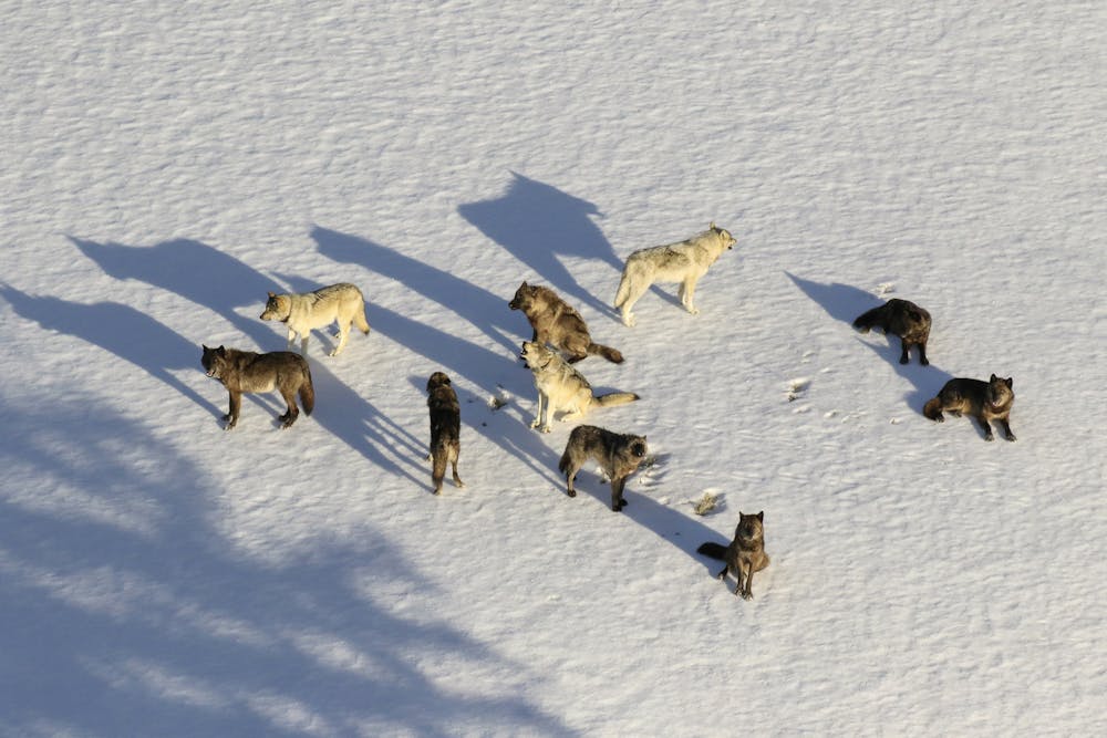
Gray wolves, long native to the Yellowstone area, were reintroduced to the national park in the mid-1990s and have helped the entire ecosystem flourish since. National Park Service via AP
Returning wolves to Yellowstone
One of the best known outcomes of conservation research in park service history is still playing out in the nation’s first national park, Yellowstone.
Gray wolves once roamed the forests and mountains, but government-sanctioned eradication efforts to protect livestock in the late 1800s and early 1900s hunted them to near extinction in the lower 48 states by the mid-20th century. In 1974, the federal government declared that gray wolves needed the protections of the Endangered Species Act.
The return of wolves has not only drawn visitors hoping to see these beautiful and powerful predators, but their return has also triggered what scholars call a “trophic cascade,” in which the wolves decrease elk numbers, which in turn has allowed willow and aspen trees to survive to maturity and restore dense groves of vegetation across the park.
Increased vegetation in turn led to beaver population increases as well as ecosystem changes brought by their water management and engineering skills. Songbirds also came back, now that they could find shade and shelter in trees near water and food sources.
Black bear protection in the Great Smoky Mountains
Great Smoky Mountains National Park is the most biologically diverse park in the country, with over 19,000 species documented and another 80,000 to 100,000 species believed to be present. However, the forests of the Appalachian Mountains were nearly completely clear-cut in the late 1800s and early 20th century, during the early era of the logging industry in the region.
Because their habitat was destroyed, and because they were hunted, black bears were nearly eradicated. By 1934, when Great Smoky Mountains National Park was designated, there were only an estimated 100 bears left in the region. Under the park’s protection, the population rebounded to an estimated 1,900 bears in and around the park in 2025.
Much like the gray wolves in Yellowstone, bears are essential to the health of this ecosystem by preying on other animals, scavenging carcasses and dispersing seeds.
When Everglades National Park was created in 1947, it was the first time a U.S. national park had been established to protect a natural resource for more than just its scenic value.
With their help, the parks – and the landscapes, resources and beauty they protect– can be preserved for the benefit of nature and humans, in the parks and far beyond their boundaries.
Tubers float down the Yampa River in Steamboat Springs on July 23, 2025. A stretch of the river running near downtown can see more than 20,000 tubers through the course of the summer, but city officials sometimes roll out recreational shutdowns to protect the Yampa’s fish. Alex Hager/KUNC
Click the link to read the article on the KUNC website (Alex Hager):
August 5, 2025
This story is part of ongoing coverage of water in the West produced by KUNC and supported by the Walton Family Foundation.
On a hot summer day in Steamboat Springs, the Yampa River feels like the beating heart of the city. On a recent July afternoon, its banks teemed with people looking for a cool refuge from the mid-80s temperatures and direct sun.
Local mom Alohi Madrigal was one of them. She and two friends watched their kids jump off the rocks into the Yampa’s clear water. A steady stream of relaxed-looking tubers floated by too, sprawled out on thick, yellow inflatables.
Even at 3 p.m. on a Wednesday, this little section of the Yampa looked like a postcard-perfect picture of a summer vacation in the Colorado mountains.
But days like this are a precious commodity in Steamboat Springs. When it gets too hot, the city shuts down this specific stretch of river: a roughly six-and-a-half-mile section that flows through downtown, just steps away from the shops and restaurants. During the driest years, it can be bereft of swimmers, tubers and anglers for weeks at a time.
This year, it was already closed for four days in July, and may close again before the summer is through.
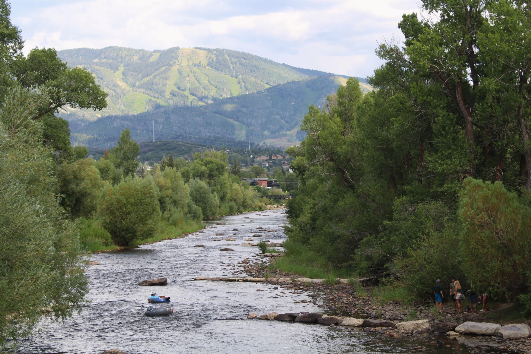
Tubers float down the Yampa River, in the shadow of Steamboat Ski Resort, on July 23, 2025. City officials close the river to recreation when it gets too hot, too low, or lacks oxygen for fish. Alex Hager/KUNC
It’s part of an uneasy balance struck by Steamboat Springs. The Yampa is the city’s lifeblood. Its water irrigates nearby farms and ranches. The same river supplies drinking water to homes and businesses all over town. During the summer, it becomes a mecca for vacationers who flock to the resort town for a cool mountain escape. The city estimates that more than 21,000 people took tubes down this stretch of river in 2024.
But it’s also home to fish. When the river is hot and low, too many humans in the water can setress out its fish – causing lasting damage to their health or even killing them. That could create an unpleasant scene for all of those river users and throw the Yampa’s ecosystem out of whack.
As a result, the city enforces periodic shutdowns to keep the river healthy, even if it means people – and businesses that can make big bucks on equipment rentals – will have to avoid it on the days when its cool water beckons the most.
Flows for fish
It’s easy to look at the Yampa and think about the paddlers and floaters playing on its surface. It’s also easy to forget about the silent, scaly residents beneath. But those fish are at the heart of the river’s summer closures.
“It pretty much all comes down to fish health,” said Emily Burke, conservation program manager at the nonprofit Friends of the Yampa. “Fish get super stressed when river temperatures reach a certain level.”
Recreational closures on the Yampa can be triggered by three things: low water levels, high water temperature or low levels of dissolved oxygen in the water. All three make it harder for fish to survive.
Models of fish that live in the Yampa River are on display at the Steamboat Flyfisher shop in Steamboat Springs on July 24, 2025. When water is low and hot, fish can get stressed and even die. Alex Hager/KUNC
When the river gets low and hot, fish often don’t have enough oxygen to breathe, causing them to get exhausted. That could make them too tired to look for food or stop eating. Already stressed and drained of energy, the extra stress added by humans in the river can cause lasting harm to fish health and — in some cases — kill them.
“If you have a bunch of people splashing around in these deep pools [that] these fish are using as refuge,” Burke said, “It’s really stressful for them, and it can sometimes lead to fish die-offs.”
Measuring stations along the river gather data about its water every fifteen minutes. If the water is hotter than 75 degrees for two consecutive days or flowing lower than 85 cubic feet per second, city officials will roll out a river closure.
‘A huge economic driver’
When the Yampa is teetering on the edge of a shutdown, the people watching closest are often those whose businesses depend on it. Johnny Spillane is one of them. He owns Steamboat Flyfisher, which has a back patio that overhangs the river itself.
On a recent Thursday morning, as people milled in and out of brunch spots and started heading toward tourist activities, Spillane stood behind the counter of his store.
“You can tell in the shop right now it’s pretty quiet,” Spillane said. “If it was a busy, hopping day with people fishing in town, it would be a lot busier right now.”
The river was still open for swimming, tubing and paddling, but officially shut down for fishing.
“July days are our most important days as a business, so losing July days certainly hurts a little bit more,” Spillane said. “But at the same time, you know, losing the fish in the river would hurt a lot more than that. For us, protecting the fish, protecting the resource, is far much more important than getting an extra couple days of fishing on the town stretch, or selling a couple dozen extra flies.”
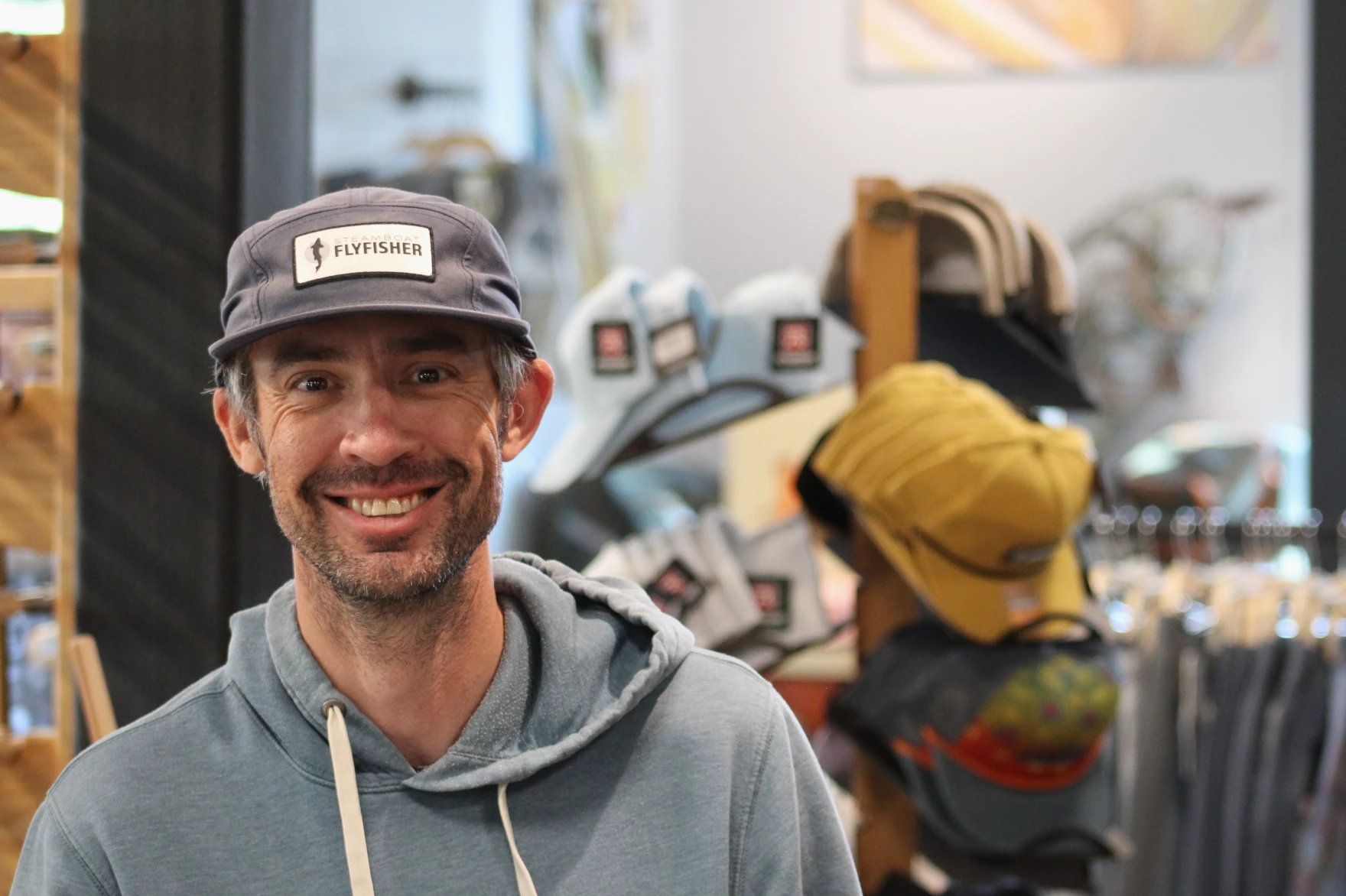
Johnny Spillane, owner of Steamboat Flyfisher, poses in his shop on July 24, 2025. “Protecting the fish,” he said, “protecting the resource, is far much more important than getting an extra couple days of fishing on the town stretch, or selling a couple dozen extra flies.” Alex Hager/KUNC
Spillane said the river closure doesn’t affect his business that much. Fewer people come into the store to buy equipment, but the shop’s fishing guides — who can run more than 200 trips each week — can take customers 20-30 minutes outside of town to other streams, rivers and lakes that are open for anglers.
Even owners of businesses that are inextricably tied to the Yampa’s “town stretch” share Spillane’s mentality.
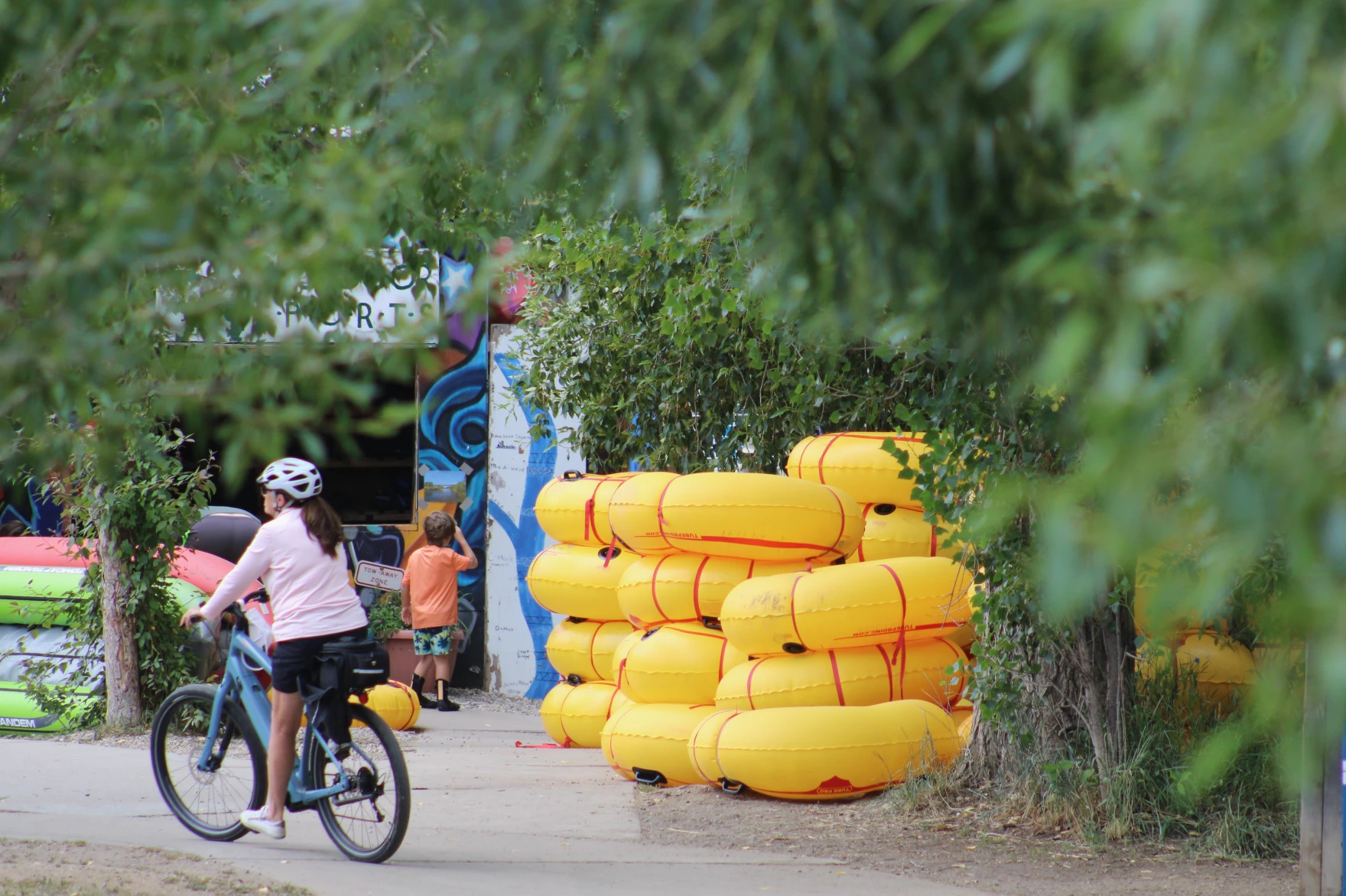
Backdoor Sports sits just a short walk downstream from the flyfishing shop. It’s a powerhouse in the local tube renting scene. Backdoor moves so many rental tubes – as many as 400 a day during the peak of summer – that it has a drive-thru-style window to keep customers moving from signup to river in short order. The shop dispatches rental tubes from a literal backdoor, which lies no more than a couple dozen feet from the Yampa.
Stacks of inflatable tubes wait for renters at Backdoor Sports in Steamboat Springs on July 23, 2025. “The closures can be tough at times,” said Mike Welch, the shop’s owner, “But also necessary, because it’s good to protect what we have here.” Alex Hager/KUNC
“The Yampa River is a huge economic driver for the city,” said Mike Welch, a co-owner of Backdoor. “We want to make sure that it stays that way for a lot of years to come. The closures can be tough at times, but also necessary, because it’s good to protect what we have here. It’s a wonderful, wonderful thing that we’ve got.”
While it takes some extra preparation to steel Backdoor against changing river conditions and shutdowns, Welch said communication from city officials makes it easier.
“The city has done a great job in setting those parameters,” he said. “So we know what the water is looking like and where and when those closures are potentially coming. So we can plan for it.”
People ride a tube through the Yampa River in Steamboat Springs on July 23, 2025. The river is a major draw for tourists and locals alike during the summer. Alex Hager/KUNC
Welch bought the business alongside his brother and sister-in-law this spring. The previous owner, Pete Van De Carr, was a well-known local who died in February following a skiing accident.
Another shop owner, Marty Smith, said Van De Carr played a part in getting the city to specify its plans for reopening the river after a closure.
“Every day, all the outfitters in town, we would get emails from Pete saying we need to come up with a rule to reopen the river,” said Smith, owner of Mountain Sports Kayak School. “I think that they definitely listened to Pete.”
City officials say they are trying to be more transparent about the criteria they use to reopen the Yampa for recreation and communicate directly with outfitters about upcoming changes to closures. The city consults with Colorado Parks and Wildlife before reopening the river. They consider current river conditions, weather forecasts and the amount of stress that fish may already be feeling from hot, dry conditions.
‘A tough spot to be in’
For the city officials who manage closures on the Yampa, it’s all about balance.
“We hate having to do this,” said Jenny Carey, the city’s Open Space and Trails supervisor, “Because you inevitably will hear from somebody that it’s just ruining their day, their business. And that’s tough. That’s a tough spot to be in. We don’t want to do that.”
Carey said Steamboat Springs puts up signs and social media posts to inform people about the closures and the reasons for them.
“We understand that people want to be in the river,” she said, “And so it’s a difficult conversation. We do our best to educate as best we can. I think a lot of our locals are getting used to this, and they understand the reason.”
While it can be rocky trying to tell out-of-town tourists that they won’t be able to tube on a hot summer day, locals really do seem to be getting the message. In a 2024 survey of Steamboat Springs residents, 92% of people said “management of the health of the Yampa River” was essential or very important.
That’s only five points lower than the fire department. Managing the Yampa’s health ranked as more important than city parks and the police department.
“The Yampa river is considered one of the most important services that the city provides,” said Julie Baxter, the city’s water resources manager. “So we feel very grounded that we have the support of the local community members that live here in Steamboat Springs.”
Bears play along the banks of the Yampa River in Steamboat Springs on July 23, 2025. In a survey of city residents, 92% of people said protecting the health of the river was important — scoring it higher than city parks and the police department. Alex Hager/KUNC
Recreational closures on the Yampa are mandatory for rental shops, but technically voluntary for individuals who want to bring their own tubes or kayaks. But with so many locals on board, few people decide to take a dip.
“If there is a closure in place and you get in the river,” Baxter said with a chuckle, “You will likely have a local yell at you.”
Alohi Madrigal, who was raised in Steamboat Springs and still lives in town, watched her kids splash in a stretch of the Yampa that may be closed later this summer. She said a shutdown wouldn’t be the end of the world.
“There’s a million things to do here,” she said, proceeding to list off a handful of other swimming spots. “We have to take care of the river, or it won’t be here for long.”
Click the link to read the article on the Big Pivots website (Allen Best):
August 5, 2025
Colorado governors of the past and possibly the future gathered in Lamar to pay their respects. His last wishes were that the wheat harvest go on.
When it became clear that John Stulp had little time left to live, he specified that the memorial service would come later, after the wheat had been harvested but before the next planting.
That service was held on Saturday, August 2, at the First Baptist Church in Lamar, in southeastern Colorado, not quite a month after his death. Several hundred people attended, many of us from out of town.
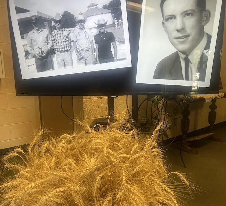
Fittingly, the family had positioned a few large vases fill with bundles of wheat next to the photos of Stulp. One photo was Yuma High School, and another was from a meeting with then-President Jimmy Carter. He got around in his life, but in his heart, he remained a farmer.
Tributes to his life were lavished at the church in Lamar, and from my experiences with him during the last 13 years or so, they were deserved. Responding to my first impressions on Facebook, one individual said this: “A great man.” Said another: “These sorts of people make civilization work.”
Former Colorado Gov. Bill Ritter was at the remembrance in Lamar, as was an individual who may possibly become Colorado’s next governor, Phil Weiser. Neither spoke, and as for Weiser, I saw no evidence he was campaigning. It appeared to me he was simply there to pay his respects after likely arising early in [Denver] to get to Lamar by mid-morning.
This was in addition to former U.S. senator, Ken Salazar, who was in the audience along with Kate Greenberg, the current Colorado commissioner of agriculture, and two of her predecessors, Don Brown and John Salazar. I also recognized various people from the Colorado Water Conservation Board, including at least two former directors of the Colorado Water Conservation Board, Becky Mitchell and James Eklund.
John Hickenlooper, still another former Colorado governor, was not there but had delivered a eulogy from the floor of the Senate shortly after John’s death on July 7. “John was a good man, a great man by any measure,” Hickenlooper had said.
What came out again and again was his love of place, his devotion to family and community, his generous heart. And while he was also a notably good listener, it was also said that John was a very good storyteller.
I knew Stulp a bit. In about 2012, I went to Beaver Creek for a water forum, and he was a speaker. I struck up a conversation with him, and he invited me to visit him on his farm south of Lamar the following weekend. Then I didn’t fully realize the irony of his position as the state’s “water czar” for Hickenlooper: his farm south of Lamar was entirely dryland.
When I visited him at that farm, we talked at length before he showed me around his home country. We stayed in touch after that, usually it being a matter of me seeking his perspective about water, energy, and other matters.
John leaned into the future. He saw the tiny details and the big pictures. Several times I consulted him to understand the role of eastern Colorado in our state’s energy transition. He had been a Prowers County commissioner from 1992 to 2003, and during the latter time he voted for approval of Colorado Green. The wind farm south of Lamar was, when it began operations in 2004, the largest in the country.
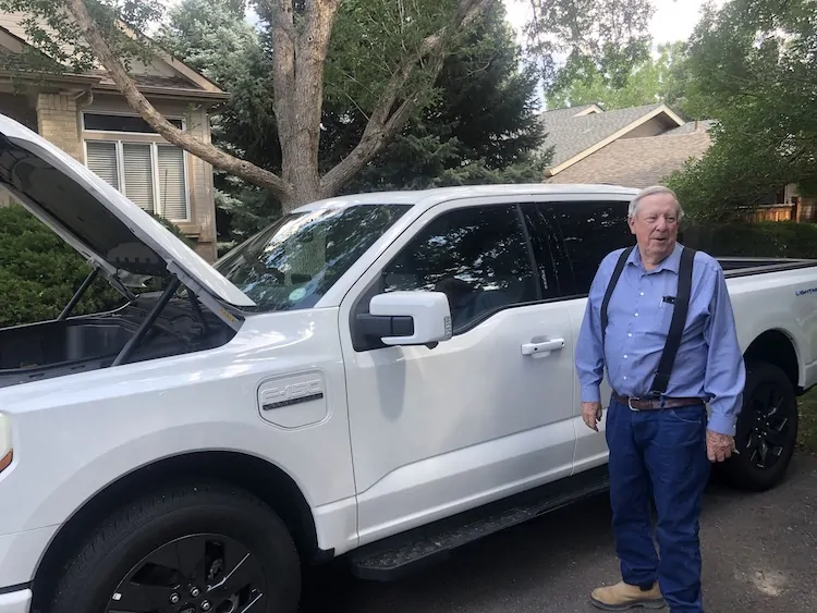
John Stulp purchased an electric pickup truck in 2022 and was happy to show it to visitors. Photo credit: Allen Best/Big Pivots
Of late, I was particularly interested in his experience as an early adopter. In his electric pickup he made the rounds between Lamar, a home in Lakewood that I believe he and his wife, Jane, had acquired during his 12 years in his position in Colorado state government, and Yuma, where he had begun life during an intense snowstorm in 1948 and where he still had farming property. Trips often also included Fort Collins, where two of his children lived.
Earlier this year, I was curious whether the growing network of fast-charging stations in eastern Colorado was meeting his traveling needs. By then, he was on oxygen, eight liters a minute, and when in the pickup he needed to draw on the battery. That gave him less margin for error, he said, and no, Colorado’s fast-charging infrastructure on the eastern plains fell short. He had been forced to return to an internal-combustion engine for trips to the Front Range.
As recently as late June, I had written to him after noticing a letter from him filed in a Colorado Public Utilities docket. It was, I wrote to him truthfully, the most compelling of all the comments I had seen filed in that case.
The main reflection I had after hearing the remarks in Lamar was a reinforcement of my previous opinion. For whatever reason, John put it together early in life. Many of us struggle to figure out our paths. He did not. He must have been a bright boy. By age 4, he was accompanying his aunt to a one-room schoolhouse. He grew up farming, growing corn, and raising cattle and hogs. He went to Colorado State University and became a veterinarian.
After stints as a veterinarian in Windsor and then Las Cruces, N.M., he and his wife, Jane, moved to the Lamar area, where she had grown up on a farm. They had five children, and he assumed new roles in agriculture organizations, his community, and state and national organizations. He was on the board of directors for the State Land Board, for the Colorado Wildlife Commission, and the board of governors of Colorado State University.
In the 1990s, then Colorado Gov. Roy Romer twice asked him to be the state ag commissioner, but he declined, citing the need to be with his family. Bill Ritter made the same request when he was elected in 2006, and this time he excitedly said yes. He served a four-year term.
Governor Hickenlooper, John Salazar and John Stulp at the 2012 Drought Conference
When John Hickenlooper was elected governor in 2010, he asked Stulp to be part of his team but in a different capacity. In his eulogy on the floor of the Senate, Hickenlooper explained what he was up to. Colorado had experienced particularly severe drought in 2011 and even more in 2012.
“I was convinced that we needed a blueprint, a plan of some sort, to address the projected growth and its future water supply, to make sure that we had the supply that could match our needs. I recruited John to serve as my top water policy advisor. We made it a cabinet-level position. He came to all our cabinet meetings. He was our water czar.”
Wheat harvest was a time of hard work but also joy at the Stulp farm south of Lamar. Photo credit: Allen Best/Bigg Pivots
Stulp’s background in agriculture — which uses 85% to 90% of water in Colorado — was key to his choice.
“John understood the agriculture community in Colorado better than almost anyone,” explained Hickenlooper. “Maybe that’s why, when I first approached him with the idea of a statewide water plan, he wasn’t immediately convinced. Actually, he was far from it. He was, I would say, more than skeptical.”
Hickenlooper explained that he understood how difficult it would be to get buy-in. “He didn’t think it was a smart idea for me politically as a new governor to take on an issue that had the potential to be so divisive,” explained Hickenlooper. “But he understood that we couldn’t let our rivers and farms be at risk of running dry. We needed him. Colorado needed him. And he set aside his reservations, rolled up his sleeves and went to work.”
Stulp’s work in achieving consensus was part of the state water plan completed in 2015 (and since updated twice). What has been the result of that plan? Has it actually been a success? That’s a much longer story.
In his eulogy, Hickenlooper also added a personal touch.
“I’m not sure there are gradations of ‘goodness,’ but I have traveled long distances with John Stulp, and I’ve stayed at his home in Prowers County where he and his remarkable wife, Jane, would cook up a barbecue and get me together with some of their neighbors.” “He even loaned my son, Teddy, a .410 shotgun so he could learn how to shoot,” said Hickenlooper.
“If I did believe in gradations of ‘goodness,’ John and Jane Stulp would be at the very top.”
Delivering a testament later, once again in response to my Facebook post, was Jackie Brown, who spent 39 yeas in public health, including 22 years in Prowers County. Stulp had recruited her to the position from nearby Baca County.
“John was the best example of a good man and a great leader,” she wrote. “He was honest, smart, caring, fair and had integrity. His family, community and his employees were his priority. Plus, he had a great sense of humor.”
The service was held in a church, and it turns out that Stulp was deeply religious. During covid, after his work in Colorado state government, he was confined to his home. He had, he told me, been admonished by one of his sons for venturing out to Walmart. Later, he lost a brother in Yuma to covid.
In this time of isolation, John agreed to take over the Baptist minister’s daily phone tree that sought to connect people during times of isolation. The pastor, Darren Stroh, said that Stulp had sent more than 200 messages. One of them contained these thoughts:
“If you were judged — choose understanding.
If you were rejected — choose acceptance.
If you were shamed — choose compassion.
Be the person you needed when you were hurting, not the person who hurt you.
Vow to be better than what broke you -— to heal instead of becoming bitter.
Act from your heart — not your pain.”
At the church on Saturday, his son Jensen told us about the father he knew, the father who relished wheat harvest, where he loved to offer rides in a combine to his grandchildren and others. Harvest on July 4th always produces extra energy amid questions of will it rain and will there be time to watch fireworks.
On this year’s July 4th, days before he died, the Stulp family gathered around John. With his strength ebbing, he delivered “one of the most meaningful and powerful speeches we’ve ever heard,” said John Stulp III. “It was a charge to the grandkids. First thing he said, finish harvest. Keep cutting the wheat. That was said multiple times.”
Then he continued about how he wanted them to comport themselves. Be flexible. The world is better when you are generous. We produce food, and the world is hungry. Care for others. Make sure they know you love them. Jesus wasn’t petty; neither should you be. Live in this moment and live it to the fullest, but plan for the future.
And with those words to his grandchildren remembered we were invited to the fellowship hall and a long table of tasty home-cooked food and an equally long table of desserts. In the middle of each table was a centerpiece consisting of a mementoes of John’s life and a small bundle of wheat.
How pervasive toxicity threatens human and planetary survival
What if one of the biggest threats to our health and planet is invisible, yet found in our air, food, and water?
Our latest report is the first time that a single report has attempted to analyse the broader collective problem and solution spaces of chemical toxicity answering the questions: how and why are toxic chemicals produced, how do they get into our bodies and the environment, and how do they affect the health of humans and other organisms?
Over eight months, we conducted an extensive analysis, including reviewing countless peer-reviewed studies and 50+ interviews with global experts. This research shows that the impacts of chemical toxicity are largely underestimated, contributing to increasing cancer rates, declining fertility, and a surge in chronic diseases, alongside ecosystem damage.
The overarching conclusion is that chemical toxicity is an underestimated risk to society and deserves significantly more attention and resources.
But this report isn’t just about the problem; it’s a call to action for solutions. We highlight critical industry, regulatory gaps and, most importantly, identify key areas for innovation and urgent funding that can put us on the right path to increase our understanding and make positive changes where it’s most needed.
We identified three opportunity areas that demand solutions: pesticides (herbicides and insecticide), food contact materials, personal care products.
Key takeaways include:
Over 3,600 synthetic chemicals from food contact materials are found within human bodies globally.
PFAS have contaminated the entire world, with levels in rainwater often exceeding safe drinking water limits.
Over 90% of the global population is exposed to air pollution exceeding World Health Organisation (WHO) guidelines.
The impact of pesticide use on cancer incidence may rival that of smoking and is linked to leukaemia, non-Hodgkin’s lymphoma, bladder, colon, and liver cancer. Prenatal pesticide exposure increases the odds of childhood leukemia and lymphoma by over 50%.
To learn more, you can download both the executive summary and the full report below. If you’re curious about how to create an impactful and commercially viable company in this space, we’d love to hear from you!
CPW is developing a Beaver (Castor canadensis) Conservation and Management Strategy. The public scoping period is now open through August 31, 2025. Please provide feedback through the comment form on this page. A recorded presentation with more information is available under Important Links.
Background and Need
As a keystone species, beavers provide essential ecosystem services and increase local biodiversity in ecologically suitable habitats. However, beavers also represent a source of human-wildlife conflict, particularly at the interface of human infrastructure and waterways.
Increasing interest in beavers as an agent for ecological restoration prompted Colorado Parks and Wildlife (CPW) to begin developing formal guidance to inform beaver conservation and management, including such topics as: harvest regulation, restoration, techniques for coexisting with beaver, and relocation. Given the broad reach, complexity, and interrelatedness of these topics, CPW is gathering input from diverse stakeholders to inform a strategy for beaver conservation and management.
How to Get Involved
The public scoping period will be open from July 30 through August 31, 2025. A scoping feedback form will be available at the bottom of this page once the input period opens.
Public input on the draft Beaver Conservation and Management Strategy will be open in Fall 2025.
American beaver, he was happily sitting back and munching on something. and munching, and munching. By Steve from washington, dc, usa – American Beaver, CC BY-SA 2.0, https://commons.wikimedia.org/w/index.php?curid=3963858
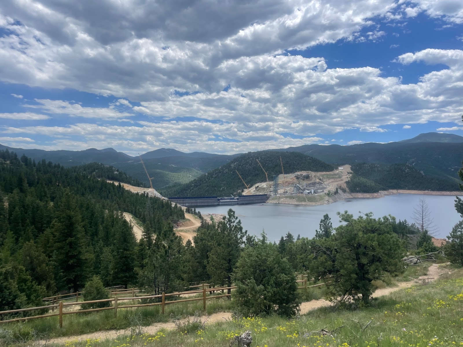
Cranes and construction equipment line the shore at Gross Reservoir on June 19, 2025 in Boulder County, Colorado. The construction is part of an expansion project that will supply water to Denver’s residents. (Cassie Sherwood/The Water Desk)
Pieter Strauss used to love hosting stargazing parties at his house in the Lakeshore Park neighborhood up Flagstaff Road southwest of Boulder. The hobbyist astronomer would fire up the barbecue and spend hours showing his neighbors the night sky through his observatory and telescopes.
Strauss’s house sits looking directly over Gross Reservoir, which provides water to Denver residents.
But when a project to significantly raise the reservoir’s dam began construction in 2022, those moments of neighborhood tranquility were lost for some residents. For Strauss the biggest impact was the bright construction lights used to keep work moving overnight.
“It became impossible to sit on the deck before sunrise and after sundown, astrophotography was impossible. They lit up the skies,” with powerful floodlights, Strauss said.
For over 20 years, residents and various environmental groups have protested the project, which suffered a series of legal blows this year. Construction on the massive dam ground to a halt in April amidst the courtroom wrangling, and subsequent decisions have cast a new level of uncertainty over large-scale water projects that propose to draw on the beleaguered Colorado River.
However, by the end of May, federal courts ruled that construction could continue due to concerns surrounding uncompleted construction and potential flooding possibilities, but that the reservoir could not be filled.
The Gross Reservoir Expansion Project involves raising the height of the existing dam by 131 feet. The dam will be built out and will have “steps” made of roller-compacted concrete to reach the new height. Image credit: Denver Water
Raising the dam
Gross Reservoir’s dam is owned and operated by Denver Water. The utility built it in the 1950s, with two other building phases planned to accommodate future water needs. The current dam expansion will raise the height of the dam 131 feet, tripling the current capacity of the reservoir, and providing more water for Denver Water customers.
The construction was spurred by “a combination of demands in our system, as well as concerns about climate and concerns about the needs for greater resilience in our system,” said Jessica Brody, general counsel for Denver Water.
The need for the expansion is similar to a bank savings account, Brody said. Tripling the capacity of the reservoir is a savings account that can be drawn on in circumstances of an emergency.
“If we have an extreme drought event, we want to have more water banks that we can help smooth the impacts to our customers,” Brody said.
When the utility initially announced plans to begin moving forward with a dam expansion, residents of the area were concerned. Environmental threats and the disruptions from the massive construction project topped the list of worries. They attended meetings at town halls with county commissioners. They organized with other residents in and around Coal Creek canyon.
While some residents fought the expansion, others anticipated it. When the dam was initially constructed, the utility planned to expand further down the line.
Since construction began in 2022, residents have experienced noise and light pollution. Five neighbors have moved from the Lakeshore Park neighborhood. Pieter Strauss, at whose house they once held stargazing gatherings, was among them.
Beverly Kurtz, member of TEG, on Pieter Strauss’s former porch overlooking Gross Reservoir on June 19, 2025. Once construction began, Strauss was no longer able to host neighborhood stargazing parties due to light pollution. (Cassie Sherwood/The Water Desk)
“The most valuable thing to all the people who have moved up here is that they had a quiet nature sanctuary. But then when you take that away, is it worth it?” said Anna McDermott, another resident of the area.
“We sleep with our windows open. Not one house has air conditioning, so you sleep with your windows open in the summer months,” she said. “You hear these giant backup beepers crashing, grinding all night long. Even with earplugs, I can’t sleep.”
The Environmental Group (TEG) is an organization of residents in the Lakeshore Park neighborhood and surrounding residents, focused on engaging the community in action when environmental issues arise. Along with Save the Colorado, The Sierra Club, and other environmental organizations, TEG has fought the expansion. Beverly Kurtz, former president of TEG, has worked to hold Denver Water and the companies working on the dam, Kiewit Corp. and Barnard Construction Company Inc., accountable during construction.
Heavy duty trucks are required to use a different road to access the dam rather than the paved road up Flagstaff Mountain due to fire concerns. Large semi-trucks have slid off the road due to the steep grade, which can cause traffic jams and road closures.
“At one point they had one of the two roads down this mountain closed for five months,” Kurtz said. “It wasn’t until we called the sheriff out here and he realized the safety concern that they opened the road back up.”
Legal snares slow construction
In October 2024, two years after construction began, Save the Colorado, along with other environmental groups, won a lawsuit against Denver Water. U.S. District Court judge Christine Arguello found the utility’s dam construction permit violated the Clean Water Act and the National Environmental Policy Act. At the time, construction was able to continue and Arguello ordered the groups to work out an agreement regarding damages.
In April 2025, the judge ordered a temporary halt on construction. The initial lawsuit argued that the U.S. Army Corps of Engineers, who provided the project permitting, did not fully consider climate change impacts when it approved the dam’s expansion.
A month later, Arguello ruled that Denver Water could finish construction on raising the dam, but that the reservoir could not be filled until the Army Corps reissued the permits.
“If you stop the construction of a dam when it is partially built, the dam doesn’t function as it was ultimately designed to function,” said Denver Water’s Brody. “That was a big concern of ours and the Federal Energy Regulatory Commission.”
The utility has also been ordered to not remove any additional trees surrounding the dam until the proper permits are obtained. The project proposes the removal of over 200,000 trees.
Arguello’s opinion also called into question the underlying water rights Denver Water would rely on to fill the newly enlarged reservoir when construction finished. Gross Reservoir is filled with water from the headwaters of the Colorado River, which has experienced steep declines in water supply amid a long-term warming and drying trend in the Rocky Mountains.
“The Environmental Impact Statement didn’t even look at the fact that the flows of the Colorado River are in decline. Most of the science suggests they will continue to decline further,” said Doug Kenney, Western Water Policy Program director at the University of Colorado Boulder’s Natural Resources Law Center. Acquiring new permits will require Denver Water to redefine the project’s purpose and evaluate the environmental damage, he said.
The case is more than a local water project. Diverting more water across the western slope of Colorado has created concerns for ecosystems throughout the overappropriated watershed and for communities downstream in California, Nevada and Arizona.
“It makes it more difficult to ensure that there’s sufficient flow downstream as a result,” Kenney said. “We have got to stop this practice of taking more and more water out of the upper reaches of the Colorado River because it just increases the stress on a river that is already under a tremendous amount of stress.”
By calling into question the project’s potential to have downstream impacts, the decision could add a new legal hurdle future water development infrastructure will have to clear.
“Historically, agencies in recent decades have not done enough to consider climate change in decisions,” Kenney said. Cases like this one need to happen in natural resource law more generally, he said, as they help establish precedents for future projects that could potentially put the environment at risk.
Denver Water is appealing the court decisions that bar the expansion. That could result in a reissue of the permits with a redefined purpose or a dismissal of the court rulings made earlier this year.
“We think that the district court made some misjudgements or misinterpretations when it found the Army Corps committed these errors,” Brody said.
Learning to live alongside it
Amid the stops and starts of Gross Reservoir construction, nearby residents are not ready to let go of what they used to have.
Kurtz and McDermott recall their old activities along the reservoir’s north shore. A handful of neighbors would walk their dogs everyday along the hiking trail that connected the reservoir to their neighborhood. The trail has since been widened significantly, to allow for excavating equipment. They would host Memorial Day parties along the water’s edge.
Beverly Kurtz and Anna McDermott, longtime residents of the Lakeshore Park neighborhood pose in front of Gross Reservoir on June 19, 2025. They are members of TEG, an environmental group involved in a lawsuit against Denver Water. (Cassie Sherwood/The Water Desk)
Now they minimize their excursions to the shore as much as they can. At this point they’re more than ready for construction to be completed, exhausted from the daily disruptions, explosions and drilling.
“Now clearly, when the work is done, the things which negatively impacted my life would go away. But I couldn’t last them out,” Strauss said. He recently relocated to the Boulder area. “It was just my bad luck that my golden years coincided with the worst effects of the project.”
Some residents found that the expansion project has renewed their sense of community in Lakeshore Park.
“In a weird way a lot of us have gotten even closer because we were in the battle together,” Kurtz said. “We feel like at this point we won the battle, but we’ve lost the war.”
“They will get the permits to eventually fill this reservoir following the expansion,” she said.
However, federal courts requiring the proper permits to continue construction is a win in her and TEG’s book, as it sets a precedent for any large construction processes that occur in the future. It will ensure that the proper environmental permits are obtained before construction can begin on a project.
“If nothing else, we hope that precedent still stands. Because it will help somebody else,” she said.
This story was produced by The Water Desk, an independent journalism initiative at the University of Colorado Boulder’s Center for Environmental Journalism.
Survey work begins in 2018 for the Navajo-Gallup Water Supply Project on the Navajo Nation. Photo credit: U.S. Bureau of Reclamation via The High Country News
Bidtah N. Becker, chief legal counsel for the Navajo Nation, told St. George News there is an urgency to secure the tribe’s legal rights to the Colorado River in Arizona, calling it their “No. 1 issue.” Becker explained that while the tribe secured water rights settlements in Utah in 2022 and in New Mexico in 2009, members still lack a legal water allocation in Arizona. A proposed bill in Congress, the Northeastern Arizona Indian Water Rights Settlement Act of 2025, seeks to address this gap. The bill involves partnerships with the Hopi Tribe, the San Juan Southern Paiute Tribe, the state of Arizona and more than 30 municipalities and communities in northern Arizona…The legislation has been delayed due to a lack of agreement from the seven Colorado River Basin states, which are focused on post-2026 guidelines for managing the river. Becker said the Navajo Nation remains hopeful that once those discussions advance, a settlement can gain momentum…
The Navajo Indian Irrigation Project, located in northwest New Mexico, draws its water from Navajo Lake on the San Juan River and moves it through more than 70 miles of main canals and 340 miles of laterals. Approved by Congress in 1962, the project transformed from a small-scale farming initiative into a major agricultural operation. The project holds rights to 508,000 acre-feet of San Juan River water annually, used to irrigate high desert lands south of Farmington, New Mexico…
Beyond agriculture, the Navajo Nation is working to secure municipal water supplies. Becker said one key project underway is the Navajo-Gallup Water Supply Project. A lateral portion of the project, running along U.S. Route 550, is already constructed; the second lateral section still requires funding to be completed.
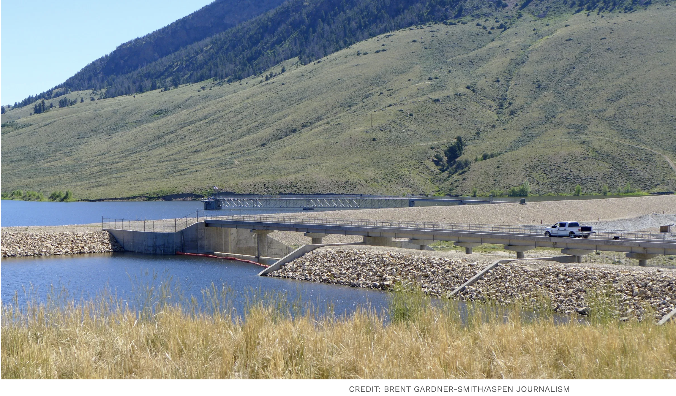
A truck drives out to Ritschard Dam, which forms Wolford Mountain Reservoir, on July 13, 2016. A court sided with the River District in a dispute with Denver Water over repairs to the dam.
A judge has sided with a Western Slope water district in a dispute with Denver Water over a problem dam in Grand County.
In its 2021 complaint, Denver Water accused the Colorado River Water Conservation District of breach of contract by slow walking required repairs to Ritschard Dam until Denver Water became part owner of the dam in 2020, at which time the Front Range water provider would share financial responsibility for repairs.
But in a June 19 judgment, District Court Judge Mary C. Hoak found in favor of the River District, writing that the River District made thoughtful, prudent and reasonable decisions with respect to repairs to Ritschard Dam, and did not act dishonestly or outside of accepted practices.
“Our partner in that reservoir turned around and sued us, in my mind, because they wanted a different contract over how the dam is managed and they wanted to weasel out of their obligation to pay for the repair and rehabilitation, should it ever be required,” said River District General Manager Andy Mueller at the River District board’s regular meeting Tuesday. “The judge saw through their smokescreen and really rewarded the district for doing the right thing.”
The River District is now asking that Denver Water pay nearly $773,000 in costs associated with the lawsuit.
In an emailed statement, Denver Water spokesperson Todd Hartman said the water provider “continue(s) to assess the ruling and consider potential next steps.”
Wolford Mountain Reservoir. An aerial view of Wolford Reservoir, formed by Ritschard Dam. An aerial view of Wolford Reservoir, formed by Ritschard Dam. The reservoir is managed by the River District and Denver Water owns 40% of the reservoir capacity.
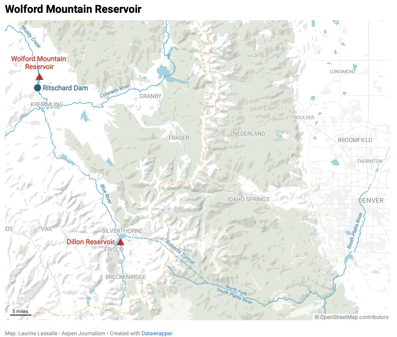
The complaint stemmed from structural issues at Ritschard Dam, which forms Wolford Mountain Reservoir on the Muddy Creek upstream of the town of Kremmling. Built in 1995, the reservoir has a capacity of 66,000 acre-feet, and Denver Water releases water from it downstream to offset its upstream diversions at Dillon Reservoir and the Roberts Tunnel. Denver Water, which is Colorado’s oldest and largest water provider serving about 1.5 million people, helped finance construction of the dam and reservoir, paying about $43 million.
The River District owns and operates the 122-foot-tall dam and reservoir, and according to agreements between the two entities, Denver Water would lease 40% of the reservoir capacity from when the reservoir was completed in 1995 until 2020. At the end of 2020, Denver Water would take 40% ownership of the reservoir capacity along with 40% ownership of the water right.
Denver Water would also become responsible for 45.33% of the costs of operation, maintenance and rehabilitation of the dam, which had been solely the River District’s financial responsibility up until that point.
Because of the disagreement, the two entities extended the lease agreement until summer 2021. At that point, according to Mueller, the River District conveyed a deed to Denver Water, which then became part owner, and the water provider has been paying for its share of the operation, maintenance and repair costs during the litigation.
Settling and cracking
In 2009, the River District became aware of settling and deformation of the dam, meaning the structure is moving more than expected, and has been intensely monitoring the situation since then. From 2012 to 2015, the River District began moving toward structural rehabilitation, but a 2015 expert review panel found there was not a need for immediate remediation.
In 2019 and 2020, cracks appeared in the dam, prompting further study and dam safety evaluations. From 2013 to 2022, the River District spent $3.7 million on dam-related maintenance and dam-deformation expenses.
Denver Water argued the River District led Denver Water to believe that the River District would make repairs to the dam, but then changed its mind just prior to the expiration of the lease agreement, after which Denver Water would be on the hook for its share of the cost of repairs. Denver Water argued that instead of repairing the dam as required, the River District hired new experts and reversed course.
Jim Lochhead, who was Denver Water CEO from 2010 to 2023, testified at a 12-day trial in May 2024 that Denver Water didn’t know until an August 2019 meeting that the River District wasn’t going to repair the dam. But the court disagreed, citing evidence Denver Water knew of the River District’s plans as of February 2017 at the latest.
“…the Court does not find Mr. Lochhead’s testimony on this point credible,” the judgment reads. “Mr. Lochhead was the only witness that testified at trial regarding this meeting, there are no documents supporting the occurrence or substance of this meeting, and Denver Water’s Complaint, Denver Water’s Notice of Breach and discovery responses do not reference this meeting.”
In addition to expert testimony and documents, the court’s judgement relied on the annual inspection reports for Ritschard Dam from the Colorado Division of Water Resources State Engineer’s Office, which have rated the dam “conditionally satisfactory” since 2012 and never ordered a storage restriction.
“The SEO annual inspection reports were uniformly positive as to the maintenance of the dam,” the ruling reads.
“(Denver Water) had an elaborate scheme cooked up in their heads that this board and staff management, as well as the past management, concocted some way to delay things and did it in bad faith,” Mueller told the River District board. “They told a story to the court that they completely failed to support with any facts at the court level, and we won on all claims.”
Wolford Mountain Reservoir, on Muddy Creek in Grand County, is managed by the River District. Denver Water owns 40% of the reservoir capacity. CREDIT: HEATHER SACKETT/ASPEN JOURNALISM
The River District win comes at a pivotal time for Colorado water managers that underscores the simmering tension that remains between the West Slope and Front Range. Denver Water, along with other Front Range water providers, has been granted a special hearing in September to air their concerns about the River District’s plan to purchase water rights tied to the Shoshone hydropower plant in Glenwood Canyon.
Although this chapter of litigation is over — Denver Water has a right to appeal — the problems with the Ritschard Dam remain. The dam is classified as high hazard, which means dam failure is expected to result in loss of human life. The River District board allocated more money to address the structural issues at its regular meeting Wednesday, approving a $294,185 contract with HDR Engineering, Inc. for an alternatives analysis to evaluate potential modifications to the dam. The alternatives analysis was recommended in a 2024 Comprehensive Dam Safety Evaluation.
“We’re not out of the woods on that dam, so we just have to continue to put public safety as the number one priority of the district, and use that as our guiding principle,” Mueller said.
…in his second administration, President Donald Trump is not just approaching climate science with skepticism. Instead, his administration is moving to destroy the methods by which his or any future administration can respond to climate change. These moves, which are sure to be challenged in court, extend far beyond Trump’s well-documented antipathy toward solar and wind energy and his pledges to drill ever more oil even though the US is already the world’s largest oil producer. His Environmental Protection Agency announced plans this week to declare that greenhouse gas emissions do not endanger humans, a move meant to pull the rug out from under nearly all environmental regulation related to the climate. But that’s just one data point. There are many others:
Instead of continuing a push away from coal, the Trump administration wants to do a U-turn; Trump has signed executive orders intended to boost the coal industry and has ordered the EPA to end federal limits on coal- and gas-fired power-plant pollution that’s been tied to climate change.
Tax credits for electric vehicles persisted during Trump’s first term before they were expanded during Joe Biden’s presidency. Now, Republicans are abruptly ending them next month.
The administration is also ending Biden-era US government incentives to bring renewable energy projects online, a move that actually appears to be driving up the cost of electricity.
Republicans in Congress and Trump enacted legislation to strip California of its authority to ban the sale of new gas-powered vehicles beginning in 2035.
Trump is also expected to overturn national tailpipe standards enacted under Biden’s EPA and is also to challenge California’s long-held power to regulate tailpipe emissions.
The authors of a congressionally mandated report on climate change were all fired; previous versions of the report, the National Climate Assessment, which showed likely effects from climate change across the country, have been hidden from view on government websites.
Other countries, large and small, will gather in Brazil later this year for a consequential meeting on how the world should respond to climate change. Rather than play a leading role — or any role at all — the US will not attend.
This summer, the Southern Ute Indian Tribe rolled out miles of temporary rubber water lines. The above-ground tubes had one job: carrying water to oil and gas operations on the reservation.
But the pipelines also represent something else: a historic moment in a drawn-out, arduous debate over water in southwestern Colorado.
In May, the Southern Ute Indian Tribe tapped into its water in the controversial Animas-La Plata Project, the first time a tribe has used its water from the project since it was authorized in 1968.
The Animas-La Plata Project has come to encapsulate long-held dreams to develop Western water — and the decades of debates, environmental concerns, local objections and Congressional maneuvering that almost made the project fail.
At the center of it all were tribal nations and the chance to, once and for all, settle all of the tribal water claims in Colorado. It took until 2011 to fill Lake Nighthorse, the main feature of a heavily scaled-down federal water project located just south of Durango. Then 14 more years for a tribe to be able to use a small slice of its water.
More barriers — tied to interstate laws, finances and infrastructure — still stand in the way of tribes and other Animas-La Plata water users taking full advantage of the multimillion-dollar project.
“This has taken the hard work of many Tribal leaders and Tribal staff over many decades to get to where we are at now,” the Southern Ute Indian Tribe said in a prepared statement.
All Animas-La Plata Project water users can access water both in the reservoir, Lake Nighthorse, and the Animas River, but they draw from the river first. The reservoir functions like a savings account, said Russ Howard, the general manager for the Animas-La Plata Project.
This year, the tribe used water from the Animas River for oil and gas well completion activities, which wrapped up in mid-July. The tribe declined to provide more details.
It plans to use the revenue from the project to upgrade dilapidated irrigation systems, like the deteriorating federal Pine River Indian Irrigation Project, or other water-related projects, like infrastructure to access its Animas-La Plata Project water.
The Southern Ute Indian Tribe and its sister tribe in Colorado, the Ute Mountain Ute Tribe, have repeatedly brought up their lack of access to the Animas-La Plata Project in high-level conversations about tribal water access in the broader Colorado River Basin and how to manage the basin’s overstressed water supplies once key management rules expire in 2026.
The Colorado River Basin is the lifeblood of the American Southwest, providing water to 40 million people, cities from Denver to Los Angeles, industries and a multibillion-dollar agriculture industry. The Colorado River’s headwaters are in western Colorado, but its water finds its way to faucets, ditches and hoses in every corner of the state.
Tribal nations have federally recognized rights to about 26% of the Colorado River’s average flow between 2000 and 2018. But they’re not using all of this water. In some cases, they’re still going through legal processes to finalize their rights. In others, they are working on finding funding for new pipes, reservoirs and canals to access their water.
In some cases, downstream water users have become reliant on water while tribes are sorting out their water rights. But tribes say they are actively working on ways to put their water to use, which could push nontribal water users down the priority list.
“The Tribe wants everyone to understand that there currently is a reliance on undeveloped tribal water,” the Southern Ute statement said. “It is important for everyone to understand that the Southern Ute Indian Tribe has the right to develop its water resources and plans to do so.”
A big dream for the Southwest
People have been crafting different versions of an Animas-La Plata Project since at least 1904.
In the 1970s, they were drawing up maps showing a dam across the Animas River, also called El Río de las Ánimas Perdidas or the River of Lost Souls, to create the Howardsville Reservoir north of Durango. Other new reservoirs, plus hundreds of miles of canals and ditches, would provide irrigation water for both Native and non-Native farmers. The “Animas Mountain Reservoir” would provide drinking water for Durango. There would be plenty of water for irrigation, municipal and industrial users in the Southwest.
It was the age of water development in the West, led by the U.S. Bureau of Reclamation, and anything seemed possible.
Only, none of that happened.
That’s according to piles of manila folders, labeled in scrawling cursive, in the archives at Fort Lewis College’s Center of Southwest Studies. There, thousands of pages of documents reveal how, exactly, the big dream fell apart and a small, but vital, version survived.
In the 1960s, lawmakers, like Colorado Democrat Wayne Aspinall, fought in Congress to get the Animas-La Plata Project into the Colorado River Basin Project Act of 1968.
Congress authorized the project alongside others in the Upper Colorado River Basin, like the Dolores Project in southwestern Colorado, and Lower Basin goals, like the Central Arizona Project. They were supposed to be developed on the same timeline to avoid showing favoritism to one basin or another.
The Central Arizona Project came online and started sending water to growing cities, like Phoenix. The Dolores Project launched to help farmers and ranchers.
But the Animas-La Plata Project remained snared in issue after issue.
Decades of challenges
In the 1980s, the Southern Ute and Ute Mountain Ute tribes saw the Animas-La Plata Project as a way to settle their water rights in Colorado.
They agreed to stop 15 years of water-related lawsuits against the federal government — and to give up water rights claims in other local streams — in exchange for the Animas-La Plata Project and the tribal water rights that came with it.
The idea turned into the Colorado Ute Indian Water Rights Final Settlement Agreement of 1986. Getting the agreement approved by Congress, however, took two years.
Some farmers supported it: If the tribes pursued their powerful water rights on the streams, their claims would likely have priority over nontribal farmers, meaning they might not get as much water in drier years. And people in the dry Southwest needed the stability of guaranteed water storage.
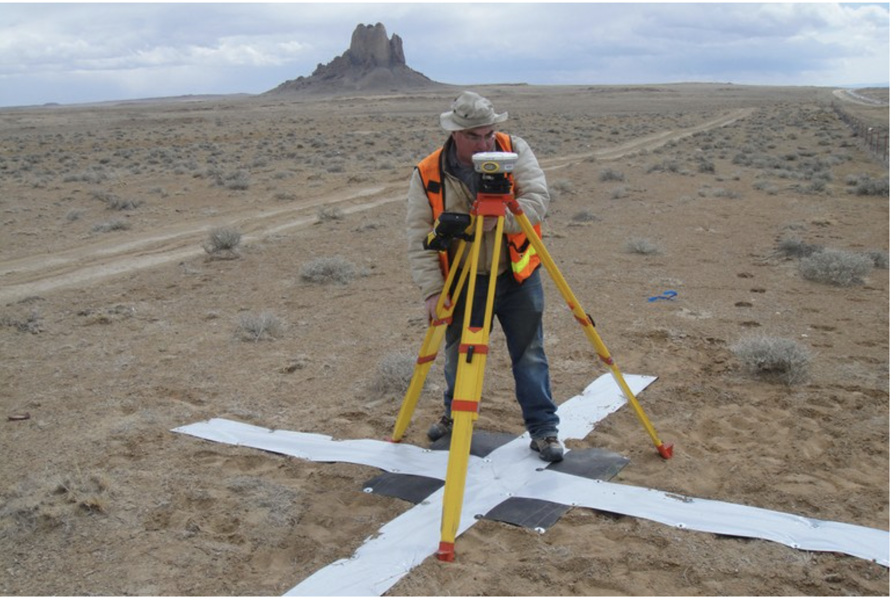
Drought conditions have at times forced the Ute Mountain Ute Tribe Farm & Ranch Enterprise in southwest Colorado to operate on a fraction of the water needed to grow crops, resulting in dormant fields and irrigation systems. On a day in late May [2022] when wildfire smoke obscured the throat of an ancient volcano called Shiprock in the distance, I visited the Ute Mountain Ute farming and ranching operation in the southwestern corner of Colorado. Photo credit: Allen Best/Big Pivots
Rafting companies feared a project would hurt business. Environmentalists said it was one of the last free-flowing rivers in the Colorado River Basin. It didn’t make sense to pump water out of the Animas, over a hill and into a valley to create a reservoir, they said. That valley held protected elk habitat. It also included waste material from uranium mining. (This was eventually removed in a remediation project.)
For years, local groups fought the project’s costs, the electricity its pumps would require and the burden more irrigation water use would put on the Animas.
“I’ll actually tell you a little bit about it,” said Lew Matis, one of the volunteers organizing railroad photos in the Center of Southwest Studies on a Wednesday in July. “I was involved with the taxpayers against the Animas Project.”
Matis, a self-described “old fart of old Fort Lewis,” even wrote to The Durango Herald in the 1980s, saying the $586.5 million price tag was “approaching pie-in-the-sky aspects.”
Then there was the classic Colorado River tug-of-war between the Lower Basin and the Upper Basin: The Upper Basin tribes wanted to be able to lease their water off-reservation. Lower Basin states, like Arizona, California and Nevada, said it would conflict with state and interstate laws. They’d kill legislation that included leasing. Tribal officials said the states didn’t want to have to pay for tribal water they were already getting for free.
(Whether and how tribes can lease water between the Lower Basin and Upper Basin is still an issue today. It was one of the central problems that held up a $5 billion Arizona-tribal settlement that is languishing in Congress.)
Tribal officials traveled to Washington, D.C., to push for the settlement to pass.
“I’ve been moving this Animas-La Plata Project through, the people say well it’s not going to get funded,” said Leonard Burch, former Southern Ute Chairman, in an interview from the 1980s. “But we insist.”
A big dream and a (much) smaller reality
By 1988, Congress approved the settlement agreement with the Animas-La Plata Project at its center.
It solved all the tribal water rights claims in Colorado in one go, something that states like Arizona are still trying to do. The Ute Mountain Ute Tribe, which also has land in New Mexico and Utah, is still working to finalize some of its water claims.
Then U.S. Rep. Ben Nighthorse Campbell, in a press release from 1988, likened the settlement to “winning a gold medal.” (And he would know. Campbell won a gold medal in judo in the 1963 Pan-American Games.)
Then, in the early 1990s, the U.S. Fish and Wildlife Service found an endangered fish species, the Colorado pikeminnow, downstream from the potential project site. And the Animas-La Plata Project started to crumble.
The Colorado pikeminnow, renamed to remove a slur, can grow to nearly 6 feet in length and was the main predator in the Colorado River system. But by the late 20th century, it occupied about 25% of its natural range, and federal wildlife officials said dams and river depletions were one of its biggest threats.
The findings opened the door to questions about impacts to other species, like peregrine falcons, rare plants, bald eagles and razorback suckers.
The federal government started to question whether the project’s costs matched the benefits. The U.S. Bureau of Reclamation’s fervor for enormous Western water projects had waned, and former President Bill Clinton’s administration did not support the larger version of the Animas-La Plata Project authorized in the 1960s.
That project would have cost $744 million and built two reservoirs, 240 miles of pipelines and canals, seven water-pumping plants and 34 miles of electric transmission lines, according to local news coverage from the ’90s. It would also require the careful collection and removal of hundreds of years of cultural artifacts from different Native American bands, which was done for the final project.
After years of intense political maneuvering and fighting among all sides, Congress finally approved the final project: a dam to create a reservoir in Ridges Basin — now called Lake Nighthorse — and a pumping plant and pipes to suck up Animas River water and push it into the reservoir.
The La Plata River, which would have received Animas River water in the original version (hence its name), was left alone. The irrigation water — part of the original goal of the project — was removed from the agreement. The size of the dam shrank to 217 feet from 313 feet above the streambed. Congress dropped reservoirs and delivery pipelines for tribes. The final cost estimates ranged from $250 million to $340 million.
Looking at a description of the project from the 1980s, the project’s current manager Howard said hardly any of the plan actually happened.
“It’s unfortunate. That was the vision. Everybody was excited, and everybody supported what it was trying to do,” he said. “But ultimately, we ended up with a very, very small portion of what you’re showing in that document.”
“A whole bunch of work left”
The final Animas-La Plata Project did achieve some of its original goals.
It settled water rights in Colorado for the Southern Ute and Ute Mountain Ute tribes. It included about 132,000 acre-feet of water and a new recreation spot for locals. Officials responded to environmental concerns (although some may still argue that point). It secured municipal and industrial water for the Navajo Nation near Shiprock, three New Mexico communities, Durango and rural residents in the Southwest. And tribes had funding to help them develop their water resources.
But “there’s a whole bunch of work left to do,” Howard said.
So far, four of the 11 entities that have water rights in the Animas-La Plata Project have been able to put that water to use, he said. The Southern Ute Tribal Council approved the use of up to 2,000 acre-feet annually of its Animas-La Plata Project water, according to the tribe’s statement.
“It’s long overdue,” said Becky Mitchell, the state’s commissioner to the Upper Colorado River Commission. She has advocated for tribes in Colorado River negotiations. “They’ve been trying to get access and infrastructure help and be able to access water that they have rights to. This is a step in that direction.”
The Ute Mountain Ute Indian Tribe, which is located farther from the Animas River and Lake Nighthorse, is still looking for ways to access its water. Whether that is new, expensive infrastructure — pipes and reservoirs that were formerly included in the Animas-La Plata Project — or other options is still to be determined.
Simple geography is one of the biggest barriers in using their project water, said Peter Ortego, a long-time lawyer for the Ute Mountain Ute Tribe.
The Animas-La Plata Project is right next to the Colorado-New Mexico border, but it must be used within Colorado. The tribes have too much municipal water for the area’s population, and too much industrial water for the potential mining uses so close to the border. Hydraulic fracturing, the main oil and gas water use, doesn’t use much, he said.
“When it comes to the health of the Tribe’s water system, I think taking the irrigation out of that was really bad,” Ortego said. “It hurt the farmers. It hurt the Tribe.”
The Ute Mountain Ute Tribe took a major step forward in December when they finalized their repayment contract with provisions that make it easier to participate in conservation projects and to afford the federal operations and maintenance fees that are triggered upon first water use, he said.
Ben Nighthorse Campbell, now 92 and living about 25 miles from the reservoir that bears his name, still thinks the project was a success. He remembers the bitter fights with environmentalists, recalling a passing car with a bumper sticker that said, “Don’t dam the Animas, damn Campbell.”
When the project finally passed, it passed overwhelmingly, and that was the thing the opposition hated most of all, he said.
“I don’t like to be vindictive, but I felt like, ‘Gotcha, you bastards,’” Campbell said in an interview with The Colorado Sun. “It became kind of personal, you know? They threw so many barbs at me, so many shots, and I was just ready to fight back.”
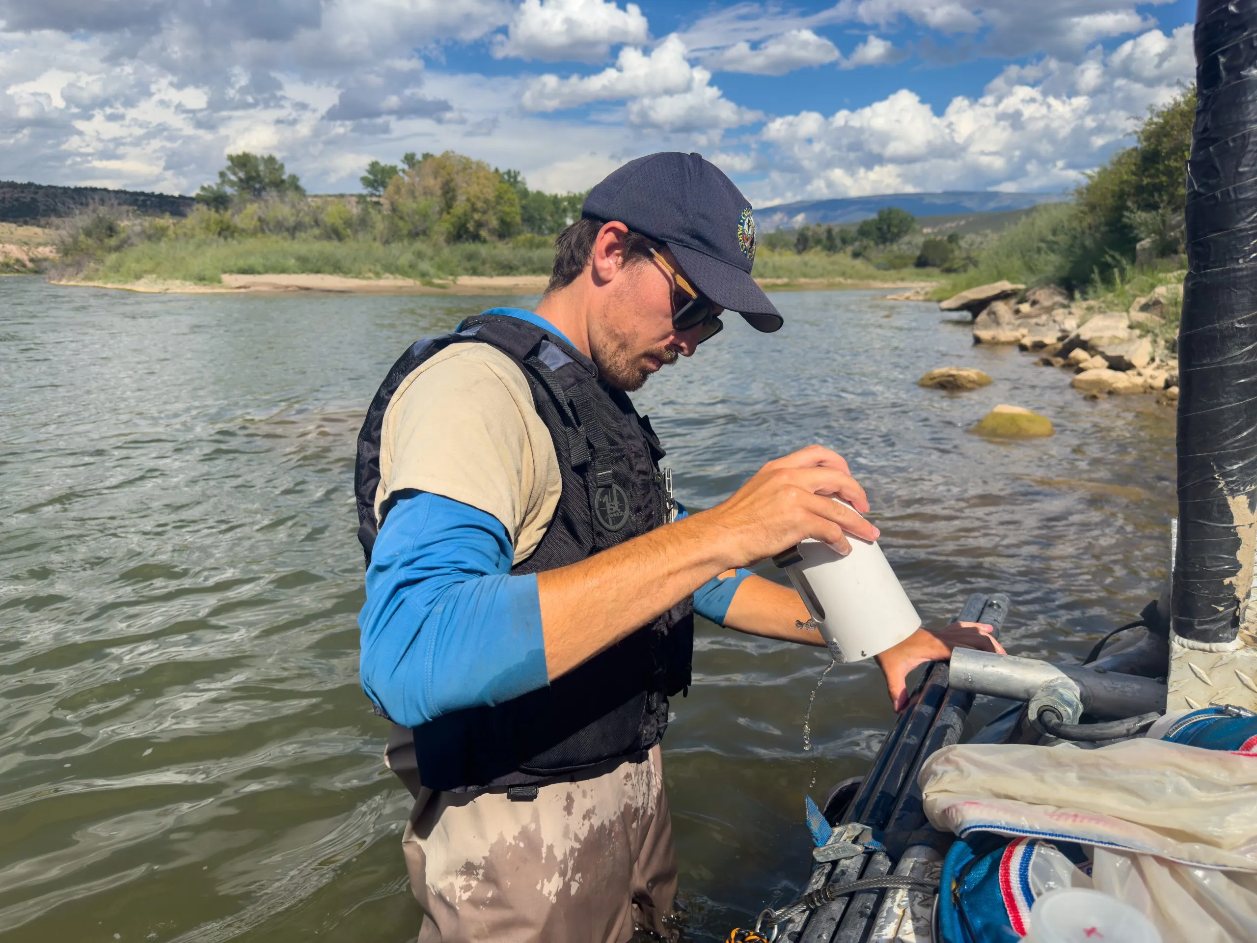
CPW sampling on the Colorado River found zebra mussel veligers. The river is now considered “positive” for zebra mussels from its confluence with the Roaring Fork River to the Utah state line. CREDIT: PHOTO COURTESY OF COLORADO PARKS & WILDLIFE
State officials may have solved the puzzle of how zebra mussels got into the Colorado River.
On July 3, Colorado Parks and Wildlife officials discovered a large number of adult zebra mussels in a privately owned body of water in western Eagle County. On Monday, Madeline Baker, an invasive species specialist with CPW, told members of the Colorado Basin Roundtable they believe this private lake is an upstream source of the mussels that have contaminated the Colorado River, the Government Highline Canal, Highline Lake and Mack Mesa Lake.
“We do believe this to be the primary source, but it could now have created other secondary sources downstream with locations that hold water,” Baker said. “There is a lot of speculation of could these veligers survive the journey from Eagle County down to Highline and create a new population there or is there some sort of intermediate population in between. So we still have a lot to figure out.”
Baker said that the lake’s owner is collaborating with CPW on a mitigation plan. CPW is not releasing the owner’s name or specific location of the lake.
“The property owner is unsure of how this could have happened, but is being cooperative,” she said.
Baker said there were quite a few dead shells on the shoreline of the private lake, which indicates the zebra mussel population has been there for several years. She said CPW staff found the lake by searching Google maps for bodies of water on private property near the Colorado River and then calling property owners and asking if they could inspect their lakes. An outlet from the lake was bringing zebra-mussel-infested water into the Colorado River, an issue that has since been fixed.
“We’ve done a dye test at the reservoir to be sure that nothing more is flowing into the river, and that dye test showed us that it should be contained at this point, which will allow us to pave a path toward mitigation,” Baker said.
Zebra mussels are a prolific invasive species that if left unchecked could clog irrigation infrastructure, and strip the plankton and nutrients from the water. Once established, they are nearly impossible to eradicate.
For the last two summers, microscopic zebra mussel larvae, known as veligers, have been found in the Colorado River at several locations. In June, they were found at the boat launch in New Castle, in Highline Lake and Mack Mesa Lake. The Colorado River is now considered “positive” for zebra mussels from the confluence with the Roaring Fork River to the Colorado-Utah border.
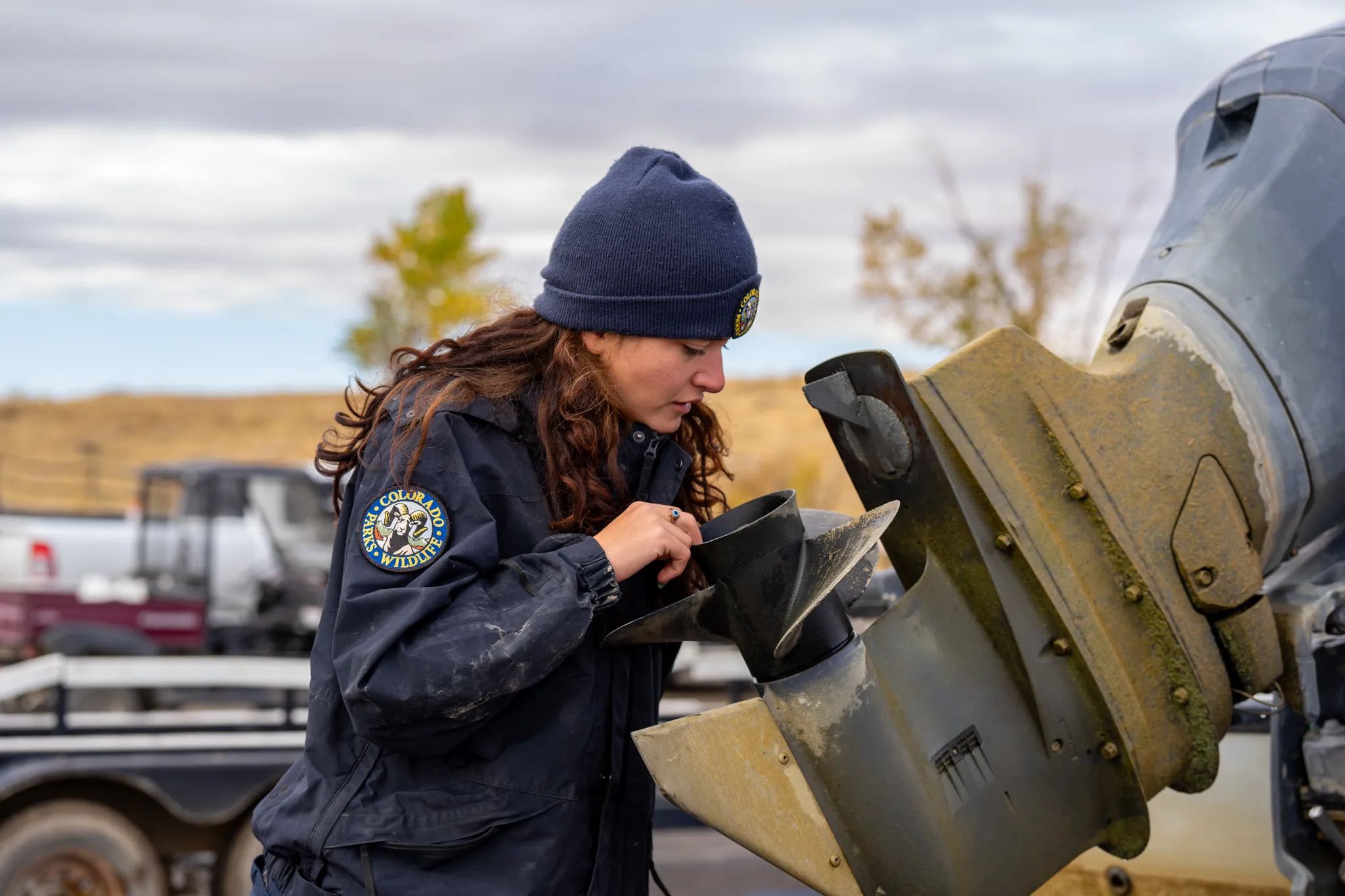
CPW staff inspects a boat motor at Highline Lake in 2023. The lake is infested with zebra mussels. CREDIT: PHOTO COURTESY OF COLORADO PARKS & WILDLIFE
Threat to the Grand Valley
The arrival of zebra mussels has been especially alarming for the Grand Valley, which is one of the most important agricultural areas and home to the biggest agricultural water users of Colorado River water on the Western Slope.
“At least from a Grand Valley perspective, we feel like we are under a very serious threat,” said Kirsten Kurath, a Grand Valley attorney and vice-chair of the roundtable.
Adult mussels were found in 2022 in Highline Lake near the Utah state line. Officials treated it with a form of copper that kills zebra mussels called EarthTec QZ and drained it for the 2024 boating season. The lake reopened for recreation this year but on June 10, CPW staff found more veligers in Highline Lake, which is now designated an infested body of water. Highline Lake is filled with water from the Government Highline Canal, which pulls water from the Colorado River.
“We now know that Highline Lake was continuously being reinfested with mussels after the treatment, so it’s difficult to ascertain the effectiveness of the treatment,” Baker said.
Veligers were also found last year in the Government Highline Canal, which brings water from the Colorado River to Grand Valley farms, vineyards and orchards. Realizing the mussels could be disastrous for commercial peach growers who use micro-drip irrigation, water managers sprang into action last fall, treating their systems with a copper solution that kills the mussels.
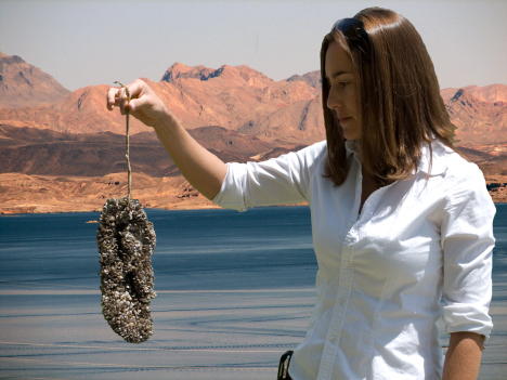
An adult zebra mussel found at Highline Lake in 2023. The lake was treated with a copper solution and drained for the 2024 boating season in an effort to eradicate the invasive species. CREDIT: PHOTO COURTESY OF COLORADO PARKS & WILDLIFE
Grand Valley Water Users Association General Manager Tina Bergonzini said the copper treatment was successful — the irrigation company has not seen any signs of adult mussels in their system — and the Government Highline Canal has not had any more positive tests for veligers. Still, Bergonzini said GVWUA will probably do the copper treatment again this fall, and that preventing zebra mussels from becoming established is something they will be working on for the foreseeable future.
“I don’t think there is any way around [doing the copper treatment again],” Bergonzini said. “We can’t risk our infrastructure. It’s a financial hurdle for the irrigation companies because it’s very costly, but not as costly as having fouled infrastructure.”
The discovery of the source pond in Eagle County is a step in the right direction, but it doesn’t mean the fight against zebra mussels is over. CPW will continue sampling and mitigation work, Baker said.
“Finding the source was always the main focus,” Bergonzini said. “There’s no way you can win the war if you can’t figure out where they are coming from. So I think discovering that pond was huge. That gives us a really good chance.”
CPW says cleaning, draining and drying fishing gear, motorized boats and hand-launched vessels like paddle boards is key to preventing the spread of invasive species.
Click the link to read the article on The Land Desk (Jonathan P. Thompson):
August 1, 2025
🥵 Aridification Watch 🐫
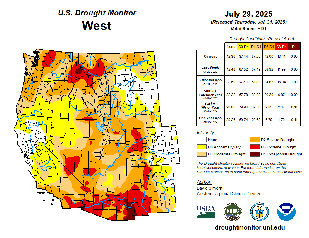
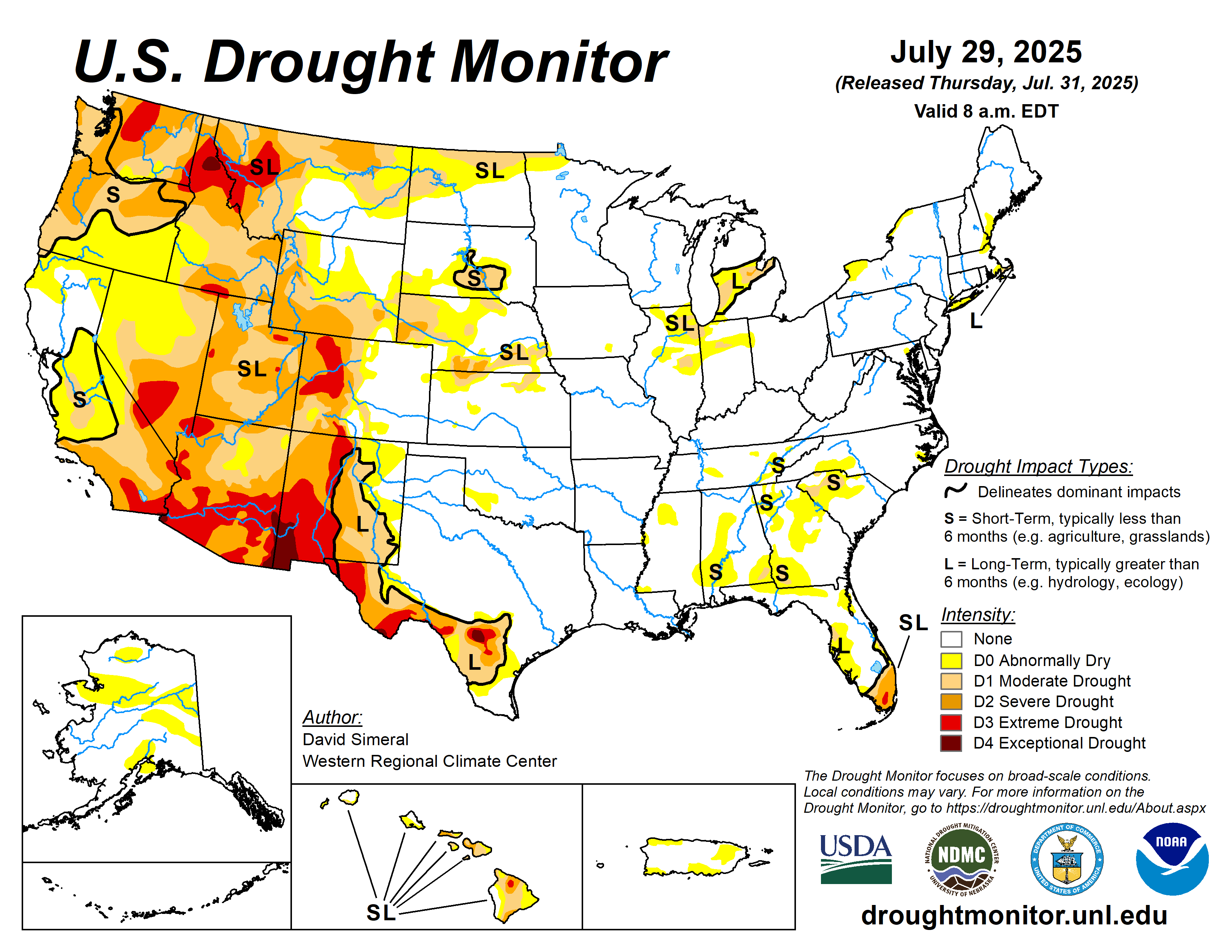
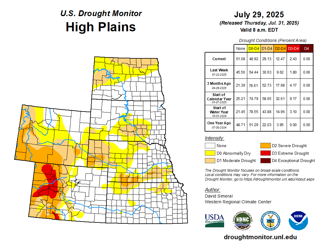
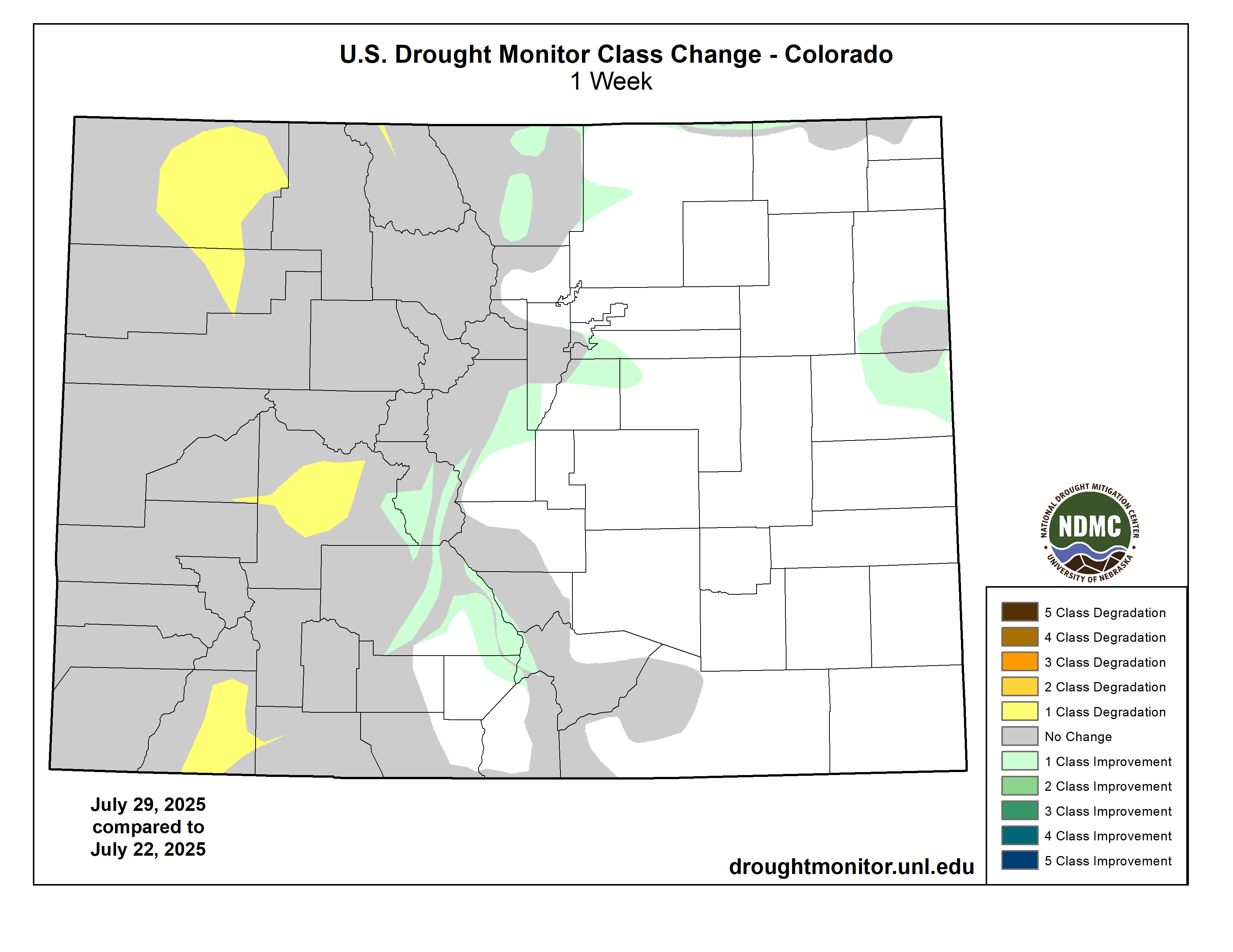
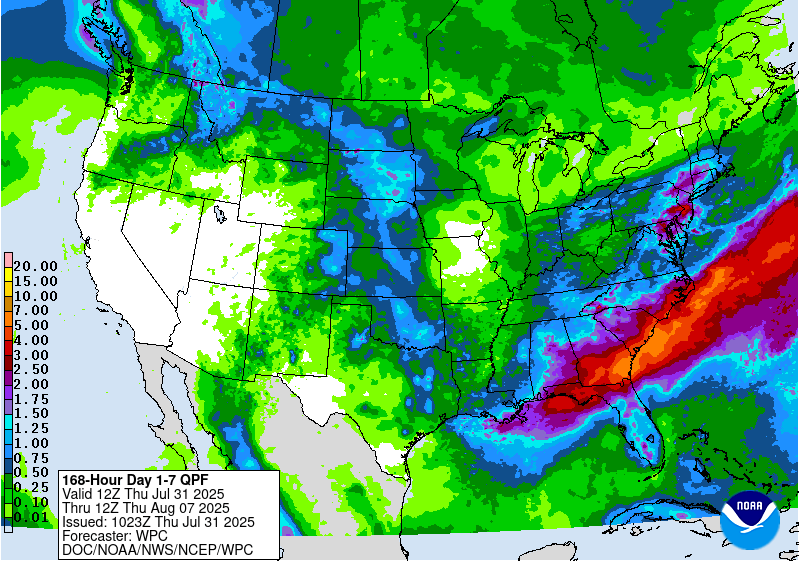
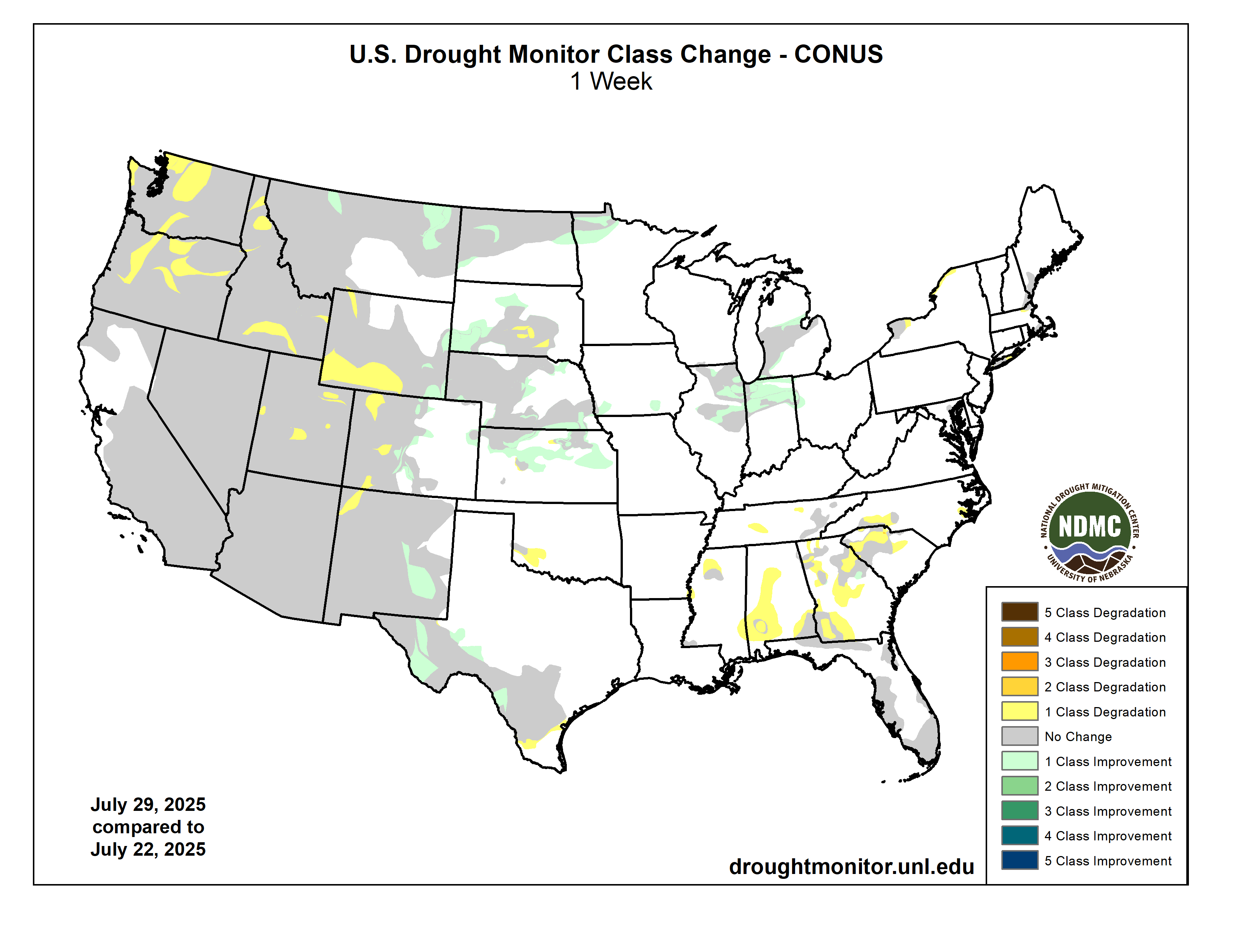
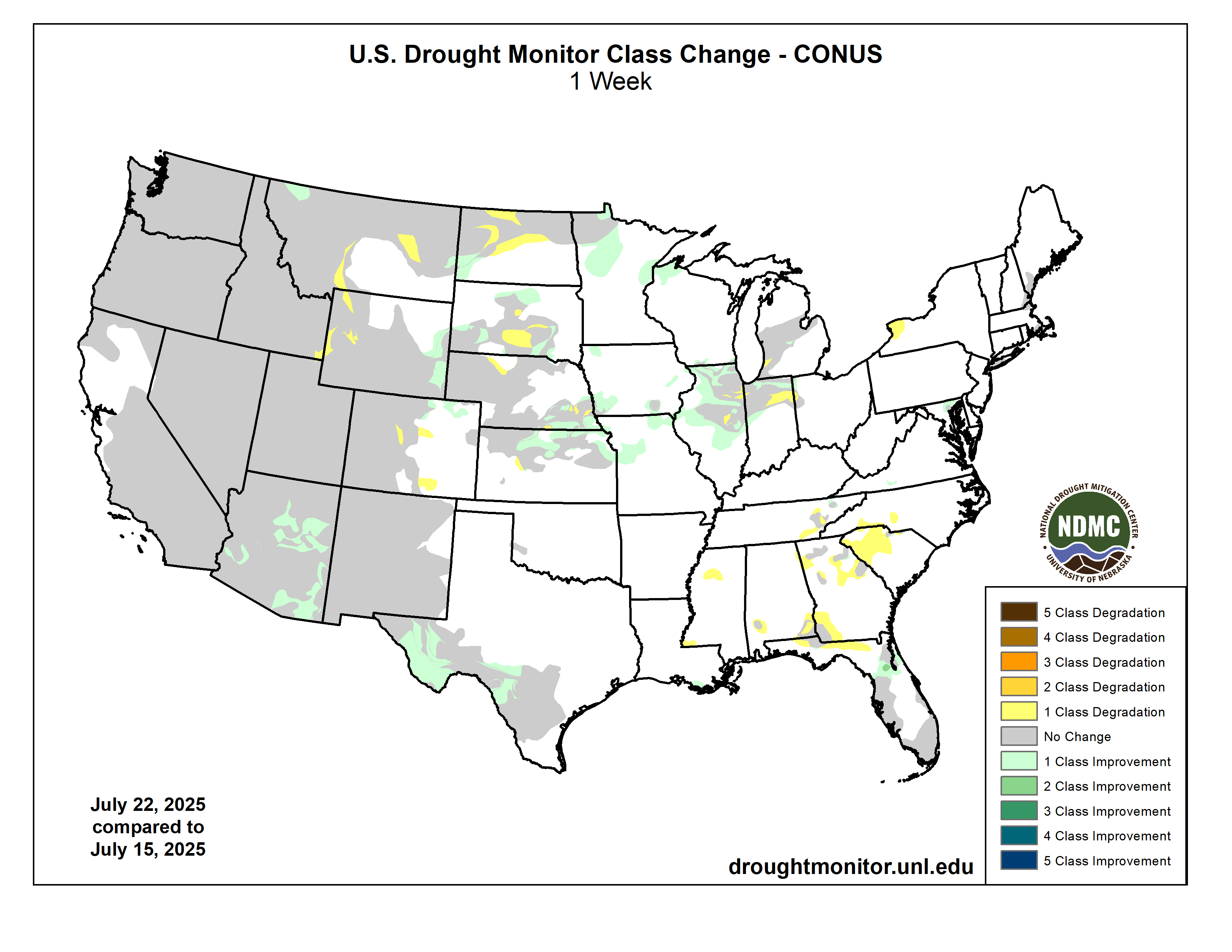
The monsoon is on its way, apparently, but seems to be delivering more lightning than rain to many areas that are grappling with wildfires. Meanwhile, the drought is intensifying and spreading in almost all parts of the West, especially in the deep Southwest.
Streamflows are dropping, too. The Animas River in Durango has fallen to about 200 cubic feet per second, and it’s only at about half that by the time it gets to Farmington, New Mexico’s, new surfing wave. The Rio Grande already dried up in Albuquerque a couple of weeks ago (but got a good boost from a thunderstorm early this morning). WyoFile reports that the Snake, Wind, and Bear Rivers are all at record low flows for this date, even though the snowpack was about average this winter.
And, of course, the wildfires continue to burn. The Dragon Bravo Fire on the Grand Canyon’s North Rim has burned through 112,000 acres so far, with only 9% containment. The Monroe Canyon Fire in southwestern Utah is at 55,642 acres with 7% containment, and is causing power outages in surrounding communities. The Turner Gulch Fire northeast of Gateway is still growing “due to continuous hot and dry conditions and erratic winds.” And the Elkhorn Fire north of Durango has settled down a bit at 317 acres, but officials worry forecasted hot and dry conditions could reawaken it.
Below are some satellite moisture index maps, with blue being moist and red indicating dryness. The top image shows Dove Creek and areas south of there. This was dryland farming country for many years (Pinto Bean Capital of the World), but irrigation from McPhee Reservoir on the Dolores River was later extended out to Dove Creek. Problem is, their water rights are junior to the farmers in the Montezuma Valley near Cortez, so when reservoir levels are low, they tend to get less irrigation water. Here you can see the difference between 2023 (on the left), when snow, river, and reservoir levels were high, and this year (right), when they are not. What stands out to me is that some fields are still being irrigated this year, despite the drought, as is indicated by the circles of bright blue. But there are more fallow fields now, and the areas around the fields are especially dry.
Here are two more images showing the Ute Mountain Ute Tribe’s farms south of Ute Mountain in 2023 compared to 2025. Again, some irrigation is still reaching the fields, but apparently far less, given the number of fields that are apparently fallow.
📈 Data Center Watch 📊
The Land Desk is adding another beat to its roster, the Data Center Watch, which is just to say that I’ll be covering data centers and their economic and environmental ramifications a bit more frequently from here on out. Why? Because they currently are proliferating throughout the West: There are 93 data centers in the Phoenix area, 54 in the greater Denver area, and eight in Albuquerque, with many more on their way. And every one of them uses outsized quantities of electricity and water, straining power grids, and throwing utilities’ resource planning into disarray.
Cheyenne, Wyoming, is already home to six data centers. That doesn’t count Meta’s $800 million center that is under construction there, or energy firm Tallgrass’s proposed facility that would pull 1,800 megawatts of electricity from new, dedicated natural gas plants and renewable power installations (presumably solar and wind). Down in Tucson, city officials are considering Amazon Web Services’ proposed Project Blue, a massive complex that is poised to consume up to 2,000 acre-feet of water per year and become Tucson Electric Power’s largest single customer.
In Alaska, a company is looking to build a large data center and a dedicated natural gas plant that would run off of oilfield methane. Numerous data centers can be found along the banks of the Columbia River, drawn there in part by the relatively cheap and abundant hydropower. In Montana, a proposed data center would use all of the powergenerated by NorthWestern Energy’s existing resources. And Pacific Gas & Electric expects new data centers in Silicon Valley to drive a 10 GW increase in electricity demand over the next decade, which is about one-third of today’s forecast peak demand for California’s grid.
The biggest concern with these sprawling warehouses packed with processors is their power consumption. Each one can draw as much electricity as a small city — the proposed Cheyenne server farm would use more power than all of the state’s households. As recently as half a decade ago, most utilities weren’t expecting the speed and magnitude of the big data center buildout. Now it’s hitting hard, and coinciding with increased demand from a growing number of electric vehicles and electrified homes, and utilities are scrambling to bring new power sources online to meet the projected demand growth. This includes geothermal, wind, and solar power — each with impacts of their own — but also new natural gas plants and even small nuclear reactors. Some utilities are cancelling plans to retire coal plants to keep enough generating capacity online.
In other words, the data center boom is likely to radically reshape the energy landscape of the West, and will spur more debates over the costs of this sort of economic development and the impacts our cyber-world has on the environment and humanity.
📈 Data Dump 📊
In some ways, I guess you could say that as alfalfa is to the Colorado River, data centers are to the Western power grid: they both suck up a lot of the resources. That doesn’t make them bad. Alfalfa mostly goes to dairy cows, which make cheese and ice cream and other really good things. Data centers power annoying AI art, sure, but they also make everything internet possible, including me sending this newsletter to you.
Anyway, it’s worth tracking both — alfalfa and data centers, I mean. So here’s a quick update on hay exports from the U.S. (which includes alfalfa and other hay), as well as a look at acreage planted in alfalfa (excl. other hay) over time. Exports seem to have peaked in 2022 and are now in decline. Nevertheless, sending alfalfa and other hay overseas is big business.
🤯 Annals of Inanity 🤡
You might think that our federal agencies under Trump would be content to wreck the environment and trample civil liberties in a quiet, not-so-noticeable way. But no, of course not: They’re so proud of their racism and fetishization of fossil fuels that they plaster social media with their proclamations thereof — they are trolling us, in other words.
Above are just two recent examples. In the first one, the Department of Energy fawns over a sparkling chunk of coal. In the other, the Department of Homeland Security posts an 1872 painting by John Gast titled “American Progress.”
Both are gross in their own way.
What the hell kind of sexualization of coal — i.e. “She is the moment” — are they going for in that first one? Friggin’ perverts, if you ask me.
As for the second, it glorifies the crimes the American military and white colonial settlers perpetrated against the Indigenous peoples in order to get more Lebensraum, one might say (it makes sense to use Hitler’s term given that he was inspired by the U.S.’s policies toward Native Americans). Not only is the use of the word “Heritage” in this way a dog whistle to white supremacists, but it’s also kind of weird to be talking about defending the “Homeland” against immigrants when, in the image, the immigrant invaders are the white settlers, and the folks trying to defend themselves and their homeland are the Indigenous people (and wildlife) fleeing from the settlers.
📸 Parting Shot 🎞️
I don’t want to leave y’all with that awful taste in your mouth, so here are a couple of nicer images of one of my favorite flowers out there.
On the evening of July 31, 49 years ago, a deadly flooding disaster began in the Big Thompson Canyon in northern CO. Highway 34 cuts through the canyon between Loveland and Estes Park. On that night, an extreme precipitation event resulted in a large wall of water crashing through and killing 144.
n July, the Parachute Town Council adopted a Water Restriction and Conservation Program to help the town respond quickly and responsibly to changing water conditions.
The new program allows the town to implement or lift water use restrictions as needed throughout the year, based on water availability, drought conditions and regional coordination.
On July 15, it was announced that Parachute remains at a Stage 1 Water Watch due to low flows on the Parachute Creek. It has remained at Stage 1 partially due to ongoing coordination with other users of Parachute Creek and the community’s ongoing conservation efforts.
Stage 1 is a voluntary stage that applies to raw water irrigation users only. Parachute has not implemented any mandatory restrictions at this time and potable drinking water customers are not affected.
Parachute is encouraging all irrigation water users to take simple voluntary actions to help conserve water, such as:
Reducing outdoor watering to three to five days a week
Watering in the early morning or late evening to reduce evaporation
Focusing water use on trees, vegetables and essential landscaping only
Avoiding overwatering lawns or irrigating during rainfall
Voluntary conservation is key, as cutting back now could help the community avoid stricter, mandatory restrictions later this summer.
If conditions change, additional stages of the program may be implemented. Higher stages could make the current voluntary measures enforceable or even lead to a ban on all outdoor irrigation, though that has not yet been necessary in Parachute.
Future restrictions will be announced publicly and community members can stay up to date by following the town of Parachute’s social media accounts, like their Facebook at facebook.com/townofparachute/, downloading the “Town of Parachute” mobile app or visiting the town’s utilities page at parachute.gov/o/top/page/utilities.
For more questions on the program or water usage, contact Parachute Town Hall at 907-285-7630.
Colorado River May 2023 swelled from low elevation snow runoff.
Click the link to read the article on the KJCT website. Here’s an excerpt:
July 28, 2025
On Monday, the Colorado Basin Roundtable had a meeting to discuss the state of the Colorado River. The Roundtable discussed the potential Shoshone stream flow acquisition. The area of interest is the 2.4 miles in Glenwood Canyon. It is important for Western Colorado because of its stream flow rate that mimics the current water rates used for hydropower. Wildlife organizations did habitat studies on it, and they show it improves the natural environment.
Another topic of discussion was the basin hydrology. With a limited snowpack this year, there is less water. The biggest concerns people had in the meeting related to that was the stress of many systems struggling from prolonged drought and aging infrastructure. Lindsay DeFrates, Deputy Director of Communications for the Colorado River District, said, “The Colorado Basin Roundtable is a great example of a room where a bunch of different stakeholders from agriculture, recreation, environment, municipal, industrial, water users all come together to talk about those solutions. It’s never an easy conversation. And we can’t forget about zebra mussels. Zebra mussel veligers were found at the Silt Boat Ramp and near New Castle.
The International Wastewater Treatment Plant is located along the US-Mexico border fence. Surfrider Foundation and Veriditas Rising
Click the link to read the article on the CNN website (Avery Schmitz, José Álvarez). Here’s an excerpt:
July 25, 2025
The governments of Mexico and the United States signed a memorandum of understanding on Thursday [July 24, 2025] to fund and expedite several wastewater treatment projects in the Tijuana River basin. Untreated wastewater continually affects residents living along the river, which flows across the border from Tijuana and through several of San Diego’s southern neighborhoods. Residents living along the river have long battled severe health issues which researchers say stem from the river’s contamination. One research team based at the University of California San Diego found that trace amounts of waterborne chemicals from tires, personal care products, and even illicit drugs present in the Tijuana River are being introduced into the air — exacerbating health concerns for tens of thousands of residents living on its banks…
In Thursday’s event celebrated in Mexico City, US Environmental Protection Agency Secretary Lee Zeldin and Mexico’s Secretary of the Environment and National Resources of Mexico Alicia Bárcena agreed to a series of actions to be taken by both governments by 2027 to address the deteriorating wastewater treatment crisis. The agreement stipulates that both Mexico and the US will re-commit to funding the construction and renovation of water treatment infrastructure on both sides of the border. The document also accelerates several projects to be completed over the next two years…Former Commissioner of the International Water and Boundary Commission (IBWC) Maria-Elena Giner called the agreement “excellent news” toward reaffirming commitments made by the US and Mexican officials in Minute 328, which outlines how Mexico and the US will share the costs of operating and maintaining water treatment infrastructure on the border.
Click the link to read the article on the Big Pivots website (Allen Best):
July 22, 2025
This is the final part of a series about four groundwater basins in Colorado. The story was commissioned by Water Education Colorado and benefited from editing by Caitlin that organization’s staff. It appears in a variant form in the summer 2025 issue of Headwaters magazine.
The San Luis Valley, like the Republican River Basin, has almost no tax base other than irrigated agriculture. “Nearly everything in the valley is somehow related to agriculture. Our hospital, our schools — everything is dependent on agriculture’s existence in the valley,” says Amber Pacheco from her office in Alamosa. From her office in Wray, Deb Daniel has a parallel observation.
What then constitutes sustainability of the water that is the foundation of agriculture or, in the case of Parker, Castle Rock, and other south metro communities, their economic vitality? What decisions should be made now to foster that vitality through the 21st century?
Smuggler Mine back in the day via GregRulon.com
Thoughts about conservation have shifted over time. When Colorado’s gold and silver miners arrived, they had no goal of conserving. They either mined the veins to exhaustion, or it became too costly to continue. In a sense, that has happened in the Republican River Basin. The only limits to this groundwater mining are those triggered by the interstate compact. Because the Republican River and its tributaries get most of their water from aquifers, pumping must be limited — or supplemented.
In the last 20 years, the Republican River Water Conservation District has done some of both. It has or soon will have committed $86 million to pump water from wells expressly to deliver water to the Nebraska state line. One of the directors, Tim Pautler, has called this a strategy of kicking the can down the road. Other directors have started to agree.
“It’s like the clock is ticking when it comes to sustainability,” said Rod Lenz, the board chair, at the board’s quarterly meeting in May 2025. “What more can we do with the tools we have? Do we dare ask for more tools such [as would be delivered by] statute changes? Do we really want all the groundwater districts in the basin to ask the state engineer to reconsider how much we’re allowed to pump, or do we just stay in compliance until we can’t?”
San Luis Valley Groundwater
In the San Luis Valley, coming off the century-defining drought of 2002, state legislators went in exactly the opposite direction. They said that the unconfined aquifer was to be managed sustainably. Granted, that’s easier said if you have a major river flowing nearby, even if that river has been hammered hard by the warming, drying climate of the 21st century.
Water stored in Colorado’s Denver Basin aquifers, which extend from Greeley to Colorado Springs, and from Golden to the Eastern Plains near Limon, does not naturally recharge from rain and snow and is therefore carefully regulated. Courtesy U.S. Geological Survey.
The south metro area falls somewhere between these two extremes. State legislators nearly a half-century ago ordered a “slow sip” of the groundwater such as to preserve it for a century. In some places, there seems to be sufficient water to slow sip for another 300 years. In other places, the aquifer might have enough water for a few decades. Some water utilities hope for a completely sustainable water supply in decades ahead. Much work has been done. The harder work lies yet ahead.
What we need are aspirations premised not on entitlement and enrichments solely for today, but instead to build economies and cultures that more comprehensively look several generations ahead. That should be the question in all these meetings, all these court cases, all of these individual actions. Based on what we know and understand today, what should we be doing for the kids, grandkids and their grandkids, too? Are we doing better than kicking the can down the road?
We left the Colorado River a couple months ago to explore the Trumpsters’ effort to use the public lands in the river basin to ‘unleash American energy’ and return us to the glorious age of cheap petroleum – and why it’s not happening. At that time, the seven states in the river’s basin were in a stalemate over a management plan to replace the cobbled together ‘interim’ management guidelines that expire next year. The Trumpsters’ have not interceded noticeably in this situation, since it appears to require complex and sustained thought.
Unfortunately, the stalemate is still the basic situation. As a couple water mavens put it, we’re all still waiting for the black smoke coming out of the chimney to turn white. The Basin’s state representatives are meeting together regularly though, with input from the First People, and reports from the meetings suggest that the participants have all agreed to ‘work with the river we have, not the river we wish we (still) had’ (if we ever actually did have it) – the Colorado River Compact’s river. So a little review here today, to remind us where this puts us….
Members of the Colorado River Commission, in Santa Fe in 1922, after signing the Colorado River Compact. From left, W. S. Norviel (Arizona), Delph E. Carpenter (Colorado), Herbert Hoover (Secretary of Commerce and Chairman of Commission), R. E. Caldwell (Utah), Clarence C. Stetson (Executive Secretary of Commission), Stephen B. Davis, Jr. (New Mexico), Frank C. Emerson (Wyoming), W. F. McClure (California), and James G. Scrugham (Nevada)
CREDIT: COLORADO STATE UNIVERSITY WATER RESOURCES ARCHIVE via Aspen Journalism
The Colorado River Compact was created in 1922 for a river that had been, for a couple decades, running flows guesstimated to average 18 million acre-feet (maf) annually. The compact commissioners thought they were being conservative in only dividing 15 maf among themselves, and assumed that ‘those men who may come after us, possessed of a far greater fund of information’ would be dividing up even more water after resolving a share for Mexico and resolution of the Indian rights.
The river then played desert trickster and stopped running those big flows, shortly after Congress passed the Boulder Canyon Act to reconstruct the Colorado River through the subtropical deserts below the canyons. By the end of the 1930s drought that followed, the states’ water leaders knew the numbers in the Compact division might have been for a river that no longer existed, if it ever really had. But they persisted with the Compact, in the spirit of the unnamed quasi-mythical G.W. Bush administration official: ‘We are an empire now, and when we act, we create our own reality.’ The next half century was invested in creating our own imperial reality for the Colorado River – until we began to run into more ‘natural’ realities than we’d anticipated….
Udall/Overpeck 4-panel Figure Colorado River temperature/precipitation/natural flows with trend. Lake Mead and Lake Powell storage. Updated through Water Year 2024. Credit: Brad Udall
The unimperial reality today is a river whose annual flow since the turn of the century has dropped to an average around 12.5 million acre-feet (maf), two-thirds the size of the Compact’s river. That is ‘the river we have’ – and we are aware of the extent to which our superimposed imperial reality on the Colorado River region (and on the whole planet) has caused a lot of this unanticipated loss of water.
Exactly what it means when the basin-wide negotiators say they are working with that ‘river we have’ has not been revealed. One bad sign, however, viewing it from ‘outside the box,’ is their persistence in thinking of the river as divided into a four-state Upper Basin and a three-state Lower Basin, a construct destined by a competitive appropriation culture to devolve into chronic conflict – which it has.
Much of the conflict has revolved around the foggily written Article III(d) of the Compact, stating that the Upper Basin ‘will not cause the flow of the river at Lee Ferry to be depleted below an aggregate of 75,000,000 acre-feet for any period of ten consecutive years.’ This could be most rationally interpreted as a warning to the Upper Basin to just be careful to not develop to the point of using more than their 7.5 maf/year (which the four states have not even come close to doing) and cutting into the Lower Basin’s 7.5 maf in dry periods. Or it could be irrationally interpreted as a delivery obligation that the Upper Basin had to deliver regardless of the natural state of the river, even if an extended drought forced the upper states to short themselves in order to deliver the required 7.5 maf.
Looking upstream at the Boulder Dam (now called Hoover Dam) under construction. “Boulder Dam, looking upstream August 31, 1933 2345” is written at the bottom of the photo. Via UNLV
Given a history of tension among the states based on how fast California was growing, the obvious choice between those interpretations was to believe the worst. Their intent in convening the compact commission had been to prevent a ‘seven-state horse race’ to appropriate water for their futures; they wanted a seven-state division of the use of the river’s water that would override interstate appropriative competition. But they didn’t know enough about either the river or their own fantasy-infused futures to do that desired division. The two-basin division has come to be regarded as a stroke of genius, good for all time, when in fact it was just an expedient measure – one wouldn’t be wrong to call it a ‘desperate measure’ – to cobble together something that would persuade Congress that the states were enough on the same page so Congress could put up the money for a big control structure (Hoover Dam).
But in their haste in pasting together the two-basin compact, they appeared, through Article III(d), to make one basin ‘junior’ to the other, subject to a ‘compact call’ in an extended drought – or at least that is how everyone chose to interpret it. The 2007 ‘Interim Guidelines’ began to address that (perceived) inequity by imposing cuts on the Lower Basin states when Mead and Powell Reservoirs dropped to dangerous levels, but on not the Upper Basin (leaving their shortages up to the erratic river). But interstate ‘seniority’ played a big role in the size of cuts for each Lower Basin state, belying the notion that the Compact would protect states from interstate appropriative competition.
So what could today’s negotiators be doing instead? There is actually a constructive and useful way to divide a desert river into two ‘basins,’ based on the nature of the desert river. All rivers are surface water that is leaving – maybe reluctantly – the land it flows through; it is leaving the land because the land and its life were not able to put the water to use in support of life or to hold it as groundwater in an aquifer. Even much of the groundwater that doesn’t get used by the plants does not escape leaving the land with the river; isotopic analysis indicates that over the course of a year more than half of all the water in surface streams is groundwater trickling back in.
Ephemeral streams are streams that do not always flow. They are above the groundwater reservoir and appear after precipitation in the area. Via Socratic.org
This is not to say that a river is nothing but a drainage ditch – an earlier Army Corps of Engineers perspective that messed up a lot of rivers, trying to make the drainage more efficient by straightening channels. All rivers have a much more complex relationship with the land they are flowing through than just ‘drainage.’ Most rivers have their origins in highlands – mountains or other significant uplands – where steep slopes or fast snowmelts produce too much water to sink into whatever soil there might be; this generates surface flows that become small streams confluing to form larger streams and rivers. Through hyporheic exchange, surface streams either gain groundwater from the land they flow through when that land has a higher water table than the stream level (a gaining stream), or they lose water to the riparian areas along the river when the water table there is lower than the stream level (a losing stream – although, since the water it loses nurtures life in the riparian area, I think hydrologists should consider calling it a ‘giving stream’).
For rivers in humid regions, there is adequate precipitation throughout the river’s basin so the rivers will usually gain more from the land they pass through than they will lose (or ‘give’); they are gaining streams that grow from both surface and ground water until they discharge it all into the seas. But a desert river like the Colorado, on the other hand, is a dependable gaining stream only in its highland headwaters, where the Colorado River accumulates 85-90 percent of its entire water supply from the Southern Rockies, Wind River and Wasatch Mountains above ~8,000 feet elevation. This water-producing region is less than 15 percent of the whole basin. (That ‘division contour’ is more accurately an ‘ecotone,’ a blurry edge zone, in the 7,500-8,500 feet range.)
Below the ~8,000 foot elevation, the river’s tributaries flow first into the high orographic ‘cold deserts’ (steppes) of western Colorado, southwestern Wyoming and eastern Utah. Most of its tributaries have been ‘stepping down’ through the mountain region in a series of canyons alternating with floodplains, all of it the water’s work – and all of it the beautiful erosion and deposition that draws and holds us here. As they drop into the high desert, they get into a serious canyon-cutting project through the Colorado Plateau, up to a mile deep – a mystery story in itself that I’ve written about before. After more than five hundred miles of canyons winding through the Plateau, the river flows out into the subtropical Mojave and Sonora ‘hot deserts,’ and thence – only occasionally now – emptying what’s left into the Gulf of California.
Super Bloom along UT-128 during the last road trip with Mrs. Gulch May 2023.
But once they drop out of its headwaters highlands, desert streams and rivers like the Colorado and its tributaries become losing (giving) streams; they get little new precipitation below the ~8,000 foot contour. The occasional exception is the desert cloudburst that manages to penetrate the desert’s heat shield, dumping a huge rain that mostly runs off the desert land in a quick, destructive flood, filling dry arroyos and stream beds for a few dangerous hours. Or a rare winter snowfall that melts and sinks in, activating flora and small fauna that have lain inactive for long periods, instigating pilgrimages from hundreds of miles away just to see the desert in bloom.
The ‘natural’ Colorado River (the river before the 20th century CE) became a ‘big river’ for two or three months a year, in the May-July period when its mountain snowpack released the majority of the river’s water into its tributaries and ground storage. But once the snowpack was gone, the natural river became an increasingly modest flow, fed largely by groundwater, and as it wandered through the desert regions, it gave what water it had to riparian life (a process that intensified as humans began ‘broadening’ its riparian areas through irrigation systems), or into desert aquifers – and a lot of it just evaporated or transpired back into the atmosphere (losses that increased as humans spread more of it out in reservoirs and fields).
There were probably years (like our current water year) in which the last of the natural river’s water never made it through its lush delta to the sea in the autumn. It is not unusual for a desert stream to completely disappear in its desert; some 40 surface streams and rivers flow into the Great Basin, and most of them just disappear after spreading their limited beneficence en route.
The natural and logical ‘two-basin’ division for a desert river like the Colorado, then, would be into a ‘water production region’ and a ‘water consumption region.’ With the exception of mountain mining or resort towns, and the mountain flora and fauna, nearly all the users of Colorado River water live below that ~8,000 foot division. They are all in the same boat, trying to figure out how best to share a ‘losing river’ when its flows drop into the desert regions where they live.
Map of the Colorado River drainage basin, created using USGS data. By Shannon1 Creative Commons Attribution-Share Alike 4.0
The Colorado River Compact ignores this natural division of the river. The clumsy division into the four-state Upper Basin and three-state Lower Basin is done according to state boundaries, which have no geographic or hydrographic relevance to the Colorado River Basin. The state boundaries also include a lot of heavily developed land outside the natural river basin that can lay claim to Colorado River water as part of the state – and they have population and wealth concentrations that enable them to move that water out of the basin through tunnels. ‘We are an empire, and when we act’ et cetera et cetera.
The Compact division is especially problematic for the Upper Basin. A quarter to a third of the Upper Basin area is the river’s major water production area, scattered among the mountains of the four states above the ~8,000-foot contour, and the rest of the Compact’s Upper Basin is part of the river’s water consumption region. The Compact makes no such distinction, and all the water above the Upper-Lower division point near Lee’s Ferry is presumed to be the Upper Basin’s – minus the annual ‘delivery obligations’ of 7.5 maf for the Lower Basin and half of the 1.5 maf for Mexico. Given that the river’s annual flows vary between 5 and 20 maf, this makes the Upper Basin’s Compact allotment of 7.5 maf annually a fantasy.
Acknowledging the desert nature of the Colorado River suggests a rather radical, but common sense two-basin management strategy for the Colorado River, addressing two main challenges: first, to work out an equitable division among all users for the use of the water that flows into the ‘water consumption region’; and second, for all water consumption region users to collaborate on optimizing (not ‘maximizing’) the flow out of the ‘water production region’ and into the deserts.
And a third challenge (which should be first) would be to transcend (abandon) the Compact’s two-basin division, the artificiality of which just gets in the way of desert-river reality at best, and at worst fosters a competitive rather than collaborative attitude between the two basins.
And that’s enough for today. We will look more closely at those challenges next time – unless the negotiators have come up with a brilliant breakthrough to parse out. Don’t hold your breath….
Colorado River “Beginnings”. Photo: Brent Gardner-Smith/Aspen Journalism
This U.S. Drought Monitor (USDM) week saw continued improvement in drought-related conditions across areas of the Midwest (Michigan, Ohio, Indiana, Illinois, Iowa, Minnesota), central and northern Plains (Kansas, Nebraska, Dakotas, eastern Montana), South (Texas), and in the Desert Southwest (New Mexico). During the past week, the most significant rainfall accumulations were observed across areas of Kansas, Missouri, Iowa, and Minnesota, where they ranged from 3 to 7+ inches. Elsewhere, short-term precipitation shortfalls (past 30 to 60 days) led to continued expansion of Abnormally Dry (D0) areas across the Southeast states including the Carolinas, Georgia, and Alabama as well as the introduction of isolated areas of Moderate Drought (D1) in Alabama, Georgia, and South Carolina where agriculture-related drought impacts are being reported. In the South, drought conditions continued to improve in western portions of Texas as well as in areas of eastern New Mexico where monsoonal storms have provided some minor relief to areas experiencing long-term drought. In the West, conditions continued to deteriorate across the Pacific Northwest (Oregon, Washington, Idaho) and areas of the Intermountain West (Wyoming, Utah, and Colorado), while areas of eastern Montana saw improvement in drought in response to precipitation events during the past few weeks. In terms of reservoir storage in the West, California’s major reservoirs continue to be at or above historical averages for the date (July 29), with the state’s two largest reservoirs, Lake Shasta and Lake Oroville, at 105% and 116% of average, respectively. In the Southwest, the U.S. Bureau of Reclamation is reporting (July 27) Lake Powell at 32% full (46% of average), Lake Mead at 31% full (51%), and the total Colorado system at 39% of capacity (compared to 44% of capacity the same time last year)…
On this week’s map, improvements continued from Kansas to North Dakota after another week of scattered shower activity with light-to-moderate accumulations. During the past 30 days, drought-related conditions have improved significantly in northern Kansas, eastern Nebraska, southeastern and southwestern South Dakota, and southwestern North Dakota as evidenced in a variety of drought monitoring products including streamflows, soil moisture, and vegetation health indicators. However, conditions have degraded in other parts of the region, including central South Dakota and northern North Dakota. For the week, average temperatures were generally above-normal average (1 to 6 degrees F) across the region, with eastern portions experiencing the largest departure, while far western portions of the Dakotas observed temperatures 1 to 4 degrees F below normal…
Colorado Drought Monitor one week change map ending July 29, 2025.
Out West, generally dry conditions prevailed over much of the region except for some isolated shower activity in northeastern California, northwestern Nevada, eastern New Mexico, eastern Colorado, and Montana. On the map, degradations were made across areas of the Pacific Northwest (Oregon, Washington, Idaho) and Intermountain West (Utah, Wyoming, Colorado). In the Pacific Northwest, streamflow activity continues to be well below normal levels across the Cascade Range of Oregon and Washington as well as in the mountain ranges of northern Idaho and western Montana. Similarly, poor surface water conditions were present in many streams and rivers of western Wyoming, Utah, western Colorado, central Arizona, and northern New Mexico. For the week, average temperatures were below normal across most of the region, with anomalies ranging from 2 to 10+ degrees F and the greatest departures observed across California and Nevada…
On this week’s map, improvements were made in areas of South Texas and the Trans Pecos region of Texas in response to above-normal precipitation during the past 30-120 days. In these regions, improvements were made in numerous drought categories (D1-D3). In other areas of the region, degradations occurred in southwestern Oklahoma, northern Mississippi, and central Tennessee, where rainfall has been below normal during the past 30 to 60 day period. For the week, average temperatures were above normal in the eastern and northern areas of the region, with anomalies ranging from 2 to 8 degrees F. Conversely, the western extent of the region, including areas in the southern half of Texas, experienced temperatures ranging from 1 to 4 degrees F below normal…
Looking Ahead
The NWS Weather Prediction Center (WPC) 7-Day Quantitative Precipitation Forecast (QPF) calls for generally dry conditions across much of the western U.S. except for some light shower activity (accumulations generally <1 inch) across areas of the Rockies (Idaho, Montana, Wyoming, Colorado) and mountain ranges of New Mexico. East of the Rockies, light-to-moderate accumulations (ranging from 1 to 4 inches) are expected across areas of the Plains states with the heaviest accumulations expected in western Oklahoma. In the lower Midwest, Mid-Atlantic, South (Gulf Coast areas), and portions of the Southeast, 1 to 5+ inch accumulations are forecast, with the heaviest accumulation expected along the coastal plains of Carolina and Georgia. The Climate Prediction Center (CPC) 6-10-day outlooks call for a moderate-to-high probability of above-normal temperatures across the Desert Southwest, southeastern portions of the Intermountain West, Plains, Midwest, New England, South, and southern portions of the Southeast region. In contrast, below-normal temperatures are forecast for areas of the West, including southern California, the Great Basin, and Pacific Northwest. In terms of precipitation, there is a low-to-moderate probability of above-normal precipitation across the Pacific Northwest, northern portions of the Intermountain West, northern Plains Midwest, Mid-Atlantic, and Southeast. Elsewhere, below-normal precipitation is expected across the southern half of the western U.S., southern Plains, and Texas.
US Drought Monitor one week change map ending July 29, 2025.
It’s been called the “summer of flash flooding” in the US. The worst was the tragic flooding in Texas Hill Country on July 4, which took over 135 lives. But there have also been significant flash floods in other places across the country, from Ruidoso, New Mexico, to West Virginia, to Chicago, to the Washington, DC area, and many other places in between.
Here in Colorado, thankfully we haven’t experienced a lot of flash flooding so far this summer. There have been a handful of flash flood warnings and reports, but no major incidents. However, we are now in the midst of the peak season for flash floods. The last 10 days or so of July and the first week of August are when we’ve historically seen by far the most flash flood activity across the state.
Average number of reports of flood, flash flood, or debris flow in Colorado from 1996-2024. The brown line shows the average number of reports on each calendar day; the thick black line is a 15-day rolling average. Data source: NOAA/NCEI Storm Events Database.
One of the worst disasters in state history, the 1976 Big Thompson flood, happened on July 31. The Fort Collins flood of 1997: July 28. The Saguache Creek flood in the San Luis Valley in 1999: July 25. The heavy rain on the Grizzly Creek burn scar that closed I-70 for weeks in 2021: several rounds of storms in late July, especially on the 30th and 31st. And that’s just a sampling; the list could go on and on!
It’s not the only time of year at which flash flooding happens in Colorado. The graph above shows another peak in early to mid June, which is when some other historic floods have occurred like the 1921 Arkansas River flood and the 1965 flood on the South Platte in Denver. There’s also a big spike in September associated with the Great Colorado Flood of September 2013. Still, it’s remarkable how sharp of a peak there is in late July into early August.
What’s so special about late July and early August?
Meteorologically, the end of July through the beginning of August is when atmospheric moisture is at its highest on average. The North American Monsoon regularly transports moisture into Colorado in late summer, and at both Grand Junction and Denver, the precipitable water—the total amount of water vapor measured throughout the atmosphere—peaks right around August 1.
Annual cycle of precipitable water at Denver. The daily average is in the black line, the daily maximum in red, and the daily minimum in blue, with rolling averages also shown. From the NOAA Storm Prediction Center sounding climatology site.
Annual cycle of precipitable water at Grand Junction. The daily average is in the black line, the daily maximum in red, and the daily minimum in blue, with rolling averages also shown. From the NOAA Storm Prediction Center sounding climatology site.
At this time of year, the winds through the atmosphere tend to be pretty weak, as the jet stream is positioned far to our north. That means that when storms do form, they don’t tend to move very quickly, and in some situations can stay over the same location for hours. And they have plenty of moisture to tap into (at least by Colorado standards), leading to large rainfall accumulations.
Flash flooding isn’t just about the rainfall, however. It also matters *where* that rain falls. When slow-moving, heavily raining storms develop over complex terrain, or over wildfire burn scars, that water can quickly turn into runoff or a debris flow. The combination of extreme rain rates in a steep canyon led to the Big Thompson flood. There were many unfortunate parallels between this month’s tragic flooding in Texas and the Big Thompson flood, including a rapid “wall of water”, people visiting the area on a holiday weekend, and challenges with communicating warnings, among others. Eve Gruntfest’s analysis of what people did during the Big Thompson flood remains relevant and will provide a point of comparison for studies of the 2025 Texas hill country disaster.
Schematic depiction of the processes that led to the 1976 Big Thompson Flood. From this 2006 USGS publication, which credits the University Corporation for Atmospheric Research for the original.
What can we expect during flash flood season this year?
Last week, on July 22-24, there were some storms that produced heavy rainfall, and several flash flood warnings were issued across the state, but no significant flash flooding was reported. Then, the moisture moved out, resulting in very hot and dry conditions for late July. But the outlook for the coming week has some reason for concern, in part because it’s our climatological peak in flash flooding, and also because a significant surge of moisture will move into Colorado.
Following the near-record highs and dry conditions on Sunday and Monday, a cold front is expected to move through Colorado sometime on Tuesday, with winds from the east (i.e., upslope flow) and plentiful moisture behind it. This figure from NOAA’s Global Ensemble Forecast System shows the precipitable water at Denver going from extremely low on Sunday (below the climatological 10th percentile) to extremely high (above the 90th percentile) on Wednesday. Anytime the PW gets above 25 mm (~1 inch) it warrants paying attention to for the potential of heavy rainfall.
NOAA’s Global Ensemble Forecast System predictions of precipitable water at Denver, for the forecast initialized early on Sunday the 27th. Each colored line represents a different member of the ensemble, and the thick black line is the ensemble mean. The dashed gray lines show the 10th and 90th percentiles and the solid gray line shows the median, based on historical radiosonde observations.
For the last several years, my research group has developed tools that use machine learning to identify the probability of excessive rainfall and severe weather. These models have been consistently showing a strong signal for heavy rainfall along the Front Range on Wednesday, July 30th. In fact, for the current version of these models that have been running since 2020, this is the first time that both models (which were trained using slightly different definitions of ‘excessive rainfall’) have had probabilities greater than 20% four days in advance along the northern Front Range. Probabilities are relatively high for Thursday the 31st as well.
Graphics showing the probability of excessive rainfall from the Colorado State University-Machine Learning Probabilities system, issued on Sunday July 27, and valid for (left) Weds July 30 and (right) Thurs July 31. These zoomed in versions are available on this <a href=”https://schumacher.atmos.colostate.edu/weather/“>website</a>, or visit the main <a href=”https://schumacher.atmos.colostate.edu/hilla/csu_mlp/“>CSU-MLP site</a> for more information about the models.
Flash flooding remains extremely difficult to forecast, because it requires predicting both the rainfall itself, and what will happen to that water once it hits the ground. So it’s too early to say exactly what will play out this week. But when forecast models are pointing to the potential for heavy rainfall that lines up with the climatological peak in flash flooding (the last week of July), it’s worth keeping a close eye on. If you live in a flood-prone area, or will be traveling through a beautiful Front Range canyon this week, take a moment to think about how you’ll get warnings if they are issued (do you have a NOAA weather radio?), and what you might do in case of a flash flood.
Sign that says “Climb to safety! In case of a flash flood”, which are seen in many canyons in Colorado.
A satellite view of Mesa, Arizona, showing a handful of the 91 energy- and water-intensive data centers in the greater Phoenix metro area. Source: Google Earth.
When I first read a recent headline in Matthew Yglesias’s Slow Boringnewsletter, I assumed it was a sort of joke to rope me into reading. “There’s plenty of water for data centers,” it said, reassuringly. “Probably the last worry you should have about either water or AI.”
Unfortunately, he wasn’t joking. But he opened his piece with a line that should have warned his readers to take everything else he said with a grain of salt:
Before I continue with my rant, I’d just like to encourage Yglesias to do a little more thinking about water scarcity before writing about it. Oh, and also, maybe consider spending a little bit of time in the water-starved West before committing punditry about it. (This is the same guy who tweeted that Sen. Mike Lee’s proposal to sell off public land was “pretty reasonable” and an “okay idea on the merits”).
Yglesias acknowledges that data centers use water, and that more data centers will lead to more water consumption. But it’s okay, he says, because “We’re not living on Arrakis, and rich countries are not, in general, abstemious in their water usage.”
No, we are not on Arrakis, but have you seen the lower reaches of the Colorado River or even the mid-reaches of the Rio Grande lately? It’s looking pretty Dune-like if you ask me.
Well, sure, Yglesias argues, but even in those places, people are doing frivolous things with water, like filling up their Super Soakers or using it to make ice cubes for their cocktails. Yes, he used those actual examples. Never mind that the potable water used each day by a single Microsoft data center in Goodyear, Arizona, could yield more than 35 million ice cubes or fill about 223,000 Super Soakers. That would be one big, drunken water fight.
Yglesias also notes that agriculture, especially growing alfalfa and other feed crops for cattle, is an even larger water consumer than Big Tech. True, for now. And he writes:
His logic appears to be: People are currently using a lot of water for all sorts of things — frivolous or otherwise. So, it should be fine to use a lot more water for data centers in perpetuity, since water is “sufficiently plentiful.” This is the sort of thinking that got the Colorado River Basin into its current mess, in which there actually may not be enough water to drink very soon if its collective users don’t change their ways. Adding a fleet of water-guzzling hyperscale data centers to places like Phoenix, Las Vegas, and Tucson, where water is anything but “sufficiently plentiful,” will only exacerbate the crisis.
Researchers have tried various methods to determine how much water a single ChatGPT query or AI-assisted Google search uses as compared to, say, streaming a Netflix video or writing a standard e-mail. So far the estimates diverge wildly. An early calculation came up with a whopping 500 ml for each AI query, but the estimates have since gone down. The difficulty is due in part to the fact that water use data isn’t always publicly available, and also because data centers’ water use can vary depending on location, as do their carbon footprints.
What is clear is this: Data centers use large quantities of both energy and water, no matter where they are. The massive server banks churning away in warehouse-like buildings on the fringes of Phoenix and Las Vegas, and even in rural Washington and Wyoming, each gobble as much electricity as a small city to process AI queries, cryptocurrency extraction, and other aspects of our increasingly cloud-based society. The harder they work, the hotter they get, and the more power and water they need to cool off to the optimum operating temperature of between 70° to 80° F.
Evaporative or adiabatic cooling, where air is cooled by blowing it through moistened pads (i.e. high-tech swamp coolers), works well in arid areas like Phoenix, Tucson, or Las Vegas. They use less energy than refrigerated cooling, but also use far more water.
Data centers can also indirectly consume water through their energy use, depending on the power source. Thermal coal, nuclear, or natural gas plants need water for cooling and steam-production (some of this water may be returned to the source after use, except with zero-discharge facilities); natural gas extraction uses water for hydraulic fracturing; and solar installations can require large amounts of water for dust-suppression and cleaning. This explains how Google’s data centers withdrew 8.65 billion gallons of water globally in 2023 1.
A 2023 study found that a single Chat GPT-3 request processed at an Arizona data center uses about 30 milliliters of water, compared to 12 ml per request in Wyoming. That doesn’t seem like much (it’s less than a shot-glass) until you consider that there are at least 1 billion ChatGPT queries worldwide per day and growing, using a total of some 8 million gallons of water daily, worldwide. And, training the AI at an Arizona data center would use about 9.6 million liters — or 2.5 million gallons — of additional water.
Another estimate finds the average data center uses between 1 million and 5 million gallons of water per day, onsite, which would be far more than the aforementioned Goodyear center (56 million gallons/year), but in line with a planned Google data center in Mesa, Arizona. When Google was first planning the facility back in 2019, the city of Mesa guaranteed delivery of nearly 1 million gallons of water per day. If they reach certain milestones they can use up to 4 million gallons daily, or about 4,480 acre-feet per year.
Now multiply those numbers by the more than 90 data centers of various sizes and water and energy intensity in the Phoenix area, alone, which would amount to somewhere between 14 million to 450 million gallons per day. No matter how you add it up, they collectively are sucking up a huge amount of water and power, and enough to strain even Yglesias’s purported “sufficiently plentiful” supplies (which do not exist in Arizona, by the way).
The average Phoenix-area household uses about 338 gallons of water per day, or almost 123,000 gallons per year. One of these big data centers, then, could guzzle as much water as some 10,000 homes. And yet housing developments in groundwater-dependent areas on Phoenix’s fringe must obtain 100-year assured water supply certification before they can begin building. The same is not the case for data centers.
According to Open ET maps, a 75-acre alfalfa field in Buckeye (western Phoenix metro area), uses about 156 acre-feet — or 50.8 million gallons — per year. That’s far less than the 28-acre Apple Data Center in Mesa consumes. Of course, there are the equivalent of about 3,470 alfalfa fields of that same size in Arizona (260,000 acres), meaning the total water consumption of hay and alfalfa is still greater than that of data centers. But it shows that while replacing an alfalfa field with houses would result in a net decrease in water consumption, replacing those same fields with data centers would substantially increase consumption.
And don’t forget that the 75-acre alfalfa field produces about 690 tons of alfalfa per year, which could feed quite a few dairy cows, which in turn would produce a bunch of milk for making cheese and ice cream. Just saying. Maybe it’s time to update the old saying: “I’d rather see a cow than a data center.”
Data centers aren’t going away. After all, they are the hearts and brains of the Internet Age. Many of us may wish that AI (not to mention cryptocurrency), which are more water- and energy-intensive than other applications, would just up and vanish. But that’s probably too much to ask for. Besides, AI, at least, does have real value.
So what can be done to keep the data center boom from devouring the West’s water and driving its power grid to the snapping point? Here’s where Yglesias had a good point: Policymakers and utilities should adjust water and power pricing for large industrial users, i.e. data centers, to discourage waste, incentivize efficiency and recycling, and push tech firms to develop their own clean energy sources to power their facilities.
It’s imperative that utilities force data centers to pay their fair share for infrastructure upgrades made necessary by added water or power demand, rather than shifting those costs to other ratepayers, as is usually the case. Arizona should make data centers prove out their water supply, just like they do with housing developments. Plus, states should stop trying to lure data centers with big tax breaks, which ultimately are paid for by the other taxpayers. And local governments and planners should subject proposed data centers to the highest level of scrutiny, and not give in to promises of jobs and economic development if it means sacrificing the community’s water supply or the reliability of the power grid.
Proper policy isn’t a cure all, by any means. But it could mitigate the impacts of the imminent data center boom. Meanwhile, Mr. Yglesias, I will reiterate that the West, at least, does not have plenty of water for data centers, and I will continue to worry about them guzzling up what little water remains.
📖 Reading Room 🧐
The Land Desk is reading all of y’all’s great responses to last week’s open thread about forms of resistance. Check it out and weigh in if you haven’t already.
Len Necefer has had some really strong pieces on his All At Once by Dr. Lennewsletter recently, including this one musing about the opportunities for the Navajo Nation to build a recreation economy on the San Juan River (great idea!). He writes about how strange it is that he, a Navajo Nation citizen, must get a permit from the BLM to raft the river, when it borders his homeland (and is at the heart of Diné Bikeyah). I also like that he sees boating/recreational opportunities along the entirety of the river, not just from Sand Island to Clay Hills Crossing. I’ve always thought it would be super cool to boat the reaches between Farmington and Bluff (actually, I’ve always wanted to boat from Durango to Farmington to Bluff).
Another Substack that’s been getting my attention is Time Zero, a podcast and Substack on “the nuclearized world.” The Wastelanding series is about the legacy of uranium mining and milling on the Colorado Plateau, the Navajo Nation, and on Pueblo lands. Very powerful stuff.
The Colorado Sun’s Shannon Mullane has a good story about the Southern Ute Tribe finally getting some of its Animas-La Plata water, which was the whole reason the last big Western water project, as it’s known, was finally built.
1 This is not the same as consumption, which is the amount of water withdrawn minus the amount returned to the source.
Udall/Overpeck 4-panel Figure Colorado River temperature/precipitation/natural flows with trend. Lake Mead and Lake Powell storage. Updated through Water Year 2024. Credit: Brad Udall
DENVER – Today, by repealing the 16-year-old “Endangerment Finding,” which determined that greenhouse gas (GHG) pollution poses a threat to public health and welfare, the Trump administration’s U.S. Environmental Protection Agency (EPA) paved the way for more extreme weather and natural disasters, hurting Colorado communities.
“This decision flies in the face of decades of data about the negative public health impact of greenhouse gasses including heat exposure and fire risk. Colorado is all too familiar with the impacts of climate change, seeing the three largest fires in our state’s history and the most destructive in the last five years. Despite the EPA’s denial of our reality, Colorado will continue to achieve our ambitious clean energy goals to save people more on energy bills, reduce emissions and improve our air-quality and health,” said Governor Jared Polis.
Big Thompson Flood, Colorado. Cabin lodged on a private bridge just below Drake, looking upstream. Photo by W. R. Hansen, August 13, 1976. Photo via the USGS.
Heavy rainfall in late July in Colorado’s past caused two of the state’s worst floods, the Spring Creek Flood and the Big Thompson Flood.
The 1997 Spring Creek Flood resulted in five deaths and over $200 million in damages in Fort Collins.
The 1976 Big Thompson Flood led to 144 fatalities and $35 million in damages.
Twenty-eight years ago this week, 14 inches of rain fell on Fort Collins in just over a day, overwhelming the Spring Creek and leading to the deaths of five people.
And 49 years ago this week, more than a foot of rain fell on the Big Thompson River west of Loveland in about four hours, creating a wall of water that swept away and killed 144 people. It’s not a coincidence that both events happened in the same week of July, though they were years apart. It’s flash-flood season in Colorado, and three of the state’s worst floods occurred from mid-July through mid-September, which is also the state’s monsoon season.
Oak Flat, Arizona features groves of Emory oak trees, canyons, and springs. This is sacred land for the San Carlos Apache tribe. Resolution Copper (Rio Tinto subsidiary) lobbied politicians to deliver this National Forest land to the company with the intent to build a destructive copper mine. By SinaguaWiki – Own work, CC BY-SA 4.0, https://commons.wikimedia.org/w/index.php?curid=98967960
Click the link to read the article on the AZCentral website (Debra Utacia Krol). Here’s an excerpt:
July 29, 2025
Key Points
A group of Apache women has asked a court to stop a land exchange that would lead to a huge copper mine at Oak Flat.
The suit is the latest attempt to block Resolution Copper from building the mine on land east of Phoenix considered sacred to the Apache and other tribes.
A judge will hear arguments in a separate lawsuit next week as the date nears for the land swap to take place.
A group of Apache women asked a federal judge in Washington, D.C., to halt a disputed land exchange at the center of a long battle over plans to build a huge copper mine at Oak Flat. It’s the fourth lawsuit that seeks to stop the U.S. Forest Service from signing over title to the site, held sacred by Apache peoples and culturally significant by other tribes, to Resolution Copper in exchange for other plots of environmentally sensitive land in Arizona. The four women, who all have spiritual and cultural connections to the 2,200-acre campground in Tonto National Forest about 60 miles east of Phoenix, filed their suit in the U.S. District Court for the District of Columbia July 24. Nelson Mullins, a law firm based in Washington, D.C., and South Carolina, outlined the case, which asks Judge Timothy J. Kelly, an appointee of President Donald Trump, to stop the exchange until the plaintiffs can have their day in court. The suit claims the exchange violates the Religious Freedom Restoration Act, the plaintiffs’ First Amendment-guaranteed religious rights protections and two environmental laws.
Visualizing Subsidence Through Block Cave Mining — Resolution Copper
Click the link to go to the “Best of the West” page on the Western Governors website. Here’s an excerpt:
July 24, 2025
Redefining Drought: Drought is often defined as “drier-than-normal,” but if the climate is shifting, what’s considered the new normal? While a larger sample size reduces uncertainty, it could also create a baseline that isn’t representative of today’s climate.
For instance, “if you’re in a place where the precipitation is declining, such as far Western Texas or New Mexico, or possibly you’re relying on stream or river flow to irrigate your crop, and that water resource is declining, you want to be able to think ahead and be aware of the average amount of water you have access to,” said Joel Lisonbee, a senior associate scientist at the Cooperative Institute for Research in the Environmental Sciences, or CIRES, at the University of Colorado in Boulder. In those cases, it may make sense to use a shorter baseline to reflect recent trends, rather than include data from a century ago, when the climate was different.
“What we should be asking is, when should drought be defined using all available data? When should we use the whole climate record?” Lisonbee said. “There’s not one answer, and the correct answer will really depend on why you’re assessing drought in the first place.”
On July 22, after months of uncertainty about the impact of federal funding cuts and tariffs, Gunnison City Council received an update on the future of the water treatment plan project. Gunnison Public Works Director Pete Rice addressed the council with a report on funding, design and construction of the proposed plant on the Van Tuyl Ranch. The water treatment plant, estimated to cost $50 million and be one of the largest infrastructure developments in city history, is divided into three projects. The first project covers the construction of a raw water intake and three separate wells at the VanTuyl Ranch. The second and third projects focus on the water delivery system and water treatment facility. With the first project nearing approval from the Environmental Protection Agency (EPA), the city is expected to finalize its design this fall and begin construction before the end of 2025. The treatment plant initiative stems from the 2021 water master plan and a potable water evaluation. Gunnison currently relies on nine wells to source its drinking water. The system is outdated and no longer permitted by the state. Because all of the wells pull water from the same aquifer, drinking water is vulnerable to contamination and extended drought conditions. The proposed plant will allow Gunnison to pull water from the Gunnison River, in addition to the aquifer…
The first project includes the construction of a raw water intake and three separate wells. The proposed intake will be 18-feet deep alongside the Gunnison River, and cylindrical intakes will extend halfway into the river. The first project is expected to be approved by the EPA in the next four weeks, and begin construction this year with well drilling extending into 2026. The project is projected to cost $4 million, with $900,000 covering design, and $3 million going toward construction. The entire construction cost is funded by $1.75 million in congressionally directed spending, and $1.5 million from a Colorado Water Conservation Board grant. Four additional grants covered roughly $850,000 in design costs. The City of Gunnison will pay the remaining $25,000. Once complete, the water intake will have little impact on outdoor recreation, including boating and fishing, Rice said. However, construction will likely disrupt those activities for an estimated two to three months. It is currently unknown if construction can take place in the winter to minimize impact on summer recreation. Project two focuses on a complex network of pipes that will connect the raw water intake and wells, and deliver water directly to the water treatment plan. The third project is the construction of the water treatment plant itself. Rice said the second and third project design is estimated to be completed between winter 2025 and spring 2026, with construction lasting into 2029. The two projects will cost $2.7 million for design, and $40 million for construction. The majority of design costs are already funded by six grants, while the construction costs are set to be discussed at upcoming council meetings.
The continents are rapidly drying out and the earth’s vast freshwater resources are under threat, according to a recently released study based on more than 20 years of NASA satellite data. Here are the report’s key findings and what they portend for humankind:
Much of the Earth is suffering a pandemic of “continental drying,” affecting the countries containing 75% of the world’s population, the new research shows.
The study, published in the journal Science Advances, examined changes to Earth’s total supply of fresh water and found that nearly 6 billion people live in the 101 countries facing a net decline in water supply, posing a “critical, emerging threat to humanity.”
Mining of underground freshwater aquifers is driving much of the loss.
According to the study, the uninhibited pumping of groundwater by farmers, cities and corporations around the world now accounts for 68% of the total loss of fresh water at the latitudes where most people live.
Much of the water taken from aquifers ends up in the oceans, contributing to the rise of sea levels.
Mined groundwater rarely seeps back into the aquifers from which it was pumped. Rather, a large portion runs off into streams, then rivers and ultimately the oceans. According to the researchers, moisture lost to evaporation and drought, plus runoff from pumped groundwater, now outpaces the melting of glaciers and the ice sheets of either Antarctica or Greenland as the largest contributor of water to the oceans.
Water From Land Has Become a Leading Driver of Sea Level Rise
Most of the water lost from drying regions is from groundwater pumping, which ultimately shifts fresh water from aquifers into the oceans.
Note: Glaciers refer to the parts of the continents covered in glaciers but excludes the ice sheets of Greenland and Antarctica. Drying land and aquifers refer to the water lost by the continents in areas not covered by glaciers, including river flow and evaporation. Groundwater loss accounts for 68% of the drying in those places. Credit: Lucas Waldron/ProPublica
As droughts grow more extreme, farmers increasingly turn to groundwater.
Worldwide, 70% of fresh water is used for growing crops, with more of it coming from groundwater as droughts grow more extreme. Only a small amount of that water seeps back into aquifers. Research has long established that people take more water from underground when climate-driven heat and drought are at their worst.
Drying regions of the planet are merging.
The parts of the world drying most acutely are becoming interconnected, forming what the study’s authors describe as “mega” regions. One such region covers almost the whole of Europe, the Middle East, North Africa and parts of Asia.
Drying of the Earth has accelerated in recent years.
The study examines 22 years of observational data from NASA’s Gravity Recovery and Climate Experiment, or GRACE, satellites, which measure changes in the mass of the earth and have been applied to estimate its water content. Since 2002, the sensors have detected a rapid shift in water loss across the planet. Around 2014, the study found the pace of drying appears to have accelerated. It is now growing by an area twice the size of California each year.
The Drying of the Earth Accelerated in Recent Years
The dramatic depletion of groundwater and surface water plus the melting of glaciers between 2014-24 has connected once-separate arid places, forming “mega-drying” regions that stretch across whole continents.
Credit: Lucas Waldron/ProPublica
Credit: Lucas Waldron/ProPublica
Credit: Lucas Waldron/ProPublica
Note: Data is for February 2003 to December 2013 and January 2014 to April 2024. The first time period contains seven more months of data than the second.
Water pumped from aquifers is not easily replaced, if it can be at all.
Major groundwater basins underlie roughly one-third of the planet, including about half of Africa, Europe and South America. Many of those aquifers took millions of years to form and might take thousands of years to refill. The researchers warn that it is now nearly impossible to reverse the loss of water “on human timescales.”
As continents dry and coastal areas flood, the risk for conflict and instability increases.
The accelerated drying, combined with the flooding of coastal cities and food-producing lowlands, heralds “potentially staggering” and cascading risks for global order, the researchers warn. Their findings all point to the likelihood of widespread famine, the migration of large numbers of people seeking a more stable environment and the carry-on impact of geopolitical disorder.
Data Source: Hrishikesh. A. Chandanpurkar, James S. Famiglietti, Kaushik Gopalan, David N. Wiese, Yoshihide Wada, Kaoru Kakinuma, John T. Reager, Fan Zhang (2025). Unprecedented Continental Drying, Shrinking Freshwater Availability, and Increasing Land Contributions to Sea Level Rise. Science Advances. https://www.science.org/doi/10.1126/sciadv.adx0298
The Shoshone hydro plant in Glenwood Canyon. The Shoshone hydropower plant in Glenwood Canyon. The CWCB will hold a hearing on the water rights associated with the plant in September. Credit: Heather Sackett/Aspen Journalism
Front Range asked for Colorado Water Conservation Board neutrality on historic use of Shoshone water rights
In an effort to head off concerns about the state’s role in a major Western Slope water deal, a Western Slope water district has offered up a compromise proposal to Front Range water providers.
In order to defuse what Colorado River Water Conservation District General Manager Andy Mueller called “an ugly contested hearing before the CWCB,” the River District is proposing that the state water board take a neutral position on the exact amount of water tied to the Shoshone hydropower plant water rights and let a water court determine a final number.
“Although we believe this would be an unusual process, the River District believes it would address the primary concern (i.e., avoiding the state agency’s formal endorsement of the River District’s preliminary historical use analysis) that we heard expressed by your representatives at the May 21, 2025 CWCB meeting regarding the Shoshone instream flow proposal,” Mueller wrote in an email to officials from the Front Range Water Council.
The River District worked with CWCB staff to draft the proposal, but it may not go far enough to address Front Range concerns.
The River District, which represents 15 counties on the Western Slope, is planning to purchase some of the oldest and largest non-consumptive water rights on the Colorado River from Xcel Energy for nearly $100 million. The water rights, which are tied to the Shoshone hydropower plant in Glenwood Canyon, are essential for downstream ecosystems, cities, endangered fish, and agricultural and recreational water users. As part of the deal, the River District is seeking to add an instream flow water right to benefit the environment to the hydropower water rights.
The effort has seen broad support across the Western Slope. The River District has raised $57 million toward the purchase from at least 26 local and regional partners. The project was awarded a $40 million Inflation Reduction Act grant in the waning days of the Biden administration, but those funds have been frozen by the Trump administration.
“These water rights are foundational to the Colorado River,” said Amy Moyer, chief of strategy at the River District. “It’s the number one project for the Western Slope. It’s the top priority to move forward.”
Critically, because its water rights are senior to many other water users — they date to 1902 — Shoshone can force upstream water users to cut back. The Shoshone call has the ability to command the flows of the Colorado River and its tributaries upstream all the way to the headwaters.
The twin turbines of Xcel Energy’s Shoshone hydroelectric power plant in Glenwood Canyon can generate 15 megawatts. The River District is proposing that the CWCB remain neutral on the issue of the plant’s historic water use. Credit: Heather Sackett/Aspen Journalism
Putting a precise amount on how much water the plant has historically used is a main point of contention between the River District and the Front Range Water Council, a group that includes some of Colorado’s biggest municipal water providers: Denver Water, Colorado Springs Utilities, Aurora Water and Northern Water. These entities take water that would normally flow west, and bring it to farms and cities on the east side of the Continental Divide through what are called transmountain diversions. About 500,000 acre-feet of water annually is taken from the headwaters of the Colorado River and its tributaries to the Front Range.
Estimates by the River District put the Shoshone hydro plant’s average annual use at 844,644 acre-feet using the period between 1975 and 2003 — before natural hazards in the narrow canyon began knocking the plant offline regularly in recent years.
But Front Range Water Council members say this estimate is flawed and could be an expansion of the historical use of the water right. They have requested a hearing at the September CWCB meeting to hash out their concerns.
“The preliminary analysis that has been presented appears to expand historic use and creates potential injury,” Abby Ortega, general manager of infrastructure and resource planning at Colorado Springs Utilities told the CWCB at its May meeting.
Determining past use of the Shoshone water rights is important because it will help set a limit for future use. While changing the use of a water right is allowed by going through the water court process, enlarging it is not. The amount pulled from and returned to the river must stay the same as it historically has been.
As part of the River District’s deal to buy the water rights, the CWCB — which is the only entity in the state allowed to hold an instream flow water right — must officially accept the water right and then sign on as a co-applicant in the water court change case.
But Front Range water providers said that doing so would amount to an endorsement of the River District’s historical use estimate, which would mean taking a side in the Front Range versus Western Slope disagreement.
“If you agree to accept the right and as I understand it, the instream flow agreement, you’re agreeing to be a co-applicant, which risks you accepting their analysis,” said Alexandra Davis, an assistant general manager with Aurora Water, at the CWCB’s May meeting.
Some members of the Front Range Water Council have asked that the CWCB remain neutral during the water court change case. In May 9 and June 9 letters to the CWCB from Marshall Brown, general manager of Aurora Water, he said the CWCB shouldrefrain from endorsing any specific methodology or volume of water.
“… [T]he CWCB should remain neutral in the water court proceedings and defer to the court’s determination of the appropriate methodology and volumetric quantification,” the May 9 letter reads.
The River District’s offer does just that: It proposes that the CWCB should not take a position regarding the determination of historical use of the Shoshone water rights.
“We heard the issues that are most front and center from these entities,” Moyer said. “And so we are trying to find a path forward that works for everyone.”
But even if Front Range Water Council members are in favor of the proposal, it is unlikely to result in a cancellation of the hearing. CWCB Executive Director Lauren Ris said in an email that under the board’s rules, they are required to hold a hearing. And Jeff Stahla, public information officer at Northern Water, said they will still be asking for the hearing to proceed.
Spokespeople from Colorado Springs Utilities, Aurora Water and Denver Water all declined to comment on the River District’s proposal because it was marked as confidential.
Some members of the Front Range Water Council have concerns beyond CWCB neutrality that could be addressed at the September hearing.
In a May 14 letter to the CWCB, Denver Water’s CEO Alan Salazar said the water provider also wants to carry over some provisions from existing agreements like the Shoshone Outage Protocol. This agreement has an exception in cases of extreme drought that allows Denver Water to keep taking water if its reservoirs fall below certain levels and streamflows are low. Denver Water added that by omitting the last two decades of Shoshone water use, the River District’s study period is skewed, and that using an upstream stream gauge to measure historical use is improper.
The hearing is scheduled for the next CWCB board meeting Sept. 16-18. The board can approve or disapprove the acquisition of the water rights, or make changes to the proposal and adopt the amended proposal. The board is required to take action at the September hearing unless the River District approves an extension. Pre-hearing statements are due by Aug. 4.
CWCB board members Brad Wind, who is general manager of Northern Water, and Greg Johnson, manager of resource planning at Denver Water, recused themselves from the July 17 CWCB board meeting discussion of the Shoshone water rights and plan to recuse themselves from future Shoshone discussions and decisions.
Map of the Colorado River drainage basin, created using USGS data. By Shannon1 Creative Commons Attribution-Share Alike 4.0
Engineering students take measurements from a scale model of the dam at Halligan Reservoir in a lab at Colorado State University in Fort Collins on July 15, 2025. Their data will help make the soon-to-be-built dam safer in the real world. Alex Hager/KUNC
Click the link to read the article on the KUNC website (Alex Hager):
July 15, 2025
This story is part of ongoing coverage of water in the West produced by KUNC and supported by the Walton Family Foundation.
If you’re going to build a new reservoir, you better be dam sure it’s safe.
Engineers at Colorado State University are doing exactly that by running tests on a giant model of a dam that will soon be built near Fort Collins. In an airy warehouse at CSU’s foothills campus, they’re sending water through a 24:1 scale mockup of the dam that will hold back an expanded Halligan Reservoir.
“It just gives us assurances on so many different levels that our design is sound, that it is going to be constructable, and that it is going to perform when it’s built, as expected,” said Darren Parkin, Halligan Water Supply Project Manager with the City of Fort Collins.
Water flows through a scale model of the area surrounding Halligan Reservoir in a lab at Colorado State University on July 15, 2025. The model was built to precisely mimic conditions at the actual reservoir. Alex Hager/KUNC
The new dam will be built to survive a one-in-ten-million year precipitation event — or 72 inches of rain — which is required to get building permits. For comparison, the devastating Spring Creek flood of 1997 was caused by 14.5 inches of rain.
Running that test, even on a dam that’s a fraction of the size of the real one, requires a huge pulse of water. It tumbles and whooshes through the manmade river with so much force that it’s hard to hear the person standing next to you.
When engineering students switch on the model, a large tank fills behind the dam. First, it spills down the stairstep-like face of the structure with a gentle trickle. Before long, it’s hitting the base as roiling whitewater. That’s exactly where most of this team’s research has been focused.
They built a series of “baffles” to slow that water down and prevent it from bashing the dam and eroding its base. They are essentially large blocks that change the speed and direction of water cascading over the dam. The engineers working on the dam say they were able to figure out precisely the best place to put those baffles, how many to install, and how far apart they should be because they were running tests on this model instead of a computer program.
A Colorado State University student monitors data at a scale model of the Halligan Reservoir dam in Fort Collins on July 15, 2025. Alex Hager/KUNC
“We can easily change things in a physical model,” said Jeff Ellis, who manages the hydraulics lab where the model is housed. “We can move things by an inch and just keep on retesting, and it’s really optimizing performance.”
The City of Fort Collins is nearing construction on the dam, which will enable them to expand Halligan Reservoir’s storage capacity. City officials say that it’s necessary to supply water to the growing city in the future. Work on the new dam, about 25 miles northwest of Fort Collins, is expected to start in early 2027 and finish in late 2029 or early 2030.
Ellis said the project serves another function, too. It’s giving engineering students a new kind of experience.
“It’s super rewarding,” he said. “A lot of time in class, you’re doing a lot of theoretical work, it’s not hands-on. Where this, they’re actually doing design and they’re helping solve these real world problems.”
Water tumbles over a model of the Halligan Reservoir dam in a lab at Colorado State University in Fort Collins on July 15, 2025. Students tested different baffles at the base of the dam to help prevent erosion during times of excess flow. Alex Hager/KUNC
Students helped build the intricate model, which is shaped exactly like the area around Halligan Reservoir, and they operate the data-gathering equipment that helps engineers form conclusions from their testing. Catherine Lambert, an undergraduate senior studying Environmental Engineering, said the experience was fun and exciting, but would also help prepare her for a career.
“It’s really cool to see all of our hard work actually translate into the real world,” she said, “We’re very proud of what we do here.”
Halligan Reservoir aerial credit: City of Fort Collins
Unprecedented continental drying, shrinking freshwater availability, and increasing land contributions to sea level rise. Credit: Science Advances
From the Alamosa Citizen Monday Briefing:
This report by Science.org and this explainer from the investigative nonprofit ProPublica on the drying climate puts the San Luis Valley squarely in the camp of a mega-drought region that is dry and getting drier. It also signals the uphill battle irrigators in the San Luis Valley and the Upper Rio Grande face as they implement their own practices to reduce groundwater pumping and efforts to recharge the aquifers of the Valley; few other regions facing the same quandary of overpumping and depleting aquifers have committed to the same. In this case, there’s a lot others can learn from the Valley’s way of addressing its drying problem.
Changes in terrestrial water storage (TWS) are a critical indicator of freshwater availability. We use NASA GRACE/GRACE-FO data to show that the continents have undergone unprecedented TWS loss since 2002. Areas experiencing drying increased by twice the size of California annually, creating “mega-drying” regions across the Northern Hemisphere. While most of the world’s dry/wet areas continue to get drier/wetter, dry areas are now drying faster than wet areas are wetting. Changes in TWS are driven by high-latitude water losses, intense Central American/European droughts, and groundwater depletion, which accounts for 68% of TWS loss over non-glaciated continental regions. “Continental drying” is having profound global impacts. Since 2002, 75% of the population lives in 101 countries that have been losing freshwater water. Furthermore, the continents now contribute more freshwater to sea level rise than the ice sheets, and drying regions now contribute more than land glaciers and ice caps. Urgent action is required to prepare for the major impacts of results presented.
The downtown Salt Lake City skyline is backdropped by fresh snow on the Wasatch Mountains on Monday, January 15, 2024. (Photo by Spenser Heaps for Utah News Dispatch)
The U.S. Department of Agriculture plans to slash its presence in the Washington, D.C., area by sending employees to five regional hubs, Secretary Brooke Rollins said Thursday.
The department wants to reduce its workforce in the District of Columbia, Maryland and Virginia from 4,600 to less than 2,000 and add workers to regional offices in Raleigh, North Carolina; Kansas City, Missouri; Indianapolis; Fort Collins, Colorado; and Salt Lake City.
The department will also maintain administrative support locations in Albuquerque, New Mexico, and Minneapolis and agency service centers in St. Louis; Lincoln, Nebraska; and Missoula, Montana, according to a memorandum signed by Rollins.
The effort, which the memo said is expected to take years, will move the USDA geographically closer to its constituents of farmers, ranchers and foresters, Rollins said in a press release.
“American agriculture feeds, clothes, and fuels this nation and the world, and it is long past time the Department better serve the great and patriotic farmers, ranchers, and producers we are mandated to support,” Rollins said.
“President Trump was elected to make real change in Washington, and we are doing just that by moving our key services outside the beltway and into great American cities across the country. We will do so through a transparent and common-sense process that preserves USDA’s critical health and public safety services the American public relies on.”
U.S. Sen. Todd Young, an Indiana Republican, called the announcement “very exciting news for Hoosiers.”
“Great to see these services move outside of DC and into places like Indiana that feed our nation,” he wrote on X.
Top Ag Democrat critical
U.S. Rep. Angie Craig, the top Democrat on the House Agriculture Committee, slammed the plan, saying it would diminish the department’s workforce and that Rollins should have consulted with Congress first before putting it in place.
The move by President Donald Trump’s first administration to move USDA’s Economic Research Service and National Institute of Food and Agriculture out of Washington, D.C., resulted in a “brain drain” in the agencies, as 75% of affected employees quit, Craig said.
“To expect different results for the rest of USDA is foolish and naive,” she said Thursday. “Sadly, farmers will pay the price through a reduction in the quality and quantity of service they already receive from the department.
She called on the committee’s chairman, Pennsylvania Republican Glenn “G.T.” Thompson, to hold a hearing on the issue.
“That the Administration did not consult with Congress on a planned reorganization of this magnitude is unacceptable,” Craig added. “I call on Chairman Thompson to hold a hearing on this issue as soon as possible to get answers. We need to hear from affected stakeholders and know what data and analysis USDA decisionmakers used to plan this reorganization.”
Pay rates
The USDA release also appealed to the plan’s cost efficiencies. By moving workers out of the expensive Washington, D.C. area, the department would avoid the extra pay workers in the region are entitled to, the department said.
Federal workers are eligible for increased pay based on the cost of living in the city in which they’re employed.
Washington has among the highest rates, boosting pay for workers in that region by 33%. Other than Fort Collins, whose workers also earn more than 30% more than their base pay, the other hub cities range from 17% in Salt Lake City to 22% in Raleigh, according to the release.
The plan includes vacating several D.C.-area office buildings that are overdue for large maintenance projects, the department said.
It will vacate the South Building in D.C., Braddock Place in Alexandria, Virginia, and Beltsville Agricultural Research Center in Maryland. The George Washington Carver Center in Beltsville will serve as an additional office location during the reorganization, but will also be sold or transferred once the reorganization is complete, the memo said.
Each of USDA’s mission areas will still have a presence in the nation’s capital, according to the release.
But the plan includes consolidating several functions into regional offices in an effort to “eliminate management layers and bureaucracy,” according to the memo.
Forest Service
The U.S. Forest Service, a key USDA agency, will phase out its nine regional offices primarily into a single location in Fort Collins. The agency will retain a small state office in Alaska and an Eastern office in Athens, Georgia, according to the memo.
The Agriculture Research Service will also consolidate from 12 offices to the five regional hubs.
And a series of support functions would be centralized, according to the memo.
Amidst the roar of rapids and the serenity of the Grand Canyon, “About Damn Time” by filmmaker Dana Romanoff, chronicles the journey of trailblazing boatwomen who, guided by legacy and determination, challenge a male-dominated world, protect sacred rivers, and pass the oars to the next generation. Dories—delicate, hand-crafted wooden boats—are known as the ballerinas of the river. They first danced on the Colorado River in the 1970s, introduced by environmentalist Martin Litton to immerse people in the Grand Canyon’s majesty and rally support against damming and destruction. Today, as the fight over Colorado River rights intensifies, river guides carry on this legacy, advocating for the protection of the Grand Canyon, the Colorado River, and its sacred places. Powerful, poetic, and action-packed, About Damn Time takes viewers on an exhilarating journey through churning rapids and serene starry nights. Along the way, it delves into the rich history and inspiring presence of boatwomen who are reshaping the river-running world for generations to come. A Stept Studios, Vault Rentals & Lockt Film presented by OARS Directed & Produced by Dana Romanoff Supported by American Rivers You might also like: A Guide to Fighting for Wild Rivers: • A Guide to Fighting for Wild Rivers | Pres… Martin’s Boat – A Film by Pete McBride: • Martin’s Boat – A Film By Pete McBride Dory Land: • Dory Land | Presented by OARS OARS has been providing whitewater rafting, hiking & multi-sport vacations since 1969 and we learned from decades of experience how to create magical nature-based experiences for you, your family, your friends or your business—the beauty of a pristine wilderness setting, combined with real-life adventure and thrills, captivating companionship and the chance to get away from it all. Find out more at our website: https://www.oars.com
Deadlocked for months in tense, closed-door meetings, Colorado River states may be one step closer to an agreement. Representatives from each of the seven Western states have agreed to discuss a new path forward — one that could more firmly ground Colorado River policy in hydrological reality as snowpack fails to deliver, reservoirs decline and fears mount…The proposal, presented for the first time publicly at a meeting in Arizona on June 17, would base the release of water from Lake Powell on a three-year average of the “natural flows” of the river. Water released from Lake Powell ends up in Lake Mead, the source of roughly 90 percent of Southern Nevada’s supply…The natural-flow proposal, while details remain sparse, would be a stunning departure from guidelines minted in 2007, which some argue don’t take into account declining water availability.
Barn Pond before developer caused draining in 2024. Photo credit: SaveTwinLakesBarnPond.com
Click the link to read the article on The Denver Post website (Elise Schmelzer). Here’s an excerpt:
June 26, 2025
For decades, the pond in the hamlet of Twin Lakes served as a peaceful lunch spot for travelers, as a wildlife viewing area for locals and as one of the most photographed spots in Colorado. When filled, the pond reflected an old barn and the snowcapped peaks of the Sawatch Range — an image that adorns postcards and tourism websites…But the pond dried up last year after a developer altered the path of the stream water that filled it…On Sunday [June 22, 2025], residents gathered to celebrate the restoration of the pond after their collective efforts brought back the water flow. Twenty people — and four dogs — gathered near a new sign marking the creek before touring the water infrastructure put in place to restore the pond.
This 2023 diagram shows the tubes through which Lake Powell’s fish can pass through to the section of the Colorado River that flows through the Grand Canyon. Credit: USGS and Reclamation 2023
Federal officials reported Tuesday that the water level in Lake Powell, one of the main water storage reservoirs for the Colorado River Basin, could fall low enough to stop hydropower generation at the reservoir by December 2026.
The reservoir’s water levels have fallen as the Colorado River Basin, the water supply for 40 million people, has been overstressed by rising temperatures, prolonged drought and relentless demand. Upper Basin officials sounded the alarm in June, saying this year’s conditions echo the extreme conditions of 2021 and 2022, when Lake Powell and its sister reservoir, Lake Mead, dropped to historic lows.
The seven basin states, including Colorado, are in high-stakes negotiations over how to manage the basin’s water after 2026. One of the biggest impasses has been how to cut water use in the basin’s driest years.
“You can’t reduce what doesn’t come down the stream. And that’s the reality we’re faced with,” Commissioner Gene Shawcroft of Utah said in the statement. “The only way we’re going to achieve a successful outcome is if we’re willing to work together — and not just protect our own interests.”
Lake Powell is seen in a November 2019 aerial photo from the nonprofit EcoFlight. The Upper Basin states are proposing two pools of stored water in Lake Powell: A Lake Powell protection account and a Lake Powell conservation account. Credit: EcoFlight
Lake Powell, located on the Utah-Arizona border, collects water from Colorado, New Mexico, Utah, Wyoming, part of Arizona and tribal reservations in the Colorado River’s Upper Basin. Glen Canyon Dam releases the reservoir’s water downstream to Lake Mead, Native American tribes, Mexico, and Lower Basin states, including Arizona, California and Nevada.
Lake Powell and Lake Mead make up about 92% of the reservoir storage capacity in the entire Colorado River Basin.
The U.S. Bureau of Reclamation’s July report, called a 24-month study, shows the potential for Lake Powell to decline below two critical elevations: 3,525 feet and 3,490 feet.
It could drop below 3,525 feet in April 2026, which would prompt emergency drought response actions. That’s in the most probable scenario, but the federal agency also considers drier and wetter forecast scenarios. The dry forecast shows that the reservoir’s water levels would fall below this elevation as soon as January.
Lake Powell would have to fall below 3,490 feet in order to halt power generation.
Planning for emergency water releases
In 2021 and 2022, officials leapt into crisis management mode and released water from upstream reservoirs — including Blue Mesa, Colorado’s largest reservoir — to stabilize Lake Powell’s water levels.
The July 24-month study triggered planning for potential emergency releases, called drought response operations, at Lake Powell, and Flaming Gorge, Blue Mesa and Navajo reservoirs, said Chuck Cullom, executive director of the Upper Colorado River Commission.
“The Upper Division States and Reclamation have been monitoring the risks to Lake Powell since January 2025 due to the declining snowpack and runoff, and are prepared to take appropriate actions as conditions evolve through 2025 and spring of 2026,” he said in an email to The Colorado Sun.
The back of Glen Canyon Dam circa 1964, not long after the reservoir had begun filling up. Here the water level is above dead pool, meaning water can be released via the river outlets, but it is below minimum power pool, so water cannot yet enter the penstocks to generate electricity. Bureau of Reclamation photo. Annotations: Jonathan P. Thompson
At-risk hydropower
Hydroelectric power generation takes a hit with lower water levels at Lake Powell and Lake Mead.
Reclamation’s dry conditions forecast says Lake Powell could fall below 3,490 feet by December 2026, and Lake Mead’s water level could fall below a key elevation, 1,035 feet, by May 2027. At that point, Hoover Dam would have to turn off several turbines and its power production would be significantly reduced, said Eric Kuhn, a Colorado water expert.
In more typical or unusually wet forecasts, neither reservoir would fall below these critical elevations in the next two years, according to the report.
Lake Powell and other federal reservoirs provide a cheap and consistent source of renewable energy. Without that, electricity providers would have to look to other, more expensive sources of energy or nonrenewable supplies. Some of those costs can get handed down to customers in their monthly utility bills.
Output capacity of the dam’s turbines decreases in direct proportion to the reservoir’s surface elevation. As Lake Powell Shrinks, the dam generates less power. Source: Argonne National Laboratory.
Glen Canyon’s hydropower is normally pooled with other power sources to serve customers in Wyoming, Colorado, Arizona, New Mexico, Nevada, Texas and Utah. Its power generation has already been impacted: Fourteen of the lowest generation years at the dam have occurred since 2000.
A strong monsoon season this summer could help elevate the water levels in the major reservoirs, as could a heavy winter snowpack in the mountains this coming winter.
“If next year is below average, then we’re setting ourselves up for some very difficult decisions in the basin,” said Kuhn, former general manager of the Colorado River District and author of “Science Be Dammed,” a book about the perils of ignoring science in Western water management.
Arizona power house at Hoover Dam December 2019. Each of the 17 hydroelectric generators at Hoover Dam can produced electricity sufficient for 1,000 houses. Photo credit: Allen Best/The Mountain Town News
An interstate legal mire
Kuhn has also been tracking the releases from Lake Powell with big, interstate legal questions in mind.
If the river’s flow falls below a 10-year total of about 82.5 million acre-feet, it could trigger a legal mire. In that scenario, the Lower Basin could argue that the Upper Basin would be required to send more water downstream in compliance with the foundational agreement, the 1922 Colorado River Compact.
Some Upper Basin lawyers disagree about the terms of when states, like Colorado, would be required to send more water downstream. That’s a big concern for water users, including farmers and ranchers, who say they already don’t have enough water in dry years.
From 2017 to 2026, the 10-year cumulative flow is expected to be about 83 million acre-feet, Kuhn said.
“We’re OK through 2026,” Kuhn said. “But under the most probable and minimum probable [forecasts], it’s almost a certainty that the flow will drop below 82.5.”
Lake Powell’s ecosystems feel the strain
Bridget Deemer, a research ecologist for the U.S. Geological Survey, keeps her eye on how lower water levels impact ecosystems in Lake Powell.
In a recent study, she found that low dissolved oxygen zones grow larger as water levels fall and more sediment gets backed up in the reservoir over time. This sediment can spur more decomposition, which uses up oxygen in the water.
The zones can cut down on fish habitat. Fish don’t want to be in the warm surface waters of the lake, but as they search for their preferred temperature and food source, they can end up in an area with low oxygen, Deemer said.
The effect is greatest right below Glen Canyon Dam. In 2023, there were 116 days when the oxygen was below 5 milligrams per liter, which is the threshold for trout. At 2 to 3 milligrams per liter, the fish can die.
Deemer also studies how these zones are impacted by algae blooms.
Lake Powell researchers noted toxic algae blooms around the Fourth of July and last fall. They don’t know definitively what caused either bloom event, but research does show that warming water temperatures and increased nutrients are two leading causes of harmful algae blooms.
These blooms can impact fish, people, pets or anything that ingests the algae.
“In general, Lake Powell is doing well,” she said. “Its waters are really clear without a lot of nutrients and algal growth. These blooms are smaller scale and localized.”
An idle drill rig with Raplee Ridge in the background near Mexican Hat, Utah, an oil and gas hotspot back in the early 1900s. Jonathan P. Thompson photo
Remember back in the pre-Trump II days, when every six months or so the environmental community would harp on Biden for issuing more oil and gas drilling permits than Trump did during his first term? If so, you probably also remember the Land Desk harping on the greens for making the comparison in the first place, saying it doesn’t really mean anything.
Well, it looks like it does mean something to Trump. And, wanting to demonstrate his fondness for those big fat drill rigs, his administration has been handing out drilling permits at a mind-bending rate. Between Jan. 21 and Jul. 21 of this year, the BLM has issued 2,660 permits, or about 524 per month. And since everyone likes comparisons: That eclipses Biden’s biggest year of 2023, when he issued 317 per month.
But do you know who likes drill rigs more than Trump? George W. Bush and Dick Cheney, who issued a whopping 569 per month in 2007. Yet this is a good example of why these comparisons are not really meaningful.
Most of George W.’s APDs (approved permit to drill) were for coalbed methane wells (which is just natural gas extracted from coal seams) in places like New Mexico’s and Colorado’s San Juan Basin, Wyoming’s Sublette County, or Colorado’s Piceance Basin. They are smaller and lower-producing than the horizontal “fracking” wells that sparked the “shale revolution” in about 2008, altering the industry and the geography of oil and gas extraction. Most new wells are aiming for oil rather than gas with drilling centered in the Permian Basin. The Farmington office of the BLM has issued just 48 APDs in the past six months, while the Carlsbad office has handed out 2,565.
Whether these permits are ever used is another question altogether. So far this year, the rig count is down from last year. There certainly are not enough rigs operating to burn through all of these new permits anytime soon, meaning the companies will just sit on them until oil prices increase again and then go on a frenzy.
Back in the San Juan Basin, where the natural gas industry pretty much collapsed in 2009 and has stayed that way since, rig activity is beginning to pick up just a bit, according to Hart Energy. But it’s all relative: There are only about six rigs operating in the basin currently, compared to more than 90 in the Permian.
Fresh off legislatively pillaging the public lands — and so much else — in the “One Big Beautiful” law, MAGA is looking to rub a little bit of acid in those wounds with the House’s 2026 fiscal year budget. Last week, they released their appropriations bill for Interior, environment, and related agencies, and it robs the public lands of cash and environmental protections, while handing concessions to the extractive and fossil fuel industries. It is, like so much that this administration and its lackeys do, straight out of Project 2025, the radical right wing’s roadmap for crushing democracy and turning America into a a corporate-run oligarchy.
Basically every public lands and environment related agency is getting its funding cut, not out of some sort of fiscal responsibility (Defense and Homeland Security are getting massive infusions of additional taxpayer funding), but because today’s GOP is dead set on taking out their resentment on the planet and in offsetting a small portion of tax cuts for corporations and the wealthy. The only good news is that some of the cuts are less than what Trump asked for. Some examples:
The Bureau of Land Management would take a $110.4 million cut below fiscal year 2025’s level, or an 8% decrease.
The U.S. Geological Survey’s budget will be slashed by 5.6%, or $82 million.
The National Park Service will see it’s budget cut by about $176 million, a 6% decrease.
The Environmental Protection Agency will have its funding slashed by $2.12 billion, or a whopping 23%. That includes huge cuts to Science and Technology, Environmental Programs and Management, and State and Tribal Assistance Grants.
The U.S. Forest Service’s budget will be reduced by $16.8 million.
The National Institute of Environmental Health Science will see a budget cut of $27.9 million, or 35%.
Some good news: The Indian Health Service would get a $182 million increaseunder the bill and the Bureau of Indian Affairs is getting about the same funding as last year, in defiance of Trump’s request to slash its budget by more than 30%.
Also taking deep cuts under the Interior et al appropriations bill: Smithsonian, National Gallery of Art, National Endowment for the Arts, National Endowment for the Humanities, and the Woodrow Wilson International Center for Scholars. The Presidio Trust’s funding will be totally eliminated, after receiving $90 million last year. This could open the way for the Presidio to be developed or become a “Freedom City.”
But this is more than just about bean counting. It’s also a way for lawmakers to exert their will over federal agencies by way of funding.
For example, since the Trump administration has yet to shrink or eliminate any national monuments, congressional Republicans are doing some de facto national monument shrinkage of their own. The appropriation bill would freeze funding for Grand Staircase-Escalante National Monument’s new management plan, forcing the relevant agencies to revert back to the February 2020 plan enacted under the previous Trump administration and applying only to the vastly reduced, Trump I-era monument boundaries. This effectively voids Biden’s restoration of the monument’s original boundaries and trashes the new management plan and all of the work that went into it.
The GOP’s bill also would suffocate the BLM’s 2024 Conservation and Landscape Health Rule, aka the Public Lands Rule, which aims to put conservation on a par with drilling, mining, and grazing on public lands.
The appropriation bill is also a sort of MAGA love letter to the fossil fuel industry, including provisions such as:
Cutting off funding for — and thereby killing — the Biden administration’s Fluid Mineral Leasing rule, which increased oil and gas royalty rates from 12.5% to 16.67% to reflect modern times and give taxpayers a slightly better deal; increased minimum leasing bids to $10 per acre; established an “expression of interest” fee for leases; eliminated non-competitive leasing; increased minimum reclamation bonds for oil and gas wells from $10,000 to $150,000 and eliminated blanket nationwide operator bonds. It also directed leasing towards areas with high oil and gas potential and away from more sensitive cultural, wildlife, and recreation resources. In other words: All very common sense, some might say watered-down, provisions.
Cutting off funding for and killing the Biden administration’s methane fee aimed at incentivizing oil producers to sell natural gas — a byproduct of oil drilling — on the market rather than simply venting or flaring the potent greenhouse gas into the atmosphere. The bill would also eliminate the greenhouse gas reporting system for the oil and gas industry.
Mandating quarterly oil and gas leases on public lands in nine states (WY, NM, CO, UT, MT, ND, OK, NV, AK) and expanding the definition of lands eligible for leasing.
Cutting off all funding for the Biden administration’s environmental protections in the National Petroleum Reserve-Alaska.
Cuts off funding for a 2024 coal combustion waste disposal rule that had been in the works for decades as part of an effort to tackle one of the nation’s largest and nastiest solid waste streams.
The GOP isn’t too fond of wildlife. The bill takes aim at numerous endangered species — from the lesser prairie chicken and grizzly, to the gray wolf, wolverine, and long-eared bat — and blocks funding for bans or restrictions on lead ammunition, even though that’s a leading killer of condors and some birds of prey.
I’ve been really curious about how the Trump administration’s policy chaos might affect visitation at national parks. Would the threat to privatize public lands through various means (from selling it off to turning reservation systems over to private concessionaires) inspire folks to get to their parks while they’re still around? Would the administration’s hostility towards non-Americans (tariffs and trade wars, deportations) keep international tourists at bay? Or would the declining value of the U.S. dollar bring more foreign tourists to America?
We’re six months in to this nightmare … er … administration, and there aren’t any obvious trends in the year-to-date visitation statistics. A lot of parks have actually seen an increase in visitation over the last couple of years so far. Drill down a bit, however, and something else becomes apparent: While visitation was unusually high in the winter and spring in Zion, Grand Canyon, Arches, Bryce Canyon, Capitol Reef, Chaco Canyon, and other parks, it dropped off relative to previous years in May and June.
This may be due to heat and drought, but it also may be tied to the drop in international tourism into the U.S. Federal data show that incoming international air travel during the first half of the year is down 3.6% from the same period last year. (Meanwhile, more U.S. citizens are flying overseas, despite the weak U.S. dollar. Perhaps they are fleeing something?).
I’ve always been interested in visitation patterns at Glen Canyon National Recreation Area, as well. It seems like it used to correlate with water levels: No one wants to visit Lake Powell when many of the boat ramps are high and dry, the shores are mudflats, and Rainbow Bridge isn’t accessible by boat. Or that’s what I used to think. But more recently it seems that visitation rates are driven by other factors, perhaps because people are coming to the recreation area for different reasons, such as the spectacular landscape that surrounds the reservoir.
That said, visitation this year is down again along with the water levels.
Yes, the Department of Energy’s social media account did tweet this stupidity, I’m sorry to say.
🤯 Annals of Inanity 🤡
Dumb, dumb, dumb, dumb … One of the many, many stupid, ugly provisions in the Big Beautiful (I cringe every time I write it) law was a royalty reduction for coal production on federal lands. The rate has been at 12.5% for about a century. If you think of that as the wholesale price that Peabody, Arch, Oxbow, and other corporations have been paying to purchase Americans’ coal, then you could say they are marking the product up by about 800%.
It seems like a pretty good deal for the corporations — and a crappy one for us taxpayers. But it wasn’t enough, apparently, so the Republicans lowered the royalty rate to a measly 7%. And just so you understand, this isn’t just for new coal leases, it’s for all existing and future coal leases on public lands and for the public’s coal.
What that means is that all of those coal mines in the Powder River Basin, Colorado, and Utah are now paying the federal government only about 56% as much as they paid before the bill was signed into law. So that means if production levels remain flat and coal prices remain steady — which is not a given — then the federal government will bring in about $250 million from coal royalties this year, which is about $200 million less than last year. What about that is fiscally responsible, may I ask?
But here’s the kicker: The states where the coal is mined get 50% of that royalty revenue back. This means Wyoming will receive something like $50 million less per year from coal royalties, according to a report by Wyoming Public Radio’s Caitlin Tan. That’s My estimates say Wyoming could take an even bigger hit of more like $80 million annually, depending on the price of coal and production levels. That’s $50 million to $80 million less for the state to spend on schools, public services, roads, and so forth. Heck, it may even spur Wyoming to finally implement a corporate and individual income tax!
Federal coal royalty revenues from calendar year 2024. This is from a 12.5% royalty rate. Congressional Republicans just dropped it to 7%, meaning the taxpayers are going to be shorted about $200 million per year.
The pushers of this plan claim to be doing it to boost production, which would then offset some of the losses. But that’s not how it works. Coal mines aren’t going to produce more just because it’s cheaper to do so; they produce more when demand goes up. Production will remain the same or, more likely, drop, since fewer and fewer utilities are interested in burning coal. The corporations will make more profit. Everyone else will get screwed.
Center pivot in the San Luis Valley. Photo credit: Allen Best/Big Pivots
Click the link to read the article on the Big Pivots website (Allen Best):
July 20, 2025
Center, as its name implies, lies at the center of the San Luis Valley. The valley is among the nation’s two most prominent places for growing potatoes. Among the growers is a fourth-generation family operation, Aspen Produce LLC.
Jake Burris married into the family. In addition to spuds, the family grows barley and alfalfa on 3,500 acres. Some neighboring farmers also grow canola. Burris is president of the board of managers of one of six subdistricts in the San Luis Valley’s Rio Grande Water Conservation District. His subdistrict — called Subdistrict No. 1 — was formed in 2006 in response to a declining water table. What’s known as the unconfined aquifer supports this area, the most agriculturally productive in the San Luis Valley. With just seven inches of annual precipitation, irrigation in the San Luis Valley is everything. And in Subdistrict 1, much of that water comes from 3,617 wells..
Alfalfa grown is quite thirsty, but potatoes get grown on much larger areas of the Rio Grande Water Conservancy District. Photo credit: Allen Best/Big Pivots
Alfalfa is the thirstiest crop, using 24 to 36 inches of water to get three cuttings. The strong sunshine and cooler temperatures found above elevations of 7,000 feet produce a high-quality hay that draws orders from dairies as far as California. Alfalfa is grown on 21,100 acres in the district. Potatoes cover 51,100 acres. Barley is grown on 28,000 acres. Some have replaced barley with rye. Several thousand acres have together been devoted to canola, lettuce, and other crops. A recent census found about 25,000 acres had been fallowed.
The San Luis Valley has two primary aquifers. Lower in the ground, separated by relatively impermeable beds of clay from what lies above, is the confined aquifer. The first well into the confined aquifer was bored in 1887. Because of the pressures underground, it was an artesian well. No pumping was needed to bring water to the surface. Louis Carpenter, a professor at the Colorado Agriculture College (now Colorado State University), estimated the valley had 2,000 artesian wells when he visited in 1891.
The unconfined aquifer lies above the confined aquifer. The unconfined aquifer existed prior to major water development in the valley but water volumes rose greatly when farms began using Rio Grande water in the 1880s. Four ditches deliver Rio Grande water to the farms and hence to the aquifer. Introduction of high-capacity pumps in the 1950s and center-pivot sprinklers in the 1970s accelerated groundwater extraction. In 1972, the state engineer imposed a moratorium on new wells from the confined aquifer, followed in 1981 by a moratorium on new wells in the unconfined aquifer. These moratoria acknowledge that groundwater drafting had to be limited.
Then came 2002, hot and dry, escalating the challenge. Impact to the unconfined aquifer was drastic with rising temperatures causing growing water demand even as snowpack declined.
The unconfined aquifer “has been dropping overall since about 2002,” says Craig Cotten, the Colorado Division of Water Resources engineer for Division 3, which encompasses the San Luis Valley. “We just have not had a real good series of years as far as the surface water.”
In 2004, state legislators passed a law that sets the San Luis Valley’s aquifers apart from those of the Republican River and Denver Basin groundwater stories. That law, SB04-222, explicitly orders both the confined and unconfined aquifers in the San Luis Valley be managed for sustainability. The Colorado law governing the Denver Basin aquifers requires a “slow sip” but does not imagine sustainability. In the Republican River Basin, no law speaks to sustainability. There, only the interstate compact insists upon limits.
San Luis Valley Groundwater
Here’s another difference. Water from aquifers create the Republican River and its tributaries. In the south-metro area, surface streams cause little recharge to the Denver Basin aquifers. In the San Luis Valley, the Rio Grande as well as some surface streams coming off the San Juans contribute water to both the unconfined and confined aquifers. The hydrogeology is more complex.
This 2004 law also encouraged the formation of groundwater subdistricts within the Rio Grande Water Conservation District. The thinking was that very local groups of farmers could work together to figure out how to keep their portions of the aquifers sustainable. They could also be more effective in this pursuit by working together than doing so individually.
Six subdistricts have been created in the Rio Grande Water Conservation District and one in the Trinchera Water Conservancy District. Subdistrict No. 1 began operations in 2012 after the state approved its operating plan.
All these groundwater districts have the goal of reducing water consumption as necessary to replenish the aquifers or by introducing water into the aquifer from the Rio Grande or other sources.
Agriculture constitutes nearly the entire economy of the San Luis Valley. Photo credit: Allen Best/Big Pivots
Exactly how much restoration of the aquifers is needed? The state law specified a return to volumes that approximate those of 1976 to 2001 in the confined aquifer. But there’s some guesswork about how much water the confined aquifer had then. Detailed records on Subdistrict No. 1 were not kept until 1976.
In August 2024 the unconfined aquifer in Subdistrict 1 was estimated to have averaged almost 1.2 million acre-feet less water during the five preceding years than it had in 1976. The rules approved by the Colorado Supreme Court in 2011 in a document called the Plan for Water Management call for the unconfined aquifer recovery within 200,000 to 400,000 acre-feet of where it was in 1976. That would be deemed sustainable, as ordered by the 2004 law.
To achieve this, the state engineer said that Subdistrict No. 1 would need to recover 170,000 acre-feet each year between now and 2031. Initially, Subdistrict No. 1 aimed to take 40,000 acres out of irrigation per year, or about 80,000 acre-feet of annual groundwater pumping, to allow the unconfined aquifer to recover. That goal is unattainable, say water officials, and hence a rethink is needed. Success has occurred, though. In 2024, for example, roughly 176,000 acre-feet were pumped from the confined and unconfined aquifers in Subdistrict No. 1, the fewest since groundwater metering began in 2009. That’s about a 30% reduction.
More sustained success will be necessary. “You don’t recover that unconfined aquifer through single years of good runoff,” says Ullmann, the state engineer. “There are difficult decisions that have to be made in order to recover and restore the aquifers, but that’s what these subdistricts are trying to do.”
Unlike the Republican River Basin, the unconfined aquifer in the San Luis Valley is fed water diverted from the Rio Grande, seen here at Monte Vista, and into irrigation canals. Photo credit: Allen Best/Big Pivots
This success is at least partly due to efforts to modify irrigation practices and taking land out of production. Amber Pacheco, deputy general manager of the Rio Grande Water Conservation District, explains that it’s difficult to quantify the reductions.
“Some farmers, for example, have simply reduced the number of alfalfa cuttings (and hence the irrigation required), for example. Or they only irrigate when they need to do so. Others have changed the cover crops planted after a potato harvest to reduce the amount of water needed.”
As in the Republican River District, local efforts to take land out of production use the foundation of federal programs, particularly CREP, or Conservation Reserve Enhancement Program. The subdistrict provides 20% of funds and the federal government 80%.
As did the Republican district in 2022, the Rio Grande district got an additional $30 million allocation of federal money funneled through the state. That money allows $3,000 in payment per acre-foot of curtailed groundwater use.
More must be done to recover the aquifer. The current proposal assembled by Burris and other directors of Subdistrict No. 1, their fourth iteration, would require aquifer recharge as a condition of pumping on a one-to-one basis. Water for recharge would come from water secured from the Rio Grande or native flows into the unconfined aquifer. This new plan allows subdistrict members with surface water credits to pump from the aquifer, because they are resupplying it.
The pumping allowed under the plan would be cut drastically. The Rio Grande district does not have authority to shut down wells, but it does have authority to assess fees for over-pumping. That fee stands at $150 per acre-foot. The plan would elevate that to $500. And, if aquifer recovery is not achieved, it would rise to $1,000.
Ultimately, the state engineer has authority to curtail wells that do not provide replacement water pursuant to an approved groundwater management plan or some other augmentation plan.
Some farmers in the subdistrict disagree with this plan. Opponents banded together as the Sustainable Water Augmentation Group, or SWAG, and filed a lawsuit to block implementation of the plan. A five-week trial has been scheduled for early 2026. Nobody expects that court’s decision to be the end of it. Whoever loses might well appeal the decision to the Colorado Supreme Court, a process likely to continue into 2028.
Might the problem of the depleted unconfined aquifer be resolved by diverting more water from the Rio Grande? The river has long been over-appropriated. This year, for example, rights junior to 1880 were being curtailed in May. As with the Republican River, water must be allowed to flow downstream as required by the Rio Grande Compact.
For the unconfined aquifer to recover quickly, Mother Nature would need to quickly step up. “It would take multiple years of above-average flows [in the Rio Grande] to recover to the level that we need,” says Pacheco. In fact, 19 of the last 20 years have been sub-average as compared to 1970 to 2000. This year’s runoff in mid-May was forecast to be 61% of the average from 1890 through 2024.
Part IV: “It’s like the clock is ticking when it comes to sustainability,” said Rod Lenz, chair of the Republican River Water Conservation District, at a recent board meeting. This and other parting thoughts about the three groundwater basins examined in this story. Also, a study is underway to provide a better estimate of the groundwater remaining in Baca County.You can also download the entire story here in a magazine format.
This U.S. Drought Monitor (USDM) week saw improvement in drought-related conditions across areas of the Southeast, South, Midwest, central and northern Plains, Intermountain West, and Desert Southwest, where short-term precipitation accumulations (past 30-day period) have helped to improve drought-related conditions. For the week, the most significant rainfall accumulations were observed across northern Kansas and areas of the Midwest including Missouri, Iowa, Illinois, and Indiana where accumulations ranged from 3 to 10+ inches, with the highest accumulations observed in northeastern Kansas. On the map, improving conditions over the past 30 to 60 days led to reduction in areas of drought in the Plains states, Kansas to North Dakota, as well as across drought-affected areas across the Midwest. Elsewhere, short-term dryness led to widespread expansion of areas of Abnormally Dry (D0) across the Southeast states including the Carolinas, Georgia, Alabama, and the Florida Panhandle. In the South, drought conditions continued to improve in Texas, including in the Trans-Pecos region in western Texas where short and mid-term composite drought indicators are showing improving conditions in terms of precipitation, soil moisture, and vegetation health. In the West, conditions were generally dry regionally, however, some isolated monsoon thunderstorms provided a much-needed boost in moisture (2 to 3 inch accumulations during the past week) to drought-affected areas of east-central and southeastern Arizona as well as lesser accumulations observed in central and northern Arizona. In terms of reservoir storage in the West, California’s reservoirs continue to be at or above historical averages for the date (July 22), with the state’s two largest reservoirs, Lake Shasta and Lake Oroville, at 105% and 117% of average, respectively. In the Southwest, the U.S. Bureau of Reclamation is reporting (July 21) Lake Powell at 31% full (47% of average for the date), Lake Mead at 31% full (52%), and the total Colorado system (July 20) at 39% of capacity (compared to 45% of capacity the same time last year)…
On this week’s map, improvements were made in the region, namely in central northern Kansas, southeastern Nebraska, and South Dakota, where shorter-term precipitation (past 30-60 days) was normal to above normal. Additionally, these areas were showing improvements in other drought indicators including soil moisture, streamflow activity, and crop-related vegetation health indices. Conversely, conditions degraded on the map in areas of central South Dakota as well as in northern North Dakota, where dry conditions have prevailed during the past 30 to 60 days. For the week, light-to-heavy rainfall accumulations (ranging from 1 to 10 inches) were observed, with the heaviest amounts impacting northern Kansas and southeastern Nebraska. Below-normal average temperatures (ranging from 1 to 8 degrees F) were logged across most of the entire region…
Colorado Drought Monitor one week change map ending July 22, 2025.
Out West, generally dry conditions prevailed over much of the region with the exception of isolated areas of the Four Corners states, which observed monsoon-related thunderstorm activity with accumulations ranging from 1 to 4 inches. The storms led to targeted improvements on the map in Arizona. Likewise, isolated areas of the Pacific Northwest and eastern Plains of Montana and Wyoming observed isolated shower activity with accumulations generally of < 2 inches. On the map, persistent dry conditions led to expansion of areas of drought in southeastern Idaho, western Wyoming, and in eastern and southwestern Montana. For the week, average temperatures were mainly below normal with anomalies ranging from 2 to 10 degrees F and the greatest departures logged were observed in eastern Montana…
On this week’s map, improvements were made in the Hill Country and Trans-Pecos regions of Texas in response to improving conditions during the past 30-90 days. In these regions, targeted improvements were made in all drought categories (D1-D4). In Tennessee, a mix of degradations and improvements were made on the map in isolated areas of central and eastern Tennessee. For the week, average temperatures were generally above normal in eastern areas of the region, with anomalies ranging from 2 to 8 degrees F. Conversely, the western extent of the region, including much of Texas and Oklahoma, experienced temperatures ranging from 1 to 5 degrees F below normal. Texas reservoirs are reported to be 80% full, with many in the eastern part of the state in good condition (over 90% full), while numerous others in the western portion of the state continue to experience below-normal levels, according to Water Data for Texas (July 23). In terms of streamflow activity (July 23), the U.S. Geological Survey is reporting well above normal streamflows (>90th percentile) across areas of central and eastern Texas, eastern Oklahoma, and north-central Tennessee, while areas of the Texas Gulf Coast and South Texas Plains, northern Louisiana, and southern Mississippi are experiencing below normal levels (1st to 24th percentile range)…
Looking Ahead
The NWS Weather Prediction Center (WPC) 7-Day Quantitative Precipitation Forecast (QPF) calls for relatively dry conditions across the western U.S., areas of the South, and southern Plains. Elsewhere, light-to-moderate accumulations are expected across areas of the central and northern Plains, Northeast, and the Gulf Coast region of the South and Southeast. The Climate Prediction Center (CPC) 6-10-day outlooks call for a moderate-to-high probability of above-normal temperatures across most of the conterminous U.S. with the exception of portions of California and Maine where below-normal temperatures are forecasted. In terms of precipitation, there is a low-to-moderate probability of above-normal precipitation across the Pacific Northwest, northern portions of the Intermountain West, central and northern Plains, Gulf Coast region, and much of the Eastern Seaboard…
US Drought Monitor one week change map ending July 22, 2025.
Companies feared rules and lawsuits based on the Office of Research and Development’s assessments of the dangers of formaldehyde, ethylene oxide and other substances.
Soon after President Donald Trump took office in January, a wide array of petrochemical, mining and farm industry coalitions ramped up what has been a long campaign to limit use of the Environmental Protection Agency’s assessments of the health risks of chemicals.
That effort scored a significant victory Friday when EPA Administrator Lee Zeldin announced his decision to dismantle the agency’s Office of Research and Development (ORD).
The industry lobbyists didn’t ask for hundreds of ORD staff members to be laid off or reassigned. But the elimination of the agency’s scientific research arm goes a long way toward achieving the goal they sought.
In a January 27 letter to Zeldin organized by the American Chemistry Council, more than 80 industry groups—including leading oil, refining and mining associations—asked him to end regulators’ reliance on ORD assessments of the risks that chemicals pose for human health. The future of that research, conducted under EPA’s Integrated Risk Information System program, or IRIS, is now uncertain.
“EPA’s IRIS program within ORD has a troubling history of being out of step with the best available science and methods, lacking transparency, and being unresponsive to peer review and stakeholder recommendations,” said an American Chemistry Council spokesperson in an email when asked about the decision to eliminate ORD. “This results in IRIS assessments that jeopardize access to critical chemistries, undercut national priorities, and harm American competitiveness.”
The spokesperson said the organization supports EPA evaluating its resources to ensure tax dollars are being used efficiently and effectively.
H. Christopher Frey, an associate dean at North Carolina State University who served as EPA assistant administrator in charge of ORD during the Biden administration, defended the quality of the science done by the office, which he said is “the poster case study of what it means to do science that’s subject to intense scrutiny.”
“There’s industry with a tremendous vested interest in the policy decisions that might occur later on,” based on the assessments made by ORD. “What the industry does is try to engage in a proxy war over the policy by attacking the science.”
Among the IRIS assessments that stirred the most industry concern were those outlining the dangers of formaldehyde, ethylene oxide, arsenic and hexavalent chromium. Regulatory actions had begun or were looming on all during the Biden administration.
The Biden administration also launched a lawsuit against a LaPlace, Louisiana, plant that had been the only U.S. manufacturer of neoprene, Denka Performance Elastomer, based in part on the IRIS assessment of one of its air pollutants, chloroprene, as a likely human carcinogen. Denka, a spinoff of DuPont, announced it was ceasing production in May because of the cost of pollution controls.
Public health advocates charge that eliminating the IRIS program, or shifting its functions to other offices in the agency, will rob the EPA of the independent expertise to inform its mission of protection.
“They’ve been trying for years to shut down IRIS,” said Darya Minovi, a senior analyst with the Union of Concerned Scientists and lead author of a new study on Trump administration actions that the group says undermine science. “The reason why is because when IRIS conducts its independent scientific assessments using a great amount of rigor … you get stronger regulations, and that is not in the best interest of the big business polluters and those who have a financial stake in the EPA’s demise.”
The UCS report tallied more than 400 firings, funding cuts and other attacks on science in the first six months of the Trump administration, resulting in 54 percent fewer grants for research on topics including cancer, infectious disease and environmental health.
EPA’s press office did not respond to a query on whether the IRIS controversy helped inform Zeldin’s decision to eliminate ORD, which had been anticipated since staff were informed of the potential plan at a meeting in March. In the agency’s official announcement Friday afternoon, Zeldin said the elimination of the office was part of “organizational improvements” that would deliver $748.8 million in savings to taxpayers. The reduction in force, combined with previous departures and layoffs, have reduced the agency’s workforce by 23 percent, to 12,448, the EPA said.
With the cuts, the EPA’s workforce will be at its lowest level since fiscal year 1986.
“Under President Trump’s leadership, EPA has taken a close look at our operations to ensure the agency is better equipped than ever to deliver on our core mission of protecting human health and the environment while Powering the Great American Comeback,” Zeldin said in the prepared statement. “This reduction in force will ensure we can better fulfill that mission while being responsible stewards of your hard-earned tax dollars.”
The agency will be creating a new Office of Applied Science and Environmental Solutions; a report by E&E News said an internal memo indicated the new office would be much smaller than ORD, and would focus on coastal areas, drinking water safety and methodologies for assessing environmental contamination.
Zeldin’s announcement also said that scientific expertise and research efforts will be moved to “program offices”—for example, those concerned with air pollution, water pollution or waste—to tackle “statutory obligations and mission essential functions.” That phrase has a particular meaning: The chemical industry has long complained that Congress never passed a law creating IRIS. Congress did, however, pass many laws requiring that the agency carry out its actions based on the best available science, and the IRIS program, established during President Ronald Reagan’s administration, was how the agency has carried out the task of assessing the science on chemicals since 1985.
Justin Chen, president of the American Federation of Government Employees Council 238, the union representing 8,000 EPA workers nationwide, said the organizational structure of ORD put barriers between the agency’s researchers and the agency’s political decision-making, enforcement and regulatory teams—even though they all used ORD’s work.
“For them to function properly, they have to have a fair amount of distance away from political interference, in order to let the science guide and develop the kind of things that they do,” Chen said.
“They’re a particular bugbear for a lot of the industries which are heavy donors to the Trump administration and to the right wing,” Chen said. “They’re the ones, I believe, who do all the testing that actually factors into the calculation of risk.”
ORD also was responsible for regularly doing assessments that the Clean Air Act requires on pollutants like ozone and particulate matter, which result from the combustion of fossil fuels.
Frey said a tremendous amount of ORD work has gone into ozone, which is the result of complex interactions of precursor pollutants in the atmosphere. The open source computer modeling on ozone transport, developed by ORD researchers, helps inform decision-makers grappling with how to address smog around the country. The Biden administration finalized stricter standards for particulate matter in its final year based on ORD’s risk assessment, and the Trump administration is now undoing those rules.
The House budget, though not as severe as the White House’s, proposes a 25 percent cut to the main source of federal funding for local water systems.
Senate approves Trump’s $9.4 billion in cuts to public broadcasting and foreign aid.
Other water bills in Congress include tribal water infrastructure funding, sinkhole monitoring, microplastics, and Great Lakes fisheries.
Bureau of Reclamation announces $200 million for water recycling projects in two western states.
EPA delays requirements to monitor groundwater at coal ash dumps.
Before taking summer break, Congress will hold hearings this week on fossil fuel pipeline safety, rising electricity demand, FEMA improvement, and NEPA reviews.
And lastly, Congress’s watchdog finds NRCS could improve its dam safety approach.
“While requests greatly exceeded the funding available for projects, we did our best to provide some funding for all eligible projects given the impact these dollars will have in communities across the country.” Rep. Mike Simpson (R-ID), speaking about water infrastructure earmarks in his committee’s 2026 budget proposal.
By the Numbers
$200 Million: Bureau of Reclamation funding announced for two water reuse projects in the western states. Phoenix will receive $179 million for its North Gateway project, which will produce 8 million gallons of recycled water a day. Washington County Water Conservancy District, which encompasses high-growth St. George in southwest Utah, will see more than $20 million for its regional recycled water system. The final cost for that system is expected at more than $1 billion.
News Briefs
House Proposes Water Cuts In its draft fiscal year 2026 budget, a House Appropriations subcommittee proposes a 25 percent combined cut to the state revolving funds, the main source of federal funding for local water systems.
The Drinking Water State Revolving Fund would be funded at $895 million, down from $1.1 billion. The Clean Water State Revolving Fund, which is for sewer and stormwater projects, would be funded at $1.2 billion, compared to $1.6 billion in 2025.
Though not as deep as President Trump’s proposal of a 90 percent cut, the budget proposal still drew criticism from water utility groups, who would prefer federal assistance be maintained or increased.
Combined, half of the appropriated funds would be redirected as earmarks to specific projects. This action pulls money out of circulation in the revolving funds, which grow as utilities repay interest. Water groups worry that if Congress continues down this path of carving out earmarks from the revolving funds the viability of the funds will be at risk.
Delaying Coal Ash Compliance The EPA granted states and utilities more time to meet federal rules for cleaning up waste pits at coal-fired power plants that pollute groundwater and rivers.
Groundwater monitoring requirements will not be mandatory until August 2029, according to the new timeline. It is a 15-month extension.
Senate Approves Foreign Aid, Public Broadcasting Cuts Joining the House, the Senate endorsed the president’s desire to cut $9.4 billion in already approved spending on public broadcasting and foreign aid.
Reuters details the on-the-ground fallout from U.S. foreign aid cuts, documenting 21 water projects that were abandoned before completion.
Other Water Bills in Congress Besides the budget, members introduced bills on microplastics, tribal water access, and sinkholes.
Representatives from Florida and Oregon introduced a bipartisan bill in both chambers that would require a federal study on the damage to human health from microplastics in food and water.
The House Natural Resources Committee approved a bill to reauthorize a federal research program for Great Lakes fisheries.
The House passed a bill to establish within the U.S. Geological Survey a sinkhole mapping and risk assessment program.
Democrats in the House and Senate introduced the Tribal Access to Clean Water Act, a bill that would increase funding authorizations for a number of federal programs that invest in water infrastructure and technical assistance on tribal lands. The largest chunk would be directed to the Indian Health Service, authorized at $500 million annually through 2030 for sanitation facilities. Even if the bill were to pass, Congress would still need to appropriate the money.
Studies and Reports
Dam Safety The Government Accountability Office reviewed the Natural Resources Conservation Service’s approach to dam safety.
The report found that NRCS could improve in several areas. For one, the agency does not monitor completion of dam inspections with its local project sponsors.
Also, the agency is missing data on the condition of the dams, even those that are rated high-hazard and threaten lives and property downstream if they fail.
NRCS helped to plan, design, and construct nearly 12,000 dams.
On the Radar
Congressional Hearings A few hearings on tap this week before the representatives take summer break.
On July 22, the House Natural Resources Committee will hold a hearing on NEPA reviews, which agencies are beginning to shorten.
That same day, a House Energy and Commerce subcommittee will hold a hearing on fossil fuel pipeline safety. This week marks the 15th anniversary of one of the nation’s largest inland oil spills. In July 2010, an Enbridge pipeline ruptured near Marshall, Michigan, spilling more than 843,000 gallons of oil into local waterways.
Also on July 22, the House Appropriations Committee will vote on the fiscal year 2026 budget bill for EPA and Interior.
Cybersecurity Webinar for Water Utilities The EPA and the federal government’s cybersecurity agency will hold a free webinar for water utilities on cybersecurity vulnerabilities.
The webinar is July 24 at 2:00 p.m. Eastern. Register here.
Federal Water Tap is a weekly digest spotting trends in U.S. government water policy. To get more water news, follow Circle of Blue on Twitter and sign up for our newsletter.
Unlike the sparsely populated Republican River Basin, the south metro area of the Denver Basin has large and still-growing cities. Most of the south metro area lies within Douglas County, whose population ballooned between 1980 and 2025 from 25,200 to nearly 400,000.
Castle Rock, the county’s largest city, has 87,000 residents. Based on approved development, the city expects to grow to a population of 120,000 to 140,000. Parker, the second largest city, has 68,000 residents and has zoning for 80,000. Utilities serving these two cities in 2005 were almost 100% dependent upon extractions from the underlying Dawson, Denver, Arapahoe and Laramie-Fox Hills aquifers. Both cities as well as other jurisdictions have lessened their dependence, but they have much work to do.
How much water remains? That’s not an easy answer to deliver, as a consultant told the Castle Rock City Council in 2005. A council member asked him: “Just how much water remains?” Perhaps leery of trying to offer easy answers that required a half-hour explanation, he simply smiled and said: “It’s dark down there.”
That absence of total certainty was at the heart of a Colorado Supreme Court decision handed down in late 2024. Parker Water and Sanitation District, Castle Rock Water and others had squared off in water court beginning in 2021 with the Colorado Division of Water Resources. Parker Water has 33 wells that are 515 to 2,745 feet deep. State-issued permits for the newest five wells limit the volumes to what could be withdrawn during 100 years at a rate of 1% a year. Parker Water and several other south-metro jurisdictions disputed the state’s authority to attach this stipulation.
The stipulation was premised on a 1973 law in which state legislators ordered a “slow sip” of Denver Basin aquifers. Later legislation and rulemaking clarified that withdrawals were not to exceed 1% of total recoverable water in that portion underlying the land of the permittee’s well in any given year.
Castle Rock believes it has underlying water in the Denver Basin aquifers to satisfy its needs for 300 years but is also making efforts to reduce per-capita use while also diversifying sources. It has 87,000 residents now but expects to grow to between 120,000 and 140,000. Photo credit: Allen Best/Big Pivots
This dispute is about the future. When the cities reach those 100-year limits and the total volumetric limits associated with their wells, will they be able to continue pumping. Must they cease pumping even if water remains in the aquifer?
Aurora, which lies within a half-mile of Parker Water wells, argued its water rights could be harmed if Parker pumped more than the total volume of water found to be available for its wells.
It’s crucial to understand that water underground knows no property lines, no signs saying “Welcome to Parker.” Water could, in theory, flow from below Aurora’s land to Parker’s wells. Underground, there are no fences.
Colorado Supreme Court justices, in their November 2024 majority opinion, warned of a “race to the bottom of the aquifer, with earlier permittees receiving a significant head start.” What would happen if Parker Water, Castle Rock Water and others had their druthers? “Absent a total volumetric limit, a permittee who continues to pump at the maximum permitted rate for more than 100 years would end up pulling water to its well that would not otherwise be underlying its land,” said the justices in their majority opinion.
In his dissent, Justice Brian Boatright came to the opposite conclusion, siding with the south-metro jurisdictions.
A study by the U.S. Geological Survey published in 2011 used a model that found 1% to 2% of precipitation becomes water in the bedrock aquifers and 7% in the alluvial aquifer. For urban irrigation, such as at the Watercolor subdivision in Castle Rock, 2.5 inches of water makes it back to underlying aquifers each year. Photo credit: Allen Best/Big Pivots
Some south-metro entities may seek state legislation that reflects what they believe is the best policy. As it stands now, a permit-holder that has withdrawn the total volumetric amount identified on a well permit must cease pumping, says Jason Ullmann, the state engineer and director of the Colorado Division of Water Resources. He has authority to notify users in writing of their violations. Could he shut down wells? They would be given “time as may reasonably be necessary to correct deficiencies,” he says. But yes, they would be “subject to enforcement.”
Just how much water remains in the Denver Basin aquifers? The Division of Water Resources issues well permits, and in doing so, estimates the potential volume of water underlying the applicant’s parcel. But the state agency does not track changes in volume over time, nor does it track the amount of water that wells pump. It requires well owners to maintain pumping records.
When asked how much water remains in Castle Rock’s wells, Mark Marlowe, director of the city’s water utility, suggested consultation of a hydrogeologist, perhaps from the U.S. Geological Survey. Pressed further, he said Castle Rock’s groundwater supply will last more than 300 years “from a legal standpoint” based on current rates of use.
The practical effect of the Supreme Court ruling on Castle Rock? Very little in the short term, Marlowe says. In 2005, Castle Rock set out to create a pathway to dramatically lessen groundwater dependence. “We’ve been headed down this road for a long time,” he says. So why participate in Parker’s lawsuit? Because, he replied, the city wants to make long-term use of its investment in groundwater extraction. And as a practical matter, the city commonly extracts less than the 1% allowed annually.
Marlowe’s answer is not totally satisfying, but the work done by Castle Rock since 2005 must be acknowledged. It was 100% dependent on groundwater extraction then. It is adding new impoundments to store surface water, pumping water upstream from Chatfield Reservoir, and doubling the daily capacity for treating wastewater. Castle Rock already has lessened its dependence on groundwater to less than 69% over the last four years and Marlowe says he’s confident that by 2050 it will lessen to 25%.
Several of Castle Rock’s successes have involved working with other south-metro jurisdictions, including the Parker Water and Sanitation District. In 2013, when Ron Redd was hired by Parker Water as general manager, the utility was still 90% groundwater reliant. He was given a mission: transition to renewable sources.
A key project has been water reuse. Water introduced into the South Platte River from other basins or from groundwater can be reused. Aurora Water set out to do so in 2003. The $680 million Prairie Waters Project pumps water from the river-side aquifer near Fort Lupton to a reservoir in the southeast metropolitan area. From there, in 2010, Parker Water, Castle Rock and eight other south-metro communities joined Denver Water and Aurora Water in a partnership called WISE (Water Infrastructure and Supply Efficiency) to further manage infrastructure cooperatively and deliver the reclaimed water to their members.
Making this possible was a new 75,000-acre-foot impoundment called Rueter-Hess Reservoir. Completed in 2012, it is a core asset for Parker Water and three other utilities who share its use.
Jim Yahn, left, manager of the Prewitt Reservoir, which might become part of the Platte Valley Water Partnership, speaks with Ron Red, manager of Parker Water and Sanitation District, and Joe Frank, general manager of the Lower South Platte Water Conservancy District, which is part of the proect. There is still hope that Prewitt would be part of the plan,” says Yahn. “The decree that Parker and Lower South Platte are seeking still has Prewitt Reservoir as a component of the plan.” Photo credit: Allen Best/Big Pivots
The Platte Valley Water Partnership is even more ambitious. Parker Water and Castle Rock Water have joined with the Lower South Platte Water Conservancy District.
They plan to detain South Platte River water that currently flows downstream into Nebraska during winter and spring runoff. The South Platte River Compact allows the use of this water. Little excess exists in many years, but when there is, such as in 2023, no place exists to store that water. The project plans to use Prewitt Reservoir and a new reservoir northwest of Akron in the capture and storage of those flows before pumping some of that water 125 miles to Rueter-Hess Reservoir.
Farmers will also have access to a cut of this “new” water — with agricultural users receiving 50% of the captured water and municipalities receiving 50%. Construction is set to begin around 2035, at an anticipated cost of $780 million.
As of mid-July, it’s not clear how the Nebraska lawsuit against Colorado involving water for Nebraska’s proposed Perkins Canal might affect this project.
A final important component of the path forward for the water utilities who mine Denver Basin aquifers lies in conservation, particularly for outdoor landscaping. The prevailing theme at one time was use as much as you want — but pay for it. That thinking has shifted to limits and goals of reduced use.
Parker has reduced groundwater dependence to 60% and has goals to reduce it to 25%. Might that be achieved in tapping the aquifers of the San Luis Valley? The idea has provoked outrage for more than 30 years.
“Thanks, but no thanks,” is how Redd describes Parker’s response to the idea of a lengthy straw sucking water from two river basins away.
“We have our project, and financially it makes a lot more sense to go that route.”
For that matter, the San Luis Valley aquifers have their own problems.
Part III: Declines in flows of the Rio Grande parallel those of the Colorado River during the 21st century. There were problems anyway for the potato and other growers around in the eponymously named San Luis Valley farm community of Center. Simply put, less water must be pumped from underground. Easier said than done. You can also download the entire story here in a magazine format.
Click the link to read the article on the High Country News website (Natalia Mesa):
July 1, 2025
The U.S. Supreme Court’s 2023 decision on Sackett v. Environmental Protection Agency dramatically weakened protections for millions of acres of the West’s essential wetlands and streams. Under the ruling, only bodies of water with a “continuous surface connection” to a “relatively permanent” traditional, navigable water body can be legally considered part of the waters of the United States (WOTUS) and therefore covered by the Clean Water Act.
The court’s definition excludes wetlands with belowground connections to bodies of water as well as those fed by ephemeral or intermittent streams. In effect, an estimated 60% of wetlands have lost federal protection, according to a National Resources Defense Council report. The language in the decision was ambiguous — exactly how wet a wetland has to be to fall under WOTUS and qualify protections was left up to federal agencies.
Wetlands are critical to both human and ecosystem health as well as for climate change mitigation. But they are also prime targets for dredging, filling and other disruptions because of their proximity to water and rich, fertile soil.
Under President Biden, the EPA broadly interpreted Sackett, focusing on protecting wetlands adjacent to bodies of water, with no explicit threshold for how often they had to be flooded. In March, however, Donald Trump’s EPA released a memoindicating that it plans to restrict all WOTUS, although it’s not yet clear by how much.
“The current EPA seems to be using Sackett as a springboard to find any perceived ambiguities and narrow the definition of WOTUS further,” said Julian Gonzalez, senior legislative counsel at Earthjustice.
In the absence of federal regulations, state dredge-and-fill permitting programs can protect wetlands, and California, Oregon and Washington all have broad protections for non-WOTUS wetlands and streams. And since the Sackett decision, Colorado and New Mexico have passed laws restoring clean water protections for waters excluded from WOTUS. “It’s a dereliction of duty on the federal government’s part by not appropriately protecting the waters of the U.S. and that leaves it up to the states to fill in those protections,” said Rachel Conn, deputy director of Amigos Bravos, a New Mexico conservation organization.
The result is a patchwork of laws protecting the nation’s wetlands. But if more Western states were to emulate their neighbors’ efforts and take action, millions of acres of wetlands could be saved, even in the absence of strong federal protections.
National Resources Defense Council estimates are based on scenarios in which the federal government adopts two interpretations of Sackett that are supported by industry and some states: one, excluding wetlands adjacent to intermittent or ephemeral streams (bottom of range), and another, excluding wetlands that are not wet or flooded most of the year (top of range). According to legal experts, the EPA’s current guidance suggests that the administration will limit WOTUS significantly, excluding most wetlands. Alaska is excluded from this graph due to lack of data. Credit: Hannah Agosta/High Country News
Arizona
Wetland oversight is primarily conducted through the Surface Water Protection Program (SWPP), administered by the Arizona Department of Environmental Quality. House Bill 2691, passed in 2021 before Sackett, established the SWPP, which allows the state to protect some waters not covered under the Clean Water Act.
Wyoming
While Wyoming lacks a permitting program, it does bar the discharge of any pollution or wastes into its waters without a clean water permit. In addition, Wyoming established a Wetland Banking Fund before Sackett to encourage individuals and companies to preserve wetlands. It enables entities to bank wetland credits earned from wetland conservation projects and use them later to offset a development’s impacts on wetlands, with the goal of achieving “no net loss of wetland function and value in the state.”
Colorado
Wetland protections are primarily governed by House Bill 24-1379, a law passed in 2024 that aims to restore Clean Water Act protections to state wetlands that lost them owing to Sackett. It establishes a state permitting program.
New Mexico
The Pollutant Discharge Elimination System Act (SB 21), which was signed into law on April 8, gives the state authority to regulate surface waters. It creates a statewide permitting program and addresses polluted groundwater that falls outside federal programs.
How wetlands work
Approximately 40% of species, including half of all federally listed species, rely on wetlands, which act like sponges for excess water, offering billions of gallons of flood protection and storing this water for later use. Their plants, roots and microbes filter pollution from drinking water and also store 20%-30% of the world’s total soil carbon. But Western states have lost 50% of their wetlands since colonization, and roughly half of the region’s remaining ones are degraded.
Illustrations by Hannah Agosta/High Country News
SOURCES: From Gold, 2024 in Science/Environmental Defense Fund, National Resources Defense Council, U.S. Fish and Wildlife National Wetlands Inventory, Wetlands International.
Blanca Wetlands, Colorado BLM-managed ACEC Blanca Wetlands is a network of lakes, ponds, marshes and wet meadows designated for its recreation and wetland values. The BLM Colorado and its partners have made strides in preserving, restoring and managing the area to provide rich and diverse habitats for wildlife and the public. To visit or get more information, see: http://www.blm.gov/co/st/en/fo/slvfo/blanca_wetlands.html. By Bureau of Land Management – Blanca Wetlands Area of Critical Environmental Concern, Colorado, Public Domain, https://commons.wikimedia.org/w/index.php?curid=42089248
By measuring the gravitational pull of water for more than two decades, NASA satellites have peered beneath the surface and measured changes in the groundwater supplies of the Colorado River Basin for years 2002 to 2024. Credit NASA
By measuring the gravitational pull of water for more than two decades, NASA satellites have peered beneath the surface and measured changes in the groundwater supplies of the Colorado River Basin for years 2015 to 2024. Credit: NASA
By measuring the gravitational pull of water for more than two decades, NASA satellites have peered beneath the surface and measured changes in the groundwater supplies of the Colorado River Basin. In a recent analysis of the satellite data, Arizona State University researchers reported rapid and accelerating losses of groundwater in the basin’s underground aquifers between 2002 and 2024. Some 40 million people rely on water from the aquifers, which include parts of Arizona, California, Colorado, Nevada, New Mexico, Utah, and Wyoming.
The basin lost about 27.8 million acre-feet of groundwater during the study period. “That’s an amount roughly equal to the storage capacity of Lake Mead,” said Karem Abdelmohsen, an associate research scientist at Arizona State University who authored the study.
About 68 percent of the losses occurred in the lower part of the basin, which lies mostly in Arizona. The research is based on data collected by the GRACE (Gravity Recovery and Climate Experiment) and GRACE-FO (GRACE Follow-On) missions. The data were integrated with output from land surface models, such as NASA’s North American Land Data Assimilation System, and in-situ precipitation data to calculate groundwater losses.
The conclusions were similar to those arrived at by Arizona State University Global Futures Professor Jay Famiglietti in an analysis of the Colorado River Basin published in 2014, when his team was at the University of California, Irvine. “If left unmanaged for another decade, groundwater levels will continue to drop, putting Arizona’s water security and food production at far greater risk than is being acknowledged,” said Famiglietti, previously a senior water scientist at NASA’s Jet Propulsion Laboratory and the principal investigator of both studies.
The maps above underscore the accelerating rate of groundwater loss detected by the GRACE missions. In the first decade of the analysis, between 2002 and 2014, parts of the basin in western Arizona in La Paz and Mohave counties and in southeastern Arizona in Cochise County lost groundwater at a rate of about 5 millimeters (0.2 inches) per year. Between 2015 and 2024, the rate of groundwater loss more than doubled to 12 millimeters (0.5 inches) per year. [ed. emphasis mine]
1950 – 2023
Two key factors likely explain the acceleration, the researchers said. First, there was a global transition from one of the strongest El Niños on record in 2014-2016 to a period when La Niña reasserted control, including the arrival of a “triple-dip” La Niña between 2020 and 2023. La Niña typically shifts winter precipitation patterns in a way that reduces rainfall over the Southwest and slows the replenishment of aquifers.
Second, there was an increase in the amount of groundwater being used for agriculture. “2014 was about the time that industrial agriculture took off in Arizona,” Famiglietti said, noting that large alfalfa farms arrived in La Paz and other parts of southern Arizona around that time. Dairies and orchards in southeastern Arizona likely impacted groundwater supplies as well, he added. Other “thirsty” crops grown widely in the state include cotton, corn, and pecans. Data from the U.S. Department of Agriculture’s Cropland Data Layer(CDL) shows that these crops are common in several parts of southern Arizona, including Maricopa, Pinal, and Cochise counties.
Irrigated agriculture consumes about 72 percent of Arizona’s available water supply; cities and industry account for 22 percent and 6 percent, respectively, according to Arizona Department of Water Resources data. Many farms use what Famiglietti described as “vast” amounts of groundwater in part because they use a water-intensive type of irrigation known as flood irrigation (or sometimes furrow irrigation), a technique where water is released into trenches that run through crop fields. The long-standing practice is typically the cheapest option and is widely used for alfalfa and cotton, but it can lead to more water loss and evaporation than other irrigation techniques, such as overhead sprinklers or dripping water from plastic tubing.
Captured by the OLI (Operational Land Imager) on Landsat 8, shows desert agriculture in La Paz and Maricopa counties on July 12, 2025. CDL data from the U.S. Department of Agriculture indicates that most of the rectangular fields around Vicksburg and Wenden are used to grow alfalfa, while the fields around Aguila are typically used for fruits and vegetables, such as melons, broccoli, and leafy greens. Some of the alfalfa fields in Butler Valley (upper part of the image) have gone fallow in recent years following the termination of leases due to concerns from the Arizona State Land Department about groundwater pumping.
The satellite image above, captured by the OLI (Operational Land Imager) on Landsat 8, shows desert agriculture in La Paz and Maricopa counties on July 12, 2025. CDL data from the U.S. Department of Agriculture indicates that most of the rectangular fields around Vicksburg and Wenden are used to grow alfalfa, while the fields around Aguila are typically used for fruits and vegetables, such as melons, broccoli, and leafy greens. Some of the alfalfa fields in Butler Valley (upper part of the image) have gone fallow in recent years following the termination of leases due to concerns from the Arizona State Land Department about groundwater pumping.
The new analysis found some evidence that managing groundwater can help keep Arizona aquifers healthier. For instance, the active management areas and irrigation non-expansion areas established as part of the Arizona Groundwater Management Act of 1980 lessened water losses in some areas. The designation of a new active management area in the Willcox Basin in 2025 will likely further slow groundwater losses. “Still, the bottom line is that the losses to groundwater were huge,” Abdelmohsen said. “Lots of attention has gone to low water levels in reservoirs over the years, but the depletion of groundwater far outpaces the surface water losses. This is a big warning flag.”
NASA supports several missions, tools, and datasets relevant to water resource management. Among them is OpenET, a web-based platform that uses satellite data to measure how much water plants and soils release into the atmosphere. The tool can help farmers tailor irrigation schedules to actual water use by plants, optimizing “crop per drop” and reducing waste.
This is the first part of the series from the summer issue of Headwaters Magazine. Click the link to read the series on the Water Education Colorado website. Click the link to read the article on the Big Pivots website (Allen Best):
July 20, 2025
To understand the predicament in the Republican River Basin of eastern Colorado, you need to appreciate the volume of water being hoisted from the underlying High Plains Aquifer. The most important component is the Ogallala.
Farmers and the few small towns in the Republican River Basin average 720,000 acre-feet of withdrawals annually. In one hot and dry year, 2012, they pumped 940,000 acre-feet. As a point of reference, Blue Mesa Reservoir, the largest water body in the state, can hold 947,435 acre-feet.
Groundwater mining cannot be sustained far into the future in many areas of the Republican River Basin. Wells in some areas have not declined while wells in other areas have declined 13 feet during the last decade. Pumping at existing rates cannot be maintained. Within 25 years, about a third of land that’s now irrigated will have no water. In other places, pumps already sputter.
“Sustainable” and “pumping” do not belong in the same sentence in this basin. The water of the Republican River Basin in the High Plains Aquifer accumulated from 18 to 4 million years ago.
Far from the snowmelt of the Rocky Mountains, it is recharged by minimal surface water. Based on studies, the Republican River Compact of Colorado, Nebraska and Kansas assumes that 17% of the water on the surface trickles down through the ground to the aquifers. So, only very slowly is the aquifer recharged. It’s mostly an ancient bank account with now small, almost tiny deposits and fast-and-furious withdrawals.
The Republican River Basin and several other regions of the state rely largely on groundwater. In a 2024 decision, Colorado Supreme Court justices pointed out that it would be difficult to overstate the importance of groundwater given the state’s population and arid climate. The 285,000 wells poked into the earth across the state deliver 18% of Colorado’s water.
The Republican River Basin, the San Luis Valley, and the south metro area of the Denver Basin are all, to varying degrees, rethinking water — both its sources and uses. All three have historically relied heavily on groundwater, and all have made at least limited progress in shifting toward more sustainable groundwater use in the last 20 years. The cities have adopted policies that foster smaller, less water-intensive lawns. They have diversified their sources. Two south-metro water utilities that 20 years ago pulled nearly all their water from wells, today have lessened that dependency to 60% to 65%.
Farmers in the Republican River Basin and San Luis Valley have somewhat different challenges. They have taken action to use less water and to save their communities, but whether those actions match the scale of the challenges they face is another matter. Changes can best be achieved before emergency sirens wail. In the Republican River Basin, some already see a swirl of red lights warning of catastrophe ahead.
Irrigation pipe and corn crop near Holyoke. Photo credit: Allen Best/Big Pivots
It’s going fast! What needs to be done in the Republican River Basin?
The Republican River Basin consists of 7,000 square miles, an area slightly smaller than New Jersey. It is largely located within a triangle between Julesburg, Limon and Cheyenne Wells. A few businesses cater to travelers but agriculture constitutes nearly all of the basin’s economic foundation.
An average 17 inches of precipitation falls per year across the basin, less in some areas. High-dollar agriculture depends almost entirely upon water drawn from the Ogallala. A 2010 state report found that of the basin’s 600,000 acres then under irrigation, only 1,000 were supplied by surface water. Locals suggest the true number is far, far less.
Dryland farming prevailed until the arrival of high-capacity pumps and rural electrification in the late 1940s. Farmers in the 1950s began converting dryland areas to irrigation, dramatically expanding crop yields. Other farmers arrived to plow hitherto virgin turf. Twice in the 1970s, groundwater extraction exceeded a million acre-feet per year.
Drafting of groundwater via 5,000 wells today produces a bounty of herbaceous crops. Most end up in the bellies of livestock. Two feedlots near Yuma alone can each hold more than 150,000 cattle and several others can accommodate 75,000. The basin also has three hog farms, several dairies, and an ethanol plant.
Republican River Basin map. Credit: Republican River Compact Administration
In 1942, Colorado, Nebraska and Kansas allocated the waters of the Republican River and its tributaries in an interstate compact. The state engineer in 1973 ordered a moratorium on new wells. The most powerful limitation did not come until 1990. Rules were changed, reducing the allowed rate of depletion, effectively precluding new well permits.
Existing wells, however, were drawing down the aquifers in the Republican River Basin. Kansas in the 1990s complained that it was getting shorted by Nebraska. Nebraska in turn blamed Colorado. A 2002 settlement stipulation among the three states represented a new line in the sand. By whatever means, Colorado had to figure out how to deliver water to the downriver states.
Colorado responded by forming the Republican River Water Conservation District. In effect, the state gave farmers and others in the eight-county district responsibility for figuring out how to comply with the compact. To help achieve compliance, legislators gave the district authority to levy fees on irrigators. The fee, originally $5 per acre, has been boosted twice and is now $30 per acre annually.
The Ogallala is plumbed by many wells in the Republican River Basin within Colorado.
This $15 million in annual revenue is used in several ways. An early project was a pipeline to boost the amount of water flowing into Nebraska. The pipeline carries water from eight wells previously used for irrigation. They had been drilled amid hills with sugar-like sand between Wray and Holyoke in the deepest part of the aquifer. The water from these wells flows 12.6 miles through the pipeline and into the North Fork near the Nebraska border. The wells are pumped from October to April, ensuring minimal loss to evaporation or riverine trees or grasses.
This pipeline, since its completion in 2012, has allowed Colorado to meet its compact delivery requirements. The cost of the wells, pipeline, and water rights was $72 million. Faced with declining production from these wells, the district in 2025 is planning four more wells and 9.5 miles of pipe at an estimated cost of $14 million to deliver what the compact pledges to Nebraska.
With members and staff of the Republican River Water Conservation District looking on, Colorado Gov. Jared Polis signed a bill in May 2023 that allocated $30 million to be used to retire irrigated acreage as necessary to meet a 2029 deadline. Photo/Office of Jared Polis
In another move toward compact compliance, Bonny Reservoir, a 165,238 acre-foot impoundment on the South Fork of the Republican, was drained. Prior to the 2011 draining, Bonny had delighted boaters and anglers but lost too much water to evaporation and seepage. Water now flows more efficiently downstream.
More actions were needed to ensure Nebraska and Kansas received their apportioned water. Beginning in 2006, Colorado removed 30,000 to 35,000 acres from irrigation. A multi-state agreement in 2016 specified that Colorado would remove an additional 25,000 acres in the South Fork drainage by 2029. Dick Wolfe, then Colorado’s state engineer, was asked at the time how this was to be done. He paused a moment, then likened it to getting a haircut: a snip here, a snip there.
This snipping of irrigated acreage has been encouraged with financial incentives assembled from pots of local, state and federal funds. The money is delivered via two federal programs: the Conservation Reserve Enhancement Program (CREP), and the Environmental Quality Incentives Program (EQIP). The latter allows farmers to use the land for dryland farming or grazing.
By early 2025, the Republican River Water Conservation District had retired 17,120 of the 25,000 acres as required by the 2016 settlement. It was a milestone, a time for momentary celebration. The harder work lies ahead. Nearly 8,000 additional acres must be retired to meet the December 2029 deadline. If the goal is not met, the state engineer has authority to shut down wells. Nobody wants that, least of all the state engineer. To help sweeten the incentives in 2025, state legislators appropriated $6 million. This adds $750 to the $4,500 per acre paid to farmers participating in CREP and $750 to the $3,500 per acre in EQIP.
By June 2025, Bonny Reservoir had a forest of trees, but the water that had drawn boaters and anglers was drained in 2011. Photo credit: Allen Best/Big Pivots
Using less water is the paramount challenge. This has been accomplished almost exclusively by taking land out of irrigation. There are other ways, too. Today, corn is king, responsible for about 85% of irrigated acres in the basin. It commonly receives 20 to 22 inches of supplemental water. A growing realization of late has been that less can be more. Planting fewer seeds — say 18,000 per acre instead of 30,000 — will save money and require less fertilizer. Fewer seeds will then require only 12 to 14 inches of supplemental water, meaning less pumping and shaving electricity bills. Lower crop yields can counterintuitively produce better profit margins.
Conversations are also underway about water-conserving crop alternatives: milo, millet and wheat, kidney and pinto beans, even black-eyed peas. It’s partly a matter of developing markets. Deb Daniel, the general manager of the district since 2011, has been toying with how to emphasize productivity strategies with the phrase “crop per drop.”
None of this adds up to the scale of the challenge, though.
Above: Most of the water in the Republican River comes from the aquifers, and by Wray, there’s little in the river. Photo credit: Allen Best/Big Pivots
Republican River in Colorado January 2023 near the Nebraska border. During winter, water is pumped from wells north of Wray for delivery into the North Fork of the Republican at the Nebraska state line. Photo credit: Allen Best/Big Pivots
Kenny Helling, a fourth-generation farmer from the Idalia area of Yuma County, believes more is needed than financial incentives to take land out of production. “Continuing to throw money at the problem won’t fix the problem,” he says. Ways must be found to keep land in irrigation, because irrigated land pays more in property taxes. Those taxes are crucial for operating fire departments, schools and other community purposes. “It’s a very big concern to me.”
The answers? Helling sees value in permits specifying reduced volume of pumped water. He would like to see more crop rotation.
Helling was a member of the Republican River Water Conservation District Board of Directors for nine years. He says the district needs other tools. The true authority for limiting pumping belongs to the eight groundwater subdistricts within the basin. They do not use it. Why?
“Everybody on those groundwater management districts are generally irrigators,” says Helling. “Most of them are neighbors. A lot of them go to church together. A lot of them might have kids and grandkids in school together. Nobody wants to make anybody mad. And so, unfortunately, the groundwater management districts do not use all the authority they could to restrict the amount of water used.”
Colorado legislators, he says, need to give the Republican River Water Conservation District more authority. It needs sticks, not just carrots. “We need to use less water.”
Tim Pautler told members of the Colorado Groundwater Commission something similar in May 2025. A dryland farmer from the Stratton area, he has served on the Republican River Water Conservation District’s Board of Directors for 21 years. He says that the board has accomplished almost no basin-wide conservation. It hasn’t figured out how to substantially reduce water use.
Most landowners who have taken advantage of the incentives have been irrigators who have less groundwater available in their wells. Nearly all in the southwestern portion of the basin, where many wells were already sputtering. He says if reduced water use is the goal, the fees charged to farmers must be based on acre-feet of water pumped and not just on irrigated acres.
There’s no pretense of sustainability in the Republican River Basin. The water deposited over millions of years is now being mined. The task is to maximize value of the remaining water, to prolong the availability of the High Plains Aquifer. Few have yet been willing to talk about the gravity of the challenge.
“I hope enough water remains in the hole to sustain society,” says Pautler. “I hope we don’t go completely dry.”
Part II: Entering the 20th century, the Denver metro communities of Castle Rock and Parker were growing fast — and almost entirely reliant upon Denver Basin aquifers. They still are, but they have started diversifying their sources while encouraging conservation of water. You can also download the entire story here in a magazine format.
Climate change is warming the North Pacific Ocean, leading weather patterns that drive drought in the U.S. Southwest to persist decades longer than they have in the recent past.
The drought in the Southwestern U.S. is likely to last for the rest of the 21st century and potentially beyond as global warming shifts the distribution of heat in the Pacific Ocean, according to a study published last week led by researchers at the University of Texas at Austin.
Using sediment cores collected in the Rocky Mountains, paleoclimatology records and climate models, the researchers found warming driven by greenhouse gas emissions can alter patterns of atmospheric and marine heat in the North Pacific Ocean in a way resembling what’s known as the negative phase of the Pacific Decadal Oscillation (PDO), fluctuations in sea surface temperatures that result in decreased winter precipitation in the American Southwest. But in this case, the phenomenon can last far longer than the usual 30-year cycle of the PDO.
“If the sea surface temperature patterns in the North Pacific were just the result of processes related to stochastic [random] variability in the past decade or two, we would have just been extremely unlucky, like a really bad roll of the dice,” said Victoria Todd, the lead author of the study and a Ph.D student in geosciences at UT Austin. “But if, as we hypothesize, this is a forced change in the sea surface temperatures in the North Pacific, this will be sustained into the future, and we need to start looking at this as a shift, instead of just the result of bad luck.”
Currently, the Southwestern U.S. is experiencing a megadrought resulting in the aridification of the landscape, a decades-long drying of the region brought on by climate change and the overconsumption of the region’s water. That’s led to major rivers and their basins, such as the Colorado and Rio Grande rivers, seeing reduced flows and a decline of the water stored in underground aquifers, which is forcing states and communities to reckon with a sharply reduced water supply. Farmers have cut back on the amount of water they use. Cities are searching for new water supplies. And states, tribes and federal agencies are engaging in tense negotiations over how to manage declining resources like the Colorado River going forward.
“Planners need to consider that this drought, these reductions in winter precipitation, are likely to continue, and plan for that,” said Tim Shanahan, an associate professor at UT Austin’s Jackson School of Geosciences and co-author of the study.
The research began with decades-old sample cores taken from lakes in the Rocky Mountains. Using modern geochemical techniques, Todd was able analyze drought conditions during the mid-Holocene period 6,000 years ago, a period in Earth’s history when the Northern Pacific warmed and the Southwestern U.S. experienced hundreds of years of drought.
But the sample cores suggest the drought was much worse than previously thought by scientists. Through a series of climate models, the researchers found vegetation change in the tropics darkened the Earth’s surface so that it absorbed more of the sun’s heat. That led to a warming of the North Pacific that was similar to the PDO that drives drought in the Southwest, but in this case, the drying lasted for centuries. “As soon as we saw that, you know, we started thinking about what’s happening today,” Todd said.
For the past 30 years, the PDO has been in its negative phase, which leads to drought in the Southwest by reducing winter precipitation and the runoff from mountain snowpack that fills many of the region’s rivers and recharges groundwater aquifers.
Using an ensemble of historical and future climate models forecasting climate and precipitation patterns until 2100, they found the PDO-like negative phase continues through this century. But unlike the mid-Holocene period’s warming, which was brought on by vegetation change, today’s is driven by greenhouse gas emissions. Certain models revealed that the change in the ocean pattern was less about vegetation absorbing solar radiation, Todd said, and more about warming in general.
The study also revealed that current climate models are underestimating drought conditions, Todd and Shanahan said, and they hope to find better ways to approximate aridity going forward.
Drought that continued until the end of the century would have major implications for water resources in the Southwest and how they are managed. The region currently sustains some of the country’s biggest cities and most productive agricultural areas.
Brian Richter, president of the water research and education group Sustainable Waters and a water researcher not involved in the study, said the research further proves the drought in the Southwest is more intense than previously thought and is not going away any time soon.
“Doesn’t it suck that every time the science improves, the outlook for the climate and water looks worse?” he said.
In many ways, Richter said, what people are seeing on the ground is outpacing science. Five years ago, he said, farmers would say they’ve been through droughts before, and this one would soon pass. Now, he said, their tone has changed to “This is a different kind of a drought.”
Udall/Overpeck 4-panel Figure Colorado River temperature/precipitation/natural flows with trend. Lake Mead and Lake Powell storage. Updated through Water Year 2024. Credit: Brad Udall
It's been a bit since I've done a meteorological deep dive, but the devastating flash #flood in central Texas this July 4th/5th deserve a closer look. #TXwxYes remnants of #Barry were involved helping enhance moisture. A remnant MCV from Mexico on 3 July also played a role.Full evolution below ⤵️
Click the link to read the article on the Grist website (Tik Root):
July 21, 2025
The country watched in horror as torrential rain drenched Texas earlier this month, sweeping at least 135 people to their death. Kerr County alone lost 107, including more than two dozen children at Camp Mystic.
From afar, it would be easy, even tempting, to think that the floods like these could never happen to you. That the disaster is remote.
It’s not.
As details of the tragedy have come into focus, the list of contributing factors has grown. Sudden downpours, driven by climate change. The lack of a comprehensive warning system to notify people that the Guadalupe river was rising rapidly. Rampant building in areas known to flood, coupled with incomplete information about what places might be at risk. ’
These are the same elements that could trigger a Kerr County-type of catastrophe in every state in the country. It’s a reality that has played out numerous times already in recent years, with flooding in Vermont, Kentucky, North Carolina and elsewhere, leaving grief and billions of dollars in destruction in its wake.
“Kerr County is an extreme example of what’s happening everywhere,” said Robert Freudenberg, vice president of energy and environmental programs at the Regional Planning Association. “People are at risk because of it and there’s more that we need to be doing.”
The most obvious problem is we keep building in areas prone to flooding. The Federal Emergency Management Agency, or FEMA, produces readily available maps showing high-risk locales. Yet, according to the latest data from the nonprofit climate research firm First Street Foundation, 7.9 million homes and other structures stand in a FEMA Special Flood Hazard Area, which designates a location with 1 percent or greater chance of being inundated in any given year.
FEMA Flood Zone Top Ten
Rank
State
Percent of Properties
Number of Properties
1
Louisiana
22.83%
542,756
2
Florida
17.15%
1,581,552
3
Mississippi
12.41%
240,526
4
New Jersey
10.57%
364,098
5
West Virginia
9.29%
126,918
6
Arkansas
7.27%
146,226
7
Texas
6.49%
806,827
8
Iowa
6.32%
154,217
9
New Mexico
6.28%
94,265
10
Nebraska
6.18%
71,235
Source: First Street Foundation
In Louisiana, a nation-leading 23 percent of properties are located in a FEMA flood zone. In Florida, it’s about 17 percent. Arkansas, New Mexico and Nebraska are perhaps less expected members of the top ten, as is New Jersey, which, with New York City, saw torrential rain and flooding that killed two people earlier this month.
Texas ranks seventh in the country, with about 800,000 properties, or roughly 6.5 percent of the state’s total, sitting in a flood zone. Kerr County officials have limited authority to keep people from building in these areas, but even when governments have the ability to prevent risky building projects, they historically haven’t. Although one study found that some areas are finally beginning to curb floodplain development, people keep building in perilous places.
“There’s an innate draw to the water that we have, but we need to know where the limits are,” said Freudenberg. “In places that are really dangerous, we need to work towards getting people out of harm’s way.”
Kerr County sits in a region known as Flash Flood Alley and at least four cabins at Camp Mystic sat in an extremely hazardous “floodway” and numerous others stood in the path of a 100-year flood. When the Christian summer camp for girls underwent an expansion in 2019, the owners built even more cabins in the water’s path.
“It’s an unwillingness to think about what future — and the present — have in store for us,” said Rob Moore, the director of the Water & Climate Team at the Natural Resources Defense Council, or NRDC, about Americans’ tradition of floodplain development. ”It’s a reluctance to own up to the reality we live in.”
Many people don’t even know they are in harm’s way. According to NRDC, 14 states have no flood disclosure laws and, in eight, they deem the laws ‘inadequate.’ FEMA maps are also flawed. For one, they can be politically influenced, with homeowners and communities often lobbying to be excluded in order to avoid insurance mandates and potential building costs. And experts say the science underpinning the maps is lagging too.
“[FEMA] only maps main river channels and coastal storm surge areas,” explained Jeremy Porter, the head of climate implications research at First Street Foundation. The agency, he added, specifically doesn’t model heavy rainfall, isn’t great about indicating the risk of urban flooding, and is behind on accounting for climate change.
First Street Flood Zone Top Ten
Rank
State
Percent of Properties
Number of Properties
1
West Virginia
30.25%
413,499
2
Louisiana
26.33%
626,120
3
Florida
19.04%
1,755,363
4
New Jersey
17.32%
596,521
5
Mississippi
15.46%
299,566
6
Kentucky
15.30%
328,283
7
Texas
15.19%
1,888,282
8
Pennsylvania
14.93%
856,889
9
New York
14.27%
771,605
10
Delaware
12.95%
55,535
Source: First Street Foundation
First Street built a flood model that tries to fill in those gaps. It found that 17.7 million people are at risk of a 100-year flood, a number that’s more than double what FEMA’s hazard area covers.The state rankings also change, with mountainous areas susceptible to inland flash-flooding jumping up the list. West Virginia moves into first, with a staggering 30 percent of properties built in flood prone areas. Kentucky climbs from 19th to sixth.
Texas remains at seventh, but the portion of properties at risk goes to 15 percent. In Kerr County, FEMA’s maps showed 2,560 properties (6.5 percent) in a flood zone. First Street’s model nearly doubled that.
“There’s a ton of unknown risk across the country,” said Porter, who says better maps are among the most important goals that policy makers can and should work toward. First Street has partnered with the real estate website Redfin to include climate risk metrics in its listings.
Rob Moore says political will is essential to making that type of systemic change when it comes to not only flooding, but other climate risks, such as wildfires or coastal erosion. Strengthening building codes and restricting development in high-risk areas will require similar fortitude.
“Governments and states don’t want to tell developers to not put things in a wetland, not put things in a floodplain,” he said. “We should be telling people don’t put them in a flatland, don’t build in a way that your home is going to be more susceptible to wildfire.”
Until then, hundreds of communities across the country could — and likely will — be the next Kerr County.
Grist has a comprehensive guide to help you stay ready and informed before, during, and after a disaster.
Indigenous youths with Ríos to Rivers’ Paddle Tribal Waters program head toward the shore where the Klamath River meets the Pacific Ocean in Northern California on July 11. The young kayakers were joined by a flotilla with dozens of tribe and community members on the final days of their monthlong, 310-mile journey. CREDIT: ERIK BOOMER / COURTESY OF RÍOS TO RIVERS
Click through to listen to an audio version of this story, produced for Aspen Public Radio.
In a thick forest along the remote northern California coast earlier this month, a group of mostly young Indigenous kayakers pushed off into the clear-emerald waters of the recently undammed Klamath River.
The 13- to 20-year-olds from more than six tribes in the Klamath Basin, along with several instructors, had been paddling for a month, covering over 300 miles.
In just a few hours, they would reach the Pacific Ocean, making the group among the first in over a century to descend the river from its headwaters in southern Oregon to its mouth in northern California. The expedition began in early June after the largest dam-removal project in history was completed last fall to restore salmon populations, improve water quality and support tribe-managed lands.
In the group was 15-year-old Hoopa Valley tribe member Carmen Ferris, who comes from a long line of fishing people along California’s Trinity River.
“The Trinity is the biggest tributary to the Klamath,” she said. “So I feel like I have a deep connection and ancestry with both of the waters.”
Carmen and about 40 other Indigenous kayakers had spent years training for the expedition with the help of Ríos to Rivers. Founded by Aspen resident Weston Boyles, 38, the nonprofit organization works with Indigenous youths around the world to protect rivers through advocacy, education and exchange programs.
Thirteen-year-old Scarlett Schroeder, left, and Coley Miller, 14, who belong to tribes on the Upper Klamath, stand with their paddles on the banks of the Klamath River. The Paddle Tribal Waters group of 13- to 20-year-olds from more than six tribes in the Klamath Basin, along with several instructors, were among the first in a century to paddle the free-flowing river after several major hydropower dams were removed last year. CREDIT: ERIK BOOMER / COURTESY OF RÍOS TO RIVERS
Historic paddle
In anticipation of the removal of four of the Klamath’s six dams, Boyles teamed up with local Indigenous youths and kayak instructors to launch the Paddle Tribal Waters program, with the goal of supporting young tribal members aiming to be the first to paddle the mostly free-flowing river since the first dam was built in 1918.
Although Carmen had heard about the dams growing up, it wasn’t until joining the program that she learned the full history of the decades-long effort by tribes and environmentalists, including her own Hoopa Valley people, to remove the dams from the Klamath and restore the salmon that local tribes once depended on.
“I was like, ‘Oh, my God, that is happening, and it’s nearby,’” she said. “I was in shock, and I learned about the history and what my ancestors and people before me have gone through for these dams to finally come out.”
Eighteen-year-old Ruby Rain Williams, of the Karuk tribe, and several other kayakers with Paddle Tribal Waters, navigate a section of whitewater on the Klamath River along the California-Oregon border. The group of local Indigenous youths trained for several years with the support of Aspen-based nonprofit Ríos to Rivers to be among the first in a century to paddle the recently undammed river. CREDIT: ERIK BOOMER / COURTESY OF RÍOS TO RIVERS
Carmen spent two years in the Paddle Tribal Waters program — taking tribe-led classes on river ecosystems, advocacy and cultural knowledge, as well as learning to whitewater kayak both in her own backyard and on exchange trips to Chile.
“I built a love for kayaking,” she said. “And then I was like, I’m definitely doing the descent, like I can’t stop kayaking now.”
The journey from the river’s headwaters to the Pacific Ocean wasn’t easy, from camping in a remote, rugged wilderness to tackling a number of Class 4 rapids on the upper Klamath, including one called “Big Ikes.”
“I got battered into this hole for a little bit, and if I didn’t know how to roll, I’d probably swim that day, which wouldn’t have been fun, because there were a lot of rocks,” she said. “I ended up being OK, but everyone was like, ‘Carmen, what happened?’”
Ruby Rain Williams of the Karuk tribe, who turned 18 on the trip, said the paddle group faced other challenges beyond navigating technical and dangerous rapids.
“There were definitely some hard parts, like getting up every morning around 6:30, and also the flat-water days on the lake with the headwind were quite treacherous,” Ruby said.
They also learned some valuable river-trip lessons, including the importance of sun protection.
“I remember the first couple days, we’re all like, ‘Oh, we don’t need sunscreen. We never wear sunscreen,’” Ruby said. “You know, we’re swimming in the river all day and I put pink Zinc on my face just to look cool and I had polka dots burned all over my cheeks and my ears were burnt, and even my eyes because I didn’t wear sunglasses. It was just gnarly.”
A map of the Klamath River Basin shows the four hydroelectric dams that were removed last year: Iron Gate, Copco 1, Copco 2, and J.C. Boyle. The two remaining dams in the upper river basin (located west and northwest of J.C. Boyle Dam and depicted as gray dots) are mostly used for farming irrigation.
The recently undammed Klamath River runs through the site of the former Copco Lake reservoir, named for the Copco 1 dam, in Northern California. Restoration efforts have begun at the former reservoir site, but signs of the former reservoir still remain on the landscape. CREDIT: ELEANOR BENNETT / ASPEN JOURNALISM & ASPEN PUBLIC RADIO
The recently undammed Klamath River runs through the site of the former Copco Lake reservoir, named for the Copco 1 dam, in Northern California. Restoration efforts have begun at the former reservoir site, but signs of the former reservoir still remain on the landscape.
CREDIT: ELEANOR BENNETT / ASPEN JOURNALISM & ASPEN PUBLIC RADIO
Reshaped landscape
Along the river, the young kayakers saw how the dam- removal and restoration effort had started reshaping landscapes and communities as they paddled through former reservoirs and dam sites, including Northern California’s Kikacéki Canyon, where for decades the water had been diverted to a power station, leaving a dry stretch of riverbed.
The four recently removed hydropower dams, which were built between 1918 and the mid-1960s, were still producing relatively low amounts of electricity. According to PacifiCorp, which operated the dams and is owned by Warren Buffett’s company Berkshire Hathaway, the sites were producing less than 2% of the operator’s total power generation — enough to power about 70,000 homes when they were running at full capacity.
In addition to losing a relatively low amount of power generation, there were other concerns about removing the dams. These included potential impacts of drained reservoirs such as exposed sacred burial sites that had been previously submerged, increased fire risk, loss of tax revenues for nearby counties, and decreased property values for former lakeside homes.
Still, scientists and advocates for dam removal maintained that the dams and their reservoirs worsened water quality in the river and that removing them would reduce the likelihood of sediment buildup, toxic algae blooms and diseases that thrive in warmer, stagnant waters and are harmful to salmon. They also maintained that the dams blocked salmon from returning to their upstream habitat where fish lay eggs and babies grow before migrating to the ocean.
Eventually, local tribes and other dam-removal advocates came to an agreement with PacifiCorp and federal regulators, and in 2022, the four dams on the lower Klamath were approved for removal.
In order to alleviate some of the community concerns, the Klamath River Renewal Corporation (KRRC), which helped broker the dam-removal deal, and Resource Environmental Solutions (RES) are now overseeing restoration efforts. These include working with fire officials concerned about the loss of a wildfire-fighting resource once the reservoirs were drained to set up dry-hydrant systems that allow crews to pull water directly from the river.
They also worked with the Shasta Indian Nation to mitigate the risk of damage to newly exposed cultural sites. Last year, the state of California also transferred some of the land near one of the former reservoirs back to the group.
Other restoration projects include excavating sediment that had built up behind the dams and planting billions of native seeds along the riverbanks and former reservoir sites.
The two dams that remain in the upper section of the river in southern Oregon are primarily used to divert water for irrigation and farming. During their monthlong river trip, which began in Chiloquin, Oregon, the Paddle Tribal Waters group carried their kayaks on land and portaged around these remaining dams.
Tribal Paddle Waters youths kayak below the Keno dam, one of the two remaining dams on the upper Klamath. The expedition group carried their kayaks on land and portaged around both of the remaining dams. CREDIT: ERIK BOOMER / COURTESY OF RÍOS TO RIVERS
Salmon returning
Brook Thompson, a scientist and Yurok and Karuk tribe member, researches salmon life cycles and water quality, and joined the paddlers for the last few days on the river.
Despite an unexpected salmon die-off after the first of four dams came down last year, Thompson said hundreds of miles of fish habitat on the Klamath and its tributaries have now opened up and dwindling salmon populations are already returning to spawn in greater numbers.
Chinook salmon on the Klamath River, Oct. 16, 2024. Photo: Oregon Department of Fish & Wildlife
“We really did not know what was going to happen with the salmon and if they would return right away, or if it would take years,” Thompson said. “So the fact that they immediately started going past where the dam sites were is so exciting for me as a tribal member.”
Researchers have also found lower rates of disease-carrying parasites and toxic algae since the dams were removed last year, according to Thompson.
Thompson decided to study environmental engineering, water infrastructure and ecosystems after tens of thousands of dead salmon clogged the lower reaches of the river during a major drought in 2002, after a decision by the Bush administration that reversed environmental protections and allowed upper Klamath farmers to divert much of the remaining water.
“Witnessing thousands of fish die on the river firsthand as a 7-year-old really devastated me, personally, because these salmon are not just a food source for my family, they weren’t just our income — I paid for all my school clothes and supplies through selling fish as a kid — but they’re also a connection to family, they’re my connection to my ancestors and they’re really the lifeblood of the tribes here,” Thompson said.
Now that the dams are out, Thompson hopes reconnecting with the river, including through salmon fishing and recreation opportunities, can help address a rise in health concerns such as cardiovascular disease and diabetes, as well as mental health challenges faced by tribes in the region, including addiction and suicide.
“When you lose out on that culture, you’re having all these issues health-wise, and you’re having people die because of it,” Thompson said. “I know for me, if I’m not by the river, and I don’t get a chance to fish and pray and be thankful for this food that feeds my body, that connects me to my ancestors, then I don’t feel as well mentally either.”
Although the Klamath was once the third-largest salmon-producing river on the West Coast, young people such as Ruby, the Karuk tribe member, had only heard stories about those days.
“My grandma and my dad always told me how there used to be so many salmon in the river, you used to be able to walk across their backs and almost make it across,” Ruby said. “There was such an abundance of them that my grandpa would go spearfishing and be able to see them swimming through the river, because it was so clean and healthy.”
During a fall scouting trip before their monthlong journey, Ruby and another young kayaker were some of the first to witness the salmon migrate past one of the former dam sites in Kikacéki Canyon.
“We looked down, and then there’s these salmon just flying up the river, and you could see their heads at the top of the river’s edge,” Ruby said. “I’ve never seen that before. And to be able to say that I saw some of the first set of salmon make it up above where the dams used to be was incredible.”
Ma-Kaych McConnell, right, and several of his fellow Paddle Tribal Waters kayakers get ready to push off into the Klamath River on July 10, the day before reaching the Pacific Ocean. About 15 of the young paddlers finished the full, 310-mile descent of the river, and about 30 more met up with the group for the second half of the journey. CREDIT: ELEANOR BENNETT / ASPEN JOURNALISM & ASPEN PUBLIC RADIO
Carmen Ferris, in the red kayak, of the Hoopa Valley tribe, and Ruby Rain Williams, in the blue kayak, of the Karuk tribe, float on a peaceful stretch of the Klamath River the day before reaching the Pacific Ocean. The two young paddlers grew up hearing stories from their elders about a time when the undammed river was plentiful with salmon. CREDIT: ELEANOR BENNETT / ASPEN JOURNALISM & ASPEN PUBLIC RADIO
‘Only the beginning’
John Acuna, a Hoopa Valley tribe member and Ríos to Rivers kayak instructor, helped lead the group of young people on the Klamath just a few years after being introduced to the sport.
Despite nearing the end of a long expedition with only a day left on the river, Acuna sees the monthlong descent as the beginning of something bigger.
“This is the biggest dam removal in history, and kind of the question is ‘What do we do next?’” Acuna said. “The hope is that this sets a precedent for other dam-impacted rivers and dam-threatened rivers, and I think our work has kind of just begun.”
Ríos to Rivers board member and river guide Jaren Roberson, who grew up in Arizona, agrees — and he hopes the recent dam-removal can be a model for how his own Diné (Navajo) and Hopi tribes can have a greater say in how water is allocated in the Colorado River basin.
“Indigenous people should be figures in these resource management areas because they’re the ones who have been taking care of them and have been living in these places for generations and generations and generations,” Roberson said.
During the last few days of the trip, Boyles, Ríos to Rivers’ founder, invited Indigenous groups from Bolivia, Chile and New Zealand to join a flotilla with dozens of local tribe and community members, which accompanied the long-distance paddlers as they neared the end of their journey.
Afterward, the visitors were invited to share their experiences with dams in their own communities during a two-day symposium on the Yurok Reservation, near the California towns of Requa and Klamath, where the river meets the ocean.
“In other basins, the mistakes of building dams, of destroying habitat, destroying culture, can be avoided if we learn from the past,” Boyles said, addressing the symposium crowd July 12. “And that’s a goal and a vision of ours, is to make sure that folks in river basins that have yet to be impacted or could avoid having the big impacts of dams, can come here to the Klamath and other parts of the world and learn from all of your lived experiences.”
Paddle Tribal Waters youths run to touch the ocean at the mouth of the Klamath River after finishing their monthlong journey July 11. Some of the young paddlers have already started their own kayak clubs in their communities to help other Indigenous youth reclaim their rivers. CREDIT: ELEANOR BENNETT / ASPEN JOURNALISM & ASPEN PUBLIC RADIO
Young kayakers with Paddle Tribal Waters embrace a loved one on the beach July 11 after completing a 310-mile journey to the Pacific Ocean. Community members welcomed the paddlers home with a traditional prayer ceremony on the beach. CREDIT: ELEANOR BENNETT / ASPEN JOURNALISM & ASPEN PUBLIC RADIO
Reaching the ocean
On July 11, the final day of the monthlong paddle, dozens of community members lined the beach and cheered as the flotilla, with the young kayakers leading the way, emerged from the mist and paddled toward the Pacific Ocean.
Clarence Hostler, of the Hoopa Valley, Yurok and Karuk tribes, and two younger men brought traditional drums to welcome the paddlers.
He grew up swimming on the river as a kid in the 1950s, but he had to stop after he got a rash from the toxic algae.
Clarence Hostler, of the Hoopa Valley, Yurok and Karuk tribes, waits on the shore at the mouth of the Klamath River to greet the young Indigenous paddlers as they reach the ocean. Having grown up on the river in the 1950s, Hostler witnessed decades of violence, protests and legal battles over fishing and water rights before the dams were removed last fall. CREDIT: ELEANOR BENNETT / ASPEN JOURNALISM & ASPEN PUBLIC RADIO
“So I hadn’t been on the water on the Klamath since 1965, and just a couple of days ago, I joined the paddle group and it was a stretch of river that I’d never been on because I didn’t want to get that rash again,” Hostler said. “And then being with the group, it settled with me that this was a triumph of a spirit coming back to the river, that we get to live with the river again after so many of us had to stay away from the river because of the contamination.”
Seeing the young kayakers paddle the river, after experiencing decades of violence, protests and legal battles over fishing and water rights on the Klamath, brought him to tears.
“A lot of the early warriors had to do the difficult work, and there are some of us, older ones, who carry the knowledge of old ways,” Hostler said. “But now, some real work starts with these young people who are activists on the water because there’s more contaminated water yet that needs to be worked on.”
As Carmen and her fellow kayakers reached the ocean and splashed in the waves, she felt the weight of that history.
“We shouldn’t be having to do this — like, there shouldn’t have been dams in the first place — but we fought a lot for nearly a century, for decades and decades, and now dams are finally out,” Carmen said.
Even with feelings of sadness and frustration over what her people endured, Carmen is proud of what she and her peers accomplished.
“We’re making history,” she said. “This is something I never thought I’d ever do, but I’m doing it today.”
Now that the dams are out, Carmen and several of the other young kayakers who have already started their own kayak clubs, are looking forward to returning to their communities to help the next generation of young paddlers reclaim their rivers and their ancestry.
This story was produced by Aspen Journalism and Aspen Public Radio, in partnership with The Water Desk at the University of Colorado Boulder’s Center for Environmental Journalism.
This story was produced through a social justice reporting collaboration between Aspen Journalism and Aspen Public Radio.
In response to last week’s dispatch on a potential new Colorado River sharing deal, Save The World’s Rivers! tweeted this compelling — but, for some, potentially opaque — tweet:
I say “opaque” because at first glance it might seem strange that a 50/50 split of the river’s waters between the Upper Basin and the Lower Basin would lead to ecological disaster. But it could, if, during a period of extremely low flow years, the 50% sent downstream was so low that it reduced daily flows through the Grand Canyon to a level that could not support fish or the ecology.
I’ve written about the faulty math of the Colorado River Compact many times here. Yet the assumptions of the river’s flow and the math are hardly the only, or largest, problems with the document. Most egregious was the exclusion of tribal nations from the original negotiations and the compact, itself, even though they collectively are entitled to a significant portion of the river’s waters. Under the compact, the tribal nations’ water rights must come out of the respective states’ allotments — that reduces tribes to subdivisions of the states, which they are not. They are sovereign nations and their water rights are negotiated with the federal government.
The other very big problem is that the compact never once considers the river, or the ecology that depends upon it. Instead, it apportions all of the water in the river and then some to “beneficial use,” which does not include environmental or even recreational uses. The compact also states that “the use of its waters for purposes of navigation shall be subservient to the uses of such waters for domestic, agricultural, and power purposes.” If we consider river-running and Lake Powell boating to be navigation, then the compact also deprioritizes those uses, i.e. recreation.
Because all of the Lower Basin’s water must flow through the Grand Canyon, the Lower Basin’s water rights serve as sort of de facto instream water rights through the canyon. In other words, the more water the Imperial Irrigation District and other Lower Basin users demand for irrigating alfalfa, the more water there is for fish and other critters in the Grand Canyon (including river runners). So, if the states were to strike a deal that might allow the Upper Basin to send only a trickle to the Lower Basin, it would also result in a mere trickle flowing through the Grand Canyon.
The thing is, the fish and even the river runners don’t really care much about the annual volume of water in the river, they care more about the daily streamflow. And that is currently regulated by a separate set of rules aside from the Colorado River Compact that were implemented in the 1990s.
But first, let’s go back in time to the years before there was a Glen Canyon Dam. Back then, the Colorado River through Glen Canyon, Marble Gorge, and the Grand Canyon was truly wild. Seasonal streamflow fluctuations were extreme, swinging from as low as 3,000 cubic feet per second in late summer, fall, and winter, to 80,000 cfs or more during spring runoff and late summer monsoonal floods. The water was often laden with orange-red sediment, and in the summer its temperature might reach 80° F or higher, giving it a viscous, dirty-bathwater feel. It may not have been great for swimming in, but the native fish reveled in it.
The completion of Glen Canyon Dam in 1963 changed all of that. Annual flows were evened out to build up storage in Lake Powell while also meeting Colorado River Compact obligations. Seasonal fluctuations were also no more, and the silt-free, murky green water emanating from the dam was a near-constant 46° F. Daily fluctuations of streamflow, however, could be erratic and downright manic, depending on the power grid’s need for more juice.
Before there was a Glen Canyon Dam, the Colorado River ran wild and free, often topping out at Lees Ferry at or above 100,000 cubic feet per second, which is ginormous. After the dam was completed, managers withheld flows to fill up the reservoir. Then, in 1983, they withheld too much water, and a massive spring runoff threatened the dam itself, forcing managers to release nearly 100,000 cfs once again and providing a wild ride for Grand Canyon river runners. After the 1996 operations plan was implemented, occasional high-flow releases occurred to help move sediment through the Grand Canyon in an effort to benefit the riparian ecology and build new beaches. But they still pale in comparison with pre-dam high flows. Data source: USGS.
During the first few decades after the dam was completed, the hydropower plant operators had ample leeway to “follow the load” by modulating the flow of water through the turbines. This occasionally caused huge fluctuations in the flow of water through the Grand Canyon. On one July day in 1989, for example, about 3,471 cfs was running through the dam at 5 a.m., a meagre flow by the Colorado’s standards. By 3 p.m., it had jumped to 29,000 cfs—the maximum flow through the turbines—to generate juice to the burgeoning number of air-conditioners on the Southwest power grid. This must have wreaked havoc on river runners in the Grand Canyon, who might have tied up their boats during high flow, only to find them beached out several hours later (or vice versa, depending on how far downriver they were). It probably wasn’t so good for the fish, either.
In the early ‘80s, dam operators wanted to maximize the potential for following the load by also installing turbines in the river outlets so they could generate even more power by releasing more water, which likely would have exacerbated daily fluctuations. The proposal was shot down following intense opposition, and sparked an effort to develop a more river-friendly plan for managing the dam.
Congress passed the Grand Canyon Protection Act in 1992, and in 1996 Interior Secretary Bruce Babbitt signed off on the Glen Canyon Dam Operations plan, selecting the “Modified Low Fluctuating Flow” alternative — a compromise between environmental and power-generating interests — and creating an adaptive management working group. The annual releases would remain the same (8.2 million acre-feet), but it imposed minimum and maximum release rates and maximum fluctuation rates, along with adding in occasional high-flow events meant to simulate pre-dam seasonal fluctuations. This limited Glen Canyon Dam’s flexibility as a hydroelectric plant, but it was far better for the downstream river and its users.
A profile of the Colorado River with potential future dam and reservoir sites. From the 1916 USGS paper “Colorado River and its utilization,” by E.C. La Rue.
Yet in the ensuing three decades, power-generation has often taken precedent over downstream ecological health, and the Grand Canyon’s riparian environment remains imperiled. (As long as we’re talking about ironies: A portion of revenues from Glen Canyon Dam’s power sales fund endangered fish recovery efforts.)
Whether a new deal to share the Colorado River becomes an ecological disaster would seem to depend less on the annual volume released from Glen Canyon Dam than it does on the daily and seasonal operations of the dam. And I would add this to the above tweet: It would be the second ecological disaster for the Grand Canyon; the first was the construction of Glen Canyon Dam, itself.
The back of Glen Canyon Dam circa 1964, not long after the reservoir had begun filling up. Here the water level is above dead pool, meaning water can be released via the river outlets, but it is below minimum power pool, so water cannot yet enter the penstocks to generate electricity. Bureau of Reclamation photo.
As long as we’re talking streamflows … here’s a hydrograph of the Animas River in Durango for the last year (July 17, 2024-July 17, 2025) and for the same time period during the previous year. You can see that spring runoff this year was lower, and less drawn-out than in 2024, and that the current streamflow is about 25% lower than it was on this date last year. Hopefully the monsoon will arrive soon and boost flows, at least for a bit.
🤯 Trump Ticker 😱
While everyone is going bananas over the Trump/Jeff Epstein brouhaha, the Trump administration is putting its fossil fuel fetish on garish display. This includes:
Yesterday the Interior Department said it would subject proposed solar and wind developments on public lands to elevated scrutiny in an effort to end “preferential treatment for unreliable, subsidy-dependent wind and solar energy.” Meanwhile these guys have been eliminating environmental reviews for and public input on oil and gas and mining projects. So who’s getting preferential treatment now?
Meanwhile, the Environmental Protection Agency is trying to block the state of Colorado from pushing dirty coal plants to close as part of its effort to reduce air pollution and, well, comply with EPA air quality regulations. CPR’s Sam Brasch has the story, and reports that Colorado’s not about to take this one lying down.
And, the EPA continues to defy its name by extending the deadline for compliance with regulations for managing coal combustion waste, or CCW. Coal combustion waste is the solid stuff left over from coal burning, like ash, clinkers, and scrubber sludge, and it contains copious quantities of nasty stuff like mercury, arsenic, boron, cobalt, radium, and selenium. This is an enormous waste stream, and is piled up outside coal plants and in coal mines all over the West. Check out this map from Earthjustice to see where the coal waste depositories are near you!
And finally, U.S. Energy Secretary Chris Wright, in an Economist column, wrote that climate change is “not an existential crisis,” merely a pesky little “by-product of progress.” He said he was willing to take the “modest negative trade-off” of climate change—along, presumably, with the heat waves, wildfires, and devastating floods—”for this legacy of human advancement.” It’s almost as if they like pollution! It would be funny if it weren’t so tragic.
😀 Good News Corner 😎
Colorado has new wolf pups! Yes, Colorado Parks and Wildlife has confirmed three new wolf families have joined the Copper Creek Pack with new pups, though they have not released the number of pups in each family. This is good news, indeed.
“Like so many Coloradans, I’m thrilled to hear of new wolf families and puppy paws on the ground,” said Alli Henderson, southern Rockies director at the Center for Biological Diversity, in a written statement. “The howl of wolves rising once more in this iconic landscape signals real progress toward restoring balance in Colorado’s wild places.”
For more background and history on wolves, check out my essay from a little while back on wolves, wildness, and hope. But you’ll have to sign up as a paid subscriber to read it, since the archives are behind the paywall!
La Plata Electric Association (LPEA) has signed a new 10-year power purchase agreement (PPA) with Ptarmigan Resources and Energy Inc. for locally generated hydropower from the Vallecito Dam, reinforcing the cooperative’s commitment to clean, reliable, and community-focused energy.
Effective April 1, 2026, through March 31, 2036, the agreement will provide approximately 5.8 megawatts of renewable capacity onto LPEA’s system – enough to power around 2,500 homes per year. It’s the first time LPEA has been able to purchase power directly from Vallecito, thanks to new flexibility under its evolving power supply strategy.
“This is a win for our members and our mission,” said LPEA CEO Chris Hansen. “For the first time, we’re contracting directly with a local hydropower provider right in our backyard.”
The hydropower facility at Vallecito Dam, located northeast of Bayfield, has long provided clean energy to the regional grid. However, LPEA’s previous long-term wholesale power contract limited its ability to work with independent producers like Ptarmigan.
“This project is exactly what we envision for the future of energy for our members: affordable, responsibly generated power produced right here in our community,” said Nicole Pitcher, LPEA Board President. “It’s meaningful that the same water sustaining our ranches and farms and bringing joy to recreationists will also be generating clean energy for homes across our service territory.”
“Selling power locally is a win-win,” said Sam Perry, CEO of HydroWest (contracted by Ptarmigan to oversee plant operations). “With this new partnership, Vallecito can provide consistent, renewable energy and grid stability to LPEA.”
This PPA follows LPEA’s launch of a competitive Request for Proposals (RFP) earlier this year, seeking additional long-term energy resources to serve its load after 2028.