Niche ag, along the Yampa River. Photo: Brent Gardner-Smith/Aspen Journalism
From the Community Agriculture Alliance (Patrick Stanko and Mark Williams) via Steamboat Today:
The Yampa-White-Green Basin Roundtable is one of nine basin roundtables in Colorado established to address the ever-increasing water challenges facing our state.
As part of its mission and to meet the Colorado Water Plan, the roundtable is developing an Integrated Water Management Plan for the Yampa River Basin that best represents the interests and needs of all water users. These interests include agricultural, recreational, environmental, municipal, industrial and water providers. The first phase of the Management Plan focuses on the Yampa River main stem and the Elk River basin.
In order to make the Management Plan a success, the roundtable seeks to provide the community with meaningful opportunities to participate and provide valuable input for the Management Plan. To do this, two subcommittees where formed — stakeholder and technical — to complete related tasks.
The stakeholder subcommittee is working to implement a community outreach program designed to listen and learn in an open communication process. This subcommittee will provide a forum for dialogue on water related issues for all water users, including agriculture, recreational, municipal and environmental aspects of a healthy river.
The technical subcommittee was formed to look at the science-based river health for each of the identified geographic segments. One of the many related tasks is working with a private engineering contractor to conduct 40 to 50 voluntary water diversion assessments within the Yampa River Basin.
The goal is to learn more about the diversion effectiveness and incorporated environment aspects at the diversion site. Ultimately, this may help identify water projects that have positive impacts for the water diversion and broader river health.
The Management Plan recognizes the importance of agriculture to the Yampa River Basin. One of the roundtable priorities is to protect and maintain agricultural water rights in the region in consideration of increasing water demands and water availability fluctuations. Another goal is to help identify potential funding for water infrastructures that have multiple benefits and are in need of improvement for interested and volunteering agricultural stakeholders.
Two segment coordinators, Gena Hinkemeyer and Jerry Albers, are working as contractors on this project to listen, learn and seek input from agricultural stakeholders. Hinkemeyer has lived in the Yampa Valley for most of her life and will be working in the lower and middle Yampa River regions. Albers has lived in Stagecoach for the last 15 years and will be working in the Upper Yampa and the Elk River Basin.
We will be reaching out to members of the agricultural community to better understand water related issues confronting agriculture and seek input on planning efforts. If you are interested and would like to learn more visit the Yampa-White-Green Basin Roundtable site at http://yampawhitegreen.com.
Patrick Stanko and Mark Williams are with the Community Agriculture Alliance.
Ralph Parshall squats next to the flume he designed at the Bellevue Hydrology Lab using water from the Cache la Poudre River. 1946. Photo Credit: Water Resource Archive, Colorado State University, via Legacy Water News.
Erin Light is the division engineer for the Yampa, White and North Platte River basins for the Colorado Division of Water Resources, the state agency that manages water rights. Light said she’s sent orders requiring 575 water users to install headgates and measuring devices as required by Colorado law. Most of these orders went to users in the Yampa River basin, though Light estimated about 100 of them went to users in the North Platte River basin in North Park.
In March, water rights holders received notice that they would be required to install headgates and measuring devices. Light estimated fewer than 25% of the users who received notices actually installed the required infrastructure.
Now, those water rights owners have been sent an order to install these devices by Nov. 30. After that date, they’ll be required to either have devices in place or stop using their water.
“If you choose to not divert water and say ‘Fine, I only have a headgate, I’m shutting it. Again, I’m shutting it. I’m not going to put a measuring device in.’ That’s fine, as long as you don’t divert water,” Light said. “But if you have a headgate, no measuring device and choose to divert water contrary to that order after Nov. 30, next spring, May or whenever you turn on (your water), and we see that, we’re going to shut the headgate, and if necessary, we’ll lock the headgate.”
If users break the lock or open the gate, the division could pursue enforcement actions with the Colorado Attorney General’s Office, Light said.
Without a headgate, users and engineers can’t shut off water. For users who divert water without a headgate, Light said the fine for diverting water contrary to the order is $500 each day water is flowing.
Colorado water rights are a “use-it or lose-it” commodity. If a person is not using all of their water right, they can lose part or all of their water right through the abandonment process. Every 10 years, division engineers are required to provide the water court with a list of water rights they believe are abandoned partially or entirely. Light’s office is working through this process now. A preliminary list will be published on July 1, 2020.
“We’re talking to people about the fact that their water right is being considered for abandonment, because we do have an initial list that we’ve developed,” Light said. “Our water commissioners are inspecting structures with water rights on the list and talking to water users, and there’s a lot of frustration (from users) about ‘How could my water right be on the abandonment list?’”
Light said some users don’t realize they can lose part of their water right, but statute says water rights can be abandoned “in whole or in part.”
Keeping accurate records can help. Light encourages water rights owners to track the water they’re using as her office works through the abandonment process. Light said water users should keep note when and at what flow they turn their diversions on or off, any time they adjust flows or anytime water levels in streams and ditches significantly fluctuate.
“Maybe they did divert their water right, but we never got a record of it,” she said. “We observe something less because we weren’t out there at peak flow, and if water users would provide us accurate records of their water use, it’s possible that some of these water rights wouldn’t be included on the list. … It’s really critical that people start taking on that responsibility to protect their water right and keep records. It’s critical in many instances, but one of them is abandonment.”
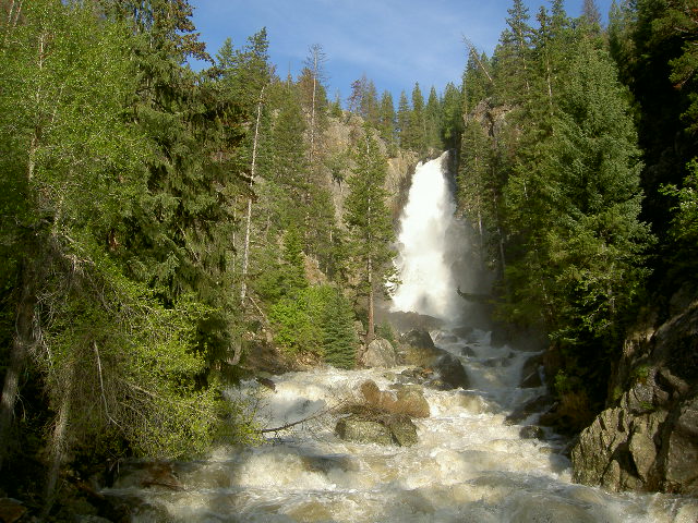
This water year was marked by above-average snowpack, a spring of precipitation at or near average and a summer that turned drier and, at least anecdotally, windier than average late in the season.
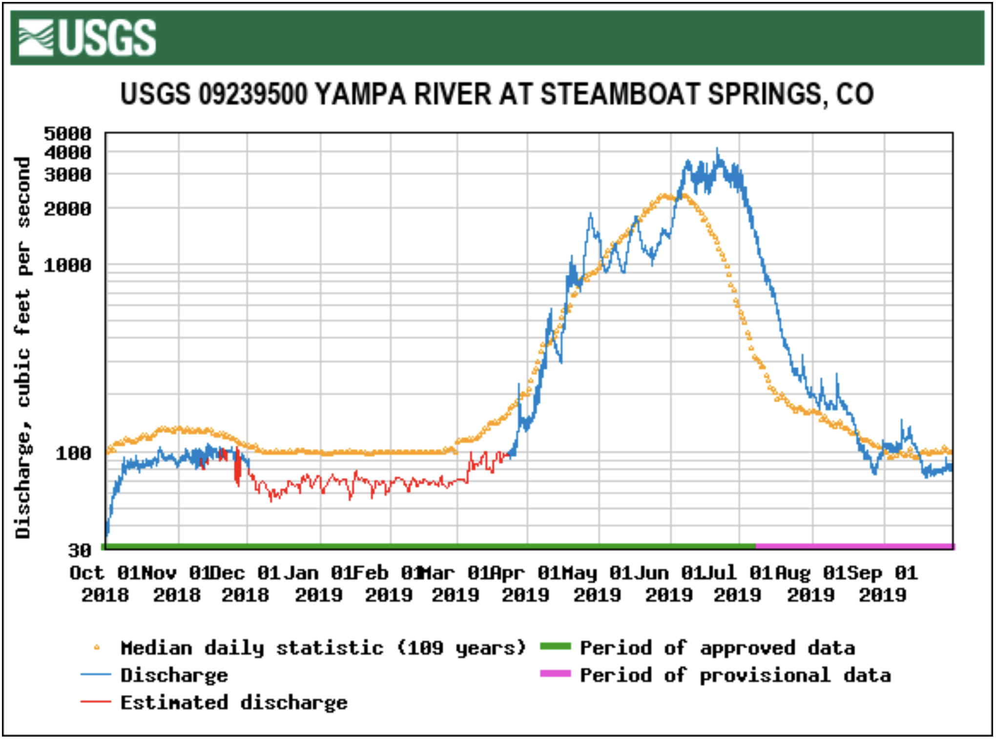
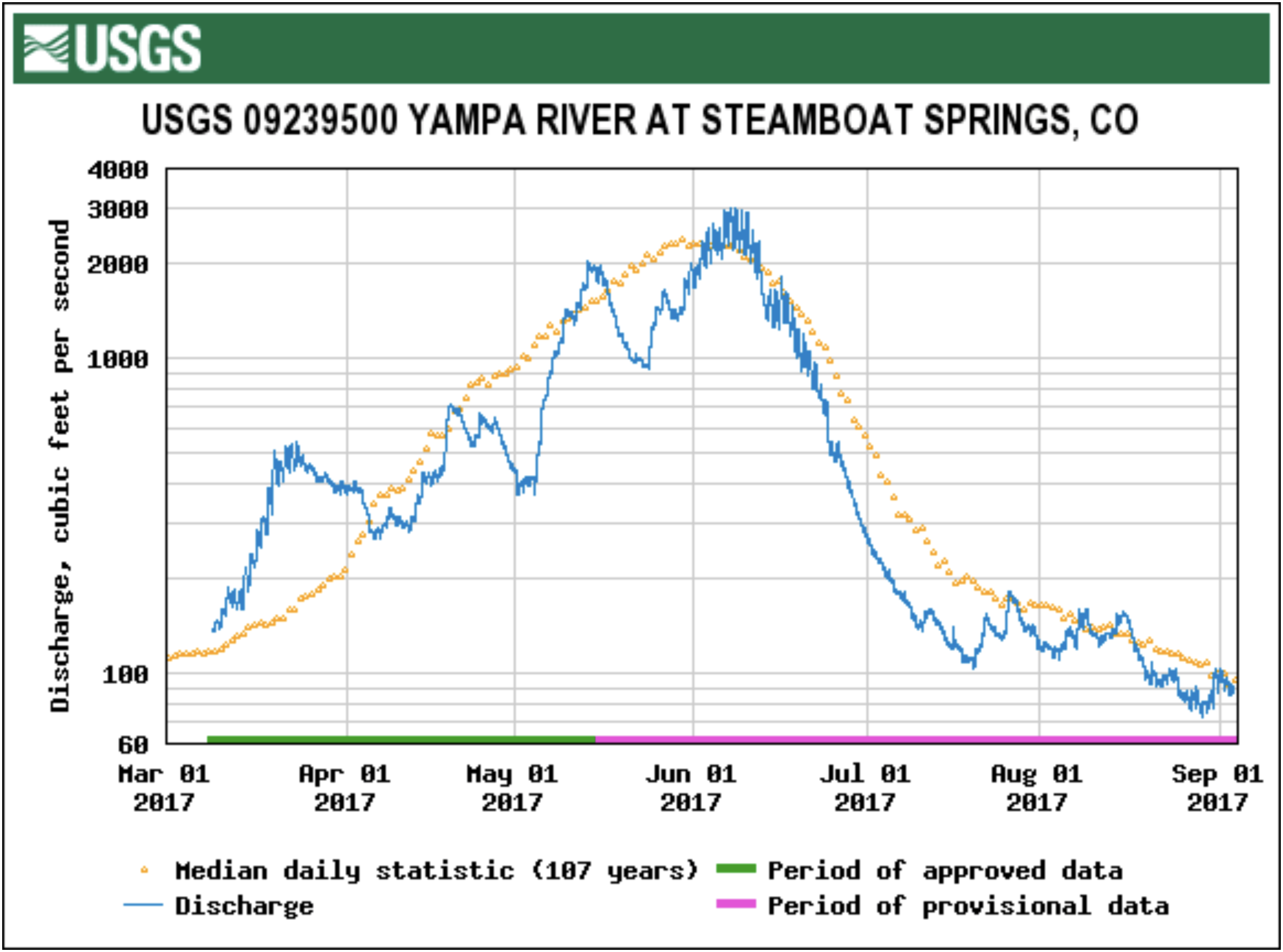
Cool spring temperatures melted snowpack off slowly, giving irrigators time to use that water before it flowed passed. The river ran high and fast at about 1,000 cubic feet per second through Steamboat Springs from the time the snow started melting in late April until early July, according to U.S. Geological Survey data recorded at the Fifth Street stream gauge. A mix of rain and summer snow on the summer solstice brought the river one of its latest peaks on record at the Fifth Street gauge in downtown Steamboat, flowing at 4,180 cfs on June 21.
This extended the rafting season on the stretch of river through town, but it delayed tubing season until July 15. The river also closed for only a day this summer, when flows fell below 85 cfs on Aug. 29. The city of Steamboat Springs and Tri-State Generation and Transmission released water to increase hydropower production at the dam at Stagecoach Reservoir and boosted flows through town, allowing the river to reopen the following day…
The late runoff was a boon for [Jeff] Meyers, though Erin Light, the Colorado Division of Water Resource’s Division 6 Engineer, said that wasn’t the case across the entire Yampa River basin.
“Some areas did really well, and other areas seemed like all the snow just soaked right into the ground,” Light said. “It would certainly make sense that would occur, given how dry we were the previous year, that a lot of snow just soaked right into the ground. That definitely was a factor in some areas.”
Meyers said the snow-soaked ground helped his pastures recoup from a hot, dry summer in 2018.
“Of course, it’s not just the hay crop, but it’s also the pastures,” he said. “After 2018, they really needed a break, and they got one. This year was really great that way.”
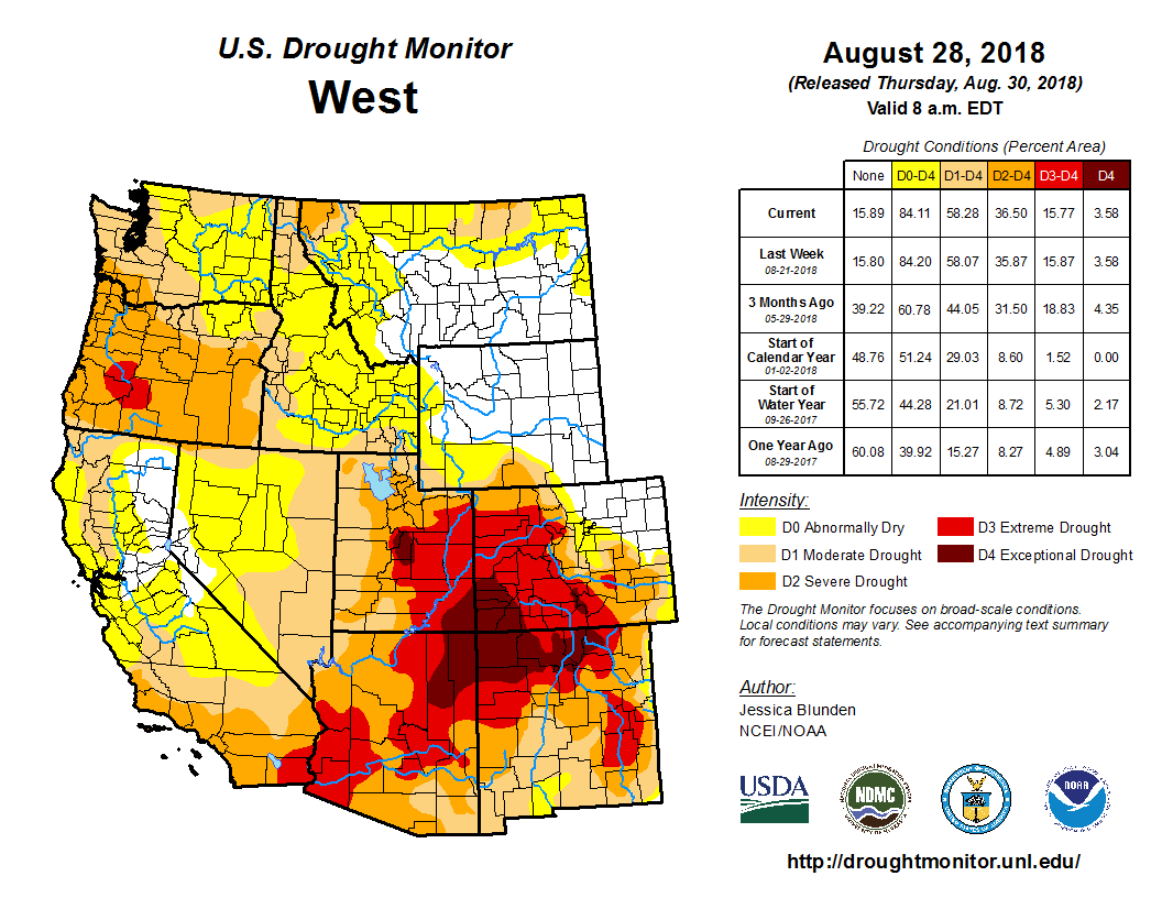
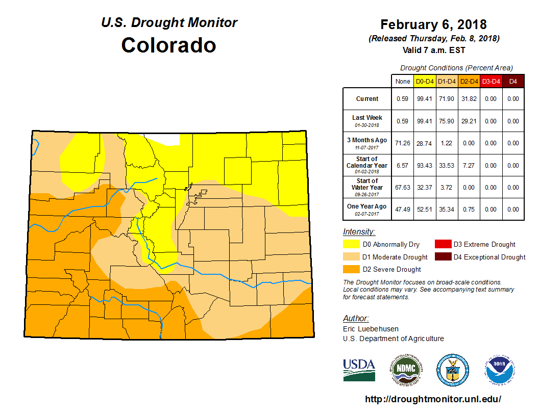
A winter thick with snow and a spring full of rain broke a 20-year streak of drought conditions in the state of Colorado, though slight rainfall in late summer brought back abnormally dry conditions in late July, according to the U.S. Drought Monitor. Routt and Moffat counties are currently in abnormally dry conditions, according to the Drought Monitor.
On Thursday, Steamboat Resort announced that it plans to donate $500,000 to the Yampa River Fund as a founding donor to the new endowed fund, which will pay for projects to protect the Yampa River’s flow…
The Yampa River Fund will pay for three types of projects aimed at benefiting all water users, from South Routt ranchers to Steamboat rafters to people drinking water from Craig faucets and the endangered fish living in Dinosaur National Monument. This includes leasing water to boost flows in dry years, actions to restore the river health and water infrastructure improvements.
The $500,000 donations will be matched dollar for dollar under a million-dollar matching challenge grant, boosting the amount raised by the money to $1 million…
The Nature Conservancy will lead management of the fund until at least 2021.
Perlman said the resort is “putting their money where its mouth is” in supporting its core values, particularly collaboration and environment. This donation is the largest single cash donation since the resort was founded in 1963. Last week, Steamboat Resort also announced it has created a new department focused on environmental sustainability…
The resort will donate $100,000 per year to the fund for the next five years.
Smith said Ski Corp.’s donation “lays a strong foundation for the effort to be successful.” Ski Corp. will participate in the fund’s board of directors and the smaller steering committee that will make funding decisions…
Ski Corp. will join about 20 other local governments, companies and organizations overseeing the fund’s operation. Other entities range from agricultural organizations, such as the Moffat County Cattleman’s Association and Community Agricultural Alliance, to nonprofits, such as the Yampa Valley Sustainability Council and Friends of the Yampa, to businesses, including Smartwool and Tri-State Generation and Transmission…
[Nancy Smith] also noted there’s still $2 million needed to reach organizers’ fundraising goal of $4.75 million over the next five years.
On Thursday, Sept. 19, community members gathered in Steamboat Springs for the launch of the Yampa River Fund, an endowed fund that will be used to fund projects to improve river health, protect the water supply, and boost river flow in dry years.
Currently the fund has about $2 million, but organizers plan to build the fund up to $5 million.
The Yampa River Fund specifically directs its money to goals included in several Northwest Colorado river management plans, including those created by the Yampa, White and Green River Basin Roundtable, and many others. These goals include protecting water users on the Yampa from curtailment, finding ways to address water shortages, and keeping water infrastructure up to date.
Another factor that instigated the water fund are the reservoir releases that are becoming a regular occurrence to increase river flow in dry years…
Other signatories that have joined Craig and Moffat County in the fund include the Colorado River District, the Colorado Water Trust, the Community Agriculture Alliance, Friends of the Yampa, Mount Werner Water and Sanitation District, Northwest Colorado Chapter of Parrotheads, Routt County, Smartwool, Steamboat Ski Resort, the Nature Conservancy, and the towns of Dinosaur, Hayden, Oak Creek, and Yampa…
The fund would have a steering committee of nine members along with a four-member board and the Nature Conservancy has apparently taken the lead on dispersing the funds. Any decision made on the board must be by unanimous consent, meaning if Moffat County doesn’t agree, it won’t happen…
Craig City Council signed the agreement at their Sept. 10 meeting. The city is interested in using the fund to possibly finance a diversion structure on the Yampa River near Loudy-Simpson park.
Yampa/White/Green/North Platte river basins via the Colorado Geological Survey
Water leaders from across the state converged on Steamboat Springs this week as part of the Colorado Water Congress Summer Conference.
The Colorado Water Congress is a group of people who work and live in water, explained Routt County Commissioner Doug Monger…
In a legislative update, attendees heard about three proposals that could change water management in the state. Reps. Dylan Roberts, Jeni Arndt and Donald Valdez and Sens. Kerry Donovan, Jerry Sonnenberg and Don Coram sat on the panel.
“As somebody who represents Routt County and other Western Slope counties, we know what a dry year looks like,” Roberts said. “We just had one last year, and we’re fortunate to have a wet year this year, but we have to continuously plan for those dry years and look at any legislation that helps us to preserve and conserve as much water as possible, prevent forest fires and protect agriculture, because they’re the ones that really lose out when we have dry years.”
Changes to a program that increases river flow in dry years
The instream flow program allows the Colorado Water Conservation Board to designate water rights to preserve or improve the natural environment of a stream.
In the Yampa River, this program has been used to release reservoir water to boost flows through Steamboat in dry summers.
Under the current law, the program allows people who hold water rights to temporarily loan reservoir water to the state to boost flows in a stream three times over the course of a 10-year period. The Colorado Water Conservation Board has already used loaned water for an instream flow in the Upper Yampa River three times in 2012, 2013 and 2017.
Though reservoir water has been released in other years, including last summer, it was under a different legal mechanism.
Roberts, a Democrat who represents Routt and Eagle counties, introduced a bill that would allow for more instream flow releases.
“Once the 10-year period is done, you’re done forever, and you can never do it again,” Roberts explained. “So while city of Steamboat and the Yampa River has taken advantage of that program, they’ve started their 10-year clock. Once we hit 10 years in 2022, they won’t be able to use it again, so if we have a really low water year on the Yampa in 2023 or 2024, we won’t be able to use the instream flow to keep the Yampa running through town.”
The bill, as currently proposed, would allow these loans for five of every 10 years and allow it to be renewed twice once those 10-year periods end.
This would improve stream habitat, Roberts said, as well as limit economic impacts due to river closures placed during low flows that impact tubing outfitters, fishing shops and the businesses that benefit from recreation in the area.
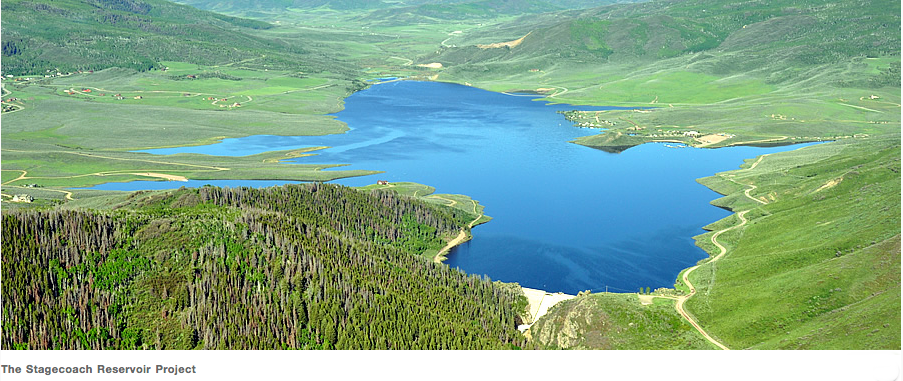
Monger, who sits on the board of the Upper Yampa Conservancy District, said the program has “been a great thing.” The district operates Stagecoach Reservoir.
“(The district’s) actually been fortunate enough to have some available wet water that we can send down through to the city of Steamboat Springs, and it helps with water quality as well as water temperature,” he said. “It’s been a great thing, and the upper Yampa sells a little bit of water for its revenue sources to be able to take care of the water, so that’s a good thing.”
It would also expand the program by allowing more water to be released to create more habitat for aquatic species, whereas currently, these releases are smaller releases designated only to preserve the existing natural environment…
Ballot measure to legalize sports betting with tax revenue funding water projects
Earlier this year, the legislature passed a measure that will ask voters to legalize sports betting with tax revenue from the practice funding the implementation of the Colorado Water Plan.
If approved by voters, Colorado would allow some casinos to offer a sports book, essentially a room with a betting board and “every game known to man” on television screens, as Donovan put it. Casinos could also contract with online sports betting companies, such as DraftKings and FanDuel, to operate web-based sports betting. People could bet on college, professional and Olympic games.
While sports betting has taken place in the state, it’s currently illegal.
“This is a chance to legalize an action that we know is happening on the ground and to provide regulation protection under that act if people choose to bet on sports betting,” Donovan said.
A 10% tax on each wager would be paid by casinos, with the bulk of the revenue funding the Colorado Water Plan. Some revenue would be directed to administrative costs, a hold harmless fund and a gambling crisis hotline.
The Colorado Water Plan outlines a number of actions such as conserving more water used by cities and industry, storing more water, establishing plans to protect critical watersheds and increasing public awareness of water issues. The Yampa-White-Green River Basin Roundtable would implement the plan locally.
Earlier this year, Gov. Jared Polis requested $30 million to fund the plan and statewide drought planning. The legislature granted $8.3 million to fund the water plan and $1.7 million for drought planning…
Using new technology to trade water rights in real-time
Another law, passed earlier this year, establishes an advisory group to study possible uses of blockchain technology within agriculture.
Blockchain is a way to track transactions, and it uses the same record-keeping technology as bitcoin. Each transaction within the network, whether the blockchain network is trading water or money, is recorded in a block and includes data about transactions under a unique signature, sort of like a username. Each transaction is verified by the network of computers in the blockchain.
Evan Thomas, director of the Mortensen Center in Global Engineering at the University of Colorado Boulder, presented on possible applications of blockchain in the world of water rights. Blockchain could create a system to trade water by using sensors that track how much water is used or conserved to create “water credits.”
“(Those water credits are) entered into the blockchain,” Thomas said. “Somebody requests a transaction. They say ‘I need to buy more water this month, so I want to buy somebody else’s water credits.’ You enter in that transactionm, and they buy and sell points. The sensor identifies water use and water consumption, (and) turns that into a blockchain node.”
Thomas said this is a worthwhile tool to study in its applications for water rights, but that it is one part of a “suite of tools” that should be examined to update how water is traded.
The headwaters of the Yampa River. Photo: Brent Gardner-Smith/Aspen Journalism
Here’s a report Water Education Colorado (Jerd Smith). Click through for the photos and the graphics:
Could something as simple and natural as a ragged corridor of expansive, towering shade trees help a river arm itself against a world in which temperatures are rising?
In northwestern Colorado’s Yampa River Basin, a 300-person-strong army of volunteers is banking on it.
The Yampa River historically has produced so much abundant, clear, cool water that its fish, kayakers, and the farmers along its banks were rarely left wanting.
But climate change is altering that dynamic. Last summer the river’s flows shrank sharply, and its formerly cool waters became dangerously warm, threatening the fish. Its high fever prompted the City of Steamboat Springs to close the popular stretch through town to fisherman and boaters on multiple occasions to avoid further stressing the mountain white fish, which is found in few other Colorado regions.
The shut-down was a huge blow to the city and to local rafting and tubing companies who rely on the river for their livelihoods.
The disturbing heat added urgency to a small program that has been gaining supporters and clout in the Yampa River Basin. The Yampa Sustainability Council (YSC), aided by $175,000 from local donors and some state grants, has ramped up a broad-based tree planting program along the river’s banks known as ReTree. Additional funding from a new $1.7 million Nature Conservancy water fund will add even more muscle to the effort.
On a hot Friday afternoon in late June, Sarah Jones, executive director of the YSC, parks at a trailhead just east of town, slathers herself in sunscreen, and loads a white plastic bucket with small calipers, a measuring stick, a GPS device and wooden stakes to take down to the river’s edge. These are the tools she and others will use to carefully locate and measure the progress of trees planted in recent years.
The reforesting work is conducted with a careful, slow precision. Each tree that is planted along the banks, and there are hundreds, is assessed, measured and located each season, even as more are placed in the ground.
The trend of warming rivers is creating a need for new science and reams of field data. “This is a new, not well-understood problem,” Jones said.
She and her partners, including the Colorado State Forest Service and the City of Steamboat, are taking the long view, carefully evaluating each year what has worked, discarding practices that have failed, and boosting those that have succeeded.
They once used elaborate planting protocols for placing the young saplings in the ground, but the trees respond much better when their small root balls are poked into the side of the bank, almost casually, supported by simple twigs. The starter trees also like being planted in the fall, they’ve learned, not the spring.
The Yampa River, in some ways, is a blessed stream, with more water than most Western rivers, and a community of hard-working, often wealthy, advocates.
This year The Nature Conservancy announced it had raised $1.7 million in a long-term water fund to restore and protect the Yampa River. The goal is to raise another $4.3 million to protect the watershed.
It is an unheard-of sum in this remote, northwestern corner of the state.
But those who know the Yampa understand the significance of protecting it, not just for the sake of this region, but for the state of Colorado and even for the greater American Southwest.
The river sits near the headwaters of the drought-stressed Colorado River system and is one of its last, mostly free-flowing tributaries. Because it is relatively unhindered, with only a few small reservoirs high on its mainstem, it serves as a kind of benchmark for scientists seeking to understand natural river dynamics and mimic them elsewhere.
Keeping the Yampa healthy also helps a much broader effort in the West to bring the Colorado River system back from the edge of a crisis precipitated by population growth, a nearly 20-year drought, and rising temperatures.
Jones and her colleague Caroline Manriquez, assistant district forester with the Colorado State Forest Service, walk slowly along a public stretch of the river. Each of them notes the young trees planted two or three years ago that are outgrowing the metal cages put in place to protect them from beavers, who are both a curse and a blessing on the river.
“On the one hand we want them,” said Manriquez, because their work on the river creates natural dams and habitats. “But on the other hand, they’re cutting the trees we want to preserve.”
Each tree that outgrows its anti-beaver cage will need to be visited, its protective metal enclosure cut off and a bigger one put in place.
The re-treeing effort anticipates a Johnny-Appleseed kind of longevity, with some 200 shade trees planted annually over the next 20 years.
“This is a huge project, and we are planting very small trees,” Manriquez said. “But given the water issues climate change is creating, we decided we had better start now.”
Like other river basins around the state, the Yampa Basin has developed a state-funded management plan for the river. Some of that funding went toward several years of studies and planning to develop the science to support the reforestation effort, said Kelly Romero-Heaney, water resources manager for Steamboat Springs.
“We’ve done a tremendous amount of modeling to look at what this river will look like in the future,” Romero-Heaney said.
Just downstream of the work zone, on the opposite bank from the workers, is a nursery which houses hundreds of delicate, young willow, cottonwood, and box elder trees. These varieties are known for growing tall and spreading a generous shade canopy.
The young seedlings have been sprouted in a nursery in Fort Collins, then transferred up to the Steamboat nursery early in the summer, all in preparation for the fall planting season.
These seedlings will be planted in the public stretches of the river, but reforesting there alone won’t be enough.
Jones and Manriquez know that the key to success for the project will be to bring the private landowners who control most of the land on the river’s banks into the program.
And that’s not easy. Western ranchers are notoriously government-averse, skittish about letting federal and state environmental officials onto their property, they said.
Rancher Steve Williams is an exception. He owns 200 acres of land along a critical reach of the Yampa east of Steamboat Springs, one that has been degraded by heavy cattle grazing, its cottonwood canopy gone, its streambed wide and much shallower than it once was.
As a result the water temperature here each summer threatens to exceed the state’s standard for the stream. If Williams can cool down his reach of the river, it will help everyone farther down and closer to Steamboat Springs.
To achieve this, he has partnered with federal agencies to shore up the river’s banks, deepening it as it curves, snakelike, through the wetlands and pastures above Lake Catamount.
This land hasn’t been grazed in 10 years, Williams said, and he’s hopeful the bank restoration work, as well as the re-treeing effort, will give this stretch of the river the assistance it needs to heal.
Williams understands the magnitude of the work that lies ahead and the challenges, the discrepancy in scale between young trees and a sprawling Western river, and the global dilemma of warming. “We will see how this goes,” Williams said. “It is a Band-aid, but it’s one I think will last at least through my lifetime.”
Romero-Heaney and other river advocates know that they will likely never see the final results of this reforestation effort, but based on the preliminary studies, they see it as an important tool for helping this playful, powerhouse of a river flourish in a very different world than it has inhabited up until now.
“I have to believe that if any river can persist through climate change, it will be the Yampa,” Romero-Heaney said.
This story is made possible, in part, by The Water Desk, an initiative of the University of Colorado’s Center for Environmental Journalism.
Jerd Smith is editor of Fresh Water News. She can be reached at 720-398-6474, via email at jerd@wateredco.org or @jerd_smith.
On Monday afternoon, the river was flowing at about 200 cubic feet per second at the U.S. Geological Survey stream gauge at Fifth Street, falling over the course of the past week from just under 300 cfs on Monday, July 22. Saturday’s rainfall boosted flows back up to 300 cfs on Sunday, though the river fell back to 200 cfs by Monday.
The river typically levels out after its peak, but city water resources manager Kelly Romero-Heaney said that level varies year to year.
“We see the hydrograph tail off after the peak snowmelt, and then it hovers above 100 cfs typically for the majority of the summer, but it can depend on what’s happening with releases out of Stagecoach Reservoir and irrigation diversions upstream from town and the weather,” Romero-Heaney said…
So far this July, the area received 1.06 inches of precipitation at a National Weather Service Cooperative Observer Network weather station, below the long-term average of 1.52 inches at the same location.
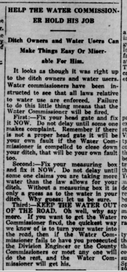
Please note the attached newspaper article from, the “Yampa Leader”, May 18, 1923…
Kind of ironic…Given the fact, we’re still attempting to deal with the same issues in 2019 as they were on the ground in the Yampa Valley in 1923, and before…
The Yampa River has finally fallen to a level that allows for commercial tubing.
On Monday, the river dropped below 700 cubic feet per second through downtown Steamboat Springs, according to the U.S. Geological Survey, the flow rate that typically kicks off tubing with commercial outfitters…
Though lower than it has been all summer, the river is still running quickly, with water temperatures around 60 degrees. The city of Steamboat Springs — and commercial outfitters — recommend wearing a life jacket on the water, even when on a tube.
fter several weeks of rising water on the Yampa River, homes near the waterway might see drier river banks soon as river level continues to fall.
“We had a big snow year,” said Jim Pokrandt, community affairs director for the Colorado River District. “Then we had a cool, wet spring even into summer as you saw in Steamboat with their snowfall.”
Officials say much of the snow in Steamboat Springs and other highland areas of the Yampa Valley hasn’t melted yet. So, unless there’s a series of exceptionally hot days, the Yampa River should stay steady…
That standing water has caused some mosquito issues in Moffat County. At least one mosquito tested positive for West Nile Virus near the South Beach boat ramp in Craig. No official human cases of West Nile Virus have been reported anywhere in Colorado yet, but officials want residents to be proactive in protecting themselves during the peak mosquito feeding times of dawn and dusk…
Though it breeds mosquitoes, much of that water has made things green up at ranches across the Yampa Valley as cows and other livestock are having their fill of the foliage.
“It’s been a great year, especially compared to last year,” [Brian Romig] said. “Farmers are happy. Farmers and ranchers seem to be a lot happier this year.”
From the Steamboat Pilot & Today (Eleanor C. Hasenbeck):
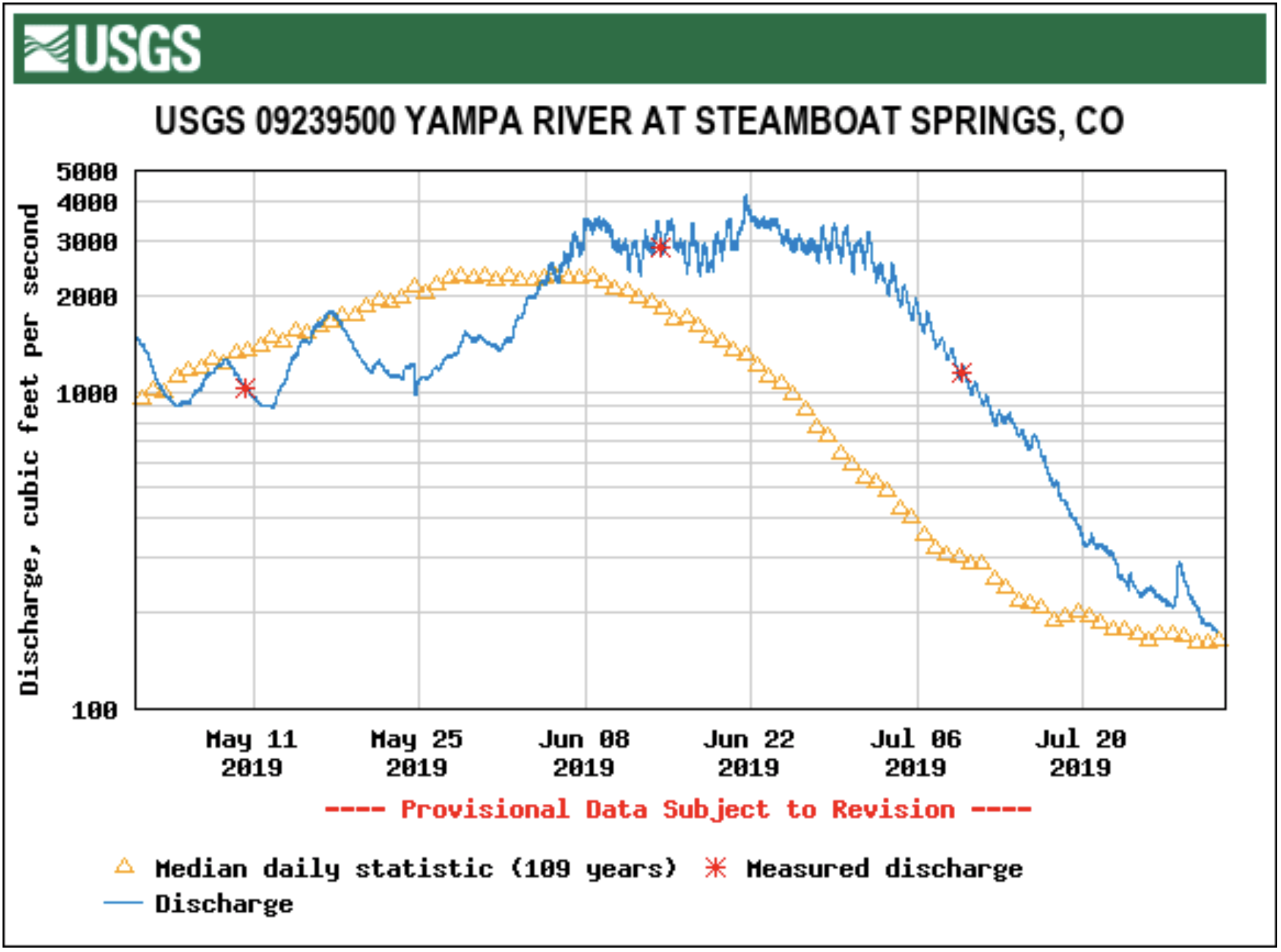
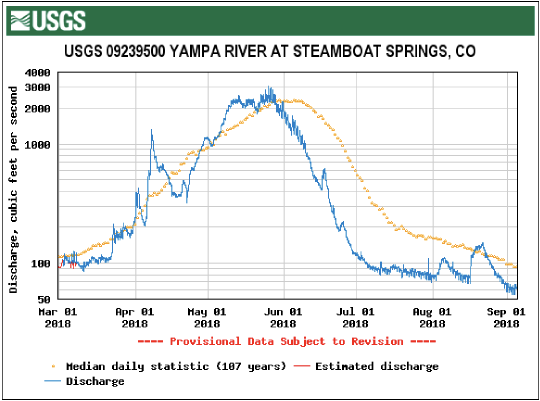
Nearly 5 inches of June precipitation and 2 inches of June snow have contributed to keeping the Yampa River flowing near peak levels since the beginning of the month.
Since the river rose to 2,300 cubic feet per second at the Fifth Street gauge in downtown Steamboat Springs on June 5, the river hasn’t fallen below that level, according to data from the U.S. Geological Survey.
“It’s a good year, and that’s no surprise to anybody at this point,” Upper Yampa Water Conservancy District General Manager Kevin McBride said. “It’s a good thing that it comes off and stays at that level for a long time, because the last thing we want to see is one big peak because that means flooding.”
[…]
Scott Hummer, Colorado Division of Water Resources water commissioner serving water users in South Routt, said the ranchers he works with say it’s peaked, but he’s still waiting to see.
“Some of my water users have told me they think the river’s peaked,” Hummer said. “I’m not particularly sold that it’s peaked. I think that everything is still totally temperature dependent. We may see a very sustained, higher-flow rate.”
Hummer added that water users in the southernmost end of the district have seen high water — with the Yampa spilling out of its banks and pooling up in fields — that hasn’t been seen for a lifetime.
“We are light years ahead of where we were last year at this particular point in time,” Hummer said. “Last Saturday (June 22), we saw record all-time inflows into Stagecoach (Reservoir). On Sunday, we saw Stagecoach spill at an all-time record amount, so it’s a much different season than last season, simply based on the snowpack.”
On Thursday, about 200 cfs of water was flowing into Stagecoach Reservoir. The mean for this date — the average of the 31-year record — is 90 cfs…
These higher flows are a boon for river runners who are still catching big waves on the Yampa and to ecosystems that rely on fluctuating flows. While ranchers are glad to have enough water to irrigate hay, the moisture and low temperatures have likely pushed back the growing season, meaning they’ll cut hay later in the season, Romero-Heaney said.
For those who hope to hit the river, it might be a better bet to rent a raft instead of a tube for awhile yet. Commercial outfitters typically start renting out tubes when the river falls below 700 cfs. The Yampa is still flowing at four times that rate.
Romero-Heaney guessed — based on data from 2011, a similar runoff year — that the river might fall to a tube-able level in mid- to late-July.
And while the water is high now, McBride cautions that it doesn’t remedy years of low flow in the greater Colorado River Basin, which the Yampa is a part of.
“As they say, don’t get too comfortable with just one year of good runoff in the Colorado Basin as a whole, but for users in the Yampa, it looks like a banner year,” he said.
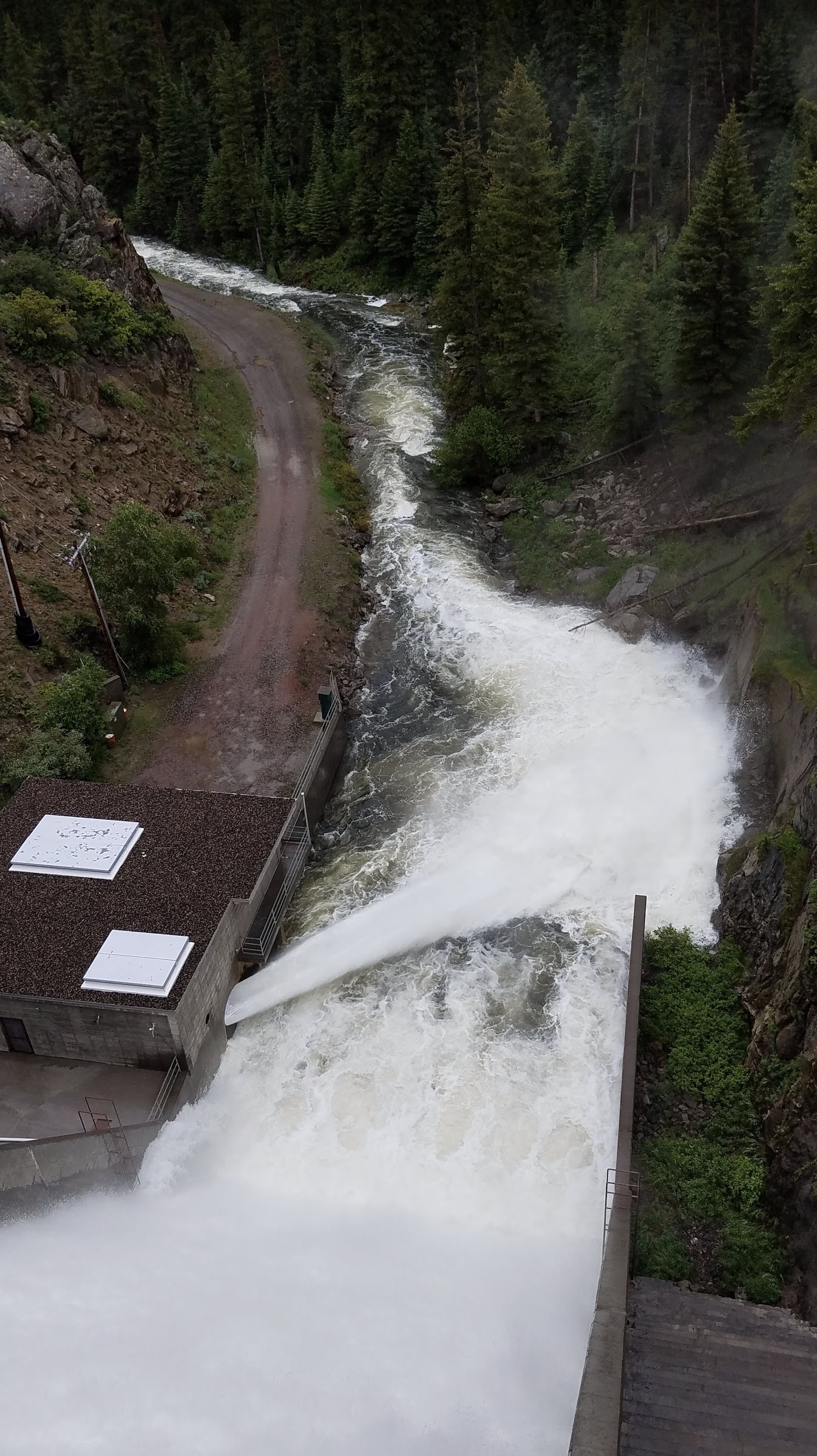
Stagecoarch Reservoir outflow June 23, 2019. Photo credit: Scott Hummer
Here’s a guest column from Kent Vertrees that’s running in the Steamboat Pilot & Today:
For all snow, water and river junkies out there, last weekend’s weather was one of the most intense and bizarre we have seen in some time. Twenty or more inches of snow in the high country, inches of rain, massive lightning, cold temps, snow in downtown Steamboat Springs marked the official beginning of summer in the Yampa Valley.
Since 1983, the year of all water years in the Colorado Basin, 2011 was the next wettest on record. This year is now very comparable.
This is a reality of ours. Living on the spine of the continent, high up in elevation, this offers extreme variability in our climate as is. We have always experienced broad shifts in annual snowpack, rain, temperature and river flow, and the perfect scenario like last weekend is never out of our reality. We already had a deep snowpack remaining from winter and spring. Then, throw in a low front with adequate moisture and low temperature and residents woke up to snow on first day of summer.
The trick with last week’s storm is that is wasn’t all snow. We typically see river levels drop when we get cold fronts, because they shut down the snowmelt with colder temperatures. But in this case, it poured rain leading up to the snowfall which spiked our rivers, creeks and streams to their seasonal peak flows.
River flows in the Yampa Basin are notorious for having large fluctuations in their seasonal flow. With limited storage reservoirs in the basin, there isn’t the capacity for water managers to store the runoff. When the conditions are right, and Mother Nature sends us her wrath, it’s not out of the ordinary to see river levels spike.
In early June at the Yampa Basin Rendezvous that was held in Steamboat Springs, we learned all about snow, water, rivers, climate modeling and the resiliency of communities to handle shifting climate aridity. We learned from scientists that the future we can expect in the Yampa and greater Colorado River basins in general, will only continue to be more variable, extreme and a bit wilder than what we are all used to.
Years of hotter and dryer climate, drought and low river flow, followed by periods of extreme snow and rainfall along with heavier flooding seems probable in our future, and it is what many of the modeling trends are indicating. What we saw last weekend is just a glimpse into our extreme weather reality and is something that we will all have to get used to.
Kent Vertrees is the board president of the Friends of the Yampa.
For the last four years, Green River and Little Snake River basin ranchers have been getting paid not to irrigate in late summer to conserve Colorado River water. But the pilot phase of the program is now over. The next step is developing the technology to measure how much water is actually saved.
Big Piney Rancher and water engineer Chad Espenscheid said the key to making sure the program succeeds is proving the water was really making it down to the Colorado River…
As part of a new drought contingency agreement, Upper Basin states like Wyoming will now be able to store as much as 500,000 acre feet of conserved water to fill lower basin demands. But that’s only if they figure out how to quantify the saved water.
Espenscheid said the program is definitely worth keeping. He said it made it worth his while to participate, paying him enough to expand his cattle herd.
But as for quantifying how much water he really conserved?
“How much? Who knows,” he said. “But for sure there was water going down the creek that we probably would have used.”
Espenscheid said he plans to work on possible methods to answer that question, like developing computer models or creating measuring devices to install in streams.
Wyoming’s Trout Unlimited Director Cory Toye says the test run was popular with ranchers and translated to real benefits for native trout.
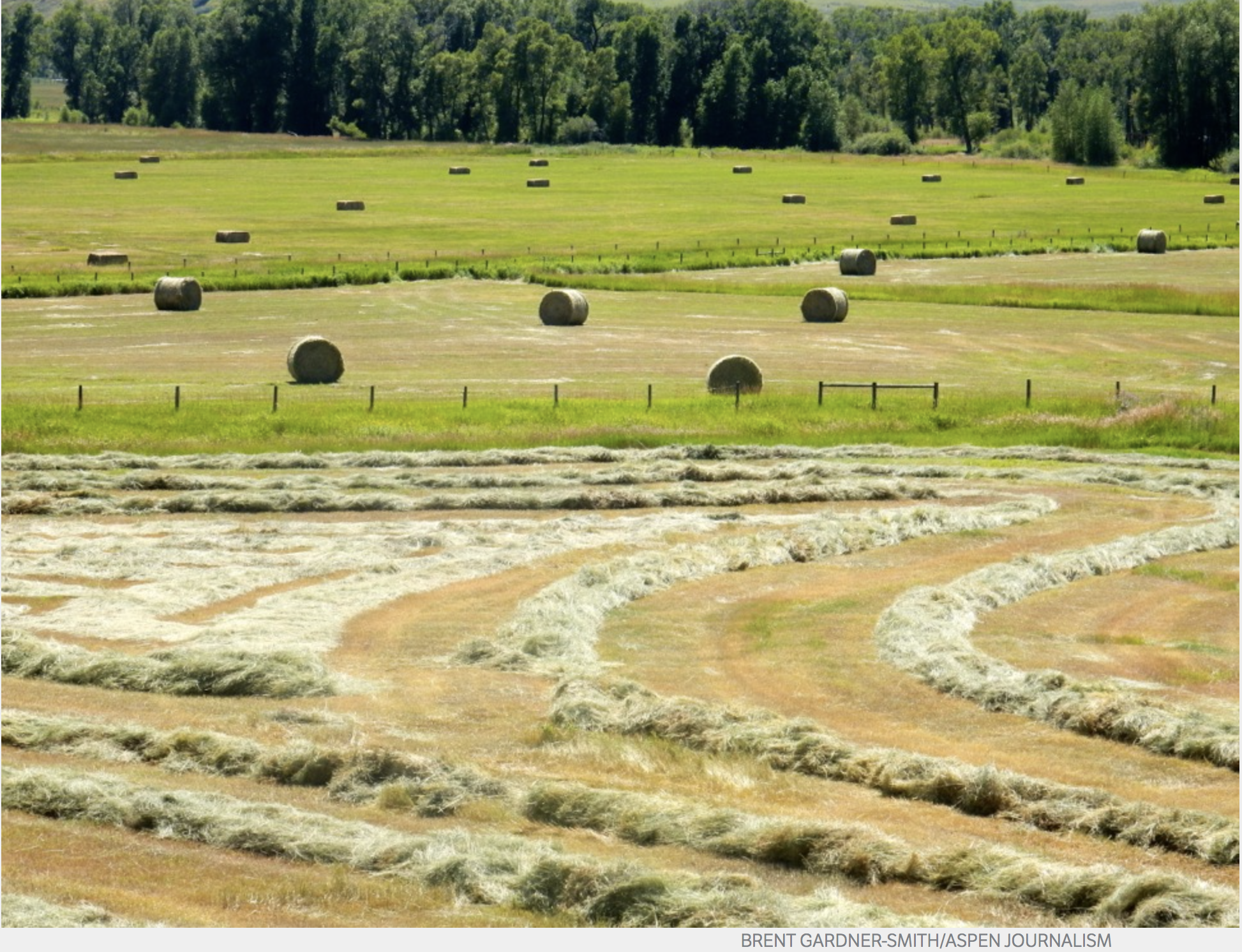
The looming possibility of mandatory curtailment of water use has raised concerns among Western Slope water managers, who feel that such cuts could harm Western Slope agricultural, such as this hay filed in the Yampa River basin. However, as water levels continue to drop to record lows in Lake Powell, mandatory curltailments are being discussed as a real possibility, especially by Front Range water managers. Photo credit: Brent Gardner-Smith/Aspen Journalism
FromThe Steamboat Pilot & Today (Eleanor C. Hassenbeck):
The collective group of [recently signed] agreements is called the Colorado River Drought Contingency Plan.
It aims to raise the unprecedented low water levels in the largest reservoirs on the Colorado River system, Lake Powell and Lake Mead, to enable them to continue to deliver water and produce hydropower.
In Colorado, it calls for three possible actions:
Creating a bank of stored water in federally owned reservoirs upstream of Lake Powell. This water would be released into Lake Powell in order to make sure Colorado continues to meet obligations to deliver a certain amount of water to downstream states under the Colorado River Compact.
Increasing cloud seeding and removing deep-rooted, invasive plants that take up a lot of water, such as tamarisk.
Creating a voluntary program that would temporarily pay agricultural water users to fallow their land and send water they have a right to downstream. This is called demand management.
Of the options on the table, demand management — the option that would pay farmers not to use their water — is the one most likely to impact Routt County…
Demand management is still only a hypothetical, so the Yampa River Basin could opt out of a program if it doesn’t work for the area.
The Colorado Water Conservation Board has assembled workgroups on topics related to demand management. These groups are now meeting behind closed doors to develop preliminary reports outlining how the program might work.
Brown said once these reports are completed and released to the public, there will be opportunities for community members to provide input on the idea. She said there will be the “opportunity for a real, thoughtful conversation, especially in the Yampa and White (river) basins.”
The Yampa River flows through the Carpenter Ranch. Photo courtesy of John Fielder from his new book, “Colorado’s Yampa River: Free Flowing & Wild from the Flat Tops to the Green.”
From Colorado Parks and Wildlife (Jack Taylor) via Steamboat Pilot & Today:
Are you familiar with Colorado Parks and Wildlife’s Habitat Partnership Program (HPP)? If you are in the livestock/agriculture business or a landowner in Routt County you should be.
CPW’s HPP program works to reduce wildlife conflicts, particularly conflicts associated with forage and fences, and to assist CPW in meeting game management objectives. HPP efforts are primarily aimed at agricultural operators and focus on problems and objectives for deer, elk, pronghorn and moose. HPP is funded by receiving 5% of the deer, elk, pronghorn and moose license revenue from each HPP area. This results in millions of dollars annually that can be spent on projects on both private and public land across Colorado.
The local HPP committee in Routt County is the Upper Yampa River HPP committee. The committee is comprised of several local agricultural producers, local sportsman and agency representatives (CPW, Bureau of Land Management, U.S. Forest Serivce). This combination of local knowledge allows for innovative project ideas and novel solutions to problems specific to Routt County.
The Upper Yampa River HPP committee has recently funded several habitat improvement projects, specifically projects that enhanced the amount of water available to both wildlife and livestock on private property. These projects allowed for better grazing practices that will benefit wildlife and livestock into the future.
Other common projects for the Upper Yampa River HPP committee involve assisting landowners with fencing projects. This could be providing materials for a strong welded wire hay stack-yard that can stand up to the snow loads in Routt County or supplying vinyl-coated top wire. The vinyl-coated top wire program helps to reduce the damage that deer and elk can cause to fencing while they are crossing it because the vinyl-coated wire is more visible, which also results in fewer deer and elk fence entanglement issues.
The possibilities do not end there. In addition to fence and forage type projects, the Upper Yampa River HPP committee also assists landowners with funding a portion of the transaction costs for conservation easements.
HPP looks for a 50/50 cost split to approve the project being submitted. This means if you are asking the HPP committee to contribute $2,000 to a habitat improvement project on your property, they would be looking for a contribution from you worth $2,000.
The Upper Yampa River HPP committee also considers any other partners associated with the project, like a neighbor, if the project can span multiple parcels of property.
To submit a project with the Upper Yampa River HPP committee, contact your local district wildlife manager directly or call the CPW Steamboat Springs Service Center at 970-870-2197. Upper Yampa River HPP meetings are typically held once a month. Contact Colorado Parks and Wildlife to learn more.
Jack Taylor is a district wildlife manager for Colorado Parks and Wildlife.
Christmas Elk via the Middle Colorado Watershed Council December 2013
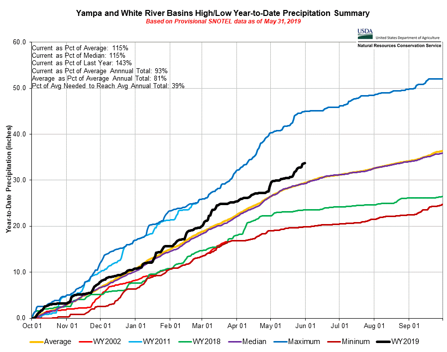
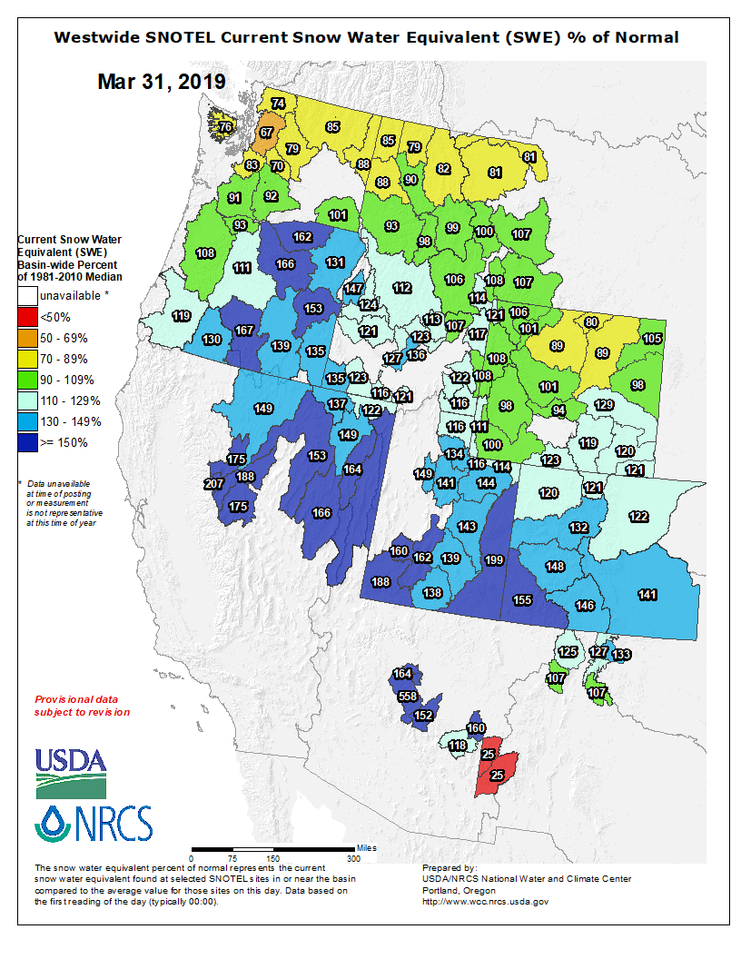
Yampa and White Basins High/Low Precipitation Summary May 31, 2019 via the NRCS.
From the Steamboat Pilot & Today (Eleanor C. Hasenback):
According to data from a National Weather Service cooperative weather station, Steamboat Springs receives a long-term average of 2.15 inches of water in May.
Data from that station shows the area received nearly double that average, with a total of 4.26 inches in May. This data is preliminary, and the National Weather Service will release its official tally of May precipitation later this month.
Steamboat received 9.3 inches of snow in May, well over the long term May average of 2.8 inches at the station.
That snow hasn’t melted off the mountains, either. The Natural Resource Conservation Services’ snow telemetry site atop the Continental Divide on Buffalo Pass measured 115 inches of snowpack on the ground on Sunday. There were 35 inches at the Rabbit Ears Pass site…
“This has been a pretty active year — a pretty wet winter and spring. … I think that’ll have some influence on the temperatures too because as the sun is melting the snow, it’s not able to heat the ground as much. That could be a reason why our temperatures could be at or below normal for this short-term forecast,” said Erin Walter, a meteorologist at the Weather Service Forecast Office in Grand Junction…
“The warmer temperatures are just going to increase the runoff, so that’s kind of the big threat right now for Western Colorado,” she said.
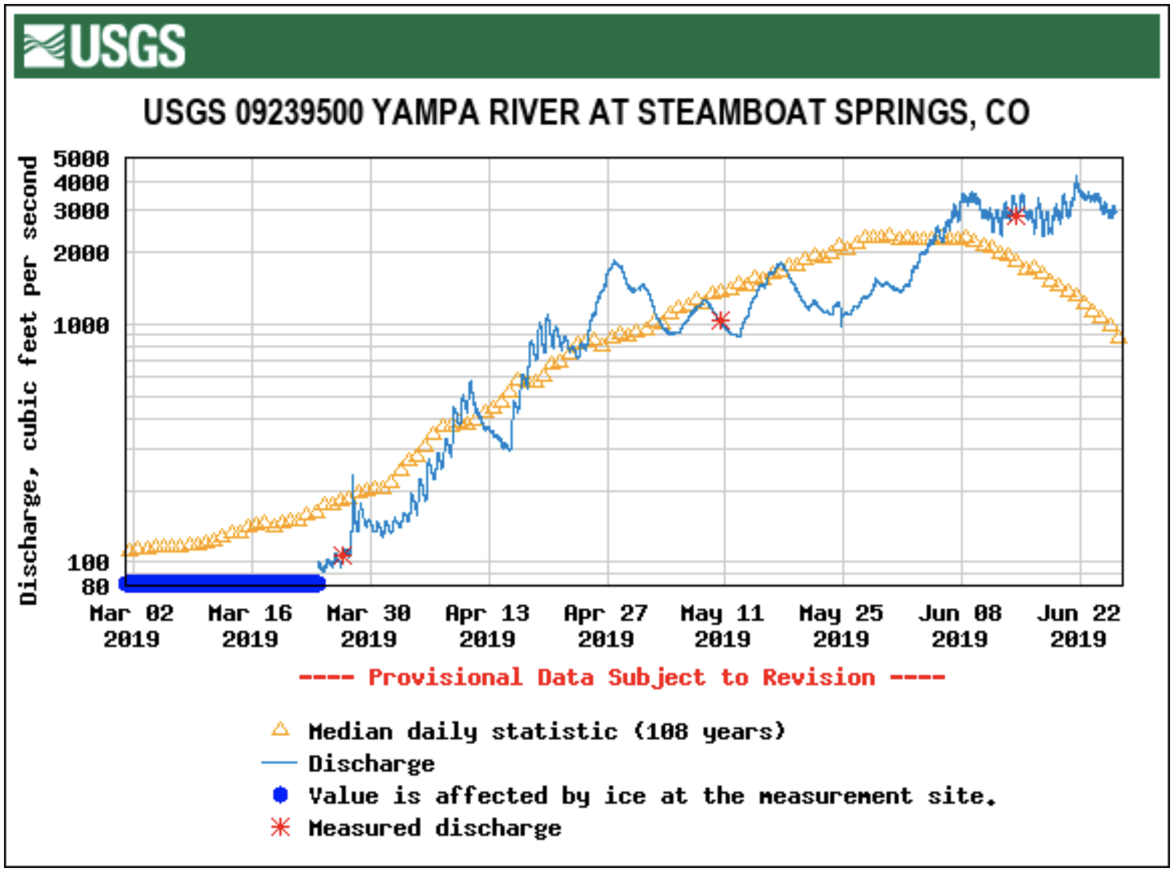
The river runners’ adage states that the Yampa River peaks when two brown spots atop Storm Peak meet. Those brown spots have yet to make an appearance this spring.
The Yampa River sees an average peak in early June around 2,250 cubic feet per second at the U.S. Geological Survey’s Fifth Street gauge in downtown Steamboat, though the peak has ranged from 1,570 to 5,200 cfs in the last ten years.
For much of the last month, the river has flowed relatively consistently between 1,000 and 1,500 cfs through Steamboat, though the Weather Service forecast that the Yampa will rise to about 3,600 cfs later this week amid sunny weather starting Tuesday.
Walters said the forecast for June looks to see average temperatures and a slightly above average chance for “wetter than normal conditions.”
While this year is shaping up to be a good water year so far, climatologists and water managers are still concerned by a trend of drought intensified by warmer temperatures and an earlier spring in the West.
“Just because we have one good year … doesn’t negate the realities we’re seeing with consistent warming trends,” Taryn Finnessey, a senior climate change specialist with the Colorado Water Conservation Board told the Durango Herald on Wednesday…
The Yampa River flows into the Colorado River, and then into Lake Powell, where it helps fulfill Colorado’s annual obligation to provide a certain amount of water to downstream states. As of Saturday, Lake Powell was only 43% full, and even with Colorado’s healthy snowpack, the U.S. Bureau of Reclamation estimated that Powell would fill to 54% of its storage capacity this water year. The lower Powell falls, the more concerned water managers become about meeting obligations to other states.
From the Steamboat Pilot & Today (Nicole Seltzer):
Boring. Arcane. Those are words I hear when I ask people their opinions on water management. If you don’t own a water right or rely on water for your paycheck, it’s usually an afterthought in the grand scheme of things.
Until it isn’t.
Until there isn’t enough water in the river to bring in tourism dollars. Until low river levels mean ranchers without senior water rights must stop irrigating hay fields. Until water levels in Nevada’s Lake Powell go low enough to require all Colorado water users to send more water downstream. These realities are at the forefront for only a small percentage of people, but the rest of us will notice the ripple effects eventually.
One of the reasons I moved to Routt County a few years ago was the slow pace of change. Having witnessed 15 years of Front Range growth, I was ready to celebrate the value of maintaining the status quo. The Yampa River is healthy and hard working, and most water users don’t face imminent threats. But we can’t let the lack of an emergency blind us to a slow accumulation of changes that require good planning.
That’s why I am involved in helping the Yampa-White-Green Basin Roundtable develop the first Integrated Water Management Plan for the Yampa River basin. The planning effort takes advantage of state grant dollars available for water planning. A coalition of Basin Roundtable members, local water agencies and NGO partners has raised over $500,000 to make progress on roundtable goals and build relationships with water users.
This plan will combine top-down and bottom-up tactics. The roundtable is currently hiring segment coordinators to meet with water users and other stakeholders to understand the opportunities they see and the challenges they face. They will also hire science and engineering experts to characterize existing conditions and identify future trends.
The outcome of the plan will be a prioritized list of actions that users can take to protect existing and future water uses and support healthy river ecosystems in the face of growing populations, changing land uses and climate uncertainty. The roundtable has its own grants to help fund implementation of those actions and will identify federal, state and local partners that can contribute as well.
The plan is just starting to take shape, and there will be ample opportunity for involvement. You can learn more at yampawhitegreen.com.
Nicole Seltzer is the science and policy manager for River Network, a national nonprofit that empowers and unites people and communities to protect and restore rivers. She lives in Oak Creek and now owns more irrigation boots than high heels.
Here’s the notice from the the Colorado Division of Water Resources (Scott Hummer):
South Routt County Water Users Meeting
Bear River at CR7 near Yampa / 3:30 PM, May 16, 2019 / Flow Rate = 0.52 CFS. Photo credit: Scott Hummer
Wednesday, May 29, 2019
Soroco High School / Oak Creek, CO
6:30 PM – 8:00 PM
Representatives from the Colorado Division of Water Resources (DWR), Upper Yampa Water Conservancy District (UYWCD), United States Forest Service (USFS), and Natural Resources Conservation Service (NRCS)
The agenda will address the agencies specific roles regarding:
Authority and Responsibilities associated with Administration, Management, and Oversight of water matters in the Morrison Creek, Oak Creek, and all Tributary drainages above Stagecoach Reservoir
All waters users are encouraged to Attend
Special recognition to the Soroco High School, FFA Chapter for helping organize the event!
“The city is confident, based upon volumes of analysis, that it has adequate water supply to provide West Steamboat Neighborhoods, even in dry years,” city Water Resources Manager Kelly Romero-Heaney said…
According to a water demand study conducted by the developers, at full build-out, homes in the neighborhood will require a total of 203.9 acre-feet of additional water…
The addition of a school and commercial developments increase this demand to 255.3 acre-feet, Romero-Heaney said…
Between 2006 and 2017, the city of Steamboat Springs used an average of 1,344 acre-feet each year, according to Romero-Heaney.
In 2012, one of the driest years on record in the Yampa River Basin, according to the Natural Resource Conservation Service, about 7,800 acre-feet of water was available to the city from Fish Creek, Romero-Heaney said. The Yampa River added another 2,000 acre-feet.
She estimated that 93% of the water the city uses comes from Fish Creek, with the remaining 7% coming from the Yampa River. The city is working to expand its Yampa River water intake to provide an additional water source should Fish Creek become unusable.
Funding additional water infrastructure
Before the first home is built, West Steamboat Neighborhoods will be required to do the following under the annexation agreement:
Pay $292,000 to a newly established water-firming fund to pay for additional water infrastructure
Install a “water distribution system” either by extending a water main along U.S. Highway 40 that currently ends near Snow Bowl Plaza, by connecting to and extending from water lines in the neighboring Overlook Park development or by building a storage tank in the development
Install pressure-relief valves and boosters
Brynn Grey will be required to pay $15,000 to the water-firming fund upon the closing of each market-rate home. There will be an additional $11,200 payment to the fund on closing when selling homes with secondary units. This amount will be adjusted for inflation according to the Engineering News-Record Construction Cost Index.
This payment is in addition to standard tap fees Brynn Grey will pay when it receives a building permit for each home. Water tap fees equate to about $6,800 for a 1,500-square-foot, two-bath, single-family home.
The developer’s total contribution to the water-firming fund is expected to be more than $4.67 million at full build-out, according to the city.
The water-firming fund would be used to eventually build an additional water-treatment plant and purchase additional water rights, which would be necessary should the city annex land beyond West Steamboat Neighborhoods, Romero-Heaney said.
The city also will build a new water tank on the west side of town within two years of the proposed annexation agreement taking effect. In 2018, the city budgeted $3.82 million for the project.
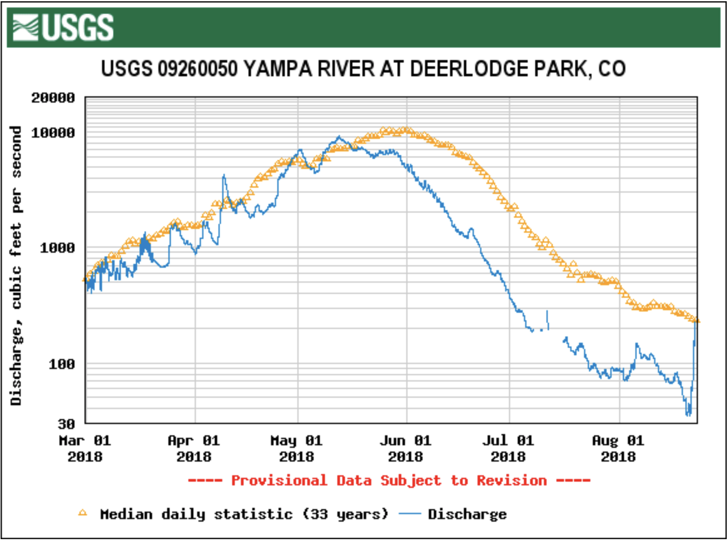
The Yampa River had almost no flows at Deerlodge Park, at the entrance to Dinosaur National Park, when this photo was taken in mid-August, 2018. Photo/Erin Light via The Mountain Town News
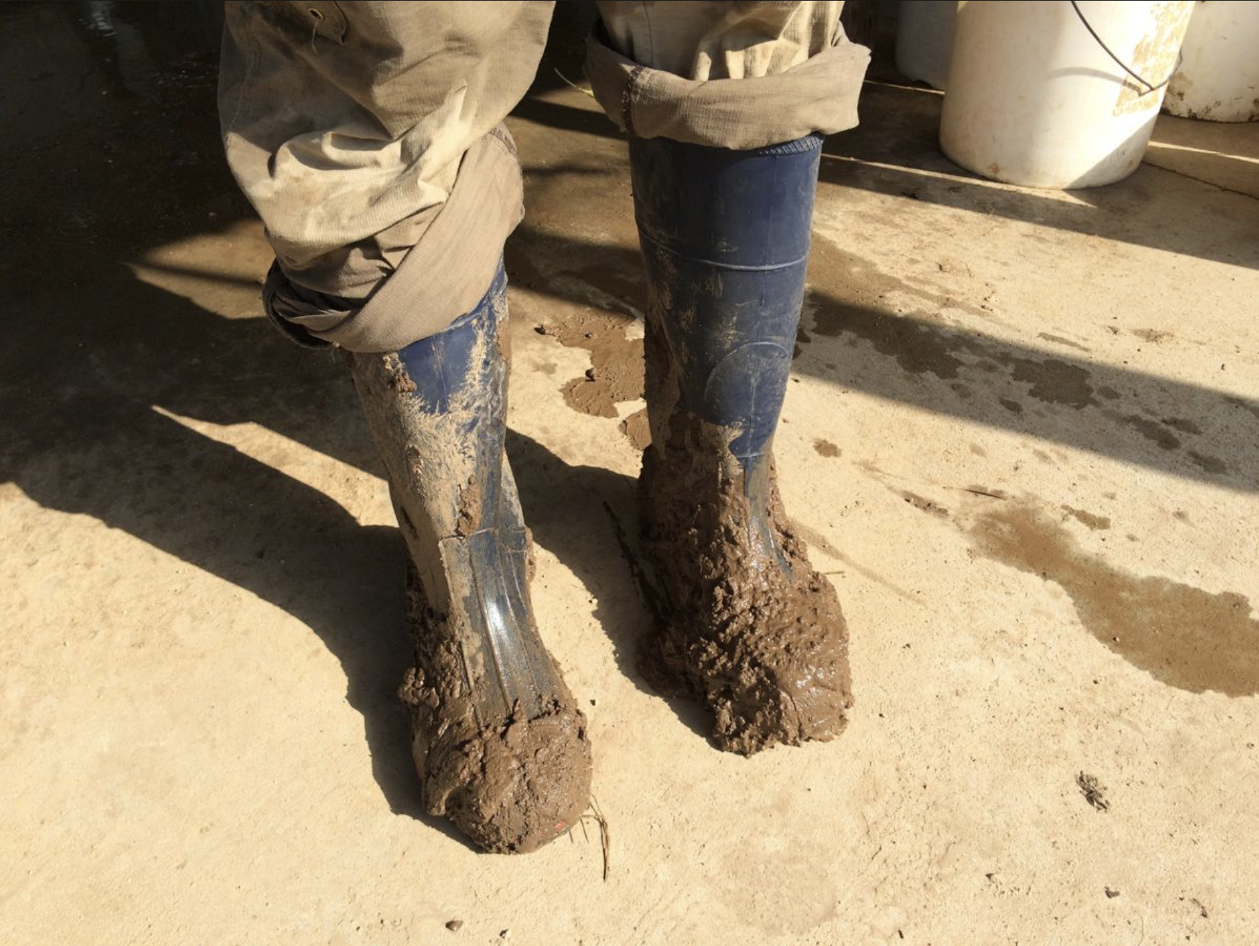
When the Yampa River went on call for the first time last year, 65% of water users on the river had to cut back or stop using their water because they didn’t have a measuring device or headgate on their diversion.
In light of that, Colorado Division of Water Resources Division 6 Engineer Erin Light sent water users on the Yampa a notice earlier this year, requiring that they install these devices.
Water users must install headgates
“We know we had a problem with measuring devices … but because of this call and this recognition of a problem of having so many structures without measuring devices, I made the decision to send out notices for the installation of headgates and measuring devices,” Light told the audience at the annual State of the River presentation in Steamboat Springs earlier this month.
Light is asking users to install devices by July 31 or ask for more time. If someone does not comply with the notice or receive an extension, they’ll receive an order to install these devices. Not complying with the order can result in a locked headgate, which means a user can’t use any of their water, or a $500 fine per day for every day a user continues to divert water without a headgate.
These structures are required by law, but the Yampa River is still the Wild West when it comes to water use. The Yampa was among the last, if not the last, large rivers in the state to go on call. The area also is among the last in the state to have so many diversions without headgates.
When the river went on call, even water users who had senior water rights and were using less water than they were legally entitled to were not allowed to use their water because their ditches didn’t have measuring devices that count how much water is used.
That’s means about 65% of the devices Light and her staff track in the Yampa River basin — about 850 — were shut off.
A similar notice and order was issued after the Elk River was placed on call in 2010.
Measuring for the future
These devices are important, Light said, because, in the state’s eyes, the value of a water right is based on the record of how much water that crops, livestock and people consume.
Without a way to measure the water, this record is an estimate, with water commissioners — the people charged with monitoring water rights on the ground — taking an educated guess at how much water is flowing based on how quickly a dandelion head floats downstream.
And how the state values a water right is becoming increasingly important as water managers start to plan for the possibility of an interstate call under the Colorado River Compact, which would require Colorado to cut back use as a state in order to send water downstream. Water managers are already working to balance increased demand for water with less available water…
The Upper Yampa Water Conservation District, which includes much of Routt County, offers mini-grants for up to half of the project cost or $500 to assist water users with the cost of installing water control and measuring devices. Each device can earn a grant, so if a producer is installing a headgate and measuring device, they can receive up to $1,000, Upper Yampa General Manager Kevin McBride said.
An earlier spring
Though having a lot of snow is generally good for the water year, the type and timing of the snow also impacts the western cycle of water.
“It’s not just amount of snowpack we have that is critical, it’s also the type of precipitation we’re receiving, especially in the winter — whether we’re getting rain or snow,” said Orla Bannan, in a Yampa Valley Sustainability Council Talking Green event. Bannan works with water scarcity as strategic engagement manager for the conservation organization Western Resource Advocates in its Healthy Rivers Program.
She added when snow melts is critical, and “we’re seeing changes there.”
Springtime has sprung earlier and earlier in the Yampa Valley, according to data from the Natural Resources Conservation Services’ snow telemetry sites. Snowpack is reaching its peak and melting off earlier in the season. Dust on snowy, windy and sunny days can all increase how quickly snow melts off the mountains.
When that early snowmelt runs off into the streams that feed into the Yampa and Elk Rivers, the rivers also peak earlier. This has impacts to everyone who uses Yampa water.
When the river peaks early, flows can rush by before producers’ crops are ready to use them. The river level appropriate for river recreation in town can fall by early summer, closing the river at the hottest time of the year when many would like to be paddling, fishing or tubing down it. When flows are low, the river is also more likely to warm to temperatures that are unhealthy for trout and other aquatic species.
These changes are forecasted to continue, largely driven by warming global temperatures as human impacts continue to create a hotter atmosphere, according to the 2019 National Climate Assessment, a report authored by several federal agencies and reviewed by members of the National Academy of Sciences.
“In the last 50 years, Colorado has seen greater amounts of precipitation as rainfall as opposed to snowfall, and then snowmelt and subsequent peak flows have shifted by weeks,” Bannan said. “So, we’re already seeing those changes.”
Across the West, states with water cycles reliant on snow are seeing smaller snowpack, with a greater decline at lower elevations, Bannan said. Higher temperatures also intensify droughts as more water evaporates from streams and both crops and wild plant species use more water to grow in hot sun.
Longterm drought
One good year is not enough to mitigate the impacts of a decade of dry years, Bannan said.
Locally, Routt County was only pulled out of drought conditions last week, according to the U.S. Department of Agriculture’s Drought Monitor. Before snowmelt hits the streams, it will first soak into dry soil. While snowpack is above average, river forecasters are still predicting near-average flows in the Yampa.
As of Sunday, snowpack in the Yampa Valley contained 125 percent of its normal snow water equivalent, according to the NRCS, but the National Weather Service is forecasting flows in the Yampa River in April through July to be much closer to average — 91 percent of average at Stagecoach Reservoir and 100 percent in Steamboat Springs.
The Yampa is also part of a much larger watershed, flowing into the Green River and then the Colorado River, and then into Utah, Arizona and Mexico. Colorado is legally obligated to send a portion of its water — including Yampa River water — to downstream states in the form of an annual contribution to Lake Powell.
In recent years, below average water years have increased concern that Colorado won’t contribute enough water to Lake Powell to meet its legal obligations. Should that happen, an interstate call would be administered, requiring water users in Colorado to reduce use to send more water downstream to meet its obligations.
Just as upcoming flows in the Yampa are predicted to be slighter than its snowpack, flows in the Colorado River are predicted to be slighter than its snowpack, meaning the state needs several more good years to soothe water managers worries for Lake Powell.
“We’re going to have a normal year for Lake Powell,” Bannan said. “It’s going to go up a little bit, but it’s not going to go up a lot. It would take an awful lot of wet years for that reservoir to really recover.”
Statewide, water managers are working to plan how to divvy up water should Colorado be required to curtail water use due to an interstate call.
On the Yampa, the city and other partners are working to make the river more resilient to a changing climate. Kelly Romero-Heaney, water resources manager for the city of Steamboat Springs, explained programs to restore trees along the riverbanks will eventually help shade the river, preventing evaporation and temperature increase due to the heat from the sun’s rays. This will allow more of that water to make it downstream.
The city has also partnered with the Colorado Water Trust to increase flows in the river, and a new endowed fund set to launch later this year will help fund river management in the future.
“When it comes to the Yampa River, we don’t exactly know what to expect year-to-year, but we know that if we give the Yampa the ingredients it needs — like conserved lands, flowing water, restored riparian forests — then we’ve done the best we can do to at least help our rive buffer our self against the extremes we have coming our way,” Romero-Heaney said.
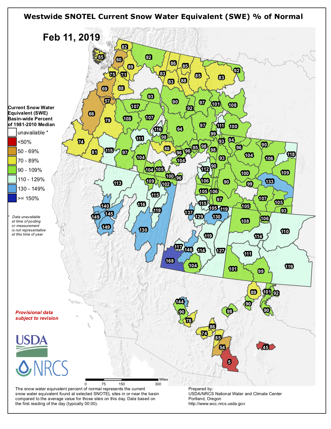
Precipitation in the Yampa and White River basins was surveyed at 106 percent of average as of Sunday, Feb. 10, according to data reported by U.S. Department of Agriculture Natural Resources Conservation Service’s Colorado Snow Survey Program.
Statewide, mountain snowpack improved from 94 percent of normal Jan. 1 to 105 percent of normal Feb. 1.
The result was attributed to “a consistent pattern of weather systems throughout much of January (that) brought snow to the state, particularly, storms during the 15th through 24th of January,” said Brian Domonkos, snow survey supervisor.
The southern mountains have fared even better.
“Southern portions of the state currently show more than twice the snowpack present at this time last year, a stark contrast to last year’s shortage,” Domonkos said. “Double the snowpack of last year is a step in the right direction as reservoirs remain low.”
Precipitation in Northwest Colorado has been high for three of the past four months.
According to the most recent NRCS Water Supply Outlook report, “Water year 2019 got off to a great start with all major basins receiving above average precipitation in October. This ranged from a low of 109 percent of average in the combined Yampa, White, and North Platte basins to a high of 144 percent in the combined San Miguel, Dolores, Animas, and San Juan basins of Southwest Colorado. November precipitation displayed notable differences between the northern and southern parts of the state. Northern Colorado continued to receive well above average precipitation …”
December was not as strong, with precipitation falling to just above 60 percent of average before rising in January.
Streamflow forecasts Feb. 1 point to a much more positive runoff season than last year’s forecasts, however, with nearly one-third of the usual snow accumulation yet to fall, conditions may change.
Westwide SNOTEL basin-filled map February 11, 2019 via the NRCS.
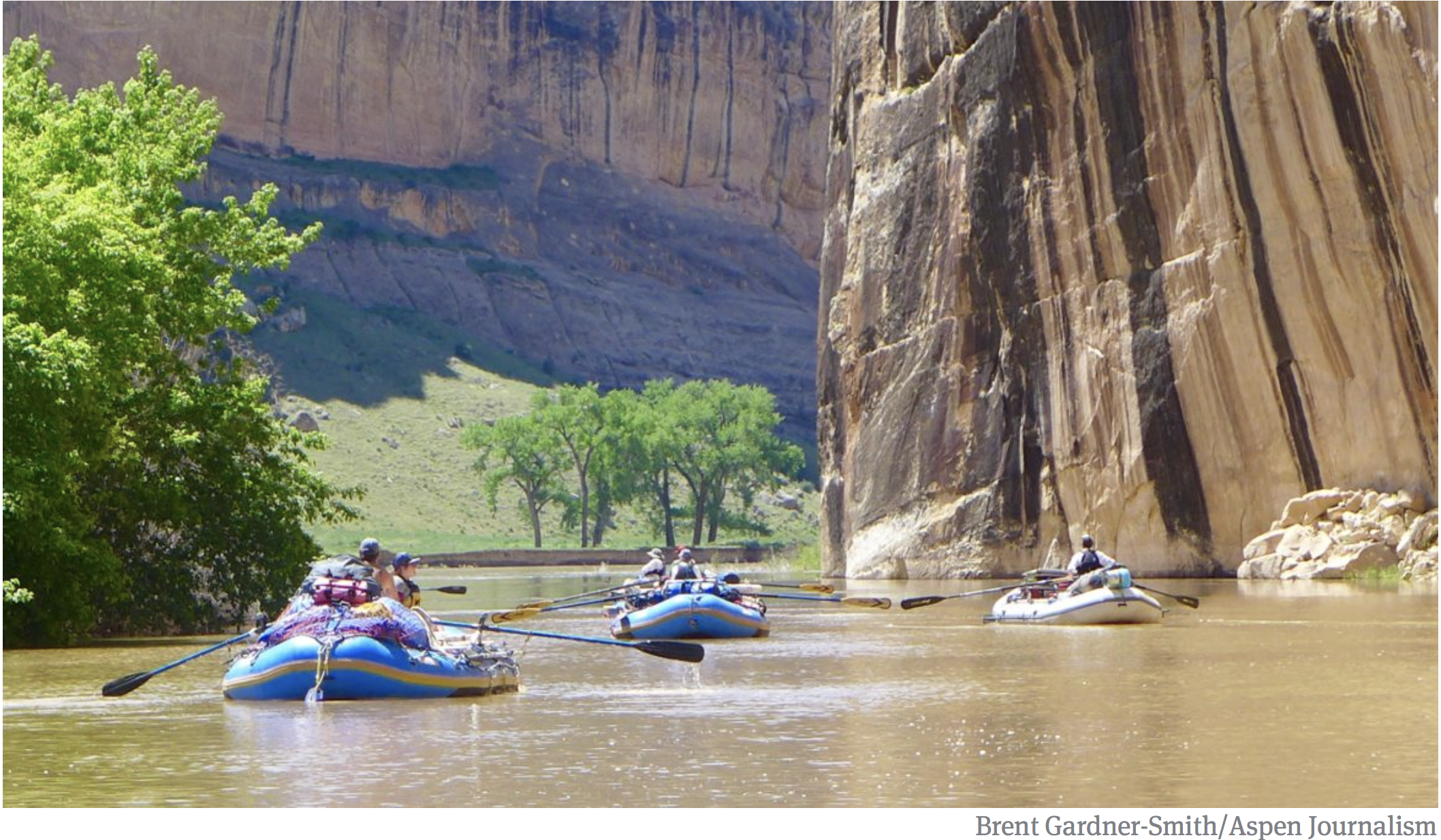
A fleet of rafts makes its way down the Green River toward its confluence with the Yampa River. Future potential releases of water out of Flaming Gorge Reservoir to boost levels in Lake Powell shape the flows on the Green River, although it’s not clear how the releases may change flow levels. Photo credit: Aspen Journalism/Brent Gardner-Smity
After 19 years of extended drought in the Colorado River basin, water users in Northwest Colorado are concerned that the region could become a “sacrificial lamb” as the state seeks to reduce water use to meet downstream demands.
As Colorado water officials begin work on a new “demand management” system to reduce water consumption, members of the Yampa-White-Green Basin Roundtable, which met Jan. 9 in Craig, are seeking to make sure the cutbacks don’t disproportionately impact their river basins, including the Yampa, White and Green rivers. The concerns prompted the creation of a new Big River Committee, which met for the first time Jan. 9, to advocate for the basin on state and regional issues across the Colorado River system.
“We’re already doing our fair share,” said Routt County Commissioner Doug Monger, a basin roundtable member and fourth-generation cattle rancher. “[In the Yampa basin] we already use only 10 percent of our water — 90 percent of our water goes to Lake Powell.”
There is relatively little reservoir storage on the Yampa River — less than 72,000 acre feet of water on the main stem and a total of 113,000 acre feet in the basin — compared to other major rivers in the West, meaning most of the water feeds into the Colorado River system and eventually Lake Powell.
“Such a small part of our native flow is developed, and there are concerns about how much should fall on the shoulders of our basin to send past the state line when we already don’t use very much,” said Yampa White Green Basin Roundtable Chair Jackie Brown, who is the natural resources policy advisor for Tri-State Generation and Transmission.
Indeed, data shows that consumptive water use in the Yampa basin averaged about 182,000 acre feet of water annually between 1990 and 2013, or about 10 percent of the basin’s total 1.74-million acre feet of average annual stream flow, according to hydrologic models used by the state.
By comparison, upper Colorado River stream flows averaged about 3.8 million acre feet of water over the same time period, not including the Gunnison River. Consumptive use equaled about 908,000 acre feet, or about 24 percent of the basin’s total water, according to the same data source.
But Colorado water law doesn’t account for such discrepancies across basins, and prioritizes water use according to a system based on dates tied to the initiation of a water right, often described as “first in time, first in right.”
“The Yampa and the White both were settled at such a later time period than the Front Range and some other areas, and we’re that much further behind in priority dates,” Monger said. “If we want to go forward on the prior appropriation system for allocating future water — last one in is the first one cut — that absolutely doesn’t work for us.”
Yampa River
Demand management
Many roundtable members believe the Yampa and White river basins should have the right to develop their water resources further in the future.
“We’re the sacrificial lamb if they were to lock things in the way they are now,” said Kevin McBride, general manager of the Upper Yampa Water Conservancy District and a member of the Big River Committee.
However, such worries are largely speculative at the moment, as the mechanisms of a demand management program are far from decided and drought contingency planning hasn’t yet been finalized.
“This is the very, very beginning of the demand management conversation,” said Brent Newman, the interstate, federal and water information section chief for the Colorado Water Conservation Board.
The board has already committed to avoiding “disproportionate negative economic or environmental impacts to any single sub-basin or region within Colorado while protecting the legal rights of water holders,” according to a policy statement adopted by the agency’s board in November.
“We want to make sure no basin is a target basin, and as best we can, make sure reductions are shared equitably across the state, across basins and the divide,” Newman said. “We’re trying to make things fair.”
If a compact call were to occur — a demand by lower basin states for more water to be sent downstream according to the Colorado River Compact — then it is widely expected that Colorado water officials will use the prior appropriation doctrine to curtail water use based on seniority.
“We want to be proactive and avoid a compact call instead of being reactive and responding to crisis if it came to pass,” Newman said.
“Big river” issues aside, Northwest Colorado water users are feeling the squeeze after record-breaking heat and drought in 2018 prompted the first-ever call on the Yampa River.
Furthermore, officials at the Colorado Division of Water Resources will examine this year whether the Yampa and the White rivers should be designated as “over-appropriated,” Division Engineer Erin Light told roundtable members at the Jan. 9 meeting.
The designation would signal that there is not enough water to meet demands during dry years, and new water rights would be conditional to available water supply.
But even as water users start to adjust to the new local reality, roundtable members are preparing for an uphill battle to argue their case regarding demand management.
“We’re already sending as much water as we can,” Monger said. “We’re paying the bill for Colorado.”
Editor’s note: Aspen Journalism is collaborating with the Steamboat Pilot & Today, the Craig Press and other Swift Communications newspapers on coverage of rivers and water. The Pilot published this story online on Thursday, Jan. 31, 2019 and the Press published it online on Jan. 30, 2019.
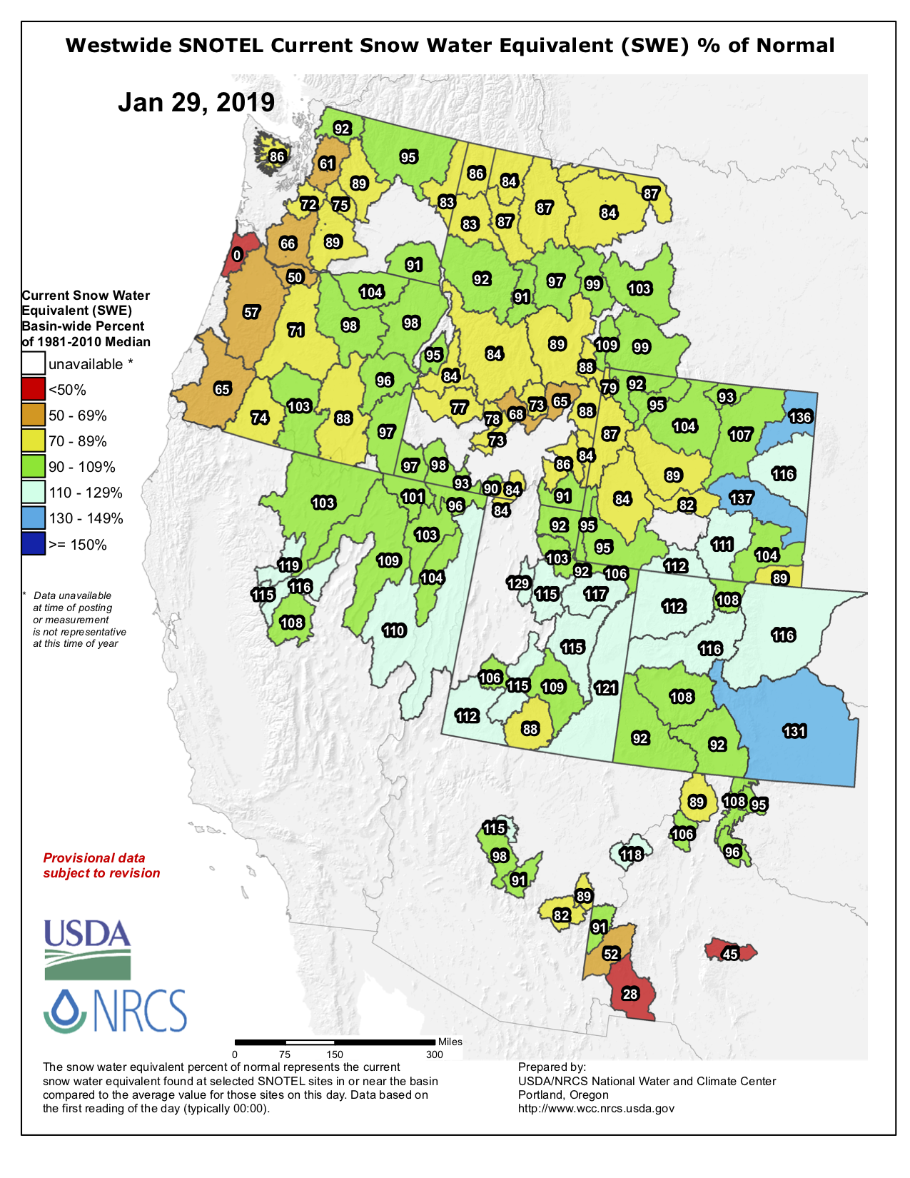
Westwide SNOTEL basin-filled map January 29, 2019 via the NRCS.
FromThe Steamboat Pilot & Today (Eleanor C. Hasenbeck):
Snowpack in the Yampa and White river basins is at 110 percent of its long-term median snow water equivalency, which is a measure of how much water is contained within the snowpack. Snowpack typically peaks in April, so snowfall — or lack of it — could still force that number away from the median.
… the city of Steamboat Springs has enough water to provide for current demands for a decade under 2012 conditions — the third worst drought episode in Colorado’s history — according to city water resources manager Kelly Romero-Heaney. Romero-Heaney said this would be a “doomsday scenario.”
“I don’t know if there are many communities in Colorado that can say that,” she said in an update to the Steamboat Springs City Council on Jan. 15.
One of the ways managers seek to minimize the risk of a compact call is demand management, she said. This is a spot where Steamboat has hit beyond the mark. In 2011, the city’s water conservation plan sought to reduce water consumption by 5 percent, said Michelle Carr, city water and sewer distribution and collection manager. The city exceeded this goal, and as Steamboat’s population has grown, it’s demand for water has fallen, she explained.
The plan to impound 10,000 acre feet of water on the West Fork of Battle Creek barely survived a legislative roadblock earlier this year when the Wyoming House stripped $40 million from a water bill that had been earmarked for the project. A compromise with the Senate saw $4.7 million in appropriations restored, but with caveats requiring further legislative approval for expenditures and pro-rata financial participation from potential beneficiaries in Colorado.
Dam backers are not for the moment returning to Wyoming’s financial well. Neither of two draft 2019 water bills that propose more than $28 million for water planning and development statewide include funding for the project, according to a review of draft bills posted online. But two water districts — one in Colorado and one in Wyoming — are asking for a total of $1.2 million from the U.S. Department of Agriculture to conduct environmental reviews of the dam and reservoir that would be constructed in the Medicine Bow National Forest, officials say.
Meantime, dam backers failed to win full-throated support for the $80 million project from a water coalition in Northern Colorado. Instead, members of the Yampa-White-Green Basin Roundtable said they supported further evaluation of the proposed dam, but not yet construction of the facility itself (see letter below).
Dam backers also must figure out whether Wyoming and Colorado’s new governors — both of whom were elected in November — will support the project and to what degree. Wyoming Water Development Office Director Harry LaBonde said he continues to work with his counterpart in Colorado to obtain support and money but the election means dam backers have to undertake a new round of lobbying.
“Every time there’s a new governor, all those conversations start over,” he said in a telephone interview.
Show-me tour wins tepid Colorado support
To build Colorado support, Wyoming officials took members of the Colorado roundtable on a tour of the dam site and surrounding area last summer. LaBonde drafted a letter of support that the Colorado group could consider signing its name to in late November, group chairman Jackie Brown said. “We require[d] that,” she said of the draft correspondence.
It proposed that the roundtable, a coalition of water users that includes irrigators, municipal interests, and recreation representatives, write the following; “We would like to offer this letter of support for the project and look forward to working with your office to continue to move this project forward for the mutual benefit of water users in both states.”
LaBonde’s version stated that the project would have $92 million in benefits. It said the Wyoming Legislature has already appropriated $11.3 million to build the dam and that Colorado irrigators could have a chance to buy some of the stored water. The $11 million figure comes from a $7 million planning appropriation, very little of which was used, plus the conditional $4.7 million appropriation earlier this year.
“As the project is currently configured approximately 4,000 – 5,000 acres of irrigated lands in Colorado would be potentially eligible to purchase supplemental irrigation water from the project,” LaBonde’s draft said.
The Colorado roundtable adopted most of the proposed language. But “the group stopped short of supporting the project,” LaBonde said, backing an investigative process only.
“At our November 14th meeting, the Roundtable unanimously approved the support for the process of reviewing a reservoir at the west fork of Battle Creek,” the final roundtable letter, dated Nov. 27, reads. “The membership would like to be clear that this is not support of the reservoir itself, only the process of the exploration, as approval of a reservoir would need to come before the membership in a final format, after [National Environmental Policy Act analysis] has been completed.”
The roundtable also dropped proposed language that stated it “would like to continue … identifying other funding opportunities for this project.” Instead, the Colorado group said it “supports the development of water resource in the basin and would be happy to work with local water users in Colorado and Wyoming and the State of Wyoming.”
The proposed dam on the West Fork of Battle Creek would serve 67 to 100 irrigators, studies commissioned by the Water Development Office say. The most likely beneficiaries in Colorado would appear to be members of the Pot Hook Water Conservancy District that joined the Savery-Little Snake district in applying for the $1.2 million federal grant.
That district appears to be relatively small. In 2017 it held a successful election to impose a four-mill property tax that would raise $12,831.48 in 2018, and similar amounts in subsequent years. The tax money will “meet the future needs of landowners within the district” and “proactively protect … existing water rights,” according to a description of the measure. It passed on a 13-7 vote.
O’Toole agreed with LaBonde that the fresh administrations in Cheyenne and Denver will require a renewed effort securing support — support that backers couldn’t find in their home House of Representatives. “I’m going to watch and see who gets picked for positions and go from there,” O’Toole said.
Among the considerations is the announced retirement of Wyoming State Engineer Pat Tyrrell who has held the cabinet-level position since 2001. A gubernatorial appointee who’s considered the state’s water czar, his office resolves conflicts among users and represents Wyoming during inter-state negotiations. When Tyrrell retires in January, he will have served under four governors.
Meantime, conditions in the Little Snake River Basin are deteriorating, O’Toole said, as a 19-year-drought is forcing water users to plan for shortages. “We saw the [Little Snake] River in a state I’ve never seen,” he said. This summer, for the first time ever, there was a call for regulation on Colorado’s Yampa River as water users asked state regulators to enforce prior appropriation doctrine and law. Those ensure that during low flows the holders of earlier water rights get their allocation before holders of more recent rights can divert river flows.
Backers want federal funds but not oversight
West Fork Dam supporters want a land exchange that would give Wyoming some 100 acres of federal property in the Medicine Bow National Forest to construct the proposed dam and impound the reservoir. Such a deal would exempt the project from some aspects of the demanding NEPA process, likely making it easier to accomplish. So far, the federal agency hasn’t received any formal requests for development, forest spokesman Aaron Voos said in a telephone interview from forest headquarters in Laramie.
Elkhead Reservoir “teacup” graphic illustrates who owns water stored at Elkhead, measured in acre-feet or AF, both before and after it was expanded in 2006. Credit: The Craig Daily Press
…in dry, hot years like 2018, owners of Elkhead water were glad to have the backup.
“The reservoir served a good purpose for multiple reasons in Moffat County,” said Jim Pokrandt, director of community affairs for the Colorado River District.
Both the Upper Colorado River Endangered Fish Recovery Program and Tri-State Generation & Transmission had to call on their water stored at Elkhead this year. They are among four major owners of water in the reservoir, which also includes the city of Craig and the river district. The city drew ample water from the Yampa and didn’t need Elkhead water this year.
The Fish Recovery Program owns 5,000 acre-feet of water, which it procured when the reservoir was expanded in 2006 in exchange for a $13.5 million contribution to the project. An acre-foot is enough to cover one acre, about the size of a football field, with one foot of water, or about 326,000 gallons.
The Recovery Program also has the option to lease an additional 2,000 acre-feet from the River District, bringing its total to 7,000 usable acre-feet of water…
The Recovery Program utilized every drop of its 7,000 acre-feet, releasing water into the Yampa beginning in late July — unusually early — and continuing until October.
With the prolonged summer drought, Yampa flows dropped to a precipitously low 38 cubic feet per second by early October in Maybell, where the United States Geological Survey operates a stream gauge. The Maybell gauge is used to determine how much water is making it downriver and how much to release from Elkhead. For comparison, the Recovery Program ordinarily aims to keep flows at 93 cfs or greater, Anderson said.
Drought poses some obvious challenges to native fish populations. Colorado pikeminnow can reach lengths of 2 to 3 feet, according to Tom Chart, director of the Recovery Program, and low flows in the river can make it difficult for them to swim…
When river flows dropped too low this year, Tri-State called on its water in both Elkhead and Stagecoach reservoirs to keep the plant operational.
From Elkhead, it used 341 acre-feet of water, according to the River District, though it owns much more. Tri-State secured 2,500 acre-feet of water when the reservoir was expanded, plus it owns a portion of an 8,408 acre-foot pool shared by owners of Craig Station Units 1 and 2. Additionally, Tri-state owns 4,000 acre-feet of storage in Yamcolo Reservoir and 7,000 acre-feet in Stagecoach, according to the 2004 Yampa River Basin report.
Tri-state would not divulge how much water it used from Stagecoach this year. According to historical data provided in the 2004 report, however, Craig Station’s annual water use averaged more than 11,000 acre-feet per year between 1985 and 1991. Again, Tri-state declined to provide more recent data.
Decisions about how much water to release out of Elkhead are evaluated in a weekly phone call between the reservoir’s partners and users, state officials, meteorologists, irrigators, and other stakeholders, all led by Anderson. Water levels in the reservoir dropped slightly lower than average this year, down to 12 feet instead of 14 — revealing more shoreline than some are used to seeing — but recreational use of the reservoir by fisherman and boaters wasn’t significantly affected.
The reservoir collects water from a 205-square-mile basin and reliably recharges with spring runoff each year. Water managers worry about what would happen if drought persisted for several years, but so far, Elkhead has offered a measure of security to Moffat County’s biggest water users.
Floating the tiger, Yampa River, 2014. Photo: Brent Gardner-Smith/Aspen Journalism
FromSteamboat Today (Eleanor C. Hasenbeck) via The Craig Daily Press:
The past water year, which began in October 2017 and ended in September, broke records on the Yampa. Average temperatures in much of the Yampa River basin were the warmest on record, and for the first time ever, the main stem of the Yampa River was placed on call, meaning use of Yampa water was curtailed.
This summer, the portion of the Yampa River in Steamboat Springs city limits was open to summer recreation — including tubing, fishing, and paddling — for about 40 days, one of the shortest summer seasons on this stretch of river. For much of the summer, the river was under a voluntary closure as the water was too hot, too low or without enough dissolved oxygen to meet streamflow standards set by the city and Colorado Parks and Wildlife to protect river habitat.
Warm and dry summer
The Yampa and Colorado rivers peaked in mid-May, and according to long-term averages of daily flows, both rivers normally peak in June. This led to the second earliest start to tubing season on the Yampa in 10 years.
A warm spring played a role in this — as snow melted off the mountains earlier, water flowed downhill into the river and its tributaries earlier. This water year was the warmest on record in the state, according to the Colorado Climate Center.
In Routt County, about half of the county saw its warmest water year on record, while parts of central and south Routt saw temperatures in ranges that placed it among the top 10 percent of the record.
Most of Routt County received below normal precipitation this year, though the area fared better than other parts of Colorado. The National Weather and Climate Center’s snow telemetry sites in the Routt County area received 70 to 80 percent of average precipitation this year, through July, August and September saw lower rainfall compared to historic averages.
“Statewide, this was the fourth driest year in the 123-year record,” said Kelly Romero-Heaney, water resources manager for the city of Steamboat Springs. “It was fourth only to 2012, 1934 and 2002.”
This year was the driest water year on record in southwest Colorado, western Moffat County and parts of the San Luis Valley, according to the Colorado Climate Center.
Human-caused temperature increases and drought have caused earlier spring snowmelt and shifted runoff earlier in the year across the southwest, according to the 2014 National Climate Assessment.
“Not only are we in situations where we get less water, but we get it earlier, which makes for a longer season of need,” said Kevin McBride, district manager of the Upper Yampa Water Conservancy District.
His agency operates Stagecoach and Yamcolo reservoirs.
The early runoff means producers kicked off the irrigation season earlier, too. Producers are also seeing longer growing seasons in Colorado, according to the U.S. Environmental Protection Agency.
Reservoir water keeps flows up
Drought conditions and warm temperatures have made supplementing the Yampa River’s natural flow with releases of reservoir water a consistent practice in recent years.
Since 2012, the Colorado Water Trust has purchased reservoir water to supplement flows in the Yampa River. This year, Tri-State Generation and Transmission also released water from Elkhead Reservoir to keep up power generation at Craig Station.
The Upper Colorado River Endangered Fish Recovery Program releases water from Elkhead Reservoir to provide habitat for bonytail, razorback suckers, and humpback chub. These releases are determined based on the amount of water flowing by the U.S. Geological Survey’s stream gauge near Maybell in western Moffat County.
“Obviously, when you have low flow years, you have warmer stream temperatures and then less habitat available to aquatic life,” Romero-Heaney said.
In Steamboat, the river dropped to 50 cubic feet per second — low flow — during spawning season for brown trout, she added. That made habitat more difficult to come by, and Romero-Heaney said it could have impacts to fish populations in the upper Yampa.
The Yampa Valley suffered major droughts in 2002 and 2012. In 2002, the USGS reported less than 10 cubic feet per second of flow at the Maybell gauge at the Yampa River’s lowest points in the summer, said Erin Light, area division engineer for the Colorado Division of Water Resources.
Reservoir releases likely kept the water higher than that mark this summer. The USGS streamflow gauges can’t show how much water is natural flow and how much is reservoir water, so stream gauge measurements don’t reflect the full picture when it comes to water…
When the call was administered for about two weeks in September, the water at the Yampa’s lower reach through Dinosaur National Monument fell to about 18 cfs — its long-term average for the same time frame is about 260 cfs. At Lily Park, near the Little Snake River’s confluence with the Yampa, irrigators’ pumps were sweeping the river, Light said earlier this year.
Planning for the future
Romero-Heaney said flows on the Yampa in Steamboat were “extremely low,” falling below 34 cfs at the gauge at the Fifth Street Bridge in Steamboat…
The city outlined its plans to purchase reservoir water on contract to boost flows in dry periods in the Yampa River Streamflow Management Plan released this summer. The plan also seeks to implement voluntary projects that would pay water users to participate in projects enhancing the health of the river.
Earlier this year, some of the city’s water rights were curtailed in the call. As droughts and warm temperatures become more common, releases to augment river health will likely have to be balanced with releases to augment municipal water.
In late August, as reservoirs levels declined across the American Southwest, Erin Light issued something common in most river basins of Colorado but which had never been done on the Yampa River. She issued a “call.”
When a call is issued, those with newer or younger water rights must cease their diversions from the river and its tributaries until the older or more senior rights are satisfied. This system is called prior appropriation. Eighteen states in the West use aspects of prior appropriation to sort out who gets how much water and when.
Light, as the division engineer for Colorado Division of Water Resources, administers the labyrinth of water rights in the Yampa River Valley. Water goes to ranches, a power plant, and other purposes, each occupying a specific place in the pecking order as determined by volumes, locations and, above all, date of adjudication. That’s the way it works when a river is under administration. Some Colorado rivers have been under administration since the late 1800s.
Until this summer, the Yampa was different. Those with legally adjudicated water rights took what they thought was theirs. Calls had been placed on tributaries, but not the river itself.
Then in late August, Light announced that those with water rights on the rivers’ main stem awarded since 1951 would have to cease diversions until those older, or seniors, had been satisfied. By mid-September, as irrigators slowed their demands and cooler temperatures eased losses from evaporation and transpiration, Light edged the call back to those rights junior to 1960. Last week, she suspended the call altogether.
Droughts hit the Yampa and many other river basins in Colorado hard this year. But this drought may best be viewed as part of an extended 21st century drought caused more by temperature increases than precipitation declines. It’s part of a clear trend of a warming and more erratic climate.
Ted Kowalski says the water call on the Yampa should be understood within the context of these hotter, drier times in the American Southwest. A former Colorado water official who is now senior program officer for the Walton Family Foundation’s Colorado River Initiative, Kowalski calls the Yampa River the first domino to fall.
Lower streamflows in all the rivers of the Colorado River Basin that produce declining reservoir levels represent the additional dominoes.
This is starkly demonstrated, says Kowalski, by the fact that reservoir storage in the Colorado River Basin has reached its lowest level since the late 1960s. That’s when the newly created Glen Canyon Dam was starting to create Lake Powell.
“All of this underscores the importance of developing and adopting and agreeing to drought contingency plans so that we can effectively manage if and when there is less water in the system,” says Kowalski. The work begins, he says, with conservation.
Conserving water in the 20th century
Far into the 20th century, conservation had a different connotation in the West. Managing water in the Colorado River Basin meant building dams and creating reservoirs, all with the intent of ensuring none of the water was “wasted” by flowing into the ocean.
Hoover Dam plugs the Colorado River on the Nevada-Arizona border. Photo December 2012/Allen Best
Nearly all this major hydraulic engineering was done on the tab of the federal government. Downstream, first Powell and then Mead, the second largest and largest reservoirs in the nation, respectively, provide most of the storage. If separated by 300 miles and the Grand Canyon National Park, the two reservoirs fundamentally operate in tandem, as a Colorado River Research Group report in August noted. They are “essentially one giant reservoir (bisected by a glorious ditch),” the report said in a nod to the Grand Canyon.
Reservoir levels rise after big snow years, but in the 21st century the more common trend has been decline.
Evidence emerging in recent years suggests the Colorado River’s decline can best be explained by rising temperatures instead of reduced precipitation. In a 2017 paper, Brad Udall, a senior water and climate research scientist at Colorado State University, and Jonathan Overpeck, the dean of the School for Environment and Sustainability, attributed two-thirds of water declines to temperature rather than precipitation. Not only is more water evaporating, they said, but plants have been transpiring more water.
“This is the kind of drought we will have to deal with in the future,” Overpeck said at a water conference in Santa Fe during April.
Doug Monger testifies to the warmer weather. A native of the Yampa Valley, he remembers 45-below temperatures, once in the 1980s for two days straight. Down the valley in Maybell, the temperature in that same cold spell hit 61 below. (It had also hit that same low in 1979.)
“I always prayed for climate change and global warming,” he jokes.
Now, he’s getting that warming. “We never had 90 degrees, and now it’s nothing to have 90-plus days for five or six days in a row.”
That heat has been taking a toll on the snow. About three-quarters of the precipitation in the Colorado River Basin originates as snow. Colorado itself provides 70 percent of the water in the river.
In the Yampa Basin, most of the snow collects in an elevation band of between 8,000 to 10,000 feet. The river originates on the flanks of the Flattops Wilderness Area as the Bear River, gurgles playfully along at the foot of the Gore Range and then, drawing more water from the usually snow-laden Park Range, hooks westward at Steamboat Springs for a 100-mile journey to Dinosaur National Monument.
Beyond Dinosaur, the Yampa’s water eventually flows into the Utah desert and Lake Powell.
The Park Range has a reputation as the snowiest place in Colorado. A gauge at 10,285-foot Buffalo Pass, located northeast of Steamboat Springs, reported 80 inches of water contained in the much deeper snowpack by early May on a recent, snow year.
When spring arrives in years such as that, the Yampa gushes through Steamboat Springs well into summer. Flows needed for commercial tubing during summer represent one measure of winter’s legacy. Tubers are not allowed to use the river until flows drop below 700 cubic feet per second. That commonly isn’t possible until after the Fourth of July.
This year, snowpack was better than in Southwest Colorado. Still, it came weeks early and was altogether modest in its surge. Tubing season in Steamboat began June 11. Commercial tubing season ended a month later, when it is usually starting. City and state wildlife officials asked all tubers and others river users to stay out. The river was dropping to 85 cfs, considered a critical threshold, and warming as it did, hitting 75 degrees, reported the Steamboat Pilot at the time.
“If the river’s getting above 75 degrees Fahrenheit, the aquatic life is severely stressed, and this is the time of year when they’re feeding, and they’re getting ready for winter,” said Kelly Romero-Heaney, the city water resources manager for Steamboat Springs.
No relief came with summer, hot and dry. Clouds produced just a few drops.
Water infrastructure in 21st century
Light, the water engineer on the Yampa since 2006, tells a complicated story of why the first call was made this year and not during prior years. Water rights always get complicated. The immediate repercussion will be that investments will necessarily be made in the devices that assure flows. In the Yampa River it was a point of pride that there was no call, unlike places like the South Platte Basin. But almost everybody agrees it was inevitable.
The Yampa River had almost no flows at Deerlodge Park, at the entrance to Dinosaur National Park, when this photo was taken in mid-August. Photo/Erin Light via The Mountain Town News
That inevitably stems in large part to trends in hydrology. In 20th century hydrologic records, three drought years stand out: 1935, 1955, and 1977. Now, in this still young century, there have been three more: 2002, 2012 and 2018.
“When you look at temperatures that were 5 to 10 degrees above average every day, that has to raise eyebrows about what the climate is saying,” she says.
Changes in the Yampa River Basin have not been well documented, but anecdotally at least comport with statewide trends reported in a 2015 report to the Colorado Water Conservation Board. That report, “Climate Change in Colorado,” says statewide average temperatures had increased 2 degrees F during the previous 30 years, with daily minimum temperatures warming more than maximum temperatures. Timing of snowmelt and peak runoff had shifted earlier in spring by one to four weeks. Snowpack as measured by April readings had been mainly below-average since 2000.
Anecdotal evidence of this abounds around Steamboat. Local ranchers long measured a winter’s severity by how deep it accumulated on their barbed wire fences. The 20th century produced many three-wire winters, enough snow to hit the top strand. Three-wire winters seldom come anymore. Last winter snow failed to reach the bottom wire. In some places, the was no snow at all on the ground, says Ken Brenner, who grew up on a ranch south of Steamboat Springs and is now president of the Upper Yampa River Water Conservancy District Board of Directors.
Light says the Snotel automated snowpack measuring sites fail to tell the full story. The stations maintained by the federal government’s Natural Resources Conservation Service record snow and water content at 8,000 to 10,000 feet. Some years, they report robust snow that cannot be seen in snow depths on the valley floor. This leaves locals wondering how this snowpack could be anywhere near normal. The rising levels for snowpack argue for a different monitoring system, says Light, one that captures dynamics of the low-elevation snowpack.
Water infrastructure for 21st century climate
Climate change models predict sharply increased temperatures in coming decades, Models also predict greater variability of precipitation, more extremes of both wet and dry. That could provide an argument for more reservoirs. The Yampa River has just 2 percent of Colorado’s reservoir capacity, but the river provides a much larger percentage of the state’s overall flows. The Gunnison River, with about the same runoff on average, has three giant federal dams, part of the same Congressional authorization in 1956 that created Lake Powell.
The Yampa, White, and Green Basin Roundtable, a decision-making body created by the Colorado Legislature, agree that instead of giant reservoirs, the basin could benefit from smaller reservoirs, discretely located, such as on tributaries, to serve specific needs, reports Light, the state’s liaison to the roundtable.
Monger does see the need for storage on the Yampa River. It could help Colorado manage its water so as to ensure it can meet its commitments to other states in the Colorado River Basin. “Let’s keep it in my backyard rather than sending it down to Lake Powell and have it be subject to the Bureau of Reclamation and the Department of Interior,” says Monger, a Routt County commissioner as well as a delegate to the Colorado River Water Conservation District. Higher elevation storage, he says, will reduce evaporative losses from Lake Powell, about six and a half feet a year off the surface.
About 90 percent of the Yampa’s total annual flows go downstream out of Colorado, ultimately to Lake Powell. That reservoir provides Colorado and other upper-basin states in the Colorado River Basin the ability to meet requirements for delivery of 8.3 million acre-feet annually to Arizona, California, and Nevada at Lake Mead.
That obligation of 7.5 million acre-feet plus the upper basin’s share for Mexico was derived by negotiators who met at a resort near Santa Fe in 1922. Disregarding contrary evidence, they assumed at least 16.5 million acre-feet average annual flows in the river and probably more. That rarely has been the case. In the hotter, drier 21st century, flows have been just 12.4 million acre-feet, say Eric Kuhn, former general manager of the Colorado River Water Conservation District.
At a recent conference called “Risky Business on the Colorado River,” Kuhn warned against overdrawing Lake Powell, Lake Mead, and other reservoirs.
“When you build reservoirs, you have to have some water. You have to have a little bit of money in the bank. We can’t bankrupt the system. We have to find ways to cut back before we bankrupt the system.”
In Vail on Wednesday, Kuhn took his vision of difficulty for the Colorado River a step further. As long as greenhouse gas emissions go untamed, he said, “there is no bottom” to how hot and how dry the Colorado River Basin could become.
It’s not that the past hasn’t also been drier. Kuhn looks to the past to warn against even more difficult times on the Yampa River and in the Colorado River Basin altogether. The evidence comes from examinations of batches of trees at eight different sites in the Colorado River Basin above Lee Ferry, located just above the Grand Canyon and below Lake Powell.
Dendrochronologists can estimate precipitation by the growth of tree rings. Using that technique, they have charted wet and dry periods since 1434.
Tree-ring research indicates there have been much more severe 19-year droughts in the Colorado River Basin than the current one—and without the impact of human-induced higher temperatures. Graphic via The Mountain Town News
“A number of folks claim that the current 19-year period of 2000-2018 is the driest 19 year period on the Colorado River. That’s nonsense,” says Kuhn, pointing to the graph. In the past there have been droughts both longer and deeper. (Above, see estimated river flows at Lee Ferry, at the top end of the Grand Canyon, from 1434 to 2018. For underlying data, see http://treeflow.org).
Those droughts occurred without the rising temperatures of today. “If these past 19-year droughts were to happen with today’s temperatures,” he adds, “things could be much worse.”
This article was published in the Oct. 4 issue of Mountain Town News, a weekly e-magazine. To subscribe, see options in the red boxes in the top-right corner of the http://mountaintownnews.net webpage.
The Yampa River in northwestern Colorado has closed again. Ongoing drought has drastically reduced water levels.
Colorado Park and Wildlife instituted restrictions on commercial and public activity on the Yampa River this week. An earlier closure ended just 10 days previously.
Commercial tubing companies have been instructed to suspend operations. Officials are requesting that public river users, including tubers, swimmers and anglers, adhere to the “voluntary closure” and stay out of the river.
Colorado Division of Water Resources Division Engineer Erin Light delayed a call on the river, which would curtail users according to the doctrine of prior appropriation. The delay comes as water managers wait to see if increased flows in the upper Yampa reach Dinosaur.
The Yampa River has never been placed on call.
“The last pumps on the river were sweeping the river,” Light said of her Tuesday visit to the lower Yampa. “If you can imagine, literally, the Yampa River getting to the point that all the water has been taken out of it, is frightening and monumental. It never has happened.”
The Colorado Division of Water Resources places a call on a river when water rights owners do not receive the amount of water they have a legal right to. When a call is in place, some water users are forced to reduce or stop their use in order to send enough water downstream to fulfill the older water right.
Though reservoir releases have boosted flows in the upper Yampa near Steamboat Springs and Craig, it’s not clear if or when that water reaches the state line. Water managers aren’t positive that the gauge measuring flows at Deerlodge Park in Dinosaur National Monument has been providing an accurate reading.
On Tuesday, flows at Deerlodge Park fell to about 35 cubic feet per second. On Wednesday, it was up to about 70 cfs. Historically, the river flows at 351 cfs on the same date.
“It’s very extremely dynamic what we’ve got going on here,” Light said. “Obviously the rains affect everything. As much as we love the rain, it makes it difficult to see what’s going on in the system and what effects it’s going to have, but the reservoir water that was in the river before is now being reduced.”
The Colorado Water Trust has been releasing reservoir water to increase flows for aquatic habitat and recreational use. Tri-State Generation and Transmission added a significant boost in flows with released reservoir water to maintain power generation at Craig Station. As weekend rain has increased flows, the organizations have slowed their releases.
“They only have so much contract water, and they have to manage and budget that contract water for times when it’s critical for their purpose,” Light said.
Last week, total releases from Stagecoach Reservoir jumped from 65 cfs to 125 cfs, Light said. This fell back to 70 cfs Wednesday. Releases from Elkhead Reservoir between Hayden and Craig were also reduced, from 75 cfs to 25 cfs.
“The reservoir water and the rainwater has hit Craig, and it has hit Maybell, but it’s just not getting to Deerlodge,” Light said. “I’m hoping it will.”
The first to be curtailed are those that do not have a water right or do not have a measuring device on their water intake. Then, users with the newest water rights are curtailed, followed by those with older rights…
Light said the fact that, if it occurs, this would be the first call on the Yampa, and that has made her and the water users on the river “very cautious.”
“We’re very hesitant about this scenario,” Light said. “Who wants to be the one that’s been tagged as being the first one to actually request administration by our office?”
The seventh annual Yampa Valley Crane Festival will be held August 30 – September 2 in beautiful Steamboat Springs and Hayden, Colorado. It will include four days of mostly free events thanks to donations from people like you and our wonderful sponsors, partners, and volunteers.
The Bud Werner Memorial Library at 1289 Lincoln Ave., Steamboat Springs, CO will once again serve as headquarters for the festival. Click here to view the locations of all festival venues.
The Colorado Water Trust began releasing 15 cubic feet per second of water into the river July 14. That’s about the equivalent of 15 soccer balls worth of water rolling by per second, said Zach Smith, an attorney at the Colorado Water Trust.
New funding sources have allowed the Water Trust to purchase more water and increase the releases to 25 cfs. The additional water brings the total acre-feet intended to be released into the river from 600 acre-feet to 1,800 acre-feet.
“That’s actually a huge help for the river,” said Kelly Romero-Heaney, water resources manager for the city of Steamboat Springs. “If we can get some additional flow to the river, that increases the available habitat for the aquatic life, in addition to helping to bring down the stream temperatures, so it’s really important given how dry and hot the summer has been.”
The boost could help the Yampa River meet criteria to re-open the river to recreation within city limits. The magic numbers to lift the voluntary closure are a flow consistently greater than 85 cfs at the Fifth Street Bridge and a water temperature below 75 degrees. Managers also consider the levels of dissolved oxygen in the water. Conditions in the Yampa don’t meet these criteria right now.
Colorado Parks and Wildlife has also instituted a voluntary closure of the river from Chuck Lewis State Wildlife Area to the western edge of Steamboat. The agency recently lifted a second, mandatory fishing closure of the tailwaters of Stagecoach Reservoir.
The closures are intended to protect fish, riparian plants and other life that depends on the river. Trout are cold-water fish that have evolved to function best in water temperatures around 50 to 60 degrees, according to a Parks and Wildlife news release. When temperatures exceed 70 degrees, they often stop feeding and become more susceptible to disease.
“We’ve worked closely with partners up there, including Colorado Parks and Wildlife, to determine that this is an appropriate increase in flows and will create some real benefits for aquatic life and recreational users up there,” said Mickey O’Hara, a water resources engineer at the Colorado Water Trust. “It sounds like that reach below Stagecoach Reservoir, since it opened back up, has seen some significant use, and these flows should help fish especially through that region all the way down through the city.”
The Colorado Water Trust will release a total of 600 acre-feet of water from Stagecoach Reservoir, initially at a rate of 15 cubic feet per second. The releases began on Saturday, said Zach Smith, an attorney for the organization.
“We’ve worked with them to deliver water to and through Steamboat Springs to improve both the fishery and the recreational opportunities that folks there have,” Smith said.
For the most part, the river has hovered between 80 and 90 cfs since July 7. Since the releases, about 90 to 100 cfs of water have been flowing under the Fifth Street Bridge in downtown Steamboat.
Even with the boost, the river is flowing well below its average for the date. It was flowing at 90 cfs at 11 a.m. Tuesday, about 32 percent of its long-term average flow of 273 cfs for July 17…
Though the river is up, it’s unlikely the city would lift voluntary recreational closures on the river through Steamboat.
“At this point, it is not likely that the increased flows from the release are enough to lift the river closure with the current weather patterns that we are seeing,” Craig Robinson, interim director of the city’s Parks and Recreation Department, wrote in an email.
The river is still heating up with water temperatures above 75 degrees, he added. That high temperatures stress trout and other aquatic species that are adapted to live in the Yampa’s cold-water ecosystem. The high water temperatures also decreases the amount of oxygen available to organisms in the river.
“The flows are very helpful for river health as conditions would likely be worse without this additional flow,” Robinson wrote. “If the monsoon season started, and we had a pattern of daily moisture and cooler temps, these combined factors with the additional cfs from the release could reduce the stressors, and the closure could be lifted.”
A mandatory fishing closure is still in place in the tailwaters of Stagecoach Reservoir. The river is closed between the dam and the lowermost park boundary. Anglers who violate the Colorado Parks and Wildlife closure order could receive citations.
The agency also has instituted a voluntary closure of the river from Chuck Lewis State Wildlife Area to the western edge of Steamboat. Area Wildlife Manager Kris Middledorf said wildlife managers and biologists continue to discuss river conditions and evaluate the agency’s closures.
Once snowpack melts, increases in the Yampa’s flow come from the area’s sparse rainfall, reservoir releases and groundwater that returns to the river after it’s used to irrigate agriculture.
Since 2012, reservoir releases have boosted flows in the Yampa in every year except 2014, Smith said. Last year, the Yampa saw the last release allowed under an approval issued by the Colorado Water Conservation Board, which allowed for three years of releases to benefit in-stream flows over the course of 10 years.
Current releases operate outside of the Water Conservation Board program and are designated to benefit municipal users.
“The fish don’t care by which legal mechanism that water is in there, as long as the flow is up,” Smith said.
The Water Trust purchased the water using funding from the Nature Conservancy, Tri-State Generation and Oskar Blues Brewery’s CAN’d Aid Foundation.
Should flows in the river remain low once the Colorado Water Trust’s initial 600 acre-feet of water is sent downstream, the trust could use other funding sources to purchase more water, Smith said. In the past, the city has cooperated to release city-owned water from the reservoir after the Colorado Water Trust has released its allocation of water, he added.
“We know that the community up there loves this river, and they love it enough to know when to get out of it when it’s stressed,” Smith said. “If we can improve it with additional flow for the community up there, that’s what the Water Trust is around for.”
Colorado Parks and Wildlife is lifting the mandatory fishing closure on the sixth-tenth mile section of the Yampa River below the dam at Stagecoach State Park, effective immediately…
Voluntary closures remain in effect on the river through Steamboat Springs between the Chuck Lewis State Wildlife Area and the west end of town.
Parks and Wildlife officials caution some form of angling restrictions could be re-enacted should environmental conditions worsen…
“Fish early when it’s cooler, and take care when handling fish,” he said. “Land them quickly, handle them gently with wet hands, or use a net, then return them to the water as soon as possible.”
The mandatory closure was implemented June 14 to protect the fishery after minimal snowpack resulted in low stream flows during the hottest time of the year. Since then, Parks and Wildlife has been continuously monitoring conditions on this stretch of river.
Anglers are encouraged to call their local Parks and Wildlife office for the latest information about fishing closures, fishing conditions and alternative places to fish.
For more information, contact Stagecoach State Park at 970-736-2436, or Parks and Wildlife’s Steamboat Springs office at 970-870-2197.
The Yampa River Core Trail runs right through downtown Steamboat. Photo credit City of Steamboat Springs.
Here’s the release from the City of Steamboat Springs:
Due to high water temperatures and low flow in the Yampa River, the City of Steamboat Springs is implementing closures for all commercial activities on the Yampa River and asking the public to abide by a voluntary closure for all recreational river use. The river closure, which began today, Monday, July 9, 2018, will remain in effect until rescinded.
The Yampa River experienced water temperatures greater than 75 degrees for two consecutive days, July 7 & 8, which exceeds the threshold for a mandatory river closure as outlined in the Yampa River Management Plan. Low water flows, high water temperatures, and low levels of dissolved oxygen are all unfavorable conditions to aquatic life and any one of these factors can trigger a closure.
Stream flows are currently hovering around 90 cubic feet per second (cfs); however, it is anticipated based on current trends to continue dropping and fall below the 85 cfs level. Average flow for this day in July is 445 cfs, which the river is well below at the current time.
“A mandatory closure of the Yampa River isn’t something the city takes lightly and goes directly to the long-term health of the community’s number one natural resource,” said Craig Robinson, interim Parks & Recreation Director. “We would like to thank the community, especially our commercial operators, for their cooperation and support during this time.”
Commercial tubing companies have suspended operations until river conditions return to acceptable levels. Commercial river recreation companies must also adhere to regulations adopted in the Yampa River Management Plan.
River users – tubers, SUP-ers, swimmers, anglers – are requested to adhere to the voluntary closure and avoid river recreation. Please be mindful of the impacts your actions may have on the Yampa River and its wildlife.
In addition to the mandatory closure of commercial activities on the Yampa River through Steamboat Springs, Colorado Parks and Wildlife is initiating a voluntary fishing closure between the Chuck Lewis State Wildlife Area and the western edge of Steamboat Springs.
Although anglers are not prohibited from fishing in this stretch, CPW and Steamboat Springs is asking anglers to find alternative places to fish to protect the popular fishery.
“Great fishing can be found at several area lakes and ponds, as well as the high-country,” said Bill Atkinson, area aquatic biologist for CPW. “Anglers still have great opportunities to fish while helping us protect this local resource.”
Trout are cold water fish that have evolved to function best in 50-60 degree waters. When temperatures exceed 70 degrees, they often stop feeding and become more susceptible to disease.
A wide range of temperature tolerances for trout have been reported, but upper lethal limits range from 74 to 79 degrees. According to local officials, water temperatures in the Yampa River are now exceeding 75 degrees in the afternoons.
“When water flows are minimal, fish become concentrated in residual pool habitat and become stressed due to increased competition for food resources,” said Kris Middledorf, CPW’s area wildlife manager in Steamboat Springs. “Because the fish are already stressed by poor water quality conditions, any additional stress from being hooked could make them even more vulnerable to disease and death.”
Middledorf reminds the public that the mandatory fishing closure on a six-tenth mile section of the Yampa River below Stagecoach Reservoir remains in effect, enforced by law.
City staff will continue to monitor flows and river temperatures at the 5th Street Bridge. Water temperature monitoring was incorporated in November 2017 through a partnership with Mt. Werner Water, the Colorado River District and the USGS.
Notices will be posted at popular river access points and requests everyone’s cooperation in protecting the Yampa River by staying out of the river until conditions improve. The health and protection of the Yampa River rates high with residents. Thank you for Respecting the Yampa and helping to protect the health of the river.
Click here to listen to the podcast from H2O Radio. Here’s an excerpt from the transcript:
Agriculture uses a lot of water. But what if that water were used for more than growing food? What if it could generate energy—renewable energy? It can, and a program in Colorado is helping farmers harness hydropower to lower costs, save time—and conserve the water itself.
[…]
Tyler Snyder ranches just outside Yampa, Colorado, in the northwest part of the state, and he has several hundred acres that were part of several old homesteads. Back in the early 1900s, farmers grew potatoes, head lettuce, and strawberries on his fields by flooding meadows with diverted water.
Snyder is pretty impressed that those early settlers dug ditches in these rocky conditions using only picks and mules pulling plows—partly because he recently spent months digging miles of trench himself. It was slow going and time-consuming because he had to screen out rocks to make sure nothing would sit against pipe he was laying.
More than a century later, Snyder has installed pipelines that move water differently on his property than those historic ditches—a move that is saving him time, labor, and money—plus conserving the water itself.
A whooshing sound pierces the air as water starts to flow through the pipe. It’s going to a “center pivot” in the meadow where we’re standing. A center pivot is a way of irrigating that makes those bright green circles you see from airplanes. Water comes up in the middle of a field and motorized wheels move a long arm with sprinklers around in a circle.
But Snyder’s center pivot is different that ones you might see in other parts of the country. It’s a “hydro-mechanical” center pivot for irrigation. It’s called hydro-mechanical because it’s powered by moving water—no diesel or electricity are required to make it work—just gravity. The pressure that builds as the water is piped down the hillside is great enough to spin a turbine, which provides energy for its hydraulic motors.
After the pivot pressurizes, water starts to spray out of nozzles strung along the long arm that stretches over a quarter of a mile out into Snyder’s field, putting the droplets exactly where they need to go.
Snyder says that flood irrigation uses only about 30-40 percent of the water in order to grow the same quality crop as you do with an efficiency project that uses all the water that you put on because it doesn’t run off. He says when he was flood irrigating the water would collect at the bottom of his fields, often leaving the top land burnt and dry.
Photo credit Upper Yampa River Water Conservancy District.
Here’s the release from Colorado Parks and Wildlife (Mike Porras):
Due to critically low water flow caused by dry conditions and minimal snowpack levels, Colorado Parks and Wildlife will close a 0.6-mile stretch of the Yampa River between the dam at Stagecoach State Park down to the lowermost park boundary.
The closure begins June 14 and will continue until further notice.
“Should the flow rate increase substantially for a continuous period of time, CPW will re-evaluate the emergency fishing closure,” said Senior Aquatic Biologist Lori Martin. “But for now, we need to take this course of action because of the current conditions at this popular fishery.”
When water flows are minimal, fish become concentrated in residual pool habitat and become stressed due to increased competition for food resources. The fish become much easier targets for anglers, an added stressor that can result in increased hooking mortality.
“We are trying to be as proactive as possible to protect the outstanding catch and release trout fishery we have downstream of Stagecoach Reservoir,” said Area Aquatic Biologist Bill Atkinson. “This stretch of the river receives a tremendous amount of fishing pressure, especially in the spring when other resources might not be as accessible. This emergency closure is an effort to protect the resource by giving the fish a bit of a reprieve when they are stressed like they are right now.”
CPW advises anglers to find alternative areas to fish until the order is rescinded. Many other local areas are now fishable, with tributaries contributing water to maintain various fisheries. Several area lakes are also open and fishing well.
Colorado Parks and Wildlife asks for cooperation from anglers; however, the closure will be enforced by law with citations issued for anyone violating the order.
Wildlife officials warn when a fish population is significantly affected by low flows or other unfavorable environmental conditions, it could take several years for it to fully recover if not protected.
Like many rivers and streams in western Colorado, the Yampa River offers world-class fishing and attracts thousands of anglers each year, providing a source of income to local businesses that depend on outdoor recreation.
“We ask for the public’s patience and cooperation,” said Atkinson. “It is very important that we do what we can to protect this unique fishery, not only for anglers, but for the communities that depend on the tourism revenue this area provides for local businesses.”
For more information, contact Stagecoach State Park at 970-736-2436, or CPW’s Steamboat Springs office at 970-870-2197.
The headwaters of the Yampa River. Photo: Brent Gardner-Smith/Aspen Journalism
From the Northwest Colorado Food Coalition via Steamboat Today:
his time of year embodies the pastoral landscapes the Yampa Valley is known for. The change of seasons brings the return of the familiar sights and sounds of geese, cranes and other migratory birds. People, too, flock from around the world to celebrate this rebirth, as our valley sheds its winter coat and begins to bloom.
While many in our community are watching the weather to see how long they can continue to ski, when bike trails will be dry and how high the river will be for the 38th annual Yampa River Festival, another group of valley residents is tuned into the weather for another reason.
Our agriculture community is tracking the same indicators that skiers, bikers, rafters and fisherman are watching: snowpack, water flows and historical averages. Area farmers and ranchers need this crucial data to determine how long they will be able to irrigate their fields.
Without the extensive use of irrigation on area ranches, our landscape would be very different. Irrigated land provides numerous benefits beyond agricultural yields: It provides habitat for migratory birds, feeds riparian zones along the Yampa and increases late-season flows.
Friends of the Yampa, or FOTY, has done a lot of growing during the past several years. FOTY received its nonprofit status in 2008 and has been hard at work ever since. Branching into roles beyond building recreational features, we now facilitate projects that address noxious weeds, late season flows and other issues specific to the Yampa River.
The Leafy Spurge Project, for example, aims to address a weed that is threatening agricultural and riparian lands throughout the West. Leafy spurge, for those who are not familiar, is an invasive weed that is becoming more prevalent each year. Through partnerships with public and private landowners, state and federal agencies and other advocacy groups, FOTY and its partners hope to address this growing threat.
FOTY continues to support exploring innovative options to provide late season flows through Steamboat Springs. Options such as Alternative Transfer Methods, headed by the Colorado Water Trust and the State Engineer’s Office, provide water-rights holders the ability to lease water to downstream users for up to three years in a 10-year period, while still retaining original rights.
Similarly, FOTY is excited about research into the creation of a water fund. Groups, including the Nature Conservancy, are exploring this concept, which could be used to finance and implement similar transfers to benefit the health of the river into the future.
It is through these collaborative efforts that FOTY hopes it can continue to be a helpful resource for water users throughout the basin. Agriculture, recreation, municipal and industrial users are in this together. Using strategic partnerships and innovative water use practices, we can insure a vibrant river community for generations to come.
Learn more about this and all our work at friendsoftheyampa.com. See you on the river.
Steamboat Springs area residents will soon get a chance to pick the brains of scientists and conservationists on how to prevent the Yampa River from being ravaged by extreme weather conditions.
A community discussion, “The Yampa Basin: Snow, Weather, Water and Our Future,” will be offered on Wednesday night at the end of a weekend workshop, which is being hosted by Colorado Mountain College and the University of California, San Diego’s Scripps Institution of Oceanography.
The Yampa River Rendezvous on June 5 and 6 will involve about 80 graduate students, post-doctoral scholars, researchers and water resource experts, who are traveling to Steamboat to study the Yampa River’s unique role in the Colorado River system as one of its wildest tributaries.
“In San Diego, we get about 70 percent of our tap water from the Colorado River,” said Atmospheric Scientist Leah Campbell, a postdoctoral researcher with UC, San Diego and a scholar at the Center for Western Weather and Water Extremes. About 20 post-graduate students will be attending the workshop with Campbell.
IF YOU GO
What: Community discussion: “The Yampa Basin: Snow Weather, Water and our Future”
When: 5:30 to 7:30 p.m. Wednesday, June 6
Where: Albright Auditorium at Colorado Mountain College Steamboat Springs, 1275 Crawford Ave.
CRAIG — Three variations of a potential dam that could someday sit astride the main stem of the White River between Meeker and Rangely have been examined by the Rio Blanco Water Conservancy District in Rangely.
Last week in Craig, Steve Jamieson, a principal engineer and president at W.W. Wheeler and Associates, told the members of the Yampa, Green and White river basin roundtable that an 80-foot-tall dam built across the main stem of the White River at Wolf Creek could store 68,000 acre-feet of water.
He said a 104-foot-tall dam across the river could store 138,000 acre-feet.
And a 290-foot-tall dam across the valley floor could store 2.9 million acre-feet of water.
“The maximum you can get here is 2.9 million acre-feet in this bucket,” Jamieson said. “It’s a big bucket, and you can do that with a dam that it’s about 290 feet high. It would be a very efficient dam site, but you need to have the water to fill it.”
A slide being presented by Steve Jamieson of Wheeler a showing the range of dam and reservoir sizes that have been studied for the potential White River Dam on the main stem of the White River 23 miles east of Rangely. The dams range in size from 80-feet-tall to 290-feet-tall and could store between 68,000 AF to 2.9 MAF. The dam sizes were studied as part of Phase 2A of the White River storage project, and the state has provided $500,000 in funding so far to study the project.Steve Jamieson, left, of Wheeler and Associates, and Brad McCloud, right, showing an illustration of where the axis of a 290-foot-tall dam across the White River would be. The big dam would require a 500-foot-wide spillway, which would mean relocating a section of Hwy 64.
Water enough
About 500,000 acre-feet of water a year runs down the lower White River each year, flowing through Meeker and Rangely and into Utah and the Green River.
And between 1923 and 2014, the annual flow in the White River at the Utah line ranged from 200,000 to 1.2 million acre-feet, according to Wheeler and Associates.
The potential White River Dam would be located 23 miles east of Rangely, along Highway 64.
The existing Taylor Draw Dam, which forms Kenney Reservoir on the main stem of the White River, is six miles east of Rangely.
That reservoir was built in 1984 to hold 13,800 acre-feet of water, but it’s gradually silting in, as was expected in a 1982 EIS done for the project. The surface area still “available for recreation,” or boating, is now less than 335 acres, down from 650 acres when the reservoir opened.
The dam’s hydro plant, however, is still generating about $500,000 a year in electricity revenue for the Rio Blanco district in a run-of-river setup.
A slide being presented by Steve Jamieson of Wheeler and Associates and Brad McCloud of EIS Solutions showing the range of dam and reservoir sizes that have been studied with state funding for the Wolf Creek drainage. The dams range in size from 80-feet-tall to 260-feet-tall and could store 41,000 AF to 1.6 MAF. The dam sizes were studied as part of Phase 2A of the White River storage project, and the state has provided $500,000 in funding so far to study the project.
Off-channel too
Jamieson also has been studying an off-channel dam in the Wolf Creek drainage, which is a broad, dry valley on the north side the river, just upstream of the proposed White River Dam site.
The Wolf Creek Dam would be located 3,000 feet back from the river and 170 feet above it.
An 80-foot-tall version of that dam could store 41,000 acre-feet of water, a 119-foot-tall dam could store 130,000 acre-feet, and a 260-foot-tall dam could store 1.6 million-acre feet, Jamieson said.
“This is really good dam site here, I like this,” Jamieson said. “It’s very flexible.”
However, the off-channel Wolf Creek Dam would require that water be pumped up from the river, at a high cost, or delivered via a 40-mile long canal or pipeline starting near Rio Blanco Lake — closer to Meeker than Rangely.
“It’s going to be a very long and expensive canal,” Jamieson said.
The pumping facility for a 90,000 acre-foot reservoir, which was studied in 2014, was estimated to cost $18.2 million build and up to $1.1 million a year to operate.
Jamieson said Highway 64 would need to be moved to accommodate the biggest White River Dam option, which requires a 500-foot-wide spillway on one side of the river valley.
The river itself would also have to be moved during construction.
“You’d be constructing two to three years at least,” Jamieson said. “So what we looked at is actually building a tunnel around into this abutment that we would divert the White River through during construction.”
A slide presented by Steve Jamieson of Wheeler and Associates on May 9, 2018, showing the maximum inundation area of a 290-foot-tall dam on the main stem of the White River. Jamieson presented the slide at the May 9, 2018 meeting in Craig of the Yampa/White/Green basin roundtable.
Gardner-sized
Jamieson said the district started studying the maximum size of the potential reservoirs after Sen. Cory Gardner asked during a site visit, “How big can you make this reservoir?”
During his presentation Jamieson repeatedly referred to Sen. Gardner, using phrases such as “this is the maximum Cory Gardner reservoir.”
A roundtable member asked, “Did the senator promise the money for this?”
The basin roundtables operate under the auspices of the Colorado Water Conservation Board and review grants for water projects.
“No, he did not, unfortunately,” said Brad McCloud of EIS Solutions, a public affairs consulting firm retained by the district. “We asked.”
The Colorado Water Conservation Board also wants to know what the maximum reservoir size is.
“Based on recent comments from some stakeholders, it may be beneficial to build the largest possible reservoir at Wolf Creek,” the scope of work for a 2017 grant from the board to the district states.
It also says “a much larger reservoir … could have additional benefits to the state.”
One of those benefits could be helping the state avoid a compact call on the Colorado River.
“Part of the Phase 2A study is to determine if the project may have the potential to provide Colorado compact curtailment insurance during periods of drought,” the 2017 grant application from the district said.
Since 2013, the district has received three grants totaling $500,000 from the Colorado Water Conservation Board for its White River project, and the potential benefit of compact compliance has been mentioned in all three grants.
The White River near the vicinity of the Wolf Creek drainage. The river sends about 500,000 acre-feet of water a year across the state line into Utah, with flows ranging from 200,000 AF to 1.2 MAF a year. The White drains the western side of the Flat Top Mountains and flows through Meeker and Rangely.
20,000 or 90,000
On Wednesday in Craig, Jamieson downplayed compact curtailment and focused on the district’s goal of creating a 20,000 or 90,000 acre-foot “working pool” of water inside larger potential reservoirs.
For example, it would require a 138,000 acre-foot on-channel reservoir to establish a 90,000 acre-foot working pool for the district, after allowances for a recreation pool and a 24,000 acre-foot sedimentation pool — which would fill in over 50 years.
To establish a need of the stored water, Jamieson cited a 2014 study showing demand in the basin at 91,000 acre-feet in 2065.
That’s on the high end, though.
The low-end need in 2065 was 16,600 acre-feet.
The district filed in water court in 2014 for a 90,000-acre-foot storage right at both the on-channel and off-channel locations.
But Erin Light, the division engineer in Div. 6, told the district in July 2017 “this application continues to contain aspects that are speculative and this is concerning to me.”
She questioned the district’s use of the highest estimates for such potential uses as oil shale production and flows for endangered fish.
The water attorney for the district, Ed Olszewski, responded to Light in August.
He said the district “disputes that any portion of the application is speculative” and the application is intended to be “as flexible as possible.”
As Jamieson wrapped up his presentation, he said the Rio Blanco district plans to “initiate project permitting” in 2019.
“I know we’re very aggressive,” Jamieson said. “We’re making progress.”
Aspen Journalism is covering water and rivers in collaboration with The Aspen Times and the Glenwood Springs Post Independent. The Times and the Post Independent published this story on Monday, May 14, 2018.
The headwaters of the Yampa River. Photo: Brent Gardner-Smith/Aspen Journalism
From the CSU Extension Office (Todd Hagenbuch) via Steamboat Today:
If it feels dry and warm this winter, it’s because it is. While our snowpack water equivalent is lower than average in Northwest Colorado, it’s the warm temperatures that make it feel like even less snow as it has melted and condensed the snow considerably. In fact, every point west of the Continental Divide, from Idaho to New Mexico, has experienced unseasonably warm temperatures all winter, further exacerbating our low moisture levels.
When comparisons are made on percentage of snow level or temperatures, they are measured against an average, even if it is sometimes listed as a percentage of normal. The reality in our area is that normal weather is variable, really variable.
So how do landowners and agricultural producers make themselves resilient to dramatic weather?
Make a grazing plan for the longterm. Plan to have enough pasture for your animals no matter what happens. Yes, you may not use it all to maximum effectiveness every year, but having land in reserve for dry periods pays dividends in the longterm. Range grasses overgrazed even one year will lead to long-term, decreased production. Stressed grasses take even longer to recover from grazing, so allowing plenty of time for grass to rest during the growing season is critical, too.
Cull animals as appropriate while preserving genetics. If times get tough and you need to reduce the amount of forage consumed on your property, it may be time to cut numbers. Older, larger animals take more resources than smaller, younger ones, so consider that when culling. If you’ve raised your own replacement livestock, then keeping heifers/ewes and young bulls/rams with the same genetic makeup as the older animals allows you to keep the genes you’ve worked hard on promoting while reducing the forage required to keep the herd going.
Take advantage of moisture when it’s more likely to come. Consider taking on seeding projects and fertilization in the fall, when winter snows are more likely to guarantee moisture than unpredictable spring rains. Fertilizer depends on moisture, so move it into the soil profile quickly after application. Applying it right before snow-up helps guarantee it will move into the soil before dry air can cause volatilization of the nitrogen you’re trying to supply to your plants.
Use water wisely, for conservation sake and for better grass. Grass plants do not want to be wet all of the time, but do need water. Thoroughly soaking grass then letting it dry for a period of time before wetting it again helps grass remain resilient and helps your pasture retain the grasses that are best for grazing, not sedges and other water-loving plants. If you have little water, you’ll be more likely to manage it well if you’ve been practicing your irrigation skills in times of plenty.
Always plan for the unthinkable. Forest fires and other natural disasters can happen any summer. Be prepared with an evacuation plan for yourself, family and animals. Share the plan with your family and neighbors, and find out what their plans are. Practice when possible and make sure that everyone is on the same page so when the time comes, you’re ready.
There is only so much one can do to thwart the challenges Mother Nature throws at us. But thinking through possible scenarios and having a drought mitigation plan in mind before disaster strikes is paramount. Weather variability and extreme events are here to stay, and by planning ahead, you can assure that you can weather whatever comes our way.
Todd Hagenbuch is the interim county director and agriculture agent for the CSU Extension office.
“The key with Lake Powell is that it is our river savings account,” Andy Mueller told a gathering of more than 200 people who packed into the Steamboat Springs Community Center Tuesday night for the Steamboat State of the River meeting, less than 50 feet from the banks of the Yampa River…
Less understood, Mueller said, is the Colorado River District’s stake in power generation at Glen Canyon Dam, where water levels are coming perilously close to dropping below the intakes for the power plant.
“It really starts with power generation at Lake Powell,” Mueller said. “That dam is a cash register for those of us on the river. It pays for the Colorado Endangered Fish Program, which allows all of us in Colorado to continue to divert water while the endangered fish are being protected.”
[…]
Mueller told his Steamboat audience that agricultural water rights continue to be of preeminent importance in the district.
“On the Western Slope, try to picture what it would look like without ag. It is a very different world if we don’t have irrigated agricultural land,” he said. “That’s where the water is. Eighty percent of the water consumed on the Western Slope is in ag. We have to protect this agriculture, and a lot of that has to do with agricultural water rights.”
[…]
The district represents about 28 percent of the physical land mass in Colorado but is home to just 500,000 of the 5 million people in the state. And 57 percent of the water produced statewide comes from the Colorado River District…
Lake Powell, backed up by Glen Canyon Dam, just above the Grand Canyon, is where the Rocky Mountain states, including Utah, Wyoming and the northern portions of Arizona and New Mexico store water to ensure they can meet their obligations to send water to the lower basins states including California, Nevada and southern New Mexico and Arizona.
As of 1999 the reservoir was almost full. But subsequent drought years, notably 2002, drew the reservoir down. It took until 2012 to slowly re-build storage in the vast reservoir, but snowpacks in the Colorado Basin have not been generous since.
As winters have grown milder, river flows are sapped and extended growing seasons are also resulting in plants absorbing more of the available water.
“We’re working on cloud seeding, but you have to have storm events in order to hit them with the silver iodide,” Mueller said.
When the Stagecoach Property Owners Association was informed by the Colorado Division of Water Resources in summer 2017 that it was temporarily suspending the issuance of well permits in unincorporated Stagecoach, 18 miles south of Steamboat Springs, it caused a significant amount of distress.
Some homeowners in Stagecoach get their domestic water from the Morrison Creek Water and Sanitation District, but many others, with lots of 1 to 2 acres, rely on water wells.
With 2,300 platted building lots and only 400 of them developed, people were concerned that the moratorium might become permanent and de-value their properties. With the arrival of spring, most of those worries have been resolved, Stagecoach Property Owners Association President John Troka said.
Since last summer, the Colorado Division of Water Resources has studied the circumstances that led to the moratorium. Decades ago, neither property owners in some rural subdivisions here nor the Routt County Planning Department had been submitting water supply plans to the Colorado Division of Water Resources for its review and approval.
In the interim, the Yampa River above Steamboat Springs, as well as the entire length of the Elk River, have become over-appropriated, placing homeowners in rural subdivisions where they depend on wells for domestic water temporarily in limbo.
However, the Division of Water Resources studied the situation through autumn 2017, and State Engineer and Director of the Division Kevin G. Rein reached a solution intended to honor the rights of senior water rights holders and do as little harm as possible to people living in rural subdivisions. He sent his findings to Routt County Planning Director Chad Phillips in a lengthy memo dated Feb. 1.
Troka thinks the Division’s findings worked out as well as they could have for Stagecoach property owners.
“We put our lawyers on notice,” Troka said. “(The Division) could have drawn a hard line. This was a positive outcome for us. People in originally platted subdivisions out there can relax. Owners will be allowed to drill a well.”
What they won’t be able to do is irrigate their yards or gardens, nor will they be able to provide water to livestock. These restrictions will protect the rights of those senior water rights holders.
That’s not a big deal in Stagecoach where the large majority of people have natural yards, and as Troka pointed out, the property owners association rules forbid horses.
However, the story varies around the upper Yampa Valley. But for the present, there are far less concerns, because the Yampa in that stretch is not yet over-appropriated.
Say goodby to Green Acres?
Stagecoach wasn’t the only neighborhood in Routt County where rural subdivisions were confronted last summer with the suspension of well permitting. The same process was being applied to long-standing subdivisions in the upper Yampa Valley above Steamboat Springs and in the Elk River Valley.
The rub has to do with the fact that the waters in the Yampa River above the kayak feature in downtown Steamboat Springs, known as Charlie’s Hole, and the Elk River basin have been deemed over-appropriated. There’s no more water in the streams and rivers that isn’t spoken for.
The second issue is the Division’s recognition last year that there are rural subdivisions in Routt County in those watersheds where the Division has discovered that it never had the opportunity to review “water supply plans” required of many new subdivisions, depending on when they were approved. That means the potential to harm senior water holders was never adequately considered.
Routt County Planning Director Chad Phillips described the situation in a memo to the Board of County Commissioners.
“The regulations required an applicant wanting to subdivide land to provide proof of a dependable and potable water supply,” Phillips wrote. “The regulations laid out several ways an applicant could prove this. During the ’70s, ’80s and ’90s, staff did not send a referral to the Division for their covenants … because it was not required by the regulations.”
Kevin G. Rein, state engineer and director of the Division of Water Resources, wrote in his agency’s finding that in spite of the lack of the required water supply plans, the division will continue to issue well permits in the affected subdivisions “under limited conditions.”
The good news is that the division will resume issuing well permits in over-appropriated areas. The concerning news, for some, is that in certain cases the new permits will be limited to providing water for use within the home only. Using the water outside the home to water gardens or horses won’t be permitted, unless the property owners are able to arrange a contract leading to an “augmentation plan,” which would offset an outdoor use with stored water, for example, from another basin.
Division 6 water engineer Erin Light said the application of the Division’s findings varies from subdivision to subdivision.
And Rein’s memo to Phillips contains eight different scenarios about how Rein’s findings will be applied in different rural subdivisions, varying with circumstances like the layout of the subdivision and the configuration of the lots.
Rural property owners can read Rein’s findings for various categories of rural subdivisions in the appendixes at the bottom of his letter to Routt County, which is embedded in the online version of this news story.
A Steamboat State of the River Forum will be held from 5:30 to 8 p.m. Tuesday, March 20 at the Steamboat Springs Community Center. A free chili supper will be served at 5:30 p.m. and the program will begin at 6 p.m.
Retired state climatologist Nolan Doesken will discuss how this winter unfolded and talk about the weather patterns that have created a low snow year on par with the record drought year of 2002.
Also speaking will be Andy Mueller, new general manager of the Colorado River District. Mueller will highlight river district priorities surrounding irrigated agriculture and Lake Powell, as well as talk about operations of Wolford Mountain and Elkhead reservoirs.
Other presenters include the following:
Kevin McBride, manager of the Upper Yampa Water Conservancy District, who will talk about snowpack and reservoir operations.
Zack Smith of the Colorado Water Trust, who will discuss the Yampa River water leasing program.
Erin Light, Division 6 engineer, who will address water administration.
Jackie Brown, chair of the Yampa-White –Green River Roundtable, who will give an update on water resources planning and actions.
The meeting is sponsored by the Community Agriculture Alliance, the Colorado River District, the Upper Yampa Water Conservancy District and the Yampa-White-Green River Roundtable.
Westwide SNOTEL basin-filled map February 14, 2018 via the NRCS.
From the Craig Daily Press (Eleanor C. Hasenbeck):
According to the Natural Resources Conservation Service, the Yampa River basin has received 73 percent of the average amount of snow it typically receives by this time of year. The Little Snake River basin has received 72 percent. In river basins in the southwest and south central part of the state, this number is in the 30s.
The drastic difference in snowpack between the northern and southern parts of the state is thanks to the La Niña winter. La Niña is a weather phase that cools the waters of the Pacific.
A La Niña year influences weather patterns around the globe, but in the United States, it creates a ridge of high pressure in the West. Storms develop in the moist air of the Pacific Northwest, then ride the jet stream on the northern edge of this high-pressure ridge.
National Weather Service meteorologist Megan Stackhouse calls these storms “northern clippers.” They typically hit only the northern edge of Colorado.
According to the U.S. Drought Monitor, all of Colorado (except a sliver at the northern edge, containing Larimer and Jackson counties) is facing drought or near-drought conditions.
Eastern Moffat County is abnormally dry, which is a pre-cursor to a drought designation. West of Maybell, the county is in a moderate drought. Steamboat Springs is also in a moderate drought, which could have implications for Moffat County, as snowpack in the Park Range melts into Moffat’s water supply.
Stackhouse said it would take 40 to 60 inches of snow for the Yampa/White River basin to reach an average level of precipitation for this water year. Receiving that much snow is not out of the question, though it’s unlikely.
With this in mind, Tom Gray, Moffat County’s representative to the Colorado River District, cautions the public not to panic before it’s warranted. In 2015, he said, Northwest Colorado faced a similar light snow year. Then, there was a “miracle May.” Mountain storms dumped snow late in the season and brought the basin back up to the average…
Gray and others at the Colorado River District are worried about meeting obligations under the Colorado River Compact. Under the agreement, the state of Colorado is required to contribute a 10-year rolling average amount of water downstream to the Colorado River system to help fill reservoirs such as Lake Powell.
So far, Colorado is set to contribute about 40 percent of its average annual contribution, according to Jim Pokrandt, director of community affairs at the Colorado River District.
That puts Colorado on track to send the smallest amount of water downstream to Lake Powell in the past 10 years, according to data from the Colorado Basin River Forecast Center. This could cause shortages to water users in parts of California, Utah, Arizona and New Mexico.,,
Closer to home, the Stagecoach and Elkhead reservoirs are on track to be filled. These reservoirs are relatively small, however, which makes them easier to fill.
But unless more snow comes, rural Moffat County is likely to feel the impact.
“If you start the spring with not-very-good soil moisture levels, and then, through April and May, if we don’t get rain to get some soil moisture, you’re that much drier,” Gray said.
For farmers, this could mean a weaker hay crop, as water to irrigate isn’t there. Dry soil also means dry grasses, which are better fuel for wildfire.
For now, residents of Northwest Colorado can kick off their snowshoes and hope to receive more moisture to avoid a drought. The weekend snowstorms helped.
“Statewide snowpack for Colorado approximately went up 5 percent with this last storm,” Stackhouse said in an email. “But that is very preliminary, since we are still collecting and receiving reports with this storm.”
Last week, lawmakers on the Select Water Committee agreed to put $40 million in their budget to build a new dam in southern Wyoming, but only if all the money for the project is identified first. The total cost of the dam is estimated at $80 million dollars.
Water Development Office Director Harry LaBonde says with more droughts expected in the future, more irrigation water is needed for about 25 different ranches along the West Fork of Battle Creek in south-central Wyoming.
“When you get to August, flows are low and so the irrigation purpose of this project would be to provide these late season irrigation flows so that they could continue to irrigate and enhance their grass hay crops,” said LaBonde.
Battle Creek flows into the Yampa River in Colorado and the hope is that state would help fund the project…
Water Development Office Director LaBonde said, with more droughts likely, Wyoming needs to provide for its irrigators. He said now is a good time to build dams.
“I will say also that with regards to the President’s infrastructure bills that are being proposed, there’s also potential for a component of federal funding for this project.”
LaBonde says the reservoir will also provide recreation opportunities and habitat for the imperiled Colorado cutthroat trout.
The project is one of Governor Matt Mead’s 10-in-10 water projects, an effort to build ten new water storage projects in ten years. Four others around the state are also moving forward including Middle Pioneer Reservoir and an enlargement of Big Sandy Reservoir, both in Sublette County on the Green River, a main branch on the Colorado River. Also, two dam projects in the Bighorn Basin in northern Wyoming have been funded for construction costs, including Alkali Creek Dam and Levitt Reservoir.
The Little Snake River as it passes under Wyoming Highway 70 near Dixon. Photo credit: Wikimedia
The Yampa-White-Green Rivers Basin Round Table is a group of 32 stakeholders from Routt, Moffat and Rio Blanco counties who work on local water issues. Established in 2005 when the Colorado General Assembly passed the Colorado Water Act for the 21st Century and officially beginning 2010 by order of the governor, the Round Table often uses studies, system modeling and projects with the goal of preserving the quantity and quality of water. Their goals include protecting the Y-W-G Basin from the Colorado River Compact curtailment of existing decreed water uses and some increment of future uses, protect and encourage agricultural uses of water in the Y-W-G Basin within the context of private property rights, improve agricultural water supplies to increase irrigated land and reduce shortages, identify and address municipal and industrial water shortages, quantify and protect non-consumptive water uses, maintain and consider the existing natural range of water quality that is necessary for current and anticipated water uses. They also seek to restore, maintain, and modernize water storage and distribution infrastructure while developing an integrated system of water use, storage, administration and delivery to reduce water shortages and meet environmental and recreational needs.
In November the Round Table will need to fill 10 vacancies on their board. Areas that will be open for re-election or new appointments include representatives for recreation, domestic water provider and industrial water user, as well as four at-large representatives plus three individuals or entities who reside outside the basin but own water rights within the basin. Eligibility requirements vary between the positions. Those interested in serving or seeking more information should contact April McIntyre, Round Table Administrative Assistant at 970-985-9924 or mcintyreapril6@gmail.com.
Those who are interested in protecting and directing the future of the Yampa, White and Green River Basins are encouraged to get involved. Changing population distributions and water demands across the west will only serve to raise the level of importance these rivers play making groups like the Round Table ever more vital.
With the Yampa River flowing well below normal during most of the week preceding Labor Day, the city of Steamboat Springs has closed down commercial tubing in the river where it flows through the city and is asking the public to voluntarily follow suit by refraining from private tubing, paddling SUPs, swimming and fishing…
It’s not unusual for commercial tubing to be suspended by the first week in September, but the United States Geological Survey was reporting earlier this week that the river had dropped significantly below 100 cubic feet per second, the median flow for the date. Ironically, the stiff rain showers that cooled Steamboat the night of Aug 31 had temporarily boosted river flows by Sept. 1…
City of Steamboat Water Resources Manager Kelly Romero-Heaney said commercial tubing would not be restored unless river flows return to 85 cfs. But the boost in flows from the rainfall of Aug. 31 is expected to be short-lived; the National Weather Service forecast for the upper Yampa River Valley called for a 20-percent chance of isolated storms the afternoon of Sept. 1, followed by sunny to mostly sunny skies through Sept. 7
The city and the Colorado Water Trust had been collaborating since earlier this summer on boosting the flows in the Yampa with water procured from the Upper Yampa Water Conservation District’s Stagecoach Reservoir, and that effort will resume.
Romero-Heaney said efforts to boost the Yampa’s flows will likely continue until early October, when the managers of Lake Catamount, downstream from Stagecoach, begin releasing water as they draws down the reservoir in anticipation of spring runoff in 2018…
The USGS reported at midday Friday that the Yampa was flowing at 97 cubic feet per second, just below median for the date. The lowest Sept. 1 river flow measured at the Fifth Street Bridge, was the 24 cfs, reported in 1934.
My campground in Steamboat Springs has charging stations for the tent campers. I was able to connect the Leaf’s trickle charger.
Leaf charging at my camp in Steamboat August 21, 2017.
I was a bit worried on the leg from Kremmling to Steamboat Springs. Highway speeds and a climb really knock down the battery charge. I gained a whole bar (8.33%) of charge coming down the west side of Rabbit Ear’s pass due to the regenerative charging system. Did not have to break once, regenerative charging held the speed limit.
Now I’m on my bicycle until the drive home Friday.
The Yampa River Core Trail runs right through downtown Steamboat. Photo credit City of Steamboat Springs.
The city received 14 different proposals for how to best spend a reserve fund of lodging tax money that has been accruing in recent years. They range from a plan to use the money to keep the Yampa River flowing at a healthy pace in the summer to adding several public restrooms around town.
The money, which comes from a 1 percent tax tourists pay on their nightly stays, must be spent on something aimed at drawing more tourists to town. Projects must also enhance the city’s “environmental desirability.”
A committee appointed by the Steamboat Springs City Council will spend this week grading all of the proposals and coming up with a recommendation.
It will then be up to the City Council to decide which project is most worthy, or whether the money should be spent at this time at all…
Yampa River Flow Endowment, Friends of the Yampa, $1 million
Anyone who uses the Yampa River in the summer would benefit from Friends of the Yampa’s idea for how to spend the reserve lodging tax money.
The fish would also thank the group too if they could.
The river advocacy group thinks the money could be well spent on water releases from Stagecoach Reservoir that help keep the Yampa River flowing at a healthy level during the summer.
The Colorado Water Trust has partnered with the Upper Yampa Water Conservancy District in recent years on such water releases.
The releases help maintain a healthy river and ecosystem during low water years and times of drought.
“A healthy Yampa River is paramount to Steamboat Springs’ tourism industry,” Friends of the Yampa wrote in its application.
“Fly fishing shops, tubing outfitters, restaurants, breweries and river property owners depend on healthy river flows.
The application is a collaborative effort that also includes the Water Trust, The Nature Conservancy and some local business owners.
Once again this year, the nonprofit Colorado Water Trust and the Colorado Water Conservation Board are collaborating to arrange a release of water from Stagecoach Reservoir to boost lagging flows in the Yampa River under an agreement with dam owner, the Upper Yampa Conservancy District. New this year is the support of The Nature Conservancy.
Last year, conservation releases did not begin until mid-September, but in 2017, with the river already flowing well below normal, water releases from the dam were set at 10 cubic feet per second beginning July 11. But it can’t go on forever this way.
With this year’s release, the role of the Conservation Board, a division of the State Department of Natural Resources, has expanded to include committing to contributing up to $46,692 for water releases. At the same time, the CWCB will undertake the third, and final, approved year to release water into the Yampa. The opportunity cannot be renewed under current law, Water Trust staff attorney Zach Smith said…
This year’s program will forge a new relationship with the Nature Conservancy to carry on the effort when conditions warrant. The Nature Conservancy’s Carpenter Ranch just east of Hayden straddles the Yampa, and for 2017, the global conservation organization has agreed to bring $50,000 to the effort to purchase water releases out of Stagecoach. It will also explore sustainable funding for future years.
Smith said new efforts to bolster the flows in the river during dry seasons could range from seeking ways for the Nature Conservancy and the Water Trust to collaborate on locating new funding sources to perhaps seeking a water source with long-term legal protection.
Upper Yampa Manager Kevin McBride pointed out it’s only because there is a moderate amount of water storage in the upper reaches of the Yampa that mid-summer conservation releases are possible…
Flows in the Yampa have been supplemented with the participation of the Water Trust in 2012, 2013, 2015 and 2016. The Yampa was flowing at 128 cubic feet per second Monday afternoon, 67 cfs below the median for the date…
Water Trust water resources engineer and former Steamboat resident Mickey O’Hara said the return to healthier natural flows in the Yampa this summer “depends on if, and when the monsoons happen.”
A coalition of ranchers and environmentalists, politicians and bureaucrats, and Jimmy-Buffett-loving river recreationalists came together Friday to learn about a quiet scourge overtaking the banks of the Yampa River known as the leafy spurge.
The plant itself looks innocent enough, with little yellow flowers that turn entire sections of river bank into a sea of green and yellow. But the demure-looking weed is extremely aggressive and invasive, and has wreaked havoc in states like Montana and North Dakota, where more than 2 million acres of ranch land have been put out of production due to the noxious weed.
Formed in 2015, the Yampa River Leafy Spurge Project brought together partners in Routt and Moffat counties to tackle the growing infestation, which first took root more than 40 years ago…
The problem has eluded an effective solution for decades, as the conditions unique to river banks challenge all variety of treatments from chemical to biological to mechanical.
The result is that debate continues about how to deal with the destructive plant, and for now, officials have focused on keeping the infestation from spreading…
The project received $30,000 in funding from the Colorado Department of Agriculture in 2016; Moffat and Routt counties each received $10,000 to fund projects to target infestations, and $10,000 went to landowner education and outreach.
Additional county and federal funds also flow towards containment efforts on private, county and federal lands, but for a weed that sends roots as deep as 60 feet down and is able to broadcast its seeds up to 30 feet, as well as send them downriver, available resources have been outmatched.
“For our economy’s sake, from a recreational standpoint, an agricultural standpoint and an environmental standpoint, it’s a big issue,” said Todd Hagenbuch with Natural Resources Conservation Services.