Installed last September, a net designed to keep non-native, predatory fish at Elkhead Reservoir from entering the Yampa River appears to be fulfilling its purpose, though it may be too soon to tell.
This spring, Colorado Parks and Wildlife conducted its first count of the two species of concern, northern pike and smallmouth bass, in the stretch of water between the net and the spillway, where water leaves the reservoir and enters Elkhead Creek, which feeds into the Yampa.
“In our first sample this spring, we didn’t see any indication that the net was failing,” said CPW Aquatic Biologist Tory Eyre.
The count was taken before the reservoir filled with spring runoff and water began spilling over the spillway. Another count taken this fall, after the reservoir is done spilling, will give biologists an even better idea of how the net is working.
“This is a big spill year,” Eyre said. “When it’s spilling, it can suck trees and other debris through, damaging the net.”
Officials are hoping the net, made of a sturdy polyethylene mesh, will hold up to any debris that gets swept its way, and divers will check and clean the net once a year.
The net is one piece of a multi-pronged approach to protect four species of endangered fish in the Yampa River, the humpback chub, bonytail, Colorado pikeminnow and razorback sucker…
The net will hopefully keep the predatory fish contained, but with so many factors affecting the species, biologists won’t necessarily be able to determine the precise impact of the net on endangered fish populations…
The life span of the $1.2 million net is only estimated at about seven years, Eyre said, which is why CPW is also hoping to check northern pike and smallmouth bass populations through its new, annual Elkhead Reservoir Fishing Classic.
Upper Colorado River Endangered Fish Recovery Program
With the Western Slope under a NOAA heat advisory, the four water districts in Steamboat Springs will continue mandatory stage 2 water restrictions for the remainder of the summer.
“Conditions continue to dry out in our region, and we’re seeing hotter temperatures across Colorado, and in many cases, record temperatures for many areas,” said Frank Alfone, with Mount Werner Water, in a news release.
“As a community, we were able to get a jump on what’s shaping up to be a very hot and dry summer with the early implementation of Stage 2 in May. We appreciate everyone’s cooperation and their support as we head into the heart of summer.”
As part of stage 2 restrictions, home and property owners are allowed to water based on the last number of their street address. Even address numbers water Sunday, Tuesday and Friday, while odd addresses are set for Monday, Thursday and Saturday. There is no watering Wednesday…
In an effort to help reduce use of treated water, the city of Steamboat Springs Parks and Community Service Department is now using non-potable water for irrigation in several parks. Drawn from the river and other sources, non-potable water systems are utilized in Ski Town, Emerald, Memorial, Howelsen, West Lincoln and Heritage parks.
Upper Colorado River Endangered Fish Recovery Program
Wolford Mountain Reservoir. An aerial view of Wolford Reservoir, formed by Ritschard Dam. The Colorado Water Plan outlines many different types of projects, including reservoirs and dams, that need funding.
Ruedi Reservoir. Photo credit Greg Hobbs
Green Mountain Dam via USBR.
Grays and Torreys, Dillon Reservoir May 2017. Photo credit Greg Hobbs.
Williams Fork spill.
Willow Creek Reservoir.
From the U.S. Fish and Wildlife Service via The Los Alamos Daily Post:
Coordinated releases from a series of Upper Colorado River Basin reservoirs began Saturday, June 3, and are anticipated to continue through this week as part of the Coordinated Reservoirs Operations Program.
The US Bureau of Reclamation, the Colorado River District, Denver Water and Northern Colorado Water Conservancy District as owners and operators of upper Colorado River reservoirs have mutually agreed to modify their operations to benefit the endangered fish of the Upper Colorado River Basin.
The Coordinated Reservoir Operations (CROS) program was established in 1995 as part of the Upper Colorado River Endangered Fish Recovery Program. The purpose of the Coordinated Operations is to enhance spring peak flows in a section of the Colorado River upstream of Grand Junction, Colo. Determined to be critical to the survival of four endangered fish species: the Humpback Chub, Razorback Sucker, Bonytail and the Colorado Pikeminnow. The higher peak flows remove more fine sediment from cobble bars that serve as spawning habitat for the endangered fish. In years with sufficient snowpack, surplus inflows to the reservoirs can be passed downstream to benefit these fish without impacting reservoir yields or future beneficial water uses.
Coordinated Reservoir Operations were most recently conducted in 2016, 2015 and 2010. In 2011 and 2014, wet conditions caused streamflows in certain areas of the basin to approach or exceed levels associated with minor flooding, so CROS was not performed. In 2012 and 2013, reservoirs did not have surplus inflow to contribute due to extremely dry conditions.
Managers of the reservoirs completed a conference call June 2, agreeing to voluntarily run the program this year. Planned reservoir operations as of June 2 are described below. Release and flow amounts are approximate. Most reservoirs will step up releases over the next several days, hold at a constant rate for 3-7 days, and then wind down releases.
Green Mountain Reservoir, operated by the Bureau of Reclamation, will increase releases from 418 cubic feet per second (cfs) to powerplant capacity of around 1400 cfs. Releases from Green Mountain include inflows bypassed by Dillon Reservoir, operated by Denver Water, that will be increased by approximately 100 cfs during CROS.
Denver Water also operates Williams Fork Reservoir, which is releasing 200 cfs. Releases will likely increase to approximately 600 cfs over the coming week to bypass increasing inflows.
Willow Creek Reservoir, operated by the Bureau of Reclamation and Northern Colorado Water Conservancy District, is releasing 90 cfs. Releases will increase this week to roughly 600 cfs by curtailing pumping operations to Granby Reservoir and bypassing those inflows instead.
Wolford Mountain Reservoir, operated by the Colorado River District, is passing inflows of 350 cfs. Outflows will be increased to around 600 cfs for approximately five days.
Ruedi Reservoir, operated by the Bureau of Reclamation, is releasing 182 cfs and will increase releases to approximately 600 cfs over the next few days.
The Colorado Basin River Forecast Center (CBRFC) will incorporate these planned reservoir operations into their streamflow forecasts. Based on weather forecasts and planned reservoir operations, flows in the Colorado River near Cameo (upriver of Palisade, Colo.) are anticipated to be approximately 14,000 – 17,500 cfs, June 7 through June 12, with the highest flows Thursday or Friday June 8 or 9. Flows in the forecasted range are still below defined “bankfull” and flood stages for the area.
More detailed information about forecasted streamflows in the Colorado River basin are available from the CBRFC website at http://www.cbrfc.noaa.gov. A map-based interface allows viewing of hydrographs detailing recent, current and anticipated flows.
For more information, contact Don Anderson, U.S. Fish & Wildlife Service, at 303.236.9883, donald_anderson@usfws.gov, Michelle Garrison, Colorado Water Conservation Board, at 303.866.3441, ext. 3213, michelle.garrison@state.co.us or James Bishop, Bureau of Reclamation, at 970.962.4326, jbishop@usbr.gov.
The Upper Colorado River Endangered Fish Recovery Program is a cooperative partnership of local, state and federal agencies, water developers, power customers and environmental groups established in 1988 to recover the endangered fishes while water development proceeds in accordance with federal and state laws and interstate compacts.
Through both natural and man-made activities, the area’s waterbodies will ramp back up to seasonal heights this week. The National Oceanic and Atmospheric Administration anticipates the Colorado River and its primary Summit County tributaries will reach their highest 2017 levels this Wednesday, June 7.
The volume-based flow rates, measured as cubic feet per second, on North Tenmile Creek, for example, will rise from about 600 to 900 cfs and the Blue River north of Dillon should grow in the next two days by another couple hundred cfs from its present 600. To offset forthcoming supply, Denver Water, which owns and oversees Dillon Reservoir, stated that it plans to up flows from Dillon Dam into the Lower Blue River from its Monday total of 380 cfs to 600 no later than Tuesday morning, and between 1,400 and 1,800 cfs by the end of the week.
“The snowpack up on the mountain, it’s now warmed up and is starting to come off,” said Jim Pokrandt, spokesman for the Colorado River District, a public policy agency that closely monitors the region’s major waterway. “It’s fast water, but shouldn’t flood anybody out. All streams will be quicker-paced than people are used to, but the flooding is not the danger.”
[…]
North of Silverthorne, additional releases at Green Mountain Reservoir also allow the Bureau of Reclamation to increase power plant capacity and generate more electricity. Those levels could reach approaching 1,400 cfs from the current 418.
Estimating that 40 percent of the winter’s snowpack still remains above Dillon, Denver Water is comfortable increasing the flows from Dillon Reservoir into the Lower Blue River that ultimately head to northern Arizona’s Lake Powell. That result is threefold, preventing wasteful overflow of the reservoir, maintaining ideal recreational heights on the lake, as well as fulfilling the demands of Lower Basin states based on senior water rights.
“Our experts are monitoring conditions carefully with the goal of ending runoff season with a full reservoir,” Matt Wittern, Denver Water Summit County liaison, wrote by email. “That way, we’re able to meet our customers’ needs while providing locals and tourists alike with valued summer recreation activities that have a positive impact on the local economy.”
A standup surfer in the Arkansas River at Salida during Fibark, the river celebration held in late June. Photo/Allen Best
Where spring runoff has been something like average—and where it hasn’t
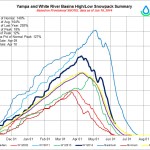
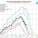
Spring runoff of the Yampa River likely peaked on May 14 this year as it flowed through northwestern Colorado. That makes it an anomaly in the precipitation-dripping mountains of the West.
In most other locations, the peak runoff—the time when the largest volume of water in rivers occurs as winter’s snow melts—more normally occurs in early June after temperatures finally warmed. This year looks to be more or less normal, despite a trend to earlier runoff in many locations during the last several decades.
“The Yampa did have an early runoff, and that was the result of the warm temperatures and below-average snowpack,” said Ashley Nielson, senior hydrologist with the Colorado Basin River Forecast Center in Salt Lake City, when interviewed last week by Mountain Town News. The Yampa, she noted, will probably rise again in the next week or so, if not to the same high mark.
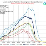
But elsewhere, the show is now, not a month ago. Peak runoff of the Green River was expected this week or next. It originates in the Wind River Range of west-central Wyoming. Unlike the Yampa, that basin still has a significant snowpack. That was also reported to be the case in Jackson Hole, at the headwaters of the Snake River. The snowpack there was 181 percent of average in late May, not a record but “up there,” in the words of one water official cited by the Jackson Hole News&Guide.
Peak runoff in the upper Colorado River at its headwaters along the Continental Divide in Colorado was also expected to occur in early June.
Winter had wild swings: barren until late fall, then torrents of snow in December and January. Temperatures were unseasonably warm in February and almost hot in March. It looked like an early runoff everywhere. Then May turned cold and snowy.
What explains the Yampa’s aberrant behavior? Karl Wetlaufer, a hydrologist with the Natural Resources Conservation Service in Denver, said the peak snowpack in northwestern Colorado arrived about a month earlier than usual. That snowpack around Steamboat Springs occurred on March 12, compared a more typical April 10.
Instead of mid-May for the Yampa, he says that rafters floating through Dinosaur National Monument more often experience the highest water flows of the year in early June.
The Dolores River in southwestern Colorado on Memorial Day in 2009. Photo/Allen Best
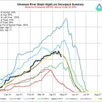
Flows in the Animas River through Silverton and Durango have had some “pretty wild swings,” Wetlaufer says. The Arkansas River has been slow to get started with runoff.
The Snake River of Wyoming and Idaho has a very different story than the Yampa, with around 200 percent of snowpack this year. The Snake originates in Jackson Hole and picks up water from the Big Wood River, which originates in the Sawtooth Mountains above Ketchum and Sun Valley, before joining the Columbia at the Idaho-Washington border.
“My takeaway is that this year is pretty normal” in terms of timing, says Bruce Anderson, the senior hydrologist at the Northwest River Forecast Center, in Portland, Ore. It was cooler and wetter in spring, but the big story was the amount of precipitation that fell during winter. “We are hugely above normal for precipitation.”
In the Tahoe-Truckee area of California’s Sierra Nevada, the snowpack was among the deeper ones on record after three bad drought years and then a so-so winter in 2015-16. Snowfall this winter was not a record, but it was a record for total precipitation. Being somewhat lower and closer to the coast than Colorado, the Sierra Nevada gets more rain during winter. This year it got a lot of rain.
Colorado, too, had rain on snow, which is not unprecedented. But it happened frequently this winter. The result was telling for travelers on I-70 who crossing Vail Pass.
“In general, there was less snow than you would expect,” says Klaus Wolter, a research scientist at the National Oceanic and Atmospheric Administration in Boulder.
Were those rain on snow storms of this past winter a result of accumulating greenhouse gas emissions? Wolter told Mountain Town News that thinks this is “probably partially climate change.”
Wolter, whose focus is empirical climate research, using statistical methods to solve climate problems, is reluctant to pin climate change on much of what we have seen this year. True, he says, one storm during May left 42 inches of fresh snow in the foothills above Boulder, a storm unprecedented since the 1920s. As extreme as that storm was, proving causality is difficult, he says.
A scientist in Oregon also shared the difficulty of proving causality. John Stevenson of Oregon State University told the Idaho Mountain Express in Ketchum that it’s “really difficult to judge any one year” to be a result of rising global temperatures.
“That’s one of the challenges we run into in the science world where people say, ‘Oh, it’s climate change.’ We’re not at the point where we can take any one random event and say it’s climate change.”
That said, his 2015 study concluded that the point each spring when half of the water year’s streamflow had run off was occurring an average 1.9 days earlier per decade.
But more extreme events are happening with greater frequency, said Mark Davidson, director of conservation initiatives with The Nature Conservancy. He pointed out that the Big Wood River has had two 100-year floods in the last 15 years.
Warm temperatures in the Ketchum and Sun Valley area were 6 to 13 degrees warmer than normal for early May, producing a flood in the Big Wood River that peaked on May 8. It was regarded as the largest in 101 years of recorded history, reports the Idaho Mountain Express.
But more warm weather was producing another surge in early June that threatened to surpass that peak of a month before, the newspaper reported last week.
The four native fish involved with the program are the Colorado Pikeminnow, Bonytail, Humpback Chub, and Razorback Sucker. As these unique fish are found only in this part of the world, the Colorado River Basin, the decline is due to the loss in habitat and several non-native fish species preying on them, including Small Mouth Bass, Northern Pike, and Walleye.
“The fish that we’re trying to remove compete for resources with the native fish as well as they are predatorial fish and they’ll eat the native fish as well,” said Tory Eyre, Aquatic Biologist with Colorado Parks and Wildlife (CPW).
These non-native fish are coming into these native fish habitats from reservoirs overflowing and from a way that is a bit more unorthodox.
“People are moving live fish from one body of water to another and that is illegal on the West Slope of Colorado, and when we have folks that are doing that, it results in a lot of our time and dollars to try to eradicate those species from areas in places that we don’t want them to be,” said Lori Martin, Senior Aquatic Biologist with CPW.
Eyre explained the various instinctive recover efforts helping to save these native fish, “we propagate fish so we raise fish in hatcheries and stock them. We alter habitat [and] try to alter flows. Then our involvement is with the non-native removal.”
Eyre added, “We placed gill nets in the backwaters that are a certain mesh size that targets the Northern Pike and we try to catch them in while they are entering the backwater to spawn.”
CPW has also worked with other program partners to install spillway screens in reservoirs at Elkhead and Highline Lake State Parks to prevent non-native fish from escaping into the Yampa and Colorado Rivers.
“It allows us to stock warm water fish that are okay with the recovery program into Highline Lake and the purpose of it is to keep those fish in the lake and not allow them to get in the Colorado River,” said Alan Martinez, Park Manager for Highline Lake State Park.
However, those with the initiative have been running into a small issue as the recovery program is controversial for some people. Eyre explained, “Small Mouth Bass and Northern Pike are sport fish…people like to catch them.”
As this is upsetting to some anglers, CPW has been working with the program’s agencies, and with anglers, to address their frustrations.
“We’re trying to provide opportunities for anglers for similar species in waters or areas where there is no interaction with native fish,” said Martin.
To encourage involvement by the angling public, CPW is sponsoring the Elkhead Reservoir Fishing Classic Tournament from June 24-July 2 in Craig.
“The aim is to have anglers help us remove small mouth bass and northern pike so we that can better provide a compatible sport fishery that’s in line with endangered fish recovery efforts downstream,” said Martin.
With all of the efforts in helping to reduce the non-native fish to increase the native fish populations, CPW officials say some improvements with some species have already been made in some locations along the Western Slope.
“This is kind of our one chance to recovery these species. They’re not found anywhere else, so if they’re gone, then they’re gone, and they’re gone forever,” said Eyre.
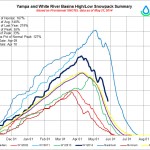
Even though the river where it flows through downtown has already peaked for the season, the Colorado Basin River Forecast Center in Salt Lake City, Utah, is projecting the final push of the spring runoff will continue into the first few days of June.
The river, which was flowing at below 1,000 cfs the morning of May 24, had already jumped to 1,250 cfs by midday May 25 and is projected to go even higher June 1 to 3 when it will be flowing above 1,550 cfs just in time for the 37th annual Yampa River Festival.
However, hydrologists at the Forecast Center report the river won’t climb as high as it did shortly after 2 a.m. May 14, when the flow peaked at 2,030 cfs for the season. That compares to a peak flow of 3,880 cfs on June 9, 2016.
Karl Wetlaufer, a hydrologist with the Natural Resources Conservation Service in Denver, suggested Thursday the below-average peak flow in the Yampa correlates with mountain snowpack that peaked atypically early.
“Across the entire Yampa, White and North Platte, snowpack peak was just about a month earlier than normal,” Wetlaufer said. “There were slight resurgences, but it never reached that peak again.”
Typically, Wetlaufer said, snowpack — a term that refers to the amount of water accumulated in the settled snow — peaks in this region on about April 10. This year, snowpack in the mountains peaked March 12…
The Yampa at Deerlodge Park in Moffat County, just above Dinosaur National Monument, was flowing in 4,350 cfs late this week with a boost from the Little Snake River, which drains the northern portion of the Mount Zirkel Wilderness Areas, and was flowing at 1,350 cfs.
The Green River, just before it flows out of Utah and into Moffat County, was flowing at 7,100 cfs, as Flaming Gorge Dam operators counteracted high inflows generated by unusually heavy snow in Northwest Wyoming this winter…
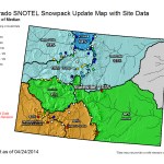
The Natural Resources Conservation Service reports that the 8 inches of snow water equivalent — water stored in the remaining 18 inches of snow — on the West Summit of Rabbit Ears Pass May 25 was just 58 percent of median, but that has grown from just 34 percent of median on May 17.
Those figures are even more significant above 10,000 feet on Buffalo Pass where the snow is still 90 inches deep, and the 44.8 inches of water there is 93 percent of median for the date.
Wetlaufer said the benefit of a late surge in snowmelt could be amplified if it also comes with rainfall on the valley floor. That would boost soil moisture, he said, which in turn would satisfy the demands of vegetation and allow more of the snowmelt to make its way into the streams and river.
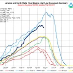
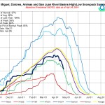
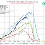
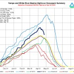
Yampa/White/Green/North Platte river basins via the Colorado Geological SurveyGunnison River Basin via the Colorado Geological SurveyColorado River Basin in Colorado via the Colorado Geological Survey
Water Providers Announce Mandatory Water Restrictions
With minimal precipitation, above average temperatures and runoff steadily increasing, coupled with a very dry February and March, the four districts which provide water to the Steamboat Springs area – Mt. Werner Water, City of Steamboat Springs, Steamboat II Metro District and Tree Haus Metro District – will institute mandatory stage 2 water restrictions starting May 1, 2017.
“Even with our recent moisture, this shouldn’t come as a surprise to anyone,” said Frank Alfone, Mt. Werner Water District General Manager. “With lower than normal precipitation so far this year and a still fluctuating summer forecast, the early adoption of stage 2 restrictions and a conservative approach made sense for the conditions we’re seeing at this point.”
The NOAA Climate Prediction Center is still predicting average precipitation this summer with a good chance (40%) for above average temperatures. Steamboat depends upon a combination of natural flows and reservoir releases from the Fish Creek watershed to carry it through the summer, fall and winter.
“It’s good to see the return of rain and snow this week,” said Jon Snyder, Public Works Director for the City of Steamboat Springs. “However, we’ll need consistent and steady precipitation for the foreseeable future to move away from restrictions and we appreciate everyone’s cooperation over the coming months.”
Early implementation of Stage 2 watering schedule will also allow lawns, shrubs and trees to adapt early in the growing season and enables automatic systems to be set by landscapers, businesses and homeowners to the Stage 2 schedule right from the start of the season.
Through these restrictions and continued efforts by water users to reduce water demands, the community is able to strike a balance between conserving water supplies in the reservoirs and maintaining the riparian health of Fish Creek and the Yampa River.
Stage 2 water restrictions are in accordance with the Steamboat Springs Water Conservation Plan adopted in 2011 by the Steamboat Springs City Council and Board of Directors of Mt. Werner Water District. Stage 2 mandatory restrictions were most recently enacted in 2015, 2013 and 2012.
According to the Tower weather monitoring station at 10,500 feet on Buffalo Pass, 12 inches of snow had fallen by Tuesday morning.
The weather station on Rabbit Ears Pass at 9,400 measured 8 inches of new snow.
The town of Yampa had 5 inches of snow while Clark had 2 inches.
Ski areas still operating benefited with Winter Park receiving 7 inches of snow. Loveland Ski Area saw 5 inches.
The current snow depth on Buffalo Pass is 105 inches. That’s the equivalent of 41.8 inches of water.
On average for April 25, there is 49.3 inches of snow equivalent water at the Buffalo Pass monitoring station, meaning snowpack is 85 percent of average, according to the Natural Resources Conservation Service.
Historically, snowpack on Buffalo Pass peaks on May 9.
Snow depth on Rabbit Ears is 43 inches with the equivalent of 16.7 inches of water. The snowpack for Rabbit Ears is 65 percent of average.
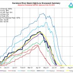
The snowpack for the entire Yampa and White river basins was at 78 percent of average as of Tuesday.
Snow is more of a sure thing at Breckenridge at an elevation of 9,600 feet, with an 80 percent chance of receiving 1 to 3 inches Friday. Saturday’s accumulations in Breck are expected to be about an inch.
More snow could fall in the San Juans and the West Elk Mountains to the south. Intellicast rates the chance that Telluride will see 3 to 5 inches of snow on Saturday at 100 percent. Crested Butte, at the headwaters of the Gunnison River, has a 70 percent chance of 3 to 5 inches of snow on Friday and a 60 percent chance of 1 to 3 inches on Saturday.
Kate Gmeiner’s weather station, between downtown and the base of the ski area, confirms that precipitation has come in dribs and drabs early and late this month, with nothing but trace amounts in the middle of March. There was no measurable precipitation from March 12 to 24.
In spite of the dry spell that began here in February, moisture for the water year, which began Oct. 1, 2016, is still at 105 percent for the combined Yampa and White river basin. However, the water stored in the standing snow at higher elevations has slipped to 93 percent.
Much of that moisture fell in December and January, when the ski area saw back-to-back 100-inch snow months at 9,000 feet.
“It’s crazy how high the flows are for this time of year,” Ashley Nielson, a senior hydrologist with the Colorado Basin River Forecast Center in Salt Lake City Utah, said. “I think we’re getting snowmelt at low and middle elevation and not at the higher elevations. But this is not something we expect this time of year.”
The Elk is still well below flood stage, but the acceleration of snowmelt during a time when snowpack is typically increasing stands out from the norm.
Flows in the river, which has its headwaters in the Mount Zirkel Wilderness Area northeast of Clark, hit a 24-hour peak of 1,050 cubic feet per second at 1:45 a.m. March 20, nearly doubling the previous record for the date, according to the U.S. Geological Survey. The previous record was 524 cfs, recorded in 2007. The median March 20 flow is 160 cfs.
At the same time, the Yampa River was flowing through downtown Steamboat Springs at a rate of 408 cfs, well above the median of 150 cfs (in the 90th percentile range for the date), but significantly lower than the 1916 record for the date of 690 cfs.
High flows in the Elk have been driven by snow melting under bright skies and daytime temperatures in the 60s, which have dominated the weather throughout the month. The National Weather Service reports the high temperature in Steamboat reached 70 degrees March 19, but a cooling trend is on the way.
The Elk had calmed down to 896 cfs as of 9:30 a.m. Monday as it went through its diurnal cycle of rising and falling flow volumes. However, the River Forecast Center foresees the river will continue to rise to more than 1,000 cfs through March 23, when a cooling trend calms things down March 25 through 31 and the river could remain above 600 cfs.
A pair of snowpack measurement sites operated by the Natural Resources Conservation Service confirm the record flows in the Elk are attributable to snowmelt above 9,000 feet, Nielson agreed.
The Lost Dog site, at 9,320 feet of elevation on the edge of the Zirkel Wilderness, has lost 3 inches of snow water equivalent since March 16, leaving it at 113 percent of median for the date. The Elk River measuring site, at 8,700 feet, has also lost 3 inches of snow water equivalent in the same timeframe, and snowpack there stands at 93 percent of median.
Nielson pointed to the Tower measuring site on the summit of Buffalo Pass northeast of Steamboat Springs as evidence that snowmelt has not begun at the highest elevations in the Park Range. The water content of the snowpack there, at 10,500 feet, has not changed more than a fraction of an inch since March 7.
Yampa/White/Green/North Platte river basins via the Colorado Geological Survey
From the Colorado Ag Water Alliance (Marsha Daughenbaugh) via Steamboat Today:
If you have an agriculture water right, then the Colorado Ag Water Alliance workshop is for you. If you are concerned about the future of Colorado’s water, then the CAWA workshop will be of interest to you. If you want to learn more about water, you might attend the CAWA workshop.
The Colorado Ag Water Alliance is composed of representatives from all the major ranching and farming organizations in the state. The organization’s goal is to preserve Colorado’s irrigated agriculture through education and constructive dialogue. Its role is to provide the best information to Colorado’s agricultural water users and increase the understanding of water rights to help balance the gap between limited water supplies, population growth and the deficit in the Colorado River Basin.
CAWA engages with a variety of entities to address environmental and economic concerns. Currently, CAWA is hosting a series of meetings throughout Colorado to allow and encourage agricultural producers to take an active role in the implementation of the Colorado Water Plan.
A workshop for the Yampa-White-Green River Basins will be held from noon to 4 p.m. March 22 at the Steamboat Springs Community Center, 1605 Lincoln Ave. The workshop is free, and lunch, featuring locally produced food, will be served.
Discussion topics will include the Colorado Water Plan, status of the Colorado River Basin, alternative transfer methods, water leasing, water banking, “use it or lose it” policies, water efficiency and waste, challenges of ditch renovations, collaboration opportunities and research results.
Speakers from CAWA, Colorado Water Institute, Colorado Cattlemen’s Association, Colorado River Water Conservation District, Colorado Division of Water Resources, Colorado Water Trust, Trout Unlimited, The Nature Conservancy and the Maybell Ditch Company will give spirited, quick presentations explaining different parts of Colorado’s complex water issues. Attendees will be encouraged to ask questions and provide feedback throughout the afternoon.
Colorado’s population is predicted to double to 10 million people by 2050, bringing with it a water shortage of more than 500,000 acre-feet per year. Agricultural water rights are being scrutinized as a potential solution to the deficit.
Ideas take time and multiple discussions before anything becomes reality. This workshop is part of a much larger conversation, and it is critical that agricultural producers provide their invaluable knowledge and voices to the deliberations. If not you, then who will speak up? This is a close-to-home opportunity for Northwest Colorado agriculture to participate.
Those planning to attend are encouraged to RSVP to yampaag.eventbrite.com for a lunch count.
This workshop hosted by CAWA, Community Agriculture Alliance and the Yampa-White-Green Basins Roundtable. Other sponsors include CSU Routt County Extension, Colorado Cattlemen’s Association, CSU’s Colorado Water Institute, Colorado Water Conservation Board, Colorado Corn and Rocky Mountain Farmer’s Union.
Marsha Daughenbaugh is the executive director of the Community Agriculture Alliance and a member of the Routt County CattleWomen.
The Dolores River shows us what’s at stake in the fight to protect the American West — Conservation Colorado
The confluence of Cement Creek, at right, and the Animas River, left, as seen September 2015 in Silverton, Colo. This is where the plume of contaminated water from the Gold King Mine entered the Animas River. (Jon Austria — The Daily Times)
The Yampa River Core Trail runs right through downtown Steamboat. Photo credit City of Steamboat Springs.
The rivers that roll past our cities, towns, homes, and highways are reflections of all things that happen upstream and uphill. In this lecture, we will learn to see rivers as a sum of their parts, learning the roles, forms and functions of water, sediment, and vegetation. Blue, the role of water, mobilizing and shaping; Brown, the role of sediment, filling, re-routing and building; and Green, growing, holding and slowing all things mobile. From this context, we will launch into discussions of river health, riparian resilience in the face of climate change, and what we can do to protect habitats critical to fish and wildlife and our riverside communities. We’ll see river cameos of the hard-working Dolores, the now-famous Animas, and the unfettered wildness of the Yampa.
Presented by Dr. Chris Rasmussen of EcoMainstream Contracting, and hosted by Abby Burk of Audubon Rockies.
Photo credit Upper Yampa River Water Conservancy District.
Here’s a report from a tour of Stagecoach Dam from Matt Stensland writing for Steamboat Today. Click through for the cool photo of the drain system from inside the dam. Here’s an excerpt:
It is a careful balancing act at the Stagecoach Dam, where electricity is generated for homes, fish habitat is managed and water is stored for a time when cities, ranchers and industry need it.
Behind the steel door, mineralized sludge covers the concrete walls and incandescent bulbs dimly light the narrow corridor.
These are the guts of the Stagecoach Dam southeast of Steamboat Springs, and it can be a little unnerving knowing that at the other side of the wall, 9,360 pounds of pressure push against each square foot of concrete.
Water drips from the ceiling and falls from drain pipes that collect water from the seeping concrete.
“All dams get water into them,” said Kevin McBride, adding that not having a system to drain the water would create pressure and put the dam’s integrity at risk…
“It’s pretty much paradise here,” said Blankenship, who most recently worked at a coal mine and previously worked in the power house of the USS Enterprise for the U.S. Navy.
Rogers has an electrical engineering degree from the Colorado School of Mines.
In addition to monitoring the integrity of the dam, they oversee the hydroelectric power plant, which was named the John Fetcher Power Plant in 1997. He pushed to make electricity generation part of the dam design.
“I think John was a natural conservationist and to have this capability in a project that size and not do it was a bad thing,” said McBride, referring to Fetcher, who died in 2009 at age 97 after being recognized as one of the state’s water leaders.
Above the loud turbine in the power house sits a sign warning people not to stand underneath. That is because above, there is a large, weighted steel lever that will come crashing down if the power generated at the plant needs to immediately come off the grid.
On Tuesday afternoon, the electrical turbine was generating upwards of 500 kilowatts. The system can generate as much as 800 kilowatts, but generation is limited by the amount of water that is flowing into the reservoir.
“The generation, it fluctuates wildly,” said Andi Rossi, the water district’s engineer. “If the flows get too low, we shut down for power generation. In a big wet year, we’ll make a lot of power.”
The water district had been selling the power to Xcel Energy, but Yampa Valley Electric Association began buying the power last year for six cents per kilowatt hour. In 2016, YVEA paid more than $230,000 for the 3.85 million kilowatt hours generated at the dam. That is enough energy to power about 355 homes.
Power generation varies and is dependent on runoff. During the drought year of 2002, only 1.85 million kilowatt hours was produced. When there was abundant snowfall in 2011, 4.7 million kilowatt hours was produced. Since 1999, an average of 3.8 million kilowatt hours has been made each year…
A tower of concrete in the reservoir beside the dam has three gates that allow different temperatures of water to be mixed and sent through a pipe under the dam toward the generator.
From there, the water is either sent through the generator or through a pipe called a jet flow, which shoots water out of the power plant and helps oxygenate the water for fish habitat in the section of river in front of the dam known as the tailwaters.
The area is an angler’s delight and can only be accessed by snowmobile from the Catamount area or by hiking along a county road from Stagecoach State Park.
“It’s phenomenal,” Colorado Park and Wildlife fish biologist Billy Atkinson said.
With improvements by Parks and Wildlife to the river habitat, the area has thrived for fishing, partly because of the dam and reservoir. Relatively warm water released from the dam keeps the section of river from freezing over, and the water from the reservoir is rich in nutrients for the fish.
“The system is very productive,” Atkinson said.
In 2016, 25 percent more people visited the section of river, and 4,000 trout were measured per mile.
Not all tailwaters below dams in Colorado are experiencing similar success.
“It depends on the dam and the operations of the dam,” Atkinson said.
The Routt County Board of Commissioners agreed Dec. 6 to renew its $9,660 commitment in 2017 to the water quality monitoring that has been ongoing in the Upper Yampa River Basin since 2011, with the support of the U.S. Geological Survey and other local agencies…
Under the testing regimen, six different sites on the river are tested four times annually to establish the baseline for a healthy river.
In addition, Cowman said the Yampa has been found to have a temperature impairment, and consistent water quality testing over time will help the entities involved in the testing make the case that they’ve been responsive to that condition when the Colorado Water Quality Control Division next focuses on the Yampa.
Steamboat Today reported Dec. 7, 2015, that some high water temperature readings in the river west of Hayden have the potential to lead to a big shift in how a 57-mile stretch of the river is regulated by the state of Colorado.
After a summer of sparse moisture in 2016, the Yampa, where it enters Stagecoach Reservoir, was flowing at 22 cubic feet per second on Sept. 23, representing an historic low, based on 27 years of record.
Managers of the Stagecoach and Catamount dams timed their seasonal draw-down of their reservoirs to benefit the Yampa downstream. And the city of Steamboat and the Colorado Water Trust both arranged to release stored water to boost the river’s flow by 10 cfs well into autumn.
The cost of the water testing in 2017 is up about 2 percent, with the USGS contributing $14,631, or 30 percent, of the total cost of $48,443. Joining the county in contributing 20 percent of the total are the city of Steamboat Springs and the Upper Yampa Water Conservancy District.
The Mount Werner Water and Sanitation District and Morrison Creek Water and Sanitation District are each contributing $2,415, or 5 percent, of the total.
Work begins [November 21, 2016] on a new whitewater feature on the Yampa River adjacent to Little Toots Park.
The new Toots Hole will be similar to the A-Wave upstream, which was reconstructed in December 2015.
“There is going to be a drop feature on the right-hand side and then a passage on the left for fish,” said Kent Vertrees, board member for Friends of the Yampa, which is carrying out the project in collaboration with the city of Steamboat Springs Parks and Community Services Department. “It will create a good, fun wave for tubers and also create some fish habitat.”
The project will include river bank stabilization, riparian habitat restoration and other improvements.
In December 2015, the river’s A-Wave was reconstructed, as the drop-off had become troublesome for tubers who could hurt themselves or become stuck in the wave.
“At low water, it was keeping tubers in the hole, or tubers were flipping in and getting stuck,” Vertrees said. “Now, it flushes.”
Both the A-Wave and Toots Hole projects are being funded by Friends of the Yampa, thanks to grants the organization received from the Colorado Water Conservancy board’s Yampa White Green Basin Roundtable and the Yampa Valley Community Foundation.
Friends of the Yampa also organizes additional fundraisers, including its annual Big Snow Dance, which took place Saturday. The event raised more than $12,000 through an auction, money that will also support the Toots Hole project.
“That money goes directly into the river for this project,” Vertrees said. “The community of river people and Friends of the Yampa folks have really supported this project.”
The improvements to the river were identified in the 2008 Yampa River Structural Plan, and the two projects together are expected to cost about $130,000.
Vertrees said Toots Hole is the last component of what he calls the Yampa River Boating Park, a series of river features through downtown.
“We’ve created this interesting little urban river canyon, and we’re just adding to it,” he said. “We’re really excited about the conclusion of this project.”
Vertrees thanked Rick Mewborn, of Nordic Excavating, for his work on the projects, including donations of time and rock.
“Without him as a partner, this wouldn’t have been as successful,” he said.
Work on the project is expected to last about two weeks, and periodic closures of the Yampa River Core Trail might occur while work is taking place.
Solar-powered water systems let livestock drink more easily and take pressure off ponds and streams
[Vance Fulton], an engineering technician with the Natural Resources Conservation Service, described the way solar energy provides an effective way for landowners to transport water to their livestock.
“Especially around here, (landowners) have found that solar is a much more efficient way to pump water than the old windmills,” Fulton said.
And now, with the birth of the Sage Grouse Initiative, the solar-powered systems are receiving increasing amounts of federal support. Fulton said the systems have received funding through the Farm Bill for decades — but for the last several years, SGI has targeted more money for the solar-powered projects in places where the sage grouse is affected, such as Moffat County.
Surprising as it may seem at first glance, the creation of multiple water sources for cattle helps sage grouse too.
The system often works this way: A solar panel powers a pump that drives water through an underground pipeline, and the pipeline delivers the water to troughs at various points in the land so that animals can drink. The pump often fills up a storage tank for a backup water supply, as well.
The system, as Fulton explained it, creates an efficient means of supplying water to animals on the land. By creating several water sources, the system also eases stress on the ponds, puddles and streams where animals may gather to drink. That benefits a host of creatures — including the sage grouse.
Chris Yarbrough, formerly a biologist with the Rocky Mountain Elk Foundation, who is now regional habitat biologist for Idaho Fish and Game, explained how a water system such as this can help sage grouse. If there’s only one pond on a ranch, he said, that’s where the cows will congregate.
“That area will probably get overgrazed, and you’ll probably get a lot of weeds — things that aren’t good for wildlife,” he said.
But water troughs scattered throughout the land can attract animals to different spots, easing the pressure on a pond or a stream.
“The grasses and (other plants) then have a chance to grow,” he said — something that’s good for sage grouse and lots of other species, as well.
Yarbrough said much of the funding to install solar pumping systems in Moffat County is generated by the SGI, launched by the Natural Resources Conservation Service in 2010.
Fulton said the NRCS works with about 20 landowners in Moffat County on solar watering systems, and he noted there may be others using solar power, as well. It’s a number that’s far larger, he said, than it was about a decade ago, before the SGI.
One of the Moffat County landowners who uses solar-powered system is Doug Davis, who has a ranch called Davis Family Farm LLC that lies in the eastern part of the county.
“We discovered a very good water source up high, and because it’s up high you can use gravity flow,” Davis said.
Davis explained that the solar panel on this ranch pumps water from the well into a storage tank — and from that storage tank, gravity allows the water to flow through pipes to troughs throughout the property. Davis said that, on another property, he uses the solar-powered pump to push water directly to the troughs.
Either way, Davis said he’s glad to be using solar energy. He used to use windmills, which could be tough to maintain and less reliable.
“Windmills are much higher maintenance, and the wind does not blow as consistently as the sun shines,” he said. “Solar, which has turned out to be a low-maintenance, relatively low-cost proposition for us, is a winner.”
As Fulton walked through Davis’s land on that sunny July day, he pointed to some small nuances in the equipment, including strategically placed fencing to protect the plumbing from the animals drinking from the troughs, and a “small animal escape ramp” to let otherwise trapped animals climb to safety.
Fulton said the solar-powered system works without batteries, which means that energy is transferred directly to the pumps. It also means that the amount of energy may vary from day to day, depending on the supply of sunlight at a given time. That’s where the agility of the pumps comes into play.
“These pumps are able to work on variable voltage,” he said. “They’ll even continue to pump on a slightly cloudy day.”
Storing water during the sunny days, Fulton said, creates a water supply to use on the cloudy ones.
“You store water instead of storing electricity,” he said.
Fulton said, too, that advances in technology — in the pumps and the solar panels — have made the system even better than it used to be.
“It got more dependable, more efficient through the years,” he said — a sign that the sun soaking ranches throughout the county will be put to good use for many more years to come.
Yampa/White/Green/North Platte river basins via the Colorado Geological Survey
Here’s the release from the Colorado Water Trust (Zach Smith, Kelly Romero-Heaney, Kevin McBride):
Today, Upper Yampa Water Conservancy District began releasing water purchased by the Colorado Water Trust and its partners to bolster flows in the Yampa River from Stagecoach Reservoir through the City of Steamboat. The purchase of 264 acre-feet, to be released at a rate of 10 cfs for 13 days, provides a gap measure between other local entities’ efforts to keep the Yampa flowing in this dry late summer.
The Yampa River, although forecasted to run at normal streamflow levels this summer, began dropping in the late summer and remained well below average, impacting fish, recreationalists, and water quality. Noting dropping water levels, the City of Steamboat began releasing water from its 552 acre-feet pool in Stagecoach on August 19th to improve water quality – the first time the City has used its water in Stagecoach in such a way. When that water ran out on September 14, Upper Yampa maintained that 10 cfs release by generating hydropower as part of a winter drawdown of Stagecoach it performed earlier than normal to coordinate with this purchase. The Water Trust’s purchase will continue adding water to the Yampa until the Catamount Metro District lowers levels in Lake Catamount to prepare for the winter sometime in early October.
“Watching the local community now lead the streamflow restoration effort on the upper Yampa River is the best outcome for the work the Water Trust has accomplished in the Yampa valley since 2012,” said Zach Smith, staff attorney for the Water Trust.
“A healthy Yampa River is important to our community on so many levels,” said Kelly Romero-Heaney. “The City was fortunate to be able to release its Stagecoach Reservoir water this year to improve water quality in the river.”
The Water Trust’s partners, The Nature Conservancy, the Bonneville Environmental Foundation, Tri-State Generation & Transmission and the CAN’d Aid Foundation funded the $10,000 for the 2016 purchase and costs related to the transaction.
In 2012, 2013, and 2015 the Water Trust purchased water out of Stagecoach for release to the Yampa River to help maintain healthy stream flows and water quality.
As always, the project wouldn’t be a success without the help of Colorado Parks and Wildlife, Catamount Development, Inc., Catamount Metropolitan District, and other cooperative water users.
…the Colorado Water Trust has joined the city of Steamboat Springs, Upper Yampa Water Conservancy District and the Catamount Metropolitan District in ongoing efforts to boost the Yampa’s flows deeper into autumn.
The river was flowing at 60 percent of its median flow for Sept. 23 Friday morning, but it would have been lower this week if not for the fact the city and Upper Yampa Water have been adding flows of 10 cubic feet per second from water stored in Stagecoach Reservoir since August. The city, for the first time ever, began releasing water from its 552-acre-foot pool in the Yampa Aug. 19, and when that ran out Sept. 14, Upper Yampa continued the 10 cfs release by accelerating its seasonal timetable for drawing down the reservoir to accommodate 2017 spring runoff.
Upper Yampa District Engineer Andy Rossi observed at the time: “We are flirting with historically low flows into Stagecoach Reservoir.”
The Yampa was flowing at 22 cubic feet per second just above the reservoir Friday. Based on 27 years of record, that compares to the lowest flow on record for Sept. 23 — 22 cfs in 2002.
However, water district general manager Kevin McBride said the reservoir his agency manages filled to capacity after a very wet spring, allowing the water district to advance its autumn timetable.
The Water Trust announced Sept. 22 that, together with its partners, it will spend $10,000 to purchase another 264-acre feet of water from Stagecoach Reservoir, enough to increase the flows in the Yampa by 10 cubic feet per second for 13 more days. The Water Trust’s purchase will continue adding water to the Yampa until sometime in October, when the Catamount Metro District lowers levels in Lake Catamount to prepare for winter.
Water Trust staff attorney Zach Smith said that the level of cooperation among water managers in the upper Yampa Basin is gratifying for his organization.
“Watching the local community now lead the streamflow restoration effort on the upper Yampa River is the best outcome for the work the Water Trust has accomplished in the Yampa Valley since 2012,” Smith said in a news release.
Here’s the release from The Center for Biological Diversity (Taylor McKinnon):
Lawsuit Launched Over Fracking, Water, Climate Change in Colorado River Basin
The Center for Biological Diversity and Living Rivers today filed a 60-day notice of intent to sue the Bureau of Land Management and U.S. Fish and Wildlife Service to compel them to update invalid, outdated Endangered Species Act consultations on the impacts of climate change and expanded fracking in western Colorado on the Colorado River system and its four endangered fish. The challenge seeks to halt all new oil and gas leasing and development on federal public lands in the Upper Colorado River Basin of Colorado — including the White River and Grand Junction field offices — pending updated consultations.
Fracking near the White River in Utah, located immediately downstream of the Bureau of Land Management’s White River Field Office that is subject to today’s notice. Photo by Taylor McKinnon / EcoFlight.
“The Colorado River system’s endangered fish can’t handle more water depletions. The river system is already overtaxed, and declining flows because of climate change are making a bad situation worse,” said Taylor McKinnon with the Center. “It’s hard to imagine a more self-destructive policy for the Colorado River Basin than using scarce water to fuel more climate-warming fossil fuel extraction — but that’s exactly what the Obama administration is allowing.”
The notice asserts that a programmatic “biological opinion” study authorizing water withdrawals for oil and gas development on public lands in the Upper Colorado River Basin is outdated and invalid. The study fails to consider impacts to endangered fish from the drawing-down of large amounts of water that would be used for horizontal drilling, as well as the impacts of developing expanded estimates of Mancos shale gas deposits, existing and projected future climate-driven Colorado River declines, oil and other toxic spills, mercury and selenium pollution, and the failure of the federal recovery program to provide minimum river flows in critical habitat for the fish.
The notice challenges both agencies’ reliance on the study when they approved new land-use plans for the Grand Junction and White River field offices last year and other oil and gas development plans this year. Together the new land-use plans would allow nearly 19,000 new oil and gas wells in western Colorado. Yet the Fish and Wildlife Service has already conceded that any further water depletions from the Colorado River or its tributaries would jeopardize the four endangered fish — the Colorado pikeminnow, razorback sucker, humpback chub and bonytail.
“Fracking in the Colorado River Basin comes at the peril of public lands, our climate, the river, its endangered fish, and tens of millions of downstream water users,” said McKinnon. “It’s backward public policy in face of a worsening climate crisis. Now’s the time for the Obama administration to align our country’s energy policies with its climate goals by ending new fossil fuel leasing on America’s public lands.”
Center for Biological Diversity attorneys Wendy Park and Michael Saul are staffing the case.
Background
On behalf of the American people, the U.S. federal government manages nearly 650 million acres of public land and more than 1.7 billion acres of the Outer Continental Shelf — and the fossil fuels beneath them. This includes federal public land, which makes up about a third of the U.S. land area, and oceans like Alaska’s Chukchi Sea, the Gulf of Mexico and the Eastern Seaboard. These places and the fossil fuels beneath them are held in trust for the public by the federal government; federal fossil fuel leasing is administered by the Department of the Interior.
Over the past decade, the combustion of federal fossil fuels has resulted in nearly a quarter of all U.S. energy-related emissions. A 2015 report by EcoShift Consulting, commissioned by the Center for Biological Diversity and Friends of the Earth, found that remaining federal oil, gas, coal, oil shale and tar sands that have not been leased to industry contain up to 450 billion tons of potential greenhouse gas pollution. As of earlier this year, 67 million acres of federal fossil fuel were already leased to industry, an area more than 55 times larger than Grand Canyon National Park containing up to 43 billion tons of potential greenhouse gas pollution.
Last year Sens. Merkley (D-Ore.), Sanders (I-Vt.) and others introduced the Keep It In the Ground Act (S. 2238) legislation to end new federal fossil fuel leases and cancel non-producing federal fossil fuel leases. Days later President Obama canceled the Keystone XL tar sands pipeline, saying, “Because ultimately, if we’re going to prevent large parts of this Earth from becoming not only inhospitable but uninhabitable in our lifetimes, we’re going to have to keep some fossil fuels in the ground rather than burn them and release more dangerous pollution into the sky.”
Download Public Lands, Private Profits about the corporations profiting from climate-destroying fossil fuel extraction on public lands.
Download the Center for Biological Diversity’s legal petition calling on the Obama administration to halt all new offshore fossil fuel leasing.
Download the Center for Biological Diversity’s legal petition with 264 other groups calling on the Obama administration to halt all new onshore fossil fuel leasing.
The Center for Biological Diversity is a national, nonprofit conservation organization with more than 1.1 million members and online activists dedicated to the protection of endangered species and wild places.
FromThe Grand Junction Daily Sentinel (Dennis Webb):
Two conservation groups say oil and gas leasing and development need to be halted on federal lands in the Upper Colorado River Basin until agencies can take the steps needed to protect endangered fish.
The Center for Biological Diversity and Living Rivers have notified the Bureau of Land Management and U.S. Fish and Wildlife Service that they plan to sue the agencies for failing to take into account new information in order to properly protect the Colorado pikeminnow, razorback sucker, humpback chub and bonytail. This information includes the growing use of water-intensive horizontal drilling and hydraulic fracturing to produce oil and gas from the Mancos shale formation, which holds a much larger developable resource than previously thought. The U.S. Geological Survey recently estimated that the Piceance Basin’s Mancos shale formation contains 40 times more recoverable gas than it previously had estimated.
The groups say the BLM and Fish and Wildlife Service relied on an invalid and outdated study authorizing water depletions for oil and gas development in the Upper Colorado Basin as the BLM approved land-use plans in the region, most notably plans involving the Grand Junction and White River field offices that combined allow for nearly 19,000 oil and gas wells…
The study, known as a programmatic biological opinion, was adopted in 2008, before the BLM recognized the potential for horizontal drilling and the associated water impacts, the groups say in their notice of intent to sue. The notice said while the BLM estimated that local wells drilled out directionally and then vertically into producing formations require an average of 2.62 acre-feet of water, nine local horizontal wells ended up consuming an average of nearly 69 acre-feet each. That largely was responsible for water consumption of nearly twice the projected annual total for oil and gas development for a sub-basin portion of the Colorado River, in violation of a depletion limit intended to protect the fish, the groups say.
The groups’ notice said difficulty meeting minimum recommended flows for the fish in a critical 15-mile stretch of the Colorado River in Mesa County strongly suggests the habitat there will be unsuitable for the Colorado pikeminnow and razorback sucker in dry years, “and that flow depletions from oil and gas development will only exacerbate these unsuitable conditions and reduce these species’ chances of recovery.”
BLM and Fish and Wildlife Service spokesmen said Monday their agencies don’t comment on pending litigation.
Kathleen Sgamma of the Western Energy Alliance industry group said the legal action is another attempt by conservation groups to grasp at straws in their opposition to the industry. She noted a state estimate that fracking consumes less than a tenth of a percent of Colorado water.
“It’s a very small amount of water that is used for fracking and for oil and gas development in general,” she said.
She added that one horizontal well replaces several vertical wells, so the overall water use is actually lower. And she questioned how much impact energy development can be having on fish at a time of minimal drilling activity on the Western Slope.
The conservation groups single out in their notice water consumption by Black Hills Exploration & Production, but that company since has suspended local drilling.
Upper Colorado River Endangered Fish Recovery Program
Erin Light, center, and Shanna Lewis in a pasture with a mule while checking on the Meeker Ditch on July 11. Light has curtailed diversions into the ditch, which she determined was wasting water.
MEEKER – The mule in a pasture east of Meeker along the White River seemed happy to see Erin Light, a state division engineer, and Shanna Lewis, a water commissioner, when they went to take a look at the amount of water flowing through the Meeker Ditch on July 11.
Lewis, who grew up on a Colorado ranch, praised the mule’s beautiful, deer-like coloring and said they’d become friends on her frequent visits to check the ditch.
But the warm equine reception the two enforcers of Colorado water law received differed from the response they sometimes get from ranchers in Division 6, which encompasses the Yampa, White and North Platte river basins, especially when they are visiting a ditch because they think its operator is diverting more water than they need through their head gate.
“I would say I’m more telling than I am curtailing,” said Light, who has been the division engineer based in Steamboat Springs since 2006. “There have only been a few situations where I’ve actually said, ‘That’s it. We’re curtailing you.’ And they’re very obvious situations where they’ve got a lot of water going down the tail end of their ditch, where you can’t argue that this isn’t waste.
“Where the problem becomes in determining waste is that I can go out to a piece of land and say, ‘Oh my gosh, you’ve got 6 inches of water on this land. There’s ducks swimming around. This is wasteful,’” she continued. “You can go to the landowner or the irrigator and say, ‘This is waste,’ and they’ll stare you right in the face and say, ‘The hell it is.’”
Division and state engineers working for Colorado’s Division of Water Resources, as Light does, are the only officials who have the authority to determine if waste is occurring on an irrigation system. And their primary response is to curtail wasteful flows at the head gate.
But determining if there is waste in a ditch is a case-by-case exercise. It’s site specific and time sensitive, and it can take time to understand how someone manages their ditch.
There’s no state definition of waste or written guidelines, but in the end it’s a fact-based analysis focused on how much water is needed to irrigate so many acres.
An allowance is also made for customary inefficiencies on a ditch system. Water leaking out of an old ditch, for example, is not considered waste. But beyond inefficiency, which is often a physical issue, there is waste, which is usually a water-management issue.
And waste is a much bigger issue on the Western Slope than on the state’s drier eastern plains, where irrigators have long watched for anyone wasting water.
A field flooded with water from the Yampa RIver this year. Erin Light, the division engineer for Division 6, said this is an example of diverting more water than is necessary.
Free river, or not
In 2014, Light served the Meeker Ditch with a written curtailment order, and she also told the big Maybell Canal on the Yampa River that they had to stop wasting water.
And she did so even though neither river was “under administration,” the term for the body of water being called out by senior downstream diverters, so both were considered in a “free river” condition.
Nor was there another water right that was being injured by either ditch’s diversions.
Just in the past 10 days, Light’s office has informed rancher Doug Monger that water is being wasted in the irrigation system he manages on his Yampa River Ranch three miles east of Hayden.
Monger is a Routt County commissioner, a member of the Yampa-White Roundtable, and a director on the Colorado River Water Conservation District’s board.
When asked Tuesday, during a break in a daylong strategic retreat at the River District, about Light’s belief that he was wasting water, he responded in a way that she has heard before.
“I don’t know what the hell difference it makes if I’m wasting water or not, it’s going back in the river,” Monger said. “Who the hell cares, if it’s a free river.”
“I know he is wasting water,” Light said Monday of Monger. “And he should be the poster child of what should be done, not what shouldn’t be done.
“About 10 days or so ago, our water commissioner approached a bunch of water users in the ditch system,” she explained. “There are several ditches that combine and co-mingle there.
“They were immediately going, ‘That’s Doug Monger’s responsibility, Doug’s the one controlling that,’ which I take as Doug is the one controlling the head gates,” Light said. “One of our water commissioners, Brian Romig, went to Doug and said, ‘We’ve got a problem here. You’re diverting too much water.’ From what Brian told me, Doug somewhat recognized it. He concurred that he needed to reduce his diversions.”
But Tuesday, Monger was not willing to go that far, saying he understood from the water commissioner only that he was still figuring out how Monger’s ditch works.
“I won’t acknowledge it,” Monger said of the allegation that he was diverting more water than he needs. “And if they start coming up with some scenario on it, we can always get our attorney. “
That was the same initial response that David Smith, the primary shareholder on the Meeker Ditch, had when Light curtailed his ditch in 2014.
But since then, and after spending $40,000 in legal and engineering fees, Smith has come around to see Light’s point.
“I would tell you that Erin and I started out on opposite ends on this thing, but both of us have kind of tried to work our way towards middle ground that we can both agree on,” he said.
Smith was busy this week bringing in hay on his well-tended fields along the White River just west of Meeker — the same fields his grandfather irrigated.
“I’ve had some disagreements with her, but Erin is an intelligent gal,” he said of Light, who has a master’s degree in civil engineering from Colorado State University with an emphasis in hydraulics and hydrology. “We’ve worked with her, and we’ve worked with the people that she has here, and at the end of the day it’s helped all of us, and I think we’re all better educated because of it.”
Well-tended fields along the White River west of Meeker irrigated by the Meeker Ditch. The ditch has been directed to divert less water at its head gate than it used to.Shanna Lewis, a water commissioner in Division 6, inspecting the Meeker Ditch’s measuring flume. Lewis suggested it’s easy for outsiders to critique how ranchers manage their water, but that there are a lot of factors, and experience, involved that are not always readily apparent.
Laying down the law
The Meeker Ditch has a water right dating back to 1883 to divert 20 cubic feet per second (cfs) of water and two other later and smaller rights that allow it to divert 25.95 cfs in all.
The ditch diverts water from the White River just east of Meeker, runs it through Meeker proper, and then to fields west of town. (See map).
In her August 2014 curtailment order, Light said the historic water rights held by the Meeker Ditch represent enough water to irrigate about 1,000 acres, but today only 153 acres are actively being irrigated. And engineers at Resource Engineering Inc. calculated that the Meeker Ditch only needed 6 cfs to irrigate the fields still served by the ditch.
Attorney Kevin Patrick of Patrick, Miller and Noto, a water law firm with offices in Aspen and Basalt, had hired Resource Engineering to analyze the irrigation ditch on behalf of a client who owned commercial property under the ditch.
Since 2004, the property had been intermittently subject to flooding by water leaking from the ditch.
Patrick sent the engineering report and a letter to Light. “The ditch is diverting unnecessary water which is merely being spilled” and “the excessive running of water, over that reasonably required for the reasonable application of water to beneficial use for the decreed purposes and lands, is forbidden” under state law, the letter says.
After investigating the matter, Light found the ditch had been consistently diverting about 20 cfs at its head gate, but was then sending much of the water out of the ditch and down Curtis Creek, Sulphur Creek or Fairfield Gulch, back toward the White River.
Light then curtailed diversions at the Meeker Ditch head gate, which she has the authority to do. And when asked to do so by Smith, she put the curtailment order in writing.
“Colorado statute clearly prohibits the running of water not needed for beneficial use,” Light wrote in her order, dated Aug. 15, 2014.
Light cited a Colorado statute that reads “it shall not be lawful for any person to run through an irrigating ditch any greater quantity of water than is absolutely necessary for irrigating his land, it being the intent and meaning of this section to prevent the wasting and useless discharge and running away of water.”
And she addressed the issue of water being released from the ditch and back to the river.
“Generally when water is being wasted off the end of the irrigated acreage, through waste gates, or at the tail end of the ditch, the head gate should be turned down to eliminate that waste of water,” Light wrote. “In this case it appears that water is being diverted at too great a rate for the lands that are being irrigated, and the rate of diversion is not being reduced to eliminate waste.”
Light’s stance on enforcing waste has the backing of her boss, State Engineer Dick Wolfe.
A photo from the Resource Engineering report documenting waste on the Meeker Ditch in 2014. Water from the ditch is being turned out into Sulphur Creek, while the main flow in the ditch continues through the pipe above the outfall.
Use it or lose it?
Both Wolfe and Light served recently on a committee, convened by the Colorado Water Institute at Colorado State University, that issued a report in February on the widely brandished piece of advice to irrigators to “use it or lose it.”
The report is called “How diversion and beneficial use of water affect the value and measure of a water right” and is subtitled “Is ‘use it or lose it’ an absolute?”
The 11-page report ends with several declarative statements about waste that give further backing to Light’s approach, and that she might well wish to see chained to every head gate on the Western Slope.
“Water that is diverted above the amount necessary for application to a beneficial use (including necessary for transit loss) is considered waste,” states the report.
“Increased diversions for the sole purpose of maintaining a record of a larger diversion are considered waste,” it says, referring to the practice of diverting toward the full amount of a decree in order to bolster the future potential value of a water right.
And, “Wasteful diversions will either be curtailed, or will not be considered as part of the water right’s beneficial use.”
Wolfe, who recently gave a presentation to the Colorado Ag Water Alliance on the “use it or lose it” report, said that Light is not being overzealous in her enforcement of waste.
“She is not going out and as a division engineer purposely looking and being more assertive or aggressive about trying to find where waste is going on,” Wolfe said. “These are ones that just came to our attention.”
Alan Martellaro, the division engineer for Division 5, has not taken the same approach as Light when it comes to curtailing waste.
“To actually actively go look for waste is not something that’s historically been done unless there’s a call on the stream,” said Martellaro, who is based in Glenwood Springs and whose jurisdiction includes the Colorado, the Roaring Fork, and the Crystal river basins. “It just hasn’t been the mode we’ve ever been in.”
Kevin Rein, the deputy state engineer who also served on the “use it or lose it” committee, said issues vary from division to division.
“In Division 6, in the Yampa-White, we’ve had periods of free river without administration for a long time, because it hasn’t been over-appropriated,” Rein said. “That means not being water short. So very often people were just diverting whatever they wanted because, why not? But she’s really directing herself to getting people to measure their diversions and pay attention to duty of water. I think you choose what’s important in your division. That’s important in her division.”
“Duty of water” is essentially how much water someone needs to grow crops on a certain amount of land, without waste. In the Yampa and White river basins, the duty of water is generally held to be that it takes 1 cfs to adequately irrigate 40 acres of land.
After giving a presentation at a water workshop in Gunnison in June about the “use it or lose it” report, Rein was asked why the state doesn’t go around and curtail people who are over-diverting.
“We do, as resources allow,” Rein said. “It’s simply a matter of looking at our water districts where we, maybe, have one water commissioner and maybe a deputy. Maybe if they each had two or three more deputies, then we could do that.”
Light sounds like she could use some help.
“When it comes down to obvious waste,” she said, “I would say we have a tremendous problem with it. I had a long-standing water commissioner — he was with us for 40 years and grew up a rancher — tell me one day, ‘The problem with irrigators today is they don’t go out and move their sets. They just open the head gate wider.’”
“Sets” refers to how irrigators have set various control points, such as check dams and internal head gates, along their ditches.
“That just blew me away,” Light said. “Here’s a longtime rancher living in the community of Meeker his entire life who is more or less telling me that his co-irrigators … just open up their head gate and don’t move sets anymore. To me, that’s where the inefficiency is. Go out, divert less water, and move your damn sets.”
Erin Light, after being asked to pose for a photo at the head gate of the Meeker Ditch. Light has curtailed diversions into the ditch to reduce the amount of water being wasted in the ditch system.
Defending Light
After receiving Light’s written curtailment order in August 2014 on the Meeker Ditch, Smith appealed it to an administrative hearing officer, which was a rare move.
Wolfe said the appeal, which was addressed to him, “is the only curtailment order that I am aware of that has been appealed since I have been state engineer.” He’s been state engineer since since 2007 and has been with the Division of Water Resources since 1993.
An attorney for the Meeker Townsite Ditch Co., which owns the Meeker Ditch, told the state that Light was “attempting to restrict the diversion of water down the Meeker Ditch at a time when the White River is not under an administrative call and at a time when no other water rights owner is affected by the diversion.”
At that point, the state stepped in to defend Light’s curtailment order, and Philip Lopez, an assistant attorney general, prepared an answer to Smith’s appeal.
In his answer, Lopez cited a relatively straightforward statute that reads: “During the summer season it shall not be lawful for any person to run through his irrigating ditch any greater quantity of water than is absolutely necessary for irrigating his land, and for domestic and stock purposes, it being the intent and meaning of this section to prevent the wasting and useless discharge and running away of water.”
And he quoted the Colorado Supreme Court in Fellhauer v. People, where it said, “The right to water does not give the right to waste it.”
As to the matter of Light, or any other division engineer, not being able to curtail waste if there is not a call on the river, Lopez wrote “the division engineer has the authority to curtail [the Meeker Ditch’s] wasteful diversions at any time pursuant to [state law], regardless of whether or not the White River is under administration.”
Lopez did concede, though, that the water rights held by the Meeker Ditch still allowed it to divert water, as long as they did so “without waste.”
That’s an important distinction for Smith, who insists that he wasn’t technically curtailed, only that he can’t waste water when diverting.
“She hasn’t curtailed me to the amount of water that I can use,” Smith said. “All that Erin tells me is that whatever amount of water I have in the ditch, that she doesn’t want us wasting any water.”
Light has a different take.
“We curtailed them,” Light said. “We issued an order to stop wasting. They hired an attorney. They hired an engineer. It went to the hearing officer. They don’t waste anymore.”
The hearing officer in the case denied the ditch’s appeal, indicating it was a matter for water court. But Smith declined to go there.
“We kind of came to a working agreement that we were going to try to work with it, but as far as the laws, there was never a test case,” Smith said.
That may be, but on July 11, when Light and Lewis measured the flow in the Meeker Ditch, it was running at 6 cfs, not 20 cfs as it often used to.
The diversion structure for the Maybell Canal on the Yampa River east of Maybell. The ditch has been working to reduce diversions after the division engineer found it was diverting more water than it needed.
The Maybell Canal
Light has also curtailed another irrigation ditch in Division 6, the Maybell Canal on the Yampa River near Maybell, which she found was similarly diverting more water than it needed.
The canal diverts water from the Yampa into a head gate located in a canyon on the edge of Little Juniper Mountain, about 30 miles west of Craig. (See map).
The Maybell Canal has a senior water right for 42.2 cfs that was adjudicated in 1923 and appropriated in 1899. It also has a junior right for 86.8 cfs that was adjudicated in 1972 and was appropriated in 1946.
The waste on the Maybell Canal was brought to Light’s attention by one of her water commissioners who’d visited the ditch. Light then verbally instructed the canal’s manager to stop wasting water. Mike Camblin, manager of the Maybell Irrigation District, wasn’t happy when he got the curtailment order from Light, but he’s now working to secure funding to make $197,000 worth of improvements to the irrigation system.
On July 13, the Yampa-White-Green basin roundtable approved a $108,000 grant of state funds to help fix several issues on the ditch system. One of those improvements is a modern, automated “waste gate” a mile below the head gate.
Camblin said such a remote-controlled system won’t work at the head gate, which is higher up in the canyon without cell phone service and prone to being washed out by high water.
But he is willing to use the automated gate to reduce sending more water than necessary out the bottom of the ditch, where the water returns to the Yampa River.
The arrangement for the new gate does not entirely please Light, however. She insisted that Camblin agree to send someone up to the head gate within three days after receiving information from the new automated gate that they are over-diverting.
An agreement to that end has been worked out and is poised for adoption, both Light and Camblin said.
“The whole goal is to not only help Erin out but to make us better at what we do,” Camblin told his fellow roundtable members on July 13.
In an interview this week, Camblin said, “At times we were probably taking more water than we need, but that’s what this whole process is about, to cut that down.” He said he is forging a productive working relationship with Light.
“I think it all comes down to communication, especially with Erin and the water commissioners,” he said. “If they get to know us and how our ditch can run better, and we allow them to do that, and we communicate, we can solve a lot of problems.”
Water diverted into the Maybell Canal enters a flume a mile below the head gate and crosses the Yampa River. A remote-operated outlet is to be installed just above the flume in an effort to reduce diversions into the ditch.The Maybell Canal, toward its end, below the town of Maybell, on July 13, 2016. The ditch is working to waste less water by reducing diversions from the Yampa River.
Watch that stick
Dan Birch, the deputy general manager at the Colorado River Conservation District and a member of the Yampa-White basin roundtable, is supportive of the improvements that Camblin is trying make on the Maybell Canal.
“I think Mike’s really trying to do the right thing, and I think he wants to take a look at ways he can manage his diversions better,” Birch said. “I certainly don’t think he’s diverting just for the sake of diverting.”
Birch also cautioned against using a stick to beat back waste.
“You can’t go into a situation and say, ‘Hey, you guys are wasting water, I want you to reduce your diversions,’” Birch said. “You really have to be prepared to go into that situation and say, ‘Hey, look, here’s something that we’re seeing here. Let’s have a conversation. I’m interested in exploring what we might do to improve flow in the river.’”
But Light feels the Maybell Canal needed to be prodded into action.
“What has partially pushed the Maybell Canal to go the direction they have is us really putting our foot down that we’re not going to allow this waste to continue,” she said. “Again, the waste is so blatant. They were diverting about 54 cfs at the head gate, and we estimated about 18 cfs going out the tail end. It’s like, ‘No, you can’t do that.’”
Birch was asked directly if he thought the Maybell Canal would be making its proposed improvements without Light’s enforcement actions.
“That’s a fair question, and my immediate response is probably not,” he said.
While Light has been able to work with both Smith and Camblin, she knows she’s raising the hackles of ranchers in the Yampa and White river basins.
“I don’t think the irrigation community wants to be told they’re wasting,” she said. “I’d love to do more as far as waste, but I do have to tread lightly.”
Editor’s note: Aspen Journalism, the Aspen Daily News and Coyote Gulch are collaborating on coverage of rivers and water. The Daily News published this story on Sunday, July 24, 2016
Click here to go to the website for the cool photography and story. Here’s an excerpt:
Wild River. What comes to mind? It’s a trick question because there aren’t many wild rivers. The Yampa River, which begins as a trickle from melting snow high in Colorado’s Flat Tops Wilderness is the only remaining wild river in the Colorado River watershed. The Yampa flows freely to the Green River, a major tributary of the Colorado River, so the Yampa has a big role if we’re ever to reach some measure of stream flow sustainability in a watershed that runs from Wyoming’s Wind River Range to the Gulf of California – it doesn’t make it that far today. Colorado’s thirsty Front Range cities that surround Denver are calling for transmountain diversions from the Colorado River watershed – importing 195,000 acre feet for growing cities and 260,000 acre feet for irrigation. I wonder, does irrigation include growing Kentucky Blue Grass to be installed and watered forever? An acre foot is as it sounds, one acre that is one foot deep. Drought is the new normal, rivers are over allocated, people are flooding in, and there’s this one wild river in northwest Colorado. Logically we must have the courage to let the Yampa run free.
The tournament is hosted by CPW, and it is offering over $6,000 in prizes, but the effort is part of the Upper Colorado River Endangered Fish Recovery program.
To prevent further federal involvement, the recovery program was formed in 1988 to provide endangered species act compliance and keep water development projects closer to the local level.
Three states — Colorado, Utah and Wyoming — along with a multitude of federal agencies and private organizations formed the recovery program to help improve fish populations of the endangered humpback chub, Colorado pikeminnow, razorback sucker and ponytail.
The program’s actions are dictated by the U.S. Fish and Wildlife Service, but it still provides an important buffer between state and federal government.
If the program fails and is dissolved, an individual who draws water from the Yampa River would have to justify their use and provide evidence that their use does not impact endangered fishes — a task the recovery program currently completes.
Sherman Hebein, CPW’s senior aquatic biologist for the northwest region, said his organization is hosting the tournament at Elkhead and offering serious prizes because it is important to engage the public in the effort to control non-natives.
Elkhead Reservoir is home to nonnative northern pike and smallmouth bass, making it a popular fishery for anglers from across Colorado.
But the same nonnatives that attract anglers to the reservoir eat the four fish the recovery program is trying to save.
“The objective of this tournament is to suppress these fish, smallmouth bass and northern pike, to reduce the impact of those fish on the Yampa River,” Hebein said.
Hebein said protecting these fish easily approaches philosophical debate but genetic diversity is an important thing to protect.
“A lot of people ask what’s so important about these four fish species… don’t they live somewhere else?” he said. “These fish don’t live anywhere else… These fish are the true natives of the Colorado River Basin… If we don’t recover them here, they won’t be anywhere else.”
Until humans have a better understanding of DNA and what makes us tick, it is crucial to preserve all iterations of life, Hebein said.
“Until we can figure that out, we really need to conserve the DNA of all these living organisms because we don’t know how to make it,” he said.
But some are still opposed to a tournament that would potentially reduce the fishery in Elkhead Reservoir.
Steve Smith, Craig local and longtime Elkhead angler, had a sign posted in protest of the tournament at the turn off to the launch ramp.
“This is one of the closest lakes that we can fish,” he said. “It’s been holding it’s own for crappie or pike or bluegill but now they want to eliminate or lower the number of smallmouth or pike.”
Despite their differences, Smith and CPW officials were able to interact with respect. Smith understands that CPW has objectives to complete and CPW officials understand Smith’s passion for his hometown fishery.
Hebein said CPW is not out to kill the fishery, like many locals believe.
“We’re here to turn this lake into a far better fishery but to do that we have to suppress the numbers of big predators,” he said.
Hebein and CPW spokesman Mike Porras both said that without their efforts, Endangered Species Act compliance would be out the window and federal intrusion into local affairs would be even greater.
“Every water user would be compelled to deal with a Section 7 consultation with the (U.S. Fish and Wildlife Service) on how their use of water would not impact the endangered fish,” he said. “That’s a lot of work and a lot of paperwork and that’s the reason behind why the recovery program has been such a valuable thing.”
Out of all the anglers interviewed by the Craig Daily Press on Saturday, only one was from Craig, and a gentleman from the Denver area joined him
The rest of the fishermen were from Grand Junction, Eagle or Rifle.
The tournament ends on June 19 with daily prizes for smallest, biggest and most fish caught. Catching a fish with a tag enters anglers into a raffle for big prizes, with the top prize being a new boat.
“The sooner that we can recover the endangered fish, the sooner we can have some more freedom,” said Hebein. “I’d like to encourage everyone to think about the recovery program and the value it has presented in everyone’s lives. How can we get together, recover the fish and move on from there?”
Upper Colorado River Endangered Fish Recovery Program
…the Upper Colorado River Endangered Fish Recovery Program’s latest high-priority objective — reducing or eliminating nonnative predators from Elkhead Reservoir — has local fisherman in an uproar.
Elkhead Reservoir, which averages 130,000 people visiting during recreation days per year, is home to nonnative northern pike and smallmouth bass, making it a popular fishery for anglers from across Colorado.
But the same nonnatives that attract anglers to the reservoir are a threat to the four fish the recovery program is trying to save — the humpback chub, bonytail, Colorado pikeminnow and razorback sucker…
Upper Colorado River Endangered Fish Recover Program Director Tom Chart said right now, the program’s biggest obstacle is managing nonnative fish, which prey on endangered fish and prevent populations from thriving.
“The greatest threat that we are dealing with right now is these nonnative, predatory fish,” he said.
Chart said that after ramping up attempts to control nonnatives living in the river, it has been become increasingly clear that source populations must be dealt with.
Elkhead Reservoir
“Elkhead, unfortunately, I understand is a prime fishing location for some of the locals out there, but the amount of escapement of smallmouth bass and northern pike (into the Yampa River) is just intolerable,” he said.
Longtime fisher and Craig resident Burt Clements said he understands that under federal law the fish need to be recovered, but he doesn’t think Elkhead is the problem and rather than eradicating nonnatives, other approaches should be the priority.
“Until they start a real stocking program in the upper Yampa with adult pike minnow, they probably will not recover them in the Yampa River,” he said.
In 2015, the program spent about $1 million on recovery projects in the Yampa River, according to recovery program deputy director Angela Kantola. Efforts did include shocking nonnative fish in the Yampa.
“That total certainly exceeds $1 million when support activities (outreach and program management) for Yampa Basin projects are included,” Kantola wrote in an email.
To address the root of the nonnative problem — Elkhead Reservoir — the recovery program is installing a net on the reservoir to help prevent spillage of predatory nonnatives into the Yampa where the endangered fish live and thrive.
The cost of installation, which is scheduled for this fall, is estimated at $1.2 million. The Colorado Water Conservation Board is contributing $500,000 and the rest of the funding comes from the U.S. Bureau of Reclamation on behalf of the recovery program.
The program also is recruiting civilians for assistance.
A nine-day fishing tournament offering prizes totaling about $6,000 is scheduled to recruit anglers for the purpose of purging the lake of pike and smallmouth.
The tournament begins Saturday and ends June 19. The boat ramp will be open from 6:30 a.m. to 9:30 p.m. but anglers are welcome to stay on the reservoir overnight. If a participant catches a tagged fish, they are entered in a drawing for the top prizes, including a brand-new boat.
Colorado Parks and Wildlife Senior Aquatic Biologist Sherman Hebein said the initial plan was to lower water levels in the lake and poison the fish population with rotenone. However, that approach turned out to be unpopular and unfeasible.
“What we decided was to actually get the public to assist us with our efforts through a tournament,” he said. “I’m prepared to give away prizes, significant prizes, to get the public involved in this project.”
Despite the hefty prizes, local fishermen are boycotting the tournament.
Craig resident Steve Smith said he has been fishing Elkhead Reservoir since it was opened and he can’t support a “kill tournament.”
“It’s like the WildEarth Guardians and the coal mines,” he said. “This is us going against the government.”
Smith said reducing the fishery at Elkhead would have a negative economic impact on Craig.
“Craig will lose some revenue because fisherman won’t come from all over,” he said. “The lake, as it was for the last few years, has been a destiny lake where people come to fish.”
Allen Hischke, another Craig local, expressed concerns about what he sees as intrusive and unnecessary and government involvement. His thoughts are that Elkhead should be left alone.
The recovery program’s nonnative fish coordinator Kevin McAbee said providing Section 7 compliance is where most of the general population should recognize the importance of the program.
“The success of our program is the Endangered Species Act compliance mechanism for all of these water development projects,” said McAbee. “If we didn’t work together to recover these fish then every time that water development wanted to take place anywhere in the Colorado River Basin, it was going to be a fairly contentious endangered species act consultation,”
Moffat County Commissioner John Kinkaid said he supports the local fishermen and hopes for a reasonable compromise ensuring a successful recovery and the preservation of Elkhead’s fishery.
Spring snowmelt runoff in the Colorado Rocky Mountains has triggered the spawning and emergence of endangered razorback sucker fish populations in the Green River downstream from Flaming Gorge Dam, Utah. Larval emergence in the river was observed on May 28, 2016.
To assist the survival of this endangered fish population, Bureau of Reclamation officials will gradually increase water released from Flaming Gorge Dam from the current flow of 800 cubic feet per second (cfs) to 8,600 cfs beginning Tuesday, May 31, 2016. The rate of release will reach 8,600 cfs on Friday, June 3, 2016, and will remain at that flow rate until further notice. However, Reclamation officials anticipate the release to remain at this rate for only 7 to 14 days beyond June 3.
At the highest rate, Flaming Gorge reservoir will release approximately 4,600 cfs through the Flaming Gorge Dam powerplant, allowing power generation to reach its full capacity of approximately 150 megawatts. Another 4,000 cfs will be released through the dam’s bypass tubes to reach the total of 8,600 cfs.
Projected peak flow on the Green River at Jensen, Utah, resulting from the combined flows of Flaming Gorge Dam releases and the Yampa River, will be approximately 22,000 to 24,000 cubic feet per second. These projections are close to flood stage and Reclamation officials urge caution while recreating or farming along the Green River during the next few weeks.
Scientists monitor critical habitat to detect the first emergence of razorback sucker larvae as a “trigger” for this type of release by Reclamation in cooperation with the State of Utah Division of Wildlife Resources, U.S. Fish and Wildlife Service and the Upper Colorado River Endangered Fish Recovery Program. A major purpose of the higher release is to transport as many larval fish as possible into critical nursery habitats located in the floodplains along the Green River, downstream of the confluence of the Green and Yampa rivers. The increased releases from the dam, combined with the Yampa River flows, will provide the maximum possible flow of water to transport the larval fish.
Reclamation consulted with the Utah Division of Wildlife Resources concerning possible impacts of the releases to the rainbow trout fishery below the dam. While releases during this period will make fishing the river more difficult, no adverse impacts to the fishery are expected.
Meanwhile, Granby Reservoir should fill and spill this year. Here’s a report from Lance Maggart writing for the Sky-Hi Daily News:
Things look to be shaping up nicely in terms of water levels for 2016. The Colorado River District recently hosted a “Grand County State of the River” meeting at Mountain Parks Electric in Granby. During the meeting representatives from the Federal Bureau of Reclamation informed attendees their prediction models indicate Granby Reservoir will physically fill again this year, sometime around the second week of July at which point those administering the water flows will begin bypassing additional water downstream.
Officials expect the massive reservoir to spill slightly, around 1,700 acre-feet of water, right at maximum flow times. Bureau of Reclamation representatives said that if Granby does spill they anticipate moving the excess water through the outlet works for the reservoir’s dam.
So far 2016 has been a fairly average year in terms of precipitation. Reservoirs along the eastern slope of the continental divide are mostly full and transmountain diversions will likely be diminished because of storage levels in places like Horsetooth and Carter Lake Reservoirs.
Willow Creek Reservoir, a relatively small reservoir located just a few miles directly west of Granby Reservoir has seen high levels of runoff already and officials anticipate pumping roughly 40,000 acre-feet of water from Willow Creek into Granby Reservoir this summer. Because of storage limits water from Willow Creek Reservoir is already being bypassed downstream.
Because of the high water levels anticipated for Willow Creek Reservoir and the rest of the Three Lakes Colorado River Collection System officials do not expect to pump any water up from the Windy Gap Reservoir, located west of Granby on US Highway 40 and downstream from Granby Reservoir.
Existing directives from the US Secretary of the Interior require at least 75 cubic feet per second (cfs) of water be released from Granby Reservoir throughout the summer. The Bureau of Reclamation will maintain releases of 75 cfs from Granby Reservoir through October this year as part of the ongoing Upper Colorado River Endangered Fish Recovery Program.
The last time the community funded a Yampa River management plan, in 2004, it was all about balancing the health of the town stretch of the Yampa with recreation. More than a decade later, plans are underway for a new river management plan, and this time, there is more emphasis on protecting the health of the river to help ensure ample water for the community in times of drought.
“In part, this is an update of the 2004 plan. But it’s more of a streamflow management plan, where we’ll be looking for target flows that support aquatic life and water quality,” city of Steamboat Springs Water Resources Manager Kelly Heaney said Tuesday after meeting with Routt County officials. “It’s almost like a drought resiliency plan for the river.”
And the new study will take in a longer stretch of the river — from the Chuck Lewis State Wildlife Area downstream to the city’s wastewater treatment plant west of town.
The Routt County Board of Commissioners agreed Tuesday to earmark $5,000 in its 2017 budget for a contribution toward a 50 percent local match of a $51,875 grant to fund the new management plan. The grant is part of $1 million allocated to the Colorado Water Conservation Board in accordance with one of the measurable objectives in Colorado’s landmark 2015 state water plan…
The [Colorado Water Plan] set the goal of covering 80 percent of a list of locally prioritized rivers with new stream management plans by 2030.
Heaney told the BOC that, with this grant, the Yampa will be among the first in the state to be the subject of such a study.
There is a plan underway on the Crystal River (upstream from Carbondale), Aspen and Pitkin County have begun work on a plan for the Roaring Fork and plans are in the works for the Colorado River and the San Miguel on the western side of the San Juan Mountains, Heaney reported.
“We’re kind of like pioneers, along with them,” she said.
Heaney said the Colorado Water Trust, which has, in the past, facilitated efforts to secure supplemental summer flows for the Yampa in drought years such as 2002 and 2012, will participate in the study. In 2002 and 2012, Colorado Parks and Wildlife placed a voluntary ban on fishing on the town stretch of the Yampa, because the shallow flows were too warm to hold desirable levels of dissolved oxygen for trout.
Water temperature and dissolved oxygen will be a part of the new river study, which will include a streamflow management plan meant to manage for target flows that support both aquatic life and water quality, Heaney said.
“We’re working with the Colorado Water Trust to get us to a place where we have a sustainable plan,” Heaney said.
The Water Trust will undertake a legal analysis of the city’s water rights and advise on different strategies to make the best use of them, she said. For example, strategies could include securing storage contracts, stream improvement projects and re-timing flows through wetlands.
Here’s an in-depth look at a fallowing experiment on the Carpenter Ranch in the Yampa Valley from Tom Ross writing in Steamboat Today. Click through and read the whole thing. Here’s an excerpt:
Beginning in 2015, the Nature Conservancy committed four hay fields comprising 197 acres at the Carpenter Ranch to a multi-state pilot project conceived to determine how irrigated hay fields in the region would respond to being temporarily left fallow in order to leave more water flowing in the Yampa River. The stronger summer flows would support habitat and help to replenish the vast reservoirs of the Southwest that supply water to cities in Arizona, Nevada and Southern California.
The ranch is among five pilot sites in Colorado and five in Wyoming to make up the Colorado River System Conservation Program.
The Conservancy’s Yampa River Project Director Geoff Blakeslee told Steamboat Today in August 2015 that the water project essentially involves a water transfer plan that could someday allow ag water users to be compensated for temporarily taking water off their land to be used elsewhere.
“It’s very much an exploratory project,” Blakeslee said last year. “We’re doing what we call a split-season fallowing of four fields on Carpenter Ranch just to help with information gathering — what are the impacts to the ranch? What are the impacts to the river?”
It’s understood that the short-term consequences may be a smaller hay harvest that could support fewer cattle. But there are also benefits in the program that flow to the ranchers.
The $11 million program to conserve water is funded by water providers in Las Vegas, Los Angeles and the Central Arizona Water Conservation District.
The Yampa River flows through the Carpenter Ranch. Photo courtesy of John Fielder from his new book, “Colorado’s Yampa River: Free Flowing & Wild from the Flat Tops to the Green.” — via The Mountain Town News
As the new chair of the Yampa-White-Green Rivers Basin Round Table, I’m writing today to give an update on some of the water issues being addressed both in Northwest Colorado and throughout the state…
Members are elected and/or appointed to their positions per the requirements of the statute, and the roster is filled with people who have a passion for preserving the water in our region. Officers are elected annually and must represent the Yampa and White river basins.
Jackie Brown and Alden Vanden Brink, from Routt and Moffat counties respectively, now serve as the vice-chairs. Jon Hill from Rio Blanco is the immediate past-chair. We have met consistently since our formation to identify, quantify and address challenges of water quantity and quality for the Yampa, White and Green rivers.
The Yampa-White-Green Rivers Basin Round Table one of nine basin round tables in Colorado. During 2014 and 2015 our Round Table was engaged fully with the development of our basin implementation plan. We have authorized studies that help us understand the agricultural, industrial and municipal, environmental and recreation needs of Northwest Colorado.
Many of our members serve on state and regional committees, task forces and modeling crews. All have attended countless meetings and volunteered incalculable hours to produce the basin implementation plan, which was used in the development of the Colorado Water Plan.
Steamboat skiers and snowboarders prefer their champagne dry, but the relatively wet snow that buried the slopes over the weekend put a big boost into the snowpack on nearby Rabbit Ears Pass, where the amount of water stored in the standing snow jumped from a healthy 126 percent of median Jan. 30 to 135 percent Monday morning with the snow continuing to fall.
The snowpack on Rabbit Ears now contains 18.9 inches inches of water — and counting — compared to the median 14 inches for the first day of February. After measuring 69 inches Sunday, the snow depth at 9,400 feet on the pass had settled to 67 inches Monday morning.
But it’s a different story north of Steamboat Springs beginning at Buffalo Pass and continuing north to snow pack measuring sites maintained by the Natural Resources Conservation Service (NRCS) on the edges of the Mount Zirkel Wilderness Area.
The Tower site on Buff Pass has significantly more snow than Rabbit Ears, as it always does. However, on a percentage basis, the snowpack measurement of 23 inches is just 84 percent of median at 27.5 inches, according to the NRCS.
The pattern repeats further north at the Lost Dog and Mount Zirkel sites at roughly the same latitude on opposite sides of the Continental Divide. Lost Dog is on the western flanks of the Park Range in Routt County where the snow that melts into the streams ultimately finds its way into the Colorado River.
At the Zirkel site on the eastern, or North Park side of the Divide, the water is bound for the North Platte River and finally the Mississippi River.
The snowpack at Lost Dog is 90 percent of median, and at Zirkel, it is 87 percent of median. The combined Yampa/White river drainages stand at 106 percent median snowpack based on 20 measuring sites. That ranks the basin last among the eight major basins in the state with the San Miguel/Dolores/Animas/San Juan Basin leading the way at 123 percent of median. Lizard Head Pass south of Telluride stands at 162 percent of median snowpack.
On the east side of Rabbit Ears in Buffalo Park at an elevation of 9,240 feet, the snowpack contains 10.5 inches of water — 144 percent of median. But the nearby Columbine measuring site at 9,160 feet is at just 101 percent of median with 14.9 inches of water.
Turning to South Routt, the Crosho measuring site at 9,100 feet at the foot of the Flat Tops southeast of Phippsburg has 9.9 inches of water — 146 percent of median.
The Yampa River flows through the Carpenter Ranch. Photo courtesy of John Fielder from his new book, “Colorado’s Yampa River: Free Flowing & Wild from the Flat Tops to the Green.” — via The Mountain Town News
RANCHING AND CONSERVATION GO HAND IN HAND
The Carpenter Ranch, located near Steamboat Springs, is a great site for a pilot project. The ranch is owned by the Conservancy but leased to a rancher who grows hay and raises cattle. The four fields participating in the pilot, totaling 197 acres, were irrigated for only the first half of the irrigation season last summer.
Geoff Blakeslee, the Yampa River project director, says that the Conservancy has a long history of combining ranching and conservation and finding creative solutions. “This pilot is an exploratory project to understand the impacts of temporary fallowing on the ranch, the Yampa River and the overall Colorado River system,” he says. “There’s a lot of common interest to find solutions that work for our communities, farms and rivers.”
“Colorado’s Front Range receives about 50% of its water from the Colorado River,” adds Taylor Hawes, the Conservancy’s Colorado River program director. “If a crisis does hit—an even more severe or prolonged drought—the information from projects like this one can be used to design a fair way of sharing the water. It benefits all of us to figure out an equitable path forward.”
Although the short-term consequence of reducing irrigation may be a smaller hay yield and fewer cattle on the Carpenter Ranch this fall, finding ways to share water will ultimately help all who depend on the Colorado River for survival.
City officials in Steamboat Springs say some high water temperature readings taken in the Yampa River just west of Hayden in recent years could soon lead to a big change in how a 57-mile stretch of the river is regulated by the state.
The stretch of the Yampa that runs from the confluence of Oak Creek south of Steamboat to the Moffat County border is poised to be listed by the Colorado Department of Public Health and Environment as an impaired waterbody.
City officials are concerned that the listing could eventually lead to some costly, multi-million upgrades to such things as the wastewater treatment plants that discharge water into the river.
They are questioning the methodology used to arrive at the listing and are hoping a proposal to monitor the health of the river in more areas will help municipalities along the river avoid costly new regulations.
“Given the variability of altitude, temperature, and aquatic life throughout the 57-mile segment, the City questions whether the standard applied to such a long reach is appropriate,” city officials recently wrote in a memo to the Steamboat Springs City Council.
Kelly Heany, the city’s water resources manager, said the Water Quality Control Commission will consider whether to list the Yampa as an impaired waterbody at its Dec. 14 meeting.
“It could potentially have a costly impact n the wastewater treatment plants in Hayden, Milner and ours,” Heaney said.
She said the added regulations could call for such things as the installation of expensive cooling towers at these wastewater treatment facilities.
The classification could also add more regulations to construction de-watering permits, industrial discharge permits and stormwater permits.
Heaney will attend the Dec. 14 hearing to outline the city’s plans and the extensive efforts it has undertaken already to protect the water quality of the Yampa.
Heaney said the city does not have enough temperature data from the entire stretch of the Yampa to oppose the listing on the impaired waterbody list.
So city officials are proposing to invest more in monitoring the quality of the Yampa at more locations to better understand what impacts the temperature changes.
Yampa/White/Green/North Platte river basins via the Colorado Geological Survey
The nightmare scenario for West Slope water nerds is a “call” on the Colorado River, meaning that Colorado, Wyoming, and Northwest New Mexico are not delivering a legally required amount of water to California, Nevada, Arizona, and Utah.
If or when that happens, some water users in the three Upper Basin states will have their water use curtailed so that the Lower Basin states get their share. Water banking as a concept being proposed on the West Slope to minimize curtailment and huge water fights between holders of pre-1922 water rights, which would not be curtailed, and holders of post-1922 rights that would be curtailed.
Durango water engineer Steve Harris spoke to this at the Sept. 25 Water 101 seminar in Bayfield.
The idea started in 2008 with the Southwest Colorado Water Conservation District and the Colorado River Conservation District. Those two entities cover the entire West Slope, Harris said. The idea of water banking is “to provide water for critical uses in cases of compact curtailment.”
West Slope agricultural water users would voluntarily and temporarily reduce their water use and be compensated for it. The water would go to Lake Powell to satisfy the legal requirement for the three Upper Basin states to deliver 7.5 million acre feet of water each year (averaged over 10 years for a total 75 million AF) to the four Lower Basin states and avert curtailment…
All this is dictated by a water compact signed in 1922. It committed 15 million AF per year divvied up between the Upper and Lower Basin states. “Average flow now is around 13 million AF in the Colorado,” Harris said. The result has been continued draw-down of Lake Powell and Lake Mead.
“Right now we are at around 90 million AF versus the 75 million AF over 10 years,” Harris said. If the amount delivered goes below the 10 year requirement, perfected water rights before 1922 would not be curtailed. Most of that is West Slope ag water.
About half of Bayfield’s and Durango’s municipal water is pre-1922 rights, he said. More than 90 percent of the 1-plus million AF of pre-1922 West Slope water is used to grow grass or alfalfa hay.
Post-1922 rights include area reservoir storage, water for coal-fired power plants, a lot of municipal and industrial water, and 98 percent of West Slope water diversions to Front Range urban areas. “So they would be curtailed. But that’s not going to happen,” Harris said, because Front Range residents aren’t going to have their water supply cut to grow hay.
“We want to set up a water bank so the pre-1922 users would set aside water for the post-1922 users. Otherwise, pre-1922 rights could be targeted for acquisition by post-1922 users,” he said.
Water banking is still an idea at this point. “We don’t know if the water bank will work,” Harris said. Two studies have been done, one is under way, and a fourth will be conducted by Colorado State University to look at the impacts on eight small farms of full irrigation, reduced irrigation, and no irrigation.
Harris said 50,000 to 200,000 AF of West Slope pre-1922 water might be able to go into a water bank, based on land that could be fallowed. But there is concern that some other senior water right holder could take the water before it gets to Lake Powell. Also, he said, “It’s very hard to measure water saved through fallowing. Every year is different.”
In contrast, there is an estimated 55,000 AF of critical post-1922 municipal and industrial use on the West Slope and 295,000 AF of critical diversions to the East Slope. “The amount of pre-compact water that might be available is much smaller than the demand,” Harris said. He cited another local issue: “If you don’t irrigate on Florida Mesa, people don’t have water wells.”
An assortment of water entities in the Colorado River Basin have contributed $11 million to do demand management pilot projects to get more water to Lake Powell. Durango applied to change their water billing to “social norming,” meaning how much water you use compared to your neighboors. Harris quipped that he’d pull the norm down because he made a show of removing his lawn back in the spring.
State Sen. Ellen Roberts also spoke at the seminar. “Even though we are a headwaters state, there’s a limited amount of water, and if the population is going to double by 2040 or 2050, where will the water come from? … Every direction from Colorado, there’s a neighboring state that has a legal right to some of our water.”
Eighty-seven percent of the state population lives between Fort Collins and Pueblo, and they like their Kentucky blue grass, she said, adding, “Kentucky is a much better place for it. … On the Front Range, all they care about is does the water come out when they turn on the tap.”
She noted the heated reaction to the bill she introduced in 2014 to limit the size of lawns in new residential developments that use water converted from ag, leaving the ag land dry. Harris initiated that idea. Roberts commented, “To feed their lawns, they need our water.”
As with population, 87 of 100 state legislators also live betwween Fort Collins and Pueblo, she said. “If they don’t come out here to know our world, they don’t appreciate why water is so important. … Water is our future.”
Roberts gave an update on the Colorado Water Plan, which is intended to address the projected gap between water demand and supply. Community meetings on the plan were held around the state last year and earlier this year. “The number one thing we heard was the need for storage,” Roberts said. “If we can’t capture and hold the water we have, we are hurting ourselves.” The next question is how to pay for storage projects. “That’s where the fighting begins,” she said.
The water plan needs more specifics on recommended actions, Roberts said. And after the Gold King spill of toxic mine waste, it needs something about water quality threats from abandoned mines.
The 470-plus page plan is being done by the Colorado Water Conservation Board and is supposed to be presented to the governor by Dec. 10. It’s available on-line at http://www.coloradowaterplan.com.
Colorado River Basin including Mexico, USBR May 2015
Water Trust Staff Attorney Zach Smith said Upper Yampa began releasing 12 cubic feet per second from Stagecoach Reservoir on Monday, with the goal of boosting flows in the river up to the decreed instream flow amount of 72.5 cfs. The U.S. Geological Survey reflected that flows had quickly reached that level on Monday before declining slightly on Tuesday.
Smith reported Tuesday that the Lake Catamount Metropolitan District had agreed to pass flows below the Catamount Dam downstream from Stagecoach.
This summer’s water release comes later in the summer than it did in 2012 and 2013, when below average winter snowpack and early spring runoff left the river flowing below historic averages in early July. The hay harvest has been early in 2015 — months earlier, in some cases — than it was in 2014.
This summer’s purchase of 1,185 acre-feet of water is in contrast to 2012, when 4,000 acres was purchased from Stagecoach, translating into about 26 cfs for much of the summer.
The winter of 2014-15 was another low snow year, but above average rainfall has kept the upper Yampa Valley lush and the river at healthy flows through the end of July.
As recently as Aug. 4, the Yampa was flowing above median for the date at 180 cfs, but fell to 110 cfs on Aug. 9. It bumped slightly upward in downtown Steamboat on Tuesday.
The city of Steamboat Springs, Colorado Parks and Wildlife, Tri-State Transmission and Generation and Catamount Development and the Catamount Metropolitan District also played a role in the latest conservation water release.
The Colorado Water Trust is a private, nonprofit organization that facilitates voluntary, market-based water rights transactions to restore and protect streamflows in Colorado to sustain healthy aquatic ecosystems. It also works on physical solutions and provides technical assistance on other projects.
Both legislators and members from the Colorado Water Conservation Board appointed by Gov. John Hickenlooper visited Craig on Wednesday to present information on the plan and listen to public input.
Northwest Coloradans have a major stake in the plan, which could allow for the eventual diversion of water from the Yampa River to the Eastern Slope to quench the thirsty lawns of a rapidly growing urban and suburban population.
Several local leaders from the water, agriculture and conservation arenas voiced their opposition to a trans-mountain diversion of Yampa waters.
“The state water plan has probably caused as much angst and apprehension as anything that’s happened in my lifetime,” said Ken Brenner, member of the Upper Yampa Water Conservancy District board of directors and also part of a third-generation ranch family in Routt County. “I am opposed to any new trans-mountain diversion. I don’t believe the water supply exists, and we are certainly having enough trouble meeting our compact obligations.”[…]
The Upper Yampa Water Conservancy District board, which includes Brenner and eight other members, issued a letter Wednesday to the CWCB asking for “an equitable apportionment of the native flow within the Yampa,” relative to native flows used by other basins in the state that empty into the Colorado River.
The concern is that, because Colorado is only allowed to use a certain portion of its river flows, and because Northwest Coloradans have junior water rights relative to regions that developed earlier, the state may limit local use of water in the Yampa/White/Green Basin in order to meet its obligations downstream.
State water planners are seeking public comments on the plan through Sept. 17. The legislative Water Resource Review Committee is also currently juggling how to weigh in on the plan. Committee-sponsored bills are due in October, two months prior to the deadline for the final water plan’s completion.
“As legislators, myself included, we feel very strongly that the water plan will only be successful if we have widespread public input,” said Committee Chair, Sen. Ellen Roberts, R-Durango, District 6.
Roberts, who is one of a four-person Western Slope majority on the committee, hopes the visit to Craig and other locations will help better inform legislative water policy in the future.
“Getting them over here, driving our roads, seeing our forests and seeing that agriculture really is strong and viable. … They’re not necessarily aware of that if they live in the urban corridor,” Roberts said. “I think part of the value of the water plan … is to make urban dwellers more conscious of the tradeoffs that have occurred and that we live in a high altitude, arid environment.”
We had come to the canyon that the Yampa carved through ancient Weber sandstone on a raft trip, to talk about the future of wild rivers, and rivers in general. Advocacy groups Friends of the Yampa and American Rivers decided that the best way to talk about water issues was on the water. So they pulled together 20 people who have been making decisions about water in Colorado, and in the West, for the past 30 years—the head of Denver Water, former Deputy Secretaries of the Interior, ranchers, power plant managers and environmentalists—and a few journalists like myself. They tempted them with the idea of running an untapped river, and then stuck everyone in boats for five days so they had to talk to each other.
The Yampa flows from the high country near Routt National Forest, past power plants and ranchlands, into Dinosaur National Monument where it joins the Green River at Echo Park. It hits the main stem of the Colorado just over the border in Utah. Even though it’s not dammed anywhere, it’s used by almost all the major groups who depend on river flows: farms, fish, cities, industry, recreation and power. The coal-fired Craig Power Plant is its major consumptive user. Endangered fish like the Colorado pikeminnow depend on its flow. Along the way it irrigates pasture lands and provides flows for kayakers. And, if it continues to run free—hence the flow-dependent bathtub ring—it can be a model for fish habitat and smart agricultural use…
On the river, as we floated through the folded geology of the canyon and stopped to scout rapids, we talked about those questions. At night, people pulled up chairs around the fire, cracked beers and tried to explain their priorities. We talked about risk management and sharing the burden of drought. The most heated topic was transmountain diversions of water across the Continental Divide, and how to avoid them.
The Yampa, and with it the state of Colorado, is a microcosm of river management. Colorado has to send almost half of the water that falls in the state downstream. To complicate things, the state’s water law is legally layered and hard to change. This spring, a bill that would allow Colorado residents to collect rainwater failed to pass, because it was argued that it could injure downstream water rights.
“It’s just like balancing a checkbook,” says Eric Kuhn, the general manager of the Colorado River Water Conservation District. “Based on the last 16 years, nature has provided a flow of about 13 million acre feet of water at Lee’s Ferry [just below Glen Canyon Dam], and our estimate is that we’re using about 15 million. Since then, we’ve overused the system by 30 to 32 million acre feet, which we know because we’ve drawn down storage by that amount. We started with 50 million in the bank, now we have about 18. The system is heading for zero.”[…]
Water rights are also based on a use-it-or-lose-it principle of beneficial use. In theory, or maybe in the 1920s, that sounds good, because it implies that if you’re using a lot you must need a lot. But now it means that senior rights holders—corporations, irrigation districts, water departments and others with earlier and higher priority rights that get their share of water first—are unlikely to use less water than they’re allotted, for fear they’ll never get it back. It makes conservation unappealing, because by using less, you could be selling your security blanket down the river.
“Everybody is trying to pressure dreams from the past,” says Jay Gallagher, from the Colorado Water Conservation Board, after the boats were pulled up on the beach one day. “They want security for today and something left over for tomorrow. That’s the root of the emotion around water, the fear of losing it.”
That’s particularly true on the Yampa, which feels like the last of a dying breed. The Colorado itself has been so allocated that it no longer flows to the Pacific, and other western rivers, like the Dolores, in southern Colorado, are considered dead, because only a trickle flows past the dam. The Yampa is the only one that has remained untouched despite proposals to siphon off or dam up its flow.
Conservation across all facets of the water system, from farming to lawn watering, could stanch the bleeding, but it’s tricky to ask people who have a legal right to a certain amount of water to give it up. To change both perspective and use patterns, you have to make the greater good also good for the individual. Kuhn says that basically comes down to money—you have to make it financially smart for water users to conserve…
Kuhn is trying to outline the clearest ways to make conservation financially appealing. There is talk of setting up a water market, where willing sellers and buyers can trade water rights. “Those plans are moving at a snail’s pace, but the conversations are happening,” he says. People on the trip are also working together on smaller, creative projects. Blakeslee is fallowing parts of the ranch he manages to try to conserve, while American Rivers is working with ranchers to create manmade riffles—small rapids where fish can find food—on streams to build trout habitats without diverting any water.
On the Yampa, despite the disparate intentions, there was more teamwork than infighting. “Overall the average amount of water we recieve each year is still below our needs,” Kuhn says. “What we need to figure out how to do is live within our means.”
One evening on the banks of the river, Matt Rice, the director of American Rivers’ Colorado River Basin Program, brought out a bottle of beer he’d been saving. “It’s called ‘Collaboration Not Litigation,’” he said. “And I think we should all have some.”
The city of Steamboat Springs and the Yampa Valley Housing Authority are advertising for bidders on a water and sewer project in Fish Creek Mobile Home Park that would combine replacement of the city’s sanitary sewer interceptor that happens to run through the park, while accomplishing a much needed replacement of water and sewer lines to park’s 67 mobile homes.
“Talk about a partnership — the city has been terrific,” Housing Authority Board Chairwoman Kathi Meyer said Monday. “The city’s departments that do the bid work and public works have been very helpful in putting this together.”
Combining the city’s sewer interceptor project with water and sewer line replacement for the homes in the mobile home park, which is owned and managed by the Housing Authority, represents an economy of scale, Meyer said. It will allow the successful bidder to stage the job site once for both jobs and avoid incurring the extra expense of disrupting homeowners’ driveways and retaining walls twice.
Replacement of the city sewer interceptor already was on its list of prioritized capital projects. Merging the two projects required multiple departments having the will to “figure out how do we do it?” Meyer added.
The city loaned the Housing Authority $954,000 in 2007 to help with purchase of the mobile home park from Bob and Audrey Enever, who had owned it for 33 years. The Housing Authority took out an additional bank loan of $2.58 million, counting on lot rent to cover the debt.
Everyone involved understood that the park’s infrastructure was aging and required frequent repairs, but the Housing Authority’s cash flow was tied up with debt service.
Three years ago, the Authority’s consulting engineering firm, Drexel Barrell, informed the board that it needed to replace the water and sewer lines.
“We knew it was original infrastructure. Some of the sewer lines run underneath the homes,” Meyer said. “Over the last eight years, there have been ongoing maintenance issues. We’ve been lucky that although breaks over the last few years have caused inconvenience to tenants, there hasn’t been a significant incident.”
Fortunately, prevailing lending terms allowed the board to refinance the original bank loan, this time with Alpine Bank, at a lower interest rate. The freed-up revenue stream allowed the Housing Authority to leverage a loan through the Colorado Water Resources and Power Development Authority to fund the water and sewer work.
“The stars aligned,” Meyer said, securing an important source of workforce housing in the community for perhaps another 50 years or so.
Upper Colorado River Endangered Fish Recovery Program
Yampa/White/Green/North Platte river basins via the Colorado Geological Survey
Here’s the release from Colorado Parks and Wildlife:
Residents of Craig and the surrounding areas will have the opportunity to discuss the Upper Colorado River Endangered Fish Recovery Program and Elkhead Reservoir fish management with several key partners during an open house, Thursday, Feb. 5, beginning at 6 p.m. at Craig City Hall, 300 West 4th Street.
The open house format will allow program representatives to answer questions and provide information about the multi-faceted program and its goals of protecting four endangered native fish – the Colorado pikeminnow, humpback chub, bonytail and razorback sucker – found only in the Upper Colorado River Basin.
“People who attend will learn what they can do to help us achieve what we all want, that is to bring this recovery effort to a successful conclusion,” said Senior Aquatic Biologist Sherman Hebein of Colorado Parks and Wildlife. “We understand that people have questions and concerns, so we welcome this opportunity.”
Among the various topics up for discussion will be how Elkhead Reservoir’s predominantly non-native fishery affects local native fish populations, and actions that Recovery Program partners are taking to manage non-native fish populations in the Yampa River and throughout the upper Colorado River basin.
According to principal investigators working on native fish recovery, escapement of non-native fish such as northern pike and smallmouth bass, found in significant numbers in Elkhead Reservoir and several other waters in Western Colorado, are among the primary obstacles to the full recovery of the endangered fish.
“Non-native fish often escape from reservoirs, ponds and other bodies of water into rivers where they not only compete with natives for available habitat, they also eat them,” said Hebein. “Based on years of data analysis, we have determined that non-native predators are the main reason we have yet to fully recover our native fish populations. It’s a major problem that we can overcome, but it will take significant effort from the partners and cooperation from the public.”
Recent reports that the reservoir might be drained and chemically reclaimed to remove the non-natives led to much discussion and concern in the community; however, at a joint workshop with Moffat County Commissioners and the Craig City Council last December, Hebein announced that CPW and its partners are implementing the installation of a net across the reservoir’s spillway to reduce the number of northern pike and smallmouth bass that escape into the Yampa River. Netting the spillway would provide time to implement other non-chemical management actions to reduce the numbers of smallmouth bass and northern pike in the reservoir.
“We anticipate that there will be many questions about the net and Elkhead’s future,” said Hebein. “We look forward to the opportunity to explain the complexities of the issue to the public.”
Hebein says that the public will have the opportunity to provide both written and verbal comments during the meeting.
FromThe Grand Junction Daily Sentinel (Dennis Webb):
Protecting Western Slope agriculture appears to be one area of agreement as the region looks for ways of speaking with one voice on Colorado water issues. That was one takeaway from what was effectively a Western Slope water summit held [December 18] in Grand Junction with the goal of presenting some consolidated messages on the state’s newly drafted water plan.
Members of four roundtable groups — representing the Gunnison and Colorado river basins, southwest Colorado and the Yampa, White and Green river basins — already have developed their own plans that were incorporated into the newly completed draft plan. Representatives from all those roundtables gathered Thursday to talk about common themes that have emerged that they can be jointly voicing to the rest of the state as a final plan is developed.
In the case of agriculture, Colorado roundtable basin chair Jim Pokrandt said it’s important that the state not engage in poor water planning that forces farmers and ranchers out of business.
Said state Rep. J. Paul Brown, R-Ignacio, who works in agriculture himself, “Our agriculture water is the low-hanging fruit. It’s the easy water to buy and that’s exactly what’s happened.”
He talked about a need for more Front Range storage of its own water and alternatives like bringing in water from the Missouri River “so you’re not buying that agricultural water.”
Jim Spehar, a former Mesa County commissioner and Grand Junction mayor, agreed about the importance of considering agriculture in state water planning.
“If this discussion isn’t done by and for agriculture I think it will be done to agriculture,” he said.
Thursday’s discussion also turned to other areas including municipal and agriculture conservation. Gunnison County rancher Ken Spann said one thing those in agriculture need to know is where any water they might free up from conservation would go. He’d like to see it help fill Lake Powell to help states in the Upper Colorado River basin meet interstate compact water obligations.
But he worries that instead it could just end up supplying another new subdivision, or perhaps simply being offset by new water use being sought in the Yampa basin, which would mean no net increase in Colorado River water reaching Powell.
“The trade-offs (from conservation efforts) have to be identified and we are now at the point where we have to do that or people won’t play,” he said.
Western Slope water interests plan to continue talking about seeking a unified voice on water, including by addressing issues such as a somewhat controversial proposed framework for discussing any possible new diversions of western Colorado water to the Front Range.
“This is just the start of the West Slope conversation,” said Moffat County rancher T. Wright Dickinson, who also sits on Colorado’s Interbasin Compact Committee, a statewide forum for discussing water issues.
Recently, over burritos and margaritas at Vallarta’s Restaurant, I was asked what the number one thing is that I should know about rivers in Colorado. Like a deer in the headlights, I sat in silence. His brusque follow up was, “the Yampa is the last wild river in Colorado, and it had better stay that way.” I quickly nodded in agreement.
The man is certainly not alone in his opinion. The Yampa has a dedicated following of boaters, anglers, sportsmen and conservationists who don’t want to see the heart of Northwest Colorado dammed and diverted. As Soren Jespersen, of the local group Friends of the Yampa, recently stated in a Steamboat Today article on the Colorado Water Plan, “The Yampa is one of the last major untamed waterways in the entire Colorado River system. If we were to start diverting its waters to the Front Range, we wouldn’t just be diminishing its flows; we’d be killing the very thing that makes the Yampa River unique.”
Unfortunately, there is good reason to be concerned about the future of the Yampa. In an era viewed by some as the last “water grab” in Colorado, attention is shifting towards the Yampa under the presumption of having water to spare. That opens up a debate about what qualifies as excess water. Anyone who has enjoyed a day on the Yampa will attest water left in the river is still water being put to good use, albeit a non-consumptive one.
It isn’t just about the quantity of water that places a target on the Yampa Basin. Colorado is a prior appropriation state, which means the seniority of a water right is everything. The older the date on a water right, the further towards the front of the line you get to stand. Some municipalities, such as Steamboat Springs, have junior water rights putting their ability to meet demand during drought conditions at jeopardy. Luckily the issue of a “call” from senior water rights holders on the Yampa is fairly rare occurrence, but in a warmer, drier future, things could get more complicated if we don’t have a plan in place.
So, to head off those problems here and to alleviate existing issues elsewhere, Colorado is in the process of crafting its first ever state water plan. This plan will shape how we manage water well into the future. Every interest group, from municipalities, agricultural producers, industries, outdoor recreation professionals and conservationists, is fighting for their interests to be protected within the plan.
Few would dispute that we need a Colorado Water Plan that protects agricultural, municipal and recreational needs — and the $9 billion economy river related recreation supports. However, when it comes down to how the water is managed, tensions rise quickly. The hot-button issues of cities buying agricultural water rights leaving an alfalfa field to wither and transmountain diversions creating huge reservoirs and pipeline systems to send water across the continental divide get most of the attention. The risks and consequences of both those ideas are just too great for rivers like the Yampa, so we need to look elsewhere.
The most obvious answer is to maximize the water we currently have available before looking to develop additional new supply. The idea of living within our means isn’t new, especially in a blue-collar town like Craig. Conservation is effective and costs significantly less than new, large pipelines and other projects. The bright new shiny thing might look good on paper, but the environmental damage and huge costs to taxpayers makes them a dream to developers and a nightmare for everyone else.
The Yampa is a unique, irreplaceable resource not just for the residents of northwest Colorado, but the nation. The last major free-flowing river on the Colorado Plateau deserves every bit of deference, because it’s the last of its kind. Many other parts of west slope and the west in general have their own “Yampa.” We’ve seen the Dolores turned into a trickle and the majority of the Fraser’s water sent over the divide, not to mention everything that has happened to the Blue, Eagle, Roaring Fork, etc.
With a draft of the Colorado Water Plan already in motion, it’s time to step up and protect local resources across our state. As Rep. Don Coram quipped at the closing of a CLUB 20 debate, “Empty your bladder before you go. No water leaves the Western Slope.” It drew a good chuckle from the crowd, but if we really want to protect our west slope rivers, we need to step up and make sure the plan prioritizes them too.
Yampa/White/Green/North Platte river basins via the Colorado Geological Survey
Yampa River east of Maybell March 2008
Yampa River near Hayden
Yampa River
Standup paddling beginner
Yampa River habitat improvement via Steamboat Today
Here’s a post about the Yampa River from Matt Rice writing for The River Blog. Click through for the photos and video. Here’s an excerpt:
There are simply not that many wild rivers in the Colorado River Basin. By wild I mean rivers that are not controlled or diverted to other basins – rivers that fill with torrents of raging muddy brown water during spring floods providing nourishment to valleys below – rivers that provide a varied, unique and unparalleled recreational experience.
In the Colorado River Basin, there is one river that stands above them all. It is a river that sustains a vibrant agricultural community while providing for world class whitewater boating and trophy trout fishing. Downstream its turbid waters provide life for endangered fish, wildlife, and plants. It is a natural model – a living classroom – a poster child for balance, community heritage, and livability. Despite being the second largest watershed in Colorado, very few people outside of the state know about this river and its importance to the Colorado River Basin, all the way down to Lake Powell.
The wild Yampa River rises in the Flat Top Mountains above Steamboat Springs, Colorado. While it would certainly not be accurate to characterize the Yampa as “undammed” because there are two relatively small storage reservoirs that capture its water in the headwaters, it functions as a wild, free-flowing river. The reservoirs are high in the basin and do not have the storage capacity to capture its powerful spring flows. From Steamboat it meanders through rangeland, past the rural agricultural towns of Hayden, Milner, Craig, and Maybell. Below Maybell, the river flows through the Class V whitewater of Cross Mountain Canyon and into Dinosaur National Monument.
We recently teamed up with our partners at Friends of the Yampa, American Whitewater, and OARS to support a film created by the talented group of artists at Rig to Flip. The film documents the history of Warm Springs rapid, the unique role the Yampa River played in creating the modern river conservation movement, and the importance of keeping the Yampa wild and free.
We need rivers like the Yampa – to remind us how rivers are supposed to function, to demonstrate that it is possible to sustain vibrant agriculture while conserving endangered fish and recreation, and to help us improve the management of other rivers in the Colorado Basin. Unfortunately, because of its abundant water, increased demand, and diminishing supplies in the Colorado River basin due to climate change, the Yampa River will continue to be a target for diversion. This is why American Rivers is actively working with partners across the basin to find solutions that will safeguard the Yampa for generations to come. We will always stand up for the wild Yampa River.
A year after the city was grappling with the potentially enormous cost of improving its aging stormwater system, the city has started to revamp its stormwater maintenance program without busting its budget or assessing property owners a new fee to help cover the cost.
The city also is earning kudos as it starts to adopt the recommendations of a much-praised citizen task force that spent more than 500 volunteer hours analyzing the city’s storm water infrastructure.
“We’ve historically maintained maybe a dozen culverts per year, and typically we’re just chasing problems and complaints,” Kelly Heaney, the city’s new water resources manager, said last week as she briefed the council on the improvements. “This year with the additional resources we were able to maintain 45 culverts in less than two months.”
Steamboat City Council members liked what they heard.
The biggest changes the city has made this year include hiring Heaney, increasing the streets maintenance budget and adding two seasonal employees dedicated to drainage maintenance.
All of the stormwater improvements in 2014 cost $302,000 and included $47,000 for capital improvements, according to Public Works Director Chuck Anderson.
The total cost of the improvements this year was far less than some of the multi-million dollar options the city was presented with last year for improving its neglected stormwater system.
Early last year, a Minnesota consulting firm that was paid $180,000 to study the city’s stormwater infrastructure, which includes bridges, culverts and dams, called for the city to possibly spend more than $10 million in new capital projects to upgrade its stormwater system and help manage future flooding and problems associated with annual spring runoff.
Faced with the high cost, city officials at one point floated the idea of assessing a fee to property owners to help pay for the improvements.
Before that, city officials were bracing for recommendations carrying a price tag even higher than the $10 million.
The city assembled the stormwater task force to look over the master plan and make recommendations for how to implement and fund it.
While several other communities in Colorado have turned to new fees on property owners to pay for expensive upgrades, the task force here recommended against that option at this time.
Instead, they called on the city to add more money in the annual budget for personnel to more proactively maintain the system.
First water over Cheesman back in the day via Denver Water
Denver Water’s collection system via the USACE EIS
9News.com reporter Maya Rodriguez has embarked on a series about the Colorado Water Plan and water issues in Colorado. The first installment deals with Cheesman Dam and Reservoir.
Correction: The original post attributed the article to *Mary* Rodriguez. Coyote Gulch blames autocorrect rather than the author and his propensity to post at the wee hours of the morning.
Here’s an excerpt from Ms. Rodriguez’s article:
It is something most of us take for granted: running water. Colorado is now beginning to grapple with how to keep the tap flowing, both now and in the future. As the state develops a water plan, set to be released in December, we are beginning a series of stories revolving around that precious resource…
Cheesman Reservoir and Dam
Nearly 7,000 feet above sea level, it’s a place of stillness and a quiet refuge. Yet, it’s also a place capable of wielding immense power.
Cheesman Reservoir is a major source of water for communities up and down the Front Range. It holds 25 billion gallons of water. That’s enough water to cover Sports Authority Field with a foot of water more than 79,000 times. All of it is held in place by the Cheesman Dam, which was built nearly 110 years ago.
“It was tremendous foresight that this reservoir has been pretty much unchanged in all that time,” documentary filmmaker Jim Havey of Havey Productions said.
The reservoir is just one of the places Havey is beginning to capture as part of an upcoming documentary called “The Great Divide.” The subject? Water.
“We looked at water, initially, as a great way to tell the story of Colorado,” he said.
Colorado’s water system is a complex combination of reservoirs, rivers and dams. As the state’s population has grown, though, there has been a greater need to come up with a water plan that can evolve with time.
“Really, it is all connected,” said Travis Thompson, spokesperson for Denver Water, which bought the Cheesman Reservoir nearly 100 years ago.
Denver Water– along with water municipalities and agencies across Colorado– is now working on a long-term plan for Colorado’s water. It includes, among other things, figuring out the best way to manage the state’s water as it flows between different river basins and whether or not to create more reservoirs.
“We’re not planning just for today, we’re planning for tomorrow– 25 years, 50 years down the road,” Thompson said. “And we have many challenges that we’re looking into, just like our forefathers had.”
Those challenges include how to provide enough water for people and industries in Colorado, as well as people in 18 other states– and even two states in Mexico– which also get their water from rivers that begin in Colorado.
“What the water plan is going to mean, I don’t think anybody knows yet,” Havey said.
Yet, it’s a plan that has a lot riding on it below the surface. The first draft of the state’s water plan is due in December and is expected to be presented to the state legislature next year. For more information about the water documentary, “The Great Divide,” go to http://bit.ly/1qDftUO.
More Denver Water coverage here. More South Platte River Basin coverage here. More Colorado Water Plan coverage here.
Yampa/White/Green/North Platte river basins via the Colorado Geological Survey
Click here to read the newsletter. Here’s an excerpt:
Earlier this month, Bart Miller, Water Program Director, joined a group of more than 20 national and local conservationists, water policy stakeholders, and other river advocates on a four-day raft trip through Yampa Canyon and Dinosaur National Monument as part of the Yampa River Awareness Project (YRAP).
Some YRAP participants did a fly-over of the Yampa Valley and Yampa Canyon to see the river and landscape from the air. Then the entire group spent the next four days floating down the 71-mile stretch of river from Deerlodge Park (west of the town of Maybell) to the Split Mountain Boat Ramp in Utah.
The trip was fun and informative. Rafts and kayaks crashed through waves at a whopping 20,000 cubic feet per second while the group learned about the Canyon’s geology, history, recreation, and habitat value for endangered fish. Discussions took place on potential threats to the river and how best to preserve the flows and integrity of the river’s bio-diversity and many other values. Each participant left with a better understanding of what needs to be done to preserve the Yampa and his/her personal role in that effort.
Bart’s take-homes included the benefits of: better aligning recreational and agricultural interests at the local level; creating an update to the management plan for the Yampa’s resource values; and spreading the word on the Yampa River’s unique and irreplaceable bio-diversity.
Hydropower sprinkler system via Homelink Magazine FromColoradoBiz Magazine (Allen Best):
And now come new efforts across Colorado to further yoke the power of falling water. One such example is near Yampa, a town between Vail and Steamboat Springs. The site is just a few miles from where the Bear River takes a sharp turn and becomes the Yampa River. On his ranch, Gary Clyncke decided three years ago to use the 126-foot drop in elevation of his irrigation water to power a new center-pivot irrigation system.
Clyncke’s hydro-mechanical center-pivot doesn’t produce electricity. It does, however, preclude the need for stringing up power lines to operate the center-pivot sprinklers. The sprinkling system, in turn, saves water — which is worth money. The 90 acres were previously irrigated with flood irrigation from ditches spread across the field of timothy, brome and clover several inches thick. Center-pivot irrigation requires just one-sixth the water.
That savings motivated Clyncke to invest in center-pivot. This hydro-mechanical system cost $13,000, of which $6,000 came from the Natural Resources Conservation Service, a federal agency. That left Clyncke a cost of $7,000. Payback on that investment is achieved in three years.
Federal aid is motivation, at least in part, because of concerns about salinity. When large volumes of water are applied to fields in flood irrigation, the water picks up salts that are then returned to creeks and then rivers. It’s a major problem on the Western Slope, where water can be used two times for flood irrigation before it enters Utah. Downstream in California’s Imperial Valley, an important source of food for the nation, some fields have become so salty they have been abandoned.
One of the most saline areas is in the Uncompahgre Valley, where Delta, Montrose and Paonia are located. An ancient sea left salts and the element of selenium in unusually large quantities in the Mancos shale. Both are harmful to endangered fish downstream in the Colorado River. “Anything that you can do that helps with salinity also helps with selenium, and vice versa,” says “Dev” Carey, manager of the Delta Conservation District.
Saving money is a strong argument by itself. Farmers spend an average of $33,000 each year on electricity, more than half of that to power irrigation pumps, according to the Colorado Energy Office. Using hydropower to operate these pumps doesn’t work everywhere. Farms near Sterling, for example, tend toward flatness. Still, the state agency estimates Colorado has untapped capacity in pressurized irrigation systems to deliver 30 megawatts in direct production of electricity or avoided electricity. To put that into context, it’s enough electricity for 12,125 homes, says Kurt Johnson, president of the Colorado Small Hydro Association.
More potential exists in irrigation ditches. Not just any irrigation ditch will do. It must have flows of more than 100 cubic feet per second, a relatively large volume. And there must be drops of at least 150 feet. When falls of that steepness occur, various devices are used to contain the force.
One such canal is located east of Montrose, where water from the Gunnison River is diverted through a tunnel that emerges near U.S. Highway 50. From there, the water flows through South Canal toward the head of the Uncompahgre Valley. In 2012, the Delta-Montrose Electric Association completed a project that had been talked about for more than 100 years. The two powerhouses generate electricity equal to what is needed for 3,000 homes.
In nearby Delta County, the state has identified nine sites on irrigation ditches where it would be economical to install small hydro systems, collectively producing 0.8 megawatts. That’s given current prices of electricity. Should electricity prices go up, as they have steadily, more potential would exist near Delta and many other locations.
For the fourth time, local nonprofit Friends of the Yampa (FOY) hosted a group of more than 20 national conservationists, water policy stakeholders and other river advocates for a four-day raft trip through Yampa Canyon and Dinosaur National Monument as part of its Yampa River Awareness Project (YRAP).
After taking a fly-over of the Yampa Valley and Yampa Canyon the day before to see the waterway from the air, attendees packed dry bags and river gear to float the 71-mile stretch of river from Deerlodge Park west of Maybell to the Split Mountain Boat Ramp in Utah.
Included on the trip were representatives from such conservation organizations as American Rivers and Western Resource Advocates, scientists from the Nature Conservancy and stakeholders from Conservation Colorado, The Wilderness Society, Colorado Water Trust, the Upper Yampa Water Conservancy District, the National Young Farmers’ Coalition, the Yampa River System Legacy Project and the Colorado River Water Conservation District. Local participants included former Routt County commissioner Ben Beall and former City Council president Ken Brenner.
Hosted by river outfitter O.A.R.S, the think-tank trip included campfire panel discussions on everything from preserving the Yampa’s flows and integrity of its bio-diversity to the river’s PBO (Programmatic Biological Opinion), flow management plans and much more. Pow-wow sessions were held each morning and evening at camp, as well as at key ecological sites along the river.
“One of Friends of the Yampa’s goals is to protect the free-flowing nature of the Yampa,” said FOY Board President Soren Jespersen. “You can’t protect something if you don’t have engaged constituents. This year our focus was bringing people who work in river advocacy and water policy programs. There’s an increasing threat that Front Range water interests are looking to the Yampa to solve their perceived water gaps.”
Included on the trip was 14-year Dinosaur National Monument botanist Tamara Naumann, who estimates she’s been down the river nearly 100 times. For her, the biggest threat isn’t protecting the river’s flows or trans-basin diversions, but “people not caring.”
“We need to figure out how to manage it into the next half-century,” she said. “There are many obligations that need to be met, and Colorado has an obligation to send water downstream. But while people’s objectives can be different, the end result can benefit everyone.”
Two other participants, former Adrift Adventures owner Pat Tierney and renowned photographer John Fielder, attended as part of their plans to produce a coffee table book entitled “The Yampa River: Wild and Free Flowing,” to be released in 2015. As part of their efforts before the trip through Dinosaur, they floated and photographed the river from Steamboat to Maybell.
“It’s a great story, and we’re excited to tell it,” said Tierney, adding that this year marked his 37th straight year running the canyon. “It will have great photographs and bring many of the river’s issues to light.”[…]
“We need to build more relationships with farmers and ranchers in the region and show them that our interests are aligned,” said Kate Greenberg of the National Young Farmer’s Coalition. “We’re not going to solve the problem in a week, but this is a great start.”
Take-homes included the need to get recreational and agricultural interests better aligned at both the local and Water Basin Roundtable level; creating an informal management plan for the Yampa’s resource values; and spreading the word on its unique bio-diversity.
“The science aspect of the endangered species that thrive in a free-flowing river environment is important,” said FOY board member and recreational representative for the Yampa/White/Green Basin Roundtable Kent Vertrees, touting such endangered fish in the river as the Colorado pikeminnow. “You need it to back up water policy.”
In the end, after crashing through the dinosaur-sized waves of Split Mountain Canyon at a whopping 20,000 cfs, every participant left with a better understanding of what needs to be done to preserve such a treasure. And many participants stayed on — and were joined by nearly 50 other out-of-town river advocates — to attend the ensuing three-day seminar in Steamboat and tour the upper Yampa Basin as part of a program put together by Nicole Seltzer of the Colorado Foundation for Water Education.
Steamboat Springs — Residents of the Yampa Valley, where the meadows are lush and snow still lingers on the peaks, easily could conclude that this is a year of water abundance. But in terms of the water produced by the entire Colorado River Basin, the summer of 2014 won’t be outstanding.
Eric Kuhn, of the Colorado River Water Conservation District, told an audience of about 50 state legislators, water managers and educators at the Sheraton Steamboat Thursday the abundance of snowmelt in the upper Colorado, Yampa and Green rivers early this summer isn’t indicative of the entire Colorado Basin.
“We have wet years, we have dry years but the bottom line for Lake Powell this year is that it’s going to be right about average,” Kuhn said…
“Currently, Lake Mead (below the Grand Canyon) and Lake Powell (just above the Grand Canyon) are 42 percent full,” Kuhn said. “Does that make us nervous? Yeah that makes us very nervous.”[…]
Water storage in Flaming Gorge Reservoir on the Green River just upstream from its Colorado stretch is expected to be 140 percent of average, and Blue Mesa Reservoir on the Gunnison River is expected to be 126 percent of average, Kuhn told his audience. But 25-mile-long Navajo Reservoir, straddling the Colorado and New Mexico state line and capturing flows from the San Juan River, will be just about 67 percent of average. It’s the southernmost reaches of the upper basin that are below par.
Kuhn and his audience had gathered in Steamboat Springs Thursday to begin a tour of the Yampa River Basin sponsored by the nonprofit Colorado Foundation for Water Education. CFWE program manager Kristin Maharg told the gathering that the purpose of the tour is to explore the compatibility of consumptive water uses (agriculture and power plants) and non-consumptive uses (recreation and habitat conservation) along the length of the Yampa in Routt and Moffat counties.
“The Yampa is no longer a valley too far, and we want to look at some of the demands this basin is facing,” Maharg said. “This is a very cooperative basin in terms of resource management and conservation.”
Thursday’s audience included more than a half dozen state legislators, members of their technical support staff, including an economist and an attorney who work on water bills, a Pitkin County commissioner and an Eagle County water district official, as well as college educators from Colorado State University, the University of Colorado Denver and Colorado Mesa University.
If there is some good news for the Colorado Basin and the people who depend on Lake Powell this summer, it’s that the abundance in the Green River basin will give the reservoir a boost this summer. Flaming Gorge Reservoir, about 30 miles upstream from the point where the Green makes a dog leg into Colorado on the way to its confluence with the Yampa, is currently releasing large amounts of water. That’s being done to mimic the spring floods that occurred before the dam was built in order to support the ecosystem that evolved around those floods. When the river is restored to its baseline sumer flow, it will be at double the flows seen in the last few years, or about 1,600 cubic feet per second. The net result of those additional flows should boost Lake Powell to 50 percent full by the end of July, Kuhn confirmed.
The Natural Resources Conservation Service in Denver predicted Monday that the total volume of flows in the Yampa in Steamboat Springs in June and July will be 118 percent of average, and maybe more if precipitation is abundant. And flows in the Elk, one of the Yampa’s biggest tributaries, could be at 145 percent of average during the heart of the summer.
The streamflow projections issued by the NRCS shouldn’t be interpreted as meaning the flows in the Yampa consistently will be at 118 percent of average, Mage Hultstrand cautioned. She is the assistant snow survey supervisor with the NRCS in Denver. Hultstrand explained that the streamflow projection anticipates the total volume of water that will flow under the Fifth Street Bridge from June through July.
“It’s based on current (snowpack) conditions and weather patterns in the area the past few months,” Hultstrand said.
The weather in terms of temperature and precipitation will have much to say about streamflow from week to week.
The Yampa at Steamboat peaked for the season May 30 at 4,850 cubic feet per second, Brenda Alcorn, senior hydrologist with the Colorado Basin River Forecast Center in Salt Lake City, Utah, said Wednesday. The Elk peaked at 6,300 cfs also on May 30. The Yampa came close to going higher June 2, but fell just short, Alcorn said. Flows in the Yampa were in decline this week, but the snowpack still has a kick in it; the Forecast Center expects the Yampa to rally Thursday and Friday, jumping from Wednesday morning’s flow of 2,300 cfs to perhaps 3,400 cfs by Friday. The median flow for June 11 is 2010 cfs. Temperatures are expected to reach the mid-70s under clear skies Thursday and Friday.
The streamflow projection issued by the NRCS really is intended to inform reservoir managers and help them understand how full their reservoirs will be and how much water they can release.
It’s safe to say the upper Yampa will be carrying more water than average for much of the next seven or eight weeks, but the streamflow forecast doesn’t guarantee there will be above average water in the river for irrigating hay fields or providing thrills for tubers during the last week in July, for example, Hultstrand said.
The Laramie River reached 6.3 feet Tuesday in Laramie, entering “moderate-flood” stage. With warming temperatures and rain in the forecast, it could reach 6.7 feet by June 1, according to the National Weather Service. The “major-flooding” threshold is 7 feet.
Nearly 200 volunteers checked in at Woods Landing and Big Laramie Valley Volunteer Fire Department stations Tuesday to pile thousands of sandbags near the rising river…
The Snowy and Sierra Madre ranges got between 3 and 4 feet of snow on Mother’s Day, followed by temperatures warming to above 70 degrees and rainstorms over the weekend, Binning said.
Even in land-locked Colorado, Memorial Day served as a day at the beach for folks across the state.
High water in rivers statewide brought out the adventurous and encouraged others to take a more cautious approach and enjoy the views from dry land as the potential hazards of swift and surging currents began to reveal themselves at the start of what is expected to be a banner year for snowmelt runoff.
“It’s a blessing in that our overall season ends up being really, really good,” said Antony McCoy, head boatman and operations manager for Vail-based Timberline Tours whitewater rafting company. “But during the early season in a year like this, we often have to reroute and run trips differently than normal in the name of safety. Out decisions are always based on safety first and fun second, and we make those decisions day by day.”
With warm temperatures and weekend precipitation boosting flows, Timberline Tours and other established commercial rafting companies were forced to make reroute Memorial Day trips away from the raucous Dowd Chute section of the Eagle River between Minturn and EagleVail. The company institutes a cutoff for commercial trips through the Class IV-plus run when the river broaches 4½ feet on the gauge installed atop Dowd Chute, launching just below the most severe whitewater rapids instead.
“That’s a fun level for expert kayakers, but it gets tricky in a raft,” McCoy said. “And with water this high, most clients don’t really notice the difference. They still love it.”
Ironically, it’s just about the time that many commercial rafting companies begin to take more extreme precautions when many of the most daring decide that conditions are optimal.
A few miles below the Eagle River’s confluence with the Colorado River, the state’s growing cadre of river surfers arrived en masse at the increasingly renowned Glenwood Springs Whitewater Park on Monday. There they were greeted by river flows unseen on the Colorado since the high-water year of 2011, measuring in the neighborhood of 16,000 cubic feet per second below the confluence with the Roaring Fork River.
“I drive up here from Boulder just about every weekend this time of year,” said Ben Smith, a stand-up paddle (SUP) surfer of two years who had never ridden the river at flows above 5,000 cfs before this spring. “This season, I’m going to surf it as much as I can, and every weekend is like a new experience for me. It’s a different wave each time. Better and better.”
Surfers on Monday’s unofficial launch of summer were lined up as many as 10 deep on both sides of the Colorado River at West Glenwood, some with paddles and others with traditional surfboards diving headlong into the raging currents before popping to their feet for rides lasting several minutes. They alternated with — and largely outnumbered — skilled whitewater kayakers performing tricks in the frothy whitewater as spectators on the banks took in the show. One photographer launched a drone above the surfers to capture the action on video.
“This wave is by far my favorite,” Smith added. “A lot of kayak play holes have a big foam pile that’s designed to hold the kayaks in the play spot, whereas this wave is so steep that it’s gravity that’s pulling you down the face of it, which is what an ocean wave does. Plus it’s so clean. You can make these nice big turns on a clean, green wave. It’s the closest thing to ocean surfing I think that you are going to get in Colorado.”
In a state renowned for its paddlesports offerings and participation, it comes as no surprise that Smith and several others have adapted a paddle to the surfing equation. Credit for SUP’s origin goes back to Honolulu, where it was known as “beach boy” surfing by the Hawaiians who used paddles while standing to photograph tourists taking surfing lessons more than 50 years ago. The sport’s recent resurgence on the ocean has rapidly crept inland during the past decade, where it has established a home on and around the beaches of Colorado.
The heavy rains and scattered thunderstorms in Boulder County over the weekend gave emergency officials a taste of what may be coming during flash flood season this summer. With the ground still heavily saturated from September’s floods, the rain that fell off and on for multiple days last week pooled in underpasses, streets and drainage areas, and it gave residents of the area burned in the Fourmile Fire of 2010 a short-lived scare. Ultimately, emergency officials said the storms didn’t cause any significant destruction and allowed them to test their plans ahead of what’s sure to be another busy flash flood season in Colorado…
Flash flood season officially began April 1 and ends Sept. 1, though it’s not just local rains and thunderstorms that can cause flooding, Chard said.
Thunderstorms high up in the mountains can cause the snow to melt quickly, prompting spring runoff to accelerate and fill the creeks within the county. Chard added that extra runoff may also occur because the ground is still saturated with water from September’s floods. The water table can stay elevated for a year to 18 months after such a major rain event, Chard said.
All of those factors have led emergency officials to ask residents to be extra vigilant this flash flood season.
“Make sure you’re signed up for emergency warnings, have a plan, have a weather radio,” Chard said. “Pay attention to the skies; pay attention to the forecast.”
With 20 inches of water still stacked up in the snow on Rabbit Ears Pass and forecasts of daily high temperatures pushing into the low 80s Wednesday before tapering off to the mid-70s later in the week, the Yampa River in Steamboat Springs has a chance to reach the bank-full stage at the Fifth Street Bridge June 4 to 5. But the current outlook does not foresee it exceeding flood stage of 7.5 feet in the next 11 days.
The Yampa was flowing harmlessly over its banks and bypassing its meanders in the vicinity of Rotary Park as of late Sunday afternoon.
The Elk River at its confluence with the Yampa west of Steamboat is another story. The Colorado Basin River Forecast Center in Salt Lake City, Utah, updated its projected streamflows for the Elk Tuesday morning and reported that the river shot beyond bank-full over the holiday weekend and could nudge flood stage overnight Wednesday and Thursday before dipping just under flood stage again during the daylight hours. A tentative forecast for the Elk, which is weather dependent, anticipates the river will go higher June 1 to 3 but continue to bounce above and below flood stage during its diurnal cycle, which sees peak flows at night…The Elk was flowing at 4,090 cubic feet per second at 4 p.m. Tuesday, and to put that in perspective, it peaked at 6,860 cfs on June 6, 2011. The Yampa, which was flowing at 3,360 cfs Tuesday afternoon, peaked at 5,200 on June 7, 2011.
The snowpack on Rabbit Ears is 175 percent of the median for the date, and some of that snowmelt will inevitably flow down Walton Creek, which passes through the city’s southern suburbs near Whistler Park before running beneath U.S. Highway 40 and quickly into the Yampa.
Soda Creek is another tributary of the Yampa that can create minor flooding in Old Town Steamboat. #City of Steamboat Springs Public Works Department Streets and Fleet Superintendent Ron Berig said Tuesday the creeks become a problem when the Yampa gets so high it backs up its tributaries.
With rivers already running high and temperatures expected to rise, the National Weather Service has extended a small-stream flood advisory for Grand County until 9:30 p.m. on Thursday, May 29. Nowell Curran with Grand County’s Office of Emergency Management said her office gave the go ahead to extend the advisory due to a possible increase of runoff into the already swollen Upper Colorado River and its tributaries…
Snowpack in the Upper Colorado River Basin was over 140 percent of its normal level in April, according to a Natural Resources Conservation Service snow survey. Officials said earlier this year that they were preparing for a run-off season comparable to 2011, but Curran said that the worst case scenario could now surpass the destructive flooding Grand County saw that year.
Northern Colorado’s water storage is nearing capacity headed into the peak season for farm and residential users due to mountain snow melt and rains. Horsetooth Reservoir and Carter Lake are already full.
“We haven’t been this full for a couple years at the two reservoirs,” said Brian Werner, spokesman for Northern Colorado Water Conservancy District.
“We’re anticipating that we’re going to fill our west slope storage as well. Lake Granby the second largest reservoir in the state, we anticipate, that if we don’t fill it up completely we’re going to get very close,” Werner said…
High mountain snow melt and recent rains caused the Big Thompson River to peak at 11 hundred cubic feet per second over the weekend, well above its usual peak of 900 cubic feet per second. The Cache La Poudre peaked at 4700 cubic feet per second over the Memorial Day weekend, it’s normal peak is 3,000 cubic feet per second…
“What it means is we can’t capture much of that water. And most of the local storage, the reservoirs, that people see when they drive around Northern Colorado are full for the most part, so what’s going to happen unless ditches are opened and are ready to take as much of that water as they can, we’re going to see a lot of that water just pass downstream into Nebraska,” he said.
FromThe Denver Post (Tom McGhee) via the Loveland Reporter-Herald:
The National Weather Service has placed the Cache La Poudre River near Greeley under a flood warning and numerous roads are closed in the area.
“For the most part, the flooding today is snowmelt in the high country,” Evan Kalina, a meteorologist with the National Weather Service in Boulder, said Tuesday afternoon.
The river was overflowing its banks, with water rising 8.9 feet from the riverbed at 10:30 a.m. Tuesday. It is expected to reach 9 feet by Tuesday evening.
“Once you reach 8 feet, you start to see the water spilling into low-lying areas,” Kalina said.
By 9 a.m. Thursday, water is expected to fall below flood level and the flood warning is expected to be lifted, Kalina said.
Flood advisories — which signal that stream and river levels are higher than normal, but not at flood level — were in effect along the Cache La Poudre, Big Thompson and St. Vrain Rivers in Larimer and Weld counties until 7:15 p.m. Tuesday evening.
Jackson and Grand counties are under flood advisories until 9:30 a.m. Thursday. The area has been hit by thunder and hail storms, and even tornadoes, during the past week or so.
But the chance of rain in the next few days is low, at about 20 percent, Kalina said. Heavier moisture will move in during the weekend, but “at this point it is unlikely that the weather will be as active as it was last week,” Kalina said.
Temperatures are expected to hover in the low to mid-80s for the rest of the week, Kalina said.
From email from Wyoming Governor Matt Mead:
Governor Matt Mead is sending three more Wyoming National Guard teams to Carbon County today. The North Platte River in Saratoga is expected to rise to record levels this week. In total there will be 150 National Guard personnel in Carbon County today. They have been assisting local efforts since this weekend by filling thousands of sandbags.
“This is a tense time for Saratoga and several other communities in Wyoming. I know the local officials, the Wyoming National Guard, the Office of Homeland Security, the Smokebusters and volunteers are working very hard to protect the people and homes. It is a team effort,” Governor Mead said.
There will be 150 National Guard soldiers and airmen, more than 80 volunteers and 24 members of the Smokebusters team, which assists with forest fire fighting and flooding, in Carbon and Albany Counties today. The Wyoming Office of Homeland Security also has personnel across Wyoming working with emergency managers from counties and municipalities.
“This is a comprehensive state response,” said Guy Cameron, Wyoming Office of Homeland Security Director. “Governor Mead has told us to protect Wyoming communities from flooding and we are doing everything possible to make that happen.”
Governor Mead increased the numbers of Guard personnel deployed to Saratoga today due to warmer temperatures and increased rainfall.
“It’s an important mission for us to keep Wyoming residents safe during flood season and to support local prevention efforts,” said Maj. Gen. Luke Reiner, Wyoming’s Adjutant General.
The city’s Open Space and Howelsen Hill Facilities superintendent wasn’t totally surprised by what he saw on the face of the city-owned ski area, but this mudslide was something he had hoped he wouldn’t see this spring.
“I never know what to expect,” Robinson said before he climbed up the steep slopes to get a closer look at what was happening. “Just about every year, something is moving up here.”
A few minutes later, Robinson was investigating what might have caused the hill to slide and was snapping a few photos to record the slide’s progress.
He has been watching the hill since Tuesday when two small cracks appeared halfway up the slopes between the first and second exits for the Poma lift. Robinson said he could see the cracks getting larger and the hill changing every day. Today when he showed up, it was easy to see where large chunks of the hill had broken loose and two rivers of mud reached for the bottom of the hill.
“Each day it has progressed a little bit more,” Robinson said. “We noticed it on Tuesday for the first time. The next morning we saw the highest crack, which is visible now. Each day it has changed a little bit and shifted down hill with gravity.”
Robinson said he has talked to soil engineers, and Northwest Colorado Consulting has been working with the city on all the slides that Steamboat has had throughout time. He said it’s a wait-and-see approach right now.
“We are hoping that it will stay in place, and if it comes down, we will have to see what the recommendations are for putting it back together,” he said.
This isn’t the first slide on Howelsen Hill’s steep-pitched slopes. Last year, there was a small slide just below this year’s slide. In 2011, the city repaired a slide area near the Alpine Slide, and in 2004, a section of Howelsen Hill’s largest ski jump slid.
Robinson said it would take some time before crews could begin to repair the damage. He thinks that heavy equipment will be brought in to push the soil back up the hill, where it will be packed and eventually seeded in order to keep the ground in place.
Many county officials and land managers are bracing themselves for a runoff season comparable to 2011, which ripped up roads, clogged culverts, surged rivers, flooded farms and caused a lot of distress for county residents.
The latest snow data will be reported on May 1, but according to this month’s Natural Resource Conservation Service snow survey, snowpack for the Upper Colorado River Basin was at 144 percent. In 2011, April’s snowpack was at 135 percent.
“My guess is to be ready for a year like 2011,” said Mark Volt, snow surveyor for the NRCS, in am email. “(It) all depends on if it keeps snowing and how fast it warms up now.”


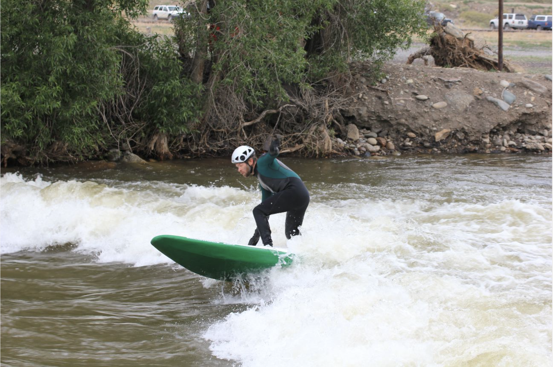
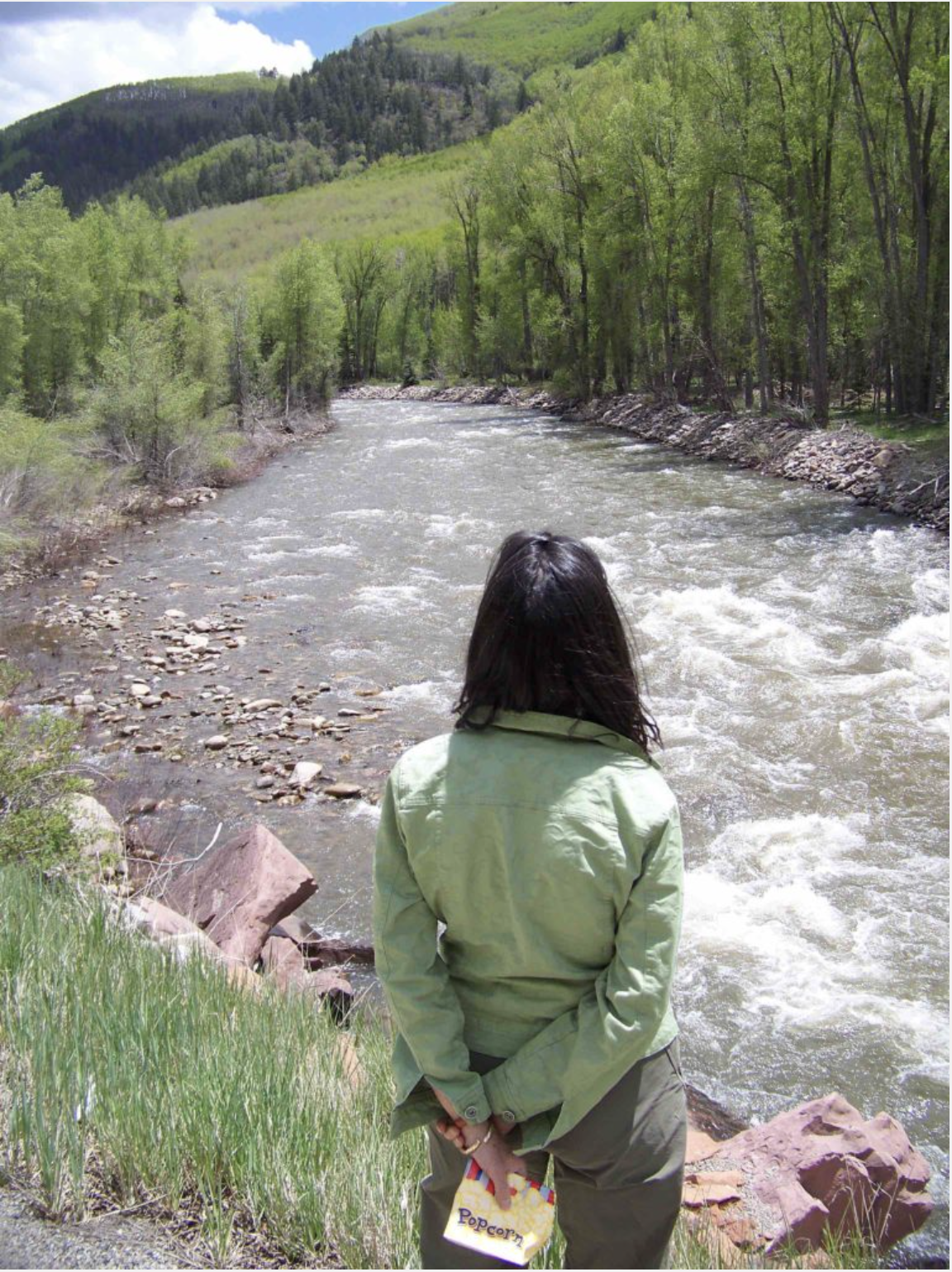
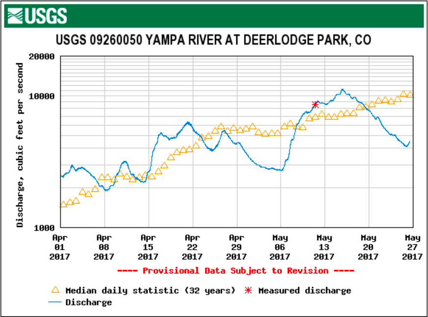


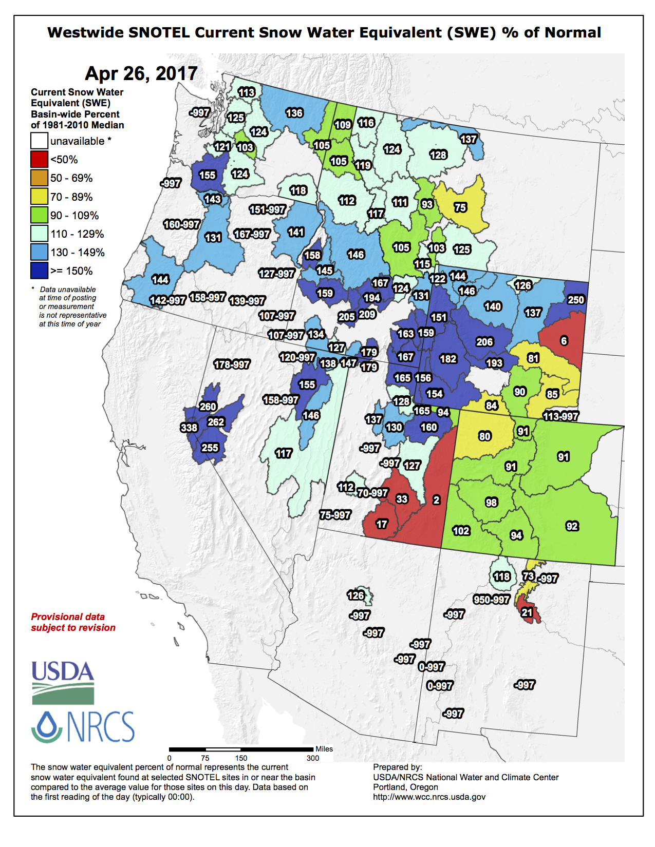

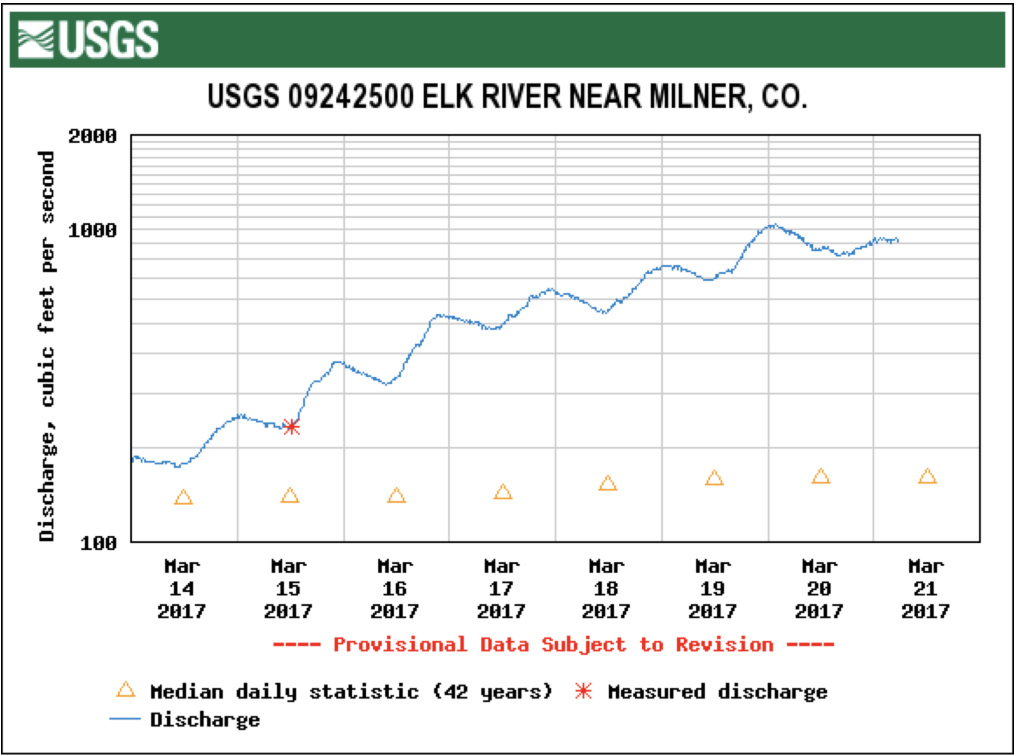


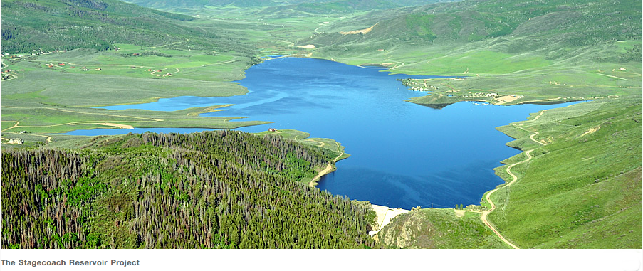
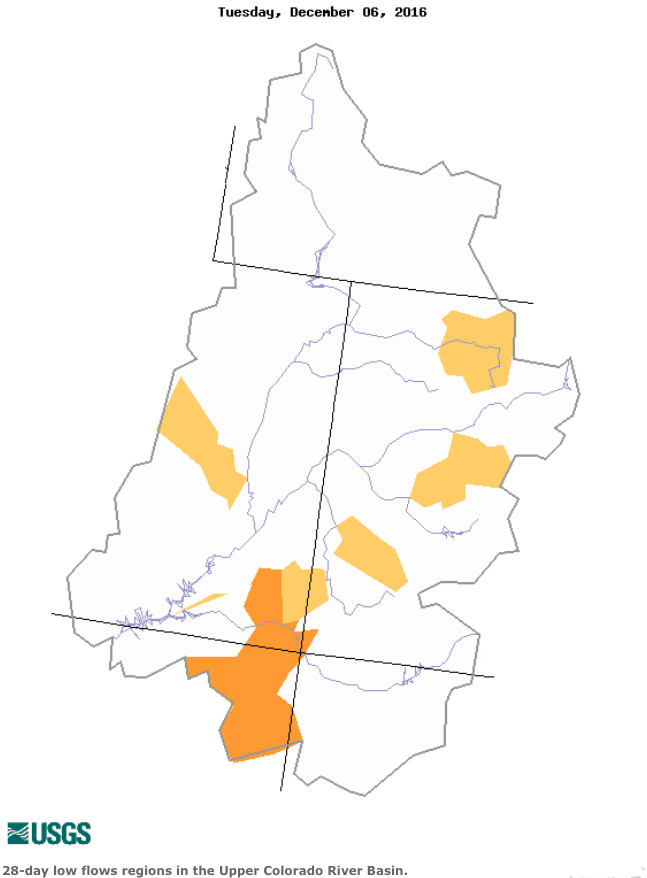

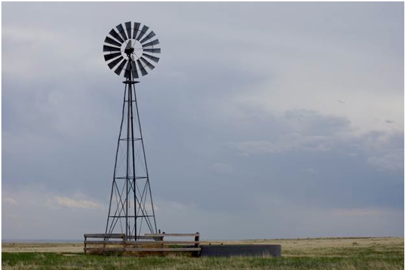


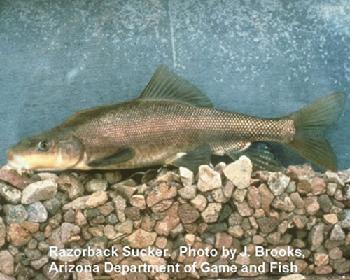
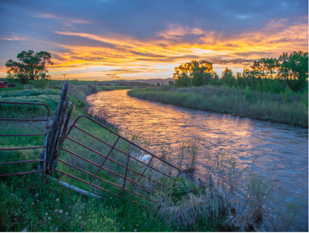

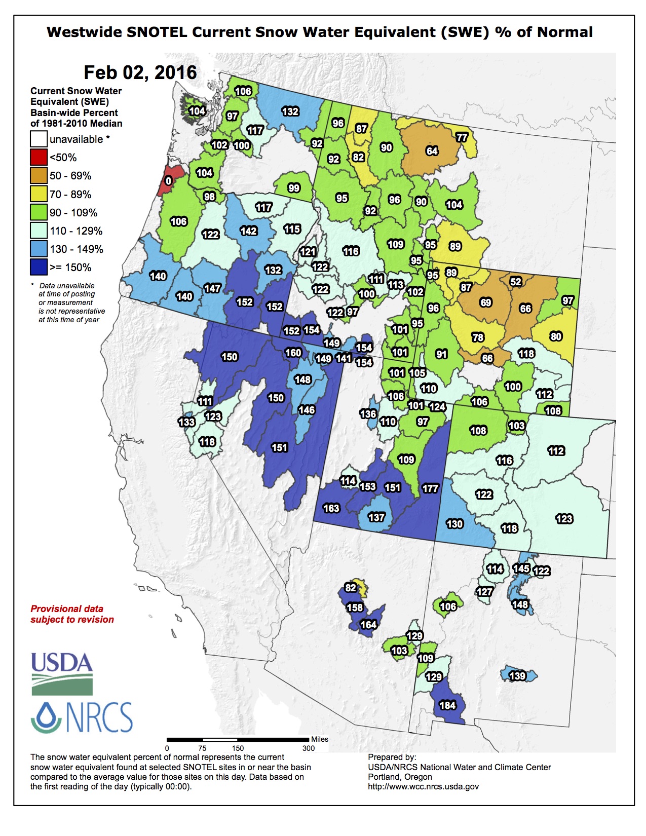


")