Utah’s high court has backed that state engineer’s decision to reject a proposal to pipe water from the Green River to Colorado’s Front Range. The project’s proponent is viewing the ruling as only a temporary setback.
“Look, the court gave us a C-minus on a couple homework issues. We’ll resolve it and get our thesis straightened up and get on down the road,” Aaron Million, founder, CEO and chair of Water Horse Resources, LLC., said Friday in an interview…
In 2018, Water Horse filed a water export application with the Utah state engineer. Million wants to divert 55,000 acre-feet a year of water from two points on the Green River south of Flaming Gorge Reservoir in Daggett County in northeastern Utah…In 2020, Utah State Engineer Teresa Wilhelmsen rejected Million’s latest proposal, in part citing uncertainty over whether it would count against Colorado’s allocation of Colorado River water or Utah’s under a 1948 compact between Upper Colorado River states. Million says it would count against Colorado’s because that’s where the water would be used. A lower court had upheld Wilhelmsen’s findings. The state’s Supreme Court ruled in part that before the state engineer can grant Water Horse an export appropriation, the company must show the appropriation will be beneficially used in Colorado. Million indicated in comments to the Sentinel on Friday that meeting the beneficial use requirement won’t be a problem. He said the court in its ruling was helpful in showing that the state’s water export statute has a low bar for exports to be allowed. In upholding the Utah state engineer’s determination, both the lower court and Utah Supreme Court noted that Water Horse hasn’t filed any application in Colorado for approval of its water appropriation or project and hasn’t asked the state of Colorado or Upper Colorado River Commission to have the appropriation counted against Colorado’s Upper Colorado River Compact allocation…Water Horse had argued that the Upper Colorado River Compact required the Utah state engineer to approve its application even as the state export statute required it to be rejected, and that the compact pre-empts the state law. But the state Supreme Court disagreed that they were in conflict. Million voiced confidence that Water Horse will be starting construction on the project “in the near term” and the ruling won’t affect that.
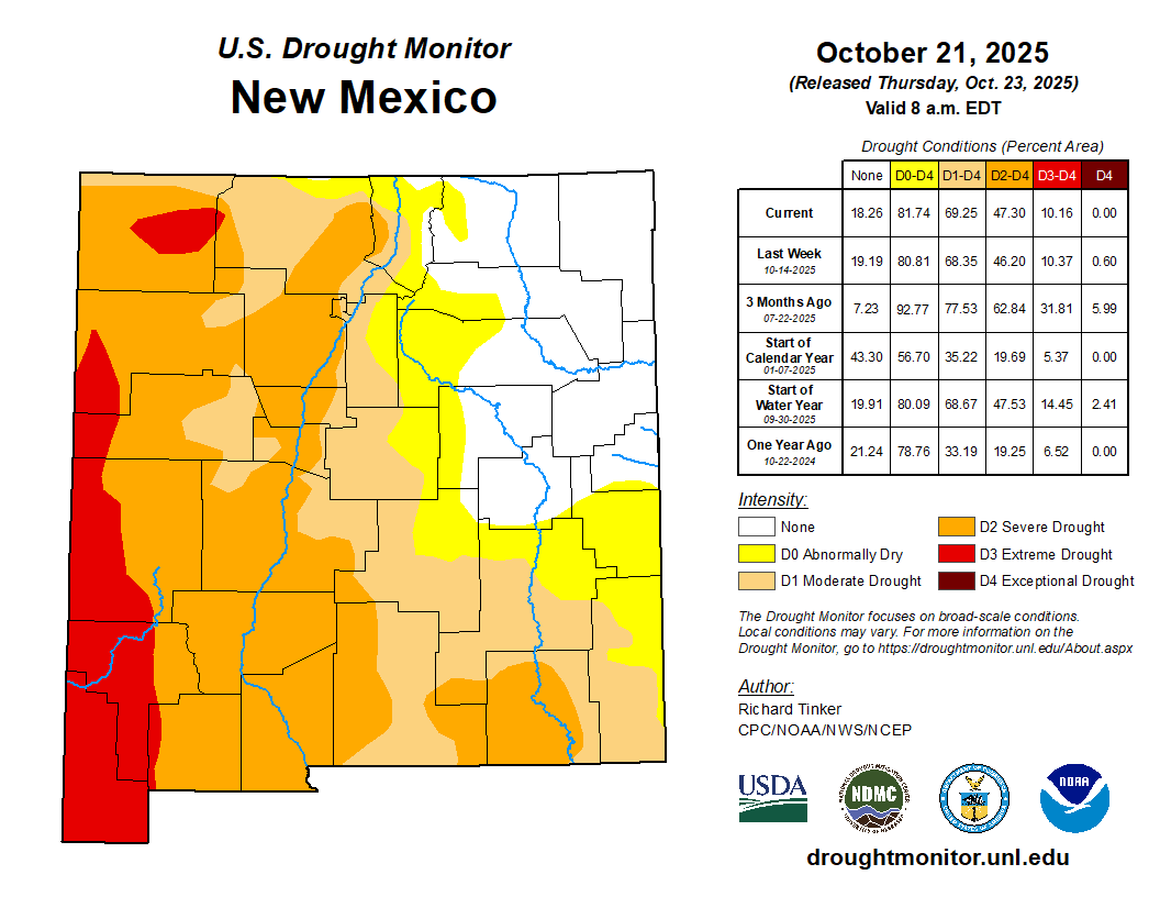
What would it take to get New Mexico out of megadrought? The short answer: water. The longer answer: multiple years of heavy winter snows. The Southwestern U.S. — including New Mexico — has faced a steady drought for a quarter century, improving and degrading as seasonal moisture comes and goes. The short-term drought in the state is now relatively mild, thanks to a rainy summer monsoon, but the longer-term conditions paint a different picture — one that’s harder to fix, said Andrew Mangham, a senior service hydrologist with the National Weather Service in Albuquerque.
“A really good, aggressively wet monsoon season — just one — can wipe out drought effects in terms of the short term,” Mangham said. “This can improve fine fuels, by which I mean grasses and shrubs; those can be quite healthy. Surface soils can be fairly wet. But that doesn’t necessarily mean that it’s going to fill up the reservoirs.”
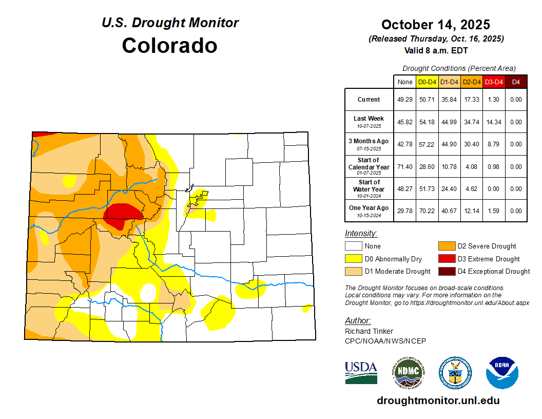
Drought is measured through multiple sectors: hydrological, referring to reservoir and river levels; agricultural, referring to how drought impacts crops; and ecological, referring to forest health. The U.S. Drought Monitor tracks the short-term drought across the state, categorizing it from “abnormally dry” to “exceptional” in intensity. A swath of northeastern New Mexico is not currently experiencing drought, but the rest of the state is facing at least abnormally dry conditions, according to the monitor’s most recent data; the drought is worst in southwestern New Mexico, as it has been for months…Around the time the reservoir storage levels dropped, the Southwest entered what scientists call a megadrought, now in its 25th year. This is believed to be the worst megadrought of the past 1,200 years, and recent research from the University of Texas at Austin indicates it could continue at least through the end of the century. New Mexico’s long-term drought wholly improving would require heavy wintertime snows in the northern part of the state and in southern Colorado, Mangham said, as that’s the source of much of the water that ends up “recharging” the state’s rivers and reservoirs…Snowpack is more helpful for drought than the spotty, hard-hitting storms of the summer monsoon, Mangham said. This is because snow is typically slower-moving than rain — and too much rain at once leaves only a little soaking into the soil.
New Mexico Lakes, Rivers and Water Resources via Geology.com.
USDA forecasts the largest U.S. corn planting, by acreage, since the Great Depression, and record production.
At the same time, the EIA notes that U.S. ethanol exports are at a record high, pushing ethanol production higher even as domestic consumption is flat.
Salt water continues to move up the Mississippi River.
EPA intends to approve a carbon sequestration permit for a company operating in eastern Indiana.
And lastly, a Senate committee advances a bill on water research and forecasting.
“Recent weather events across the country have highlighted the need for advanced water prediction.” – Excerpt from a Senate committee report on a bill that would expand the responsibility of the National Water Center, a federal program that uses computer modeling to forecast river flows and levels. “These models are crucial for predicting and managing water-related hazards and enabling timely and informed decision-making by emergency managers and water resource planners,” the Commerce, Science, and Transportation Committee noted. It voted to send the Water Research Optimization Act to the full Senate.
By the Numbers
River Mile 56: Estimated location, as of October 24, of the saltwater “wedge” pushing up a weakened Mississippi River. The Army Corps of Engineers just completed an underwater dam at river mile 64, in southern Louisiana, to impede the salty water’s upstream movement. Because it is denser than fresh water, the salt wedge moves along the river bottom. The wedge travels upstream when the river is weakened by drought. Two weeks ago the wedge was at mile 53.
News Briefs
Carbon Sequestration Permit The EPA says it intends to issue a permit to One Carbon Partnership that would allow the company to inject carbon dioxide deep underground at a site in eastern Indiana.
Indiana and other midwestern states are centerpieces in a regional expansion of carbon dioxide pipelines and underground storage.
This carbon sequestration project would be located in Randolph County and store carbon generated by the Cardinal Ethanol production facility. One Carbon, a joint venture between Cardinal Ethanol and Vault44.01, a carbon-capture specialist, will be required to monitor the Class VI injection well so that the carbon does not pollute aquifers used as drinking water.
The injection zone is between 3,100 and 3,659 feet deep.
The EPA is taking public comments on its proposed permit approval through December 8. Submit them here.
Studies and Reports
Rising Ethanol Production The Energy Information Administration reports that U.S. ethanol production has exceeded its pre-pandemic peak. Rising output is not due to domestic consumption, which is flat.
Exports instead are fueling the industry.
At the same time, U.S. corn production, a main input for the ethanol industry and a major source of groundwater demand in the High Plains, is breaking new ground.
The U.S. Department of Agriculture forecasts that corn plantings, by acreage, in 2025-26 will be the largest since the Great Depression. Production is expected to be around 16.8 billion bushels, which would be roughly equal to this year’s record output.
The two trend lines point to ethanol production remaining “near record highs” in 2026, according to the EIA forecast.
On the Radar
Carbon Sequestration Hearing The EPA will hold a public meeting on December 4 in Winchester, Indiana, to take comments on the proposed carbon injection project.
The meeting is from 5:30 p.m. to 9:00 p.m. at Winchester Community High School Commons.
Federal Water Tap is a weekly digest spotting trends in U.S. government water policy. To get more water news, follow Circle of Blue on Twitter and sign up for our newsletter.
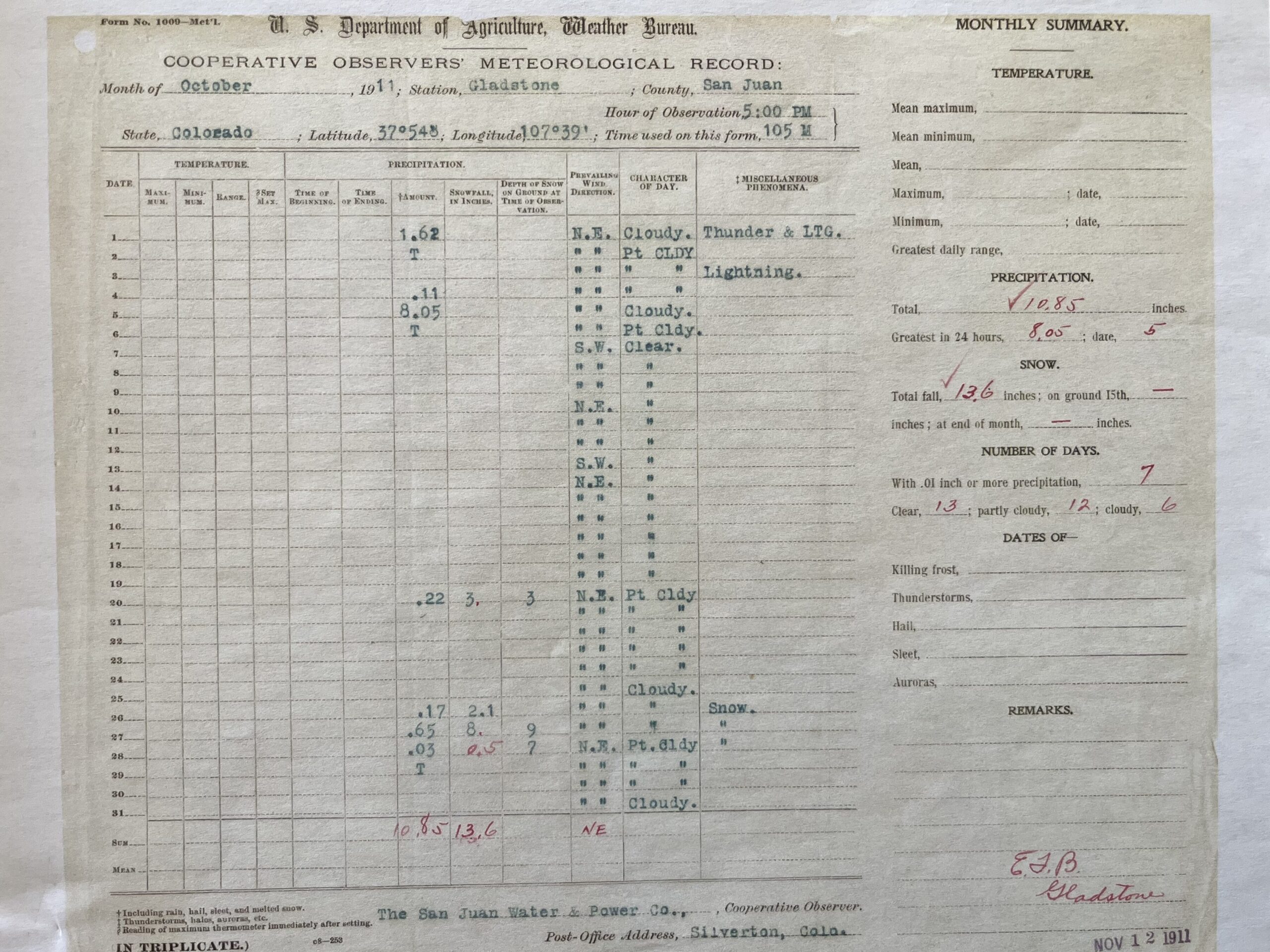
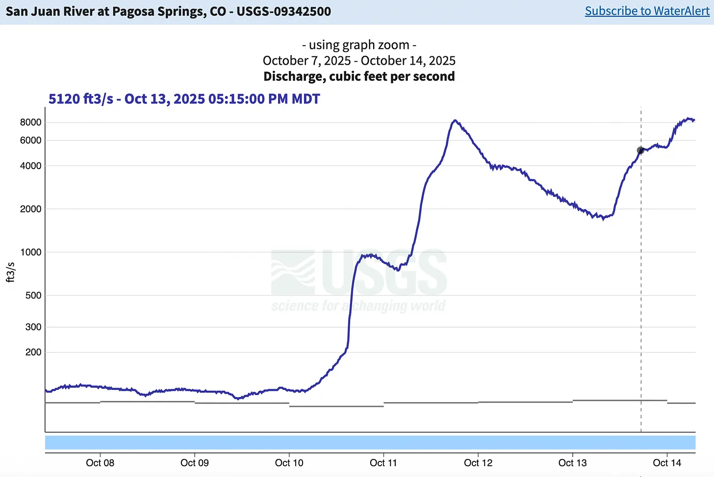
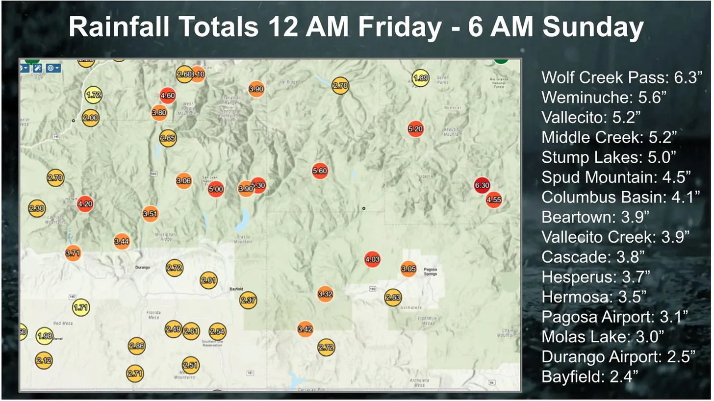
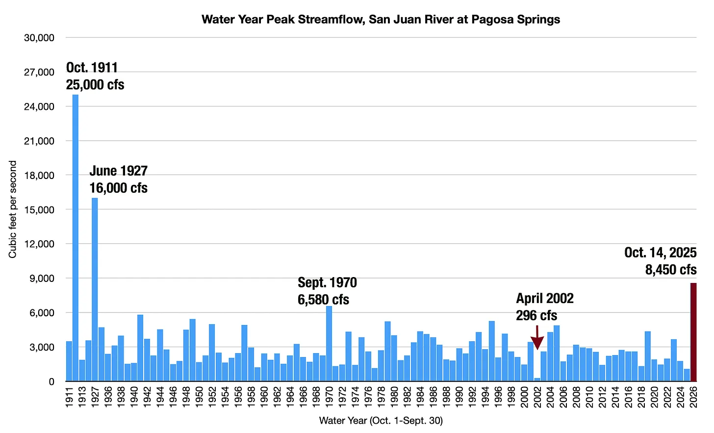
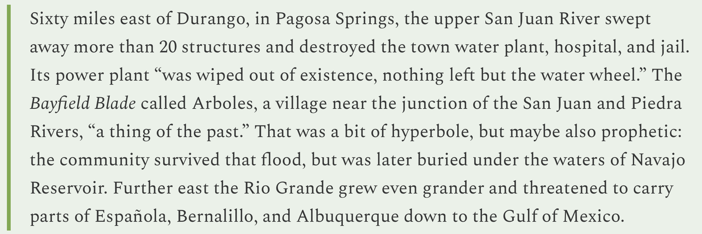
Assessments and discussions have followed the historic floods that took place on Oct. 11 and 14, with several governmental entities continuing to work to determine the extent of the damage caused by the floods and their effects on the area. Pagosa Country experienced two historic floods in four days thanks to moisture from the remnants of a pair of tropical storms, Priscilla and Raymond. The flooding for the San Juan River at Pagosa Springs peaked at 8,270 cubic feet per second (cfs) and 12.66 feet at 6 p.m. on Oct. 11 and again at 8,560 cfs and 12.82 feet at 5:15 a.m. on Oct. 14, putting the two events as the fourth and third highest on record, behind floods in October 1911 and June 1927. Other area river levels were also significantly impacted, including the Piedra and Blanco rivers.
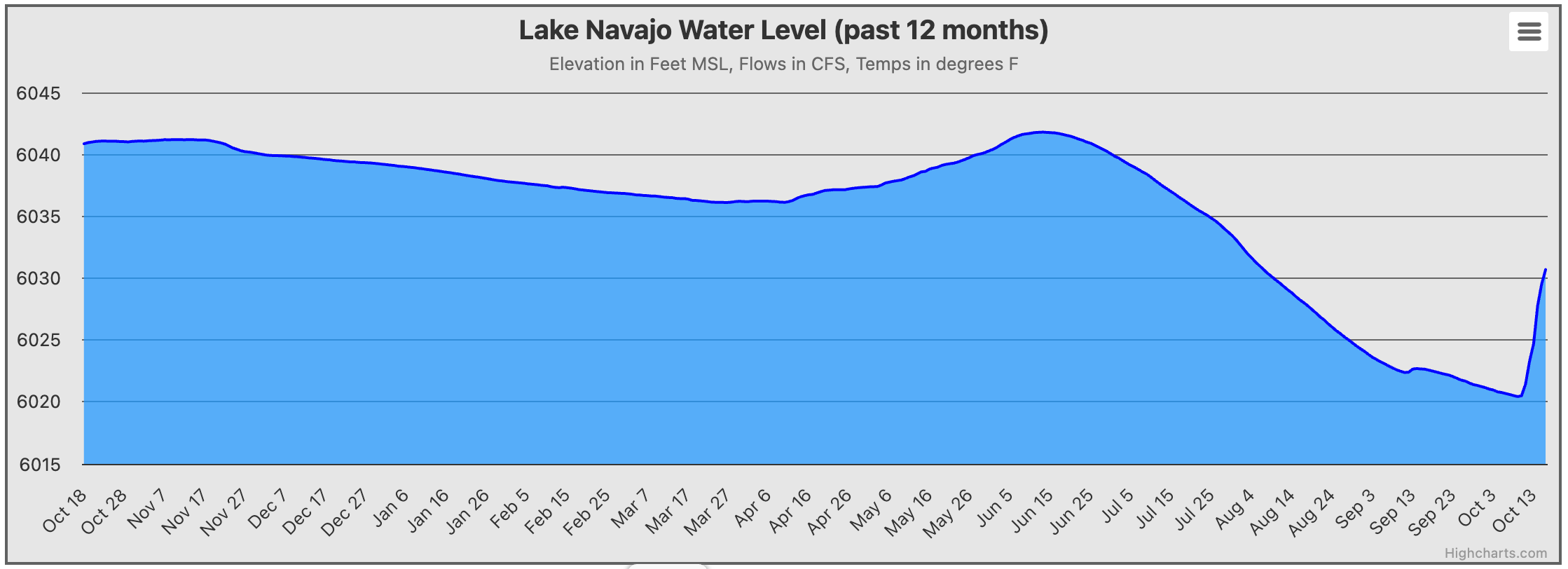
Area river levels have continued to decline since Oct. 14, with the San Juan River at Pagosa Springs running at 537 cfs and 5.52 feet as of noon on Wednesday, Oct. 22. That compares to a median of 88.00 cfs for the same date and a mean of 143.67 cfs. The increased moisture has also led to a significant increase in the level of Navajo Lake Reservoir. On Oct. 9, Navajo was at 6,020.44 feet elevation. By Oct. 21, that had increased by 12.10 feet to 6,032.54, according to the Lake Navajo Water Database. It remains 52.46 feet below full pool, or 6,085 feet elevation. It remains down 8.51 feet from a year prior. The database shows that total inflows for water year 2026, which began on Oct. 1, are at 421.49 percent of the average, and the rivers feeding Navajo are running at 147.04 percent of average.
Colorado Drought Monitor map October 21, 2025.
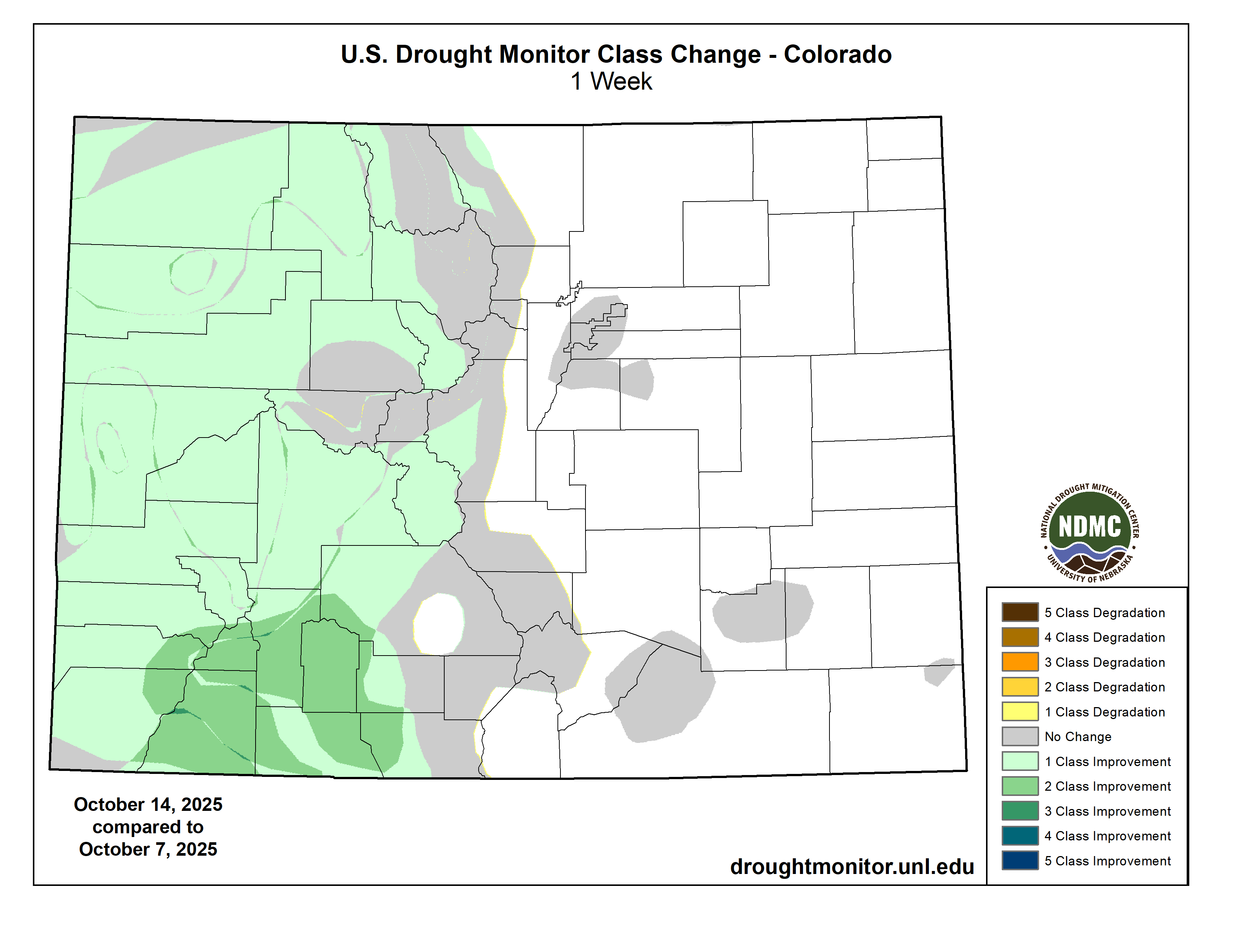
The storms also helped area drought. As of Oct. 14, the last update available by the U.S. Drought Monitor, 65.53 percent of the county was abnormally dry or above, with 3.71 percent of the county falling into moderate drought. A week, prior, 100 percent of the county was in moderate drought or above, with 30.18 percent being in severe drought or above, with 0.31 percent of that being in extreme drought…
On Oct. 21, Town Manager David Harris updated the Pagosa Springs Town Council on the damages to town infrastructure caused by the recent flooding along the San Juan River, with an early “thumbnail sketch” assessment showing around $9 million worth of damages. The major costs are associated with debris removal, riverbank stabilization, inflow and infiltration of unwanted water into the sewer system, 10th Street culvert replacement, sewer line replacement on the 1st Street bridge after the line was damaged by debris, and damages to a river restoration project that the town invested in some years ago, he explained…[Riley Frazee] noted total damages in the county based off of initial assessments is around $13 million. Of that $13 million, about $8.125 million is from the Town of Pagosa Springs and about $4 million is from damage to public roadways in Archuleta County. Archuleta County Sheriff Mike Le Roux noted that there are still about 200 miles of secondary roadways to be assessed. During the Oct. 18 tour with Bennet, Le Roux noted about 30 miles of primary county roads require “total reconstruction” and about 60 miles require significant patching and repair. Frazee also mentioned that the San Juan River Village Metro District sustained sewer system and roadway damage of about $2 million, which also qualify as infrastructure.
The Colorado Cattlemen’s Agricultural Land Trust brokered a new 2,348-acre conservation easement with the Snyder family on Fish & Cross Ranch west of Yampa.
CCALT/Courtesy photo
The Colorado Cattlemen’s Agricultural Land Trust has completed a new 2,348-acre conservation easement with the Snyder family on Fish & Cross Ranch, a working cattle ranch located at the base of the Little Flattops west of Yampa.
The ranch is in an area known as “The Gateway to the Flat Tops” where landscape-level conservation investments through the Routt County Purchase of Development Rights program have created a “stronghold of interconnected agricultural lands and habitat corridors,” according to a land trust media release.
This new conservation easement adds to Routt County’s commitment to conserve working landscape and allows the family owners to continue taking care of the agricultural lands and wildlife habitat. In exchange for county funds, the landowner grants a perpetual conservation easement, or deed restriction, on the property, protecting the land from development.
Ownership of the property remains vested with the landowner, who can use and manage the property consistent with the terms of the conservation easement.
“Their commitment to agricultural conservation will carry on to future generations of their family and continue to support the rural economy in South Routt County,” CCALT Conservation Manager Monica Shields said.
“As was evident this summer, agricultural lands not only provide important wildlife habitat and scenic views, but the hay meadows and wetlands act as critical wildfire breaks during times of drought. The Fish and Cross Ranch, nestled up against the Flat Tops Wilderness area, serves all these critical community functions,” added Shields.
Routt County Commissioner Tim Redmond noted the “property links together U.S. Forest Service, BLM and state lands, as well as existing conservation easements, to form a pristine tract that protects views and critical wildlife corridors.”
Lands within the easement include sagebrush rangelands, aspen woodlands and irrigated pastures with senior water rights along Watson Creek tied to those lands through the conservation easement. The property is utilized as part of a larger cattle and hay operation operated by the Snyders as well as natural habitat. Allen Snyder and his family purchased the ranch in 2006, and four generations currently live and work on the ranch.
“We would like to thank everyone who helped make this easement possible, from the PDR board and county commissioners to the CCALT team and Natural Resources Conservation Service,” said Tyler Snyder. “We are very blessed to be able to take a step forward in continuing to pass down the generational legacy of ranching in the Yampa Valley to generations to come.”
Since the initiation of the program in 1997, Routt County has helped fund the purchase of conservation easements on 68,535 acres for approximately $32 million. Funding for the program comes from a 1.5 mill levy in county property tax approved by voters through 2035.
The Colorado Cattlemen’s Agricultural Land Trust brokered a new 120-acre conservation easement with landowner Susan Larson on Wild Goose Ranch south of Steamboat Springs. CCALT/Courtesy photo
In addition, earlier in October the land trust and the county program worked with landowner Susan Larson to conserve 120 acres of Wild Goose Ranch south of Steamboat Springs.
The easement secures irrigated hay meadows and riparian habitat and fulfills the conservation vision of Susan and her late husband, Jim Larson. The Wild Goose Ranch is comprised primarily of irrigated hay meadows with 92% of the easement area in active hay production.
“Since our arrival in the Yampa Valley full time, our family has always felt a duty to protect the land and the water, especially here in the South Valley,” Larson said. “We have felt even more strongly about this responsibility with all the growth that has occurred in the last several years all over Colorado and notably here in Routt County.”
This protection safeguards valuable wildlife habitat for elk, mule deer, moose, black bear and species of special concern such as the Columbian sharp-tailed grouse and greater sandhill crane, while also securing scenic views along Colorado Highway 131 and U.S. Highway 40, according to a media release.
Routt County Commissioner Sonja Macys noted, “Nestled in the highly scenic South Valley floor corridor, the ranch is a vital part of the iconic landscape of working agriculture and conserved lands that residents and visitors alike enjoy when descending Rabbit Ears Pass.”
The land trust has conserved more than 820,000 acres of farmland, ranchland, wildlife habitat and open space across Colorado, including more than 83,000 acres in Routt County.
From email from the Kansas Department of Water Resources (Kevin Salter):
October 23, 2025
The 2025 ARCA Annual Meeting will be held on Tuesday, December 9, 2025 at:
Historic Cow Palace Inn, 1301 N Main St, Lamar, CO 81052
Meetings of ARCA are operated in compliance with the federal Americans with Disabilities Act. The meeting room is on the second floor with no elevator access, if you will need accommodations to attend this meeting please contact Stephanie Gonzales at (719) 688-0799.
The ARCA committee meetings will be held on Monday, December 8, 2025 at this same location. Draft agendas for the ARCA Annual and committee meetings will be provided in advance of these meetings.
For those needing lodging at the Historic Cow Palace Inn, there has been a block of rooms reserved for $100 per night (plus taxes); just mention “ARCA” when making reservations. The hotel phone number is (719) 691-6167 and their website is https://www.historiccowpalaceinn.com/.
Click the link to read the article on the Big Pivots website (Allen Best):
October 23, 2025
It’s another one of those good news, bad news stories.
First, the bad news. The federal government withdrew its tax credits of up to $7,500 for purchase or lease of a new EV (and $4,000 for a used EV). Congress made that decision in early July, as part of the One Big Beautiful Act. The deadline was Oct. 1.
The good news is that the deadline spurred Coloradans to set a new record for purchases of EVs. From July through September, 32.4% of new vehicle sales in Colorado were EVs or plug-in hybrids. Colorado led the nation, slight ahead of California.
Colorado now has surpassed 210,000 EV registrations. To put that into perspective, then-Gov. John Hickenlooper in 2018 declared a goal of 940,000 registered EVs in Colorado by 2030.
The state has a long way to go. But it does have momentum.
This chart from the Colorado Automobile Dealers Association shows how the sales of EVs and plug-in hybrids has grown during the last five years in Colorado. Sales of EVs dropped in the first six months of this year but leaped to a record in response to the imminent federal deadline.
In a statement issued by his office, Gov. Jared Polis heralded the sales. “Coloradans and the free market are saying loud and clear that affordable, clean and efficient electric vehicles are here to stay,” he said. Those electric cars, he said, save money while improving air quality.
First road charge for Coyote Gulch’s Leaf in Granby May 19, 2023. Note the Colorado Energy Office’s logo below the connectors on the unused charger.
We hear less about range anxiety. We still don’t have high-speed charging stations to match the “filling stations” created in the 20th century. However, the state as of early October, had 1,487 high-speed charging ports at 458 locations around Colorado. They can be found from Cortez to Holyoke, and from Dinosaur to Lamar.
And the number of EVs is, in some places, reaching a tipping point.
Travis Madsen, transportation manager for the Southwest Energy Efficiency Project, reports a trip to New Mexico recently along Interstate 25. At Pueblo, he stopped to recharge. For the first time ever anywhere in his experience, he had to wait. All the ports were busy.
Madsen also had good news. From July through September, a record 167 new fast-charging ports were installed in Colorado.
Will this momentum continue?
Madsen doesn’t expect sales to remain above 30% during the next few quarters. He does hope that public awareness has grown about the value of EVs regardless of federal tax credits. EVs still generally cost more, but they require less maintenance and can be fueled far more cheaply, especially at home. Department of Energy data show that current EVs are 2.6 to 4.8 times more efficient at traveling a mile compared to a gasoline internal combustion engine, according to the Natural Resources Defense Council.
To help maintain momentum, the state on Nov. 3 will raise Vehicle Exchange Colorado rebates from the existing $6,000 to $9,000 for new EV purchases and leases. For used EV purchases and leases, the prices will rise from $4,000 to $6,000. The program aims to enable income-qualified Coloradans to access EVs. Maybe that will include writers.
The power of Artificial Intelligence (AI) to improve the accuracy, accessibility and reach of weather forecasts and early warnings has been recognized by the World Meteorological Organization, which will seek to ensure that all countries can benefit from its life-saving potential.
Key messages
AI can accelerate Early Warnings for All
Forecasts and warnings save millions of lives and billions of dollars
AI will compliment – not replace – traditional forecasting tools
WMO science for action supports the global economy
Credit: WMO / Melissa Debray
An Extraordinary World Meteorological Congress issued a call to the public, private and academic sectors to collaborate on the development of AI and machine learning (ML) technologies to protect communities and economies from hazards like extreme heat and rainfall. It also paved the way for AI/ML to be anchored in WMO’s global observation, data processing and forecasting backbone.
The resolutions were part of a wider package of measures approved by the Extraordinary Congress to accelerate progress towards WMO’s top overriding priority – to ensure universal coverage of early warning systems through the achievement of Early Warnings for All by the end of 2027.
“Early warnings are not an abstraction. They give farmers the power to protect their crops and livestock. Enable families to evacuate safely. And protect entire communities from devastation,” UN Secretary-General António Guterres told the Extraordinary Congress on 22 October in a ceremony which was one of the highlights of WMO’s 75th anniversary activities.
“We know that disaster-related mortality is at least six times lower in countries with good early-warning systems in place. And just 24 hours’ notice before a hazardous event can reduce damage by up to 30 per cent. Early-warning systems work. And they’re finally getting the attention – and investment – they deserve,” said the UN Secretary-General.
Mr. Guterres launched Early Warnings for All in 2022 with the goal of ensuring universal coverage by the end of 2027.
“The visit of the United Nations Secretary-General, the participation of presidents and ministers and the global attention they attracted is a reminder that what we do matters. Now we must build on this momentum. This is the moment to turn visibility into impact. To translate recognition into investment. To make sure that our transformation continues — that WMO remains not only relevant, but more essential than ever,” she said.
Global forecasting backbone
Congress approved a new set of technical regulations concerning early warning services, providing a clear reference and ensuring that the authoritative and trusted role of National Meteorological and Hydrological Services in issuing reliable and accurate warnings are supported and enshrined in national legislation
It issued a “call to all stakeholders” to collaborate on the development of AI/ML environmental monitoring and prediction technologies, tools and applications, noting the “unprecedented pace of progress” and the “transformative potential” to achieve Early Warnings for All.
The resolution builds on decisions by the WMO Executive Council in June 2025. It reaffirms WMO’s mission to facilitate international cooperation and standardization, building on decades of trust and data collection. AI must complement, not replace, existing well-honed scientific forecasting methods and infrastructure.
It emphasizes open data, open-source tools, and FAIR principles to foster transparency and global participation. It calls for ethical frameworks which establish principles for cooperation, intellectual property, and responsible AI use.
Congress also approved a resolution to integrate AI into the global forecasting infrastructure.
Acknowledging the significant disparity in forecasting capabilities among WMO Members, Congress stressed the need to support National Meteorological and Hydrological Services (NMHSs) globally, especially those in low- and middle-income countries, LDCs, and SIDS, to access and utilize new AI technology.
Due to rapidly evolving AI/ML technologies, Congress agreed to develop a new WIPPS strategy incorporating AI. The WMO Integrated Processing and Prediction System (WIPPS) is a worldwide network of operational centres that makes scientific and technological advances accessible and exploitable by Members, providing products related to weather, climate, water, and the environment.
While AI offers transformative potential for operational forecasting and warnings, the resolution recognizes that considerable challenges remain in AI systems’ capability to support forecasts of local high-impact weather systems and hydrological processes. These challenges must be addressed, tested, and demonstrated for operational use.
To ensure all Members benefit, the resolution requested WMO bodies enhance capacity development on AI use under WIPPS for low- and middle-income countries, LDCs, and SIDS. Furthermore, WIPPS pilot projects are essential to explore and deliver new prediction products, demonstrating AI’s potential to enhance developing countries’ capabilities.
An ongoing pilot project between the meteorological services of Norway and Malawi, which demonstrate an AI weather prediction and the concept of Forecasts-in-a-Box, was presented to Congress. It has showed improvements in forecasts – and is being closely watched as a model for other countries with resource constraints.
In other action, Extraordinary Congress:
Advanced the goals of the Global Greenhouse Gas Watch by integrating key components into existing programmes, including the expanded World Weather Watch and the Global Atmosphere Watch Programmes.
Approved WMO’s first Youth Action Plan, marking a structured approach to integrating youth perspectives into its work and empowering the next generation of leaders. This is a landmark step in nurturing young meteorologists, hydrologists and climate and ocean scientists, marking a new era of shared inter-generational responsibility and expertise in weather, water, and climate action.
Streamlined procedures on elections and appointment of the WMO Secretary-General.
Endorsed the WMO Secretary-General’s restructuring of WMO, responding to evolving global challenges, the need for a more integrated Earth system services and increasing financial constraints.
Requested the WMO Executive Council to set up a task force to develop recommendations for modification to the strategic and operating plans for 2026/2027 as a result of the ongoing liquidity challenges of WMO.
Executive Council
WMO’s Executive Council met on 24 October immediately following Extraordinary Congress. It confirmed a total budget of 138.7 million for the biennium 2026/2027. It agreed to the terms of reference and composition of the new task force which will identify proposals for realignment of WMO’s Strategic and Operating Plans during the 2026–2027 biennium, given the ongoing financial uncertainty. Science for Action
The Extraordinary Congress was held as WMO celebrates its 75th anniversary, with the theme of Science for Action.
WMO’s work underpins resilient development, food, transport, energy, security, health, water management and disaster risk reduction.
It is essential to the global economy and society and can leverage potential to unlock even more benefits for the global good.
Credit: WMO / Fabian Rubiolo
Science for Action
The Extraordinary Congress was held as WMO celebrates its 75th anniversary, with the theme of Science for Action.
WMO’s work underpins resilient development, food, transport, energy, security, health, water management and disaster risk reduction.
It is essential to the global economy and society and can leverage potential to unlock even more benefits for the global good.
Click the link to read the article on the InkStain website (John Fleck):
October 11, 2025
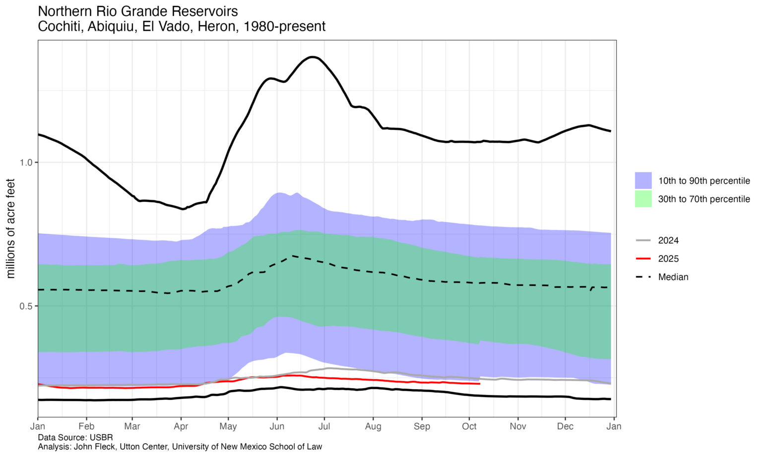
Total flow to date on the Rio Grande at Otowi is the lowest since 1964.
Otowi is the place where the river leaves the upper valleys and enters the canyons that lie at the head of the valley of Albuquerque, what we in New Mexico call the “Middle Rio Grande.”
The graph shows total flow to date this year, with previous drier years called out in red. You can see that the “drought of the ’50s,” (which really extended well into the 1960s) was the big impact decadal-scale event here, not the ’30s, Dust Bowl.
If you squint, you also can see the subtle impact of the San Juan-Chama Project, which beginning in the 1970s began importing Colorado River water. I’m measuring total flow with this calculation, not what is formally called the “Otowi Index Flow,” the official measure of native water used for Rio Grande Compact accounting. This is the number that matters the most to me – it’s the total amount of water we have to work with here in the Middle Rio Grande, the actual flow of water into the valley each year. You can see a subtle impact of that SJC water, raising up the floor in dry years. At least I think I can see that.
A Note on Method
I am not a computer programmer, or software engineer, or whatever you call that thing. But I’ve been writing computer code since I was a teenager in Upland, California, writing Fortran on punch cards that we would send to the guy who ran the school district mainframe to run in the middle of the night. (Southern California’s Mediterranean climate meant we did not have to trudge miles to school barefoot in the snow, but we did write code on punch cards.)
I’ve done it because it’s fun (I did a stint as a free software volunteer on the GNOME project 20-plus years ago), as a toolkit for analyzing data in my haphazard career as a “data journalist,” and in early days of newspaper Internet work, when we rolled our own web site code in Perl. I am a terrible coder, but with some help (site:stackexchange.com “cryptic error message”) I know enough to make my way around the data I have questions about. I was the guy at the newspaper who “borrowed” Lotus 1-2-3 from a friend to analyze city budgets, and persuaded the IT folks to put “R” on my desktop computer against their better judgment. But it’s laborious stuff because of the gap between my subject matter expertise and my coding skills. As a result, there were things I didn’t bother with.
Luis Villa, a friend from my GNOME days who went on to become a lawyer and big think person about “open” and the commons, posed a question on his blog last month about the gateway language model coding tools provide into open data. The provocative header to the section of the post was “Accessibility & Democratization”:
“Vibecoding” is a technique by which you tell a language model in plain language what you want your code to do. It writes it. You run it. It chokes, you paste in the error message and say “Fix this.” After a couple of iterations, it works. This is both dangerous and liberating. For me, it opens up vast areas of open data for analysis that I never would have bothered with because of the agony of pasting error messages into a search engine trying to find someone on Stackexchange who had the same problem, running their code, getting a new error message, turtles all the way down. I know the questions and the analytical structures I need, but turning those ideas into code was a pain in the ass!
In the case of the graph above, I had some old code I had written that downloaded USGS streamflow data, converted cubic feet per second (a rate) to acre feet over a specified time period (a volume), compared flow to date this year to flow to the same date in previous years, and made a graph.
This year has been super dry. I was curious about previous years that had been this dry. Updating the code to color those with lower flow than this year’s red was conceptually trivial, but would have been tedious and time consuming. Also, the old code’s visualization was ugly. Vibecoding the changes took an order of magnitude less time than writing all of that code by hand. I’m pretty sure it took longer to make the locator map in Datawrapper (which is fast!) than it did to update the code.
This would be a terrible idea, as Simon Willison argues, if my goal was to become a better programmer, or a software engineer writing production code. This is the same reason using language models to do your writing for you – if your goal is to come to understanding – is a terrible idea. The act of writing is an act of coming to understanding. For me, the knowledge work here is staring at the graph, incorporating what it is telling me into my knowledge framework, and doing the work of writing this blog post. I need to know enough to look at the code and the data it spits out to be confident that it’s sane. But I don’t care about the finicky syntax of R’s “mutate” and “ifelse.”
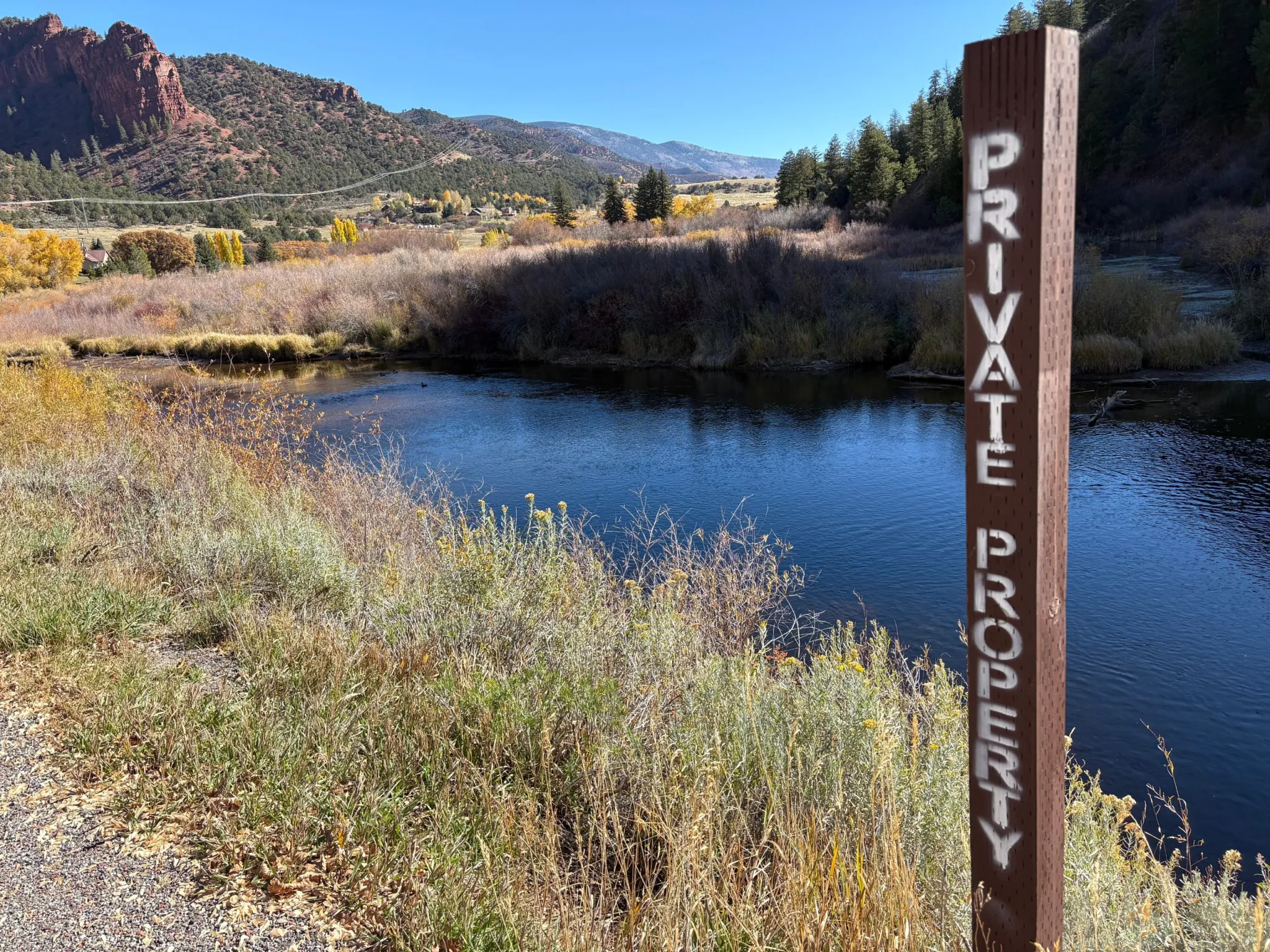
No trespassing signs line a section of the Fryingpan River flowing through private property upstream of Basalt. The Fryingpan is a popular stream for anglers, though public access is limited. CREDIT: HEATHER SACKETT/ASPEN JOURNALISM
A group of recreation advocates are hoping Colorado lawmakers will settle the state’s legal gray area surrounding public river access. The Colorado Stream Access Coalition is fighting for the public’s right to use the state’s waterways for recreation, a right they say is guaranteed in the Colorado Constitution.
“Our position is that under the Colorado Constitution, it’s always been understood that there was a public easement,” said Mark Squillace, a law professor at the University of Colorado Boulder and an expert on water and natural resources policy. “And if there’s a public easement, even though it’s private property, the public gets to use it. We would like to see legislation that basically guarantees the right to both wade and float through private property.”
Squillace was referring to a clause in the state constitution that declares all unappropriated water in every natural stream to be the property of the public and dedicated to the use of the people of the state.
Kestrel Kunz, southern Rockies protection director at American Whitewater, testified at the Water Resources Committee in August, asking legislators to guarantee public access to rivers for all Coloradans, while respecting landowners’ property rights. Kunz said American Whitewater gets regular reports of conflicts between boaters and property owners.
American Whitewater is seeking legal public protections for boating on Colorado’s rivers, to portage around hazards and to scout when needed.
“Colorado offers no clarity, no protection and no certainty for landowners or the public,” Kunz said. “That lack of clarity is dangerous.”
The issue of stream access highlights a basic tension in Colorado’s laws and values: Are rivers just another category of property that can be privately owned and fenced off? Or are they so central to the state’s culture, identity and outdoor recreation economy that they should be considered public resources open to public use?
“There are a lot of very wealthy landowners in this state that are strongly opposed to the public having any rights in what they consider to be their rivers,” Squillace said. “And we don’t believe they own the rivers. We think those are public resources that should be held in common for all the people to use.”
Paddlers float through North Star Nature Preserve on the Roaring Fork River upstream of Aspen. Some river access advocates want the state to clarify the right of boaters to touch the beds and banks of streams, and the ability to portage and scout for safety. CREDIT: HEATHER SACKETT/ASPEN JOURNALISM
The public’s right to use waterways was codified in a 19thcentury U.S. Supreme Court decision that said states own the beds of “navigable” rivers, meaning rivers that were used for commerce at the time of statehood. But Colorado does not consider any of its rivers to be navigable, meaning the streambeds belong not to the state — and therefore the public — but to adjacent property owners. A 1979 Colorado Supreme Court decision in People v. Emmert ruled on the side of property owners, saying that the public could not float through private property.
A subsequent Colorado attorney general opinion said boaters can float through private property, and as long as they don’t touch the streambed or banks, they won’t be charged with criminal trespass. But stream-access supporters say this informal policy needs to be clarified into law and should also make allowances for boater safety.
Kent Vertrees, a board member and staffer for Friends of the Yampa, said any new law should make it OK for people to get out of their boats to scout hazards and rapids, and portage around obstacles without fear of getting in legal trouble or being harassed by landowners.
“If there is a new tree that’s fallen or something that’s blocking such as a fence, I believe I can get out of the river to safely get around,” he said. “All I’m doing is portaging for this safety element. And that’s the gray area that needs to be figured out.”
Vida Dillard, president of the Roaring Fork Kayak Club, agrees. Her organization is part of the coalition supporting clarity around stream-access laws. The club, which has 53 active memberships, focuses on improving access to the sport for everyone, especially beginners. She said situations such as helping a swimmer or scouting could cause tensions with landowners, and that uncertainty disproportionately affects newcomers to kayaking.
“We teach our students to scout hazards and make really conservative choices,” she said. “And if you’re afraid you’re going to be trespassing or have a confrontation, it might make you less likely to hike out or make choices on the river that you need to make to be safe.”
Private property signs line a section of the Fryingpan River upstream of Basalt. Some advocacy groups a pushing for more public river access for anglers. CREDIT: HEATHER SACKETT/ASPEN JOURNALISM
Wading into murky waters
According to Squillace, stream access is ripe for legislation because of the case of Roger Hill, a fly fisherman on the Arkansas River, which thrust the issue into the national spotlight.
Hill had baseball-size rocks thrown at him by a property owner and later sued the state on the basis that he believed the river was navigable when Colorado became a state in 1876, and therefore the streambed he was standing on while casting his line was public. But the Colorado Supreme Court ruled in June 2023 that Hill had no legal standing in the case.
“I think it reflects the controversial nature of this issue,” Squillace said. “I think maybe the court was trying to duck the hard question of finally declaring that maybe the Arkansas River is navigable, in fact, and so should be open to public access.”
Coalition members will have to address a widening schism in their membership: those who think any new legislation should include the right of anglers, such as Hill, to wade and those who think it should remain more narrowly focused on the right to float. Some see the right to wade as an additional, expanded use and is where some landowners draw the line.
American Whitewater recently left the coalition and together with Colorado Whitewater and the American Canoe Association, is pursuing legislation that would grant just the right to float. Vertrees said the right to float and the right to wade are two separate issues that shouldn’t be lumped together.
“I personally cannot support [the right to wade] because I believe it will tank the whole thing,” he said. “I just personally believe that it’s going to be hard to do them both at once.”
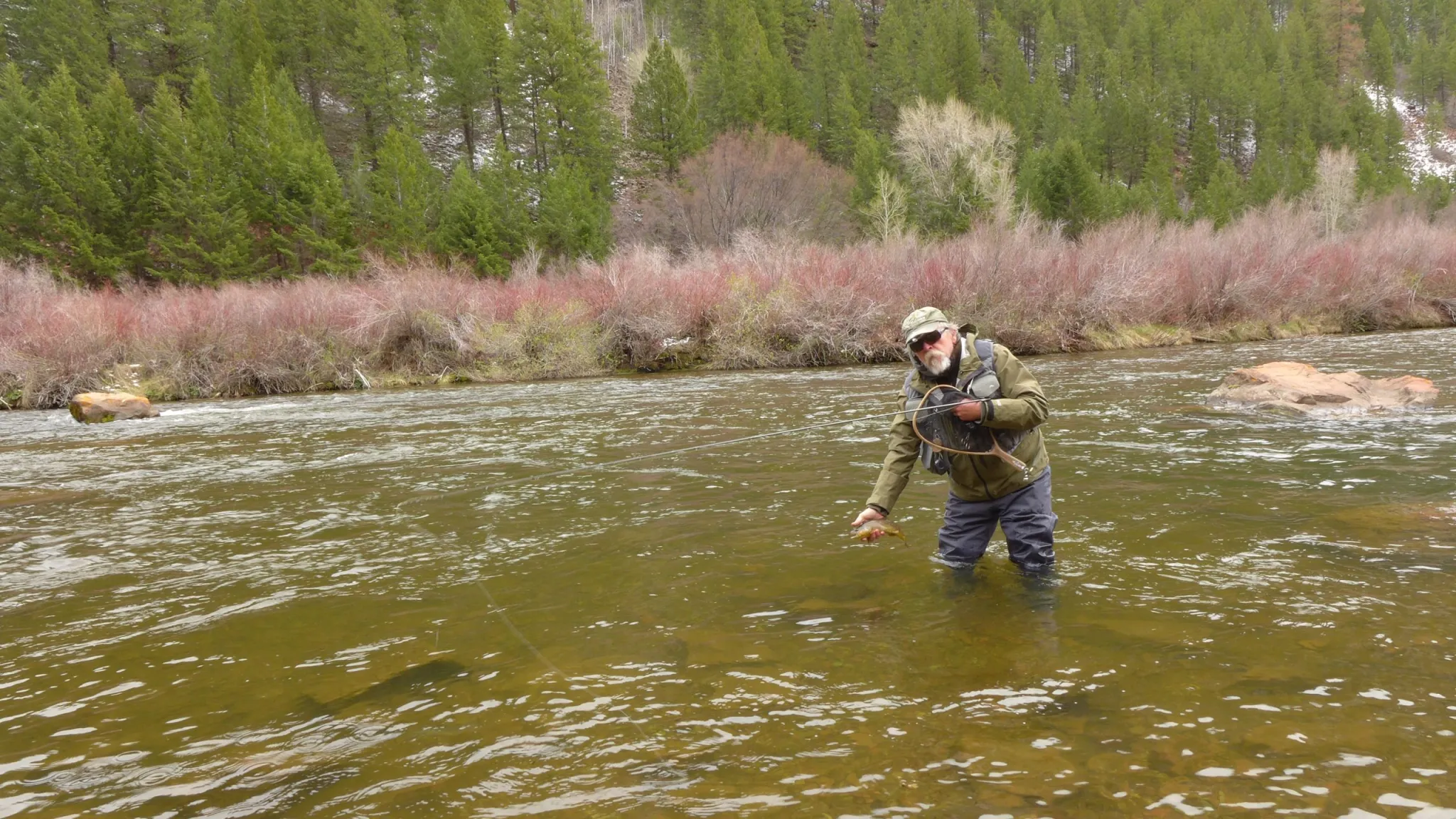
Anglers want to be able to walk up and down a streambed to fish, but only after entering the river through a public access point and not trespassing across private property to get there. This right to wade is particularly relevant to the Fryingpan River, which is a popular Gold Medal trout fishery where only about half of the river below Ruedi Reservoir is public and no trespassing signs line stretches of the waterway.
Bill Nein, of Salida, prepares to release a brown trout he caught back into the Fryingpan River. Some river access proponents want the state to clarify rules regarding public use of streambeds and banks for fishing. CREDIT: HEATHER SACKETT/ASPEN JOURNALISM
More education needed
Opponents of a law expanding access say that this is a private property issue and that landowners have the right to exclude others from their property. Garin Vorthmann testified on behalf of the Colorado Farm Bureau at the Water Resources Committee meeting in August. She said she was also working with a broad coalition of landowners, private businesses and real estate agents.
“Depriving a landowner of the right to exclude people from their private property without just compensation is considered a taking,” she told lawmakers. “Legislation that would change the ownership of the bed or bank to be public or owned by the state obligates the government to provide just compensation to the landowner and will embroil the state in expensive litigation.”
Other experts say addressing this issue through legislation might only make it worse. A report released in September by the conservative-leaning Common Sense Institute said that “the path to clarification is fraught with innumerable bad outcomes where both sides and ultimately the state of Colorado will be worse off than they are now” and that “attempts by either side to expand those rights at the expense of the other are likely to create more problems than they solve.”
Greg Walcher, former director of the Colorado Department of Natural Resources and co-author of the report, said a better approach would be a public education campaign so that boaters know exactly where they are allowed to float: through land that is already owned by the state or federal government and therefore public. The study notes the importance of rivers to Colorado’s outdoor recreation economy, and the millions that the Great Outdoors Colorado (GOCO) grant program has invested in stream access and conservation projects in recent years.
“The floating industry has become huge in Colorado, so we need to find a solution,” Walcher said. “And part of that is making sure people understand where they can and can’t float.”
Proponents of stream access agree that education is important, and to that end, Steamboat Springs-based advocacy organization and content studio Rig to Flip is releasing a short film by Cody Perry called “Common Waters,” which features the Hill case and outlines the issue as they see it: that Colorado is one of the worst states for providing public access to streams, and in a place that prides itself on an outdoor lifestyle, increased access and clarity on the rules are needed.
With proponents still hashing out differing options on what a policy proposal should call for, any new legislation for the 2026 session won’t be introduced by the Water Resources and Agricultural Review Committee, but there’s still a chance lawmakers could take it up. Coalition members say they are continuing to meet with stakeholders and figuring out the best way forward.
“At American Whitewater, we believe that people are really only going to protect the resource if they have the opportunity to explore that place and understand and experience a river,” Kunz said. “So our hope is that by allowing people to access these rivers in Colorado that we will ensure future generations of river stewards.”
The Northern Integrated Supply Project, currently estimated at $2 billion, would create two new reservoirs and a system of pipelines to capture more drinking water for 15 community water suppliers. Credit: Northern Water
Eaton and Evans recently announced they are backing away from the Northern Integrated Supply Project, or NISP, due to rising costs.
The news comes months after Fort Collins-Loveland Water District, NISP’s largest participant, announced its hopes to sell its 20% share in the project.
Despite some growing reluctance, Northern Water plans to move forward with the full project.
Over the years, the project has grown in both scope and price. As NISP’s once conceptual designs met reality, the scale of its reservoirs, pipelines and pump stations increased and the relocation of U.S. Highway 287 to accommodate Glade Reservoir proved to be “more complex and expensive than originally planned,” according to a staff presentation to Evans City Council on Oct. 7.
Jace Lankow and Zanna Stutz measure a beaver dam in Glen Canyon on September 16, 2025. Environmental advocates say the return of beavers to the canyon is a sign that nature is thriving in areas that were once submerged by Lake Powell. Alex Hager/KUNC
Click the link to read the article on the KUNC website (Alex Hager):
October 24, 2025
This story is part of ongoing coverage of the Colorado River, produced by KUNC in Colorado and supported by the Walton Family Foundation. KUNC is solely responsible for its editorial coverage.
To hike up this narrow canyon, Eric Balken pushed through dense thickets of green. In the shadow of towering red rock walls, his route along a muddy creekbed was lined with bushes and the subtle hum of life. The canyon echoed the buzzing and chirping of bugs and toads. But not long ago, this exact spot was at the bottom of a reservoir.
“We would have needed scuba gear 20 years ago,” Balken said. “We would have been 150 feet underwater.”
As director of the nonprofit Glen Canyon Institute, Balken has tracked the rebirth of these canyons for years. They were once home to Lake Powell, the nation’s second-largest reservoir. But as the Colorado River is strained by drought and steady demand, Powell has shrunk to record lows. In the wake of that shrinking, a sprawling web of canyons like this one are seeing the light of day for the first time in decades.
They serve as an unsettling visual reminder of the rapidly-diminishing water supply that provides for roughly 40 million people across the Southwest. They also cradle thriving ecosystems – a humming network of oases in the desert.
Employees of Glen Canyon Institute look out onto a section of Glen Canyon filled with vegetation on September 16, 2025. Some portions of the canyon have been above water for more than two decades, allowing native species to return to areas that were once submerged by Lake Powell. Alex Hager /KUNC
On this September afternoon, Balken was joined by a team of environmentalists and scientists looking for one specific species of charismatic rodent.
“Basically,” said Zanna Stutz, Glen Canyon Institute’s program manager, “If the beavers are here, it means good things are happening.”
She explained that beavers are a “keystone species” and serve as an indicator for the health of the whole ecosystem. And in this particular side canyon — a snaking tributary that leads into Lake Powell — they are alive and well.
“There are all these different species of wildlife that are coming back here,” Stutz said. “It is a place that is full of life. It’s full of biodiversity.”
Dams, lodges and footprints
Lake Powell’s water levels have been retreating for the past two decades, revealing vast swaths of once-submerged land. The falling water levels have jeopardized hydropower generation and added anxiety to policy talks about managing the region’s water supply.
At the same time, they have put stunning geologic features and lush riverside habitats back in the open air.
Those habitats come back gradually. In the early stages, shortly after the reservoir has pulled out of an area, there is often little more than a flat plain of muddy sediment, with a few lonely seedlings poking out of the muck.
Further up the canyon, where the reservoir pulled out at least two decades ago, life has had time to come back in force. Plants grow thick and tall, teeming with the animals that call them home.
Jace Lankow holds a northern leopard frog in Glen Canyon on September 15, 2025. Beaver dams create ponds that serve as habitat for a variety of plant and animal species. Alex Hager/KUNC
Beavers are architects that make those animal communities even stronger. The continent’s largest rodents move slowly on land, but they’re built for speedy swimming and can escape from predators better in the water. When they settle into a new area, they dam up streams to create ponds that provide them shelter.
Those ponds are providing for more than just beavers. Stutz said they provide a home for native fish, frogs and insects. They also allow water to seep into the banks and provide for plants for a longer portion of the year.
Recent studies have tracked the emergence of old river features and the return of native plants. This one aims to track the return of healthy ecosystems, using beavers as a marker of progress.
Glen Canyon Institute is paying for the study, and scientists from the Tucson, Arizona-based Watershed Management Group are helping carry it out.
One of those scientists, Nadira Mitchell, stood at the foot of a beaver dam and marveled at its size.
“I don’t really know how long it would take them to build this huge structure,” she said. “But you can definitely tell that they put in a lot of effort.”
The walls of Glen Canyon reflect off of a beaver pond on September 15, 2025. Beaver ponds can spread out the water from a stream, making it easier for plants to grow near their banks. Alex Hager/KUNC
The dam loomed chest high — a messy tangle of branches, leaves, mud and rocks holding back a large pool of standing water. Little trickles emerged from the bottom of the dam, turning back into a babbling stream on the other side. Mitchell said this helps filter the water.
Upstream of the dam, on the other side of the pond, the landscape was littered with signs of beavers. Mitchell pointed to little footprints in the mud, a sign that the “ecosystem engineers” may have been at work mere hours ago. Their wide, paddlelike tails had clearly dragged through the soft sand. All around the stream’s edge, whittled-down branches bore tiny, distinct teeth marks.
Another scientist, Jace Lankow, pointed out a gently chirping toad that also called the pond home.
Lizbeth Perez bends down to look inside a beaver lodge in Glen Canyon on September 16, 2025. The area is rich with signs of beaver activity, from tiny footprints to large dams and lodges. Alex Hager/KUNC
His colleague Lizbeth Perez came across a strikingly large beaver lodge, a resolute-looking mound of sticks and mud with little openings near the bottom. She got down on her hands and knees, practically sticking her head underwater to peer inside.
“The water goes back all the way and it’s all dark,” she said. “It’s a pretty well contained lodge.”
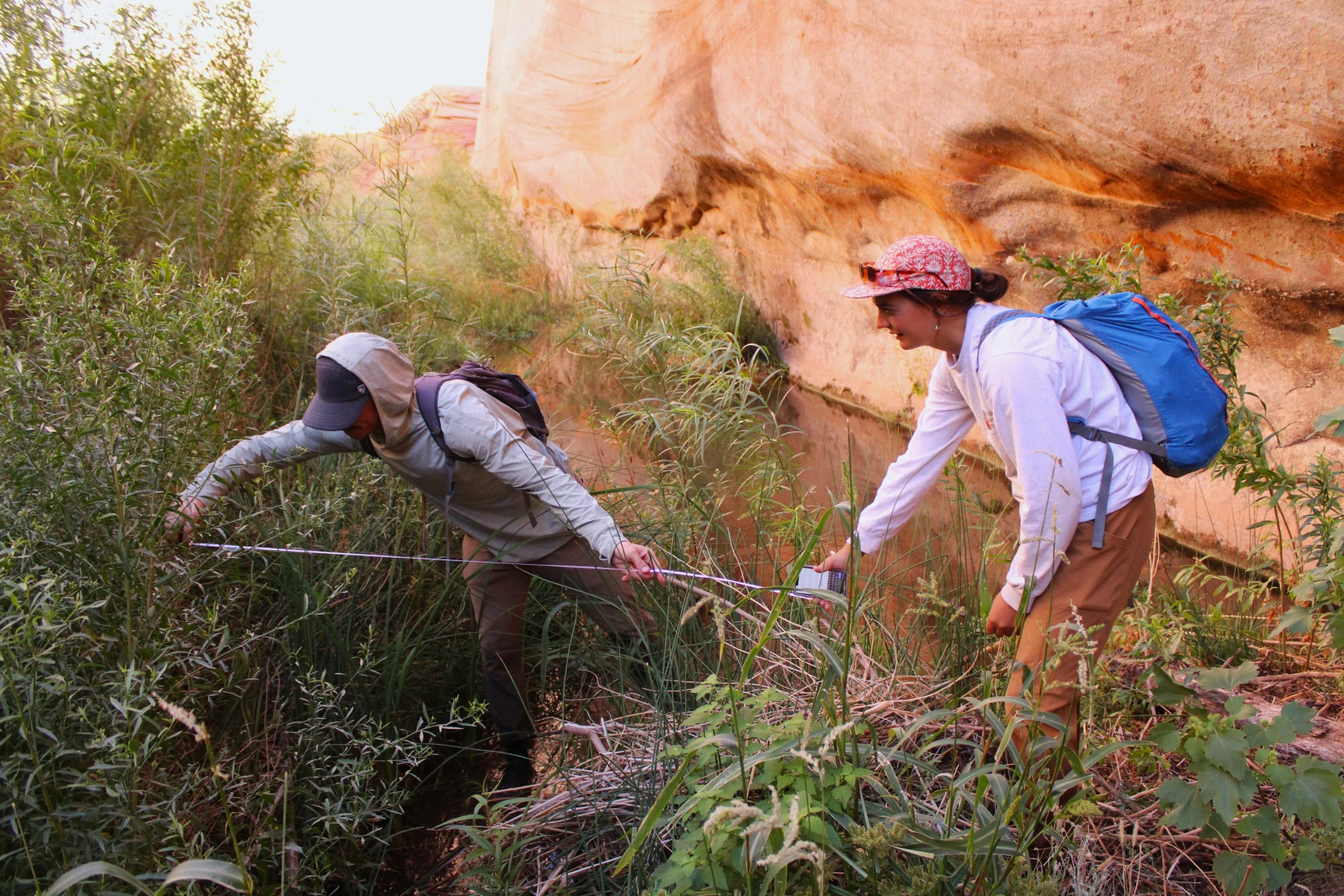
The team fanned out and took note of each sign of beavers, from footprints smaller than a human hand to lodges wider than a human wingspan. The team pulled out a tape measure and noted the length of a stream-wide beaver dam.
“It’ll be really exciting to mark that data point and look back on that for the years to come,” Mitchell said.
Policies to protect
Lake Powell is at a crossroads. Dropping water levels are forcing difficult conversations about its future. They could soon drop too low to generate hydropower inside Glen Canyon Dam. They could even drop too low to allow water to pass from the reservoirinto the Colorado River on the other side. Some environmentalists are calling for a major shakeup to the region’s water storage system — a policy change that would take Lake Powell’s water and store it elsewhere.
The environmental advocates at Glen Canyon Institute say the habitats in these tributary canyons should be protected by those policies.
“Glen Canyon is viewed by many water managers as a storage tank,” he said, “And it’s so much more than that. It’s not a barren landscape, it’s a living, breathing place.”
The wreckage of a motorboat, once submerged beneath Lake Powell, sticks out above the water on September 16, 2025. The nation’s second-largest reservoir has fallen to record lows in recent years. Climate scientists say it is unlikely to rise to previous highs as the region gets drier. Alex Hager/KUNC
But Lake Powell’s decades-long legacy as a key piece of the West’s water storage system will make that difficult. The seven states that use the Colorado River are in the middle of tense negotiations about its future. As they try to balance the needs of major cities and a powerhouse agriculture industry, the needs of the environment can sometimes fall to the back burner. Sinjin Eberle, senior director of communications at the environmental group American Rivers, said that the balancing act may affect decisions about the beaver-laden streams of Glen Canyon.
“Managing [Lake Powell] specifically for those side tributaries,” he said, “I’m not sure that that would be a priority for all of the stakeholders that would be at the table for this.”
Eberle’s group receives funding from the Walton Family Foundation, which also supports KUNC’s Colorado River coverage. Eberle called the emergence of thriving habitats in Glen Canyon “inspiring,” but pointed to larger region-wide tensions that could get in the way of policy decisions designed specifically to protect them.
“It will be a real challenge to encourage leaders from the seven basin states and then the hydropower industry to be willing to keep Lake Powell at a level that is more beneficial for the side Canyon ecologies than the security that a higher Lake Powell gives to each individual state that depends on it,” he said.
Researchers explore a section of Glen Canyon on September 16, 2025. Receding water levels have revealed geologic formations and allowed plants and animals to return. Alex Hager/KUNC
The National Park Service and the Bureau of Reclamation, which manage Lake Powell, did not provide comment for this story in time for publication.
Lake Powell levels sit below 30%, and climate change-fueled drought means the reservoir is unlikely to refill to the high marks set decades ago. Zanna Stutz said those climate trends may force the hand of policymakers. Lake Powell, she said, may never refill enough to drown these side canyons anew.
“The restoration of Glen Canyon is basically an inevitability,” she said. “The sooner we can recognize how what’s happening in Glen Canyon is tied into this larger trend, the sooner we can shift from this being a happy byproduct and have it be taken into consideration and valued accordingly.”
Three years after the Hermit’s Peak/Calf Canyon wildfire burned over 500 square miles in New Mexico — cementing the blaze as the state’s largest-ever — residents are feeling the ripple effects of flood damage and water insecurity.
Flash flooding is common following large burns, and the risks can last for a decade or more. Charred soils are unable to effectively absorb water, and trees are no longer around to soak up or slow rains, which run over burn scars “like water off a parking lot,” Reuters reports.
Last year alone, 105 fires put 6 million acres — primarily in the American West — at risk of flooding impacts.
In Mora, New Mexico, more than two dozen floods have ravaged homes since the Hermit’s Peak/Calf Canyon blaze. More lives have been lost to water than fire. Meanwhile, mold after flooding has led to the abandonment or demolition of homes. Runoff of toxic heavy metals and other contaminants have left residents’ wells polluted and unusable.
Rio Grande and Pecos River basins. Map credit: By Kmusser – Own work, Elevation data from SRTM, drainage basin from GTOPO [1], U.S. stream from the National Atlas [2], all other features from Vector Map., CC BY-SA 3.0, https://commons.wikimedia.org/w/index.php?curid=11218868
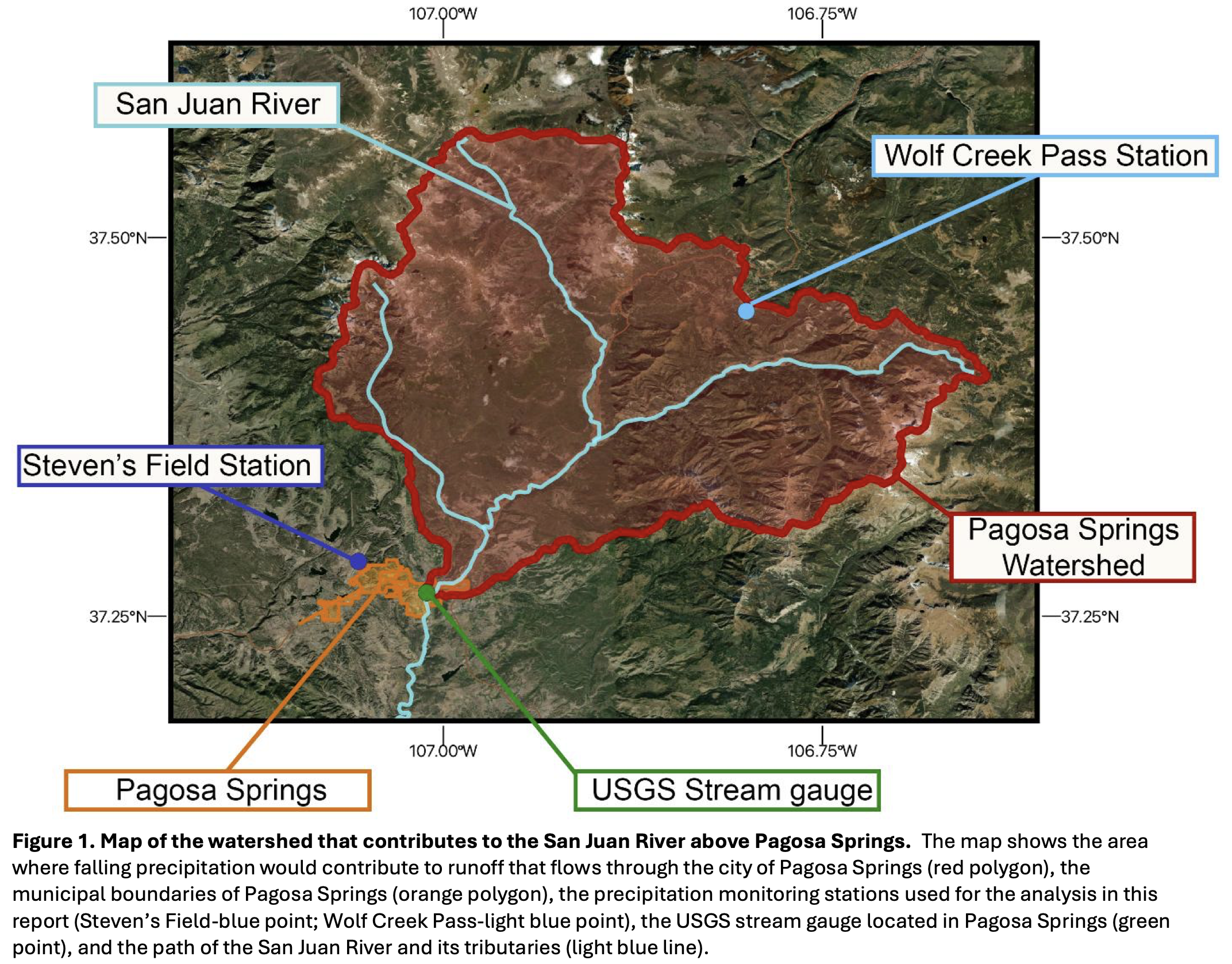
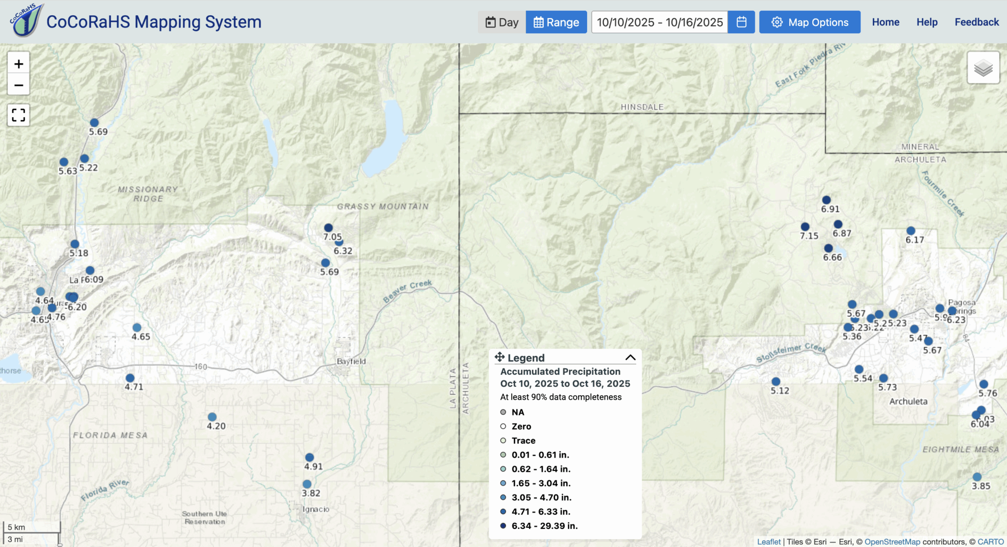
Purpose of the report: This rapid assessment, produced by the Western Water Assessment (WWA), serves as a scientific resource for understanding drivers and impacts of the flooding events that occurred from October 10th -14th, 2025 in southwest Colorado. The report is designed to support local resilience building efforts and hazard planning for communities in the region. It provides the longterm and recent historical context for the flooding, hydrologic characteristics of the flood event, and an assessment of the local probability of an event of this magnitude.
Key Findings:
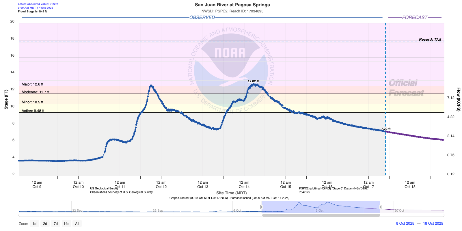
• The October 10th-14th, 2025 floods were the 3rd largest on record for Pagosa Springs, CO, with river levels reaching a maximum gauge height of 12.82 feet and peak flow rates of 8,570 cubic feet per second
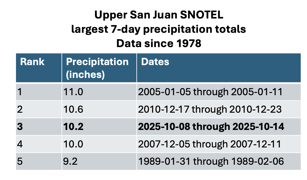
• A total of 12.5 inches of precipitation fell at a high-elevation observation site in the watershed over 5 days, saturating the watershed and driving the river to reach Major Flood stage twice in that period
• Flood frequency analysis based on historical observations of runoff in Pagosa Springs suggests this flood has a return period of 25 to 40 years, meaning that there is a 2.5-4% likelihood of a flood of similar magnitude occurring in any given year.
• Early reports following the flooding suggest that hundreds of residents and households were evacuated in Pagosa Springs and surrounding rural communities and many structures were damaged or destroyed by the floods including homes, bridges, and roadways.
• Nearly two decades of exposure to drought conditions, increasing wildfire activity, and now the recent flooding collectively highlight the geographically unique and increasingly frequent natural hazard risks that rural mountain communities face in southwest Colorado.
Supporting future resilience: Understanding the drivers, characteristics, and likelihood of extreme events like the floods of October 2025 is crucial for effective resilience planning. Scientific analysis that is tailored to local communities, like this assessment for Pagosa Springs and Vallecito, provides specific, actionable information that planners and residents can use to understand their unique exposure to hazards. The Western Water Assessment (WWA) is committed to providing usable science to support hazard planning and response in communities across Colorado, Utah, and Wyoming.
For further information on how WWA can support your community, please reach out to our team at wwa@colorado.edu.
Denver Water and Save the Colorado must enter mediation at the end of the month to see if a deal is possible on the mid-project challenge to the water utility’s $531 million dam raising underway at Gross Reservoir in Boulder County, according to an order from the U.S. Court of Appeals.
A federal trial judge initially halted construction on the nearly finished dam, saying the U.S. Army Corps of Engineers permits for Denver Water violated U.S. environmental laws and that the water level at Gross could not be raised. Judge Christine Arguello later lifted the injunction on construction, for safety reasons, while Denver Water appealed the permit issues to the 10th Circuit Court of Appeals.
The 10th Circuit will take briefs from both sides of the dam dispute in November, and is now ordering a mediation session for Oct. 30. The conference is to “explore any possibilities for settlement” and lawyers for both sides are “expected to have consulted with their clients prior to the conference and have as much authority as feasible” on settlement questions, the court order says.
Construction has continued since the injunction was lifted, with Denver Water pouring thousands of tons of concrete to raise the existing dam structure on South Boulder Creek. Denver Water has argued it needs additional storage on the north end of its sprawling water delivery system for 1 million metro customers, to balance extensive southern storage employing water from the South Platte River basin.
Denver Water’s collection system via the USACE EIS
Save the Colorado and coplaintiffs the Sierra Club, WildEarth Guardians and others argue too much water has already been taken from the Colorado River basin on the west side of the Continental Divide, and that the forest-clearing and construction at Gross is further destructive to the environment. Gross Reservoir stores Fraser River rights that Denver Water owns and brings through a tunnel under the divide into South Boulder Creek.
“We look forward to having a constructive conversation with Denver Water to find a mutually agreeable path forward that addresses the significant environmental impacts of the project,” Save the Colorado founder Gary Wockner said.
When securing required project permits from Boulder County, Denver Water had previously agreed to environmental mitigation and enhancements for damages from Gross construction. But Save the Colorado and co-plaintiffs sued to stop the project at the federal level, and Arguello agreed that the Army Corps had failed to account for climate change, drought and other factors in writing the U.S. permits.
Denver Water declined comment Tuesday on the mediation order.
The halt and restart of the Gross Dam raising came in what has turned out to be a tumultuous year for major Colorado water diversion and storage projects.
While the Gross Dam decisions were underway, Wockner was finishing negotiations with Northern Water over $100 million in environmental mitigation funding to allow the $2.7 billion, two-dam Northern Integrated Supply Project to move forward. Once the 15 communities and water agencies subscribed to NISP water shares saw the increasing price tag, some began pulling out.
Northern Water reviewed the scale of NISP with engineers, then said it planned to move forward at the previously announced scale. The consortium’s board has asked all 15 initial members to indicate by Dec. 31 where they stand with the project and its price tag.
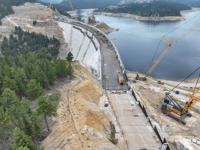
Roller-compacted concrete will be placed on top of the existing dam to raise it to a new height of 471 feet. A total of 118 new steps will make up the new dam. Image credit: Denver Water.
Fun beaver/fish interaction: When I approached this pond, I startled brown trout preparing to spawn below it (beavs filter sediment & keep downstream substrate clean). The fish dashed to the dam & hid in its base. Beavers created perfect spawning grounds: pristine gravel adjacent to dense cover! 🤯🦫🐟
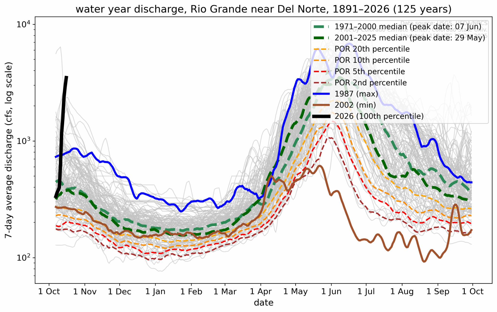
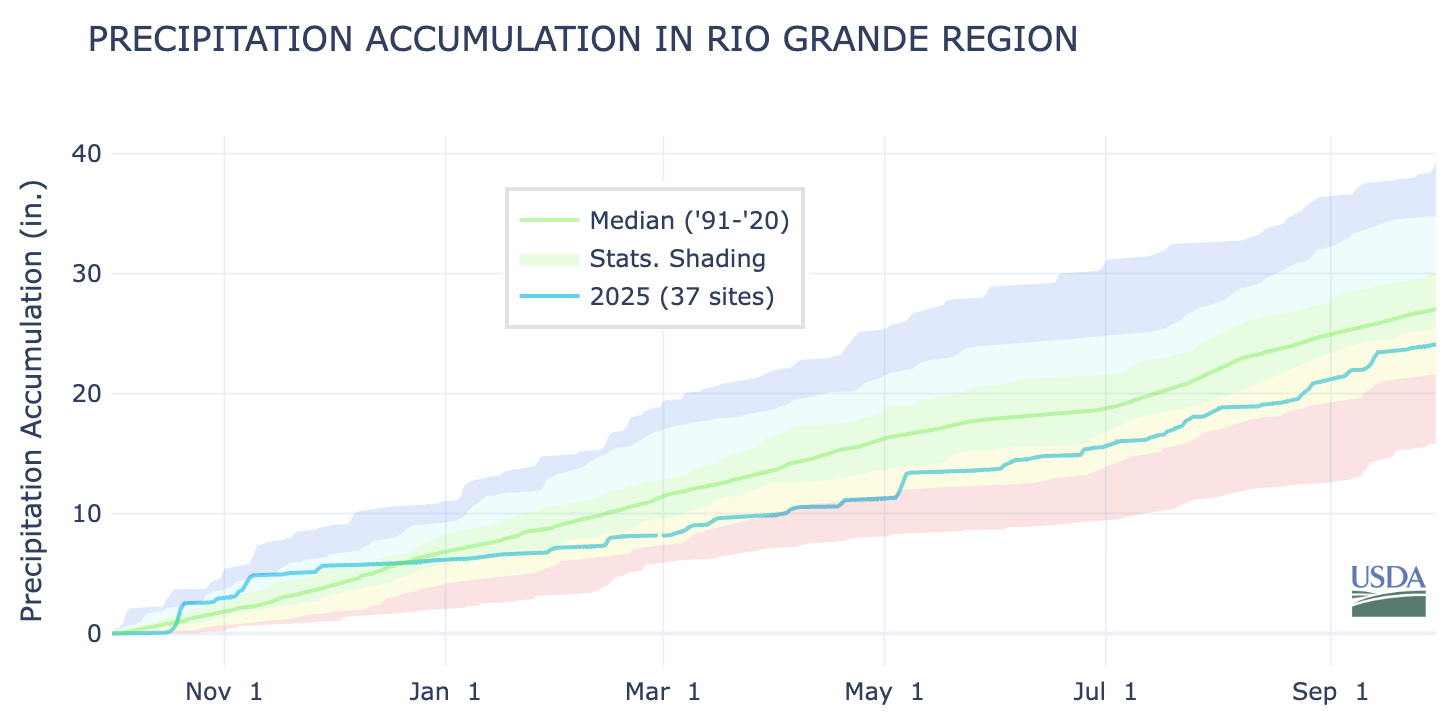
The October rains that changed this water year in the San Luis Valley came at a particularly critical time.
In September the closely-watched unconfined aquifer hit its lowest level ever recorded since monitoring of the troubled aquifer began in January 2002, according to the Davis Engineering report given at Tuesday’s quarterly meeting of the Rio Grande Water Conservation District.
Knowing that, now imagine the conversations that would be happening in the Valley’s farming and ranching community had there been diminished or no October rains. The year was shaping up to be among the worst for flows on the Upper Rio Grande and readings on the unconfined aquifer reinforced it.
Then October delivered heavy rains across the southwest, which resulted in historic fall seasonal flows on the San Juan and into the Rio Grande and Conejos River systems. The Rio Grande grew by 80,000 acre-feet and the Conejos River by 20,000 acre-feet as a result of the rains, said Craig Cotten, division engineer for the Colorado Division of Water Resources.
Colorado is now estimating a total annual flow of 470,000 acre-feet on the Upper Rio Grande, up from its earlier estimates for the year at 390,000 acre-feet. Still, the irrigation year on the Rio Grande will likely end on Nov. 1 as scheduled, said Cotten.
“That’s a big amount of water in just a short amount of time,” he said in noting the latest accounting for Rio Grande Compact purposes.
2026 budget hearing set
The Rio Grande Water Conservation District set a 2026 budget work session for Nov. 24; then a public hearing to adopt next year’s budget on Dec. 11. The water conservation agency is proposing a year-over-year increase to its mill levy. It is proposing a 1.75 mill levy property tax, up from 1.6 mills in 2025.
Rio Grande and Pecos River basins. Map credit: By Kmusser – Own work, Elevation data from SRTM, drainage basin from GTOPO [1], U.S. stream from the National Atlas [2], all other features from Vector Map., CC BY-SA 3.0, https://commons.wikimedia.org/w/index.php?curid=11218868
This shows how buffaloes were pushed west by white immigrants—just like Native Americans. No coincidence the last years on it coincide with the end of the US Wars on the Indigenous. Also no coincidence both were nearly driven to extinction—they killed them to starve Native people pic.twitter.com/bclCTwbsUR
A core element of Denver Water’s mission is ensuring the large, complex system that collects, cleans and delivers drinking water for 1.5 million people is prepared to meet future challenges.
And with more than 100 years of operations under its belt, Colorado’s largest water provider, which serves about 25% of Colorado’s population, is in the biggest period of capital investment in its history. Denver Water expects to invest about $1.7 billion into the system during the next 10 years.
“The work we do provides the critical water supply that the community we serve needs to thrive and grow,” said Denver Water CEO/Manager Alan Salazar.
“Continuing to maintain and invest in the system that supports our water supply will ensure that we — Denver Water as well as our customers — are ready for what lies ahead, from a warming climate to the potential for new regulations, while keeping rates as low as good service will allow,” Salazar said.
Since 2022, Denver Water has replaced an average of 97,000 feet of water mains per year. Photo credit: Denver Water.
Responsibility to maintain and protect the state’s largest water system, along with a desire to encourage water conservation, keep essential indoor water use affordable and ensure the utility is financially stable, were incorporated into the Oct. 22 decision by Denver’s Board of Water Commissioners to approve new water rates for 2026.
Denver Water is protecting and preparing the complex system and its customers for the future in many ways, including:
The Lead Reduction Program, which started in 2020, is protecting customers from the risk of lead in their drinking water and to date has replaced more than 35,000 old, customer-owned lead service lines at no direct cost to customers.
The new Northwater Treatment Plant, which began operations in 2024, can clean up to 75 million gallons of water per day and can be expanded when needed to 150 million gallons per day.
The Gross Reservoir Expansion Project, which began construction in 2022, is designed to nearly triple the reservoir’s storage capacity.
The Landscape Transformation Program, which helps customers remodel landscapes dominated by water-intensive Kentucky bluegrass into water-wise, climate-resilient ColoradoScapes.
And ongoing work to replace aging water mains, upgrade infrastructure on the utility’s southern collection and treatment system, and reach a net-zero carbon emissions goal by 2030.
Overall, Denver Water expects to invest $1.7 billion over the next 10 years in projects that will maintain, repair, protect and upgrade the system, and make it more resilient and flexible in the future.
In addition to rates paid by customers, funding for Denver Water’s infrastructure projects, day-to-day operations and emergency expenses like water main breaks comes from bond sales, cash reserves, hydropower sales, grants, federal funding and fees paid when new homes and buildings are connected to the system.
The utility does not receive tax dollars or make a profit. It reinvests money from customer water bills and fees to maintain and upgrade the water system.
And the utility is committed to delivering a safe, clean and affordable water supply to its customers while managing the impacts of the larger economy, from inflation to supply chain issues.
How the 2026 water rates will affect individual customer bills will vary depending on where the customer lives (either in Denver or in one of the utility’s suburban distributor districts) and how much water they use.
And major credit rating agencies recently confirmed Denver Water’s triple-A credit rating, the highest possible, citing the utility’s track record of strong financial management.
Monthly bills for single-family residential customers are comprised of two factors: a fixed charge, which helps ensure Denver Water has a more stable revenue stream to continue the necessary water system upgrades to ensure reliable water service, and a volume rate for the amount of water used.
Combining both of those factors, a typical single-family residential customer who uses 104,000 gallons of water annually will see their monthly bill increase by an average of $2.45 to $3.30 over the course of the year, depending on where the customer lives (in Denver or in one of the utility’s suburban distributor districts) and the type of service the customer’s suburban distributor district receives from Denver Water.
(See the infographic below for information about Denver Water’s suburban distributor districts, types of service and rates.)
The monthly bill example above includes an increase to the fixed monthly charge, which is tied to the size of the meter. For most single-family residential customers with a 3/4-inch meter, the fixed charge will increase by $1.85 in 2026, to $20.91 per month.
The more you use, the more you pay
After the fixed monthly charge, Denver Water’s rate structure for residential single-family customers has three tiers based on the amount of water used. The tiers are designed to keep essential indoor water use affordable while encouraging water conservation outdoors. (See additional details about the 2026 rates for the three tiers in the infographic below.)
The first tier is charged at the lowest rate and covers essential indoor water use for bathing, cooking and flushing toilets. Each customer has their individual first tier determined by the average of their monthly water use as listed on bills that arrive in January, February and March — when there is very little or no outdoor watering.
The second tier is for water consumption, typically used for outdoor watering, that is above the customer’s first tier and up to 15,000 gallons of water per month. Water use in this tier is considered to be an efficient use of water outdoors.
The third tier is for water use of more than 15,000 gallons per month. It is priced at the highest level to signal potentially excessive water use and encourage conservation efforts by larger-lot customers.
Bills in the summer months can be higher if customers use water to irrigate their outdoor landscapes.
Need help?
Denver Water offers one-time payment assistance to customers who may qualify. The utility’s Customer Care representatives also can help customers navigate payment options and unique circumstances. Customers can reach them via denverwater.org/ContactForm or by calling 303-893-2444.
What customers can do to save water, money
Denver Water encourages all customers to conserve water where they can indoors and out.
Finding and plugging leaks inside the home can be done year-round, and the utility offers rebates for qualified water-saving toilets and sprinkler equipment.
To help customers remodel their lawns to create a more vibrant, diverse ColoradoScape, Denver Water in 2026 will again offer a limited number of customer discounts on Resource Central’s popular turf removal service and its water-wise Garden In A Box plant-by-number kits. Photo credit: Denver Water.
Outside, Denver Water encourages customers to conserve water by remodeling unused areas of water-intensive Kentucky bluegrass into more diverse, water-wise ColoradoScapes that fit naturally into our dry climate and are interesting to look at through all seasons. These drought-resistant and climate-resilient ColoradoScapes include tree canopies and plants that help maintain vibrant urban landscapes and benefit our communities, wildlife and the environment.
Using less water also means more water can be kept in the mountain reservoirs, rivers and streams that fish live in and Coloradans enjoy. It also can lower monthly water bills, saving money.
Note 1: An individual customer’s monthly water bill will vary depending on where they live in Denver Water’s service area (in Denver or in one of the utility’s suburban distributor districts), the types of service the suburban distributor district receives from Denver Water, and how much water the customer uses.
Note 2: The difference in volume rates (in the infographic above) for Denver Water customers who live inside Denver compared to those who live in the suburbs is due to the Denver City Charter (see Operating Rules), which allows permanent leases of water to suburban water districts based on two conditions: 1) there always would be an adequate supply for the citizens of Denver, and 2) suburban customers pay the full cost of service, plus an additional amount.
West Plains Drought Monitor map October 21, 2025.High Plains Drought Monitor map October 21, 2025.Colorado Plains Drought Monitor map October 21, 2025.
Click on a thumbnail graphic to view a gallery of drought data from the US Drought Monitor website. Here’s an excerpt:
This Week’s Drought Summary
Recently, precipitation has been spatially variable across the Contiguous U.S. (“Lower-48”). Over the past 30 days, heavy precipitation (4 to locally over 8 inches) fell on parts of central and southern New England, the interior Northeast (especially eastern New York state), the Ohio Valley (particularly northern Kentucky and adjacent areas), eastern South Carolina, eastern Florida, parts of the Tennessee and adjacent Mississippi Valleys, isolated sites in the central Plains, the higher elevations in the Rockies, central Arizona and other scattered locations across the Southwest, parts of the Great Basin, portions of California (where such amounts are unusual this early in the wet season), and the Pacific Northwest (where these amounts are not unusual).
In stark contrast, an inch or less of precipitation has been noted in the desert Southwest and lower elevations across the interior West, most of the central and southern Plains, the northern Great Plains, the northwestern Great Lakes, portions or northern and western Florida, and some interior sections of the Southeast and Mid-Atlantic region.
Given the regional variability, there were a lot of changes in the Drought Monitor this week, with large parts of the West, much of the Ohio and middle Mississippi Valleys, and scattered locations across northern Mississippi, the Eastern Great Lakes, and the Northeast. At the same time, conditions have deteriorated across much of the southern and south-central Plains, the South Atlantic region from interior Georgia through eastern Virginia, southern parts of the Lower Mississippi Valley, and scattered areas across the rest of the Southeast, the Mid-Atlantic region, the Northeast, the Upper Mississippi Valley, and the northern Plains.
In sum, the array of improvements and deterioration incorporated into this week’s Drought Monitor resulted in slight declines in overall coverage of the various drought severity levels across the Lower-48. Abnormally dry or worse conditions cover 72 percent of the country, down from 74 percent last week. About 21 percent of the country is experiencing Severe Drought or worse (D2-D4), down slightly from 23 percent last week. For the 50 states plus Puerto Rico in total, coverage of abnormally dry or worse conditions fell from 62 to just under 60.5 percent…
A wide range of precipitation totals were observed last week. Generally, 1.5 to 3.0 inches hit the northern and western Dakotas, much of central and eastern Wyoming, and scattered locations in northwestern Wyoming. An inch or a little more fell on many locations in a swath from central Nebraska into southeastern South Dakota, but other locations reported several tenths of an inch of precipitation at best, with most areas from southwestern Wyoming through western Nebraska and from eastern Nebraska through Kansas reporting little or none. This pattern resulted in less change here than in most other regions. Areas of deterioration were introduced in parts of the east-central and southeastern High Plains Region while improvement resulted from heavier precipitation farther west. The most widespread areas of improvement covered southwestern Colorado and western Wyoming. Coverage of dryness and drought is considerably lower in this region than in others, with the total area entrenched in some degree of dryness or drought (D0-D4) dropping slightly to a bit over 36 percent this week. The extent of Extreme Drought (D3) was almost cut in half, from 3.3 percent down to 1.7 percent. There is no D4 in the Region, but D3 remains across much of southwestern Wyoming and part of central Colorado. The proportion of the Great Plains States in this Region experiencing some degree of dryness or drought (D0-D4) is relatively low compared to much of the Lower-48; specifically, 3 percent of North Dakota, 32 percent of South Dakota, 35 percent of Nebraska, and 28 percent of Kansas…
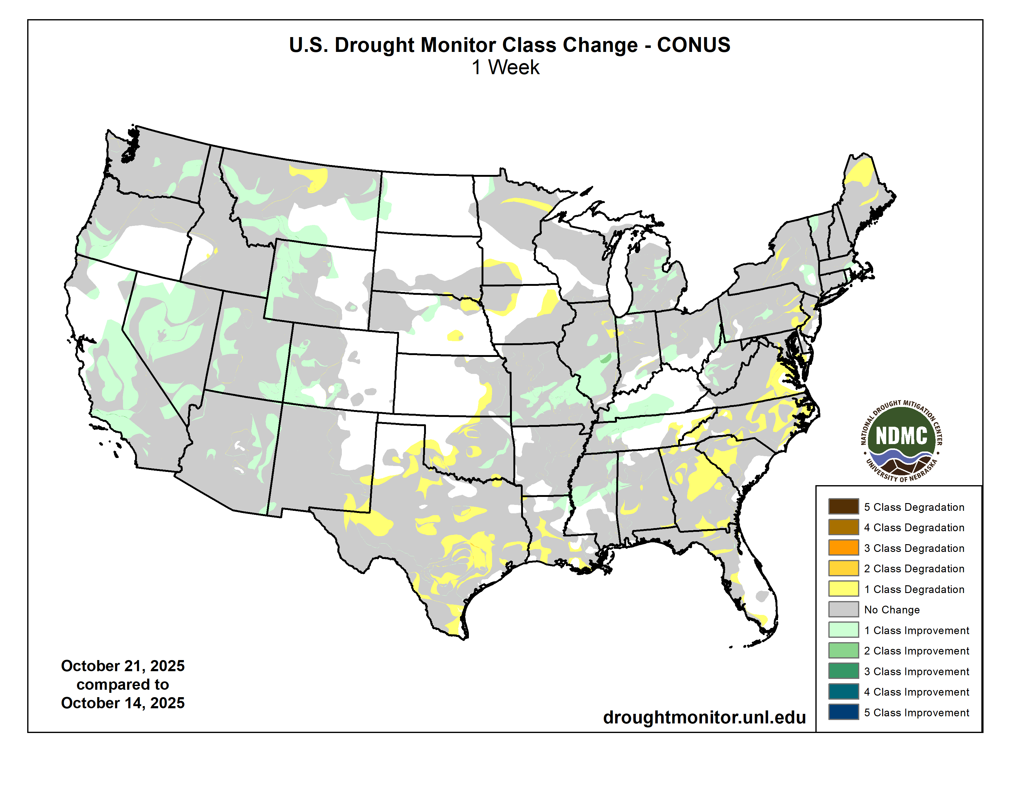
Colorado Drought Monitor one week change map ending October 21, 2025.
Some unusually heavy early-season rain and snow has affected portions of the West, including areas of central and southern California where October so far has been wetter than most such months on record. Large portions of central and upper southern California, the Great Basin, and the western and eastern tiers of Utah saw improvement on this week’s Drought Monitor, along with patches of central and eastern Arizona, southwestern Oregon, central and eastern Washington, and parts of eastern, southern, and western Montana. Only a portion of north-central Montana saw any deterioration. The total area covered by any dryness (D0-D4) declined from 80 to a bit over 74 percent this week while the coverage of the more intense drought categories (D2-D4) dropped from 38.5 percent to just over one-third of the Region. D3-D4 was still entrenched over a decent proportion of the Region, but declined from almost 9 percent last week to about 6.5 percent this week. The only remaining area of the most intense category (D4) is in north-central Idaho…
Moderate to heavy rain resulted in several areas of improvement in Tennessee, central and northern Mississippi, northeastern Louisiana, and eastern Oklahoma. Farther south and west, subnormal precipitation continued for another week, resulting in numerous areas of deterioration from central and southern Louisiana westward across Texas and central through western Oklahoma. The proportion of the Region experiencing some degree of dryness or drought (D0+) increased slightly this week, from 79 percent to about 80.5 percent. There was a bigger jump in areas covered by some degree of drought (37 percent, up from a bit over 32 percent). The most intense drought (D3 with some isolated patches of D4) cover parts of the panhandle of western Texas and a sizeable part of south-central Texas. The heaviest rains this week (2 to 4 inches) were observed in a broken pattern from northwestern Louisiana through northern Mississippi. In contrast, southern sections of the Lower Mississippi Valley and the vast majority of Texas and Oklahoma received a few tenths of an inch at best, with most sites reporting no measurable precipitation…
Looking Ahead
Over the next 5 to 7 days, two general areas are expected to receive heavy precipitation: The Pacific Northwest, and a swath from the southern Great Plains through the Lower Mississippi and Lower Ohio Valleys. Windward areas and higher elevations are expecting 5 to locally over 10 inches of precipitation, with 2 or more inches anticipated for other areas from the Cascades to the Pacific Coast. Meanwhile, 3 to 5 inches are expected from the Red River (South) Valley into eastern Texas and parts of the Lower Mississippi Valley. Elsewhere, totals exceeding 1.5 inches are forecast in the higher elevations of northern and central Idaho and adjacent areas. Moderate amounts (0.5 to locally over 1.5 inches) are expected to fall on the Ohio Valley, the Middle and Upper Mississippi Valley, and remaining locations in the southern half of the Plains outside Deep South Texas. Look for a few tenths to around an inch of precipitation in the northern Sierra Nevada, plus portions of the northern Intermountain West and Rockies. Elsewhere, light amounts at best are anticipated in most of New England, parts of the Mid-Atlantic region, the South Atlantic coastal plain, much of Peninsular Florida, Deep South Texas, most lower elevations across the interior West including the Southwest into central California, plus most of the Great Basin. Daily highs are forecast to average 4 to 8 deg. F below normal from central California through the Pacific Northwest and across the northern Intermountain West. Similar anomalies should affect the Atlantic Seaboard and Piedmont from northern Georgia through southern New England. Meanwhile, unusually warm weather will likely continue across the northern Plains, with daily highs averaging 5 to 10 deg. F above normal from northern Minnesota through the Dakotas and northern Great Lakes into northeastern New York. Also, highs averaging 4 to 8 deg. F above normal are expected from the Southwest through western and southern Texas. Low temperatures should average warmer with respect to normal across most of the Lower-48, especially over the Plains, Mississippi Valley, the Southwest, and the Great Basin. Low temperatures could average 6 to 13 deg. F above normal in the northeastern Great Plains and adjacent areas. The only broad area expecting below-normal lows (by 2 to 5 deg. F on average) stretches from Virginia northward through much of New York.
The Climate Prediction Center’s 6-10 day outlook valid for October 29 – November 1 favors heavier than normal precipitation continuing across the Pacific Northwest, where odds for significantly above-normal precipitation range from 50 to 70 percent. Wet weather is slightly favored across most of the Rockies and Plains as well as parts of central and northern California, northwestern Nevada, and the Pacific Northwest. Wetter than normal conditions are nominally favored across Hawaii. Abnormally dry weather is expected from central and western Texas through central and southern sections of the High Plains and Rockies. Odds for subnormal amounts exceed 50 percent from eastern Arizona through parts of the Texas Big Bend. Meanwhile, warm weather is favored from California, the Southwest, and the Great Basin through parts of the northern Rockies, the High Plains, the northern Great Plains, the Great Lakes, and northern New England. There is a better than 60 percent chance for warmth from southern California into western New Mexico. Cool weather is forecast across the South Atlantic region from Maryland through parts of Florida along with the central and southern Appalachians and the adjacent central Gulf Coast. The Hawaii forecast favors warmth, with chances exceeding 50 percent across the western half of the island chain.
US Drought Monitor one week change map ending October 21, 2025.
A detail of a map produced by Water Horse Resources, and published by the state of Utah, showing two pipelines from the Green River, one above Flaming Gorge Reservoir and one below, plus a connecting pipeline between the two. The map is on a Utah state website with a note saying it was “left at hearing” on Nov. 11, 2018.
The Utah Supreme Court ruled on a controversial pipeline project in Eastern Utah last Friday. In January 2018, Water Horse Resources, LLC proposed a pipeline project that would send 55,000 acre-feet of water every year from the Green River to the state of Colorado. However, on Nov. 7, 2020, the Utah State Engineer rejected the application…The proposal sought to pipe water to be used for “beneficial use in Colorado.” However, a district court found Water Horse failed to establish evidence that the water can be put to beneficial use in Colorado. The pipeline would extend through Wyoming before dropping into an undecided location in Colorado.
Proposed pipeline by Water Horse would bring water from Utah to Colorado. (Courtesy//Utah Supreme Court)
Colorado officials declined to sign onto the project citing the lack of clear authority to administer the diversion of water into the state. Water Horse appealed the district court’s decision, leading to a years-long legal battle. On Friday, Oct. 17, 2025, the Utah Supreme Court reaffirmed the initial decision of the state engineer to reject the project…The Supreme Court ruling is not the end for the project. According to the court’s opinion, a renewed application could be submitted and potentially approved by the state engineer.
Until the passage of the Comprehensive Environmental Response, Compensation, and Liability Act (CERCLA) in 1980, miners across the American West extracted gold, silver, and other valuable “hardrock” minerals—and then simply walked away. Today, tens of thousands of these abandoned hardrock mines continue to leak acidic, metal-laden water into pristine streams and wetlands. Federal agencies estimate that over a hundred thousand miles of streams are impaired by mining waste. Nearly half of Western headwater streams are likely contaminated by legacy operations. Despite billions already spent on cleanup at the most hazardous sites, the total cleanup costs remaining may exceed fifty billion dollars.
So how did we end up here? In short, the General Mining Law of 1872 created a lack of accountability for historic mine operators to remediate their operations, but CERCLA and the Clean Water Act (CWA) arguably add an excess of accountability for third parties trying to clean up abandoned mines today.
The Animas River running orange through Durango after the Gold King Mine spill August 2015. Photo credit: Jonathan P. Thompson/The Land Desk
The first legislation to address this problem was introduced in 1999. Many iterations followed and failed, even in the wake of shocking images and costly litigation due to the Gold King Mine spill that dyed the Animas River a vibrant orange in 2015. Finally, in December, 2024, Congress passed the Good Samaritan Remediation of Abandoned Hardrock Mines Act of 2024 (GSA).
The GSA is a cautious, bipartisan attempt to empower volunteers to clean up this toxic legacy. The law creates a short pilot program and releases certain “Good Samaritans” from liability under CERCLA and the CWA, which has long deterred cleanup by groups like state agencies and NGOs. EPA has oversight of the program and the authority to issue permits to Good Samaritans for the proposed cleanup work.
Despite the promise of this new legislation, critical questions remain unanswered about the GSA and how it will work. Only time will tell whether EPA designs and implements an effective permitting program that ensures Good Samaritans complete remediation work safely and effectively. EPA now has the opportunity as the agency that oversees this program to unlock the promise of the GSA.
The GSA left some significant gaps unanswered in how the pilot program will be designed and directed EPA to issue either regulations or guidance to fill in those gaps. EPA missed the statutory deadline to start the rulemaking process (July, 2025) and is now working to issue guidance on how the program will move forward. EPA must provide a 30-day public comment period before finalizing the guidance document according to the GSA. With EPA’s hopes of getting multiple projects approved and shovels in the ground in 2026, the forthcoming guidance is expected to be released soon. While we wait, it’s worth both looking back at what led to the GSA and looking ahead to questions remaining about the implementation of the pilot program.
A Century of Mining the West Without Accountability
The story begins with the General Mining Law of 1872, a relic of the American frontier era that still governs hardrock mining on federal public lands. The law allows citizens and even foreign-based corporations to claim mineral rights and extract valuable ores without paying any federal royalty. Unlike coal, oil, or gas—which fund reclamation through production fees—hardrock mining remains royalty-free.
As mining industrialized during the 20th century, large corporations replaced prospectors. Until 1980, mines were often abandoned without consequences or cleanup once they became unprofitable. The result: an estimated half-million abandoned mine features will continually leach pollution into American watersheds for centuries.
CERLCA Liability Holds Back Many Abandoned Mine Cleanups
Congress sought to address toxic sites through CERCLA, also known as the Superfund law, which makes owners and operators strictly liable for hazardous releases. In theory, that ensures accountability. In practice, it creates a paradox: if no polluter can be found at an abandoned site, anyone who tries to clean up the mess may be held responsible for all past, present, and future pollution.
The Clean Water Act’s Double-Edged Sword
Even state agencies, tribes, or nonprofits that treat contaminated water risk being deemed “operators” of a hazardous facility. That fear of liability—combined with enormous costs—has frozen many potential Good Samaritans in place. Federal efforts to ease this fear have offered little more than reassurance letters without real protection.
The Clean Water Act compounds the problem. Anyone who discharges pollution into a surface water via any discernible, confined and discrete conveyance must hold a point source discharge permit. By requiring these permits and providing for direct citizen enforcement in the form of citizen suits, the CWA has led to significant improvements in water quality across the country. That said, courts have ruled that drainage pipes or diversion channels used to manage runoff from abandoned mines may also qualify as point sources. As a result, Good Samaritans who exercise control over historic point sources, like mine tunnels, could face penalties and other liabilities for unpermitted discharges, even when they improve overall conditions.
The 2024 Good Samaritan Act Steps onto the Scene
After decades of failed attempts, the Good Samaritan Remediation of Abandoned Hardrock Mines Act was signed into law in December, 2024. The GSA authorizes EPA to create a pilot program, issuing up to fifteen permits for low-risk cleanup projects over seven years. Most importantly, permit holders receive protection from Superfund and Clean Water Act liability for their permitted activities. This legal shield removes one of the greatest barriers to cleanup efforts.
Applicants can seek either a Good Samaritan permit to begin active remediation or an investigative sampling permit to scope out a site for potential conversion to a Good Samaritan permit down the road.
In either case, applicants must show:
they had no role in causing, and have never exercised control over, the pollution in their application,
they possess the necessary expertise and adequate funding for all contingencies within their control, and
they are targeting low-risk sites, which are generally understood to be those that require passive treatment methods like moving piles of mine waste away from streams or snowmelt or diverting water polluted with heavy metals below mine tailings toward wetlands that may settle and naturally improve water quality over time
Under the unique provisions of the GSA, each qualifying permit must go through a modified and streamlined National Environmental Policy Act (NEPA) review process. EPA or another lead agency must analyze the proposed permit pursuant to an Environmental Assessment (EA). If the lead agency cannot issue a Finding of No Significant Impact (FONSI) after preparing an EA, the permit cannot be issued. The GSA therefore precludes issuance of a permit where the permitted activities may have a significant impact on the environment.
The pilot program only allows for up to fifteen low risk projects that must be approved by EPA over the next seven years. Defining which remediations are sufficiently low-risk becomes critical in determining what the pilot program can prove about the Good Samaritan model for abandoned mine cleanup. To some extent, “low risk” is simply equivalent to a FONSI. But the GSA further defines the low-risk remediation under these pilot permits as “any action to remove, treat, or contain historic mine residue to prevent, minimize, or reduce (i) the release or threat of release of a hazardous substance, pollutant, or contaminant that would harm human health or the environment; or (ii) a migration or discharge of a hazardous substance, pollutant, or contaminant that would harm human health or the environment.”
This excludes “any action that requires plugging, opening, or otherwise altering the portal or adit of the abandoned hardrock mine site…”, such as what led to the Gold King mine disaster. Many active treatment methods are also excluded from the pilot program, therefore, because they often involve opening or plugging adits or other openings to pump out water and treat it in a water treatment plant, either on or off-site. As a result, the Good Sam Act’s low-risk pilot projects focus on passive treatment of the hazardous mine waste or the toxic discharge coming off that waste, such as a diversion of contaminated water into a settlement pond.
The GSA requires that permitted actions partially or completely remediate the historic mine residue at a site. The Administrator of EPA has the discretion to determine whether the permit makes “measurable progress”. Every activity that the Good Samaritan and involved permitted parties take must be designed to “improve or enhance water quality or site-specific soil or sediment quality relevant to the historic mine residue addressed by the remediation plan, including making measurable progress toward achieving applicable water quality standards,” or otherwise protect human health and the environment by preventing the threat of discharge to water, sediment, or soil. The proposed remediation need not achieve the stringent numeric standards required by CERCLA or the CWA.
Furthermore, it can be challenging to determine the discrete difference between the baseline conditions downstream of an acid mine drainage prior to and after a Good Samaritan remediation is completed. Not only do background conditions confuse the picture, but other sources of pollution near the selected project may also make measuring water quality difficult. This may mean that the discretion left to the EPA Administrator to determine “measurable progress” becomes generously applied.
Finally, once EPA grants a permit, the Good Samaritan must follow the terms, conditions, and limitations of the permit. If the Good Samaritan’s work degrades the environment from the baseline conditions, leading to “measurably worse” conditions, EPA must notify and require that the Good Samaritantake “reasonable measures” to correct the surface water quality or other environmental conditions to the baseline. If these efforts do not result in a “measurably adverse impact”, EPA cannot consider this a permit violation or noncompliance. However, if Good Samaritans do not take reasonable measures or if their noncompliance causes a measurable adverse impact, the Good Samaritan must notify all potential impacted parties. If severe enough, EPA has discretion to revoke CERCLA and CWA liability protections.
Recently, EPA shared the following draft flowchart for the permitting process:
Disclaimer: This is being provided as information only and does not impose legally binding requirements on EPA, States, or the public. This cannot be relied upon to create any rights enforceable by any party in litigation with the United States. Any decisions regarding a particular permit will be made based upon the statute and the discretion granted by the statute, including whether or not to grant or deny a permit.
Challenges Facing the Pilot Program Implementation
Despite its promise, the pilot program’s scope is limited. With only fifteen Good Samaritan permits eligible nationwide and no dedicated funding, the law depends on states, tribes, and nonprofits to provide their own resources. The only guidance issued so far by EPA detailed the financial assurance requirements that would-be Good Samaritans must provide to EPA to receive a permit. Definitions provided in this financial assurance guidance raised concerns for mining trade organizations and nonprofits alike with EPA’s proposed interpretations of key terms including “low risk” and “long-term monitoring”. Crucial terms like these, along with terms impacting enforcement when a permitted remediation action goes awry, like “baseline conditions”, “measurably worse”, and “reasonable measures” to restore baseline conditions, are vague in the GSA. How EPA ultimately clarifies terms like these will play a large role in the success of the GSA in its ultimate goal: to prove that Good Samaritans can effectively and safely clean up abandoned hardrock mine sites. The soon-to-be-released guidance document will therefore be a critical moment in the history of this new program.
Funding the Future
Funding remains the greatest barrier to large-scale remediation efforts. Coal mine cleanups are funded through fees on current production under the Surface Mining Control and Reclamation Act. Current hardrock mining, however, still pays no federal royalty. A modernized system could pair Good Samaritan permitting with industry-funded reclamation fees, ensuring that those profiting from today’s mining help repair the past. Without this reform, the burden will remain on underfunded agencies and nonprofits. However, this General Mining Law reform remains politically unlikely. In the meantime, the GSA creates a Good Samaritan Mine Remediation Fund but does not dedicate any new appropriations to that fund. Grants under Section 319 of the CWA (Nonpoint Source Pollution) and Section 104(k) of CERCLA (Brownfields Revitalization) programs may help, but funding opportunities here are limited.
The GSA includes provisions that allow Good Samaritans to reprocess mine waste while completing Good Samaritan permit cleanup work. These provisions include a key restriction: revenue generated from reprocessing must be dedicated either to the same cleanup project or to the GSA-created fund for future cleanups. A January 20, 2025 executive order to focus on domestic production of critical minerals led to a related Interior secretarial order on July 17, 2025, for federal land management agencies to organize opportunities and data regarding reprocessing mine waste for critical minerals on federal lands. Shortly after these federal policy directives, an August 15, 2025, article in Science suggested that domestic reprocessing of mining by-products like abandoned mine waste has the potential to meet nearly all the domestic demand for critical minerals. Legal and technical hurdles might prevent much reprocessing from occurring within the seven-year pilot program. Reprocessing projections aside, the political appetite for dedicated funding for the future may still grow if the GSA pilot projects successfully prove the Good Samaritan concept using a funding approach reliant on generosity and creativity.
Despite Significant Liability Protections, Good Samaritans Face Uncertainties
While the new law should help to address significant barriers to the cleanup of abandoned mines by Good Samaritans, uncertainties remain. The GSA provides exceptions to certain requirements under the Clean Water Act (including compliance with section 301, 302, 306, 402, and 404). The GSA also provides exceptions to Section 121 of CERCLA, which requires that Superfund cleanups must also meet a comprehensive collection of all relevant and appropriate standards, requirements, criteria, or limitations (ARARs).
In States or in Tribal lands that have been authorized to administer their own point source (section 402) or dredge and fill (section 404) programs under the CWA, the exceptions to obtaining authorizations, licenses, and permits instead applies to those State or Tribal programs. In that case, Good Samaritans are also excepted from applicable State and Tribal requirements, along with all ARARs under Section 121 of CERCLA.
However, Section 121(e)(1) of CERCLA states that remedial actions conducted entirely onsite do not need to obtain any Federal, State, or local permits. Most GSA pilot projects will likely occur entirely onsite, so it is possible that Good Samaritans might still need to comply with local authorizations or licenses, such as land use plans requirements. While it appears that GSA permitted activities are excepted from following relevant and applicable Federal, State, and Tribal environmental and land use processes, it is a bit unclear whether they are also excepted from local decision making.
The liability protections in the GSA are also limited by the terms of the statute. Good Samaritans may still be liable under the CWA and CERCLA if their actions make conditions at the site “measurably worse” as compared to the baseline. In addition, the GSA does not address potential common law liability that might result from unintended accidents. For example, an agricultural water appropriator downstream could sue the Good Samaritan for damages associated with a spike in water acidity due to permitted activities, such as moving a waste rock pile to a safer, permanent location on site.
Finally, the GSA does not clearly address how potential disputes about proposed permits may be reviewed by the federal courts. However, the unique provisions of the GSA, which prohibit issuance of a permit if EPA cannot issue a FONSI, potentially provide an avenue to challenge proposed projects where there is disagreement over the potential benefits and risks of the cleanup activities.
Measuring and Reporting Success of the Pilot Program
The Good Samaritan Act authorizes EPA to issue up to fifteen permits for low-risk abandoned mine cleanups, shielding participants from Superfund and Clean Water Act liability. Applicants must prove prior non-involvement, capability, and target on low-risk sites. Each permit undergoes a streamlined NEPA Environmental Assessment requiring a FONSI. To be successful, EPA and potential Good Samaritans will need to efficiently follow the permit requirements found in the guidance, identify suitable projects, and secure funding. The GSA requires baseline monitoring and post-cleanup reporting for each permitted action but does not require a structured process of learning and adjustment over the course of the pilot program. Without this structured, adaptive approach, it may be difficult for Good Samaritan proponents to collect valuable data and show measurable progress over the next seven years that would justify expanding the Good Samaritan approach to Congress. EPA’s forthcoming guidance offers an opportunity to fix that by publicly adopting a targeted and tiered approach in addition to the obligatory permitting requirements.
The EPA’s David Hockey, who leads the GSA effort from the EPA’s Office of Mountains, Deserts, and Plains based in Denver, has suggested taking just such a flexible, adaptive approach in public meetings discussing the GSA. EPA, working in coordination with partners that led the bill through Congress last year, like Trout Unlimited, intends to approve GSA permits in three tranches. EPA currently estimates that all fifteen projects will be approved and operational by 2028.
The first round will likely approve two or three projects with near-guaranteed success. If all goes according to plan, EPA hopes to have these shovel-ready projects through the GSA permit process, which includes a NEPA review, with the remedial work beginning in 2026. These initial projects will help EPA identify pain points in the process and potentially pivot requirements before issuing a second round of permits. This second tranche will likely occur in different western states and might increase in complexity from the first tranche.
Finally, the third tranche of permits might tackle the more complex projects from a legal and technical standpoint that could still be considered low risk. This may include remediation of sites in Indian Country led by or in cooperation with a Tribal abandoned mine land reclamation program. Other projects suited for the third tranche might include reprocessing of mine waste, tailings, or sludge, which may also require further buy-in to utilize the mining industry’s expertise, facilities, and equipment. These more complex projects will benefit most from building and maintaining local trust and involvement, such as through genuine community dialogue and citizen science partnerships. The third tranche projects should contain such bold choices to fully inform proponents and Congress when they consider expanding the Good Samaritan approach.
EPA appears poised to take a learning-by-doing approach. But the guidance can and should state this by setting public, straightforward, and measurable goals for the pilot program. This is a tremendous opportunity for EPA and everyone who stands to benefit from abandoned mine cleanup. But this is no simple task. Each permit must be flexible enough to address the unique characteristics at each mine site, sparking interest in future legislation so more Good Samaritans can help address the full scale of the abandoned hardrock mine pollution problem. But if EPA abuses its broad discretion under the GSA and moves the goalposts too much during the pilot program, they may reignite criticisms that the Good Samaritan approach undercuts bedrock environmental laws like the Clean Water Act. If projects are not selected carefully, for instance, the EPA could approve a permit that may not be sufficiently “low risk”, or that ultimately makes no “measurable progress” to improve or protect the environment. Either case may invite litigation against the EPA under the Administrative Procedure Act’s arbitrary and capricious standard or bolster other claims against Good Samaritans.
While the GSA itself imposes only a report to Congress at the end of the seven-year pilot period, a five-year interim report to Congress could help ensure accountability. If all goes well or more pilot projects are needed, this interim report could also provide support for an extension before the pilot program expires. The guidance issued by EPA should only be the beginning of the lessons learned and acted on during the GSA pilot program.
Seizing the Window of Opportunity
The GSA represents a breakthrough after decades of gridlock. It addresses the key fears of liability that stymied cleanup. Yet its success will depend on how effectively the EPA implements the pilot program and the courage of Good Samaritans who are stepping into some uncertainty. If it fails, America’s abandoned mines will continue to leak toxins into its headwaters for generations to come. But if the program succeeds, it could become a model for collaborative environmental restoration. For now, the EPA’s forthcoming guidance could mark the first steps toward success through clear permitting requirements and by setting flexible yet strategic goals for the pilot program.
If you are interested in following the implementation of the Good Samaritan Act, EPA recently announced it will host a webinar on December 2, 2025. They will provide a brief background and history of abandoned mine land cleanups, highlight key aspects of the legislation, discuss the permitting process, and explain overall program goals and timelines. Visit EPA’s GSA website for more information.
Map of the San Juan River, a tributary of the Colorado River, in Arizona, Colorado, New Mexico and Utah, USA. Made using USGS National Map data. By Shannon1 – Own work, CC BY-SA 4.0, https://commons.wikimedia.org/w/index.php?curid=47456307
Populations of salmon re-establish spawning habitat in a tributary in Southern Oregon in October 2025. To get here, the salmon had to swim past Keno and Link River dams and through Upper Klamath Lake, which was made possible after four hydroelectric dams were removed downstream on the Klamath River last year. Photo credit: Paul Robert/Wolf Wilson
Click the link to read the article on the Oregon Public Radio (es Burns and Cassandra Profita):
October 17, 2025
Just a year after four dams were removed, fall Chinook have migrated nearly 300 miles into the Upper Klamath Basin in Southern Oregon.
For the first time in more than 100 years, Chinook salmon have been spotted at the confluence of the Sprague and Williamson rivers in Chiloquin, the government seat of the Klamath Tribes in Southern Oregon.
“A hundred and fifteen years that they haven’t been here, and they still have that GPS unit inside of them,” said the visibly giddy Klamath Tribal Chair William Ray, Jr. “It’s truly an awesome feat if you think about the gauntlet they had to go through.”
Ray said salmon traditionally comprised about a third of the diet of the Indigenous people in the Upper Klamath Basin. That food source vanished with the building of Copco 1 Dam in northern California in 1918.
Scientists have been tracking the migration of this year’s run of fall Chinook as they’ve passed all of the old dam sites on the river.
Last week they reached a huge milestone: A Chinook was photographed entering Upper Klamath Lake. But it was unclear how that fish and the others waiting to scale the fish ladder would fare in the lake, which has been plagued by water quality issues, including toxic cyanobacteria blooms.
“This past summer the water in the lake was so toxic that you could not drink it or swim in it,” said Ray.
Ray says the Klamath Tribes fisheries staff started tracing the tag on one of the Chinook as it passed through the Link River Dam fish ladder in Klamath Falls on Oct. 8. Just a couple days later, the fish was detected passing into the Williamson River, having swum approximately 15 miles through the lake.
A guide to salmon returning to the Upper Klamath Basin created by the Oregon Department of Fish and Wildlife in October 2025. Courtesy of Oregon Department of Fish and Wildlife
“The run so far this year has been incredibly exciting, and we’re expanding our monitoring program on an almost daily basis to keep adapting,” said Mark Hereford, ODFW Klamath fisheries reintroduction project leader. “It is incredible to be a part of this historic return and see where these salmon go and what they do.”
ODFW Public Information Officer Adam Baylor said tagged fish were also detected Tuesday in the spring-fed waters of Pelican Bay, on the opposite side of the lake.
A radio-tagged Chinook salmon swims amongst Kokanee and Redband Trout in a spring-fed pool alongside the Upper Klamath Lake in October 2025. Paul Robert Wolf Wilson
“We figure that right now, there are possibly more than 100 salmon that have made it — that are above the Link River Dam,” said Ray.
ODFW and the tribes are encouraging people not to touch or catch the salmon. The rivers in the Upper Klamath Basin are closed to all salmon fishing.
“What’s next is to allow them to live their lives without any kind of interference,” Ray said. “We’re praying. We’re praying as loud as we can pray that the spawners will do their natural work and just keep coming back every year so the population can grow into a fishable population for us.”
In the meantime, Ray said the Tribes have a responsibility to continue habitat restoration work in the region to make sure the new visitors to the Upper Klamath Basin have healthy places to go.
The reversal of fortunes this water year for San Luis Valley irrigators – going from one of the deadest rivers on record to a bountiful water year that sees full canals and increased reservoir storage – has been breathtaking.
The “water year” for Valley farmers technically ends Nov. 1, which means no more water in the fields. Now with the mid-October rains from the southwest and resulting historic fall river flows, the state is talking to farmers about extending the water season a bit into November, which would allow for another week of irrigating and another cut of hay.
“I’m working hard, but I’m not complaining,” said Greg Higel, whose Alamosa County cattle ranch and hay operation takes in surface water through the Centennial Ditch. It was private ditch operators like Higel who opened their head gates to begin diverting water off the Rio Grande.
“All of us who live along the river on the flat have water out in the meadows today,” said Higel.
That was not the case before Sunday, Oct. 12, when it became evident the Upper Rio Grande would be impacted by La Niña’s first seasonal storm.
Back in April at the start of the irrigation season, State Engineer Jason Ullmann warned Valley irrigators that the 2025 water year looked troubling given the lack of snow in the San Juan Mountains and expectation for another light spring runoff.
By August, the Rio Grande through Alamosa was disappearing before our eyes. Literally. The flow of the Rio Grande was 180 cfs at Del Norte, the Conejos at Mogote was running at 75 cfs, and downstream into New Mexico the Rio Grande had become a dry bed in Albuquerque.
The state is talking to farmers about extending the water season a bit into November, which would allow for another week of irrigating and another cut of hay. Credit: The Citizen
Then came the ocean storms over the Pacific and heavy rains through the southwest, and the rivers that are essential to the Valley and downstream into New Mexico sprang to life. The Upper Rio Grande at Del Norte hit 7,180 cfs, and unheard of flow this late into the water season. The Conejos River at Mogote hit its record high flow for the season, and farmers in the southern end of the Valley, like Higel on the west end, opened ditches to take water in.
“This helps us in the long run,” said Lawrence Crowder, president of the Commonwealth Ditch.
The Commonwealth had six ditch riders working the storm and diverting water into fields throughout the week. Now the expectation is the water will freeze in the fields and then thaw in the spring to give irrigators “a little extra head start.”
Total precipitation (inches) from 9-15 October 2025 with gridded data from the PRISM Climate Group and observations from the Community Collaborative Rain, Hail, and Snow (CoCoRaHS) network.
“It’s not going to dry out much between now and when the snow flies,” Crowder said.
The October moisture also turned around the calculations of the Colorado Division of Water Resources and its delivery of water to the New Mexico state line under the Rio Grande Compact. The weather event, according to initial estimates by the Colorado Division of Water Resources, added 20,000 to 25,000 acre-feet of water to the Rio Grande system itself, and around 10,000 to 15,000 acre-feet that was diverted into the private ditches like the Commonwealth and Centennial.
“All of us who live along the river on the flat have water out in the meadows today,” said rancher Greg Higel. Credit: The Citizen
With all the extra water, Colorado no longer thinks it overdelivered this year and instead likely owes in the neighborhood of 5,000 acre-feet to New Mexico.
At the upcoming Rio Grande Water Conservation District quarterly meeting on Oct. 21, Colorado Division of Water Resources officials will deliver a report that should provide final estimates on the amount of water the great storm of October delivered and the impact it had on the Upper Rio Grande Basin.
Needless to say, the reversal of fortunes on the Upper Rio Grande was dramatic. At least for 2025.
Rio Grande and Pecos River basins. Map credit: By Kmusser – Own work, Elevation data from SRTM, drainage basin from GTOPO [1], U.S. stream from the National Atlas [2], all other features from Vector Map., CC BY-SA 3.0, https://commons.wikimedia.org/w/index.php?curid=11218868
The flooding that breached the levees of Vallecito and Grimes creeks on Oct. 11 and forced the evacuation of 390 Vallecito homes has been described as “unprecedented.” Record flow rates fueled by record rains left the little valley awash, with recovery efforts expected to continue for months. The event – which owed its debut to Tropical Storm Priscilla and, to a lesser extent, Tropical Storm Raymond – is a striking reminder of the power of Mother Nature. But when compared with another destructive flood that inundated towns, drowned fields of crops and washed out miles of railroad tracks, the Vallecito flood hardly made a splash…
The 1911 Flood occurred 114 years ago on Oct. 5, 1911 on the Animas River. According to the Animas Museum in Durango, “1911 was a wet year for southwest Colorado with heavy snows in the high country and heavy rains through the summer.” A gentle rain began Oct. 5, the museum’s summary said. By morning, 2 inches of rain had fallen and the storm showed no sign of letting up. The Animas Museum described the Animas River’s waters as “unstoppable.”
[…]
The river flowed at an estimated rate of 25,000 cubic feet per second, washing out railroad tracks and shutting the stretch of Denver & Rio Grande Western Railway’s railroad for nine weeks. By comparison, the Animas River reached 4,860 cfs on Tuesday, less than a fifth the amount in 1911. Matt Aleksa, meteorologist for the National Weather Service in Grand Junction, said the 1911 Flood was “way worse” than the flood that washed through Vallecito last weekend. The only real comparable details, he said, are both events were caused by tropical storm systems that resulted in consecutive days of heavy rainfall. He said 1911 opened with a strong winter and heavy snowpack. In the summertime, runoff combined with a strong monsoon season, and disaster finally struck in October when a tropical storm rolled through. The soils were already saturated, meaning moisture from rain wasn’t absorbed into the ground and instead flowed over it. In 1911, Durango received almost 3.5 inches of rain over 36 hours. Silverton received 4 inches of rain. Gladstone north of Silverton received 8 inches of rain, Aleksa said. Between 2 and 4 inches of rainfall was measured in the Animas River Basin and 4 to 6 inches was measured at higher, mountain elevations. He said the Durango area probably received half the precipitation last weekend as it did during the 1911 Flood.
Track of the October 1911 hurricane, along with rainfall measurements in the southwestern US. From the National Weather Service report “THE EFFECTS OF EASTERN NORTH PACIFIC TROPICAL CYCLONES
ON THE SOUTHWESTERN UNITED STATES”, https://www.weather.gov/media/wrh/online_publications/TMs/TM-197.pdf . h/t Jeff Lukas for pointing out this report.
There is no way around it: The city of Durango must increase water and sewer rates next year and follow up with annual rate increases going forward, according to city officials. For water rates, the city proposes an average monthly increase of $2.80 for residential accounts and $16.76 for commercial accounts. For sewer rates, the city proposes an average monthly increase of $9.18 for residential accounts and $78.14 for commercial accounts. The city, which has a number of significant water infrastructure projects planned for the next decade – including a $35 million to $40 million replacement of the pipeline that delivers Durango’s drinking water – expects its water fund to be $3 million in the red by the end of 2030, officials said. The sewer fund requires a rate increase just to meet operational expenses, which are projected to exceed revenues next year…
The Public Works Department is recommending 10% and 20% increases to water and sewer rates, respectively, to be followed by annual increases yet to be determined. What residents should expect of annual rate increases will be informed by a rate study outlined in pending water and sewer master plans to be completed in 2027, said Bob Lowry, interim Public Works director…Had the city incrementally raised rates annually “since Day 1,” current rates would be significantly higher. If rates aren’t raised soon, larger increases will be necessary later on, and utility customers will feel them all the more in their pocketbooks. Lowry said it’s best practice to review water and sewer rates annually and to adjust them no less frequently than every other year.
Map of the San Juan River, a tributary of the Colorado River, in Arizona, Colorado, New Mexico and Utah, USA. Made using USGS National Map data. By Shannon1 – Own work, CC BY-SA 4.0, https://commons.wikimedia.org/w/index.php?curid=47456307
Exploring the data commons (I need to update the legend, the black lines are max and min)
Click the link to read the article on the InkStain website (John Fleck):
October 9, 2025
A bunch of odds and ends cluttering my brain, blog posts that are half written in my mind that are in the way:
Quoting Luis Villa on accessing the open data commons
Yes.
See graph above.
I always have had more questions (sometimes ill-posed, sometimes well-thought-through) than my coding abilities can execute. (See also domestic wells below.)
I pay for a subscription to Newspapers.com in order to have access to a large portion of my written work. I view what I have written over the course of my life – newspapers, books, blogs – as a mindful and intentional contribution to the information commons. But this aligns poorly with the formal economic and legal structures – “institutions” as we might define them for our water resources students, the rules that serve as the foundation for the more common-language definitions of “institutions” that might apply here, the organizations of publishing – newspapers and book publishers and Inkstain.
The newspaper paid me well (it wasn’t a lot of money, but I viewed it as a fair transaction) and owned what I produced. I pay now for the privilege of reading it. The books are more complicated. I choose to make Inkstain freely available.
Derrida and Adorno, two philosophers I have been poking at of late, are helping me think about the definitional challenges – not “the commons” in particular, but what we’re doing when we attach words/concepts to things, the cultural quicksand beneath our linguistic feet.
That Postcard
Point Sublime
“the nearest thing I have seen to being true”
Found this in a stack of old Dad stuff. It is my origin story, my father as a young artist in a moment of profound change. In laying the groundwork for his life, it laid the groundwork for mine.
Domestic Wells
OpenET-reported change in evapotranspiration, 2000-2004 compared to 2020-2024. Green is places water consumptive use from all sources has gone up. Brown is places it has gone down.
Density of domestic wells in greater Albuquerque. Dark green is >150 wells per square kilometer. Brown is no wells at all.
See Luis’s comment above about vibe coding and open data.
I am not sure what to do with this. I can’t unsee it.
I’m out on the epistemological thin ice here, but as a journalist I spent much of my life working in areas where that ice is thin, it’s where the interesting stuff happens.
Ostrom and the Colorado River
I’ve mostly been grabbing the handrail and trying not to fall off as my Wilburys friends, in what we see as a discourse vacuum, charge ahead with our critique of Colorado River governance:
In a 2011 paper, Elinor Ostrom laid out one of the final versions of her “design principles,” characteristics of successful institutional arrangements for collective action around natural resource systems. We spend a lot of time on this in the class I teach with Bob Berrens each fall for UNM graduate students. It was at the heart of my book Water is For Fighting Over, and it is at the heart of Ribbons of Green, the book Bob and I wrote that UNM Press will be publishing next year.
(Did I mention how much I love teaching?)
There are two design principles in particular that are at the heart of the current Colorado River challenges. Quoting from Ostrom 2011:
How are conflicts over harvesting and maintenance to be resolved?
How will the rules affecting the above be changed over time with changes in the performance of the resource system, the strategies of participants, and external opportunities and constraints?
There is an additional principle from Ostrom that shows up over and over in her work, that’s embedded in her explicit principles: a need for a shared understanding of the quantification of the resource.
I am thinking through how these ideas relate to the current Colorado River challenges. Those challenges suggest what I had thought was a functional system lacks these three things. I am thinking a lot about what I described in 2015 when I was writing Water is For Fighting Over, versus what I see happening in 2025. What has changed, or what did I miss?
In which I get my first ambulance ride
Burying the lead here (I always hated the artifice of the journalistic jargon-spelling “lede”), but I had occasion recently to spend a few days in the bubble of the medical-industrial complex. I’m fine, I think, but the identification of a “new” life-changing risk is in actuality the identification of a risk that has probably been there all along. It’s just that now I know about it.
Which means I can do some stuff to reduce that risk, including magical pharmacology (“If I crash,” I told my bike-riding buddy Sunday, “be sure to tell the EMT’s!”) and also saying more “nos” to the stresses of my life of public engagement. My contributions to the commons are not without personal cost, as well as the personal benefits I derive. (Sorry, J.)
It also means that I spend a lot of time thinking about this (new?) risk. This is subtext to all the rest of what I just wrote.
Our post from over the weekend highlighted the first round of heavy rainfall and flooding in southwest Colorado. There was a break in the rain on Sunday, October 12, and then a second round of heavy rain on Monday the 13th associated with moisture from remnant Tropical Storm Raymond. That’s right, a one-two punch of tropical moisture from the larger Priscilla and then from Raymond a couple days later. Here are some observations of the total precipitation over the entire event.
Total precipitation (inches) from 9-15 October 2025 with gridded data from the PRISM Climate Group and observations from the Community Collaborative Rain, Hail, and Snow (CoCoRaHS) network.
With soils already saturated and rivers and creeks running high, the Monday rainfall led to even more flooding in La Plata and Archuleta Counties. The San Juan River at Pagosa Springs actually peaked slightly higher on Tuesday morning than it did on Saturday, once again reaching major flood stage.
The high elevations of the San Juan mountains received another 3-4″ of precipitation on Monday (a bit of it as snow on the higher peaks), with 1-3 additional inches at lower elevations around Pagosa Springs, Bayfield, and Durango. This brought the 7-day total precipitation to a remarkable 10.2 inches at the Upper San Juan SNOTEL station, with over 9″ at several other sites.
7-day precipitation at southwestern Colorado SNOTEL stations from 9-15 October 2025. From the USDA NRCS interactive map
Volunteer observers from the Community Collaborative Rain, Hail, and Snow network (CoCoRaHS) recorded over 7 inches of rainfall in 7 days north of Bayfield and northwest of Pagosa Springs. These are huge rainfall totals for this part of the state!
CoCoRaHS precipitation observations for the period from 10-16 October 2025 in La Plata and Archuleta Counties. From https://maps.cocorahs.org/
Updating the table from the previous post to show seven-day precipitation accumulations at the Upper San Juan SNOTEL station, we see that the 10.2″ from the recent storm is surrounded only by huge winter snowstorm cycles. In the years since that station was established in 1978, there aren’t any fall rainstorms that come anywhere close to rivaling it.
Ranking of the top 7-day precipitation totals at the Upper San Juan SNOTEL station since 1978, with overlapping periods removed. Data from ACIS.
The hurricane and flood of October 1911
Looking back farther in history, however, there is one event that surpassed this one in terms of the level of flooding in the southwestern US (including Colorado): the “Sonora hurricane” of October 1911. This caused the flood of record on many rivers in southern Colorado, including the San Juan at Pagosa Springs (the 17.8 feet shown on the graph at the beginning). Jonathan Thompson of the Land Desk had a great summary a few years ago about that flood along with other historic floods in the region. (h/t John Orr for pointing me to this).
The track of the 1911 hurricane appears to be somewhat similar to what happened with Priscilla this year, with tropical moisture streaming ahead of the decaying circulation. (Animations below are from this year, the map below that is the track of the 1911 hurricane.)
Track of the October 1911 hurricane, along with rainfall measurements in the southwestern US. From the National Weather Service report “THE EFFECTS OF EASTERN NORTH PACIFIC TROPICAL CYCLONES
ON THE SOUTHWESTERN UNITED STATES”, https://www.weather.gov/media/wrh/online_publications/TMs/TM-197.pdf . h/t Jeff Lukas for pointing out this report.
There are a lot more rainfall observations available now than there were during the 1911 storm (thank you, CoCoRaHS observers and SNOTEL network, among others!), but from the available data, the rainfall totals over 1-2 days in the 1911 storm were greater than those in the 2025 event, but the fact that there were *two* tropical cyclone remnants in 2025 made the total precipitation over 5-7 days much greater. The break in the rainfall on Sunday in between the two waves of heavy rain was certainly important, or the flooding could have been closer to what happened in 1911.
And it turns out there was a particularly controversial rainfall observation in October 1911 — I was not really aware of this previously, but my predecessor Nolan Doesken was involved in many of the debates surrounding the chart shown here.
Photo of the cooperative observer form from Gladstone, Colorado, October 1911.
This is the observation form from Gladstone, Colorado, north of Silverton, at around 10,500 feet elevation. It shows 8.05″ on October 5, 1911. There’s no question that a lot of rain fell in southwestern Colorado during that storm based on the floods that happened, but if it’s possible for over 8″ of rain to fall in one day at 10,500 feet, that has major implications for the robustness of infrastructure that is needed. A later study of the flooding near Gladstone by Pruess, Wohl, and Jarrett found that it was not consistent with such large rainfall accumulations (or at least not within 24 hours), and the Gladstone observation is now generally deemed to be unreliable.(Thanks to Jeff Lukas for pointing this paper out.) Even so, Silverton recorded 4.05″ on October 5, 1911, and flooding on the Animas and San Juan Rivers reached record levels (at least since measurements have been in place)
The good news: improvements in drought conditions
The flooding in southwestern Colorado led to the destruction of multiple homes and to major disruptions around the region. But the flip side is that all the rain will help to ameliorate the lingering drought in the area. Everyone would prefer that the water arrive more steadily rather than in a huge burst like this, but as noted in this Colorado Sun story, small reservoirs like Vallecito saw big boosts in their storage from the storm. On this week’s US Drought Monitor, there were widespread two-category improvements in southwestern Colorado, going either from D2 (severe drought) to D0 (abnormally dry), or from D1 (moderate drought) to nothing on the map. Two-category improvements in one week are very rare for the Drought Monitor, typically only applied when there are major rain events associated with tropical systems.
Summary of US Drought Monitor changes for the week ending October 14, 2025. Courtesy of Allie Mazurek, Colorado Climate Center.
Both the Animas and Rio Grande Rivers saw huge increases in streamflow, with 7-day average flows near record levels for the fall, and close to the average early-summer peak from snowmelt runoff. On the Rio Grande, only the peak from October 1911 is higher than the current average flow for the period between October and April. [Daily data is missing for the Animas in October 1911, but it surely peaked even much higher than shown on the graph.]
Other than around the San Juan Mountains, this event didn’t end the drought that goes back to last winter (or even longer, depending on how you define it) across western Colorado, but did put a nice dent into the precipitation deficits that had mounted over that period. Now it’s time to look ahead to the snow accumulation season and see what arrives in the usual source of water in western Colorado: the mountain snowpack.
We got pulled in to analyzing this major storm, along with some other activities this week, but we will be finalizing and releasing our recap of Water Year 2025 within the next week or so, so please stay tuned for that! [Subscribe here if you want to get it delivered straight to your inbox. And use the ‘subscribe’ box here on the blog if you like these posts and want to get them in your email — it’s a different mailing list.]
The Lee-Curtis proposal would bring OHV traffic into the wildness and quiet of Cathedral Valley in Capitol Reef National Park. Photo courtesy Stephen Trimble
In her “Last Words” interview that was broadcast after her death, Jane Goodall talked about her calm in the face of “the dark times we are living in now.” She devoted her life to battling for conservation but attributed this serenity to the time she spent in the forest with the chimps. All those weeks and months and years of quiet observation.
Such quiet is a rare gift. I haven’t been in Goodall’s Tanzanian rain forest, but recently shared Utah’s Capitol Reef National Park with a 25-year-old cousin visiting from urban America. Once in the canyons he kept pausing to say, “it’s so peaceful, so still.” He was astonished and renewed by that quiet.
This canyon country stillness is under attack. The assaults come in waves powered by motorized vehicles, engines revving.
First, the Trump administration proposes abandoning the 2023 Bureau of Land Management travel plan for Labyrinth Canyon. This 300,000-acre Utah wildland along the Green River just north of Canyonlands National Park is a gem—a fretwork of slickrock canyons along the river. Labyrinth preserves quiet for rafters, hikers, and bighorn sheep. No death-defying rapids here on this lazy, looping stretch easily paddled by families in canoes.
In a model compromise, the current Labyrinth plan maintains access to more than 800 miles of off-highway-vehicle (OHV) routes, closing only 317 miles to vehicles. In the surrounding Moab region, more than 4,000 miles of routes remain open. OHVs have plenty of room to roam.
But moderation is never enough for Utah politicians determined to motorize every inch of our public lands. They are pushing to reopen 141 miles of closed OHV routes at Labyrinth and hoping for even more. You can comment here before October 24.
In another backtrack on conservation in Utah, the administration has solicited bids for coal leasing on 48,000 acres of BLM land, much of it on and near the boundaries of national parks. The big views from Capitol Reef, Zion, and Bryce Canyon don’t stop at the park boundaries. Visitors, many from other countries, would be horrified by such industrialization of these world-class destinations. Rural Utah depends on these tourists to survive economically.
These are lands that even the conservative second Bush administration deemed unsuitable for mines. As Cory MacNulty, with the National Parks Conservation Association, said of the proposed leasing, “It’s absurd.”
Now the OHV battalions are threatening to overwhelm Capitol Reef National Park.
Utah Republican Senators Mike Lee and John Curtis introduced a bill on October 5 to open virtually every road in Capitol Reef to off-roaders. They claim that disabled Americans need this fundamental change to park policy, though even the park’s back roads are currently accessible by moderately high-clearance cars and trucks. There’s absolutely no need to permit noisy and destructive OHVs.
The senators’ second bill would potentially open other national parks to OHV use. Lee tried to pass nearly identical bills in 2021 and encountered a buzzsaw of resistance from national park advocates.
As retired Capitol Reef superintendent Sue Fritzke said, “OHVs would denigrate the very resources those sites have been set aside to protect, with increased dust and noise and impacts on wildlife, endangered species, and visitors.”
At each mile farther into remote corners of the park, off-highway vehicles become more problematic. Even though a majority of riders obey the rules, some will go off-road. They just will. Their vehicles are designed for this exact purpose. In Capitol Reef’s considerable backcountry—as in all underfunded national parks and monuments— staffing does not allow for constant patrolling to apprehend and ticket wrongdoers.
Capitol Reef is a place to slow down, not speed up. To revel in quiet, not reach for earplugs. To share the healing land with tenderness and restraint.
Lee disrespects national park values with these twin bills, and Curtis, who likes to tout his nature sensitivity on hikes with constituents, should know better. Their misguided proposals should be left to wither in committee and die. Those of us who love the restorative peace of national parks will just keep fighting such regressive bills.
Stephen Trimble: Photo credit: Writers on the Range
In her last interview, Jane Goodall asked us to never give up: “Without hope, we fall into apathy and do nothing. If people don’t have hope, we’re doomed. Let’s fight to the very end.”
We will.
Stephen Trimble is a contributor to Writers on the Range, writersontherange.org, an independent nonprofit dedicated to spurring lively conversation about the West. He is a writer and photographer in Utah.
The Gifford Homestead in Capitol Reef National Park. Jonathan P. Thompson photo.
Democrats on budget committees tell EPA and Interior to halt potential staff cuts during the shutdown.
White House budget office says $11 billion in Army Corps infrastructure projects will be paused.
BLM will begin an environmental analysis of a proposed expansion of a Mojave Desert gold mine that will need more groundwater to operate.
And lastly, EPA prepares to permit abandoned hardrock mine cleanups under a new Good Samaritan law.
“If you were a nonprofit or a county with a serious water pollution issue coming out of an old set of mine tailings, you could not work on that problem. The moment you touched it, you accepted total liability for the pollution going downstream. So nobody would ever do anything about all these 140,000 abandoned mines. Almost every one of them having some environmental problem. Almost all of it connected to water.” – Sen. John Hickenlooper (D-CO) speaking with the Western Governors’ Association podcast about the problem of cleaning up abandoned mines in the western United States.
Last year the Good Samaritan Remediation of Abandoned Hardrock Mines Act was signed into law. It requires the EPA to permit 15 pilot cleanup projects to be completed within seven years. The projects can be located on private, federal, or state land.
David Hockey, acting director of the EPA Office of Mountains, Deserts, and Plains, said the agency will review project applications starting this fall. He hopes to have the first projects under construction next year and all 15 in progress by summer 2028.
By the Numbers
$11 Billion: Army Corps infrastructure projects that will be “paused,” Russell Vought, the director of the White House budget office, wrote on X. Vought blamed the government shutdown for the freeze. The targeted projects are mostly in states where Democrats are in power, E&E News reports.
News Briefs
Potential Shutdown Staff Cuts Leading Democrats sent letters to the heads of EPA and Interior asking them to halt potential job cuts at their agencies during the shutdown.
Sen. Jeff Merkeley and Rep. Chellie Pingree are the ranking Democrats on the budget committees that oversee spending by those agencies.
Their concern is over the administration’s use of “reduction in force” during the shutdown to pare the federal workforce closer to President Trump’s vision of a diminished bureaucracy, even though Congress is supposed to set funding levels.
“This coordinated, government-wide approach to implementing RIFs during a lapse in appropriations appears designed to circumvent the appropriations process,” they wrote in their letter to Lee Zeldin, EPA administrator.
Of particular concern, they wrote, are proposed changes and reductions to the EPA’s science assessment and research division.
Similar concerns were raised in the letter to Doug Burgum, the interior secretary.
Studies and Reports
State Revolving Fund Audits The EPA Office of Inspector General reviewed the financial documents for the state revolving fund programs, the main federal vehicle for water infrastructure funding.
The review found that 42 state drinking water programs and 43 clean water programs had an independent financial audit.
Audited financial statements help to identify wasteful and fraudulent spending.
On the Radar
Shutdown Continues Nineteen days and counting, as of this writing.
The expansion would extend the mine’s life by 30 years and would entail construction of a 32-mile pipeline to supply 2,250 acre-feet of groundwater per year.
The mine is part of FAST-41, a federal program to accelerate project permitting and environmental reviews through close interagency coordination. The project dashboardsuggests that permitting for the Castle Mountain expansion will be completed by December 2026.
Public comments are being accepted through November 20. Submit them via the above link.
A virtual public meeting will be held on November 5 to outline the project and collect public input. Register here.
Federal Water Tap is a weekly digest spotting trends in U.S. government water policy. To get more water news, follow Circle of Blue on Twitter and sign up for our newsletter.
Colorado River “Beginnings”. Photo: Brent Gardner-Smith/Aspen Journalism
Click the link to read the article on The Aspen Times website (Ali Longwell). Here’s an excerpt:
October 8, 2025
The Shoshone water rights acquisition and negotiations on post-2026 Lake Powell and Mead operations dominate conversations at the Colorado River District’s annual water seminar
Western Slope elected officials, water managers, engineers, and conservationists met in Grand Junction on Friday, Oct. 3, all focused on one thing: the uncertain future of the Colorado River.
“Water users, as a lot, tend to crave certainty, and that certainty seems more and more elusive these days,” said Peter Fleming, general counsel for the Colorado River District, at this year’s annual seminar hosted by the River District.
While the seminar broached many of the challenges and opportunities facing those who rely on the Colorado River, most discussions came back to two looming decisions that will dictate how the future looks for the 40 million people, seven states, two counties, and 30 tribal nations that rely on the waterway. This includes the River District’s proposed $99 million acquisition of the Shoshone water rights and the interstate negotiations over the post-2026 operations of Lake Powell and Lake Mead. Both decisions will have ramifications for all Colorado River users — including agriculture, recreation, and municipal water — but are stalled by competing interests, be it political, geographic, or otherwise…The River District is currently working through a multi-year process to purchase the Shoshone water rights from Xcel Energy for $99 million. The rights — established in the early 1900s — are the oldest, non-consumptive water rights on the Colorado River…The Shoshone water right is currently tied to the hydroelectric power plant in Glenwood Canyon, which returns 100% of the water used to produce electricity to the river. However, he said that uncertainty surrounding the plant’s longevity, given its age and location — which he called an “area of great geohazard” — led the River District to seek acquisition of the rights. Under the proposed acquisition, Xcel would continue to operate the plant…The district intends to purchase the right and reach an instream flow agreement with the Colorado Water Conservation Board — the only entity that can hold an instream flow water right in Colorado. Doing so would maintain the status quo of the river, the River District claims. Defining what the status quo looks like, though, has led to disagreements between the West Slope entity and East Slope water providers…
Water allocation on the Colorado River dates back to the 1922 compact agreement, which divided the river between the upper and lower basins. Right now, it’s not the compact, but the 2007 operational guidelines for Lake Powell and Lake Mead that are being renegotiated. While the four Upper Basin states — Colorado, New Mexico, Utah, and Wyoming — rely predominantly on snowpack for water supply, the Lower Basin states — Arizona, Wyoming, and Nevada — rely on releases from Lake Powell and Lake Mead. The 2007 guidelines for the two reservoirs, which govern how they store and release water, are set to expire in 2026. The seven states have until Nov. 11 to try and reach a consensus on the reservoirs’ post-2026 operations; otherwise, the federal government will step in and impose its own plan.
Becky Mitchell, who has been negotiating on Colorado’s behalf, said on Friday that she is “hopeful” for this seven-state consensus “because the alternative is not great.” “I think we’ve kicked the can and we’re at the end of the road,” Mitchell said…Throughout the negotiations, the Lower Basin states have advocated for basin-wide water use reductions. The Upper Basin states, however, have pushed back on the idea, claiming they already face natural water shortages.
“In Western Colorado, it happens every year,” [Andy] Mueller said.
CSU Spur at dusk October 14, 2025. Photo credit: Allen Best/Big Pivots
Click the link to read the article on the Big Pivots website (Allen Best):
October 17, 2025
We heard about Colorado’s warming but uncertain climate. We heard about research projects. But what exactly is this new Climate Hub all about?
Colorado State University has created a Climate Hub that is to be based at its Spur campus in the heart of what used to be industrial Denver. This is on the grounds of the National Western Complex.
This is north of downtown Denver, near Colorado’s transportation hub: the intersection of Interstates 70 and I-25. When I first visited the National Western, no interstate highways existed anywhere. That dates me. I can vaguely remember my grandfather, a farmer/rancher from northeastern Colorado, boosting me up atop a fence to see all the cattle. I suspect that some were his.
The cattle have all disappeared except during the Stock Show each January. You can still smell a bit of manure, though, when walking from the parking lot to the Hydro Building, one of four major and architecturally interesting buildings erected on this new campus so far. A certain amount of research goes on at this campus. A correspondent from Gardner, a hamlet in south-central Colorado, mentioned that he had just mailed water and soil samples that he needed tested to the laboratory in the Hydro Building. Denver Water operates its lab there.
As for this event, I suspect it would fall under the label of “marketing.” I was there for the full two hours of presentations and heard much that was interesting but left without understanding exactly what was new.
CSU undeniably has its fingers in what the Climate Hub, at its website, calls “a defining challenge of our time.”
Russ Schumacher, the state climatologist, a professor at CSU, was an obvious choice for leading off a program like this. He recapped the climate report issued in 2024: We have already warmed an average 1.5 degrees Fahrenheit, he said. The 10 warmest years in Colorado’s recorded history going back to the 1870s have been in the 21st century. Last year was the fourth warmest, but this year, not as warm — but still in the top 20 on record.
And much more warming is in store, between 1 and 4 degrees Fahrenheit by 2050, given current emissions trajectories.
“Precipitation is more complicated,” he explained. “If you look at long-term trends, it hits hard, too, but you see a lot of ups and downs.”
Flooding will worsen, as will wildfires. We can also expect more heat waves and droughts.
Oh yummy. Somebody other than Russ, with his happy persona, could leave you very depressed.
The Climate Hub “explainer” meeting on Oct. 14 on the CSU Spur campus. Photo credit: Allen Best/Big Pivots
But then, that’s the story at CSU. They are figuring out solutions. Debby-downer is not the vibe.
For example, there was no talk of converting the world into vegetarians. Instead, Dr. Sara Place, who is an associate professor of feedlot systems (yes, I’m not making this up), talked about the effort to reduce the methane from the burping of cattle. It’s burps, not farts, that produce this significant component of our greenhouse problem. They constitute 3.1% of total U.S. greenhouse gas emissions.
The takeaway static from the cows-burping presentation was that 80% of the methane emissions come from cattle grazing on grass, not cattle chowing down in feedlots as they fatten up for the conveyor belt to the butchery. And yes, solutions are being devised, although I am at a loss to explain any of this.
Somewhat similarly, we got a peek at the research that has been underway at CSU now for a number of years to tighten up the methane emissions leaking from our “natural” gas infrastructure. “You can’t manage what you don’t measure,” said Dr. Dan Zimmerle.
And still other research, some of it global in scale, is underway, a bit difficult to summarize in something less than, well, maybe a 10,000-word tome. And some of it very Colorado-centric. One presenter asked if any of those in the room had been to Sterling? To Eads? (These are towns in eastern Colorado). My hand was only among a few raised in the room.
This was all part of an explanation about a new concept called digital twins. They can observe what is happening in the field from laboratories.
Surprising, though, was a tag-team effort to peel us back from the narrow confines of what we think we know to imagine possible futures. It was a marked departure from the usual conveyor belt of facts and exhortations at climate meetings.
Courtney Schultz, director of the CSU Climate Initiative, quoted an author, Jim Dater, who had said that the future cannot be predicted. The only useful ideas about the future should (at first) appear to be ridiculous.
Only later did I think about science itself. Some of the big ideas, such as plate tectonics, were originally seen as ludicrous, to be laughed out of the room.
We were asked by Lynn Badia, a professor of English, to engage in what she called speculative storytelling.
We were quickly induced to exercise some of this outside-our-boxes imagining. Can’t say that anything I imagined for Olde Town Arvada in 2050 was all that imaginative. High(er) rises? Fewer blue skies. The next round, I got a little more adventurous: glasses that you could wear that would allow you to see the essence of the person you were looking at.
Again, only later, did I ponder smart phones. Twenty-five years ago could I see people wandering down sidewalks, sauntering across streets, seemingly mindless of traffic or, for that matter, anything else around them, their faces scrunched close to little boxes in their hands? We call them smart phones, and sometimes I seem them in droves — and just down the street.
“Have you exaggerated the possible changes to the point of absurdity?” Badia asked us.
It was fun. I am so accustomed to trying to verify facts, not to imagine the future.
Others in attendance that I consulted afterward echoed my read on the event. CSU wants to make its presence better known and the willingness to work with the private sector. That already exists with the methane-testing center. Zimmerle said they were working with many oil and gas companies trying to respond to increasing regulation by the Colorado Department of Public Health and Environment. A member of the Climate Central team talked about providing help to Fort Collins Utilities.
One individual pointed to two themes: (a) the value of collecting, analyzing and making available substantive data; and (b) a growing partnership between universities and the private sector, filling in the new gap caused by the termination of the federal government as a research partner.
You can also see that at the CSU Climate Hub website in its statement that it “partners with diverse groups to co-create impactful solutions.”
The Legacy building, which is located across the street from the Hydro and Terrra buildings on the CSU Spur campus in Denver, appears to be ready for imminent occupancy. Photo credit: Allen Best/Big Pivots
As we left the Hydro building, I paused to study the latest edifice — a word I use with deliberation — that is soon to be available for public occupation. Just down the street, though, were train cars, perhaps containing crude oil. Who knows.
When I first moved from the mountains to Denver in 1998, I remember the vacant field west of the train tracks at Union Station. Nothing there. A place of homeless people, maybe. Now? The folks from Aspen and Vail have built luxury real estate. Some of the units overlook the train tracks that to this day are used by coal trains exporting carbon from the coal pits of Wyoming to distant power plants.
I could not then imagine the scene observable today at Union Station. Frankly, it has been very hard for some people to imagine the end of the fossil fuel era. But I may live long enough to see the end of those coal trains. I can imagine that.
President Donald Trump’s quest for what he calls energy dominance has run into a few snags, many of which are of his own making. Let’s set aside, for a moment, the fact that the term “energy dominance” doesn’t really make sense (What is energy dominating? Or are we dominating energy? Or …????). Let’s assume that it’s just an insecure male’s version of energy independence (so woke!), or just a dumb term for producing enough energy to keep all the data centers running.
In that case, don’t you think you’d want to use all of the tools — or weapons, if you prefer — at your disposal? Certainly any reasonable person, even one who doesn’t care about pollution or greenhouse gas emissions, would do that, pushing for more solar, wind, battery storage, hydropower, and geothermal, in addition to nuclear and natural gas. But as has been shown over and over, Trump tends to let his personal whims — along with a desire to crush everything that he thinks Democrats favor — erase rationality.
As a result, he has waged war on the most promising energy sources (i.e. solar and wind), while trying to dust off the old, dying ones (i.e. fossil fuels) and prop them up on the battle lines in hopes they won’t fall down too soon. Well, it’s not working out so well.
Oil and gas drilling is continuing on federal lands, although at a much slower pace than during the Biden administration, even though Trump has handed out drilling permits like candy at a parade. That’s in part due to low oil prices, and in part due to higher drilling costs: Trump’s tariffs have increased the price of pipe and other materials used on the rigs.
The number of rigs actively drilling has stayed somewhat steady over the last nine months, but rig counts remain below what they were in 2023 and 2024 and there are no signs that Trump’s “drill, baby, drill” rhetoric is having the desired effect. Source: Baker Hughes, Land Desk graphic.
But the most obvious failure is playing out in the administration’s bid to revitalize the flagging coal industry. Let’s take a look:
After the administration and congressional Republicans made much ado about rescinding Biden-era moratoria on new federal coal leasing, the Interior Department rushed to auction off parcels containing hundreds of millions of tons of coal in Montana, Wyoming, and Utah. They flopped:
In Montana, the Navajo Transitional Energy Company bid $186,000 for a tract containing an estimated 167 million tons of coal adjacent to its Spring Creek Mine in the Powder River Basin. That’s a mere 1/10 of one cent per ton. Contrast that with other Powder River Basin leases in 2012 that brought in more than $1/ton. The feds rejected the bid, saying it was below fair market value.
The dismal result prompted the Bureau of Land Management to cancel the 441-million-ton West Antelope coal lease sale in Wyoming.
And then the Interior Department rejected a single lowball bid for a lease containing about 6 million tons of federal coal in Utah.
On a somewhat related note: After the Trump administration announced it would subsidize the coal industry to the tune of $625 million, PacifiCorp said it would go forward with its plans to convert the Naughton coal plant in Wyoming to run on natural gas.
You’d think that maybe the administration would get a hint and adjust their strategy accordingly. Yeah, right.
A warning sign in the Lisbon Valley. Jonathan P. Thompson photo.
⛏️ Mining Monitor ⛏️
Last week, Anfield Energy announced that Utah regulators had approved its proposed Velvet Wood uranium mine in the Lisbon Valley. “Permitting Complete, Construction to Follow,” the company’s press release says, adding that they expected to break ground within 30 days. The project was the first beneficiary of Trump’s accelerated “energy emergency” permitting, and the BLM completed its environmental review in a mere 13 days.
The company may be jumping the gun a bit. The Utah Division of Oil, Gas, and Mining actually gave only tentative approval to the project, conditioned upon the company posting a $539,000 bond. And it specifies that no ground disturbance can happen until the project gets other applicable agencies’ go-ahead.
But as Sarah Fields of Uranium Watch points out, Anfield has not yet received approvals from other state agencies for its radon ventilation shafts, wastewater treatment plant, or its air quality permit.
Anfield — or at least its PR team — is busy as of late. They also announced that they had completed the first phase of exploratory drilling at the defunct JD-7 uranium mine in the Paradox Valley. While these announcements are a dime-a-dozen, I was a bit intrigued by this one, because the JD-7 is like a poster child of the follies of the last uranium “boom.” It’s an open pit, a gaping wound overlooking the valley, but never actually produced any uranium because the “boom” busted before it even really began. Somehow I’m not convinced that this time will be much different.
As one might expect, the recent rains and resulting flooding boosted reservoir levels. Navajo Reservoir saw its surface level jump considerably (rising about 10 feet) due to all that water in the San Juan River. However, it’s still lower than it was this time last year.
Source: Lake Navajo Water Database
Lake Powell, which is much, much bigger, only added 1.28 feet to its surface level, and remains 32 feet below what it was on this date last year. But as the following graph shows, the big water is still making its way into the reservoir, so its level could keep climbing.
📸 Parting Shot 🎞️
I’m on the road right now, making my way from southern Oregon to southwestern Colorado via a circuitous route. And no, I’m not in the Silver Bullet (I’ll reveal the purpose of the trip later, along with more details about Land Desk transportation). I don’t have my good camera with me, but I’ve tried to get some snapshots anyway.
Gravestones in City Cemetery, Yreka, California. Photo credit: Jonathan P. Thompson
Snow and water in the eastern Sierras. Jonathan P. Thompson photo.
Basin and Range country along Hwy 50. Photo credit: Jonathan P. Thompson
Beaver Creek Ditch June 12, 2021. Photo credit: Scott Hummer
Here’s the release from the Colorado Water Conservation Board (Michael Elizabeth Sakas):
October 17, 2025
The Colorado Water Conservation Board (CWCB) is announcing the launch of a new program to install diversion measurement structures on the Western Slope at no cost to water users. Utilizing $7 million in federal funding, the structures will allow Colorado to improve water management within the Upper Colorado River Basin.
“Accurate and effective measurement of diversions on the West Slope is critical to protect Colorado’s apportionment of water for our water users,” said Colorado State Engineer Jason Ullmann. “This funding is critical to helping those on the Western Slope meet the challenges of water management in the West.”
The Diversion Measurement Installation Program will be administered by the CWCB, in coordination with the Division of Water Resources (DWR) and a hired consultant, SGM. Eligible water users will have a measurement structure installed at their point of diversion, at no cost to them. A diversion measurement structure is a device installed at or near a point where water is diverted from a river, stream, or ditch, in order to accurately measure the volume or flow rate of water being diverted. Common examples include flumes and weirs.
Water users with a missing or faulty measurement device may apply to the CWCB for a measurement device to be installed at their point of diversion, free of charge. To be eligible, their legal water right must be actively put to beneficial use. The Program does not include the installation of headgates or other diversion structures.
“It’s a win for Colorado that we can use this funding to help water users with the costs of a measurement device,” said Upper Colorado River Commissioner Becky Mitchell. Mitchell voted to approve the use of federal funding for diversion measurement at a November 2024 meeting of the Upper Colorado River Commission (UCRC), as part of the UCRC’s Bipartisan Infrastructure Law Spend Plan.
Because the Program is federally funded through the UCRC, it is limited to the Upper Colorado River Basin. It covers streamflow diversions in Colorado’s Gunnison River Basin (DWR Division 4), the Colorado River Basin (DWR Division 5), the Yampa and White River Basins (DWR Division 6, excluding the North Platte), and the San Juan and Dolores River Basins (DWR Division 7).
Applications for measurement structures in Divisions 6 and 7 will be made available later this year. CWCB has two upcoming public meetings to provide additional information and assist with applications. The Division 6 meeting will be held on Tuesday, November 4, from 3:30 to 6:00 at the Colorado Northwestern Community College, 2801 W 9th St, Craig, CO 81625. The Division 7 meeting will be held on Wednesday, November 12, from 3:30 to 6:00 at the Florida Grange, 656 Highway 172, Durango, CO 81303. Virtual options are available for both meetings; please see cwcb.colorado.gov/diversionmeasurement for Zoom links.
Applications for Divisions 4 and 5 will be made available in 2026. Further application rounds will be available in 2027 and 2028. All structures will be installed by 2029, when the federal funding authorization expires.
Klamath salmon are spawning in the Williamson River 4 the 1st time since the early 1900s. This pivotal moment is a testament to decades of activism, rigorous scientific research & advocacy from Klamath Basin Indigenous communities & allies. Photos by Paul Wilson/Klamath Tribes pic.twitter.com/P1gYxhUXaD
“About 80% of the water goes to agriculture. If you’re using a big share and it’s more cost-effective, then that’s going to need to be the target,” said a co-author of the study. (Photo: Bureau of Reclamation Flickr, CC BY-SA 2.0)
The most cost-effective and quickest way to conserve the Colorado River’s shrinking water supply amid persistent drought and rapid population growth is changing how states handle the largest use of water on the river: agriculture.
Agriculture uses about 80% of the river’s water, but the good news is that paying farmers not to use water allotted to them has proved to be remarkably cost-effective.
That’s according to a comprehensive study examining 462 federally funded Colorado River conservation and supply projects using available spending data from the U.S. Bureau of Reclamation.
The study, published in the Journal of the American Water Resources Association last week, was conducted by UC Riverside’s School of Public Policy in partnership with the Utah Rivers Council.
The water projects examined – ranging from large-scale infrastructure such as reservoirs and wastewater treatment plants to agricultural water use – totaled about $1 billion in federal funding between 2004 and 2024.
“How much water is actually being saved for every dollar we are spending?” asks Mehdi Nemati, an assistant professor of public policy, co-author of the study. “If we want to be more efficient or gain more water saved per dollar spent, then answering this question matters.”
“The big message is not all water savings are equal. Some projects saved water at a fraction of the cost of others,” he continued.
Agricultural conservation programs conserved water for as low as $69.89 per acre-foot. On average, agricultural conservation programs cost about $417 per acre-foot, while local supply projects —such as reservoirs, wells, and wastewater treatment facilities—cost more than $2,400 per acre-foot on average. (An acre-foot is the amount of water needed to cover one acre of land to a depth of one foot, or about 325,851 gallons.)
“Spending money to conserve water within the agriculture sector seems to be one of the most cost-effective ways. There’s also a lot of room to improve and save more water in this sector,” Nemati said. “About 80% of the water goes to agriculture. If you’re using a big share and it’s more cost-effective, then that’s going to need to be the target.”
Historically, farmers have been reluctant to lower their water use out of fear the government might take their water permanently. But the study found that agricultural conservation programs, particularly those that provided financial incentives to promote behavioral changes among farmers, were successful at delivering water savings at a relatively low cost.
The most common type of agricultural conservation program was paying farmers who rely on the Colorado River to reduce their water use on crops during certain non-critical periods, saving an average of 747 acre-feet per year at a cost of about $140 per acre-foot.
Paying farmers to temporarily leave their fields empty – particularly for water-intensive crops like alfalfa – produced an average annual water saving of 17,500 acre-feet per year at an average cost of about $193 per acre-foot, according to the study.
“Grass, alfalfa, corn pasture, these are all water intensive crops. That’s where we get our most savings per dollar, and there is huge room for savings. I would say these are low hanging fruit,” Nemati said.
Other programs studied paid farmers to replace flood irrigation with precision methods such as drip or sprinkler systems, which demonstrated substantial efficiency improvements while maintaining agricultural productivity.
The U.S. Bureau of Reclamation spent about 30% of water conservation funding between 2004 and 2024 on agricultural projects.
Agricultural conservation projects had an average lifespan of about three years, meaning once those short-term projects end water savings are expected to gradually decline.
Water-intensive crops are where the savings are
Much of the funding used to pay farmers to conserve Colorado River water was provided by the Biden-era Inflation Reduction Act, which helped double agricultural water conservation from 1.5 million acre-feet of water to over 3 million acre-feet of water, according to the study.
Water recycling and treatment facilities also proved to be a cost-effective way to conserve substantial amounts of water in the long-term, despite higher initial construction costs. Water recycling and treatment facilities had an average lifetime cost of $385 per acre-feet with an average annual water savings of about 18,600 acre-feet.
Despite the large potential for water savings through water reuse projects, only about 7% of the bureau’s water conservation funding was spent on reuse projects. California got the lion’s share of that funding, about 80%. Upper Basin states received only 4% of reuse funding, while Tribal areas received no funding.
There’s a lot of room for improvement in water recycling across states that rely on the Colorado River. One recent study found that Upper Basin states – Colorado, Utah, Wyoming and New Mexico – recycled less than 5% of their water, as compared to Lower Basin states – California, Arizona and Nevada– which recycled more than 30% of their water.
The study also revealed a major disparity in federal funding for water conservation projects between the Upper Basin and Lower Basin states.
Between 2004 and 2024, Upper Basin states only received about 6% of overall water conservation spending by the U.S. Bureau of Reclamation, while about 75% was directed to the Lower Basin, and about 19% was designated for Tribal areas, some of which extend across both regions.
Nevada received nearly $6 million for 28 water conservation projects for an average annual savings of roughly 1,500 acre-feet at a cost of about $3,800 per acre-foot.
It’s a stark contrast to Upper Basin states like Colorado, which received about $610,000 in federal funding for 47 water conservation projects for an average annual savings of about 2,100 acre-feet at a cost of about $285 per acre-foot.
It’s an example of how federal dollars could be more efficiently used to conserve water across the Colorado River Basin by rethinking funding priorities.
“In some areas in Nevada there has been tremendous investment in the urban side and efficiency gains in the urban side. But if you’re looking at the lowest dollar per acre feet, water-intensive crops are the areas we want to target,” Nemati said.
“There are areas in the Upper Basin that could save water for a fraction of money being used in Nevada or southern California,” he said.
Just after the Southwest suffered through one of the drier summers on record, the remnants of cyclone Priscilla barreled through the region and dumped enormous amounts of rain in the San Juan Mountains and other areas. Previously dry arroyos became raging torrents, and the rivers swelled up and, in many cases, jumped their banks and wreaked havoc and destruction. And it happened not once, but twice — so far — with the first wave hitting over the weekend of Oct. 11, and the second wave underway as I write this on Tuesday morning.
Priscilla favored — if that’s the right word here — the high country, depositing more than four inches of rain during the first wave at Columbus Basin in the La Plata Mountains, more than five inches at the Vallecito SNOTEL station, and more than six inches at Wolf Creek Pass. Interestingly, Molas Pass south of Silverton received “only” three inches during the first wave.
Rain totals for select locations from the first wave of the storm (Oct. 10-12). Source: National Weather Service.
The moisture on Wolf Creek and surrounding areas made its way into the San Juan River, which ballooned into a roiling monster that inundated parts of downtown Pagosa Springs, including sections of the hot springs resort. During the first wave, the river’s flow reached 8,270 cubic feet per second, which was the highest level since the flood of 1927. And during the second wave, it reached a whopping 8,450 cfs.
Note that this is for water years (which is why today’s flows appear under 2026), that several years are missing prior to 1935, and that the 1911 number is an estimate and the 1927 number may be as well. Source: USGS.
While today’s high waters pale in comparison to those that raced through Pagosa (destroying homes and infrastructure) in 1911, it is notable that they far exceed those during the flood of 1970, which was the largest flooding to hit the region in more recent memory. Here’s my take on the 1911 flood in Pagosa:
Clearly all the water will relieve some drought conditions, though certainly not cure them yet. And it is a huge start to the 2026 water year, as can be seen in this graph of accumulated precipitation at Wolf Creek Pass. The station has received 9.9 inches of rain in just two weeks, the highest amount on record.
The San Juan wasn’t the only river to rage. Vallecito Creek above the reservoir hit a mind-blowing 6,980 cubic feet per second on Oct. 11, forcing the evacuation of hundreds of homes in the area. The second wave was substantial, as well, but so far isn’t as extreme as the first wave.
The Animas River through Durango, meanwhile, also grew tremendously, but did not reach flood stage during the first wave, topping out at just under 5,000 cfs. Levels are still increasing as I write this, but it doesn’t appear that they will go much higher this time around. Stay safe everyone!
And, if you want to read more about the history of flooding in the Four Corners Country, check out my long-read from a few years back. I’ve taken down the paywall for a limited time on this one, so everyone can read it — even you free-riders! (And if you like it, maybe you’d consider subscribing).
South Platte River south of Brush. Photo/Allen Best
Click the link to read the article on the Big Pivots website (Allen Best):
October 16, 2025
Colorado say this is really an effort by Nebraska to renegotiate the 1923 South Platte River Compact. But is the core of this story about water for metropolitan Denver?
Mark Twain in July 1861 traveled through the northeast corner of what was then Colorado Territory, stopping briefly at a place called Overland City. It’s now called Julesburg. It lies along the South Platte River no more than three or four miles from the Nebraska border.
After briefly serving in the Civil War, the young fellow was on his way to the gold mining riches of the Sierra Nevada. In “Roughing It,” his later recounting of that and other Western adventures, he called the encampment the “strangest, quaintest, funniest frontier town that our untraveled eyes had ever stared at and been astonished with.”
Governor Clarence J. Morley signing Colorado River compact and South Platte River compact bills, Delph Carpenter standing center. Unidentified photographer. Date 1925. Print from Denver Post. From the CSU Water Archives
Twain always was the master of overstatement. But then, you need to remember he had come of age on the Mississippi River when reading his description of the South Platte River. He called it a “melancholy stream” that was “only saved from being impossible to find with the naked eye by its sentinel rank of scattering trees standing on either bank. The Platte was ‘up,’ they said — which make me wish I could see it when it was down, if it could look any sicker and sorrier.”
Oh, that Clements fellow could milk a moment. He spent only an hour there before continuing west. I actually spent a night in Julesburg. The next morning I drove to the community cemetery. It’s located east of the town, the river, and Interstate 76. From the cemetery I made out an incision in the side of a hill. It was the remnant of the effort begun in 1894 to create a ditch. The ditch was to export water from the South Platte 13 river miles in Colorado and into Nebraska, there to irrigate farms in Perkins County.
Investors in that ambition, the Perkins County Canal, ran out of money. A compact governing the South Platte between Colorado and Nebraska negotiated in 1923 left Nebraska with the right to build the canal and divert up to 500 cubic feet per second from mid-October until April 1, according to Nebraska Public Media, and the idea was studied again in the 1980s. But again, it got no traction.
Three years ago, Nebraska set out again to realize the diversion. It has set aside $628 million, most of it received from the federal government as part of the Covid-19 pandemic stimulus. The state has taken steps to plan and permit the project through the U.S. Army Corps of Engineers.
In July, Nebraska asked the U.S. Supreme Court to rule that Colorado has violated the compact, both by not delivering enough water in the non-irrigation season and also by preventing Nebraska from building the canal. Colorado has said it is abiding by the compact and acknowledges Nebraska’s right to build a canal.
Colorado Gov. Jared Polis and Attorney General Phil Weiser, who hopes to succeed Polis as governor, announced yesterday that they had urged the U.S. Supreme Court to reject the case.
“Nebraska’s claimed violations rely on speculative and premature allegations. To the extent any legal issues arise in the future, there are alternative forums to resolve them. The Supreme Court need not take a case that would put the court and the parties on a long, time-intensive, and expensive path that might well, in the end, put the states right back where they were before Nebraska filed (its) proposed complaint,” said Weiser.
“Even if the court decides to take up part or all of Nebraska’s case. I’m confident that we will win on the merits. Both the facts and the law are on our side.”
The South Platte River originates in South Park and then wanders northeast, entering Nebraska just a few miles west of Colorado’s northeast corner. The red line here distinguishes the upper South Platte Basin in Colorado from the lower basin. The compact between Colorado and Nebraska speaks only to the lower basin. Image: U.S. Geologic Survey.
Colorado’s brief in response to Nebraska’s lawsuit is just that, at least by legal standards: 35 pages long. It opens with this statement: “Like every western state, Nebraska wants more water.” Colorado acknowledges Nebraska’s right to build a canal, it says, but the Cornhusker state has “only just begun to plan and permit its project.”
In other words, Colorado contends that whatever may eventually be disputed is not ready for prime time. The Supremes have better ways to spend their time.
Why the Supreme Court? Because interstate issues must go before the highest court. In such cases, it commonly appoints a “special master,” typically a retired judge, to hear the case and report findings to the Supremes.
For example, a special master was used in the dispute between Texas, New Mexico and Colorado involving the Rio Grande. A special master was also enlisted in the dispute between Kansas and Colorado involving the Arkansas River.
Colorado wants to avoid this battle.
Coyote Gulch’s VW Bus South Park 1973.
A hard-working river
The South Platte may be among the hardest-working rivers in the United States. It arises in South Park, flanked by the Mosquito and Tarryall ranges, southwest of Denver, flow 380 miles through Colorado before entering Nebraska. Between 70% and 85% — seemingly authoritative sources differ substantially in estimates — of Colorado’s nearly 6 million residents live in the South Platte River Basin. The basin also has 30% of the state’s irrigated agriculture, well more than half coming from the flows of the South Platte or its tributaries.
What exactly is this dispute about?
Nebraska, says Colorado, “appears to be using the prospect of the canal and this request for Supreme Court action as leverage to renegotiate the South Platte River Compact.”
Oct. 15 was Colorado’s deadline for responding to the lawsuit filed by Nebraska against Colorado on July 15. The press conference where Nebraska’s politicos announced the lawsuit was full of rhetoric. “We’re going to fight like heck. We’re going to get every drop of water,” said Nebraska Gov. Jim Pillen. “We’ve been losing to Colorado on this issue for too long.”
He piled it on. “They want absolutely everything. They’re even stealing the water from their own farmers, for crying out loud,” he said according to a July 16 story in the Nebraska Examiner.
Pillen said Colorado is storing more water for its “upstream economy,” presumably reference to the Denver metropolitan area.
Polis, in his Oct. 15 comments, made no mention of metropolitan Denver, instead emphasizing the threat to “our robust agriculture industry and our rural communities in Northeastern Colorado.” He dismissed the lawsuit by Nebraska as “meritless.”
The South Platte River provides the water crucial for even a marginal economy in the lower South Platte River Valley of Colorado. Perkins County Canal Project Area. Credit: Nebraska Department of Natural Resources
The Denver Post, in a Sept. 21 story, mined the agriculture component after reporter Elise Schmelzer followed Weiser to a meeting in Julesburg to meet with farmers there. Darrin Tobin, a Sedgwick County commissioner, said if the canal gets built, it will potentially turn everything in the last 20 miles of the South Platte River Valley to the state line into “almost an unusable wasteland.”
If the canal is built, Nebraska will use much of the winter river flow that Coloradans rely upon to fill ponds, which are used for augmentation. These augmentation ponds allow the farms to use more water during irrigation season.
Irrigated land produces more and hence has higher property values, which means a broader tax base. Sedgwick County ranks 44th among Colorado’s 64 counties in per capita income.
What is this dispute about?
Is this really about retaining the vitality of places like Ovid and Julesburg? I have to think it’s more — as the Nebraska governor insinuated — about the situation of metropolitan Denver and other northern Front Range communities.
The South Platte long, long ago ceased to be able to support a population this large and farms, too. Denver’s first major transmountain diversion began importing water from the Colorado River headwaters through the original bore of the Moffat Tunnel in 1936. Now, the headwaters of the Colorado River are all but plumbed out. Too, the Colorado River has its own problems.
In recent years, Front Range communities have started looking inward, to impose greater efficiencies. Denser populations enable that. Denver has actually expanded its population greatly in the last 20 yeas without using more water. The city has been rising, not expanding. The growth in demand comes from the outer rings of suburbs and the exurbs.
Platte Valley Water Partnership project overview. Credit: Parker Water
Revealing are the plans by Parker Water and Sanitation District, now joined by Castle Rock, to build a pipeline far down the South Platte River to the Sterling area. The plan would be to hold back water during winter or those occasional times of spring runoff when the river is carrying uncommitted amounts of water. This plan, called the Platte River Water Partnership, would involve some new impoundments of water.
The Lower South Platte Water Conservation District, which consists almost entirely of farmers, supports the plan in collaboration with Parker Water. They see some benefits to “new” water, courtesy of Parker’s checkbook, and an alternative to “buy and dry.” The broad outlines are explained in this story published in Big Pivots during July.
Ron Redd, district manager of Parker Water and Sanitation District, right, makes a point to Jim Yahn and Joe Frank at the structure used to divert water from the South Platte River to Prewitt Reservoir. Owners of Prewitt, who are part of Yahn’s organization, have decided they do not want to be part of Parker’s ambitions. Frank leads the South Platte River Water Conservancy District. Photo/Allen Best
The fundamental story is that the newer and more affluent cities on metropolitan Denver’s southern fringe rely heavily on unsustainable pumping of groundwater. They have started lessening that dependency in the last 20 years, and this is an effort to further reduce that dependency.
As you might expect, the issues in this dispute between the two states are somewhat complex. I found a Sept 24 essay by J. David Aiken, a professor in the Department of Agriculture Economics at the University of Nebraska — Lincoln, illuminating.
Aiken takes the story back to the drought of 2002, the year that Colorado was finally forced to address a long-festering issue about the impact of wells drilled for agriculture along the riverine aquifer in the South Platte Valley. That action yielded 4,000 (out of 9,000 total irrigation wells being required to cease pumping.
We then have a study in 2017 South Platte storage. It found that Colorado was allowing an average 332,000 acre-feet of water to flow into Nebraska beyond minimum compact compliance. That was followed by a study of how these “surplus flows” could be used by Denver instead. of buying agriculture land for its water rights, a.k.a. “buy and dry.”
Then came work by Denver metro water interests on a study about how to take advantage of the 332,000 acre-feet. Soon after came Parker Water’s plans to avoid buy-and-dry in its partnership with the lower-valley irrigators by figuring out how to retain the remaining uncontested water.
Who will this contest between Colorado and Nebraska?
Nebraska has some valid complaints about Colorado’s actions, says Aiken, but Colorado “will likely raise some very interesting legal issues of their own, which could lead to Nebraska’s not being able to pursue the Perkins County Canal project.”
One legal wildcard will be whether Nebraska could demonstrate that the Denver metro water supply projects in the South Platte Basin would reduce flows through the protected critical habitats in Nebraska used by whooping cranes. The species is listened as endangered by the federal government. This argument could strengthen Nebraska’s case.
When Nebraska first announced its renewed Perkins County canal plans, I shrugged it off as a minor tempest. But now I find it more interesting, part of the tightening vise on Colorado’s still rapidly-growing Front Range cities. Certainly, we’re not Las Vegas. Not even a Phoenix. In some ways, we are still luxuriant with water. But now, Colorado is seeing the bottom of the cup. This new reconciliation has been underway since the early 1990s.
As for the South Platte and the 1923 Colorado-Nebraska compact, remember that it allowed Nebraska to divert up to 500 cfs from Oct. 15 through March. On Wednesday night, the river was flowing 270 cfs at the Balzac Gage near Sterling. There are asterisks to this that we don’t want to get into, but the point is that there isn’t much river here and hence the quarrel.
Twain has often been credited with saying that whiskey is for drinking and water is for fighting over. Actually, somebody else almost certainly made up that phrase now grown tiresome in its use. But if Weiser, is correct, there will likely be plenty of fighting. He told the Post in September that more than a billion dollars might be spent in litigation during the next decade, and he insisted that all the time in the courtroom will leave neither state better off.
The South Platte River Basin is shaded in yellow. Source: Tom Cech, One World One Water Center, Metropolitan State University of Denver.
Here’s the link to the obituary in The New York Times (Gavin Edwards). Here’s an excerpt:
October 16, 2025
Ace Frehley, the original lead guitarist of the hard-rock band Kiss, who often performed in white-and-silver face makeup as the group sold millions of records during his two tenures with it, from 1973 to 1982 and then from 1996 to 2002, died on Thursday in Morristown, N.J. He was 74…A consummate showman, like all the members of Kiss, Mr. Frehley was known for playing guitars rigged with pyrotechnic effects and for his distinctive stage persona: He was known as “the Spaceman” or “Space Ace” because of the silver stars on his face. He designed the band’s logo, with its lightning-bolt letters…
Many rock fans initially dismissed Kiss as gimmicky charlatans. Its members weren’t photographed without their stage makeup until 1983. But the band’s energetic and theatrical live shows built a following of teenagers, known as the Kiss Army. The band placed eight singles in the Top 40 during Mr. Frehley’s tenure, and he played on seven of them, including “Love Gun,” “Christine Sixteen” and “I Was Made for Loving You.”
[…]
During Mr. Frehley’s time with Kiss, the band released 11 albums, both studio and live, that went gold or platinum in the United States. (Kiss ultimately sold more than 100 million albums.) With the passage of time and the enduring popularity of its party anthem “Rock and Roll All Nite,” the band saw its critical reputation improve. Kiss was inducted into the Rock & Roll Hall of Fame in 2014. The guitarist Tom Morello of Rage Against the Machine inducted the band, making the case for Kiss’s influence on everyone from Metallica to Lady Gaga. Mr. Frehley, he said, “blazed unforgettable, timeless licks across their greatest records.” Mr. Frehley himself bragged in a 2024 interview with the website Antihero that “out of the four founding members of Kiss, I definitely have been the most successful solo artist.” That was true largely because of his single “New York Groove,” a Top 20 hit with a stomping beat that is now played at Citi Field after every Mets victory. “New York Groove” was the most successful single from a typically excessive Kiss stunt: In 1978, the four members all released solo albums simultaneously.
A late-season surge of tropical moisture brought heavy precipitation and areas of flooding to parts of the Four Corners States. Amounts of 4 to locally over 6 inches were reported in parts of interior Arizona and southern Colorado. Farther east, a potent coastal storm system brought gusty winds and heavy rains to parts of the East Coast. Rainfall totals approached one foot near Georgetown and Pawley’s Island, SC while amounts of 7 to 10 inches were scattered across South Carolina and near Whiteville, NC. Totals of 4 to 6 inches were measured at scattered locations from South Florida northward through eastern Massachusetts. Wind gusts reached 60 to 65 mph at several buoys near the North Carolina Coast; Cape Lookout, NC; and Island Beach Park, NJ. In contrast, only a few tenths of an inch, at most, fell across southeast California, most of the Great Basin, the central and northern High Plains, much of the Great Plains, the Great Lakes Region, portions of the Middle and Lower Mississippi Valley, much of the interior Deep South, and the Gulf Coast Region. Drought designations improved by multiple categories in some of the wetter areas across interior Arizona, southern Colorado, and eastern South Carolina while broad areas of 1-category improvement covered the central and southwestern Four Corners Region, The Middle and Lower Ohio Valley and adjacent locations, and portions of the Atlantic Coast from south Florida through southern New England. In contrast, dryness and drought persisted or intensified across large parts of the Deep South away from the Atlantic Coast, the central Gulf Coast Region, the Lower Mississippi Valley, the east-central and south-central Great Plains, and scattered locations across the northern tier of the Lower-48 from Montana through northern New England…
Heavy to excessive precipitation pounded the higher elevations of Colorado. Most areas from west-central through south-central portions of the state received at least 3 inches of precipitation, with much heavier amounts – approaching 8 inches in spots – falling on the higher elevations of south-central Colorado. This precipitation let to widespread improvements, with some of the wetter areas noting 2-category improvements. Elsewhere light to moderate precipitation (generally 0.5 to 1.5 inches) fell on most of the Plains and Wyoming, with amounts over an inch recorded in isolated sections of central Kansas, eastern North Dakota, and westernmost Wyoming. Significant areas of dryness development or deterioration were limited to eastern Kansas and the southern tier of South Dakota…
Colorado Drought Monitor one week change map ending October 14, 2025.
Late-season tropical moisture surged into the Four Corners States, bringing heavy to excessive precipitation to large parts of Arizona, western New Mexico, and eastern Utah. Improvement was also noted in scattered areas across central and western Utah, and southwestern Montana. The only areas of deterioration were in north-central and northeastern Montana, where parts of a few counties slid from D0 into moderate drought (D1). In other parts of the West Region, precipitation amounts were nondescript, and dryness and drought were essentially unchanged…
Recent rainfall allowed for some improvement in dryness and drought across western Tennessee, adjacent Mississippi, central Oklahoma, and western Texas. However, deterioration was more common in aggregate across the South Region, with most of northwestern Mississippi, Louisiana, and eastern Oklahoma noting some intensification. There were scattered areas of moderate to locally heavy rainfall, but most of the Region recorded subnormal amounts for the week…
Looking Ahead
During October 15-20, 2025, heavy precipitation (1.5 to 3.0 inches) is forecast for coastal and windward locations from the Cascades to the Pacific Ocean, across eastern Montana and adjacent North Dakota, along a frontal boundary from the Middle Mississippi Valley through the central tier of the Great Lakes Region, and across scattered locations in northwestern Pennsylvania, the Tennessee Valley, and the Lower Ohio Valley. Moderate amounts of 0.7 to 1.5 inches are anticipated in the remainder of the Pacific Northwest, the higher elevations of the northern Intermountain West, central and northern Wyoming, the northern tier of the Plains, parts of the central Great Plains, most areas from the southeastern Great Plains through the Gulf Coast Region, the interior Deep South, most of the Ohio Valley, the lower Northeast, and southern New England. Meanwhile, a few tenths of an inch at most are expected across the South Atlantic Region, most of the southern half of the Plains, and the southwestern quarter of the Lower-48. Temperatures should average generally below-normal from the Rockies westward, and above-normal from the Plains to the Atlantic Coast. Daily highs are expected to average 4 to 5 deg. F below normal from southeastern California through southern Idaho and eastern Oregon while readings top out 8 to 11 deg. F above normal on average across central and southern Texas and most of Maine.
The Climate Prediction Center’s 6-10 day outlook valid for October 21-25 favors heavier than normal precipitation across central and northern California, northwestern Nevada, and the Pacific Northwest. Chances for totals in the top one-third of historical occurrences exceed 60 percent west of the Cascades. Wetter than normal conditions are nominally favored across Hawaii, most of Alaska, southern sections of the Rockies and High Plains, central and western Texas, and from the Great Lakes through much of the mid-Atlantic Region and Northeast. Subnormal precipitation is more likely across central and northern sections of the Rockies and Great Plains as well as parts of the South Atlantic Region. Warmer than normal weather is expected from the northern Intermountain West to the Appalachians, plus much of the South Atlantic and Northeast. Southern Texas and most of Maine are most likely to experience warmer than normal weather. Unusually warm weather is also favored across the eastern half of Mainland Alaska and across Hawaii. Temperatures are expected to average closer to normal from the Rockies through the West Coast and across the Carolinas and Virginias. The central tier of Alaska is also expected to average near normal while subnormal temperatures are nominally favored across western Mainland Alaska.
US Drought Monitor one week change map ending October 14, 2025.
Wonk warning: I’ll be explicating the chart above. If this sort of thing bores you, or just gets you more, not less confused about what’s going on with the river today as the negotiators for post-2026 system management continue to negotiate with a November 11 deadline, then I’d say take a break until next post, when I’m going to try to explain why I call this stuff ‘Romancing the River.’
For those reading on here, remember my purpose from earlier posts: to show a reasonably equitable division of the consumptive use of the Colorado River waters among the seven states and Mexico, with no ‘temporary’ division into competitive Upper and Lower Basins – the Compact they really wanted to do in 1922. I present the table above as just a draft effort in that direction; there will be arguments about some of the specific figures, but the method to the madness might have some merit.
All the consumptive use information is from Bureau of Reclamation records accessible online, or from other cited historical documents going back to the 1922 Compact. The Bureau publishes consumptive use records every five years – eventually. (Figures for 2016-2020, for example, still have ‘Coming soon!’ where one would click to get them.) All quantities are expressed in millions of acre-feet (maf) or thousands (kaf).
To just jump into it, here’s a column-by-column explication of the chart. I suggest clicking on the image above to get an enlargable view of the table. If nothing else, this table is kind of a history-in-numbers of the Colorado River in the 20th century CE. (It is important to remember too that, thanks to the 1952 McCarran Amendment, all the Indian tribal rights are negotiated intrastate, although suits and appeals go to the federal courts – a separate set of challenges from what the seven states are trying to negotiate right now.)
Column 1, River Users: I make no reference to the Upper and Lower Basin, but it does make sense to distinguish between the ‘hot desert’ states below the canyon region, and the ‘cold (orographic) desert’ states above the canyons, due to the significant difference in system losses – evaporation, transpiration, bank and aquifer storage and other losses. We will start with some analysis of those lines in the table, one for each set of desert states (considerably higher for the subtropical ‘hot desert’ region than the higher and cooler ‘cold (or steppe) desert’ region.
System Losses, Structural Deficit and Surpluses: These constitute the river’s wild card. Natural system losses were listed in the paragraph above – all the natural things that happen to water mixed with sun, wind and thirsty ground. Storage reservoirs are built on snowmelt rivers to increase the amount of water available for use through a longer period of time, storing the two-month snowmelt flood for use through the rest of the year. But increasing in reservoirs the amount of water available for use does not increase the amount of water; in fact, it decreases that, as the stored water spreads out in reservoirs under a desert sun that can evaporate annually as much as six acre-feet per acre off of open water in the lower Colorado River.
This was completely ignored in the Colorado River Compact, despite the fact, that as Eric Kuhn and John Fleck pointed out in their book Science Be Dammed, there were scientists who tried to advise the commissioners. Today, with two huge reservoirs, another half dozen big reservoirs and a lot of little ones, along with around 600 miles of large open aqueducts meandering through the hot deserts, somewhere between 12 and 16 percent of the river is lost to the system under the sun and wind.
The compact commissioners, thinking they had an 18 maf river, believed that evaporation would be covered by the surplus they anticipated above and beyond the quantities consumed by the seven states and Mexico. That was actually the case, well into the 1980s. But as more users materialized in the states above the canyons, and the Central Arizona Project began to draw from the mainstem, the ‘structural deficit’ from ignoring the system losses began to draw down the big reservoirs. These natural system losses were estimated at around 800,000 af annually from the mainstem for the states below the canyons, and between 400,000 and 500,000 from Powell and the other Colorado River Storage Project reservoirs.
Another element in the structural deficit was consistent provision for Mexico’s treaty allotment of 1.5 maf per year. The compact made the Upper and Lower Basin each responsible for half of whatever portion of that allotment which was not covered by surplus flow (up to 750 kaf). Beginning in 1971, however, under a 1970 reservoir management agreement, the Bureau began releasing the Upper Basin’s full half of the 1.5 maf each year, whether it was a ‘surplus year’ or not. A similar arrangement was not made for the Lower Basin share of the Mexican allotment; the Bureau apparently has just continued to charge it to ‘surplus’ – along with the Lower Basin’s system losses – whether or not there was actually that much surplus. These ‘structural deficits’ were almost as responsible for the big 21st-century reservoir drawdown as was the ‘millennial drought.’ A figure of around 2 maf was established for these natural and cultural commitments: 1.5 maf for the ‘hot desert’ states, 1.2 maf for the ‘cold desert’ states – those states having consistently delivered their 750 kaf share for Mexico (leaving the 450 kaf in the table). The three states below the canyons have apparently agreed to accept responsibility for their 1.5 maf after 2026, although they are not saying much yet about how that consumption will be divided up.
Back now to the columns.Column 2, Authorized Allotments: These are based on the 18 million acre-feet (maf) river we all believed we were working with back in the 1920s. The Colorado River Compact allotted 7.5 maf to each of its Basins. The Boulder Canyon Project Act made the Bureau water-master for the Lower Basin states, and set their individual allotments, contested by Arizona but confirmed by the U.S. Supreme Court in the last Arizona v. California case (BCPA/SC). The Mexican allotment was set by the 1944 two-rivers treaty. And in 1948, the four Upper Basin states created the Upper Colorado River Compact. Knowing by then that it was not an 18 maf river, they gave themselves percentages ‘of whatever’s left’ (OWL) after compact obligations to the downriver states and their share of the Mexican treaty obligation were fulfilled. This column shows what that ‘% OWL’ would be if those states actually got 7.5 maf regularly. The cold-desert states have never even come close to those figures.
Column 3: This column shows the allotments for the 14.5 maf average of the river’s ‘natural’ flows for the 1930-2000 period, the period when all of the river’s major development took place. All of the ‘averaging’ fell on the states above the canyons. Allotments for Mexico and the three states below the canyons were legally and physically ‘set in concrete’ at 9 maf – legally by the Supreme Court affirmation of the BCPA allotments, and physically by the two big linked reservoirs, Mead and Powell. The four states above the canyons took their floating percentages from what nature provided, or didn’t – estimated natural flows for that period ranged between 5 and 24 maf. The average ‘of whatever’s left’ (OWL) after the obligatory quantity was sent to the states below the canyon and Mexico was assumed to range between 5 and 6 maf – if no attention was paid to the structural deficit and system losses. And for most of that period, there were no worries there; the states above the canyon were not using that much water until the substantial transmountain diversions (100 percent depletions) were completed. The table figures for those states (unlike the figures for the states below the canyons) amounted to wishful thinking for a future that will never happen.
Column 4 gets real: a compilation of three columns with five-year consumptive use averages for three periods, covering the time when the physical development of the river storage and delivery systems was being completed, and consumptive use of the river was approaching full development too – but just on the edge of the trauma of the ‘millennial drought’ (which may last for a millennium) and the near-collapse of the storage system. The attempt at normal distribution for the 2001-2005 period might be considered just beyond that edge – like the roadrunner cartoons, when Wiley Coyote runs a few yards into the air beyond a cliff – then looks down…. These dates are bookended by two ‘reservoir coordination’ elements in the ‘Law of the River’: the 1970 ‘Criteria for the Coordinated Long-range Operation of Colorado River Reservoirs’ and the 2007 ‘Interim Guidelines’ for coordinated operation of the Powell and Mead Reservoirs, set to expire next year.
The Bureau’s five-year compilation tables include, for the first time maybe, the system losses/structural deficit.
Something worth noting: California’s consumptive use during this 35-year period started well above the state’s 4.4 maf compact allotment, and then declined, while uses for all the other states were increasing. This is because California’s major users had decided, before Hoover Dam was even started, that they would ‘borrow’ 800,000 af of unused Upper Basin water until the Upper Basin needed it. They would, in other words, grow on borrowed water. The Bureau of Reclamation allowed this, because they assumed that the Colorado River would eventually be augmented by even greater public works from some larger river basin. Optimism is a sunny thing. On the strength of this, the Metropolitan Water District on the Southern California coast built its 250-mile aqueduct to carry twice the 500,000 af that was their share of California’s 4.4 maf allotment. They began decreasing their ‘borrowed’ usage during this 35-year period, in anticipation of the 2006 California Limitation Act – thanks mostly to the California State Water Project exporting water from Northern California.
Arizona’s jump in usage between 1971-75 and 1991-95 was due to the completion of the Central Arizona Project. To give a more accurate picture of ‘the completed river system,’ only its 1991-95 and 2001-2005 figures were used in compiling Column 5.
Column 5: A compiled average for the three five-year periods – resulting in the 14.5 maf river of 1930-2000.
Column 6: An attempt to divvy up the system losses/structural deficit (SLD) between the seven states and Mexico. My operating assumption is that the ‘hot desert’ states and the ‘cold desert’ states should share these losses proportionally to their consumptive use. This meant creating percentages of the 9.0 maf of decreed use for the four entities below the canyons; the four entities above the canyons were already operating on percentages.
I’m sure the state (guess which one) with a lot of pre-compact ‘senior’ water will object vehemently to this concept, wanting all the junior users to absorb those losses. This is a misapplication of the appropriation doctrine, in my estimation; it was set up for resolving differences among specific users, not for the resolution of major river management issues related to natural phenomena like evaporation and riparian storage, or natural and cultural changes like a warming climate. These issues fall equally on all users, everyone’s fault and responsibility. But such rational and moral arguments will probably not dent California’s resolve of seniority uber alles.
Column 7 just adds those proportionate shares of the system losses/structural deficit to the consumptive use averages for the seven states and Mexico in Column 5, leaving the system losses/structural deficit lines empty. This is not increasing the amount of water for each state; it is increasing the amount of consumption each has to manage. This column, I’m arguing, is the seven-way equitable division of consumptive use that the Compact commissioners wanted to create in 1922, but lacked the information about both the river and their futures to develop. Now, a century later, that future is here, like it or not, and we’re sadder but wiser in knowing the river.
There’s probably an error at the bottom of this column; instead of 0.00 in the ‘Surplus or Drain’ column, it should probably be ‘-2.00 maf’: the difference between the 14.5 maf 20th-century river and the 12.5 maf early 21st-century river. This was the frightening drawdown of the early 21st century decades.
Column 8 then uses the Column 7 figures to calculate what percentage of the 14.5 maf river each of the eight entities ‘owns.’
Column 9 then applies those percentages to the 12.5 maf Colorado River of the 21st century – and subtracts from each state’s total consumption its share of system losses and structural deficit – thus showing what each state will actually have with which to try to do what it is doing today with its presumed allotment for consumptive use of the 14.5 maf river of bygone days. Read it and weep. (Note that I’ve put the 1.5 and 0.45 maf system losses/structural deficit numbers back in Column 9 to remind you that they have not disappeared from the system; they’ve just been re-collated from those portions of the individual states’ total consumptive uses.)
I would welcome comments and criticisms of this work. I do believe it is the kind of pinning down of numbers we need to finally do for the Colorado River, if we are going to go into the post-2026 era with our eyes open. ‘Woke,’ you might say.
By my next post, there will probably either be a new management plan for the river in the messy agonies of birthing – or there won’t. If there is, I would wager a six-pack that they will drag along the old two-basin cold-war division. And I’d wager further that the ratio of total consumptive use for the four ‘states’ below the canyons to the four states above the canyons will be between within a few points either way of 70-30. Is that ‘equitable’? Given the amount and productivity of land under cultivation, and the number of people gathered in large metropolitan ganglia, and the location of most of the Indian nations, it probably is. But – it’ll probably be another point of discussion.
Map of the Colorado River drainage basin, created using USGS data. By Shannon1 Creative Commons Attribution-Share Alike 4.0
Overview of the 18 CAMELS HUC2 basins (or zone) across CONUS.
Click the link to access the article on the AGU website (Sadegh Sadeghi Tabas, Vidya Samadi, Catherine Wilson, Biswa Bhattacharya). Here’s the abstract:
September 22, 2025
As Deep Neural Networks (DNNs) are being increasingly employed to make important simulations in rainfall-runoff contexts, the demand for interpretability is increasing in the hydrology community. Interpretability is not just a scientific question, but rather knowing where the models fall flat, how to fix them, and how to explain their outcomes to scientific communities so that everyone understands how the model arrives at specific simulations This paper addresses these challenges by deciphering interpretable probabilistic DNNs utilizing the Deep Autoregressive Recurrent (DeepAR) and Temporal Fusion Transformer (TFT) for daily streamflow simulation across the continental United States (CONUS). We benchmarked TFT and DeepAR against conceptual to physics-based hydrologic models. In this setting, catchment physical attributes were incorporated into the training process to create physics-guided TFT and DeepAR configurations. Our proposed physics-guided configurations are also designed to aggregate the patterns across the entire data set, analyze the sensitivity of key catchment physical attributes and facilitate the interpretability of temporal dynamics in rainfall-runoff generation mechanisms. To assess the uncertainty, the modeling configurations were coupled with a quantile regression by adding Gaussian noise with increasing standard deviation to the individual catchment attributes. Analysis suggested that the physics-guided TFT was superior in predicting daily streamflow compared to the original TFT and DeepAR as well as benchmark hydrologic models. Predictive uncertainty intervals effectively bracketed most of the observational data by simultaneous simulation of various percentiles (e.g., 10th, 50th, and 90th). Interpretable physics-guided TFT proved to be a strong candidate for CONUS daily streamflow simulations. [ed. emphasis mine]
Created by Imgur user Fejetlenfej , a geographer and GIS analyst with a ‘lifelong passion for beautiful maps.’ It highlights the massive expanse of river basins across the country – in particular, those which feed the Mississippi River, in pink.
Perkins canal drawing showing the Colorado portion, courtesy Nebraska Department of Natural Resources.
Here’s the release from Governor Polis’ office (Lawrence Pacheco and Shelby Wieman):
October 15, 2025
Governor Jared Polis and Attorney General Phil Weiser today urged the U.S. Supreme Court to reject a case about the South Platte River Compact and Nebraska’s efforts to build the Perkins County Canal. Colorado is complying with its obligations under the compact and not obstructing Nebraska’s efforts to build the canal, so there is nothing for the court to review at this time, according to a brief filed with the court.
The South Platte River originates in Colorado and supplies water for the state’s biggest cities and some of its most productive agricultural lands. The river starts in the Rocky Mountains and winds roughly 380 miles northeast into Nebraska. The South Platte River Compact is an agreement between Colorado and Nebraska that establishes the States’ rights and responsibilities to use water in the South Platte.
While Colorado acknowledges Nebraska’s right to build the Perkins County Canal, Nebraska has failed to move forward on the project for over 100 years. Recently, Nebraska officials have taken preliminary steps to plan and permit the project through the U.S. Army Corps of Engineers, but numerous steps lie ahead during which Nebraska, and others who might be affected by the project, will identify potential issues and fully study any impacts.
Nebraska appears to be using the prospect of the canal and this request for Supreme Court action as leverage to renegotiate the South Platte River Compact. Colorado will ensure that Nebraska honors the letter of the Compact, just as Colorado always has.
“Water is the lifeblood of our state. We have always faithfully honored the century-old South Platte Compact and all other water agreements with our downstream neighbor states, and we will continue to do so. We refuse to sit idly by while Nebraska chases a meritless lawsuit that threatens Colorado’s precious water resources, our robust agriculture industry, and our rural communities in Northeastern Colorado,” said Governor Jared Polis.
Attorney General Weiser said Colorado is complying with the compact and not interfering with Nebraska’s efforts to build the canal. As such, Nebraska hasn’t raised any claims ripe for Supreme Court review. Whatever issues arise in the future can be addressed through federal permitting processes or lower courts.
“Nebraska’s claimed violations rely on speculative and premature allegations. To the extent any legal issues arise in the future, there are alternative forums to resolve them. The Supreme Court need not take a case that would put the court and the parties on a long, time-intensive, and expensive path that might well, in the end, put the States right back where they were before Nebraska filed their proposed complaint,” said Attorney General Weiser. “Even if the court decides to take up part or all of Nebraska’s case, I’m confident that we will win on the merits. Both the facts and the law are on our side.”
Nebraska’s claims that Colorado authorizes water uses that harm Nebraska during the irrigation season are not supported by facts. Jason Ullmann, the State Engineer and Director of the Division of Water Resources, said Nebraska has only recently suggested they were concerned that Colorado was not meeting its obligations during the irrigation season.
“For over 100 years the Colorado State Engineer’s Office has worked with Nebraska and performed the hard work of ensuring Colorado meets its compact obligations on the South Platte River. This means we make difficult decisions every day on who receives their water and when based on the priority system and compact terms. As a result, water users in Colorado and Nebraska all receive their allotted share, said Jason Ullmann, State Engineer and Director of the Division of Water Resources “We were surprised and disappointed by Nebraska’s lawsuit and are hopeful once all the briefs are filed that we can resume discussions to meet the mutual needs of both of our States.”
The Supreme Court has original and exclusive jurisdiction over interstate disputes, such as border disputes and water rights. States must file a motion for leave to file a bill of complaint to bring a case to the court. The Supreme Court must still decide whether to accept the case.
The case is Nebraska v. Colorado, case number 220161.
The dangerous high waters on the San Juan River and Upper Rio Grande are beginning to recede following the surge from heavy rains that created historic autumn peak streamflows on the San Luis Valley’s river system.
The high flows also came at the end of irrigation season for Valley farmers and the Colorado Division of Water Resources, which will now account for the extra water in its management of the Rio Grande Compact.
The Rio Grande itself peaked at 7,000 cfs from the bounty of rain that came through the southwest region here in mid-October. The Colorado Division of Water Resources is estimating that the out-of-character weather event added 20,000 to 25,000 acre-feet of water to the Rio Grande system itself and around 10,000 to 15,000 acre-feet that was diverted into the Valley’s canal system, according to staff engineer Pat McDermott.
That measuring of the water and accounting for how it fits into this year’s obligations under the Rio Grande Compact is underway. The irrigation season ends Nov. 1.
McDermott, in a report Tuesday to Rio Grande Basin Roundtable members, said not all of the water will be of beneficial use to the Valley and the Upper Rio Grande Basin. The middle Rio Grande could see about 5,000 acre-feet flow downstream, but with a largely dry riverbed in Albuquerque, benefits from the October storms likely won’t extend as far south as Elephant Butte.
“This is not a significant event in New Mexico,” McDermott said.
For the reservoirs on the western and southern end of the Valley, it has been. Rio Grande Reservoir, Platoro Reservoir and Terrace Reservoir all will increase storage, with the reservoirs all in priority during the irrigation season for the first time since 2019.
Rio Grande Reservoir will have somewhere between 2,000 and 4,000 acre-feet of storage, Platoro Reservoir has increased its storage and Terrace Reservoir has gone up about 2,000 acre-feet, McDermott said.
“This is kind of unusual to have this big a flow event,” McDermott said. “It doesn’t happen.”
McDermott noted the importance and effectiveness of the Valley’s canal ditch riders, who worked to push water into their ditches to help with the surges of streamflow.
The Empire Canal, Monte Vista, the Rio Grande Canal, the Farmers Union, San Luis Valley Canal all opened their ditches to take in water, McDermott said.
“We here have very, very cooperative owners that have opened up their ditches after several months of non-use. We want to thank all those ditch operators for getting out there and taking some of this available flow. It is a wonderful thing.
“This is a really good thing for our basin,” said McDermott. “It’s going to give us an opportunity to get some water back out into the ditches late in the season, which we don’t see very often.”
Much of Valley will now go into its offseason with moist soils. But as McDermott noted, areas like the critical Saguache Creek, Carnero Creek, and the east side of the Valley down south through Trinchera didn’t receive much benefit from the rains.
The next best thing would be a normal to above-normal snow season in the San Juan Mountains and Sangre de Cristo range.
La Niña is still looking weak. But as October has shown, weather can happen.
Rio Grande and Pecos River basins. Map credit: By Kmusser – Own work, Elevation data from SRTM, drainage basin from GTOPO [1], U.S. stream from the National Atlas [2], all other features from Vector Map., CC BY-SA 3.0, https://commons.wikimedia.org/w/index.php?curid=11218868
Here’s the release from the Colorado Water Trust (Kate Ryan and Blake Mamich):
October 7, 2025
Colorado’s rivers are running on empty as drought grips the intermountain west. But a record-setting response from Colorado Water Trust is helping keep critical stretches of rivers around our state flowing for fish, farms, and communities alike.
This year, Colorado Water Trust is operating more projects across more rivers than at any point in its 24-year history—and restoring more water to streams than ever before. Across the state and on both sides of the Continental Divide, Colorado Water Trust is partnering with local irrigators, water districts, state agencies, and funders to release more than 16,000 acre-feet of water (over 5.2 billion gallons) back into rivers when it’s needed most. This unprecedented effort highlights how collaboration and creativity can sustain Colorado’s rivers through crisis, offering a model of resilience at a time when the state’s waterways face one of their toughest seasons yet.
Colorado is in the grip of a devastating drought. Nearly 45% of the state is currently experiencing at least moderate drought conditions, with significant portions in severe and extreme drought. Streams across the state are shrinking, water temperatures are rising, and ecosystems, farms, and communities are all feeling the strain. In many places, streamflow gauges are reporting flows in the lowest 10-25 percentile for this time of year. Rivers in some regions are hitting historically low levels far earlier in the season. This year marks the earliest call on the Yampa River in recorded history. The situation is dire, and without swift, creative intervention, stretches of Colorado’s treasured rivers could be left dry.
In response, Colorado Water Trust is rising to meet this challenge by running nearly all of its projects across the state, ensuring that water is returned to rivers when it is needed most. The scale of the response is unprecedented—this year is predicted to see more water restored to Colorado’s rivers through Colorado Water Trust’s work than in any other year since the organization was founded. Some of this year’s projects include:
This map shows the 15-mile reach of the Colorado River near Grand Junction, home to four species of endangered fish. Map credit: CWCB
Colorado River: On the Colorado River, Colorado Water Trust is again operating its project on the 15-Mile Reach, a stretch of river critical to the survival of four endangered and threatened fish species. Colorado Water Trust is expected to restore well over 1 billion gallons of water to this critical reach by releasing water from Ruedi Reservoir near Basalt which is then restored to the Fryingpan and Roaring Fork Rivers before it reaches the 15-Mile Reach of the Colorado River. Through innovative partnerships with the Grand Valley Water Users Association, Orchard Mesa Irrigation District, and the Upper Colorado Endangered Fish Recovery Program, water is being delivered at key times to support flows in this fragile habitat. Backed by generous support from corporate partners such as Niagara Cares, Coca-Cola, and Coors Seltzer, this project has become a model of collaboration and creativity.
Yampa River: Further north in the Yampa Valley, Colorado Water Trust is implementing our projects on the Upper and Lower Yampa River. Releases from Stagecoach Reservoir, made possible through collaboration with Upper Yampa Water Conservancy District and the Colorado Water Conservation Board, have been restoring significant volumes of water to the Upper Yampa as it passes through downtown Steamboat Springs since June. This water is vital for endangered fish within the reach, as well as the recreation economy downstream. Additionally, on the Lower Yampa, strategic releases out of Elkhead Reservoir in coordination with the Upper Colorado River Endangered Fish Recovery Program and the Colorado River District are sustaining critical habitat for endangered fish, as well as supporting the agricultural community downstream. These projects—already amounting to thousands of acre-feet—are keeping the Yampa River flowing through one of its most critical seasons. Without these boosts, irrigators, fish, and the communities of the valley would be facing even greater hardship. These projects are made possible thanks to generous funding from the Colorado Water Conservation Board, the Yampa River Fund, Colorado River District, and more.
Around the state: On smaller tributaries, Colorado Water Trust is also making a difference.The Slater Creek Project, in partnership with local ranchers and Western Resource Advocates, is improving conditions for an important headwater tributary to the Yampa River while supporting the local agricultural economy. So far, this project has restored over 100 million gallons of water to Slater Creek. On the Fraser River, Colorado Water Trust has teamed up with the Grand County Mutual Ditch and Reservoir Company to improve late-season flows through the Vail Ditch Project. This effort, which will return roughly 16 million gallons of water this year, helps cool the river and support critical trout spawning runs. In Boulder County in the Indian Peaks Wilderness by the Continental Divide, Colorado Water Trust’s project out of Jasper Reservoir released water and accounted for approximately 32% of flows in Middle Boulder Creek upstream of Barker Reservoir and 25% of flows in Boulder Creek in downtown Boulder. Across the state, permanent long-term projects are also running, steadily and reliably delivering water to rivers during the hottest, driest part of the year.
Taken together, these efforts represent the most ambitious season in Colorado Water Trust’s history. By weaving together partnerships with irrigation companies, conservancy districts, state and federal agencies, and local communities, and by drawing on the support of a diverse array of funders—Colorado Water Trust is delivering hope where it is needed most.
“These projects demonstrate the power of partnership to keep rivers flowing, even in the toughest years,” said Kate Ryan, Colorado Water Trust’s Executive Director. “It just goes to show how everyone—no matter who you are or where you live—cares about protecting Colorado’s rivers and the people who depend on them.”
While drought continues to tighten its grip on Colorado, these projects demonstrate that collaboration and innovation can keep rivers alive. In the face of crisis, Colorado Water Trust is proving that when partners and funders come together, rivers can be sustained for people, farms, fish, and communities alike. This year will mark the most flow ever restored to Colorado’s rivers through Colorado Water Trust’s work—a milestone born from collaboration, ingenuity, and urgent necessity.
“It’s a strange mix of pride and worry,” said Blake Mamich, Program Director for the Colorado Water Trust “On one hand, I’m thrilled to see so much water restored to rivers this year. On the other, I know that the only reason we can do this work at this scale is because it’s so needed: drought and climate stress are hitting us harder and harder. That’s a hard truth we carry with us every day.”
As Colorado enters one of its most critical water years in recent memory, Colorado Water Trust is committed to ensuring that, even in the face of historic drought, Colorado’s rivers will continue to flow.
About Colorado Water Trust
Colorado Water Trust is a statewide nonprofit organization with a mission to restore water to Colorado’s rivers. Since 2001, they’ve restored over 26 billion gallons of water to Colorado’s rivers and streams. ColoradoWaterTrust.org.
As the Upper Division States negotiate ways to equitably and sustainably manage the Colorado River’s future supplies, their water users face the harsh reality of living within the river’s 21st-century limits.
This year, in New Mexico, the San Juan Chama project received 31% of their normal Colorado River water supply, a 69% reduction, which is used by Albuquerque and Santa Fe, as well as for agricultural purposes.
“The San Juan-Chama Project contractors are absorbing unavoidable natural hydrologic shortages and have had to learn how to operate under constrained supplies, higher costs, and mounting climate pressures,” said Diane Agnew, the Albuquerque-Bernalillo County Water Utility Authority’s Water Rights Program Manager. “This ongoing uncertainty in water availability is placing significant strain on water users, challenging infrastructure investments, and disrupting water management strategies that are critical to our communities and economy.”
In Colorado, the Dolores Water Conservancy District’s water users faced cuts of up to 44%. Thousands of acres remain fallowed both on the Ute Farm & Ranch and north towards Dove Creek.
“Our farmers are left with year-by-year gambles with last-second planning going late into May and limiting farmers’ abilities to make long-term, successful crop rotation planning,” said Ken Curtis, GM of the Dolores Water Conservancy District. “The Dolores snowpack is disappearing, and the historic runoff has dropped by even greater magnitudes. Water is no longer reliably available.”
2025 marks the fifth year out of the last eight years with shortages impacting the Conservancy District. Many acres have remained fallow since 2021, when available project water supplies dropped to zero. Local farmers did not have the time and resources to bring fields back into production prior to this current shortage — all of their shortages are uncompensated and involuntary.
The District supplies water to the Ute Mountain Ute Tribe’s Farm and Ranch Enterprise. The Tribe was forced to turn off irrigation spigots to 60% of their land and lay off farm workers. The crop plan for 2025 only included the existing, high-value alfalfa needed to sustain the Farm & Ranch Enterprise [FRE].
“We [FRE] are merely surviving, not adapting,” said FRE irrigation manager Michael Vicente when responding to his view of the historic drought. Severe water shortages in Utah’s Uintah Basin, driven by Colorado River cuts, are forcing ranchers to reduce cattle herds, raising production costs and straining the local economy.
“Spring runoff was dismal at best. Early 1900s era water rights only received a week or two of natural flow delivery. Shortages were so severe that in some basins, they even affected senior 1861 water rights.
These shortages are directly impacting cattle production,” said Dan Larsen, Board Member at the Colorado River Authority of Utah. “Ranchers are being forced to cut back their herds, which not only raises costs for producers but also ripples through our entire local economy.”
Hydrologic shortage is also impacting Utah’s Demand Management Pilot Program, which is exploring voluntary, compensated water conservation in the Colorado River system in Utah. For example, the Central Utah Water Conservancy District enrolled 4,500 acre-feet of water in the program; however, the water rights held by the District were cut in priority on June 8, much earlier than the typical mid-summer cut, resulting in only around 900 acre-feet being delivered to the Program.
Agricultural producers are weighing potential impacts from hydrologic shortage on their operations as they consider participating in conservation-related pilot programs Nick Sampinos, a farmer along the Price River, said “Persistent drought conditions are a constant challenge, however, the Utah Demand Management Pilot Program has provided us with much needed assistance and set the stage for economic sustainability of our farming operation well into the future.”
In Wyoming, historic drought and Colorado River shortages have driven the Black’s Fork River down to a 1891 priority date, forcing the state to regulate off water rights to more than 52,000 irrigated acres in 2025 in that drainage alone.
“This year, more than 163,000 acres of irrigation were shut off in Wyoming’s portion of the Green River Basin,” said Kevin Payne, Division IV Superintendent of the Wyoming State Engineer’s Office. “This is an extraordinary reduction with serious impacts on producers and rural communities across southwest Wyoming.”
The Upper Basin has consistently used less than its legal entitlement through strict water administration. The four states of the Upper Basin remain committed to continued work in implementing and expanding water management initiatives, including accounting for conservation-related activities in 2026.
The Upper Basin’s sacrifices aren’t abstract; they carry real human and economic consequences. As Colorado River negotiations continue, Upper Basin leaders are clear: river operations must adapt to the actual supply and prioritize rebuilding storage to restore resiliency.
About the Upper Colorado River Commission (UCRC):
The UCRC is an interstate administrative agency made up of duly appointed representatives from the four Upper Division States of Colorado, New Mexico, Utah and Wyoming.
Army Corps, for fourth consecutive year, authorizes an underwater dam to keep salt water from moving up the Mississippi River in Louisiana.
A cold-water flow experiment at Glen Canyon Dam to disrupt non-native fish downstream will end within a week.
Senate passes a defense spending authorization bill with water-related provisions.
And lastly, EPA sits on a “forever chemical” toxicity assessment, ProPublica finds.
“Do not make American families pay the price for Trump’s war on affordable American energy.” – Sen. Martin Heinrich (D-NM) speaking on the Senate floor to rally votes to end President Trump’s national energy emergency. Heinrich and his Democratic colleagues faulted the White House for increasing electricity prices by cancelling wind and solar projects and fully supporting data center developments, which consume large quantities of electricity. Yet, the Democrats’ effort to repeal the emergency declaration failed.
River Mile 53.1: Approximate location of the front of the saltwater “wedge” that is pushing up the Mississippi River, in southern Louisiana, according to the Army Corps of Engineers. If the wedge moves far enough upriver it will endanger drinking water supplies for communities that draw from the river. Chloride concentrations are higher in the trailing sections of the wedge. The Corps estimates that the point at which they exceed EPA drinking water standards is 15 to 25 miles behind the wedge front.
News Briefs
Saltwater Barrier The Army Corps of Engineers, for the fourth consecutive year, has authorized the construction of an underwater dam across the bottom Mississippi River as a way of keeping salt water from the Gulf of Mexico from moving upriver and spoiling municipal water supplies.
A contractor is building the dam at river mile 64. As of October 10, the front of the saltwater wedge was estimated at river mile 53.1.
Salt water intrudes when river flows are too feeble to push it out. These low-flow conditions have happened in the late summer or early fall every year since 2022.
Because salt water is heavier than fresh, the intrusion happens along the bottom of the river, which is why the temporary earthen dam is placed across the river bed.
If salt water moves too far upstream, it will contaminate the water supply for communities whose intake pipes extend into the river. In 2023, the Army Corps barged 153 million gallons of fresh water to communities in southern Louisiana that were affected by the saltwater intrusion.
Senate Passes Defense Spending Bill The Senate passed a bill that authorizes defense spending for fiscal year 2026. The bill also has a number of water-related provisions.
It requires the Defense Department to conduct a pilot wastewater surveillance study at four or more military installations. The goal is to test wastewater for substances that would identify drug use among service members or the presence of infectious disease. (Wastewater surveillance grew in prominence as a testing tool during the Covid pandemic.)
It establishes a working group on “advanced nuclear” technologies that could power desalination facilities.
It requires a report on energy and water use for any data center built or expanded on military property.
It repeals a moratorium on the burning of PFAS substances, including firefighting foam.
The bill includes an amendment from Sen. Tim Kaine (D-VA) that requires NASA to pay for new drinking water wells for the Eastern Shore town of Chincoteague. The town’s existing wells were contaminated with PFAS when the land was owned by the Navy. That land has since been transferred to NASA.
Studies and Reports
EPA Sits on ‘Forever Chemical’ Report An EPA report on the toxicity of PFNA – one of the thousands of PFAS in circulation – was ready to be published in mid-April, ProPublica reports. But the agency has not yet released it.
PFNA is one of six PFAS that the Biden administration decided to regulate in drinking water. The Trump administration announced in May that it would attempt to reverse that decision for four of the chemicals – including PFNA.
On the Radar
Glen Canyon Dam Flow Experiment The Bureau of Reclamation began releasing cool water from the depths of Lake Powell in mid-August.
The cold water is meant to disrupt smallmouth bass spawning downstream of Glen Canyon Dam. Smallmouth bass are a non-native species that federal agencies and their partners are attempting to rein in to protect threatened native species like the humpback chub.
The cold-water flow experiment is set to end by October 20.
Because the cold-water flows bypass Glen Canyon Dam’s turbines, the dam has been producing less power. That means more power purchased on the market. According to the Western Area Power Administration, which markets federal hydropower, purchased power expenses are “significant.” WAPA opposed the cold-water release plan, arguing the end date should be October 1, which would reduce purchased power costs.
Sales of hydropower fund the operation and maintenance of Glen Canyon Dam.
Federal Water Tap is a weekly digest spotting trends in U.S. government water policy. To get more water news, follow Circle of Blue on Twitter and sign up for our newsletter.
I was wrong, and woefully so. I want to apologize for that and let you know how remorseful I am: I dearly, dearly wish that I was right. But alas …
See, back in November I wrote a dispatch about what to expect from the incoming Trump administration, particularly concerning public lands and the environment. It actually turned out to be fairly accurate on the public lands stuff, but there was this one offending paragraph that, I fear, may have lulled some of my readers into complacency (when they should have been preparing to resist). Here it is:
Oh, boy. Trump has been in office for less than nine months, and already he’s checked off all of the boxes that naive little me figured (and hoped) he would never dare even attempt. He and Goebbels-clone Stephen Miller and friends are going full-on fascist and trampling on the First Amendment and the U.S. Constitution in general, they are prosecuting political opponents, they are using the “Department of War” to target the “enemy within,” they are suing and bullying the media for reporting the truth and making fun of him, and they have engaged in a brutal — and performative — intimidation and terror campaign against immigrants and anyone who “looks” like they might be an immigrant. Making it even worse, the President of the United States treats it all like some sort of joke, acting like a pre-pubescent middle school bully while posting stupid videos portraying he and Russell Vought (a primary architect of Project 2025, which Trump disavowed during the campaign) as the grim reaper out to destroy America’s democracy (and the economy).
So, yeah, I was way off. Apologies for my naivety.
But I was right about one thing. I predicted Trump would practice governance by spite. He has, and done it to the extreme. Not only are his words malicious, but so are his policies, fueled by a lust for vengeance. His tariffs are aimed at punishing other countries (even though they ultimately only punish American consumers and businesses — even his beloved oil and gas industry).
His quest for “Energy Dominance” is anything but that. Sure, he’s trying to help out his fossil fuel tycoon buddies, but I think he’s even more interested in retribution against the “libs” and the environmentalists that takes the form of an all-out assault on the environment, the climate, public lands — and everyone who cherishes or depends on these things. If he wanted to bolster energy, he would have at least stood aside and let the burgeoning solar and wind do their thing alongside fossil fuels by taking an “all of the above” approach. Instead, he has done everything possible to stifle these energy sources, simply because they are cleaner than coal and gas. He shut down the Solar for All program, thus denying thousands of low- and middle-income families access to rooftop solar and a smidgeon of their own energy independence and lower utility bills. Where’s the dominance in that?
And now the Trump administration has canceled some $8 billion in federal funding for clean energy, efficiency, and grid reliability projects across the nation, many of them in the West. And while one might think that this is just another assault on clean energy (which it is), or maybe a way to slash expenses to pay for tax cuts for billionaires (that, too), it’s primarily motivated by, yet again, revenge: The cuts were limited to states that voted for Kamala Harris in the 2024 election.
Yes, you read that correctly. While funding was zeroed out for blue states, identical projects in neighboring red states were left untouched. He is doing this to punish Democrat-leaning states, but the victims end up being small and large businesses that banked on those funds, the folks who work for those firms, the environment, and ultimately folks like you and me who will see our utility bills increase (because someone has to pay for those grid upgrades). And guess what? You won’t be saved just because you’re in a red congressional district.
This is not normal, nor is it politics as usual.
In fact, the funding that the Trump administration is taking away from individuals, organizations, and businesses, was allocated by the Infrastructure Investment and Jobs Act and the Inflation Reduction Act, both of which Congress passed during the Biden administration. The vast majority of the funding from those bills went to Republican states and districts that voted for Trump in 2024. The funded projects created thousands of new jobs across the country and added up to billions in investment in communities in the Phoenix area, along Colorado’s Front Range, in Nevada, and elsewhere.
I’m not saying all of these projects were wonderful, or that they’d all succeed. Some were full on boondoggles, others would inflict more harm than good. But the funding was approved by Congress, and the organizations that received them were banking on them, had invested a great deal of their own money into the funded projects, and had built up workforces. For the administration to then take back the money, some of which had already been spent, for purely political, vindictive reasons, is both wrong and cruel.
And if you think that this is just for a bunch of solar panels, think again. Here’s a list of some of the biggest projects that were defunded (which includes some funds that Trump had previously cancelled).
$2.2 billion: Amount rescinded for hydrogen fuel production and distribution hubs in California and the Pacific Northwest.
$70 million: Amount rescinded from Xcel Energy to install 1,000 megawatt-hour iron-air battery energy storage systems in Colorado and Minnesota.
$50 million: Amount rescinded from the Tribal Energy Consortium’s Ignacio, Colorado-based program aimed at reducing methane emissions from tribal owned and operated oil and gas wells and facilities located on tribal lands.
$326 million: Amount rescinded from Colorado State University for a projectdesigned to develop methods for reducing methane emissions from oil and gas wells.
$15 million: Amount rescinded from Kit Carson Electric Cooperative in northern New Mexico for a grid resilience project.
$6.6 million: Amount rescinded from Navajo Transitional Energy Company for studying and developing a carbon capture retrofit project for the Four Corners coal-burning power plant in New Mexico.
Hundreds of millions of dollars more are being clawed back from Portland General Electric, Southern California Edison, Tri-State Generation and Transmission, the Imperial Irrigation District, and the Electric Power Research Institute — the list goes on and on. But it never extends to similar projects in red states.
Even as Energy Secretary Chris Wright was announcing the funding cuts, for example, his department went forward with a $2.23 billion loan for Lithium Americas and its contentious Thacker Pass mine in Nevada (which voted Republican in the last presidential election). In exchange, the administration took a 5% equity stake in both the company and in the firm. Never mind that the project is opposed by the Reno-Sparks Indian Colony, the Burns Paiute Tribe, and the Summit Lake Paiute Tribe, as well as by numerous environmental groups, and that the price of lithium is lower than it’s been since 2021. Go figure.
🌵 Public Lands 🌲
As expected (and as I correctly predicted would happen), the Trump administration is busy unraveling environmental protections and resource and travel management plans for public lands around the West. The most recent targets include:
The Bureau of Land Management’s Rock Springs resource management planwhich covers about 3.6 million acres of public lands in southwestern Wyoming, including the Red Desert. A solid, common-sense plan was first released about two years ago that aimed to push energy and other development away from the most sensitive areas. It was years in the making, and was a compromise. And yet, Wyoming’s right-wing was up in arms, saying it was too restrictive. That prompted the BLM to go back to the drawing board and incorporate more public input. They came back with a far less restrictive plan, a compromised compromise, I guess you could call it. That’s not enough for the current administration and their industry donors, however: The BLM is going to revise it again, this time to bring it in line with Trump’s “Unleashing American Energy” agenda. More details and commenting instructions here.
The BLM is “reassessing” the off-road route designations in its Labyrinth/Gemini Bridges travel plan that includes about 300,000 acres of slickrock-covered public lands near Moab. The new plan was issued late in 2023, and left a whopping 800 miles of roads and trails opened to motorized travel. The off-road-vehicle lobby sued to overturn the plan, but were shot down in court. You have until Oct. 24 to comment on this one.
During water year 2025, drought moved into and intensified throughout most of the Interior West. Source: U.S. Drought Monitor.
🥵 Aridification Watch 🐫
The 2025 water year has come to an end (on Sept. 30), and while we know it was a fairly lousy one for most of the Western U.S., the data is now beginning to come in letting us know just how lousy it was. Some of the stats aren’t updated yet, and may not be for a while, thanks to the government shutdown and the Trump administration’s fear of the word “climate.”
For the most part, the water year started out quite nicely, precipitation wise, with above “normal” amounts of rain and snow falling in October and November. But that was followed by a severe lack of snow, a dry, warm spring, and a late-to-arrive monsoon. The snowpack deteriorated, spring runoff was weak, and drought intensified under the hot, dry sun of summer, with only a bit of relief finally arriving in September.
Resulting low streamflows led to a 33-foot drop in Lake Powell’s surface level during the water year. Here are the charts and the numbers:
8.08 million acre-feet: Total Lake Powell inflows, water year 2024 (Unregulated inflows = 7.98 MAF)
3,578 feet: Lake Powell’s surface elevation on Oct. 1, 2024
5.14 million acre-feet: Total flows into Lake Powell during the 2025 water year. (Unregulated inflows = 4.69 MAF)
3,545 feet: Lake Powell’s surface elevation on Oct. 1, 2025
11.96 MAF: Inflows during water year 2023
21.65 MAF: Inflows during water year 1984 (the highest since Glen Canyon Dam was completed in 1963).
9.85%: Percent of the Western U.S. that was experiencing severe to exceptional drought at the beginning of the 2025 water year.
44.12%: Percent of the Western U.S. that was experiencing severe to exceptional drought at the end of the 2025 water year.
🤯 Annals of Inanity 🤡
You just can’t make this stuff up. MAGA-world is rife with conspiracies about the Charlie Kirk killing last month, which is hardly surprising. I guess it’s tough for some folks to believe that some 22-year-old Mormon kid from a Republican, gun-loving family could assassinate a right-wing entertainer and provocateur on his own. He must have had help from that ever-elusive Antifa (which is not an organization, but simply a shortening of the term anti-fascist). Or maybe it was Mossad — a favorite theory among a certain sect of the right wing.
But then there’s Candace Owens, MAGA podcaster and Crazytown mayoral candidate. She’s raising the possibility that Phil Lyman was involved in the plot to assassinate Kirk. Yes, that Phil Lyman: the former San Juan County Commissioner who gained notoriety after leading an ATV ride — with Ryan Bundy and his “militia” buddies making a cameo — down Recapture Canyon just days after the Bunkerville standoff. Lyman has since swerved further and further into MAGA-land, served as a Utah state representative, received a pardon from Trump, and hurled some conspiracy-laden accusations of his own after losing the gubernatorial election to Gov. Spencer Cox.
I tried to listen to Owens’ argument and alleged evidence (including the link, with a suggestion not to click on it) regarding Lyman and couldn’t make any sense of it. But I guess Owens’s following is big enough for folks to take it kind of seriously. Even Cox, whom Lyman has assailed with accusations of his own, took to social media to defend his right-wing rival. Meanwhile, I’ll be making some popcorn while I wait to see how this one plays out.