Click here to go to the US Drought Monitor website. Here’s an excerpt:
Summary
Powerful, late-winter storms crossed the country, delivering periods of heavy precipitation in much of the West; significant snow across the North; and additional rain in the Ohio Valley and mid-South. Lowland flooding affected several river basins in the central and eastern Corn Belt, extending southward into the northern Mississippi Delta. Meanwhile, much of the North remained under a thick blanket of snow. Extremely heavy snow, totaling a foot or more, fell across portions of the upper Great Lakes region on February 12. The following day, snow spread into the Northeast. Later, snow returned across portions of the northern Plains and upper Midwest from February 14-16. Elsewhere, the average water content of the Sierra Nevada snowpack reached 30 inches by mid-February, according to the California Department of Water Resources. This was up from 17 inches at the beginning of the month—and exceeds the normal Sierra Nevada snow-water equivalency for an entire winter. California’s heaviest precipitation fell on February 13-14, resulting in flash flooding and debris flows. One of the most damaging mudslides struck in Sausalito, California, near San Francisco…
There was no change to the depiction of abnormal dryness (D0) in North Dakota, which remains covered by snow and in the midst of a long-running cold spell. Large sections of the Great Plains remain free of dryness and drought, although short-term dryness previously resulted in the development of some D0 in western Nebraska and eastern Colorado. Information on long-term drought, which covers much of Colorado, appears in the paragraph devoted to the West…
The West, in general, has experienced a cold, stormy February, leading to notable reductions in drought coverage and intensity. During the last several weeks, some degree of drought improvement has occurred in nearly all areas of the region. Some of the biggest improvements in snowpack and season-to-date precipitation have occurred in drought-affected areas stretching from the Pacific Northwest to the northern Rockies. River basin-average snowpack in the Cascades has mostly improved to 75 to 90% of average for this time of year, up from 50 to 75% a few weeks ago. Even greater improvements have occurred in central and southern Idaho, where current snowpack mostly ranges from 90 to 125% of average. Farther south, significant snow has also recently fallen across the core severe to exceptional drought (D2 to D4) areas in the Four Corners region, with more improvement noted in Colorado and Utah than areas farther south. In addition, New Mexico also continues to suffer from critically low reservoir levels; statewide storage on February 1 was just 41% of average, compared to 70% at the same time a year ago. Farther west, however, early- to mid-February precipitation pounded California, ensuring an above-average Sierra Nevada snowpack but triggering flash flooding and mudslides. Precipitation hit southern California especially hard on February 14, when Palomar Mountain reported its wettest 24-hour period on record (10.10 inches; previously, 9.58 inches on March 1, 1991). Palm Springs, California, received 3.69 inches on February 14, accounting for 64% of its normal annual precipitation…
Much of the South remains awash in precipitation. In fact, lowland flooding has been a problem in the mid-South, including the northern Mississippi Delta. Closer to the Gulf Coast, however, short-term dryness (D0) has developed in the last couple of weeks across portions of southern Louisiana and southern Mississippi. Since the beginning of the year, rainfall in Baton Rouge, Louisiana, has totaled just 4.08 inches, or 44% of normal. Farther west, abnormal dryness (D0) and pockets of moderate drought (D1) have been on the increase in Texas, except in the eastern part of the state. The lower Rio Grande Valley and portions of West Texas and the northern panhandle have been especially dry in recent weeks. From December 1, 2018 – February 19, 2019, rainfall in McAllen, Texas, totaled just 1.75 inches (57% of normal). In addition, McAllen posted a high temperature of 94 F on February 15. Elsewhere in Texas, year-to-date precipitation through February 19 totaled less than one-quarter of an inch in Childress (0.19 inch, or 13% of normal), Amarillo (0.16 inch, or 14%), Borger (0.11 inch, or 11%), Dalhart (0.08 inch, or 10%), and Lubbock (0.02 inch, or 2%). According to the U.S. Department of Agriculture, 28% of the winter wheat in Texas was in very poor to poor condition on February 17. On the same date, 28% of Texas’ rangeland and pastures were categorized as very poor to poor, while statewide topsoil moisture was 43% very short to short. Soils in Texas were especially dry on the northern and southern high plains (moisture was 80 and 84% very short to short, respectively), as well as the Lower Valley (80% very short to short)…
Looking Ahead
A steady parade of storms will continue to traverse the country, delivering periods of rain and snow to the West; additional snowfall in the upper Midwest; and torrential rainfall across the interior Southeast, northward into the Ohio Valley. The largest storm during the next 5 days will emerge from the Southwest on February 22-23 and cross the upper Midwest on February 23-24. Five-day rainfall totals could reach 2 to 4 inches or more across the mid-South, while blizzard conditions could engulf the upper Midwest and neighboring regions, especially on February 23-24. In contrast, little or no precipitation will occur during the next 5 days in the lower Rio Grande Valley.
The NWS 6- to 10-day outlook for February 26 – March 2 calls for the likelihood of near- or below-normal temperatures nationwide, except for warmer-than-normal weather across the lower Southeast. Temperatures will remain significantly below average across large sections of the northern, western, and central U.S. Meanwhile, near- or above-normal precipitation across most of the country should contrast with drier-than-normal conditions from southern California to the southern Plains and parts of the mid-South.
US Drought Monitor one week change map through February 19, 2019.
The Colorado River, just east of the Utah state line, at Black Rocks. As water supplies fall in the Colorado River basin, the manager of the Colorado River District sees a rising demand for the organization’s advocacy and services, but Colorado’s tax structure is prompting the district to ask voters to ease some restrictions on tax revenue. Photo credit: Brent Gardner-Smith/Aspen Journalism
Facing financial headwinds, the directors of the Colorado River Water Conservation District are leaning toward asking voters in November for relief from the Gallagher Amendment, which limits residential property-tax revenue to the district.
During a five-hour “fiscal workshop” Friday in Glenwood Springs, the river district’s directors reviewed how Gallagher shifts the tax burden away from the growing residential sector to the commercial and industrial sectors, which ends up reducing property tax revenue for the district. And the district gets 97 percent of its revenue from property taxes.
For most of 2018 it looked like the river district was facing, under Gallagher’s provisions, a $370,000 hit to its $4.5 million budget. But a January estimate put the number at $77,000.
While that’s better news for the district’s 2020 budget than anticipated, the Gallagher Amendment, named for the state legislator, Dennis Gallagher, who drafted it in 1982, “will continue to negatively impact the district in the future,” according to a Feb. 11 memo to the district’s board from general manager Andy Mueller.
“We want to stress that there is not an immediate financial crisis in the district and that the district is currently in solid fiscal health,” Mueller also wrote. But he noted that “since 2012 the district general fund revenues have remained relatively flat while our expenses, have climbed at an average rate of approximately 3% per year.”
14 of the 15 directors of the Colorado River Water Conservation District, gathered for their January 19 meeting. The directors are appointed by county commissioners in 15 Western Slope counties. Back row, L to R, Alden Vanden Brink, Rio Blanco County, Karn Stiegelmeirer, Summit, Doug Monger, Routt, Marc Catlin, Montrose, John Ely, Pitkin, Steve Acquafresca, Mesa, Bill Trampe, Gunnison, Stan Whinnery, Hinsdale. Front row, L to R, Mike Ritschard, Grand, Kathy Chandler-Henry, Eagle, Dave Merritt, Garfield, Martha Whitmore, Ouray, Tom Alvey, Delta, Rebie Hazard, Saguache. Not shown, Bill Gray, Moffat County. Photo credit: Brent Gardner-Smith/Aspen Journalism
The river district was created by the state legislature in 1937 to protect and develop water supplies in 15 Western Slope counties, including Pitkin, Eagle and Garfield. County commissioners appoint its directors to three-year terms.
The organization works on shaping state and regional water policy, securing and using Western Slope water rights, operating two reservoirs, managing grants for irrigation efficiency measures, and other initiatives related to the Colorado River and its tributaries.
Mueller warned the district’s directors about potential “significant harm” to the river district’s revenue stream from the combined limitations of Gallagher and 1992’s Taxpayer’s Bill of Rights, or TABOR, which are made worse for the district by rising residential property values on the Front Range and a sagging energy sector on the Western Slope.
“The resultant effect of these caps has been and threatens to continue to be a diminishing of the district’s ability to provide services to our growing population and to our ability to successfully achieve our mission of developing and protecting our district’s water resource,” Mueller said in his memo.
At the end of Friday’s fiscal workshop the consensus among the directors was that asking voters in the district for relief from Gallagher in 2019 had the brightest short-term prospects, and they directed staff to proceed with developing a potential ballot question.
“Delaying this just makes this worse,” said Dave Merritt, who represents Garfield County on the river district board, which he also chairs. “We have an impending problem.”
Mueller said the staff needed more time to work with outside legal counsel on the nuances of both Gallagher and TABOR before bringing a specific question back to the board.
Martha Whitmore, who represents Ouray County on the river district board, said tax–related questions, especially for operations, can be hard to pass.
“I think we have to be really careful and pick the one that has the least resistance,” Whitmore said.
A map showing the boundaries of the Colorado River District, and its 15 member counties
Prior questions
The river district in the past has asked voters for relief from the tax rate and revenue limitations of TABOR, but without success.
In 2002, ballot question 4A sought to increase the river district’s taxing rate, or mill levy, but it failed 66,946 to 53,745, or 55 percent to 45 percent.
In 2003, another ballot question, also named 4A, asked voters if the river district could keep revenue that surpassed the limits set by TABOR, but not increase its mill levy. That also failed, 51,840 to 40,141, or 56 percent to 44 percent.
Now the river district is exploring if it should follow in the shoes of Colorado Mountain College, which won voter approval to “de-Gallagherize” its district in November.
The college’s district includes Pitkin, Eagle, Garfield, Summit, Routt and Lake counties, and all of them but Lake County also are within the river district’s boundaries.
So, when CMC’s ballot question was approved 72 to 28 percent it did not go unnoticed by the river district.
The river district’s boundaries also include all of Mesa, Rio Blanco, Moffat, Gunnison, Delta, Grand and Ouray counties, and parts of Montrose, Saguache and Hinsdale counties.
Mesa County, home to Grand Junction, is the crux county for a potential river district ballot question, as it has the most active voters. In 2016, 107,000 of the 329,000 voters in the river district’s territory were in Mesa County. And of those, 41,460 were active Republican voters.
CMC’s well-crafted 2018 ballot question started with the phrase “without raising additional tax revenues in the year in which the mill levy is adjusted,” as opposed to an opening required phrase that tax-weary voters often search for, and reject, on ballots: “shall taxes be increased …”
The CMC ballot language also included a positive-sounding reference to maintaining “affordable college education” for firefighters, law enforcement officers, first responders, nurses and teachers.
With CMC’s recent success with voters in mind, the river district’s directors agreed Feb. 7 to hire the same expert attorney who worked on CMC’s ballot question.
And they approved a $30,000 survey of 500 active voters in the river district’s boundaries to see how a similar question might work for the river district.
The survey, conducted Feb. 7 to 11 online and on landlines and cellphones, sought reactions to a potential ballot question for the river district based on CMC’s winning question.
Like CMC’s question, the river district’s question started with the phrase “without raising additional tax revenues.”
But instead of mentioning firefighters and nurses, the river district’s potential question said it was for “continuing to legally fight to keep river water for use on the Western Slope” and “ensuring adequate supplies for farmers and ranchers in order to sustain local food production.”
The people polled liked what they heard, with 60 percent of people across the district saying they would vote for it, including in Mesa County. And those numbers went up to 72 percent when voters were informed again that the measure did not constitute a tax increase.
A slide from a survey of 500 active voters in the Colorado River District’s territory conducted between Feb. 7 to 11, 2019 by New Bridge Strategy, about a potential ballot measure that would allow the district to adjust its mill levy to offset the impact of the Gallagher Amendment.
Crux county
The Colorado River flows through the heart of Mesa County and its water makes the Grand Valley green. When the river drops due to drought, as it did in 2002, residents notice.
In late 2002, then Republican Congressman Scott McInnis, now a Mesa County commissioner, wrote a letter to editor of the Glenwood Springs Post Independent, supporting the river district’s ballot question seeking relief from TABOR.
“The good news is that the Colorado River District covers fifteen counties in Western Colorado, so a tiny increase in property taxes across the district raises sufficient investment to provide West Slope solutions to Western Colorado’s water supply problems,” McInnis wrote. “You all know that I am loathe to support tax increases of any kind; however, we survived this year’s drought on the investments of past generations, now we must each make a small investment to benefit the next generation.”
But river district staff members know that the wind can also blow upriver in Mesa County.
In a contentious December 2017 meeting Mesa County Commissioner Rose Pugliese questioned the river district’s expenses and the size of its 24-member staff, which includes water attorneys, engineers and public affairs experts.
The river district got the message, and took steps this year to cut costs during its 2019 budget planning cycle.
For example, the district’s grant program was put on hold to save $150,000 to $250,000 a year, a retirement-incentive program was started to reduce staff by three or four people by 2020 and save $300,000 to $400,000, and a 15 percent across-the-board reduction in expenses was built in to the 2020 budget.
“These efforts are needed, but they do not present a long-term fix to the district’s financial issues,” Mueller said in his memo, adding that if the Gallagher and TABOR issues were not resolved, “the district will need to make additional significant cuts in personnel, programs and services in the future.”
Editor’s note: Aspen Journalism covers rivers and water in collaboration with The Aspen Times and other Swift Communications newspapers. The Times published this story on Tuesday, Feb. 19, 2018. The Glenwood Springs Post Independent also published it on Feb. 19. The Summit Daily News published the story in its print edition on Feb. 20, 2019.
The Central Arizona Project canal stretches 336 miles, lifts the water more than 2,900 vertical feet and includes 14 pumping plants, one hydroelectric pump/generating plant at New Waddell Dam, Lake Pleasant storage reservoir, 39 radial gate structures to control the flow of water and more than 50 turnouts to deliver water.
Karley Robinson with newborn son Quill on their back proch in Windsor, CO. A multi-well oil and gas site sits less than 100 feet from their back door, with holding tanks and combustor towers that burn off excess gases. Quill was born 4 weeks premature. Pictured here at 6 weeks old.
State House and Senate Democrats say they plan to introduce a sweeping bill in coming weeks to redefine the mission of the Colorado Oil & Gas Conservation Commission, which regulates the industry, placing a higher priority on public health and safety.
In addition, the measure is likely to seek to give local governments more control over incoming oil and gas permits rather than maintaining that oversight at the state level
“Local development and zoning are the bread and butter issues of local city councils and county commissions,” said Sen. Mike Foote, D-Lafayette. “Only oil and gas is exempt from that currently. They should have the same power [over that industry].”
Democrats have been talking about such legislation since the 2019 session opened, but their plans have been firming up lately.
The move most likely will be contained in just one bill rather than many, said House Speaker KC Becker, D-Boulder. A concerted effort is more likely to succeed, she said.
“That’s better than throwing spaghetti at the wall and seeing what sticks,” Becker said.
Working alongside Becker on the measure is Senate Majority Leader Sen. Steve Fenberg, D-Boulder, who said the state hasn’t passed any substantial legislation on oil and gas regulation in six years and spoke optimistically of the incoming bill.
“It’s actually probably the most meaningful reform that Colorado will have ever seen in oil and gas,” Fenberg said.
The legislation could be introduced into the House as early as March, Fenberg said. He and Becker anticipate opposition from the oil and gas industry.
From The Center for Climate & Security (Caitlin Werrell and Francesco Femia):
A non-partisan group of senior retired military and national security leaders at the Council on Strategic Risks’ Center for Climate and Security (CCS) strongly criticized the White House’s politically-motivated draft Executive Order (EO) to establish a Presidential Climate Security Committee (PCSS). According to descriptions of the draft by the The Washington Post, the PCSS would be chaired by a vocal climate skeptic that reports to the President. CCS also learned that the committee would allegedly provide “adversarial” peer review to reports coming from the intelligence, defense, science and other agencies. The group centered its criticism on these two elements which render the PCSS neither rigorous nor independent.
“This is the equivalent of setting up a committee on nuclear weapons proliferation and having someone lead it who doesn’t think nuclear weapons exist,” said Francesco Femia, Chief Executive Officer of the Council on Strategic Risks and Co-Founder of the Center for Climate and Security in an interview with The Washington Post. “It’s honestly a blunt force political tool designed to shut the national security community up on climate change.”
“Looks like someone at the White House doesn’t like the fact that our defense and intelligence agencies are concerned about the security implications of climate change,” said John Conger, Director of the Center for Climate and Security and former Acting Assistant Secretary of Defense for Energy, Installations and Environment. “So they want to set up a politically-led panel to undermine the credibility of military and security experts. They don’t seem to understand that to the military and to the broader security community, this is an issue of risk, readiness, and resilience, not politics. The military doesn’t have the luxury of deciding to ignore certain threats because a politician doesn’t find them convenient.”
“For over 7 decades, our Nation has been the instrument of change in establishing world order in the face of fascism, communism and terrorism. The human toll from these “isms” has been catastrophic and those of us who have served in public office and in uniform can be rightfully proud for taking decisive action to right those wrongs. But to deny the trajectory of the global climate defies America’s bias for action as a catalyst for change among world leaders.” – Admiral Paul Zukunft, U.S. Coast Guard (Ret), Senior Member of the Advisory Board at the Center for Climate and Security and former Commandant of the Coast Guard
“Our intelligence, defense and science agencies stretching back across many Administrations, both Republican and Democrat – including the Trump Administration itself are closely aligned. The science and facts on climate change are well-established and do not need an administration influenced review by an NSC headed panel. What we do need are practical and pragmatic policy choices today to fix the problem. Americans are affected everyday by climate change and will see through any thinly-veiled political attempt to say they are not. An NSC-headed panel to address solutions is what we need.” – General Ron Keys, US Air Force (Ret), Senior Member of the Advisory Board at the Center for Climate and Security and former Commander of Air Combat Command
“This is not a real peer review committee – it’s a political review committee,” said Rear Admiral David Titley, US Navy (Ret), Senior Member of the Advisory Board at the Center for Climate and Security and former Oceanographer of the Navy. “It’s designed to try to scare our intelligence, defense and science professionals into doing and saying nothing about this pressing threat. I don’t think it will succeed. In fact, I think it would be an embarrassment, like other panels before it.”
“It’s hard to stop good people from doing good work – especially those in the defense, intelligence and science agencies of our government,” said Sherri Goodman, Senior Strategist with the Center for Climate and Security and former Deputy Undersecretary of Defense (Environmental Security). “One way to try to stop them is through bullying. This proposed ‘adversarial’ committee is a bully committee. And whether it succeeds or not, it will hurt our national security. Hopefully, cooler heads will prevail.”
“With VERY few exceptions, national security experts and earth scientists know that climate change is real, and it is a real threat to national security – now and in the future. This is well documented and well-publicized. There is probably more disagreement in the national security community about the existence of UFOs than there is about this.” – Rear Admiral Jonathan White, USN (Ret), Senior Member of the Advisory Board at the Center for Climate and Security and former Oceanographer of the Navy
“The proposed committee appears to be a politically-motivated attempt to discourage our intelligence, defense and science agencies from doing their jobs,” said Captain Steve Brock, USN (Ret), Senior Advisor, the Council on Strategic Risks and the Center for Climate and Security. “If realized, this committee could force a blind spot onto those whose job it is to defend this country, and that could have dangerous national security repercussions. I hope the White House reconsiders, and dumps this bad idea.”
“We would welcome a rigorous and independent panel of credible climate and national security experts to study the security implications of climate change” said Francesco Femia, Chief Executive Officer of the Council on Strategic Risks and Co-Founder of the Center for Climate and Security. “However, this is not that. The proposed committee is intended to provide an ‘adversarial’ review of already rigorously-reviewed reports from the intelligence, defense, science and presumably other agencies, and will be chaired by a vocal climate skeptic that reports to the President. Therefore, it will be neither independent nor rigorous.”
“This effort meets the definition of insanity—doing the same thing over and over and expecting a different result. No matter who is the President, our national security agencies have uniformly recognized the security threat from climate change. That question has been answered. Now is the time for action to address the risks.” – Alice Hill, Senior Member of the Advisory Board at the Center for Climate and Security and former Senior Director for Resilience Policy on the National Security Council
“It’s important to note the person behind this attempt to chill our defense agencies from understanding and managing climate risk is Dr. Will Happer. Dr. Happer testified before Congress in December 2015 that the world has too little Carbon Dioxide and is too cold – an extreme, fringe view even for the tiny number of scientists who call themselves climate skeptics. This is a clumsy attempt to force the entire federal government to conform to a bizarre view thoroughly rejected by the vast majority of scientists.” – Rear Admiral David Titley, US Navy (Ret), Senior Member of the Advisory Board at the Center for Climate and Security and former Oceanographer of the Navy
“Even if this committee is successful for a year or two suppressing the acknowledgment of a changing climate as a security risk, the risks will continue to accelerate. The climate does not care what the White House thinks or what Executive Orders are signed – it only responds to the laws of physics. The temperatures will continue to warm, the ice will continue to melt and the seas will continue to rise. And our county will be less secure if we prevent our very own federal agencies from responding to this threat.” – Rear Admiral David Titley, US Navy (Ret), Senior Member of the Advisory Board at the Center for Climate and Security and former Oceanographer of the Navy
The Trump Administration alone has issued three Worldwide Threat Assessments that acknowledge the security risks of climate change, three Department of Defense reports on climate change, three GAO reports on climate and security, and a USAID report on global fragility and climate risks. All have been produced through comprehensive processes with rigorous reviews. President Trump also signed into law a 2018 National Defense Authorization Act that stated: Changing climate is a “direct threat” to U.S. national security. Further, at least twenty-one senior defense officials during the current Administration have publicly highlighted the security risks of climate change, including the former Secretary of Defense and the Chairman of the Joint Chiefs of Staff.
The proposed committee would therefore pit the White House against the intelligence, defense and science agencies it’s supposed to be leading.
FromThe Washington Post (Juliet Eilperin and Missy Ryan):
The White House is working to assemble a panel to assess whether climate change poses a national security threat, according to documents obtained by The Washington Post, a conclusion that federal intelligence agencies have affirmed several times since President Trump took office.
The proposed Presidential Committee on Climate Security, which would be established by executive order, is being spearheaded by William Happer, a National Security Council senior director. Happer, an emeritus professor of physics at Princeton University, has said that carbon emissions linked to climate change should be viewed as an asset rather than a pollutant.
The initiative represents the Trump administration’s most recent attempt to question the findings of federal scientists and experts on climate change and comes less than three weeks after Director of National Intelligence Daniel Coats delivered a worldwide threat assessment that identified it as a significant security risk.
In late November, Trump dismissed a government report finding that global warming is intensifying and poses a major threat the U.S. economy, saying, “I don’t see it.” Last month, his nominee to head the Environmental Protection Agency, acting administrator Andrew Wheeler, testified that he did not see climate change as one of the world’s pressing challenges.
According to the NSC discussion paper, the order would create a federal advisory committee “to advise the President on scientific understanding of today’s climate, how the climate might change in the future under natural and human influences, and how a changing climate could affect the security of the United States.”
The document notes that the government has issued several major reports under Trump identifying climate change as a serious threat. “However, these scientific and national security judgments have not undergone a rigorous independent and adversarial scientific peer review to examine the certainties and uncertainties of climate science, as well as implications for national security,” it said.
Francesco Femia, chief executive of the Council on Strategic Risks and co-founder of the Center for Climate and Security, said in an interview that the plan appeared to be an effort to undermine the consensus within the national intelligence community that climate change needs to be addressed to avert serious consequences.
“This is the equivalent of setting up a committee on nuclear-weapons proliferation and having someone lead it who doesn’t think nuclear weapons exist,” he said. “It’s honestly a blunt-force political tool designed to shut the national security community up on climate change.”
Energy analysts used power demand data from the Midwest’s January deep freeze and wind and solar conditions to find the gaps in an all-renewable power grid.
In the depths of the deep freeze late last month, nearly every power plant in the Eastern and Central U.S. that could run was running.
Energy analysts saw a useful experiment in that week of extreme cold: What would have happened, they asked, if the power grid had relied exclusively on renewable energy—just how much battery power would have been required to keep the lights on?
Using energy production and power demand data, they showed how a 100 percent renewable energy grid, powered half by wind and half by solar, would have had significant stretches without enough wind or sun to fully power the system, meaning a large volume of energy storage would have been necessary to meet the high demand.
“You would need a lot more batteries in a lot more places,” said Wade Schauer, a research director for Wood Mackenzie Power & Renewables, who co-wrote the report.
How much is “a lot”?
Schauer’s analysis shows storage would need to go from about 11 gigawatts today to 277.9 gigawatts in the grid regions that include New England, New York, the Mid-Atlantic, the Midwest and parts of the South. That’s roughly double Wood Mackenzie’s current forecast for energy storage nationwide in 2040.
Energy storage is a key piece of the power puzzle as cities, states and supporters of the Green New Deal talk about a transition to 100 percent carbon-free energy sources within a few decades. The country would need to transform its grid in a way that could meet demand on the hottest and coldest days, a task that would involve a huge build-out of wind, solar and energy storage, plus interstate power lines.
The actual evolution of the electricity system is expected to happen in fits and starts, with fossil fuels gradually being retired and the pace of wind, solar and storage development tied to changing economic and technological factors. The Wood Mackenzie co-authors view their findings, part of a larger analysis of utility performance during the polar vortex event, as a way to show, in broad strokes, the ramifications of different options.
We’ll Need More Than Just Today’s Batteries
A grid that relies entirely on wind and solar needs to be ready for times when the wind isn’t blowing and the sun isn’t shining.
During the Jan. 27 – Feb. 2 polar vortex event, a 50 percent wind, 50 percent solar grid would have had gaps of up to 18 hours in which renewable sources were not producing enough electricity to meet the high demand, so storage systems would need to fill in.
The grid would have to be designed to best use wind and solar when they’re available, and to store the excess when those resources are providing more electricity than needed, a fundamental shift from the way most of the system is managed today.
“In a modern power grid, all these advanced technologies are driving the need for more flexibility at all levels,” said David Littell, principal at the Regulatory Assistance Project and a former staff member for Maine’s utility regulator. Grid operators have to meet constantly changing electricity demand with the matching amount of incoming power. While fossil fuel power plants can be ramped up or down as needed, solar and wind are less controllable sources, which is why energy storage is an essential part of planning for a grid that relies on solar and wind.
Much of the current growth in energy storage is in battery systems, helped by plunging battery prices. A large majority of the existing energy storage, however, is pumped hydroelectric, most of which was developed decades ago. Other types of systems include those that store compressed air, flywheels that store rotational energy and several varieties of thermal storage.
Schauer points out that advances in energy storage will need to be more than just batteries to meet demand and likely will include technologies that have not yet been developed.
And that won’t happen quickly. He views the transition to a mostly carbon-free grid as possible by 2040, with the right combination of policy changes and technological advances. He has a difficult time imagining how it could be done within the 2030 timeframe of the Green New Deal.
‘This Is a Solvable Problem’
The larger point is that such a transition can be done and is in line with what state and local governments and utilities are already moving toward.
Feasibility is a key focus of the research of Mark Jacobson, a Stanford University professor, who has looked at how renewable energy and storage can provide all of the energy the U.S. needs.
He says an aim of using all renewables by 2030 is “an admirable goal” but would be difficult to pull off politically. He thinks it’s more realistic to get to 80 percent renewables by 2030, and get to 100 percent soon after.
“This is a solvable problem,” Jacobson said, adding that it must be solved because of the urgent need to reduce emissions that cause climate change.
Local politics may be the most challenging part of quickly making an all-renewable electricity system, Schauer said. To handle a big increase in wind, solar and storage, communities would need to be willing to host those projects along with the transmission lines that would move the electricity.
Interstate power lines are essential for moving electricity from places with the best solar and wind resources to the population centers. As more solar and wind farms are built, more lines will be needed. Schauer’s analysis assumes that there would be enough transmission capacity.
“I’m not here to say any of this is impossible, but there are some basic challenges to pull this off in a short period of time, mainly NIMBYism,” he said, referring to the not-in-by-backyard sentiment that fuels opposition to transmission lines.
Another important element is managing electricity demand, which is not discussed in the Wood Mackenzie report. Littell says some of the most promising ways to operate a cleaner grid involve using technology to reduce demand during peak periods and getting businesses to power down during times when the electricity supply is tight. Energy efficiency improvements have a role, as well.
Nuclear Power Plant
Nuclear Power Would Lower Storage Needs
In addition to the 50-50 wind-solar projection, Schauer and co-author Brett Blankenship considered what would happen with other mixes of wind and solar power, and if existing nuclear power plants were considered as part of the mix.
By considering the role of nuclear plants, the report touches on a contentious debate among environmental advocates, some of whom want to see all nuclear plants closed because of concerns about safety and waste, and some who say nuclear power is an essential part of moving toward a carbon-free grid.
The Wood Mackenzie analysis shows that continuing to use nuclear power plants would dramatically decrease the amount of wind, solar and storage needed to get to a grid that no longer burns fossil fuels. For example, 228.9 gigawatts of storage would be needed, compared to 277.9 without the nuclear plants.
“If your goal is decarbonization, then nuclear gets you a lot farther than if you retire the nuclear,” Schauer said.
While the report focuses on a few cold days this year, Schauer has also done this type of analysis based on data for all of 2018, including summer heat waves. The lessons are similar, underscoring the scope of the work ahead for the people working for a cleaner grid.
“It gets even more challenging when you extrapolate to the entire year,” he said.
Ogallala Aquifer. This map shows changes in Ogallala water levels from the period before the aquifer was tapped to 2015. Declining levels appear in red and orange, and rising levels appear in shades of blue. The darker the color, the greater the change. Gray indicates no significant change. Although water levels have actually risen in some areas, especially Nebraska, water levels are mostly in decline, namely from Kansas southward. Image credit: Nation Climate Assessment 2018
The Ogallala Aquifer underlies parts of Colorado, Kansas, Nebraska, New Mexico, Oklahoma, South Dakota, Texas, and Wyoming. From wheat and cows to corn and cotton, the regional economy depends almost exclusively on agriculture irrigated by Ogallala groundwater. But according to the Fourth National Climate Assessment (NCA4), producers are extracting water faster than it is being replenished, which means that parts of the Ogallala Aquifer should be considered a nonrenewable resource.
This map shows changes in Ogallala water levels from the period before the aquifer was tapped to 2015. Declining levels appear in red and orange, and rising levels appear in shades of blue. The darker the color, the greater the change. Gray indicates no significant change. Although water levels have actually risen in some areas, especially Nebraska, water levels are mostly in decline, namely from Kansas southward.
In the early twentieth century, farmers converted large stretches of the Great Plains from grassland to cropland. Drought and stress on the soils led to the 1930s Dust Bowl. Better soil conservation and irrigation techniques tamed the dust and boosted the regional economy. In 2007, the market value from the Ogallala region’s agricultural products totaled roughly $35 billion. However, well outputs in the central and southern parts of the aquifer are declining due to excessive pumping, and prolonged droughts have parched the area, bringing back Dust Bowl-style storms, according to the NCA4. Global warming is likely to make droughts across the Ogallala region longer lasting and more intense over the next 50 years.
The Agriculture chapter of NCA4 describes the risks and opportunities for resilience across the Ogallala region:
“Recent advances in precision irrigation technologies, improved understanding of the impacts of different dryland and irrigation management strategies on crop productivity, and the adoption of weather-based irrigation scheduling tools as well as drought-tolerant crop varieties have increased the ability to cope with projected heat stress and drought conditions under climate change. However, current extraction for irrigation far exceeds recharge in this aquifer, and climate change places additional pressure on this critical water resource.”
Proposed water legislation that might have upended Arizona’s Colorado River drought plan was set aside by a leading Republican lawmaker following a day of tense debate.
The dispute over the bill pitted House Speaker Rusty Bowers, who introduced the measure on behalf of a group of farmers and ranchers, against the Gila River Indian Community, whose leader threatened to pull out of the drought deal if the bill went forward.
Bowers’ decision to yank the bill from consideration on Tuesday appears to clear the path for Arizona to take a series of steps to finish its piece of the Drought Contingency Plan, which involves taking less water out of Lake Mead to prevent the reservoir from falling to critically low levels.
But even with what had seemed a difficult snag now somewhat smoothed over, Arizona still needs to finish a list of about a dozen water agreements to make its piece of the Colorado River deal work. And Arizona’s top water managers said they expect completing those deals will take longer than a March 4 deadline set by the federal government.
If Arizona and California miss that deadline and don’t sign the Drought Contingency Plan, the seven Western states that rely on the Colorado River face an uncertain process. Federal officials have said they plan to ask the seven governors for input on steps that should be taken to prevent the levels of Lake Mead from continuing to fall. It’s not clear how that process would end, or whether it would spark more disagreements.
On Tuesday afternoon, though, one big potential obstacle appeared to be out of the way after Bowers announced at a House committee hearing that he was pulling House Bill 2476.
The legislation would have repealed the state’s water-rights forfeiture law, a measure often called “use it or lose it,” under which water rights may be forfeited if water hasn’t been used for more than five years. The bill would have changed the law so that not using a water right wouldn’t result in automatic forfeiture.
The legislation was aimed at addressing the concerns of farmers and ranchers in the Upper Gila Valley in southwestern Arizona, where the Gila River Indian Community has filed forfeiture cases against some landowners.
Bowers said in a statement that he will not move forward with the bill but will “continue to fight” for landowners in the Upper Gila Valley. He said because the bill “has nothing to do with the Drought Contingency Plan, I refused to include it in those discussions.”
Bowers said he didn’t want to give the Gila River Indian Community “veto power” over water legislation, but that he also didn’t want to interfere with ongoing litigation that may affect well owners along tributaries of the Gila River. He said those factors, as well as the deadlines the state is facing, led him to hold the bill.
Bowers said he still thinks the bill focused on an important issue that has yet to be resolved.
“The concept of forfeiture of water rights is a terrible possibility for these thousands of rural folks across Arizona,” Bowers said in a statement. “And it deserves the attention of the Arizona Supreme Court in seeking a just and reliable remedy.”
FromThe Associated Press (Jonathan J. Cooper) via The Denver Post:
It’s the latest hurdle threatening the plan between seven states to take less water from the drought-starved Colorado River, which supplies 40 million people and 5.5 million acres of farmland. Missing the March 4 deadline could allow the federal government to step in and decide the rules.
About half of the 15 agreements that Arizona needs to secure among water users will be ready by March 4, said Ted Cooke, director of the Central Arizona Project, which brings Colorado River water to the sprawling cities and farm fields around Phoenix and Tucson.
“That’s an artificial deadline, and these are very complex agreements and very complex negotiations, and we will take the time that we need to do them properly,” Cooke told reporters Tuesday following a meeting of water users working on the drought plan.
He said he hopes to finalize all the agreements within 60 days…
Arizona lawmakers have approved the drought plan, but U.S. Bureau of Reclamation Director Brenda Burman has said the state also must finalize the complex agreements needed to implement it.
If that’s not done by March 4, Burman says she will ask governors what should happen next — starting a process that could result in federally mandated cuts instead of the voluntary plans negotiated by the states. That’s particularly worrisome in Arizona, which has the lowest-priority water rights on the Colorado River.
Cooke repeatedly declined to speculate on what would happen if the state doesn’t finish its work by the deadline. But he said Arizona would probably be done before the federal government could get very far down an alternative path.
Satellite imagery of a toxic algal bloom on Lake Erie in 2011. The image is gorgeous, but microcystis aeruginosa, the green algae pictured here, is toxic to mammals. NASA Earth Observatory via Popular Science.
The legal bill will allow citizens to sue a polluter on behalf of the lake and for penalties to be imposed
“My gynecologist told me: ‘Don’t even touch the water, it could make you and your baby very sick,’ and that really got to me,” [Crystal Jankowski] said.
“So many of us in the community realized we had to do something about this.”
They did, and the citizens of Toledo, on the western basin of Lake Erie, will now be voting on a controversial legal bill on 26 February. What they will be deciding is whether Lake Erie has the same legal rights as a corporation or person.
There have been cities and townships in the United States that have passed ordinances making some types of polluting illegal, but no American city or state has changed the legality of nature in a way that is this big and this extensive – effectively giving personhood to a gigantic lake.
Called the Lake Erie Bill of Rights, it would grant personhood status to the lake, with the citizens being the guardians of the body of water. If passed, citizens could sue a polluter on behalf of the lake, and if the court finds the polluter guilty, the judge could impose penalties in the form of designated clean-ups and/or prevention programs.
“What has happened in Toledo is that we have lost our faith in the current mechanisms of power, and decided to take things into our own hands,” said Bryan Twitchell, a Toledo school teacher.
“We decided it was our personal responsibility to take action and pull us back from that brink so we can live near a healthy lake.”
This type of action has been happening in other parts of the world, but usually has involved smaller ecosystems and legal settlements with indigenous people. New Zealand granted legal personhood to the Te Urewera forest in 2014, and an Indian court granted legal personhood to the Ganges and Yamuna rivers in 2017…
The Ohio Farm Bureau is opposed to the proposal, but has done so in a low-key manner. Changes in farming practices need to be based on science and not public votes, and law-abiding business may be unfairly brought into expensive and unnecessary legal proceedings, according to Yvonne Lesicko, vice-president of public policy for Ohio Farm Bureau.
“But this is still a complex issue, and if you say it is not a good idea and it will bring about unnecessary lawsuits, you get portrayed as being anti-Lake Erie and anti-environment and we’re not,” she said.
Abundant and beneficial snow across much of Colorado`s Mountains over the past few months has prompted the US Drought Monitor to improve the Exceptional Drought (D4) conditions that has plagued southwest Colorado over the past year. With that said, the latest Drought Monitor, issued Thursday February 14th 2019, is now indicting all of Mineral County in Extreme Drought (D3) conditions.
Moderate Drought (D1) conditions are depicted across Teller County and the rest of El Paso County, as well as across northeastern Fremont County, southern Pueblo County, Crowley County, western and northeastern Otero County, western Kiowa County, northwestern Bent County and central into eastern portions of Las Animas County.
Abnormally Dry (D0) conditions are indicated across central into eastern portions of Kiowa County, the rest Otero County, northern Bent County, northwestern Prowers County, and eastern portions of Las Animas County.
Drought free conditions are depicted across Baca County, extreme northeastern Las Animas County, southern Bent County, most of Prowers County and eastern portions of Kiowa County.
FIRE DANGER
Fall precipitation helped to ease fire danger across much of South Central and Southeast Colorado. However, with cured fuels and more windy weather associated with the Winter Season, fire danger across non snow covered areas could be moderate to high at times into the early Spring.
AGRICULTURAL
Summer through early Winter precipitation helped to improve soil moisture, especially across southeastern portions of the state. However, longer term dryness continues to be indicated across South Central and Southwest Colorado.
FromThe Durango Herald (Jonathan Romeo) via The Cortez Journal:
A number of different factors could hamper snowpack in the mountains from reaching reservoirs, especially water being soaked up by the parched forest floor.
Southwest Colorado has been feeling the effects of intense drought since fall 2017.
The region received about half the amount of snow it usually does during the 2017-18 winter season. Then, rains failed to show up in spring and summer, leading to the second lowest water year for the region in recorded history.
That has resulted in low levels in area reservoirs. As of Friday, for instance, Vallecito Reservoir was about 30 percent full, and Lemon Reservoir, farther to the west, sat at about 17 percent capacity…
But water managers are taking the season’s snow in stride.
It is positive that the parched earth will receive much-needed moisture, but the low soil moisture content means much of that water won’t make it to reservoirs. The soil acts like a sponge.
“Soil moisture is really the big kicker this year,” said Susan Behery, a hydraulic engineer with the Bureau of Reclamation’s office in Durango…
Becky Bollinger, a research associate with the Colorado Climate Center, said in a conference call to reporters Thursday that despite strong snowpack in the Colorado River Basin, the center predicts lower-than-average levels in water supplies.
The reason: Again, it comes back to soil moisture.
“It will be a critical piece in the spring,” Bollinger said. “But there might be some uncertainty as to how critical.”
It’s difficult to predict how much moisture the soil will soak up. But, it is an issue that has water managers holding out hope for more snow.
Ken Beck with the Pine River Irrigation District, which manages Vallecito Reservoir, said it will likely take snowpack reaching 130 to 150 percent of average levels to get the 125,400-acre-foot reservoir full again.
“We’re not out of the woods yet,” Beck said. “I don’t mean to seem pessimistic because we’re excited, but we want to be cautious because we have a long ways to go to fill it.”
Beck said other factors also cause water losses to reservoirs, such as desert dust deposited on snowpack during wind storms causing water to evaporate and runoff to occur earlier than normal. Wind itself can also cause water loss, Beck said, pulling the moisture out of the soil and dehydrating it.
As of Thursday, the U.S. Drought Monitor delisted nearly all of Southwest Colorado from the “exceptional drought” category, the center’s highest level. The region remains in the “extreme drought” category.
From the Nation Drought Mitigation Center (Claire Shield):
Precipitation surpluses and deficits were scattered across the West in January. Precipitation amounts ranged from 150 to over 300 percent of normal in pockets of Montana, Utah, western Arizona, northern New Mexico, northwestern and southern Nevada, and California, but were only 5 to 70 percent of normal in western Washington and Oregon, central Nevada, southern and eastern Arizona, and southern New Mexico, and in more isolated pockets of eastern Washington, eastern Oregon, Idaho, Montana, Utah, and California. A pocket in northern Montana saw the warmest temperatures during the month (8 to 10 degrees above normal) while a small area in eastern Utah saw the coolest temperatures (4 to 8 degrees below normal). The remainder of the region saw temperatures between 4 degrees above average and 4 degrees below average, with warmer than normal conditions generally found in Montana, Washington, Oregon, California, Nevada, and southwestern Idaho and cooler than normal conditions found in southwestern Montana, Idaho, Utah, Arizona, and New Mexico. One- and two-category drought degradation was found in parts of Idaho and Montana during January, but one- and two-category drought improvement was found in large areas of the remainder of the region, leading to the reduction of coverage of all drought categories. Moderate drought was reduced 12.03 percent to 41.22 percent and severe drought was reduced 10.10 percent to 17.12 percent. The area of the region in extreme drought at the end of the month was only 3.49 percent—less than half the area at the beginning of the month (8.35 percent). Exceptional drought was almost completely eradicated, covering only 0.39 percent of the region by the end of the month.
As one of the most important natural resources in our state, the water future of the Arkansas River Basin depends on education, dialog, and a deeper understanding of all sides of water issues. The Arkansas River Basin Water Forum has been at the forefront of this conversation for 25 years.
Please join us in Pueblo on April 24 – 25, 2019 to celebrate our 25th anniversary as we continue to work together to find common ground.
At 115 percent of the long-term average, the Yampa Valley’s snowpack is currently above the norm, but those concerned about forecasts of water available for recreation, agriculture and other uses this spring and summer are still waiting for more snow to pile on.
“What fills the rivers and the reservoirs and the irrigation ditches is the amount for the year,” said Upper Yampa Water Conservancy District Manager Kevin McBride. His agency manages water in the Stagecoach and Yamcolo Reservoirs. “What we work off is the total snowmelt, so until the snowpack gets up to average for an average year, we’re always worried.”
The Valley will need 62 percent of its average snowfall to hit its typical peak. Snowpack usually peaks at about 21 inches of snow water equivalent, which is a measure of how much water is contained in the snow. Snow water equivalent is measured at several weather stations in the mountains, called Snow Telemetry or Snotel sites.
“When we reach 100 percent of average annual snowpack, then I’ll be comfortable,” said Peter Van De Carr, owner of Backdoor Sports and a board member of Friends of the Yampa. “It is encouraging. The whole town, the atmosphere around our snowpack — it’s so much brighter. Folks are in a good mood when it snows a lot. We’re all busy and working, and all eight cylinders are hitting.”
Snotel sites in South Routt are faring the best, with Lynx Pass and Crosho at 122 percent of average. Columbine is at 117 percent and Rabbit Ears is at 111 percent. On Buffalo Pass, Dry Lake is at 118 percent and Tower is at 116 percent. In North Routt, Zirkel is at 110 percent and Elk River is at 104 percent…
Still, though snowpack at high elevations is looking good, McBride said there is more to consider in planning for the water year. When the snow melts off plays a role in how irrigators have to manage their water. What’s more, if snow at lower elevations melts too early in the season, irrigators have to divert water running off from higher elevations earlier to boost soil moisture that would typically come from snow melt on fields.
“(Snowpack’s) a little above average,” he said. “Things are looking — if they continue this way— they’ll be great.”
“These storms have been bringing a lot of water — great for the snowpack, for water supply going into the runoff season and for ski conditions,” Glen Merrill, a meteorologist with the National Weather Service, said Friday during a meeting of hydrologists, forecasters and other climate professionals who track precipitation levels…
Troy Brosten, a hydrologist with the U.S. Department of Agriculture’s Natural Resources Conservation Service Snow Survey, pointed out that the snow-water equivalent is higher than average statewide, between 114 and 172 percent.
Brosten also said soil moisture was up, from 42 percent last year to 49 percent this year. Generally speaking, when soil moisture is good, runoff is more efficient.
One area that remains worrisome is reservoirs, reported Gary Henrie of the U.S. Bureau of Reclamation’s Provo office.
He said last year at this time reservoirs were 80 percent full on average, but communities and agriculture relied heavily on them through the exceptionally dry summer. Now, he said, the average levels in reservoirs statewide are 64 percent of normal, but water managers hope a good runoff this spring will help restore them.
Statewide snowpack Utah February 17, 2019 via the NRCS.
Public Utilities Commission says it has authority to hear dispute
La Plata Electric Association and other electrical co-ops may gain insight about buying out of a contract with their wholesale electrical supplier after the Colorado Public Utilities Commission ruled this week it can oversee a dispute about the buyout fee.
LPEA is exploring a buyout from its contract with Tri-State Generation and Transmission, in part, because the wholesaler caps how much renewable power LPEA can purchase from outside sources at 5 percent as part of a contract that does not expire until 2050. Tri-State is a nonprofit of 43 member electric cooperatives, including LPEA and Delta-Montrose Electric Association.
DMEA is interested in buying out of its contract because Tri-State’s prices have been rising since 2005, and, at the same time, electricity costs in general have fallen, said Virginia Harman, DMEA’s chief operating officer.
DMEA is also interested in developing more local renewable energy than allowed under its contract with Tri-State, she said.
“We are not looking for a free exit; we are looking for fair exit,” she said.
DMEA brought a case to the Public Utilities Commission last year because it felt the fee Tri-State demanded to buy out of its contract is unreasonable.
DMEA is formally asking the PUC to establish an exit fee that is “just, reasonable and nondiscriminatory,” according to a news release.
Becky Mashburn, spokeswoman for DMEA, declined to name the amount Tri-State is asking for the co-op to leave its contract.
Colorado’s PUC ruled Thursday it has the authority to determine whether Tri-State is charging DMEA a just and reasonable price to buy out of its contract, said Terry Bote, spokesman for the Department of Regulatory Agencies. A hearing about the buyout charge will be held in June, he said.
Tri-State had filed a motion to dismiss the case brought by DMEA, arguing the dispute about the exit fee is a contractual dispute.
The PUC rejected Tri-State’s argument, ruling the commission has jurisdiction over the buyout charge dispute because it is a statutory issue, he said.
The Fountain Creek Watershed is located along the central front range of Colorado. It is a 927-square mile watershed that drains south into the Arkansas River at Pueblo. The watershed is bordered by the Palmer Divide to the north, Pikes Peak to the west, and a minor divide 20 miles east of Colorado Springs. Map via the Fountain Creek Watershed Flood Control and Greenway District.
The Environmental Protection Agency on Thursday unveiled its long-awaited plan for tackling the toxic chemicals contaminating the Widefield aquifer, immediately coming under fire from environmental groups and some El Paso County residents for not going far enough.
The agency said it would begin the yearslong process of setting a safe drinking water limit for two types of perfluoroalkyl and polyfluoroalkyl compounds by year’s end, while studying the toxicity of other varieties and taking steps to strengthen groundwater cleanup measures across the nation.
Environmental groups across the nation and residents in southern El Paso County criticized the plan for not going far enough to protect them and millions of other Americans whose drinking water sources contain the man-made chemicals.
The plan does nothing to hasten the implementation of a drinking water standard, and it largely ignores all but a couple of types of the chemicals — including those found most commonly in bloodstreams of Security, Widefield and Fountain residents.
Doug Benevento, the EPA’s regional administrator, said the agency is doing all it can to address the toxic chemicals as quickly as legally possible.
“We get it’s frustrating, because people want something done now,” Benevento said.
“And what we are required to do though under the Safe Drinking Water Act is a scientific process — and there’s an economic portion of it too — that we’re required to go through before we make a final determination. And we’re in that process right now.”
The substances, also known as PFAS, are man-made chemicals used for decades in a military firefighting foam, including at Peterson Air Force Base. They also were used in myriad nonstick household products, such as carpet cleaners, Teflon products and fast-food wrappers.
Also called perfluorinated compounds, they have been linked to several health ailments, including cancer, liver disease and high cholesterol.
Specifically, the EPA’s new 72-page plan calls for proposing a “national drinking water regulatory determination” later this year for the two best-known types of perfluorinated compounds, PFOA and PFOS.
Such determinations are considered an opening step for regulating the chemicals and setting a maximum contaminant level — similar to what exists for such chemicals as lead, cyanide and mercury.
Still, it could take three to five years before the chemicals are regulated, said Bob Benson, an EPA toxicologist.
Following an executive session, the San Juan Water Conservancy District (SJWCD) Board of Directors voted to take action on some water rights issues, as well as a potential contract offering.
The SJWCD board entered one executive session to discuss two separate items. One item dealt with legal advice pertaining to questions involving water rights, district contracts and strategic plan preparation…
Upon returning from extensive executive session and calling the meeting back into public session, Porco noted that no decisions were made in the executive session.
However, Porco then asked for a motion to file a statement of opposition in a water case involving Bootjack Ranch.
That motion was approved unanimously by the SJWCD board. According to Kane in an email to The SUN, in December of 2018, the SJWCD authorized its legal counsel to file a statement of opposition in a water rights case filed by Bootjack Ranch LLC.
According to Kane, Bootjack Ranch is now requesting several new water rights, as well as a plan for augmentation.
This plan involves what Kane referred to as “release water,” which is stored in a pond to replace depletions from its other water rights.
“To have adequate time to evaluate the potential for those water rights and the plan for augmentation and to have standing to protect its water rights from injury, the Board authorized its counsel to file a statement of opposition by the February 28 deadline so that it can be a party to the case,” Kane explained.
“I think it’s needed so that we can protect our water rights,” Pfister said at the meeting.
Also following the executive session, Porco called for a motion to offer a contract to Lewis “and authorize Mr. Pfister to begin ne- gotiations with her.”
That motion was also unanimously approved by the SJWCD board.
Regarding future negotiations with Lewis, Kane explained that SJWCD authorized Pfister to propose a contract that was similar to the original one that had her assisting the SJWCD with its strategic planning.
Colorado transmountain diversions via the State Engineer’s office
Another item that required a motion following the executive session pertained to SJWCD’s legal counsel to withdraw a statement of opposition for the Lovato case.
“I move that we authorize legal counsel to file our withdrawal of our statement of opposition in the Lovato case,” Pfister said.
That motion also carried unanimously.
The Lovato case is a case that was filed in the Rio Grande Basin in 2010, Kane explained in the follow- up email.
“The application originally involved use of a water right for a transbasin diversion from a stream tributary to the San Juan River, known as the Treasure Pass Ditch,” Kane wrote.
Initially, the SJWCD filed a statement of opposition in order to gain standing to protect its water rights from injury, Kane further explained.
“In September, the applicant decided to withdraw the claim involving the Treasure Pass Ditch. With that claim removed, the Board decided that it had no further interest in the case, so it authorized its counsel to file a notice of withdrawal so that SJWCD will no longer be a party to that case,” Kane added.
The notice of withdrawal will be filed sometime this week, Kane noted.
From the Upper San JuanWatershed Enhancement Partnership (Mandy Eskelson and Al Pfister) via The Pagosa Sun:
Local stakeholders participated in the first public meeting for the new Upper San Juan Watershed Enhancement Partnership (WEP) in Pagosa Springs on Jan. 10, contributing vital information on how to address concerns and identify opportunities to optimize the region’s water resources in accordance with Colorado water law.
With a focus on creating a community-driven process that incorporates all uses of water — including agricultural, municipal, industrial, recreational and environmental — a panel of steering committee members from diverse sectors explained the group’s goals and engaged discussions on what values and interests could drive these efforts.
WEP Steering Committee representatives include: local ranchers/managers, ditch company leaders, local outdoor recreation businesses, water districts, local and state government agencies, nonprofits, and private citizens. This partnership hopes to collaborate and build upon the accomplishments of existing cooperative groups within the area, such as Growing Water Smart, the San Juan Headwaters Forest Health Partnership and Resilient Archuleta.
Funding for this voluntary initiative comes from the Colorado Water Conservation Board and Southwestern Water Conservation District as part of the Colorado Water Plan to help communities enhance their water resources through cooperative projects. The meeting fulfilled the dual purpose of introducing the WEP and steering committee to the public and gathering critical input from local water users to provide direction and support for potential projects.
The meeting encouraged the group to discuss issues, opportunities, knowledge gaps, partners to involve, and geographic scope of this initiative to identify common interests and priorities for future steps.
Preliminary meeting results, breakout sessions and surveys revealed an interest to focus on the Upper San Juan, Navajo and Blanco watersheds initially, with the potential to expand efforts into other watersheds in the future. Discussions during the breakout sessions provided critical feedback on local issues of balancing all water uses, drought planning, education and communication needs, and watershed/forest health. Conversations on opportunities focused on creating collaborative, mutually beneficial projects for all water uses in hopes of efficiently using and conserving water resources in preparation for a drier and warmer climate.
Suggestions on what additional information to gather, priority issues and opportunities, and new partners to involve ensure this process aligns with the community’s needs and goals. The WEP will analyze this information over the coming months to further refine cooperative project progress and potential options, like improving irrigation infrastructure or river bank restoration, to discuss with interested stakeholders. Similar projects have been funded and implemented in the past throughout the San Juan River Basin. We are requesting your input and/or involvement in these future efforts.
The WEP Steering Committee strongly encourages all community members to continue submitting input via the online survey. More community input will greatly assist us in implementing projects that benefit all water users, regardless of how you use water resources — be it for rafting, fishing, drinking water, irrigating, or as a water right owner.
With only 31 responses as of Feb. 4, results are showing drought, water quantity, water quality, forest health and soil erosion as the top five concerns, while values aligned with water use rank environmental, agriculture and recreation above municipal/industrial and other uses.
The WEP is seeking an accurate and greater representation of community values and priorities, so please help this process by taking the short (less than five minutes) survey and learn how to be involved in the process at http://www.mountainstudies.org/sanjuan.
If you have additional questions, please call Al at (970) 985-5764.
The Upper San Juan site snowpack totals remain unchanged from last week, with minimal snowfall occurring in the past week.
Levels remain stagnant at 83 percent of median, according to data from the Natural Resources Conser- vation Service (NRCS).
“We really want to see this thing get to at least 100 percent,” NRCS Dis- trict Conservationist Jerry Archuleta said, also acknowledging that the San Juan site is not losing ground, but holding steady.
Additionally, each snowpack basin with snowpack levels is at or above 100 percent of median except for one.
The San Miguel, Dolores, Animas and San Juan River basins are up to 100 percent of median as of Feb. 13, up from last week’s total of 99 percent of median.
Snowpack totals for the Upper Rio Grande Basin remain the same as last week at 97 percent of median.
The Yampa and White River basins saw their snowpack levels drop a bit, falling to 106 percent of median from last week’s total of 111 percent of median.
The Arkansas River Basin’s totals dropped 10 percentage points from last week to this week, specifically falling from 126 percent of median to 116 percent of median.
More decreases were recorded for the Laramie and North Platte basins, with snowpack totals of 104 percent of median, down from last week’s 106 percent of median.
Current totals at the South Platte River Basin are 108 percent of median, down from last week’s total of 111 percent of median.
The Gunnison River Basin and snowpack levels of 109 percent of median and 112 percent of median, respectively.
Last week, the Gunnison River Basin was 110 percent of median and the Upper Colorado River Basin was 113 percent of median.
The Wolf Creek summit was 100 percent of the Feb. 13 peak and 63 percent of the median peak.
Last week, the summit was 93 percent of peak and 56 percent of the median peak.
On Dec. 2, 2017, onstage in a cavernous auditorium at Boise State University, two of the three Republican hopefuls for Idaho governor, Lt. Gov. Brad Little and businessman Tommy Ahlquist, discussed their views on public lands in front of a crowd of hunters and anglers. The forum, sponsored by the Idaho Wildlife Federation, Trout Unlimited, and 16 other sportsmen’s groups, was a pivotal one in a state where public lands are a defining issue. The third candidate was conspicuously absent: Rep. Raúl Labrador, whose voting record in the House already proved him a staunch public-lands critic.
In a political climate marked by public-land threats, Labrador’s absence spoke volumes, and he lost the primary to Little by 5 points. “In not coming to a sportsmen’s forum, you allow everyone to fill in the blanks,” said Michael Gibson, Idaho field coordinator for Trout Unlimited. “Gov.-Elect Little was willing to come in front of hunters and anglers and say he supports public lands.” In a state where only 12 percent of voters are registered Democrats, that primary victory all but handed Little the governorship.
Republicans were once instrumental in passing laws like the 1964 Wilderness Act and the 1968 Wild and Scenic Rivers Act. In recent decades, however, the party has developed a reputation as the enemy of public lands, a stance further solidified by the Trump administration’s rapid rollback of protections. But in Idaho and Wyoming, two of the West’s most conservative states, hunters and anglers threw down the gauntlet, demanding state policies that protect access and voting down gubernatorial candidates who threaten public lands. As state legislatures shift in 2019, sportsmen’s groups are positioning themselves to fight the administration’s erosion of public-land protections.
IN THE EARLY 20TH CENTURY, conservation became a political issue in America, fueled largely by Theodore Roosevelt’s desire to protect rich hunting and fishing grounds. Republicans carried on that legacy until the early 1990s, when the GOP began opposing environmental initiatives. Once President Donald Trump took office in 2016, his administration slashed national monuments and put increasing amounts of public land up for resource extraction. In Congress, Republicans refused to renew the Land and Water Conservation Fund, a popular program that safeguards natural areas.
In the West, the Utah, Montana and Nevada state legislatures have introduced resolutions urging the transfer of federal lands to state ownership. Sportsmen’s groups generally oppose such transfers, as they would likely limit public access. In Wyoming, for example, state lands ban camping, preventing multi-day backcountry hunting and fishing trips. In addition, state land is managed to fund schools, which means potentially cutting off public access in favor of gravel pits, increased logging and land sales.
More than half of Idaho is federal public land, including the Frank Church-River of No Return, the biggest contiguous wilderness in the Lower 48, and 891 miles of wild and scenic rivers, including the Salmon, Owyhee and Snake. But the state has no national parks. That’s partly because Idaho is a sportsmen’s state, and hunting is not allowed in national parks. In 1972, for example, state leaders from both parties ended a decades-long fight over making the Sawtooths a national park by designating the region a national recreation area, thereby protecting its status as popular hunting grounds. In 2016, tensions boiled over when Texas billionaire brothers Dan and Farris Wilks purchased vast chunks of old timber company land that recreationists had long used to access adjacent public lands. Gates appeared on roads, cutting off hunters, anglers and off-road vehicles. As the Wilkses bought increasing tracts, people’s frustrations grew, marked by enraged comments on news articles and letters to the editor. A confrontation at a property line between an armed security guard and a recreationist helped push Idaho lawmakers to update trespassing law, which sowed further unrest. “Critics sought the entire session to pin the bill on Dan and Farris Wilks, the Texas billionaires who have angered hunters, ATV riders, campers and local officials in central Idaho after they closed off 172,000 acres of forest they bought in 2016,” the Idaho Statesman reported.
Voters like Jerry and Terry Myers, who manage a ranch and run guided fishing trips on the Salmon River, made public lands protections a central issue in the Republican gubernatorial primary. “We live here because we love this lifestyle, and we’re always continually working to keep that lifestyle as part of Idaho,” said Terry Myers, who is also president of the local chapter of Trout Unlimited. “Even if leadership isn’t coming from the top down, it’s coming from the bottom up, with the idea that those things built locally will build into the political arena.”
Labrador’s lackluster reputation on public lands galvanized the Myerses and other sportsmen. Opinion pieces in local media like Idaho County Free Press, Idaho State Journal, and Idaho Press denounced the congressman as a public-lands-transfer activist, while groups like Idaho Wildlife Federation and League of Conservation Voters highlighted his voting record on public lands. His subsequent refusal to attend the candidate forum at Boise State confirmed voters’ suspicions. Little — the establishment candidate, who was seen as likely to continue outgoing Gov. Butch Otter’s opposition to the land-transfer movement — prevailed.
In Wyoming, public lands proved one of the defining issues in the race for governor. As in Idaho, sportsmen are a powerful force: Thirty percent of the state’s 600,000 residents applied for a hunting permit in the last five years, and 18 percent bought fishing licenses. “If you look at the voting public, which is 50 percent, I’m going to bet every one of those guys who hunt, vote,” said Dwayne Meadows, executive director of the Wyoming Wildlife Federation. “And if you look at the fact that roughly two-thirds of the state are registered Republicans, that’s a lot of voting Republicans who are hunters.”
In August 2018, at a candidate forum hosted by the Wildlife Federation in the crowded Republican primary, three candidates, Harriet Hageman, Taylor Haynes and Rex Rammell, expressed support for public-lands transfer, with Hageman going so far as to suggest a one-million-acre pilot program of land transfer to the state.
Hunting groups picked up on the issue immediately. Right to Roam, the most listened-to hunting podcast in the state, made it the focus of an episode on the candidates. The Wyoming Hunters and Anglers Alliance endorsed Mark Gordon — a multiple-use public lands advocate who frequently hunts on Wyoming’s public lands — because of the forum, citing his stance on issues related to hunting, and his opponents’ stances on land transfer (Full disclosure: Both Gordon and Little formerly served on the board of High Country News.) Gordon won the primary with 33 percent of the vote, while Foster Friess, who received Trump’s endorsement but “provided a mix of positive, negative, and neutral stances on sportsmen’s issues,” according to the alliance, got 26 percent. Hageman, who had been polling well before the forum, came in with only 21 percent.
“I think all the public-lands transfer conversation has done is galvanize the sportsmen,” said Meadows. “You can see it in the growth of organizations like mine over the last few years, and it’s powerful.”
Public-land issues also had an impact in other Western states. In the New Mexico race for governor, Republican Rep. Steve Pearce went on the record as supporting the Land and Water Conservation Fund despite previously voting against it in Congress. Pearce lost the race to Democratic Rep. Michelle Lujan Grisham, who supported public-land protections and is also an avid fly-fisher. “Our community is a staunch supporter of public lands,” said Kerrie Romero, executive director of the New Mexico Guides and Outfitters Association.
“Colorado, New Mexico and Arizona are all moving more toward the Democrats, and that’s in part because of the GOP being tone-deaf as to why people of all political stripes value public lands,” said David Jenkins, executive director of Conservatives for Responsible Stewardship. “I’ve always said that if you’re trying to change the political right on environment, you have to show how that aligns with their values — and in the West, people’s affinity for public lands is part of who they are.”
IN 2019, SPORTSMEN’S GROUPS plan to continue the advocacy that helped Little and Gordon win their governorships. In rural states like Idaho and Wyoming, it can be hard to track what the legislature is voting on day to day. Even if citizens have a subscription to a Cheyenne or Casper newspaper, those papers won’t always list individual legislators’ decisions. That is one reason the Wyoming Wildlife Federation is launching bill tracking with real-time alerts to follow specific legislators, so that citizens can let their elected representatives know how to vote. The group is also stepping up recruitment of local ambassadors in rural communities, to help explain how public-lands transfer and the administration’s removal of protections could limit public access. Groups like Trout Unlimited and Artemis, a new sportswomen’s advocacy organization, plan to ramp up trainings that teach people how to testify in hearings, call their elected officials and generally engage in local politics, all tactics intended to remind state politicians of the groundswell of local support that helped put public-land proponents in office.
Sportsmen’s groups are already taking action in the federal arena as well: On the first day of the 116th Congress, House lawmakers reversed a 2017 measure that made it easier to sell off or transfer public lands — a measure that had been widely criticized by hunters and anglers.
“The overarching thing that every sportsman can agree on is public-lands defense,” said Gibson. “Over beers or at meetings, we might argue about regulations or season length. But whether the season is a week or a month, or you keep two fish or four fish, you have to have access to them.”
Cassidy Randall writes about adventure, public lands and conservation from Revelstoke, B.C., and Missoula, Montana. Email High Country News at editor@hcn.org.
Hunter in fog at Prewitt Reservoir via Colorado Open Lands
Public Lands Rally graphic via Backcountry Hunters and Anglers
Without a just transition, the Navajo Generating Station closure will have harmful consequences.
Last year, climate-hawk billionaire Tom Steyer forked out more than $23 million to support an Arizona ballot initiative that would have required the state’s utilities to get half their power from renewable sources by 2035. Arizonans for Affordable Energy, a front-group for the state’s largest utility, Arizona Public Service, spent nearly $38 million in opposition. The initiative — which failed — was the most expensive ballot measure campaign in the state’s history.
Meanwhile, a group called Save Native American Families, funded by the Navajo Nation, spent an additional $785,000 opposing the measure. This might seem odd. After all, it’s becoming more and more clear that the ravages of environmental degradation — climate change included — have a disproportionately large impact on Indigenous people, people of color and the poor.
Yet too often, the victims of the very efforts to stem that degradation come from disadvantaged communities. A fuel tax takes a greater portion of the income of someone driving an old beater between two jobs than it does from a wealthy, SUV-driving gas-guzzler. If you don’t own a house, you can’t take advantage of rooftop solar incentives, and yet may have to pay for your wealthier neighbors via increased electricity costs. And the great coal phase-out has failed to faze coal corporation executives, who pay themselves multimillion-dollar bonuses while yanking health insurance and retirement benefits out from under retired miners.
This can be the result of badly crafted policies or of wily corporate polluters who have managed to shift the burden of environmental policies onto those in the lower income brackets. Regardless, the dynamic often results in environmental justice coming at the expense of economic justice. But it doesn’t have to be that way.
Take the case of the Navajo Generating Station in northern Arizona. In early 2017, the majority owner of the plant, the Salt River Project, announced that it would shut down the plant at the end of this year, forcing the closure of the Kayenta Mine on Black Mesa, which is currently operated by Peabody Energy. The closure comes primarily because the plant is no longer profitable, but pollution-control requirements played an indirect role by increasing the operating costs. It is a major environmental victory, keeping more than 14 million tons of greenhouse gases out of the atmosphere annually along with a slew of other harmful pollutants. It also represents a dire threat to the communities that have come to rely on the revenue from the plant and the mine. The closure will do away with as many as 900 jobs, 90 percent of which are currently held by Native American workers, in a region where unemployment hovers around 50 percent. It would also eliminate more than $50 million in royalties and other revenue to the Navajo Nation and Hopi Tribe.
As a result, members of both tribal governments have fought to keep the plant open. They’ve sought outside purchasers to no avail, and they’ve appealed to the federal government, which owns 25 percent of the plant, to intervene. And now the tribe’s own Navajo Transitional Energy Company is looking to purchase both coal mine and power plant and keep it running — and polluting — for decades to come.
Indigenous opposition groups, such as ToNizhoniAni, Diné CARE and Black Mesa Water Coalition, have made concerted efforts to stop the purchase, because it would mean taking on financial risk while also allowing the plant and mine to continue to inflict harm. Meanwhile, the major outside environmental groups that have badgered the Navajo Generating Station for years — and remain deeply invested in keeping the plant closed — are in a difficult position. Any interference with the plant’s purchase would constitute an attack on sovereignty and a continuation of the same resource colonization that brought the power plants and mines to the Navajo Nation in the first place. Yet if the environmental groups stand idly by, they risk allowing serious environmental and human harm to continue.
There is a middle way, though. Environmental groups can work with the affected communities, the polluting companies and the relevant governments to push the current owners to live up to their moral duty and repair the damage they’ve done, to make amends for historical land and resource theft, and to patch up the economic hole their departure leaves. They can help pave the way for a just transition away from coal, one in which a solid framework is provided for affected communities to exercise agency and move forward to a greener and more economically robust future.
The initial pain of closure can be soothed by ensuring that the corporate owners live up to their legal obligation to adequately reclaim both the power plant and mine sites, a commitment that will keep hundreds of jobs active for several years after closure. And even though they are not legally obliged to do so, the corporate owners have a moral duty to take the reclamation further by healing the damage caused by dumping nearly 1 billion metric tons of greenhouse gases into the atmosphere and poisoning the land, the air and the water — along with the people and other creatures — in the plant’s vicinity. The damage can’t be reversed, nor can much of the mess be cleaned up. But the corporations that are responsible can contribute to the healing by creating a just transition fund that could retrain power plant workers, provide loans for green energy entrepreneurs in the affected community, or perhaps go toward tribally developed utility-scale projects, such as the solar plant recently constructed by the Navajo Tribal Utility Authority near Kayenta, Arizona. This healing process can begin by restoring water rights and transferring transmission lines to the Navajo and Hopi nations as soon as the plant closes.
Such an initiative does not come cheap. But the money not only exists; it is owed to the tribal citizens who have been bilked by corporations for decades. Peabody began mining on Navajo and Hopi land on Black Mesa in the 1960s, displacing families and destroying grazing lands and cultural artifacts, sucking up groundwater at a rate of 1.3 billion gallons per year, and shipping the coal — which was owned by the tribes — off to the Navajo and Mojave power plants. In return, the tribes received just 2 to 6 percent royalty for the coal, an amount that was finally increased to the still-below-standard rate of 12.5 percent in 1984. There it has stood since, another product of the bad-faith negotiations that were facilitated by the federal government.
“Royalty” is a euphemism that is employed to obscure what is really going on here: For nearly five decades, these corporations have paid mere pennies on the dollar to wreck tribal land, take the coal that belongs to the citizens of the Hopi and Navajo nations and burn it in power plants that, in turn, poison the land and people of those very same nations. By not adequately compensating the tribes for their coal, the coal company and its customers have cheated the tribes’ citizens out of billions of dollars.
The resulting cheap power lights up the neon of Las Vegas, while the Colorado River water that the plant’s electricity pumps has enabled Phoenix and Tucson to sprawl into the desert, enriching the operators of the Southwest’s growth machine: real estate developers, mass-production homebuilders, the automotive industry, the corporate shareholders, the ratepayers and the executives. Arizona Public Service, 14 percent owner of the generating station, raked in half a billion dollars in profit last year. Peabody’s CEO is paid $20 million a year to run a company that just emerged from bankruptcy. They are all beneficiaries of outright theft.
And then there’s that $63 million squandered on the renewable energy initiative campaign. That money could have offset a year of the tribal government revenue lost owing to the plant’s closure. That same amount could have bought and installed more than 4,000 solar systems in low-income households, providing hundreds of jobs while cutting emissions. Or the money could have been put into a just transition fund. Instead it was squandered on public relations campaigns that certainly brought no environmental gain.
The Navajo Generating Station and the coal mines on Black Mesa were built on a foundation of theft and colonialism. But closing them down will not help unless it is done in a just way, one that heals old wounds rather than opening new ones.
Jonathan Thompson is a contributing editor at High Country News. He is the author of River of Lost Souls: The Science, Politics and Greed Behind the Gold King Mine Disaster. Email him at jonathan@hcn.org.
Over the last 20 years, hundreds of thousands of homes have been built in the West’s wildland-urban interface. Meanwhile, wildfires have become more frequent, more severe — and more costly, thanks to the expense of protecting those houses. Unfortunately, homeowners often ignore guidelines for decreasing fire risk. Jack Cohen of the U.S. Forest Service’s FireLab in Missoula, Montana, told HCN, “At this point, we need to change the perception of houses being victims of fire to one of them being fuel.” (“What the High Park wildfire can teach us about protecting homes,” HCN, 8/8/12.)
FOLLOWUP
In November’s Camp Fire, which destroyed 14,000 homes in Northern California, buildings burned but surrounding woodlands often survived. Researchers say the pattern confirms that thinning forests doesn’t reduce home loss nearly as much as fire-wise design and property maintenance. Making wildland-urban communities resistant to ignition is crucial in preventing disasters, Cohen, now retired, told E&E News. The Trump administration, though, has decided to concentrate on increased logging and thinning.
In Colorado, water-conscious homeowners are protecting river health by removing thirsty turf landscapes
For millions of homeowners, the romantic lure of the lawn is impossible to resist.
Americans are said to have a “love affair with lawns,” spending billions of dollars each year to cultivate and care for vast expanses of lush green grass in front and back yards across the country.
Rachel Mondragon doesn’t understand the appeal.
Over the past four years, the suburban Denver resident has been steadily removing turf grass from her property in the foothills of Colorado’s front range.
Not only does a ‘perfect lawn’ hold little aesthetic value for Rachel, she is bothered by the environmental costs of keeping the grass growing in a semi-arid region under persistent threat of water shortages.
“I kept thinking, ‘Why are we spending so much time, water and effort on this grass turf when, honestly, it just doesn’t bring any joy to my life,” Rachel says.
“I want to save on water. The idea of needing to water the lawn every day, and the thought of all that water going just to grow grass that’s not even native to this area, it just didn’t make sense to me.”
Rachel’s desire to remove her thirsty lawn led to her participation this year in a pilot project designed to help Colorado residents to make the shift from turf to a more water-efficient landscape.
The program, run by the Boulder-based non-profit Resource Central, offered a menu of incentives to 60 homeowners interested in converting their lawns into xeriscape gardens that feature low-water plants, mulches and other turf options that reduce or eliminate the need for supplemental irrigation.
After 19 years of drought in the Colorado River basin, many experts are calling this prolonged drying out of the southwest by a new name: aridification. Drought implies there’s an end, but what if there’s not? Right now people across Colorado and the Colorado River basin are working together to find water solutions to save the Colorado River and the livelihoods of those who depend on it.
The land and water support us now, but belong to the next generation of people and wildlife. The people who understand this most work Colorado’s land and water every day. Working land operations—like ranchers—survive by how they relate to land and water. These operations, in turn, provide vast open space for birds, other wildlife, and our enjoyment.
The dry year of 2018 pushed working lands and rivers to the brink across Colorado and the Colorado River basin. Many Colorado ranching families, communities, and wildlife that rely on healthy flowing rivers were stretched thin as some rivers completely dried up.
Take a look at our thoughtful new film: Ranching In The New Normal, a collaborative project between Audubon Rockies and American Rivers. This film takes a peek into three Colorado ranches as they adapt to increasingly dry conditions and the hope they have for their land and water legacy.
Help us keep rural agriculture and hardworking rivers thriving. Join Audubon’s Western Rivers Action Network to help protect our rivers, working lands and wide open landscapes that birds and people need.
“My generation is really upset.” The deal struck at COP24, the U.N. climate meeting in December, was insufficient, [Alexandria Villasenor] says. “We’re not going to let them . . . hand us down a broken planet.”
“Huh. Right,” the reporter says. “Big ambitions.”
Alexandria raises her eyebrows.
“Yeah,” she replies, confident.
Afterward, she changes into her striking uniform: waterproof ski pants and a down jacket, all in white, just like the congresswomen at the State of the Union and the suffragists of old. She packs her bag — planner, thermos, gloves — and grabs her plastic-encased cardboard signs, which read “SCHOOL STRIKE 4 CLIMATE” and “COP 24 FAILED US.”
She holds the signs facing inward so other commuters on the subway can’t see them. She doesn’t like it when people stare.
“They’ll probably think it’s just a science project,” Alexandria tells her mother. Then she laughs. “Well, technically it is. It’s project conservation. Project save the Earth.”
[…]
In December she watched as international negotiators met in Poland to carve out a plan for curbing carbon emissions. A recent U.N. report found that humanity has until 2030 — the year Alexandria turns 24 — to achieve “rapid and far-reaching” transformation of society if we wish to avoid the dire environmental consequences of warming 1.5 degrees Celsius above preindustrial levels. Yet the agreement that was ultimately reached fell far short of what scientists say is urgently needed.
In the midst of all this, Greta Thunberg, a 15-year-old from Sweden, took the podium.
“You say you love your children above all else, and yet you are stealing their future in front of their very eyes,” the girl proclaimed to a room full of stunned adults. “We have come here to let you know that change is coming, whether you like it or not.”
Recalling that speech, Alexandria’s eyes light up. “She just put them in their place,” Alexandria says. “That was extremely satisfying.”
Alexandria searched Greta’s name online and found stories about the Swedish girl’s climate strike in front of her country’s parliament building, then in its fourth month. Greta said she had been inspired by student activists from Parkland, Fla., who said they would not go back to school until gun-control legislation was passed. “I am too young to vote and to lobby,” she told The Washington Post this week. “But I can sit down with a sign and make my voice heard.”
Alexandria knew what she needed to do.
She made her first pilgrimage to the United Nations Headquarters on Dec. 14. The next week she was back — with an umbrella. She has endured relentless rain and brutal wind off the East River (weeks three and four). She has braved the polar vortex that sent temperatures plummeting to 10 degrees (week eight).
Few of the New Yorkers bustling by ever stop to talk to her. And in her first eight weeks of striking, no one offered to join.
“But I stay motivated,” she says. “Of course. It’s my future on the line.”
[…]
Adults who underestimate the movement do so at their own peril. Since late last year, strikes in European cities have regularly drawn tens of thousands of participants. More than 15,000 people showed up for a strike in Australia — even after their prime minister urged them to be “less activist.”
When a Belgian environment minister suggested that the growing protests were a “setup” this month, she was forced to resign. The following day, 20,000 kids were back in the streets of Brussels.
That day, Alexandria shared an image of a Dutch protest on Twitter, alongside the declaration, “It’s coming to America. You haven’t seen anything yet.”
Alexandria has joined forces with Haven Coleman, a 12-year-old striker from Colorado, and Isra Hirsi, the 15-year-old daughter of Rep. Ilhan Omar (D-Minn.), to organize the U.S. movement.
‘This is about my generation’
“That one down there is mine,” Alexandria says. She points to a bench about 100 feet from the U.N. visitor entrance, as close as she’s allowed to get to the protected building.
It’s raining — a persistent chilly drizzle — and the wind keeps blowing her posters down. But Alexandria is feeling good about the day. For the first time since she started her protest, she will have company later that day.
Hogue takes a photo to post to Twitter. Alexandria poses with her arms crossed and her hip tilted to the side, unsmiling. She is not here to look cute.
Then Hogue hugs her daughter and walks away. Since she began the strike nine weeks ago, Alexandria has been adamant about protesting on her own.
“This is about my generation,” the girl says.
Youth activists rally for climate justice in front of the US Capitol in Washington,DC. Across Australia last week, children skipped school as part of the School Strike 4 Climate protests . Image: Lorie Shaull,CC BY-SA 2.0, via Wikimedia Commons
After a few hours, the rain subsides and Alexandria’s first fellow protester appears. Stefanie Giglio, 31, is a freelance writer and activist who was trained as one of Al Gore’s “Climate Reality” advocates.
Alexandria reaches out to shake the woman’s hand. “Thanks for coming,” she says.
They compare signs and commiserate about how much more radical Europeans are than Americans.
“I really believe in direct action,” Alexandria says.
“Yeah,” says Giglio. “It’s great that your parents are okay with this.”
The 13-year-old nods. She has friends elsewhere in the city whose parents won’t let them skip school to protest.
“They’re so dependent on school,” Alexandria says. “Like, I need to go to school to get the education for the job that’s definitely going to be there in 10 years.”
She raises her eyebrows again.
“If I don’t have a future, why go to school? Why go to school if we’re going to be too focused on running from disasters? Striking has to be the way.”
A major player in the drought contingency plan on Thursday yanked its scheduled ratification of its part of the deal, potentially upending any chance of the state meeting the March 4 deadline set by the Bureau of Reclamation.
Stephen Roe Lewis, governor of the Gila River Indian Community, said he had called for a special meeting of the tribal council to consider and approve the necessary agreements to provide up to 500,000 acre feet of water between now and 2026. That was designed to help make up for the water that the state will no longer be able to draw from Lake Mead, much of that earmarked for Pinal County farmers.
But Lewis said he learned that House Speaker Rusty Bowers has his own hearing set for Tuesday on legislation that would affect the tribe’s rights to water from the Gila River. As a result, Lewis said he and the council have decided they won’t consider ratification.
“This step may very well prevent us from being in a position to approve the Arizona DCP implementation plan in time to meet the very real deadline established by the Bureau of Reclamation, or in fact ever,” Lewis said.
And the tribal governor made it clear who he thinks will be to blame if the whole deal falls apart.
Stephen Roe Lewis via the Gila River Indian Community.
“While Speaker Bowers’ action may have placed the future of DCP in serious jeopardy, it will not shake our determination to protect our water settlement,” Lewis wrote.
Bowers declined to comment on the latest development.
But an aide to the speaker said that, at this point, Bowers intends to pursue his legislation, even with the threat.
That echoes the comments Bowers made last month to Capitol Media Services when the tribe first said he has to drop his legislation.
“I’m not going to back down,” he said at the time.
And he lashed out at the tribe for trying to link the issues.
“This is just showing their mentality to everybody who gets in their way,” Bowers said. “It’s all ‘Our way or no way.’ ”
Gov. Doug Ducey, who has made approval of the DCP a key goal, sidestepped questions about the new hurdle, with press aide Patrick Ptak saying only that his boss is focused on working with other states to get Congress to approve necessary changes in federal law.
The legislation that threatens to blow up the deal, HB 2476, concerns at what point people who had one time had the right to divert water from the river lose those rights. As the law now reads, those rights were forfeited if the water was not used for at least five years.
Bowers wants to repeal all that. That, in turn, would affect ongoing lawsuits about who gets to claim water from the upper Gila River, water that the tribe says belongs to it because the prior users forfeited their rights.
MARICOPA — In satellite images, the farm fields in central Arizona stand out like an emerald green quilt draped across the desert landscape.
Seeing it from the ground level, the fields of alfalfa, corn and wheat are interspersed with the furrows of freshly plowed fields. After the cotton harvest, stray fluffy bolls lie scattered on the ground like patches of snow.
A large share of the water that flows to these fields comes from the Colorado River, and the supply of water is about to decrease dramatically.
Under Arizona’s plan for coping with drought, farmers who’ve received Colorado River water from the Central Arizona Project Canal for more than three decades now expect to see their allotment slashed more than 60 percent, from 275,000 acre-feet to 105,000 acre-feet per year for the first three years of a shortage. After that, their supply of Colorado River water will be cut off and they plan to rely solely on pumping groundwater from wells.
The plan to shut off deliveries of surface water to farms in Pinal County shows how the demands of agriculture are starting to collide like never before with water scarcity and climate change in the Southwest. The strategy of turning to groundwater pumping will test the limits of Arizona’s regulatory system for its desert aquifers, which targets some areas for pumping restrictions and leaves others with looser rules or no regulation at all.
In Pinal County, which falls under these groundwater rules, the return to a total reliance on wells reflects a major turning point and raises the possibility that this part of Arizona could again sink into a pattern of falling groundwater levels — just as it did decades ago, before the arrival of Colorado River water…
With the imported supply of water now about to go away, the farmers in the area are bracing for changes that they see approaching much more rapidly than they had anticipated. A first-ever shortage on the Colorado River could be declared starting next year. When the flow of water through the CAP canal decreases, no other group of people will feel the direct effects as acutely as the growers and laborers who run the farms in Pinal County…
“As I lose water, I will fallow land,” Thelander said as he drove his pickup past fields of cotton and alfalfa. “We’re going to have to lay off employees.”
[…]
Drought plan maps out new future
The Colorado River irrigates more than 5 million acres of farmlands and supplies about 40 million people in cities from Denver to Los Angeles.
Nineteen years of drought and chronic overuse, combined with the worsening effects of climate change, have pushed the levels of the river’s reservoirs lower and lower. Lake Mead, the country’s largest reservoir, now sits just 40 percent full and approaching a shortage.
Under the proposed Drought Contingency Plan for the river’s lower basin, Arizona would join with California and Nevada to take less water out of Lake Mead in an effort to prevent it from falling to disastrously low levels.
During the Legislature’s discussions of Arizona’s piece of the drought deal, the plan to provide state funding to Pinal irrigation districts prompted debate. There also was debate about how the agriculture economy will be affected.
The Arizona Municipal Water Users Association, which represents cities that supply water to more than half the state’s population, said in a Jan. 7 economic analysis that Pinal County agriculture represented about 0.2 percent of Arizona’s economy in 2016, and that about 11 percent of the county’s agriculture industry is at risk due to the water cutbacks under the Drought Contingency Plan.
While growers will have to shrink their crop irrigation by one-third on average, the association said, much of the county’s farming economy is based on dairies and beef production. It said feed for the cattle can be brought from outside Pinal County.
The county produces much of Arizona’s milk, and a large portion of the milk comes from Shamrock Farms. The dairy has about 12,000 cows…
Crop choices, groundwater use scrutinized
Given all the stresses on water supplies in the desert Southwest, the farmers in Pinal have faced questions about their choices of crops, their irrigation methods and their plan to rely on more groundwater pumping. Critics have asked whether it makes sense to continue growing thirsty crops like alfalfa and cotton in the desert. They’ve also called for more investment in using water more efficiently on the farms.
Sandy Bahr, who leads the Grand Canyon Chapter of the Sierra Club, criticized the plan to use taxpayers’ money for new wells and other water infrastructure. She said this goes against decades of water policy in Arizona aimed at reducing the pressures on groundwater supplies, from the construction of the Central Arizona Project canal starting in the 1970s to the passage of the state’s landmark Groundwater Management Act in 1980.
“After decades of trying to limit groundwater pumping, we see kind of this test of the Groundwater Management Act,” Bahr said. She said the plan approved by the Legislature will now promote more groundwater pumping and over-exploitation of aquifers.
If that’s going to be allowed, she asked, then shouldn’t the landowners in Pinal “have to pay for it themselves?”
Bahr said she’s concerned that the plan doesn’t involve looking at how different types of crops could help in using less water.
“Instead, almost every facet of what the Legislature passed is tied to getting water to these Pinal County interests,” she said.
Some conservationists and lawmakers have also raised questions about how efficiently water is being used on Pinal’s farms, and what steps could be taken to promote the installation of more water-saving irrigation systems.
Researchers who’ve looked at ways of improving irrigation methods have found big potential for saving water on farms, which use more than 70 percent of the water supply across the Colorado River basin. When researchers with the Pacific Institute, an Oakland-based water think tank, examined water use along the Colorado River in a 2013 study, they found that irrigating alfalfa more efficiently (through a practice known as “regulated deficit irrigation”) could save nearly 1 million acre-feet of water per year.
They also estimated that replacing about 10 percent of the alfalfa with cotton or wheat across the river basin could save about 250,000 acre-feet per year. That’s nearly half of the total water cutbacks that Arizona will have to face under the first year of a shortage.
Thelander said people often ask him about his choices of crops.
“I always get the question: Why don’t you farm crops that are more water-efficient?” he said. “We spend a tremendous amount of money on water. And if I could make money farming low-water use crops, I would do that. There’s already a big carrot there for us to do that.”
One example is barley, which he said is one of the lowest water-use crops that can be grown in the area.
“But if we farm barley, we lose a tremendous amount of money,” Thelander said. “We’re always looking for lower water-use crops that we can make a profit on.”
How Pinal got Colorado River water
In the 1930s, growers in Pinal County dug wells and began irrigating farms with groundwater. The farms expanded through the 1950s and kept relying on wells.
The agriculture investors in the ’50s and ’60s included the actor John Wayne, who bought land to grow cotton and raise cattle, and also invested in building a feedlot.
When construction began on the CAP Canal in 1973, the project promised to help sustain the farms in central Arizona while allowing them to draw less from the aquifers.
After decades of heavy pumping in Pinal County, the water tables had fallen dramatically. The ground sank in places as the aquifers were depleted. The overpumping and the sinking ground left lasting symptoms: In several areas around the region, gaping fissures opened up in the earth.
In 1985, construction began on a canal system that would run from the main CAP canal to the fields in Pinal’s Maricopa-Stanfield Irrigation and Drainage District. The district paid for the nearly $100 million canal system, issuing bonds and financing 80 percent of the cost with zero-interest loans from the federal government.
The first water deliveries flowed to farms in 1987, and the system was finished in 1989. It included the 56-mile Santa Rosa Canal, as well as the 17-mile East Main Canal and 130 miles of lateral canals. Through these arteries, the farms gained access to Colorado River water.
Brian Betcher helped design the project while working for a consulting firm in the early 1980s, and in 1988 he joined the Maricopa-Stanfield Irrigation and Drainage District as its engineer.
Under Arizona’s groundwater law, the farmlands were within the Pinal “active management area” and the regulatory system required that the irrigated areas not expand with the arrival of imported water.
“For every acre-foot of Colorado River water that was received, we had to reduce groundwater pumping by the same amount,” said Betcher, who is now the district’s general manager.
In 1989, the district assumed control of all the farms’ wells, acquiring them from the landowners with 40-year leases. The district has since delivered growers a mix of groundwater and Colorado River water.
While one of the reasons for building the CAP Canal was to help wean agriculture from groundwater, it was also to supply cities. And the Pinal farmers knew they were at the bottom of the list in the priority system.
As they began to irrigate with Colorado River water, Betcher said, the farmers were aware that the suburbs would continue to expand into farming areas and would have the highest priority for water.
“It was well-known that there would be a decreasing supply over time,” Betcher said. “It was pretty well understood that over time, the higher priority users, which were cities and industry, would grow into their allocations. And that would leave less water for agriculture.”
The irrigation districts’ initial contracts stipulated deliveries of Colorado River water through 2042. The way the system worked throughout the 1990s and into the early 2000s, Orme said, the districts were able to use the available water that remained after cities and Native American tribes had taken their allotments.
The contracts didn’t list specific quantities of water but rather percentages dividing what was left among the irrigation districts. So, exactly how much water would be available for agriculture in any year was never certain.
In the early 2000s, efforts to settle several water disputes were underway in Arizona. Among those issues: Leaders of the Gila River Indian Community were seeking to settle their longstanding water-rights claims; Arizona officials were in a dispute with the federal government over the repayment costs for the construction of the CAP canal; and the Pinal irrigation districts were in a disagreement with CAP officials over how much they were being charged for water.
When the parties reached the landmark 2004 settlement, the farmers agreed to take a step down in the water priority system. Some of the water that they had been using went to tribes and cities. In exchange, the farmers would get water for about a third of the price that CAP had proposed to charge.
At the time, Lake Mead was nearly full and the farmers felt confident they’d have an assured supply of water until 2030. Their group of water users, who took water from what was called the Agricultural Pool, faced a schedule of decreasing water deliveries between 2017 and 2030.
But the growers and their irrigation districts saw the deal as beneficial because, as Orme put it, “an affordable 25-year water supply is better than a 40-year unaffordable water supply.”
As Colorado River water has continued to flow to farms, it has allowed groundwater levels to stabilize and recover somewhat. In some areas, Betcher said, the water table has risen significantly.
Over the years, the city of Maricopa has grown and replaced some of the farmland in Pinal. Around Casa Grande, new subdivisions have also sprung up.
Even after losing some farmlands to development, the Maricopa-Stanfield district still has about 60,000 irrigated acres.
This year, the district plans to deliver 43 percent of its water from the CAP canal and get the remaining 57 percent from groundwater pumping. Even before the drought deal, the area has been gradually relying more on wells. Betcher said the district has a program to rehabilitate old wells and has added to its groundwater pumping capacity during the past decade.
Of the $50 million sought by irrigation districts in central Arizona, about $15 million would go to Betcher’s district. The money will go toward drilling new wells and building pipelines to carry the groundwater to the canal system.
Betcher said wells in the district are pumping water from 500-600 feet underground.
When the new wells go online, they will likely pump down the water table again. Just how quickly the aquifer may decline isn’t clear. Together with another irrigation district, Maricopa-Stanfield is paying a consultant to prepare a study evaluating the groundwater supply…
The farmers still could return to their current schedule of water deliveries, Orme said, under a scenario in which heavy snow and rain ends the 19-year drought and sends Lake Mead rebounding.
But even with the snowpack in the river’s upper basin about average so far this winter, a shortage still looks likely. And federal water managers have been pressing for the states to finish the Drought Contingency Plan. It’s unclear whether that will happen before a March 4 deadline set by the federal Bureau of Reclamation.
John Wesley Powell at his desk—same desk used by the USGS Director today via the USGS
John Wesley Powell’s recommendation for political boundaries in the west by watershed
John Wesley Powell replica. Photo credit: Greg Hobbs
Nearly the full length of Lake Powell on the Colorado River in southern Utah and northern Arizona is visible in this photograph shot by an astronaut aboard the International Space Station, on Sept. 6, 2016. The view is toward the southwest. Water flow is from the lower right toward the top. (Source: NASA Earth Observatory)
Click here to go the website. Click here to view all the cool planned events, it should be a hoot:
Vision and Place
Human visions have shaped fundamental contours of the sui generis place in western North America called the Colorado River Basin. Diverse and often conflicting, such visions have been held collectively and individually, embodying wide-ranging aspirations and imaginings as to how the basin proper and its vast outlying areas should be inhabited. One-armed Civil War veteran John Wesley Powell was a seminal visionary in this realm—leader of the 1869 Colorado River Exploring Expedition, author of the 1878 Report on the Lands of the Arid Region of the United States, Founding Director of the Smithsonian Institution’s Bureau of Ethnology (1879-1902), and Second Director of the U.S. Geological Survey (1881-1894). It would be difficult to overstate the influence of Powell, his ideas, and successors thereto on the character of the basin. For good or ill, it bears his name with Lake Powell, as just one testament.
2019 marks the sesquicentennial of Powell’s epic 1869 Expedition down the Green and Colorado rivers—a celebratory occasion for both a Sesquicentennial Colorado River Exploring Expedition (SCREE) and earnest scholarly revisitation of Powell’s legacy. Powell regarded the 1869 Expedition as a journey “into the great unknown.” Yet myriad aspects of how the basin and adjacent environs are currently being inhabited suggest this phrase applies with equal force to the basin’s future and our navigation of it. This basic premise underpins the multi-author volume being prepared in conjunction with the SCREE project—tentatively entitled, Vision and Place: John Wesley Powell and Reimagination of the Colorado River Basin. It is a multi-disciplinary collaboration involving 16 authors, 6 visual artists, and 2 cartographers hailing from the Colorado River Basin states and beyond. The volume aims not only to shed light on Powell’s visionary ideas upon the sesquicentennial, but also to consider the contemporary influence of those ideas in and around the basin, and ultimately to prompt dialogue about what we wish this beloved place to become.
Click here to go to scroll through the list of contributors. Friend of Coyote Gulch, Patty Limerick, and Amy Cordalis show up as does Robert Glennon.
Gross Reservoir , in Boulder County, holds water diverted from the headwaters of the Colorado River on the West Slope. The reservoir is part of Denver Water’s storage system. Photo: Brent Gardner-Smith/Aspen Journalism
Colorado will launch a far-reaching $20 million conservation planning effort this spring designed to ensure the state can reduce water use enough to stave off a crisis in the drought-choked Colorado River Basin.
The money, likely to be spent over a period of two to three years, will pay for a major public, consensus-based initiative to determine how to equitably set aside enough water to protect Colorado’s share of the river and how to pay farmers and potentially cities to reduce their use.
The river is critical to Colorado’s water supply, with roughly half of the supplies for the Denver metro area coming from its annual flows and even larger amounts fueling the state’s farms.
The initiative will include at least seven technical and public work groups examining the legal, economic, and environmental issues inherent in such a demand management program, according to Brent Newman, head of the Interstate and Federal water section of the Colorado Water Conservation Board (CWCB). Demand management is the term water officials use to describe water conservation. It will also include a feasibility study and several pilot programs.
State staffers expect the work to take more than a year to complete as they iron out whether and where to cut back use, how to measure those reductions, and how to protect the environment, local economies, and the legal rights of water users while the program is in effect.
“We’re going to do this one bite at a time,” Newman said. “It’s not something that can be slammed together.”
Water users on both the West Slope and Front Range are gearing up for the project, hopeful that a proactive conservation program will provide a sort of insurance policy should a full-blown crisis erupt on the river.
“We’re pretty anxious,” said Brad Wind, general manager of the Berthoud-based Northern Colorado Water Conservancy District, which manages the Colorado-Big Thompson Project. The project diverts Colorado River water from the West Slope for farmers and cities on the Northern Front Range. “We realize it’s going to take some time, but we would feel better having a little insurance than having nothing and having everything implode.”
Seven states comprise the Colorado River Basin, with Colorado, New Mexico, Utah and Wyoming forming the Upper Basin and Arizona, Nevada and California making up the Lower Basin.
Last October, after nearly four years of work, the seven states agreed to a broad, preliminary set of drought guidelines, known as the DCP, or drought contingency plan, that begin to spell out how cutbacks will occur on the river.
Under those agreements, Colorado and its Upper Basin neighbors could set aside up to 500,000 acre-feet of water in a special drought pool in Lake Powell. That’s enough water to serve roughly 1 million homes for a year.
In addition, the U.S. Bureau of Reclamation will be allowed to release up to 1 million acre-feet of water from three Upper Basin state reservoirs that, together with Powell, are part of the Colorado River Storage Project, to boost storage in Lake Powell if it reaches critical lows. Two of those are located at least partially in Colorado.
How much time Colorado and the other states have to refine these drought plans and put them into action isn’t clear yet.
On Feb. 1, after California and Arizona failed to hit a federal deadline for finishing their drought plans, the U.S. Bureau of Reclamation said it was moving forward to impose its own water-saving plan on the region.
Reclamation Commissioner Brenda Burman said she would halt that federal initiative only if Arizona and California complete their work by March 4. If that deadline isn’t met, the states may have to incorporate the federal government’s directives into their own work.
Equally concerning is the weather.
The drought has pushed Lake Powell and Lake Mead, the river’s two primary storage buckets, to critical lows. If the region endures another year as desperately dry as 2018, Lake Powell’s ability to produce hydropower, the major source of revenue for complying with the Endangered Species Act, could be in jeopardy. If utilities don’t have the money to comply with the ESA, the federal government can shut down their water diversions, as it has done in the past in places such as the Klamath Basin in Oregon in 2001.
Even though early snows have helped boost mountain snowpacks across the region, they aren’t likely to be deep enough to pull the region back from the brink of a major water crisis. Inflows into Lake Powell this year, for instance, are projected to be just 64 percent of average, according to the U.S. Bureau of Reclamation, well below the super-sized numbers needed for it to begin to refill.
At that rate, by August of this year, Powell will be shockingly close — within about 81 feet — of hitting its minimum power pool, a level it flirted with in 2012 and 2013, according to Heather Patno, a hydrologist with the U.S. Bureau of Reclamation in Salt Lake City.
In the Lower Basin, Lake Mead is already so low that Arizona is facing mandatory water cutbacks this year.
“We need as much time and space to craft and sharpen these tools as we can get,” said James Eklund, Colorado’s representative on the Upper Colorado River Commission. “Knock on wood we’ll get a reprieve from the hydrology for a while.”
If not, Newman said that the U.S. Bureau of Reclamation may release water from the Colorado River Storage Project reservoirs in Utah, Wyoming and Colorado to boost levels in Powell, giving Colorado and other states more time to figure out how to execute these unprecedented conservation measures.
Water users across the state are closely watching this new water-saving initiative, with farm interests on the West Slope and out on the Eastern Plains intent on ensuring that any water cutbacks that may occur are done only on a paid, voluntary basis and that all water users shoulder the reductions equally.
At the same time large urban water users, most of whom have less favorable water rights than the state’s farmers do, want to ensure their municipal supplies aren’t radically reduced.
“We are at a point where the Upper Basin does have some time to get this demand management right,” said Andy Mueller, general manager of the Glenwood Springs-based Colorado River Water Conservation District. Looking for ways to reduce water use, he said at a meeting of the Colorado Water Congress earlier this month, “is an incredibly threatening concept to West Slope water users. But the River District is committed to proactively engaging and working with the CWCB to figure out how we can stand a program up that truly protects all of us.”
A clearer outline of the state’s approach to developing the demand management initiative will be presented at a meeting of the CWCB March 20-21. Depending on the outcome of that meeting, the various task forces could begin work in April or May, Newman said.
Jerd Smith is editor of Fresh Water News. She can be reached at 720-398-6474, via email at jerd@wateredco.org or @jerd_smith.
A final wrap-up meeting of the 40-plus member Steering Committee – the stakeholder group that over the last 8 months debated and negotiated the Intra-Arizona DCP Implementation Plan – is scheduled for Tuesday, February 19 at the Central Arizona Project headquarters. The agenda for the meeting is available at the Lower Basin Drought Contingency Planning […]
From Climate.gov (Emily Becker) on Valentines Day:
After several months of flirting, the tropical Pacific ocean and atmosphere appear to have coupled just in time for Valentine’s Day and now meet the criteria for El Niño conditions. Is it true love? Time will tell, but forecasters expect weak El Niño conditions to persist through the spring.
Summary of decision process in determining El Niño conditions. NOAA Climate.gov drawing by Glen Becker and Fiona Martin.
That is, the sea surface temperature in the Niño3.4 region of the tropical Pacific Ocean has been more than 0.5°C above the long-term average, and models were predicting it would stay that way for the next several seasons.
Monthly sea surface temperature in the Niño 3.4 region of the tropical Pacific for 2018 (purple line) and all other El Niño years since 1950. Climate.gov graph based on ERSSTv5 temperature data.
What’s new over the past month is that we’re seeing signs of El Niño-related changes in the atmosphere, with increased clouds and rain in the central Pacific indicating a weaker Walker circulation. One measurement of the strength of the Walker circulation, the Equatorial Southern Oscillation Index, was -0.6 during January, indicating more rising air than average over the eastern Pacific, and less than average over the western Pacific. These changes are enough evidence that the atmosphere is responding to the warmer ocean, leading us to conclude we have El Niño conditions!
Be Mine
The Walker circulation—the atmospheric circulation over the whole tropical Pacific Ocean—is usually driven by intense rising air over the very warm waters of the far western Pacific and Indonesia. This air rises to the upper atmosphere, travels eastward, sinks over the eastern Pacific, and travels back westward near the surface, forming the trade winds.
When El Niño’s warmer-than-average surface waters develop in the central-eastern Pacific, the Walker circulation is weakened. The extra heat in the ocean surface warms the air above it, leading to more rising motion, and hence more clouds and rain than average over the central-eastern tropical Pacific. Adding a source of rising air over the central-eastern Pacific, and reducing the rising air over the far western Pacific, means the steady upper-level and near-surface winds are disrupted. Those weaker-than-average near-surface winds in turn help to keep the surface warmer, in a feedback process critical to the coupled system of El Niño.
Call me
The surface warming in the Niño3.4 region is currently just a few tenths of a degree above the El Niño threshold (0.5°C warmer than average), and actually decreased through January. Most of the climate models predict that the surface temperature anomaly (the difference from the long-term mean) will increase slightly in the near future, and remain above the El Niño threshold through the spring.
Climate model forecasts for the Niño3.4 Index. Dynamical model data (purple line) from the North American Multi-Model Ensemble (NMME): darker purple envelope shows the range of 68% of all model forecasts; lighter purple shows the range of 95% of all model forecasts. Statistical model data (dashed line) from CPC’s Consolidated SST Forecasts. NOAA Climate.gov image from CPC data.
Bolstering forecasters’ confidence that short-term surface warming will rebound and then persist for the next few months is the presence of warmer-than-average water below the surface of the Pacific. This blob, a downwelling Kelvin wave, will travel eastward over the next few weeks, gradually rising and providing a source of warmer waters to the surface.
Departure from average of the surface and subsurface tropical Pacific sea temperature averaged over 5-day periods starting in early June 2018. The vertical axis is depth below the surface (meters) and the horizontal axis is longitude, from the western to eastern tropical Pacific. This cross-section is right along the equator. Climate.gov figure from CPC data.
U R Cute
But what does it all mean? Is this relationship built to last? The future remains to be seen, but forecasters give weak El Niño conditions the edge through the spring. After that, chances of a continued El Niño drop below 50%. It’s tough to make a successful forecast for later in the year, due in large part to the “spring predictability barrier,” a notoriously tricky obstacle for computer models. Spring is a time of year when ENSO (El Niño/Southern Oscillation, the entire El Niño and La Niña system) is often transitioning, making it especially difficult to predict what comes next.
Weak El Niño conditions means that El Niño isn’t dominating the global circulation, and there is a lower probability of El Niño-related global temperature and precipitation effects through the next few months. Other players, including the Madden-Julian Oscillation, may continue to affect weather patterns. For a prediction of the U.S. climate this spring, check out the Climate Prediction Center’s outlook. For all the ENSO information your heart desires, stick with us!
Westwide SNOTEL basin-filled map February 14, 2019 via the NRCS.
The latest monthly briefing was posted today on the Intermountain West Climate Dashboard. The highlights, also provided below, cover current snowpack and drought conditions, forecasted spring-summer streamflows, recent precipitation, and ENSO and precipitation outlooks.
Snowpack conditions have improved substantially across the region since mid-January, with most basins gaining 10-20 percentage points relative to median SWE conditions. The February 1 seasonal runoff forecasts call for below-average (70-90%) or near-average (90-110%) spring-summer runoff for the vast majority of forecast points across the region, with the NOAA forecasts anticipating lower volumes than the NRCS forecasts.
Right after we waved the ‘drought flag’ in the January briefing, a very active weather pattern emerged, with frequent storms affecting all three states over the past month. As of February 12, snowpack conditions are very near or above normal in every basin in Colorado, Utah, and Wyoming, with most basins reporting between 100-115% of normal SWE. Even southwestern Colorado, which had been lagging behind all season, is now reporting near-normal SWE. The SNOTEL basin average for the Upper Colorado River Basin is at 107% of normal, up from 90% one month ago.
NRCS released their first (February 1) seasonal runoff forecasts of the season, and they call for near-average (90-110%) spring-summer runoff for most forecast points in Colorado and Utah, and below-average (70-89%) runoff for most points in Wyoming, as well as for southwestern Colorado. The February 1 forecasts from NOAA CBRFC and its neighboring RFCs are generally more pessimistic, as they explicitly factor in the low antecedent soil moisture, while the NRCS forecasts do not. For example, the NOAA CBRFC February 1 forecast for Lake Powell April-July inflows is for 74% of average (5.30 MAF), while the NRCS February 1 forecast is for 87% of average (6.23 MAF). Because above-normal precipitation has continued into February, the latest (February 12) CBRFC daily ESP forecast is higher than the official February 1 forecast, calling for 80% of average Lake Powell inflows (5.75 MAF).
Due to the above-normal precipitation and snow since early January in most parts of the region, there has been widespread improvement in drought conditions over much of Utah and western Colorado. Most of the area of exceptional drought (D4) in the Four Corners region has improved to D3. There has also been some degradation or expansion of D0-D2 conditions in northeastern Colorado and southern and central Wyoming, where the recent storms did not have much impact.
‘El Niño-ish’ conditions continue in the tropical Pacific. It is still likely (~65%) that an El Niño event will emerge by the end of spring, but it will be weak and unlikely to persist. The CPC seasonal precipitation outlooks for the February-April and March-May periods show enhanced chances for above-normal precipitation for Colorado, with slightly enhanced chances for adjacent parts of the region.
To commemorate the 50th anniversary of the National Environmental Policy Act, and to provide a historical lens on several high-profile water projects currently underway, join us to hear the story of the EPA’s 1990 veto of one of the largest water projects in Colorado history, and how the Denver metro area has moved forward in the aftermath of the project’s demise.
Following a continental breakfast, the agenda will feature two panel discussions, focusing first on the events leading up to the veto of Two Forks, and then following up with an exploration of what has transpired in the years since that have laid the groundwork for Denver and the surrounding suburbs’ evolving approach to providing water to growing communities in an era of increasing water scarcity.
This is an event any Coloradan who cares about water should attend! All attendees will also receive free admission to History Colorado’s Living West exhibit for the day.
Discounted pricing and a limited number of scholarships are available for students. Discounts are also available for members of Water Education Colorado, Colorado Trout Unlimited, and the History Colorado Center. A small number of student scholarship are available. Please contact Nona for more information.
Read more in the draft agenda, and don’t wait to register. Seats will go quickly and registration closes February 28.
Sponsorship opportunities are still available. Learn more here.
Although only light precipitation fell last week, and 30-day totals generally range from 0.5 to 1.5 inches, rainfall for several months now has been generally above normal, with totals so far this water year considerably above normal, much of which has fallen as snow in the past few months. Significant dryness now exists only on time scales exceeding one year. For these reasons, all abnormal dryness was removed from South Dakota and southwestern North Dakota. Improvement is lagging somewhat farther to the north, where D0 was left in place. Farther west, wet-season precipitation continued to outpace normal in most of central and western Colorado and adjacent southern Wyoming. Widespread above-normal mountain snowpack covers most areas. Conditions have now improved enough to finally remove the lingering D4 area in south-central Colorado, and improve the northern fringes of the D3 and D2 areas in western Colorado. Deteriorating conditions were limited to north-central Wyoming, where subnormal precipitation over the past several months prompted D0 expansion into the region; but even here, mountain snowpack was generally near to slightly above normal…
Potent storms tracked through the West Coast States this past week, pushing year-to-date precipitation totals above 6 inches in most of a broad region that includes areas along and west of the Cascades, the California coastline, the Sierra Nevada, and the Sacramento Valley. A few spots in the central and northern Sierra Nevada recorded over 30 inches of precipitation since the beginning of the year. Storms this past week were unusually cold and wet, dropping over 17 inches snow on Seattle in four days. Combined with snowfall earlier in the month, the first half of February brought 20.2 inches of snow officially to Seattle, more than 50 of the past 54 reported full-winter snowfall totals there. Farther south, up to 60 inches of snow piled up in the Sierra Nevada, and the continued abundant precipitation prompted more improvement in the Drought Monitor. The westward extent of D1 and D2 was decreased in western Oregon, and all dryness was removed from west-central California, including the Bay Area and vicinity. Other areas notably benefiting from the surplus precipitation and abundant mountain snowpack were in north-central Utah (where D2 coverage declined), and across north-central Arizona and adjacent southern Utah (where improvements resulted from D1 and D2 areas being retracted eastward)…
Little or no precipitation fell again this week on the southern High Plains, prompting broad D0 and more limited D1 expansion across the Texas Panhandle into adjacent Oklahoma, west-central Texas, part of the Big Bend, and the southwestern tier of Texas as far north as Sutton and Kimble Counties. Over the last four weeks, only about 0.1 inch of precipitation has fallen on much of the dry area from the northern Big Bend into the Texas Panhandle and adjacent Oklahoma, with the wetter spots recording up to 0.25 inch. Farther south, four-week totals of 0.25 to locally approaching an inch covered the southern Big Bend and upper southwestern Texas near the Rio Grande River. South-central and Deep South Texas received 0.5 to over an inch. The dry weather allowed for enhanced chances of significant wildfire activity in the Texas Panhandle and western Oklahoma.
Parts of Louisiana and small areas of adjacent Mississippi have dried out over the past 30 to 60 days. Dry weather has been most acute for the past 30 days from south-central Louisiana up into the coastal plain north of the Delta. Meanwhile, the last two months as a whole have been driest in southeastern parts of the state. D0 has been introduced in both of these regions even though time scales beyond a few months are markedly wet statewide…
Looking Ahead
During the next 5 days (February 14-18, 2019) a large storm system is expected to bring another round of heavy precipitation to the Far West. At least 2 inches are expected in a broad area from the central Oregon coast and Cascades southward through both the higher elevations and coastal areas of California, plus much of the Sacramento Valley. More than 6 inches are forecast in much of northwestern California, and even higher amounts (7 to locally 15 inches) are expected throughout the higher windward elevations of the Sierra Nevada. Farther east, 1.5 to locally over 3.0 inches of precipitation are forecast for the higher elevations of central and southeastern Idaho, west-central Wyoming, southwestern and north-central Utah, western Colorado, and central Arizona, with highest amounts most likely in north-central Utah and adjacent areas. The remaining areas from the Rockies westward should see anywhere from 1.5 inches to just a few tenths of an inch (amounts generally increase with elevation). In the Nation’s mid-section, not much precipitation (a few hundredths to under 0.2 inch) is anticipated in the dry areas of northern North Dakota and Minnesota, and even less is forecast for areas of dryness and drought in southern Texas and the southern High Plains (most areas precipitation-free with small, isolated spots getting up to a few hundredths of an inch). Moderate rains of 0.5 to near 1.5 inches are expected in the dry areas in southeastern Florida.
Meanwhile, the Dakotas and most of Montana can expect much colder than normal conditions. Temperatures should average at least 10°F below normal there, with daily high temperatures 21°F to 27°F below typical seasonal values. A broad area is expected to see daytime highs at least 3°F below normal, from the Great Lakes and northern Ohio Valley westward through the central and northern Plains and all areas from the Rockies westward. Nighttime readings, on the other hand, should remain near or a little above normal outside the northern half of the Plains and northern Rockies. To the south and east, above-normal temperatures should prevail. Five-day average departures of +5°F to near +10°F are expected to cover most of Texas, the central Gulf Coast, most of the Southeast, portions of Florida, and the southern mid-Atlantic region.
According to the 6- to 10-day forecasts from the Climate Prediction Center, February 19-23, 2019 will bring enhanced chances for surplus precipitation to most of the Nation. Odds tilt toward dryness only in Maine and northwestern California, and neither precipitation extreme is favored in the central West Coast States, part of the northern Rockies, most of the Great Lakes region, northern New England, and the southern Florida Peninsula. Wet weather is favored elsewhere, with the highest chances (70 percent, compared to a climatological freqiemcu of 33.3 percent) in the Carolinas, northern Georgia, and adjacent areas. The Southeast is also expected to average warmer than normal, with odds exceeding 80 percent in the central and northern Florida Peninsula. A much larger proportion of the country has enhanced chances for subnormal temperatures, specifically across the Northeast, the Great Lakes, and from the Plains westward to the Pacific Ocean. Odds for colder than normal weather reach 90 percent in a large part of the interior West from eastern sections of the West Coast States through roughly the northwestern two-thirds of the Rockies. Like most other parts of the country, odds favor cooler and wetter than normal conditions, though with less extreme chances.
Here’s the one week change map from the US Drought Monitor.
One week drought change map through February 12, 2019.
Most ski areas in Colorado have measured snow in feet since a frequent storm cycle started in late January.
Snowfall Since January 22
Aspen-Snowmass: 64″
Wolf Creek: 54″
Winter Park: 50″
Steamboat: 49″
Vail: 42″
Beaver Creek: 39″
Monarch: 36″
Loveland: 35″
Keystone: 30″
Eldora: 30″
Breckenridge: 29″
The healthy snow has put a serious dent in drought conditions and has significantly increased snowpack numbers in regions of the state where numbers were grim just a month ago.
Westwide SNOTEL basin-filled map February 14, 2019 via the NRCS.
“I really don’t like their policies of taking away your car, taking away your airplane flights, of ‘let’s hop a train to California,’ or ‘you’re not allowed to own cows anymore!’”
So bellowed President Donald Trump in El Paso, Texas, his first campaign-style salvo against Rep. Alexandria Ocasio-Cortez and Sen. Ed Markey’s Green New Deal resolution. There will surely be many more.
It’s worth marking the moment. Because those could be the famous last words of a one-term president, having wildly underestimated the public appetite for transformative action on the triple crises of our time: imminent ecological unraveling, gaping economic inequality (including the racial and gender wealth divide), and surging white supremacy.
Or they could be the epitaph for a habitable climate, with Trump’s lies and scare tactics succeeding in trampling this desperately needed framework. That could either help win him re-election, or land us with a timid Democrat in the White House with neither the courage nor the democratic mandate for this kind of deep change. Either scenario means blowing the handful of years left to roll out the transformations required to keep temperatures below catastrophic levels.
Back in October, the Intergovernmental Panel on Climate Change published a landmark report informing us that global emissions need to be slashed in half in less than 12 years, a target that simply cannot be met without the world’s largest economy playing a game-changing leadership role. If there is a new administration ready to leap into that role in January 2021, meeting those targets would still be extraordinarily difficult, but it would be technically possible — especially if large cities and states like California and New York escalate their ambitions right now. Losing another four years to a Republican or a corporate Democrat, and starting in 2026 is, quite simply, a joke.
So either Trump is right and the Green New Deal is a losing political issue, one he can smear out of existence. Or he is wrong and a candidate who makes the Green New Deal the centerpiece of their platform will take the Democratic primary and then kick Trump’s ass in the general, with a clear democratic mandate to introduce wartime-levels of investment to battle our triple crises from day one. That would very likely inspire the rest of the world to finally follow suit on bold climate policy, giving us all a fighting chance.
Those are the stark options before us. And which outcome we end up with depends on the actions taken by social movements in the next two years. Because these are not questions that will be settled through elections alone. At their core, they are about building political power — enough to change the calculus of what is possible.
That was the lesson of the original New Deal, one we would be wise to remember right now.
Ocasio-Cortez chose to model the Green New Deal after President Franklin D. Roosevelt’s historic raft of programs understanding full well that a central task is to make sure that this mobilization does not repeat the ways in which its namesake excluded and further marginalized many vulnerable groups. For instance, New Deal-era programs and protections left out agricultural and domestic workers (many of them black), Mexican immigrants (some 1 million of whom faced deportation in the 1930s), and Indigenous people (who won some gains but whose land rights were also violated by both massive infrastructure projects and some conservation efforts).
Indeed, the resolution calls for these and other violations to be actively redressed, listing as one of its core goals “stopping current, preventing future, and repairing historic oppression of indigenous peoples, communities of color, migrant communities, deindustrialized communities, depopulated rural communities, the poor, low-income workers, women, the elderly, the unhoused, people with disabilities, and youth.”
I have written before about why the old New Deal, despite its failings, remains a useful touchstone for the kind of sweeping climate mobilization that is our only hope of lowering emissions in time. In large part, this is because there are so few historical precedents we can look to (other than top-down military mobilizations) that show how every sector of life, from forestry to education to the arts to housing to electrification, can be transformed under the umbrella of a single, society-wide mission.
Which is why it is so critical to remember that none of it would have happened without massive pressure from social movements. FDR rolled out the New Deal in the midst of a historic wave of labor unrest: There was the Teamsters’ rebellion and Minneapolis general strike in 1934, the 83-day shutdown of the West Coast by longshore workers that same year, and the Flint sit-down autoworkers strikes in 1936 and 1937. During this same period, mass movements, responding to the suffering of the Great Depression, demanded sweeping social programs, such as Social Security and unemployment insurance, while socialists argued that abandoned factories should be handed over to their workers and turned into cooperatives. Upton Sinclair, the muckraking author of “The Jungle,” ran for governor of California in 1934 on a platform arguing that the key to ending poverty was full state funding of workers’ cooperatives. He received nearly 900,000 votes, but having been viciously attacked by the right and undercut by the Democratic establishment, he fell just short of winning the governor’s office.
All of this is a reminder that the New Deal was adopted by Roosevelt at a time of such progressive and left militancy that its programs — which seem radical by today’s standards — appeared at the time to be the only way to hold back a full-scale revolution.
It’s also a reminder that the New Deal was a process as much as a project, one that was constantly changing and expanding in response to social pressure from both the right and the left. For example, a program like the Civilian Conservation Corps started with 200,000 workers, but when it proved popular eventually expanded to 2 million. That’s why the fact that there are weaknesses in Ocasio-Cortez and Markey’s resolution — and there are a few — is far less compelling than the fact that it gets so much exactly right. There is plenty of time to improve and correct a Green New Deal once it starts rolling out (it needs to be more explicit about keeping carbon in the ground, for instance, and about nuclear and coal never being “clean”). But we have only one chance to get this thing charged up and moving forward.
The more sobering lesson is that the kind of mass power that delivered the victories of the New Deal era is far beyond anything possessed by current progressive movements, even if they all combined efforts. That’s why it is so urgent to use the Green New Deal framework as a potent tool to build that power — a vision to both unite movements and dramatically expand them.
Part of that involves turning what is being derided as a left-wing “laundry list” or “wish list” into an irresistible story of the future, connecting the dots between the many parts of daily life that stand to be transformed — from health care to employment, day care to jail cell, clean air to leisure time.
Right now, the Green New Deal reads like a list because House resolutions have to be formatted as lists — lettered and numbered sequences of “whereases” and “resolveds.” It’s also being characterized as an unrelated grab bag because most of us have been trained to avoid a systemic and historical analysis of capitalism and to divide pretty much every crisis our system produces — from economic inequality to violence against women to white supremacy to unending wars to ecological unraveling — in walled-off silos. From within that rigid mindset, it’s easy to dismiss a sweeping and intersectional vision like the Green New Deal as a green-tinted “laundry list” of everything the left has ever wanted.
Now that the resolution is out there, however, the onus is on all of us who support it to help make the case for how our overlapping crises are indeed inextricably linked — and can only be overcome with a holistic vision for social and economic transformation. This is already beginning to happen. For example, Rhiana Gunn-Wright, who is heading up policy for a new think tank largely focused on the Green New Deal, recently pointed out that just as thousands of people moved for jobs during the World War II-era economic mobilization, we should expect a great many to move again to be part of a renewables revolution. And when they do, “unlinking employment from health care means people can move for better jobs, to escape the worst effects of climate, AND re-enter the labor mkt without losing” (her whole Twitter thread is worth reading).
Investing big in public health care is also critical in light of the fact that no matter how fast we move to lower emissions, it is going to get hotter and storms are going to get fiercer. When those storms bash up against health care systems and electricity grids that have been starved by decades of austerity, thousands pay the price with their lives, as they so tragically did in post-Maria Puerto Rico.
And there are many more connections to be drawn. Those complaining about climate policy being weighed down by supposedly unrelated demands for access to health care and education would do well to remember that the caring professions — most of them dominated by women — are relatively low carbon and can be made even more so. In other words, they deserve to be seen as “green jobs,” with the same protections, the same investments, and the same living wages as male-dominated workforces in the renewables, efficiency, and public-transit sectors. Meanwhile, as Gunn-Wright points out, to make those sectors less male-dominated, family leave and pay equity are a must, which is part of the reason both are included in the resolution.
Drawing out these connections in ways that capture the public imagination will take a massive exercise in participatory democracy. A first step is for every sector touched by the Green New Deal — hospitals, schools, universities, and more — to make their own plans for how to rapidly decarbonize while furthering the Green New Deal’s mission to eliminate poverty, create good jobs, and close the racial and gender wealth divides.
My favorite example of what this could look like comes from the Canadian Union of Postal Workers, which has developed a bold plan to turn every post office in Canada into a hub for a just green transition. Think solar panels on the roof, charging stations out front, a fleet of domestically manufactured electric vehicles from which union members don’t just deliver mail, but also local produce and medicine, and check in on seniors — all supported by the proceeds of postal banking.
To make the case for a Green New Deal — which explicitly calls for this kind of democratic, decentralized leadership — every sector in the United States should be developing similar visionary plans for their workplaces right now. And if that doesn’t motivate their members to rush the polls come 2020, I don’t know what will.
We have been trained to see our issues in silos; they never belonged there. In fact, the impact of climate change on every part of our lives is far too expansive and extensive to begin to cover here. But I do need to mention a few more glaring links that many are missing.
A job guarantee, far from an opportunistic socialist addendum, is a critical part of achieving a rapid and just transition. It would immediately lower the intense pressure on workers to take the kinds of jobs that destabilize our planet because all would be free to take the time needed to retrain and find work in one of the many sectors that will be dramatically expanding.
This in turn will reduce the power of bad actors like the Laborers’ International Union of North America who are determined to split the labor movement and sabotage the prospects for this historic effort. Right out of the gate, LIUNA came out swinging against the Green New Deal. Never mind that it contains stronger protections for trade unions and the right to organize than anything we have seen out of Washington in three decades, including the right of workers in high-carbon sectors to democratically participate in their transition and to have jobs in clean sectors at the same salary and benefits levels as before.
There is absolutely no rational reason for a union representing construction workers to oppose what would be the biggest infrastructure project in a century, unless LIUNA actually is what it appears to be: a fossil fuel astroturf group disguised as a trade union, or at best a company union. These are the same labor leaders, let us recall, who sided with the tanks and attack dogs at Standing Rock; who fought relentlessly for the construction of the planet-destabilizing Keystone XL pipeline; and who (along with several other building trade union heads) aligned themselves with Trump on his first day in office, smiling for a White House photo op and declaring his inauguration “a great moment for working men and women.”
LIUNA’s leaders have loudly demanded unquestioning “solidarity” from the rest of the trade union movement. But again and again, they have offered nothing but the narrowest self-interest in return, indifferent to the suffering of immigrant workers whose lives are being torn apart under Trump and to the Indigenous workers who saw their homeland turned into a war zone. The time has come for the rest of the labor movement to confront and isolate them before they can do more damage. That could take the form of LIUNA members, confident that the Green New Deal will not leave them behind, voting out their pro-boss leaders. Or it could end with LIUNA being tossed out of the AFL-CIO for planetary malpractice.
The more unionized sectors like teaching, nursing, and manufacturing make the Green New Deal their own by showing how it can transform their workplaces for the better, and the more all union leaders embrace the growth in membership they would see under the Green New Deal, the stronger they will be for this unavoidable confrontation.
One last connection I will mention has to do with the concept of “repair.” The resolution calls for creating well-paying jobs “restoring and protecting threatened, endangered, and fragile ecosystems,” as well as “cleaning up existing hazardous waste and abandoned sites, ensuring economic development and sustainability on those sites.”
There are many such sites across the United States, entire landscapes that have been left to waste after they were no longer useful to frackers, miners, and drillers. It’s a lot like how this culture treats people. It’s what has been done to so many workers in the neoliberal period, using them up and then abandoning them to addiction and despair. It’s what the entire carceral state is about: locking up huge sectors of the population who are more economically useful as prison laborers and numbers on the spreadsheet of a private prison than they are as free workers. And the old New Deal did it too, by choosing to exclude and discard so many black and brown and women workers.
There is a grand story to be told here about the duty to repair — to repair our relationship with the earth and with one another, to heal the deep wounds dating back to the founding of the country. Because while it is true that climate change is a crisis produced by an excess of greenhouse gases in the atmosphere, it is also, in a more profound sense, a crisis produced by an extractive mindset — a way of viewing both the natural world and the majority of its inhabitants as resources to use up and then discard. I call it the “gig and dig” economy and firmly believe that we will not emerge from this crisis without a shift in worldview, a transformation from “gig and dig” to an ethos of care and repair.
If these kinds of deeper connections between fractured people and a fast-warming planet seem far beyond the scope of policymakers, it’s worth thinking back to the absolutely central role of artists during the New Deal era. Playwrights, photographers, muralists, and novelists were all part of a renaissance of both realist and utopian art. Some held up a mirror to the wrenching misery that the New Deal sought to alleviate. Others opened up spaces for Depression-ravaged people to imagine a world beyond that misery. Both helped get the job done in ways that are impossible to quantify.
In a similar vein, there is much to learn from Indigenous-led movements in Bolivia and Ecuador that have placed at the center of their calls for ecological transformation the concept of buen vivir, a focus on the right to a good life as opposed to more and more and more life of endless consumption, an ethos that is so ably embodied by the current resident of the White House.
The Green New Deal will need to be subject to constant vigilance and pressure from experts who understand exactly what it will take to lower our emissions as rapidly as science demands, and from social movements that have decades of experience bearing the brunt of false climate solutions, whether nuclear power, the chimera of carbon capture and storage, or carbon offsets.
But in remaining vigilant, we also have to be careful not to bury the overarching message: that this is a potential lifeline that we all have a sacred and moral responsibly to reach for.
The young organizers in the Sunrise Movement, who have done so much to galvanize the Green New Deal momentum, talk about our collective moment as one filled with both “promise and peril.” That is exactly right. And everything that happens from here on in should hold one in each hand.
The U.S. Environmental Protection Agency will announce on Thursdays limits on how much toxic chemicals from cookware and carpeting are allowed in drinking water.
The agency will announce a plan to control a group of chemicals known as PFAS that are linked to cancer, liver and thyroid damage, and other health and fetal effects. The substances, which include PFOA and PFOS, are found in non-stick cookware, stain-resistant carpeting and other manmade materials.
Acting administrator Andrew Wheeler will make the announcement at 9 a.m. EST (1400 GMT)…
An EPA statement about Thursday’s announcement did not mention a specific level for the substances.
ABC News Live interviewed Wheeler on Wednesday and reported that drinking water systems around the country will be tested for the chemicals at lower levels than an earlier round of testing in 2012.
Photo via USAF Air Combat Command
This announcement will be good (but too late) news for the folks in this article by Faith Miller that’s running in the Colorado Springs Independent:
For Steve Patterson, any decision the Environmental Protection Agency makes around whether to regulate toxic PFASs (per- and polyfluoroalkyl substances) in drinking water is too little, too late.
That’s apparent when he counts off the family members who he believes have already fallen victim to the Air Force firefighting foam that leached into drinking water sources in Fountain, Security-Widefield and the Stratmoor neighborhood of southeast Colorado Springs for decades.
At least 10 of Patterson’s family members and in-laws, including his father, sister, uncle, cousin and niece, have died from different kinds of cancer. A dozen or so more family members are battling cancer. And recently, his 14-year-old grandson required a kidney transplant.
Not all of these people are related by blood, so it’s unlikely that the high occurrence of disease, predominantly kidney- and colon-related, is purely genetic. But Patterson’s family members share at least one deadly risk factor: They all spent years in an area contaminated by chemicals which, according to a recent report in Politico, the EPA doesn’t plan to limit in drinking water.
“We have a huge family, and it’s only the ones out here [in Stratmoor, Fountain, Security-Widefield],” Patterson says. “Now the ones that live in town, they’re not having that problem. And so that’s how I know it has to be connected.”
[…]
Evidence that drinking water in the Fountain and Security-Widefield areas was contaminated with the toxic chemicals began to emerge in 2015, and the affected water districts changed sources or added treatment systems to filter out the chemicals. The EPA issued a drinking water advisory limit of 70 parts per trillion (ppt) for PFASs in May 2016.
But prior to those changes, some groundwater wells in the area had tested at PFAS levels several times that limit. And some of the approximately 65,000 residents had, like Patterson’s family, been exposed to the chemicals for many years.
Patterson’s skeptical that the government will do anything to help longtime residents who’ve suffered still-unknown consequences from the PFAS chemicals that leached into their drinking water.
“It’s not that we’re looking for money. We’re looking for like, who’s going to take care of me?” Patterson says. “I mean, what is it in my system … what is the government going to do to fix it and help us?”
In December, initial results from a study by the Colorado School of Public Health and Colorado School of Mines showed that Security-Widefield and Fountain residents who had lived in the area for at least three years before 2015 had higher-than-normal levels of three PFAS chemicals in their blood.
Study participants had blood levels of one toxic compound, PFHxS, that were about 10 times as high as U.S. population reference levels. They had about twice as much PFOS, another chemical in the PFAS group, as the general population. Previous studies have linked this chemical to thyroid hormone effects in humans.
And levels of the chemical PFOA — which human studies have linked to cancer — were 40 to 70 percent higher than U.S. reference levels.
As public awareness of widespread PFAS contamination grew (the Air Force has identified approximately 200 sites in the U.S. where the firefighting foam may have been released), anger spread among residents, who called for the Air Force to pay to fix the damage. The EPA drew ire, too, when Politico reported in May 2018 that it had sought to cover up a study by the Centers for Disease Control and Prevention that indicated safe levels of PFAS could be as low as 12 ppt.
FromYale 360 (Jim Robbins). Here’s an excerpt click through for the photos and to read the whole article:
The Colorado River has been dammed, diverted, and slowed by reservoirs, strangling the life out of a once-thriving ecosystem. But in the U.S. and Mexico, efforts are underway to revive sections of the river and restore vital riparian habitat for native plants, fish, and wildlife. Fifth in a series.
From the air, the last gasp of the Colorado River is sudden and dramatic. The pale green river flows smack into the Morelos Dam on the U.S.-Mexico border, and virtually all of it is immediately diverted into a large irrigation canal that waters a mosaic of hundreds of fields — alfalfa, asparagus, lettuce, and other vegetables, their vivid green color clashing against the sere desert. The slender thread of water that remains in the Colorado’s channel continues to flow south, but is soon swallowed up by a sea of sand, far short of its delta, which lies 100 miles farther on.
The Colorado River once surged through the delta during high flows, carrying so much water at times that shallow draft steamboats chugged hundreds of miles up the river into the U.S. with loads of freight. The water in the delta nourished a vast fertile landscape, a fitting end to a river known as the Nile of North America.
“The river was everywhere and nowhere,” the naturalist Aldo Leopold wrote during a 1922 canoe trip to the delta, describing the waterway as it ebbed, flowed, braided, and stalled into pools, nourishing a rich and diverse ecosystem of “a hundred green lagoons,” a “milk and honey wilderness” with thick stands of cottonwoods and willows that provided habitat for hundreds of species of birds. The delta’s marshes, mudflats, and white sand beaches were home to clapper rails, bitterns, mallards, teal, and clouds of egrets.
Bobcats, puma, deer, and wild boar wandered the delta’s forests. Leopold was searching for the jaguar that roamed there, but didn’t see any…
Morelos Dam. Photo credit American Rivers.
As a natural river, before it was dammed, the Colorado was a massive, dynamic waterway. It flowed from elevations above 14,000 feet in the Colorado Rockies, then dropped to sea level, which meant that it moved at high water with tremendous force, liquid sandpaper carving out red rock canyons. It flooded the desert plains, carving new channels and braids with every inundation. When it receded, it left behind a mosaic of fecund marshes, wetlands, and ponds.
In its natural state, the Colorado had more extreme flows than any river in the U.S., ranging from lows of 2,500 cubic feet per second in the winter to 100,000 cubic feet per second in the summer. In 1884, an all-time historical peak flow reached 384,000 cubic feet per second in Arizona.
But extreme flows are too capricious to support a civilization, so over the past century or so humans have built a network of expensive dams and reservoirs, pipelines, canals, flumes, and aqueducts to tame and divert the flow. Yet these projects also strangled the life out of a once-thriving ecosystem. By design, the river will never again function as a free-flowing stream.
Now, however, experts and environmentalists are rethinking this technological marvel of a river, and looking at ways a natural Colorado can flourish — to some degree, and in some places — with the permission of the engineers. One of those places is in the delta.
The water that flowed in the once-lush delta has been replaced by sand, and the cottonwoods and willows have surrendered their turf to widespread invasive salt cedar and arrowweed. Without the river and its load of nutrients, marine productivity in the Gulf of California — where the Colorado River once ended — has fallen by up to 95 percent. But despite the dismal forecast for the future of water on the Colorado, some conservationists are hoping to return at least a portion of the delta to its former glory.
Point 24 in the Colorado River Delta, September 12, 2016. Photo credit The Nature Conservancy.
“We are trying to restore a network of sites that creates a functional ecosystem,” said Francisco Zamora, who manages the project for the Sonoran Institute. “We’ve acquired water rights, but use them for habitat instead of cotton or wheat.”
The delta is one of a disconnected series of restoration projects that government agencies, local groups, and environmental organizations are undertaking along the Colorado. Numerous efforts are focused on tributaries to the main stem of the river, seeking to enhance resiliency by increasing the flow of water and protecting and restoring riparian habitat for fish and other wildlife.
For example, a coalition of groups — including state agencies, nonprofits, and the Arizona cities of Buckeye and Agua Fria — have been removing invasive salt cedar, planting native species, and building levees to reclaim a 17-mile stretch of the Gila River. Invasive salt cedars are a region-wide problem on the lower Colorado, with a single tree sucking up 300 gallons a day. The invasive forest on this stretch of the river uses enough water to serve 200,000 households.
In the upper basin, meanwhile, a number of groups and local landowners are working to restore a 15-mile-long floodplain with globally significant biodiversity on a narrow section of the Yampa River, another Colorado tributary. Called Morgan Bottom, the section has been damaged by deforestation and poor agricultural practices, threatening bald eagles and greater sand hill cranes, as well as a rare riparian forest of narrowleaf cottonwood and red osier dogwood.
But there are limits to how natural the Colorado River can become, especially along the river’s main stem. “We should not kid ourselves that we are making it natural again,” said John Fleck, the director of the University of New Mexico’s water resources program and the author of a book about the restoration of the Colorado. “We are creating an intensively managed system to mimic some nature because we value it.”
Because of the Colorado’s extensive infrastructure, serious disruption of the river’s ecology is inevitable.
Indeed, some of the remaining naturalness on the Colorado is, paradoxically, because of the human-made system. “The geography of the Colorado gives it hope because L.A. and southern California, which everybody loves to hate, guarantee that a lot of water stays in the system through the Grand Canyon,” says Jack Schmidt, a professor at Utah State University and a member of the Colorado River Research Group. “The best friend endangered fish ever had in the Colorado River Basin is that giant sucking sound” of California withdrawing water.
Widespread protection efforts are focused on native fish in the Colorado. The river once was home to an unusual number of endemic fish. But dams, irrigation, and the introduction of bullhead, carp, and catfish did them in. While the upper basin still has 14 native fish species, the lower basin, according to one study, “has the dubious distinction of being among the few major rivers of the world with an entirely introduced fish fauna.”
The Colorado pike minnow — something of a misnomer for a fish that historically grew to 6 feet in length and weighed up to 80 pounds — once swam through the entire system from Wyoming to Mexico. It is now listed as endangered, with two distinct populations remaining in the upper Colorado and the Green River.
The humpback chub lived in various canyon sections, and though once seriously endangered, it has fared better in recent years through transplantation efforts, growing from 2,000 to 3,000 fish to 11,000. Officials say it may soon be taken off the endangered list.Beginnings. Photo: Brent Gardner-Smith/Aspen Journalism
Razorback suckers, once common, are now rare. The bonytail, a type of chub that is one of North America’s most endangered fish, no longer exists in the wild. A handful of these fish exist in hatcheries, and attempts are underway to restock them in the river throughout the basin.
Because of the Colorado’s extensive infrastructure, serious disruption of the river’s ecology is inevitable. Dams trap most of the river’s sediment in reservoirs, which means there is no material to rebuild beaches, sandbars, and important fish habitat downstream.
Dams also deprive the river downstream of nutrients, such as phosphorous and nitrogen, and stratify water temperatures. The native fish in the Colorado adapted to a wide range of temperatures, from cold to very warm. They also evolved to tolerate high flood flows along with extremely dry periods. Now, the water is cold in the summer for miles below the dams, and the humpback chub and other fish that had adapted to a range of water temperatures and flows suffer.
Something called hydro-peaking also has had serious impacts on the food web. Dams generate power according to demand. As people come home from work and switch on the stove, air conditioning, and lights, demand soars and dams release more water to produce power. “Prior to the construction of dams, there were almost no major daily changes in river levels,” said David Lytle, a professor of integrative biology at Oregon State University. When fluctuations in water levels occur, they “can interrupt the egg-laying practices of some species. It’s a serious problem.”
Insects lay their eggs just below the water level, and if levels drop rapidly it can dry them out. A recent study found that below the Hoover and Glen Canyon dams, there was a complete absence of stoneflies, mayflies, and other species — insects that are vital food for fish, bats, birds, and other creatures.
Because of the ecological effects of the Glen Canyon Dam, the Grand Canyon stretch of the Colorado is one of the least productive sections of river in the world. The Colorado here will always be highly unnatural, a novel, human-created ecosystem with some natural elements.
Today, there is a large and growing backlash against dams in America and elsewhere as the immense damages they have inflicted on rivers become manifest. Few dams, though, are as reviled as the Glen Canyon, which was built in 1963 and took 17 years to fill Lake Powell.
Before the Glen Canyon was dammed, those who saw it say it was not unlike the Grand Canyon, with towering walls of red, tan, and ochre. Early Native American sites were plentiful. Environmental activist Edward Abbey decried the dam, and in his novel the Monkey Wrench Gang fantasized about using houseboats packed with explosives to blow it up. In 1981, members of Earth First!, a radical environmental group with a connection to Abbey, rolled a black plastic “crack” down the face of the dam to symbolize its demise.
Changes in the northeastern reaches of Lake Powell are documented in this series of natural-color images taken by the Landsat series of satellites between 1999 and 2017. The Colorado River flows in from the east around Mile Crag Bend and is swallowed by the lake. At the west end of Narrow Canyon, the Dirty Devil River joins the lake from the north. (At normal water levels, both rivers are essentially part of the reservoir.) At the beginning of the series in 1999, water levels in Lake Powell were relatively high, and the water was a clear, dark blue. The sediment-filled Colorado River appeared green-brown. To see the complete series go to: earthobservatory.nasa.gov/WorldOfChange/LakePowell. Photos via NASA
Removing the dam was part of the reason the Glen Canyon Institute was formed, but activists have now dropped that idea, says Rich Ingebretsen, a Salt Lake City physician who founded the group. Today, he advocates draining Lake Powell to fill Lake Mead, which is downstream and where the need for water is by far the greatest. The “Fill Mead First” campaign would restore a free-running Colorado River to what was once Lake Powell.
“You’d get much of Glen Canyon back,” said Ingebretsen. “A free-flowing river through the Grand Canyon means you’d restore the river — riparian zones, animals that belong there, a beautiful canyon with arches and bridges and waterfalls. Much of that would come back very quickly.” There would also be increased water in the river, he says, because so much of the Colorado is now lost from Lake Powell; scientists estimate that the lake loses three times Nevada’s allotment of water because of evaporation. As levels in Lake Mead drop due to prolonged drought, a growing number of people are taking this idea more seriously.
Paradoxically, two of the Colorado River’s most important wetlands for wildlife are the product of runoff from irrigated farm fields — and are now at risk from a changing climate and agreements to reduce water use.
In the Sonoran Desert of northwestern Mexico, the 40,000-acre La Cienega de Santa Clara wetland was inadvertently created in the 1970s when U.S. officials built a canal to dispose of salty wastewater from agricultural fields in Arizona. As the water began spilling into the desert, myriad forms of life began to appear. Now its cattail-studded marshes and mudflats are considered one of the most important wetlands in North America, home to 280 species of birds — including the endangered Ridgeways rail — on what was once hard-baked desert.
Meanwhile, in California, the Salton Sea was once a shallow inland lake whose levels routinely fluctuated. In 1905, an effort to increase Colorado River flow into the Imperial Valley led farmers to allow too much river water into their irrigation canal, overwhelming their system; for two years the water poured into the 35-mile-long, 15-mile-wide Salton Sea and expanded it.
But as less water becomes available to agriculture and rising temperatures cause more water to evaporate, scientists are concerned that these wetlands will dry and shrink faster than they already have. A 2003 agreement, for example, allows agricultural water in the Imperial Valley to be sent to San Diego for municipal uses. That could cause water levels in the Salton Sea to drop by more than 40 percent, dramatically reducing bird habitat and increasing toxic dust because wetlands would dry out. Local, state, and federal officials have devised a plan — still not fully funded — to restore 15,000 acres of wetlands, at a cost of more than $700 million.
The largest project to restore some semblance of nature to the Colorado River, though, is in the delta. An unusual agreement in 2012 between the U.S. and Mexico, called Minute 319, mandated that the two countries would provide water and funding to revive sections of the delta and release a one-time pulse of 105,000 acre-feet to again connect the river to the delta temporarily. Scientists would then study the effects.
In 2014, for the first time in decades, the river flowed again in Mexico — for eight weeks. San Luis Rio Colorado — once a Colorado River town, but now a dusty desert settlement — became a river town for two months, to the delight of locals, many of whom had never seen the river. The pulse offered a glimpse of what reclamation efforts might look like. “It gave us an idea of how the river behaves, and the best sites for restoration,” said Zamora.
Martha Gomez-Sapiens, a monitoring team member and postdoctoral research associate in the UA Department of Geosciences, stands on a riverbank next to willows and cottonwoods that germinated as a result of the pulse flow. (Photo: Karl W. Flessa/UA Department of Geosciences)
Minute 319 and its 2017 replacement, Minute 323, have funded the restoration of sections of the river. A group of nonprofits — including the National Audubon Society, the Sonoran Institute, The Nature Conservancy, and a Mexican group called Pronatura Noroeste — is working on a project called Raise the River to revive a significant swath of the delta.
In 2008, the group secured rights to 1,200 acres along the desiccated river channel. Since then, local residents have torn out acres of salt cedar and planted irrigated fields of cottonwood, willow, and other endemic species — more than 200,000 trees in all. A small supply of water mandated by the treaty, along with excess water that flows off of irrigated fields, have been dedicated to the restoration.
On a recent visit, I joined Zamora and botanist Celia Alvarado on a short boat ride to Laguna Grande, a 6-mile section of restored river and estuary. We skimmed across still water the color of weak tea, minnows darting away from our paddles. Thick groves of cottonwoods and willows lined the river. Zamora remarked that bobcats and beaver lived there now, along with blue grosbeaks and yellow-billed cuckoos. “Impacting the target species is key,” he said.
And what about the jaguar? I asked. It has not returned, he said. Will it come back?
“Yes,” said Zamora, smiling. “Someday. If they allow me to introduce them.”
The Crags. Photo credit: The Hiking Project FromThe New York Times (Coral Davenport):
The Senate on Tuesday passed a sweeping public lands conservation bill, designating more than one million acres of wilderness for environmental protection and permanently reauthorizing a federal program to pay for conservation measures.
The Senate voted 92 to 8 in favor of the bill, offering a rare moment of bipartisanship in a divided chamber and a rare victory for environmentalists at a time when the Trump administration is working aggressively to strip away protections on public lands and open them to mining and drilling…
Western lawmakers of both parties have been working for four years on the bill, which will next be taken up by the House of Representatives, where it also enjoys bipartisan support…
Among the most consequential provisions is the permanent reauthorization of the Land and Water Conservation Fund, a federal program established in 1964 that uses fees and royalties paid by oil and gas companies drilling in federal waters to pay for onshore conservation programs.
Although the program has long enjoyed bipartisan support, Congress typically renews it for only a few years at a time, and it expired on Sept. 30 and has not been renewed. The new public lands package would authorize the program permanently, ending its long cycle of nearing or passing expiration and awaiting Congressional renewal…
The bill designates 1.3 million acres in Utah, New Mexico, Oregon and California as “wilderness,” the most stringent level of federal land protection. It prohibits any development and the use of most motorized vehicles. And the bill creates less-stringent but permanent protections of land in Montana and Washington state…
It also classifies approximately 225 miles of river in Massachusetts and Connecticut and 280 miles of river in Oregon as wild, scenic, or recreational. It includes three new national monuments to be administered by the National Park Service: the Medgar and Myrlie Evers Home National Monument in Jackson, Miss., the Mill Springs National Monument in Kentucky and the Camp Nelson National Monument in Kentucky.
With the passage, the core group of lawmakers responsible for the negotiations was jubilant. Staff members fist-bumped in the hallway as the lawmakers — all from Western states except for Senator Joe Manchin III, Democrat of West Virginia and the new ranking member of the Senate Energy and Natural Resources Committee — celebrated the bill’s passage.
Colorado U.S. Senator Michael Bennet today applauded Senate passage of the Natural Resources Management Act, commonly referred to as the “lands package.” Bennet secured 10 provisions in the package that will improve land management and expand access to public lands in Colorado. Additionally, after a decade of fighting to save the program, Bennet helped secure permanent reauthorization for the Land and Water Conservation Fund (LWCF).
“Thank you to every Coloradan who has spoken up in support of LWCF, met with me across the state at an LWCF-funded project, and traveled to Washington to advocate for this critical program. It’s your persistence that has led to this historic vote in the Senate to permanently save the conservation fund,” Bennet said. “After a decade of leading the charge for permanent reauthorization, today is a victory for Colorado and a commitment to future generations.”
“It’s rare that a bipartisan lands package moves in Congress, so this bill is a significant accomplishment for communities across Colorado,” Bennet continued. “I am particularly pleased to know my bill with the late Senator John McCain of Arizona, who valued service to this country above all else, is one step closer to becoming law. Our bill takes the best of America—our youth, veterans, and great outdoors—and expands the pathway for one to help the other.”
Land and Water Conservation Fund
Since joining the Senate in 2009, Bennet has advocated for LWCF reauthorization. He has led the effort in Congress with Senator Richard Burr (R-NC) to permanently reauthorize the program, introducing bipartisan legislation in 2015, and in every Congress since. When LWCF expired in September 2015, Bennet spoke on the Senate floor and wrote letters to leadership to help secure a three-year authorization in the end-of-year spending bill. When the program was set to expire again in September 2018, Bennet worked with Burr to file an amendment to the Farm Bill and other bills moving on the Senate floor and introduced a separate bill with Senator Maria Cantwell (D-WA) to permanently reauthorize and fully fund LWCF. Today’s lands package includes permanent reauthorization for LWCF.
Over the years, Bennet has visited several LWCF-funded projects in Colorado, including the <a href="http://Over the years, Bennet has visited several LWCF-funded projects in Colorado, including the Animas River Trail in 2016 and the Yampa River Project in 2018, to advocate for the program. LWCF has invested more than $268 million in Colorado projects since its inception.”>Animas River Trail in 2016 and the Yampa River Project in 2018, to advocate for the program. LWCF has invested more than $268 million in Colorado projects since its inception.
Bennet-Led Provisions in Lands Package
In addition to LWCF, Bennet helped secure 10 provisions in the lands package that improve land management and expand access to public land in Colorado. This includes the 21st Century Conservation Service Corps Act, which Bennet led with late-Senator John McCain (R-AZ) beginning in 2015, to place youth and returning veterans in national service roles to enhance America’s public lands and waters.
A summary of the Bennet-led provisions included in the lands package is available HERE.
The text of the Natural Resources Management Act (S. 47) is available HERE.
Support for the Lands Package
“For more than 50 years, LWCF has been a crucial tool in protecting our public lands and waters,” said Teresa Martinez, Executive Director of the Continental Divide Trail Coalition. “Since LWCF was allowed to expire in September of last year, Americans have lost out on more than $300 million in funding for our public lands. We are excited that the Senate has taken this important step, and we hope to see this public lands package passed by the House and signed into law without further delay. The CDT is a world-class resource that draws thousands of people to Colorado each year. Yet despite four decades of progress, this national treasure is still incomplete. For example, at Muddy Pass, just outside of Steamboat Springs, the CDT is forced to follow the side of a dangerous highway for almost 15 miles due to a gap in public lands. LWCF is the only tool we have to move the trail onto a safer, more scenic route. It’s absolutely critical to completing the CDT and fulfilling the promise of an uninterrupted route from Mexico to Canada. We thank Senator Bennet for continuing to prioritize our public lands and for his vote, and look forward to working with the Senator to pass guaranteed full funding for LWCF.”
“The Senate’s vote for this comprehensive package of resource bills came to pass for many reasons: the sportsmen and women who raised our voices together in support of our public lands and waters; the citizens who united to ensure that the economic health of our communities and the places we go with our families are conserved; our leaders in the upper chamber whose dogged grit to advance this legislation never faltered,” said Land Tawney, President and CEO of Backcountry Hunters & Anglers. “Backcountry Hunters & Anglers offers our thanks to Sen. Bennet and his colleagues, who did yeoman’s work in ensuring that this critical package of bills – including language that would permanently reauthorize the Land and Water Conservation Fund – is one step closer to becoming law.”
“The Land and Water Conservation Fund is important to combat veterans, like myself, because it protects American history through the preservation of military battlefields like Gettysburg where future generations can learn the sacrifice of the men and women in uniform,” said Garrett Reppenhagen, Rocky Mountain Director of Vet Voice Foundation and U.S. LWCF also improves our quality of life through urban greening projects like the Cottonwood Creek Trail in Colorado Springs, where I first taught my son how to ride a bike. Or, by purchasing easements to hunting areas and building state wildlife lands like Sarvis Creek where my son caught his first fish. The program has been used in almost every county in the United States without costing taxpayers a dime. Programs that continue to protect the lands of the free should be permanently reauthorized with secure and full funding.”
From Senator Gardner’s office (Click through to follow the many links in the release):
Click here to download Gardner’s remarks on the Senate floor
Senator Cory Gardner (R-CO) today released the below statement after the Senate approved a public lands package, including permanent reauthorization of the Land and Water Conservation Fund (LWCF), as well as numerous other Gardner-authored bills that have a direct impact on Colorado.
Since his election to the Senate, Gardner has been an LWCF champion. Gardner spoke at an LWCF press conference touting the importance of making the LWCF program permanent by promoting its 100-day campaign in June, and led another press conference reiterating the need for this program in November. In July 2018, Gardner spoke on the Senate floor to address the necessity of this program being fully funded in order to conserve and preserve public lands, and joined his colleagues in a bipartisan effort to permanently reauthorize LWCF by introducing an amendment to the appropriations bill. In December of 2018, after years of work, Gardner played a key role in securing the first up-or-down vote on permanent reauthorization in the program’s history.
“After four years of working on this issue, the Senate was finally able to permanently reauthorize the crown jewel of conservation programs, the Land and Water Conservation Fund,” said Senator Gardner. “I have championed this program throughout my time in the Senate because of how important it is to all Coloradans who love our great outdoors. The program has a direct impact on public lands in Colorado and will be used to protect our state’s natural beauty for future generations. I’m thrilled we were able to finally permanently reauthorize this commonsense program supported by Coloradans across the political spectrum. This is a great day for the future of Colorado’s public lands.”
“The Land and Water Conservation Fund has been perhaps the single most critical tool for ensuring our outdoor-driven way of life here in Colorado for more than 50 years. Now, after many years of uncertainty about the program’s future, we no longer have that worry. Senator Gardner’s support and leadership means that we can plan better for future conservation work, and we can ensure the outdoor economy can continue to thrive here for the benefit of our communities and families. Permanently renewing LWCF is simply a tremendous accomplishment for our state and our nation, and we’re grateful for Senator Gardner’s leadership on behalf of our citizens and our lands and waters.” – Carlos Fernandez, The Nature Conservancy’s Colorado State Director
“Senator Gardner’s steadfast support of this program has been instrumental in keeping the Senate Energy and Natural Resources Committee focused on the prize of permanent reauthorization. Boots on the ground visits to key sites in Colorado that have received funding from LWCF are the best way to connect with what is at stake in this battle and Senator Gardner spends a lot of time in Colorado’s iconic outdoor destinations. All of our best champions are ardent advocates for their own treasured landscapes and that’s where Senator Gardner’s passion was born.” – Jay Leutze, Spokesman for the Land and Water Conservation Fund, President of Southern Appalachian Highlands Conservancy
“The Conservation Fund is thrilled to see permanent reauthorization of the Land and Water Conservation Fund pass the Senate, as LWCF is a critical tool in Colorado and nationally for preserving land for outdoor recreation, conservation, and economic development. U.S. Senator Gardner joined us last year at Black Canyon of the Gunnison National Park to celebrate a LWCF success that added nearly 2,500 acres to the Park, increasing access for hikers and anglers and supporting local economic development. He and the Colorado congressional delegation have been fighting hard to keep LWCF available to protect our nation’s greatest places.”- Christine Quinlan, Colorado Field Representative for The Conservation Fund.
“Today, Coloradoans voicing their strong support for more access to parks, trails and open spaces were finally heard in Washington, D.C. The Senate passed legislation to permanently reauthorize the Land and Water Conservation Fund. From neighborhood parks to national parks, LWCF brings real benefits to our urban and rural communities and economies, and is an issue that transcends the partisan divide. I want to thank Senator Cory Gardner for his leadership in pressing for permanent reauthorization of LWCF, and for working in a bipartisan fashion to win Senate approval. We look forward to working with him to get LWCF authorization over the finish line in the coming weeks.” – Jim Petterson, Colorado and Southwest Director for The Trust for Public Land.
“We thank Senator Cory Gardner for his work in the passage of this critical legislation. This package is a testament of the strength and unity of the sportsmen’s community, and we urge the House of Representatives to pass it as well.” – Timothy C. Brady, Boone and Crockett Club President
“S. 47 is the most significant public lands package to move through Congress in over a decade. Permanently reauthorizing the Land and Water Conservation Fund and dedicating resources to enhancing public access have long been top priorities for hunters and anglers, and Sen. Gardner has been a staunch champion from the very beginning. We applaud his leadership in helping advance a critical package of conservation measures that not only benefits sportsmen and women but also delivers greater certainty for our public lands, waters and wildlife. As a fellow Coloradan, I appreciate his commitment to doing things the Colorado way by setting politics aside in order to pass meaningful legislation guided by unity and bipartisanship for the benefit of our natural resources and outdoor heritage.” – John Gale, Conservation Director, Backcountry Hunters & Anglers, Pine, Colorado
“For more than 50 years the Land and Water Conservation Fund has invested in our public lands and outdoor recreation, securing access for anglers to world-class fisheries like the Gunnison Gorge and helping conserve special landscapes like the Baca Ranch in the San Luis Valley. We were alarmed that Congress allowed the program to lapse last year and deeply appreciate Senator Gardner’s hard work to get Senate passage for LWCF’s permanent reauthorization as part of this bipartisan package.” – David Nickum, Executive Director of Colorado Trout Unlimited
“For sportsmen or women, there are few programs as crucial for our outdoor traditions as the Land and Water Conservation Fund. The bipartisan support for the program is a testament to the importance of the program for all Americans. Not only will the Natural Resources Management Act permanently authorize LWCF, but numerous provisions will help to secure high-quality fish and wildlife habitat on public lands and maintain access for hunters and anglers throughout the country. We applaud the tireless and cooperative work to get this bill through the Senate and look forward to helping secure quick passage in the House of Representatives.” – Corey Fisher, Public Land Policy Director, Trout Unlimited
“Coloradans value their state’s waterways, wilderness, and outdoor heritage, and Colorado’s public lands sustain a growing outdoor recreation economy. This bipartisan package underscores the importance that you and your constituents place on protecting Colorado’s and America’s spectacular lands and waters. Thank you again for your leadership on this issue. We look forward to working with you to see the Natural Resources Management Act enacted into law, and on future measures to conserve Colorado’s public lands.”
– John Gilroy, Director of U.S. Public Lands Conservation for Pew Charitable Trusts, in letter to Senator Gardner
Several other Colorado-specific bills that Gardner authored were included in the final lands package:
Gardner continued: “After working on many of these bills that will help Colorado, I’m excited we were finally able to get them across the finish line. Colorado’s great outdoors are a national treasure and I’ll always fight to protect our public lands for Coloradans to enjoy.”
Gardner-authored bills included in the package:
Crags, Colorado Land Exchange Act
Bolts Ditch Access and Use Act
To update the map of, and modify the maximum acreage available for inclusion in, the Florissant Fossil Beds National Monument
Endangered Fish Recovery Programs Extension Act
Amache Study Act
Other bills in package Gardner was an original cosponsor of:
Arapaho National Forest Boundary Adjustment Act of 2017
Fowler and Boskoff Peaks Designation Act
Pike National Historic Trail Study Act
Wildfire Management Technology Advancement Act of 2017
The bill also blocked mining efforts near two major national parks, including Yellowstone. Far be it from me to suggest that all the pressure concerning the idea of a Green New Deal and, with it, a renewed energy in the environmental community, may have concentrated various senatorial minds a little bit on this issue, but it’s a good deal for the country anyway.
FromThe Santa Fe New Mexican (Rebecca Moss) via The Taos News:
Together, the measures would permanently reauthorize the popular Land and Water Conservation Fund — which draws revenues for conservation efforts from offshore oil and gas drilling — and protect 1.3 million acres as wilderness, including more than 270,000 acres in New Mexico within the Organ Mountains-Desert Peaks National Monument in Doña Ana County and the Rio Grande del Norte National Monument in Taos County.
The wilderness designation, which prohibits roads and motorized vehicles, would still allow for recreation, hunting, livestock grazing and law enforcement.
U.S. Sen. Tom Udall said in a news release that the Land and Water Conservation Fund has “invested over $312 million to help protect our most cherished public lands, spur job creation and fuel our $9.9 billion outdoor recreation economy, a key economic driver in the state that employs 99,000 New Mexicans.”
The public lands package has broad support in the House of Representatives, where it faces a vote after the mid-February recess, and White House officials have indicated the president will sign it, according to the Washington Post.
Warmer and shorter winters in Colorado are setting the state up for droughts, bark beetle epidemics, according to Colorado State University climate and forestry experts.
As high temperatures stretch further into the fall and earlier into the spring, the Colorado Rockies have less time to accumulate snowpack, which has major implications on the state and all other states that really on its rivers, says Becky Bolinger, the assistant state climatologist at the Colorado Climate Center. Snowpack is the accumulation of snow high in the Rockies which ultimately thaws and feeds the Colorado River Basin in the spring and summer.
“The general consensus is that climate change is going to affect snowpack,” says Bolinger. “We have seen consistent warming, and that warming has implication on the length of the snowpack season and the magnitude of the snowpack season in the mountains.”
Bolinger says low snowpack is part of a drought trend in Colorado, which some scientist consider to be part of a “mega-drought,” which started in early 2000.
“I think it’s a little bit too early to determine if that’s actually the case,” she said. “But we are probably at a higher risk for more frequent or more intense droughts.”
These droughts affect everything from municipal water availability, recreation, fire season and the success of irrigated crops and livestock. In the summer of 2018, Bolinger said she met with a farmer near Durango who was only able to water his crops once, which ultimately failed, during the season due to low water availability and senior water rights.
Bolinger said that while some years see decent or good snowpack, others see low snowpack and trying to plan for the unpredictable nature is hard for the seven states who rely on the Colorado River Basin because they simply don’t know how much water there will be.
Dan West, a forest entomologist with the Colorado State Forest Service, is studying how the changing climate and droughts are affecting Colorado’s forests, especially when it comes to beetles.
“We know that variability is probably going to be the norm moving forward,” says West. “We know that fluctuation in precipitation is really going to impact forest disturbances (like an overpopulation of bark beetles).”
For pine and spruce battling bark beetle in the state, drought is one barrier to survival, West says. Resin, which is made of water in the tree, is how trees flush out invasive bark beetles. But with less water available they may not be able to.
The warming trends in Colorado are also boosting the bark beetle epidemics. For the beetles, very low temperatures, around negative 35 degrees, kill the larva waiting for spring inside the trees, which historically controlled their population.
“Really, we haven’t seen temperatures that have caused cold-induced mortality in bark beetles since 1985-’86,” West says.
The impact of high beetle kill in pine and spruce stretches all the way into fire season. The beetles kill the trees, which means they don’t cast shade on the snow in the winter, which means the sun melts the snow earlier and allows the grasses on the forest floor to dry up.
With dry grasses, dead trees and drought conditions, wildfires are more prevalent, said West.
“We typically have wildfires every year,” said Bolinger. “But, what we heard from experts in the field is that there’s more and they’re bigger.”
Ravyn Cullor can be reached at news@collegian.com or on Twitter @RCullor99.
FromThe Grand Junction Daily Sentinel (Erin McIntyre):
Commissioners approved an amended conditional-use permit for the Deer Creek Facility after limiting the number of trucks to 10 per day or 150 per month. The 96-acre property, located directly east of Bridgeport Road off U.S. Highway 50, about a mile north of the Delta County line, was abandoned by Alanco Energy Services a couple of years ago. Goodwin Septic Tank Service is now retrofitting its disposal facilities.
Commissioners questioned the applicants and an engineer who designed the facility about the volume of traffic and concerns about odors prior to approving the proposal during an hourlong hearing Tuesday morning.
The commissioners acknowledged that past usage of the property had been controversial, and that there were numerous complaints about odors.
The plan is to take one of those ponds and use it for solid waste, to dispose of soil contaminated with hydrocarbons from the mining industry. Goodwin plans to use the other large pond for liquid waste, including sewage pumped from septic tanks and portable toilets, as well as industrial waste. The adjoining property will continue to be used for “land farming,” a waste-treatment process in which sludge is tilled into the soil.
Gerald Knudsen, the engineer who designed the facility and represents Goodwin Septic Service, said using the existing lined ponds for disposal would help owner Brent Gale mitigate the cost of cleaning up the Alanco facility. Since the ponds are double-lined, they would need to have the liners removed and be filled with soil from the berm currently blocking the neighbor’s view of the ponds. He estimated it would cost as much as $500,000 to do that. Instead, Goodwin can use the lined ponds as disposal cells for hydrocarbon-laced soil from mining operations for permanent disposal. When those are full, they’ll be covered…
Only one neighbor, Thomas Panter, spoke at the hearing, Panter, who said he has lived full time in a nearby off-grid yurt on the east side of U.S. 50 for about six years, described Gale and his business as good neighbors. He said he preferred the proposed operation to the one that Alanco was running with the produced water…
The permit allows Goodwin to dispose of waste at the property Monday through Saturday during daylight hours, and on Sundays in case of emergency, but only if the Panters are not at home.
A raft coming out of Cataract Canyon into upper Lake Powell encounters the bathtub ring left by the receding reservoir. As Lake Powell, and Lake Mead, continue to see less and less water, it’s prompting water managers, including those at the Colorado River District, to coordinate on ways to send more water downstream. Photo credit: Aspen Journalism/Brent Gardner-Smith
At the invitation of Doug Kemper, executive director of the Colorado Water Congress, I presented the keynote address at its annual meeting Jan. 31. My presentation was on water as a business risk and opportunity, and the role of innovation — technology and partnerships, among other things — in solving water challenges.
One of the water challenges discussed at the gathering is close to the organization’s Denver home: the Colorado River Basin. The timing of the Colorado Water Congress (CWC) meeting and my participation in the annual meeting was timely, as the Colorado River Basin states had until the end of the day to agree to finalize the Drought Contingency Plan (DCP).
The CWC is an important organization that brings together stakeholders that are engaged in managing water in Colorado. This includes state government, water utilities, NGOs and other interested parties such as the private sector. Two of the more prominent discussions at the CWC meeting were the DCP negotiations and how to fund the implementation of Colorado’s Water Plan. Central to solving both challenges is engaging the private sector. However, there was little discussion, if any, about the private sector’s critical interest in finalizing the DCP and ensuring the implementation of Colorado’s Water Plan is funded.
This essay centers on thoughts about how progress has unfolded to date and the role of the business sector in the Colorado River Basin DCP. (I will focus on funding the implementation of Colorado’s Water Plan in another article.)
The economic value of the Colorado River Basin is significant. It represents about $1.4 trillion in annual economic activity, the equivalent of about 1/12th of the total U.S. GDP, or roughly 16 million jobs. It is estimated that if 10 percent of the river’s water were unavailable, there would be a loss of $143 billion in economic activity and 1.6 million jobs in just one year.
The Colorado River Basin has two main reservoirs, Lake Mead on the Arizona-Nevada border and Lake Powell upstream. The combined storage of these reservoirs is at the lowest level since the early 1960s. As a result, if the water level in Lake Mead falls to an elevation of 1,075 feet, water deliveries to Arizona and Nevada would be curtailed. This is a real possibility next year.
The goal of the DCP is to spread the curtailments more widely and eventually include California. Essentially, the plan advocates for keeping more water in Lake Mead to keep it from falling drastically and avoiding severe curtailments of water delivery to the Lower Basin states.
The state of play as of Jan. 31 among the seven Colorado Basin States was less than ideal, in my opinion. (Wyoming, Colorado, Utah and New Mexico have been designated as Upper Basin states, while Arizona, California and Nevada are Lower Basin states.)
Accordingly, on Feb. 1, the U.S. Department of the Interior’s Bureau of Reclamation (the bureau has broad authority to manage water supplies in the Colorado River’s Lower Basin) stated that since two states — California and Arizona — missed the deadline to reach consensus, the federal government could intervene and decide the rules.
The agency’s commissioner, Brenda Burman, said she prefers that the seven states that rely on the river reach a consensus for how to protect the basin. But she said, “We are close, and I applaud those who have worked to get us close but only done will protect this basin,” she told reporters. “Time to get the job done.” So, as of this writing, the future is still uncertain.
Arizona lawmakers did pass legislation supporting the drought plan, and Gov. Doug Ducey signed it. Arizona was the only state that required lawmakers to review the plan. Now, water users must sign 15 agreements that address water storage, conservation and other details.
James Eklund, Colorado’s representative on interstate river negotiations, said he wasn’t surprised or discouraged by Burman’s position. “You’ve got to stick with deadlines or sometimes people won’t take you seriously. She wasn’t draconian about it,” Eklund said.
While there has been much discussion of the positions of the various state and federal agencies on the DCP, the substantial interest and influence of the private sector only seems to be marshaled in times of crisis.
The Arizona business community, for example, seemed to weigh in on the DCP discussion only at the proverbial 11th hour. But the legislation it supported passed overwhelmingly.
Regardless, it is long overdue for the private sector’s strong voice on how to implement long-term solutions to manage the Colorado River Basin to be heard. A positive development: State Colorado River principals, such as Colorado’s Eklund, are asking the business community to weigh in, by engaging business groups such as the Denver Metro Chamber of Commerce.
We are not experiencing a “drought” — in my view, this situation is a result of overallocation of the Colorado River Basin water coupled with the impacts of climate change.
It’s time for businesses to speak up and for them to ally with organizations such as the CWC, The Nature Conservancy, Business for Water Stewardship and other organizations to ensure there is sustainable water for economic development, business growth, ecosystem health and social well-being.
Here’s the abstract (Matthew C. Fitzpatrick & Robert R. Dunn):
A major challenge in articulating human dimensions of climate change lies in translating global climate forecasts into impact assessments that are intuitive to the public. Climate-analog mapping involves matching the expected future climate at a location (e.g., a person’s city of residence) with current climate of another, potentially familiar, location – thereby providing a more relatable, place-based assessment of climate change. For 540 North American urban areas, we used climate-analog mapping to identify the location that has a contemporary climate most similar to each urban area’s expected 2080’s climate. We show that climate of most urban areas will shift considerably and become either more akin to contemporary climates hundreds of kilometers away and mainly to the south or will have no modern equivalent. Combined with an interactive web application, we provide an intuitive means of raising public awareness of the implications of climate change for 250 million urban residents.
When your grandchildren plan a trip to Denver later this century, they’ll need to leave the winter hat at home and instead plan like they’re going to the Texas Panhandle.
That’s according to a new study published on Tuesday in Nature Communications, which looked at the future climate of 540 cities in North America and drew comparisons with cities of today. The results show that cities’ climates will, at the end of the century, look more like cities 528 miles south do today if emissions continue rising in line with current trends. That will rearrange more than vacation plans as city residents will be forced to cope with more intense heat and the dangerous impacts that came with it. The study also shows that if we begin to cut emissions, cities’ climates will still change but the shift will be far less dramatic.
Heat is something visceral and that’s partly why the scientists undertook the study. Matthew Fitzpatrick, a scientist at the University of Maryland Center for Environmental Science who led the study, told Earther that despite working with climate data on a regular basis, he really wanted to understand what rising temperatures would mean for him. He started his analysis looking to answer the question of what Washington, D.C.’s future climate would look like and then expanded the analysis to 539 other cities.
To undertake the analysis, he and his co-author used two climate model simulations: One where emissions continue to grow on their current trends and another where humanity reins emissions in starting in midcentury. They then took the temperature of the 540 cities under those two scenarios and compared them to city climates of today, finding a best fit.
The results show a massive southward migration of hundreds of miles for nearly all cities’ climates under both emissions scenarios, but particularly if emissions keep going up. The biggest moves distance-wise are in the eastern U.S. and along the Pacific Coast because there’s less topographic variety. While western cities’ climate analogs can sometimes just be found downslope where things are warmer, eastern and coastal cities’ analogs are often much further away. That’s how you end up with Washington, D.C. feeling like it’s in Mississippi, San Francisco feeling like Los Angeles and Los Angeles feeling like the tip of Baja California by century’s end if emissions continue. Or take Anchorage, which will feel like Powell River, British Columbia located more than 1,200 miles south.
Wednesday, February 27 | 6PM | Third Street Center, Carbondale
Thursday, February 28 | 6PM | Hallam Lake, Aspen
Colorado’s winter snowpack is an important component of the state’s water supply. Understanding how snowpack accumulates at different elevations in Colorado’s mountains, and how the snow becomes streamflow in the spring is critical to efficient management of our water resources. In collaboration with CSU faculty and students from CSU, CMU and FLC, a statewide monitoring effort enhancing our understanding of water yield from snowpack at varying elevations has been established. Dr. Richard will share some of the challenges of hydrologic monitoring in a mountain environment and will explore the preliminary results from this ongoing study.
Dr. Gigi Richard is currently a Visiting Instructor in Geosciences at Fort Lewis College. For the past 16 years, she was a Professor of Geology at Colorado Mesa University in Grand Junction, where she also co-founded and co-directed of the Hutchins Water Center.
Colorado River headwaters tributary in Rocky Mountain National Park photo via Greg Hobbs.
Here’s the release from the Western Governors Association:
Western Governors request President Trump “reject any changes to agency rules, guidance, or policy that may diminish” states’ authorities to protect water quality within their boundaries.
“Western Governors are aware of reports that the White House is considering issuance of an executive order to address energy infrastructure development that may include provisions affecting the implementation of the state water quality certification program under Section 401 of the federal Clean Water Act (CWA),” states the Jan. 31, 2019 letter signed by WGA Chair Hawaii Gov. David Ige and WGA Vice Chair North Dakota Gov. Doug Burgum.
“We urge you to direct federal agencies to reject any changes to agency rules, guidance, or policy that may diminish, impair, or subordinate states’ well-established sovereign and statutory authorities to protect water quality within their boundaries,” the letter asserts.
The Governors also request that “any executive order (or corresponding federal action) aimed at improving or streamlining the state water quality certification program under CWA Section 401 should be informed by early, meaningful, substantive, and ongoing consultation with state officials.”
Here’s the release from Adams State University (Linda Relyea and Rio de la Vista):
Water, water, water – there is seldom enough in this dry Valley. And demands on the scarce supply remain strong and growing. At the same time, there are many community-based efforts working to restore a better balance.
To help the community learn about the current water situation, from threats to opportunities, the first Rio Grande “State of the Basin Symposium” will be held from 9 a.m. until 4 p.m. Saturday, Feb. 23, on the Adams State University campus. With keynote speaker, Colorado’s new Attorney General Phil Weiser, the event is free and open to the public.
Local water leaders will also present overviews and updates on key aspects of our current water conditions and challenges. Craig Cotten, Division 3 Engineer for the Colorado Division of Water Resources, Cleave Simpson, General Manager of the Rio Grande Water Conservation District and Chair of the ASU Board of Trustees, and Heather Dutton, Manager of the San Luis Valley Water Conservancy District (SLVWCD) and the Rio Grande Basin Representative on the Colorado Water Conservation Board will speak in the morning session in the Richardson Hall Auditorium.
With lunch provided for those who pre-register by February 18th, the afternoon will offer a range of breakout sessions to be held in McDaniel Hall. A number of knowledgeable local experts and teachers will address topics of Rio Grande Basin Water Management 101; Groundwater Management and Subdistricts; the Water Economy; Water and Land Conservation and Acequias; Water, Wildlife, and Restoration of Rivers, Streams and Wetlands; Water and Education; Water and Recreation; and Water and Soil Health.
Adams State University’s Salazar Rio Grande del Norte Center and the RGWCD are hosts of the event. Additional sponsors include the SLVWCD, Conejos Water Conservancy District and the San Luis Valley Irrigation District.
“As part of an emerging Water Education Initiative at Adams State, the Salazar Center aims to help ‘grow the next generation of water leaders,’” said Salazar Center Director, Rio de la Vista. “We are working with the Valley’s many water partners to bring relevant and useful information to ASU’s students and faculty and the local community. The time is now to raise our level of knowledge on the critical water issues here, and to engage more people in community-based efforts for a sustainable water future. We need everyone’s help to make that possible.”
Parking for this free event is available in campus parking lots along Edgemont Blvd. and on the east side of McDaniel Hall. Permits are not required on Saturdays.
For more information and to register for the State of the Basin Symposium, visit State of the Basin or contact Rio de la Vista, Director of the Salazar Rio Grande del Norte Center, at 719-850-2255 or riodelavista@adams.edu.
All three commissioners said at a Monday night public hearing that the pipeline proposal doesn’t meet the county’s 12 requirements for the 1041 permit needed to build the pipeline. This is the first time county commissioners have rejected a 1041 application…
Thornton leaders could come back with a new plan for the water or file a lawsuit to challenge the commissioners’ decision in court. Thornton Water Project Director Mark Koleber said city staff will review the commissioners’ written recommendations before deciding what to do next. He added the decision could delay the timeline for the project, on which Thornton leaders hoped to break ground in 2019.
“Certainly, we’re disappointed,” Koleber said at the end of the hearing. “We thought we (provided) the evidence to show that we had met all the criteria. Larimer County staff agreed with us on that point. There’s a lot in the record that backs up that contention.”
[…]
The city initially proposed a pipeline through Douglas Road and shifted the route to County Road 56 after commissioners sent them back the drawing board last summer.
The County Road 56 route would have fewer traffic impacts than the Douglas Route but would disturb about 20 private properties, which commissioners cited as a fatal flaw in the application…
Koleber says the city would never pursue the Poudre River alternative because of issues with water degradation, increased costs and the need for new water storage infrastructure.
“It is disappointing that the Larimer County Commissioners chose to ignore the recommendations of their own county staff that Thornton met all of the 1041 criteria for a water pipeline to be built in the county, potentially causing a delay in Thornton residents’ access to the clean water resources they own,” Thornton Water Project Director Mark Koleber said in a statement provided by Thornton Water Project spokesman Cody Wertz. “In the coming days and weeks, we will review the decision and determine our next steps.”
[…]
Even if Thornton got approval from Larimer County commissioners on Monday, the first drop of water via the pipeline wouldn’t have reached Thornton until 2025, Koleber told The Tribune in a previous interview.
It’s unclear how much that timeline has changed now.
Since 1981, the Southwestern Water Conservation District has coordinated the Annual Water Seminar to bring together individuals who are passionate about water resources to hear expert speakers from around the state and region. Mark your calendars for this year’s event: Friday, April 5 in Durango…
Excited? You can reserve your seat early. Registration includes catered breakfast and lunch. Click the button below or call 970-247-1302.
Precipitation in the Yampa and White River basins was surveyed at 106 percent of average as of Sunday, Feb. 10, according to data reported by U.S. Department of Agriculture Natural Resources Conservation Service’s Colorado Snow Survey Program.
Statewide, mountain snowpack improved from 94 percent of normal Jan. 1 to 105 percent of normal Feb. 1.
The result was attributed to “a consistent pattern of weather systems throughout much of January (that) brought snow to the state, particularly, storms during the 15th through 24th of January,” said Brian Domonkos, snow survey supervisor.
The southern mountains have fared even better.
“Southern portions of the state currently show more than twice the snowpack present at this time last year, a stark contrast to last year’s shortage,” Domonkos said. “Double the snowpack of last year is a step in the right direction as reservoirs remain low.”
Precipitation in Northwest Colorado has been high for three of the past four months.
According to the most recent NRCS Water Supply Outlook report, “Water year 2019 got off to a great start with all major basins receiving above average precipitation in October. This ranged from a low of 109 percent of average in the combined Yampa, White, and North Platte basins to a high of 144 percent in the combined San Miguel, Dolores, Animas, and San Juan basins of Southwest Colorado. November precipitation displayed notable differences between the northern and southern parts of the state. Northern Colorado continued to receive well above average precipitation …”
December was not as strong, with precipitation falling to just above 60 percent of average before rising in January.
Streamflow forecasts Feb. 1 point to a much more positive runoff season than last year’s forecasts, however, with nearly one-third of the usual snow accumulation yet to fall, conditions may change.
Westwide SNOTEL basin-filled map February 11, 2019 via the NRCS.


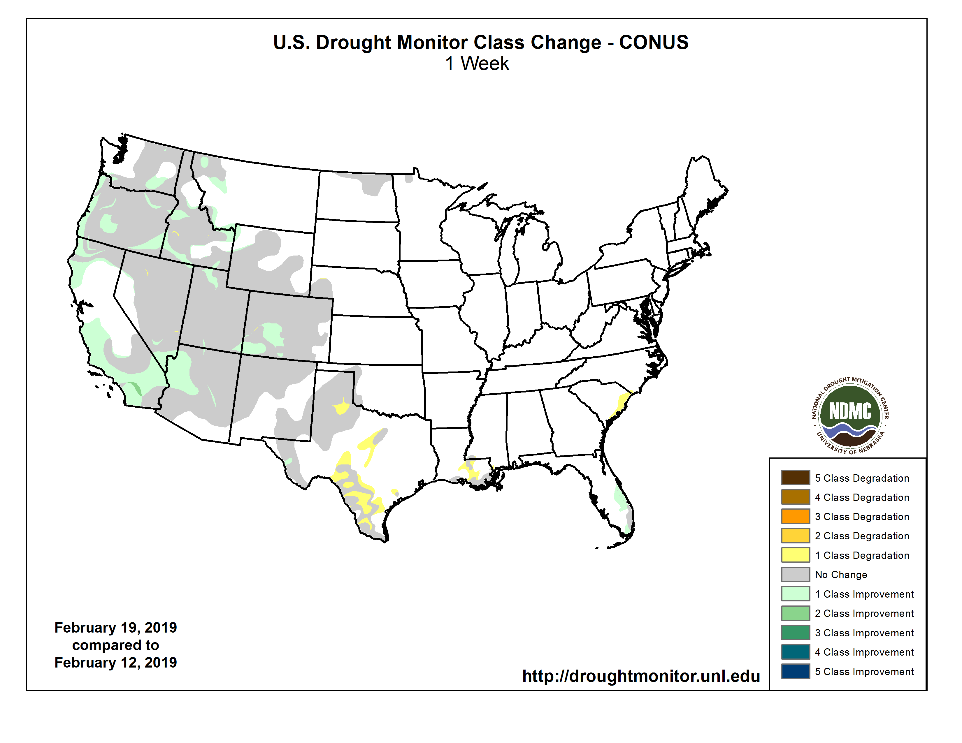
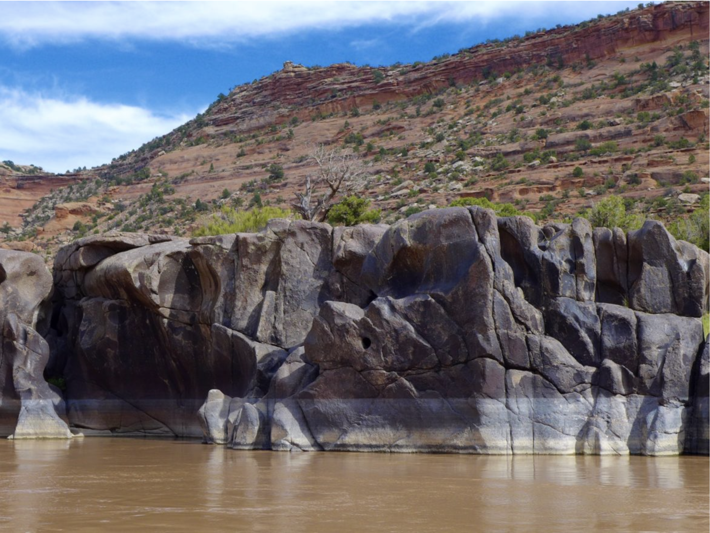
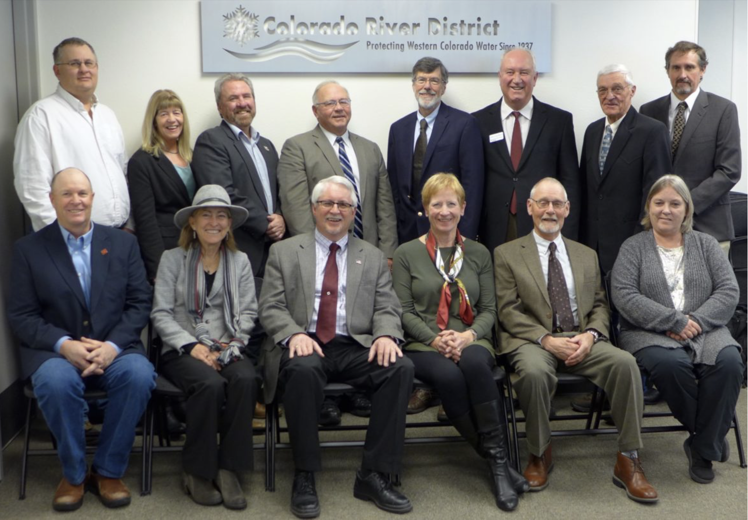
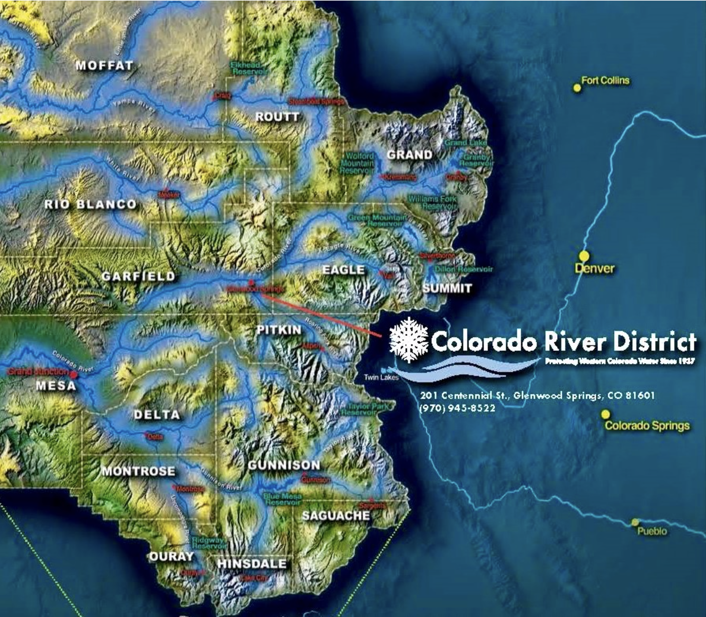

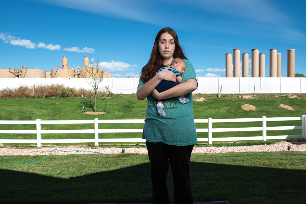


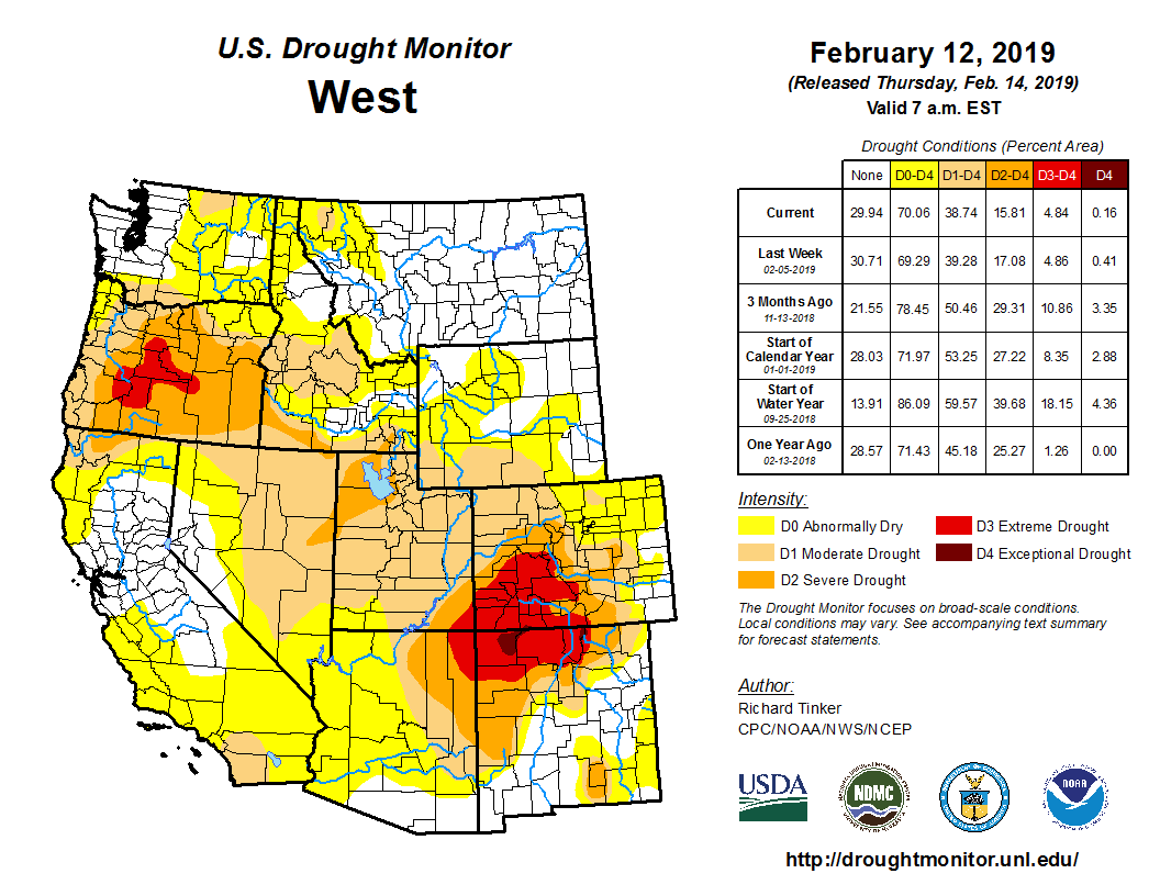


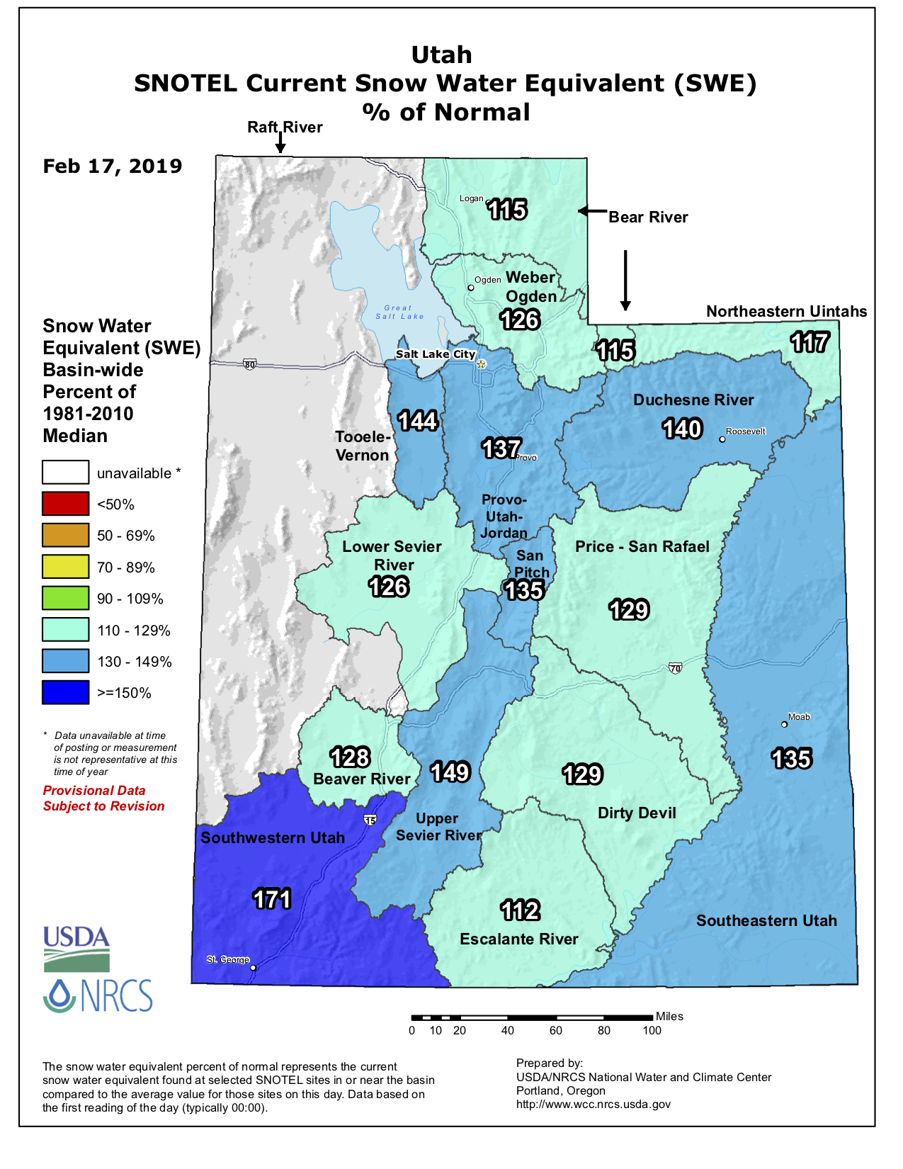


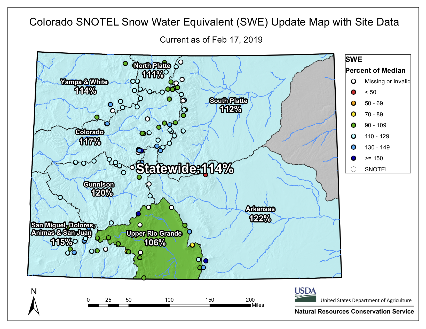


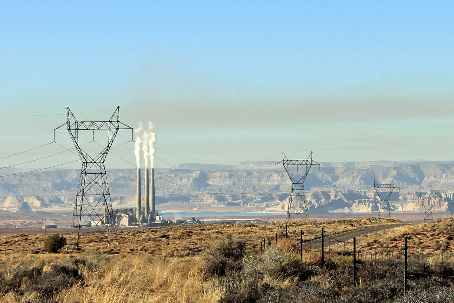
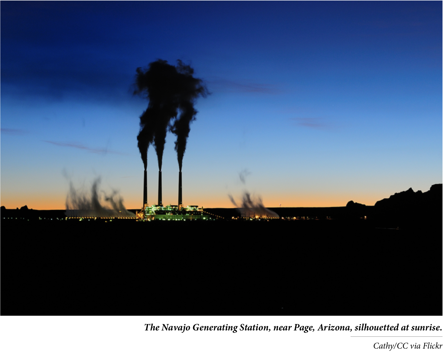
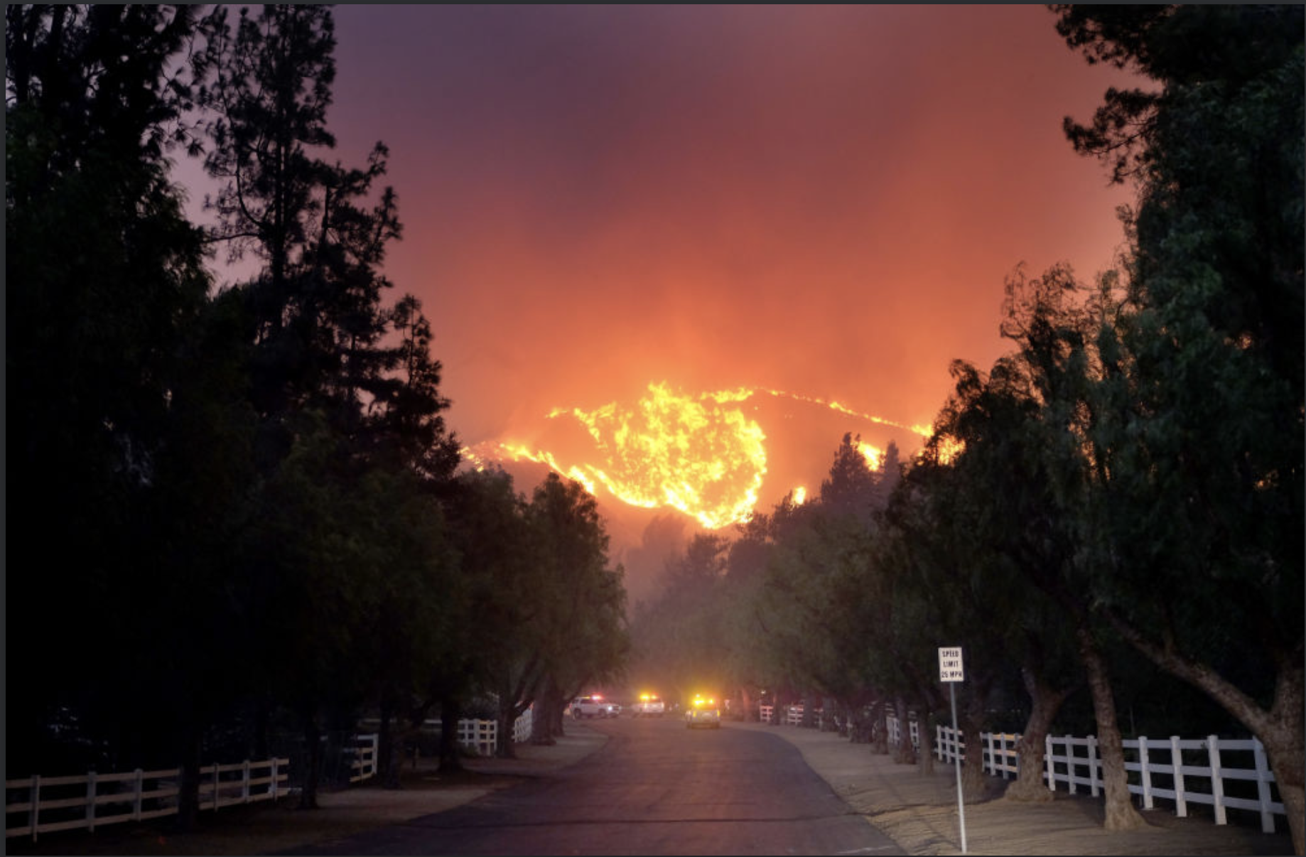


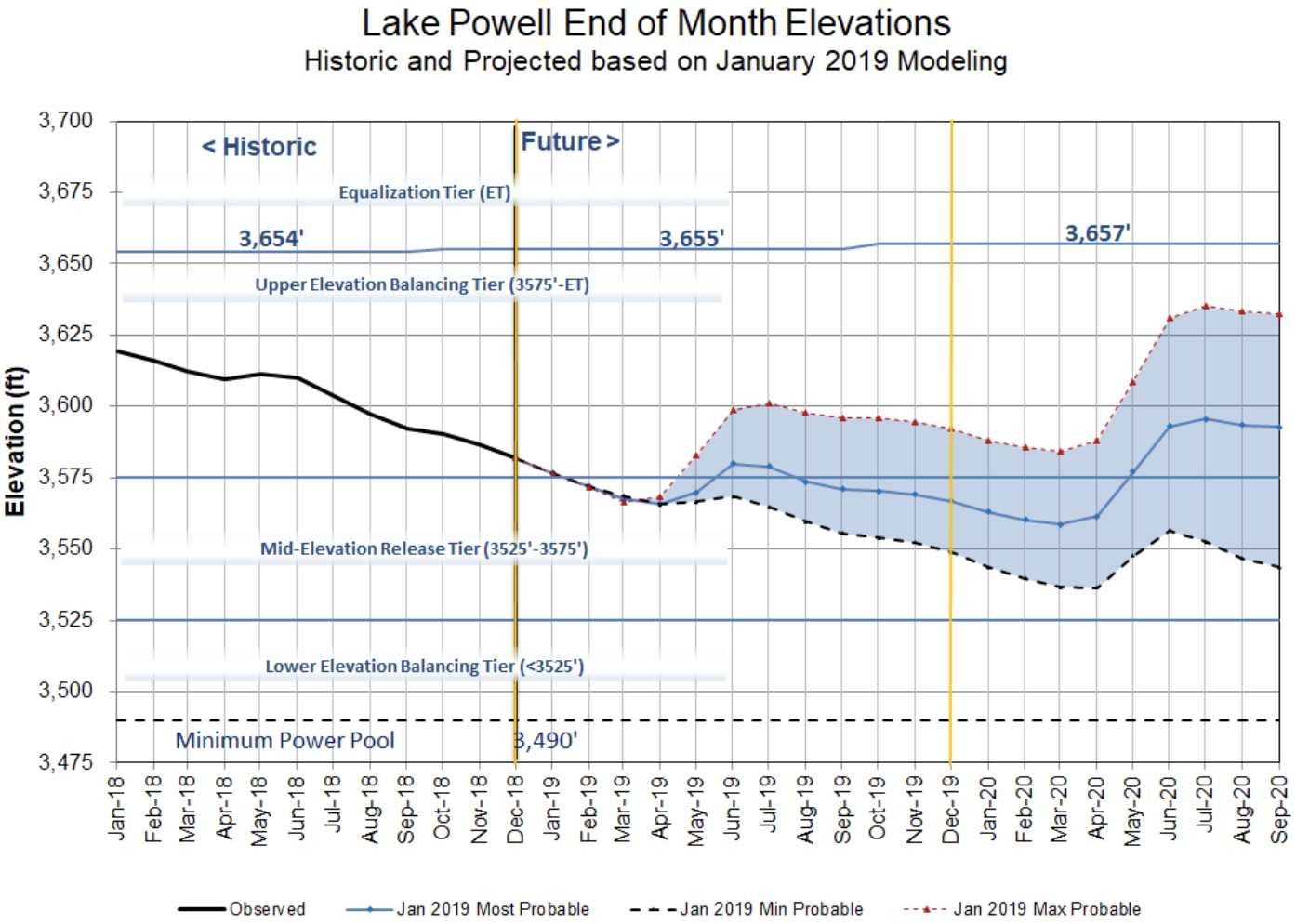


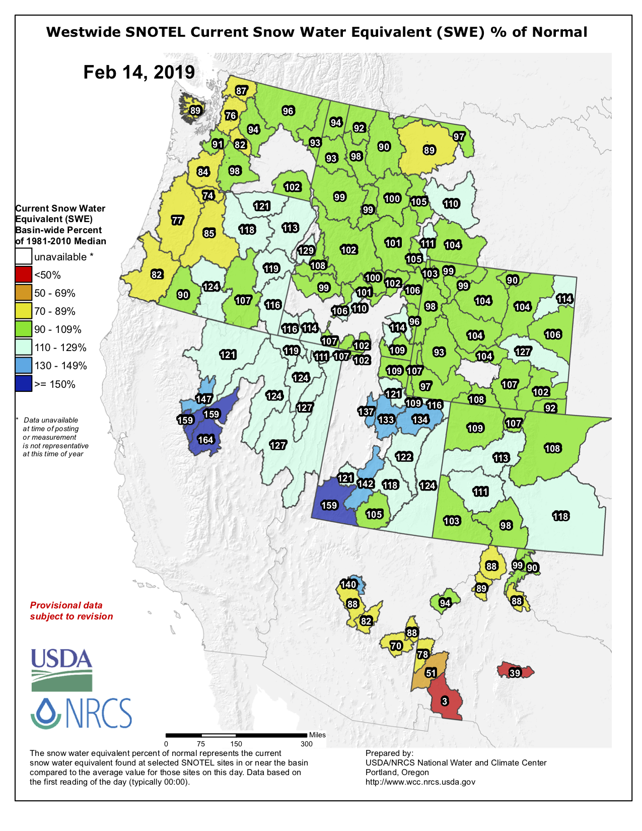
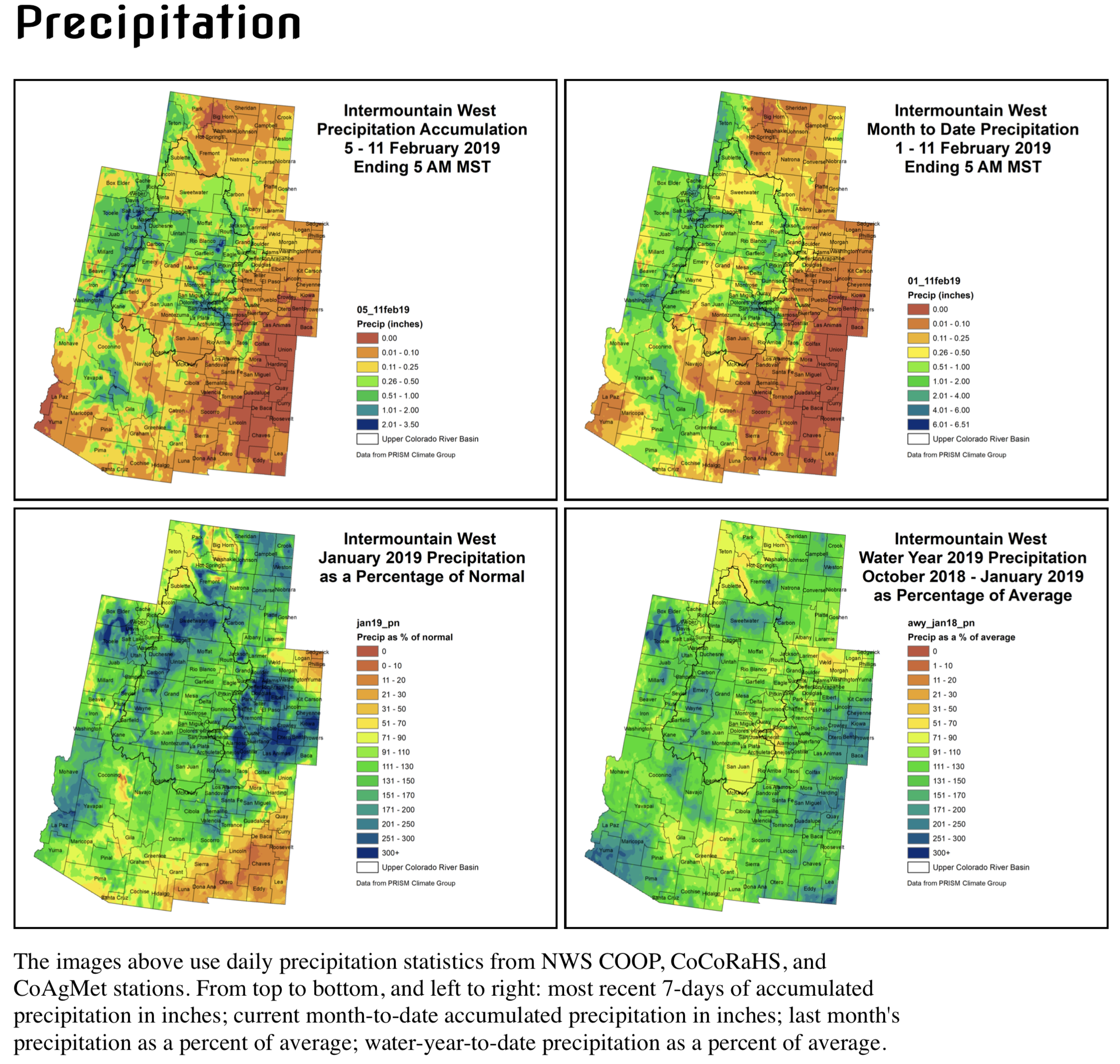


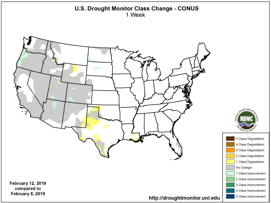


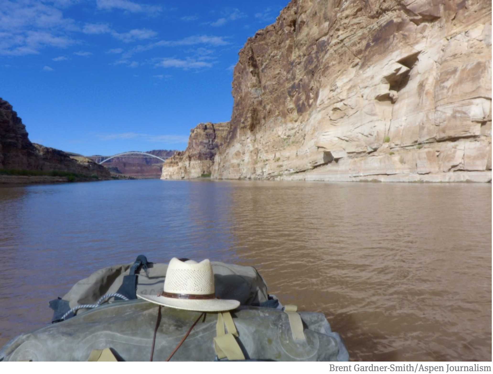


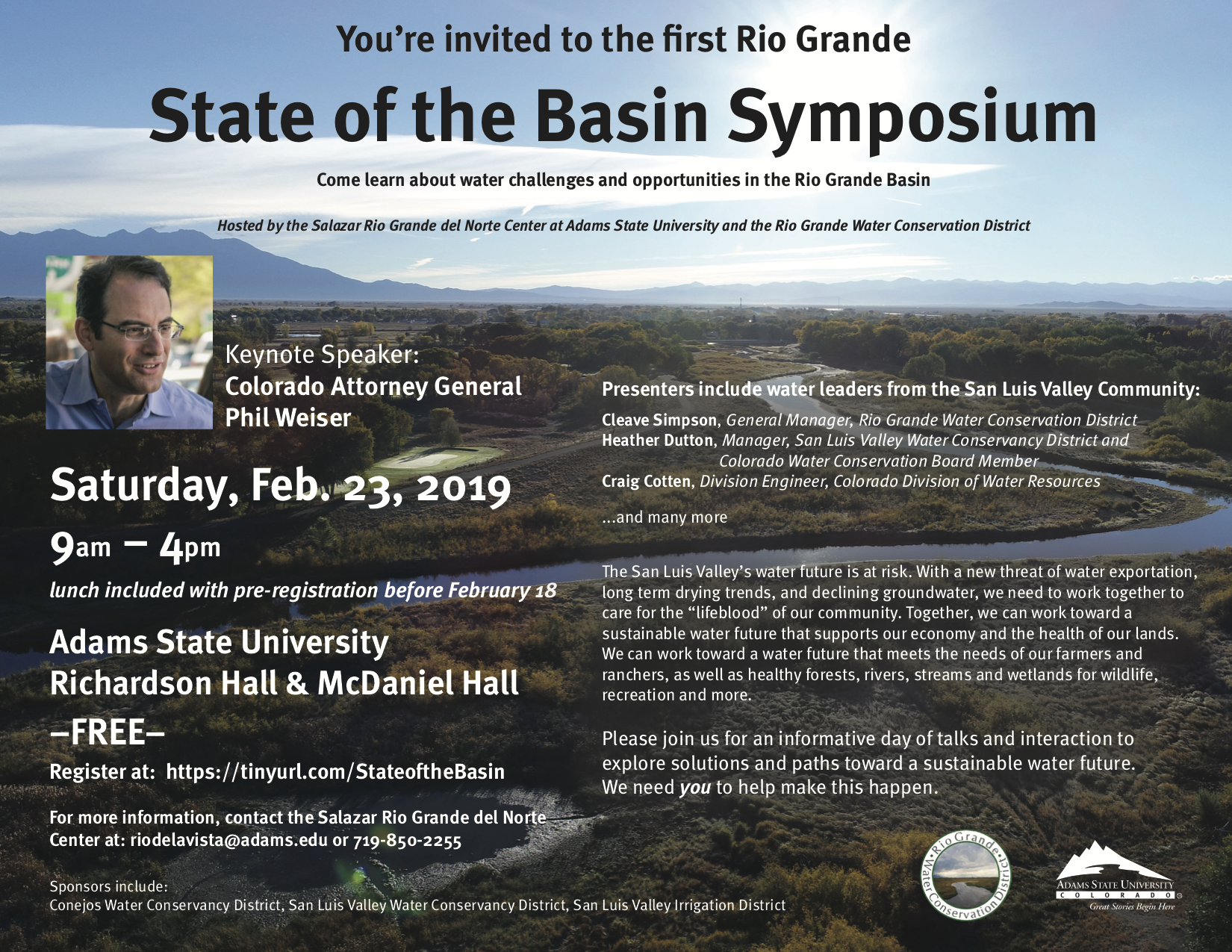


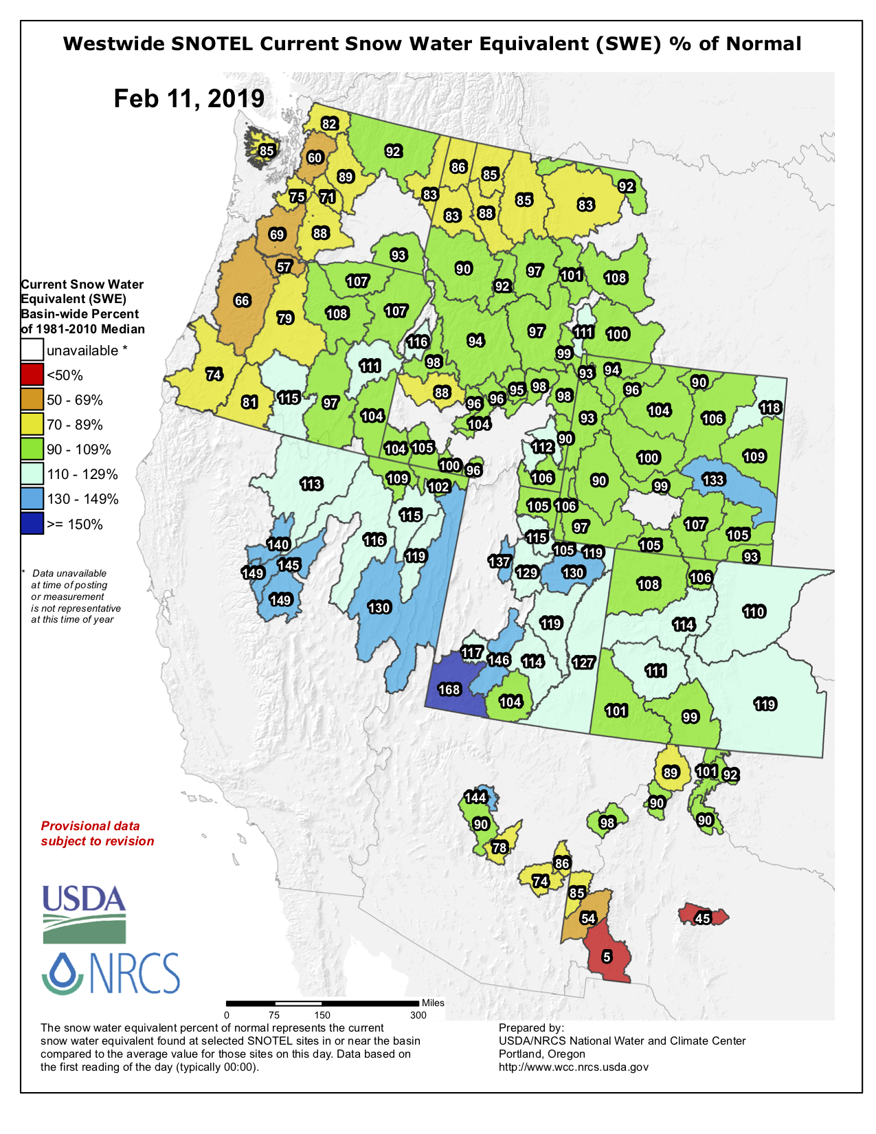