The Nature Conservancy is building a system to supply water to the Scott M. Matheson Wetlands Preserve for razorback sucker habitat

From KSLTV.com (John Hollenhorst):

The rescue project is on the Scott M. Matheson Wetlands Preserve, a property owned by The Nature Conservancy on the fringes of Moab alongside the Colorado River. Over the last few weeks, construction crews have been creating a special side-channel that will carry river-water into the wetlands during periods of higher water. It’s designed to mimic – on a small scale – the natural system of annual spring flooding that’s been disrupted over the last century or so by dams, diversions and other human activity.

“We don’t have the same magnitude of flood events, or the same duration, or even the same timing,” said Zach Ahrens, a fish biologist for the Utah Division of Wildlife Resources, one of several agencies that have partnered on the project.

In the spring, the suckers spawn and hatch tiny babies in the main current of the river. The plan is to divert the higher spring flows through the new channel into a large pond in the Matheson wetlands. Actually, in recent years it hasn’t really resembled a pond because it contains so little water. The new channel is aimed at refilling it from time to time to give the larvae of razorback suckers an alternative, temporary habitat.

“Away from the main channel allows for a little bit warmer water, which allows the fish to grow more quickly,” Ahrens said. “It also allows them some refuge from the turbulent currents that occur during spring runoff.”

If they stay out in the main channel of the river, the larvae are highly vulnerable to being eaten by non-native fish that have taken over the Colorado. “They’re maybe a half an inch long,” Ahrens said. “They’re tiny little translucent noodle-looking things.”

But if they can spend a few months in an off-stream nursery, they can come out big and strong.

“If we can bring them into a safe harbor, into a nursery and give them the months they need to grow to a sufficient size, and then release them back into the river, then they can compete” Whitham said.

When they re-enter the Colorado River, they’ll have a better chance of stand up to hungry non-native predators that were accidentally or deliberately introduced in the last few decades.

“If we can help bring back these populations of native fish, who have been around for millions of years, and get them to sufficient sizes, then we’ll know that we’re doing something right,” Whitham said.

The project is being built in phases because all the funding hasn’t been lined up yet. The Nature Conservancy hopes to fill the gap with state and federal grants as well as private contributions.

The latest E-Newsletter is hot off the presses from the Hutchins Water Center

Slide from Becky Mitchell’s presentation at the recent Water Course shindig from the Hutchins Water Center.

Click here to read the newsletter. Here’s an excerpt:

WATER COURSE MATERIALS POSTED
Presentation slides and some streaming links for the Hutchins Water Center’s recent 3-evening Water Course are now posted here. Topics included CO Water Law, Impacts of Drought & Aridification, and Drought Contingency Planning, and we had a stellar slate of speakers.

@SenatorBennet, @SenCoryGardner & Colleagues Introduce #PFAS Action Plan of 2019

Widefield aquifer via the Colorado Water Institute.

Here’s the release from Senator Bennet’s office:

Bipartisan bill would designate PFAS chemicals as hazardous substances under our environmental protection laws

U.S. Senators Michael Bennet (D-CO) and Cory Gardner (R-CO), with a bipartisan group of colleagues, today introduced legislation that would mandate the Environmental Protection Agency (EPA), within one year of enactment, declare per- and polyfluoroalkyl substances (PFAS) as hazardous substances eligible for cleanup funds under the EPA Superfund law, and also enable a requirement that polluters undertake or pay for remediation.

“It is inexcusable that the Trump administration continues to delay action to address PFAS contamination across the country,” Bennet said. “This bipartisan bill will ensure contaminated sites are cleaned up and resources are available to communities in Colorado so they have access to safe drinking water. Passing this measure is one of many steps we must take to address this public health threat with the urgency it requires.”

“This bipartisan legislation will allow EPA to pursue polluters responsible for PFAS contamination and provide the communities remediation options through Superfund,” Gardner said. “PFAS contamination is a serious issue facing our communities and we need to act quickly to address this challenge. I will continue working to make sure Coloradans have access to clean and safe drinking water.”

In May 2018, former Environmental Protection Agency (EPA) Administrator Scott Pruitt announced that EPA would propose designating PFOA and PFOS, two specific PFAS chemicals, as “hazardous substances” through one of the available statutory mechanisms, including CERCLA Section 102. Nearly a year later, on February 14, 2019, EPA released its long-anticipated PFAS Action Plan. The plan included another commitment by EPA to make that designation for PFOA and PFOS, but did not identify the available statutory mechanism it would use, nor how long the designation process would take to complete.

Clear and swift action from Congress to list PFAS as hazardous substances under CERCLA would advance the action already proposed by EPA, enabling the agency to protect human health and the environment in an expeditious manner.

Bennet’s reaction to the EPA’s plan, and his record of two years of work to address PFAS in Colorado and across the country, is available HERE.

In addition to Bennet and Gardner, original cosponsors include U.S. Senators Tom Carper (D-DE), Shelley Moore Capito (R-WV), Gary Peters (D-MI), Thom Tillis (R-NC), Debbie Stabenow (D-MI), Marco Rubio (R-FL), Jeff Merkley (D-OR), Jack Reed (D-RI), Lisa Murkowski (R-AL), Jeanne Shaheen (D-NH), Richard Burr (R-NC), and Joe Manchin (D-WV). U.S. Representative Debbie Dingell (D-Mich.) led the introduction of companion legislation in the House of Representatives earlier this Congress.

The bill text is available HERE.

From The Colorado Springs Gazette (Jakob Rodgers):

The senators’ PFAS Action Plan for 2019 comes after the Environmental Protection Agency was criticized by environmental groups and affected residents for not going further in its plan for addressing the chemicals.

The bipartisan legislation — Bennet is a Democrat, Gardner a Republican — mandates the EPA declare all perfluoroalkyl and polyfluoroalkyl substances, man-made compounds also known as PFAS, as “hazardous substances” within one year of the bill’s passage. The designation would clear the way for the EPA to use Superfund money to clean up contaminated sites, while opening the door for the government to sue polluters for cleanup costs.

“It seems like a positive step,” said Meghan Hughes, a spokeswoman for the Colorado Department of Public Health and Environment. “It really could be a driver for PFAS groundwater investigations and contaminations (cleanups) across the state.”

[…]

The legislation does not address any other aspect of the EPA’s oversight of those chemicals, such as whether the agency should regulate the chemicals in a similar fashion as lead, cyanide and mercury.

Should it pass, it’s impact on southern El Paso County — where the drinking water of tens of thousands of Security, Widefield and Fountain residents was tainted — remained unclear Friday.

The Air Force is in the midst of a yearslong process to address the chemicals that is similar to the federal Superfund program, due to the decadeslong use of a firefighting foam containing the toxic chemicals at Peterson Air Force Base that was detected in groundwater.

The Air Force is still investigating the contamination — a process that was expected to take years. And any cleanup steps — such as removing the chemicals from the Widefield aquifer — have not been announced, nor has money been allocated for such cleanup efforts.

In the meantime, water districts serving Security, Widefield and Fountain have spent millions of dollars installing treatment systems and piping in water from elsewhere to remove the chemicals from residents’ tap water to nondetectable levels.

Two other communities in Colorado — in Boulder and Adams counties — also have discovered the chemicals in their drinking water. Both contamination sites were near fire departments that used the same toxic firefighting foam that was a mainstay at Peterson Air Force Base, according to the Colorado Department of Public Health and Environment.

The @USBR March 4th deadline is upon all of us in the #ColoradoRiver Basin but the spotlight is shining on #Arizona and #California #DCP #COriver #aridification

All eyes are on Arizona and California with Brenda Burman’s extended deadline coming up on Monday. They are dealing with the Lower Basin Drought Contingency Plan, which really should be a plan to address the declining supply and increasing demand that causes an annual deficit. (H/T Eric Kuhn over at Inkstain.

From Arizona Central (Ian James):

Water poured into an artificial wetland next to the Gila River near Sacaton as Arizona’s leading proponents of a Colorado River drought plan celebrated the state’s progress in moving toward a deal.

Leaders of the Gila River Indian Community touted the restoration project as an example of putting water back into a river that has was sucked dry over the years, and a symbolic step in promoting sustainable water management in the state. The inauguration ceremony on the reservation featured traditional singing by men and boys who shook gourd rattles in unison.

Gov. Stephen Roe Lewis said the community, which has agreed to contribute water under the proposed Colorado River deal, is playing a vital role in helping to finish the three-state Drought Contingency Plan, or DCP.

“This is very important and very historic,” Lewis told the audience of community members, politicians and water managers. “It goes beyond politics. It goes to the benefit and the future sustainability and existence of all of us here.”

[…]

Caption: Imperial Valley, Salton Sea, CA / ModelRelease: N/A / PropertyRelease: N/A (Newscom TagID: ndxphotos113984) [Photo via Newscom]

Unresolved issues remain

Yet even as Arizona’s top water officials expressed optimism about finishing the drought agreement after months of difficult negotiations, they also voiced concerns that unresolved issues in California still could upend the entire deal.

More than 250 miles to the west in California’s Imperial Valley, leaders of the irrigation district that controls the largest share of Colorado River water were still discussing a key condition of their participation. Imperial Irrigation District officials announced at a meeting on Friday afternoon that the federal Bureau of Reclamation has agreed to their condition that the drought package include linkage to funding for the Salton Sea.

They said federal officials will write a strong letter of support backing IID’s requests for $200 million in Farm Bill funding for wetlands projects around the shrinking sea. The projects are aimed at keeping down dust along the shorelines and salvaging deteriorating habitat for fish and birds.

Reclamation Commissioner Brenda Burman, the U.S. solicitor and staff are finalizing a letter stating that “they consider the restoration of the Salton Sea is a critical ingredient of the drought contingency plans and cannot be ignored, and they stand prepared to help the IID with the Department of Agriculture to try to get funding in whatever way possible,” said IID attorney Charles Dumars.

He cautioned that it was “a building block, nothing more,” but said it was a big one that could be used to persuade Agriculture Department officials to allocate funds for the receding lake…

The board also voted unanimously to oppose a supposed “white knight” offer by the Metropolitan Water District of Southern California’s general manager, Jeffrey Kightlinger, to provide IID’s portion of water to be kept in Lake Mead if the agency doesn’t sign on to the drought plan.

Several board members and people in the audience chided the Los Angeles-based agency for trying to interfere in their process, saying it was ignoring the public-health issues at the Salton Sea created by the withdrawal of Colorado River water…

IID officials also discussed a timeline that Burman and her staff presented at a recent meeting in Las Vegas. The aim, Martinez said, is to have agreements adopted by all parties…in Phoenix on March 14 or 15 to sign a joint letter to Congress endorsing the plan…

Gila River watershed. Graphic credit: Wikimedia

Arizona working to wrap up its part

The Gila River Indian Community’s involvement is key because the community is entitled to about a fourth of the water that passes through the Central Arizona Project, and it has offered to kick in some water to make the drought agreement work.

Arizona’s plan for divvying up the water cutbacks involves deliveries of “mitigation” water to help lessen the blow for some farmers and other entities, as well as compensation payments for those that contribute water. Those payments are to be covered with more than $100 million from the state and the Central Arizona Water Conservation District, which manages the CAP Canal. Much of the money would go toward paying for water from the Colorado River Indian Tribes and the Gila River Indian Community…

Gov. Ducey signed a package of legislation on Jan. 31 endorsing the Drought Contingency Plan. Arizona still needs to finish a list of internal water agreements to make the state’s piece of the deal work.

State officials have presented a list of a dozen remaining agreements, two of which would require the approval of the Gila River Indian Community. But Cooke said not all the agreements need to be signed for the three-state deal to move forward.

Cooke said he’s focused most of all on finishing a framework agreement for Arizona focusing on “intentionally created surplus,” a term for unused water that is stored in Lake Mead.

Cranes make annual return to the San Luis Valley — @COParksWildlife

Greater Sandhill Cranes in flight over the San Luis Valley. The annual Monte Vista Crane Festival is March 8-10. Photo credit: Colorado Parks and Wildlife

Here’s the release from Colorado Parks and Wildlife:

In the San Luis Valley nature is again putting on one of its most memorable displays: the spring migration of Greater Sandhill Cranes. In appreciation of this wildlife spectacle, area organizations, businesses and wildlife agencies are holding the annual Monte Vista Crane Festival, March 8-10.

“Everyone who lives in Colorado should take the time to see this ancient and magnificent migration,” said Joe Lewandowski, public information officer for the Southwest Region of Colorado Parks and Wildlife. “This is one of only a few great wildlife migrations in the United States that people can easily see. The sights and sounds are absolutely amazing.”

The cranes started arriving in mid-February, flying from their winter nesting ground, primarily in New Mexico. The large wetland areas, wildlife refuges and grain fields in the San Luis Valley draw in about 25,000 birds. The cranes stop in the valley to rest-up and re-fuel for their trip north to their summer nesting and breeding grounds in Idaho, Montana and Wyoming.

Cranes are among the oldest living species on the planet: Fossil records for cranes date back 9 million years.

The birds that migrate through Colorado are the largest of the North American sandhill subspecies standing 4-feet tall, having a wing-span of up to 7 feet and weighing in at 11 pounds. Besides their imposing size, the birds issue a continuous, distinctive and haunting call. At this time of year cranes are engaged in their mating ritual and the birds perform an elegant hopping dance to gain the attention of other birds.

The birds are abundant in areas near the town of Monte Vista and wildlife watchers can see the birds most readily in the Monte Vista National Wildlife Refuge, about 5 miles south of town of Colorado Highway 15. Birds also gather at the Alamosa National Wildlife Refuge, southeast of the town of Alamosa, and at that Rio Grande, Higel and Russell Lakes state wildlife areas.

The cranes are most active at dawn and at dusk when they’re moving back and forth from their nighttime roosting areas. But in the middle of the day they graze gracefully in the grain fields of the Monte Vista refuge.

Be sure to dress warm, as winter still reigns in the valley.

During the three days of the festival, free tours are offered at 7 a.m. and 4 p.m. when the birds are most active. Visitors take buses to various spots on the wildlife refuge, and U.S. Fish and Wildlife Service staffers talk about the migration and the refuge. If you want to take a tour, be on time because the buses leave promptly.

The number of cranes in the valley peaks in mid-March; but many birds linger through the month. So even if you can’t go the weekend of the festival there’s still plenty of time to see the birds.

Birdwatchers who travel on their own should be cautious when parking, getting out of vehicles and walking along roads. People are also asked to view birds from a distance with binoculars and spotting scopes, and to observe trail signs and closure notices.

Many other bird species – including eagles, turkeys, and a variety of raptors and waterfowl – can also be seen throughout the San Luis Valley. Look in the many cottonwood trees for owl nests.

The festival headquarters and starting point for the tours is the Ski Hi Park building located near U.S. Highway 160 on Sherman Avenue on the east side of Monte Vista. Visitors can pick up maps, schedules and information at the headquarters. Besides the tours, a variety of workshops are put on by bird, wildlife and photography experts. An arts and crafts fair continues through the weekend at the headquarters building.

Approximate distances to Monte Vista: Denver, 220 miles; Colorado Springs, 182 miles; Salida, 85 miles; Vail, 175 miles; Durango, 135 miles; Grand Junction, 230 miles.

For more information on the Monte Vista Crane Festival, see: mvcranefest.org; or https://www.fws.gov/refuge/Monte_Vista. For more information on State Wildlife Areas in the San Luis Valley, go to: https://cpw.state.co.us/placestogo.

Colorado NRCS now accepting applications for 2019 Agricultural Land Easement and Wetlands Reserve Programs — High Plains/Midwest Ag Journal

Irrigation sprinklers run over a farm in Longmont in the South Platte River basin. Photo credit: Lindsay Fendt/Aspen Journalism

From The High Plains/Midwest Ag Journal:

Clint Evans, Colorado State conservationist for USDA’s Natural Resources Conservation Service recently announced applications for the 2019 Agricultural Conservation Easement Program—Agricultural Land Easement and Agricultural Conservation Easement Program-Wetlands Reserve Program—are currently being accepted on a rolling basis. Due to the new 2018 Farm Bill, Colorado NRCS will not be announcing an application deadline for either program at this time. A subsequent announcement will be made at least 30 days prior to any established deadline in 2019.

The purpose of the ACEP-ALE program is to protect the agricultural viability, grazing uses and related conservation values by limiting nonagricultural uses of the land. The purpose of the ACEP-WRE program is to protect and restore wetlands, wildlife habitat, and water quality on agricultural lands. These programs are voluntary and the landowner retains ownership of the land.

Applicants for ACEP-ALE must be a federally recognized Indian Tribe, state or local units of government, or a non-governmental organization. Individual landowners may apply for ACEP-WRE if their land includes farmed or converted wetlands that can be successfully restored or other eligible wetland type.

Completed application packets for ACEP-ALE should be emailed to Heather Foley at heather.foley@co.usda.gov or mailed to Heather Foley, easements coordinator, USDA-NRCS, Denver Federal Center, Building 56, Room 2604, Denver, CO 80225. Completed application packets for ACEP-WRE must be submitted to the local NRCS field offices located within USDA Service Centers. Application packets for either program must be submitted based on the 2018 guidelines.

For more information about NRCS easement programs, please contact Heather Foley at 720-544-2805 or heather.foley@co.usda.gov. You can also visit your local NRCS Service Center or visit the Colorado NRCS website at http://www.co.nrcs.usda.gov.

Letter: Climate crisis and a betrayed generation #ActOnClimate

From The Guardian letters to the editor:

Activists behind recent youth-led climate protests say their views are being ignored in the debate about global warming

We, the young, are deeply concerned about our future. Humanity is currently causing the sixth mass extinction of species and the global climate system is at the brink of a catastrophic crisis. Its devastating impacts are already felt by millions of people around the globe. Yet we are far from reaching the goals of the Paris agreement.

Young people make up more than half of the global population. Our generation grew up with the climate crisis and we will have to deal with it for the rest of our lives. Despite that fact, most of us are not included in the local and global decision-making process. We are the voiceless future of humanity.

We will no longer accept this injustice. We demand justice for all past, current and future victims of the climate crisis, and so we are rising up. Thousands of us have taken to the streets in the past weeks all around the world. Now we will make our voices heard. On 15 March, we will protest on every continent.

We finally need to treat the climate crisis as a crisis. It is the biggest threat in human history and we will not accept the world’s decision-makers’ inaction that threatens our entire civilisation. We will not accept a life in fear and devastation. We have the right to live our dreams and hopes. Climate change is already happening. People did die, are dying and will die because of it, but we can and will stop this madness.

We, the young, have started to move. We are going to change the fate of humanity, whether you like it or not. United we will rise until we see climate justice. We demand the world’s decision-makers take responsibility and solve this crisis.

You have failed us in the past. If you continue failing us in the future, we, the young people, will make change happen by ourselves. The youth of this world has started to move and we will not rest again.

The global coordination group of the youth-led climate strike.

Click here to go the FridaysForFuture website.

Alamosa councillors plan to oppose latest San Luis Valley water export plans

The northern end of Colorado’s San Luis Valley has a raw, lonely beauty that rivals almost any place in the North American West. Photo/Allen Best

From The Valley Courier (Ruth Heide):

Alamosa city councilors and staff are willing to join the fight against the latest water export proposal, they told water leader Cleave Simpson during a work session Tuesday night.

Simpson is the general manager of the Rio Grande Water Conservation District, which has taken a position against a water export proposal by Renewable Water Resources. He shared with the council the history of former water export proposals and details about the latest one, which proposes to export 22,000 acre feet from the San Luis Valley to the south Denver metro area.

“I do believe it’s real,” Simpson said. “I think they intend to do it.”

Nothing has yet been filed in court but Simpson said the spokesman for Renewable Water Resources indicated the case might be filed by the end of this year. Simpson said the City of Alamosa could enter the case when it is filed.

The city council and staff discussed other ways they could be involved including taking an official stand through a resolution, like the water conservation district did, and participating in education and awareness.

“It would damage the agriculture of the Valley,” Councilman David Broyles commented about the proposed export.

“And economy,” added Alamosa City Manager Heather Brooks.

Councilman Charles Griego said he believed the city’s first step would be to pass an official resolution during a council meeting. Brooks suggested the city council could pass a resolution either the second meeting in March or first meeting in April. “I am hearing this is something we should be taking seriously,” Brooks said.

Griego said the city needs to be clear that “not one drop” should be exported from the Valley and that the council would be against any kind of water leaving the Valley. He said the word needs to get out how devastating this would be to the Valley…

He said he is going to inform the Interbasin Compact Commission members later this week, as he is a member of that governor-appointed statewide water board.

Simpson said Renewable Water Resources on its website (renewablewaterresources.com) says “Best for the San Luis Valley. Best for the environment. Best for Colorado.” However, he sees no benefit whatsoever to the Valley of this project. “It’s not good for the San Luis Valley.”

He added that the Valley has a history of opposition to similar projects and will adamantly oppose this one too.

“Every 10-20 years, there’s another export proposal,” Simpson said.

Some of the past proposals, which were unsuccessful, were a proposal to export water from wells drilled in Costilla County to San Marcos, Texas in the 1970’s and multiple export proposals tied to the late Gary Boyce who owned land in Saguache County. American Water Development Inc. (AWDI) proposed to pump 200,000 acre feet of water from the Baca Ranch area to the Front Range.

The latest proposal is that of Renewable Water Resources, which purchased a 12,000-acre ranch north of Crestone. Their proposal is to pipe 22,000 acre feet of water from the confined aquifer out of the Valley and ultimately to the Denver area. (Simpson described 22,000 acre feet as the equivalent of 100 circles.) Renewable Water Resources representatives met with the Rio Grande Water Conservation District board to seek the district’s cooperation in helping the developers use up to $60 million (about $2,500 an acre foot) to buy and retire water rights across the Valley and to help manage a $50-million community fund. Although planning to pump out 22,000 acre feet, the water developers propose to buy up twice that much, 40,000-44,000 acre feet of water rights, and retire a portion, which is a different approach than previous water exporters, Simpson explained.

He said reducing water consumption is a similar goal to the water district and sub-districts. However, “We are not pursuing permanent dry up or permanent removal of 22,000 acre feet of water leaving the Valley.”

Idalia: The South Fork #RepublicanRiver Restoration Coalition Bonny Reservoir project landowner meeting March 14, 2019

From the South Fork Republican River Restoration Coalition via The Yuma Pioneer:

Bonny Reservoir, once a popular camping, boating and fishing destination located in extreme southeastern Yuma County, was drained years ago to help Colorado get into compliance with the Republican River Compact with Kansas and Nebraska.

However, efforts by a coalition of county governments and other organizations — named the South Fork Republican River Restoration Coalition — still remain underway to at least partially restore it to its formal usage.

There have been a series of public meetings since last year. The next is being planned for Thursday, March 14, in a joint meeting with the Colorado Agriculture Preservation Association. It will be at Idalia School from 5 to 6:30 p.m., followed by CAPA’s annual meeting.

The coalition has been working on the project for the past two years. Yuma County and Kit Carson County are part of the group, along with Three Rivers Alliance, the Republican River Water Conservation District, Colorado Parks & Wildlife and The Nature Conservancy.

Yuma County Commissioner Robin Wiley told the Pioneer he believes the group is making headway in a positive direction. He stressed that plans do include necessarily refilling the lake, but restoring the stream flow and possibly establishing some non-water and small water recreational activities in and around the old lake bed.

The coalition secured a grant in January 2018 from the Colorado Water Conservation Board for $99,000, with The Nature Conservancy giving the cash match.

Wiley said the money is being used to do Phase I of the project, planning and design.

The coalition has hired Otak Engineering to do channel design and engineering. A firm named Stillwater is doing the habitat restoration planning, and CHM has been hired to do an economic analysis of possible recreational activities.

It had a landowner meeting last August in Idalia to tell the landowners, up and down the South Fork of the Republican River, what the coalition is trying to do and ask for their cooperation.

Last November there were two meetings, one in Idalia and one in Burlington, to get input from the public on the project.

Now comes the March 14 meeting in Idalia. All interested members of the public are invited to attend.

@Northern_Water: Farm purchase part of #NISP effort to ensure water-secure future for local communities and agriculture

Northern Integrated Supply Project (NISP) map July 27, 2016 via Northern Water.

Here’s the release from Northern Water (Brian Werner):

The recent purchase of a Weld County farm marks a new venture for Northern Water and Northern Integrated Supply Project participants – one that’s part of the ongoing, collaborative effort to secure future water supplies for both the region’s communities and our vital agricultural industry.
On Jan. 31, Northern Water and the NISP participants purchased a 28-acre farm northeast of Greeley and the property’s water rights. The farm was purchased through the NISP Water Secure program, a cooperative effort to maintain the exchange of water for NISP while keeping water on participating farms. This investment is a shift from the “buy-and-dry” approach that has stressed our agricultural communities.

This innovative program will eventually provide supplemental water to approximately 500,000 residents in northern Colorado while preserving thousands of acres of irrigated farmland. Water Secure is part of a strategic long-term plan to better plan for future growth and to consistently apply Colorado Water Plan principles to protect water for our communities, farms and the environment. Without innovative approaches such as Water Secure, the region is on pace to see hundreds of thousands of irrigated acres dried up by mid-century.

“This is an outside-the-box, ‘buy-and-supply’ approach we’re taking to address the tightening water supplies facing Northern Colorado and its future generations,” said Northern Water General Manager Brad Wind.

The recently purchased farm sits within an area of Weld County that is key to NISP – a project that, once built, will include Glade Reservoir near Fort Collins and Galeton Reservoir near Ault, and deliver approximately 40,000 acre-feet of water annually to 15 local communities and water districts.

As part of the project, Northern Water and the NISP participants are working with the New Cache la Poudre Irrigating Company and Larimer and Weld Irrigation Company ditch and reservoir systems in Weld County, to use a portion of their senior water rights in exchanges that will ensure the NISP participants receive the water from the project.

These exchanges with the two systems will keep water flowing to those farms, as well as include compensation that will enhance the long-term viability of their operations.

To avoid water leaving those farms permanently through buy and dry purchases from other entities, Northern Water will buy land and water from willing sellers to ensure those supplies remain in the two ditch systems and available for exchange.

The senior water rights in the New Cache and Larimer-Weld systems are currently among the most sought after by water providers looking to obtain future supplies.
Farms in the New Cache and Larimer-Weld systems bought by Northern Water will remain in production, through limited land use easements on the property, lease-back agreements or other arrangements that will require continued irrigation on those farms.

Furthermore, the purchase of any irrigated lands will be done with the goal of eventually returning them to private ownership.

“The Water Secure program maintains irrigated agriculture and provides open space benefits while eliminating many of the long-term challenges with the practice of buying and drying,” Wind added.

To learn more about NISP, go to http://www.gladereservoir.org.

From The Greeley Tribune (Sara Knuth):

As part of the newly implemented Water Secure program, Northern Water purchased the 28-acre farm northeast of Greeley on Jan. 31 with communities that participate in the Northern Integrated Supply Project, which will result in two reservoirs and more water for 15 communities…

Instead of municipalities buying up water rights on farmland and leaving them to dry out, the district is looking at the initiative as a way to both preserve irrigated farmland and provide supplemental water to an estimated 500,000 northern Colorado residents.

During a phone interview Thursday, Northern Water spokesman Brian Werner said it’s critical to make sure water is delivered annually to farms.

“It’s what makes this project work,” he said. “Keeping water on farms, as opposed to the good old way it’s been done in the past in this state. The American West, you bought land and you dried it up. We’re buying it and we’re calling it ‘buy and supply’ rather than buy and dry. So we need to keep the water on the property.”

This is how the program will work:

Northern Water and the NISP participants, which include Evans and Windsor, will work with the New Cache la Poudre Irrigating Company and the Larimer and Weld Irrigation Company ditch and reservoir systems in Weld County to use a portion of their senior water rights to make sure the NISP communities get water from the project.

In turn, the exchanges with the two systems will ensure water keeps flowing to participating farms and include compensation. Farms in both systems purchased by Northern Water will remain in production through arrangements such as limited land use easements and lease-back agreements.

“To avoid water leaving those farms permanently through buy and dry purchases from other entities, Northern Water will buy land and water from willing sellers to ensure those supplies remain in the two ditch systems and available for exchange,” according to the news release.

For the district, getting rights from both systems is significant — senior water rights in New Cache and Larimer-Weld systems are among the most sought after by water providers who are looking for supplies.

Werner said the company isn’t sure yet how much the district will invest in the program but said it will likely take millions of dollars.

Still, Northern officials emphasized that the purchase of any irrigated land will happen with an end goal in sight: return the farms to private ownership again eventually.

#Snowpack/#Drought news: “Things really have been turning a corner this winter” — Peter Goble (@ColoradoClimate)

Westwide SNOTEL basin-filled map March 1. 2019 via the NRCS.

From The Grand Junction Daily Sentinel (Dennis Webb):

The state’s snowpack is ending February at 114 percent of median, compared to about 94 percent around the start of the year. It’s looking increasingly likely this winter will help the state at least somewhat recover from the drought and low water supplies that besieged it last year.

“Things really have been turning a corner this winter,” said Peter Goble, a climatologist with the Colorado Climate Center at Colorado State University.

Just this week, moister weather led to the end of a drought designation in the far-western parts of Mesa, Garfield, Rio Blanco and Moffat counties. Those areas have been downgraded to an abnormally dry U.S. Drought Monitor designation, a step below drought. Most of western Colorado otherwise remains in various stages of drought.

Some of the best moisture news in the state comes in southwest Colorado, which has had some of the worst drought conditions in the state and has struggled for years in terms of snowpack. At the year’s start, snow water equivalent levels in river basins in southwest Colorado were around 70 percent of normal. As of Thursday, that region had snowpack of 122 percent of median, tying the Arkansas River Basin for the highest amount statewide.

The Gunnison River Basin, which also had miserable snowpack a year ago and was 90 percent of normal around this year’s start, now stands at 119 percent of median. The Colorado River Basin is at 112 percent of median. No major basin in the state is below median.

A weekly climate, water and drought assessment Goble and his Colorado Climate Center colleagues help prepare says snowpack is now above average for almost all of the Intermountain West. The assessment pointed to recent storms that included nearly 2 feet of snow in Durango in 24 hours and 86 inches at Wolf Creek Ski Area in a week, an average of more than a foot a day…

…an El Niño climate pattern that has been months in developing has officially formed over the Pacific Ocean. Strautins said El Niño winters statistically lean toward wetter springs in central and southwestern Colorado, although this winter’s El Niño has been atypical in that it has taken so long to form…

Even if the storm spigots turn off, it’s worth noting that in some places in western Colorado, snowpack levels have surpassed average peak seasonal values. Peak accumulations usually aren’t reached until sometime in early to mid-April, depending on the location and elevation.

Goble said snowpack in the San Juan Mountains currently ranges anywhere from 80 to 115 percent of average annual peak.

“Roughly half of the (measuring) stations are above 100 percent,” he said.

On Grand Mesa, stations are recording levels from 73 to 87 percent of average peak, he said. Last year at this time on Grand Mesa, those figures ranged from 29 to 54 percent of average peak…

[Alsdus] Strautins said many reservoirs in western Colorado will fill when there’s an average snowpack year, even when snowpack was well below average the previous year. Refilling those reservoirs is crucial because they were drawn down last year to help meet irrigation and municipal needs due to the lack of precipitation, and have less water available to help this year if snowpack again is low.

Still, bigger reservoirs, among them Blue Mesa Reservoir, can take longer than a year to refill. And the Colorado River’s two major reservoirs, Lake Powell and Lake Mead, continue to face systemic shortfalls.

Their water levels are both currently at about 40 percent of capacity, and states within the Colorado River Basin have been developing contingency plans for dealing with the possibility of continued drought.

The Journey of Water — Lego style – News on TAP

Silas Malers, 12, dazzled the Colorado Water Congress with his use of Legos to show how water moves.

Source: The Journey of Water — Lego style – News on TAP

A multimillion-dollar project gets a fresh look through students’ eyes – News on TAP

CU engineering students tackle real-world design challenges at new Denver Water treatment plant.

Source: A multimillion-dollar project gets a fresh look through students’ eyes – News on TAP

#Drought news: #Snow blankets the #West, major improvements in Four Corners and W. #Colorado

Click on a thumbnail graphic to view a gallery of drought data from the US Drought Monitor.

Click here to go the US Drought Monitor website. Here’s an excerpt:

Summary

A pair of late-winter storms blanketed large areas of the West with snow, easing drought; bolstering high-elevation snowpack; and further improving spring and summer runoff prospects. The first storm system, which swept across the Southwest from February 20-22, produced heavy precipitation in core drought areas of the Four Corners States and deposited measurable snow in locations such as Las Vegas, Nevada, and Tucson, Arizona. The second storm—in actuality a series of disturbances—began to affect parts of the Northwest during the weekend of February 23-24 and later delivered another round of heavy precipitation across northern California. Farther east, drenching rain resulted in aggravated and expanded flooding from the northern Mississippi Delta into the southern Appalachians. Rainfall totaled 4 to 12 inches or more in the flood-affected area, with some of the highest amounts occurring in the Tennessee Valley. On February 23-24, thunderstorms spawned several tornadoes in Alabama, Georgia, and Mississippi. Farther north, a blizzard briefly engulfed portions of the northern and central Plains and upper Midwest. The short-lived but fierce storm produced several inches of snow, driven by wind gusts in excess of 60 mph, mainly on February 23-24. High winds also raked the southern Plains—without the benefit of significant precipitation—compounding the effects of short-term dryness on winter wheat and rangeland health…

High Plains

Abnormal dryness (D0) was also removed from North Dakota, following a protracted period of below-normal temperatures and frequent snowfall events. The drought situation for Wyoming and Colorado will be covered in the section devoted to the West…

West

As described in the summary section, major storm systems affected core drought areas in Oregon and the Four Corners region, respectively, leading to locally significant reductions in the coverage of dryness (D0) and moderate to exceptional drought (D1 to D4). By late February, nearly all Western river basins, except a few in southern New Mexico, are experiencing near- to above-average snowpack. In addition, the recent spate of cold weather has maximized snow accumulations, even at middle and lower elevations. According to the California Department of Water Resources, the average water content of the Sierra Nevada snowpack by February 26 stood at 36 inches—150% of average for the date and approximately 130% of average peak value. In Oregon, extreme drought (D3) was eradicated, while substantial reductions were realized in the coverage of moderate to severe drought (D1 to D2). Drought was nearly pushed out of California, with only a lingering sliver of moderate drought (D1) along the Oregon border. Major improvements were also introduced in parts of Nevada, Idaho, Utah, Colorado, and Arizona. Extreme drought (D3) was nearly eased out of southern Colorado, leaving a remnant area of extreme to exceptional drought (D3 to D4) across northern New Mexico. In another example of a major reduction, the former large Western area of moderate drought (D1) was split into three pieces, with cuts across Nevada/Idaho, and Utah/Wyoming/Colorado, respectively…

South

Some of the heavy rain that fell across the mid-South grazed the central Gulf Coast region, resulting in a slight reduction in the coverage of abnormal dryness (D0). Farther west, abnormal dryness (D0) and moderate drought (D1) was broadly expanded across western and southern Texas, as well as southwestern Oklahoma. According to the U.S. Department of Agriculture, 21% of the winter wheat in Texas was in very poor to poor condition on February 24. On the same date, 28% of Texas’ rangeland and pastures were categorized as very poor to poor, while statewide topsoil moisture was 42% very short to short. Topsoils were especially dry (moisture was 86% very short to short) on Texas’ southern high plains and in the lower Rio Grande Valley (79% very short to short). From December 1, 2018 – February 26, 2019, rainfall in McAllen, Texas, totaled just 1.81 inches (55% of normal). Elsewhere in Texas, year-to-date precipitation through February 19 totaled less than one-quarter of an inch in Childress (0.19 inch, or 11% of normal), Dalhart (0.08 inch, or 9%), and Lubbock (0.04 inch, or 3%)…

Looking Ahead

The storm system currently affecting the West will lose some organization while traversing the central and eastern U.S. Nevertheless, 5-day rainfall totals could reach 1 to 3 inches or more in the Southeast, while periods of generally light snow will affect portions of the Plains, Midwest, and Northeast. During the weekend and early next week, a strong surge of cold air will engulf the Plains and Midwest, with sub-zero temperatures expected as far south as northern sections of Kansas and Missouri. In addition, sub-freezing temperatures could reach into the Deep South. Farther west, a new storm system should arrive in California during the weekend, with wintry precipitation rapidly spreading eastward across portions of the southern U.S. by early next week. Outside of the contiguous U.S., Alaska’s drought areas will continue to experience cold, mostly dry weather during the next few days, while locally heavy showers over Hawaii’s Big Island will shift east of the state by late in the week. Elsewhere, conditions over Puerto Rico will favor a slight increase in shower activity, although no widespread, organized rainfall is expected into early next week.

The NWS 6- to 10-day outlook for March 5 – 9 calls for the likelihood of colder-than-normal conditions nationwide, except for near-normal temperatures in southern Florida and above-normal temperatures in parts of the Southwest. Meanwhile, wetter-than-normal weather from California into the middle Mississippi Valley should contrast with below-normal precipitation in the upper Great Lakes region and most areas east of the Mississippi River.

West Drought Monitor one week change map ending February, 26, 2019.

#Snowpack/#Runoff news: #DoloresRiver watershed SWE keeps building #ColoradoRiver #COriver #aridification

From The Cortez Journal (Jim Mimiaga):

Dolores Basin snowfall as of Feb. 27 is at 114 percent of average, according to Snotel data with the Natural Resource Conservation Service…

Dam releases on the Dolores River below the dam are at 28 cubic feet per second. Releases will ramp up to 35 cfs at the end of February then 40 cfs in mid-March.

Runoff predictions by the Colorado Basin River Forecast Center for the Dolores River are approaching the historical average. However, it is still highly unlikely that there will be a whitewater boating release below McPhee dam in 2019, according to the Dolores Water Conservancy District.

This is attributed to the extremely low carryover in McPhee coming out of the 2018 shortage. In April, preliminary downstream release projections will be available.

Total snowfall for Cortez for the winter season – November through February – is at 44.8 inches, or 124 percent of average snowfall of 36 inches, said Jim Andrus, a Cortez meteorologist and observer for the National Weather Service.

From The Powell Wyoming Tribune:

In the snow-starved 2018 runoff year, the [Lake Powell] came up only 4 feet. The previous year (2017), the lake recovered 44 feet with snowmelt. Reservoir watchers are anxiously awaiting the 2019 runoff.

The picture at Lake Mead behind the Hoover Dam, only 25 miles from the Las Vegas strip, is even more dire. The last time Lake Mead, downstream on the Colorado below the Grand Canyon, was full to its capacity of 26 million acre-feet of water was in 1983.

After the last 19 years of drought and overuse, Lake Mead is at only 40 percent of capacity with roughly 12 million acre feet of held water in 2019…

Wyoming has a part to play in the drama. Wyoming, Utah and Colorado are the principal Upper Colorado River Basin states which contribute snowmelt to Lake Powell (and ultimately to Lake Mead). New Mexico bridges the upper basin and the lower basin areas of the Colorado River drainage.

The Green River Basin of Wyoming is the source of Colorado River runoff contribution from this state.

Westwide SNOTEL basin-filled map February 28, 2019 via the NRCS.

“I understand IID has issues that are important to the community, but we need to have Met move forward without IID” — Jeffrey Kightlinger #DCP #ColoradoRiver #COriver #aridification

The first Metropolitan Water District Board of Directors’ meeting in Pasadena, December 1928. Photo via the Metropolitan Water District of Southern California.

From The Palm Springs Desert Sun (Janet Wilson):

With a Monday deadline looming, the Metropolitan Water District of Southern California has offered to break an impasse on a seven-state Colorado River drought contingency package by contributing necessary water from its own reserves on behalf of the Imperial Irrigation District. It’s not help that IID is seeking, but Metropolitan general manager Jeffrey Kightlinger said he had no choice.

He informed IID and federal, Arizona and Nevada officials at meetings in Las Vegas on Monday of the offer.

“I told them Metropolitan would be willing to go ahead and sign off for California, in the absence of the Imperial Irrigation District being willing to do that. We would make both IID’s and Metropolitan’s water contributions,” Kightlinger said.

He said U.S Bureau of Reclamation Commissioner Brenda Burman and the state officials were appreciative of the offer, while IID officials preferred his agency not move forward until their conditions are met.

IID, the lone holdout on the multi-pronged deal to conserve water for 40 million people and thousands of acres of farmland across the West, voted in December to only approve the plan if $200 million in federal funds was awarded to restore the fast-drying Salton Sea. The sea, California’s largest inland water body, lost imports from the river 13 months ago, sending ever greater clouds of hazardous dust across neighboring communities, farms and wildlife refuges. An avenue to provide funding was created in this year’s Farm Bill, administered by the U.S. Department of Agriculture…

Kightlinger said he took a good look at this winter’s significant snow pack and rainfall figures and decided his district could replace the 250,000 acre feet of water that IID might need to leave in the shrinking Lake Mead reservoir as part of the drought plan.

“It’s always possible mandatory cuts will be made, and we feel making our own plans instead … all that certainty helps,” said Kightlinger. “To have no certainty is very difficult for an urban agency. I understand IID has issues that are important to the community, but we need to have Met move forward without IID.”

Cutting carbon requires both innovation and regulation — @HighCountryNews #ActOnClimate #KeepItInTheGround

From The High Country News (Jonathan Thompson):

Where coal-state Sen. John Barrasso got it wrong in a recent New York Times op-ed.

In December, after world leaders adjourned a major climate conference in Poland, Sen. John Barrasso, a Wyoming Republican, penned an opinion piece in the New York Times headlined “Cut carbon through innovation, not regulation.”

Those first two words were enough to get me to continue reading. After all, when was the last time you heard a conservative Republican, particularly one who represents a state that produces more than 300 million tons of coal per year, advocate for cutting carbon?

“… the climate is changing,” he wrote, “and we, collectively, have a responsibility to do something about it.” What?! In one sentence he not only acknowledged the reality of climate change, but also admitted, obliquely, that humans are causing it — and have a responsibility to act. I had to re-read the byline. Had someone hacked the senator from Wyoming?

Unfortunately, no, as became clear in the rest of the op-ed. The “responsibility” thing was just the first of three “truths” that Barrasso gleaned from the climate conference. He continued: “Second, the United States and the world will continue to rely on affordable and abundant fossil fuels, including coal, to power our economies for decades to come. And third, innovation, not new taxes or punishing global agreements, is the ultimate solution.” Ah, yes, there’s the sophistry we have come to expect from the petrocracy.

Sen. John Barrasso, R-Wyo., argued in a recent op-ed that fossil fuels, like the coal processed at this Wyoming plant, will continue to power the world for decades, and that the solution to climate change is “investment, invention and innovation,” not regulation. Photo credit: BLM Wyoming

Translation: We’ve got to stem climate change, but we have to do it by plowing forward with the very same activities that are causing it. And we have to take responsibility by, well, shirking that same responsibility and hefting it off on “innovation” instead.

Fine. Meanwhile, I’ll be over here getting rid of my growing love handles while I continue to eat three pints of Chunky Monkey per day.

Aside from the abstract answer of innovation, Barrasso offers two specific solutions to take the place of regulations or carbon taxes. The first is nuclear power. Aside from the waste and the uranium mining and milling problems, nuclear power can be a great way to cut emissions — as long as it displaces coal or natural gas, which doesn’t seem to be what Barrasso has in mind.

His primary solution, however, is carbon capture and sequestration. It sounds great. Just catch that carbon and other pollutants emitted during coal or natural gas combustion and pump it right back underground to where it came from. Problem solved, without building any fancy new wind or solar plants. But there are currently only 18 commercial-scale carbon capture operations worldwide, and they’re not being used on coal power plants, where they’re most needed, because of technical challenges and high costs.

Once the carbon is captured from a facility, it must be sequestered, or stored away somewhere, perhaps in a leak-free geologic cavern. Most current carbon-capture projects, however, pump the carbon into active oil and gas wells, a technique known as enhanced oil recovery. This widespread method of boosting an old well’s production usually uses carbon dioxide that has been mined from a natural reservoir, the most productive of which is the McElmo Dome, located in southwestern Colorado under Canyons of the Ancients National Monument.

Using captured carbon instead makes sense. It obviates the need to drill for carbon dioxide under sensitive landscapes, and it can help pay for carbon capture projects. But none of that changes the underlying logical flaw in the whole endeavor, which amounts to removing carbon emitted from a coal plant only to pump it underground in order to produce and burn more oil and therefore emit more carbon.

Barrasso writes: “The United States is currently on track to reduce emissions to 17 percent below 2005 levels by 2025, … not because of punishing regulations, restrictive laws or carbon taxes but because of innovation and advanced technology…” And he’s right. Carbon emissions from the electricity sector have dropped by some 700 million tons per year over the last decade. But it wasn’t because of carbon capture, or more nuclear power. It was because U.S. utilities burned far less coal, period.

Sure, innovation played a role. New drilling techniques brought down the price of natural gas, and advances in solar- and wind-power did the same with those technologies, making them all more cost competitive, displacing some coal. But Barrasso seems not to understand whence that innovation comes. It doesn’t happen in a vacuum. More often than not, innovation is driven by money, regulations, or a combination of both. Fracking was a way to increase profits in old oil and gas fields. Renewable technologies moved forward in response to state energy requirements. Carbon taxes would encourage renewables, nuclear and, yes, carbon capture, by making them more competitive with fossil fuels.

“People across the world,” Barrasso writes, “are rejecting the idea that carbon taxes and raising the cost of energy is the answer to lowering emissions.” He mentions France, and the Gilet Jaune, or Yellow Vest, movement, the members of which have passionately protested against higher taxes on fuel, among other things. But the yellow vests aren’t opposed to carbon-cutting or environmental regulations. They were demonstrating against inequality, and against the fact that the fuel tax was structured in a regressive way, hurting the poor far more than the rich. The lesson is not that regulations are bad, but that they must be applied equitably and justly. That, in turn, will drive innovation, and hopefully more thoughtful op-eds.

Jonathan Thompson is a contributing editor at High Country News. He is the author of River of Lost Souls: The Science, Politics and Greed Behind the Gold King Mine Disaster. Email him at jonathan@hcn.org.

Governor Polis Announces Water Appointments

Aspen trees in autumn. Photo: Bob West via the Colorado State Forest Service.

From email from the Colorado Department of Natural Resources:

Governor Polis has announced three new board appointments to the Colorado Water Conservation Board.

· Gail Schwartz of Basalt, Colorado, representing the Colorado River basin
· Jackie Brown of Oak Creek, Colorado, representing the Yampa-White River basin
· Jessica Brody of Denver, Colorado, representing the City and County of Denver

In addition, the Governor appointed Russ George as the Director of the Inter-Basin Compact Committee in addition to five gubernatorial appointees.

· Aaron Citron
· Mely Whiting
· Robert Sakata
· Patrick Wells
· Paul Bruchez

“I’m excited to work with these appointments,” said Dan Gibbs, Executive Director of the Department of Natural Resources. “Their collective experience is unmatched.”

Gail Schwartz has spent over two decades serving Colorado in both appointed and elected office. Jackie Brown brings a diverse background in natural resources and is a leader in the water community as the current Chair of the Yampa-White-Green basin roundtable. Finally, as General Counsel for Denver Water and formerly with the Denver City Attorney’s Office, Jessica Brody brings both municipal and environmental law experience.

“I’m looking forward to working with the newly appointed board and IBCC members to continue implementing Colorado’s Water Plan. They bring valued expertise and leadership to the water community,” said Rebecca Mitchell, Director of the CWCB. “We sincerely thank the outgoing Board members and IBCC appointments for their service. Their dedication has been instrumental on numerous policy and planning efforts, including bringing a diversity of perspectives to Colorado’s Water Plan.”

Russ George is a fourth generation native of the Rifle, Colorado area and brings a depth of state government and public service. Russ was instrumental in creating the IBCC and basin roundtables.

“As the first champion of the IBCC and roundtable process, there’s no one better equipped to lead the IBCC. We’re embarking on a future of great opportunity in water, and Russ is the perfect choice to navigate the times ahead,” said Gibbs.

@COParksWildlife: Colorado and Kansas resolve 40-year deadline with the signing of a historic agreement to provide a new source of water in John Martin Reservoir

This view is from the top of John Martin Dam facing west over the body of the reservoir. The content of the reservoir in this picture was approximately 45,000 acre-feet (March 2014). By Jaywm – Own work, CC BY-SA 4.0, https://commons.wikimedia.org/w/index.php?curid=37682336

Here’s the release from Colorado Parks and Wildlife (Bill Vogrin):

Colorado and Kansas sign historic agreement for a permanent water supply at CPW’s John Martin Reservoir State Park

A 40-year deadlock between Colorado and Kansas has been resolved with the signing of a historic agreement that will provide a new source of water for a permanent fish and wildlife conservation pool in John Martin Reservoir.

The long-sought compromise between members of the Colorado-Kansas Arkansas River Compact Administration will allow the Lower Arkansas Water Management Association (LAWMA) to transfer water from the Highland Canal on the Purgatoire River in Bent County into John Martin Reservoir on behalf of Colorado Parks and Wildlife (CPW) to maintain a permanent pool for fishery and recreation purposes.

The permanent agreement, approved by the Compact Administration on Feb. 14, began as a one-year pilot program in 2017 when CPW was allowed to run 6,000 acre feet into the reservoir. The newly approved agreement will allow water to be delivered each year from the Highland Canal from March 1 through Nov. 15.

The agreement is the culmination of decades of negotiations between a variety of agencies including CPW, the Colorado Division of Water Resources, the Kansas Division of Water Resources, the Colorado Water Conservation Board, LAWMA and the Attorney General’s office. It was brought to fruition through extensive collaboration between the State Engineers of Colorado and Kansas.

“CPW has worked for the past 40 years to get a new source of water approved by the Compact Administration,” said Dan Prenzlow, CPW’s Southeast Regional manager who directed the breakthrough negotiations together with Deputy Regional Manager Brett Ackerman. “John Martin Reservoir is a multimillion-dollar fishery and source of water recreation, camping, hiking and wildlife watching.”

In fact, visitors to John Martin spend an estimated $8.7 million a year in local businesses, making John Martin an important economic engine in the region.

“But it has constantly been in flux and at risk,” Prenzlow said. “This agreement will stabilize the valuable fishery and recreational facilities at John Martin Reservoir State Park and State Wildlife Area.”

Prenzlow listed several significant benefits to the new agreement, including:

  • Reducing the hundreds of thousands of dollars CPW has spent leasing Colorado River water to fill the conservation pool in previous years.
  • Lowering the risk of fish loss, saving CPW approximately $165,000 annually in restocking costs when the fishery is damaged.
  • Providing more consistent boating recreation, especially in drought years.
  • Prenzlow noted that visitation at John Martin drops as dramatically as the water levels fluctuate at the reservoir, which was built as a flood-control structure and completed in 1948. In wet years, the waters of John Martin can spread out to 11,000 surface acres. But in drought years, it’s not uncommon for surface acres to plunge to just 1,000. That was the case during extreme drought years of 2011-15.

    “We are proud to achieve this agreement because we know the importance of a healthy John Martin Reservoir to Colorado anglers, boaters and surrounding communities,” Prenzlow said. “A consistent flow of water into John Martin will keep the boat ramps at John Martin wet and that will mean a consistent source of recreation for boaters, anglers, water skiers and campers in the park and region.”

    Colorado health officials, utilities hit pause, again, on high-stakes lead lawsuit — @WaterEdCO

    Roman lead pipe — Photo via the Science Museum

    From Water Education Colorado (Jerd Smith):

    State health officials and Colorado’s largest water utilities have agreed for a second time to hit pause on a major lawsuit over how to keep lead out of Denver’s drinking water, citing progress in talks that began last fall.

    “The main point is that everyone has rolled up their sleeves and is working hard to come up with the best solution that we can that minimizes the lead that folks will be ingesting in their tap water,” said Ron Falco, safe drinking water program manager at the Colorado Department of Public Health and Environment.

    Last April, the City of Aurora, the Metro Wastewater Reclamation District, and the Denver Greenway Foundation sued the Colorado Department of Public Health and Environment to block an order it issued directing Denver Water to install a phosphate-based treatment system to reduce corrosion in old lead pipes. That corrosion can put lead into drinking water in homes and businesses served by lead supply lines and in-house fixtures. Denver Water joined the suit weeks later.

    Avoiding lead contamination in drinking water is of paramount importance for water providers and state health officials, as no level is considered safe to ingest. But heightened levels of phosphates in wastewater and irrigation runoff create issues for reservoirs, lakes and streams. This prompted Metro Wastewater and other entities who must treat the phosphate-heavy water to sue, citing damage to the environment and dramatically higher treatment costs.

    Denver Water had proposed an alternative, after several years of pilot studies, to use chemicals that would adjust the PH levels of its drinking water, something which the CDPHE determined did not reduce lead corrosion enough to meet the federal standards it is required to uphold.

    Among the plaintiffs’ concerns is that phosphate levels in water that is discharged to the South Platte River have to be tightly controlled under provisions of the Clean Water Act. If phosphate levels in treated drinking water rise, wastewater treatment protocols would have to be changed to correct the problem, potentially costing millions of dollars, if not more, according to a report by the Denver-based, nonpartisan Water Research Foundation.

    From an environmental perspective, any increased phosphate in the South Platte River makes fighting such things as algae blooms, which are fueled by nutrients including phosphorous, much more difficult and could make the river less habitable for fish.

    Denver Water, and other plaintiffs, declined to comment, citing the ongoing litigation. But in a statement, Denver Water Chief Executive Officer Jim Lochhead said, “We are committed to taking the right steps to reduce the risk of lead leaching into water through customers’ plumbing…As we are fully committed to protecting public health, we are also looking for opportunities to minimize downstream impacts from the use of orthophosphate.”

    After filing the suit, last summer the parties agreed to engage in talks, placing the lawsuit on hold, giving themselves until last November to agree on a set of treatment protocols.

    When that deadline passed, the utilities and the CDPHE requested more time to work, citing progress in the talks. In January, a Denver District Court judge agreed to give everyone until September 20, 2019 to find an acceptable solution.

    Under the CDPHE’s original order, Denver must begin using the new treatment protocol by March 20, 2020. To ensure it can meet that deadline, Denver Water is spending $1.2 million to upgrade its water treatment plants so they can implement the new treatment protocols.

    Denver is not in violation of the federal law that governs lead in drinking water, but it has been required to monitor and test its system regularly since 2012 after lead was discovered in a small sample of water at some of its customers’ taps.

    Lead has continued to appear at taps in some customers’ homes, according to court filings.

    Treating lead and copper in water systems is a complex undertaking governed by the federal Lead and Copper Rule. There is no lead in the water supply when it leaves Denver Water’s treatment plants. But it can leach into the supply via corrosion as water passes through lead delivery lines and pipes in older homes. Denver has 58,000 lead service lines in its system and is gradually replacing them. It also advises customers whose homes are serviced by lead lines to use filters to remove any potential contamination.

    It is the ongoing concerns about lead that have prompted the state to push for the phosphate treatment, because it reduces lead that reaches customers by 74 percent, compared to less than 50 percent using a PH-based process, according to court filings.

    Despite the environmental concerns, the CDPHE maintains that its first job is to protect the health of the thousands of children served by Denver Water in the metro area. Children are most vulnerable to lead contamination.

    Falco said he is optimistic that a solution can be found. New pilot studies underway indicate that Denver Water may be able to use roughly one-third the amount of phosphates originally thought were needed and still achieve the same level of lead reduction, CDPHE officials said.

    “We have a very engaged group of stakeholders working hard to develop the best solution. This this is going to come to a resolution, certainly by March of 2020. We are going to get there,” Falco said.

    Jerd Smith is editor of Fresh Water News. She can be reached at 720-398-6474, via email at jerd@wateredco.org or @jerd_smith.

    @ColoradoClimate: Weekly #Climate, Water and #Drought Assessment of the Intermountain West

    Click here to read the current assessment. Click here to go to the NIDIS website hosted by the Colorado Climate Center.

    The U.S. House passes historic public lands bill 363-62, now on to the @POTUS’s desk and the appropriations fight #lwcf

    From the Associated Press (Matthew Brown) and Colorado Politics:

    A wide-ranging bill that revives a popular conservation program, adds 1.3 million acres of new wilderness, expands several national parks and creates five new national monuments has won congressional approval.

    The measure is the largest public lands bill approved by Congress in more than a decade. The House passed the bill Tuesday, 363-62, two weeks after it gained Senate approval, sending the measure to the White House for the president’s signature.

    The bill would permanently reauthorize the federal Land and Water Conservation Fund (LWCF), which supports conservation and outdoor recreation projects across the country. The program expired last fall after Congress could not agree on language to extend it. Both of Colorado’s senators — Republican Cory Gardner and Democrat Michael Bennet — supported its renewal.

    The legislation combines more than 100 separate bills that designate more than 350 miles of river as wild and scenic and create nearly 700,000 acres of new recreation and conservation areas. The bill also withdraws 370,000 acres in Montana and Washington state from mineral development.

    Among Colorado provisions in the measure are language calling for a study of designating the site of the Amache World War II internment camp for Japanese Americans as a national historic park, another study of adding the route of explorer Zebulon Pike (for whom Pikes Peak is named) to the national scenic trails system, the addition of 280 acres to Florissant Fossil Beds National Monument in Teller County, and the addition of land to Arapaho National Forest…

    Jennifer Rokala, executive director of the Denver-based conservation advocacy group Center for Western Priorities, hailed the measure’s passage.

    “Such overwhelming support in the House and Senate once again demonstrates that public lands conservation transcends partisan politics,” Rokala said. “This legislation establishes new wilderness areas, mineral withdrawals, National Park Service units, and national monuments, a welcome contrast to the energy-first and anti-conservation policies that have flooded out of the Interior Department over the last two years.

    She added: “Permanent reauthorization of the Land and Water Conservation Fund will provide certainty for projects that protect and increase access to our national parks and public lands. It’s imperative that President Trump sign the legislation, then fully fund LWCF in his upcoming budget proposal.”

    The Colorado Division of Parks and Wildlife estimates the LWCF helped pay for $147 million in state projects and another $120 million for federal projects. The federal part of the Colorado funding was only $61 million. However, the federal funds acted as seed money to help the state secure additional financing from other public and private sources.

    Rep. Raul Grijalva, D-Ariz., chairman of the House Natural Resources Committee, said the bill represents Congress at its best and “truly gives the American people something to be excited about.”

    Grijalva called the bill as “a massive win” for conservation across the United States.

    “Everyone from inner cities to suburbs to rural communities wins when we work together to preserve the outdoors,” he said…

    The hodgepodge bill offered something for nearly everyone, with projects stretching across the country…

    Environmental groups and lawmakers from both parties said they were especially proud the bill reauthorizes the Land and Water Conservation Fund, which has supported more than 42,000 state and local projects throughout the U.S. since its creation in 1964. The program, one of the most popular and effective programs Congress has ever created, uses federal royalties from offshore oil and gas drilling to fund conservation and recreation projects…

    “In an era when bipartisanship remains elusive, conservation is a rare issue that still brings Congress together,” said Collin O’Mara, president and CEO of the National Wildlife Federation. The bipartisan public lands package “represents a historic victory for our wildlife heritage and outdoor enthusiasts of every stripe,” he said.

    The bill creates three new national monuments to be administered by the National Park Service and two others overseen by the Forest Service and Bureau of Land Management, respectively. The new monuments are the Medgar and Myrlie Evers Home National Monument in Mississippi; the Mill Springs and Camp Nelson national monuments in Kentucky; the former Saint Francis Dam site in Southern California; and the Jurassic National Monument in Utah.

    Paonia: “We realized we simply were using more water than we were able to produce based on the raw water supply” — Town Administrator Ken Knight

    Paonia. Photo credit: Allen Best

    From The Grand Junction Daily Sentinel (Dennis Webb):

    The town of Paonia was forced Tuesday to cut off water to about a third of its users in the second phase of a water emergency that began when it issued a boil order last week due to leaks and resulting low pressure.

    Although the town believes it has fixed the leak problem, it’s now struggling to build back up storage in its main, 2 million gallon tank because its spring-fed water supply was diminished by last year’s drought.

    Town Administrator Ken Knight said the town’s springs are producing about a quarter of what they currently do this time of year, and the water tank had only about a foot or foot-and-a-half of water left as of Tuesday morning.

    “We realized we simply were using more water than we were able to produce based on the raw water supply,” he said.

    The town decided to cut off service to 27 water companies it serves, and continue to supply areas that include downtown businesses, school facilities, and an urgent care center and nursing home. The town is providing bottled water, and the National Park Service also has loaned a potable water truck from Black Canyon of the Gunnison National Park to give people drinking water. Delta County also is providing a truck that supplies raw water for uses such as flushing toilets and other nonconsumptive uses, Knight said.

    The town’s water problems began early last week due to two major water leaks Knight said weren’t immediately noticeable because the leaked water ran underground to the nearby North Fork of the Gunnison River, rather than surfacing on streets as leaks typically do. Knight suspects at least one leak, which occurred in the area of a fire hydrant, was caused by the freeze-thaw cycles this time of year, but he said the cause isn’t yet known.

    Due to low pressure and the potential for backwash in the system, the town had a state-mandated boil-water order in place from Monday through Friday of last week.

    Service was back to normal over the weekend, but then the issue with the low spring water supply surfaced.

    Knight said the problem is that last year’s low snowpack was compounded by a lack of rain later in the year, so heading into winter the springs never had the chance to recharge…

    The water system serves about 1,800 people. Knight said it could be 24 to 48 hours before water service is restored to those who have been cut off, but that’s an educated guess and the town should know more this morning.

    Once service is restored, a boil order will be in place for a while for those currently not getting water until tests of the restored water supply are completed. Knight said Mesa County health officials provide that testing and have been doing so in a timely manner amidst the current crisis. He credited Mesa County’s health and emergency management officials along with the Park Service, Delta County, state officials and others for their assistance to the town, and also praised town residents for their patience and understanding.

    Assessing the Global Climate in January 2019, January 2019 was third warmest on record for the globe — @NOAA

    From NOAA:

    The globally averaged temperature over land and ocean surfaces for January 2019 tied with 2007 as the third highest for the month of January in the NOAA global temperature record, which dates back to 1880.

    This monthly summary, developed by scientists at NOAA National Centers for Environmental Information, is part of the suite of climate services NOAA provides to government, business, academia and the public to support informed decision-making.

    January 2019 Temperature

  • The January temperature across global land and ocean surfaces was 1.58°F above the 20th century average of 53.6°F. This value tied with 2007 as the third highest for January in the 140-year record. Januaries 2016 (+1.91°F) and 2017 (+1.64°F) were warmer.
  • The 10 warmest January global land and ocean surface temperatures have all occurred since 2002.
  • Record-warm January surface temperatures were present across much of Australia and its adjacent Southern Ocean waters, southern Brazil, the ocean off the south coast of South Africa, and across parts of Africa, Asia, and the southeastern Pacific Ocean. No land or ocean areas had record-cold January temperatures.
  • The January globally averaged land surface temperature was 2.72°F above the 20th century average of 37.0°F. This was the fourth highest January land global temperature in the 1880–2019 record, trailing behind 2007 (warmest), 2016 (tied second warmest), and 2017 (tied second warmest).
  • The most notable warmer-than-normal land temperatures were present across much of Australia and across parts of northeastern and southwestern Asia, where temperatures were 7.2°F above average or higher. The most notable cool temperature departures from average during January were observed across much of northern North America, with temperatures 1.8°F below average or less.
  • On a continental level, Oceania had its warmest January since continental records began in 1910, while South America and Asia had their fifth warmest January on record. Meanwhile, North America’s January 2019 temperature was the coldest January since 2011.
  • The January globally averaged sea surface temperature was 1.17°F above the 20th century monthly average of 60.5°F – the third highest global ocean temperature for January in the 1880–2019 record. The record January global ocean temperature was set in 2016. The year 2017 was the second warmest on record.
  • Sea Ice and Snow Cover

  • The January average Arctic sea ice extent was the sixth smallest in the 41-year record at 332,000 square miles (6.0 percent) below the 1981–2010 average, according to analysis by the National Snow and Ice Data Center using data from NOAA and NASA. Sea ice coverage was below average in Baffin Bay, as well as the Barents, Okhotsk, and Bering Seas.
  • Antarctic sea ice extent during January was 450,000 square miles (23.4 percent) below the 1981–2010 average, the second smallest January extent on record. Only the Antarctic sea ice extent in January 2017 was smaller.
  • According to data from NOAA and analyzed by the Rutgers Global Snow Lab, the Northern Hemisphere snow cover extent during January was 140,000 square miles above the 1981–2010 average. This ranked near the median value in the 53-year period of record. The North American and Eurasian snow cover extents were each slightly above average.
  • For a more complete summary of climate conditions and events, see our January 2019 Global Climate Report.

    Paper: Mechanisms of a coniferous woodland persistence under drought and heat

    Piñon pine (Juniperus_occidentalis). Photo credit: Wikimedia

    Click here to read the paper. Here’s the abstract:

    Predictions of warmer droughts causing increasing forest mortality are becoming abundant, yet fewer studies have investigated the mechanisms of forest persistence. To examine the resistance of forests to warmer droughts, we used a five-year precipitation reduction (~45% removal), heat (+4°C above ambient) and combined drought and heat experiment in an isolated stand of mature Pinus edulis-Juniperus monosperma. Despite severe experimental drought and heating, no trees died, and we observed only minor evidence of hydraulic failure or carbon starvation. Two mechanisms promoting survival were supported. First, access to bedrock water, or ‘hydraulic refugia’ aided trees in their resistance to the experimental conditions. Second, the isolation of this stand amongst a landscape of dead trees precluded ingress by Ips confusus, frequently the ultimate biotic mortality agent of piñon. These combined abiotic and biotic landscape-scale processes can moderate the impacts of future droughts on tree mortality by enabling tree avoidance of hydraulic failure, carbon starvation, and exposure to attacking abiotic agents.

    #AnimasRiver: Sunnyside Gold wants @EPA out of the #GoldKingMine cleanup

    This image was taken during the peak outflow from the Gold King Mine spill at 10:57 a.m. Aug. 5. The waste-rock dump can be seen eroding on the right. Federal investigators placed blame for the blowout squarely on engineering errors made by the Environmental Protection Agency’s-contracted company in a 132-page report released Thursday [October 22, 2015]

    Good luck with that.

    From The Durango Herald (Jonathan Romeo):

    Is it a conflict of interest for the Environmental Protection Agency, responsible for the Gold King Mine spill, to lead the Superfund cleanup of mine pollution around Silverton? The last company to operate a mine in Silverton, which is also possibly on the hook for cleanup costs, seems to think so.

    Sunnyside Gold Corp. on Monday sent a letter to the acting inspector general for the EPA, Charles Sheehan, asking the EPA be investigated for its part in the Superfund site and ultimately be recused as the lead agency in the cleanup.

    “The conflict of interest is clear,” Kevin Roach, director of reclamation for Sunnyside Gold, wrote in an email to The Durango Herald. “EPA caused the Gold King spill, which led to the Superfund listing, and resulted in the EPA being a defendant in multiple lawsuits.”

    […]

    Roach said the “conflict” has made the EPA incapable of cleaning up the site in an “even-handed” manner.

    @COWaterTrust, Grand Valley Irrigators, and the Orchard Mesa Irrigation District ink water deal for fish and hydroelectric generation #ColoradoRiver #COriver

    Max Schmidt, general manager of the Orchard Mesa Irrigation District in Palisade. (Photo by Osha Gray Davidson)

    From The Grand Junction Daily Sentinel (Dennis Webb):

    A deal announced Tuesday will help both endangered fish in the Colorado River and the aging Grand Valley Power Plant hydroelectric facility near Palisade.

    The Colorado Water Trust has reached a five-year deal with the Grand Valley Waters Users Association and the Orchard Mesa Irrigation District, the operators of the facility. Under the deal, water the nonprofit Colorado Water Trust will secure from upstream sources may be delivered to the nearly century-old plant during critical times of year, helping provide adequate water levels for fish in an important 15-mile stretch of the river just downstream of the plant.

    Andy Schultheiss, executive director of the Colorado Water Trust, said a major goal is to deliver more water to the fish in the spring to help counter a drop in river flows that results when irrigation diversions have begun but runoff from mountain snowpack is still minimal. He said that phenomenon has come to be known as the “April hole,” although it has actually begun to happen earlier in the year. Warming temperatures have accelerated the start of irrigation and runoff seasons in Colorado.

    Upper Colorado River Endangered Fish Recovery Program

    The agreement is designed to help humpback chub, Colorado pikeminnow and other native endangered fish in the river. It also will benefit the plant and its operators by enabling the plant to run at a higher capacity when it doesn’t get enough water from other sources, including its own water rights, to maximize power production.

    That should mean more revenue for the plant’s operators. In addition, the Colorado Water Trust has committed to contribute $425,000 to a $5.4 million rehabilitation project at the plant, which is nearly a century old. A Walton Family Foundation grant is making that contribution possible.

    Schultheiss said the trust benefits by getting the ability to deliver water from upstream to the fish, without the possibility of the water being diverted by other users before it gets there. He said what has frustrated conservationists trying to get more water to what’s known as the 15-Mile Reach is that it can’t be protected from other upstream users unless there’s a purpose for it.

    “It just so happens this plant is just upstream of the 15 Mile Reach so it’s perfectly located,” he said.

    He said the trust will likely contract for water from an upstream reservoir for the project.

    The upgrade work at the plant also will help protect the plant’s senior water rights, which benefit the fish. Those rights let the plant pull water from the Colorado River headwaters to the 15-Mile Reach without that water being available to holders of more junior upstream water rights.

    “Working in partnership with the Colorado Water Trust to rehabilitate the Grand Valley Power Plant and more effectively utilize the capacity in the system is a win-win proposition,” Max Schmidt of the Orchard Mesa Irrigation District said in a news release.

    Mark Harris of the Grand Valley Water Users Association said in the release, “In times of increased pressure on water supplies throughout the state, projects like this that further the interests of multiple sectors are sorely needed.”

    In the release, Tom Chart, director of the Upper Colorado River Endangered Fish Recovery Program, which is led by the U.S. Fish and Wildlife Service, applauded those involved for “crafting this one-of-a-kind agreement.”

    #ColoradoRiver District sees soft demand for its stored water — @AspenJournalism #COriver #aridification

    A view of the upstream side of the dam that forms Wolford Reservoir, on Muddy Creek, a tributary of the Colorado River, above Kremmling. The Colorado River District has 5,000 acre-feet of water in the reservoir set aside for future water sales, but demand for the water has been flat since 2009.

    From Aspen Journalism (Brent Gardner-Smith):

    Officials at the Colorado River Water Conservation District say the market for additional water sales to cities and the energy sector from water it owns in four Western Slope reservoirs, including Ruedi Reservoir, is flat or declining.

    However, the potential to sell water from the reservoirs to increase flows in rivers for environmental purposes holds promise.

    As part of a Feb. 15 workshop on the river district’s financial outlook, which is challenged by the effects of two Colorado laws that put limits on property-tax revenue, district officials briefed the district’s board of directors on the potential to increase revenue to the district from additional water sales.

    Today, the district’s enterprise fund brings in about $1.2 million a year from the sale of about a third of the 24,400 acre-feet of water it has available for sale in Ruedi, Wolford, Elkhead and Eagle Park reservoirs.

    But there does not appear to be much future demand for the district’s unsold water.

    “Municipal entities that could benefit from either Ruedi or Wolford water are already well situated for the foreseeable future through existing Ruedi and Wolford contracts,” district general manager Andy Mueller said in a Feb. 11 memo to the board of directors. “Energy demands are expected to remain modest or potentially decline as the principal use for our marketing pool by industry has been for frac water and ancillary uses. Again, absent some large-scale, industrial demand (historically, oil shale development) demands are expected to be flat.”

    The district owns 11,413 acre-feet of marketable water in Ruedi Reservoir, which holds about 102,000 acre-feet of water behind a dam on the Fryingpan River above Basalt.

    Today, the district has existing sales contracts to deliver to various customers 5,263 acre-feet of water from Ruedi, leaving 6,150 acre-feet of water available to sell.

    In Wolford Reservoir, the district has 8,100 acre-feet of water set aside for sales. Wolford is owned and operated by the river district and located on Muddy Creek, a tributary of the Colorado River above Kremmling. The district now has sales contracts for 3,038 acre-feet of water from Wolford, leaving 5,062 acre-feet available to sell.

    In Elkhead Reservoir, on Elkhead Creek, a tributary of the Yampa River near Craig, the district has 4,457 acre-feet of water available for sale but has contracts for only 100 acre-feet of the water.

    And the district owns 432 acre-feet of water in Eagle Park Reservoir, which is on the upper Eagle River. Of that, 254 acre-feet is under contract, leaving 178 acre-feet to sell.

    But according to Mueller, Wolford contracts have decreased since 2009 and Ruedi contracts have been flat or decreased since 2013.

    A recent exception to the trend at Ruedi is a lease for water that the district signed in July with a state agency, the Colorado Water Conservation Board, for $229,000.

    In exchange for the money, the district will ask the Bureau of Reclamation, which manages Ruedi, to release this year up to 3,500 acre-feet of water from the reservoir.

    Releases of the water will be timed to boost instream flows in the Fryingpan River during the winter to prevent icing and to increase flows in the Colorado River later in the year to help preserve habitat for endangered fish in the “15-mile reach” below Palisade. (The Fryingpan flows into the Roaring Fork River in Basalt, and the Fork flows into the Colorado River in Glenwood Springs).

    “There is a growing trend and acceptance for paying market rates for in-channel water,” Mueller said in his memo. “Evidence is the 3,500 AF lease to the CWCB, as well as prices paid for various non-diversion agreements in recent years. Staff recommends that the enterprise (fund) pursue creative ways to monetize our marketable yield for in-channel beneficial uses while preserving our ability to meet municipal and industrial demands when they arise.”

    Tom Gray, who represents Moffat County on the river district board, was bullish on the idea of using water stored in reservoirs to bolster flows in the state’s rivers as an alternative to drying up agricultural fields to do so.

    “I think in all the basins there is going to be money for that,” Gray said. “I think there is opportunity there.”

    Editor’s note: Aspen Journalism covers rivers and water in collaboration with The Aspen Times and other Swift Communications newspapers. The Times published a version of this story on Sunday, Feb. 24, 2019, as did the Glenwood Springs Post Independent and the Summit Daily News.

    #Snowpack news: The SW #Colorado basins continue to accumulate significant SWE

    Click on a thumbnail graphic to view a gallery of snowpack data from the NRCS.

    And heres the Westwide SNOTEL basin-filled map from the NRCS.

    Westwide SNOTEL basin-filled map February 25, 2019 via the NRCS.

    Why big storms and deep snows don’t always equal full reservoirs – News on TAP

    Just like taxes eat into a big paycheck, lots of factors sap Denver’s water supply.

    Source: Why big storms and deep snows don’t always equal full reservoirs – News on TAP

    The Grand Mesa, Uncompahgre and Gunnison National Forests are assessing Wild and Scenic River designation eligibility within their boundaries, public comment ends March 22, 2019

    From The Montrose Press (Katharhynn Heidelberg):

    Nearly 112 miles of area rivers are eligible for Wild and Scenic River System designation, based on their outstanding, unique values.

    Their eligibility does not mean area waterways necessarily would be so designated, but, under their ongoing forest plan revision, the Grand Mesa, Uncompahgre and Gunnison National Forests are required to consider rivers and streams, with public input.

    “At a minimum, we have to make a determination on eligibility,” acting forest planner Brittany Duffy said Tuesday. “Ultimately, only Congress can designate rivers (as wild and scenic).”

    The GMUG began the forest plan revision in June 2017. Now in its second phase, the plan is an overarching document to move the forests to resiliency over the next 15 years.

    As part of the process, the GMUG is required to conduct an eligibility process under the Wild and Scenic River Act of 1968…

    Prior to any recommendation being made to Congress for additions to the National Wild and Scenic River System, rivers must also be found to be “suitable.” These suitability studies are not required on the Forest Service’s planning rule and the GMUG would initiate such evaluations only upon demonstration of strong local interest or support; Congress’ express interest, or if a proposed project would alter the free-flowing nature of a stream or river, or would affect other resources that made the stream or river eligible.

    The GMUG as part of the forest plan revision conducted a draft eligibility study to determine free-flowing conditions and to evaluate outstandingly remarkable values, or ORVs, of local rivers.

    ORVs are unique, rare or exemplary features significant within comparable regions — such as scenery, recreation, geology, cultural, recreational or vegetation. Only one such value need be found for eligibility.

    The GMUG previously conducted an eligibility study in the early 2000s, which found 76 miles in 18 segments of rivers or streams could be eligible. The new evaluation was conducted to consider changed circumstances, such as species information and classification, Duffy said.

    For example, a threatened trout species has been found on the GMUG, as have additional populations of boreal toad.

    “While the GMUG is producing the draft eligibility part, we are investigating the options. … We want to make sure we can get to the in-depth discussions with all the stakeholders that are necessary. We want to make sure we’re giving it as much attention as we can,” Duffy said.

    Under the new eligibility evaluation, slightly more than 40 miles of waters in the Gunnison Ranger District were listed — portions of Oh Be Joyful Creek, West Elk Creek, West Soap Creek and Copper Creek, and their tributaries.

    In the Ouray Ranger District, eligible waterways for inclusion in the Wild and Scenic Rivers System are parts of Cow Creek, Roubideau Creek and their tributaries, a total of 33.45 miles.

    In the Norwood Ranger District, about 8.5 miles of Tabeguache Creek and North Fork are listed, along with less than a mile of the San Miguel River.

    The Grand Valley Ranger District rounds out the list, with more than 29 miles of the North Fork, Escalante and Kelso creeks.

    Public comment is being accepted until March 22. The full eligibility report can be found at http://fs.usda.gov/goto/gmug/forestplan.

    [Graywater] Water-saving rule, passed with high hopes, goes nowhere — @WaterEdCO

    Graywater system schematic.

    From Water Education Colorado (Jerd Smith):

    More than three years after state health officials okayed the use of so-called graywater in homes and businesses [HB13-1044 (Authorize Graywater Use)], the public has shown no interest in using it, a fact that has baffled water conservation advocates and government officials.

    “Unfortunately it’s had very little impact,” said Jon Novick, an environmental public health administrator for the City of Denver.

    The Colorado Department of Public Health and Environment approved Regulation 86, as it is known, in May of 2015. It requires that counties opt into the program, creating their own standards and enforcement mechanisms. But Denver, which adopted the rule in 2016, and Pitkin, which adopted it nearly a year ago, are the only two of Colorado’s 64 counties that have chosen to do this. And despite the two counties’ enthusiasm for water conservation, neither the homeowners nor the businesses they serve have sought permits seeking to capture graywater for a second-time use.

    Graywater flows out of bathroom sinks, tubs, showers and clothes washers. Nearly half of water used in homes on average goes to these purposes. Reusing it would generate significant water savings, something health officials and water conservation advocates say is critical as Colorado faces escalating water demands—and potential shortfalls— due to population growth, drought and climate change.

    Under Regulation 86, homeowners and businesses can capture graywater and then use it to flush toilets and urinals and to water lawns if those lawns have subsurface irrigation systems. Graywater cannot be used in above-ground sprinkler systems.

    Graywater is different than recycled water because it requires little treatment. Recycled water, on the other hand, is heavily treated before it is reused because it contains waste water from toilets and other sources.

    Brandie Honeycutt is an environmental protection specialist with the Colorado Department of Public Health and Environment. She said it’s important that the regulation be widely adopted. To that end the state is planning a series of meetings in the first quarter of this year to examine how the program might be changed to broaden its appeal.

    Colorado is among 20 states nationwide that allow use of graywater, according to Berkeley, Calif.-based GrayWater Action.

    But Colorado’s Reg. 86 has numerous requirements, in some cases making it more burdensome than it is in other states. To use graywater indoors, for example, a home or office needs a dual plumbing system, with one set of pipes carrying treated drinking water, and the other set carrying graywater. Even new developments in Colorado don’t typically incorporate these dual-pipe systems, because they are expensive.

    And retrofitting older homes and buildings is costly as well, Honeycutt said.

    “You’re never going to see this in old construction because you would have to do a whole lot of rework,” Honeycutt said.

    In addition, under the regulation, graywater has to be disinfected and cannot be stored for more than 24 hours.

    Douglas County is among the dozens of counties statewide who have opted not to adopt the new rule. Officials there declined to comment on that decision, however a statement on the county’s website cited high costs, possible exposure to pathogens, as well as difficulty enforcing the rules as reasons for their decision not to allow the program in the county.

    But those concerns did not prevent Pitkin County from moving forward with the new rule.

    “We recognize that a number of other counties haven’t adopted [Reg. 86],” said Kurt Dahl, Pitkin County’s environmental health manager. “Being a leader [in water conservation] we thought it was important to go ahead and adopt them. But since we don’t have any takers, we’re going to have to regroup and see how to move this forward.”

    Denver’s Novick and Dahl have several ideas they believe will help the graywater program catch on.

    Among them is a tweak that would allow an innovative toilet system — one that doesn’t require dual-piping — to be used. Often seen in other states, the new toilets have a direct connection to a sink, so that once someone finishes washing his or her hands, for instance, the water flows into the toilet tank so that it can be reused for flushing.

    This new-age loo eliminates the need for a separate tank to store graywater for toilet flushing, something now required under Reg. 86.

    Another idea is to create a grant program that would provide low-interest loans or rebates to encourage homeowners and businesses to install these new toilets and sub-surface irrigation systems.

    Similar programs exist to encourage installation of solar energy systems and other green technologies.

    “We really need folks to install graywater systems so we can start to prove that they are not going to be a risk to public health,” Novick said. “This will increase the state’s comfort level and then we can come up with other technologies to use. We really want to see this program work.”

    Jerd Smith is editor of Fresh Water News. She can be reached at 720-398-6474, via email at jerd@wateredco.org or @jerd_smith.

    Taylor Graham’s film “Glen Canyon Rediscovered” to screen at the 14th annual Durango Independent Film Festival, Feb. 27-March 4

    “Glen Canyon Rediscovered” will be shown during the 14th annual Durango Independent Film Festival. Courtesy of Taylor Graham via The Durango Herald

    From The Durango Herald (Katie Chicklinski-Cahill):

    Taylor Graham never thought he would have the chance to explore Glen Canyon in Southern Utah.

    The canyon, in southern Utah and extending into Arizona, was flooded in 1963 when the controversial Glen Canyon Dam was built, creating Lake Powell reservoir in the Arizona portion of the canyon, leaving many side canyons and an untold number of archaeological sites buried under water.

    “Glen Canyon was a place I’d always heard about growing up in Durango and growing up in the river-running community,” the documentary filmmaker said. “I’d always heard of this wonderful world that was lost when Glen Canyon Dam was built in 1963.”

    Graham, a Durango native and son of former City Councilor Scott Graham and Susan Graham, now lives in Salt Lake City. He said climate change and the Colorado River being “basically sucked dry in many parts” has caused Lake Powell to drop to a level that side canyons are emerging.

    “I felt like it was an opportunity for me to go back and explore some of these places that I thought I would never see in my life,” he said.

    Graham chronicled his exploration in the film “Glen Canyon Rediscovered.” It is a story about an epic 350-mile journey “to the remote and lost wonders of Glen Canyon,” but he said there was a bigger purpose for making the movie.

    “I set out to make the film to highlight the ways in which climate change and resource mismanagement are affecting the Colorado River and to connect my generation with the story of the loss and resurrection of Glen Canyon,” he said.

    Graham and a crew of three – Courtney Blackmer-Raynolds, Micah Berman and Isabelle La Motte – loaded up sea kayaks in fall 2017 and took off on a 42-day expedition on the reservoir. According to the film’s official website, the group started in Moab, Utah, paddled through Cataract Canyon and across the length of Lake Powell to the Glen Canyon Dam site near Page, Arizona.

    The film itself was about a year-and-half-long endeavor, Graham said. “Glen Canyon Rediscovered” was released in December through National Geographic, which also helped fund the project with an explorer grant. It will be screened as part of “The Cause and the Call Adventure” program during the Durango Independent Film Festival, which will run Feb. 27 through March 4.

    Changes in the northeastern reaches of Lake Powell are documented in this series of natural-color images taken by the Landsat series of satellites between 1999 and 2017. The Colorado River flows in from the east around Mile Crag Bend and is swallowed by the lake. At the west end of Narrow Canyon, the Dirty Devil River joins the lake from the north. (At normal water levels, both rivers are essentially part of the reservoir.) At the beginning of the series in 1999, water levels in Lake Powell were relatively high, and the water was a clear, dark blue. The sediment-filled Colorado River appeared green-brown. To see the complete series go to: earthobservatory.nasa.gov/WorldOfChange/LakePowell. Photos via NASA

    Toxic ‘Forever Chemicals’ in Drinking Water Leave Military Families Reeling — The New York Times #PFAS

    Photo via USAF Air Combat Command

    From The New York Times (Julie Turkewitz):

    When Army Staff Sgt. Samuel Fortune returned from Iraq, his body battered by war, he assumed he’d be safe.

    Then the people around him began to get sick. His neighbors, all living near five military bases, complained of tumors, thyroid problems and debilitating fatigue. Soon, the Colorado health department announced an unusually high number of kidney cancers in the region. Then Mr. Fortune’s wife fell ill.

    The military, it turned out, had been leaching toxic chemicals into the water for decades.

    Mr. Fortune felt “stabbed in the back,” he said. “We give our lives and our bodies for our country, and our government does not live up to their end of the deal.”

    That was 2016. Since then, the Defense Department has admitted that it allowed a firefighting foam to slip into at least 55 drinking water systems at military bases around the globe, sometimes for generations. This exposed tens of thousands of Americans, possibly many more, to per-and polyfluoroalkyl substances, a group of man-made chemicals known as PFAS that have been linked to cancers, immune suppression and other serious health problems.

    Though the presence of the chemicals has been known for years, an announcement last week from the Environmental Protection Agency for the first time promised regulatory action, a significant acknowledgment of the startling scope of the problem that drew outrage from veterans and others living in contaminated communities.

    Acting administrator Andrew Wheeler said that the agency would begin the process of potentially limiting the presence of two of the compounds in drinking water, calling this a “pivotal moment in the history of the agency.”

    The admission drew some praise, but many said that it was not enough and that millions of people would keep ingesting the substances while a regulatory process plods along. “It should have been called an inaction plan,” said Judith Enck, a former E.P.A. regional administrator appointed by President Barack Obama.

    While the military has used the chemicals extensively, it is far from the only entity to do so, and in recent years, companies like DuPont have come under fire for leaching PFAS into water systems.

    All told, 10 million people could be drinking water laced with high levels of PFAS, according to Patrick Breysse, a top official at the federal Centers for Disease Control. Mr. Breysse has called the presence of the chemicals “one of the most seminal public health challenges” of the coming decades.

    The residents of Fountain, a mountain-flanked suburb of Colorado Springs, were told of the contamination by local officials who had been required by the E.P.A. to test the water for the substances, a step toward possible regulation. Soon dozens of communities from New York to Washington State discovered their drinking water was also polluted with PFAS.

    Many people began demanding that state and military officials test their blood for the chemicals, hoping to learn the extent of their presence in their bodies.

    The military has started an expensive cleanup effort that has involved shifting entire municipalities to new water sources and assessing toxic plumes that continue to spread for miles.

    Maureen Sullivan, the military’s deputy assistant secretary for environment, said the government had moved “aggressively” to tackle the problem, assessing cleanup duties and looking for alternatives to the firefighting foam, a version of which the military still uses.

    “I’m proud of what the Department of Defense has done in the past two-plus years,” she said.

    But frustration persists. The military never alerted all of the people who drank polluted water, meaning some are still in the dark. When asked how many people were affected by contamination, Ms. Sullivan said she “couldn’t hazard a guess.”

    Scottsbluff, #NE: Becky McMillen’s “Rising Water” to screen on March 2, 2019

    Nebraska Rivers Shown on the Map: Beaver Creek, Big Blue River, Calamus River, Dismal River, Elkhorn River, Frenchman Creek, Little Blue River, Lodgepole Creek, Logan Creek, Loup River, Medicine Creek, Middle Loup River, Missouri River, Niobrara River, North Fork Big Nemaha River, North Loup River, North Platte River, Platte River, Republican River, Shell Creek, South Loup River, South Platte River, White River and Wood River. Nebraska Lakes Shown on the Map: Harlan County Lake, Hugh Butler Lake, Lake McConaughy, Lewis and Clark Lake and Merritt Reservoir. Map credit: Geology.com

    From Farm & Ranch (Spike Jordan):

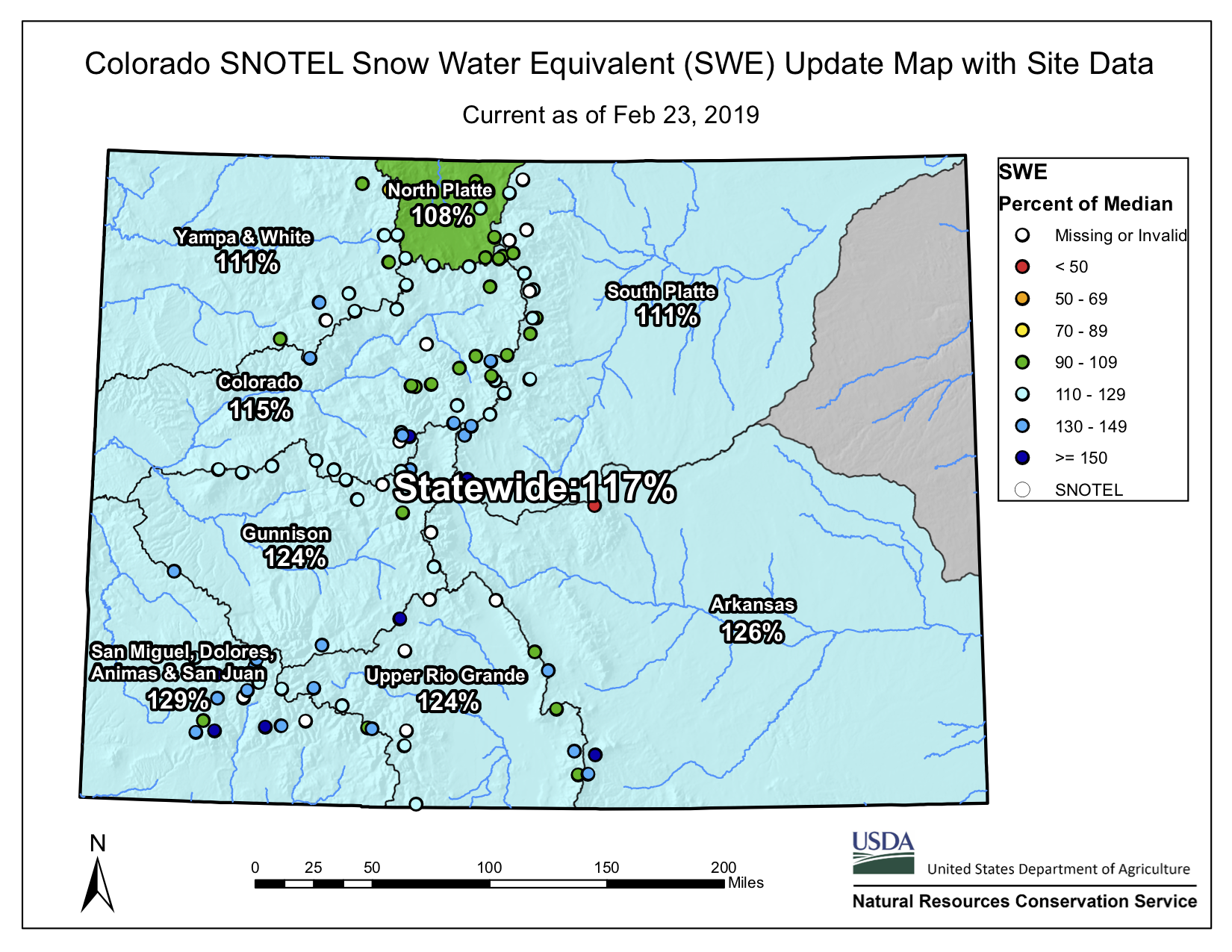
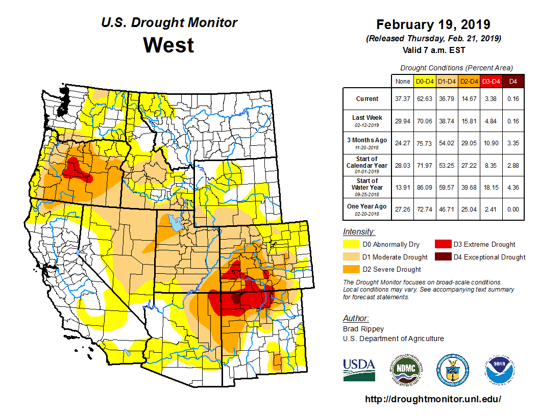
    Water is a contradiction for Western Nebraska. It’s both seemingly abundant, yet simultaneously finite and scarce.

    A new film by a local award-winning documentary filmmaker explores this contradiction and tells the story of water in the Panhandle, from the founding of the numerous irrigation and natural resources districts that line the North Platte valley, to the legal fights surrounding the regulation, distribution and control of that water.

    Insight Creative Independent Productions Executive Producer and Director Becky McMillen’s “Rising Water,” was originally designed to be a web series, and viewers will get a first peek at it when the film premiers at the Legacy of the Plains Museum in Gering on Saturday, March 2, at 1 p.m. The screening of the documentary is in conjunction with The Smithsonian’s Museum on Main Street the Water/Ways” exhibit, which is open now until April 13 at Legacy.

    “Everyone knows how to use YouTube, and they’ve gotten used to web series,” McMillan said. “They’re used to watching short pieces.”

    In essence, each of the segments of the film is a self-contained documentary which covers a different facet of the story of our water, she said.

    The hour and fifteen minute feature is the product of more than three solid years of work, with much of the footage and information gathered over a greater period of time. McMillen said that her father, Udell Hughes Sr., helped her with much of the technical research for the film. It also contains material gathered during production of McMillen’s last major project, “River of Time: Wyoming’s Evolving North Platte River,” a half-hour program which premiered on Wyoming PBS in November 2012.

    “We’ve been sort of building up towards this film,” she said. “A lot of my historical research was actually done at Legacy of the Plains.”

    The film contains interviews with managers of irrigation districts, farmers, UNL researchers and footage from public hearings concerning water issues.

    “I knew that I needed to talk about the Ogallala Aquifer, but it took me a while to understand that issue,” McMillen said.

    So she consulted UNL research hydrogeologist Jim Goeke, who is known as “Mr. Water.” Goeke researched the aquifer and arguably knows more about the water under our feet than any other human being.

    McMillen said she was surprised by how candid Goeke.

    “He gave me courage to address issues that probably weren’t very popular and won’t be very popular,” she said. “We have sucked so much water out of the aquifer and I’ve been watching the Pumpkin Creek battle for years, but lost track of it.”

    The challenge for McMillen was to tie together the surface water and ground water portions of the story.

    And it was a lawsuit over the little western Nebraska stream that became a big State Supreme Court case.

    In 2009 The Spear T Ranch settled with more than a dozen upstream ranchers and farmers in a dispute between irrigators feuding over water in Pumpkin Creek.

    “I was thinking about Pumpkin Creek, but I didn’t have any visuals,” she said. “I’d filmed a meeting of farmers years ago, but the camera went south on me and there was no way I could recover the footage.”

    Then synchronicity struck. McMillen’s bookkeeper was from the Spear T Ranch, and the family over time had saved all of the newspaper clippings about the fight.

    “That helped me tie it all together,” McMillen said. “You just have to be able to listen and when you hear something say ‘What was that?’”

    And the hunger for investigative work is what fuels most of her projects.

    “I have to tell myself to stop, take notes and check things out,” she said. “I hear stories all the time and I’d love to go chase them, but I have to be responsible and pay my bills.”

    McMillen said a lot of the project has been self-funded because she couldn’t kick the habit once a lead seemed promising.

    Newspapers also provided McMillen a window into the issues. As the “first draft of history,” clippings are featured at prominent portions of the film.

    “The Star-Herald is in a lot of these stories that I brought back from the past,” she said. “There was so much information that really help me understand what was going on at the time.”

    Another portion of the film is spent exploring contamination concerns, especially the 2015 fight against a Colorado company who sought permission to use an abandoned oil well in Sioux County as a wastewater disposal site. Sioux County landowners eventually won their appeal and state lawmakers reformed the process in which permits are granted.

    “I documented almost everything, and there is a lot of that in there, along with newspaper clippings” she said. “The physical thing is really important, because I couldn’t have told any of this story without the work of reporters from back in the 1800s on to the present day.”

    And those are the little things, McMillen said.

    “I saw articles where they hung effigies of law makers because they were going to shut the water off,” she said. “There’s always a fight about water. One guy will say ‘I was here first,’ and another guy will say, ‘hey I need that.’ And just because you were here first doesn’t mean you get to have all of it.”

    And over the course of making the film McMillen said that she’s learned that there needs to be change to protect and preserve not only the Valley’s greatest gift, but the way of life for Farmers and Ranchers who live here.

    “We’re going to have to look beyond what we’re calling ‘traditional practices,’” she said. “We can continue on the same track that we have been. We can’t keep expanding and still be able to sustain that.”

    It was her discussions with farmers that drove home the point for her.

    “I think we need to look at it as growing food,” she said. “I would like us to grow more food that doesn’t have to be shipped, because we’re going to have to address climate change and reverse it.”

    And at the same time, caution needs to be exercised when employing solutions, she said.

    “What we think are the solutions are not always the best way of doing things,” she said. “We can’t just blindly forge ahead just because we think it’s a good idea. At the time we’re looking at sustainable energy, we’re also wanting to put it in places that will never be the same.

    “We need to work within the infrastructure we already have and not go to condemning land so that we can use it for transmission lines or wind farms. There is plenty of space for that without tearing up areas that can’t be returned to their natural state.”

    Poem: Greater Intelligences — Greg Hobbs

    Friend of Coyote Gulch, Greg Hobbs, was traipsing around Washington Park in Denver today and sent this poem and gallery of photos via email.

    Greater Intelligences

    The City grew out of the farms, farms sustain the City.

    In the City’s heart, a park a ditch runs through
    feeds the peoples’ need for snowmelt spaces.

    Park the baby’s buggy by your favorite retriever.
    Listen to the flyers honk about their parking places.

    Graceful swimmers ripple waters, you can to

    Greg Hobbs 2/24/2019

    This slideshow requires JavaScript.

    2019 #COleg: Governor Polis signs HB19-1015 (Recreation Of The Colorado Water Institute) into law

    Click here to visit the Colorado Water Institute website:

    The Colorado Water Institute (CWI), an affiliate of Colorado State University, exists for the express purpose of focusing the water expertise of higher education on the evolving water concerns and problems being faced by Colorado citizens.

    2019 marks the 140th anniversary for #Colorado Water Commissioners

    Scott Hummer shows off a fish passage at a North Poudre Irrigation Company diversion structure. His agency worked with Fort Collins Natural Areas and Colorado Parks and Wildlife to include a fish passage when the irrigation company replaced a diversion structure on the Poudre River that was destroyed by the 2013 floods. Work was completed [in February 2016]. (Pamela Johnson / Loveland Reporter-Herald)

    Scott Hummer was kind enough to forward the materials below in celebration of the 140th anniversary of the creation of Colorado’s water commissioners:

    John,

    This past Tuesday, February 19, 2019 marked the 140th anniversary of the creation of the position of Water Commissioner by the State Legislature/General Assembly on February 19, 1879…

    The concept of Colorado’s system of Prior Appropriation, “the Colorado Doctrine”, was first established in the “gold camps” of the late 1850’s. The concept was first put into practice in the “gold camps” of California and came to Colorado with the “miner’s courts” established by the original “prospectors” in the territory.

    And yes, the Water Commissioner position came before the creation of the State Engineers Office as well as the position of “Superintendent of Irrigation”, today’s Division Engineers.

    In brief the original legislation created the position as well as the first ten water districts, and as many know…the legislation was in response to the “water war” along the Poudre River in the mid 1870’s…

    In 2004, a “celebration” of the 125th anniversary was organized and Water Commissioner were recognized on the floor of the Colorado House of Representatives at the Capital and received an honorary proclamation from then Gov. Owens…

    Also in July of 2004, water commissioners were invited to attend and participate in the annual Water Workshop, at then Western State College in Gunnison.
    The title of the ‘o4 Water Workshop was “Technology, Science (including the Dismal Science, and Changing Politics of Water”.

    So after 15 years, perhaps, it is appropriate to inform and educate the water users and citizens of Colorado as to the public servants that serve them so well.

    I have attached my outline of the presentation I gave out the “04 Water Workshop” regarding Water Administration when I was then the Water Commissioner in WD-36.

    As well as two poems written by Justice Hobbs back in 2004 [Oh You Divders of Me, an Ode and Voices of the Natural Stream] and a quote from State Engineer, J.P. Maxwell from 1890:

    “He who expects the letter of the law in relation to irrigation to be executed with the precision of clockwork, and that infallible results will be obtained, has a small conception of the tangled web of difficulties in the way, and a meager knowledge of the uncertainties of the element to be manipulated.” — J.P. Maxwell, State Engineer 1890

    Thank you!

    Best Regards,
    Scott

    Colorado Water Commissioner Districts

    Trump’s false narrative of chaos at the border — @HighCountryNews

    From The High Country News (Ruxandra Guidi):

    Este artículo también está disponible en Español aquí.

    California is often the first state in the West to test new solutions to social and environmental problems. These days, the state is at the fore of a much more ambitious challenge, as it finds its progressive ideals — and its increasingly diverse citizenry — in frequent opposition to the policies of President Donald Trump. Every month, in the Letter from California, we chronicle efforts in the state to grapple with its role in the changing, modern West.

    In 2010, back when I covered the border region for public radio, I visited a shelter for migrants, a modest building located a mile away, just south of the fence separating San Diego and Tijuana. There, recent deportees could find a bed for a few nights after Customs and Border Protection agents released them in Mexico. That’s where I met 34-year-old Verónica Vargas, a mother of two from Los Angeles, who’d been deported after a domestic violence incident. At the local jail, police checked both her and her husband’s immigration status and soon after, processed both for deportation. The couple’s youngest child, 7, remained under the care of their oldest, 18, back in their Los Angeles apartment.

    “There’s nothing I can do about it now,” Vargas told me, in a dispirited, barely audible voice. “We are here and our children are there, and they really need us.” Vargas, who told me she’d been living in the U.S. for more than 20 years without a criminal record, added that Tijuana was not even her home. All she could think about now, she said, was finding a way back into the States to be with her daughters. The possibility of arrest, fines or another deportation was no deterrent; she wanted to be with her children. “I’ll try to cross back into the U.S. tomorrow, and as many times as I’ll need to.”

    The stretch of land between Tijuana and San Diego was then — and is now — the most surveilled part of the 2,000-mile-long U.S.-Mexico border. Yet smuggling goes on anyway: People and drugs find new ways into the U.S., while guns cross in the opposite direction. Crossing illegally is increasingly dangerous and costly for everyone involved, but no amount of reinforcement can possibly stop this flow. Nor will political theater — including the kind that is paving the way for National Guard troops to be stationed at the border.

    Southern border wall. Photo credit: Allen Best/Mountain Town News.

    Last month, Defense Secretary James N. Mattis approved deploying up to 4,000 National Guard troops to “seal up our Southern Border,” as President Donald Trump announced on Twitter. Troops from California, Arizona, New Mexico and Texas would support U.S. Customs and Border Protection — without being permitted to arrest migrants or interact with them directly — through Sept. 30, 2018, which is when, in theory, Trump will have managed to come up with the funds to finally build his border wall.

    But here’s the thing: There is no such thing as a “crisis” at the border. What we are witnessing is a rise in the number of people seeking asylum in the U.S., and doing so without receiving due process. That includes the caravan of more than 1,100 Honduran migrants, most of them families with children, whose well-publicized trek to the U.S. prompted Trump’s call for the National Guard. These migrants did not come to scale any walls; they came to ask for U.S. asylum at the border, as several dozen of them reportedly already have.

    Illegal crossings are currently at a 46-year low — down 71 percent in May 2017 from 2014’s peak, when Customs and Border Protection records show that it detained almost 69,000 people. So the extra troops are most likely unnecessary. But, as previous deployments demonstrate, they will be very expensive. In 2006, President George W. Bush stationed the National Guard at the border for two years at a cost of $1.2 billion. After the mission, Army National Guard Commander Maj. David M. Church said the Department of Homeland Security, which oversees CBP, had not communicated effectively with the Guard and gave him little time for preparation. Then, in 2010, President Barack Obama ordered a similar deployment to “help reduce drug and human trafficking.” That cost an estimated $110 million, and, according to the Government Accountability Office, the results did not justify the price tag.

    There’s no telling how much Trump’s National Guard deployment will cost, or even what it will be able to accomplish. California Gov. Jerry Brown, D, joined the other border states’ governors in pledging to send 400 troops, but he made sure to curb their role. “This will not be a mission to build a new wall,” he wrote in a public letter to Homeland Security Secretary Kirstjen Nielsen and Mattis. “It will not be a mission to round up women and children or detain people escaping violence and seeking a better life. And the California National Guard will not be enforcing federal immigration laws.” Unlike the other border states, California’s National Guard troops won’t be allowed to use equipment to report suspicious activity to the Border Patrol, operate radios or provide “mission support.”

    Back in January 2017, Trump signed an executive order that promised to make good on his campaign promise to build a wall, “monitored and supported by adequate personnel so as to prevent illegal immigration, drug and human trafficking, and acts of terrorism.” This was followed by more mandates targeting refugees and immigrants from Muslim-majority countries, undocumented immigrants without criminal records, and sanctuary policies, especially California’s.

    More than a year since that executive order, the $18 billion needed for Trump’s wall has yet to materialize. Meanwhile, we’re left with an increasingly isolated nation, one that is simmering with fear and anger, and ready to expel immigrants — mothers, children, asylum-seekers, Muslims — under the false narrative of chaos at the border.

    Contributing editor Ruxandra Guidi writes from Los Angeles, California.

    Get to know the #GreenNewDeal, by the numbers The plan would boost the U.S. economy and eliminate fossil fuel use in ten years. — @HighCountryNews #ActOnClimate

    Senator Ed Markey and Representative Alexandria Ocasio-Cortez.

    Not long after Rep. Alexandria Ocasio-Cortez, D-N.Y., was elected last November, she began gathering support for a “Green New Deal,” mobilizing young climate activists and pushing Democratic leaders to pursue the concept. The idea, which was first floated by New York Times columnist Thomas Friedman in 2007, is modeled on Franklin D. Roosevelt’s sweeping Depression-era New Deal and proposes tackling climate change as a massive job creator to boost the American economy. In its current form, it also marries climate action with a host of other progressive aims. On Feb. 7, Ocasio-Cortez introduced a nonbinding resolution articulating what a Green New Deal might include, from eliminating fossil fuels entirely to establishing universal health care and ensuring stronger rights for Indigenous people and nations. Here’s the proposal — and some context — by the numbers:

    Number of co-sponsors of the nonbinding resolution as of Feb. 15: 68.

    Number of Republicans who have signed on: Zero.

    Percentage of co-sponsors who come from Western states, including California, Washington, Colorado and Arizona: 35.

    Average hourly wage for a U.S. worker in January 1973: $4.03.

    Equivalent hourly wage in today’s dollars, in terms of purchasing power: $23.68.

    Average hourly wage of a U.S. worker as of July 2018: $22.65.

    Estimated number of jobs in the wind and solar energy industries as of 2017: 457,169.

    Estimated percentage of the energy Americans used in 2017 that came from wind, solar, hydropower and biomass: 11.3.

    Estimated percentage of the energy Americans used in 2017 that came from fossil fuels: 80.

    Percentage of the energy mix in the Green New Deal resolution that would come from fossil fuels: Zero.

    Number of years the resolution proposes for achieving that goal: 10.

    Number of centuries fossil fuels have dominated U.S. energy consumption: Just over one.

    Percent by which natural gas production is expected to rise in 2019, projected to be the highest year on record: 8.

    Projected annual cost of climate change to the U.S. economy by 2100, if temperatures increase by 2 degrees Celsius (3.6 degrees Fahrenheit) or more: $500 billion.

    Projected cost of climate change-related infrastructure and coastal real estate damage in the U.S., if temperatures increase by 2 degrees Celsius (3.6 degrees Fahrenheit) or more: $1 trillion.

    Climate Science 101

    #GilaRiver Indian Community Moves Forward With #Arizona #DCP With Assurances That HB2476 Will Not Be Reintroduced #ColoradoRiver #COriver #aridification #waterrights

    Gila River watershed. Graphic credit: Wikimedia

    Here’s the release from the Gila River Indian Community (June M. Shorthair):

    Today, elected officials of the Gila River Indian Community, including the Governor, Lt. Governor and several Council members, determined that the Community had received sufficient assurances that HB 2476 was “dead” and that the Community could re-engage in the effort to finalize the Arizona Drought Contingency Plan Implementation Plan. Community elected officials came to this determination after meetings with Speaker Pro Tem T.J. Shope, and House Minority Leader Charlene Fernandez and Senator Lisa Otondo.

    Due to unjustified attacks on the Community through the Arizona legislative process in the form of HB 2476, earlier this week the Community informed the Chairs of the Arizona DCP Steering Committee that if the Arizona legislature continued its consideration of HB 2476, the Community would have no choice but to withdraw from the Arizona Drought Contingency Implementation Plan altogether. Based on the assurances received at today’s meetings, especially those from Speaker Pro Tem Shope, the Community officials determined that HB 2476 is dead and as a result that the Community is able to move forward with the Arizona DCP Implementation Plan despite this unwarranted attack on the Community.

    Speaking for the Community, Governor Stephen R. Lewis stated, “On behalf of the Community, I want to thank Rep. Shope and Rep. Fernandez for making the effort to come and speak with us directly about this very troubling attack on our Community. They listened carefully to our concerns, and Rep. Shope assured us he would take them back to the Legislature to help others understand why we perceived this legislation as highly inappropriate and an attack on our Community. He also provided us with very solid assurances that this legislation is truly dead and that there would be no further consideration of it, as did Rep. Fernandez. Their word on this is what we need to confirm this legislation is truly not moving forward and I am pleased that the Community will be able to rejoin the State’s efforts to get DCP over the finish line.”

    Rep. Shope said, “As one of the members representing the Community, and a member of House leadership, I believed it was essential to come and meet with Community leaders and hear their concerns. I was pleased to provide them with the assurances that I have received from the Speaker, and my own, which I believe make clear that this bill is truly dead and will not be raised again this legislative session”

    Rep. Fernandez stated, “I completely understand why the Community would have viewed this bill as the attack that it was. It is not only bad policy, but an abuse of our legislative process, and I was pleased to commit to the Community’s leaders the support of my caucus in fighting this legislation if it ever is brought back up, which I do not think will happen.”

    Senator Otondo confirmed the Senate Democratic Caucus position in opposition to the bill, and sympathized with the Community, stating “I completely understand why the Community and its members would be outraged at this kind of unwarranted attack. From what I know, far from being the bad actor that they were portrayed to be, they are actually the wronged party. While most of the farmers in the Upper Valley are doing all they can to work with Community and the Community is cooperating with them, there is a small group that simply won’t pay attention to the law of the Gila River. I think the Community is fully within its rights to try to get them to comply with the law.”

    Stephen Roe Lewis via the Gila River Indian Community.

    Governor Lewis concluded, “This meeting was a critical turning point in Arizona’s DCP and Rep. Shope and Rep. Fernandez, and Sen. Otondo, all deserve great credit for taking this important step to reach out to us and hear our concerns and assure us of their continued support. It is this kind of leadership that will help us all move DCP over the finish line. This was an unfortunate chapter in this historic effort, but we will now do all we can to put this in the rear view mirror, and move forward together.”

    The purpose of HB 2476 is ostensibly to repeal a cardinal principal of Arizona water law, the so-called “use it or lose it” rule codified in the State’s very first water code as a rule of forfeiture. Under the forfeiture statute any water right holder who does not use his water rights for an uninterrupted period of five years, without a legitimate excuse specified in the statute, can be found to have forfeited that right. This “use it or lose it” principle is an essential element of the water codes across the arid West, and appears in 16 different state water codes in almost the same form. If HB 2476 were enacted, Arizona would become the first and only state in the West to repeal such a forfeiture statute.

    On February 19, 2019, a hearing was held on HB 2476. While the hearing was supposed to focus on the forfeiture statute and its effect on certain water users, the testimony and questions instead focused on the Community’s actions in federal district court to legitimately enforce its settlement and to protect its water rights under its settlement. Most of the witnesses who testified actually stated in open testimony that they were concerned for their “hot” land farming practices, a term that refers to a practice of illegally using water from the Gila River, water to which the Community has a clear and superior right. The misstatements made during the testimony and questions posed made it very clear that this hearing was intended to be a form of “show trial” for the Community, whose real purpose could only have been to somehow intimidate the Community into not enforcing its rights. At the end of the hearing, the proponent of HB 2476 asked that his bill be “held” so that he could review its legality and perhaps refine it so it could perhaps be raised again at a future time, leaving the Community with no clear indication as to whether the bill would move forward or not.

    This decision to hold HB 2476 put the Community in an untenable position, as it could not proceed with its participation with DCP until this issue was clearly put to rest. Today’s meetings provided the Community with an opportunity to discuss directly with key members of the Arizona Legislature whether this legislation is for all intents and purposes “dead” for this session. In the meeting with the Rep. Shope, as a member of House leadership he was able to convey to Community tribal leadership that Speaker Bowers had assured Rep. Shope that the Speaker did not intend to take any further action to move HB 2476 forward this session. In addition Rep. Shope also assured Community leaders that even if Speaker Bowers might decide to move the legislation forward, Rep. Shope would himself vote against it on the floor. During the meeting, Community leaders made clear why they felt HB 2476 was a purposeful attack on the Community and how the hearing had completely misrepresented the Community’s legitimate actions and efforts to enforce its water settlement rights,. Rep. Shope offered to take these concerns back to the legislature to help educate other members on this issue.

    In a separate meeting with the Democratic House Minority Leader, Rep. Charlotte Fernandez, and with Sen. Lisa Otondo, they both reiterated their caucuses’ support for the Community in its opposition to this unjustified attack in the form of legislation.

    In a separate decision, Community leaders authorized its water team to continue its efforts to protect the Community’s water settlement and to enforce the Community’s rights as and when necessary.

    #Drought/#Snowpack news: Conditions improving across S. #Colorado

    From The Kiowa County Press (Chris Sorensen):

    Extreme drought – the second most severe category – dropped to the severe category for all or most of Chaffee, Pitkin, Gunnison and Saguache counties, as well as large portions of Montezuma, La Plata, Dolores, San Juan and Hinsdale counties. Northeast Conejos County and northwest Archuleta County also saw severe drought overtake extreme conditions. A sliver of southwest Archuleta also retains the state’s only remaining trace of exceptional drought.

    Colorado Drought Monitor February 19, 2019.

    Overall, areas of drought-free, abnormally dry and moderate drought conditions were unchanged in the most recent report, holding at eight, 25, and 27 percent of Colorado, respectively. Severe drought increased from 18 to 29 percent of the state, while extreme conditions dropped from 22 to 10 percent. Exceptional drought was unchanged at less than one percent of Colorado. The total does not equal 100 percent due to rounding…

    Colorado Drought Monitor February 12, 2019.

    Colorado’s river basins continue a strong showing in the wake of recent snowfall that continues into this weekend. Statewide, snow water equivalent – the measure of water in the snowpack – stands at 115 percent of the median for this time of year, up from 108 percent one week ago. All basins are reporting 108 percent of median or greater. The San Miguel, Dolores, Animas and San Juan basin leads the state at 124 percent. At the start of the year, the basin was one of the weakest at around 80 percent of median. Similarly, the Upper Rio Grande basin has improved to 118 percent.

    Statewide basin-filled map February 23, 2019 via the NRCS.

    From Colorado Public Radio (Grace Hood):

    What a difference a year makes. In 2018, hot and dry conditions fueled the 416 Wildfire that destroyed homes and slowed down tourism. Farmers and ranchers sold cattle and lost crops to the drought. This week the U.S. Drought Monitor map upgraded conditions for Montezuma, La Plata and other southwestern counties.

    West Drought Monitor February 19, 2019.

    Assistant state climatologist Becky Bolinger calls conditions, “a stark difference from what we saw last year.”

    The San Juan Mountains saw one inch more of precipitation compared to average for February 2019. Snow pack is well above average in the region. But there’s still cause for concern. Soils beneath the snow are still bone dry from drought. That means spring runoff will first seep into the soil. There could be less runoff water available to fill up the reservoirs.

    And after a severe 2018 drought, thirsty reservoirs need water. The largest in the region, McPhee, is just 7 percent full.

    Despite the lag in water storage, the picture feels more hopeful for agricultural producers like Brian Wilson, who grows hay in Montezuma County. In 2018 he grew about 3 tons, down from about 4 tons in an average year.

    “Production was down, but the price [of hay] was better so the bottom line was about the same,” Wilson said…

    Still, the extra moisture in the soil will mean better grazing for rancher Matt Isgar’s cattle. He has a different problem as he looks to recover from last year’s disappointing season. A more productive 2019 will mean he’ll need more workers.

    “It’s kind of hard after drought year. You typically don’t have all the same help you had because they didn’t work as much on a drought year,” Isgar said. “So now you have to get it geared backed up and try to get help back on track.”

    Around town in Durango, Blake has her eyes on another logistics problem. She said the city’s nearly run through the $47,000 budgeted for snow removal this year. [Amber] Blake says the city will a have to ask the Durango Council to approve more money for additional snow removal.

    Arizona Rep. Grijalva plans to introduce the Grand Canyon Centennial Protection Act on Tuesday, February 26, 2019, when the park celebrates its 100th anniversary

    From the Associated Press via Tucson.com:

    Arizona Rep. Raul Grijalva is pushing to make a temporary ban on the filing of new mining claims in the Grand Canyon region permanent.

    He’ll be joined Saturday by tribal leaders at the Grand Canyon to talk about legislation he plans to introduce next week.

    The Obama administration put about 1,562 square miles (4,045 square kilometers) outside the boundaries of the national park off-limits to new hard rock mining claims until 2032.

    Grijalva wants to make it permanent…

    Grijalva says he’ll introduce the Grand Canyon Centennial Protection Act on Tuesday when the park celebrates its 100th anniversary.

    The Vail Town Council awards Glenn Porzak their 2019 Trailblazer Award

    Rainbow trout release at Black Lakes via CPW.

    From City of Vail via The Vail Daily:

    Glenn Porzak, the water rights attorney who has worked tirelessly through the decades to advance and protect water rights for Vail and the Western Slope, has been selected as the recipient of the 2019 Vail Trailblazer Award.

    Presented by the Vail Town Council, the award has been established as an annual civic recognition to honor those who contribute their time and talent to make Vail a great resort community.

    Porzak will be formally recognized at the March 5 evening Vail Town Council meeting. A mayor’s proclamation honoring his vast contributions will be read into the public record. Recognition will also take place during the Vail Annual Community Meeting, to be held March 12 at Donovan Pavilion.

    Porzak has been a fixture in the Vail community since the 1970s when he served as the water law counsel for Vail Associates (now Vail Resorts) and later for the current and predecessor entities of the Eagle River Water & Sanitation District and Vail Water sub-district, which provides water and wastewater treatment services to the greater Vail community. His nomination for the Trailblazer Award carries the endorsement of five former mayors as well as past and present members of the board of directors of the Eagle River Water & Sanitation District.

    PIONEERING CONTRIBUTIONS

    Nominators cited numerous examples of Porzak’s pioneering contributions in creating the water infrastructure essential for Vail’s successful growth as a resort community. For example, in the 1990s he led the effort to negotiate and secure approvals for construction of the Eagle Park Reservoir, located at the headwaters of the Eagle River. This in-basin water storage has been instrumental in supporting snowmaking capabilities on Vail Mountain as well as accommodating Vail’s growth through the decades while ensuring adequate 12-month streamflows in Gore Creek and the Eagle River. The complicated water and storage rights for Vail Mountain’s snowmaking water help to ensure quality skiing and snowboarding, even in the driest of years — such as last year.

    Porzak helped continue the development of Black Lakes, which are located at the headwaters of Black Gore Creek near the Interstate 70 Vail Pass exit and are part of the district’s water supply system. The two cold-water reservoirs serve as in-basin water storage and reservoir releases enhance streamflows in Gore Creek. They also support fishing, wildlife habitat and recreation through a partnership with Colorado Parks and Wildlife.

    Porzak was largely responsible for expanding Vail’s recreational amenities by making it possible to build Vail’s whitewater park, which serves as a major venue for the annual Mountain Games. Located at the Gore Creek promenade in Vail Village, the park opened in 2000 after Porzak authored a new recreational in-channel diversion category as a test case under Colorado water law.

    The park withstood a series of legal challenges and the game-changing decree was eventually upheld in a ruling by the Colorado Supreme Court. The 2003 judgment has since been used to create other whitewater parks throughout the state.

    PROTECTING SUPPLIES

    As the founding partner of Porzak Browning & Bushong LLP, a Boulder-based firm representing water and land use interests, Porzak is well-known for his expertise in the protection of existing water supplies. In an unprecedented move to protect the water interests of Vail and the upper Eagle Valley, Porzak led negotiations in 1998 that limited the amount of water the Front Range cities of Aurora and Colorado Springs could divert from the Eagle River basin, forever protecting local stream flows and fisheries from out-of-basin development interests.

    He spearheaded the litigation and subsequent negotiations that resulted in the 2007 abandonment of the Eagle-Piney Water Project for which Denver Water owned extensive water rights. The agreement and abandonment forever protect local stream flows and fisheries from trans-basin development. That water project would have taken hundreds of thousands of acre feet of water each year from Gore Creek and the Upper Eagle River and transported that water through a planned tunnel below Vail Pass to Dillon Reservoir.

    In announcing Porzak as the 2018 Trailblazer Award recipient, Vail Mayor Dave Chapin said Porzak’s underlying contributions are both vast and visible in almost everything we do.

    “From the water that comes out of our tap, to the amazing recreational amenities we have in this valley, to the protection of our streams from massive transmountain diversions, we owe our gratitude to Glenn for having the courage and the wherewithal to challenge the status quo,” Chapin said.

    Porzak said he was “speechless” when notified of the award. “It has truly been an honor to represent the greatest recreational-based community, Vail, for over four decades,” said Porzak.

    Throughout his career, Porzak has participated in over 120 water court trials and over 30 Colorado Supreme Court appeals. He has been named a Colorado Super Lawyer by 5280 magazine every year from 2006 to 2019.

    In his spare time, Porzak has been a world-class climber, having summited Mount Everest and three of the world’s other 8,000-meter peaks. He was one of the first people to climb the Seven Summits, the highest peak on each of the world’s seven continents. He is a past president of the American Alpine Club and the Colorado Mountain Club.

    Porzak has also been the president of the Manor Vail Homeowners Association and led the effort to remodel the hotel and condominium complex at the base of Golden Peak.

    The Vail Trailblazer Award was established during the town’s 50th birthday celebration in 2016. Porzak is the fourth recipient to be honored and was selected by a town council committee from among other deserving nominations.

    For more information about the Vail Trailblazer Award and the nomination process, go to http://www.vailgov.com/trailblazeraward.

    Happy Birthday Wallace Stegner — @HighCountryNews

    Wallace Stegner. Ed Marston/HCN file photo

    From The High Country News (Matthew D. Stewart):

    Wallace Stegner lived through almost the entire 20th century and wrote his way through more than half of it. His fan mail started with a trickle in the 1930s, opened up to a flow in 1943, after the publication of The Big Rock Candy Mountain, and then rushed like the rivers he loved until his death on April 13, 1993. Many letters came on his birthday, Feb. 18. Today, they are preserved with the rest of his papers at the University of Utah’s J. Willard Marriott Library.

    The letters arrived by plane from Kenya, Japan and England, and by hand from Los Altos Hills, California, where Stegner and his family lived when they were not traveling or spending the summer at their cabin in Vermont. Book clubs from across the nation wrote to Stegner, from the Literary Ladies of Hyde Park, Vermont, to a Vietnam veterans’ book club in New York City that enclosed 25 copies of Angle of Repose with a request for Stegner’s signature on all of them because the book had “left a deep-seated impression” on all 25 members of the club.

    Many letters asked for autographs, some confessed love, and one was written by a couple on their honeymoon. A British fan of Stegner’s Women on the Wall included this brief review of the book: “I think it is lovely, so do my friends, we all hope you make masses of money, and pay no tax.” Among the thousands of letters that readers wrote, the theme that recurs over and over again is that Stegner respected his readers, their lives and the places they inhabited.

    Most profoundly, he was capable of writing about heartbreak without succumbing to nihilism. His characters suffered real pain, and many of them failed. But Stegner’s characters sometimes went beyond the failures, if only by one step, and he never fell into cheap sentiment.

    As a woman wrote after finishing Crossing to Safety: “It has something to do with bonds and frailties, a sense of place and events unfolding, and above all, endurance.” Stegner respected those who fell into the abyss and saw it for what it was, but endured nonetheless.

    Stegner also told hard truths to his readers — particularly his readers in the West — about the region’s past and present. Decades before the “New Western Historians,” several of whom acknowledged his influence and corresponded with him, Stegner brought serious and critical attention to the settling of the West. He could criticize the region from within; in the words of a man who wrote to him in 1978, he could “handle the region’s culture without condescending to it.”

    As one of his most famous readers, his friend and former student Wendell Berry, put it in his 1990 collection of essays, What are People For?, Stegner was a regional writer “who not only (wrote) about his region but also (did) his best to protect it, by writing and in other ways, from its would-be exploiters and destroyers.” Berry contrasted Stegner with the “industrialists of letters” who mine “one’s province for whatever can be got out of it in the way of ‘raw material’ for stories and novels.”

    A woman from Montana told Stegner, “Somehow I have a sense of the land from reading your book that I have not found in a long time, and the urge to tell you that looking back to the years when I was an unprepossessing small girl suffering some of the same mental tortures that you seemed to, I figuratively wave to you across the prairie miles that lay between us. You have used your background well — the prairie and I are proud of you.”

    If wisdom is simply pulling back the curtain to reveal a howling empty wasteland, 20th century fiction was full of such debilitating wisdom. Stegner was generally agnostic about any ultimate reality, but refused doubt as an excuse for selfish despair. There were too many people who had fallen in love with the land, and who counted on him; there were too many places that were threatened and fragile. In one of his most famous phrases, he described the West as the “geography of hope.” Letter after letter thanked Stegner for his sympathy, but also for his thoughtful nudge to move past the pain and live.

    Mining industry water #pollution: “Having money immediately available from a responsible party would be a game changer” — Amanda Goodin

    From The Associated Press (Matthew Brown) via The Grand Junction Daily Sentinel:

    Every day many millions of gallons of water loaded with arsenic, lead and other toxic metals flow from some of the most contaminated mining sites in the U.S. and into surrounding lakes and streams without being treated, The Associated Press has found.

    That torrent is poisoning aquatic life and tainting drinking water sources in Montana, California, Colorado, Oklahoma and at least five other states.

    The pollution is a legacy of how the mining industry was allowed to operate in the U.S. for more than a century. Companies that built mines for silver, lead, gold and other “hardrock” minerals could move on once they were no longer profitable, leaving behind tainted water that still leaks out of the mines or is cleaned up at taxpayer expense.

    Using data from public records requests and independent researchers, the AP examined 43 mining sites under federal oversight, some containing dozens or even hundreds of individual mines.

    The records show that at average flows, more than 50 million gallons (189 million liters) of contaminated wastewater streams daily from the sites. In many cases, it runs untreated into nearby groundwater, rivers and ponds — a roughly 20-million-gallon (76-million-liter) daily dose of pollution that could fill more than 2,000 tanker trucks.

    The remainder of the waste is captured or treated in a costly effort that will need to carry on indefinitely, for perhaps thousands of years, often with little hope for reimbursement…

    At many mines, the pollution has continued decades after their enlistment in the federal Superfund cleanup program for the nation’s most hazardous sites, which faces sharp cuts under President Donald Trump…

    TAINTED WELLS

    In mountains outside the Montana capital of Helena, about 30 households can’t drink their tap water because groundwater was polluted by about 150 abandoned gold, lead and copper mines that operated from the 1870s until 1953.

    The community of Rimini was added to the Superfund list in 1999. Contaminated soil in residents’ yards was replaced, and the EPA has provided bottled water for a decade. But polluted water still pours from the mines and into Upper Tenmile Creek…

    Estimates of the number of such abandoned mine sites range from 161,000 in 12 western states to as many as 500,000 nationwide. At least 33,000 have degraded the environment, according to the Government Accountability Office, and thousands more are discovered every year.

    Officials have yet to complete work including basic risk analyses on about 80 percent of abandoned mining sites on federal lands. Most are controlled by the Bureau of Land Management, which under Trump is seeking to consolidate mine cleanups with another program and cut their combined 2019 spending from $35 million to $13 million.

    PERPETUAL POLLUTION

    Problems at some sites are intractable.

    Among them:

    — In eastern Oklahoma’s Tar Creek mining district, waterways are devoid of life and elevated lead levels persist in the blood of children despite a two-decade effort to clean up lead and zinc mines. More than $300 million has been committed since 1983, but only a small fraction of the impacted land has been reclaimed and contaminated water continues to flow.

    — At northern California’s Iron Mountain Mine, cleanup teams battle to contain highly acidic water that percolates through a former copper and zinc mine and drains into a Sacramento River tributary. The mine discharged six tons of toxic sludge daily before an EPA cleanup. Authorities now spend $5 million a year to remove poisonous sludge that had caused massive fish kills, and they expect to keep at it forever.

    — In Colorado’s San Juan Mountains, site of the Gold King blowout, some 400 abandoned or inactive mine sites contribute an estimated 15 million gallons (57 million liters) of acid mine drainage per day.

    This landscape of polluted sites occurred under mining industry rules largely unchanged since the 1872 Mining Act.

    State and federal laws in recent decades have held companies more accountable than in the past, but critics say huge loopholes all but ensure that some of today’s mines will foul waterways or require perpetual cleanups…

    QUESTIONS OVER WHO SHOULD PAY

    To date, the EPA has spent an estimated $4 billion on mining cleanups. Under Trump, the agency has identified a small number of Superfund sites for heightened attention after cleanup efforts stalled or dragged on for years. They include five mining sites examined by AP.

    Former EPA assistant administrator Mathy Stanislaus said more money is needed to address mining pollution on a systematic basis, rather than jumping from one emergency response to another…

    Democrats have sought unsuccessfully to create a special cleanup fund for old hardrock mine sites, with fees paid by the mining industry. Such a fund has been in place for coal mines since 1977, with more than $11 billion in fees collected and hundreds of sites reclaimed.

    The mining industry has resisted doing the same for hardrock mines, and Republicans in Congress have blocked the Democratic proposals.

    Montana Mining Association director Tammy Johnson acknowledged abandoned mines have left a legacy of pollution, but added that companies still in operation should not be forced to pay for those problems…

    In 2017, the EPA proposed requiring companies still operating mines to post cleanup bonds or offer other financial assurances so taxpayers don’t end up footing cleanup bills. The Trump administration halted the rule, but environmental groups are scheduled to appear in federal court next month in a lawsuit that seeks to revive it.

    “When something gets on a Superfund site, that doesn’t mean it instantly and magically gets cleaned up,” said Earthjustice attorney Amanda Goodin. “Having money immediately available from a responsible party would be a game changer.”

    The latest seasonal outlooks (through May 31, 2019) are hot off the presses from the Climate Prediction Center #drought

    It looks like near-normal temperatures, slightly above average precipitation, and drought improvement for Colorado. It’s all good.

    Seasonal temperature outlook through May 31, 2019 via CPC.
    Seasonal precipitation outlook through May 31, 2019 via CPC.
    Seasonal drought outlook through May 31, 2019 via CPC.

    @CWCB_DNR February 2019 #Drought Update

    A standup surfer in the Arkansas River at Salida during Fibark, the river celebration held in late June. Photo/Allen Best

    Here’s the report from the CWCB and DWR (Taryn Finnessey and Tracy Kosloff):

    In response to persistent and prolonged drought conditions throughout the southern half of the state and along the western border, t​he C​olorado Drought Mitigation and Response Plan​ was activated for the agricultural sector​ ​on May 2, 2018,​ a​dditional counties in northwest Colorado were added in September and activation remains in effect; information can be found ​HERE​.

    Calendar year 2019 has brought with it beneficial moisture that has nearly eliminated all exceptional drought conditions in Colorado and increased snowpack to above normal conditions. As a result, streamflow forecasts have increased in some areas and water providers looking ahead to the 2019 demand season are cautiously optimistic given current conditions. However, much of the snow accumulation season remains and reservoir storage and soil moisture will take time to rebound to pre-drought levels.

    ■ As of February 19th, exceptional drought, D4, has been almost entirely removed from the state. Only a small sliver remains in Archuleta county, covering about a tenth of a percent of the state. Extreme drought, D3, has also decreased and now covers 10 percent of the state; severe drought 29 percent and 27 percent is classified as moderate drought. An additional quarter of the state is currently experiencing abnormally dry conditions (see image below).

    ■ El Niño conditions are now present, and may continue through spring (55 percent chance). This is a weak event and given the timing it is unclear the impact that it will have.

    ■ SNOTEL snow water equivalent statewide is 115 percent of average with all basins above average. The highest snowpack is in the Arkansas basin at 123 percent of median, while the lowest is the Rio Grande at 111 percent of median (see image below).

    ■ Reservoir storage, statewide is at 83 percent of normal, with the South Platte, Colorado, and Yampa-White, all above 90 percent of average as of February 1st. Storage in the Arkansas and Upper Rio Grande basins are at 89 and 79 percent of normal, respectively. The Southwest basins of the San Miguel, Dolores, Animas & San Juan, and Gunnison remain the lowest in the state at 57 and 61 percent of normal, respectively.

    ■ Individual reservoir storage levels are highly variable statewide, some reservoirs have strong storage while storage in other reservoirs remain at low levels for this time of year. Historically, reservoirs take a long time to refill following a drought event.

    ■ March through May is an important period for annual average precipitation in Colorado, many regions receive a large portion of total precipitation during these spring months.

    ■ Outlooks for the spring season do not show a clear direction. There is a slightly increased chance of above-normal precipitation for the spring across Colorado, and equal chances of above, below, and near-normal temperature​.

    Statewide snowpack basin-filled map February 21, 2019 via the NRCS.
    Colorado Drought Monitor February 19, 2019.

    San Juan County, #Utah commissioners’ resolution condemns @Potus reduction of #BearsEars acreage #KeepItInTheGround

    The road to Bears Ears via the Salt Lake Tribune.

    From Pacific Standard Magazine (Rebecca Worby):

    The San Juan County commission voted two-to-one in favor of a resolution that rescinds the county’s previous opposition to the monument and condemns its reduction by Donald Trump.

    The county commission of Utah’s San Juan County—home of Bears Ears National Monument, which President Donald Trump vastly reduced in 2017—has historically opposed the designation of the land as a national monument. But it has now changed its tune: On Tuesday, the commission voted two-to-one in favor of a resolution that rescinds the county’s previous opposition to the monument and condemns its reduction.

    Specifically, the https://www.utah.gov/pmn/files/467927.pdf rescinds all prior resolutions opposing the establishment of the monument, or calling for the dissolution or reduction of it. Most notably, it also “condemn[s] the actions of President Donald Trump in violating the Antiquities Act of 1906 by unlawfully reducing the Bears Ears National Monument” in his December 4th, 2017, proclamation, and “call[s] upon the United States to fully restore” the monument.

    The vote does not signal a change of heart, but rather reflects a major shift in the county commission’s make-up: Thanks to recent redistricting, it is now Utah’s first-ever majority-Navajo county commission. Previously, the county’s three districts were drawn such that most Native American voters were grouped into one district, but in 2016, a federal judge ruled that the voting districts were unconstitutional and ordered the county to redraw them. (According to the census, Navajos make up the majority of the county’s population by a small margin.) In response to the shift in representation, Utah state representative and former San Juan County commissioner Phil Lyman—notorious for the time he rode an ATV down a trail that was closed to motorized vehicles in protest of federal land control—has raised the possibility of splitting the county in two to bring power back to his white-majority hometown of Blanding.

    Both of the Navajo members of the commission, Willie Grayeyes and Kenneth Maryboy, voted in favor of the Bears Ears resolution. The dissenting vote came from the commission’s white member, Bruce Adams. (When I was in San Juan County for then-Secretary of the Interior Ryan Zinke’s visit to Bears Ears during his monuments review in 2017, Adams greeted Zinke wearing a white “MAKE SAN JUAN COUNTY GREAT AGAIN” cowboy hat—and gave Zinke one too.)