2024 #COleg: A #Colorado Program the Colorado Way — Audubon Rockies

Photo credit: Audubon Rockies

Click the link to read the release on the Audubon Rockies websiite (Abby Burk):

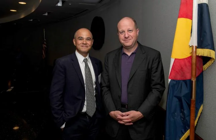
On May 29, 2024, Colorado Governor Jared Polis stated โ€œWater is life in Colorado and today I was proud to protect our water resources that are essential for our agriculture, our economy, and our way of life.โ€ That day, he signed HB24-1379 Regulate Dredge & Fill Activities in State Waters, making Colorado the first state in the nation to pass legislation that addresses the stream and wetlands protection gap created by the May 2023 Sackett vs. Environmental Protection Agency (EPA) decision. It took a lot of hard work, long days, collaboration, substantive and technical outreach, leaning into complex topics, working through misinformation, and dealing with a competing bill. We had to make some compromises, but ultimately, we came together in the โ€œColorado wayโ€ on a new law that works for Coloradoโ€™s unique intermountain waterways and protects wetlands and streams that were put at risk of losing protection by the Sackett decision.

Audubon convened and facilitated conversations to support consensus around a good solution and worked to depoliticize wetland and stream protections. After all, they support all of us. Audubon celebrates our network who submitted 2,248 comments to legislators in support of creating a robust Colorado Dredge and Fill Program that covers all streams and wetlands. Audubon members also made more than 60 contributions to the “What’s Your Wetland?” storymap in support of HB24-1379. Audubon celebrates our critical partnerships with the Protect Colorado Waters Coalition and the Colorado Healthy Headwaters Working Group as we worked together to preserve our critical needs through a storied and challenging process.
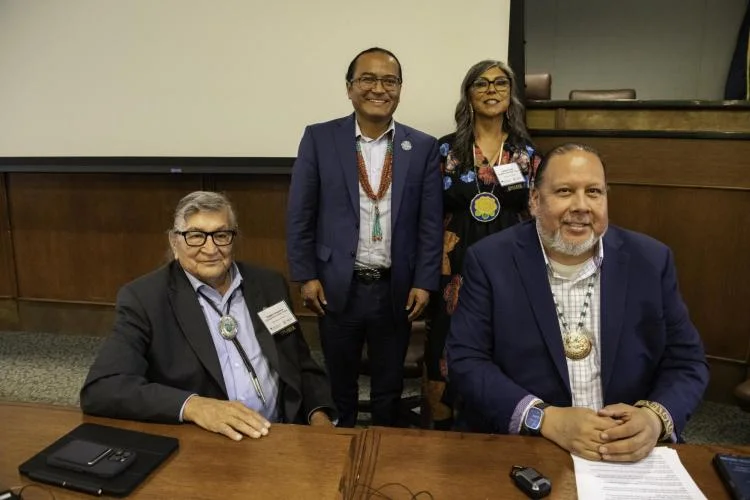
The new lawโ€”led by Speaker of the House Julie McCluskie (D-Dillon), Senator Dylan Roberts (D-Frisco), Representative Karen McCormick (D-Longmont), and Colorado Department of Public Health and Environment’s (CDPHE) Director of the Water Quality Control Division, Nicole Rowanโ€”is excellent news for Colorado’s birds and communities that critically depend upon clean water. It helps lead the way for other states in their pursuit of wetland and stream protections in the post-Sackett landscape.

House Bill 24-1379 was one of two proposed bills that sought to address the regulatory gap created by the Sackett decision. Senate Bill 24-127, sponsored by Senator Barbara Kirkmeyer (R-Brighton), was the second. Due to the two competing approaches of the two bills, consensus was found after a wild ride of public engagement, testimonies, intense negotiations, and 29 amendments. Notably, Senator Kirkmeyer became a co-sponsor to the amended and final HB24-1379 within the last week of the legislative session, winning bipartisan backing.

Why Was a โ€œColorado Programโ€ Necessary to Protect Wetlands and Streams? 

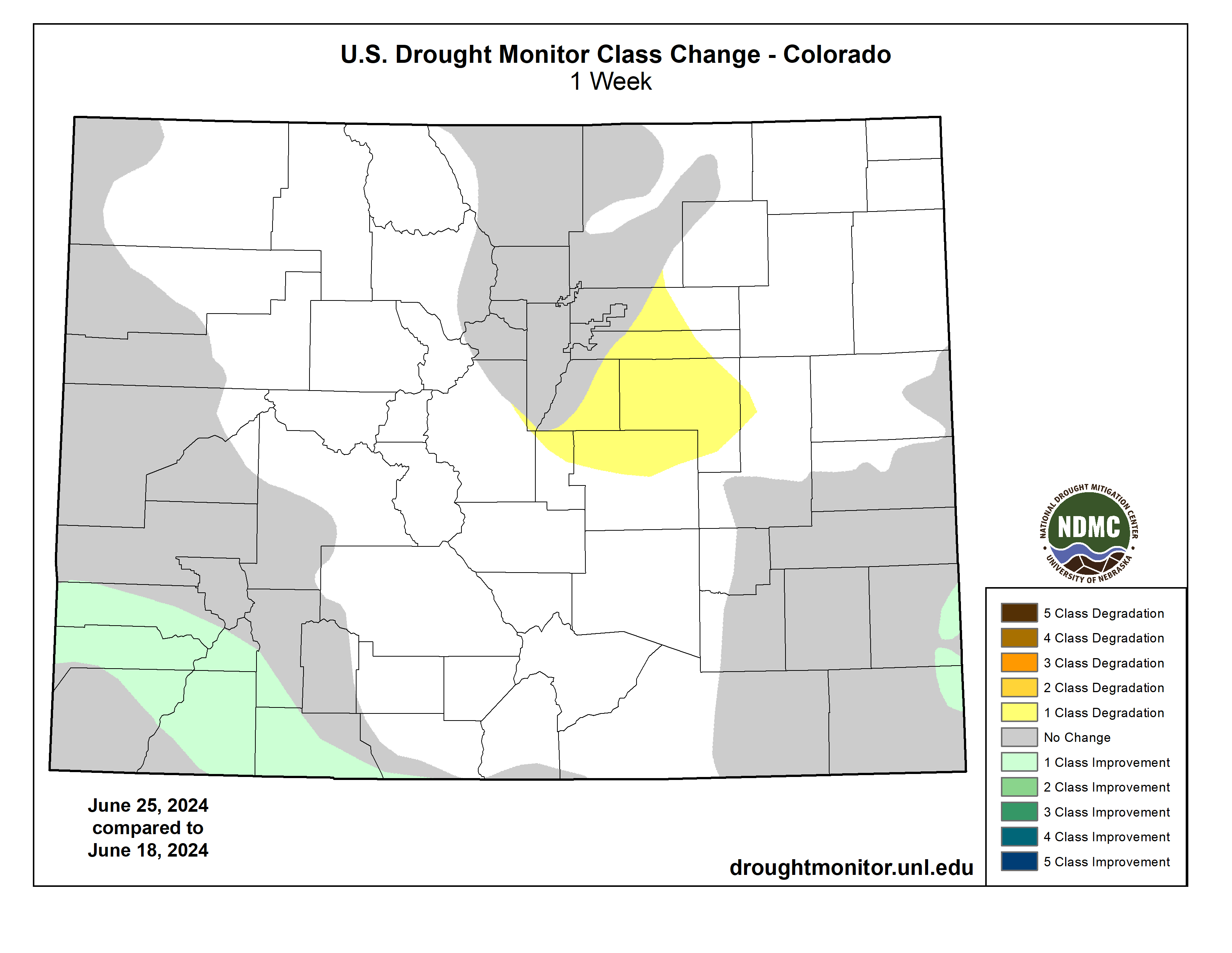
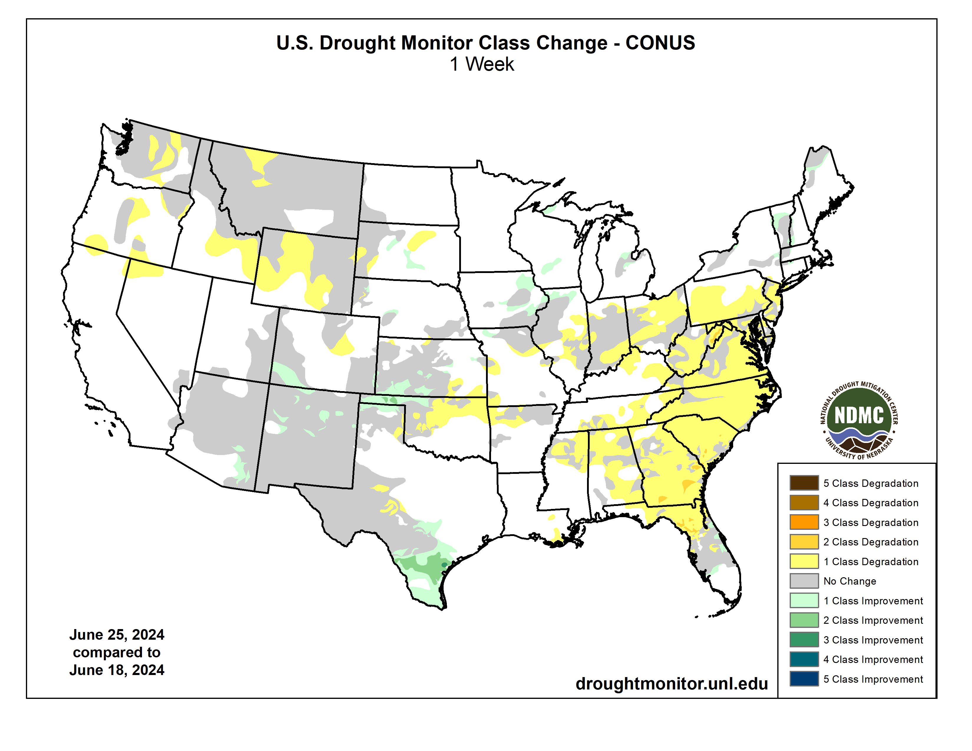
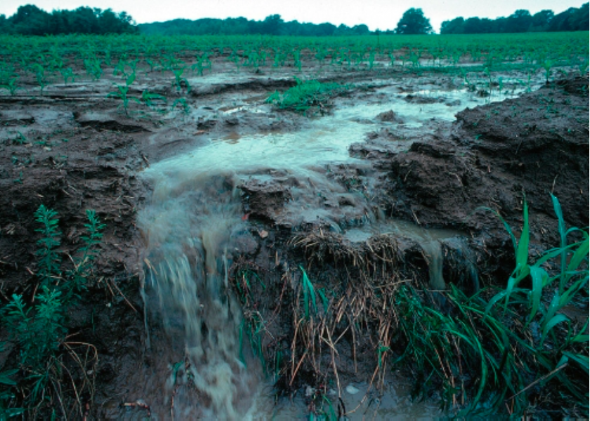
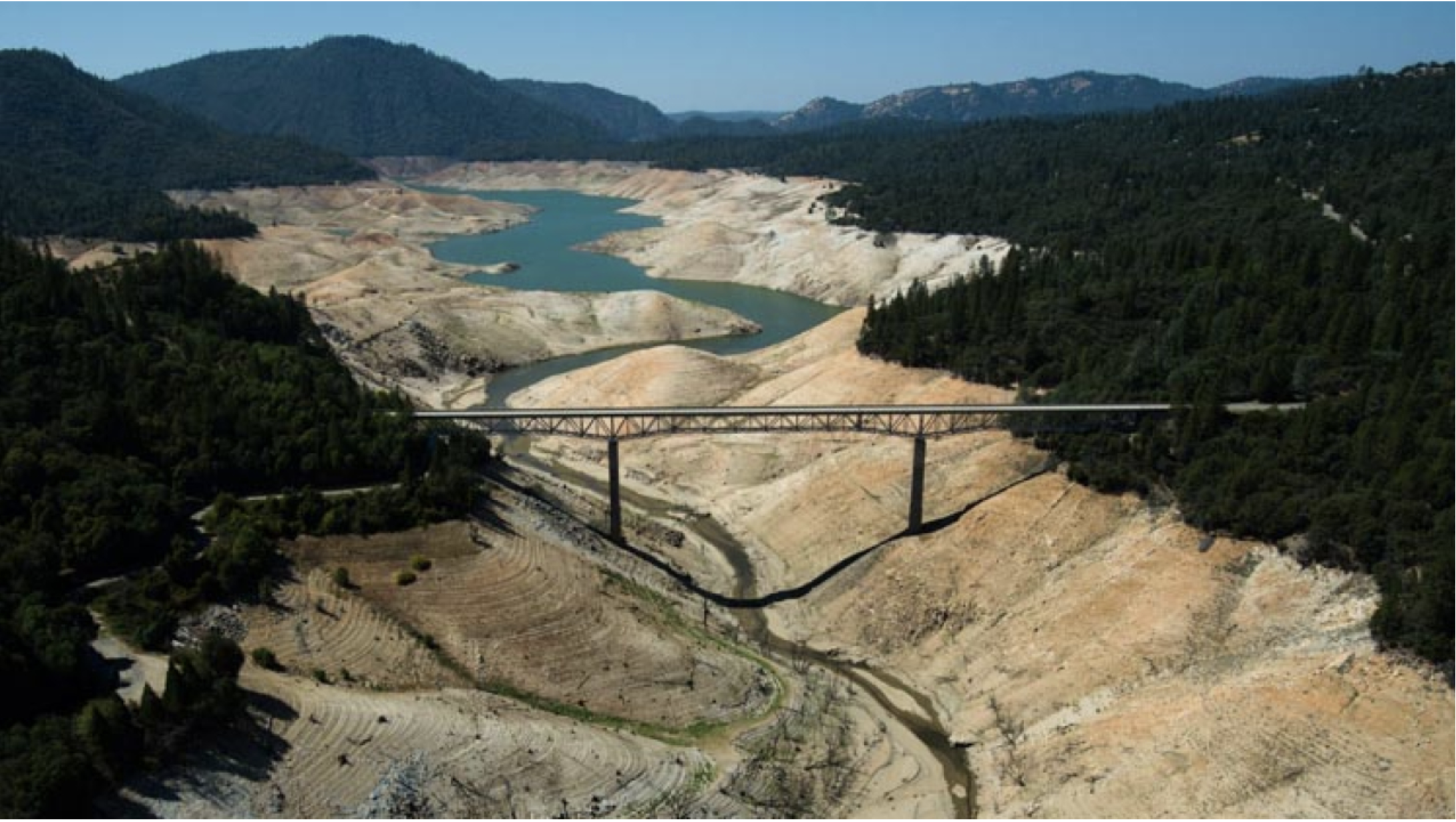
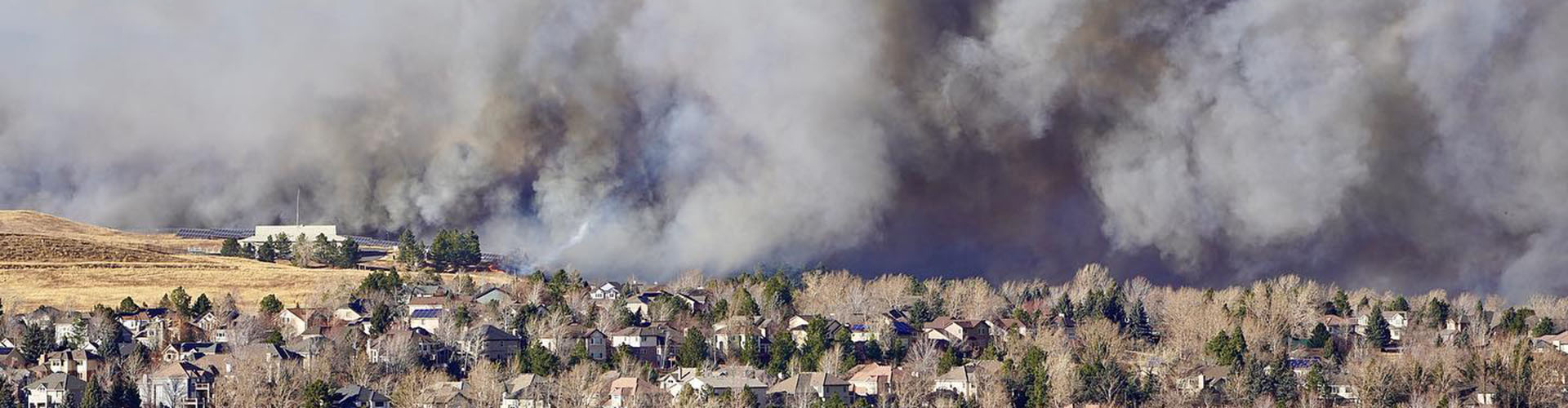
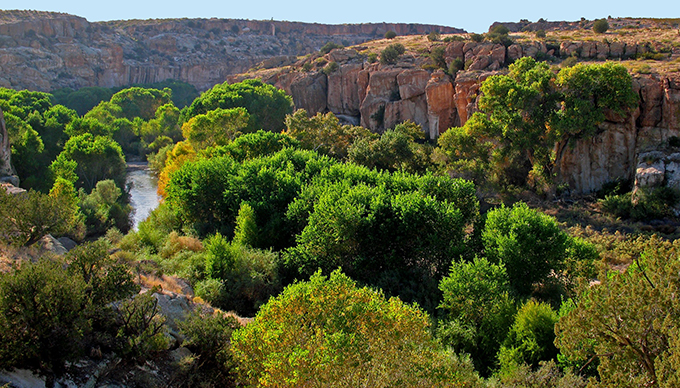
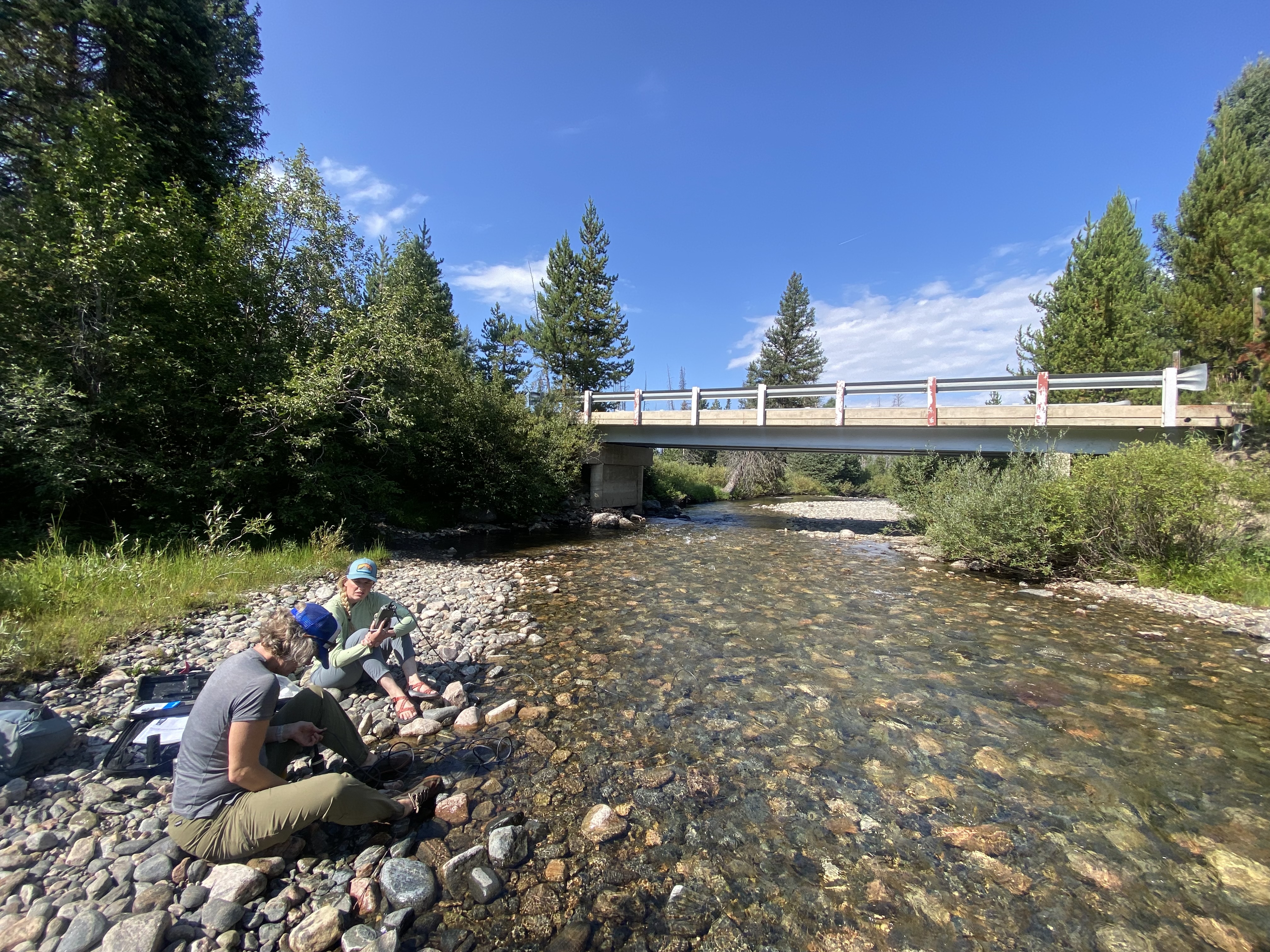
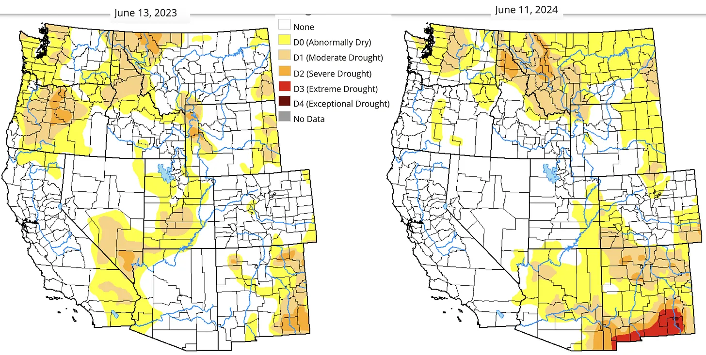
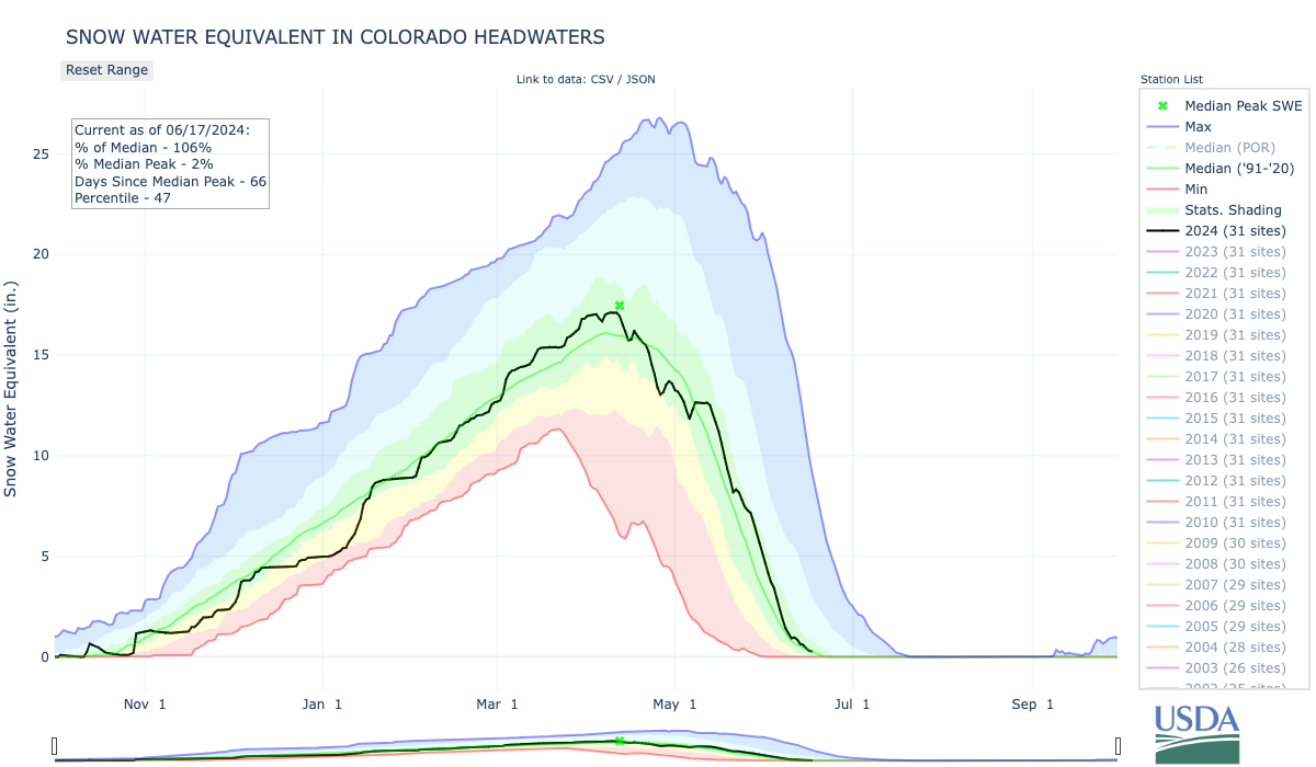
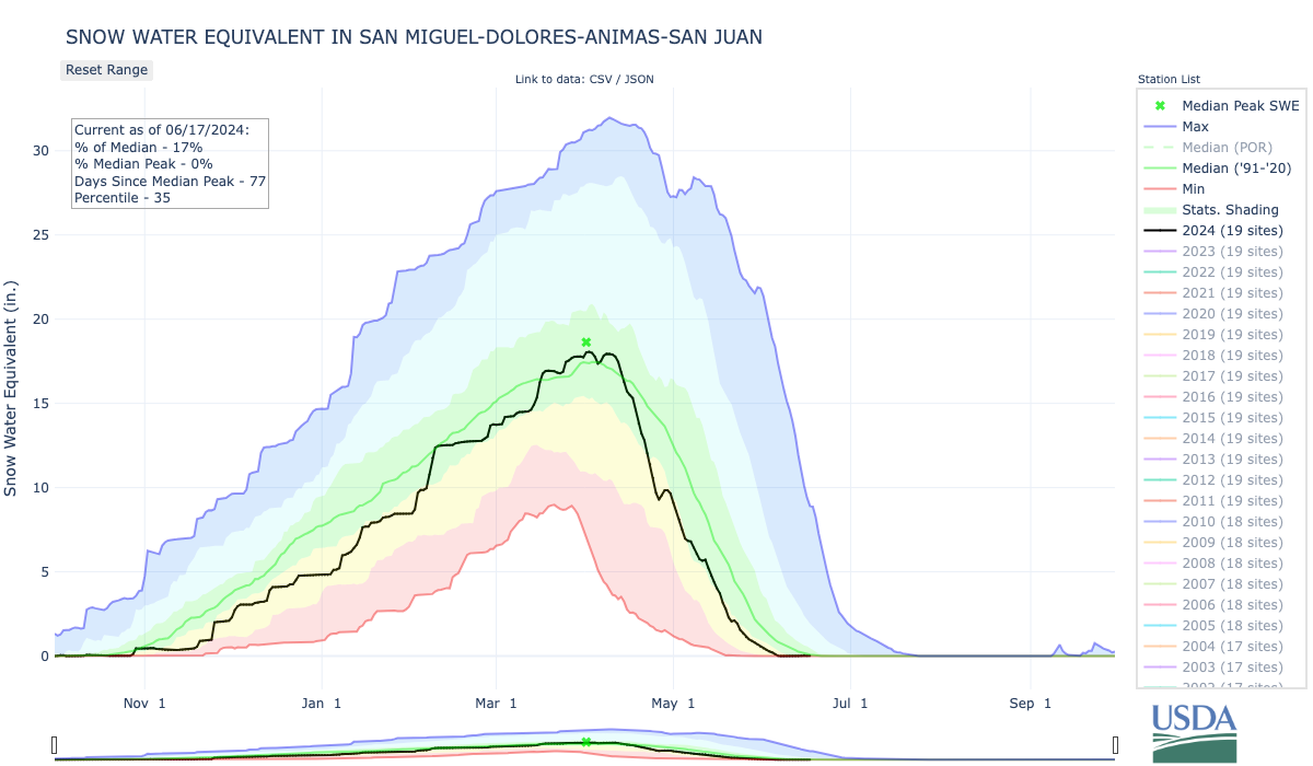
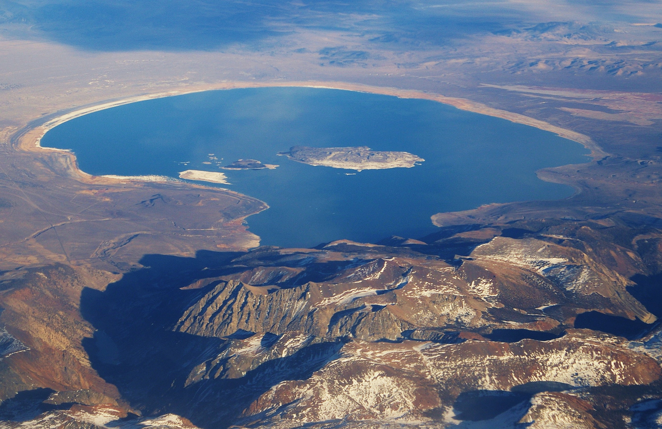
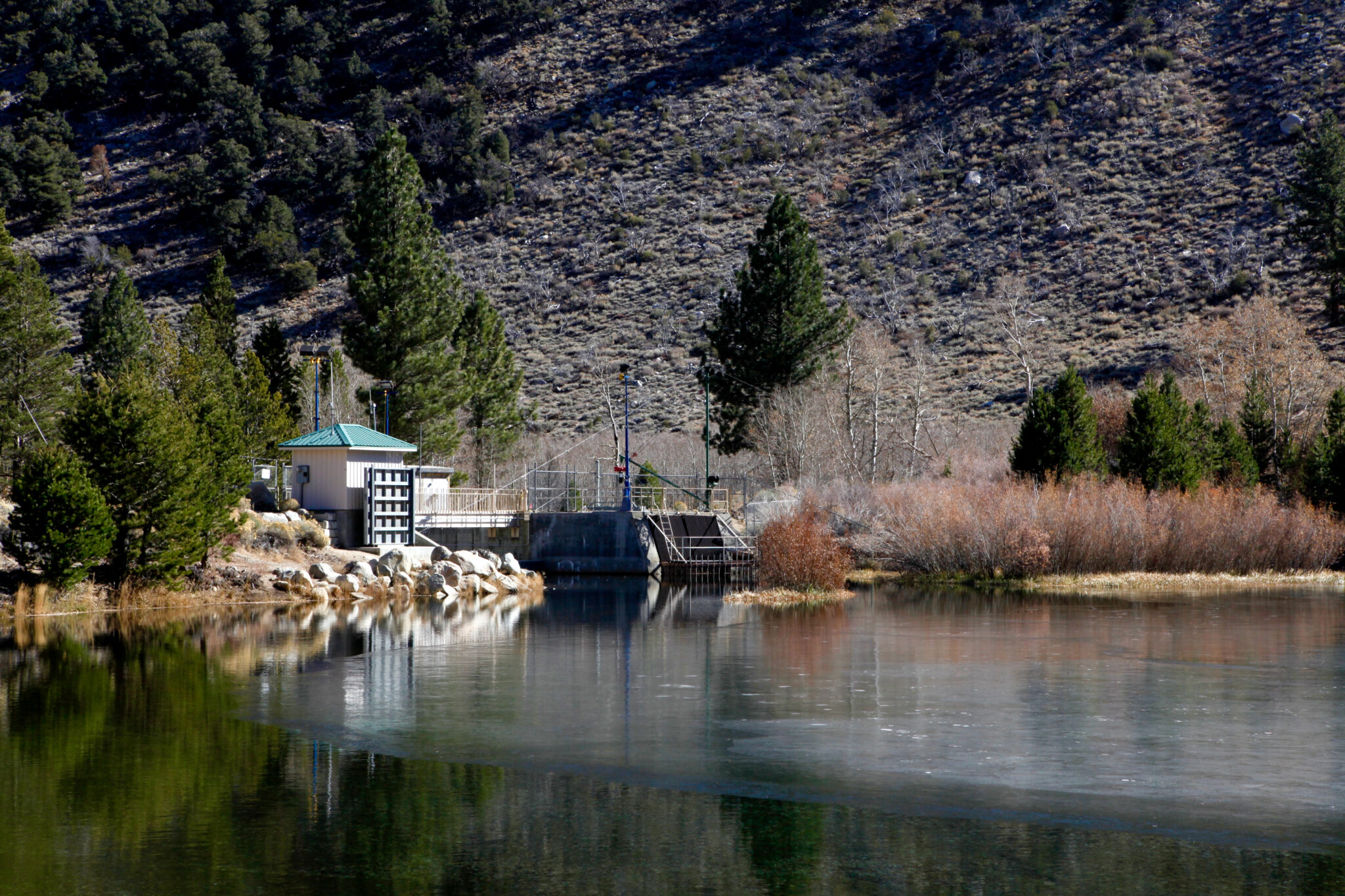
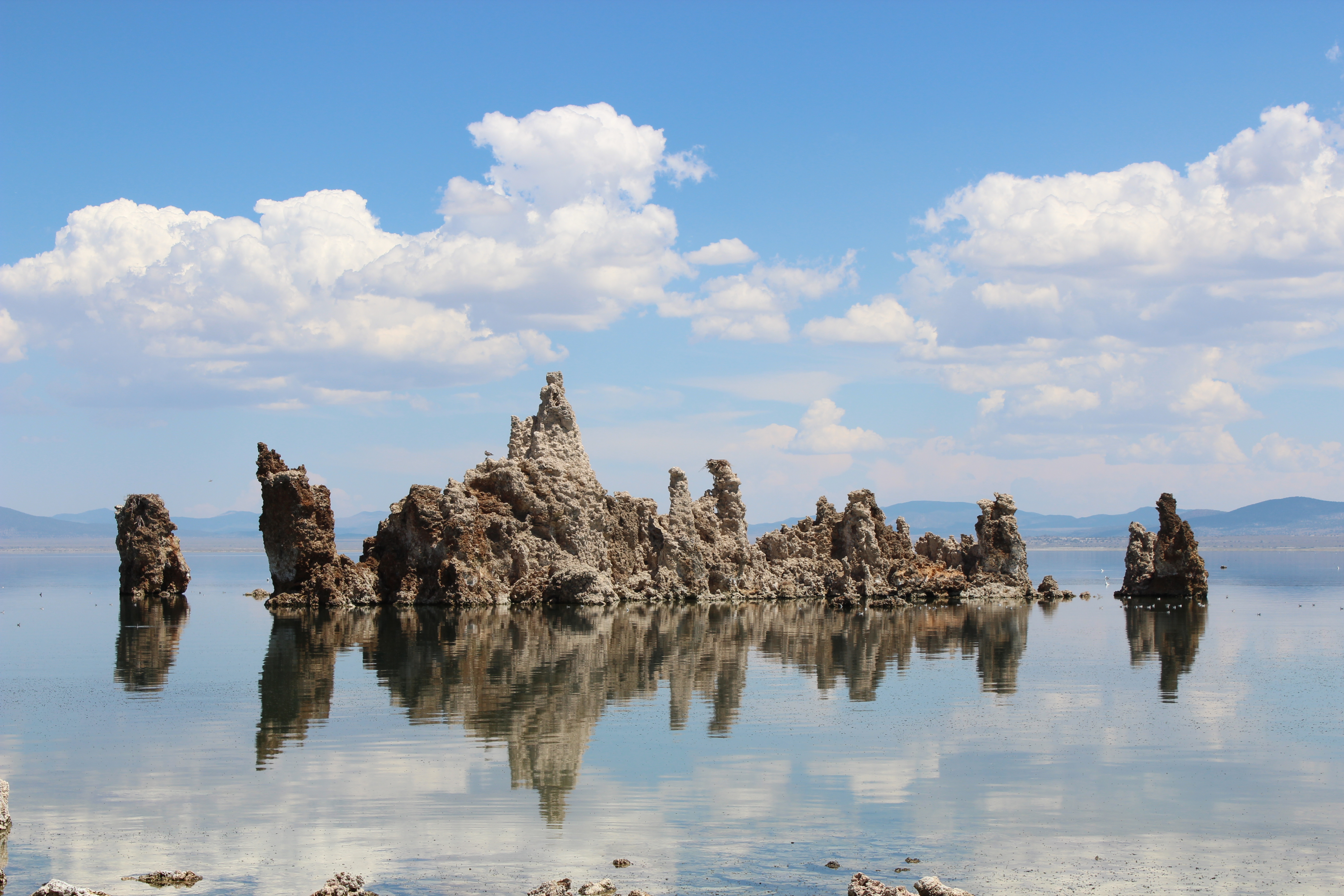
Wetlands and stream systems are essential for birds and provide ecosystem services such as water purification, wildlife habitat, and flood, wildfire, and drought mitigation. Colorado has lost about 50 percent of its wetlands due to development since statehood, so protecting what remains is imperative. 
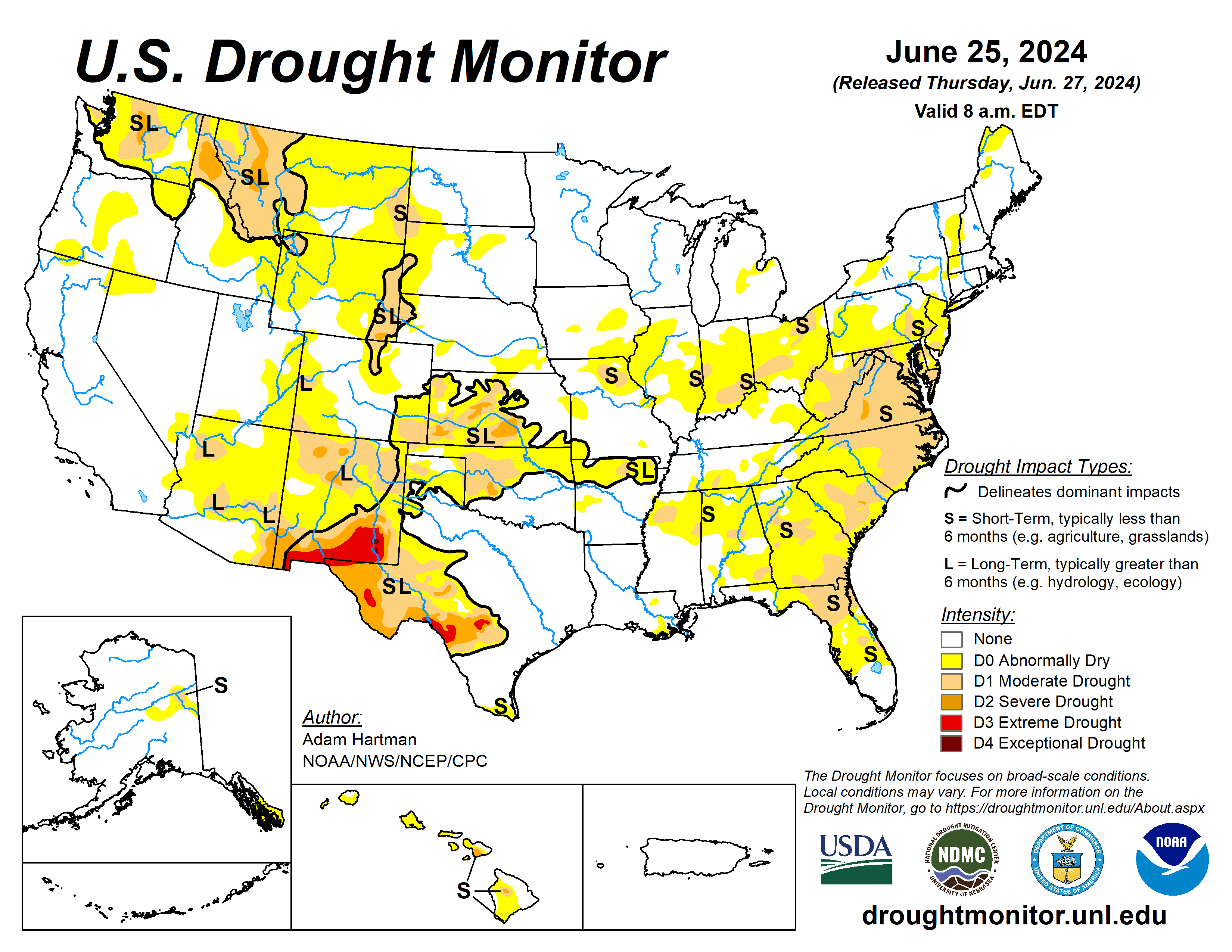
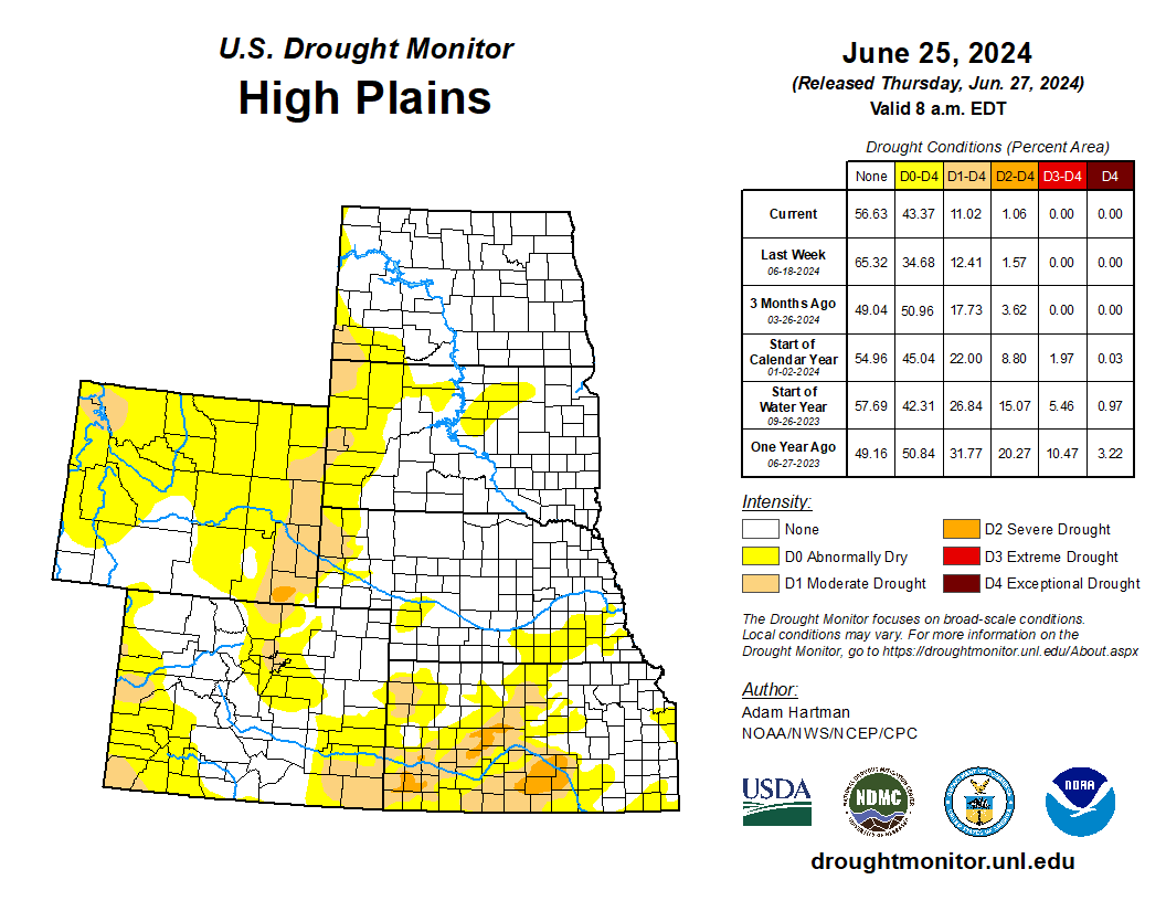
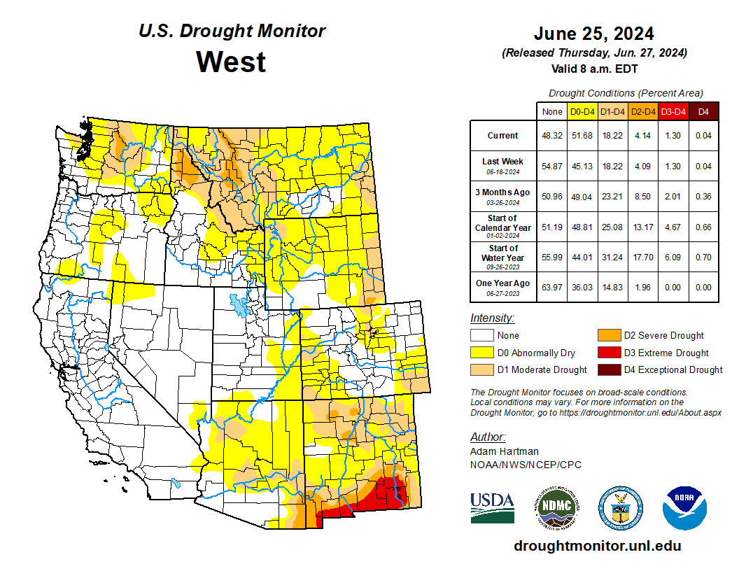
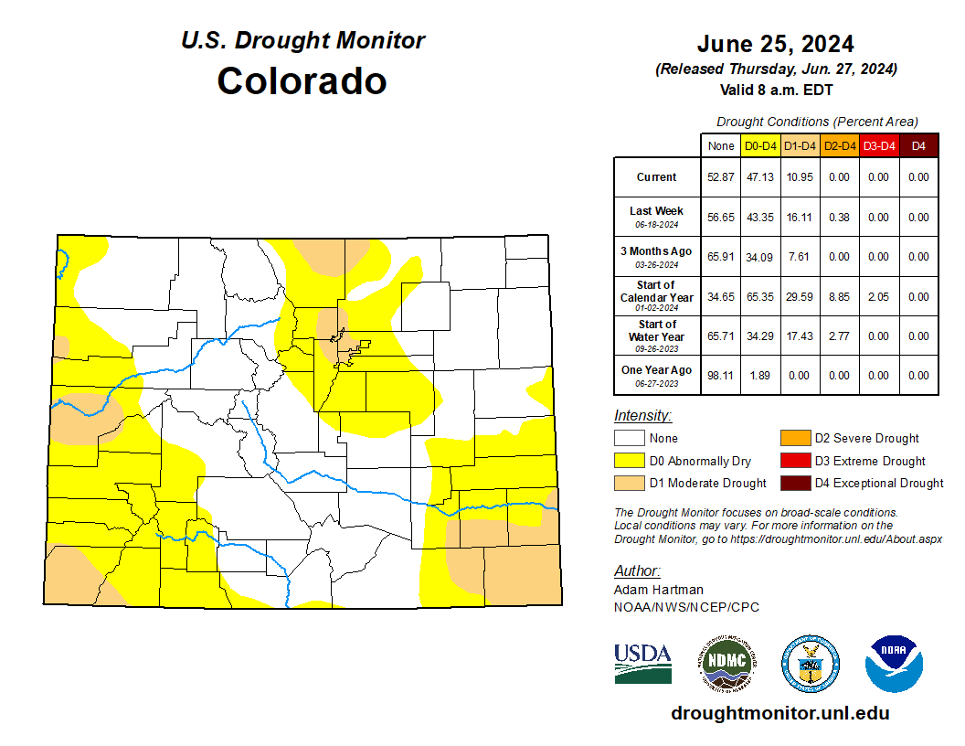
The Clean Water Actย  provides authorities for the EPA and the U.S. Army Corps of Engineers (USACE) to define and regulate different types of water bodies. This includes the 404 Permit Program, which determines which wetlands must be regulated and which kinds of dredge-and-fill activities must be permitted for specific waterways.ย The U.S. Supreme Court decision inย Sackett v. EPAย dramatically narrowed the scope of these regulations and undercut waters subject to federal regulation and placed an estimated 60 percent of Colorado wetlands at risk of losing protections. Moreover, all ephemeral streams and a significant portion of intermittent streamsย in every area of the state would have lost protection if a new state program was not adopted. The United States Geological Survey’s National Hydrography Dataset* (as reported inย Colorado’s 2022ย Sackettย Amicus Brief) estimates that 24 percent of Colorado’s streams are ephemeral and 45 percent are intermittent** meaning over two-thirds of Colorado’s waters are temporary and lack year-round flow. ย 

The Sackett decision opened the doors for development to occur next to and on top of wetlands on private land, so long as there is no surface water connection between them and flowing waterways. House Bill 24-1379 was drafted to moderate the pendulum swings in federal wetland and stream protection levels in Colorado by creating a predictable State permitting and protections program that would work for Coloradoโ€™s intermountain semi-arid waterways.

What Does the New Law do for Coloradoโ€™s Wetlands, Streams, and Restoration Projects?ย 

The new state Dredge and Fill Permit Program created by HB24-1379 contains many details established in statute, and there are areas where more time and attention is needed to determine outcomes through a rulemaking process. Although the new law contains all of the federal 404 agricultural exemptions and some new exemptions tailored to Colorado needs on irrigation ditches, and much more, the below list pertains to Audubon and the Colorado Healthy Headwater Working Groupโ€™s direct work in protecting wetlands and streams and restoration project capabilities. 

  • The new regulatory protections program, with its broad application to Colorado ‘State Waters,’ surpasses the scope of the federal ‘Waters of the United States.’
    • State Waters” C.R.S. 25-8-103(19) means any and all surface and subsurface waters which are contained in or flow in or through this state, but does not include waters in sewage systems, waters in treatment works of disposal systems, waters in potable water distribution systems, and all water withdrawn for use until use and treatment have been completed.
  • The new permitting program is structured to prioritize avoidance of adverse impacts to State Waters, followed by minimization and, finally, compensatory mitigation of the unavoidable impacts.
  • Federal 404 guidelines are the floor and not the ceiling for any state rules, allowing Colorado to customize regulations that work for intermountain semi-arid waterways.
  • The existing Water Quality Control Commission (WQCC) will draft the new rules and review and issue individual permits so that no new regulatory commission will be formed, and reports will be generated detailing the functionality of the new permitting approach.
  • The new law creates a new definition in the statute of “ecological lift,” which โ€œmeans an improvement in the biological health, as well as the chemical, geomorphic or hydrologic health of an area that has been damaged, degraded for destroyed.โ€
  • This new definition is used as one of several criteria for when certain restoration projects will not be required to obtain a state dredge and fill permit: For ephemeral streams, the WQCC must promulgate rules that include: โ€œAn exemption for voluntary stream restoration efforts in ephemeral streams that do not require compensatory mitigation and are designed solely to provide ecological lift where the activity is taking place.โ€ This was one of the provisions that Audubon pressed hard for to maintain the status quo that restoration of rangeland ephemeral drainages to stop erosional headcuts from destroying critical mesic areas could continue to take place without having to obtain a dredge and fill permit (as these areas have always fallen outside of the federal 404 permit jurisdiction). These mesic area restoration projects have been happening for about 10 years in Colorado with great success.
  • For perennial and intermittent streams, if your restoration project requires a federal USACE 404 Nationwide Permit 27 or other general permit, provided those activities result in net increases in aquatic resource functions and services, then a project proponent will not need a separate permit from the Water Quality Control Division.ย 

What Are the Next Steps? 

CDPHE will initiate the rulemaking process starting September 2024 through December 2025 to fully form the regulatory program put in place by HB24-1379. All voices will play a role in both the design and implementation of HB24-1379โ€™s regulatory program, helping to set up Colorado for long-term success. Watch for additional information and engagement from Audubon. Sign up for notifications and learn more here!

Conclusion 

Water connects us all, and rivers do not stop flowing at state lines. More must be done to restore federal protections for interstate river health while adequately supporting state wetland and stream protection programs. As a headwater state, Colorado must continue to lead the way for the rest of the West and the nation in terms of what can be accomplished with collaboration and shared vision. HB24-1379 does that and puts Colorado on a path to protect its waterways for future generations. At Audubon, we know the value and connectivity of our watersheds, wetlands, streams, and rivers; these are waterways we all depend uponโ€”birds and people. We also know the value of bringing people together for durable solutions and we cannot do this work without you. Together, we can protect our most precious natural resource, water, and the health of our waterways and continue the Colorado way of coming together to address our most pressing issues.

Thank you for helping us pass this historic legislation. 

Healthy mountain meadows and wetlands are characteristic of healthy headwater systems and provide a variety of ecosystem services, or benefits that humans, wildlife, rivers and surrounding ecosystems rely on. The complex of wetlands and connected floodplains found in intact headwater systems can slow runoff and attenuate flood flows, creating better downstream conditions, trapping sediment to improve downstream water quality, and allowing groundwater recharge. These systems can also serve as a fire break and refuge during wildfire, can sequester carbon in the floodplain, and provide essential habitat for wildlife. Graphic by Restoration Design Group, courtesy of American Rivers

Supreme Court overturns Chevron v. NRDC — Western Resource Advocates

West Fork Fire June 20, 2013 photo the Pike Hot Shots Wildfire Today

From email from Western Resource Advocates (Erin Overturf):

June 28, 2024

STATEMENT FROM WESTERN RESOURCE ADVOCATES

This morning, the Supreme Court ruled to overturn Chevron v. NRDC, one of the most cited cases in American law.

This is just the latest in a series of SCOTUS decisions designed to undermine the effectiveness of federal administrative agencies like the Environmental Protection Agency. 

Todayโ€™s far-reaching ruling overturns a 40-year legal framework, marking the culmination of a decades-long effort to undermine federal agenciesโ€™ efforts to protect our health and our environment. Overturning Chevron v. NRDC will exacerbate existing dysfunction in federal policymaking, inviting litigation and making it increasingly challenging to secure public health and safety standards – including solutions addressing climate change – at the federal level.

Administrative agencies are the workhorses of our modern system of government. The issues confronting our day-to-day lives are too numerous and too nuanced for the three main branches of government to address alone, but agencies have the technical expertise and flexibility to fill in the gaps.

This decision will make it harder for federal agencies to take action to protect our health and our environment,ย allowing unelected federal judges with lifetime appointments to reject the policy judgements of agencies with more expertise and replace those agency judgments with their own policy preferences.

โ€œThis ruling makes the work we do before state utility regulators and legislatures all the more important.ย Given the challenging new landscape for federal agencies created by todayโ€™s decision,ย state-level policy on climate action and environmental protection is more critical than ever.ย The feds will not be able to solve this problem for us. It is time for leadership at the state level.”ย 

In light of this decision, advocacy within our states to protect our health, our environment, and our climate has never been more important. States can and should set their own standards to reduce pollution, conserve water, and protect wildlife.  

WRA is committed to continuing to leverage our expertise driving state-level policies that protect our health and fight climate change and its impacts in the Interior West. 

Bureau of Reclamation seeks public comment on environmental assessment of proposed water conservation agreement #ColoradoRiver #COriver #aridification

The Salton Sea (pictured above ) straddles the Imperial and Coachella valleys and has long been a sticking point in Colorado River deals. But the federal government recently committed up to $250 million for restoration efforts at the sea. (Source: Water Education Foundation)

Click the link to read the release on the Reclamation website (Mike Boyles):

Jun 28, 2024

BOULDER CITY, Nev. – The Bureau of Reclamation is seeking public comments on a draft environmental assessment analyzing potential impacts of a System Conservation Implementation Agreement between Reclamation and the Imperial Irrigation District. The agreement, administered through the Lower Colorado River Basin System Conservation and Efficiency Program and funded in part by the Inflation Reduction Act, supports voluntary system conservation to protect Colorado River reservoir storage volumes amid persistent drought conditions driven by climate change. 

As analyzed in the draft environmental assessment, the Imperial Irrigation District has proposed to conserve a volume up to a maximum of 300,000 acre-feet of Colorado River water each year from 2024 through 2026 which will remain in Lake Mead to benefit the Colorado River System and its users. 

The draft environmental assessment considers potential impacts from actions taken to implement water conservation, thereby reducing water diversions from the Colorado River at Imperial Dam.  

The draft environmental assessment is available at Lower Colorado Region | Bureau of Reclamation (usbr.gov). The public comment period will end July 28, 2024.  

Comments should be directed to Reclamation via email to prj-lcr-nepa@usbr.gov or to the mailing address below.โ€ฏ 
 
Bureau of Reclamation, Lower Colorado Regional Office 
Attn: Resource Management Office Chief (LC-2000) 
P.O. Box 61470 
Boulder City, NV 89006 
 
Mailed comments on this notice must be postmarked byโ€ฏJuly 27, 2024.โ€ฏIn your response, please refer to the above public notice title and date. Should no response be received by the above expiration date, a โ€œno commentโ€ response will be assumed.โ€ฏ

Commentary:ย How Trump lied about his #climate record at the presidential debate — The Los Angeles Times

“I know how to do this job. And I know how to get things done” — President Joe Biden in North Carolina. Screenshot from The New York Times website

Click the link to read the commentary on The Los Angeles Times website (Sammy Roth). Here’s an excerpt:

June 27, 2024

Two-thirds of the way throughย Thursday nightโ€™s presidential debate, CNN journalist Dana Bash finally asked the candidates how they would tackle a challenge that scientists say poses an existential threat to human civilization: climate change. Perhaps unsurprisingly, former President Trump made a series of false claims about his first-term track record. After he spent most of his two-minute response time returning to a previous debate topic, Bash prompted him to say something about global warming. Trump responded that he wants โ€œabsolutely immaculate clean waterโ€ and โ€œabsolutely clean air.โ€

โ€œWe were using all forms of energy, all forms โ€” everything,โ€ he said, referring to his first term. โ€œAnd yet, during my four years, I had the best environmental numbers ever, and my top environmental people gave me that statistic.โ€

Although planet-warming carbon emissions fell sharply during the final year of Trumpโ€™s first term, due to an economy slowed by the COVID-19 pandemic, theyย rose slightlyย from 2016 to 2019. And if Trump could have helped it, emissions would have risen even more. Heย glorifiedย coal, oil and gas even as they polluted the air and water he claimed to love;ย bashedย solar and wind energy with bogus talking points; and pulled the United States out of the internationalย Paris climate accord. At Thursdayโ€™s debate, Trump claimed the Paris accord โ€” which Biden ultimately rejoined โ€” would cost the country $1 trillion. He didnโ€™t cite a source for that number. And he didnโ€™t come close to acknowledging that the heat waves, wildfires, floods, storms, droughts, migrant flows and crop failures already being exacerbated by rising temperatures will cost the U.S.ย far more than the price of transitioning from fossil fuels to renewable energy, in the view of climate and economic experts. Trump also claimed that the Paris agreement will cost China, Russia and India โ€œnothing.โ€ Another lie. All three nations, like every other Paris signatory, have pledged to do whatโ€™s necessary to try to keep global temperatures from rising more than 1.5 degrees Celsius above preindustrial levels โ€” which scientists say involves slashing carbon emissionsย 43% by 2030ย โ€” a tall order.

In total, the candidates spent about two and a half minutes discussing the climate crisis during Thursdayโ€™s debate before the moderators moved on to other topics.

#Colorado Attorney General Phil Weiser: Supreme Court ruling threatens to create regulatory uncertainty, higher costs and greater harms

Perchlorate Pollution by State

Click the link to read the release on the Colorado Attorney General’s website:

June 28, 2024

Attorney General Phil Weiser released the following statement regarding todayโ€™s U.S. Supreme Court decision overruling 40 years of regulatory law precedent:

โ€œUnder 40 years of precedent known as the Chevron doctrine, the Supreme Court has given reasonable deference to federal agencies to implement statutes passed by Congress, notably, when a statute is unclear. As the court has consistently acknowledged, it is impossible for Congress to legislate every detail needed to carry out and enforce complex laws.

โ€œWith todayโ€™s opinion inย Loper Bright Enterprises v. Raimondo, the Supreme Court appoints itself as the super regulator. The court says that it knows better than highly trained experts when it comes to protections for the air we breathe, the water we drink, public lands, worker safety, food and drug safety, public safety, disaster relief, public benefits, or any other regulation that affects American lives. [ed. emphasis mine] The courtโ€™s decision in this case threatens to create regulatory uncertainty for businesses, government agencies, and everyday Americans. As a result, it promises not only confusion, but also higher costs and greater harms. Rather than clarifying the scope of the Chevron doctrine, the court chose to sow chaos and uncertainty.

โ€œTodayโ€™s decision does not impact state regulations promulgated under Colorado state law. The Department of Law will continue to work with state agency partners to implement and enforce state regulations.โ€

Colorado was part of a coalition of state attorneys generalย that filed a court brief defending the Chevron doctrineย in Loper Bright Enterprises v. Raimondo.

Supreme Court Overturns #Chevron Doctrine: What it Means for #ClimateChange Policy — Inside #Climate News

Denver smog. Photo credit: NOAA

Click the link to read the article on the Inside Climate News website (Marianne Lavelle):

June 28, 2024

This article originally appeared on Inside Climate News (hyperlink to the original story), a nonprofit, independent news organization that covers climate, energy and the environment. It is republished with permission. Sign up for their newsletter here

The high court sweeps away a โ€˜Goliathโ€™ of modern law, weakening agenciesโ€™ legal authority as courts weigh Bidenโ€™s policies to cut greenhouse gases.

Just as federal regulators move forward with a climate change policy rooted in dozens of complex provisions of law, the Supreme Court on Friday overturned the principle that has guided U.S. regulatory law for the past 40 years.

That principle held that a federal agencyโ€™s interpretation of the law should be honored, as long as it is reasonable, in cases where there is any question about the lawโ€™s meaning.

Now, the so-called Chevron doctrine has been swept aside by a 6-3 court split along ideological lines. Chief Justice John Roberts, who two years ago authored a major opinion limiting the Environmental Protection Agencyโ€™s authority to regulate greenhouse gases, wrote the majority opinion, reining in the power of all federal agencies. The court โ€œgravely erredโ€ in 1984 when it gave the regulators deference to decide what the laws they implement mean, he wrote.

โ€œChevronโ€™s presumption is misguided because agencies have no special competence in resolving statutory ambiguities,โ€ Roberts wrote. โ€œCourts do.โ€

In response to the argument by the Biden administration that resolving such ambiguities involves policymaking that is best left to political actors, not to unelected judges, Roberts said Congressโ€”itself a political branchโ€”expects courts to decide the meaning of the law. And Congress can always change the law, he said.

โ€œTo the extent that Congress and the Executive Branch may disagree with how the courts have performed that job in a particular case, they are of course always free to act by revising the statute,โ€ Roberts wrote.

But Congress has backed away in recent decades from substantive stand-alone bills like the Clean Air Act, and has included much of its recent health and environmental decision-making in must-pass budget legislation that can leave lawmakersโ€™ intent subject to interpretation. Experts say the end result of the decision to overturn Chevron will be increased power for the courts and less for the executive branch.

The decision to overturn Chevron fulfills a long-held wish of conservative groups that seek a smaller role for the federal government. They are led by a network funded by the Koch family, which made its billions in the petrochemical industry. Although small fishing operations brought the case against federal regulators, they were represented by a titan of conservative law, former U.S. Solicitor General Paul Clement, and lawyers for the Cause of Action Institute, which shares an address and personnel with the Koch-funded organization Americans for Prosperity.

Ironically, the 1984 case articulating the deference principle, Chevron v. Natural Resources Defense Council, was an anti-regulatory decision. In that case, a unanimous court upheld a Reagan administration air pollution regulation that environmentalists challenged as too weak. 

That rule was issued by an Environmental Protection Agency then led by the late Anne Gorsuch, a fierce opponent of regulation. Her son, Supreme Court Associate Justice Neil Gorsuch, today wrote a lengthy concurring opinion affirming the wisdom of sweeping away the Chevron precedent, finding the reason in the roots of common law, from ancient Roman law to the efforts of King George to control the American colonies.

โ€œToday, the Court places a tombstone on Chevron no one can miss,โ€ Gorsuch wrote. โ€œIn doing so, the Court returns judges to interpretive rules that have guided federal courts since the Nationโ€™s founding.โ€

In the years since Chevron was decided, courts invoked the doctrine repeatedly to uphold regulations that industries chafed at, making the case one of the most-cited in administrative law (it appears in more than 41,000 cases, according to Google Scholar.) Advocates of unfettered industry began to view the legal principle as a tool of government overreach, and called for the courts to abandon it.

No one articulated that view more memorably than Gorsuch when he was a federal appeals court judge, just months before he was hand-picked by the conservative Federalist Society to be President Donald Trumpโ€™s first addition to the Supreme Court.

โ€œWhat would happen in a world without Chevron? If this Goliath of modern administrative law were to fall?โ€ Gorsuch wrote in a 2016 immigration case. Congress would write laws, agencies would โ€œoffer guidance on how they intend to enforce those statutes,โ€ and judges would โ€œexercise their independent judgmentโ€ on those laws, not bound by what agencies said they meant, he wrote. โ€œIt seems to me that in a world without Chevron very little would changeโ€”except perhaps the most important things.โ€

Chevronโ€™s Climate Stakes

When it comes to President Joe Bidenโ€™s effort to put a national climate policy in place, the most important things may well be the outcomes of a slew of lawsuits filed against the Environmental Protection Agency and other federal agencies in the past year.

These lawsuits, most of them in the names of Republican-led states that have been joined by fossil fuel industries, essentially accuse the agencies of overstepping their legal authority with regulations to curb greenhouse gas emissions or otherwise address climate change.

The agencies in most cases are applying broad legal authority Congress gave them years before the dangers of climate change were fully recognized or even contemplated. The EPAโ€™s regulations to cut carbon pollution from the nationโ€™s two leading sourcesโ€”vehicles and power plantsโ€”are based on the Clean Air Act, passed in 1970 and amended in 1990. The Securities and Exchange Commission is seeking to standardize corporate disclosure of climate risks by relying on Great Depression-era laws that require publicly traded companies to fully inform investors of factors that could affect their financial conditions.

In some cases agencies have more explicit direction from Congress than othersโ€”for example, the Clean Air Act provisions on vehicles are more specific than those governing power plants. But in virtually all pending challenges to Biden policy, foes have identified what they see as legal ambiguities, or faults in agenciesโ€™ interpretation of the law.

โ€œItโ€™s very hard to write statutes in technical, controversial areas and not have a shred of ambiguity,โ€ said Lisa Heinzerling, a professor at Georgetown Law School, in an interview prior to the decision. โ€œEven if someone is really trying to be careful, people with enough money and enough lawyers can, after the fact, really bring ambiguity out of something that was intended to be clear.โ€

Now that Chevron has been overturned, the Supreme Court has placed the onus squarely on judges to interpret regulatory law, which typically involves application of science and knowledge of the latest technological advances.

In a scathing dissent, Associate Justice Elena Kagan said the court had removed โ€œa cornerstone of administrative law,โ€ upending the structure that supported much of the federal governmentโ€™s functions.

The Chevron doctrine โ€œhas become part of the warp and woof of modern government, supporting regulatory efforts of all kindsโ€”to name a few, keeping air and water clean, food and drugs safe, and financial markets honest.โ€

Contrary to Robertsโ€™ view, Kagan said that Congress has assigned federal agencies to address interpreting the law in regulatory areas, which often involve scientific or technical subject matter. โ€œAgencies have expertise in those areas,โ€ Kagan wrote. โ€œCourts do not.โ€ Now she said such decisions will be made by courts that have no political accountability and no proper basis for making policy.

โ€œA rule of judicial humility gives way to a rule of judicial hubris,โ€ she wrote.

A Move Long Coming

But the Supreme Court for years has been moving in the direction of giving less authority to federal agencies; the trend accelerated after Trump gave conservatives a commanding 6-3 majority with his three appointees. Although the lower courts still invoked Chevron often, the high court has not relied on the doctrine in any case since 2016. And without mentioning Chevron, the Court recently has displayed little deference for agenciesโ€™ reading of the law.

Two weeks ago, for example, the Supreme Court struck down the federal ban on โ€œbump stocks,โ€ rejecting the Bureau of Alcohol, Tobacco and Firearmsโ€™ technical and legal analysis that the rapid-fire gun accessories convert rifles to machine guns, long banned by federal law. Associate Justice Clarence Thomas wrote that a converted rifle wasnโ€™t a machine gun, in an opinion accompanied by a highly unusual set of trigger mechanism illustrations.

โ€œWhat that opinion looks like is pretty much the court figuring out on its own how guns work,โ€ Heinzerling said. โ€œThat decision is a sign of things to come.โ€

On Thursday, in a 5-4 opinion by Gorsuch, the Supreme Court put a hold on the EPAโ€™s effort to address the difficult problem of smog-forming pollutants that drift across state lines, saying the agency had not adequately explained how it would address the cost-effectiveness of the โ€œGood Neighborโ€ program over time. (Associate Justice Amy Coney Barrett broke from other conservatives in a dissenting opinion, warning the court was downplaying the EPAโ€™s role under the Clean Air Act and leaving โ€œlarge swaths of upwind States free to keep contributing significantly to their downwind neighborsโ€™ ozone problems for the next several years.โ€)

Especially relevant to climate law was the courtโ€™s 2022 decision in West Virginia v. EPA case, written by Roberts and also settled 6-3 with Republican-appointed justices in the majority. In that case, the Supreme Court set a new standard of skepticism for federal agency authority on โ€œmajor questionsโ€ of national importance, throwing out the Obama administrationโ€™s approach for cutting carbon emissions from power plants.

That case, and now the loss of Chevron deference, could well tip the balance against climate policy in the courts, experts say. A case in point is the litigation (Loper Bright Enterprises v. Raimondo, and Relentless, Inc. v. Department of Commerce) that was before the court, brought by fishing operations against the agency charged with enforcing fishing law in U.S. waters, the National Marine Fisheries Service, or NMFS. 

For three decades, NMFS has had a program of putting scientific observers on board fishing vessels to prevent overfishing and ensure compliance with other federal laws, like those to protect endangered species. Lack of observer coverage has been a chronic problem in the underfunded program and in 2020, to increase coverage to address strain on the important Atlantic herring fishery, in part due to climate change, NMFS set new rules requiring that the fishing operations pay the cost of the observers. 

The fishing operations ended up being reimbursed for 100 percent of their costs (about $30,000), but the Supreme Court did not focus on such details. Instead, it focused on what it viewed as the correct roles of agencies, Congress and the courts. Roberts wrote that it was an error for courts to give the executive agencies the benefit of the doubt whenever there was a question of the lawโ€™s meaning.

โ€œBy forcing courts to instead pretend that ambiguities are necessarily delegations, Chevron prevents judges from judging,โ€ Roberts wrote.

Tara Brock, Pacific legal director and senior counsel for the advocacy group Oceana, said the result would be less monitoring of the industry at a time when more is needed. 

โ€œThings are changing in fisheries,โ€ Brock said. โ€œSuddenly somebody in Alaska is catching species that they historically havenโ€™t. Well, what does that mean for fisheries management? Observers being present and being able to document what we are seeing on the water and having that really critical data is going to become even more valuable as climate change continues to change our oceans.โ€

But lawyers representing the fishing operations that brought the challenge said that the Supreme Court has restored balance to decision making about federal regulation.

Thousands of Navajos died on the ‘Long Walk.’ Their descendants still seek the truth — AZCentral.com

The traditional homelands of the Navajo (Dinรฉ) are marked by four sacred mountains that stretch across modern-day Colorado, New Mexico, and Arizona. Credit: Native Knowledge 360ยบ

Click the link to read the article on the AZCentral.com website (Arlyssa D. Becenti). Here’s an excerpt:

June 5, 2024

In June 2018, Virginia Beyale and her brother set out to retrace the steps their ancestors took from Fort Sumner in New Mexico back to Dinรฉ Bikรฉyah, the Navajo Reservation. It was there the people were released after Dinรฉ leaders on June 1, 1868, signed what is now referred to as the Treaty of 1868 with the U.S. government. The siblings were dropped off at Fort Sumner (Hwรฉeldi) to begin the over 300-mile journey that about 8,000 surviving Dinรฉ undertook to get home 150 years before. On this arduous trek, known today as the Long Walk, about 2,600 Navajos died. The forced march to Fort Sumner was a horrific four-year ordeal, one of many genocidal and ethnic cleansing campaigns that took place against the Indigenous peoples at that time.

โ€œThe reason we did it was not only to commemorate the 150 years, but to do a lot of healing and understand how it felt,โ€  Beyale said. โ€œThere was a lot of reflecting of understanding on what our people went through.โ€

[…]

โ€œThe Long Walk and 1863 to 1868 is a watershed in Dinรฉ history because that is the point where we lost our freedom and our independence,โ€ Jennifer Nez Denetdale said. โ€œThat is when we became another occupation of the American colonial government. We are still under their control and under their authority.โ€

U.S. troops at Fort Sumner. By unknown, uploaded by: Aj4444 – Original text : LEGENDS OF AMERICAA Travel Site for the Nostalgic & Historic MindedCopyright ยฉ 2003-2009, http://www.Legends of America.com), Public Domain, https://commons.wikimedia.org/w/index.php?curid=10186386

Nearly 10,000 Navajo men, women and children were forcibly marched to Bosque Redondo. Approximately 200 died of starvation and exposure during the walk, Charles said.

โ€œNearly a quarter of our people died in the conditions at Bosque Redondo,โ€ [Mark] Charles said. โ€œThe government called Bosque Redondo a reservation but it wasnโ€™t a reservation, it was a death camp. A death camp that was approved by Abraham Lincoln on Jan. 15, 1864.โ€

[…]

One notable aspect of Navajo stories is that they often contradict American historical narratives, Denetdale said. These narratives claim that the Navajo returned from Fort Sumner as a better people, having learned to get along with others, mastered silversmithing and understood government. 

โ€œThis is what I had to read when I was in graduate school and I said, โ€˜no,โ€™” Denetdale said. โ€œThis is not how I am going to read this, and I am not going to agree with you. So you go to oral history and to your own people’s stories.”

She sought out her own grandparents to hear their stories about this period. One story from her book, which she discussed during her presentation on the Long Walk and the Treaty of 1868, highlighted that the treaty included an agreement by Navajo leaders that Navajo children would receive an American education.

โ€œThey call it assimilation, I call it genocide and ethnic cleansing,โ€ Denetdale said. โ€œThey never lived up to that article of 1868.โ€

U.S. Supreme Court flips precedent that empowered federal agencies — #Colorado Newsline

Atlantic herring. Credit: NOAA Fisheries/Calvin Alexander

Click the link to read the article on the Colorado Newsline website (Jacob Fischler):

June 28, 2024

The U.S. Supreme Court struck down a precedent Friday that had for decades limited judicial power to strike executive branch regulations, in a decision immediately criticized for potentially undermining decisions by scientists and agency experts.

The 6-3 and 6-2 decisions in two cases brought by fishing operators in New Jersey and Rhode Island challenged a National Oceanic and Atmospheric Administration rule and overturned the principle known as Chevron deference.

That precedent gave federal agencies broad discretion to use their judgment to resolve any ambiguity Congress left in a federal statute.

The courtโ€™s six conservatives reasoned that courts โ€œroutinely confront statutory ambiguitiesโ€ that have nothing to do with the authority of regulatory agencies, Chief Justice John Roberts wrote in the majority opinion.

โ€œOf course, when faced with a statutory ambiguity in such a case, the ambiguity is not a delegation to anybody, and a court is not somehow relieved of its obligation to independently interpret the statute,โ€ Roberts wrote.

Under the 40-year-old precedent, courts gave up their interpretive role and deferred to agencies, Roberts wrote.

But they shouldnโ€™t, he added. Judges should apply their own legal reasoning to reach a sound decision.

โ€œCourts instead understand that such statutes, no matter how impenetrable, do โ€”  in fact, must โ€” have a single, best meaning.โ€

1984 ruling overturned

The decision overturned Chevron v. Natural Resources Defense Council, a 1984 Supreme Court ruling that said courts must defer to federal agenciesโ€™ expertise when considering legal challenges to a rule. The 1984 ruling significantly raised the bar for overturning an agency rule.

The precedent strengthened the executive branch under presidential administrations of both parties, but experts worry its reversal will strip agencies of the power to enact regulatory safeguards across a broad spectrum of issues including clean air and public health.

In a dissenting opinion, the courtโ€™s three liberals โ€” not including Justice Ketanji Brown Jackson in one of the cases, after she recused herself because sheโ€™d heard the case as an appeals court judge before joining the Supreme Court โ€” said the majority erred by misunderstanding the roles of three branches of government.

Congress knows it cannot โ€œwrite perfectly complete regulatory statutes,โ€ Justice Elena Kagan wrote in a dissent. Interpretation of those statutes is a given, and Congress usually prefers a โ€œresponsible agencyโ€ instead of a court.

Agencies are more politically accountable and have greater technical expertise in a given issue than courts, she wrote.

โ€œPut all that together and deference to the agency is the almost obvious choice,โ€ Kagan wrote.

Kagan went on to criticize the decision as a power grab by the judiciary at the expense of agency experts.

โ€œA rule of judicial humility gives way to a rule of judicial hubris,โ€ she wrote. โ€œIn one fell swoop, the majority today gives itself exclusive power over every open issue โ€” no matter how expertise-driven or policy-laden โ€” involving the meaning of regulatory law.โ€

Liberals see a weakening of safeguards

Liberal groups and elected Democrats worried the reversal will strip agencies of the power to enact strong regulatory safeguards across a broad spectrum of issues, especially climate and environmental regulations.

โ€œIt weakens our governmentโ€™s ability to protect us from the climate crisis, threats to worker safety, public health, clean air and water, safe medicines and food, a sound financial system, and more,โ€ Manish Bapna, president of the environmental group NRDC Action Fund, wrote in a statement.

โ€œTodayโ€™s reckless but unsurprising decision from this far-right court is a triumph for corporate polluters that seek to dismantle common-sense regulations protecting clean air, clean water and a livable climate future,โ€ Wenonah Hauter, the executive director of the advocacy group Food & Water Watch, said in a statement.

Rachel Weintraub, the executive director of the Coalition for Sensible Safeguards, a group that advocates for strong federal regulations, said in an interview before the decision was released that Chevron deference has allowed a host of regulations affecting consumer safety, labor, environmental protections and other issues.

โ€œThe important role that government plays in ensuring the health and safety of our families and the fairness of our markets could be undermined here,โ€ she said.

The ruling takes power away from the experts on a particular subject of a federal regulation โ€” traffic engineers at the Department of Transportation, disease experts at the Food and Drug Administration or scientists at the Environmental Protection Agency, for example โ€” and gives it to the federal judiciary, Weintraub said.

U.S. Rep. Raรบl Grijalva, an Arizona Democrat who is the ranking member on the U.S. House Natural Resources Committee, called the ruling a gift to polluters and the fossil fuel industry.

โ€œFor 40 years, Congress has passed laws with the understanding that the interpretation of those laws is for the courts, but the implementation laid in the hands of the scientific and policy career experts at our federal agencies,โ€ Grijalva said in a statement.

โ€œBut now, thanks to this extremist power-grab, our most fundamental protections will be at the whim of individual judges โ€” many of whom are far-right ideologues โ€” regardless of their lack of expertise or political agenda.โ€

Conservatives applaud rollback

Republicans in Congress and conservative activists praised the decision for weakening the administrative state, saying it would return power to the legislative branch.

โ€œThe Constitution vests Congress with the sole authority to make law,โ€ Senate Republican Leader Mitch McConnell of Kentucky said in a statement. โ€œAfter forty years of Chevron deference, the Supreme Court made it clear today that our system of government leaves no room for an unelected bureaucracy to co-opt this authority for itself.โ€

Rep. Bruce Westerman, an Arkansas Republican who chairs the House Natural Resources Committee, said Fridayโ€™s ruling should spur Congress to write more prescriptive laws.

โ€œCongress has sidestepped our legal duties for far too long and todayโ€™s ruling puts us back in the driverโ€™s seat when it comes to rulemaking and regulatory authority,โ€ Westerman said in a written statement. โ€œWeโ€™re no longer going to let federal agencies fill in the details when it comes to the policies we enact.โ€

Roman Martinez, an attorney who argued on behalf of the Rhode Island fishing operators, called the ruling a โ€œwin for individual liberty and the Constitution.โ€

โ€œThe Court has taken a major step to shut down unlawful power grabs by federal agencies and to preserve the separation of powers,โ€ Martinez said in a statement distributed by the conservative public relations firm CRC Advisors. โ€œGoing forward, judges will be charged with interpreting the law faithfully, impartially, and independently, without deference to the government.โ€

No plans to reopen old cases

In the majority opinion, Roberts said the court did not plan to reopen cases that had been decided by Chevron โ€œdespite our change in interpretive methodology.โ€

Even prior to Fridayโ€™s decision, the court had used Chevron less often. During theย oral argument, Roberts cited a study that the court had relied on the precedent sparingly over the past 14 years.

The courtโ€™s conservative majority has shown a willingness to move away from deference to agency decision-making, demanding more explicit congressional instruction.

In West Virginia v. EPA in 2022, for example, the court ruled that the EPA lacked the authority under the Clean Air Act to regulate greenhouse gas emissions.

Daniel Wolff, an administrative law attorney at the law firm Crowell & Moring, downplayed the effect the ruling would have on the administrative state.

Congress at times explicitly directs agencies to craft regulations, and those rules will still be subject to the same standard that they were written reasonably, Wolff said in an interview prior to the decision.

Rules with solid legal and statutory foundations would survive under either standard, he said.

โ€œRolling back Chevron is simply going to mean agencies donโ€™t get the benefit of the doubt in the case of a tie,โ€ Wolff said. โ€œThey have to come into the court and persuade the court that they have the better reading of the statute.โ€

Fishing operators

The cases decided Friday was brought by herring fishing operators from New Jersey and Rhode Island who challenged a NOAA rule requiring the operators to pay for the federal monitors who regularly join fishing boats to ensure compliance with federal regulations.

The fishing operators said the rule forced them to hand over up to 20% of their profits.

After a lower court relied on Chevron deference to rule in favor of NOAA, oral arguments at the Supreme Court in January focused almost entirely on Chevron.

#Drought news June 28, 2024: The Four Corners region experienced several rounds of heavy rainfall, some localized flooding also occurred, associated with a surge of tropical moisture from the remnants of Tropical Storm Alberto

Click on a thumbnail graphic to view a gallery of drought data from the US Drought Monitor website.

Click the link to go to the US Drought Monitor website. Here’s an excerpt:

This Week’s Drought Summary

Much of the eastern contiguous U.S. (CONUS), south of the Great Lakes, received little to no rainfall, and this is on top of several weeks of below normal rainfall leading up to last week. In addition, temperatures have remained hot for many locations. This combination of antecedent dryness, much below normal rainfall, and hot temperatures has resulted in rapidly deteriorating conditions, particularly across the Ohio Valley, Mid-Atlantic, and Southeast, with large increases in abnormally dry (D0) and moderate drought (D1) conditions. Conversely, southern Texas, the Four Corners region, and the Upper Midwest and Northern Plains experienced several rounds of heavy rainfall. Some locations across southern Texas (associated with Tropical Storm Alberto) and the north-central CONUS received well in excess of 5 inches of rainfall that led to flash and river flooding, as well as improvements to drought conditions. Some localized flooding also occurred in portions of the Four Corners region, associated with a surge of tropical moisture from the remnants of Tropical Storm Alberto that came ashore in northern Mexico late last week. Across much of the western CONUS, conditions are starting to dry out a bit, particularly in the Pacific Northwest and northern Rockies. In Alaska, moderate drought was introduced in the eastern interior Mainland, where warm and dry weather continues, elevating fire concerns. In Hawaii, trade winds are lacking moisture resulting in below normal rainfall across the islands and the widespread expansion of abnormal dryness. Puerto Rico continues to remain drought-free…

High Plains

The High Plains region experienced a mixture of both deteriorating and improving drought conditions last week, which has predominantly been the case over at least the last month. High pressure over the eastern U.S. and an active storm track across the northern tier of the lower 48 states have been able to funnel moisture northward over the past few weeks, but precipitation has been hit-and-miss from week to week. However, last week was a little different from prior weeks, as some of the moisture from Tropical Storm Alberto was funneled northward into the Four Corners region and then into the Central and Northern Plains. Southeastern South Dakota received in excess of 5 inch rainfall surpluses for the week leading to flooding along the Missouri River and some of its tributaries. Heavy rain also fell across parts of southeastern Colorado and southwestern Kansas last week, associated with the surge of moisture from Alberto, leading to some targeted improvements to the drought depiction in those areas as well. Elsewhere in the High Plains region, targeted degradations are warranted due to antecedent dryness, below normal weekly precipitation, and predominantly above normal temperatures (with the exception of northern Montana and the Dakotas)…

Drought Monitor one week change map ending June 25, 2024.

West

A surge of moisture from Tropical Storm Alberto led to widespread, localized heavy rainfall across portions of the Four Corners region, leading to localized flash flooding and targeted drought improvements across Arizona, New Mexico, and southeastern Colorado. Conversely, targeted degradations are warranted across parts of the interior Pacific Northwest and northern Rockies, where warm and dry weather prevailed. Elsewhere in the West, conditions are largely drying out, but the influx of tropical moisture from Alberto has helped to stall the progression of the dryness a bit for many locations…

South

The passage of Tropical Storm Alberto in northern Mexico resulted in a large influx of moisture into southern Texas, with widespread 5 inch rainfall totals (locally upwards of 8 inches for some locations). This heavy rainfall caused localized flash flooding and resulted in large improvements to soil moisture. However, leading up to last week, southern Texas was experiencing abnormally dry and moderate drought conditions, so despite some large improvements (2-category improvements in some cases), some parts of southern Texas remain abnormally dry given the rainfall deficits leading up to Albertoโ€™s landfall. Heavy rainfall also fell across portions of the Oklahoma Panhandle, with several locations receiving in excess of 5 inches of rain, warranting some targeted 2-category improvements to the drought depiction there as well. Elsewhere in the Southern region, conditions are rapidly deteriorating, as rainfall has been lacking entirely over the past few weeks for many locations. Persistent heat has exacerbated the ongoing dryness, leading to degradations across parts of the Tennessee and Lower Mississippi Valleys, western Texas, and northern Oklahoma. Following a very wet May, the last few weeks have been very dry across eastern Texas and this area will need to be monitored in the coming weeks if warmer than normal temperatures persist…

Looking Ahead

During the next five days (June 27 – July 1), a couple of storm systems and trailing frontal boundaries are forecast to bring periods of rainfall to portions of the eastern U.S. These storm systems are likely to usher in some cooler than normal air behind them, particularly across the northern tier of the lower 48 states. Temperatures are expected to remain predominantly warmer than normal across the southern tier of the U.S., with excessive heat also possible across the Gulf Coast states.

The Climate Prediction Centerโ€™s 6-10 day outlook (valid July 2 – 6), favors enhanced chances of above average temperatures across the southern two-thirds of the lower 48 states and near to below normal chances across the northern tier states. Near to below normal temperatures are also favored in the Desert Southwest, due to the increased potential for above normal precipitation. Below normal precipitation is favored across parts of California and Nevada, and across the southeastern U.S. Increased above normal precipitation chances are favored elsewhere across the lower 48 states, with the highest chances across portions of the Southwest and Midwest.

US Drought Monitor one week change map ending June 25, 2024.

Hot, dry conditions could push much of #Colorado into #drought by summerโ€™s end — Fresh Water News

Click the link to read the article on the Water Education Colorado website (Shannon Mullane):

June 27, 2024

Colorado has seen an average water year so far, but looking ahead, climate experts say much of the state could fall into drought conditions and struggle to find relief. 

Coloradoโ€™s very average snowpack has officially melted away from all 115 federal snow monitoring stations in the state, as of this week. Reservoir levels are at 94%, just slightly below average, while precipitation was at exactly 100% of the 30-year median, according to a Water Conditions Monitoring Committee meeting Tuesday.

Heat, however, has been on the rise. Even summer showers may not be enough to combat its effects, or to keep the state away from drought.

โ€œReally the entire state is at risk of developing drought this summer,โ€ Assistant State Climatologist Becky Bolinger told listeners during the meeting. โ€œA strong monsoon would be really helpful. It would limit that risk of worsening drought, particularly over the Four Corners. โ€ฆ For now, itโ€™s looking like that is not as likely, and that itโ€™s going to be a pretty rough summer.โ€

Climate experts track precipitation, temperature, soil moisture and other factors year-round to gauge water supplies and storage for farmers, city utility managers, reservoir operators and residents around the state.

This yearโ€™s outlook has some of those water users looking out for impacts to fish populations, recreation opportunities, irrigation supplies and wildfires. 

โ€œWithout much rain, wildfire will definitely be a pretty serious concern,โ€ said Adrian Bergere, executive director of the San Miguel Watershed Coalition in southwestern Colorado.

The period from October 2023 through May ranked in the top 10 warmest time periods across a significant majority of the state when compared with a 129-year historical record, Bolinger said. 

Areas of southeastern Colorado, like Lamar and La Junta, have already reported 20 or more days over 90 degrees. The Front Range has already had 10-15 days over 90 degrees. Most of the country is also likely to be hotter than usual for the rest of the summer, she said.

Thatโ€™s quite the switch after last year, which started out with cooler-than-average months, Bolinger said.

The hotter temperatures are likely to continue for the rest of the summer. Western Colorado and the Four Corners area have a 70%-80% chance of above-average temperatures โ€” a very high degree of confidence, Bolinger said.

Coloradoโ€™s stream and river levels are receding after a normal runoff year, and incoming precipitation will be increasingly helpful for water users in the late summer and early fall. Although the state has seen average precipitation so far, thereโ€™s a 40%-50% chance rainfall will tumble below normal levels for July through September. 

Some areas, like Fort Collins and Burlington, have seen less-than-average rainfall so far. Even with some rain in the near-term forecast for early July, it will be hard for these areas to end the water year, which closes Sept. 30, at the average level, Bolinger said.

The combination of hot and dry weather could make it harder for areas of the state that are already experiencing drought conditions to recover, and it could mean that more areas fall into drought, she said. 

Colorado Drought Monitor map June 25, 2024.

About 16% of the state is experiencing drought conditions. That is vastly better than in late 2020 and early 2021, when the entire state was in drought and over 20% was in the most severe drought category. At that level, agricultural and recreational economic losses are large, reservoirs are low, large fires can develop and mandatory water restrictions are often implemented, according to the U.S. Drought Monitor.

โ€œThere is a slightly increased risk for drier extremes in the southern part of the state, which really means there would be a low likelihood that any drought that worsens or develops in the summer is not going to see relief through the fall,โ€ Bolinger said.ย 

In the Upper Rio Grande River Basin, aquatic biologist Estevan Vigil is keeping an eye on the water temperatures and water levels on the Rio Grande and Conejos rivers for Colorado Parks and Wildlife.

Brown trout and rainbow trout flourish when water is about 50 degrees but struggle when it rises above 70 degrees. At that level, their immune systems become stressed, and catch-and-release fishing can lead to higher fish mortality.

If stream levels fall below 50% of the norm, and if temperatures rise above 70 degrees, Vigil may implement voluntary or emergency fishing closures.

โ€œIn the [San Luis Valley] since 2019, weโ€™ve probably done it twice,โ€ Vigil said. โ€œIโ€™m anticipating having to do it this year.โ€

A strong monsoon season would help keep rivers flowing and fishing access open, he said.

Several city water managers said their reservoir storage supplies were looking good during the water conditions meeting. Colorado Springs Utilities reservoirs were at 85% of their capacity, and Denver Waterโ€™s reservoirs were 97% full.

The lack of monsoons would heighten concerns over wildfire risk or lead to a shorter rafting season for boaters, Bergere said. Less-than-average rainfall could also leave sections of the river dry as water gets pulled for other uses, like irrigation and municipal supplies.

Water users in the San Miguel River Basin know how to endure fluctuating supplies, Bergere said.

โ€œWhat weโ€™re looking at there is not amazing, but itโ€™s something weโ€™re pretty used to down here,โ€ he said. โ€œWithout much rain, wildfire will definitely be a pretty serious concern.โ€ย 

Romancing the River: Back to Basics? — George Sibley (sibleysrivers.com) #ColoradoRiver #COriver #aridification

Credit: George Sibley/Sibley’s Rivers

Click the link to read the article on the Sibley’s Rivers website (George Sibley):

June 26, 2024

Note in passing: this is the 50th post on this โ€˜weblogโ€™ (a meaningful number to a ten-digit species). I am grateful to those who continue to open and even read these posts. I am obviously writing as much for my own edification and clarification as for yours, in the spirit of British writer E.M. Forster, who said, โ€˜I donโ€™t know what I think until I see what I write.โ€™ Working it out on paper, as we used to say, except now it is electrons on a screen only a little more organized than a starry night.

Most of these posts have been about the Colorado River โ€“ a river I can say I โ€˜loveโ€™ in all the complexity that concept of engagement encompasses. I love its natural forms and contours, which leave me thinking that we need a โ€˜sur-โ€™ category for nature โ€“ โ€˜surnatureโ€™ like โ€˜surrealโ€™ is to โ€˜realโ€™ โ€“ for natural phenomena that seem to be โ€˜beyond nature,โ€™ at least as we usually seem to think about nature, a fragile china shop in which we have sometimes behaved like a bull; here the river often seemed to be the rampant bull.

I am also fascinated, mystified and sometimes horrified by our often surreal engagement with this river and the geography through which it runs, from the mountains where weโ€™ve pushed into the high rock and ice with conveyor lifts for recreation; then through the region of canyons and floodplains where a pre-urban agrarian culture contends unsuccessfully with a post-urban refugee culture trying to figure out what it wants to be; then into the serious canyons where the river in full patiently works at filling in silt behind some temporary (in river terms) structures built to teach the river to stand in and push rather than cut and run during their river-moment; then out onto the hot deserts where weโ€™ve spread the river out in all directions to grow food, feed, and megacities where 20-25 million people live in a luxuriant culture they are just beginning to learn may be as fragile and ephemeral as any china shop in a bullish world.

The world we have made here is our fathersโ€™ world; I am a son ofย homo faber, man the maker, artisan, artificer, engineer; but my mother was of theย homo sapiensย clan, men and women who stop, look, listen and think about what they see before rushing into action. Withย homo faberย leading, we have created what looks like miracles in the deserts, but on a โ€˜buy now pay laterโ€™ plan; our miracles now start looking a little short-term, either from the changed environment or from just wearing out, or both, but we will still be paying for them as far into the future as we can see. Our challenge now is forย homo faberย andย homo sapiensย to work more in harmony: to stop, look and listen to envision how we can carry forward what we do well with the foresight to avoid what we now know we do badly, accepting that the river and its world are not inert, but have their own standards, not self-evident but discoverable: standards we should learn before we challenge them in this unpredictable โ€˜surnaturalโ€™ mix of utility and beauty because nature can dispassionately punish, withhold, destroy. Weโ€™ve no choice but to keep moving what we hope is forward, but remembering the maze thatโ€™s the great seal of the Salt River Maricopa and Pima People; donโ€™t expect anything to be easy and fast, like the 20thย century appeared to be. Chronicling and analyzing where we are and what we do is the purpose here โ€“ on to the next 50.

That noted โ€“ back to the river. Lots is happening and not happening along the Colorado River these days, some of which youโ€™ve been seeing in the national news. One of the notable things happening and not happening is the almost unbelievable fact that the Navajo People, the Hopi People, the San Juan Paiute People, and the People of the State of Arizona as well as We the People (as Indian trustees) have finally negotiated a settlement on water rights for the three-in-one reservations โ€“ the huge Navajo Reservation covering a tenth of Arizona and parts of New Mexico and Utah, and the smaller Hopi and Paiute Reservations contained within it. Unfortunately this very complex settlement still needs the approval of Congress, and carries a five billion dollar price tag, so we will wait till that happens, or doesnโ€™t, to look at it more closely.

The most important thing that is not happening along the river today is the impasse in negotiations between the seven Colorado River states, in their efforts to figure out how to manage the river in the post-2026 epoch, when the 2007 Interim Guidelines for managing the river in the early 21st century expire (along with the 2019 and 2022 Interim Interim Guidelines required to limp through to 2026). Looking over the negotiatorsโ€™ shoulders very closely are the people of Mexico and the 30 First People tribes, whose rights to water are all shoehorned into the seven state allotments and appropriation systems โ€“ and the 30 tribes have informed the Bureau and the states that they will not be ignored or shortchanged this time.

Negotiations with everyone more or less in the same room broke down early in 2024, and the seven states withdrew into their artificial Colorado River Compact division: the four states of the Upper Basin and the four states of the Lower Basin retreated to their redoubts above and below the mainstemโ€™s canyons, to start lobbing proposals over the canyons at each other, each telling the other what they are willing to do in their Basin โ€“ and what they expect the other Basin to do in theirs.

Each Basinโ€™s demands on the other Basin are, of course, more than the other Basin is willing to do, and everyone is stubbornly holding their ground. Weโ€™ll not go over their separate proposals again; a summary of the two Basin plans can be found here if you want a review.  The only real step forward has been the Lower Basinโ€™s willingness to finally take out of their own Compact allotments the โ€˜structural deficitโ€™ โ€“ the Lower Basin system losses through evapotranspiration, bank storage, et cetera, and their half of the Mexican obligation.

There will probably eventually be another set of links in the Law of the River chain going back to the Colorado River Compact: either a complicated set of compromises worked out among the states of the two Basins, with lots of hoops for the Basin states tied to different reservoir elevations โ€“ or if that proves impossible, the Bureau of Reclamation will come up with another โ€˜interim planโ€™ to stagger a little further into the 21st century.

But all that is just kind of tedious, mundane โ€“ hardly worthy of the surnatural river and its environment we are now just trying keep up with. And โ€“ isnโ€™t everyone saying we need to think creatively, โ€˜think outside the boxโ€™? So I want to look at an idea thatโ€™s at least up on the edge of the box looking outside it: the fact that we could actually do now โ€“ have almost done โ€“ what the Colorado River Compact commissioners could not do in 1922.

The Compactโ€™s Signers. Photo via InkStain

They gathered in 1922 to create an interstate compact that would preempt the appropriations doctrine at the interstate level; they wanted an equitable (not the same as โ€˜equalโ€™) seven-way division of the riverโ€™s waters, so they could avoid being trapped in a seven-state appropriations race, with California already at the first turn while Wyoming and New Mexico were still looking for the starting gate. They wanted each state to know that it would have water to develop when it was ready for it.

They were unable to do that seven-way division, however, because they knew too little about the flow of the river, and even less about the future needs of their states. The best compact they were almost able to agree on was the last-minute field-expedient division of the Colorado River Basin into two basins, each with half of the riverโ€™s water to develop. At one point in the negotiations, the Commission chair and federal representative Herbert Hoover called the two-basin division โ€˜a temporary equitable division,โ€™ postponing the more thorough division they had wanted for โ€˜those men who may come after us, possessed of a far greater fund of information.โ€™ The โ€˜temporary equitable divisionโ€™ would suffice, Hoover believed, to โ€˜assure the continued development of the river,โ€™ and it did; even though only six of the seven states ratified the Compact, Congress was persuaded that there was enough โ€˜comityโ€™ among the states for them to authorize the construction of  the Boulder Canyon Project.

But โ€“ โ€˜those men who may come after us, possessed of a far greater fund of informationโ€™ โ€“ thatโ€™s us, isnโ€™t it? Women now too, as well as men? We know a lot more about the river than we did in 1922 โ€“ a lot of it in the โ€˜sadder but wiserโ€™ category of knowledge, but โ€ฆ havenโ€™t we also, at this point, incrementally effected a seven-way division of the waters of the Colorado (including a share for Mexico, with the states responsible for fulfilling the Winters promise to the Indians with federal help)? Each state may not have all the river water it wants, and wanted in 1922, but we all know the river is now tapped out: each state has all the water it is ever likely to get; a seven-way division has happened, like it or not. And the quantity each has to use is reasonably close to the quantities codified in various elements of the Law of the River.

So, in other words โ€“ could we not finally draft the Colorado River Compact the original compact creators wanted to do, but lacked the necessary โ€˜fund of informationโ€™? Well, yes butโ€ฆ. That seven-way division is not so easy as writing down seven acre-foot numbers and saying โ€˜Thatโ€™s all, folks,โ€™ live with it. There are some rough spots that would have to be worked out, probably at the usual glacial speed of Colorado River decision-making.

By my amateur calculations, for example, all three Lower Basin states and Colorado and Utah in the Upper Basin are using somewhere between 5 and 13 percent more water than their โ€˜Law of the Riverโ€™ allotments when system losses are figured in โ€“ but thatโ€™s assuming a proportionate distribution of system losses, rather than distribution based on appropriation seniority, which of course under the two-basin system would allow California to dump its portion on Arizona and Nevada, and Colorado and Utah to legally diss Wyoming and New Mexico. But 5-13 percent is not a huge quantity, and should be negotiable.

Another rough spot would be writing the future into a new compact โ€“ a future that does not look so rosy as the future did to the original compact commission. Then, the idea of augmenting the river from other larger rivers was still alive; the commissioners thought that โ€˜those men who may come after usโ€™ would be allotting more water, not less. Today, our greater fund of information lets us know that we will have less water in the future. So once the statesโ€™ current reality-based allotments are settled on, it will be necessary to convert them all to percentages of the current measured flow of the river, maybe as a ten-year rolling average. Then each stateโ€™s allotment would be reduced proportionally as the river flow decreased due to climate heating โ€“ or. if appropriationโ€™s true believers (aka senior users) continue to rule the roost, with junior users taking the hit.

There would be other rough spots too, Iโ€™m sure. But it is obvious at this point that, when it comes to adapting either to reality (the system losses) or to the probable future, the first-come first-served appropriations doctrine as a foundational law is a box with high sides. The 1922 compact commissioners wanted to preempt it at the interstate level, and even California went along with that then because that agreement was the only way to get Congress to build the dam they desperately wanted. But that was then; California got its Boulder Canyon Project, and now doesnโ€™t need to be nice; every time the idea of proportionate sharing of losses among the states comes up, California says first-come first-served or see you in court.

The other box we ought to be thinking outside of is nested within the appropriation doctrine box, the Compact itself, which only partially appeared to succeed in limiting interstate appropriation issues by supposedly giving the four states above the canyons half the river to develop on their own schedule (after working out their own interstate issues). Arizona, stuck in the lower basin with California, refused to even ratify the Compact, and spent three decades in court against California. And as soon as annual flows began to drop after the โ€˜pluvial Twenties,โ€™ the Upper Basin states got increasingly testy about the ambiguous Compact mandate to โ€˜not cause the flow of the river at Lee Ferry to be depleted belowโ€™ the Lower Basinโ€™s set share, or else โ€“ย ย what? (Expect the worst; itโ€™s California.) The Compact looked increasingly threadbare as the 20thย century wore on. The 2007 Interim Guidelines to help the Compact limp through another two decades was amended by the Drought Contingency plans in 2019, and again by the panicky call forย majorย cuts in use across the board in 2022, centennial year for the Compact โ€“ a downward spiral marked, in my mind, by Californiaโ€™s assertion ofย ย appropriative seniority over the other states in 2022, a mark of the lack of real progress in sharing the river since 1922. The history of the two-basin division has led inexorably to the current impasse.

Yet no one negotiating is suggesting that maybe it is time to start fresh post-2026, based on our accumulated โ€˜fund of information,โ€™ and the realization that we could start by formalizing the seven-way division envisioned by the original compact commissioners. We cling to the Compact like shipwrecked sailors clinging to straws.

Maybe if we could at least hoist ourselves up the edge of the Compact box, and look out beyond it and the edge of the appropriations box, we would be able to look back to the surnatural river we had and, with our fund of greater information, see it for what it really is rather than what we imagined it could be โ€“ a desert river as well as a water source, with all the coyote trickery and surprises implied therein.

Stay tuned for โ€˜Outside the Box with the Desert River.โ€™

Data Dump: #ColoradoRiver Consumption Drops — Jonathan P. Thompson (www.landdesk.org) #COriver #aridification

Click the link to read the article on The Land Desk website (Jonathan P. Thompson):

June 25, 2024

PLUS: Biden has not issued more drilling permits than Trump

๐Ÿฅต Aridification Watch ๐Ÿซ

Credit: Jonathan P. Thompson/The Land Desk

The latest Lower Colorado River Accounting Report is out from the Bureau of Reclamation, and it holds some good news: The biggest guzzlers of the riverโ€™s water are using less of it.

Last year, the Lower Basin states of California, Nevada, and Arizona consumed1 5.78 million acre-feet, or nearly 900,000 acre-feet less than in 2022. Thatโ€™s a huge amount of water thatโ€™s staying in โ€” or being returned to โ€” the river rather than getting gulped up by crops or lawns or power plants or swimming pools.

Still more impressive is that consumptive use has decreased by nearly 1.8 million acre-feet since 2003, or a 23% drop, even as the population of the region served by the river has ballooned. Both agriculture and municipal users appear to be taking a portion of the cuts. The predominantly agricultural Imperial Irrigation District, the riverโ€™s single biggest user, slashed consumption by 160,000 acre-feet from the previous year, indicating that federal compensation programs for fallowing fields are working. Nevada, where virtually no water is used for farming, is taking less of its already paltry share of the river by cracking down on waste.

The riverโ€™s largest water users have cut consumption over the past decade, some more dramatically than others. Source: USBR.

Whether these cuts will be enough isnโ€™t yet clear โ€” they donโ€™t include any changes in Upper Basin use. Federal officials have said 2 million to 4 million acre-feet of reductions will be necessary to offset the effects of climate change-exacerbated aridification and to keep Lake Mead and Powell viable. Others think even deeper cuts will be necessary if the river continues to shrink.

The river has carried less than 10 million feet during nine of the last 22 years. In 2002 and 2023 it only held about 5 million acre-feet โ€” which wouldnโ€™t have been enough to serve just the Lower Basin.

Estimated natural flow of the Colorado River at Leeโ€™s Ferry (the dividing line between the Upper Basin and the Lower Basin). The natural flow is basically the total amount of water the river delivers each year, or the volume that would pass by Leeโ€™s Ferry if there were no upstream diversions. Source: USBR.

***

On a related note: Those Summer Solstice storms and flash floods gave a bit of a boost to Lake Powell. On June 21, the average inflow to the reservoir was about 31,000 cubic feet per second โ€” a pretty good volume resulting from the tail-end of the spring runoff. Two days later, it popped up to more than 51,000 cfs, bringing the surface elevation up to 3,583 feet above sea level and a bit further out of the dead pool danger zone. Itโ€™s still a long, long ways from full, however.

From the Lake Powell Water Database.

Itโ€™s likely the floods delivered another gift to Lake Powell: a herd of rafts belonging to a boating party that happened to set up camp along the banks of the San Juan River above Mexican Hat just before the storm hit. They had tied up their boats and set up their tents right at the mouth of Lime Creek. Pretty soon a wall of hot chocolate-colored water came barreling down the wash, taking gear and all of the boats with it. Thankfully, no one was hurt…

๐ŸŒต Public Lands ๐ŸŒฒ

Credit: Jonathan P. Thompson/The Land Desk

Here we go again: Another media outlet is trying to make hay out of the question of who issued more oil and gas drilling permits, Biden or Trump. And here I go once again, allowing myself to get dragged into this little tiff, which has received so many words in the news and yet is ultimately about as consequential as a hypothetical Jell-O wrestling match between the two main presidential contenders. So why bother with it this time? Because people seem to care. Also, thereโ€™s a funny new twist.

As you may recall, about a year after Biden took office, environmental groups began scolding the administration for issuing more oil and gas drilling permits than the Trump administration did during its first year. The trope has been dusted off and repeated every January since, including early this year, as more evidence that Biden is still failing to live up to campaign-era statements that he would end drilling on federal land. Since this statistic is losing Biden support among young, climate-minded folks, the administration has generally played it down or denied it.

Now, the Washington Free Beacon, which is not exactly a legitimate news organization, is claiming that Biden, himself, is bragging about issuing more permits than Trump. Furthermore, the Beacon is arguing that Bidenโ€™s boasts are false and based on misleading data โ€” and that Trump actually issued more permits

So which is it? Before I get to the big reveal, let me say this: This whole comparison is stupid. Seriously. Itโ€™s all part of the horse-race politics our society has embraced. 

This is being portrayed almost as if Biden and Trump are sitting on opposite ends of the Oval Office in a race to sign the most (or least) drilling permits, with the winner (or loser) getting the most votes. Of course, thatโ€™s not how it works. Neither the president, nor their cabinet members, nor the director of the Bureau of Land Management actually sign off on these things. Theyโ€™re issued at the field or district office level. Those bureaucrats, sitting in Carlsbad or Farmington or Buffalo or what have you, can only approve a permit if an oil and gas company applies for one. And a lot of factors wholly unrelated to who is in the White House dictate whether a company wants to drill in a specific place or not.

So what Iโ€™m saying is that the numbers Iโ€™m about to present to you are less an indication of how oil and gas-friendly or climate-friendly a president is, than a sign of how healthy the oil and gas market is. So take them with a grain of salt. 

But for now, the โ€œwinnerโ€ โ€ฆ or, rather, the administration that issued the most drilling permits per month, on average, is โ€ฆ Donald J. Trump (by a hair). Which means (though it pains me to say it): The enviros were wrong and the Free Beacon is right. 

14,543: Total number of drilling permits issued by the Bureau of Land Management during the Trump administration (1/21/2017 to 1/20/2021)

302: Monthly average of drilling permits issued by the BLM under Trump (total permits/48 months).

11,964: Total number of drilling permits issued by the Bureau of Land Management during the first 41 months of the Biden administration. (1/21/2021 to 6/20/2024)

292: Monthly average of drilling permits issued by the BLM under Biden (total permits/41 months).

The bar for 2024 includes permits issued until 6/20/2024.Data is from the BLMโ€™s Approved APDs Report database. During fiscal year 2021, more than 5,000 permits were issued, 2,030 of which were handed out by the Trump administration between Oct. 1, 2020, and Jan. 20, 2021.

So there you have it. Bidenโ€™s BLM has issued 10 fewer permits per month, on average, than Trumpโ€™s. I suppose this is notable, given the extreme differences in approach and policy between the two: Trumpโ€™s โ€œEnergy Dominanceโ€ vs. Bidenโ€™s campaign pledge to end drilling on federal lands. 

But campaign promises, vapid slogans, and even the number of drilling permits issued are far less meaningful than actual policy. And in that realm, Biden has done pretty well on environmental and public lands issues, implementing new protections and pollution-fighting regulations, getting massive amounts of funding for clean energy and abandoned well cleanup from the Infrastructure and Inflation Reduction Acts, establishing new national monuments, extending Endangered Species Act protections to more critters in the path of energy development, and leasing less land to oil and gas companies than any administration in recent memory.  

And let me add that if youโ€™re a climate and/or environmentally minded person or just value public lands and are still on the fence when it comes to Biden or Trump, then youโ€™reย not paying attention. A second Trump administration will be a far bigger disaster for our lands, air, water, and climate than the first one. Last time, Trumpโ€™s and his cabinetโ€™s incompetence mitigated the damage, somewhat. This time right-wing think tanks (an oxymoron, perhaps?) areย preparing a โ€œplaybookโ€ย to guide a second Trump administration in eviscerating environmental and public health protections, rescinding national monuments, and generally opening up public lands to corporate pillaging and profiteering. [ed. emphasis mine]


1 Consumption = Consumptive Use = Total Diversions – Return Flows. So Nevada may pull more than 400,000 acre-feet from Lake Mead, but because it returns more than half of it to the reservoir in the form of treated effluent, its consumptive use is less than 200,000 acre-feet.

Helping endangered fish on the #ColoradoRiver: @DenverWater partners with group of reservoir operators to improve river’s ecosystem

Click the link to read the article on the News on Tap website (Jay Adamsย and Bailee Campbell):

June 14, 2014

Denver Water partners with Front Range, West Slope, state and federal water managers to improve conditions for four species of endangered fish on the Colorado River. Learn about the Coordinated Reservoir Operations program also known as CROS. Learn more here: https://denverwatertap.org/2019/07/16…

Thanks to above-average snowpack this past winter in the northern and central mountains, a section of the Colorado River saw a burst of water in early-June as a group of reservoir operators teamed up with Mother Nature to improve habitat for endangered fish.

As part of the Coordinated Reservoir Operations program, Denver Water, the Colorado River Water Conservation DistrictColorado Springs UtilitiesNorthern Water and the U.S. Bureau of Reclamation worked together to either release extra amounts of water from their reservoirs or stopped diverting water from rivers and streams for a period of time.

The coordinated effort is timed to match the existing natural springtime rush of water down the river from melting snow in the mountains. The flows are not higher than the amount of water that would normally occur during runoff.

The combined effort created a pulse of water that came together at a 15-mile stretch of the Colorado River near Palisade in Mesa County.

The pulse helped the riverโ€™s ecosystem, which has been affected by water being diverted from the Colorado River and its tributaries over the years.

A burst of water from the Coordinated Reservoir Operations program flows down the Colorado River near Palisade in June 2019. Photo credit: U.S. Fish and Wildlife Service.

What is CROS?

The Coordinated Reservoir Operations, also known as CROS, program began in 1995 when the water managers looked for ideas to improve conditions for four species of endangered fish; the bonytail, the Colorado pikeminnow, the humpback chub and the razorback sucker.

The 2024 effort marked the 13th time since 1995 that reservoir operators have been able to coordinate their operations on the Colorado River. The voluntary operations are coordinated by staff at the Colorado Water Conservation Board.

Before the program started, each reservoir operator had its own schedule for capturing water from the rivers and releasing extra water downstream.

Water releases from the Coordinated Reservoir Operations program are aimed at improving this stretch of the Colorado River near Palisade. Photo credit: Dale Ryden, U.S. Fish and Wildlife Service.

โ€œReservoir operators realized that if all of us worked together, we could do something to help these endangered fish,โ€ said Travis Bray, an environmental scientist from Denver Water. โ€œImproving this stretch of river was critical to the survival of all four species.โ€

Reservoirs that can contribute to the coordinated release of water into the Colorado River include Denver Waterโ€™s Williams Fork Reservoir along with Green Mountain, Homestake, Ruedi, Willow Creek, Wolford Mountain and Windy Gap reservoirs.

โ€œTypically during above average snow seasons, more water comes through our reservoirs than we can store,โ€ said Cindy Brady, water supply engineer at Denver Water. โ€œWhen snow conditions allow, we are able to fill our reservoirs for water supply and send the extra water downstream to help the fish habitat.โ€

The amount of water varies and not all water managers are able to contribute or coordinate flows each year depending on water levels, snowpack and reservoir operating conditions.

Denver Water released water from Williams Fork Dam in Grand County as part of the Coordinated Reservoir Operations program in June 2019. Photo credit: Denver Water.

Benefits to fish habitat

When the reservoir operators coordinate their releases to hit at the same time, the extra water in the river offers improves fish habitat in several ways.

For instance, when thereโ€™s more water in the river, it flows faster.

The rushing water flushes tiny pieces of sediment from the rocks on the bottom of the river, which creates space for the fish to lay their eggs. Without these flushing flows, the sediment builds up over time and leaves no room for the eggs.

There are other benefits as well, according to Don Anderson, a hydrologist with the U.S. Fish and Wildlife Service.

โ€œThe higher water creates calm side channels for young razorback suckers to swim into,โ€ Anderson said. โ€œThe fast-moving water also triggers the Colorado pikeminnows to swim upstream and spawn in the 15-mile stretch.โ€

An additional benefit, according to Anderson, is that the high flow of water scours away young vegetation that encroaches on the river channel. If left unchecked, the vegetation gradually degrades the habitat available for the fish.

Is the program working?

The coordinated release program has played an important role in restoring fish habitat.

The Fish and Wildlife Serviceโ€™s recent assessment of the four endangered fish species prompted the agency to propose reclassifying two of them โ€” the razorback sucker and the humpback chub โ€” from โ€œendangeredโ€ status to a less-dire โ€œthreatenedโ€ designation.

The humpback chub is one of four endangered fish species on the Colorado River that will benefit from the higher flow of water this year that came from the Coordinated Reservoir Operations program. Photo credit: Utah Division of Wildlife Resources.

โ€œThe change in status signals significant progress in the recovery of these fish,โ€ Anderson said. โ€œSince 2014, weโ€™ve measured record numbers of razorback suckers using a fish ladder to bypass a large dam a few miles upstream of Palisade and access additional habitat upstream.โ€

The higher flow of water is spread out over several days to prevent flooding in communities along the river.

This map shows the 15-mile reach of the Colorado River near Grand Junction, home to four species of endangered fish. Map credit: CWCB

Improving the environment

The coordinated releases are part of the Upper Colorado River Endangered Fish Recovery Program established in 1988 to bring the four fish species back from the brink of extinction.

The project marks a change in how reservoirs are managed. In decades past, environmental factors were not given as much consideration as they are now.

โ€œDenver Water participates in many different programs that help the four species of endangered fish,โ€ Bray said. โ€œOur goal is to get as many benefits as possible out of every drop of water and be responsible stewards of the environment.โ€

The #ColoradoSprings Utilities Board opposes #Auroraโ€™s recent purchase of water rights in Otero County — #Colorado Public Radio #ArkansasRiver

Straight line diagram of the Lower Arkansas Valley ditches via Headwaters Magazine

Click the link to read the article on the Colorado Public Radio website (Shanna Lewis). Here’s an excerpt:

June 4, 2024

Colorado Springs Utilities is joining a growing list of water managers and local governments across southeastern Colorado in decryingย Aurora Waterโ€™s recent purchaseย of a large farm and water rights in Otero County. The Colorado Springs utility โ€” which is overseen by the city council โ€” is among the counties, cities and other agencies who say thatย Aurora Water is violating the termsย of a 2003 agreement. That contract with the Southeastern Colorado Water Conservancy District allows Aurora to use water rights in the Arkansas River Basin along with infrastructure managed by the district but with limitations and only under certain conditions. That includes only using the water three years out of every ten and only when Auroraโ€™s storage reservoirs are below 60 percent capacity. Colorado Springs Utilities is part of the southeastern Colorado water district, along with nine counties and dozens of municipalities, rural water systems and irrigation companies within the Arkansas River Basin stretching from Leadville to the Kansas border…

โ€œWe pay taxes to support that project (SECWCD) in the Arkansas Basin. Having that project utilized for the city of Aurora, which clearly does not sit in that basin, was problematic,โ€ said Abigail Ortega of Colorado Springs Utilities during a recent presentation to the utilities board. She was referring to the reason for the original agreement between Aurora and the southeastern Colorado water district.

Ortega said El Paso County and Colorado Springs residents make up about 70% of the Southeastern Colorado Water Conservancy District’s more than 950,000 users. The southeastern Colorado water district and water managers in the Arkansas River Basin want legal documentation from Aurora to ensure that the water will not permanently leave the basin. Officials from Aurora and the water district met in early May to discuss the districtโ€™s concerns.

“Toss the Chevronย deference and every time the EPA wants to close a facility leaching poisons into the drinking water, a federal court will decide the issue” — @CharlesPPierce

View of runoff, also called nonpoint source pollution, from a farm field in Iowa during a rain storm. Topsoil as well as farm fertilizers and other potential pollutants run off unprotected farm fields when heavy rains occur. (Credit: Lynn Betts/U.S. Department of Agriculture, Natural Resources Conservation Service/Wikimedia Commons)

Click the link to read the artilcle on the Esquire website (Charles P. Pierce). Here’s an excerpt:

Some time this weekโ€”I thinkโ€”the Supreme Court is going to rule on more than one case that might change radically the structure of American government. The one with all the bells and whistles is the case on absolute presidential immunity. But itโ€™s the others that may have the most sweeping impact.ย Loper Bright Enterprisesย v.ย Raimondoย andย Relentless, Inc.ย v.ย Department of Commerceย threaten what has become known as the โ€œChevron deference,โ€ whereby the federal courts must defer to the federal agencies in their interpretation of ambiguities in their statutory obligations. Toss the Chevronย deference and every time the EPA wants to close a facility leaching poisons into the drinking water, a federal court will decide the issue. That would be just as bad as it sounds. Corporate interests have been itching to get rid of the Chevron deference for as long as it has existed. The chief argument mustered against it is that it allows Congress to unconstitutionally delegate its powers to federal administrative agencies or to private entities.

Biden-Harris Administration awards $4.9 million to advance drought monitoring and prediction in U.S. West through the Investing in America agenda

A visibly low water level is present in this aerial view of Enterprise Bridge on Lake Oroville in Butte County, California. On October 28, 2021, the storage was 970,851 reservoir acre-feet, which is 27 percent of total capacity (Image credit: Andrew Innerarity/California Department of Water Resources)

Click the link to read the release on the NOAA website (Monica Allen):

June 24, 2024

Today, the NOAA announced $4.9 million in funding for the agencyโ€™s labs and research partners to improve drought monitoring and prediction in the American West. 

This research combines $3.1 million in funding from NOAAโ€™s National Integrated Drought Information System (NIDIS) program and $1.8 million from the Inflation Reduction Act to improve decision-makersโ€™ capacity to protect life, property and ecosystems in the region from drought. 

โ€œThanks to President Bidenโ€™s Investing in America agenda and the historic Inflation Reduction Act, this investment will support NOAA and its partners in better preparing Western communities for droughts in the coming years and decades,โ€ said U.S. Secretary of Commerce Gina Raimondo. โ€œBy expanding and upgrading our drought monitoring and prediction capabilities, the Biden-Harris Administration is making communities across the American West more resilient to the effects of climate change.โ€

US Drought Monitor June 25, 2002.

Drought is a common feature of the U.S. West, driven by the regionโ€™s unique geography, location and climate. And it can exact a high toll. 

In 2022, a single drought event in Americaโ€™s West cost $23.3 billion. Federal and state water agencies, Tribal governments, water utilities, electric supply providers, reservoir operators, wildfire managers and other stakeholders frequently pose questions such as: โ€œWhat is driving the extreme and unprecedented drought conditions in the West?โ€ and โ€œWill the drought end, or is it evidence of a long-term change?โ€ Answers to those questions generated by this foundational and applied science research, will help communities plan and prepare for droughts which are amplified by climate warming.

โ€œThe future of the West depends on meeting the crisis of water availability with ingenuity and resolve,โ€ said Sarah Kapnick, Ph.D., NOAA chief scientist. โ€œIโ€™m excited to see the results of these new investments in science that will prepare managers, stakeholders and communities to anticipate, react to and manage the increasing challenges posed by the water systems critical to their lives and economies.โ€

NOAAโ€™s Climate Program Officeโ€™s Modeling, Analysis, Predictions and Projections (MAPP) program, in collaboration with the NIDIS program, will support seven innovative, impactful projects that will improve the nationโ€™s resilience at a critical time in the fight against the drought crisis. The projects are funded for three years and will cover drought issues across the southwestern U.S.

For more information on the seven funded projects, see the full list.

Visit NOAAโ€™s Inflation Reduction Act website to learn about current and future funding opportunities. Visit the MAPP-NIDIS Drought Research Competition webpage to learn more about current and future MAPP-NIDIS collaborations and competitions. 

#Boulder is one big step closer to putting Exxon and Suncor on trial for #ClimateChange — #Colorado Public Radio #ActOnClimate

Marshall Fire December 30, 2021. Photo credit: Boulder County

Click the link to read the article on the Colorado Public Radio website (Sam Brasch). Here’s an excerpt:

Judge Robert R. Gunning, a district court judge hearing the case in Boulder, rejected requests from both companies to dismiss the lawsuit on Friday.ย The rulingย allows the case to proceed, setting the stage for a trial that will consider whether fossil fuel companies should pay some of the costs related to climate-related disasters like floods and wildfires. Boulder County first filedย the lawsuitย in 2018 in cooperation with the City of Boulder and San Miguel County. The complaint argues Exxon Mobil and Suncor Energy spent decades misleading the public about the dangers of unchecked fossil fuel consumption. The lawsuit further demands the companies pay unspecified financial damages to fund local efforts to recover from recent climate-related disasters and brace for more frequent climate-fueled catastrophes in the future…The lawsuit cites the 2010 Fourmile Canyon fire and 2013 floods as examples of climate disasters in Boulder County. The case was filed before theย Marshall fireย swept through the area in the winter of 2021, incinerating more than 1,000 homes and causing more than $2 billion in damage in what is now considered the most destructive wildfire in state history…

The Boulder climate damage lawsuit has also been delayed by both companiesโ€™ attempts to push the case into federal court. Those effortsย failedย last year after the U.S. Supreme Court declined to hear the lawsuit, clearing a path for the case to proceed in state court.ย The recent ruling comes as more than 20 state and local governments have filed similar lawsuits against fossil fuel companies. Boulder is among the first to prevail against motions to dismiss from Exxon Mobil and other defendants, joining Honolulu and Annapolis, Md., along with the states of Massachusetts and Delaware.ย 

Article: Can precipitation intermittency predict flooding? — Science Direct

Click the link to access the article on the Science Direct website (Benย Livneh,ย Nels R.ย Bjarke, Parthkumar A.ย Modi,ย Alexย Furman,ย Darrenย Ficklin,ย Justin M.ย Pflug,ย Kristopher B.ย Karnauskas). Here’s the abstract:

Highlights

  • Precipitation intermittency is shown to act as a modulator of flood magnitude.
  • Floods in arid and low field capacity basins are most sensitive to intermittency.
  • As a flood predictor, intermittency requires less computation than soil moisture.

Abstract

A mystery has emerged as to why patterns of increasing extreme rainfall have not been accompanied by similar levels of flooding, garnering growing attention given concerns over future flood risks. Antecedent moisture conditions have been proposed as the missing explanatory factor. Yet, reasons for moisture variability prior to flooding remain largely unstudied. Here, we evaluate the potential utility of precipitation intermittency, defined as the dry spell length prior to a flood, to explain the variability of flooding over 108 watersheds from 1950 to 2022. Flood magnitude is shown to be sensitive to intermittency, particularly in arid and semi-arid regions (PET/P > 0.84) and for basins with low soil field capacity (<0.31 m3/m3). Following extended dry spells >20 days, floods are only possible from the most intense storms, whereas a wider range of storms can produce flooding for shorter intermittency. The flood probability decreases by approximately 0.5 % for each additional day of dry spell, with overall flood probabilities being up to 30 % lower following extended dry periods. These results underscore the potential utility of precipitation intermittency for diagnosing current and future flood risks.

How Law Students Are Keeping a Historic Water Distribution Tradition Alive in Southern #Colorado — University of Colorado Boulder

San Luis People’s Ditch March 17, 2018. Photo credit: Greg Hobbs

Click the link to read the article on the University of Colorado Boulder website (Sarah Kuta):

March 4, 2024

Water is vital for life in the West. In Coloradoโ€™s San Luis Valley, itโ€™s so essential that, for generations, some communities โ€” called acequias โ€” have treated it as a communal resource thatโ€™s meant to be shared.

For the past decade, Colorado Law students have supported the legal needs of these communities through the Acequia Assistance Project. The initiative is a collaboration between CU Boulderโ€™s Getches-Wilkinson Center for Natural Resources, Energy and the Environment with Colorado Open Lands, the Sangre de Cristo Acequia Association and several law firms in the state.

Through the project, law students work hand-in-hand with lawyers and professors to provide an estimated $300,000 worth of free legal services to the roughly 130 acequia communities in Colorado. 

Not only does this pro bono work help keep a historic water distribution philosophy alive, but it gives students a chance to put theory into practice โ€” and experience how natural resources law can affect real people.

โ€œWater in the West is at a critical point right now, where climate scientists are predicting increased aridication in Colorado, which will likely result in less water,โ€ said Mary Slosson (Lawโ€™24), one of the projectโ€™s student deputy directors. โ€œItโ€™s one thing to study these problems from a legal standpoint in the classroom, but itโ€™s entirely another thing to talk about climate change with a small family farmer while walking their land.โ€

Acequia means โ€œwater bearerโ€ in Arabic. The practice โ€” which centers on a network of irrigation channels โ€” originated in Northern Africa, then spread to Europe during the Middle Ages. From there, the Spanish brought the concept to the New World, where it took hold in Mexico and what is present-day New Mexico and Colorado.

But an acequia represents much more than just the physical infrastructure: Itโ€™s a way of life. In acequia communities, water is divvied up as equitably as possible โ€” and landowners pitch in to help maintain the ditches.

This philosophy stands in stark contrast to the way water is distributed elsewhere in Colorado. The stateโ€™s water laws are based on โ€œprior appropriation,โ€ which means that whoever has the oldest water rights gets first dibs on water, according to Gregor MacGregor (IntlAfโ€™12; Lawโ€™19), who participated in the project as a law student and now serves as its director. In times of scarcity, this approach โ€” also known as โ€œfirst in time, first in rightโ€โ€” means there may not be enough water for those with the youngest water rights, he added.

โ€œIn an acequia system, there arenโ€™t shares โ€” itโ€™s one landowner, one vote,โ€ said MacGregor. โ€œThe way they allocate water is more personal and values-driven. People on the acequia system are tied to the water and the land.โ€

For more than a century, Coloradoโ€™s legal framework did not recognize acequias. But in 2009, the state legislature passed a law that allowed acequias to incorporate while continuing to operate in their traditional way. To help acequias take advantage of this new recognition, Peter Nichols (MPubAdโ€™82; Lawโ€™01) launched the project with Colorado Law professor Sarah Krakoff in 2012. 

โ€œThe fact that we have this population that was more or less ignored for 150 years is a huge environmental justice issue,โ€ said MacGregor. โ€œThis is a great way to use our very particular set of skills to right the wrongs of the past in a very meaningful way that empowers these communities to chart their own future.โ€

Law students help acequia communities by drafting bylaws and governance documents, representing them in water court and negotiating the sale of water rights. They also conduct extensive research to help acequias incorporate, as they did with the historic Montez Ditch in San Luis, Colorado.

โ€œThe Acequia Project has become part of our community,โ€ said Charlie Jaquez, a former Montez Ditch commissioner whose ancestors were some of the original settlers of San Luis in 1851. โ€œThey have been very, very helpful โ€” and very generous. Especially in areas like Conejos and Costilla counties, these communities just do not have a whole lot of money. The ditch wouldโ€™ve just kept on going the way we did before, decade after decade, but now itโ€™s been placed on solid legal footing.โ€

The U.S. #Drought Monitor is a critical tool for the arid West. Can it keep up with #ClimateChange? — The Los Angeles Times #aridification

Click the link to read the article on The Los Angeles Times website (Hayley Smith). Here’s an excerpt:

June 3, 2024

Backed by data on soil moisture, temperature, snow cover, meltwater runoff, reservoir levels and more, the map has become an essential instrument for determining the outlook of water supplies, declaring drought emergencies and deciding where and when government aid should be distributed, among other things.

But this critical diagnostic tool is also struggling to keep pace with climate change as longer and more persistent dry spells plague the American West and take an increasing toll on groundwater reserves and the Colorado River, according to a recent study published in theย journal AGU Advances. One problem, researchers say, is that the monitor was launched just as one of the driest periods in the history of the Southwest began, and it has never been adjusted for theย regionโ€™s growing aridity

โ€œThe product is essential, but it is also undoubtedly, in my opinion, being influenced by climate change,โ€ said Justin Mankin, one of the studyโ€™s authors and an associate professor of geography at Dartmouth. โ€œAnd we in the drought community need to have a conversation about what it looks like to think about drought monitoring in the context of an aridifying climate.โ€

US Drought Monitor map June 18, 2024.

The monitor does provide an accurate and reliable snapshot of whatโ€™s happening in the climate system at a given moment, including a mixture of global warming and La Niรฑa conditions that contribute to drought conditions in the American Southwest, the study found. But its introduction happened to coincide with the start of a multi-decadal period of dryness in the West, including the regionโ€™sย driest 22 years in at least the last 1,200 years, sometimes referred to as aย megadrought. During that period, some parts of California experienced exceptional drought โ€” the worst of five possible categories โ€” nine times more often than they should have, according to the drought monitorโ€™s probability. The areas were in that category 18% of the time โ€” or for a period of nearly four years โ€” compared with the normal benchmark of 2%, the study found. The findings raise questions about how the familiar assessment can best address long-term trends, and whether a product designed for periodic anomalies can accurately capture a much larger, slower-moving crisis.

2024โ€™s violent tornado season has been one of the most active on record โˆ’ a meteorologist explains the weather behind theย outbreaks

Juana Landeros and her husband and 9-year-old son survived a deadly tornado in Valley View, Texas, on May 26, 2024. AP Photo/Julio Cortez

William Gallus, Iowa State University

Spring 2024 was unnerving for people across large parts of the U.S. as tornado warnings and sirens sent them scrambling for safety.

More than 1,100 tornadoes were reported through May โˆ’ a preliminary number but nearly twice the 30-year average at that point and behind only 2011, when deadly tornado outbreaks tore across the southeastern U.S.

The U.S. experienced several multistate outbreaks in 2024. Tornadoes damaged homes from Texas to Minnesota and east to West Virginia and Georgia. They caused widespread destruction in several towns, including Greenfield, Iowa; Westmoreland, Kansas; and Bartlesville, Oklahoma. Barnsdall, Oklahoma, was hit twice in two months.

In May, at least one tornado occurred somewhere in the country almost every day. https://www.youtube.com/embed/ZSx73rlJh6E?wmode=transparent&start=0 Greenfield, Iowa, after a powerful EF4 tornado cut through the city on May 21, 2024, amid a deadly tornado outbreak.

What causes some years to have so many tornadoes? Iโ€™m a meteorologist who studies tornadoes and thunderstorms. Hereโ€™s what created the perfect conditions for these violent storms.

2 key tornado ingredients, on steroids

The hyperactive season has been due to an abundance of two key ingredients for tornadoes: wind shear and instability.

The jet stream โˆ’ a band of strong upper-level winds that mostly blows west to east, flowing between warm air to its south and cool air to its north โˆ’ plays an important role in how and where weather systems evolve, and in wind shear.

During April and May 2024, the jet stream often dipped southward in the western U.S. before turning back to the northeast across the Plains. Thatโ€™s a pattern favorable for producing tornadoes in the central U.S.

A US map shows warm moist air rising from the Gulf of Mexico, the jet stream bending northward into the Great Plains, Tornado Alley from Texas to South Dakota and into Iowa, and cold air to the north and warm air to the south.
The region historically considered Tornado Alley and some of the influences that can fuel tornado weather. The red curved line indicates a warm front east of the jet stream. NOAA

In the area east of the jet streamโ€™s southern dip, air rises. That creates a strong low-pressure system, which causes winds near the ground to blow from a different direction than winds higher up, contributing to wind shear.

Making this year even more active, persistent record heat waves were common over Mexico and Texas, while the Rockies and far northern United States stayed cool. The sharp temperature difference created a stronger jet stream than normal, leading to strong changes in wind speed with elevation. As a result, wind shear has been on steroids.

The change in wind speed with elevation can cause air to have a rolling motion. The rapidly rising air in a thunderstorm can then tilt the rolling motion to create a spinning thunderstorm that can concentrate the spin into a tornado.

The Gulf of Mexico was also much warmer than normal, producing abundant heat and moisture that could be transported northward to fuel thunderstorms. That creates atmospheric instability, the other key ingredient for tornadoes.

Chart shows 2024 tornado reports well above the 15-year mean and only below 2011. It's just above 2019 numbers.
National Weather Service

El Niรฑoโ€™s weakening was a warning

This perfect combination of ingredients for tornadoes wasnโ€™t a complete surprise.

El Niรฑo and La Niรฑa โ€“ opposing climate patterns centered in the Pacific Ocean โ€“ can affect winds and weather around the world. A 2016 study found that when El Niรฑo is shifting to La Niรฑa, the number of tornadoes in the central Plains and Upper Midwest is often larger than normal.

Thatโ€™s exactly what was happening in spring 2024. The tornadoes mostly occurred in the traditional Tornado Alley, from northern Texas to South Dakota, with an extension across the Corn Belt through Iowa and as far east as Ohio, matching the findings of that study. https://www.youtube.com/embed/nOZhWaKy0uw?wmode=transparent&start=0 How El Niรฑo and La Niรฑa influence tornado behavior.

How is tornado activity changing?

The active spring in the Great Plains was a bit unusual, however. Studies show a long-term trend of decreasing tornado numbers in this region and an increase in tornadoes farther east, near or just east of the Mississippi River.

That shift is consistent with what climate models suggest is likely to happen throughout the remainder of the century as global temperatures rise.

A U.S. map shows the greatest activity over the Southeast, particularly Louisiana and Alabama.
a map showing the average number of days per year with a tornado registering EF1 strength or greater within 25 miles of each point shows Tornado Alleyโ€™s shift eastward. The period covered in 1986 to 2015. NOAA Storm Prediction Center

The expected decline in the number of tornadoes in the Plains is likely related to increasing heat over the high ground of the desert Southwest and Mexico. That heat flows over the Great Plains a few thousand feet above ground, creating a cap, or lid. The cap lets heat and moisture build up until it punches through to form a thunderstorm. This hot, moist air is why the central U.S. is home to the most violent tornadoes on Earth.

One theory is that, with climate change, the cap will likely be harder to break through, reducing the number of tornadoes in the Plains. At the same time, increasing heat and moisture elsewhere will fuel more tornadoes in the East.

Long-term trends and climate model predictions also suggest that more tornadoes are occurring during the cooler months, particularly in the Southeast. Tornadoes are also occurring on fewer days each year, but on the days when they do form, there is more likely to be an outbreak with several tornadoes

William Gallus, Professor of Atmospheric Science, Iowa State University

This article is republished from The Conversation under a Creative Commons license. Read the original article.

During a year of extremes, carbon dioxide levels surge faster than ever: The two-year increase in Keeling Curve peak is the largest on record — NOAA

Atmospheric carbon dioxide measured at NOAAโ€™s Mauna Loa Atmospheric Baseline Observatory peaked in May 2024 at a monthly average of 426.9 parts per million, establishing another high mark in the 66-year record of observations on the Hawaiian volcano. Credit: NOAA

Click the link to read the article on the NOAA website (Theo Stein):

June 6, 2024

Carbon dioxide is accumulating in the atmosphere faster than ever โ€” accelerating on a steep rise to levels far above any experienced during human existence, scientists from NOAA and theย Scripps Institution of Oceanographyoffsite linkย at the University of California San Diego announced today.

This graph shows the full record of monthly mean carbon dioxide measured at Mauna Loa Observatory, Hawaii. The carbon dioxide data on Mauna Loa constitute the longest record of direct measurements of CO2 in the atmosphere. They were started by C. David Keeling of the Scripps Institution of Oceanography in March of 1958 at the NOAA Weather Station on Mauna Loa volcano. NOAA started its own CO2 measurements in May of 1974, and they have run in parallel with those made by Scripps since. (Image credit: NOAA Global Monitoring Laboratory)
CO2 measurements sending ominous signs

Scientists at Scripps, the organization that initiated CO2 monitoring at Mauna Loa in 1958 and maintains an independent record, calculated a May monthly average of 426.7 ppm for 2024, an increase of 2.92 ppm over May 2023โ€™s measurement of 423.78 ppm. For Scripps, the two-year jump tied a previous record set in 2020.

From January through April, NOAA and Scripps scientists said COconcentrations increased more rapidly than they have in the first four months of any other year. The surge has come even as one highly regarded international reportoffsite link has found that fossil fuel emissions, the main driver of climate change, have plateaued in recent years.

โ€œOver the past year, weโ€™ve experienced the hottest year on record, the hottest ocean temperatures on record and a seemingly endless string of heat waves, droughts, floods, wildfires and storms,โ€ said NOAA Administrator Rick Spinrad, Ph.D. โ€œNow we are finding that atmospheric CO2 levels are increasing faster than ever. We must recognize that these are clear signals of the damage carbon dioxide pollution is doing to the climate system, and take rapid action to cut fossil fuel use as quickly as we can.โ€ 

Ralph Keeling, director of the Scripps COprogram that manages the institutionโ€™s 56-year-old measurement series, noted that year-to-year increase recorded in March 2024 was the highest for both Scripps and NOAA in Keeling Curve history. 

โ€œNot only is CO2 now at the highest level in millions of years, it is also rising faster than ever,โ€ said Keeling. โ€œEach year achieves a higher maximum due to fossil-fuel burning, which releases pollution in the form of carbon dioxide into the atmosphere. Fossil fuel pollution just keeps building up, much like trash in a landfill.โ€ 

These graphs compare the rise of atmospheric carbon dioxide (CO2) in Mauna Loa and global records.The decadal average rate of increase of CO2 in the graphs on the right are depicted by the black, horizontal lines. (Image credit: NOAA Global Monitoring Laboratory)
Like a giant heat-trapping blanket

Like other greenhouse gases, COacts like a blanket in the atmosphere, preventing heat radiating off of the planetโ€™s surface from escaping into space. The warming atmosphere fuels extreme weather events, such as heat waves, drought and wildfires, as well as heavier precipitation and flooding. About half of the carbon dioxide humans release into the air stays in the atmosphere. The other half is absorbed at Earthโ€™s surface, split roughly equally between land and ocean.

The record two-year growth rate observed from 2022 to 2024 is likely a result of sustained high fossil fuel emissions combined with El Nino conditions limiting the ability of global land ecosystems to absorb atmospheric CO2, said John Miller, a carbon cycle scientist with NOAAโ€™s Global Monitoring Laboratory. The absorption of CO2 is changing the chemistry of the ocean, leading to ocean acidification and lower levels of dissolved oxygen, which interferes with the growth of some marine organisms.

A longstanding scientific partnership

For most of the past half century, continuous daily sampling by both NOAA and Scripps at Mauna Loa provided an ideal baseline for establishing long-term trends. In 2023, some of the measurements were obtained from a temporary sampling site atop the nearby Mauna Kea volcano, which was established after lava flows cut off access to the Mauna Loa Observatory in November 2022. With the access road still buried under lava, staff have been accessing the site once a week by helicopter to maintain the NOAA and Scripps in-situ CO2 analyzers that provide continuous CO2 measurements. 

Scripps geoscientist Charles David Keeling initiated on-site measurements of CO2 at NOAAโ€™s Mauna Loa weather station in 1958. Keeling was the first to recognize that CO2 levels in the Northern Hemisphere fell during the growing season, and rose as plants died in the fall. He documented these CO2 fluctuations in a record that came to be known as the Keeling Curveoffsite link. He was also the first to recognize that, in addition to the seasonal fluctuation, CO2 levels rose every year. 

NOAA climate scientist Pieter Tans spearheaded the effort to begin NOAAโ€™s own measurements in 1974, and the two research institutions have made complementary, independent observations ever since. 

While the Mauna Loa Observatory is considered the benchmark climate monitoring station for the northern hemisphere, it does not capture the changes of CO2 across the globe. NOAAโ€™s globally distributed sampling network provides this broader picture, which is very consistent with the Mauna Loa results. 

The Mauna Loa data, together with measurements from sampling stations around the world, are incorporated into the Global Greenhouse Gas Reference Network, a foundational research dataset for international climate scientists and a benchmark for policymakers attempting to address the causes and impacts of climate change.

US Supreme Court will review nixing of #Utah oil-train project that drew #Colorado opposition — Colorado Newsline #ColoradoRiver #COriver #ActOnClimate

A train of tanker cars travels the tracks along the Colorado River near Cameo on May 16, 2023. (Chase Woodruff/Colorado Newsline)

Click the link to read the article on the Colorado Newsline website (Chase Woodruff):

June 24, 2024

The U.S. Supreme Court on Monday accepted a last-ditch appeal from the backers of a controversial oil-by-rail project in eastern Utah, agreeing to review a lower-court ruling that sided with a Colorado county and environmental groups who accused federal regulators of failing to adequately analyze the proposalโ€™s downstream risks.

In an August 2023 ruling, the U.S. Court of Appeals for the D.C. Circuit found that the Surface Transportation Boardโ€™s approval of the 88-mile Uinta Basin Railway contained โ€œnumerousโ€ and โ€œsignificantโ€ violations of the National Environmental Policy Act, and ordered the STB to correct deficiencies in the projectโ€™s environmental impact statement. The Seven County Infrastructure Coalition, a group of Utah county governments backing the project, appealed the ruling to the Supreme Court in March.

In a list of case orders released Monday morning, the court issued a so-called writ of certiorari and agreed to review the case. With the Supreme Court set to enter its summer recess next week, arguments in the case, Seven County Infrastructure Coalition v. Eagle County, will be heard during the courtโ€™s next term, which begins in October.

An ambitious multibillion-dollar scheme first formally proposed in 2019, the Uinta Basin Railway aims to connect Utahโ€™s largest oil field to the national rail network, allowing drillers there to ship large volumes of the basinโ€™s โ€œwaxyโ€ crude oil to Gulf Coast refineries. At an estimated capacity of up to 350,000 barrels exported per day, it would rank among the largest sustained efforts to transport oil by rail ever undertaken in the U.S., singlehandedly more than doubling the nationwide total in 2022, and causing a tenfold increase in hazmat rail traffic through environmentally sensitive and densely populated areas in Colorado.

Coloradoโ€™s Eagle County joined five environmental groups in suing the STB over its 2021 approval of the project, arguing the agencyโ€™s analysis had violated NEPA. A three-judge Court of Appeals panel agreed, directing the STB to further scrutinize downstream risks of increased oil-train traffic in Colorado, wildfire hazards, impacts on communities along the Gulf Coast and more.

โ€œItโ€™s disappointing the Supreme Court took up this case but the appellate courtโ€™s decision on this destructive project is legally sound and should ultimately stand,โ€ said Wendy Park, an attorney with the Center for Biological Diversity, one of the environmental groups that sued to block the project. โ€œThe proposal for the Uinta Basin Railway cut corners from the start but federal laws are now catching up with this climate and environmental catastrophe.โ€

In its March 4 petition to the Supreme Court, the Seven County Infrastructure Coalition argued that the lower courtโ€™s ruling conflicted with existing case law, and that analysis of such โ€œdistant effectsโ€ would exceed the STBโ€™s authority.

โ€œAgencies need a manageable line to guide their NEPA studies, and this Court is now the only place to find one,โ€ the coalition wrote.

In a reply brief, Eagle County and the environmental groups wrote that the lower court โ€œcorrectly concluded the Board has authority to consider the reasonably foreseeable effects of oil production and refining that the Railway would induce.โ€

Keith Heaton, the Seven County Infrastructure Coalitionโ€™s executive director, told a committee of Utah lawmakers in February that while he believed the project had โ€œa very good case before the Supreme Court,โ€ his organization was prepared for a do-over of the NEPA process if necessary. The project is a public-private partnership between Heatonโ€™s group, the Rio Grande Pacific Corporation and the private equity firm Drexel Hamilton Infrastructure Partners.

โ€œWorst case scenario is we can always go back and re-do the environmental impact statement,โ€ Heaton said.

Even with federal approval, however, critics have expressed widespread doubts about the partnershipโ€™s chances of securing the billions in financing necessary to build and operate the rail line. Backers have signaled their intent to apply for $1.9 billion in special tax-exempt infrastructure bonds that must be approved by the Department of Transportation, a move that also drawn staunch opposition from Colorado lawmakers.

โ€œThe fossil fuel industryโ€™s insistence on a doomed project at the expense of taxpayers underscores that itโ€™s only interested in protecting its own bottom line,โ€ said Luis Miranda, director of the Sierra Clubโ€™s Utah chapter. โ€œThe Uinta Basin Railway threatens public health, as well as treasured landscapes and waterways. A derailment would carry immeasurable harm.โ€

Does #Arizona have enough water? Phoenix-area cities are spending big to make sure it does — KUNC #ColoradoRiver #COriver #aridification

Brett Fleck stands by the Arizona Canal in Peoria, Ariz. on March 18, 2024. The water department he manages is focused on making sure taps keep flowing in the long term, even as Peoria’s main source of water shrinks. Alex Hager/KUNC

Click the link to read the article on the KUNC website (Alex Hager):

June 24, 2024

This story is part of ongoing coverage of the Colorado River, produced by KUNC and supported by the Walton Family Foundation. It was produced in partnership with The Water Desk, an independent initiative of the University of Colorado Boulderโ€™s Center for Environmental Journalism.

Brett Fleck does not have an easy job. He manages water for a city in the desert. He has to keep taps flowing while facing a complicated equation: The city is growing โ€” attracting big business and thousands of new residents every year โ€” but its main source of water is shrinking.

Standing on the edge of a sun-baked canal with palm trees lining its banks, Fleck watched water flow into the pipes that supply the Phoenix suburb of Peoria, Arizona.

โ€œWe’re really having a complete changeover in how people view the Colorado River from a reliability standpoint,โ€ he said.

The river, which accounts for about 60% of the cityโ€™s supply, is stretched thin. Its water is used by 40 million people from Wyoming to Mexico. Climate change is shrinking its supply, and the federal government is scrambling to boost depleted reservoirs. The Biden Administration has poured money on the problem, allocating $4 billion from the Inflation Reduction Act for Colorado River projects.

Across the seven U.S. states that use its water, that money has been used to save water in a number of ways โ€” from patching up leaky canals to paying farmers to pause crop planting. A relatively small chunk of that money has gone to cities, but itโ€™s being welcomed with open arms in the Phoenix metro area.

Peoriaโ€™s water department is one of seven in Arizona getting paid by the federal government to leave some of its supplies in Lake Mead, the nationโ€™s largest reservoir. In May 2023, the Biden Administration announced it would set aside $157 million for a handful of Arizona cities and one mining company to cut back on their take from the Colorado River.

Following that money and seeing how cities are spending the federal cash reveals a major trend in Arizonaโ€™s water management.

The sun sets behind Phoenix on June 14, 2024. The city and its suburbs are attracting new residents and businesses despite shrinking water supplies. Local leaders say they have plans for expensive engineering projects that will help keep taps flowing for decades to come. Photo credit: Alex Hager/KUNC

The Biden administration framed the spending effort as โ€œwater conservation,โ€ but Arizonaโ€™s municipal water leaders arenโ€™t using it to make changes traditionally thought of as conservation. Instead of paying for small tweaks to water use โ€“ like encouraging residents to install low-flow showerheads or rip out their thirsty lawns โ€“ many are thinking bigger, putting their multimillion dollar checks towards billion dollar infrastructure projects that are aimed at keeping taps flowing for decades to come.

Basically, cities like Peoria are planning to engineer their way out of the problem.

โ€œWhen you don’t have that reliability,โ€ Fleck said, โ€œYou have to make additional investments for alternatives, backup supplies, etc. That’s what it really takes to make sense of the world that we live in now.โ€

A changing mindset

Much ink has been spilled about the future of life in Phoenix. The sprawling metro area โ€“ referred to by locals as โ€œThe Valleyโ€ โ€“ is home to about 5 million people. A booming economy and strikingly wide suburban sprawl are pushing its borders further into once-unoccupied dusty expanses in nearly every direction. Meanwhile, climate change has inspired growing skepticism about the long-term sustainability of that growth.

Scorching temperatures, which consistently peak above 110 degrees in the summer, and much-publicized threats to its major sources of water, have accelerated calls in the national media for central Arizona to pump the brakes on expansion.

But on the ground, the people that run water departments in cities and suburbs project optimism.

โ€œWe have to plan ahead and say, โ€˜It’s not enough to have enough water to live this year, this month, two years, or five years,โ€ said Cynthia Campbell, a water management advisor for the City of Phoenix. โ€œWe plan for 100, and that’s the way we’ve approached it in Arizona. That, I think, is the secret sauce that keeps us sustainable.โ€

Downtown Phoenix viewed from City Hall on March 4, 2024. The city’s water leaders say they’re nearing the ceiling on how much water can be saved through traditional conservation, and are instead turning their eyes and budgets toward new technology that will help decrease demand for water from the Colorado River and underground aquifers. Photo credit: Alex Hager/KUNC

Campbell described shifting attitudes in Phoenix-area water management. Dwindling water supplies have, for years, forced those cities to do more with less. She explained how Phoenix uses less water now than it did two decades ago, despite significant population growth. The city mostly chalks that up to more efficient water use by homes and businesses, specifically highlighting water that was conserved through more efficient outdoor watering for lawns and plants.

But now, those practices are getting closer to the ceiling in terms of how much water they can save, and new residents keep arriving.

โ€œAt some point in time, there does have to be a recognition of the scope of the problem,โ€ Campbell said. โ€œYou just can’t conserve your way out of it.โ€

That mindset has put one word on the lips of many water managers in central Arizona: augmentation.

Engineering a way to more water

The word โ€œaugmentationโ€ has different definitions depending on who you ask, but it generally means water departments are focused on adding new water supplies, rather than just using less of the water they already have.

Peoria and Phoenix water leaders highlighted two expensive infrastructure projects that fall into the augmentation category. The first is a massive renovation of a nearby dam that would make its reservoir bigger, allowing cities in the area to store more water during wet winters.

Bartlett Dam. Photo credit: Salt River Project

The Bartlett Dam holds back a reservoir about an hourโ€™s drive northeast of Phoenix. Over time, the reservoir has gotten shallower, as sediment in the water settles to the bottom and piles up, reducing the amount of water storage. Bartlett Reservoir and nearby Horseshoe Reservoir have lost a combined 45,000 acre-feet of their total holding capacity. By comparison, Peoria, a city of nearly 200,000 people, gets a total of 35,000 acre-feet of water delivered each year.

Because the reservoirs reach capacity more quickly, water managers have been forced to release excess water instead of storing it for dryer times. A proposed expansion of the dam would make it easier to store that water by making Bartlett Dam about 100 feet taller. Peoria and Phoenix are among 22 cities, tribes and farm districts that are interested in chipping in for the project, which is projected to cost about $1 billion.

Water is released from behind Bartlett Dam in March 2023 after a wet winter. Cities that use water stored behind the dam want to fund a $1 billion expansion of the dam to make sure that extra water can be stored instead of released downstream. Michael McNamara/Salt River Project

The dam holds back water from the Salt River, whose supplies are managed separately from the Colorado River. But increasing the amount of stored Salt River water could help cities ease up on their Colorado River reliance.

A second idea that falls into the augmentation category represents an entirely different way of โ€œaddingโ€ water to the system, and itโ€™s part of a regional trend: cleaning up sewage and making it drinkable again.

Metropolitan Water District’s advanced water treatment demonstration plant in Carson. (Source: Metropolitan Water District of Southern California)

Water managers refer to the practice as โ€œadvanced water purification,โ€ or โ€œwastewater recycling,โ€ and itโ€™s stirring up a lot of excitement โ€“ and big investment โ€“ in a number of places that share similar anxieties about shrinking supplies from the Colorado River.

Small cities are eyeing the expensive new technology for the future, and big ones are already putting shovels in dirt.

In Phoenix, the city council greenlit a $300 million construction project to revive a shuttered water treatment plant in the cityโ€™s far northern reaches, which officials said would lay the groundwork for installing equipment to turn wastewater into clean drinking water.

Elsewhere in the Colorado River basin, big cities are forging ahead with the practice. In the Los Angeles Metro area, the main water distributor proposed a $3.4 billion wastewater recycling facility, and has rallied hundreds of millions of dollars in support from out-of-state water agencies that could buy Californiaโ€™s unused Colorado River water if the new facility is a success. In Colorado, the state government passed first-of-its-kind legislation that would make it easier for cities to bring the new water treatment tech online, and some cities say theyโ€™re 3-5 years away from building it.

Beneath the surface

Phoenix-area water managers have to keep a lot of balls in the air at once. The water flowing through their pipes comes from a few sources, each with very different challenges.

The Colorado River, which mostly begins as snowmelt in the faraway Rocky Mountains, comes to the metro via the Central Arizona Project, a 336-mile canal that cuts through the desert. The Salt and Verde Rivers bring snow and runoff from a watershed that covers the colder, higher-altitude parts of Arizona. And one source starts much closer to home: groundwater.

That last water source, at least recently, has proven the trickiest to manage. Groundwater use and management have become hot-button political issues in Arizona as experts raise alarm about underground stores of water that are shrinking fast, including some that, once drained, would take generations to refill.

Water experts say all of the most pressing water issues facing Arizona cities โ€“ the shrinking Colorado River, the overtaxed underground aquifers, and work to augment existing supplies โ€“ are all smaller pieces of a bigger puzzle.

Kathryn Sorensen, a former director of Phoenixโ€™s water department, said Colorado River shortages will probably turn up the pressure on groundwater.

โ€œOur aquifers, while large and plentiful, are also fossil aquifers, so if we pump them out too quickly, then it’s just gone,โ€ said Sorensen, who now researches water policy at Arizona State University. โ€œSo these types of things like advanced water purification, augmentation, additional conservation efforts, those all play into avoiding the use of those fossil groundwater supplies.โ€

Sorensen described the groundwater supplies โ€“ and whether or not theyโ€™re managed sustainably โ€“ as pivotally important to Arizonaโ€™s long-term future.

โ€œIf we’re going to continue to have the sort of economic opportunities we have here and the quality of life that we have here a few generations from now,โ€ she said, โ€œIt’s really of utmost importance that we protect groundwater today.โ€

โ€˜There’s not a lot of gambling going on hereโ€™

Groundwater has become the latest issue to help fuel a wave of national attention on the long-term viability of Phoenix as a place for people to live.

Articles with headlines like โ€œHow long can the worldโ€™s ‘least sustainable’ city survive?โ€ have helped to crystalize nationwide skepticism about central Arizonaโ€™s future. In 2023, state officials put a pause on some new subdivisions because they couldnโ€™t draw enough water from underground. The announcement launched a flurry of news coverage. The New York Times framed it as โ€œthe beginning of the endโ€ for development around Phoenix.

In that article, Katie Hobbs, Arizonaโ€™s governor, is quoted as saying, โ€œWe are not out of water and we will not be running out of water.โ€

Arizona Governor Katie Hobbs speaks in Tucson, Ariz. on Mar. 13, 2024. State leaders have been forced to advocate for policies that respond to the Phoenix areaโ€™s water supply crunch while simultaneously trying to tamp down any fears that the city and suburbs might not be a good place to live and work. Photo credit: Alex Hager/KUNC

Hobbs and other leaders in the state have been forced into a bit of a juggling act. Some are trying to advocate for policies that respond to the Phoenix areaโ€™s water supply crunch while simultaneously trying to tamp down any fears that the city and suburbs might not be a good place to live and work.

Campbell, who advises Phoenixโ€™s political leaders on water decisions, said sheโ€™s confident that people who buy a house or open a business in Phoenix will have water in the future, because those policymakers are feeling a lot of pressure to make sure growth is sustainable.

โ€œThey know that the moment there’s a crack in the armor,โ€ she said, โ€œThe moment that we have to turn off a tap, every national media outlet will cover it, and it will have a devastating effect on our economy. So there’s not a lot of gambling going on here.โ€

What โ€˜sustainableโ€™ growth looks like

Sustainable growth certainly weighs on the mind of water manager Brett Fleck in Peoria.

The city itself touted its status as one of the nationโ€™s top โ€œboomtowns,โ€ growing by 19% in the five-year stretch between 2016 and 2021. It recently paved the way for a massive, $2 billion microchip operation. Amkor Technologyโ€™s 56-acre facility in Peoria is set to be the nationโ€™s largest semiconductor packaging and test facility, and will likely use a massive amount of water.

โ€œDo I think Arizona can continue to grow sustainably? As long as we continue to make the investments and plan, absolutely,โ€ he said. โ€œThe day that we stop making those investments in our sustainability is the day that we probably shouldn’t be growing anymore.โ€

Fleck said his city is working with Amkor to create a system that brings recycled water to the facility, so the semiconductor operation doesnโ€™t draw from the drinking supply.

Brett Fleck shows where Colorado River water enters the city’s water treatment facility in Peoria, Ariz. on March 18, 2024. The city has plans to build new water purification technology that will turn sewage into usable water, decreasing the strain on the Colorado River and groundwater. Photo credit: Alex Hager/KUNC

At a relatively small water treatment plant on Peoriaโ€™s western edge, the cityโ€™s water system is getting upgraded in real time and the facility is quickly expanding its footprint.

โ€œThis water reclamation facility is really the start of Peoria’s water future,โ€ Fleck said as workers in hard hats crisscrossed the dirt expanse behind him.

Treated water from the plant could see a few fates, Fleck said. It may be pumped into underground storage, sent to the giant new microchip facility, or maybe even purified to drinking standards and sent back into pipes. The latter is probably a decade from reality.

โ€œItโ€™s all based on funding,โ€ Fleck said.

Now that cities around Arizona are seeing the promise of new technology and methods to get more out of their endangered water supplies, the massive cost of those projects stands as the biggest hurdle to their implementation. Fleck said the billions of federal dollars being sent to remedy the Southwestโ€™s water woes pale in comparison to the tens or hundreds of billions needed to build needed infrastructure.

โ€œUnfortunately, it’s a drop in the bucket,โ€ he said. โ€œHowever, at least we’re headed in the right direction. So at least we’re making those investments, and we’re recognizing that we need to make those investments to pivot away from our very large reliance on Colorado River supplies.โ€

Armed with a combination of federal, state, and local money, cities all around the Phoenix area are moving in that direction. Tempe, for example, has similar plans to Peoria and plans to open a water recycling facility by 2027. Nearby Scottsdale hosts one of only three water treatment facilities in the nation that is part of a pilot program for advanced water purification, and is poised to bring it into regular use.

An uncertain future

Arizonaโ€™s city leaders say theyโ€™re doing all they can to fend off anxiety about an uncertain future for water supply. Two big factors, largely out of those citiesโ€™ hands, mean that anxiety is justified.

The first is funding. Large-scale, high-tech water projects that come with nine- or ten-figure price tags benefit greatly from federal help. The Biden Administration has spent an amount of money that one water expert called, โ€œthe largest investment in drinking water infrastructure and water supply infrastructure that we’ve seen in a generation.โ€

Future administrations might not be so spendy.

โ€œFederal funding is always a dicey proposition,โ€ said Sorensen, the ASU water researcher. โ€œRelying on annual appropriations, it can be hinky, especially when you have to compete with other very worthy federal priorities.โ€

The second big cause for uncertainty is the messy, ongoing negotiation process that will result in new rules for sharing the Colorado River. The current rules for divvying up its water expire in 2026, and the people in charge of writing new ones are stuck in a heated standoff.

Those people are negotiators from the seven states that use its water. Despite their differences, they generally agree that climate change has shrunk the amount of water in the river, and states need to cut back on demand accordingly.

Tom Buschatzke (right), Arizona’s top water negotiator, sits on a panel about Colorado River management in Boulder, Colo. on June 6, 2024. Every proposed water cutback plan, even the one co-signed by Arizona itself, puts more of Arizonaโ€™s water on the chopping block than any other state. Photo credit: Alex Hager/KUNC

Their disagreements, though โ€“ sometimes rooted in century-old rivalries between states โ€“ mean that itโ€™s not clear exactly how much water, if any, each state should lose.

But every proposed cutback plan, even the one co-signed by Arizona itself, puts more of Arizonaโ€™s water on the chopping block than any other state.

That is due to a system called prior appropriation, which serves as the bedrock of Colorado River management. In short, it means that the first person to use water will be the last to lose it in times of shortage. And when it comes to Colorado River use, Arizona sits in a more vulnerable legal position.

The canal that carries water to central Arizona from the Colorado river was authorized in 1968, and the users who depend on its water are first in line to have their water taken away when reservoirs are low.

Sorensen said that fact is a major motivator for Arizonaโ€™s water leaders to make sure they manage supplies in a sustainable way.

โ€œWe’ve known since 1968 that our water was first to be cut when there wasn’t enough to go around, and that has made us prepare very methodically for those cuts,โ€ Sorensen said. โ€œThe pressure has certainly been turned up, but it’s pressure that’s always existed.โ€

Central Arizona Project map via Mountain Town News

CORRECTIONS: On June 24, we incorrectly identified the river held back by Bartlett Dam. This story has since been updated to clarify the connection between the Verde River and Salt River. On June 24, we incorrectly identified the estimated completion date of Tempe’s water recycling facility as 2025. This story has since been updated to include the correct year, which is 2027.

#GilaRiver Indian Community proposal for post-2026 #ColoradoRiver Management — John Fleck (InkStain.net) #COriver #aridification #gwdwti2024

Gila River. Photo credit: Dennis O’Keefe via American Rivers

Click the link to read the article on the InkStain website (John Fleck):

June 20, 2024

Given the apparently unproductive state-to-state negotiations over post-2026 management of the Colorado River, itโ€™s worth examining, in our search for a path forward, some of the other proposals submitted to the Department of the Interior. (If you need some bedtime readingโ€ฆ.)

One of the most interesting comes from the Gila River Indian Community. (Their March 29 letter to Reclamation lays it out.) Spanning the Gila River along the southern edge of Phoenix, the Gila River Indian Community has long done a masterful job of leveraging water in defense of its sovereignty โ€“ or maybe sovereignty in defense of its water?

This 2021 piece by Sharon Udasin does a great job of explaining the GRICโ€™s success:

The water, the cattails, and the birds, are part of a complex legal tangle that led to the 2004 Arizona Water Settlements Act, which ensured Central Arizona Project water โ€“ Colorado River imports, pumped up into the Gila River Valley from the riverโ€™s main stem โ€“ to replace water stolen from the Gila River Indian Community by settlers a century before.

Access to that water has made the Community a power player in central Arizona water politics. But that water is now at risk as a result of efforts to cope with declining flows on the Colorado River. In particular, the Community views the Lower Basin Statesโ€™ proposal for post-2026 river management as (my words, not theirs) an assault on their sovereignty. Hereโ€™s how they put it in their March letter to Reclamation:

Allocation of CAP water is crazy complicated, and Iโ€™m still trying to get my head around these details. But the Gila River Indian Community is essentially arguing that in the current proposal, which calls for cuts deep enough to eliminate the โ€œstructural deficit,โ€ Arizona is essentially bargaining away the Communityโ€™s water.

So the Community has concerns with the Lower Basin proposal. But it has even greater concerns about the Upper Basin proposal, which argues that if even deeper cuts are needed, they should all fall on the Lower Basin.

The footnote to that paragraph is wonderful:

The Gila River Indian Community offers an alternative suggestion for managing Lower Basin cuts thatโ€™s super interesting. Rather than what the Lower Basin Proposal offers โ€“ essentially a negotiated who-cuts-what set of numbers based on talks among the three states โ€“ the Community suggests cuts across the Lower Basin proportionally, based on the calculation of evaporation and system losses (which weโ€™re now supposed to shorten, apparently, as ESL):

The Communityโ€™s letter includes a strong emphasis on the federal governmentโ€™s trust responsibility to the basinโ€™s 30 Tribal Sovereigns. The letter makes clear that the federal government has a legal obligation โ€œto find alternative water supplies for tribes that will be negatively affected by the Post-2026 Operations.โ€ As Gila River Indian Community Gov. Stephen Roe Lewisย put itย at this monthโ€™s Getches-Wilkinson conference in Boulder, โ€œFirst peoples of this land should be the last to be cut.โ€

Gila River watershed. Graphic credit: Wikimedia

Historic milestone secures future of the high line canal: #Denver Water transfers 45 miles of iconic high line canal to Arapahoe County, securing its future with conservation easement held by the High Line Canal Conservancy

Left to Right: Harriet Crittenden LaMair (High Line Canal Conservancy), Paula Herzmark (High Line Canal Conservancy Board of Directors), Dessa Bokides (High Line Canal Conservancy Board of Directors), Amy Heidema (Denver Water), Mark Bernstein (Denver Parks and Recreation), Diana Romero Campbell (Denver City Council), Tom Roode (Denver Water), Alan Salazar (Denver Water), Jim Lochhead (High Line Canal Conservancy Board of Directors), Steve Coffin (High Line Canal Conservancy Board of Directors), Laura Kroeger (Mile High Flood District), Lora Thomas (Douglas County Commission), Evan Ela (High Line Canal Conservancy Board of Directors), Melissa Reese-Thacker (South Suburban Parks and Recreation), Dan Olsen (Southeast Metro Stormwater Authority), Pam Eller (South Suburban Parks and Recreation Board of Directors), Earl Hoellen (Cherry Hills Village City Council), Jeff Baker (Arapahoe County Commission), Leslie Summey (Arapahoe County Commission), Shannon Carter (Retired – Arapahoe County Open Spaces), Bill Holen (Arapahoe County Commission), Carrie Warren-Gully (Arapahoe County Commission), Gretchen Rydin (Littleton City Council), Gini Pingenot (Arapahoe County Open Spaces), Amy Wiedeman (City of Centennial), Suzanne Moore (City of Greenwood Village), Brian Green (Aurora Parks, Recreation and Open Space), Nicole Ankeney (Aurora Parks, Recreation and Open Space). Credit: High Line Canal Conservancy

Click the link to read the release on the High Line Canal Conservancy website (Jordan Callahan):

June 20, 2024

In a groundbreaking move to protect the historic 71-mile High Line Canal, one of the nationโ€™s longest continuous urban trails, Denver Water announces the transfer of 45 miles of the beloved High Line Canal to Arapahoe County, and with it, a conservation easement that permanently protects the Canal as a natural open space for the region. This visionary action marks the end of a century-long stewardship by Denver Water and ushers in a new chapter for the historic water delivery system, now one of the regionโ€™s treasured urban trails meandering through 11 governmental jurisdictions. 

Effective this month, the High Line Canal Conservancy will hold and manage a conservation easement for this 45-mile stretch, safeguarding it for future generations. This easement will ensure the Canal will forever be maintained as a public linear open space park and trail while protecting the Canal’s unique conservation values, including preserving the natural environmental beauty and public recreational benefits of this cherished greenway and preventing future development, while continuing stormwater management and public utility uses. 

The collaborative agreement between Denver Water, Arapahoe County, and the High Line Canal Conservancy marks a significant advancement toward the community vision to honor, enhance and repurpose this landmark of our agricultural heritage, a 71-mile irrigation canal, into one of our regionโ€™s premier green spaces connecting neighborhoods, people and nature.

โ€œThis historic milestone represents a major step forward in the ongoing transformation of the High Line Canal,โ€ said Tom Roode, Chief Operations and Maintenance Officer at Denver Water. โ€œThis very positive evolution of the Canal reflects Denver Waterโ€™s mission to advance public health and water conservation while ensuring the Canal is protected for generations to come.โ€

While Denver Water is transferring ownership of more than half of the Canal to Arapahoe County, the water provider will continue to own nearly 20 miles of the Canal during the transformation process. Maintenance of the corridor is a collaboration between Denver Water, the counties, local jurisdictions and the Conservancy.

โ€œFor decades, the High Line Canal has been an important and well used recreational asset for Arapahoe County residents, making this ownership transfer a natural fit for our open spaces, parks and trails portfolio,โ€ said Arapahoe County Commissioner and Board Chair Carrie Warren-Gully. โ€œOur work to preserve natural and legacy spaces will be greatly expanded through the conservation easement, ensuring the greenway remains a treasured asset for generations.โ€ 

Trail users will not see a dramatic difference from the ownership change; however, over time care for the natural resources will improve under county ownership. The Canal trail will always remain free to use the Canal for hiking, biking, horseback riding and enjoying the outdoors; and the Conservancy will continue to be a central point of contact for any inquiries. 

โ€œDenver Waterโ€™s protection of the Canal through a Conservation Easement demonstrates tremendous foresight and partnership. The easement is a lasting gift that will forever improve the quality of life in the Denver region for the hundreds of thousands of people who use the Canal today and for generations to come,โ€ said Harriet Crittenden LaMair, CEO, High Line Canal Conservancy. โ€œAll of us at the High Line Canal Conservancy – our board, staff and volunteers – are so honored to accept this responsibility.โ€ 

The Conservancy, Denver Water, and Arapahoe County in collaboration with local governments spent years completing a comprehensive plan that recommends investments and management changes to support the long-term transition of the Canal from a water delivery function to a protected, regional open space and trail with multiple environmental and recreational benefits. 

โ€œDenverites already know the High Line Canal as one of the best places to run, hike, and bike. The work being done here will ensure future generations know it, as well,โ€ said Mayor Mike Johnston. Jolon Clark, Executive Director of Denver Parks and Recreation also remarked, โ€œWith over a million users each year, the High Line Canal is a vital part of our parks and trail system within the City & County of Denver. For decades we have been deeply engaged and have invested in the preservation and enhancement of the High Line Canal. We look forward to fostering our partnerships to ensure that the High Line Canal remains a cherished recreational and natural resource for Denver residents.โ€

The long-term protection of the Canal will require ongoing public and private funding. The High Line Canal Conservancy is working toward that as they near the close of a transformational $33 million campaign, Great Lengths for the High Line, that is leveraging public funding for a total investment of $100 million in the Canal over 5 years. 

โ€œWe are thrilled with the incredible support the Great Lengths campaign has received from across the region, including a generous $10 million investment from Denver Water and $7 million from Great Outdoors Colorado,โ€ said Paula Herzmark, Board Chair of the High Line Canal Conservancy. โ€œWith the new ownership and conservation easement in place, Arapahoe County, the High Line Canal Conservancy, and Denver Water have collectively secured the Canalโ€™s future. This ensures that it will be here as an essential natural open space, free and accessible to the public forever.โ€ 

Great Outdoors Colorado also provided funding to the Conservancy to support the creation of the conservation easement, including a present conditions report and the establishment of an endowment that will support ongoing monitoring and enforcement of the easement.

About Denver Water

Denver Water proudly serves high-quality water and promotes its efficient use to 1.5 million people in the city of Denver and many surrounding suburbs. Established in 1918, the utility is a public agency funded by water rates, new tap fees and the sale of hydropower, not taxes. It is Coloradoโ€™s oldest and largest water utility. Subscribe to TAP to hydrate your mind, and follow us on Facebook, Twitter and Instagram.

About Arapahoe County 

Arapahoe County provides the best of everything Colorado has to offer. From babies to boomers and beyond, residents put down roots, raise families, start and run businesses, and embrace the endless opportunities and amenities that make the state unique. Arapahoe County spans 805 miles and features vibrant urban, suburban and rural communities, an unparalleled open space and trail system, major employment centers and a robust multimodal transportation network. Learn more at arapahoeco.gov

About High Line Canal Conservancy

The High Line Canal Conservancy is a tax-exempt nonprofit formed in 2014 by a passionate coalition to provide leadership and harness the regionโ€™s commitment to enhancing and permanently protecting the High Line Canal. With support from each jurisdiction and in partnership with Denver Water, the Conservancy is leading a collaborative and region-wide effort to ensure the Canal is protected and enhanced for generations. Visit HighLineCanal.org for more information.

‘Climate stripes’ graphics show U.S. trends by state and county — NOAA

Click the link to read the article on the NOAA website (Rebecca Lindsey and Jared Rennie):

June 20, 2023

Climate scientist Ed Hawkins put the idea โ€œa picture is worth a thousand wordsโ€ into practice back in 2018 when he created the graphics that have become known as โ€œClimate Stripes.โ€ These bar-code-like images turn a locationโ€™s annual climate data into rows of colored stripes that show yearly temperature and precipitation compared to the long-term averageโ€”red bars for warm years, and blue for cool ones; green for wet years, and brown for dry ones. The darker the color, the bigger the difference from average.

Inspired by Hawkinsโ€™ images, our collection of Climate Stripes images is based on the NOAA climate record for U.S. states; counties; Washington, D.C.; and selected stations in Hawaii.

  • Access the collection through the interactive embedded below.
  • Some of the interactive features work within the web page, but for best experience, open the Story Mapย in a new window.ย Then use the scroll bar to access the maps.

National stripes

Below are the climate stripes for the contiguous United States. (Alaska and Hawaii aren’t included because their climate records do not go as far back in time as the “Lower 48” states.) According to NOAA National Centers for Environmental Information, the annual average temperature of the United States has warmed at a rate of 0.16 degrees Fahrenheit per decade between 1895 and 2023. The darkest red bar that appears near the right side of the temperature image is the current warmest year on record for the countryโ€”2012, when the annual average temperature was 55.28 degrees Fahrenheit, 3.26 degrees warmer than the 20th-century average of 52.02 degrees Fahrenheit.

Annual temperature (top) and precipitation (bottom) in the contiguous United States from 1895-2023 arranged from left to right. Each line shows a given year’s temperature or precipitation compared to the 20th-century average. The darker the red or blue, the warmer or cooler the year. The darker the green or brown, the wetter or drier the year. Red bars dominate the right end of the temperature image, showing the influence of human-caused global warming on U.S. average temperature. The precipitation stripes image also shows a pattern of more green than brown in recent decades. Although there is a lot of variability from place to place, the U.S. average precipitation is increasing. NOAA Climate.gov images, based on data from NOAA National Centers for Environmental Information and analysis by Jared Rennie.

Friends of the Yampa helps designate 278 miles of #YampaRiver Watershed tributaries as Outstanding Waters: The designationโ€ฏwill preserve clean water, local economies and outdoor recreationย  #GreenRiver #ColoradoRiver #aridifcation

Volunteers Jeremy Bailey and Brad Luth pose near King Solomon Creek during winter sampling efforts in North Routt County.

From email from Katie Berning:

On June 11, 2024, the Colorado Water Quality Control Commission (WQCC) unanimously voted to approve a proposal to designate approximately 385 miles across 15 rivers and streams in the Upper and Lower Colorado, Eagle, Yampa and Roaring Fork River basins as Outstanding Waters (OW).ย Approximately 278 of those stream miles are along tributaries of the Yampa River.ย  The designation protects streams with existing excellent water quality for their benefit to the environment, wildlife and recreation, and safeguards those streams from future degradation, including pollution from development, mining, oil and gas extraction, and other uses.ย ย 

Friends of the Yampa is honored to be a part of the Colorado River Basin Outstanding Waters Coalition (CRBOWC). For two years, advocates from the coalition and within these communities worked extensively across the state, gaining broad support for the designation, by conducting outreach to local, state and federal government entities; water rights holders; water districts; water providers and interests; businesses; land managers; and landowners.  

In the Yampa Basin, this work could not have happened without countless hours donated from dedicated volunteers. The full-day missions took place about each season and were accomplished by foot, raft, snowmobile, ski, bicycle and off-road vehicle. Environmental program manager Jennifer Frithsen headed up all logistics including collecting samples then delivering samples in a full spectrum  weather events to ACZ in Steamboat and to Eagle County for testing.

Friends of the Yampa extends a heartfelt thank you โ€” on behalf of the mighty Yampa River โ€” to the following volunteers: Jeremy Bailey, Marla Bailey, Ben Beall, Angus Frithsen, Brad Luth, Maggie Mitchell, Mike Robertson, Jojo Vertrees and Sophie Vertrees.  Special thanks to Jeremy Bailey and Brad Luth. Your willingness to snowmobile during the winter of 2022-23 and 2023-24 to remote parts of Routt County to dig out streams and collect water samples in record snowfall and challenging weather helped make this possible. We love you guys! 

The timing of the OW designation is apt with June being National Rivers Month (and Yampa River Month). It is expected that the designation will become final when the WQCC approves the rulemaking documents in August 2024.  

โ€œClean water is essential to a thriving Yampa River Basin. Our community values these streams for their beauty, the habitat they provide for fish and other organisms, and the clean water they provide to the Yampa, where residents and visitors alike flock to fish, paddle, tube or just recharge. The Outstanding Waters designation is an extra layer of protection for these pristine streams in the face of climate uncertainty and development pressure.โ€  said Jenny Frithsen, Friends of the Yampa environmental program manager. 

About The Colorado River Basin Outstanding Waters Coalition  

The Colorado River Basin Outstanding Waters Coalition is composed of American Rivers, American Whitewater, Audubon Rockies, Colorado Trout Unlimited, Eagle River Coalition (previously Eagle River Watershed Council), Friends of the Yampa, The Pew Charitable Trusts, Roaring Fork Conservancy, Trout Unlimited, Western Resource Advocates, and Wilderness Workshop, which have a common goal of safeguarding clean water in Colorado. The CRBOWC proposed Outstanding Water designations to protect the outstanding waters of the Upper and Lower Colorado, Roaring Fork, Eagle, and Yampa river basins. 

Environmental program manager Jenny Frithsen and conservation program manager Emily Burke collect samples in North Routt County for analysis for the Outstand Waters project.

Getches-Wilkinson Centers’s 2024 #ColoradoRiver Conference Shatters Attendance Records #COriver #aridification

Click the link to read the article on the Getches-Wilkinson website (Chris Miller):

June 20, 2024

The Getches-Wilkinson Center just wrapped up the 44th Annual Colorado Law Conference on Natural Resources, which has held at the law school on June 6-7, 2024. This year, the conference once again focused on management of the Colorado River watershed, and GWC was honored to co-convene this important conversation with the Water & Tribes Initiative for the second year in a row.

The conference was billed as โ€œNext Chapters on the Colorado River: Short-Term Coping, Post-2026 Operations, and Beyond.โ€ The seven basin states are in the midst of sensitive negotiations over the long-term guidelines for operation of the reservoirs โ€“ Lake Mead and Lake Powell. The final decision on those operating guidelines will be made by the Bureau of Reclamation and will address critical issues including the structural deficit in the system, i.e., the imbalance in water use and water supplies. As the states continue to negotiate, the stakes are high, and all eyes are watching to see whether a consensus agreement emerges. Meanwhile, the 30 Tribes across the Colorado River basin find themselves in a familiar position โ€“ outside of the formal negotiation process looking in.

At the Colorado River Conference, however, Tribal representatives had an opportunity to share their views on an equal footing with the other sovereigns. On Day 1, Daryl Vigil of the WTI moderated a panel of Tribal leaders representing the Southern Ute Indian Tribe, the Gila River Indian Reservation, the Colorado River Indian Tribes, and the Navajo Nation. They all conveyed that Tribes had been historically excluded from these important conversations about the future of the River, and that they were now demanding a seat at the table. Tribes across the Basin are working together to ensure fair treatment in allocation of Colorado River water, and they are also making strides on formal structures like the Memorandum of Understanding that was recently announced by the Upper Basin Tribes and the Upper Colorado River Commission.

The room was also abuzz with news of the recent settlement agreement involving the Navajo Nation, the Hopi Tribe, and the San Juan Southern Paiute Tribe, involving Northeastern Arizona water rights. The historic settlement agreement was approved by all three tribes shortly before the conference and will now require approval by Congress and $5 billion in funding. The settlement was celebrated as a product of self-determination and a sign of hope for future progress; however, the ultimate outcome is uncertain and subject to the political dynamics of Washington, DC. The Conference provided a unique opportunity for everyone working on Colorado River issues to learn about the settlement from the Tribes who drove the process and will be most impacted by the outcome.

From everyone here at GWC, weโ€™d like to thank WTI, all the Tribal leaders who spoke, Governor Polis, Commissioner Touton, the state representatives, our sponsors, and all the other speakers and attendees for making this a memorable and impactful event. The show of community over those two days inspires us with hope that we can find solutions to these very challenging issues.

U.S. Supreme Court rejects #NewMexico and #Texas deal on #RioGrande — Source NM

The Vinton stretch of the Rio Grande just north of El Paso at Vinton Road and Doniphan Drive on May 23, 2022. The river below Elephant Butte Reservoir in Southern New Mexico through Far West Texas is dry most months of the year, only running during irrigation season. (Photo by Diana Cervantes for Source NM)

Click the link to read the article on the Source NM websilte (Danielle Prokop):

June 21, 2024

The U.S. Supreme Court is allowing the federal government to block the deal Texas and New Mexico proposed to end a decade of litigation over Rio Grande water.

The narrow 5-4 decision made Friday morning raises the question if the states and the federal government will go back to the negotiation table, or fight it out in the courtroom.

The order stated that the 2022 deal hammered out between New Mexico, Colorado and Texas to measure water deliveries at El Paso, and would officially allocate the river in southern New Mexico and far west Texas at a 57-43 split, and end a decades long dispute between the states over the Rio Grande.

The federal government argued that the proposed deal โ€“ called a consent decree โ€“ unfairly imposed conditions it did not consent to, and that it had the authority to object to the deal, pointing to treaty obligations to deliver water to Mexico, and contracts with two regional irrigation districts. 

Justice Michael Melloy, a federal appeals judge overseeing the case as special master, recommended the U.S. Supreme Court approve the deal, over the federal governmentโ€™s objections.

The crux of the ruling was determining if the federal government could object to the deal, even if it was not a signatory on the Rio Grande Compact, the 85-year old legal agreement dividing the river.

In the majority decision, Justice Ketanji Brown Jackson said the court finds the statesโ€™ deal unfairly excluded the โ€œunique federal interests.โ€

โ€œWe cannot now allow Texas and New Mexico to leave the United States up the river without a paddle. Because the consent decree would dispose of the United Statesโ€™ Compact claims without its consent,โ€ Jackson wrote.

Jackson pointed to the courtโ€™s prior recognition that the federal government had valid claims under the 1939 Rio Grande Compact when allowing them to intervene as a party in 2018.

โ€œOur 2018 decision leads inexorably to the same conclusion today: The United States has its own, uniquely federal claims under the Compact. If it did not, one might wonder why we permitted the Federal Government to intervene in the first place,โ€ Jackson wrote. 

Justices John Roberts,Brett Kavanaugh, Elena Kagan, and Sonia Sotomayor joined Jackson in the majority. 

Justice Neil Gorsuch, in his dissent, wrote the court should have followed the recommendation of the Special Master to approve the deal, but instead, overturned years of water law precedents. 

โ€œThe Courtโ€™s decision is inconsistent with how original jurisdiction cases normally proceed. It defies 100 years of this Courtโ€™s water law jurisprudence,โ€ he said.

Justices Sam Alito, Clarence Thomas and Amy Coney Barrett joined Gorsuch in dissent. 

State Engineer Mike Hamman, New Mexicoโ€™s top water official, who retires at the end of June, said in a statement he was disappointed in the courtโ€™s decision. 

โ€œWe need to keep working to make the aquifers in the Lower Rio Grande region sustainable, and lasting solutions are more likely to come from parties working together than from continued litigation,โ€ he said in a written statement. 

Rio Grande water stored in Elephant Butte and Caballo resevoirs is released downstream to southern New Mexico and Texas on June 1, 2022. (Photo by Diana Cervantes by Source NM)

The original lawsuit was brought in 2013 by Texas. In the complaint, Texas alleged New Mexicoโ€™s groundwater pumping below Elephant Butte reservoir was taking Rio Grande water owed to Texas under the 1939 compact.

Multi-million dollar investment helps quench #ColoradoRiver basin #drought concerns — The #Craig Press #COriver #aridification

Map credit: AGU

Click the link to read the article on the Craig Press website (Ashley Dishman). Here’s an excerpt:

In a move to combat the drought crisis affecting the Colorado River Basin, the Bureau of Land Management (BLM) announced on Thursday an $11.1 million cooperative agreement with the Foundation for Americaโ€™s Public Lands. The partnership aims to enhance drought resilience in the region, which is vital for the millions of Americans who depend on the river for their livelihoods. The funding, made available through the Inflation Reduction Act under the Biden Administration, is set to bolster efforts to ensure the sustainability of the Colorado River Basin…The BLM, which manages more public land in the Colorado River Basin than any other federal agency, recognizes drought as the most critical threat to the region. The drought impacts various sectors, including agriculture, grazing, wildlife and fisheries, recreation, cultural resource uses, and power generation and distribution.

The Foundation for Americaโ€™s Public Lands, officially formed in 2022 and chartered by Congress in 2017, serves as the BLMโ€™s charitable partner. The Foundation operates to raise private funds and awareness, increasing access to and stewardship of over 245 million acres of U.S. public lands and waters. The cooperative agreement between the BLM and the Foundation spans five years and aims to undertake restoration projects on a landscape scale. This approach will cover multiple states and invest in local communities that depend on and manage the land. The agreement also allows the Foundation to collaborate with other partner organizations, bringing in technical experts to enhance the effectiveness of the projects.

Global climate summary for May 2024 — NOAA

Click the link to read the article on the NOAA website:

Highlights

  • Temperatures were above average over much of the globe, while western North America, southern South America, and western Russia were cooler than average.
  • Sea surface temperatures were record warm for the 14th consecutive month.
  • Global tropical cyclone activity was above average, with five named storms.

May temperature

The May global surface temperature was 1.18ยฐC (2.12ยฐF) above the 20th-century average of 14.8ยฐC (58.6ยฐF), making it the warmest May on record. This was 0.18ยฐC (0.32ยฐF) above the previous record from May 2020. May 2024 marked the 48th consecutive May (since 1977) with temperatures at least nominally above the 20th-century average. May had a record-high monthly global ocean surface temperature for the 14th consecutive month.

Graph showing global temperature each May from 1850-2024 compared to the 20th-century average. Warmer-than-average years are red; cooler-than-average years are blue. Image by NOAA Climate.gov, based on data from NOAA National Centers for Environmental Information, created with Datawrapper.

The Northern Hemisphere also ranked as the warmest May on record at 1.44ยฐC (2.59ยฐF) above average. The Northern Hemisphere land temperature was also record warm in May (tied with 2020) and the ocean temperature was again record-high by a wide margin (0.25ยฐC/0.45ยฐF warmer than the previous record set in 2020). The Arctic region had its 11th warmest May on record.

May 2024 in the Southern Hemisphere also ranked warmest on record at 0.92ยฐC (1.66ยฐF) above average. The ocean-only temperature for May in the Southern Hemisphere ranked highest on record, while the land-only Southern Hemisphere temperature was 6th warmest on record. Meanwhile, the Antarctic region had its 23rd warmest May, 0.55ยฐC (0.99ยฐF) above average.

Temperatures in May 2024 compared to the 1991-2020 average. Places that were warmer than average are red; places that were cooler than average are blue. Image by NOAA Climate.gov, based on data from NOAA National Centers for Environmental Information.

Record warm temperatures covered large parts of the African continent, northern China and Mongolia, areas neighboring the North Sea, and many parts of a region stretching from southern Brazil northward through most of Mexico. 

Temperatures were warmer to much-warmer-than-average across much of the Arctic, the eastern U.S. and large parts of Canada, western Europe, the eastern half of Russia, southeast Asia, and much of Australia. In northern and central India and Pakistan, where temperatures for the month as a whole were warmer to much-warmer-than-average, a severe and persistent heat wave struck during the last half of the month. 

In contrast, cooler-than-average temperatures covered areas that included western parts of Russia and Kazahkstan, much of the western U.S. and Alaska, and large parts of Greenland. May temperatures were also cooler-than-average in Argentina and Chile, where a succession of polar air masses brought the strongest cold wave in more than 70 years to parts of Chile.

Across the global oceans, record warm sea surface temperatures covered much of the tropical Atlantic and large parts of the Indian Ocean and the equatorial western Pacific as well as parts of the southwest Pacific and Southern Ocean. Record warm temperatures also occurred in the North Sea and neighboring seas in the North Atlantic. Positive anomalies also covered large parts of the northern Pacific. Record-warm temperatures covered approximately 16.1% of the world’s surface this May, which was the highest percentage for May since the start of records in 1951, and 11.2% higher than the previous May record of 2016.

Near-average to cooler-than-average temperatures covered large parts of the southeast Pacific, the southwest Atlantic, areas of the southwest Indian Ocean, and parts of the Southern Ocean. Only 0.2% of the world’s surface had a record-cold May.

May precipitation from land-based stations

Above-average May precipitation occurred across large parts of western and central Europe, central Asia, far northeastern China, Korea, and Japan. Other wetter-than-average areas included the southern half of India, central Australia, and much of the Seychelles and Mauritius. Precipitation was below average in the southwestern U.S., Mexico, Central America, much of Brazil and Argentina, and much of eastern Europe. Other areas with widespread drier-than-average conditions included much of the United Kingdom, Spain and neighboring parts of Morocco and Algeria, northern India and neighboring Pakistan and Afghanistan, eastern China, southern and western areas of Australia, and many islands of the South Pacific.

Percent of normal precipitation for global land-based stations in May 2024 compared to a base line of 1961 to 1990. Places that received more precipitation than average are colored green; places that received less precipitation than average are colored brown. Gray areas represent missing data. Image by NOAA Climate.gov, based on data from NOAA National Centers for Environmental Information.

For information on 2024’s year-to-date temperature ranking, notable climate events, and separate statistics for Earth’s land and ocean areas see the full May 2024 monthly report from NOAA NCEI. 

Satellite summary of global precipitation patterns

Headlines

  • The Niรฑo 3.4 Index [the primary dataset for tracking theย El Niรฑo-Southern Oscillationย climate pattern] decreased during the month to a near neutral value indicatingย continued transition from El Niรฑoย and this is reflected in observed anomaly patterns [depatures from average].
  • Tropical cyclones were active in both the North and South Indian Ocean and helped to produce the observed patterns.
  • North America was mainly wet in the east and dry in the west, with Mexico continuing in drought and parts of the southwest U.S. moving toward drier conditions.
  • Global precipitation remains high with this May setting the record high for this month of the year.
May 2024 global precipitation map UMD

#Colorado tribes want to get into lucrative online sports betting. But a long-running dispute with the state is getting in the way — Fresh Water News

Colorado Columbine. Photo credit: Greg Hobbs

Click the link to read the article on the Water Education Colorado website (Jerd Smith):

Colorado tribes want to offer online sports betting. But their tax status, and other issues, has some people worried that allowing the Southern Ute and Ute Mountain tribes to offer remote wagering on professional sports might siphon valuable revenue away from Colorado water projects.

The Colorado Department of Revenue declined to comment on the specifics of the dispute, while tribal representatives say they are frustrated with the stateโ€™s refusal to allow them to offer it.

In November, a proposition referred to the ballot by lawmakers in House Bill 1436, will ask voters to allow the state to keep more of the revenue generated by sports gaming. Taxes collected on those bets, which were authorized in 2019, are projected to generate $34.2 million in tax revenue in the stateโ€™s next fiscal year, which begins July 1.

Under the current sports gaming law, the state cannot collect revenues in excess of $29 million. If voters approve the ballot measure, that cap would be removed, potentially generating millions of dollars more for water programs.

Colorado voters approved limited gaming in 1990 and the Ute Mountain Ute and Southern Ute tribes opened their own casinos soon after.

Remote sports betting is offered by casinos in Black Hawk, Central City and Cripple Creek, but the tribes have so far not been allowed to participate because of a failure to reach an agreement with the state on how it would operate, according to Peter Ortego, a lawyer representing the Ute Mountain Ute Tribe, in Towaoc. Ortego said the Ute Mountain Ute have not taken a position on the new ballot measure.

Representatives for the Southern Ute Tribe in Ignacio did not respond to a request for comment.

One of the issues is taxation. Because tribes are sovereign nations, they are exempt from paying state taxes. That tax-free status is problematic from the stateโ€™s perspective because if tribes allowed other commercial gaming companies to locate a remote sports betting kiosk on tribal land, it too would be exempt from taxation, shrinking the amount of money the state could collect for water programs including conservation, habitat restoration, stream protection and planning and storage, according to state Rep. Dylan Roberts, D-Frisco.

โ€œWhen the legislature referred the sports betting initiative to voters in 2019, a key part was the state collecting tax on the revenues and dedicating 90% of that money to water projects,โ€ Roberts said. โ€œNow there is a concern that if the physical locations moved to tribal lands, we would lose most of the funding for water.โ€

The Colorado Gaming Associationโ€™s stance on the issue is not clear. The trade group did not respond to a request for comment.

Lawmakers are expected to take up the issue later this summer when a special interim committee on tribal affairs meets, Roberts said.

โ€œI would be open to finding a middle ground. The complication is that tribal lands are not subject to state law, so lawmakers have very little ability to work in that space,โ€ Roberts said.

Previous attempts to break the impasse have failed. The Ute Mountain Uteโ€™s Ortego said itโ€™s not clear when โ€” or if โ€” the dispute will be resolved.

โ€œWe want the opportunity to do what every other casino in the state is allowed to do,โ€ Ortego said. โ€œAnd we believe we have the right to do so.โ€

More by Jerd Smith

Jerd Smith is editor of Fresh Water News. She can be reached at 720-398-6474, via email at jerd@wateredco.org or @jerd_smith.

With five days until the primary election, #ClimateChange is top of mind for #Colorado voters — KUNC

A bumblebee pollinates a prairie clover. (Erin Anfinson/NPS/Public domain)

Click the link to read the article on the KUNC website (Lucas Brady Woods). Here’s an excerpt:

Conrey has been a beekeeper outside of Berthoud for more than 30 years, and she has seen honey production dwindle to just a fraction of what it was when she started. She attributes the decline to the rise in pesticide use, monoculture crops and lawns, urban sprawl, water shortages and soil health. She now has to cultivate many different bee colonies up and down the Front Range to maintain her livelihood.

โ€œOur livelihood depends on the environment,โ€ Conrey said. โ€œSo we pay attention to it, like anybody engaged in ag is paying more attention to the weather and to forecasts and extreme weather events, et cetera.โ€

Now, with the Colorado primary election just a few days away, she wants to see candidates talking more about climate change, and not just because of the impacts on agriculture. She believes fixing basic environmental problemsโ€“like soil, vegetation and insect healthโ€“will help create solutions to the big issues like drought and air quality. To do that, though, she said candidates need to base their policies on scientific evidence.

โ€œScience is what it comes down to, and trying to actually follow the science,โ€ Conrey said. โ€œAnd thereโ€™s a lot of great science out there.โ€

NASA Releases Updated #ClimateChange Adaptation, Resilience Plan

Artistโ€™s concept of the Earth drawn from data from multiple satellite missions and created by a team of NASA scientists and graphic artists. Credit: NASA Images By Reto Stรถckli, Based On Data From NASA And NOAA

Click the link to read the release on the NASA website (Abbey A. Donaldson):

NASA joined more than 20 federal agencies in releasing its updated Climate Adaptation Plan Thursday, helping expand the Biden-Harris Administrationโ€™s efforts to make federal operations increasingly resilient to the impacts of climate change for the benefit of all.

The updated plans advance the administrationโ€™s National Climate Resilience Framework, which helps align climate resilience investments across the public and private sectors through common principles and opportunities.

โ€œThanks to the leadership of the Biden-Harris Administration, we are strengthening climate resilience to ensure humanity is well-prepared for the effects of climate change,โ€ said NASA Administrator Bill Nelson. โ€œNASAโ€™s decades of Earth observation are key to building climate resiliency and sustainability across the country and the world.โ€

NASA serves as a global leader in Earth science, providing researchers with crucial data from its satellites and other assets, as well as other observations and research on the climate system. The agency also works to apply that knowledge and inform the public about climate change. NASA will continue to prioritize these efforts and maintain an open information policy that makes its science data, software, and research freely available to all.

Climate variability and change also have potential impacts on NASAโ€™s ability to fulfill its mission, requiring proactive planning and action from the agency. To ensure coastal flooding, extreme weather events, and other climate change impacts do not stop the agencyโ€™s work, NASA is improving its climate hazard analyses and developing plans to protect key resources and facilities.  

โ€œAs communities face extreme heat, natural disasters and severe weather from the impacts of climate change, President Biden is delivering record resources to build climate resilience across the country,โ€ said Brenda Mallory, chair of the White House Council on Environmental Quality. โ€œThrough his Investing in America agenda and an all-of-government approach to tackling the climate crisis, the Biden-Harris Administration is delivering more than $50 billion to help communities increase their resilience and bolster protections for those who need it most. By updating our own adaptation strategies, the federal government is leading by example to build a more resilient future for all.โ€

At the beginning of his administration, President Biden tasked federal agencies with leading whole-of-government efforts to address climate change through Executive Order 14008, Tackling the Climate Crisis at Home and Abroad. Following the magnitude of challenges posed by the climate crisis underscored last year when the nation endured a record 28 individual billion-dollar extreme weather and climate disasters that caused more than $90 billion in aggregate damage, NASA continues to be a leader and partner in adaptation and resilience.

NASA released its initial Climate Adaptation Plan in 2021 and progress reports outlining advancements toward achieving their adaptation goals in 2022. In coordination with the White House Council on Environmental Quality and the Office of Management and Budget, agencies updated their Climate Adaptation Plans for 2024 to 2027 to better integrate climate risk across their mission, operations, and asset management, including:

  • Combining historical data and projections to assess exposure of assets to climate-related hazards including extreme heat and precipitation, sea level rise, flooding, and wildfire.
  • Expanding the operational focus on managing climate risk to facilities and supply chains to include federal employees and federal lands and waters.
  • Broadening the mission focus to describe mainstreaming adaptation into agency policies, programs, planning, budget formulation, and external funding.
  • Linking climate adaptation actions with other Biden-Harris Administration priorities, including advancing environmental justice and the Presidentโ€™sย Justice40 Initiative, strengthening engagement with Tribal Nations, supporting theย America the Beautifulย initiative, scaling upย nature-based solutions, and addressing the causes of climate change through climate mitigation.
  • Adoptingย common progress indicatorsย across agencies to assess the progress of agency climate adaptation efforts.

All plans from each of the more than 20 agencies and more information are available online.

To learn more about Earth science research at NASA, visit: https://science.nasa.gov/earth-science//

Contender for favorite chart of all time: Predictions vs. Reality for #solar energy — @AlecStapp

The latest seasonal outlooks through September 30, 2024 are hot off the presses from the #Climate Prediction Center

#Drought news June 20, 2024: Both south-central and north-central portions of the Plains and Rockies also saw significant areas where dry conditions developed or intensified

Click on a thumbnail graphic to view a gallery of drought data from the US Drought Monitor website.

Click the link to go to the US Drought Monitor website. Here’s an excerpt:

This Week’s Drought Summary

There were big changes in the Drought Monitor depiction of dryness and drought this week compared to last, primarily across the contiguous U.S. east of the Mississippi River. Inundating tropical rains literally washed away the entrenched moderate to severe drought (D1 to D2) that had covered southern Florida. The opposite was the case farther north across most of the Eastern States. Rainfall has been generally below-normal across a majority of this region for the past 1 to 2 months, with subnormal rainfall dating back 3 or more months in some areas. Increasingly, above-normal temperatures have accompanied the dryness, which has added to the rate of surface moisture depletion. Temperatures have had the greatest impact on conditions in the climatologically-hotter areas across the South until late this past week, when excessive heat started to engulf the Great Lakes and Northeast. Declining streamflows and dropping soil moisture started to become obviously apparent this past week over large sections of the East, and as a result, there was an expansive increase in new D0 coverage east of the Mississippi River and north of central Florida, with only small spots in Georgia and Maine experiencing any discernable relief. Farther west, although changes were not as expansive, both south-central and north-central portions of the Plains and Rockies also saw significant areas where dry conditions developed or intensified. There were other areas of heavy rain outside southern Florida, but most of it fell on sections of the Upper Midwest that have received consistently above-normal precipitation for at least several weeks, thus bringing no changes to areas of dryness and drought. West of the Mississippi River, limited improvement was introduced in relatively small swaths in northeastern Arkansas, central and western Kansas, southern Nebraska, southwestern Montana, and a few adjacent locales…

High Plains

Moderate to heavy rains soaked a sizeable part of the High Plains Region last week. Most fell on locations not experiencing antecedent dryness and therefore provided no relief, but several areas that have been entrenched in drought did record enough rainfall to consequentially improve conditions. Heavy rainfall totals of 2 to locally 4 inches were fairly common over a fairly broad swath from northeastern to southwestern Kansas, making this one of the few states to experience more relief than deterioration last week. Patches of 1-catregory improvements were introduced where heavier rains fell, continuing a general trend of decreasing dryness observed since mid-May. At that time, almost one-third of the state was covered by severe drought (D2) or worse. Four weeks later, less than 8 percent of the state is similarly dry. Farther north, heavy rains also affected parts of areas experiencing antecedent dryness in southern Nebraska. Generally 1 to 3 inches of rain eliminated moderate drought (D1) in south-central Nebraska, and whittled away some D0 in some other parts of south-central Nebraska. Moderate to heavy rains also ended D0 conditions in a few small areas in central South Dakota as well. Farther west, however, continued dry and warm weather engendered areas of deterioration in central portions of the Rockies and High Plains, as has been scattered across these areas occasionally for the past several weeks. Burgeoning 60- to 90-day precipitation shortfalls along with acute root-zone moisture and ground water deficits led to a broad expansion of moderate drought (D1) in eastern Wyoming and western Nebraska. The dry week compounded by recent heat and increasing short-term precipitation shortfalls also led to some lesser D0 and D1 expansion in other parts of Wyoming and a few areas across Colorado and the central and western portions of South Dakota…

Drought Monitor one week change map ending June 18, 2024.

West

Conditions were seasonably dry in this broad region, so in sharp contrast to areas farther east, very few changes were made. But one area of deterioration was in part of New Mexico, based on high wildfire danger and ongoing fires that are threatening dwellings and other structures near the town of Ruidoso. Unusually dry, hot, and windy weather combined with low fuel moisture are abetting favorable conditions for the rapid development and spread of wildfires near and south of Ruidoso, so the D1 through D3 areas in this region were expanded somewhat to the northwest. Meanwhile, improving soil moisture and some recent light to moderate precipitation โ€“ especially at higher elevations โ€“ prompted improvement from moderate drought (D1) to D0 in southwestern Montana and a small part of adjacent Wyoming…

South

D0 expansion was observed in this region as well, but mostly near and east of the Mississippi River, and not nearly to the extent seen farther north and east. New, relatively small areas of D0 were brought into south-central Tennessee and part of east-central Tennessee, with abnormal dryness expanding from the areas covered last week into somewhat larger parts of north-central Mississippi, and portions of northern and western Arkansas. In contrast, light to moderate rains (up to 1.5 inches) eased brought just enough relief to prompt 1-category improvements in parts of northeastern Arkansas, and scattered moderate rains (1 inch or more) with isolated heavy amounts (up to 3 inches) moistened parts of the northeastern fringes of the D0 region in central Texas, and some patches in eastern New Mexico and western Texas. Meanwhile, growing short-term deficits have begun to quickly reduce surface moisture levels in western Oklahoma east of the Panhandle, so this entire region has been placed in moderate drought (D1). Streamflows declined significantly this past week, with several locations reporting flows more indicative of D2 to D4 conditions if no other parameters were considered, especially over the southern half of this area. Declining streamflows and increasing short-term rainfall deficits prompted new D0 areas in parts of northern and western Arkansas where little or no rain fell last week, and similarly low streamflows were observed in parts of this region as well…

Looking Ahead

In the 24 hours after the valid period for this Drought Monitor ended (8 a.m. EDT Tuesday June 18, 2024), excessive to historically heavy rains fell on the central Oklahoma Panhandle and some adjacent locales in Texas and, to a lesser extent, Kansas. Over 7 inches of rain inundated some sites in the central Oklahoma Panhandle during the 24-hour period. Climatologically, these amounts are expected only once every few hundred years, at most, in this region. During the next five days (June 20-24, 2024), moisture from the first named tropical system in the Atlantic basin this year (Tropical Storm Alberto) is expected to stream into southern Texas, dropping 3 to locally 8 inches of rain from Webb County (north of Laredo) and San Patricio County (north of Corpus Christi) southward into Mexico. An inch or more is possible as far north as Del Rio and East Matagorda Bay. Farther north, heavy to excessive rains of 3 to 6 inches are expected to drench a swath from southeastern South Dakota through much of southern Minnesota and into part of northern Wisconsin โ€“ an area frequently affected by heavy rains over the past several weeks โ€“ and a smaller area over southwestern Colorado. Amounts exceeding 1.5 inches are forecast from parts of the north-central Great Plains eastward through the upper Mississippi Valley and the northern and western Great Lakes region, with similar amounts expected over much of New England and adjacent eastern New York, part of northeastern Florida and some adjacent areas, and scattered higher elevations in northern New Mexico and western Colorado. In contrast, fairly dry weather โ€“ featuring a few tenths of an inch of precipitation at best โ€“ is expected in the areas of dryness and drought affecting the Far West, Intermountain West, central and northern Texas, most of Oklahoma, interior portions of the lower Mississippi Valley and Southeast, the lower Ohio and Tennessee Valleys, and the mid-Atlantic Piedmont. Other locations across the contiguous United States are forecast to receive near typical amounts for a week in mid-June.

Most of the contiguous states are expected to average warmer than normal for the 5-day period, with all areas north and east of the middle and lower Mississippi Valley, the immediate Gulf and South Atlantic Coasts, and Florida forecast to average at least 2 deg. F above normal. Similar anomalies are anticipated in the central and south-central Plains, the northern half of the Rockies, the Intermountain West, and the Far West. Parts of interior California, the northern Great Basin and adjacent northern Intermountain West, south-central Great Plains, and a large swath from the middle Mississippi Valley eastward through the mid-Atlantic and adjacent regions are expected to average 6 to 10 deg. F above normal. Subnormal mean temperatures should be confined to Deep South Texas, much of the Rio Grande Valley, much of the Big Bend, part of the upper Mississippi Valley, and portions of the immediate Pacific Coast

The Climate Prediction Centerโ€™s 6-10 day outlook (valid June 25-29, 2024) favors a continuation of above-normal temperatures over a vast majority of the contiguous states, with the greatest odds (over 80 percent) across much of the Four Corners region, and farther east over most of the Carolinas and Virginia. Enhanced chances for below-normal temperatures are restricted to part of the Pacific Northwest. Somewhat enhanced chances for abnormally high temperatures also cover most of Mainland Alaska while below-normal temperatures are favored in southeastern Alaska and across Hawaii. A large part of the contiguous states also show elevated chances for above-normal precipitation, although in most areas the shift of the odds is modest. There is a 33 to near 50 percent chance of surplus precipitation in the Pacific Northwest, most of the Four Corners region, and from the Plains eastward through the Mississippi and lower Oho Valleys, Great Lakes region, southern Appalachians, Southeast, and Florida. Odds for wetter than normal weather exceed 50 percent in much of Arizona and New Mexico. Neither abnormal wetness nor dryness is favored in the Northeast, mid-Atlantic region, northern Rockies, and Southwest while drier than normal conditions are only favored in the Great Basin and adjacent areas in the northern Intermountain West and California. Meanwhile, there are slightly increased odds for above-normal precipitation over the southeastern two-thirds to three-quarters of Alaska and throughout Hawaii.

US Drought Monitor one week change map ending June 18, 2024.

Western wildfires and sprawl spread — Jonathan P. Thompson (www.landdesk.org)

This morningโ€™s (June 18, 2024) National Interagency Fire Center map showing starts in southern California within the last 24 hours (yellow ringed flames).

Click the link to read the article on The Land Desk website (Jonathan P. Thompson):

June 18, 2024

๐Ÿฅต Aridification Watch ๐Ÿซ

Wildfire season has hit the West and itโ€™s already a doozy, with several fires popping up in the last few days across California, most centered in the Los Angeles area. Arizona has had a handful of threatening fires this season, a lightning-caused blaze was burning at El Malpais National Monument in New Mexico, and on Monday night a blaze broke out in the Rabbit Valley right on the Colorado-Utah line near Fruita. The National Interagency Fire Center reported near midnight that the latter had burned 500 acres, but other reports said it was significantly smaller

But probably the scariest incident is the South Fork/Salt Fire in southern New Mexico. The two fires โ€” which seem destined to merge into one โ€” were first spotted on Mescalero Apache land Monday morning. By late Monday night they had erupted into a 5,252-acre and a 2,815-acre blaze, respectively, with the former advancing rapidly toward Ruidoso and forcing the evacuation of the entire village and surrounding areas. 

Downtown Ruidosoโ€™s live webcam early this morning [June 18, 2024] reveals an intact community following the nighttime chaos of a hurried evacuation.

Average to above average snowpacks this winter kept drought at bay in much of the West. But nearly all of New Mexico is experiencing some level of drought, with the southern part of the state โ€” including Ruidoso โ€” being especially dry.

The entire village of Ruidoso is considered to be a wildland/urban interface, or WUI, community as its surrounded by conifer forest. According to a Federal Emergency Management Agency case study, New Mexico and federal forestry officials deemed Ruidoso as having the stateโ€™s highest, and the nationโ€™s second highest, risk of catastrophic fire. The primary danger was that tree densities in the surrounding forest were more than 10 times that of a healthy Ponderosa pine ecosystem due to decades of fire suppression and a dearth of prescribed or cultural burning. 

The Cree Fire in 2000 spurred the community to action, and in the ensuing years the community created and implemented a fire hazard mitigation plan. The plan, which extends to the county as a whole, was updated and renewed in March of this year. Letโ€™s hope it works. 

Western drought shifted locations over the last year, but didnโ€™t increase much in severity, aside from in southern New Mexico. National Drought Monitor.
Existing development and the site of a proposed 3,000-home development (in the undeveloped desert on the left side). Google Earth.

6,500: The number of new homes that could be coming to the desert just west of Las Vegas if two pending developments are realized. 

522 million: Estimated gallons of water those households would consume annually. 

Yes, you read that right: Even as the Southwest suffers through the most severe megadrought in the last 1,200 years or so, even as officials throughout the Southwest grapple with how to live within the Colorado Riverโ€™s shrinking limits, and even in a place where the mercury has topped out above 100 degrees Fahrenheit on 19 days so far this year, developers are looking to build a crapload of new homes. Both proposed developments are near Red Rock Canyon National Conservation Area. 

  • The less controversial of the two is a 3,000-home master-planned community proposed by Olympia Companies on just over 500 acres of land on the northwest fringe of Las Vegasโ€™s sprawl. Up until November of last year, the land was owned by the American public โ€” i.e. the Bureau of Land Management. Olympia purchased it for $55 million as part of the Southern Nevada Public Land Management Act, a 1998 law that allowed the BLM to sell off developable land on the urban fringe in exchange for protecting more sensitive lands. Theย Las Vegas Review-Journalโ€™sย storyย gives some details about the planned trail network, but doesnโ€™t mention water. Go figure.ย 
  • Then thereโ€™s the proposal at Blue Diamond Hill, an old gypsum mine that lies a bit further afield, and right next to the conservation area. Originally the developer wanted to build 5,000 homes here. Clark County pushed back, preliminarilyย approving 429 homesย in 2022. The developers took the county to court, alleging bias and a conflict of interest. Earlier this month the county agreed to pay the developer $80 million and allow it to build about 3,500 homes to settle the issue. Local advocates have beenย fighting the developmentย since its inception two decades ago, since it would bring sprawl right up to a national conservation areaโ€™s doorstep.ย 

Granted, because theyโ€™re new homes, they will have more water use restrictions on them than older homes, in terms of how much turf they can have or the size of swimming pools. But itโ€™s not like theyโ€™re replacing the older, less efficient homes โ€” theyโ€™re still adding to Southern Nevadaโ€™s overall consumption of water, energy, space. 

Iโ€™m sure there are folks who believe building all these new homes will help solve the affordable housing crisis by increasing the overall supply. I doubt it. Aside from being on an industrial extraction site, the Blue Diamond Hill development will surely be rather desirable, given its location, and expensive. And while Olympia says they will have some โ€œentry-levelโ€ homes, they donโ€™t say what that means. Home prices in nearby Olympia developments are mostly over $400,000, which doesnโ€™t exactly qualify as affordable. More likely the added supply will โ€” akin to adding lanes to congested freeways โ€” merely induce more demand rather than lower prices in any meaningful way. 

But that wonโ€™t stop politicians from using the housing crisis to push more public land into developersโ€™ hands. Federal lawmakers are considering two such bills, including one that would make 25,000 acres of public land in Southern Nevada available for development in exchange for wilderness designations for some 2 million acres of federal land. This is being touted as a way to build more affordable housing. Yet the bill does not restrict what kind or price of housing could be developed on the land. (Read Jennifer Solisโ€™s run-down for Nevada Current)

Nor, for that matter, does it say anything about where the water would come from. 

Update: Click the link to read “Acreage burned in two Ruidoso area fires rises to 23K as rain bring flash flooding” from the Ruidoso News (Mike Smith). Here’s an excerpt:

June 19, 2024

Two large fires burning around Ruidoso continued to grow as firefighters pursued containment efforts in the air and on the ground, according to the Southwest Area Incident Fire Management Team, and heavy rains brought flooding to parts of the area. The South Fork Fire burned around 16,335 acres as of Wednesday afternoon and the Salt Fire burned over 7,000 acres, read a press release from theย agency...Zero containment was noted in the press release as mixed conifer, grass, pine and juniper are the main fuels for both fires.

โ€œExtreme fire behavior occurred across the South Fork and Salt Fires on Tuesday with crowning and long-range spotting observed,โ€ stated the press release…A flash flood watch was active until Thursday morning for the Ruidoso area, according to a forecast from the National Weather Service (NWS) in Albuquerque.

New look for stretch of forest critical to #Denverโ€™s water supply: Forest thinning project treats 1,500 acres in Denver Waterโ€™s watershed. — News on Tap #SouthPlatteRiver

Click the link to read the article on the Denver Water website (Jay Adams):

June 6, 2024

The rolling hills southwest of Denver offer spectacular views of the Pike National Forest, and the land is as rugged as it is beautiful. 

Tucked in among the ponderosa pines, hills and rock formations is Miller Gulch, a popular recreation area for bikers and hikers near Bailey, Colorado. To the casual observer, seeing a forest dense with trees looks healthy, but itโ€™s actually cause for concern.

Thatโ€™s why in 2022, the U.S. Department of Agricultureโ€™s Forest Service and Denver Water launched a forest health project to thin 1,500 acres of ponderosa pine and Douglas fir trees in the area. 

The goal was to help return the forest to its natural structure and composition. The project wrapped up in the spring of 2024. 

A look at the Miller Gulch area of the Pike National Forest after thinning work was completed. The spacing between the trees leads to a healthier forest that is less prone to large, catastrophic wildfires. Photo credit: Denver Water.

โ€œWhile small fires are beneficial to the forest, large wildfires can be devastating,โ€ said Ryan Kolling, a Forest Service Supervisory Forester. โ€œThinning the forest helps reduce the risk of large wildfires and helps the trees become more resilient to disease and insect infestation.โ€

Improving the health of the forest protects nearby homes and recreation trails from large fires. A healthier forest also offers better protection for an area that supplies water to Denver and several surrounding suburbs.

The Miller Gulch area before tree thinning shows the overly dense forest that is susceptible to large wildfires. Photo credit: Denver Water.

โ€œDenverโ€™s source water begins as the snow and rain that travels across the forests west of Denver,โ€ said Madelene McDonald, a watershed scientist at Denver Water.

โ€œAs the water flows downhill into rivers and streams, the forest acts as a natural filter for what will eventually become our drinking water. Thatโ€™s why forest health is critical to Denver Water and our customers.โ€ 

Forest treatments

Improving the health of the forest is done through โ€œtreatmentsโ€ that reduce the amount of vegetation, or โ€œfuels,โ€ that could catch fire. Treatments range from using machines to remove trees and thin the forest to using prescribed fires to burn away debris on the forest floor.

Before any treatments began in the Miller Gulch area, the Forest Service conducted an analysis of the area and created a โ€œprescriptionโ€ that outlined which trees should be removed and which ones would stay. The agency partnered with the nonprofit Stewardship West to streamline the process and complete the work.

The treatment work involved a multistep process to thin the forest. 


Learn how Denver Water is โ€œBuilding a better forest.โ€ 


The first step involved removing selected trees with a large feller-buncher cutting machine equipped with two saws and a large โ€œclaw.โ€ 

After the trees were cut down, a machine called a โ€œskidderโ€ dragged them to a collection area, where another machine called a โ€œdangle-head processorโ€ removed the branches. 

The last step involved a bulldozer-like machine called a โ€œmasticatorโ€ that works like a lawnmower, chopping up any remaining debris and spreading it across the ground.ย 

A cutting machine, known as a feller-buncher, saws the bottom of a tree, lifts it and sets it aside on the ground for removal. Photo credit: Denver Water.
A โ€œskidderโ€ grabs the downed trees and drags them to a collection area. Photo credit: Denver Water.
A dangle-head processor removes branches from the downed trees and stacks the trees in piles. Photo credit: Denver Water.
A mastication machine drives around the area where trees have been removed like a lawnmower. The machineโ€™s blades chop up debris and spread it across the forest floor. Photo credit: Denver Water.

After the treatment is complete, the forest will have openings and meadows between groups of trees, so if one tree is hit by lightning and catches fire, it will be harder for flames to jump to other trees and spread.

The area in the foreground shows the treated areas of Miller Gulch. There is more space between the trees and the forest is less dense compared to the untreated areas in the background. Photo credit: Stewardship West.

โ€œThe forest land recovers quickly after treatments. As an example, in areas around here where weโ€™ve done treatments in the past, there are now grasses, new trees and wildflowers already coming back,โ€ Kolling said. 

โ€œThinning also helps stimulate new growth and gives the forest more diversity in terms of the age of trees as older ones are removed and new ones take root.โ€

Putting debris to good use

A key part of forest management is to make sure the removed trees are put to beneficial use. 

In the Miller Gulch area, the cut trees were separated into large and small piles. The larger trees are taken to sawmills in Colorado where theyโ€™re turned into materials such as two-by-four boards and wood pallets. 

Some tree piles are left on-site for the public to cut into smaller pieces for use as their own firewood. (A permit is required.) 

Large trees on the left are taken to sawmills and turned into various wood products. The smaller branches and trees on the right are turned into firewood and mulch to be sold in the community. Photo credit: Denver Water.

The smaller trees and branches are used for firewood or turned into mulch and sold in the community. Other debris is scattered across the forest in areas where work was done to help the land recover. 

โ€œWeโ€™ve worked hard over the years to make sure weโ€™re getting added benefit from our forest treatments, so these projects help the community in many ways,โ€ Kolling said.

From Forests to Faucets

The first phase of the Miller Gulch project was funded through From Forests to Faucets, a partnership between Denver Water, the U.S. Forest Service, the Colorado State Forest Service, the National Resources Conservation Service and the Colorado Forest Restoration Institute. The partnership started in 2010 to reduce the risk of catastrophic wildfires in Denver Waterโ€™s collection area for water.

โ€œThe Buffalo Creek, Hayman and Hi Meadow fires were all high-intensity fires that burned on the Pike National Forest, which is in our South Platte watershed,โ€ McDonald said. 

โ€œWhen these types of wildfires occur, the exposed landscape can experience significant erosion that degrades our water quality and fills up our reservoirs with sediment.โ€

Downed trees and debris from the 1996 Buffalo Creek fire ended up in Strontia Springs Reservoir after a flood hit the burn scar. Denver Water is trying to prevent future disasters from happening by investing in forest health to prevent major wildfires. Photo credit: Denver Water.

Denver Water has prioritized treatment in the Miller Gulch area because of its proximity to the North Fork of the South Platte River, which flows into Strontia Springs Reservoir. The reservoir is where 80% of the utilityโ€™s water passes through before heading to water treatment facilities.

โ€œItโ€™s very important to reduce the wildfire risk above Strontia Springs,โ€ McDonald said. 

โ€œWeโ€™ve seen several big fires here in the past three decades that have caused significant problems to our water treatment operations and water delivery infrastructure.โ€

Federal help

The Pike National Forest is located in the Colorado Front Range Landscape, an area of 3.6 million acres recently identified in the Forest Serviceโ€™s Wildfire Crisis Strategy as one of 21 landscapes at high risk for large wildfires. This is due to the areaโ€™s fire history, current vegetation conditions, number of homes and importance to the water supply for people across metro Denver.

The Wildfire Crisis Strategy is a 10-year plan developed by the Forest Service to dramatically increase the pace, scale and scope of forest health treatments across the Western U.S. The plan addresses wildfire risks to critical infrastructure, protecting communities and making forests more resilient.

The original From Forests to Faucets plan for Miller Gulch called for treating 419 acres. However, since the project was already in progress, it was selected for additional federal funding in 2022 and received $3.3 million from the Bipartisan Infrastructure Law and the Inflation Reduction Act. This additional funding allowed for the treatment of an additional 1,102 acres.

A section of Miller Gulch in 2023 shows how quickly the land recovers after treatment as grasses and wildflowers grow back. Photo credit: Denver Water.

โ€œFor years, Denver Water and the Forest Service have leveraged resources through the From Forests to Faucets partnership. And with support from the Wildfire Crisis Strategy, we are able to continue this proven approach and essentially triple the number of acres treated in Miller Gulch,โ€ McDonald said.

โ€œAll of the work expands our efforts to reduce the wildfire risk in the area and helps protect our water supplies.โ€ 

Connecting landscapes

The Miller Gulch project is one of many forest health efforts that in recent years have been done in the Upper South Platte River Basin on the Pike National Forest. May of those projects are in the area of Bailey, Buffalo Creek and the Colorado Trail.

A prescribed fire along the Colorado Trail near Buffalo Creek in June 2023 is an example of other fuel reduction treatments in the Pike National Forest. Photo credit: Andrew Slack, Colorado Forest Restoration Institute.

โ€œThe goal is to connect the dots of forest treatments across the landscape,โ€ Kolling said. 

โ€œWe try to combine our treatment efforts with our partners and work with natural features like roads and rivers. This creates fuel breaks which will help us bring large-scale fires down to fighting size if one breaks out.โ€ 

Stewardship Agreements and partnerships

The Miller Gulch project is a prime example of what partnerships can accomplish by using Stewardship Agreements

In 1999, Congress created the Stewardship Agreement tool, which gave the Forest Service the authority to work with partners collaboratively across shared landscapes. The goal is to accomplish impactful work and achieve mutually beneficial goals for the national forests. 

For Miller Gulch, the Forest Service partnered with Stewardship West to speed up the treatment process and achieve shared forest health goals. Stewardship West is a nonprofit organization that is dedicated to improving forest health across the Western U.S. 

โ€œWe are a boots-on-the-ground, action-focused organization with a mission of engineering heathy and resilient forests,โ€ said Kevin Zeman, president and CEO of Stewardship West. 

โ€œThe Forest Service gives us the treatment plan and we do the coordination and implementation to make the project happen. This has allowed us to treat 1,500 acres in just 2.5 years, which is really unheard of in terms of land management.” 

Ryan Kolling (right), a Forest Service supervisory forester, meets with Stewardship Westโ€™s Jennifer Baker (left) and Kevin Zeman to discuss the forest treatments in Miller Gulch. Photo credit: Denver Water.

As a neighboring water provider with shared wildfire risks, Aurora Water joined forces with Denver Water and the Forest Service in 2022 to help fund the Miller Gulch project. Aurora Water works with Denver Water and also uses Strontia Springs Reservoir to deliver water to its customers. 

The Miller Gulch project also received funding from the Colorado Department of Natural Resourcesโ€™ Strategic Wildfire Action Program, also known as COSWAP, because the Miller Gulch area is considered a high-risk landscape within the state. 

Denver Water’s entire collection system. Image credit: Denver Water.

Denver Waterโ€™s collection system spans more than 4,000 square miles of forest land, so working with other agencies is critical, according to McDonald.

โ€œWe rely on our regional, state and federal partners to help protect our watersheds,โ€ McDonald said. 

โ€œIt really is a team effort, and the Miller Gulch project is a great example of how we can ensure a reliable water supply and improve the forest health at the same time.โ€ 

Water and Cooperation Breathe New Life Into Klamath Basin Wildlife Refuges

by Juliet Grable, The Revelator
May 29, 2024

Tule Lake National Wildlife Refuge, located in far Northern California, harbors what remains of a once vast, shallow lake. On a recent April morning, I toured the area with John Vradenburg, supervisory fish and wildlife biologist for the Klamath Basin Refuges. A few months earlier, birds had all but abandoned Tule Lake. Now they were back in the thousands: clumps of eared grebes; dipping swallows; black-necked stilts with their impossibly spindly legs.

As we drove along the edge of the refugeโ€™s largest wetland โ€” evocatively called โ€œSump 1Aโ€ โ€” pairs of Canada geese swam away from shore, followed by fluffy goslings. Vradenburg stopped the truck to rescue one that was trapped behind a headgate. He gently tossed the ball of fluff into the water, where it made a beeline for its two siblings.

View this post on Instagram

A post shared by Mickey (@marshallmickey66)

A few yards later Vradenburg stopped again to point out a pair of western grebes. Facing each other, they took turns dipping their needle-like bills into the water, then shook them off. They were getting ready to dance, side by side, across the water โ€” part of their spectacular courtship ritual.

โ€œItโ€™s just so good to see birds moving around in here again,โ€ he said.

A Transformed Ecosystem

The Klamath Basin National Wildlife Refuges are a complex of six refuges straddling the Oregon-California border โ€” remnants of vast wetlands that once expanded and contracted with the seasons, breathing an almost unfathomable abundance of life into the dry region. A century or so ago, flocks of geese and swans darkened the sky. There were masses of white pelicans; hordes of grebes, ducks, and ibises; eagles and hawks in profusion. On Lower Klamath Lake, which sprawled nearly 100,000 acres, boats conveyed tourists from the Klamath River to the lakeโ€™s southern tip.

In typical early 20th century fashion, the Bureau of Reclamation remade the basin into a network of dikes, canals, drains, sumps and pumps called the Klamath Reclamation Project. Both Lower Klamath Lake and Tule Lake were drained to feed new farms established by homesteaders, including veterans returning from both World Wars.

[CALIFORNIA-J-0025] Tule Lake farms

To preserve what remained of the shrinking habitat, President Theodore Roosevelt in 1908 established the Lower Klamath National Wildlife Refuge. At nearly 47,000 acres, it was the nationโ€™s first wildlife refuge dedicated to waterfowl. The 39,000-acre Tule Lake refuge was established in 1928 to protect what was left of the drained expanse.

Though a fraction of their former splendor, these wetlands still serve as a vital stopover for the millions of birds that use the Pacific Flyway every year.

The region has always experienced periodic drought, but the past 20 years have been drier than usual, culminating in several years of extreme to exceptional drought. Between 2019 and 2022, the Lower Klamath and Tule Lake refuges received essentially no water. Wetlands like Sump 1A turned to cracked expanses of dry mud. The birds disappeared.

Now, thanks to two decent water years in a row and a surge of funding for restoration projects across the Klamath Basin, a new optimism about reconnecting this broken ecosystem has emerged.

Reconnecting the Pieces

On March 24 members of the Tulelake Irrigation District gathered in front of a blocky concrete building for an unlikely ceremony: the revving up of โ€œD plant,โ€ a series of pumps that route water from Tule Lake to the Lower Klamath refuge via a 6,000-foot tunnel. The plant used to run nearly continuously, moving some 80,000 acre-feet of water per year, but it had been silent since 2020. (One acre-foot of water is about 326,000 gallons.)

Ironically, this ecosystem now needs D Plant, says Brad Kirby, manager of the Tulelake Irrigation District. In this remade basin, the Lower Klamath refuge is cut off from the Klamath River; D Plant functions like a heart, powering an artificial artery that delivers lifeblood to the refuge. This water also helps recharge the aquifer and eventually drains back to the Klamath River underground.

Typically, irrigators want to conserve every drop. Encouraging the โ€œflow throughโ€ of water among farmland, wetlands, and the river is a โ€œnew goal, counter to when I first started, when our goal was to minimize drainage,โ€ says Kirby.

The Klamath Refuge system and farmers of the Klamath Project have long been intertwined. Farmland surrounds the refuges; in addition, 21,000 acres within the refuges are leased for agriculture.

Even though the refuges hold a senior water right โ€” an older right with higher priority โ€” they are the last to receive water.

First priority goes to three endangered species. The Bureau of Reclamation must manage flows in the Klamath River to protect coho salmon and levels in Upper Klamath Lake to ensure the survival of cโ€™waam and koptu โ€” sucker fish that are of critical importance to the Klamath Tribes.

Next the agency must fulfill contracts with irrigators. The refuges largely depend on drain water from the irrigation districts โ€” and thatโ€™s in good years.

The Klamath Basin has a fraught history, with Tribes, irrigators, and wildlife advocates fighting over scarce and precious resources. The recent drought showed everyone โ€” refuge staff, irrigators, tribes, hunters โ€” the unthinkable: the โ€œEverglades of the Westโ€ transformed into a desert. This vision scared stakeholders to the table to hammer out solutions that benefit the landscape as a whole, and, they hope, everyone.

โ€œItโ€™s the first time โ€” at least since Iโ€™ve seen here โ€” where you see everyone interested in what everyone else has going on, and everyone participating in a proactive, collaborative way,โ€ says Vradenburg. โ€œYou hear a lot about co-benefits.โ€ Wetlands absorb and slowly release water, filter out pollutants, recharge groundwater, and provide habitat for birds and fish.

View this post on Instagram

A post shared by Mike McVey (@tulelakeguide)

โ€œThe thing thatโ€™s different from the historic Klamath Basin to today is the connectivity,โ€ says Vradenburg. โ€œCan we look at the infrastructure that we have in this highly modified system and bring that connectivity back?โ€

Across the basin working groups are looking at ways to restore wetlands and โ€œre-wet the sponge.โ€ Ducks Unlimited, which helped secure funding to run D Plant, is working with area irrigation districts to improve water conveyance and management. The nonprofit has secured funding from the U.S. Fish and Wildlife Service to install new pumping stations to deliver agricultural drain water to the Lower Klamath Wildlife Refuge. Money from that same pot will go to improve management of the wetlands โ€” or โ€œsumpsโ€ โ€” on Tule Lake refuge.

The current infrastructure โ€œis not set up to handle this new paradigm of less water,โ€ says Amelia Raquel, a regional biologist at Ducks Unlimited.

Itโ€™s not just the quantity of wet ground thatโ€™s important โ€” itโ€™s the timing. Prolonged drying can be devastating, allowing invasive species to take root and even causing land to sink, or subside. But managing wetlands so they go dry for shorter periods โ€œresets the whole health of that wetland,โ€ says Raquel. โ€œThis allows the seedbank in wetland soils to germinate, starts succession [and] brings in invertebrates food for waterfowl and fish.โ€

The Klamath Drainage District has proposed modifying one of the main diversions that delivers irrigation water from the Klamath River so that it first enters a large wetland in the Lower Klamath Wildlife Refuge. This would provide important habitat for ducks and other waterfowl, especially during spring and summer molting and breeding seasons. It would also benefit fish, including salmon that will have access to the Upper Basin once dams on the Klamath River are removed this year.

โ€œThe reason we started thinking about this is we had a dry refuge,โ€ says Scott White, general manager of the Klamath Drainage District. Birds need habitat in spring. โ€œIf theyโ€™re not going to the refuge, then theyโ€™re out in the fields as the little baby plants are starting to grow, munching away. They just wreak havoc on a crop.โ€

The district is also looking at using some of their private farmlands as floodplain habitat, similar to the way rice fields in Californiaโ€™s Central Valley function.

This project is one part of a new memorandum of understanding signed between the Klamath Water Users Association, Klamath Tribes, Yurok Tribe, and Karuk Tribe. In it the parties agreed to work together on projects that support their common goals, and the Department of Interior pledged to help secure funding.

Some of the old tension remains. Irrigators are disappointed with the Bureau of Reclamationโ€™s latest water allocation, announced in April; they feel they should have received more water on the heels of such a wet winter. Clayton Dumont, chairman of the Klamath Tribes, is also worried about the allocation. He supports projects that restore wetlands and functionality of the ecosystem, but he also wants to make sure none of these projects further compromise cโ€™waam and koptu in Upper Klamath Lake.

โ€œWeโ€™re not interested in having the refuges fill at the expense of suckers in the upper basin,โ€ he says.

And the shadow of the next drought is never far.

A Resilient Landscape

The refuge wetlands are still recovering from being dry for so long. At Tule Lake submerged aquatic vegetation is starting to return โ€” a good sign, says Vradenburg. โ€œThatโ€™s a really a big driver for a lot of our waterbird communities, especially diving ducks and grebes, those birds that like to nest on top of the water.โ€

On our way back to refuge headquarters, we stopped to watch a small flock of ibis pick through the mud, their glossy backs flashing green and rust. Then we stopped yet again to listen to the insistent murmur of hundreds, maybe thousands, of white-fronted geese. While the Canada geese are already rearing families, these birds still have to make it all the way to their breeding grounds in Alaska.

Itโ€™s a different landscape from just two years ago. During the drought going to work every day was heartbreak, says Vradenburg. โ€œThe refuge staff was so beaten down. Now people are grabbing keys to a work vehicle just so they can see the birds flying at sunrise.โ€

Get more from The Revelator. Subscribe to our newsletter, or follow us on Facebook and LinkedIn. 

Previously in The Revelator:

This article first appeared on The Revelator and is republished here under a Creative Commons license.

Winds of (climate) change — Allen Best (@BigPivots) #ClimateChange #ActOnClimate

Click the link to read the article on the Big Pivots website (Allen Best):

June 16, 2024

Boulder and other Front Range communities get some real blasts. But unlike so much else with climate change, theyโ€™re not getting worse. Why?

It was a big, long blow. Wind whooshed, whipped and wailed through Boulder County for much of Aprilโ€™s first weekend. Pearl Street and other business districts went dark after Xcel Energy cut power midway through that Saturday afternoon with only a few hours of advance notice. Xcel has a public relations black eye that will last many months and maybe years, with other repercussions yet to be determined.

โ€œAn impressive April windstorm,โ€ wrote Russ Schumacher, the state climatologist, on his blog a few days later. At the foot of the Flatirons, gusts at the National Center for Atmospheric Research (NCAR) Mesa Lab were measured at more than 95 miles per hour. Ditto for a recording station along Highway 93 at Rocky Flats.

It was the worst April windstorm in at least the last 25 years, Schumacher wrote. These down-slope wind events, sometimes called mountain waves, usually occur from September to June. This one, though, had an intensity more typical of those during December and January, the peak months for winds along the Front Range.

Those who had never experienced a big Boulder blow before might have wondered what was going on. Could this be a ramification of the warming climate?

Itโ€™s a basic tenet of climate change theory that we will see more extremes in weather. Droughts will last longer and go deeper; hurricanes will grow more intense and rain โ€” when it comes โ€” will trend toward deluges. Already, evidence has arrived to support these predictions.

But the wind storms that have always racked the northern Front Range have actually diminished in severity and frequency since the 1990s. Research conducted by meteorologists at two national agencies based in Boulder has found that the good old days were windier and wilder yet.

โ€œWhat I can say is that over the past 30 years, wind storms have become less frequent in the corridor from Golden to Boulder and Lyons, and their magnitudes have not been as strong,โ€ says Paul Schlatter, science and operations officer at the National Weather Service in Boulder.

Thirty years ago, he explains, the Boulder area averaged 8.5 days a year of at least one gust hitting 75 mph. That has declined to 5.5 days per year.

โ€œThat is just a fascinating drop,โ€ Schlatter says.

A dearth of records

Scientists have ideas about whatโ€™s happening. NCAR scientists are producing two research papers under the title of โ€œEarth, Wind and Fire: Are Boulderโ€™s Hurricane-Force Winds Changing?โ€

Making their work somewhat easier would be longer-term records. Precipitation is relatively easy to measure and across a broad area, says Schumacher. Temperature also presents a lesser challenge: โ€œEven if you donโ€™t have thermometers everywhere all the time, you can pretty robustly piece together data from where you do have thermometers to generate a good climate record,โ€ he says.

With wind, itโ€™s different.

โ€œYou need a lot more measurements to get a good sense of whatโ€™s happening with wind than with temperature, and we didnโ€™t really have that until recent years,โ€ Schumacher says. โ€œWe have had much denser networks of weather stations since the mid-1990s.โ€

Measurements of wind gusts began at the National Center for Atmospheric Research Mesa Lab upon completion of the building in 1967,. Even so, records were not preserved until beginning in the 1990s. Photo credit: Allen Best/Big Pivots

The best, long-term records in the Boulder area began only in 1967, when an anemometer was installed atop NCARโ€™s then brand-new four-story laboratory at the foot of the Flatirons. Even there, the record is marginal. For several decades, the results were not saved: Official records have only been kept since 1996.

Pre-1990s, wind measurements were recorded at NCAR on strip charts. Typically, after a big wind event, a reporter from the Boulder Daily Camera would call to get a measurement, after which the charts were routinely discarded by the researchers.

When a team of scientists decided years later that a longer record would be useful, they turned to the Daily Camera archives to locate the maximum wind gusts of the โ€™60s, โ€™70s and โ€™80s. Itโ€™s a little bit like a chef going to a fast-food restaurant for tips on recipes.

A windy history

Anecdotal evidence of severe windstorms abounds. A slate-roof tower on Old Main, the first building on CU Boulderโ€™s campus, was toppled by wind shortly after its construction, according to the 1999 book Boulder County: An Illustrated History. (The architect designed a sturdier brick structure with a lighter roof that opened two years later.)

In November 1869, Boulder County News reported that a large frame building being constructed on Pearl Street had been leveled. In what was likely the same 1869 wind storm, Golden had several roofs blown off and two houses destroyed.

Farther up Clear Creek, Georgetown experienced even worse. โ€œAn awful and destructive windstorm, with savage violence came plunging down the mountains about four oโ€™clock this morning and continued to rage with unabated violence during most of the day,โ€ said the Georgetown Miner. One small girl was killed when the timbers of a house fell, while others had legs and arms broken and dislocated.

A century later, an IBM employee who was a volunteer firefighter at the Cherryvale department was blown off a firetruck and to his death in a January 1969 wind event. The Daily Camera reported that the stormโ€™s extreme gusts of up to 130 mph resulted in loss of electricity to 30% of the cityโ€™s 10,000 homes.

Maximum gusts of 115 mph were recorded later in the year, then again in January and February of 1970. In January 1972, an even stronger gust was recorded: 142 mph. One decade after that, a windstorm damaged an estimated 40% of the structures in Boulder. Two gusts of 137 mph were recorded, and many more of 120 mph.

Amid the mayhem of the late โ€™60s and early โ€™70s, Gerald Meehl began hanging out at NCAR as an undergraduate student assistant. Today, heโ€™s a senior scientist there.

Meehl can remember windier times. The January 1982 windstorm stands out in his mind.

โ€œI drove around the morning after that windstorm and took photos,โ€ he says. โ€œThe damage was unbelievable. I mean, houses were blown apart, roofs were blown off. There was a lot of structural damage. Many trees were blown over, power lines blown down all along 30th Street, the poles snapped off and blocked traffic. It was a mess.โ€

Gusts during a 1982 storm that is vividly remembered even now were powerful enough to blow down telephone and other lines in Boulder. Photo/Thomas Schlatter

Peter Pollock, who later became a planning director in Boulder, arrived in 1978, commuting to a job at the National Renewable Energy Laboratory in Golden. โ€œI got a good feel for Boulder winds early,โ€ he remembers. Driving Highway 93 across Rocky Flats was notoriously treacherous.

One evening, the wind sent an element of a chimney crashing through the picture window of his Boulder apartment, spewing glass across the carpet.

New record spurs research

NCARโ€™s current research was spurred by a report in February 2016. A new anemometer at Wolf Creek Pass, in the San Juan Mountains of southwestern Colorado, recorded a wind speed of 148 mph. That dubious superlative bested the 147 mph measurement at NCARโ€™s Mesa Lab in 1972. (A wind speed of 201 mph was recorded by temporary equipment on Longs Peak in 1981, but for unclear reasons, it is described as an unofficial record).

โ€œThat got us thinking: We just donโ€™t seem to see those kinds of windstorms anymoreโ€ in Boulder, says Meehl. โ€œAnd it turns out we were right.โ€

One possibility is that building codes have been beefed up, resulting in less damage than 50 years ago. Trees have become bigger, which may be blunting the blow.

โ€œBut the climate change piece is the interesting one,โ€ says Meehl. โ€œAnd it looks like the winds definitely have become weaker. If you look at anemometer reports of those up and down the Front Range, they donโ€™t provide a continuous record before the โ€™90s. But they do show a decrease in the number of strong wind events just from those in Jefferson, Boulder and Larimer counties.โ€

Coloradoโ€™s dry, relatively warm downslope mountain winds are called foehn winds, and they occur on the lee (downwind) side of mountain ranges in the Alps, New Zealand and many other places in the world. In North America, we call them Chinooks, after the Indigenous people who lived near the Pacific Ocean along the lower Columbia River.

โ€œAnywhere you have a north-south oriented mountain range where the prevailing wind is from the west,โ€ says Meehl, โ€œyouโ€™re going to get these down-slope winds.โ€

Gerald Meehl

A general rule is that the steeper the slopes, the stronger the potential winds. Boulder lies closer to the high peaks than any other part of the Great Plains in Colorado. From North Arapaho Peak and others of the Indian Peaks, elevations drop 8,000 feet in just 18.5 miles.

How can the warming climate explain the lessened severity and frequency of Boulderโ€™s winds? Winds higher up in the atmosphere have shifted. A layer of warmer air that used to sit at 15,000 to 20,000 feet has gone even higher. This cap of warm air is rising, like a window being opened. That leaves a wider gap: a raised window results in less of a hurry for the wind to come across the mountains and down the slopes to wreak havoc in Boulder.

Climate change has also made wind shear greater. Wind shear is the sudden change in wind speed, wind direction or both over a short distance in height above the ground. The strong winds in the atmosphere at 15,000 to 18,000 feet altitude have become stronger, while those closer to the Earthโ€™s surface have not. Any increase in wind shear at that height above the Rocky Mountains west of Boulder means the formation of mountain waves โ€” and thus strong downslope winds โ€” are less likely to occur.

A mountain wave is essentially just like a wave of water, flowing over the top of a giant boulder. The water rises up over the boulder and accelerates quickly on the downstream side, forming a wave that breaks on top of itself. The atmosphere does the same thing: the Rocky Mountains are the boulder, or obstacle in the flow, and Boulder is where the wave of air crashes to the surface. Thatโ€™s why the wind in Lafayette or Longmont โ€” being farther from the mountains โ€” is generally less strong.

Strong wind shear in the 15,000- to 18,000-foot layer prevents the mountain wave from ever forming, allowing the energy from the wind flowing over the Rockies to harmlessly dissipate in the middle and upper atmosphere, rather than the populated cities in the lee of the Rockies.

If this sounds complex, thatโ€™s because it is. Meehl says NCAR researchers continuine modeling work in an attempt to pin down more precisely the changes that would explain lesser winds.

Bottom line, says Schlatter of the National Weather Service, is that if the temperature inversions formed by the warm layer in the atmosphere arenโ€™t as strong or located at the right altitudes, the conditions will be less favorable for the downslope winds that afflict Boulder. Increasing wind shear in the same area of the atmosphere also is likely reducing the frequency and severity of those high-wind events.

In terms of wind speeds, those that produced the Marshall Fire of December 2021 were stronger than those of the April 6-7 storm. But the duration of this yearโ€™s winds โ€“ about 30 h0ours โ€” was truly impressive, says Schlatter.

Also unusual about this most recent bluster was the geographic spread of high winds. The strongest were, as usual, in and along the Front Range foothills. Anemometers at NCARโ€™s Mesa Lab and one along Highway 93 west of Arvada near the entrance to Coal Creek Canyon recorded gusts of above 95 mph. But the Fort Collins area had gusts of above 90 mph. And Sterling and Akron had gusts of more than 70 mph. Often, the Great Plains get wind when the Front Range does not but are spared the strong blasts.

Earth, wind and fire

In literature, wind has been described in many ways: as a cleansing force, as something of change. You talk to many people in Boulder County, though, and they describe something else.

โ€œIt jostles the inner workings of your being so much that staying present to your most basic needs is a challenge,โ€ says Robert Castellino, a photographer who now lives in Lafayette. He was a resident of Boulder during the โ€™82 windstorm, and his recollections are powerful.

โ€œYou wanna duck, cover and run all at the same time,โ€ he says. There is โ€œnothing like the terror of 60-foot cottonwoods snapping on Boulder Creek nor the blowdown of telephone poles from Iris to Baseline on 30th.โ€

Terry Minger, who has spent most of the last 60 years in Boulder save for a decade as the town manager of Vail, admits to getting depressed by the relentless winds.

โ€œSnowstorms, or other types of things, you kind of come to terms with them,โ€ he says. โ€œWind takes the oxygen out of the room, dries everything out. It causes you to be a little bit on edge, a little grumpy.โ€

Upper #GunnisonRiver Water Conservancy District Board of Directors Annual Meeting Monday, June 24, 2024

North Fork of the Gunnison River. Photo credit: Colorado Water Trust

From email from the UGRWCD.org (Sue Uerling):

The Board of Directors of the Upper Gunnison River Water Conservancy District (UGRWCD) will conduct its annual meeting on Monday, June 24, 2024 at 4:00 PM at the UGRWCD Offices, 210 W. Spencer Ave., Suite A, Gunnison, CO 81230 and via Zoom video/teleconferencing.

If you plan to attend the meeting via Zoom video/teleconferencing, please register in advance using the following link:https://us02web.zoom.us/meeting/register/tZctcuyorz0qGtTnj7rxdZrgP7xApaG6eISi

After registering, you will receive a confirmation email containing information about joining the meeting.

A meeting agenda will be posted at the District Office prior to the meeting.

(P.S. Following the annual meeting, the UGRWCD will host a 65thย Anniversary Celebration.ย  We invite you to join us.)

Map of the Gunnison River drainage basin in Colorado, USA. Made using public domain USGS data. By Shannon1 – Own work, CC BY-SA 4.0, https://commons.wikimedia.org/w/index.php?curid=69257550

Article: Revealing the hidden carbon in forested wetland soils — Nature Communications

a Shows the surficial geology categories of the HRW by color classes in surficial geology legend, b shows the WIP probability gradient shown by yellow-blue shading indicated in WIP legend, c shows the predicted 1โ€‰m SOC stock across the HRW with purple-to-yellow shading that continues in inset maps showing fine scale SOC patterns overlain by estimated SOC shown by brown-teal shading from the harmonized National Wetland Condition Assessment and Soil Survey Geographic Database (NWCA-SSURGO) dataset in ref. 11 and additional current wetland extent from the National Wetland Inventory (NWI). We added a semi-transparent hill shade layer to highlight terrain and removed the river surface water shown in light blue for the final prediction map.

Click the link to access the article on the Nature Communications website (Anthony J. Stewart,ย Meghan Halabisky,ย Chad Babcock,ย David E. Butman,ย David V. Dโ€™Amoreย &ย L. Monika Moskal). Here’s the abstract:

Inland wetlands are critical carbon reservoirs storing 30% of global soil organic carbon (SOC) within 6% of the land surface. However, forested regions contain SOC-rich wetlands that are not included in current maps, which we refer to as โ€˜cryptic carbonโ€™. Here, to demonstrate the magnitude and distribution of cryptic carbon, we measure and map SOC stocks as a function of a continuous, upland-to-wetland gradient across the Hoh River Watershed (HRW) in the Pacific Northwest of the U.S., comprising 68,145โ€‰ha. Total catchment SOC at 30โ€‰cm depth (5.0 TgC) is between estimates from global SOC maps (GSOC: 3.9 TgC; SoilGrids: 7.8 TgC). For wetland SOC, our 1โ€‰m stock estimates are substantially higher (Mean: 259 MgC haโˆ’1; Total: 1.7 TgC) compared to current wetland-specific SOC maps derived from a combination of U.S. national datasets (Mean: 184 MgC haโˆ’1; Total: 0.3 TgC). We show that total unmapped or cryptic carbon is 1.5 TgC and when added to current estimates, increases the estimated wetland SOC stock to 1.8 TgC or by 482%, which highlights the vast stores of SOC that are not mapped and contained in unprotected and vulnerable wetlands.

Long-delayed #Colorado project included in latest round of federal water funding: Arkansas Valley Conduit first authorized by President John F. Kennedy in 1962 — Colorado Newsline #ArkansasRiver #COriver #ColoradoRiver #aridification

Hoover Dam and Lake Mead. Photo credit: USBR

Click the link to read the article on the Colorado Newsline website (Lia Chien):

May 31, 2024

The U.S. Department of the Interior and Bureau of Reclamation will send $242 million to five projects in Western states to improve water storage and clean drinking water supply, the bureau said Thursday.

The money, part of the presidentโ€™s domestic infrastructure and manufacturing agenda and funded through the 2021 bipartisan infrastructure law, is expected to develop 1.6 million acre-feet of water storage, supporting 6.4 million people per year. Projects in Colorado, Arizona, Washington state and California will receive funding.

The Arkansas Valley Conduit, a major pipeline project in Colorado that has stalled for decades, is set to receive $90 million. Once completed, it will bring clean water to 50,000 people in 39 communities across the southeastern portion of the state, according to a release from the Bureau of Reclamation.

John F. Kennedy at Commemoration of Fryingpan Arkansas Project in Pueblo, circa 1962.

Finishing the project has been a long time coming. President John F. Kennedy signed a law in 1962 to authorize construction of the pipeline, but work on the project has stalled over the past six decades due to lack of funding.

This yearโ€™s spending comes after almost $250 million in previous appropriations from the infrastructure law and other laws. The project overall is estimated to cost over $600 million, according to Colorado Public Radio.

Sen. John Hickenlooper, a Democrat from Colorado, said he is excited to see the project move along.

Arkansas Valley Conduit map via the Southeastern Colorado Water Conservancy District (Chris Woodka) June 2021.

โ€œWe broke ground on the Arkansas Valley Conduit to finally deliver clean drinking water to Southeast Colorado. Now, more Bipartisan Infrastructure Law investments like this one will speed up the timeline,โ€ Hickenlooper said in a written statement Friday.

Washington state Cle Elum Pool Raise Project will receive $1 million to increase water capacity an additional 14,600 acre-feet. Cle Elum Lake is on the Cle Elum River, a tributary of the Yakima River that provides essential, high quality drinking water to the city of Cle Elum.

A feasibility study to address water storage solutions in Arizonaโ€™s Horseshoe and Bartlett reservoirs is also receiving $8.5 million. The reservoirs provide drinking water to the greater Phoenix area. Over many years, sediment build-up in the Horseshoe Reservoir has reduced water storage capacity.

Climate change affects water supply

Investments in conservation projects like these will also help provide water storage and safe drinking water as Western states feel the effects of climate change, like drought, more frequently, according to the Center for Climate and Energy Solutions, a research and advocacy group.

Rep. Raรบl Grijalva, a Democrat from Arizona and the ranking member of the House Natural Resources Committee, said water infrastructure projects like these are critical as the West faces climate change.

Grijalva credited the bipartisan infrastructure law and Democratsโ€™ 2022 energy, taxes and health policy law known as the Inflation Reduction Act with helping to boost federal spending on Western water projects.

โ€œThe more than $15 billion for western water projects and programs that Democrats passed in the Inflation Reduction Act and the Infrastructure Law is a gamechanger in our fight to secure clean drinking water, build our resilience to climate change, and restore critical rivers and watersheds,โ€ said Grijalva in a statement.

Grijalva added that more investments are needed, especially to protect the most vulnerable populations from the effects of water shortages.

โ€œWhile these investments will deliver much-needed relief to communities in Arizona and all over the West, much more must be done, especially for those underserved and Indigenous communities that are being disproportionately impacted by the climate crisis and are too often left behind,โ€ he said.

Southwestern states, including Arizona, are expected to face more intense droughts as climate change intensifies, according to the Center for Climate and Energy Solutions. In the summer of 2021, drought conditions across the West were at their highest levels since 2000, according to the Bureau of Reclamation. Drought conditions worsened in 2022.

Washington state officials declared a droughtย emergencyย this April as they expect high temperatures and water shortages this summer.

As Los Angeles plans to take less water, environmentalists celebrate a win for #MonoLake — The Los Angeles Times

Photo credit: Mono Lake Committee

Click the link to read the article on The Los Angeles Times website (Ian James). Here’s an excerpt:

June 2, 2024

The Los Angeles Department of Water and Power said it plans to export 4,500 acre-feet of water from the Mono Basin during the current runoff year, the same amount that was diverted the previous year, and enough to supply about 18,000 households for a year. Under the current rules, the city could take much more โ€” up to 16,000 acre-feet this year. But environmental advocates had recently urged Mayor Karen Bass not to increase water diversions to help preserve recent gains and begin to boost the long-depleted lake toward healthier levels. They praised the decision by city leaders as an important step.

โ€œItโ€™s a historic decision in the history of Mono Lake,โ€ said Mark Gold, director of water scarcity solutions for the Natural Resources Defense Council. โ€œI think itโ€™s the first major environmental accomplishment for water in the Bass administration.โ€

DWP officials detailed their expected water diversions from the region of the Eastern Sierra in anย annual planย for the runoff year, which began in April. Environmentalists said itโ€™s the first time in 30 years that city officials have announced plans to take less water than the maximum amount allowed under a 1994 decision by the State Water Resources Control Board. However, DWP said in the plan that it will review water conditions in November, and at that point could still decide to export additional water if deemed necessary, up to the limit of 16,000 acre-feet.

Southern Ute Indian Tribe Makes History with USDA to Conserve Natural Resources — NRCS

Photo credit: NRCS

Click the link to read the release on the NRCS website (Melvin J. Baker, Summer Begay, Petra Popiel):

May 31, 2024ย – Southern Ute Indian Reservation – A historic partnership is forging between the Southern Ute Indian Tribe and the United States Department of Agriculture’s Natural Resources Conservation Service (NRCS). Through the USDA or NRCS Agency’s Conservation Stewardship Program (CSP), the entities have jointly entered an alternative funding arrangement (AFA) to improve rangeland resiliency and health on Tribal lands. This project is funded through the 2022 Inflation Reduction Act (IRA).ย 

“The Southern Ute Indian Tribe is the first Tribe in the nation to enter into an AFA through CSP. We’re proud of what that means for future relations between NRCS and the Tribe. We also get to play a role and join them as they expand their natural resource conservation journey,” said Clint Evans, NRCS State Conservationist in Colorado.

CSP, a Farm Bill program, builds upon existing conservation efforts while strengthening agricultural operations. “The Southern Ute Indian Tribeโ€™s forward thinking and resource conservation focused mindset made them the perfect candidate for a CSP AFA,โ€ said Liz With, NRCS Assistant State Conservationist for Partnerships in Colorado. “They already implement top tier rangeland management and monitoring practices, and this agreement will assist in maintaining that high standard while also helping to more widely adopt and implement a strategic invasive noxious weed treatment plan over the next five years. That treatment will target species from Colorado noxious species list to improve rangeland health and resiliency in face of the increasing drought conditions.”

“This partnership will assist with improving our land, it will also honor the legacy of stewardship entrusted to us by our ancestors. By working together, we can ensure these rangelands remain healthy and productive for generations to come, all while setting a strong example of Tribal leadership in conservationโ€, said Chairman Melvin J. Baker of the Southern Ute Indian Tribe.

The scope and magnitude of this historic project is also noteworthy. The Southern Ute Indian Tribe has agreed to enroll all rangeland acres managed by its Department of Natural Resources, totaling approximately 125,000 acres. Conservation practices implemented will help improve and favor deep rooted, native perennial plants that can help sequester more carbon and build soil health. This partnership represents a tremendous opportunity for the Tribe, NRCS, producers, and the environment as a whole.

“This partnership and project will lead to additional opportunities with the Southern Ute Tribe,” said Astor Boozer, NRCS Regional Conservationist for the West. “We will have future opportunities to address other resource concerns together, the NRCS will learn from the Tribe about indigenous and other traditional ecological practices. We are excited for this great opportunity.”

For more information about the Natural Resources Conservation Service, its programs, benefits, and opportunities, please visit www.co.nrcs.usda.gov. For more information about this partnership, please contact the Southern Ute Department of Natural Resources at 970-563-2912.