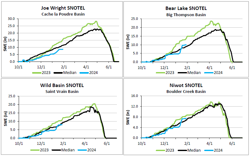
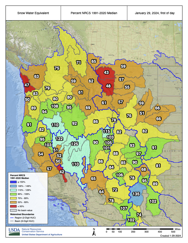
January 29, 2024
The West Slope stations are now at 96 percent and East Slope stations are at 93 percent of median snowpack for this date.
The health of our waters is the principal measure of how we live on the land — Luna Leopold

January 29, 2024
The West Slope stations are now at 96 percent and East Slope stations are at 93 percent of median snowpack for this date.

Click the link for all the inside skinny and to register on the Irrigation Innovation Consortium website:
About: This highly interactive event convenes water management leaders and others from across the Ogallala region to learn about and from each other’s work to slow aquifer decline and support ecosystem and community resilience.
When? Please plan to attend both days :
- Monday, March 18 1 pm-5 pm CDT & evening social 6:30-8:30 pm
- Tuesday, March 19 8 am-4 pm CDT


Click the link to read the article on the WyoFile website (Angus M. Thuermer Jr.):
January 25, 2024
Wyoming’s plan to construct the West Fork Dam in the Medicine Bow National Forest “does not align well” with federal policy and management plans, a forest official wrote in a 2022 brief intended for U.S. Secretary of Agriculture Tom Vilsack.
The Medicine Bow environmental policy analyst who evaluated the state’s plan for the 264-foot high dam also said the proposal might not meet a U.S. Forest Service public-interest standard necessary for a land swap that would enable dam construction.
The critical assessment was penned as Medicine Bow staff prepared a briefing paper on Wyoming’s plan to construct the dam and its 130-acre reservoir in Carbon County to serve fewer than 100 irrigators who want more late-season water. Forest officials sought staffers’ input on the proposed development above the Little Snake River.
Medicine Bow officials were preparing the late-2022 briefing for regional and Washington D.C. officials, unnamed VIPs and Secretary Vilsack, according to documents obtained by WyoFile through a records request.
In an internal Medicine Bow email, forest environmental policy analyst Matt Schweich asked that the briefing paper state that “[t]he Forest is concerned that the State’s current preferred concept does not align well with Forest Service policy and the Forest plan, that it may not be in the public interest, and is likely to be highly controversial with the public.”
Ninety-six percent of comments on the plan opposed the project, a WyoFile tally of submissions showed. Criticism ranged from the project’s environmental impacts to Wyoming’s rosy analysis of public benefits and the state’s willingness to fund the bulk of the project for the benefit of private irrigators.
An ongoing environmental review necessary to advance the Wyoming project will determine whether the dam plan meets federal policies and the Medicine Bow management plan. A federal-state land exchange necessary for construction must be found to be in the public interest. An environmental impact statement and associated reviews of the proposal have been delayed once, and their completion date remains uncertain.
A Medicine Bow spokesman said Schweich’s opinion does not reflect the official position of the agency, which will only be revealed through the environmental impact statement.
Last puzzle piece
The Forest Service, U.S. Natural Resources Conservation Service and U.S. Army Corps of Engineers are working to complete the EIS in a process largely obscured from public view. The emails, however, provide another peek into the thinking of Forest Service specialists regarding the merits of the controversial project.
In another internal discussion previously reported by WyoFile, a Medicine Bow hydrologist expressed worry that the dam proposal wasn’t being thoroughly vetted. Medicine Bow spokesman Aaron Voos dismissed that worry last year, characterizing the criticism as healthy agency discussion.
Schweich added his newly revealed assessment of the dam plan in a Sept. 26, 2022 email exchange as Medicine Bow staffers were preparing a “Hot topic” report for leadership, including Vilsack. Fully four years before that, Wyoming water developers had settled on the size of the dam, the capacity and size of the reservoir and the site of the complex. Wyoming has not deviated significantly from those plans.
A month before Schweich wrote his 2022 assessment, Wyoming had provided the last piece of the puzzle, telling Medicine Bow officials the state would seek 1,762 acres of forest land in an exchange that would enable construction of the dam and reservoir. Jenifer Scoggin, director of the Wyoming Office of State Lands and Investments, provided that land-swap information to Medicine Bow officials in August 2022,according to a letter she wrote later that year.
Medicine Bow officials appeared to have known the size of the dam and reservoir, their location and the federal acreage Wyoming sought when the officials asked Schweich for his assessment.
A month after Schweich responded, Wyoming submitted its formal proposal to the Medicine Bow for a land exchange and dam construction.
Regardless how well-informed Schweich was when he made his 2022 assessment, spokesman Voos said it was unclear at that time exactly what the state intended.
“[T]he internal, draft email of Hot Topics updates [to which Schweich contributed] is prior to receipt of any formal land exchange proposal from the State,” Voos wrote WyoFile. “At the time, multiple informal discussions were taking place surrounding conceptual ideas.
“Since it was unclear what the State’s future use of any current National Forest System land might have been at that time,” Voos wrote, “then yes, there was the possibility for misalignment with our policy and Plan.”
WyoFile obtained the emails through a Freedom of Information Act request. Although the environmental impact statement is being written largely out of public view, the public had an opportunity to weigh in on the issue before the analysis began. People will be able to comment on the review when it is completed.


Click the link to read the article on the Inside Climate News website (Bob Berwyn):
January 28, 2024
Most of the public seems unaware that global temperatures will soon push past the target to which the U.N. hoped to limit warming, but researchers see social and psychological crises brewing.
As Earth’s annual average temperature pushes against the 1.5 degree Celsius limit beyond which climatologists expect the impacts of global warming to intensify, social scientists warn that humanity may be about to sleepwalk into a dangerous new era in human history. Research shows the increasing climate shocks could trigger more social unrest and authoritarian, nationalist backlashes.
Established by the 2015 Paris Agreement and affirmed by a 2018 report from the Intergovernmental Panel on Climate Change, the 1.5 degree mark has been a cliff edge that climate action has endeavored to avoid, but the latest analyses of global temperature data showed 2023 teetering on that red line.
One major dataset suggested that the threshold was already crossed in 2023, and most projections say 2024 will be even warmer. Current global climate policies have the world on a path to heat by about 2.7 degrees Celsius by 2100, which would threaten modern human civilization within the lifespan of children born today.
Paris negotiators were intentionally vague about the endeavor to limit warming to 1.5 degrees, and the Intergovernmental Panel on Climate Change put the goal in the context of 30-year global averages. Earlier this month, the Berkeley Earth annual climate report showed Earth’s average temperature in 2023 at 1.54 degrees Celsius above the 1850-1900 pre-industrial average, marking the first step past the target.
But it’s barely registering with people who are being bombarded with inaccurate climate propaganda and distracted by the rising cost of living and regional wars, said Reinhard Steurer, a climate researcher at the University of Natural Resources and Life Sciences, Vienna.
“The real danger is that there are so many other crises around us that there is no effort left for the climate crisis,” he said. “We will find all kinds of reasons not to put more effort into climate protection, because we are overburdened with other things like inflation and wars all around us.”
Steurer said he doesn’t expect any official announcement from major climate institutions until long after the 1.5 degree threshold is actually crossed, when some years will probably already be edging toward 2 degrees Celsius. “I think most scientists recognize that 1.5 is gone,” he said.
“We’ll be doing this for a very long time,” he added, “not accepting facts, pretending that we are doing a good job, pretending that it’s not going to be that bad.”
In retrospect, using the 1.5 degree temperature rise as the key metric of whether climate action was working may have been a bad idea, he said.
“It’s language nobody really understands, unfortunately, outside of science,” he said. ”You always have to explain that 1.5 means a climate we can adapt to and manage the consequences, 2 degrees of heating is really dangerous, and 3 means collapse of civilization.”
Absent any formal notification of breaching the 1.5 goal, he hopes more scientists talk publicly about worst-case outcomes.
“It would really make a difference if scientists talked more about societal collapse and how to prepare for that because it would signal, now it’s getting real,” he said. “It’s much more tangible than 1.5 degrees.”
Instead, recent public climate discourse was dominated by feel-good announcements about how COP28 kept the 1.5 goal alive, he added.
“This is classic performative politics,” he said. “If the fossil fuel industry can celebrate the outcome of the COP, that’s not a good sign.” [ed. emphasis mine]
Like many social scientists, Steurer is worried that the increasingly severe climate shocks that warming greater than 1.5 degrees brings will reverberate politically as people reach for easy answers.
“That is usually denial, in particular when it comes to right-wing parties,” he said. “That’s the easiest answer you can find.”
“Global warming will be catastrophic sooner or later, but for now, denial works,” he said. “And that’s all that matters for the next election.”
‘Fear, Terror and Anxiety’
Social policy researcher Paul Hoggett, professor emeritus at the University of the West of England in Bristol, said the scientific roots of 1.5-degree target date back to research in the early 2000s that culminated in a University of Exeter climate conference at which scientists first spelled out the risks of triggering irreversible climate tipping points above that level of warming.
“I think it’s still seen very much as that key marker of where we move from something which is incremental, perhaps to something which ceases to be incremental,” he said. “But there’s a second reality, which is the reality of politics and policymaking.”
The first reality is “profoundly disturbing,” but in the political world, 1.5 is a symbolic maker, he said.
“It’s more rhetorical. it’s a narrative of 1.5,” he said, noting the disconnect of science and policy. “You almost just shrug your shoulders. As the first reality worsens, the political and cultural response becomes more perverse.”
A major announcement about breaching the 1.5 mark in today’s political and social climate could be met with extreme denial in a political climate marked by “a remorseless rise of authoritarian forms of nationalism,” he said. “Even an announcement from the Pope himself would be taken as just another sign of a global elite trying to pull the wool over our eyes.”
An increasing number of right-wing narratives simply see this as a set of lies, he added.
“I think this is a huge issue that is going to become more and more important in the coming years,” he said. “We’re going backwards to where we were 20 years ago, when there was a real attempt to portray climate science as misinformation,” he said. “More and more right wing commentators will portray what comes out of the IPCC, for example, as just a pack of lies.”
The IPCC’s reports represent a basic tenet of modernity—the idea that there is no problem for which a solution cannot be found, he said.
“However, over the last 100 years, this assumption has periodically been put to the test and has been found wanting,” Hoggett wrote in a 2023 paper. The climate crisis is one of those situations with no obvious solution, he wrote.
In a new book, Paradise Lost? The Climate Crisis and the Human Condition, Hoggett says the climate emergency is one of the big drivers of authoritarian nationalism, which plays on the terror and anxiety the crisis inspires.
“Those are crucial political and individual emotions,” he said. “And it’s those things that drive this non-rational refusal to see what’s in front of your eyes.”
“At times of such huge uncertainty, a veritable plague of toxic public feelings can be unleashed, which provide the effective underpinning for political movements such as populism, authoritarianism, and totalitarianism,” he said.
“When climate reality starts to get tough, you secure your borders, you secure your own sources of food and energy, and you keep out the rest of them. That’s the politics of the armed lifeboat.”
The Emotional Climate
“I don’t think people like facing things they can’t affect,” said psychotherapist Rebecca Weston, co-president of the Climate Psychology Alliance of North America. “And in trauma, people do everything that they possibly can to stop feeling what is unbearable to feel.”
That may be one reason why the imminent breaching of the 1.5 degree limit may not stir the public, she said.
“We protect ourselves from fear, we protect ourselves from deep grief on behalf of future generations and we protect ourselves from guilt and shame. And I think that the fossil fuel industry knows that,” she said. “We can be told something over and over and over again, but if we have an identity and a sense of ourselves tied up in something else, we will almost always refer to that, even if it’s at the cost of pretending that something that is true is not true.”
Such deep disavowal is part of an elaborate psychological system for coping with the unbearable. “It’s not something we can just snap our fingers and get ourselves out of,” she said.
People who point out the importance of the 1.5-degree warming limit are resented because they are intruding on peoples’ psychological safety, she said, and they become pariahs. “The way societies enforce this emotionally is really very striking,” she added.
But how people will react to passing the 1.5 target is hard to predict, Weston said.
“I do think it revolves around the question of agency and the question of meaning in one’s life,” she said. “And I think that’s competing with so many other things that are going on in the world at the same time, not coincidentally, like the political crises that are happening globally, the shift to the far right in Europe, the shift to the far right in the U.S. and the shift in Argentina.”
Those are not unrelated, she said, because a lack of agency produces a yearning for false, exclusionary solutions and authoritarianism.
“If there’s going to be something that keeps me up at night, it’s not the 1.5. It’s the political implications of that feeling of helplessness,” she said. “People will do an awful lot to avoid feeling helpless. That can mean they deny the problem in the first place. Or it could mean that they blame people who are easier targets, and there is plenty of that to witness happening in the world. Or it can be utter and total despair, and a turning inward and into a defeatist place.”
She said reaching the 1.5 limit will sharpen questions about addressing the problem politically and socially.
“I don’t think most people who are really tracking climate change believe it’s a question of technology or science,” she said. “The people who are in the know, know deeply that these are political and social and emotional questions. And my sense is that it will deepen a sense of cynicism and rage, and intensify the polarization.”

Unimpressed by Science
Watching the global temperature surging past the 1.5 degree mark without much reaction from the public reinforces the idea that the focus on the physical science of climate change in recent decades came at the expense of studying how people and communities will be affected and react to global warming, said sociologist and author Dana Fisher, a professor in the School of International Service at American University and director of its Center for Environment, Community, and Equity.
“It’s a fool’s errand to continue down that road right now,” she said. “It’s been an abysmal ratio of funds that are going to understand the social conflict that’s going to come from climate shocks, the climate migration and the ways that social processes will have to shift. None of that has been done.”
Passing the 1.5 degree threshold will “add fuel to the fire of the vanguard of the climate movement,” she said. “Groups that are calling for systemic change, that are railing against incremental policy making and against business as usual are going to be empowered by this information, and we’re going to see those people get more involved and be more confrontational.”
And based on the historical record, a rise in climate activism is likely to trigger a backlash, a dangerous chain reaction that she outlined in her new book, Saving Ourselves: From Climate Shocks to Climate Action.
“When you see a big cycle of activism growing, you get a rise in counter-movements, particularly as activism becomes more confrontational, even if it’s nonviolent, like we saw during the Civil Rights period,” she said. “And it will lead to clashes.”
Looking at the historic record, she said, shows that repressive crackdowns on civil disobedience is often where the violence starts. There are signs that pattern will repeat, with police raids and even pre-emptive arrests of climate activists in Germany, and similar repressive measures in the United Kingdom and other countries.
“I think that’s an important story to talk about, that people are going to push back against climate action just as much as they’re going to push for it,” she said. “There are those that are going to feel like they’re losing privileged access to resources and funding and subsidies.”
A government dealing effectively with climate change would try to deal with that by making sure there were no clear winners and losers, she said, but the climate shocks that come with passing the 1.5 degree mark will worsen and intensify social tensions.
“There will be more places where you can’t go outside during certain times of the year because of either smoke from fires, or extreme heat, or flooding, or all the other things that we know are coming,” she said. “That’s just going to empower more people to get off their couches and become activists.”
‘A Life or Death Task For Humanity’
Public ignorance of the planet’s passing the 1.5 degree mark depends on “how long the powers-that-be can get away with throwing up smokescreens and pretending that they are doing something significant,” said famed climate researcher James Hansen, who recently co-authored a papershowing that warming is accelerating at a pace that will result in 2 degrees of warming within a couple of decades.
“As long as they can maintain the 1.5C fiction, they can claim that they are doing their job,” he said. “They will keep faking it as long as the scientific community lets them get away with it.”
But even once the realization of passing 1.5 is widespread, it might not change the social and political responses much, said Peter Kalmus, a climate scientist and activist in California.
“Not enough people care,” he said. “I’ve been a climate activist since 2006. I’ve tried so many things, I’ve had so many conversations, and I still don’t know what it will take for people to care. Maybe they never will.” [ed. emphasis mine]

Click the link to read the article on The Denver Post website (Elise Schmelzer). Here’s an excerpt:
When the Cameron Peak wildfire ripped across northern Colorado in 2020, it left hundreds of thousands of acres charred and dusty — except for a series of beaver ponds tucked inside Poudre Canyon. The wetlands survived the state’s largest recorded wildfire and acted as a buffer as the flames raged through the canyon. And after the flames were extinguished, they served as a sponge to absorb floodwaters sped by the lack of vegetation, minimizing flood damage downstream. But a U.S. Supreme Court decision last year left wetlands like the ones in Poudre Canyon — as well as thousands of miles of seasonal streams critical to the state’s water system — without protection under federal law. The court’s majority limited the coverage of the Clean Water Act, leaving protection gaps for more than half of Colorado’s waters that lawmakers, conservationists, developers and state water quality officials are rushing to fill…Colorado, like many states, relied on the federal government’s permitting process to regulate when people could dig up waterways or wetlands and fill them in — activities known as dredging and filling. Although Colorado has its own Water Quality Control Act that makes it illegal to pollute waters, there is now no process to vet proposed dredge and fill projects, or to issue permits allowing those projects to legally proceed…
Colorado House Speaker Julie McCluskie is crafting a bill this legislative session to give the CDPHE the authority to fill that gap. But key questions remain about how far lawmakers and state officials are willing to go in replacing federal protections…
In May, the high court’s justices ruled 5-4 that wetlands not connected on the surface to another body of federally protected water do not qualify for protection themselves under the Clean Water Act. The law also doesn’t protect wetlands connected to rivers or lakes via groundwater below the surface, the court found, and it doesn’t protect streams that flow seasonally or only after precipitation falls. The ruling left the protection of the newly exempt waters to the states, many of which do not have robust water protection laws…

The Department of Public Health and Environment in July enacted an emergency rule to provide some oversight over dredge and fill activities in waters that lost federal protection…The state policy states that the department will not punish people who dredge or fill in waters if the person notifies the CDPHE, the impacted area is small and the activities comply broadly with the federal law that existed before the Supreme Court decision. The goal, said Nicole Rowan, director of CDPHE’s Water Quality Control Division, is to give developers and others a way to proceed with projects without fearing legal trouble because of ambiguity in the law.
Click the link to read the release on the Colorado State University website (Jayme DeLoss):
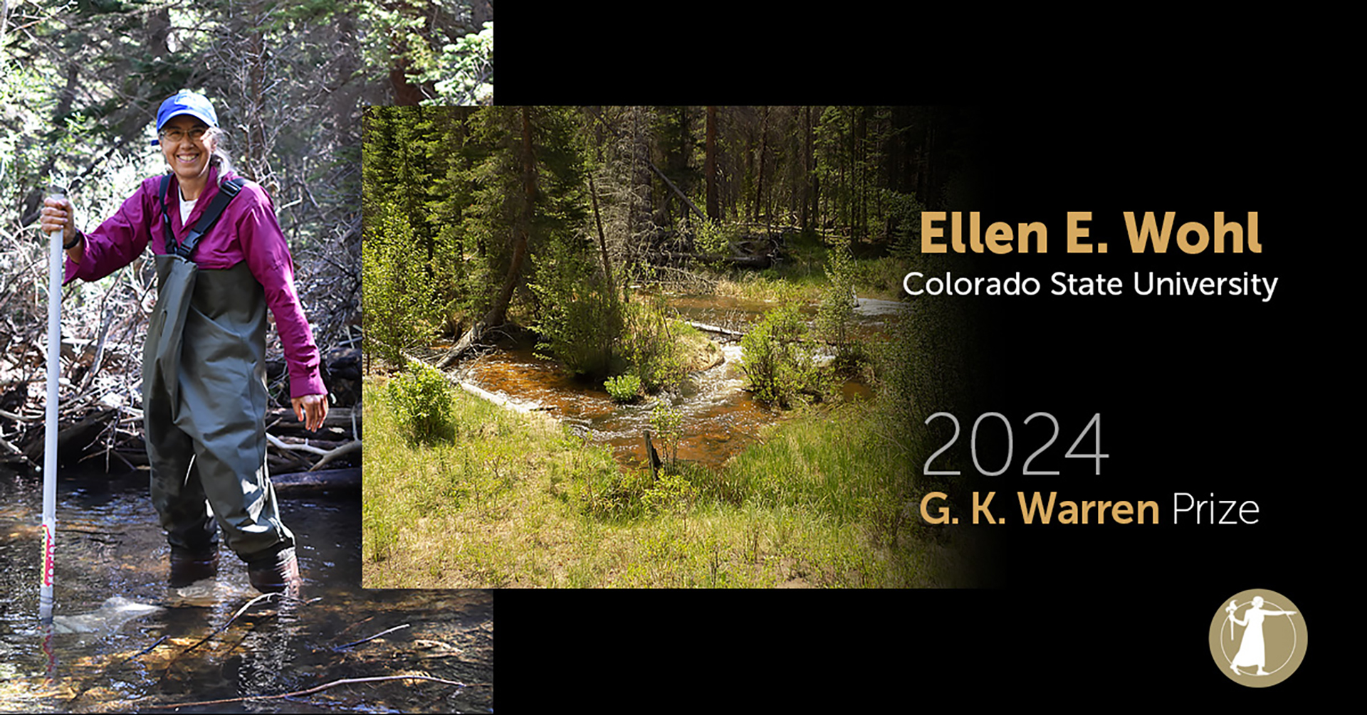
Colorado State University Geosciences Professor Ellen Wohl is so at home in rivers and streams that if you manage to catch her in her office on campus, she might be listening to stream sounds while she works.
The prolific field scientist and University Distinguished Professor has studied rivers and watersheds from ephemeral desert channels to torrents in the tropics on every continent except Antarctica. Today, the National Academy of Sciences announced that it will honor Wohl with the G.K. Warren Prize for her expansive research and advancements in river and watershed sciences.
“Her work has dramatically influenced and guided river management and restoration worldwide,” the academy said in its announcement. “Wohl is the author of an extensive number of publications and books, introducing broad audiences to river science, and is an extraordinary mentor and role model for women in science.”
Wohl is what’s known as a fluvial geomorphologist, or a scientist who studies river processes and physical characteristics. She was drawn to CSU by its legacy of water research and its location, where she would have quick access to mountain streams.
“We have such a great community of people to work with at CSU who are focused on all different aspects of water,” Wohl said. “If I have a question about water chemistry, fish, macro-invertebrates, riparian plants, whatever, there’s somebody I can talk to on campus.”

Respect for rivers
Wohl said that she couldn’t resist studying rivers and called them a delightful environment in which to work. They are also critically important, she added.
“Our survival absolutely depends on them. Particularly in Colorado,” Wohl said. “All our drinking water in the West, certainly in Fort Collins, comes from surface water. That’s not going to change.”
Her recent research examines how rivers respond to wildfire. After a fire, excess water and sediment rush down denuded slopes, causing flash floods, debris flows and sedimentation in drinking water reservoirs. Wohl’s goal is to improve river resilience for all the living things that rely on the water.
“What can we do that will make these systems better able to recover after fire and that will have downstream impacts on the communities that drink that water?”
Wohl said the answer lies in understanding the complexities, or as she calls it “messiness,” of river networks. Many U.S. rivers have been simplified to single channels that flush everything downstream very effectively. Her work has found that restoring some of the historic messiness, including floodplains, branching channels, fallen trees in the water and beaver activity, enhances river resilience.
Slowing downstream transport also gives microbes that live in the floodplain and underneath streams time to clean the water. Microbes and plants can break down excess nitrate, which is a serious issue along the Front Range, Wohl said.
Nitrate from agricultural fertilizer, feedlots and burning fossil fuels is transported in the atmosphere and falls as rain, snow or dry deposition on the eastern side of the Continental Divide, ending up in surface water. Consuming excess nitrate in drinking water is detrimental to human health. Excess nitrate in reservoirs also can lead to algae blooms that can be toxic to people and other organisms. Additionally, algae blooms can deplete oxygen in the water, causing fish kills.
“It’s a great concern for water quality managers to try and do what we can to reduce nitrate levels,” Wohl said.
Dry outlook
Wohl said Colorado’s future holds “more rainfall, but generally less water” due to continued warming and drying of the climate and human consumption. Snowpack, which supplies water to communities and feeds river ecosystems, will decline, along with river flows throughout the state.
“The good news is we have some wiggle room because we waste an awful lot of water, so we can conserve a lot more than we use,” she said. “But there’s a limit to how much you can conserve.”
The 1922 Colorado River Compact, which was renegotiated 100 years later to account for declining flow and a rapidly growing population, was based on a limited record of stream measurements taken during anomalously wet years, Wohl said, so the river’s water was overallocated from the start. Fluvial geomorphologists can extend the streamflow record and estimate long-term water supply by looking at geologic indicators – information that could help with future allocations.
Benefiting those downstream
Across the diverse environments in which Wohl has worked, the common thread is that they were all shaped by flowing water, the same force that has shaped a career she thoroughly enjoys.
“In addition to going to all the amazing natural places, by far one of the highlights of my career is working with really motivated, enthusiastic, capable people,” Wohl said.
The National Academy of Sciences will present Wohl with the G.K. Warren Prize April 28 during the NAS 161st Annual Meeting. The prize is awarded once every five years.
Wohl plans to use the $20,000 prize to establish a graduate student research fellowship through the Geological Society of America, in honor of her Ph.D. advisor Victor R. Baker.
Wohl’s award was among 20 announced today by the National Academy of Sciences that recognize extraordinary scientific achievements. View the full list of recipients in the NAS press release.

Click the link to read the article on the Fort Collins Coloradoan website (Rebecca Powell). Here’s an excerpt:
Environmental group Save The Poudre has filed a lawsuit to try and stop the Northern Integrated Supply Project from going forward to construct two reservoirs and supply water to 15 communities…In the lawsuit, filed Thursday, Save The Poudre says the diversion of water from the Poudre River would cause severe damage to the river, including its aquatic life, the Poudre River Whitewater Park in Fort Collins and the riparian corridor…The lawsuit also alleges that in approving the permit, the Army Corps violated both the National Environmental Policy Act and the Clean Water Act because it didn’t adequately consider alternatives and didn’t choose the least environmentally damaging alternative, respectively…
NISP would divert water from the Poudre and South Platte rivers to store in two new reservoirs: Glade Reservoir north of Fort Collins and the smaller Galeton Reservoir east of Ault. Communities that would be served by the project include the Fort Collins-Loveland Water District and others in Weld and Boulder counties.


Click the link to read the article on the Grist website (Wyatt Myskow):
Critical minerals for the clean energy transition are abundant in the Southwest, but the dozens of mines proposed to access them will require vast sums of water, something in short supply in the desert.
One by one, leaders from across Arizona gave speeches touting the importance of water conservation at Phoenix City Hall as they celebrated the announcement of voluntary agreements to preserve the declining Colorado River in November.
When Tao Etpison took the mic, his speech echoed those who went before him. Water is the lifeblood of existence, and users of the Colorado River Basin were one step closer to preserving the system that has helped life in the Southwest flourish. Then he brought up the elephant in the room: Arizona’s groundwater protection was lacking, and mining companies were looking to take advantage.
“The two largest foreign-based multinational mining companies in the world intend to construct the massive Resolution Copper Mine near Superior,” said Etpison, the vice chairman of the San Carlos Apache Tribe. “This mine will use, at a minimum, 775,000 acre feet of groundwater, and once the groundwater is gone, it’s gone. How can this be in the best interests of Arizona?”
The question is one the state and the Southwest must answer. Mine claims for the elements critical to the clean energy transition are piling up from Arizona to Nevada to Utah. Lithium is needed for the batteries to store wind and solar energy and power electric vehicles. Copper provides the wiring to send electricity where it will be needed to satisfy exploding demand. But water stands in the way of the transition, with drought playing into nearly every proposed renewable energy development, from solar to hydropower, as the Southwest debates what to do with every drop it has left as the region undergoes aridification due to climate change and decades of overconsumption.
Mining opponents argue the proposals could impact endangered species, tribal rights, air quality and, of course, water—both its quantity and its quality. Across the Southwest, the story of 2023 was how water users, from farmers in the Colorado River Basin to fast-growing cities in the Phoenix metropolitan area, needed to use less water, forcing changes to residential development and agricultural practices. But left out of that conversation, natural resource experts and environmentalists say, is the water used by mining operations and the amount that would be consumed by new mines.
The San Carlos Apache Tribe has fought for years to stop Resolution’s proposed mine. It would be built on top of Oak Flat, a sacred site to the Apache and other Indigenous communities, and a habitat of rare species like the endangered Arizona hedgehog cactus, which lives only in the Tonto National Forest near the town of Superior. The fate of the mine now rests with the U.S. District Court in Arizona after the grassroots group Apache Stronghold filed a lawsuit to stop it, arguing its development would violate Native people’s religious rights.
But for communities located near the mine and across the Phoenix metropolitan area, the water it would consume is just as big of an issue.
Throughout the mine’s lifespan, Resolution estimates it would use 775,000 acre feet of water—enough for at least 1.5 million Arizona households over roughly 40 years. And experts say the mine would likely need far more.

“By pumping billions of gallons of groundwater from the East Salt River Valley, this project would make Arizona’s goal for stewardship of its scarce groundwater resources unreachable,” one report commissioned by the San Carlos Apache Tribe reads. In one hydrologist’s testimony to Congress, water consumption was estimated to be 50,000 acre feet a year—about 35,000 more than the company has proposed drawing from the aquifer.
The Resolution copper mine isn’t the only water-intensive mining operation being proposed. Many of what the industry describes as “critical minerals,” like lithium and copper, are found throughout the Southwest, leading to a flurry of mining claims on the region’s federally managed public lands.
“Water is going to be scarcer in the Southwest but the mining industry is basically immune from all these issues,” said Roger Flynn, director and managing attorney at the Western Mining Action Project, which has represented tribes and environmental groups in mining-related lawsuits, including the case over Oak Flat.
‘The Lords of Yesterday’
To understand mining in the U.S., you have to start with the Mining Law of 1872.
President Ulysses S. Grant signed the bill into law as a way to continue the country’s development westward, allowing anyone to mine on federal lands for free. To do this, all one needs to do is plant four stakes into the ground where they think there are minerals and file a claim. Unlike other industries that make use of public lands—such as the oil and gas industry—no royalties are paid for the minerals extracted from the lands owned by American taxpayers.
Flynn referred to mining as the last of the “Lords of Yesterday”—a term coined by Charles Wilkinson, a long-time environmental law professor at the University of Colorado who died earlier this year—referring to the industries like oil and gas drilling, ranching and logging that were given carte blanche by the federal government to develop the West after the Civil War and push Indigenous populations off the land. All of those industry regulations have changed, Flynn said, except mining.
That’s led mining to be viewed as the top use of public lands by regulators who give it more weight than conservation or recreational activities, he said.
“You don’t have to actually demonstrate that there are any minerals in a mining claim, you don’t have to provide any evidence that there is a mineral there at all,” said John Hadder, the executive director of Great Basin Resource Watch, an environmental group based in Nevada that monitors mining claims. “You can just be suspicious—and there’s a lot of suspicion going around.”
Most of Nevada is completely reliant on groundwater, an increasingly scarce resource. Without water, companies hunting critical minerals can’t mine, Hadder said, so they look to acquire water rights from other users, typically by buying up farms and ranches, changing the economics and demographics of a community. When the mines are developed, they can impact local streams, groundwater levels and the quality of the water as toxins seep into aquifers and surface supplies over the years. Now, with the clean energy transition gaining traction, there’s a new mining boom, prompting increasing concerns over how local ecosystems will be impacted. In Nevada alone, there are more than 20,000 mining claims related to lithium, the biggest of which are, of course, drawing controversy.

Water’s Role in Mine Fights
In northern Nevada, companies have proposed two massive lithium mines—Thacker Pass and Rhyolite Ridge—in groundwater basins that are already over appropriated. Both have drawn heavy scrutiny, the former for being proposed on a sacred site for local Indigenous tribes that is also range for area ranchers and endangered sage grouse, and the latter for threatening an endangered wildflower found nowhere else in the world.
Now, Canada-based Rover Metals is looking to drill a lithium exploration project near the Ash Meadows National Wildlife Refuge, a wetland habitat in Nevada near the California border that supports a dozen endangered and threatened species and is one of the most biodiverse places on the planet, which environmentalists call “the Galapagos of the desert.”
“Nevadans almost more than any other state have had to wrestle with the availability or lack thereof of water for development for its entire history,” said Mason Voehl, the executive director of the Amargosa Conservancy, an environmental group that has helped lead the push to protect the refuge. “This is sort of compounding that already really complex challenge.”
Click the link to read the article on the InkStain.net website (John Fleck):
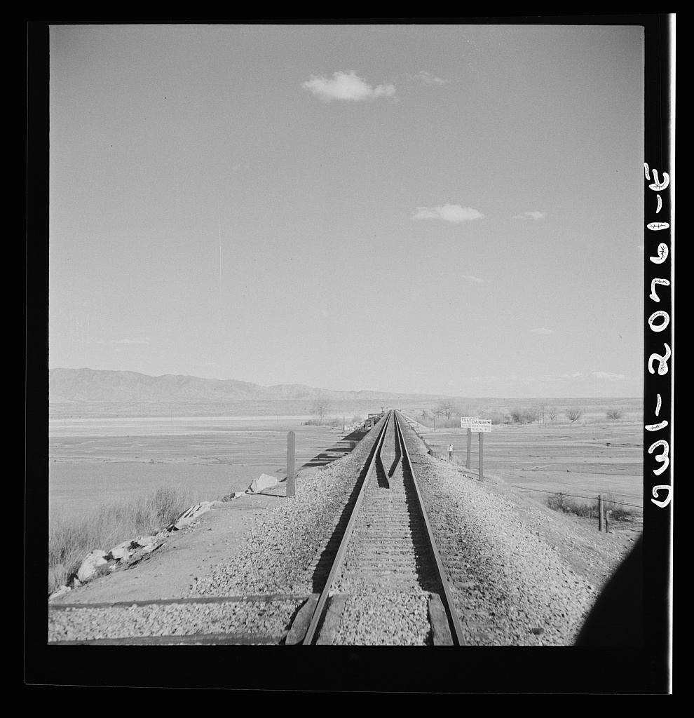
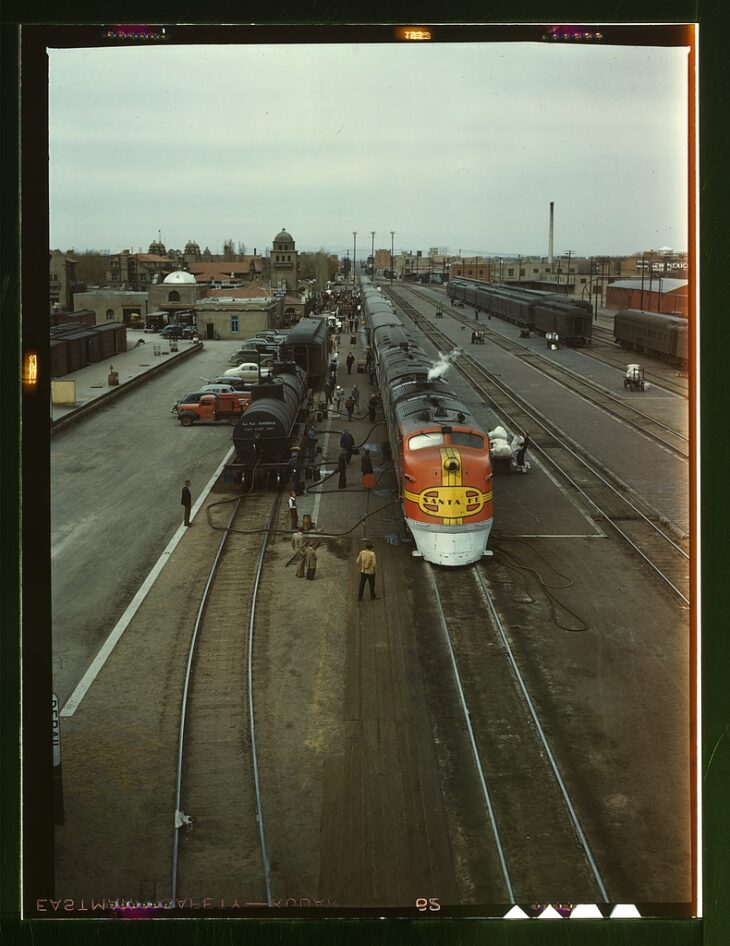
This Rio Grande crossing, just south of Belen, 30-plus miles downstream from Albuquerque, has changed dramatically since Jack Delano took the picture above in spring 1943.
THE BOSQUE
I’ve stared at Delano’s picture often, because of the story it tells – a broad open river valley. It’s nothing like that today.
I pieced together some dirt roads and ditchbanks to visit the site on this morning’s bike ride. I had hopes of duplicating Delano’s picture, but the train traffic made standing in the middle of the tracks seem ill-advised. The picture to the right, facing the river looking east, should give you a feel. The Rio Grande here is now flanked by a magnificent cottonwood gallery forest, with low stands of coyote willow and salt cedar and some other stuff. We call it “the bosque.”
Looking at the picture last night as I was doing the map work to figure a sane bike route to get to the bridge, the date clicked: Spring 1943. In thinking about the modern relationship between human communities and the Rio Grande, 1941-42 is a dividing line – the last big flood years, the floods that drove the major changes in river management that created an ecological niche that the cottonwoods exploited in the second half of the twentieth century with full-throated glee.
Delano’s picture can be misleading. It wasn’t all treeless like that. The 1917-18 Rio Grande drainage survey, which is our best “before” snapshot of the valley, shows clumps of cottonwoods up and down the river. Following the 1941-42 floods, the federal Middle Rio Grande Project reengineered the main river channel with a series of sediment traps on the banks that were intended to push the river into a narrower central channel. In the process, they created ideal seed bed habitat for the cottonwoods to fill in the empty spaces.

The result is a linear cottonwood gallery forest more than 150 miles long. I’ve always called it “continuous,” but I just scanned the whole length using satellite imagery and found two short gaps. So “nearly continuous,” to add precision.
The bosque is often treated as one of the Middle Valley’s great natural treasures, and I don’t disagree. But “natural” may not be quite the right word.
PECANS
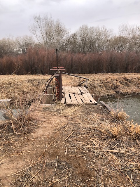
Next stop: one of the most interesting climate change adaptation experiments underway in Middle Valley agriculture.
Past the railroad bridge, I found a ditch crossing and peeled away from the river toward the sand hills to the east, winding through the small farms of Jarales that make this stretch of the valley a lovely exemplar of the “ribbons of green” we talk about in the new book. Nearly all the farms were less than 10 acres – non-commercial, “custom and culture” agriculture, mostly alfalfa or other forage crops, lots of horses. Dodging the one busy highway the best I could, I veered into a neighborhood and under the interstate, where the road kicked up to a geomorphic bench in the sand hills maybe 30 feet in elevation above the nearby valley floor.
The pecans are in the distance in the picture to the right, though you can’t really see them. I was on relatively unfamiliar ground, and was cautious in my interpretation of the “No Trespassing” signs on the ditchbank road. It’s land that was once scrubland just like the land in the foreground. Now it’s irrigated with water from the ditch in the picture, to the tune of more than 1,000 acre feet per year. (We don’t know exactly. We don’t meter this use of water here.) There was a lot of controversy nearly 20 years ago when the land was brought into production. Critics (included regular Inkstain commenter Bill Turner, who was on the MRGCD board at the time) argued it wasn’t entitled to irrigation water from the Middle Rio Grande Conservancy District’s ditches. I’m not going to relitigate that argument here. Those objecting to serving the land with MRGCD irrigation water lost. Now the land is home to a fascinating experiment in climate change adaptation.
With a warming climate, the optimal range for pecans has moved north. (UNM Water Resources Program grad Tylee Griego took a deep dive into the pecans’ migration here.)
We have seen a century of failed efforts to foster a commercially successful crop in the valley – wheat, tomatoes, sugar beats, pinto beans, tobacco (!). Pecans are the latest, and rather than climate change making it harder to grow stuff, in this case it has made it easier. By increasing irrigated acreage in the valley. We usually think of agricultural climate change adaptation as “crop switching,” not “crop adding.” In addition to the big orchards by the river, the latest USDA CroplandCROS dataset, which uses satellite data and algorithms to identify crop types, is showing more pecans in small patches across the valley. I don’t full trust CroplandCROS – it gets a lot of pixels wrong ’round here, unfortunately. But this just means more bike rides needed to “ground truth” my blog posts. This is a part of the valley I don’t know as well, so fun ahead!
As I was riding through Jarales this morning and writing this post in my head, I was playing with the theme suggested by the two forests – each spread across a niche created by human alteration of the hydrologic system. Not sure it quite works, but I’ll leave it here.
A NOTE ON JACK DELANO
Jack Delano’s 1943 trip through New Mexico is worthy of note.
Delano, born Jacob Ovcharov in Ukraine, was one of the Farm Service Administration/Office of War Information photographers whose work dominates our visual understanding of the 1930s and early ’40s in the United States. His photographs of the AT&SF rail yard in Albuquerque, taken on the same spring 1943 trip that he took the Belen railroad bridge above, represent a remarkable documentation of a moment in time, as freight bustled through Albuquerque in service of the war effort.
We tend to think of the classic FSA photography as “documentary” work of the highest order – which it was. But it also was government propaganda – artists paid by the government to tell particular kinds of stories, and share particular kinds of messages.
Much of the classic visual vocabulary of the FSA pictures – think Dorothea Lange – is very much black and white. But with the development of Kodachrome in the 1930s, photographers of the period were beginning to shoot in color too. Most of Delano’s Albuuquerque pictures are in black and white, but his color picture of the Albuquerque rail yard, taken from the Lead Avenue orverpass circa 1943, is a classic.

Click the link to read the article on the Chaffee County Times website (Hannah Harn). Here’s an excerpt:
The presented concept project would be a partnership between Pueblo Water and [Colorado Springs Utilities] to enlarge the reservoir. Colorado Springs Utilities would use the enlarged space for the first 30 years, at which point Pueblo Water would get half of it. The reservoir’s dam was built in 1902 and was used by the Otero Irrigation Co. until 1955 when the reservoir was sold to Pueblo Water. Since then, [Alan] Ward said, Pueblo Water has “spent a lot of money doing various projects to upgrade the dam for improved safety.”
The purpose of the project “is to bring it up to modern dam safety standards,” Ward said. “The challenge with the dam as it is today … the dam is built on a foundation of rock and gravel, which allows a lot of water to seep through. We’ve constantly battled seepage issues over the years.”
The other reason for the enlargement is to increase water storage to “increase resiliency, reliability, and flexibility” in meeting future water needs for Pueblo Water and Colorado Springs Utilities. The current dam is 70 feet high with a capacity of 11,140 acre-feet (currently restricted at 9,100 af). The enlargement proposal would bring the dam to a height of 106 feet and 30,000 af capacity. The reservoir’s surface area would increase from 414 acres to 631 acres. The dam would be built on the downstream side of the current dam, closer to the highway. Another impact of the project…They also may be adding an upstream buttress to hold things in place in case of an earthquake…Around 30-40 acres of wetlands around the reservoir would be impacted as the reservoir backs further up the valley, as well as a few small areas at the base of the existing dam. Ward also noted the large boreal toad population in nearby ponds.


Click the link to read the release on the USGS website:
The report provides specific and comprehensive reclamation guidance for surface oil and gas exploration and development.
The U. S. Geological Survey, in partnership with the Bureau of Land Management, recently published an oil and gas reclamation techniques and methods report that will, for the first time, give land managers and oil and gas operators specific tools to successfully reclaim disturbed lands during and after oil and gas activities.

Resource inventory, monitoring and protection of oil and gas sites are mandated by federal statutes and regulations, yet this is the first publication defining standards and guidelines for how to reclaim, monitor, and successfully reclaim disturbed oil and gas sites available at a national level.
The report also emphasizes the importance of best management practices, clear standards, effective monitoring and minimizing surface disturbance for successful land reclamation.
Initiated through an interagency agreement with the BLM, USGS and BLM drew upon existing federal reclamation policy, scientific literature review, practical field experience and expertise from various sources such as federal and state agencies, oil and gas contractors, and academia to produce the document, intended to be used for each reclamation step from start to finish.
“The BLM’s land management experience and the USGS’s best available science come together to create this powerful tool in the toolbox for federal agencies working on surface management of oil and gas to ensure environmentally responsible outcomes,” said Benjamin Gruber, BLM Acting Assistant Director for Energy, Minerals and Realty Management. “We’re proud to partner with the USGS to produce this guide that is relevant for all parts of the process—from the time a company develops its drilling application to monitoring reclamation activities after wells are plugged.”

New, comprehensive guidelines
Prior to this report, the industry relied on a set of guidelines known as the ‘Gold Book’ for practical information about oil and gas leasing and permitting, operations, bonding and reclamation planning processes. However, the Gold Book lacks the type of precise guidance often found in instructional memorandums and handbooks produced by surface management agency offices, multi-jurisdictional groups or state agencies.
To maximize the efficacy of reclamation efforts, a set of national guidance and policies specific to oil and gas monitoring and assessment were needed.
This new USGS-BLM report supplements the Gold Book and other existing guidance by providing thorough and definitive steps and metrics for reclamation surface management. The report provides these kinds of uniform monitoring protocols and standards covering standardized soil and vegetation field monitoring methods, indicators, benchmarks, appropriate designs and analyses and electronic data capture and repositories supports planning procedures, leasing, permitting processes and bond release decisions.
While it was designed to be specific to the oil and gas industry, many of the report’s concepts and practices hold the potential to benefit reclamation of other fluid minerals development and land disturbance, including wind and solar energy development.
Leveraging ecological science to achieve success
Land reclamation, in essence, is aimed at techniques that set highly disturbed or degraded ecosystems on a trajectory that benefits native plants and animals and restores functioning habitats and ecological communities similar to surrounding, naturally occurring environments. During this process, the impacts of oil and gas development are minimized.
This means a major component of land reclamation involves repopulating the landscape with locally appropriate vegetation. Therefore, the report provides useful information about repositories and data collection platforms such as the Landscape Data Commons, Esri ArcGIS Online Survey123, the Database for Inventory Monitoring and Assessment (DIMA) and LandPKS.
The report also provides guidance for developing quantitative benchmarks to determine if erosion and vegetation standards have been met, including indicators of erosion and site stability, species composition and community structure.
“This technical publication provides a solid foundation based on current ecological science. It is the product of a collaborative effort between leading ecologists and reclamation scientists at the BLM, USGS, other agencies, and private organizations,” said USGS Deputy Associate Director for Ecosystems Paul Wagner. “The report addresses the need for well-managed data collection to inform reclamation plans, operations, approval decisions, and adaptive management strategies.”
Factors such as climate change, drought, intense storms, swings in temperature and invasive species all affect seedling survival rates. Ensuring that seedlings survive is crucial for agencies and operators to meet federal requirements and achieve reclamation success.
Successful reclamation is achieved when the standards defining soil and vegetation recovery are met, and a self-sustaining, vigorous, diverse, native, or approved plant community that minimizes visual land disturbance, provides forage, stabilizes soils and prevents noxious weeds from taking hold is in place.
Who does this report support?
In conjunction with the Gold Book, this report supports the BLM — the largest surface management agency in the U.S. — with tools to monitor oil and gas reclamation and ensure environmentally responsible outcomes. BLM field office staff guide operators to create reclamation plans and to ensure that reclamation goals and expectations are clear. They inspect reclamation projects’ progress and status, complete quality assessments and quality control of operators’ monitoring data, and provide feedback.
This report will also be particularly useful for operators and contractors who conduct oil and gas activities on U.S. federal or Tribal lands, surface management agencies who are responsible for advising and enforcing those activities, stewards of private lands and other landowner reclamation projects.
Reclamation has several phases, including interim and final reclamation, which each have differing overall goals. The report can help foster relationships between surface management agencies and operators, highlight timeframes, and provide operators with specific steps and goals in the reclamation process.
The report may prove particularly useful for restoration efforts funded by the Bipartisan Infrastructure Law, which provides $4.7 billion for orphaned well site plugging, remediation and reclamation across federal, Tribal, state and private lands (see Through President Biden’s Bipartisan Infrastructure Law, 24 States Set to Begin Plugging Over 10,000 Orphaned Wells).
Read the full report online: Oil and gas reclamation—Operations, monitoring methods, and standards: U.S. Geological Survey Techniques and Methods

From email from the Colorado Division of Water Resources (Michael Elizabeth Sakas):
January 26, 2024
The Colorado Division of Water Resources announced that as of January 16, 2024, new rules governing the measurement of surface and groundwater diversions and storage are now in effect for Division 6. The division includes the Yampa, White, Green and North Platte River basins.
“The Division 6 Measurement Rules are the first set of rules covering surface water measurement in the State of Colorado and are a significant milestone for the Division of Water Resources,” said Erin Light, Division 6 Engineer. “The adoption of the rules will provide the Division of Water Resources greater leverage in assuring that the diversion and use of water is administerable and properly measured and recorded.”
For background, Colorado statutes include a requirement that owners of ditches and reservoirs install headgates where water is taken from the natural stream. These statutes also give the state and division engineer the authority to require owners and users of water rights to install measuring devices.
“Accurate measurement of diversions is critical to protect Colorado’s entitlement to water, including under the Colorado River Compact, and to ensure we are maximizing the beneficial use of the public’s water resource for consumptive and environmental purposes,” said Jason Ullmann, Deputy State Engineer.
The statutes, however, do not include any specifics regarding what is considered an acceptable headgate or measuring device. Historically, it has been administered by the Division of Water Resources (DWR) through issuing orders to owners for the installation of headgates or measuring devices.
“Over several years, Division 6 has issued hundreds of orders for the installation of operable headgates and measuring devices with varying degrees of success,” said Division Engineer Light. “I believe that these rules will help water users in Division 6 by providing clarity regarding what structures require measurement and what is considered an acceptable level of accuracy for the required measurement methods.”
The rules describe two types of measurement methods: measuring devices, which are physical devices (flumes, weirs, etc) that are placed in a diversion for measurement. Then there are alternative measurement methods, which are typically indirect methods of measuring flow rates without a physical device.
Water users are provided the following time periods to comply with the rules:
- Diversion structures with a capacity or water rights greater than or equal to 5.0 cfs – 12 months (January 16, 2025);
- Diversion structures with a capacity or water rights greater than or equal to 2.0 cfs and less than 5.0 cfs – 18 months (July 16, 2025);
- Diversion structures with a capacity or water rights less than 2.0 cfs – 24 months (January 16, 2026);
- Reservoirs with a capacity or water rights greater than or equal to 5.0 AF – 12 months (January 16, 2025);
- Reservoirs with a capacity or water rights less than 5.0 AF – 24 months (January 16 2026).
Water users unsure of their decreed water right or permitted well permit flow rates and volumes can use DWR’s online tools available through CDSS (https://dwr.state.co.us/Tools/) to find this information. Anyone who has questions regarding how these Rules apply to their diversion or how to install a measuring device on their system can contact the DWR’s Division 6 Lead Hydrographer at (970) 291-6551. The Rules are available on the DWR website as a Laserfiche imaged document.


Click the link to read the article on The Land Desk website (Jonathan P. Thompson):
January 26, 2024
⛏️Mining Monitor ⛏️
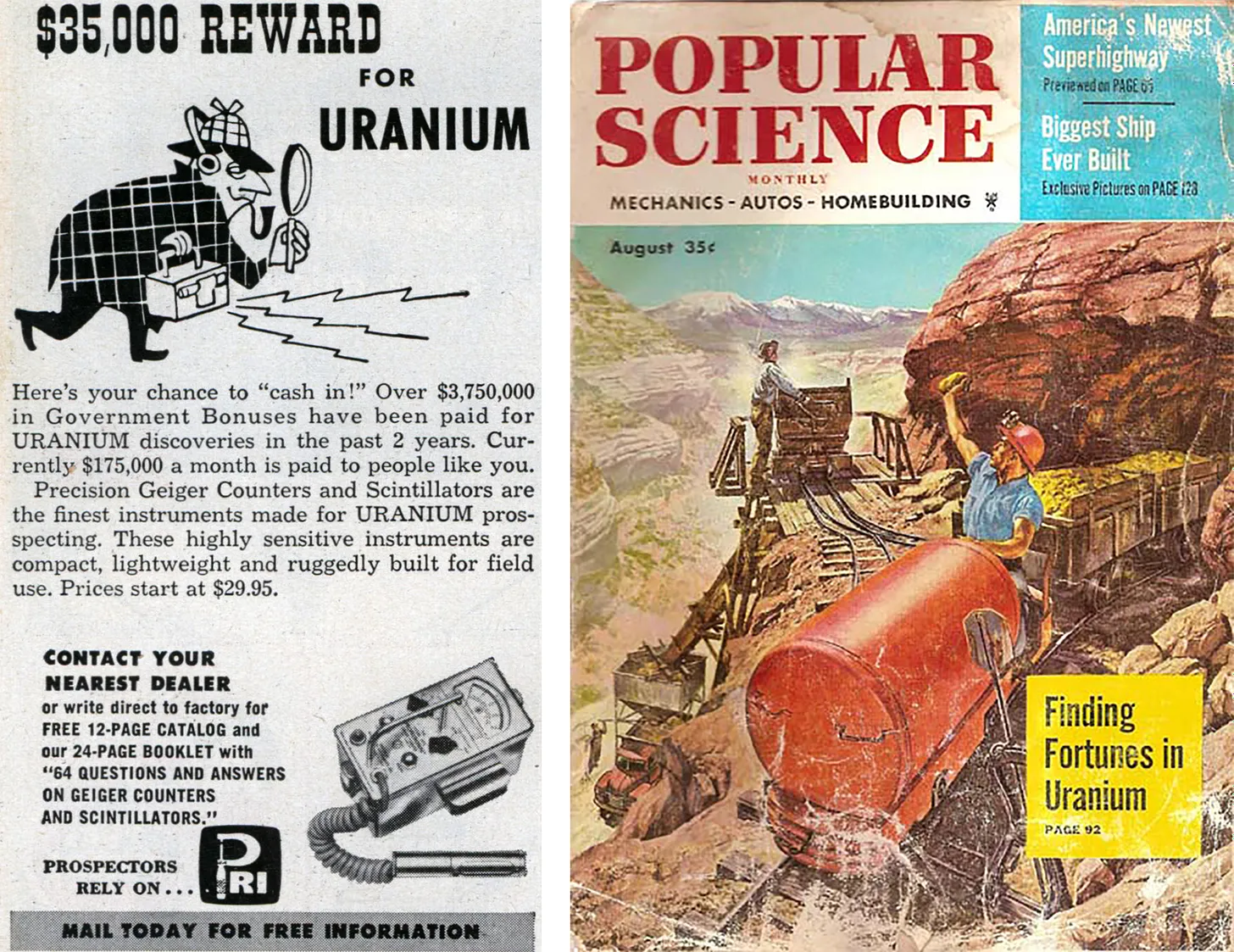
The uranium-mining buzz is reaching a fevered pitch lately as uranium prices climb above $100 per pound, the highest since October 2007. I already reported on Energy Fuels’ intent to begin or resume production at its Pinyon Plain and La Sal complex mines. But nearly every day another press release lands in my inbox touting a big find or big plans somewhere on the Colorado Plateau.
Let’s start with the headline that irks me the most: “Churchrock could pump out 31 million lb of US uranium over three decades, Laramide PEA shows.” On its surface, this one looks like just another attempt to drive up share prices. And it probably is. But it’s the location and the name that gets to me: The project is just a couple of miles from the 1979 Church Rock disaster, when a uranium mill tailings dam failed, sending 94 million gallons of acidic liquid raffinate and 1,100 tons of uranium mill tailings rushing down the Puerco River and across the “checkerboard” area of the Navajo Nation. The slug of material, containing an estimated 1.36 tons of uranium and 46 trillion picocuries of gross-alpha activity, continued past Gallup and down the Puerco for another 50 miles or more, seeping into the sandy earth and the aquifer as it went, and leaving behind stagnant and poisonous pools from which livestock drank.
It seems like an appropriate site for a memorial, warning about the potential dangers of mining and energy development. But a new mine? I’m afraid so. For years, Hydro Resources worked to build an in-situ recovery operation there (and at another site closer to Crownpoint). ISR is a form of mining in which a solution is pumped underground to dissolve the uranium ore and then it’s pumped back out and processed. As one might expect, area residents, the Navajo Nation, and environmental advocates pushed back on the proposal.
Last year Laramide bought the project from Hydro Resources and is now looking to jumpstart it. I doubt it will come without a fight. In other mining news:
- Laramide is busy these days: They also recently announced the U.S. Forest Service has restarted the environmental review and permitting process for the company’s proposed La Jara Mesa project north of Grants, New Mexico. During the uranium industry’s last “renaissance” (lasting from 2007 to 2011), Laramide looked to open an underground mine on Cibola National Forest land. They made it as far as a draft environmental impact statement, released in 2012, before low uranium prices stalled the project.
- Nexus Uranium says it will begin exploratory drilling on its Wray Mesa claims near La Sal, Utah, on the northern edge of the Lisbon Valley.
- Anfield’s subsidiary, Highbury Resources, acquired another 12 Department of Energy uranium leases from Gold Eagle Mining in the Uravan Mineral Belt in western Colorado. The tracts are near Slickrock, on Monogram Mesa south of the Paradox Valley, and near Uravan. Anfield also says it plans to reopen the Shootaring uranium mill near Ticaboo, Utah, although it appears to have made little progress in that regard.
- Thor Energy says it has found high-grade uranium at its Wedding Bell and Radium Mountain projects on a mesa just east of the Dolores River in western Colorado.
- Kraken Energy got the Bureau of Land Management’s go-ahead to drill on Harts Point, right along the northeast border of Bears Ears National Monument in Utah. This is the second time the company (or its partners Atomic Minerals and Recoupment Exploration) have purportedly received a drilling permit for the slickrock peninsula adjacent to the Indian Creek climbing area. The first time the company failed to come up with a reclamation bond and the permit was cancelled.
- Australia-based Okapi Resources is set to begin exploratory drilling near Cañon City, Colorado, raising concerns among the locals.
- And, perhaps the only big buzz in the lithium space right now (lithium prices are in the dumps): American Battery Metals is pushing its Lisbon Valley lithium project. Well, that is to say they are looking to get exploratory drilling permitted.
- Explore the above projects and more on the Land Desk Mining Monitor Map.

Click the link to read the release on the Argonne National Laboratory website (Marguerite Huber):
January 17, 2024
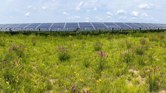
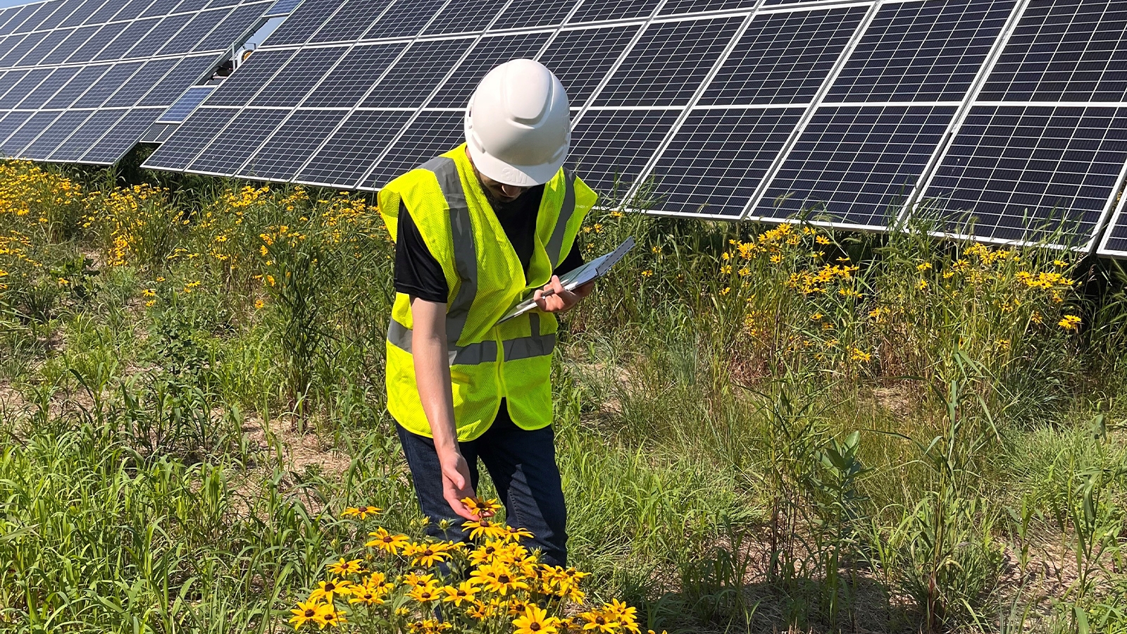
Two solar facilities built on rehabilitated agricultural land were restored with native plants. Argonne researchers observed pollinators thrive.
Bumblebees buzz from flower to flower, stopping for a moment under a clear blue Minnesota sky. Birds chirp, and tall grasses blow in the breeze. This isn’t a scene from a pristine nature preserve or national park. It is nestled between photovoltaic (PV) solar arrays on rehabilitated farmland.
Researchers at the U.S. Department of Energy’s (DOE) Argonne National Laboratory and National Renewable Energy Laboratory wanted to understand the ecological value of PV solar energy sites planted with native grasses and wildflowers. They examined how vegetation would establish and how insect communities would respond to the newly established habitat. The five-year field study looked at two solar sites in southern Minnesota operated by Enel Green Power North America. Both sites were built on retired agricultural land.

Smart land use choices provide multiple benefits
Global insect biodiversity has been in decline due to habitat loss, pesticides and climate change. Restoration of insect habitat paired with smart land use changes toward renewable energy developments could help reverse the course.
For instance, as a carbon-neutral source of electricity, expanded PV solar energy development is critical to mitigating climate change. According to the DOE’s Solar Futures Study, approximately 10 million acres of land in the U.S. will be needed for large-scale solar development by 2050 in order to meet grid decarbonization and climate change goals. But some lands are better suited for PV solar development than others. Disturbed lands such as former agricultural fields are ideal locations to hold rows of solar panels compared to lands that have been previously undisturbed.
Even more strategies can be added to this winning combination to support insect conservation. Agrivoltaics is the combination of solar energy production with agricultural and vegetation management practices. One type of agrivoltaics focuses on the establishment of habitat for insect pollinators and other wildlife that can provide important ecosystem services, such as pollination. Pairing solar energy facilities on previously disturbed lands with habitat enhancement sounds like a logical win-win strategy to address energy and biodiversity challenges. To date, however, there has been little field data available to document the feasibility and the ecological benefits of this novel land use approach.
If you build it, will they come?
The two studied solar sites were planted with native grasses and flowering plants in early 2018. From August 2018 through August 2022, the researchers conducted 358 observational surveys for flowering vegetation and insect communities. They evaluated changes in plant and insect abundance and diversity with each visit.
“The effort to obtain these data was considerable, returning to each site four times per summer to record pollinator counts,” said Heidi Hartmann, manager of the Land Resources and Energy Policy Program in Argonne’s Environmental Sciences division, and one of the study’s co-authors. “Over time we saw the numbers and types of flowering plants increase as the habitat matured. [ed. emphasis mine] Measuring the corresponding positive impact for pollinators was very gratifying.”
By the end of the field campaign, the team observed increases for all habitat and biodiversity metrics. There was an increase in native plant species diversity and flower abundance. In addition, the team observed increases in the abundance and diversity of native insect pollinators and agriculturally beneficial insects, which included honeybees, native bees, wasps, hornets, hoverflies, other flies, moths, butterflies and beetles. Flowers and flowering plant species increased as well. Total insect abundance tripled, while native bees showed a 20-fold increase in numbers. The most numerous insect groups observed were beetles, flies and moths.
In an added benefit, the researchers found that pollinators from the solar sites also visited soybean flowers in adjacent crop fields, providing additional pollination services.
The benefits of solar-pollinator habitats

“This research highlights the relatively rapid insect community responses to habitat restoration at solar energy sites,” said Lee Walston, an Argonne landscape ecologist and environmental scientist who was lead author of the study. “It demonstrates that, if properly sited, habitat-friendly solar energy can be a feasible way to safeguard insect populations and can improve the pollination services in adjacent agricultural fields.” Walston also serves as head of the Ecology, Natural Resources, and Managed Systems department in Argonne’s Environmental Science division.
The research findings suggest two important implications of habitat-friendly solar energy. One is that habitat-friendly solar sites can play an important role in conserving biodiversity. Large amounts of ground-mounted solar is expected to be developed in the future, but if properly sited, habitat-friendly solar can offset the losses of natural areas to provide biodiversity benefits. Second, habitat-friendly solar sites can help mitigate land-use conflicts associated with the conversion of farmland for solar energy production. As approximately 80% of future ground-mounted solar development could occur on agricultural lands, the proper siting of habitat-friendly solar energy on marginal farmland can not only preserve prime farmland, but it could make prime farmland more productive through the pollination services provided by habitat-friendly solar energy.
Overall, additional research is needed to understand the feasibility of habitat-friendly solar across different regions and to meet different ecological goals such as conserving a target insect or wildlife species.
Funding was provided by the InSPIRE project through the DOE Office of Energy Efficiency and Renewable Energy’s Solar Energy Technologies Office.
Click the link to read the release on the Northern Water website:
In its second year of grant funding, the Windy Gap Environmental Fund (WGEF) has awarded four Grand County organizations funds for various environmental projects. The Northern Water Municipal Subdistrict contributed funding as part of the settlement to end the federal lawsuit over Chimney Hollow Reservoir. The WGEF Committee awarded $680,000 in 2023, in addition to $1,065,000 of grant funding allocated in 2022, for a total of nearly $1.75 million.
The largest grant awarded in December 2023 was for $401,179 to Learning by Doing for its final design and implementation of the Willow Creek Restoration Project. Learning by Doing is a solution-focused collaborative group of local, state, federal and nonprofit water stakeholders charged with safeguarding Grand County rivers and streams. Learning by Doing was also awarded another $25,000 grant for the design of a stream restoration project at Kaibab Park.
Additional grants awarded include:
- $150,000 to the Town of Fraser to complete a stormwater infrastructure survey.
- $104,144 to the Grand Lake Recreation Foundation for design of river restoration of the Colorado River in the vicinity of the Red Top Valley Ditch diversion.
The WGEF is administered by the Grand Foundation, while the WGEF Committee reviews proposals and allocates grant funding. The committee is composed of three representatives from the Municipal Subdistrict and three from the Upper Colorado Watershed Environmental Team.
Construction of Chimney Hollow Reservoir began in August 2021 after the Municipal Subdistrict won a federal lawsuit in the first round that challenged the permit issued by the Bureau of Reclamation and Army Corps of Engineers. The Municipal Subdistrict then settled during the appeal process, which required a $15 million contribution throughout the four-year construction timeline that will be administered by the Grand Foundation to pay for projects that enhance the Colorado River and its many tributaries in Grand County.
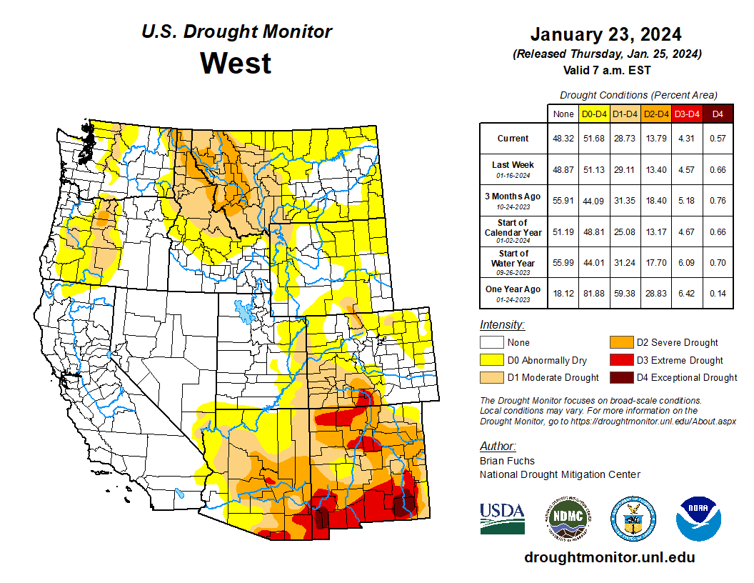
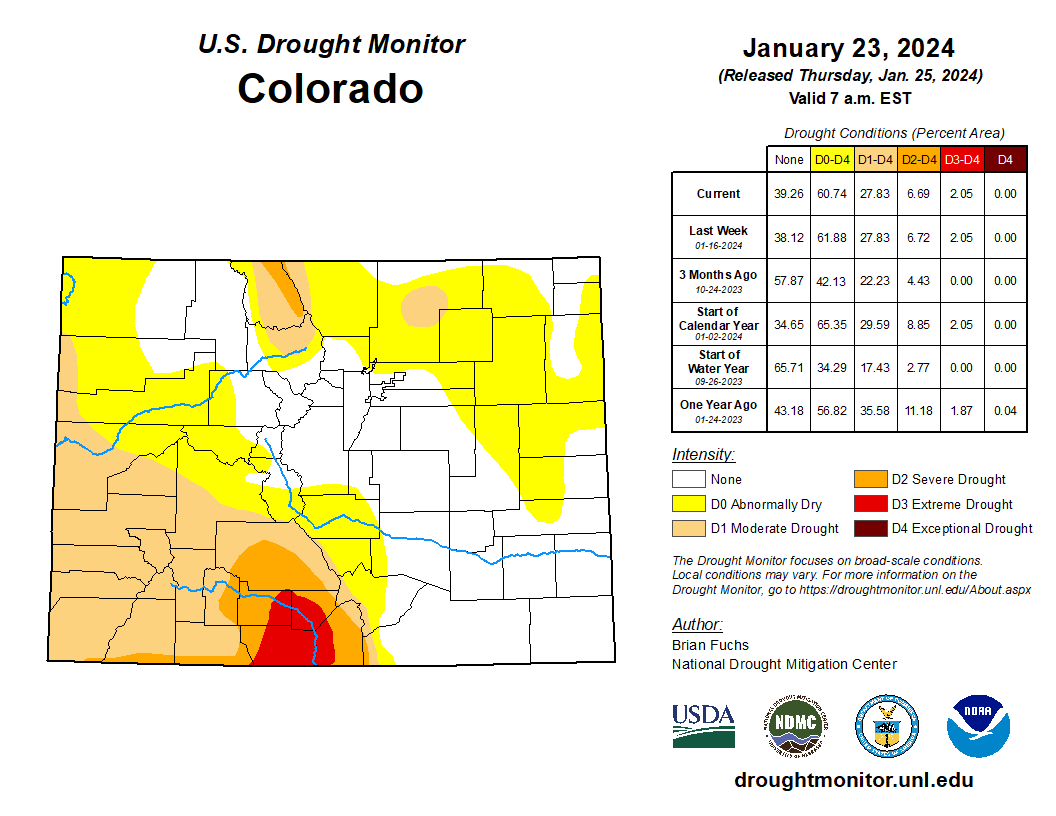
Click on a thumbnail graphic to view a gallery of drought data from the US Drought Monitor website.


Click the link to go to the US Drought Monitor website. Here’s an excerpt:
This Week’s Drought Summary
The current period was dry over most of the country with the greatest amount of precipitation occurring along the west coast and from east Texas into Arkansas. Temperatures were well below normal for most locations east of the Rocky Mountains, where departures were 5 degrees or more below normal for most areas. The greatest departures from normal were over Tennessee, Kentucky, and northern portions of Alabama and Mississippi where readings were 20-25 degrees below normal. The warm winter continued in the West with temperatures 5-10 degrees above normal over a majority of the region. The warmer-than-normal temperatures have been a challenge for snow accumulation with many locations, especially in the northern Rockies, having a very challenging start to the snow accumulation season. With an active pattern through the central Plains into the Midwest the past few weeks, a reassessment of drought indicators was done in many locations this week to examine drought intensity levels and adjust where the data supported it. In most instances, drought remains but the data allowed for intensities to be reduced. The end of the period had an active pattern again developing in the southern Plains and into the South where widespread precipitation was anticipated after the data cutoff for this week. These locations will be assessed on next week’s map…
High Plains
It was a mostly dry week over much of the region with only eastern Kansas receiving widespread, albeit light, precipitation. Temperatures were below normal for all areas outside the plains of Colorado and Wyoming and northern North Dakota where they were 3-6 degrees above normal. Outside of these areas, temperatures were generally 9-15 degrees below normal for the week. The wetter pattern over the last several months allowed for a reassessment of the data to investigate potential changes in the drought intensity levels. It was noted that even though the last 9-12 months have a stronger signal toward the wet spectrum, there are still long-term issues that go out 24-36 months or more in much of the central Plains. In looking at the data, support for the existing extreme drought in eastern Nebraska was not there, so it was improved to severe drought this week. In Kansas, areas of moderate and severe drought were also improved based on the lagging support for these intensity levels. Degradation took place over portions of northern North Dakota and eastern Wyoming where abnormally dry conditions were expanded based on the short-term dryness in these regions…
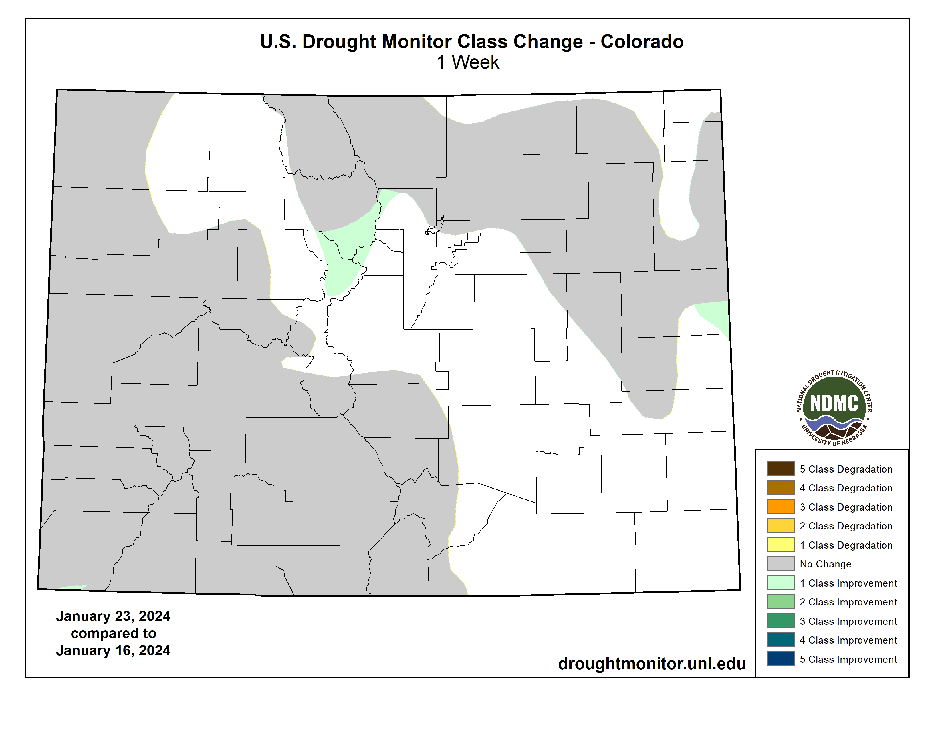
West
Above-normal temperatures dominated much of the region with departures of 9-12 degrees above normal over portions of western Wyoming, northern Nevada, central Idaho and northeast Utah. Temperatures were cooler than normal over Washington, northern Oregon, northern Idaho and much of Montana. The greatest rains were along the coast with some flooding issues being reported this week, especially in southern California. Further inland, it remained dry and the dryness coupled with the warmer temperatures has allowed for snow drought to develop, especially in the northern Rocky Mountains. The wetter pattern over the most recent weeks allowed for a reassessment of conditions over New Mexico and into eastern Arizona, where improvements were made. Areas of extreme and exceptional drought were reduced this week in western New Mexico while severe drought was improved in western New Mexico into eastern Arizona. Moderate drought was expanded over western Wyoming and severe drought was expanded over western Montana. Oregon had moderate and severe drought improvements in the west while moderate drought expanded in the central portion of the state. Washington saw moderate drought improved along the northwest coast and western portions of the state with abnormally dry conditions expanding in the north central…
South
Cooler-than-normal conditions dominated the region with departures of 10-15 degrees below normal common in the region. The greatest rains took place in east Texas to southwest Arkansas and into southeast Oklahoma. These rains continued past the data cutoff period and everything from Tuesday morning forward will be assessed on the next map. The rains allowed for some improvements, with a full category change over much of east Texas and improvements to moderate drought over central and northern Arkansas as well as the far northwest corner of Louisiana and southeast Oklahoma…
Looking Ahead
Over the next 5-7 days, the active pattern over the South and Southeast will continue, with much of the region anticipating 3-5 inches of precipitation. The coastal areas of the Pacific Northwest also will remain active with the next system coming ashore. Dry conditions are expected over the central and northern Plains, northern Rocky Mountains and Southwest. Temperatures will flip back to a warmer-than-normal pattern for most of the country, with greatest departures above normal over the northern Plains and upper Midwest.
The 6–10 day outlooks show a high probability of warmer-than-normal temperatures over much of the U.S. during this period with the highest probabilities over the Plains and Upper Midwest. There is a high probability of below-normal temperatures over Alaska and much of Florida. The precipitation outlook has the highest probability of below-normal precipitation over much of the eastern third of the U.S. with the greatest chances over the Ohio River valley. There are above-normal chances of above-normal precipitation over much of the West and into the Plains during this time.


Click the link to read the article on the Audubon Rockies website (Abby Burk):
A new year brings a new opportunity for Colorado decision-makers to shore up water resource vulnerabilities and accelerate resilience and stewardship practices. Policy is born by addressing a solution to a problem. Impacts of climate change and unsustainable water demand bring uncertainty to Colorado’s birds, communities, watersheds, and waterways. Resilience and stewardship are top themes for 2024 legislation on water, our most valuable natural resource. Audubon Rockies is busy working with lawmakers, agencies, and partners to prioritize healthy, functioning, and resilient watersheds and river systems for people and birds—the natural systems that we all depend upon.
Below are the two top water priorities for Audubon in the 2024 Colorado legislative session. Please make sure you’re signed up to hear about opportunities to engage with them.

1. Clean Water Stewardship for Colorado
Speaker of the House McCluskie mentioned the need to restore protections removed from the Sackett vs. Environmental Protection Agency decision in her opening 2024 legislative session remarks:
“Water is intrinsic to the Colorado Spirit, and the lifeblood of our agriculture industry and tourism economies. The recent United States Supreme Court decision about the definition of Waters of the United States leaves many of our waterways in Colorado unprotected. In the wake of this difficult decision, we have an opportunity to take action to reestablish these critical protections.”
It is imperative to protect our waterways for all of Colorado to thrive. The United States passed the Clean Water Act (CWA) in 1972 for water quality and related public health protections, realizing the outsized importance of our rivers, streams, and wetlands to communities and wildlife. At the time when waterways were literally burning with industrial waste, Congress recognized the threat to public health and addressed the widespread problem with bipartisan support and passage of the CWA. The CWA aimed to restore and maintain the chemical, physical, and biological integrity of the nation’s waters and took a watershed approach due to the connectivity of waters from headwaters to lowlands. The CWA protects waterways and their many benefits by requiring certain activities such as the construction of highways to minimize or mitigate their impact.
Despite the CWA’s successes over the last 50 years, there has been a lot of litigation and legal interpretations over the years. Most recently, the United States Supreme Court, through the Sackett case decision, effectively rewrote the CWA by severely narrowing the scope of its protections. Before Sackett, the CWA provided for the protection of the majority of Colorado’s wetlands and streams at the federal level.
So what is the void created by the Sackett decision for Coloradospecifically? In Colorado, we no longer have a federal partner to help protect our waterways. The decision upended a regulatory system that protected water quality for public health. Wetlands and streams are crucial ecosystems, particularly in Colorado, where we are semi-arid to arid. Before Sackett, the CWA would have protected all Colorado waters with a significant affect on downstream water quality and availability. After the Supreme Court decision, protections were sharply reduced.
Here are some examples of waterways that now have reduced or no federal protections in Colorado:


- Headwater streams that flow only after precipitation events
In Colorado, 26 percent of streams only flow in response to rainfall, and 59 percent flow seasonally. By some estimates, as much as two thirds of Colorado’s waterways have lost protections.* Nationwide, approximately 63 percent of all wetlands are now unprotected.
With the loss of 3 billion birds in the past 50 years—in part due to dwindling wetlands and significant development of natural spaces—and Audubon science showing that two-thirds of North American bird species are at risk of extinction from climate change, action is needed at the state and federal levels to protect the water bodies and habitat that birds need to survive. Protecting water quality is a bipartisan stewardship issue and brings broad public support. We look forward to working with the state as it creates a wetlands and streams protection program for water quality protection that works for Colorado’s unique waterways. If Colorado does this right, it could be a model for other semi-arid Western states to follow suit.

2. Resilient tools to deal with long-term uncertainty in the Colorado River
Despite near-term optimism (and a momentary sigh of relief) from a heavy 2023 snowpack and recent January storms, climate change and unprecedented drought conditions in the Colorado River Basin for the last 24 years are threatening Colorado’s ability to satisfy water users, ecosystem needs, water-related recreation, and, potentially, interstate obligations. There are real consequences for people, birds, and every other living thing that depends on rivers in this region.
In 2023, the Colorado General Assembly determined that it is in the best interest of Colorado to form a task force to provide recommendations for programs to assist Colorado in addressing drought in the Colorado River Basin and the state’s interstate commitments related to the Colorado River and its tributaries (SB-295, Section 1). From August through December 2023, the Colorado River Drought Task Force and a sub-task force on Tribal matters, met to draft a report on recommendations for further actions. You can learn more about the recommendations here.
As Colorado contends with near-certainty of continued warming, severe drought, and declining river flows over the next several years, we need more flexible ways to manage and deliver water to support the Colorado River we love. Colorado needs tools and resources to proactively respond to drought conditions and maximize the benefits to the state, its water users, and river ecosystems from once-in-a-generation competitive federal funds available to address the Colorado River Basin drought. Audubon will be engaging this session for solutions that will provide new and innovative solutions to the water threats we face.
*The State is waiting for additional guidance from the United States Environmental Protection Agency and Army Corps of Engineers to determine exactly how many of Colorado waters may lose protection.


Click the link to go to the State of Colorado Job Opportunities website:
Description of Job
OPEN ONLY TO CURRENT RESIDENTS OF COLORADO. This posting may be used to fill more than one vacancy.
Hydrographer duties include measuring and evaluating data to determine the stream flow quantity at assigned stream gaging stations, and maintaining such gages; measuring water flow in canals and ditches in support of state Water Commissioners; servicing, calibrating, monitoring, and repairing all equipment associated with stream gaging stations, including telemetry equipment; inspecting water measurement structures, reporting on their accuracy and recommending solutions to any problems observed; and, evaluating and compiling official flow records for state and federal publication. These duties will be primarily performed within the Colorado River Basin.

Click the link for all the to go to the State of Colorado Job opportunities website:
Description of Job
This posting is open to current and non-current residents of the State of Colorado at the time of submitting your application. However, if you are selected and accept the position, you will be required to establish residence in the State of Colorado.
The purpose of this position is to provide leadership, guidance and oversight to the Division 5 operations group responsible for Augmentation Plan coordination and administration. This group supports water rights administration by developing methodologies to collect and analyze water diversion and delivery data to verify augmentation plan operators are operating in compliance with all applicable court decrees, statutes, rules and regulations and to analyze Water Court applications, including reports of engineering experts, consult with the Water Court Referee regarding all applications, write reports summarizing the agency’s position and negotiate or provide expert engineering support / testimony to litigate any conditions necessary to protect existing water rights; to supervise professional and technical staff; and provide assistance to the public in understanding Colorado water law.

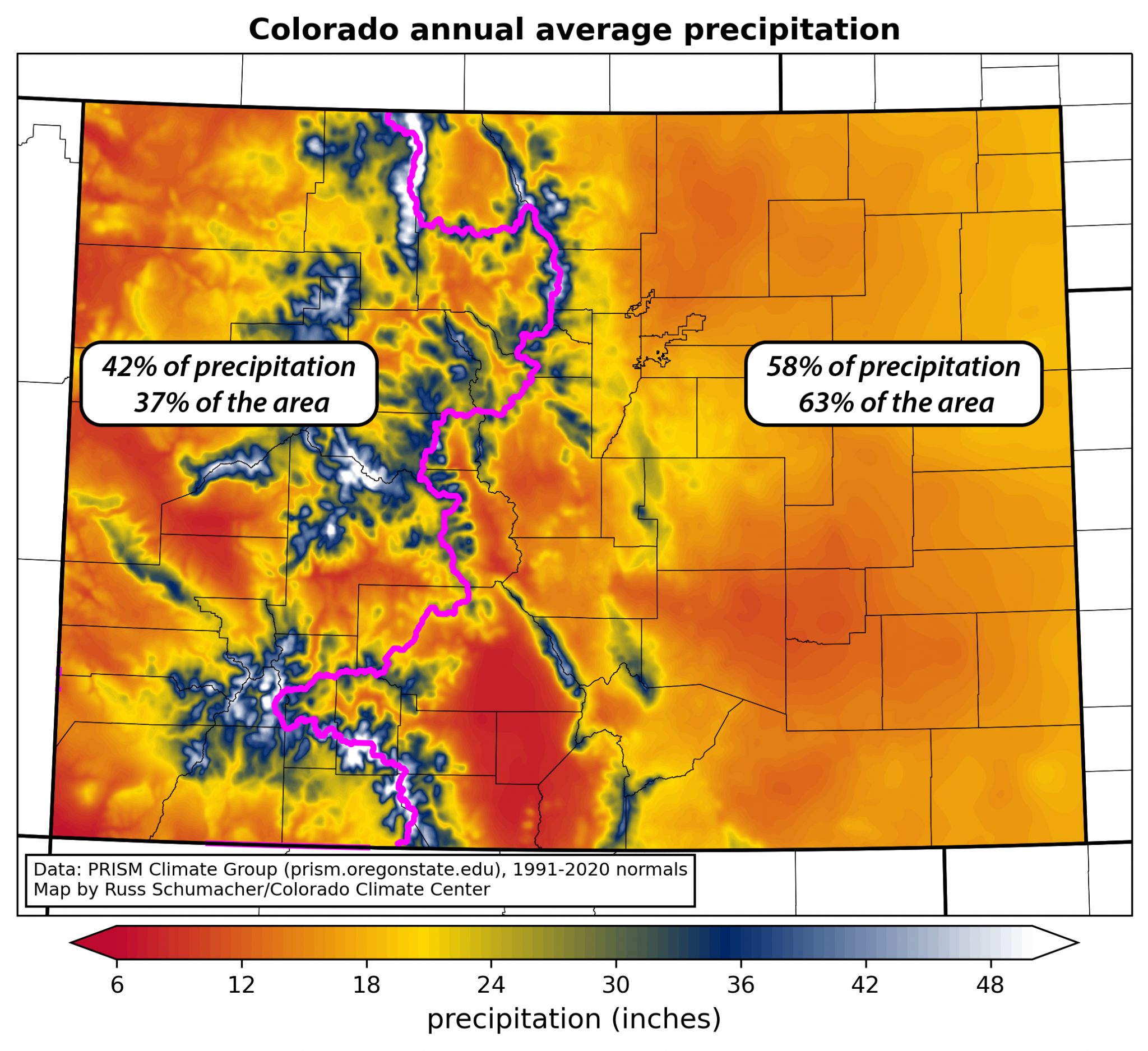
Click the link to go to the Colorado Climate Center blog:
You can head over to https://climate.colostate.edu/blog and check out our latest blog posts now. For example, is the old 80/20 rule actually true (80% of our state’s precipitation falls on 20% of the population)?
In addition to checking out the website anytime, you can also subscribe to our blog mailing list – just use the sign-up form on the blog page. Once you subscribe, you’ll get our blog posts delivered directly to your inbox (about once a week). What could be better with your morning cup of coffee than learning a bit more about Colorado’s climate?!
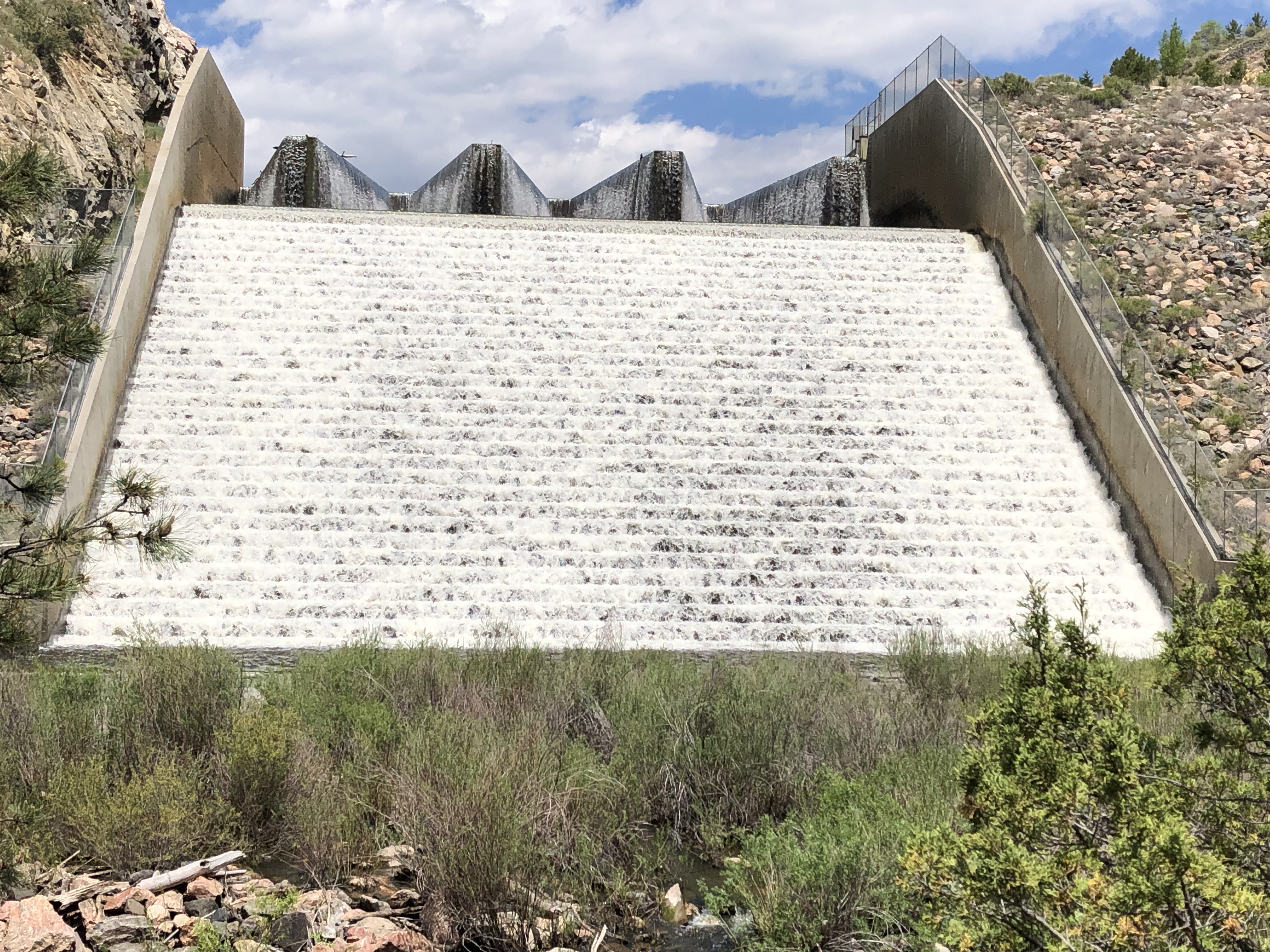
Click the link to read the article on The Greeley Tribune website (Chris Bolin). Here’s an excerpt:
January 23, 2024
The city of Greeley launched a multi-language survey to gather thoughts on designing a new water conservation program to fit everyone’s needs, according to a city news release. City officials will also host a pair of community workshops to engage with residents and bridge the gap between the city and its water users.
“We want our conservation programs to serve all water users in our growing and diverse community,” Water Conservation Specialist Rita Jokerst said in the release. “And we’re excited to use this survey to hear from as many residents as possible.”
Residents can enter to win one of three $100 gift cards by filling out the survey at greeleygov.com/LILAC or by attending one of the two come-and-go community workshops. The first will be hosted from 4-7 p.m. Jan. 23 at the Greeley Recreation Center, 651 10th Ave. The second will take place from 5:30-7:30 p.m.Feb. 21 at the LINC Library, 501 8th Ave. Greeley Water Efficiency Resource Coordinator Margarita Padilla said she is excited about the survey and looks forward to engaging with the community…
For more information on the survey or workshop details, go to greeleygov.com/LILAC.
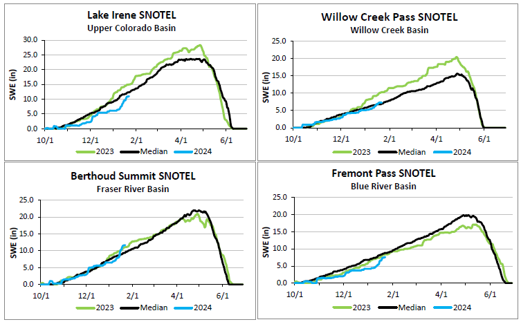
On average, both the West Slope and East Slope stations are at 100 percent of median snowpack for January 23, 2024 — @Northern_WaterA live snow report is available on our website. View the dashboard at http://northernwater.org/snowpacksummary.
Click the link to read the article on the Carbon Brief website (Josh Gabbatiss):
January 12, 2024
A boom in Chinese solar power construction drove another record-breaking year of renewables growth in 2023, according to the International Energy Agency (IEA).
Carbon Brief analysis of figures in the IEA’s Renewables 2023 report show that the world is now on track to build enough solar, wind and other renewables over the next five years to power the equivalent of the US and Canada.
Rapid growth has also pushed the IEA to once again significantly upgrade its renewables forecast, adding an extra 728 gigawatts (GW) of capacity to a five-year estimate it made just a year ago. This is more than the electricity capacity of Germany and India combined.
The agency attributes this growth to plummeting costs of solar power and favourable policy regimes, particularly in China. New solar and onshore wind now provide cheaper electricity than new fossil fuel power plants almost everywhere, it says, as well as being cheaper than most existing fossil fuel assets.
Despite such accelerated expansion, the world is not currently on track to achieve the COP28target of tripling renewables capacity by 2030, according to the IEA.
However, it proposes various measures to further increase deployment, including more finance for developing countries.
‘Step change’
Last year was a “step change for renewable power growth” as the world built an extra 507GW of renewable capacity, primarily solar and wind power, according to the IEA.
This was a 49% increase on the previous year’s construction. It marked the 22nd year in a row that renewable capacity addition reached record levels.
Over the six-year period 2023-2028, an additional 3,684GW of renewables is expected to come online under the IEA’s “main” forecast. This is double the current total of renewable capacity installed globally.
In 2023, solar power both at utility-scale and on rooftops amounted to three-quarters of capacity additions, primarily due to growth in China. Over the next five years, 73% of the 3,174GW of new capacity will be solar, again driven largely by China. (See: China leads.)
By Carbon Brief’s calculations, this 2024-2028 period is on track to see an extra 4,963 terawatt-hours (TWh) of electricity generation from renewable sources.
This amounts to one-sixth of the world’s electricity output in 2022. As the chart below shows, this is equivalent to covering the entire electricity demand of the US and Canada with newly-built renewables.

By 2028, the IEA forecasts that renewables will account for 42% of global electricity generation, with wind and solar power making up 25%. Despite showing no growth across this period, hydropower is still expected to be the largest single source of renewable power.
Taken together, the agency says renewables will overtake coal power as the largest source of power in “early 2025”. (A year ago, the agency said renewables would become the world’s largest electricity source within three years.)
One major driver of this growth is the plummeting cost of renewables, especially solar photovoltaics (PV). Spot prices for solar modules declined by almost 50% in 2023 compared to the previous year, according to the IEA.
Last year, 96% of newly installed utility-scale solar and onshore wind capacity generated cheaper electricity than new coal and gas plants, according to the IEA.
Moreover, three-quarters of new wind and solar power plants provided cheaper power than even existing fossil-fuel facilities.
The other key driver is the strong policy support that renewables enjoy in “more than 130 countries”, the IEA says. It notes that “policies remain key for attracting investment and enabling deployment”, with roughly 87% of the utility-scale renewable growth between 2023 and 2028 “expected to be stimulated by policy schemes”.
At the same time, the report highlights the impact of the “new macroeconomic environment” on the renewables sector, with inflation and high interest rates raising costs. Offshore wind has been hardest hit, with the IEA’s forecast for its growth outside China dropping by 15%.
The report also examines renewable heat consumption and the use of biofuels. Both are set to grow considerably in the coming years, but the IEA says neither are currently on track for the trajectories seen in its net-zero scenario, which aligns with the Paris Agreement.
Record revision
As a result of this growth, the IEA has again significantly raised its forecast for renewables capacity expansion, by a record amount.
It now sees an additional 728GW being built in the 2023-2027 period compared to its forecast from 2022 – a 33% increase. This is notable considering that, last year, the agency described a five-year 424GW adjustment as its “largest ever upward revision”.
The chart below shows the 120GW divergence between actual renewables growth in 2023 – some 507GW – and the forecast for that year of 387GW, made by the IEA in 2022.

The IEA has a long history of making relatively conservative predictions for renewable growth that are subsequently outstripped by reality, due to a combination of more favourable policy conditions and faster-than-expected cost reductions.
Forecasts from previous IEA renewables reports issued in 2020 and 2021 showed annual renewable growth rates remaining fairly stable at around 200GW and 300GW per year for the following five years, respectively.
However, these forecasts have not been included in the chart above as, for the first time, the agency has converted all of its solar power values to direct current, resulting in slightly different GW values. This means previous forecasts are not directly comparable, although the 2022 forecast figures have been converted for this purpose.
China leads
A key conclusion from the IEA’s new report is the global dominance of China in deploying solar and other renewables, which is set to increase in the coming years.
In the period 2005-2010, China built 39% of the world’s new renewable energy capacity. This increased to 47% in the 2017-2022 period and the IEA expects it to rise to 59% between 2023 and 2028. This can be seen in the chart below.
By 2028, the agency estimates that nearly half of China’s electricity will be generated by renewables. According to Ember, as of 2022 only around 30% of China’s electricity was from renewables.
During this period, the nation is set to deploy four times more renewables than the EU and five times more than the US.

This growth is being driven by the nation’s success in solar power manufacture and installation, according to the IEA. In “almost all provinces”, generation costs for new utility-scale solar and onshore wind are now lower than for coal, which is generally used as the benchmark for electricity prices, the agency says.
The IEA attributes this progress to policy measures, including power market reforms, green certificate systems and province-level financial support to support rooftop solar installation. It also points to a “supply glut” that has helped solar module costs “plummet drastically”.
As China accounts for 90% of the upwards revision in the IEA’s forecast out to 2028, it notes that the nation’s solar achievements actually “hide slower progress in other countries”.
There have been a number of significant supportive policy changes in other countries and regions, however.
The US and the EU are expected to see renewable installation rates double across 2023-2028, compared to the previous six-year period – in both cases due primarily to solar expansion. The IEA attributes this to the US Inflation Reduction Act and supportive national policies – such as government renewable power auctions – across European nations.
The report also highlights the success of supportive policies in India and Brazil. It notes that while renewables are set to expand rapidly in sub-Saharan Africa – particularly South Africa – the region “still underperforms considering its resource potential and electrification needs”.
Tripling renewables
At COP28, nearly every government in the world agreed to a target of tripling global renewables capacity by 2030. This would bring the total to 11,000GW, which is in line with the IEA’s own net-zero scenario.
As it stands, the new report concludes that under the IEA’s “main case” forecast, shown in yellow in the chart below, renewable capacity would increase to 7,339GW in 2028.
Following that trajectory, capacity would reach around 9,000GW in 2030 – roughly an increase to 2.5 times current levels.
This forecast is based on existing policies and takes into account “country-specific challenges that hamper faster renewable energy expansion”, the IEA says.
By contrast, the IEA’s “accelerated case” involves governments “overcom[ing] these challenges and implement[ing] existing policies more quickly”.
In this scenario, shown in red below, renewables growth is around 21% higher. Capacity increases to 8,130GW in 2028, putting the world on track for the tripling by 2030 target.

The IEA lists a handful of broad measures that governments could take to achieve an “accelerated” trajectory.
These include: improved policy responses to the “new macroeconomic environment” such as higher inflation; more investment in grid infrastructure; and dealing with “cumbersome administrative barriers and permitting procedures and social acceptance issues”.
The IEA notes that “the lack of affordable financing remains the most important challenge to renewable project development in most EMDEs [emerging markets and developing economies], especially in countries where renewable policy uncertainties also increase project risk premiums”.
It emphasises the need to boost financing for EMDEs to overcome this barrier. Last year, renewable growth was concentrated in just 10 nations and tripling renewables requires “a much faster deployment rate…in numerous other nations”, the IEA says.
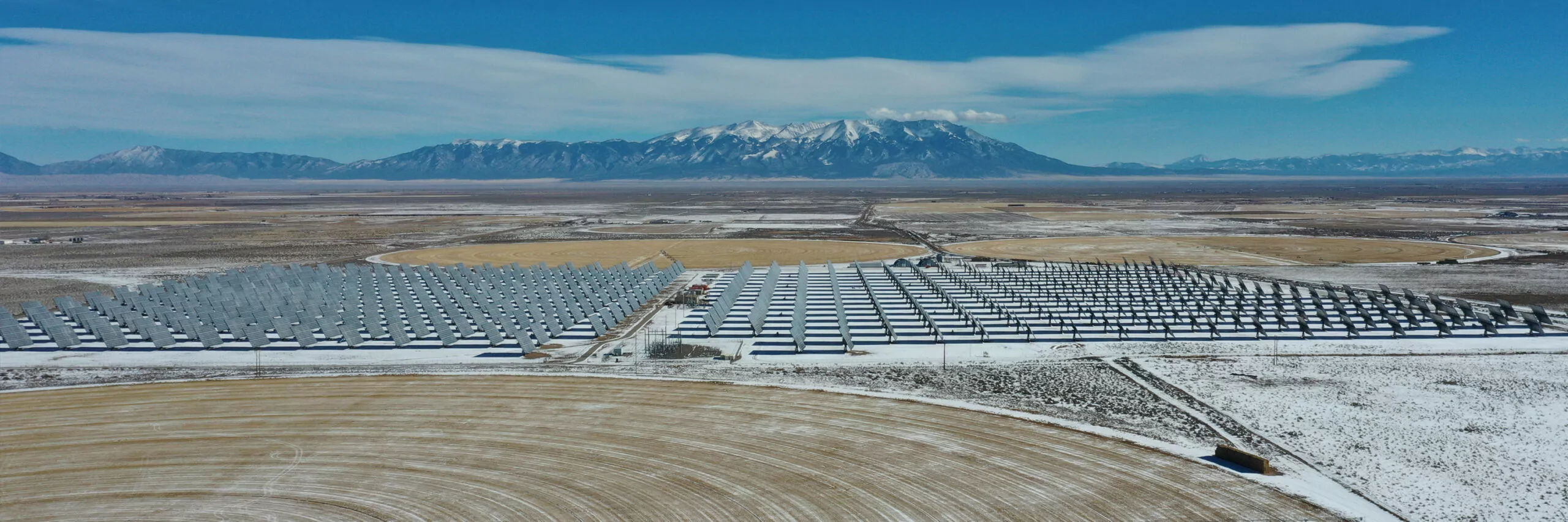
Dec 19, 2023
Embark on an exhilarating visual journey as we unveil the awe-inspiring transformation of the Klamath River over 5 months of meticulous deconstruction of Copco 2 dam. Immerse yourself in the grandeur of over 15,000 captivating images capturing the first and smallest of the four dams destined for removal by October 2024. Witness history in the making with the unveiling of the largest river restoration project ever undertaken! This mesmerizing time-lapse is just a glimpse into our ambitious 6-year independent feature film, “Undamming Klamath.” Join us as we bring this monumental river restoration story to life! This is an independent film and time-lapse project that needs your support. Tax-deductible donations through The Redford Center below:
https://www.paypal.com/donate/?hosted…
Produced by: Swiftwater Films Producer: Shane Anderson Timelapse Project Lead: Jesse Andrew Clark Timelapse Technicians: Olivia Vosburg and Jason Hartwick Project owner: Klamath River Renewal Corporation Owners rep: McMillen Deconstruction by: Kiewit Corporation Restoration Contractor: Resource Environmental Solutions Supported in part by: The Redford Center The Catena Foundation Resources Legacy Fund © SWIFTWATER FILMS LLC. UNDAMMINGKLAMATH.COM
ALL IMAGES PROPERTY OF SWIFTWATER FILMS LLC

Click the link to read the article on The Denver Post website (Elise Schmelzer). Here’s an excerpt:
January 22, 2024
Statewide, the snowpack sat at 92% of the 30-year median on Monday, according to the National Water and Climate Center. That’s a significant improvement from the beginning of January, when the snowpack was sitting at just below 70% of the median. The storms from Jan. 11 to Jan. 15 dumped feet of snow on Colorado’s mountains, finally covering ski slopes that had been patchy with grass and closing highways across the state.
“This was a hugely beneficial storm cycle over the last couple of weeks, both with respect to the water situation and outdoor recreation,” said Russ Schumacher, the state climatologist and the director of the Colorado Climate Center. “Colorado looks a lot better than it did a couple of weeks ago.”
Sixty-two percent of the state was in drought last week, according to the most recent data released by the U.S. Drought Monitor. That’s a slight improvement from 67% before the storms…Not all areas of the state are faring the same. While the snowpack in the Yampa and South Platte river basins are sitting at 98% of median levels, the amount of snow in the Upper Rio Grande basin is at 69% and the snowpack in the San Juan basin is at 80% of median…A swath of land in southern Colorado — including Conejos, Costilla, Rio Grande and Alamosa counties — remained in severe or extreme drought, representing 9% of the state.

The snowpack in the Colorado River headwaters measured 99% of the median on Monday.
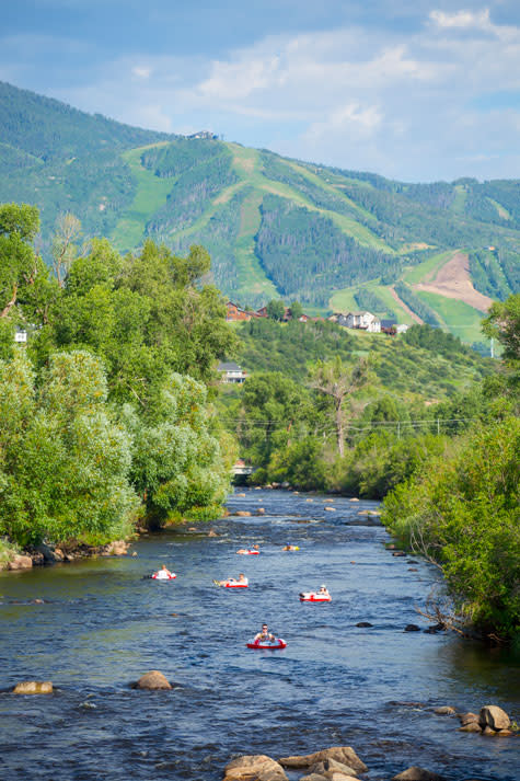
Click the link to read the article on the Steamboat Pilot & Today website (Trevor Ballantyne). Here’s an excerpt:
January 22, 2024
A new forecasting tool to determine closing and opening procedures for the Yampa River is among a set of proposed regulations being discussed by city officials. The proposed policies are aimed at protecting “the biological integrity of the Yampa River while sustainably managing recreation,” according to a report provided to council members last week. Late last year, Parks and Recreation commission members approved the use of the new tool, provided by the Carbondale-based firm Lotic Hydrological, which will set closure and reopening decisions for the Yampa River based on a framework of scientific criteria. Craig Robinson, Parks and Recreation Open Space and Trails Manager, said the current regulations for the criteria to determine river openings and closures “are a little bit vague,” in that they are based on a number of factors and involve consultation with Colorado Parks and Wildlife…
Outfitters and anglers licensed by the city to use the Yampa River agree the health of the river’s ecosystem is most important, but depending on their interests, they don’t necessarily agree over the proposed policies. Backdoor Sports owner Pete Van De Carr noted the proposed system to close and reopen the river will likely result in less frequent but longer-term closures…
Brett Lee, the owner of Straightline Sports, provides angling tours for his customers on the Yampa River. Unlike Van De Carr, he said he welcomes the new opening and closing procedures being pitched by city staff because they will, hopefully, help mitigate the impact of tubing on the river…Adding to system for determining the opening and closing of the Yampa River, the city is also proposing new policies for licensed commercial outfitters that supply tubes and other guided services on the Yampa River. The proposed rules will require any tubes rented by outfitters or sold in the city must have a minimum 30-guage PVC thickness. If approved, they would also implement a three-year permit renewal process for outfitters and will specify that tube allocations for the outfitters are not considered as “real or personal property.” Additionally, if any business owner with tube allocations sells their business — and its tubing allocations — the city must be notified, and the new entity must reapply to assume their allocation.

Click the link to read the article on the Writers on the Range website (David Marston):
January 22, 2024
The experts tell us an energy gap looms. Fossil fuels are phasing out, and solar and wind power can’t produce enough electricity to meet the demand in coming decades.
But that’s not the thinking of Amory Lovins, the 76-year-old co-founder of RMI, formerly the Rocky Mountain Institute in western Colorado.
A Harvard and Oxford dropout who’s been called the “Einstein of Energy Efficiency, Lovins said recently: “If we do the right things, we’ll look back and ask each other, ‘What was all the fuss about?’”
Lovins became famous in the 1970s after his research told him that building more polluting coal-fired power plants was a destructive mistake. His solution then was greater efficiency and reliance on renewables, and they, he insists, are still the answer.
“Though it’s invisible, efficiency will cut 50% of energy use and up to 80% if we do the right things,” he told me recently. “Most of the energy we use is wasted, which makes it much cheaper to save it, rather than buy it or burn it.”
According to a recent Princeton paper, he’s right: 84% of all energy consumed goes to waste during delivery or by leakage.
To prove it decades ago, he built a passive solar, super-insulated house at 7,100 feet of elevation in Old Snowmass, Colorado. It never had a heating system though winters regularly recorded 40 degrees below-zero temperatures.
When I arrived there recently at 8 a.m. it was 12 degrees F. Yet the house featured banana and papaya trees growing in natural light around a koi pond.
We became acquainted when he read my January 2023 Writers on the Range column entitled; “The energy gap nobody wants to tussle with.” I’d advocated building small modular nuclear reactors to bolster the grid when the wind doesn’t blow and the sun doesn’t shine.
Lovins called to set me straight, and after a second conversation and more research, I’m beginning to think he’s right.
Though Lovins has many solutions for the energy gap, he touts three major ways to find more energy in what we already do. Tops on the list is changing how we build and retrofit existing structures because buildings consume 75% of the electricity we buy.
Most energy jobs in the United States are already increasing efficiency, ranging from upgrading windows and other retrofits, far outpacing the shrinking fossil fuels industry. (energy.gov)
As one example, Lovins advocates “outsulation” for older structures, defined as adding exterior insulating panels to save heat. Courtesy of the European Union, my Irish in-laws recently had their house “wrapped” and saw their heating bills plummet.
His second way is demand-response, which Lovins calls flexiwatts. An example is cycling air conditioners off for 15-30 minutes at a time, a barely noticeable adjustment that cuts demand for peaker-power plants, those big emitters of greenhouse gases.
His third way is using renewables more effectively. Diversifying renewables by location and type within a region evens gaps from windless and cloudy weather.

As for electric cars being a drain on the grid, they will prove to be sources of electricity, he said, as the next generation batteries will be cheaper and likely have double the storage. Daytime solar stored in vehicles will be bi-directional, spooling out power during peak evening demand.
Lovins also cites LED lights dramatically cutting the cost of energy. In just a decade, they’ve become 30 times more efficient, 20 times brighter and 10 times cheaper.
Lovins is quick to admit that an energy gap remains, but he predicts a single-digit gap—6%—between what renewables produce and what’s needed. That, he said, can be made up by stored, green hydrogen or ammonia, manufactured from water and air with solar energy, and burned in existing gas plants.
As for nuclear power plants, Lovins said even the best-case scenarios for the next generation of nuclear generators are at least a decade away, and at least eight times more costly than renewables today.
“It’s better to use fast, cheap and certain rather than slow, costly and speculative,” he said.
Though cutting loose from fossil fuels is a massive undertaking, Lovins said America is on track. “We are on or ahead of schedule on renewables, with 85% of net new additions to the grid from renewables, and $1 billion invested in solar in the United States daily.”
For these reasons and more, Lovins sees our energy future as more of what we’re already doing—only smarter and faster. [ed. emphasis mine]
Let’s hope that he’s right. Dave Marston is the publisher of Writers on the Range, writersontherange.org, an independent nonprofit that exists to spur lively dialog about the West. He lives in Durango, Colorado.
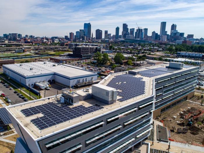
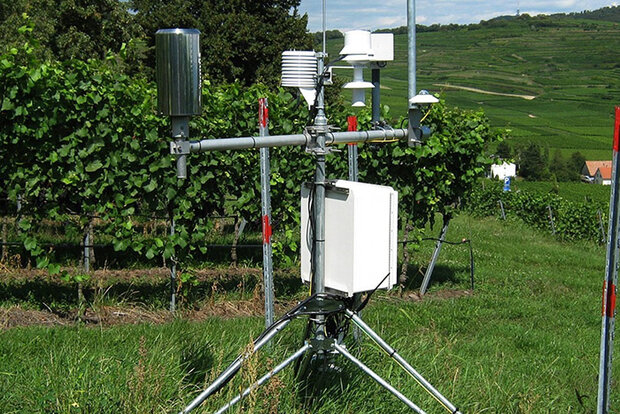
Click the link to read the release on the NOAA Website
January 4, 2024
CPO’s Climate Observations and Monitoring (COM) program is announcing two new two-year projects in Fiscal Year 2023 (FY23) that aim to improve the research on precipitation datasets. The competitively selected projects total four hundred seventy-nine thousand dollars in grants1. These precipitation projects, chosen in response to the Disaster Relief Supplemental Appropriations Act (DRSA) of 2022 and motivated by NOAA’s Precipitation Prediction Grand Challenge (PPGC) strategic objectives, will help improve NOAA monitoring and modeling capabilities. NOAA plays an important role in providing timely and accurate precipitation predictions to protect lives and property.
The Fifth National Climate Assessment, recently released by the U.S. Global Change Research Program, finds that climate change “will continue to cause profound changes in the water cycle, increasing the risk of flooding, drought, and degraded water supplies for both people and ecosystems. These impacts will disproportionately impact frontline communities.” In 2023 (as of November 8), the U.S. has experienced 25 weather/climate disaster events with losses exceeding $1 billion, including two flooding events, 19 severe storm events, one tropical cyclone event, and one winter storm event.
To reduce the severity of these impacts, NOAA scientists need to build new databases for precipitation information, and these projects will facilitate that work.
The two new projects2 funded by the COM Program in FY23 are:
- Improving and Expanding Gridded Snowfall Analyses and Season-to-Subseasonal (S2S) Snowfall Forecasts
- Snowfall is a critical resource within the hydrologic cycle of much of the continental United States (CONUS), especially in western states. Given this status, it is important to accurately quantify snowfall to maximize its benefits when it is abundant, and enable mitigation activities when it is lacking. This project will focus on the role of Snow-to-Liquid Ratio in analysis and forecasting by developing an improved methodology for a gridded snowfall product in the CONUS. This methodology will be then applied to create a novel gridded snowfall product for Alaska. The project will also produce a series of research-guided recommendations to produce S2S snowfall forecasts using output from the Unified Forecast System.
- PI: Andrew Rosenow, University of Oklahoma
- CoPI: Peter Veals, University of Utah
- Developing Long-term High resolution precipitation dataset using deep learning with multi-source Earth System Data
- The development of accurate, high-resolution gridded precipitation datasets over a long period of time is crucial for climate monitoring and forecasting. Although useful, current datasets exhibit great discrepancies and have different strengths and weaknesses. This project will develop an improved long-term high-resolution precipitation dataset over CONUS using machine learning techniques. It will integrate radar observations, gauge-based precipitation analysis data, climate reanalysis data, and satellite-based cloud data.
- PI: Di Tian, Auburn University
1The funding will be distributed over the life of the projects and future-year funding is conditional on appropriations.
2At the time of publication, all awards may not have been accepted by recipient institutions
Click the link to read the article on The Denver Post website (Elise Schmelzer). Here’s an excerpt:
[Marijane] Sisson is among many residents of South T Bar Ranch alarmed by an Australian company’s plans to drill in the subdivision as a way to learn more about the uranium deposits beneath it. An appeal by a homeowner to stop the prospecting failed last week, allowing Global Uranium and Enrichment to proceed. It could drill as many as 20 holes in the area this year. While original homeowners in the community owned some of the mineral rights and knew drilling was a possibility, the plans caught others by surprise, said Skip Blades, who owns three parcels in South T Bar Ranch. He appealed the company’s plans…
The drilling by Global Uranium and Enrichment, previously known as Okapi Resources, comes as prices for the radioactive element soar. They reached a 16-year high Monday as global supplies tighten and demand for nuclear power rises — and as alternatives to oil and gas energy become more appealing. The market shift has spurred the opening of new uranium mines in the United States for the first time in eight years — including three in the Mountain West.
The company plans to drill over a 60-day period between May and December. The goal is to extract samples of the rock and minerals for further study. Crews will work 24/7 to drill 5-inch-diameter holes 700 feet into the ground to collect the samples, according to the company’s application for a Colorado Division of Reclamation, Mining and Safetypermit. Each hole will require a drill pad area of 6,400 square feet, cleared of grass and rocks, and will remain open for about six days. After the samples are extracted, the company will fill and cover the holes. More than 1,400 such holes have been drilled in the vicinity as different companies have come and gone…
Blades and Sisson worry the drilling could disrupt wildlife and contaminate their water supply. The drills will push through underground aquifers. Some of the drilling will occur near Tallahassee Creek, which feeds into the Arkansas River. Company representatives and staff from the Division of Reclamation, Mining and Safety said water contamination was unlikely. Company representatives also said they would comply with wildlife officials’ recommendations to mitigate harm to wildlife and would try to minimize disturbances to the neighborhood. In a written response to Blades’ formal complaint, a company representative said the drill areas would quickly revegetate. The company also said it would point lights toward the ground at night to minimize light pollution, adding that noise from the drill to be used “is relatively muted when compared to other drills.”

Click the link to read the article on the Alamosa Citizen website:
January 21, 2024
Fund will retire approximately 11,296 acre-feet of water
When Colorado Senate Bill 28 was adopted during the 2022 legislative session, it created the Groundwater Compact Compliance Fund with $30 million earmarked for irrigators in the Upper Rio Grande Basin.
The state money derived from Colorado’s share of federal COVID dollars that came through the American Rescue Plan Act would serve to incentivize local farmers to permanently retire more groundwater wells. Doing so would further reduce groundwater pumping and translate to fewer irrigated acres in the Valley as a whole.
Seven months after opening applications to the fund, the Rio Grande Water Conservation District has enough contracts to spend nearly the entirety of the $30 million. The contracts represent the full retirement of approximately 34 crop circles and partial restrictions on 28 circles, according to an accounting from the Rio Grande Water Conservation District.
When it’s all said and done, the $30 million will have paid for the retirement of approximately 11,296 acre-feet of water. An acre-foot represents around 326,000 gallons, or enough water to cover an acre of land.
Each application submitted to the Groundwater Compact Compliance Fund was reviewed by the Rio Grande Water Conservation District and Colorado Division of Water Resources. So far six applications representing $4,772,204 have been closed and the RGWCD now owns those water rights, according to deputy general manager Amber Pacheco.
The remaining applications have to be approved or rejected by March 31.

The senate bill also directed $30 million to sustainability efforts on the Republican River Basin in the eastern plains. Like the Rio Grande Water Conservation District, the Republican River Water Conservation District has been successful in administering the program, Pacheco said.
“We’ve been pretty successful,” she said at the Jan. 16 board meeting of the Rio Grande Water Conservation District. “It’s pretty shocking that in six months that amount of money was obligated.”
A small amount of funding will likely remain after current applications are all reviewed, Pacheco said.
The RGWCD received a total of 27 applications. Here’s a breakdown of applications by subdistrict. The applications represent 11,296 acre-feet of past annual withdrawals that would be retired.
Applications total approximately $29,000,000
14 applications in Subdistrict 1* – $11,700,000
2 applications in Subdistrict 3* – $1,200,000
1 application in Subdistrict 4 – $500,000
4 applications in Subdistrict 5 – $5,100,000
2 applications in Subdistrict 6 – $1,300,000
4 applications in Subdistrict 7 (Trinchera Subdistrict) – $9,300,000*SD1 and SD3 both offered some type of incentive on top of the SB28 program.

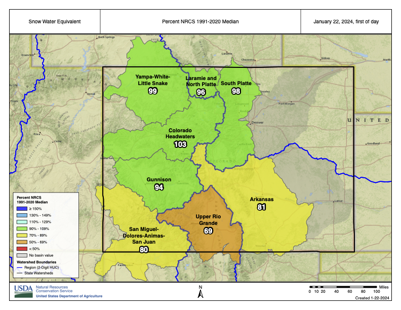
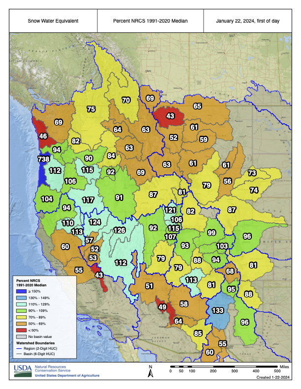
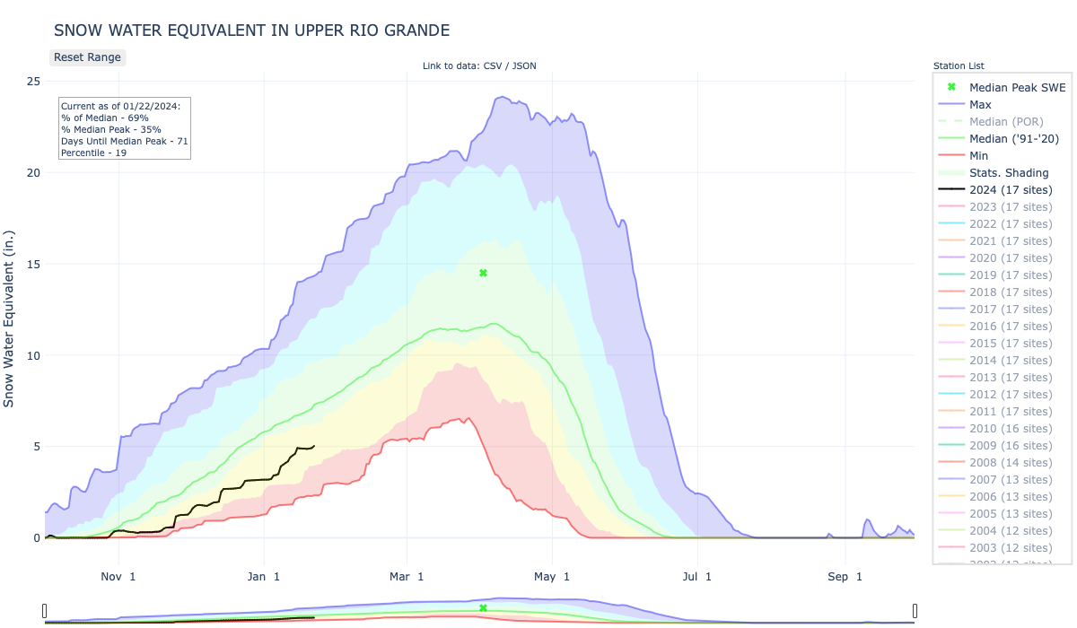
Click the link to read the article on the Alamosa Citizen website (Chris Lopez):
January 20, 2024
Current levels are at 71 percent of normal for the Rio Grande Basin
The Rio Grande Basin has about another 70 days to get itself up to average peak levels for snowpack that would deliver a normal spring runoff year for San Luis Valley irrigators in 2024. Water from melting snow in the surrounding mountain ranges also irrigates farm fields in New Mexico and Texas through the Rio Grande Compact.
The snowpack levels and corresponding 2023 spring runoff was the focus of a presentation at the Rio Grande Water Conservation District’s quarterly meeting held on Tuesday, Jan. 16. Craig Cotten, Division 3 engineer for the Colorado Division of Water Resources, walked water managers through a series of slides showing the conditions of rivers and creeks all critical to Valley’s agricultural economy as well as Colorado’s ability to deliver water to the New Mexico state line for Rio Grande Compact obligations.

Rio Grande and Conejos River
These charts represent the two river systems tied to the Rio Grande Compact and the effect on stream flows from snow runoff during the spring of 2023. The winter of 2022-23 translated into significantly above-average runoff for several months and then by the first of July a drop in streamflows to below average on the Rio Grande and right at average to below on the Conejos River.
It’s the Rio Grande and Conejos that form the Rio Grande Compact between the states of Colorado, New Mexico and Texas. The annual spring runoff determines how much water Colorado delivers to the New Mexico state line to fulfill its compact obligation. From the 2023 runoff Colorado delivered 29 percent of the streamflow or 208,000 acre-feet of water from the Rio Grande, and 47 percent or around 200,000 acre-feet from the Conejos River.

Los Pinos River near Ortiz
Los Pinos is the main contributor to the San Antonio River, which is a main tributary to the Conejos. Los Pinos had significant above-average runoff that resulted in some flooding on the lower end of the San Antonio in the spring of 2023. With its tributaries, the Conejos River had 411,000 acre-feet or 137 percent of its long-term average in 2023. Again, 47 percent of that water had to be delivered to the New Mexico state line to meet Colorado’s Rio Grande Compact obligations.

Saguache Creek near Saguache
Saguache Creek forms from runoff coming off the San Juan Mountains. It had above-average spring streamflows like others, and ended up below-average when the normal summer rains did not materialize in 2023.
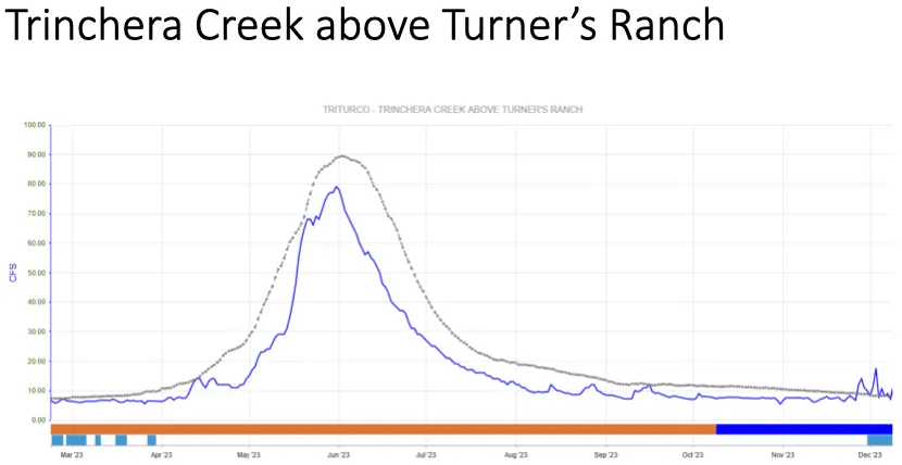
Trinchera Creek above Turner’s Ranch
Trinchera Creek presented the biggest challenges for irrigators in 2023 due to less snow on the Sangre de Cristos than on the San Juans. Trinchera Creek was significantly below average for most of the irrigation season.
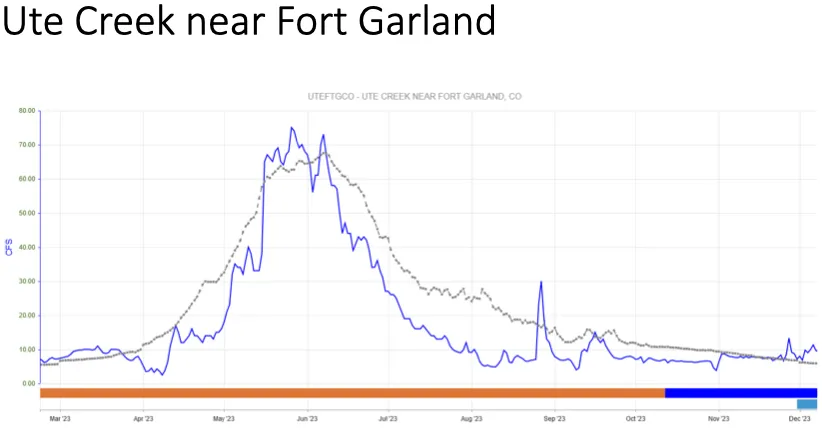
Ute Creek near Fort Garland
Ute Creek too forms from the Sangres. Unlike the Trinchera Creek, it got to average and a bit above for the peak of the 2023 spring runoff and then dropped to below-average streamflows for the year.

Alamosa Creek above Terrace Reservoir
The highlight of the heavy snow from 2022-23 and the corresponding spring runoff was the spilling of Terrace Reservoir for the first time in 40 years. “That was really neat to see,” Cotten said.
Spring and summer 2024 forecasts
Looking to the 2024 spring runoff, current snowpack levels are at 71 percent of normal for the Rio Grande Basin and the lowest for any basin in Colorado by a significant amount. “We do still have some time to get up that average,” Cotten said. “If we can get some good snowstorms coming our way, hopefully we’ll be in decent shape for this year.”
Precipitation outlook through March shows potential for more snow that would help build up the snowpack for spring water. The spring months show an equal chance for precipitation and then below-average forecasts for the summer months. The temperature forecasts for the summer do not predict the same type of record-setting heat as the summer of 2023.

Click the link to read the article on the Inkstain website (John Fleck):
The Bureau of Reclamation’s January 2024 “Most Probable” 24-month study forecasts that annual releases from Glen Canyon Dam for both Water Years 2025 and 2026 will be 7.48 million acre-feet per year (maf). If this happens, the ten-year total flow at Lee Ferry for the 2017-2026 period will drop to about 83.0 maf, only about 500,000 acre-feet above 82.5 million acre-feet, the first 1922 Compact hydrology “tripwire.”
That line – 82.5 maf feet of Lee Ferry deliveries over a ten year period – has become a dividing line between two contending interpretations of the most important unresolved question in the century-old Colorado River Compact: How much water must the Upper Basin deliver to the Lower Basin? What happens if it doesn’t?

The consequences of triggering the tripwire, which might happen in 2027, are significant. In the worst case scenario, it could plunge the basin into Supreme Court litigation over the interpretation of the 1922 Compact, which could result in a forced curtailment of post-compact water uses in the Upper Basin. Or, alternately, if the Basin States are willing to settle their long-term disputed issues or implement basic changes to the Law of the River via the renegotiations of the post-2026 operating rules, it could be a “non-event.” This is one of the fundamental issues facing the states as they meet to develop their basin-state alternative.
The 82.5 maf tripwire is based on the 1922 Compact’s two flow-related requirements at Lee Ferry; Article III(d) requires the four Upper Division States to not cause the progressive ten-year flow at Lee Ferry to be depleted be depleted below 75 maf. Additionally, Article III(c) provides that if there is not sufficient surplus water to meet the annual water delivery requirements of the 1944 Mexican Treaty, normally 1.5 maf, then each basin must provide half of the deficiency (the required annual delivery minus the available surplus). The Upper Division States must deliver their share of the deficiency at Lee Ferry in addition to their obligations under Article III(d).
The Upper Division and Lower Division States have never agreed on the meaning and interpretation of Article III(c). There have been numerous papers on the disputed issues by both compact scholars and practitioners and Article III(c) has never been interpreted by the U.S. Supreme Court. Suffice it to say that the Lower Division States believe that the Upper Division States must deliver at Lee Ferry a total of 82.5 maf every ten years (75 maf + 10 x 750,000), but the Upper Division States believe that they currently have no obligation to Mexico, so the number is at most 75 million. There are of course, nuances. The Lower Division States have suggested that the Upper Division States might also need to cover transit losses between Lee Ferry and Mexico and the Upper Division States have most recently suggested that if climate change, not Upper Basin depletions, is causing the ten-year flow to fall below 75 million, then their article III(d) non-depletion obligation must be appropriately adjusted. Further, if pursuant to either the extraordinary drought provision or a treaty minute, the required annual delivery to Mexico is less than 1.5 maf, then, even with no surplus, the Upper Division’s 50% share would be less than 750,000 acre-feet.
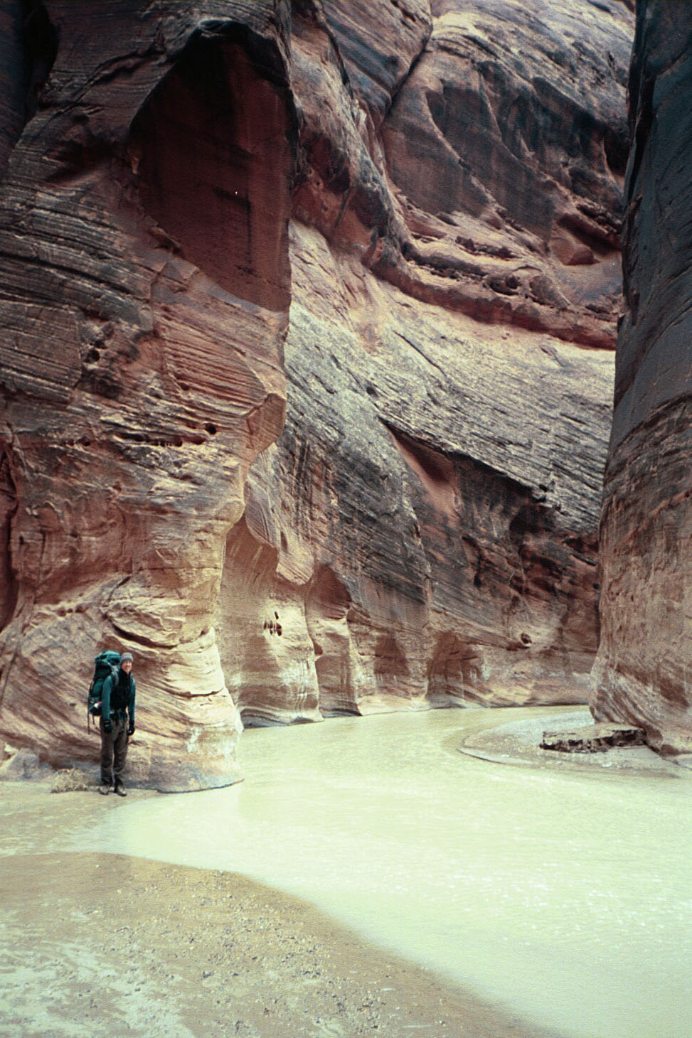
One should recognize that the annual releases from the Glen Canyon Dam and the annual flow at Lee Ferry (the compact point) are not the same. Between the dam and Lee Ferry, the river gains flow from groundwater accretions (in part due to leakage around the dam) and from the Paria River. These gains can vary from about 30,000 acre-feet to over 300,000 acre-feet annually. The ten-year Lee Ferry flow for 2014-2023 was approximately 86.1 maf.
That amount – 86.1 maf – might seem like a safe cushion. But because it is a ten-year moving total, we are about to drop out years with big releases (9 million acre feet) and replace them with years with just 7.48 maf. At the end of 2024, because both 2014 (the year that drops out) and 2024 (the year that is added in) are 7.48 maf years, the ten-year flow will stay about the same. The way the ten-year flow calculation works is next year, 2015 will drop out and 2025 will be added in, and so on, but here is the problem; From 2015 through 2019, the 2007 Interim Guidelines dictated an annual release of 9 maf per year. With accretions, flows at Lee Ferry averaged about 9.18 maf per year (source: UCRC 74th Annual Report). Thus, if 2025 and 2026 are 7.48 maf years, the ten-year flow will lose about 1.5 maf/year making the total about 83 maf for the 2017-2026 period. Because the 2007 Interim Guidelines expire, we don’t know what the annual release will be in 2027, but if it’s less than about 8.5 maf, because 2017 was a 9 maf year, the ten-year Lee Ferry flow could drop below the tripwire – 82.5 maf (with two more 9 maf years, 2018 and 2019, in the pipeline).
We recognize that the 24-month studies don’t predict the future. They are a planning and management tool. It’s plausible that by 2027, a series of wet years could result in a ten-year flow that is much higher than 82.5 maf, something that is, in our view, unlikely. But as we sit here in January 2024, the 24-month study is the only planning tool we’ve got. It would behoove us to pay attention to what it is telling us.
If a future 24-month study projects that ten-year flows will fall below 82.5 maf, it will be a big deal for the basin. What provision of the Law of the River will control annual releases from Glen Canyon Dam – the post-2026 Operating Guidelines, the Lower Division’s interpretation of the 1922 Compact (82.5 maf), or the Upper Division’s interpretation of the 1922 Compact (75 maf or less)? If the Lower Division States agree to a ten-year flow target of less than 82.5 maf, are they effectively surrendering to the Upper Division States? If the Upper Division States agree to a flow target of 82.5 maf, are they effectively surrendering to the Lower Division States? If the Upper Basin states agree to either 82.5 maf or some smaller compromise delivery target and the hydrology remains bad, how will Wyoming, Colorado, New Mexico, and Utah – our states – approach the required water use reductions? What if there is not enough water in storage in Lake Powell (and the other CRSP reservoirs) to release sufficient water to bring the ten-year flows to 82.5 maf? Will the Lower Division insist that that the UCRC implement a curtailment of post-compact uses in the Upper Basin. If the UCRC refuses to do so, will that plunge the Basin into litigation?

At the recent 2023 CRWUA meeting, representatives of the Lower Division States stepped up and made it clear they own the “structural deficit,” and the conference was buzzing with talk of the innovative system approach the Lower Division has put on the table. This is great news, but as Colorado’s Royce Tipton concluded sixty years ago, the “structural deficit” is not a single number. It’s a range that depends on the interpretation of the Lee Ferry obligations of the Upper Division States under the 1922 Compact. If the average annual flow requirement is 8.25 maf/year, (which Tipton referred to as “fictional”) he calculated the deficit to be about 1.2 maf/year. Today we believe it’s about 1.4 -1.5 maf/year (Tipton’s assumptions about system losses were probably too low and perhaps his Lee Ferry to Lake Mead inflow assumptions too high). If, however, the average annual flow requirement is 7.5 maf/year, he calculated the deficit to be about 2 maf/year, today maybe 2.2 maf/year. This difference is huge, especially for the Central Arizona Project, the junior user on the Lower basin mainstem.
In the past decades, water managers in the Colorado River Basin have made accomplishments that even two decades ago were considered out of reach: The 2019 Drought Contingency Plans, the shortage sharing agreements with Mexico, the increased recognition of the rights of the Basin’s Native American communities are just a few. The Lower Division’s recent pronouncement that they own the structural deficit is another major step forward, but it has a fundamental flaw. Representatives of all seven Basin states continue to stubbornly insist that the Law of the River, and specifically, the 1922 Colorado River Compact, will serve as the “foundation” of the post-2026 operating guidelines. The flaw is that is that we don’t know if this foundation is based on a ten-year Lee Ferry flow of 82.5 maf, or 75 maf, or something different.
Put simply, the states agree that the Law of the River has to be the basis of what we do, but don’t agree on what the Law of the River actually says. [ed. emphasis mine] Without an agreement on this fundamental issue, calling the 1922 Compact a foundation is nothing more than self-delusional wishful thinking. Now that the Lower Division States have agreed to own the structural deficit, is the next step for all seven states and the federal government to openly acknowledge that given the impacts of climate change on the river, the 1922 Compact’s overallocation of water and its disputed Lee Ferry flow provisions are core problems for the basin, not the foundation? Finding a sustainable future, without litigation, will require accepting and acknowledging the basic problems we face, not avoiding them.

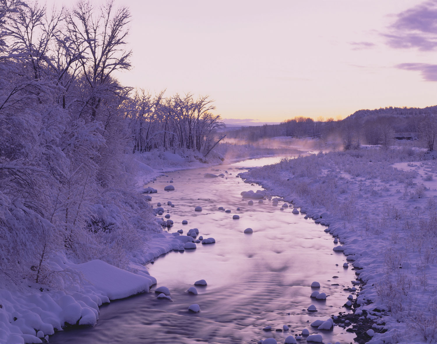
Click the link to read the article on the Colorado Water Trust website (Sarah Klahn):
It is a bitterly cold December morning and I am tooling up Boulder Canyon to do some backcountry skiing above Nederland. As I slow down for a hairpin turn, the sun makes its way over the edge of the canyon and I notice some movement in the creek. It’s a little bird known as a Dipper, bobbing up and down on a rock in the creek—and now diving into a pool below a fallen tree. These incredible birds live year-round near flowing streams in the Rocky Mountains and elsewhere in the west. They dive underwater for their food—aquatic insects—and actually have an extra eyelid so they can see while they’re underwater! Dipper populations on a stream mean it has excellent water quality and low silt load—both characteristics of Boulder Creek in Boulder Canyon above the City of Boulder.
Excellent water quality for Dippers and other species that live in or around aquatic ecosystem starts—of course—with water in the stream. In Colorado, water use is controlled under the state’s “prior appropriation system”, which forms the legal framework for water distribution in the state. You may have heard the phrase “first in time is first in right” which simply means the more “senior” rights to use a quantity of water are associated with the earliest uses. In many parts of the state (for example the Cache La Poudre River near Fort Collins or the Rio Grande and its tributaries near Alamosa), many irrigation water rights pre-date statehood. And, while the act of putting water to use forms the basis of a water right, that right is only enforceable if confirmed by a district court or, since 1969, Colorado’s water courts.

In many, if not most streams in the state, the amount of water decreed far exceeds available water supplies. Such streams are “over-appropriated”, meaning that only in a very wet year will many of the more recent (“junior”) water rights get to divert water. In fact, Boulder Creek is over-appropriated at locations downstream of the City of Boulder. The Dippers are still safe in the canyon, where there are few actual diversions of water for consumptive use.
“Over-appropriated” as a concept gets a bad rap. At the time of European settlement, those turning the prairie and mountain valleys into farms and cities were focused on building new homes in an unfamiliar place. Whether we agree with these decisions today, at the time, claiming every drop of available water was an obvious start to settling in a place as arid as Colorado. But Colorado’s prior appropriation system also has flexibility that allows volumes of water to be assigned to “instream flow” uses—providing a means to leave water in the stream to benefit aquatic ecosystems, including our friend the Dipper.
The Colorado Water Trust is on the forefront of creative and thoughtful efforts to use flexibility in state water law to put water back into streams. The Trust works to identify both streams in need of additional flows and water rights owners who want to re-imagine the use of their consumptive water rights to improve stream health in their own neighborhood. Broadly, these tools fall into two categories: leases or loans, which are used by the Trust and water right owners who want to maintain ownership of their water rights; and purchase of water rights from owners who are interested in selling to the Colorado Water Trust.

On the Crystal River, a tributary of the Colorado River, the Water Trust and Cold Mountain Ranch, a water user diverting from a critical reach of the Crystal River, entered into an agreement that compensates the Ranch for coordinating diversions in a manner that enhances stream flows. The result is two-fold: the Ranch coordinates its diversions during certain types of water years to benefit the stream flow, but maintains ownership of its valuable, senior irrigation rights for use when water is more plentiful; and the stream benefits in years in which the river reach would otherwise be dry.
The Trust has also, from time to time, purchased portions of water rights, including an interest in the McKinley Ditch which diverts from the Little Cimarron River near Gunnison. Historically, three miles of the Little Cimarron River near Gunnison ran dry during late summer, due to upstream water diversions. Working with the Trust’s frequent partner, the Colorado Water Conservation Board, the Trust obtained a change decree from the Division 4 Water Court. The change decree authorizes the Trust’s water, which would otherwise be limited to irrigation uses, to be left in the stream for the benefit of the aquatic ecosystem.

The Dippers in Boulder Canyon are in good shape, given the water quality and flow regime in Boulder Creek below Barker Dam; any resident Dippers in the Cimarron or Crystal watersheds in the vicinity of the Water Trust’s projects are in better shape than they were before the Trust’s projects were initiated. And for other streams in Colorado that may experience extreme low flows (or dry up completely) during certain types of water years, the Water Trust is actively looking for opportunities to partner with senior water right owners and use available tools provided by the prior appropriation system to enhance stream flows and enhance and protect aquatic ecosystems.
Sarah Klahn is a member of the Water Trust Board of Directors and a shareholder in Somach Simmons & Dunn. Sarah represents farmers and ranchers, as well as institutional clients, on water rights matters in four western states.
From email from Pete Kolbenschlag (Colorado Farm & Food Alliance):
The North Rim of the Black Canyon, in the National Park, which is accessed from Fruitland Mesa near Crawford – a remote region of ranches at the base of the West Elk Mountains – showcases an especially dramatic feature. Even among many spectacular places in western Colorado it impresses, marking where the Southern Rockies transition into the mesas, deserts and canyons of the Colorado Plateau. This cherished national treasure is also a local North Fork favorite, found on the way to Blue Mesa and the city of Gunnison.
The Colorado Farm & Food Alliance is supportive of public lands conservation, for protecting the stunning landscapes near our home-base. Set into this amazing landscape are small towns like Crawford, Paonia and Hotchkiss, and scattered between and on the mesas all around are the farms, ranches, wineries and businesses that work hard to make it here.
As we consider how we can adapt rural communities to be resilient and prosperous in a changing climate and dynamic future, we think that land conservation and watershed health are two of the most important, and effective, strategies we can pursue. That is one reason, as we look even further west, across the Uncompahgre Plateau, into the heart of Colorado’s red rock canyon country along the Dolores River, we see opportunity.
Far less visited than Moab and Monticello, Utah which lie just on the other side of the La Sal Mountains and Paradox Basin, the looming Wingate cliffs along this tributary to the Colorado River, which it joins at Dewey Bridge just over the stateline, contain an unique, fascinating, often hardscrabble history.
Back in the North Fork Valley, the Black Canyon National Park is not the only nearby designated national park service or conservation area. Just downstream is the Gunnison Gorge National Conservation Area. And above it is the Curecanti National Recreation Area which includes not only Blue Mesa reservoir, Colorado’s largest water body, but seldom visited upper reaches of the Black Canyon itself, with sweeping vistas of the San Juan Mountains and the Uncompahgre Plateau. Protected public lands are critical components of the economy in this region.
So lately as talk has percolated up from people who love the red rock Dolores River country, about securing protections to conserve what is unique and important about it, we pay attention. Sen. Bennet has long championed a bill to establish a national conservation area for part of the Dolores Canyon region. And more recently, a growing coalition of businesses, conservation groups and local elected officials are calling on President Biden to designate a national monument for a part of the region as well.
We think this could be a great opportunity to ensure what is unique there remains intact and that local businesses benefit from growing visitation to the region. Given the rich history in the West End of Montrose County, like the Hanging Flume and the town of Uravan – a critical player in the Atomic Age – it’s no wonder community leaders are wanting to protect the area.
Towns like Naturita and Nucla, with their markets and cafes, can serve as hubs that support local farms and residents, as they always have, and play host to visitors and activities, provide guides and services, and be the jumping off and provisioning point for the more adventuresome.
For places as rooted in tradition as are the rural communities of western Colorado, public land conservation and protecting the health of our lands and watersheds is a solid strategy to preserve what we care about most. And to welcome new opportunities. This is the strongest connection we see with our friends on the West End: protected public lands protect a rural way of life – and can help us better prepare for and better prosper in the future.
As 2024 opens to new possibilities, we cannot think of a better conversation than how to secure a locally-rooted, sustainable, and prosperous future for the Dolores Canyon Country and the rural, western communities of our local and nearby watersheds. As President Biden looks for legacy projects to leave with future generations, now is the time for Colorado’s leaders like Senators Hickenlooper and Bennet, and Governor Polis to speak up and urge the president to act.


Click the link to read the article on the Aspen Journalism website (Heather Sackett):
Puckett Land Co.’s 23,893 acre-foot proposal dates to 1966, part of “integrated system” involving lands in Garfield and Rio Blanco counties
A company with an interest in oil shale development in western Colorado is seeking to maintain its water rights associated with a proposed reservoir on Thompson Creek that would be located within an area proposed for oil and gas lease withdrawal.
Puckett Land Co. is seeking to hold on to conditional water rights that date to 1966 for a 23,893-acre foot reservoir on Thompson Creek, a tributary of the Crystal River just south of Carbondale. It would be nearly one-fourth the size of Ruedi Reservoir, which, when full, holds just over 100,000 acre-feet. The reservoir site is located on Bureau of Land Management land in Pitkin County.
According to water court documents filed in November, Puckett says the water is needed for the “commercial development of Puckett’s oil, gas, coalbed methane and/or oil shale minerals.” The water is decreed for industrial, domestic, recreational, irrigation, power, mining and all other purposes related to shale oil production, including the maintenance of a camp and community.
Puckett Land Co., based in Greenwood Village, Colorado, holds interests in 17,500 acres of land in Garfield and Rio Blanco counties, according to the application. The Thompson Creek water rights are described as being part of an integrated system that includes conditional rights for two small reservoirs, and a pump and pipeline on Starkey Gulch, a tributary of Parachute Creek. Those Parachute Creek basin reservoirs have not been constructed.
Attorney for Puckett Land Co. Peter D. Nichols said that it would be inappropriate to respond to questions from Aspen Journalism while the application is pending in water court.
The proposed reservoir site is within the boundaries of an area that the U.S. Forest Service and BLM are proposing to withdraw from eligibility for new oil and gas leases. The proposed Thompson Divide withdrawal area is comprised of 224,713-acres in Garfield, Gunnison and Pitkin counties that generally straddles the ridge of mountains running from south of Glenwood Springs to the northern edge of the West Elk Wilderness, south of McClure Pass.
Carbondale-based conservation group Wilderness Workshop supports the withdrawal, and executive director Will Roush said a reservoir on Thompson Creek is highly problematic for many reasons, including its many harmful effects on the ecosystem.
“The local community has been working for over a decade to protect Thompson Creek and the surrounding lands; damming the creek runs counter to these efforts and deeply held community values,” Roush said in a statement. “Furthermore, the intended use of this water would be to enable oil shale and other fossil fuel production. Given our water and climate crises, utilizing precious West Slope water to increase climate pollution is simply unacceptable.”
The proposed reservoir site is just upstream from Sunfire Ranch, which is near the confluence of Thompson Creek and the Crystal River. In 2020, Pitkin County spent $10 million to put a conservation easement on the property, meaning that most of the 1,240-acre property is protected from development. Pitkin County also has its own taxpayer-funded board, Healthy Rivers, that funds programs and grant requests that focus on improving water quality and quantity.
Pitkin County Attorney John Ely said he is evaluating Puckett’s application and deciding whether the county wants to weigh in. Interested parties have until Jan. 31 to file statements of opposition in water court. As of Friday, no such statements had been filed.
Proposed Thompson Creek reservoir
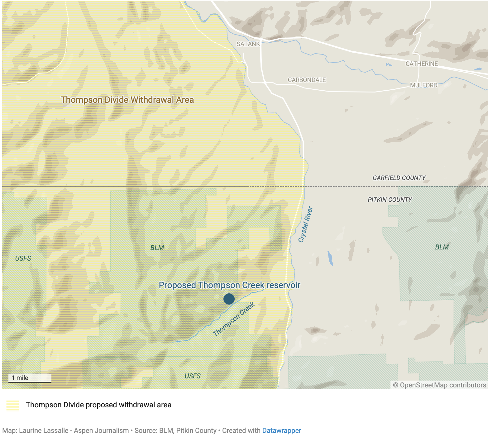
Conditional water rights
The reason Puckett has been able to hold on to water rights that are nearly 60 years old without putting them to beneficial use lies in a quirk of Colorado water law that at least one scholar says needs to be reformed. Conditional water rights allow a would-be water user to reserve their place in the priority system based on when they applied for the right — not when they put water to use — while they work toward developing the water. Under the cornerstone of water law known as prior appropriation, older waters rights get first use of the river.
To maintain a conditional right, an applicant must every six years file what’s known as a diligence application with the water court, proving that they still have a need for the water, that they have taken substantial steps toward putting the water to use and that they “can and will” eventually use the water. They must essentially prove they are not speculating and hoarding water rights they won’t soon use.
But the bar for proving diligence is low. Judges are hesitant to abandon these conditional water rights, even if they have been languishing without being used for decades. Andrew Teegarden, a water fellow at the Getches-Wilkinson Center for Natural Resources, Energy and the Environment at the University of Colorado School of Law, argues this is partly because in Colorado water is treated as a property right.
“Some of the standards I think are a little lackadaisical merely because they don’t require the holders to spell out and specify all of the diligence activities that an individual took,” Teegarden said. “Most of the diligence applications that you’ll see are not filled with tons and tons of information; it’s more general statements about things like maintenance and building infrastructure. … It seems like we could require a little bit more specificity out of some of these holders.”
In Puckett’s diligence filing, the company says that in the past six years, it has spent nearly $100,000 on maintaining, repairing and upgrading its infrastructure and overall water system on its properties in the Colorado River basin; spent more than $80,000 on operational activities such as road maintenance and erosion control; spent more than $16,000 on professional services, including survey and title work; and has spent more than $80,000 on legal services to protect and develop its water rights.
The application does not specifically mention work regarding the Thompson Creek reservoir site in its list of diligence activities and says that diligence on any part of the system constitutes diligence with respect to the entire system. It is not clear how the Thompson Creek reservoir would operate with other parts of the system.
Puckett also said in its application that current economic conditions are adverse to oil shale production, but that that should not be sufficient on its own to deny its diligence claim.
Diligence filings are common and often fly under the radar. In 2017, the last time Puckett filed a diligence application for the Thompson Creek reservoir, no parties filed statements of opposition in the case. In the diligence filing prior to that, in 2010, only one party — the owners of the Crystal River Ranch — came forward as opposers. In that case, Puckett agreed to abandon conditional rights for a pipeline that would have diverted water from a point below the proposed dam.
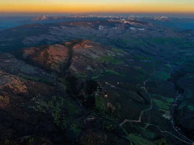
Oil shale and water use
In 2009, conservation group Western Resource Advocates produced a report called “Water on the Rocks” about oil shale water rights in western Colorado. According to the report, in anticipation of a boom, in the 1950s and ‘60s, companies with an interest in western Colorado oil shale amassed an enormous portfolio of water rights because extracting the oil from shale, a type of sedimentary rock, requires huge amounts of water. The report found that there were conditional water rights associated with oil shale development for 27 reservoirs with 736,770 acre-feet of water in the mainstem of the Colorado River basin.
If these conditional water rights were to be developed, the impacts could be felt by other water users throughout the basin. When the holders of conditional rights with older priority dates finally begin diverting water they have not used in decades, they may force junior rights holders to stop using water, something Teegarden calls “line-jumping.” The sheer volume of water tied to oil shale development, if ever used, could upend the whole system.
“As soon as some of these conditional rights begin coming online, they’re going to curtail these users that have been receiving that water in some cases for decades,” Teegarden said. “We have these users who have been making productive use of the state’s water for all this time and have been following all of the requirements of the law, but now they are the ones that might be punished for their use of the water.”
In a draft paper on the unintended consequences of conditional water rights in Colorado, Teegarden advocates for reforms to the anti-speculation and due-diligence standards. He says if users fail to put water to beneficial use within the typical 10-year abandonment period, the conditional water rights should be abandoned. With the help of the legislature, water courts could also implement a strict time limit for putting conditional rights to beneficial use and stop allowing them to exist indefinitely. For example, extensions through diligence filings could stop being granted after 50 years.
“I think that we really need to be serious about looking into and reforming these conditional rights before the time comes where we see some of these impacts to other water users across the state,” Teegarden said. “Because if we wait until that point, we won’t be able to guarantee a water-secure future, especially with the volumes of water that are associated with these conditional rights.”


Click the link to read the article on the InkStain website (John Fleck):
January 12, 2024
New Mexico once again fell short in 2023 of the requirement set out in the Rio Grande Compact to deliver water to Elephant Butte Reservoir for use in Southern New Mexico, Texas, and Mexico, delivering ~25,000 acre feet less than the Compact requires, according to preliminary estimates presented at Monday’s meeting of the Middle Rio Grande Conservancy District.
These numbers are preliminary. The final, official numbers will be sorted out at this spring’s meeting of the Rio Grande Compact Commission. But if they hold, that would put New Mexico’s cumulative Compact debt at ~125,000 acre feet.
Really bad things don’t start happening until New Mexico’s cumulative Compact debt rises above 200,00 acre feet, but lessbad things are already happening now as a result of the debt. Under Article VI of the Compact:

Translated, that means any runoff we could actually store in upstream reservoirs in 2024 we can’t use, but rather have to hang onto to run down to Elephant Butte after the end of the irrigation season.
RUN-OF-THE RIVER AGAIN FOR MIDDLE VALLEY IRRIGATORS, AND FOR THE FISH
There’s a complex interaction here between physical storage* and rules. But the bottom line is that once again this summer, water users in New Mexico’s Middle Rio Grande Valley, the stretch of the river between Cochiti Pueblo and Elephant Butte Dam, will be entirely dependent on natural runoff available after the farmers in the San Luis Valley of Colorado take their share of the river.
I would predict, as a result, that:
- People who irrigate in the Middle Valley should expect a high risk of significant stretches with no ditch water in the summer,
- Water available for instream flows for the endangered Rio Grande silvery minnow will once again be extremely tight, with a high likelihood of drying in the Isleta and San Acacia reaches this summer, and
- The Albuquerque Bernalillo County Water Utility Authority is likely to shut down river diversions for its drinking water plant at some point in the summer and switch over to groundwater pumping so I can keep taking showers.
* PHYSICAL STORAGE
El Vado Dam, built by the federal government and the Middle Rio Grande Conservancy District in the 1930s to store water during the spring runoff peak for irrigators to use in the late summer is under repair, a project taking way longer than expected. It’s likely that the necessary paperwork to store some water in Abiquiu Reservoir will be in place by runoff season, but the Compact Article VI debt means that water cannot be used for irrigation in 2024.


From email from Reclamation (Susan Novak Behery):
January 17, 2024
At 3:00 PM on January 29th (Monday), the release at Navajo Dam will be transferred to the 4×4 Auxiliary outlet, where the release will be reduced to 250 cfs. The minimum release will accommodate instream work for the Turley Manzanares Ditch Company Diversion Dam Rehabilitation Project. The release will be transferred back to the power plant and increased back to its current level of 350 cfs at 8:00 AM the following morning, January 30th, 2024 (Tuesday). You may expect some silt and discoloration downstream in the river during this time due to the location of the intake of the 4×4.
This scheduled operation is subject to changes in river flows and weather conditions. If you have any questions, please contact Susan Behery (sbehery@usbr.gov or 970-385-6560), or visit Reclamation’s Navajo Dam website at https://www.usbr.gov/uc/water/crsp/cs/nvd.html
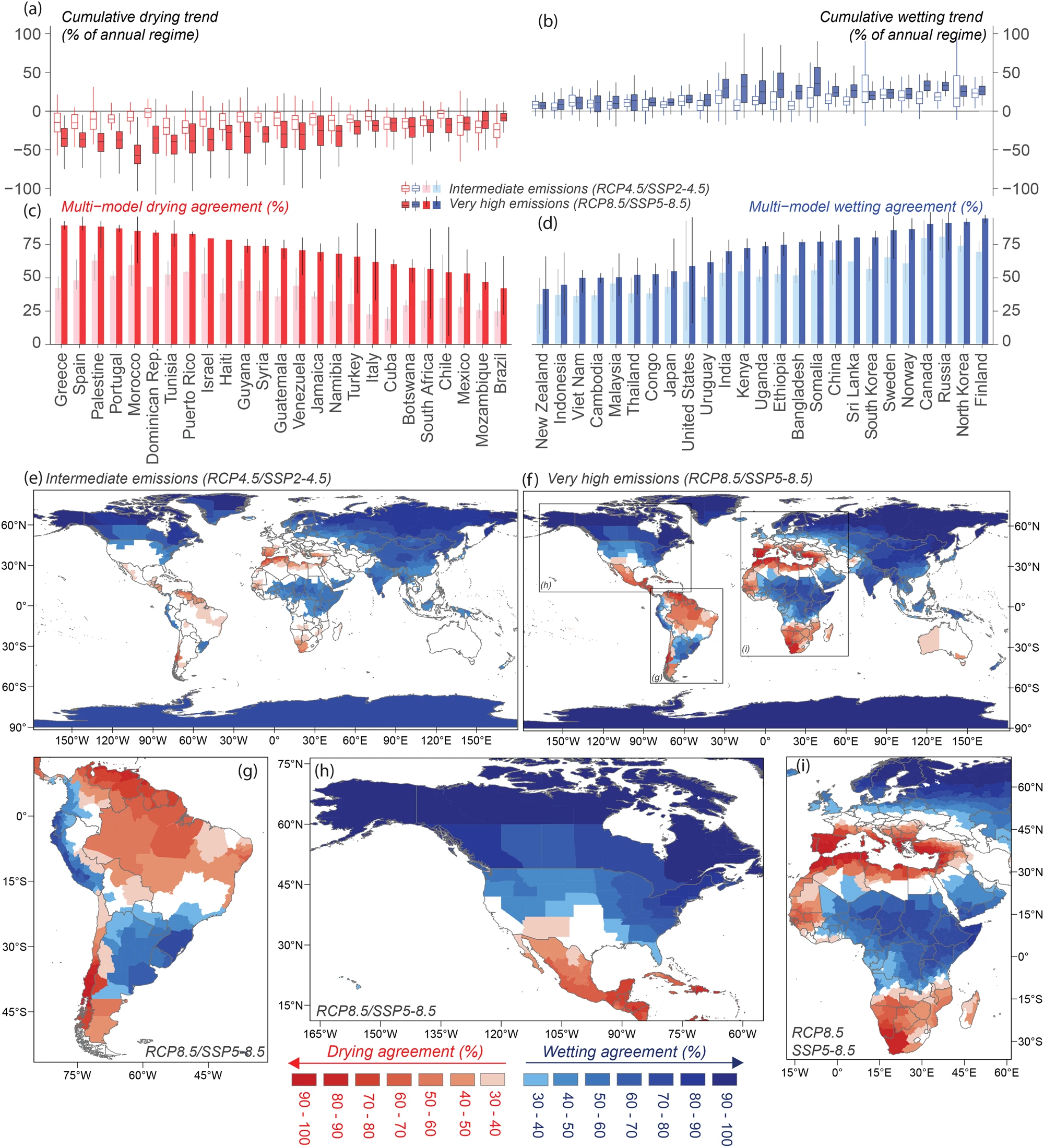
Click the link to access the article on the Nature website (Ralph Trancoso, Jozef Syktus, Richard P. Allan, Jacky Croke, Ove Hoegh-Guldberg & Robin Chadwick). Here’s the abstract:
Future projections of precipitation are uncertain, hampering effective climate adaptation strategies globally. Our understanding of changes across multiple climate model simulations under a warmer climate is limited by this lack of coherence across models. Here, we address this challenge introducing an approach that detects agreement in drier and wetter conditions by evaluating continuous 120-year time-series with trends, across 146 Global Climate Model (GCM) runs and two elevated greenhouse gas (GHG) emissions scenarios. We show the hotspots of future drier and wetter conditions, including regions already experiencing water scarcity or excess. These patterns are projected to impact a significant portion of the global population, with approximately 3 billion people (38% of the world’s current population) affected under an intermediate emissions scenario and 5 billion people (66% of the world population) under a high emissions scenario by the century’s end (or 35-61% using projections of future population). We undertake a country- and state-level analysis quantifying the population exposed to significant changes in precipitation regimes, offering a robust framework for assessing multiple climate projections.
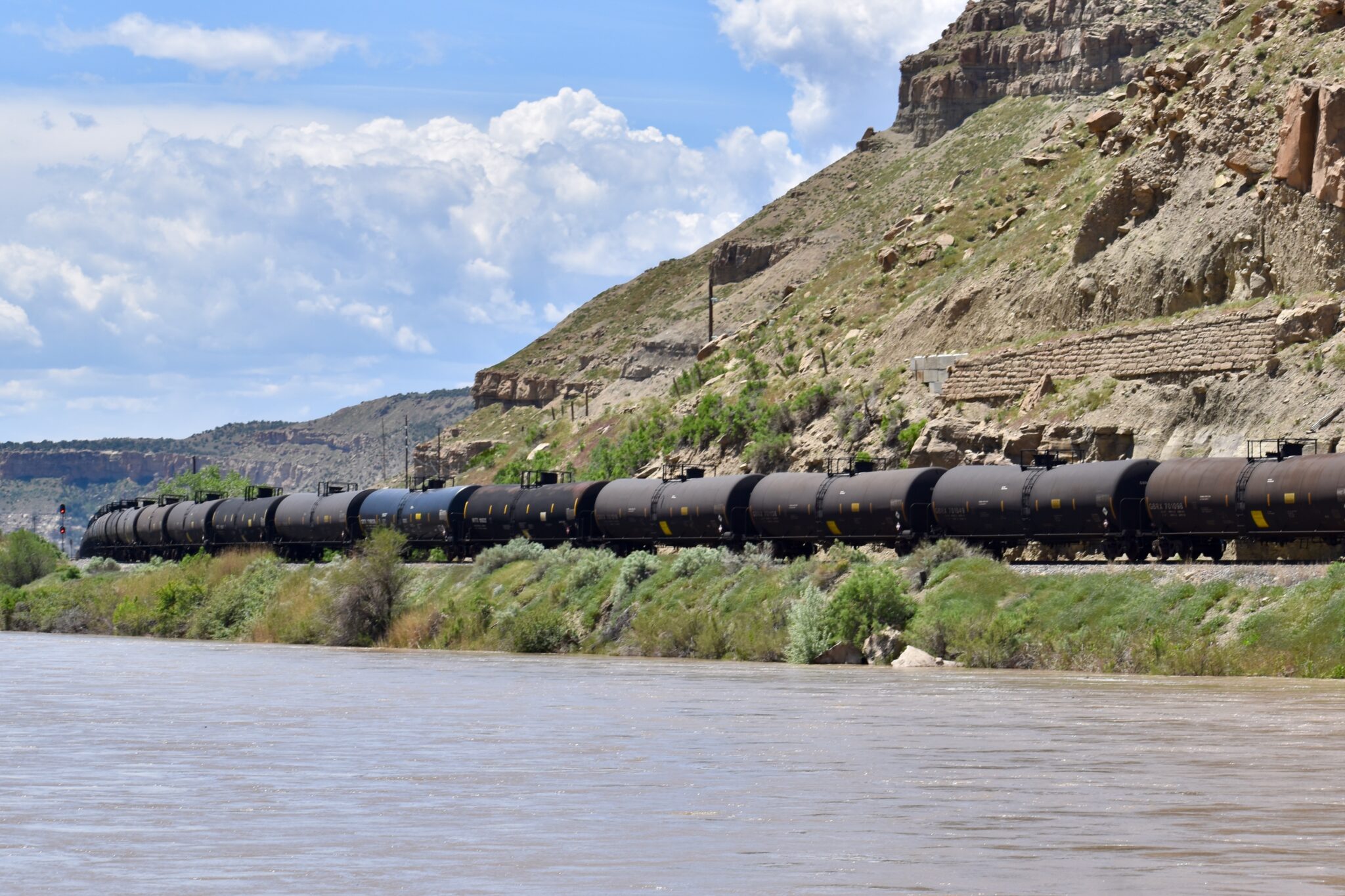
Click the link to read the article on the Colorado Newsline website (Chase Woodruff):
January 18, 2024
A controversial Utah oil-train proposal opposed by Colorado communities and environmentalists was dealt another blow this week when the U.S. Forest Service withdrew a key permit for the project.
In an announcement published Wednesday, Ashley National Forest Supervisor Susan Eickhoff blocked the issuance of a permit to the Uinta Basin Railway to construct 12 miles of railroad track through a protected area of the national forest in northeast Utah. The stretch of track in question is part of the proposed railway’s 88-mile connection between the oil fields of eastern Utah’s Uinta Basin and the existing national rail network.
The project has drawn fierce opposition from Coloradans. A federal “downline analysis” estimated that 90% of the resulting oil-train traffic — as many as five fully loaded, two-mile-long trains of crude oil tankers per day — would be routed through environmentally sensitive and densely populated areas in Colorado, en route to oil refineries on the Gulf Coast. The oil trains would more than quadruple the amount of hazardous materials being shipped by rail through many Colorado counties.
Colorado’s Eagle County and five environmental groups sued to overturn the Uinta Basin Railway’s approval, and in August 2023 a panel of federal judges ruled that the approval process contained “numerous” and “significant” violations of the National Environmental Policy Act. The ruling vacated portions of the project’s environmental impact statement and ordered the federal Surface Transportation Board to redo its analysis of key environmental risks.
Because the Forest Service’s decision in August 2022 to grant a right-of-way permit to the project was based on that flawed analysis, the agency has withdrawn its decision pending further proceedings at the STB.
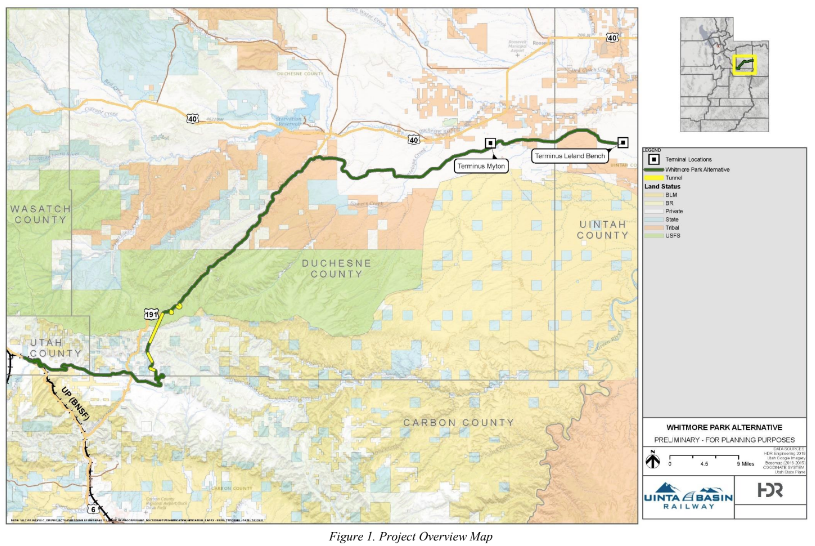
“If the deficiencies are addressed and resubmitted for consideration, the Forest Service may issue a new decision,” Eickhoff wrote in a Jan. 17 letter.
“This is wonderful news for the roadless forest in Utah’s Indian Canyon and the wildlife who call it home,” said Ted Zukoski, senior attorney with the Center for Biological Diversity, one of the groups that sued to block the project. “It’s a victory for the Colorado River and nearby communities that would be threatened by oil train accidents and spills, and for residents of the Gulf Coast, where billions of gallons of oil would be refined. If the oil train’s backers attempt to revive this dangerous scheme, we’ll be there to fight it again.”
In a press release, Democratic U.S. Sen. Michael Bennet of Colorado, who had urged multiple federal agencies to put a stop to the project, applauded the Forest Service’s move.
“A derailment along the headwaters of the Colorado River could have catastrophic effects for Colorado’s communities, water, and environment,” Bennet said. “I’m glad the Forest Service has taken this important step to protect the Colorado River and the tens of millions of people who depend on it.”
Backers of the railway project include the Seven County Infrastructure Coalition, a group of Utah county governments in the oil-rich Uinta Basin. The coalition’s petition for a rehearing of the case by the U.S. Court of Appeals for the D.C. Circuit was denied in December, though the ruling could still be appealed to the U.S. Supreme Court.
“We’re still looking at options,” Greg Miles, a Duchesne County commissioner and co-chair of the coalition, said during a Jan. 11 public meeting. “We may be making a decision here within the next month.”
Click the link to read the article on The High Country News website (Jonathan P. Thompson):
When it comes to the country’s climate change culprits, the biggest offenders lurk in the transportation sector: Altogether, planes, trains and automobiles, etc., emit 28% of the nation’s greenhouse gases, plus other nasty pollutants that harm anyone who lives near highways and airports. Industrial sources — factories, cement plants, steel mills, etc. — spew nearly one-fourth of our climate-warming pollutants, while commercial and residential buildings are responsible for 13%, and agriculture contributes 10%.
Experts generally agree that the best way to reduce all these emissions is to electrify everything: Just replace petroleum-powered vehicles, natural gas-fired heaters and stoves and coal-fired cement kilns and steel furnaces with their electric analogs. After all, an electric vehicle’s tailpipe emits zero greenhouse gases or other pollutants. In fact, electric vehicles don’t even have tailpipes.
There is one nagging little detail, though: The energy producing all that electricity has to come from somewhere, generally from greenhouse gas-emitting fossil fuels. The electric power sector is the nation’s second-largest emitter of greenhouse gases, after transportation. Electrifying everything might do little more than redistribute emissions from buildings and cars to the power grid. Unless, that is, the power grid is decarbonized, a simple — but monumental — task: The electric power sector needs to quit fossil fuels, cold turkey. And that requires massive investments in new power sources and innovation to remake the grid for a carbon-free world.
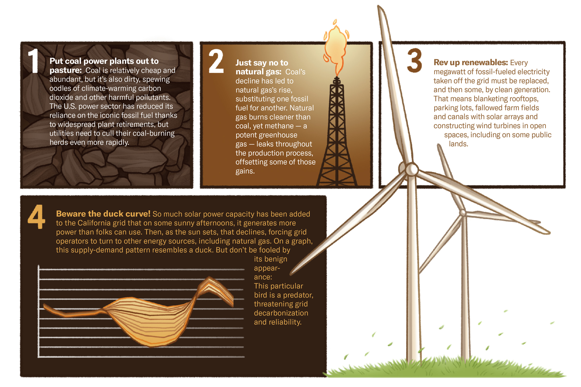
$3.5 million
Funding the New Mexico Mortgage Finance Authority has allocated to help install rooftop solar on low-income households.21,894 megawatt-hours
Amount of electricity produced by utility-scale solar facilities in Oregon in 2015.1.69 million megawatt-hours
Amount produced in 2022.500 megawatts
Amount of battery storage on California’s grid in 2018.8,000 megawatts
Amount of battery storage on California’s grid today.

103.5%
Amount of California’s total demand met by solar power on May 8, 2022, a record.16,044 megawatts
Amount of solar generation on the California grid on Sept. 6, 2023, just after noon, the all-time record so far.1,000
Feet of irrigation canal to be covered by solar panels at a Gila River Indian Community project in Arizona.
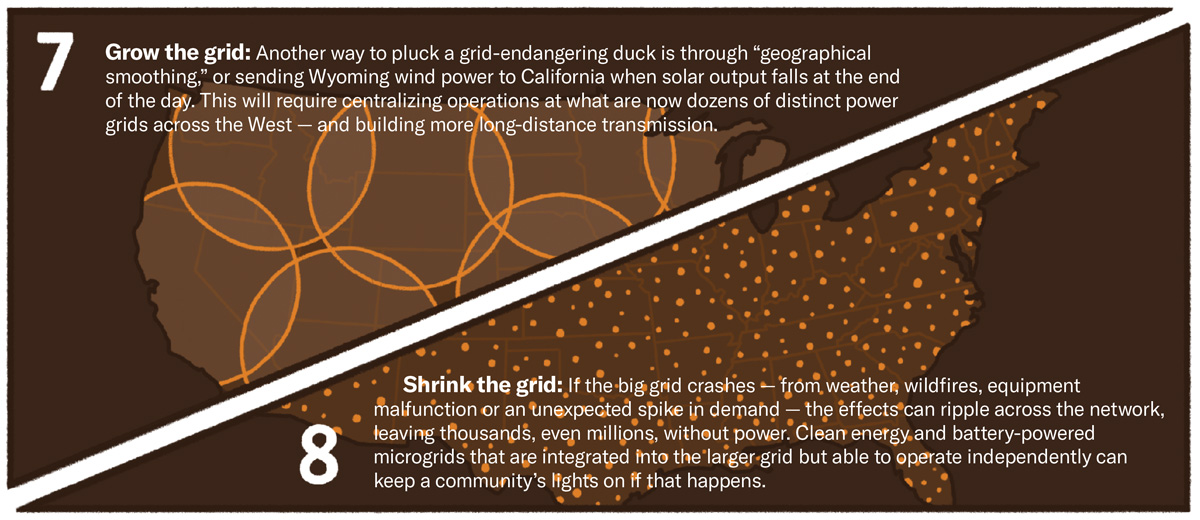
1.05 billion tons
Amount of coal burned for electricity generation in the U.S. in 2007.469 million tons
Amount burned in 2022.7.1 trillion cubic feet
Amount of natural gas burned for electricity generation in the U.S. in 2007.12.4 trillion cubic feet
Amount burned in 2022.
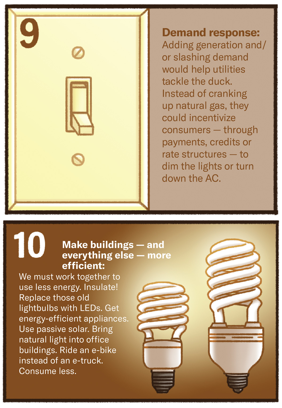
371.5 million metric tons
Carbon dioxide emissions from burning natural gas to generate electricity in 2007.661 million metric tons
Amount emitted in 2022.2.33 billion
2007 total emissions (natural gas and coal).1.5 billion
2022 total emissions.
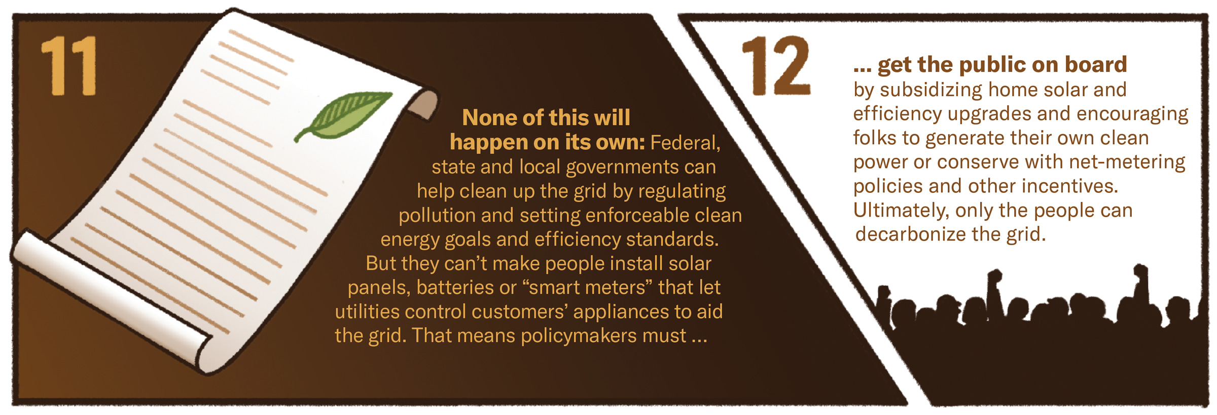
Illustrations by Hannah Agosta/High Country News
Jonathan Thompson is a contributing editor at High Country News. He is the author of Sagebrush Empire: How a Remote Utah County Became the Battlefront of American Public Lands.
Click the link to access the article on the ACS Publications website (Daniel E. Giammar*, David M. Greene, Anushka Mishrra, Nalini Rao, Joshua B. Sperling, Michael Talmadge, Ariel Miara, Kurban A. Sitterley, Alana Wilson, Sertac Akar, Parthiv Kurup, Jennifer R. Stokes-Draut, and Katie Coughlin). Here’s the abstract:
Municipal water reuse can contribute to a circular water economy in different contexts and with various treatment trains. This study synthesized information regarding the current technological and regulatory statuses of municipal reuse. It provides process-level information on cost and energy metrics for three potable reuse and one nonpotable reuse case studies using the new Water Techno-economic Assessment Pipe-Parity Platform (WaterTAP3). WaterTAP3 enabled comparisons of cost and energy metrics for different treatment trains and for different alternative water sources consistently with a common platform. A carbon-based treatment train has both a lower calculated levelized cost of water (LCOW) ($0.40/m3) and electricity intensity (0.30 kWh/m3) than a reverse osmosis (RO)-based treatment train ($0.54/m3 and 0.84 kWh/m3). In comparing LCOW and energy intensity for water production from municipal reuse, brackish water, and seawater based on the largest facilities of each type in the United States, municipal reuse had a lower LCOW and electricity than seawater but higher values than for production from brackish water. For a small (2.0 million gallon per day) inland RO-based municipal reuse facility, WaterTAP3 evaluated different deep well injection and zero liquid discharge (ZLD) scenarios for management of RO concentrate. Adding ZLD to a facility that currently allows surface discharge of concentrate would approximately double the LCOW. For all four case studies, LCOW is most sensitive to changes in weighted average cost of capital, on-stream capacity, and plant life. Baseline assessments, pipe parity metrics, and scenario analyses can inform greater observability and understanding of reuse adoption and the potential for cost-effective and energy-efficient reuse.

Click the link to access the article on the Environmental Evidence website (Madeleine A. Rubenstein, Sarah R. Weiskopf, Romain Bertrand, Shawn L. Carter, Lise Comte, Mitchell J. Eaton, Ciara G. Johnson, Jonathan Lenoir, Abigail J. Lynch, Brian W. Miller, Toni Lyn Morelli, Mari Angel Rodriguez, Adam Terando & Laura M. Thompson). Here’s the abstract:
Background
Among the most widely predicted climate change-related impacts to biodiversity are geographic range shifts, whereby species shift their spatial distribution to track their climate niches. A series of commonly articulated hypotheses have emerged in the scientific literature suggesting species are expected to shift their distributions to higher latitudes, greater elevations, and deeper depths in response to rising temperatures associated with climate change. Yet, many species are not demonstrating range shifts consistent with these expectations. Here, we evaluate the impact of anthropogenic climate change (specifically, changes in temperature and precipitation) on species’ ranges, and assess whether expected range shifts are supported by the body of empirical evidence.
Methods
We conducted a Systematic Review, searching online databases and search engines in English. Studies were screened in a two-stage process (title/abstract review, followed by full-text review) to evaluate whether they met a list of eligibility criteria. Data coding, extraction, and study validity assessment was completed by a team of trained reviewers and each entry was validated by at least one secondary reviewer. We used logistic regression models to assess whether the direction of shift supported common range-shift expectations (i.e., shifts to higher latitudes and elevations, and deeper depths). We also estimated the magnitude of shifts for the subset of available range-shift data expressed in distance per time (i.e., km/decade). We accounted for methodological attributes at the study level as potential sources of variation. This allowed us to answer two questions: (1) are most species shifting in the direction we expect (i.e., each observation is assessed as support/fail to support our expectation); and (2) what is the average speed of range shifts?
Review findings
We found that less than half of all range-shift observations (46.60%) documented shifts towards higher latitudes, higher elevations, and greater marine depths, demonstrating significant variation in the empirical evidence for general range shift expectations. For the subset of studies looking at range shift rates, we found that species demonstrated significant average shifts towards higher latitudes (average = 11.8 km/dec) and higher elevations (average = 9 m/dec), although we failed to find significant evidence for shifts to greater marine depths. We found that methodological factors in individual range-shift studies had a significant impact on the reported direction and magnitude of shifts. Finally, we identified important variation across dimensions of range shifts (e.g., greater support for latitude and elevation shifts than depth), parameters (e.g., leading edge shifts faster than trailing edge for latitude), and taxonomic groups (e.g., faster latitudinal shifts for insects than plants).
Conclusions
Despite growing evidence that species are shifting their ranges in response to climate change, substantial variation exists in the extent to which definitively empirical observations confirm these expectations. Even though on average, rates of shift show significant movement to higher elevations and latitudes for many taxa, most species are not shifting in expected directions. Variation across dimensions and parameters of range shifts, as well as differences across taxonomic groups and variation driven by methodological factors, should be considered when assessing overall confidence in range-shift hypotheses. In order for managers to effectively plan for species redistribution, we need to better account for and predict which species will shift and by how much. The dataset produced for this analysis can be used for future research to explore additional hypotheses to better understand species range shifts.

Click the link to read the article on the Natural Resources Defense Council website (David Doniger):
January 12, 2024
The U.S. Supreme Court is scheduled to hear arguments on January 17 in a pair of cases that could weaken the ability of federal agencies to confront the wide array of challenges the modern world throws at us, from protecting clean air and water to assuring the safety of food and medicines to preventing stock fraud and other financial scams, and more.
The cases Loper Bright Enterprises v. Raimondo and Relentless Inc. v. Department of Commerce challenge the authority of federal agencies to make their best judgments about the detailed rules and standards required to carry out laws that Congress has passed and tasked those agencies to administer.
The cases narrowly involve the management of the Atlantic herring fishery. The stakes, though, are much broader: whether the courts will continue to respect the decisions of the expert agencies, or whether judges will be set free to impose their own preferences on agency actions and decisions. [ed. emphasis mine]
The result could put hundreds of such decisions in the hands of unelected lower-court judges rather than agency professionals who have deep expertise in their appointed fields and who are accountable to the elected branches of government—the president and Congress.
At issue is a legal doctrine called Chevron deference. It came out of the 1984 case of Chevron USA v. Natural Resources Defense Council. In that case, the U.S. Supreme Court ruled that both agencies and courts must follow Congress’s laws when they are clear and unambiguous. But when laws have more than one reasonable interpretation, courts must defer to the reasonable choices made by the expert agencies that Congress has tasked to administer those laws.
NRDC lost that case. In the four decades since, NRDC has both lost and won other cases that have been decided based on the Chevrondoctrine. But NRDC respects the legal framework that the doctrine provides and the important values it serves.
Congress passes the laws the federal agencies administer. And Congress gives agencies the responsibility to administer those laws.
Federal agencies are directly accountable to the U.S. president, the only public official elected nationally to serve the entire country. They are also accountable to Congress, which controls their funding and, through the Senate, decides whether to confirm each agency’s senior leadership nominees.
It is these publicly accountable federal agencies, not unelected judges, that have the responsibility, as well as the legal and technical expertise, to administer our laws in a way that ensures they achieve the purpose Congress intended.
Below are answers to key questions about this foundational legal doctrine and the important stakes these new cases have for the country.
What’s the Chevron case all about?
Federal agencies have both the responsibility and the expertise to administer the laws passed by Congress, to ensure that those laws achieve their intended purpose. For well over a century, the Supreme Court has given great weight and respect to agency interpretations of the laws that Congress told them to carry out.
Under long-standing precedent, when Congress has decided a specific policy issue, agencies and courts must carry out the legislature’s decisions. But when Congress has tasked an agency to flesh out Congress’s policy choices and the agency has made a reasonable determination, then the courts are supposed to respect those determinations.
Forty years ago, the Supreme Court affirmed this doctrine in the Chevron case, saying that federal courts generally must defer to an agency’s reasonable interpretation on points where a statute leaves room for an agency to fill in details or has more than one reasonable interpretation. In such cases, unelected federal judges, lacking the same technical expertise, may not substitute their personal policy preferences for agency interpretations.
Why is the doctrine of Chevron deference so important?
It protects the essential role of federal agencies in writing the rules and standards required to administer laws passed by Congress to protect, for example, public health, worker safety, the integrity of financial markets, or the quality of our air, food, water, and medicine.
It allows federal agencies—which are accountable to elected officials and have developed decades of expertise in the tasks that Congress has assigned to them—to do their duty on the public’s behalf, without having their reasonable policy choices second-guessed by unelected judges.
It provides judges with clear guidelines for resolving legal disputes regarding the administration of laws intended to safeguard the public.
And it clarifies the roles of the three branches of federal government (legislative, executive, and judicial) so as to promote nationwide consistency in the administration of our laws and minimize the number of conflicting court decisions due to diverse policy inclinations from individual judges.
That entire legal framework—and the protections, assurances, guidelines, and clarity it provides—is now being challenged before the U.S. Supreme Court.
How is this doctrine being challenged?
In both Loper Bright Enterprises v. Raimondo and Relentless Inc. v. Department of Commerce, several herring boat owners have asked the Court to do away with or weaken the doctrine of Chevrondeference, and the essential public protections it provides. If the Court decides to overturn Chevron, it will have to set a new test for judges reviewing agency decisions.
A ruling that weakens or reverses the Chevron deference doctrine could allow hundreds of unelected lower court judges to make decisions based on personal preferences, disregarding the expertise of the federal agencies that are accountable to the public through the elected branches of the president and Congress.
That could undermine safeguards the public has counted on for decades and the ability of federal agencies to administer the laws that Congress passes.
How might this case put public safeguards and protections at risk?
In confronting the complex challenges of the modern world, Congress doesn’t have the bandwidth, expertise, or foresight to address every detail, answer every question, or anticipate every new development that might arise in administering its laws.
So, when Congress enacts a law to advance some national purpose—protecting clean air, for example—Congress makes the big decisions and then relies on federal agencies to administer the law. That means crafting the detailed and technical rules and standards needed to achieve the law’s intended purpose, and to adapt those rules to keep pace with unforeseen and evolving risks.
This ensures that policy decisions are enacted into law and administered by the two branches of government—legislative and executive—that are accountable to the public, because they are composed of or responsible to elected officials. And it further ensures that laws are administered to achieve the purpose that Congress intended and are not thwarted by unelected judges inserting their personal policy choices.
How is that approach threatened by these cases?
This approach had been the foundation of sound governance in this country for many decades, but the Chevron deference doctrine affirmed it in 1984.
Reversing or weakening Chevron deference could upend that approach by opening the door to rulings in lower courts around the country that reflect the personal policy preferences of unelected judges who lack expertise in the relevant subject matter. That could unleash a torrent of litigation ai med at weakening or eliminating rules and standards we’ve relied on for decades to ensure the efficient functioning of society and protect us all from needless risk.
What was NRDC’s argument in the original Chevron USA v. Natural Resources Defense Council?
We argued that the Clean Air Act was unambiguous on the specific issue involved in that case. But the Supreme Court decided that Congress had given the U.S. Environmental Protection Agency (EPA) the authority to make a policy choice on that issue, and the Court later told the lower courts that in such situations, they should respect the agencies’ reasonable choices.
The Court’s ruling upheld a deregulatory decision by the Reagan administration (a decision by Justice Neil Gorsuch’s mother, Anne McGill Gorsuch, who was Reagan’s first EPA administrator). The Court’s decision was widely hailed by conservative judges and legal scholars—including conservative justices such as Antonin Scalia—as the right way for courts to conduct themselves. The Chevron doctrine has been followed for 40 years since in literally thousands of lower court decisions.
Now, however, an alliance of billionaire businessmen and conservative groups has turned against this useful doctrine. They want judges, not the agencies Congress has tasked to carry out its laws, to make these policy decisions. The small herring boats are out front in these cases, but siding with them in court are big business interests that want to avoid the safeguards our environmental, health, and financial laws demand of them.
Aren’t judges supposed to interpret our laws? Isn’t that why we have an independent judiciary?
Yes. It’s the job of federal courts to ensure that federal agencies carry out the will of Congress, as expressed in the passage of laws.
That means federal courts must first determine whether Congress has already decided the policy question at issue in a case. If so, that’s the end of the story. The court’s job then is to compel the agency to do what Congress intended.
But, when Congress decides to task an agency with choosing the right approach, within a certain range, the courts have a duty to respect that congressional choice. In such cases, the judge’s job is to determine whether an agency’s choice falls within the bounds Congress has set. If so, the court’s duty is to uphold that reasonable agency decision. If not, the court’s duty is to overturn the agency’s actions and make the agency stay within those bounds.
Does the Chevron doctrine undermine judicial authority?
No. It gives courts clear guidelines for resolving legal disputes involving laws that agencies implement that are ambiguous or lend themselves to more than one reasonable interpretation.
Sometimes, for instance, a law will provide an agency with a range of options, or a range of parameters, and leave it up to the appropriate federal agency to determine the best way to carry out what Congress intended. Other times, a law will be imprecise as to the specific actions required to administer it, in the expectation that such determinations will be made by the agency that has the expertise to make those decisions.
It is in those instances, where the law leaves room for reasonable interpretation, that the Chevron deference doctrine provides courts with clear guidelines: Defer to the expertise of the appointed agency, which is accountable to the public, not the personal preferences or predilections of an unelected judge who lacks the appropriate expertise.
Does the Chevron doctrine place too much power in the hands of agency bureaucrats?
No. Federal agencies are accountable to the two elected branches of government—the president and Congress.
Congress controls the funding of federal agencies. Congress tasks these agencies to administer the laws passed by Congress. And Congress, through the Senate, decides whether to confirm a president’s appointments to each agency’s senior leadership positions.
Why is agency expertise important?
Federal agencies are staffed by professionals with technical, legal, and scientific expertise in areas relevant to their field, whether that involves, for instance, defending federal ocean waters from the hazards of oil and gas drilling; protecting savings and investments by ensuring the integrity of capital markets; or safeguarding the public from dangerous chemicals in our air, water, or food.
Agency expertise therefore represents a significant public asset, accrued at substantial public investment. Taxpayers expect, and have a right, to benefit from the judgment and knowledge a staffer acquires over the course of a career devoted to, for example, food safety, water quality, or public health.
What else informs agency decisions and rulemakings?
Agency decisions and rulemakings are informed by a transparent process of public comments, hearings, and inquiry, all of which must be conducted in accordance with the U.S. Administrative Procedure Act. That ensures public input in agency decisions. It further ensures that agency actions are supported by the best available science, economic analysis, and other relevant information.
Once rules or standards are put into place, the politically accountable branches can amend or even repeal them, as conditions warrant.
Finally, federal agencies are accountable to both the president, the only public official elected through a national vote to represent the entire country, and to Congress, through its powers of oversight, funding, and authority to amend or repeal laws and regulations.
Is this what some conservatives call the administrative state?
We rely on the federal government to help advance and defend the national interests, values, and aspirations that gather us as a nation. Providing responsible public oversight—to ensure the efficient functioning of our society and to protect us all from needless risk—is an essential part of its job.
To perform those duties effectively, the executive branch operates federal agencies staffed by professionals with expertise appropriate to their appointed fields.
Congress controls the funding for those agencies and passes the laws that the agencies administer, subject to judicial overview. The agencies are directly accountable to the president, who is directly accountable to the public. Where the system falls short, oversteps its bounds, or requires updates, the Constitution provides the legislative, judicial, and executive branches sufficient tools to make needed adjustments.
What some wrongly call the administrative state is actually our federal system of governance at work. The doctrine of Chevron deference provides a legal framework that helps to make our government more effective at serving the public.
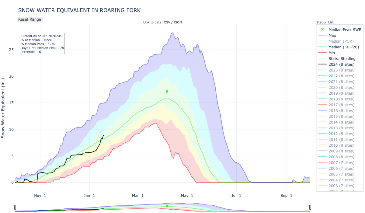
Click the link to read the article on the Aspen Daily News website (Scott Condon). Here’s an excerpt:
January 16, 2024
For the Roaring Fork Basin overall, the snowpack soared from just 85% of average on Thursday morning to 102% on Monday morning, according to the NRCS. The Fryingpan Valley was the biggest gainer from the storms. The Chapman Tunnel Snotel site is at 107% of median. The Ivanhoe site is at 128%, Kiln is at 105% and Nast Lake is boasting a snowpack at 145% of median. Meanwhile the Independence Pass Snotel site remains well below the rest of the basin. Independence was at only 67% of median as of Thursday morning. That improved to 80% by Monday morning with more snow falling. Nevertheless, that’s the lowest reading in the region. In the Crystal River drainage, McClure Pass was at 82% of median as of Monday morning. The North Lost Trail Snotel site outside of Marble was at 117%. The Schofield site, which typically has one of the highest snowpacks in the region, was at 90% Monday.

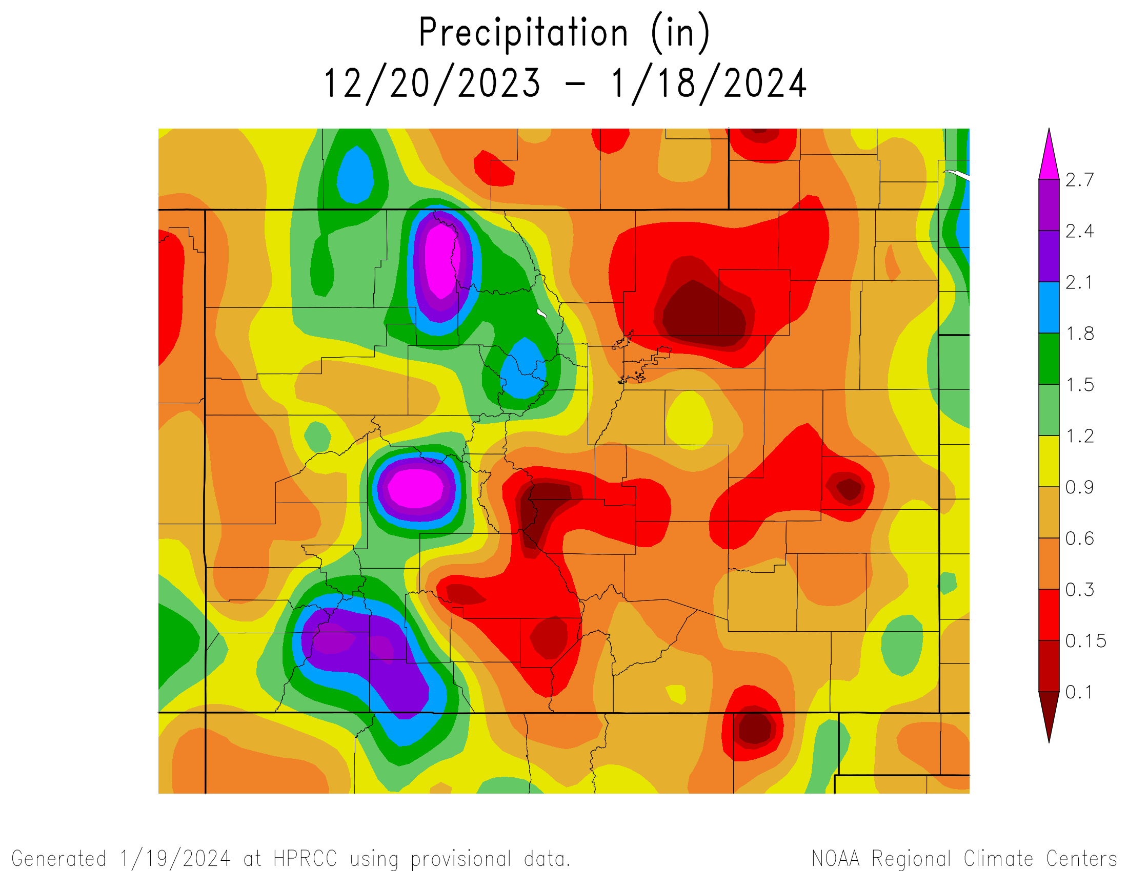
Click the link to read the article on The Grand Junction Daily Sentinel website (Dennis Webb). Here’s an excerpt:
January 17, 2024
The National Weather Service in Boulder reported that from Friday through Monday, many areas in the central and northern mountains got 2 to 3 feet of snow, with some areas getting up to 4 feet, and wind gusts topping 100s mph in a few areas. Powderhorn Mountain Resort on Tuesday was reporting 8 inches over the past 48 hours. That was after it said it got more than 3 feet of snow over six days through last Thursday, including a whopping 24 inches in just 24 hours early last week. As of last week, all lifts and runs are now open at the resort. Vail Resorts is reporting seven-day snow totals at its Colorado ski areas ranging from 29 inches at Keystone Resort to 4 feet at Crested Butte Mountain Resort…Tom Renwick, a forecaster for the National Weather Service in Grand Junction, said the weekend storm produced about 50 inches of snow at Rabbit Ears Pass in the Steamboat Springs area and 51 inches at Green Mountain north of Vail, and much of the central mountain corridor got about 2 feet at higher elevations. In southwest Colorado, accumulations varied from about 4 to 8 inches in the foothills to a foot in higher elevations, he said. He said the Gunnison area had accumulations ranging from a foot to a foot and a half and Grand Mesa got around one foot in areas…

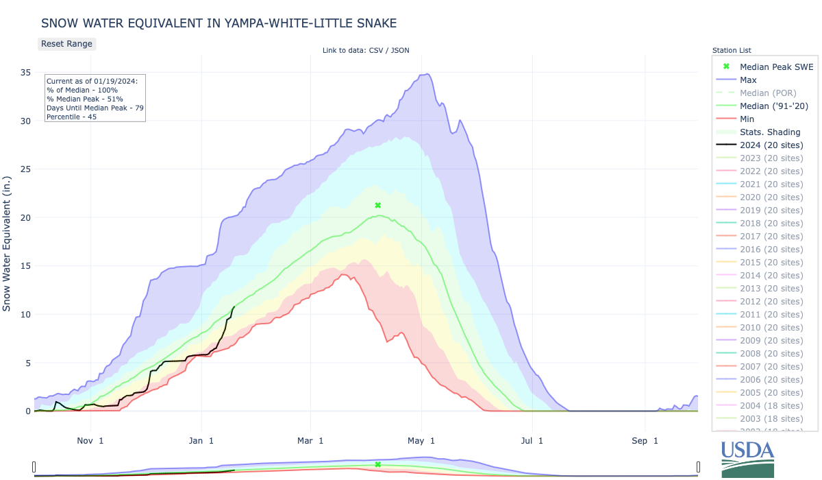
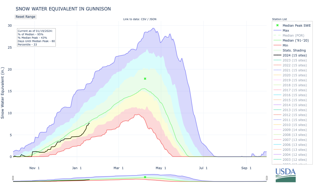
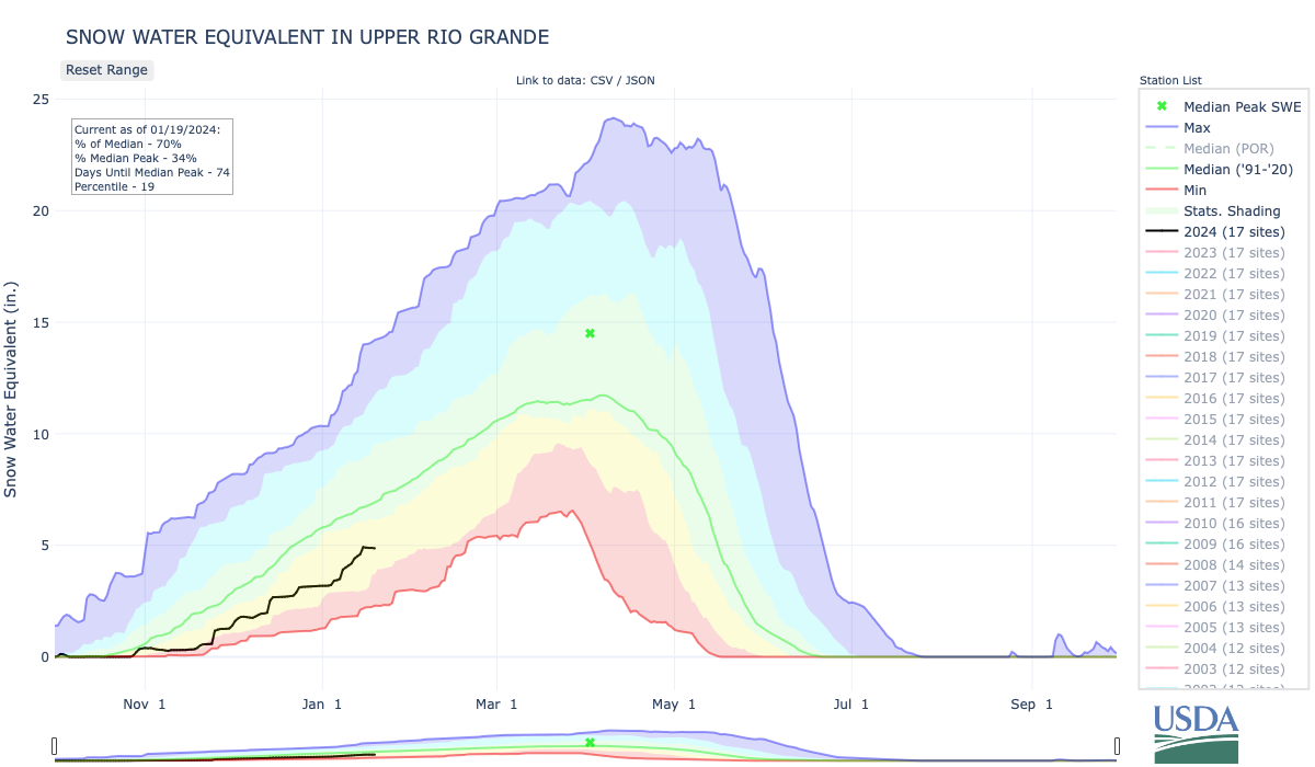
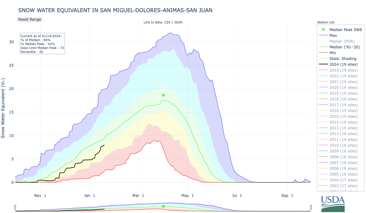
Snowpack in the Colorado River headwaters basin on Tuesday stood at 96% of normal for Jan. 16, with the Yampa/White/Little Snake river basins at 94% and the Gunnison River Basin also at 94%, according to the Natural Resources Conservation Service. The Upper Rio Grande River Basin’s snowpack has increased to 71% of median from just 55% at the start of the month, the combined San Miguel/Dolores/Animas/San Juan basins stood at 84% of normal Tuesday and the Arkansas River Basin was at 85%.
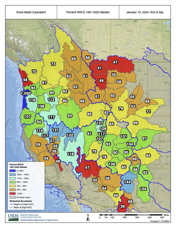
Click the link to read the memo on the Reclamation Website (Noe Santos and Alex Pivarnik):
The operation of Lake Powell and Lake Mead in the January 2024 24-Month Study is pursuant to the December 2007 Record of Decision on Colorado River Interim Guidelines for Lower Basin Shortages and the Coordinated Operations of Lake Powell and Lake Mead (Interim Guidelines) and reflects the draft 2024 Annual Operating Plan (AOP). Pursuant to the Interim Guidelines, the August 2023 24-Month Study projections of the January 1, 2024, system storage and reservoir water surface elevations set the operational tier for the coordinated operation of Lake Powell and Lake Mead during 2024.
The August 2023 24-Month study projected the January 1, 2024, Lake Powell elevation to be less than 3,575 feet and at or above 3,525 feet and the Lake Mead elevation to be at or above 1,025 feet. Consistent with Section 6.C.1 of the Interim Guidelines the operational tier for Lake Powell in water year (WY) 2024 will be the Mid-Elevation Release Tier and the water year release volume from Lake Powell will be 7.48 million acre-feet (maf).
The 2022 Drought Response Operations Agreement (DROA) Plan1 for May 2022 through April 2023 was amended to suspend 2022 DROA Plan releases as of March 7, 2023. A total DROA release of approximately 463 thousand acre-feet (kaf) occurred under the 2022 DROA Plan. Reclamation will attempt to maximize DROA recovery in the Upper Initial Units in WY 2023 and through April 2024. Reclamation will provide monthly DROA accounting, including DROA releases and recovery, which can be found online at: https://www.usbr.gov/ColoradoRiverBasin/documents/dcp/DROA/DROSummarySheet.pdf.
In May of 2023, the DROA Parties agreed to the 2023 DROA Plan. The 2023 DROA Plan does not include any DROA releases, but rather provides for recovery of prior DROA releases from the units upstream of Powell.
Reclamation will continue to carefully monitor hydrologic and operational conditions and assess the need for additional responsive actions and/or changes to operations. Reclamation will continue to consult with the Basin States, Basin Tribes, Mexico, and other partners on Colorado River operations to consider and determine whether additional measures should be taken to further enhance the preservation of these benefits, as well as recovery protocols, including those of future protective measures for both Lakes Powell and Mead.
The August 2023 24-Month Study projected the January 1, 2024 Lake Mead elevation to be below 1,075 feet and above 1,050 feet. Consistent with Section 2.D.1 of the Interim Guidelines, a Shortage Condition consistent with Section 2.D.1.a will govern the operation of Lake Mead for calendar year (CY) 2024. In addition, Section III.B of Exhibit 1 to the Lower Basin Drought Contingency Plan (DCP) Agreement will also govern the operation of Lake Mead for CY 2024. Lower Basin projections for Lake Mead take into consideration updated water orders to reflect additional conservation efforts under the LC Conservation Program.
Click on a thumbnail graphic to view a gallery of drought data from the US Drought Monitor website.


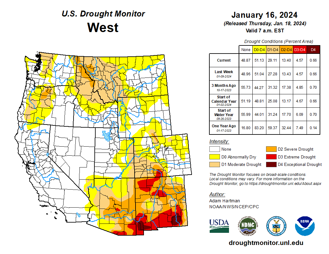
Click the link to go to the US Drought Monitor website. Here’s an excerpt:
This Week’s Drought Summary
It was another stormy week across much of the eastern lower 48 states leading to widespread drought improvements from the Mississippi River Valley eastward to the Appalachians. A powerful storm system early in the week (January 9-10) brought heavy rainfall to parts of the eastern U.S., with most locations from Georgia to New England picking up more than 2 inches of precipitation, leading to flooding for several locations. In some locations across the Mid-Atlantic and interior Northeast, flooding was exacerbated by melting snow left over from a winter storm hitting the region the previous weekend (January 6-7). Behind the powerful storm system early this week, cold air plunged southward from Canada across the northern tier states, gradually spreading southward and eastward and overtaking most of the country east of the Rockies by the end of the week (January 16). Toward the end of the week, another storm system dropped wintry precipitation in a swath stretching from the Ozarks eastward to the Mid-Atlantic and Northeast. Across the western lower 48 states, precipitation was above average for the week, leading to targeted improvements to drought areas across the Intermountain West, where snowpack continues to build for several locations. Unfortunately, weekly precipitation and seasonal snowpack remain below normal this week across the Southwest and northern Rockies, leading to some degradation of drought conditions. No changes are warranted in Alaska this week, as the snowpack is in good shape statewide. Hawaii received more heavy rainfall this week, predominantly from a Kona Low early on, leading to improvement. Conversely, another warm and dry week in Puerto Rico warranted another round of degradation…
High Plains
Storminess in recent weeks and frigid temperatures this week warrant no changes across much of the Central and Northern Plains. However, there are mixed improvements (Colorado Plateau) and degradations (High Plains along the Front Range) warranted this week. Improvements to snowpack and short-term precipitation deficits this week warrant the improvements across the Colorado Plateau. Conversely, the lack of seasonal snow cover has led to degradations across parts of the High Plains along the Front Range, due to topsoils being exposed and drying out…
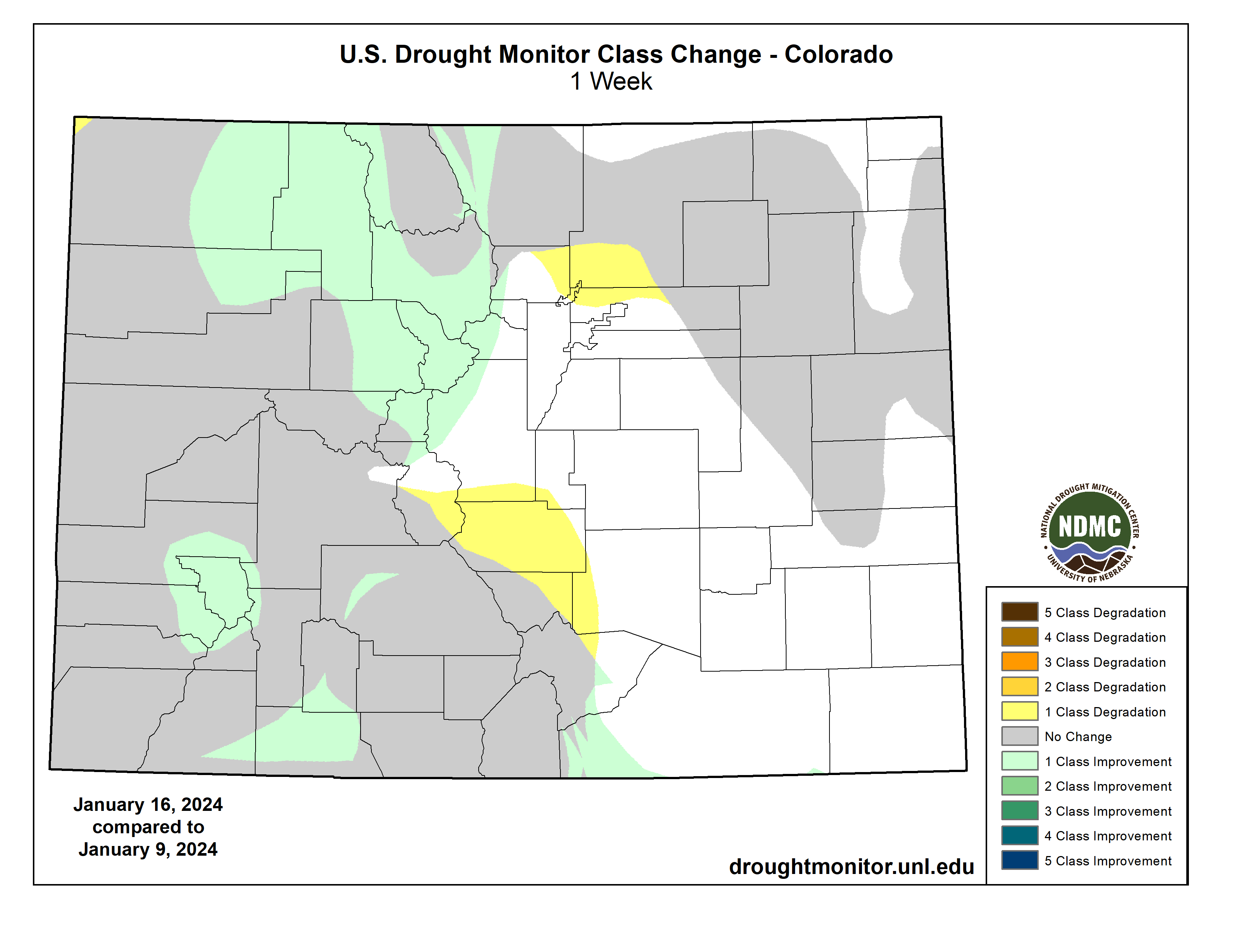
West
Some degradation of drought conditions is warranted where below average precipitation was observed this week. This is especially the case across western portions of Montana, where below average seasonal snow cover has left soils predominantly exposed, resulting in a slow decline in soil moisture over the past couple of months. On the other hand, targeted improvements are warranted across parts of the Pacific Northwest and eastern Great Basin, where 7-day precipitation totals and storminess in recent weeks have improved some of the long-term drought indicators. The active storm track in recent weeks has also led to gradual improvements to seasonal snowpack for several locations across the higher elevations of the Pacific Northwest, Great Basin, and portions of the Colorado Plateau…
South
Much of the precipitation this week fell across portions of the Ozarks and Tennessee Valley, associated with a couple of storm systems leading up to the start of the weekend (January 13), with many locations receiving in excess of 1 inch of rainfall. Toward the end of the week (January 15-16), a winter storm dropped several inches of snowfall across many of these same locations. Given the wetter than average conditions last week and another round of above average precipitation again this week, widespread improvement to drought conditions are warranted across portions of Arkansas and Tennessee. In parts of southern Texas, some degradation to the drought depiction is warranted, where short-term precipitation deficits are starting to mount. No changes are warranted elsewhere across the region due to above average precipitation last week and cold temperatures spreading across the region this week…
Looking Ahead
During the next five days (January 18-22), a fast moving storm system could bring some snowfall to portions of the Great Plains, Midwest, and Mid-Atlantic January 18-20. Surface high pressure behind this system is expected to gradually bring more southerly flow across much of the eastern U.S. as it moves eastward, leading to a moderation of the bitterly cold temperatures east of the Rockies, and some storminess across the south-central U.S., by January 22. A series of storms is also forecast to impact the West Coast over the next five days.
The Climate Prediction Center’s 6-10 day outlook (valid January 22-26), favors enhanced chances of above average temperatures across the entirety of the lower 48 states, with the highest chances (greater the 80%) centered over the Great Lakes. Enhanced chances of above average precipitation is also favored across much of the lower 48 states from coast to coast, with the highest chances (greater than 70%) across the south-central U.S. The exception is across the Northern Plains, where below average precipitation is favored.
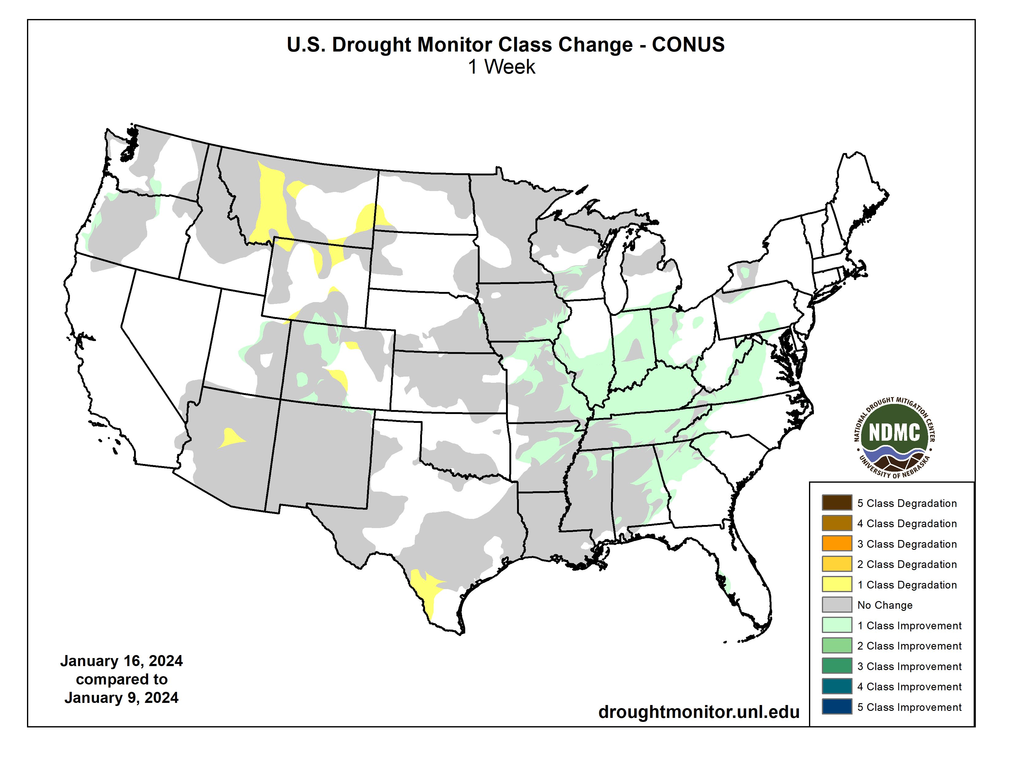

Click the link to read the release on the State of Utah website (Kim Wells):
January 16, 2024
The Great Salt Lake Commissioner’s Office has released the state of Utah’s first strategic plan to get the Great Salt Lake to a healthy range and sustain it. In November 2022, the lake fell to a new record low level. During the 2023 Legislative General Session, HB491 was passed, creating the Office of the Great Salt Lake Commissioner and required the preparation of a strategic plan applying “a holistic approach that balances the diverse interests related to the health of the Great Salt Lake….”
“The plan represents an initial strategy to more effectively protect the lake while balancing the other ecological, economic and societal interests surrounding the lake,” Commissioner Brian Steed said. “Restoring the lake to a healthy range is not a one-year, one-policy, one-constituency solution. It will take a coordinated, data-driven approach so decision-makers can evaluate tradeoffs and balance competing interests.”
The lake is a dynamic system, and its management must also be dynamic. The plan will be revisited regularly and adjusted to reflect the latest data and meet new challenges and opportunities. The strategy includes short-, medium- and long-term actions.
As outlined in HB491, the Great Salt Lake Strategic Plan helps ensure coordination of the work taking place among the many stakeholders who work on lake issues and calls for:
- Coordinating the efforts of a wide variety of agencies and stakeholders and ensuring robust public engagement on issues related to the lake
- Utilizing the best available science and data when making decisions that impact the lake
- Getting more water to the lake and ensuring a sustainable water supply while balancing competing needs, including human health and quality of life, a healthy ecosystem and economic development
- Conserving water across different sectors (M&I, industrial and agricultural), including quantification of water savings and shepherding saved water to the lake
- Protecting air and water quality
The release of the Great Salt Lake Strategic Plan is just the beginning. The hard work of implementing the plan builds off the work the state and others have already begun. As the plan states on page 15, “the actions identified in the plan’s first year largely build upon initiatives, partnerships, and programs that have already begun to help the Great Salt Lake. The short-term actions are designed to provide a foundation and guidance for longer term strategies and actions.” The plan also calls for additional detailed planning efforts to ensure enough water gets to the lake over the next 30 years and to maximize the investments that the Legislature has made for the benefit of the lake and everyone who relies upon it.
“Striking the right balance for the Great Salt Lake is no small task, especially among the pressures of continued growth, sustained drought and higher temperatures that threaten to increase demand and shrink available water supplies even further,” Steed said. “It will take all of us working together to protect and sustain the lake.”