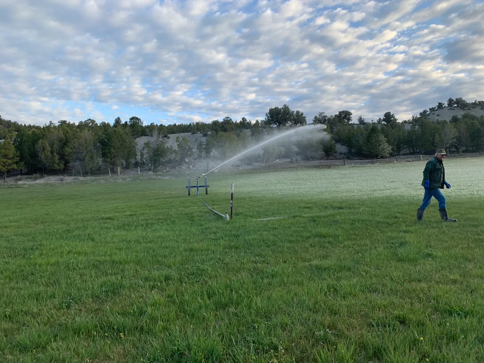
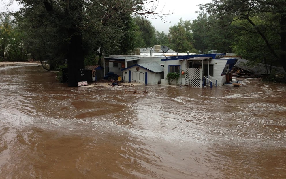
Raymond Langstaff irrigates his fields outside of Rifle in May 2022. A water conservation program that pays irrigators to use less water from the Colorado River (SCPP) will be offered by the upper basin states starting in October 2023. CREDIT: HEATHER SACKETT/ASPEN JOURNALISM
From email from the Colorado Water Conservation Board (Katie Weeman):
September 21, 2023 (Denver, CO) – the Upper Colorado River Commissioners voted to implement the System Conservation Pilot Program (SCPP) for the 2024 Water Year. SCPP provides Upper Basin water users with the opportunity to participate in temporary, voluntary, and compensated water conservation. SCPP simultaneously allows the Upper Colorado River Commission (UCRC) and Upper Division States to learn from the piloted conservation efforts, expanding knowledge on aspects like monitoring, measurement, and local benefits or impacts. For water users, it provides opportunities to develop tools to build resilience and adapt to long-term drought.
The revamped SCPP integrates input from Upper Basin water users. Changes include:
An earlier application window, beginning in October 2023, to provide operational certainty for applicants.
A transparent pricing mechanism to provide clarity to applicants.
Increased education and outreach to ensure water users are fully informed.
Expanded information about project applications in Colorado with the opportunity to provide comment.
Prioritization of projects that support innovative water conservation and development of drought resiliency tools.
“We learned a lot about SCPP last year, so this year’s revamp integrates a lot of input from Colorado water users,” said Becky Mitchell, Colorado River Commissioner for the State of Colorado. “SCPP should—and can—work in a way that makes sense for Colorado. The pilot program can provide flexibility for Coloradans who want or need to explore innovative conservation projects. As we continue to learn together and do what we can to be part of the solution, I continue to push for reductions where it matters most: in the Lower Division States.”
“There is no silver bullet for drought resiliency in Colorado,” said Lauren Ris, Director of the Colorado Water Conservation Board. “SCPP is one tool in the State’s toolkit that we can all learn from. It can fund innovation, letting water users try something new, because they have that financial certainty. And, because it’s totally voluntary, temporary, and compensated, SCPP lets Coloradans choose for themselves.”
At the September 21 UCRC meeting, Commissioner Mitchell strongly advocated for SCPP reforms that would be responsive to Colorado water users’ input. More information on the revamped SCPP process will be available in the coming weeks. The Congressional reauthorization for SCPP expires in Fall 2024.
Browns Canyon National Monument protects a stunning section of Colorado’s upper Arkansas River Valley. The area is a beacon to white water rafters and anglers looking to test their skills at catching brown and rainbow trout. Photo by Bob Wick / @BLMNational
The San Juan River, below Navajo Reservoir. Photo: Brent Gardner-Smith/Aspen Journalism
From email from Reclamation (Susan Novak Behery):
September 21, 2023
Due to forecast sufficient flows in the critical habitat reach of the San Juan River, the Bureau of Reclamation has scheduled a decrease in the release from Navajo Dam from 850 cubic feet per second (cfs) to 800 cfs for Friday September 22nd, at 4:00 AM.
Reclamation continues to release project water to fulfill a project water release request by the Jicarilla Apache Nation’s subcontractors, The Nature Conservancy and the New Mexico Interstate Stream Commission, in addition to the normally scheduled release required to maintain the minimum downstream target baseflow.
Releases are made for the authorized purposes of the Navajo Unit, and to attempt to maintain a target base flow through the endangered fish critical habitat reach of the San Juan River (Farmington to Lake Powell). The San Juan River Basin Recovery Implementation Program recommends a target base flow of between 500 cfs and 1,000 cfs through the critical habitat area. The target base flow is calculated as the weekly average of gaged flows throughout the critical habitat area from Farmington to Lake Powell.
Click the link to read the article on the Denver Water website (Jay Adams):
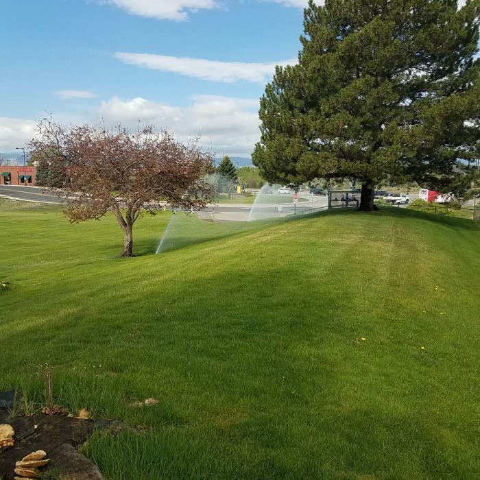
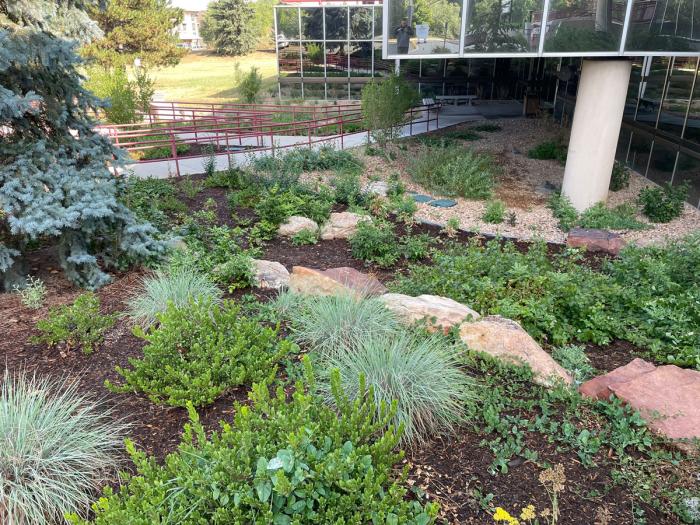
What a difference a year makes for the front of Arapahoe County’s Administration Building in Littleton.
Since the 1970s, the west side of the building had been covered by a 3-acre field of unused, water-intensive Kentucky bluegrass.
Recognizing the need to set a positive example regarding water conservation for the long term, in August 2022 the Arapahoe County Commissioners launched a plan to seed the field with a mix of prairie grasses in an effort to transform the bland expanse of bluegrass into a more natural ColoradoScape that will use less water.
The project is part of Arapahoe County’s broader sustainability initiative that includes reducing water consumption indoors and outdoors.
One year later, all the planning has paid off and the grasses are flourishing.
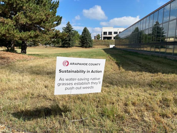
Arapahoe County’s Administration Building in Littleton has a new ColoradoScape with its prairie grass field on the west side of the building. The transformation is a part of the county’s sustainability efforts to reduce water consumption. Photo credit: Denver Water.
“We’re very pleased with how the grasses have come in and are thriving,” said Lisa VanderHeyden, senior project manager of facilities and fleet at Arapahoe County. “We were lucky and got a nice boost from Mother Nature with all the rain in May and June, which really helped the grasses grow in their first season.”
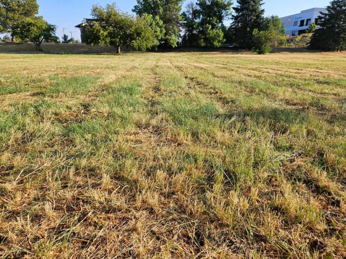
The old field was chosen for landscape transformation because it was considered to have “nonfunctional grass,” which is grass that requires frequent watering from an irrigation system but is not used for activities or events.
The old Kentucky bluegrass field as seen before the transformation in 2022. The field required extensive watering to stay green and was considered nonfunctional grass because it was not used for activities or events. Photo credit: Arapahoe County.
The new field contains a mix of grasses with varying heights and textures. It resembles what the field looked like before people settled the area and started irrigating the land.
It typically takes about three years to fully establish a native grass area, in which the grasses fill in and squeeze out the weeds. Once established, the grass should be able to survive solely on the moisture provided by Mother Nature.
This is how Arapahoe County’s ColoradoScape is going. See how it started.
Arapahoe County’s staff will actively manage the field and the county anticipates saving approximately 1.5 million gallons of water per season due to the switch from the bluegrass.
“The field will have a very natural look and, like other prairie grass fields in the area, the colors will change depending on the amount of precipitation throughout the year,” VanderHeyden said.
The field, seen here in August 2023 after it was mowed for the first time. The field, which will be mowed once a year, has a mix of native prairie grass seeds including blue grama, buffalo grass, sideoats grama, western wheatgrass, green needlegrass and sand dropseed. Photo credit: Denver Water.
Changing landscapes across the Southwest
The building is in Denver Water’s service area and is a great example of a greater push across the Southwest to reduce the amount of nonfunctional grass and help boost the struggling Colorado River, where Denver Water gets half of its water supply.
“We’ve been really impressed with Arapahoe County’s efforts to examine their nonfunctional grass areas and make water-saving changes,” said Austin Krcmarik, water efficiency planner at Denver Water.
The landscape transformation in front of Arapahoe County’s Administration Building includes a garden that features low-water-use plants designed to do well in Colorado’s semi-arid climate. Photo credit: Denver Water.
“For decades, Kentucky bluegrass has been the default landscaping option for many government buildings and now we’re seeing a shift to more natural looking, water-saving ColoradoScapes.”
So, how do you start a new prairie grass field? Hear Arapahoe County officials discuss the project:
Creating a long-term plan
Krcmarik and Arapahoe County agree that there are a number of steps to take when doing large landscape transformation projects:
Consult with the growing number of landscape experts who support water-saving transformations.
Work with landscapers who are willing to research what will work best and commit to support the transformation beyond the initial implementation.
Get the full support of management.
Think the project through, from start to finish and consider long-term maintenance.
Mature trees remain in front of the building. Arapahoe County has experimented with different types of irrigation techniques to ensure they stay healthy as irrigation to the field is reduced. Photo credit: Denver Water.
Inform the public about the reasons behind the landscape change.
Develop a plan for how to prepare the site for new seeds and plants.
Upgrade and/or modify irrigation systems to protect mature trees if the new landscape will use less water.
Develop a plan to manage weeds during the early years.
Choose plants that can survive without irrigation after establishment.
Denver Water and Arapahoe County are part of the Colorado Native Grass Working Group, which includes dozens of other cities, landscape and water professionals to put together a guide on best practices for installing low-water grass landscapes. You can check out their resources and sign up for their email list at coloradonativegrass.org.
Signs point out the challenges weeds present during landscape transformation. Grasses typically take around three years to become fully established and squeeze out the weeds. Photo credit: Denver Water.
State support
The turf replacement project was awarded a grant from the Colorado Water Conservation Board for supporting the Colorado Water Plan’s goal of encouraging municipalities to reduce water use through landscape change.
“It’s been great working with Denver Water, and we appreciate their support and also the grant from the CWCB,” said Anders Nelson, Arapahoe County public information officer.
“While this is a relatively small field, we hope to learn from our work, share and improve the processes and continue to look for other opportunities to reduce our water consumption here in Arapahoe County.”
Mrs. Gulch’s landscape September 14, 2023. Note the freshly mowed Blue gramma area at center left.
Potential Water Delivery Routes. Since this water will be exported from the San Luis Valley, the water will be fully reusable. In addition to being a renewable water supply, this is an important component of the RWR water supply and delivery plan. Reuse allows first-use water to be used to extinction, which means that this water, after first use, can be reused multiple times. Graphic credit: Renewable Water Resources
Click the link to read the article on the Colorado Politics website (Marianne Goodland). Here’s an excerpt:
A Douglas County commissioner recommended individuals who contributed to his campaign to sit on a new water commission that would be tasked with ensuring sufficient future water supply for the county. The individuals included two principals of a water development firm that has been trying to get buy-in for a proposal to pipe water from the San Luis Valley into Douglas County, a move that has been met with stiff opposition from governments in the valley.
Douglas County commissioners, from left: George Teal, Lora Thomas and Abe Laydon. Courtesy Douglas County
Douglas County’s commissioners met earlier this week to begin deciding who they would put on the new 11-member water commission, which will include three representatives of each district and two at-large members. The nominees were among those who submitted applications for the water commission, a list that has been kept confidential.
During Monday’s discussion, Commissioner George Teal announced his eight picks for members: Three for his district, three for another district, plus two at-large members. Five of his picks have made substantial contributions to his political campaigns, including two principals from Renewable Water Resources, the firm that pitched moving water from San Luis Valley’s groundwater to Douglas County…On Aug. 13, 2021, Renewable Water Resources principals, their spouses and friends contributed to pay down Teal’s 2020 campaign debt. The contributions totaled $16,000. Among the funders were Tonner and John Kim, both RWR principals, and Craig Broughton, an associate of Tonner’s. All three are on Teal’s list for the water commission. He also named Castle Pines City Councilman Roger Hudson, who is deputy chief of staff for the House Minority caucus at the state Capitol and who also made several contributions to Teal’s campaign for the 2020 election. Teal also recommended Harold Smethills, who doesn’t live in Douglas County but owns property in Sterling Ranch. Smethills has also contributed to Teal’s campaign. In a previous discussion, Teal had proposed allowing people who don’t live in the county but own property there to apply for the water commission.
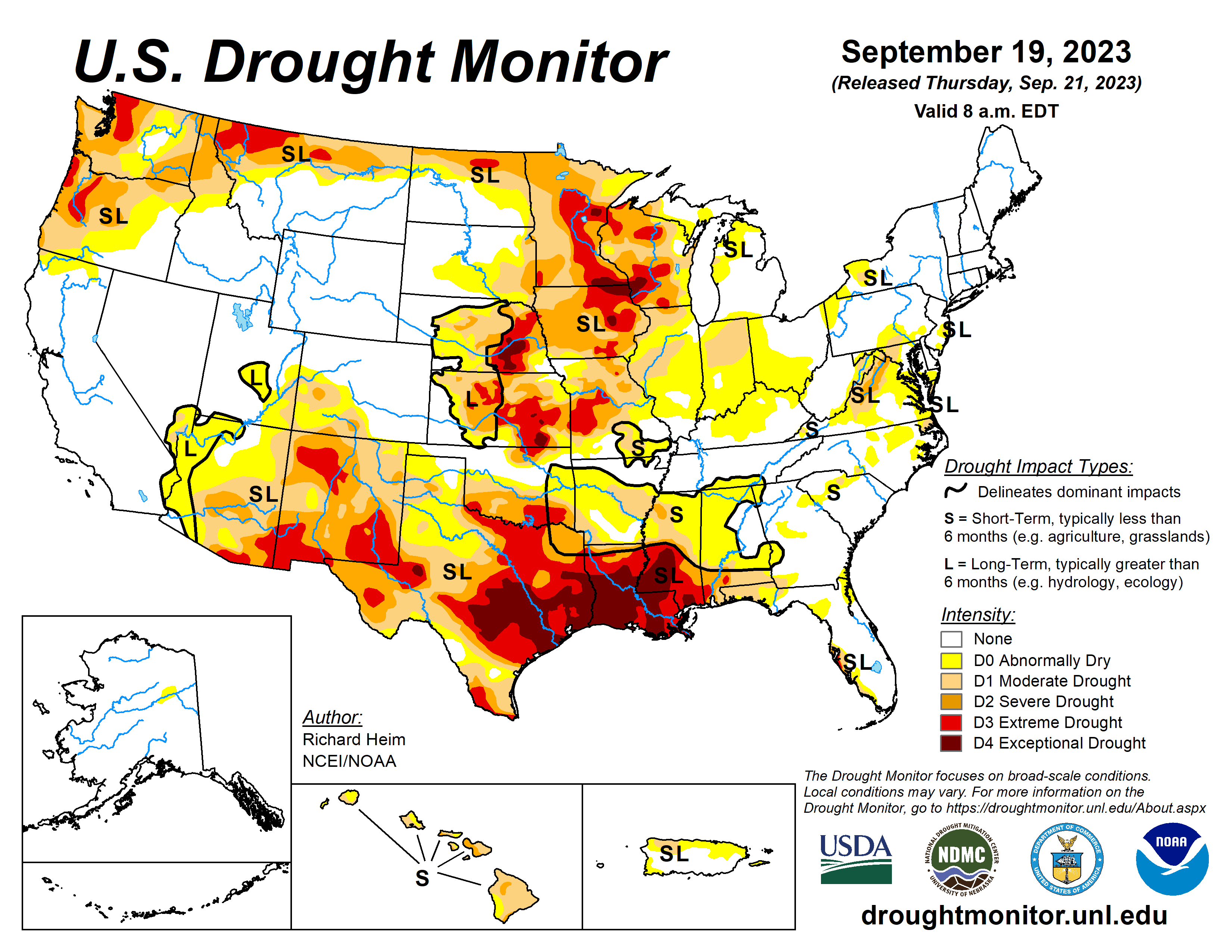
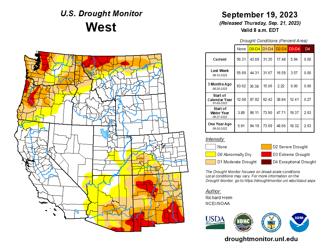
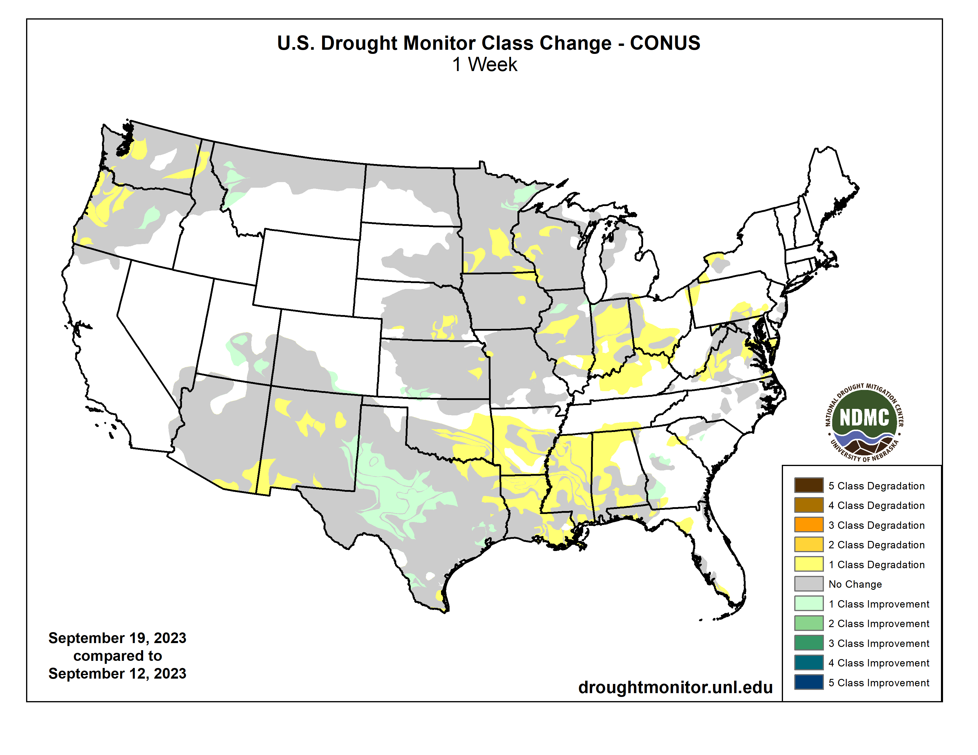
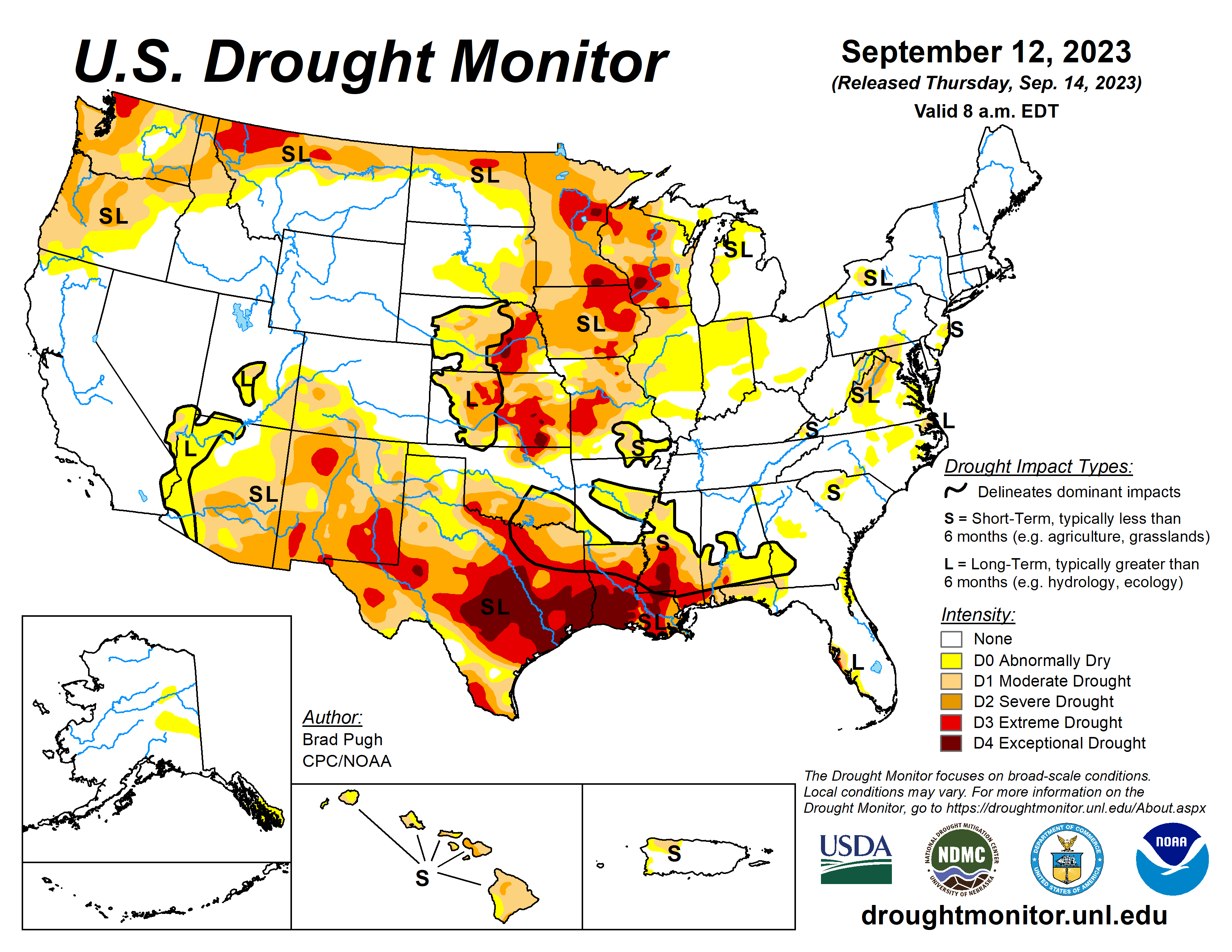
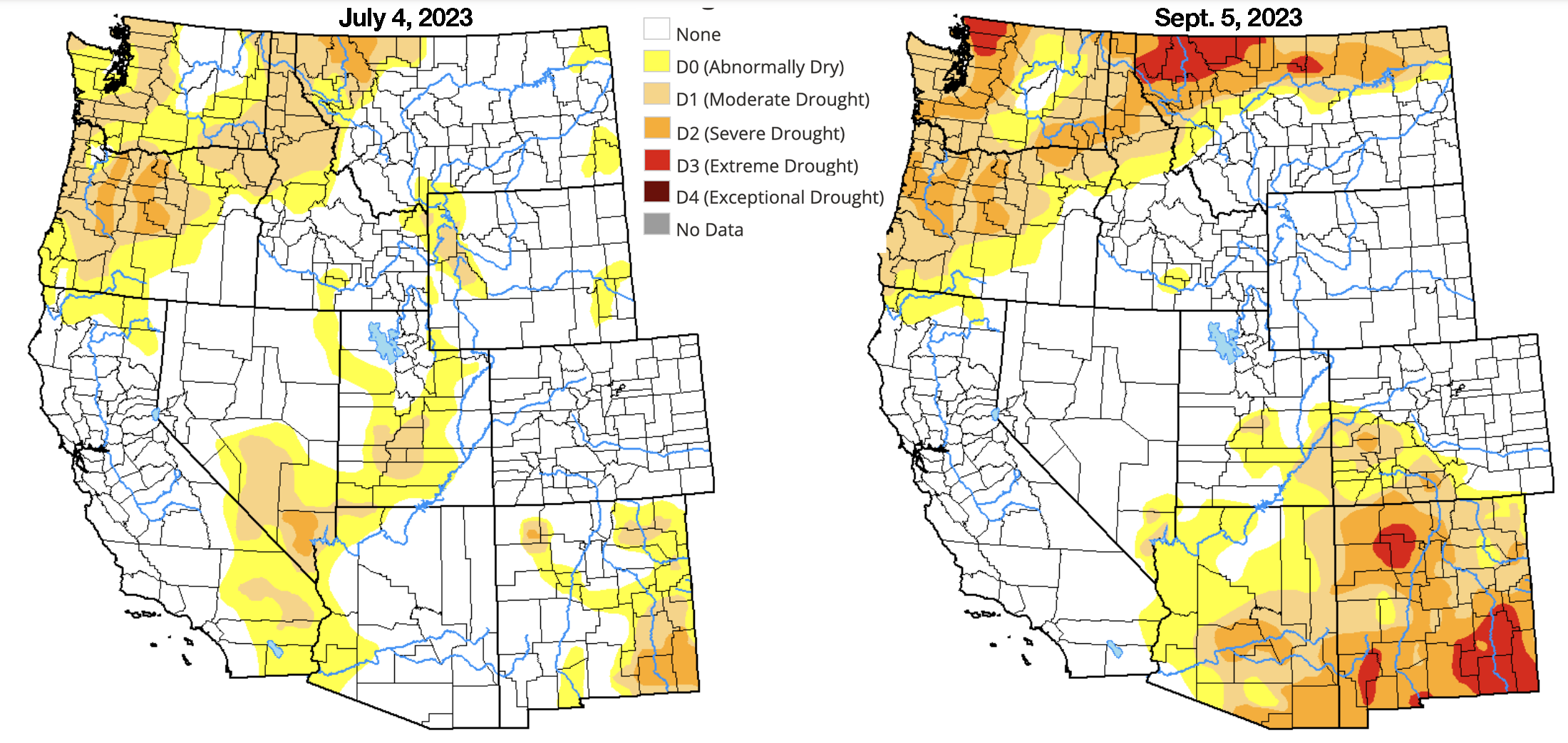
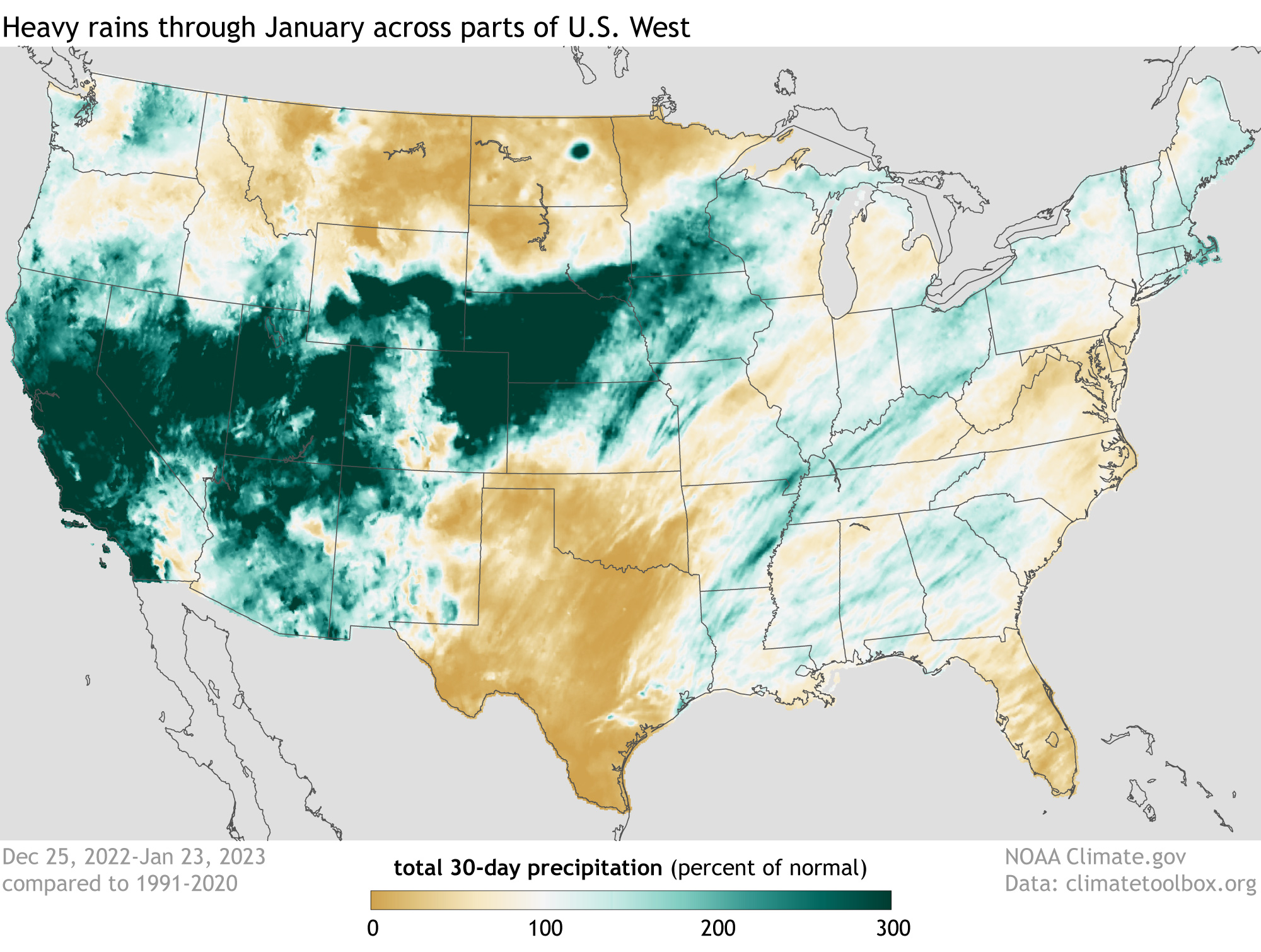
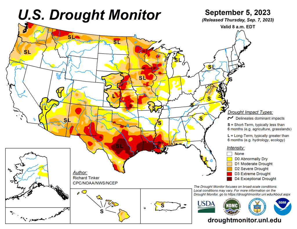
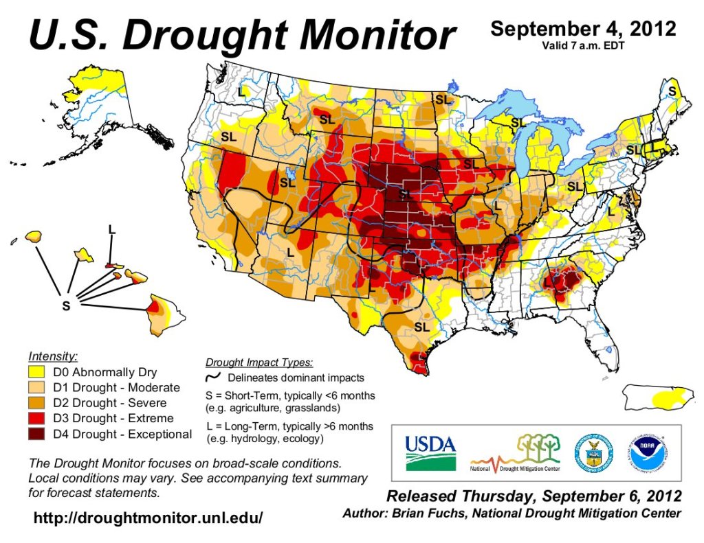
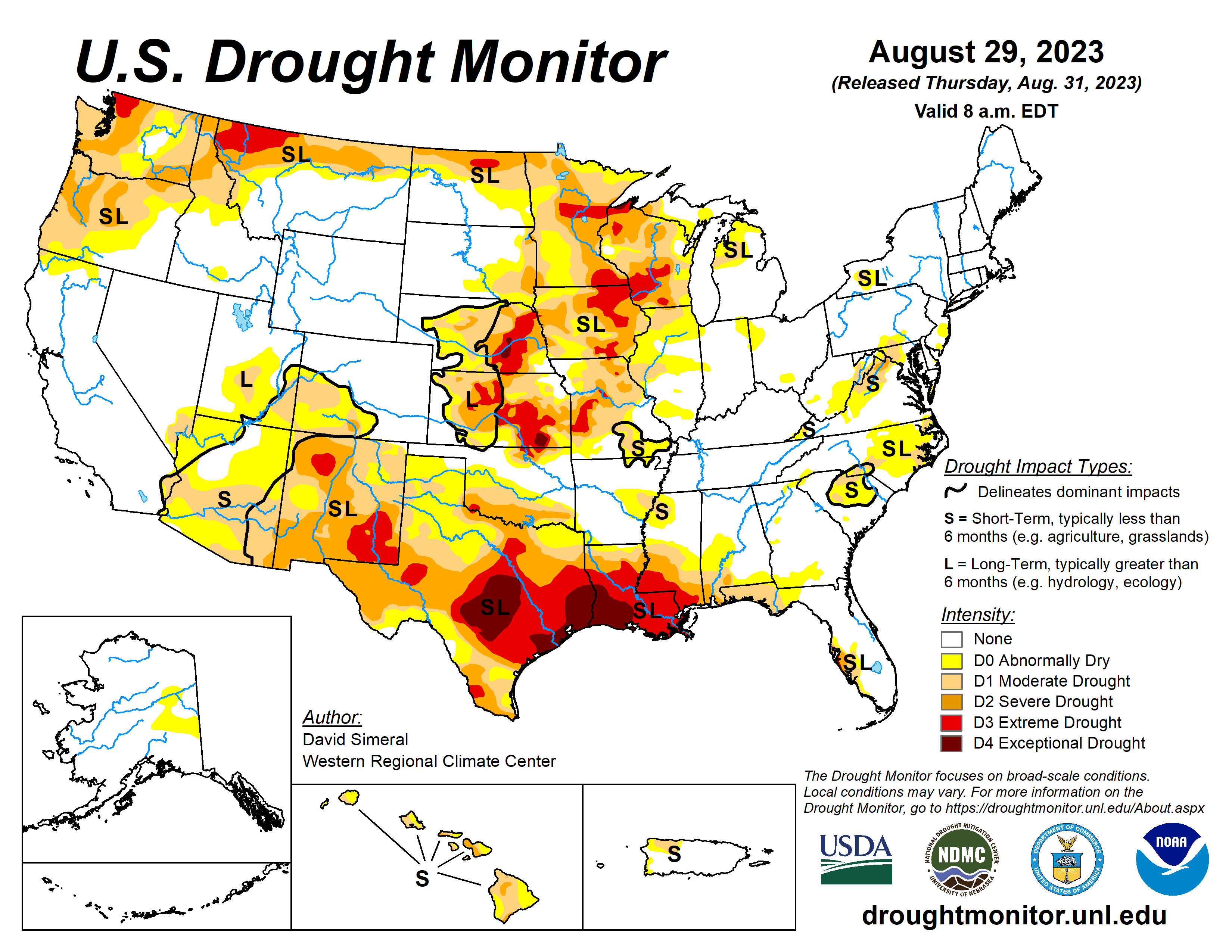
Several Pacific weather systems moved through the jet-stream flow during this U.S. Drought Monitor (USDM) week (September 13-19). The upper-level circulation still consisted of an upper-level ridge over the western contiguous U.S. (CONUS), but it was weakened by the traversing Pacific weather systems. The ridge kept most of the western U.S. dry with warmer-than-normal temperatures from northern California to Montana. Cold fronts and surface low-pressure systems, that accompanied the weather systems, brought rain to the Southwest, southern Plains, Southeast, and Northeast. Heavy rain fell across western to central Texas, improving drought conditions. The rain in the East fell mostly on non-drought areas. The fronts kept temperatures cooler than normal from the Southwest to most of the southern Plains and across much of the country from the Mississippi River to East Coast – only the Gulf of Mexico coast and New England had a warmer-than-normal week. In addition to getting rain from frontal systems, parts of New England were soaked by the remnants of Hurricane Lee over the weekend. The northern Plains and parts of the central Plains, the Great Lakes, and the Mississippi and Ohio Valleys had a drier-than-normal week. The dryness this week was a continuation of dry conditions that have lasted for several months – in some cases for years – across parts of the country and that have dried out soils across more than half of the CONUS. According to U.S. Department of Agriculture statistics, 58% of the nation’s topsoil moisture and 59% of the subsoil moisture was dry or very dry. For topsoil moisture, based on data going back to 2015, this amount is second only to the drought of 2022, which peaked at 68%. The continued dry conditions resulted in expansion or intensification of drought and abnormal dryness across parts of the Mississippi and Ohio Valleys, Mid-Atlantic states, and Pacific Northwest…
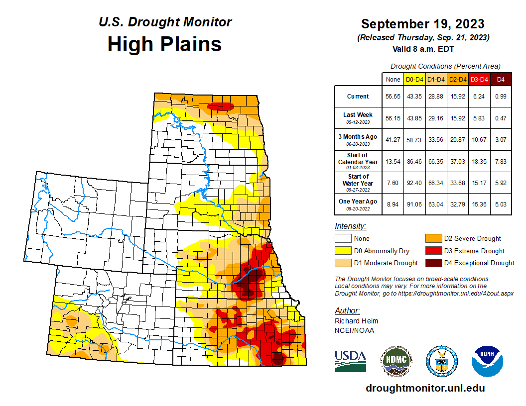
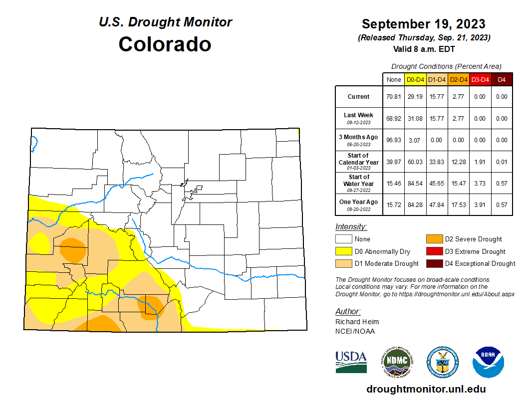
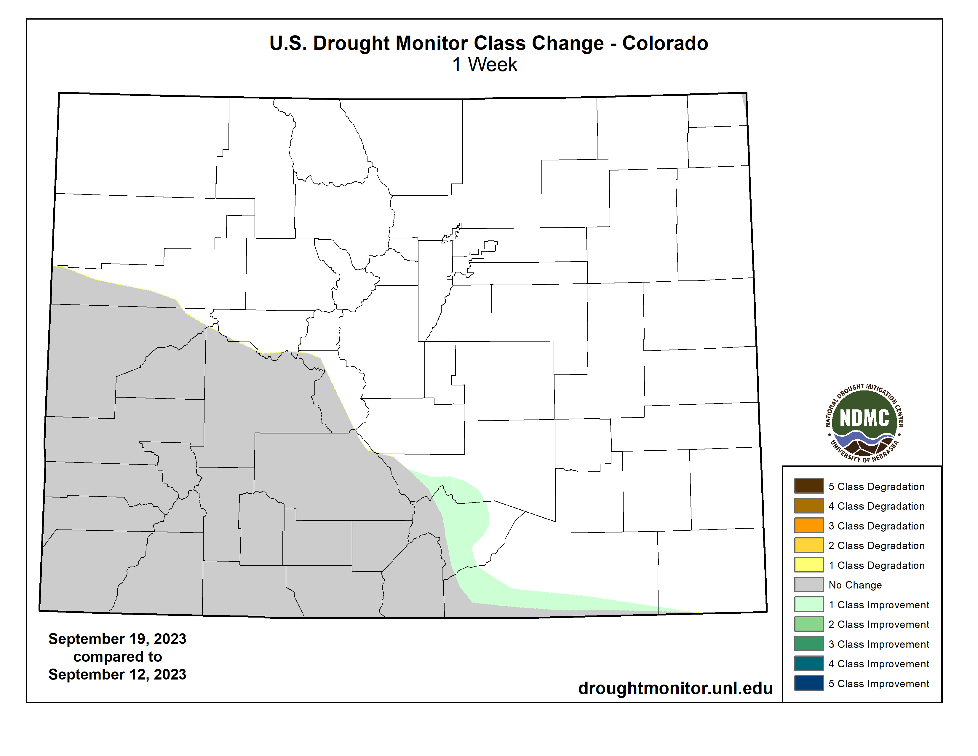
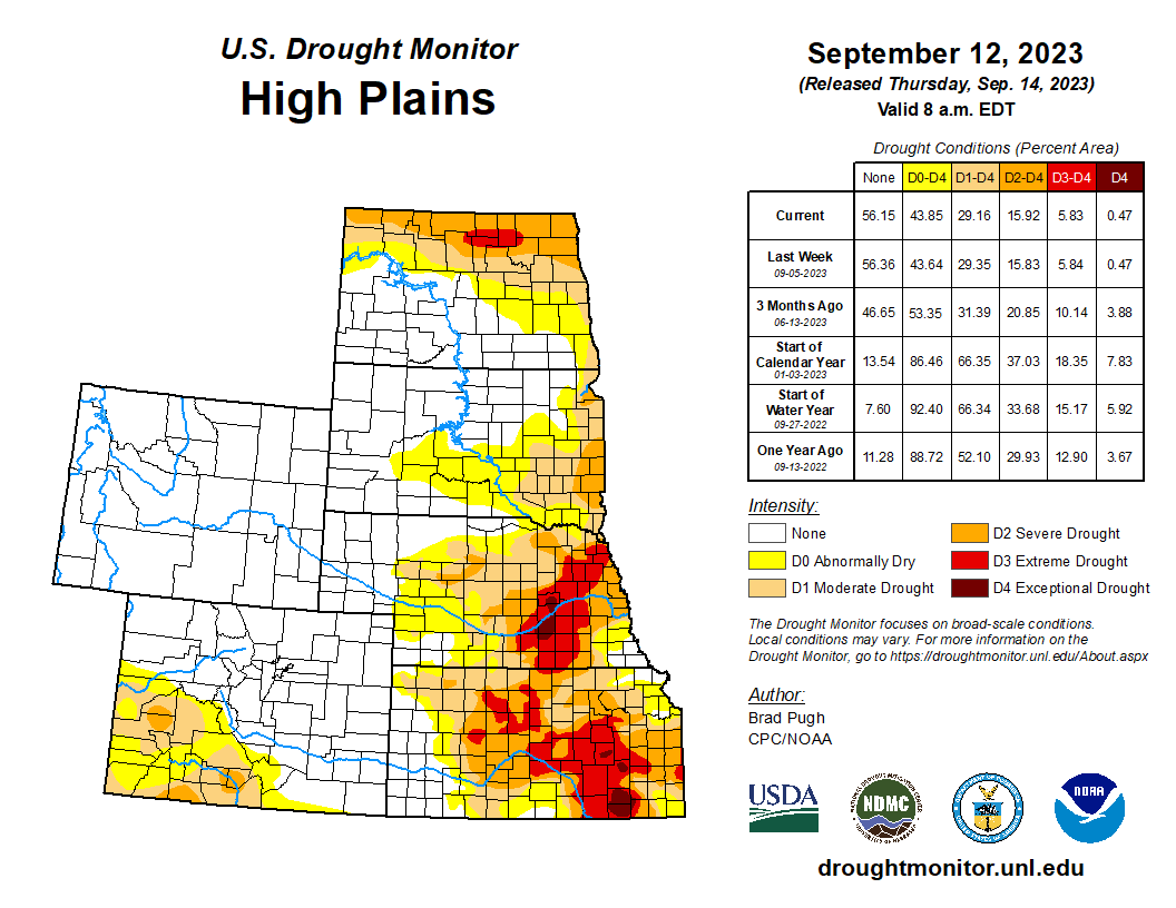
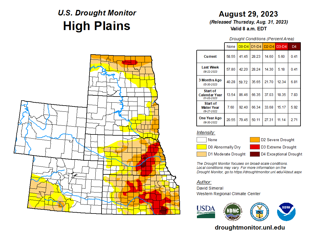
Half an inch to locally 2 inches of rain fell over western and southern parts of the High Plains region, mostly in Colorado, southern Kansas, and parts of Nebraska. But most of Wyoming, the Dakotas, Nebraska, and Kansas were dry this week. The rain trimmed D0 in southern Colorado and contracted D0-D1 in southwestern Kansas. D0 and D3 expanded in eastern Kansas. D0 expanded in parts of southwest Nebraska, but the compounded effects of excessive summer heat and overall dryness over the last 1 to 2 years resulted in expansion of D3 and D4 in parts of southeast Nebraska. Sporadic summer showers have not had much of an impact on the multi-year drought, with low soil moisture continuing and stressed vegetation as seen on satellite-based indicators. A farmer/rancher in Nuckolls County, Nebraska reported stock ponds had never gone dry in his 65 years living in the county until this summer and his crops were all burned up. Reports like this are typical across the region. According to USDA statistics, 50% or more of the topsoil moisture was short or very short in Kansas (68%), Nebraska (60%), North Dakota (51%), and South Dakota (50%), and 50% or more of the subsoil moisture was dry or very dry in Kansas (75%), Nebraska (65%), and North and South Dakota (52% each). Half (50%) of the pasture and rangeland in Kansas was in poor to very poor condition…
Colorado Drought Monitor one week change map ending September 19, 2023.
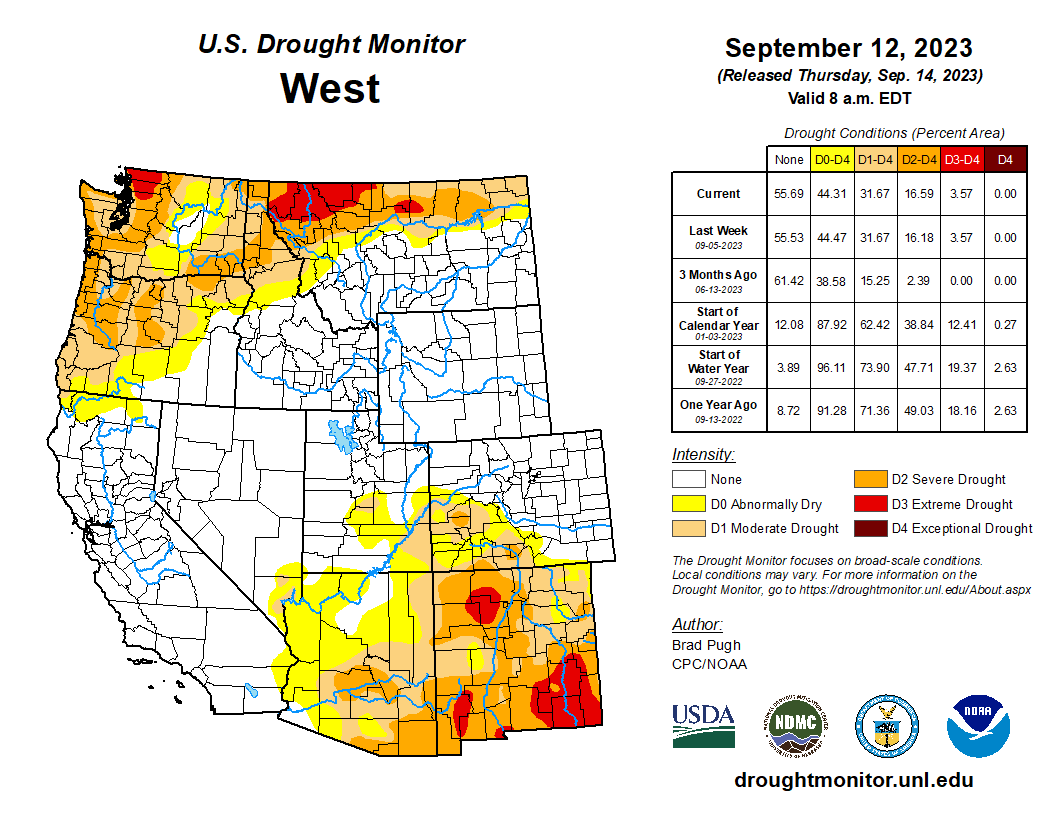
Half an inch to locally 2+ inches of rain fell over parts of Arizona, New Mexico, and Utah, but most of the West received no rain this week. High evapotranspiration due to persistently hot temperatures, low streamflow and soil moisture, and lack of precipitation over 1-month to 12-month time scales resulted in the expansion of D2 and D3 in northwest Washington, expansion of D2 in eastern Washington and the Idaho panhandle, and expansion of D1 and D2 and the introduction of D3 in western Oregon. Rain from weather systems in past weeks, especially the remnants of Hurricane Hilary, resulted in contraction of D1 in central Oregon, D0 and D1 in Utah, and D0 to D3 in western Montana. While parts of New Mexico received rain this week, other parts were dry. The weather system that dumped rain on Texas also soaked east-central New Mexico, so drought contracted there. But prolonged dryness resulted in expansion of D1 and D2 in central to northeast New Mexico and D3 in northwest and southern parts of the state, as well as D3 expansion in adjacent southeast Arizona. According to USDA reports, more than two-thirds of the topsoil was short or very short of moisture in New Mexico (87%), Washington (83%), Montana (82%), and Oregon (74%), and more than two-thirds of the subsoil moisture was short or very short in New Mexico (87%), Montana (79%), Washington (78%), and Oregon (75%). Half or more of the pasture and rangeland was in poor or very poor condition in Washington (65%) and Arizona (57%)…
A large part of Texas received over 2 inches of rain this week. These areas included western to central Texas and parts of the Southeast and Far South. Over 5 inches of rain was reported at stations near Lubbock, Austin, Houston, and Galveston Bay, with the CoCoRaHS station at Nassau Bay 0.9ENE reporting 9.57 inches. The rain resulted in the contraction of D1-D4 in western to central Texas and in the southeast and far south sections of the state. Areas of half an inch to 2 inches of rain occurred over parts of western and southern Oklahoma. But most of Arkansas and Mississippi, parts of Louisiana and eastern Oklahoma, and much of the Rio Grande Valley were dry this week. The compound effects of the excessive heat and dryness of the summer and early fall prompted expansion of abnormal dryness and moderate to exceptional drought in Mississippi, Louisiana, northeastern Texas, and southeast Oklahoma, with abnormal dryness and moderate drought expanding in Arkansas and eastern Oklahoma. The high evapotranspiration and lack of rain has dried out soils and resulted in impacts that include low or dry streams and cattle ponds, desiccated pasture and cropland, and stressed vegetation dropping leaves. Reports include: hay and grasses are short and insufficient for cattle; soils are so dry that the ground is as hard as concrete. Reports like this are typical across the region. According to USDA reports, topsoil moisture is short or very short across 80% of Louisiana, 74% of Mississippi, 72% of Oklahoma, 69% of Arkansas, and 59% of Texas. The subsoil moisture statistics are: 87% Louisiana, 73% Oklahoma and Texas, 67% Mississippi, and 55% Arkansas. Over 60% of the pasture and rangeland is in poor to very poor condition in Texas (71%) and Louisiana (68%), and over 40% in Oklahoma (49%) and Mississippi (41%)…
Looking Ahead
In the two days since the valid time of this USDM, rain has fallen across parts of the West, parts of the Plains to Mississippi Valley, and parts of Florida. For September 21-26, a strong weather system will slowly move out of the Rockies into the Plains and spread heavy rain across much of the Plains to Mississippi Valley, while a low-pressure system moves along the East Coast, spreading heavy rain to coastal areas, and a third Pacific weather system brings rain to coastal areas from northern California to Washington. Weekly precipitation totals could range from 1 to locally 5 inches or more in these regions. Other parts of the Far West, the Four Corners states, much of the Southeast, and the Appalachians to eastern Great Lakes are expected to receive little to no precipitation. Temperatures are expected to be warmer than normal across parts of the Plains to the Mississippi River Valley and Great Lakes.
The Climate Prediction Center’s (CPC) 6-10 Day Outlook (valid September 26-30) favors above-normal precipitation from northern California to North Dakota and across much of the Southeast, with below-normal precipitation centered over Colorado and extending from Missouri to the Great Lakes and New England. Odds favor near normal precipitation for Alaska. The outlook is for below-normal temperatures over southwest Alaska and the Far West in the CONUS, and above-normal temperatures from the Rockies to Appalachians and over northeast Alaska.
The temperature pattern favored in CPC’s 8-14 Day Outlook (valid September 28-October 4) is a continuation of that in the 6-10 Day Outlook, with cooler-than-normal temperatures extending to the Rocky Mountains and the warmer-than-normal area extending to the East Coast. The area favored for above-normal precipitation extends across the Great Plains, while the below-normal area extends to the Lower Mississippi Valley. Odds favor above-normal precipitation for most of Alaska.
US Drought Monitor one week change map ending September 19, 2023.
The San Juan River near Navajo Dam, New Mexico, Aug. 23, 2015. Photo credit: Phil Slattery Wikimedia Commons
From email from Reclamation (Susan Novak Behery):
September 19, 2023
Due to the forecast for the coming week indicating sufficient flows in the critical habitat reach of the San Juan River, the Bureau of Reclamation has scheduled a decrease in the release from Navajo Dam from 900 cubic feet per second (cfs) to 850 cfs for Wednesday September 20th, at 4:00 AM.
Reclamation continues to release project water to fulfill a project water release request by the Jicarilla Apache Nation’s subcontractors, The Nature Conservancy and the New Mexico Interstate Stream Commission, in addition to the normally scheduled release required to maintain the minimum downstream target baseflow.
Releases are made for the authorized purposes of the Navajo Unit, and to attempt to maintain a target base flow through the endangered fish critical habitat reach of the San Juan River (Farmington to Lake Powell). The San Juan River Basin Recovery Implementation Program recommends a target base flow of between 500 cfs and 1,000 cfs through the critical habitat area. The target base flow is calculated as the weekly average of gaged flows throughout the critical habitat area from Farmington to Lake Powell.
In May of 2009, three concurrent venues each showed different artwork, photo essays and educational material about ditches.
Exhibits and featured events at the Boulder Public Library drew crowds of curious Coloradans, while visitors to the Dairy Center for the Arts enjoyed eclectic displays inspired by local water scenes. Various bits of sculpture lined Boulder Creek near the headgates of the Boulder and Left Hand Ditch.
Special programs included tours, storytelling, films, and a symposium of expert speakers. Here, you can revisit parts of the Ditch Project with our comprehensive archive of images, podcasts, and movie clips.
New content will be added here sporadically. Check back here for more updates.
The Forest Service is awarding more than $1 billion nationwide in grants to plant trees in cities, tackle climate change and make green spaces more accessible to less wealthy neighborhoods. Nearly $70 million will go to more than 30 projects in the Mountain West, which include expanding urban orchards in Nevada, improving tree canopies in Colorado and adding education programs in New Mexico. The goal is to help communities that do not have easy access to parks and forests, and are more vulnerable to the urban heat island effect. These areas have historically been overlooked when it comes to adding green spaces, and as a result, residents face increased energy bills, bad air quality and a greater risk of sickness and death…
“You’re focusing on places and welcoming people who might not have felt at home in the fancy neighborhoods with the big trees and making sure that people know that they deserve that, too,” [Xochitl] Torres Small said when announcing the funding. “That there is an opportunity for a cooler place for their kids to enjoy in a park nearby shaded by the trees.”
It’s all part of the agency’s Urban and Community Forestry Program. It received more than 800 applications requesting more than $6 billion in funding – showcasing the desire to grow more trees in urban areas. The grants are funded by the federal Inflation Reduction Act. Colorado and New Mexico received the most grant money in our region – more than $20 million each to fund green spaces projects. Nevada was not far behind with nearly $16 million, whileIdaho, Utah and Wyoming received less than $6 million each.
Torres Small said representatives are already knocking on people’s doors to ask if they want to plant a tree.
Denver skyline, view is west from City Park. Photo credit The City of Denver.
Arkansas Valley Conduit map via the Southeastern Colorado Water Conservancy District (Chris Woodka) June 2021.
Click the link to read the article on the Reclamation website (Anna Perea and Darryl Asher):
President Biden’s Bipartisan Infrastructure Law supporting major water infrastructure project to provide clean, reliable drinking water to 39 communities in southeastern Colorado
Sep 15, 2023
LOVELAND, Colo. – The Bureau of Reclamation has awarded a contract for the second segment of trunkline of the Arkansas Valley Conduit to Pate Construction Co., Inc. for $27,216,950.00. This contract, partially funded by President Biden’s Bipartisan Infrastructure Law, funds construction of Boone Reach 2, which includes a 5.4 mile stretch of water pipeline and 7.4 miles of fiber conduit. Construction will follow Colorado State Highway 96 from North Avondale to Boone, Colorado.
President Biden’s Investing in America agenda represents the largest investment in climate resilience in the nation’s history and is providing much-needed resources to enhance Western communities’ resilience to drought and climate change. Through the Bipartisan Infrastructure Law, Reclamation is investing a total of $8.3 billion over five years for water infrastructure projects, including water purification and reuse, water storage and conveyance, desalination and dam safety. An overall $160 million has been allocated so far from the Law to complete the Arkansas Valley Conduit project.
This is a major infrastructure project that, upon completion, will provide reliable municipal and industrial water to 39 communities in southeastern Colorado. The pipeline will bring water from Pueblo Reservoir to Bent, Crowley, Kiowa, Otero, Prowers, and Pueblo counties. It is projected to serve up to 50,000 people in the future; equivalent to 7,500 acre-feet of water per year.
“We’re looking forward to this next project milestone,” said Jeff Rieker, Eastern Colorado area manager. “Today’s contract award allows the project to maintain the momentum we’ve built over the past year and helps us achieve the ultimate goal of bringing clean and reliable water supplies to the people of southeastern Colorado.”
“The Arkansas Valley Conduit is vitally important to the people of the Lower Arkansas Valley, so it is very rewarding to see the Bureau of Reclamation moving ahead,” said Bill Long, president of the Southeastern Colorado Water Conservancy District, local sponsors of the Arkansas Valley Conduit. “The Southeastern District also is working to complete this project as quickly as possible to provide a better quality of water for the people of the valley.”
Work on the first segment of trunk line began in spring of 2023 with completion anticipated in 2024. Reclamation expects work on the second segment, Boone Reach 2, to begin in late 2023 with completion slated for late summer 2025.
As the Arkansas Valley Conduit project moves forward, under existing agreements, Reclamation plans to construct the trunkline, water tanks, and related components, while the Southeastern Colorado Water Conservancy District coordinates with communities to fund and build the project’s water delivery pipelines. Eventually, the Arkansas Valley Conduit will connect 39 water systems along the 103-mile route to Lamar, Colorado.
The project will use Pueblo Water’s existing infrastructure to treat and deliver Arkansas Valley Conduit water from Pueblo Reservoir to a connection point east of the city of Pueblo along U.S. Highway 50. The project will use water from either the Fryingpan-Arkansas Project or from a participant’s water portfolio, but not from Pueblo Water’s resources.
Congress authorized Arkansas Valley Conduit in the original Fryingpan-Arkansas Project legislation in 1962 (Public Law 87-590). This project does not increase Fryingpan-Arkansas Project water diversions from the western slope of Colorado; rather, it is intended to improve drinking water quality.
Currently, many people in the areas that will be served by the Arkansas Valley Conduit rely on groundwater supplies that contain naturally occurring radionuclides, such as radium and uranium, or use shallow wells that contain harmful microorganisms and pollutants. Alternatives for these communities consist of expensive options such as reverse-osmosis, ion exchange, filtration, and bottled water.
If you have questions or need more information, please contact Anna Perea, public affairs specialist at the Bureau of Reclamation’s Eastern Colorado Area Office, at (970) 290-1185 or aperea@usbr.gov. If you are deaf, hard of hearing or have a speech disability, please dial 7-1-1 to access telecommunications relay services.
Pueblo Dam. Photo courtesy of Colorado Parks and Wildlife
The clerk of the Supreme Court granted an extension for parties to submit arguments against a settlement proposal in the decade-long lawsuit over Rio Grande water.
U.S. 8th Circuit Judge Michael Melloy – overseeing the case as a special master – gave the nod in early July to a plan proposed jointly by attorneys from New Mexico, Texas and Colorado to settle the dispute.
The federal government argued for Melloy to toss the settlement, saying that issues about the administration of the terms would violate their status as a party to the lawsuit and would impose new burdens on federal agencies.
Melloy’s 123-page report recommended the Supreme Court accept the lawsuit over the U.S. Department of Justice’s objections.
In a Sept. 5 letter to the court, Solicitor General Elizabeth Prelogar requested the date for arguments taking exception to the special master’s report to be pushed back to Oct. 6. Then other parties have a chance to reply in December, with one final round of arguments in January.
All parties agreed with the schedule changes according to the letter.
What happens next depends on the high’s court’s opinion of any objections to the special master’s report – which would most likely come after all arguments are filed in early January.
The long history and new settlement
This leg of the dispute started in 2013 when Texas sued New Mexico in the U.S. Supreme Court, in the case officially called Original No. 141 Texas v. New Mexico and Colorado . Texas alleged groundwater pumping from farming and other uses below Elephant Butte Reservoir shorted Texas of its fair share of Rio Grande water.
The river was split by the 1938 Rio Grande Compact signed by Colorado, New Mexico and Texas.
Texas’ lawsuit was an escalation of decades of lawsuits in different layer of court, which intensified as the megadrought’s grasp on New Mexico’s water supplies has intensified in the last 30 years.
In 2019, the U.S. Supreme Court allowed the federal government to join as a party. The federal government’s argument’s mirrored Texas’ claims, saying New Mexico’s pumping threatened a U.S. treaty with Mexico and contracts with irrigation districts in southern New Mexico and far west Texas.
In 2022, after pivoting between settlement talks and heading back to trial, the state’s presented an eleventh-hour settlement proposal, which laid out how the Rio Grande would be split below Elephant Butte Dam. New Mexico would receive 57% of water, and Texas would receive 43% (all excluding Mexico’s share). A new index based off of the drought period from 1951-1978 would factor in groundwater pumping. The agreement lays out penalties if deliveries are above or below the agreed amount.
It also would require establishing the El Paso Gage, just past the Texas-New Mexico state line.
Rio Grande and Pecos River basins. Map credit: By Kmusser – Own work, Elevation data from SRTM, drainage basin from GTOPO [1], U.S. stream from the National Atlas [2], all other features from Vector Map., CC BY-SA 3.0, https://commons.wikimedia.org/w/index.php?curid=11218868
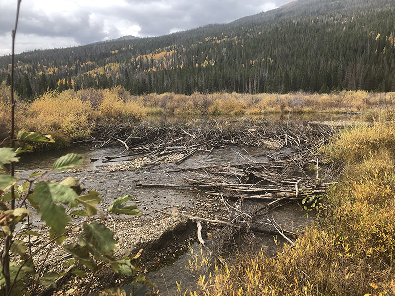
Over the course of two decades, David Cooper, a senior research scientist emeritus of wetland and riparian ecology at Colorado State University, returned to Rocky Mountain National Park’s Kawuneeche Valley to map a visual timeline of the ecological collapse occurring before his eyes.
Bypass structure Grand River Ditch July 2016. Photo credit: Greg Hobbs
Cooper’s research team found that the 86-year-old Grand Ditch—a 15-mile water diversion that siphons 20,000 acre-feet of water per year from the Colorado River and transports it to the arid Eastern Plains—had dried out the valley floor, making it difficult for riparian trees and shrubs to grow. Swelling elk and moose populations were overgrazing the remaining vegetation, leaving an already dwindling beaver population with few building materials for their dams. The area’s beaver population was critical to keeping the ecosystem healthy. Without beavers’ careful stewardship, their ponds drained, decreasing the amount of surface water in the area by 95% and dramatically altering the hydrology of the valley, according to Cooper.
It’s a reality that plays out across Colorado and the West. Riparian areas—the lands along the edges of rivers and streams—and wetlands, have been degrading for decades due to mining pollution; overgrazing; flow alterations from dams, diversions and roads; and historical and present-day farming and timber management practices. Approximately 61% of smaller streams and 97% of major rivers in Colorado have experienced floodplain alterations, rendering them partially or wholly nonfunctional, according to a 2017 analysis for the Center for American Progress.
David Cooper talks with members of the Kawuneeche Valley Ecosystem Restoration Collaborative during a tour of the valley in July 2022. Photo by Eric Brown, courtesy of Northern Water
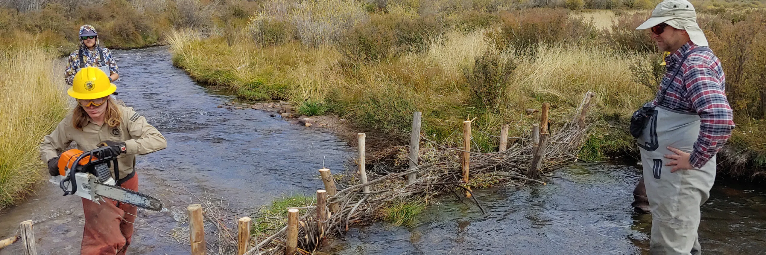
Cooper’s decades-long research helped inform the creation of the Kawuneeche Valley Ecosystem Restoration Collaborative, which is working to restore four riparian areas within the valley by protecting vegetation and mimicking beaver activity in hopes of luring nature’s master river engineers back to their historical homes. The project, which is primarily using low-tech, process-based restoration methods, is one of dozens of such projects occurring across the state—bolstered by a recent influx of state and federal funding.
Process-based restoration, of which low-tech, process-based restoration is a subset, targets the root causes of ecosystem change with a goal of restoring a river’s natural processes.
Research shows that connected floodplains and healthy riparian areas provide valuable ecosystem services such as capturing sediment as it heads downstream; filtering out pollutants; storing more water on the landscape to increase vegetative growth and biodiversity; and moderating soil moisture, streamflows and temperatures throughout the year. All of this combines to make the watershed more resilient to floods, wildfire and drought.
But research surrounding low-tech, process-based restoration is fairly limited, especially as it relates to how projects might impact downstream water availability and the timing of flows.
Because of this, in part, the process for getting restoration projects approved in Colorado has been somewhat opaque and challenging for practitioners to navigate, prompting state lawmakers to draft a bill last session that sought to clarify the process in order to scale up efforts across the state. The final bill was amended by those who were concerned with how the projects might impact priority water rights, so work continues to determine whether more restoration projects can be better facilitated with policy that makes them easier to permit while still protecting water rights.
Scientists and restoration experts are pushing forward with projects, given the scope of riparian degradation and the strain climate change and population growth continue to have on water resources and the ecosystems that support them.
Beaver mimicry as restoration
Jackie Corday, a land and water conservation attorney based in Montrose, has been an enthusiastic proponent of low-tech, process-based restoration since 2018, when she first saw the impact that these low-tech projects could have. “I could see the difference. It just made sense,” Corday says.
While working at Colorado Parks and Wildlife as a water resource manager, she began to research the benefits—and potential legal barriers—for scaling up those types of restoration projects.
“You can do it the fast way and come in with a big excavator and try to reset the elevation to what it would have been,” Corday says. “But that’s very expensive. It’s like $600,000 to $1 million a mile, and there are thousands of miles. It’s not even a possible approach [on its own].” By comparison, low-tech, process-based approaches can be cheaper and faster, at $50,000 to $100,000 per mile.
“Also, the science was showing that [a high-tech approach] wasn’t necessarily always bringing back the [ecosystem] that you were hoping for,” she adds.
“What these researchers were showing was that, well, there’s actually a better way to do this. You mimic beaver.”
A beaver dam on the Gunnison River. Photo: Brent Gardner-Smith/Aspen Journalism
Beaver dams have been shown to retain sediment and nutrients, as well as heavy metals, which can improve water quality.
Construction of Beaver Dam analogue Photo courtesy of the Rio Grande Headwaters Restoration Project.
An example of a low-tech, process-based method would be to install posts vertically into a creek bed to catch wood and debris floating downstream, mimicking natural log jams. This can jumpstart a beaver’s home. In other cases, structures that mimic a beaver dam, called a beaver dam analog, are installed in the stream to slow the flow of water to allow it to pool and rehydrate the soil.
While low-tech, process-based restoration is seemingly growing in popularity, it’s not always the right tool. Sometimes, higher-tech engineering is needed, such as after major flooding events, below dams that alter flows, or when a river’s natural processes have been strained to the breaking point, rendering them unable to self heal, according to a design manual created by Joe Wheaton, an assistant professor of fluvial geomorphology at Utah State University.
Low-tech, process-based restoration also may not be appropriate near housing developments or busy roads, where there is the potential for flooding and infrastructure damage, according to Corday.
“So we have to look farther up the watershed in the public lands and the private lands, the big ranches where there is space for the river to be natural again and to reconnect with its floodplain,” Corday says.
Legislation to pave the way for minor stream restoration projects
In 2019, Corday helped create Colorado’s Healthy Headwaters group, which included conservationists, academics, NGOs, state and federal agencies, and water stakeholders, to come up with policies and strategies to scale up riparian restoration projects throughout the state. The group influenced legislation that was introduced by state lawmakers in April 2023 as SB 23-270. But amendments reduced the bill to include only “minor” restoration projects—and removed language related to low-tech, process-based restoration projects.
“Those [low-tech, process-based] projects were the least understood and raised the most concerns for water users,” says Kelly Romero-Heaney, the state’s assistant director for water policy with the Colorado Department of Natural Resources. “And so that’s why we ended up having to amend coverage for those projects.”
The bill, which was signed into law on June 5, clarifies that minor stream alterations such as bank stabilization or restructuring a channel after it’s been damaged by wildfire or flood are presumed to not impact water rights users.
“The key [in the final bill] is there can only be an incidental amount of flooding or pooling with those structures and they can’t exceed the ordinary high water mark, so they can’t push water outside of the natural channel,” says Romero-Heaney.
For minor restoration projects defined in the bill, a person or group does not need to go to water court, obtain water rights or get a plan of augmentation, according to Romero-Heaney. Projects established before August 2023 are also “grandfathered in” meaning they are presumed to not impact water rights and can move forward.
Those who sought to amend or defeat the bill included various agricultural groups, cities, water districts, and some environmental groups.
“Their concerns are that their water rights may be injured by a stream restoration project that changes the timing in flow or increases evapotranspiration associated with the growth of trees and shrubs along the river corridor,” says Romero-Heaney, who also sits on Gov. Jared Polis’ policy team as a special advisor on water policy. “What we hear a lot is it might be ‘death by 1,000 cuts.’”
Tyler Garrett, the director of government relations for Rocky Mountain Farmers Union—a group that represents 17,000 farmers and ranchers across Colorado, New Mexico and Wyoming—told state lawmakers that his main concerns with the original bill were related to what recourse a person could seek if their water rights were impacted by a restoration project, and the amount of time they had to file a complaint or lawsuit.
“The geomorphic changes may not even be completed during this two-year window and injury may not be realized,” he said during the bill committee hearing this spring. “We also need to ensure the water right holders have time to collect the proper data and build a proper suit when they are injured.”
Romero-Heaney says it will take time for the Department of Natural Resources to interpret the new law in order to provide guidance to existing project managers and other entities interested in restoration
In the meantime, Corday says the Colorado Healthy Headwaters group is continuing to have conversations on how to streamline the process for restoration projects in the hopes of potentially introducing another bill next legislative session to expand the existing law’s scope.
Romero-Heaney is excited to participate and help coordinate field trips for members of the water community to see process-based projects in action.
She hopes the conversations help bridge the divide between the ecological community and the water attorneys who work on protecting water rights portfolios.
Colorado River Kawuneeche Valley May 19, 2023.
Progress in the Kawuneeche Valley
Back at Rocky Mountain National Park, the Kawuneeche Valley Ecosystem Restoration Collaborative—which includes the National Park Service, Northern Water, the U.S. Forest Service, the Colorado River District, The Nature Conservancy, Grand County, and the Town of Grand Lake—is installing beaver-like structures within Beaver Creek to slow streamflows, catch sediment, and promote vegetative growth farther from the banks.
Members of the Kawuneeche Valley Ecosystem Restoration Collaborative walk along an abandoned irrigation ditch during a tour of the valley in July 2022. Photo by Eric Brown, courtesy of Northern Water
“We’re really looking to improve the habitat, kind of the Field of Dreams approach, where if we improve the habitat in the area, then hopefully beavers will come back on their own,” says Kimberly Mihelich, a water protection specialist with Northern Water, a water conservancy district that serves eight counties in Northeastern Colorado.
The group—funded by the Rocky Mountain Conservancy, The Nature Conservancy, Northern Water, and the Colorado Water Conservation Board—isn’t looking to re-introduce beavers into the ecosystem since the environment wouldn’t be able to support them given the lack of vegetation available for them to build dams. But beavers have started to show interest.
In summer 2021, the group stumbled upon something they hadn’t seen in nearly two decades—an active beaver dam. The beaver home was nestled within a 35-acre, fenced-in restoration area in the valley that had been installed a decade ago to keep moose and elk from overbrowsing the willow trees. The fences have gaps in the bottom so small animals such as beavers can slip through.
“We were like, ‘Oh my gosh, these fences work!’” Mihelich says. “There was so, so much excitement.”
“[The beaver dam] did get washed away in some of the spring runoff,” she quickly adds. “But it was really exciting to show that if the habitat is there, beavers in the area might make it home.” This isn’t unusual: Beaver dams are often damaged during large floods, but the beaver are able to rebuild if the environment can support them.
This summer, the team installed more fence enclosures to keep moose and elk from overgrazing the restoration areas and continued using herbicides to kill off invasive plants.
Mihelich says Northern Water is involved in restoring the riparian areas because it’s a way to improve drinking water quality. The Colorado River, which winds through the Kawuneeche Valley, is part of a storage system that includes Grand Lake, Shadow Mountain Reservoir and Granby Reservoir on the Western Slope. The system has struggled with poor water quality due to increases in fine sediment loading, debris and nutrients, all of which impair water quality and can clog up water infrastructure. The system has also been impacted by recent wildfires, which are increasing in frequency and intensity due to climate change.
But restoring the riparian zones and changing the hydrology of the valley will take time, says Koren Nydick, the resource stewardship manager for Rocky Mountain National Park, especially since the damage has spanned decades.
And efforts to replace natural processes aren’t always as effective as the real thing, she adds. “We aren’t beavers. We can’t do it all,” she says. “The hope is that they come in and do it better than we could ever do it.”
Fresh Water News is an independent, nonpartisan news initiative of Water Education Colorado. WEco is funded by multiple donors. Our editorial policy and donor list can be viewed at wateredco.org.
More by Moe ClarkMoe K. Clark is an independent journalist based in Denver. She covers topics related to the criminal justice system, environmental issues and housing/homelessness.
American beaver, he was happily sitting back and munching on something. and munching, and munching. By Steve from washington, dc, usa – American Beaver, CC BY-SA 2.0, https://commons.wikimedia.org/w/index.php?curid=3963858
Solar energy will be an integral part of a more sustainable future, but with current technology, generating the amount of power needed in Colorado alone would require using roughly the land area of Denver.
That’s a lot of space – and potential disturbance to ecosystems, especially when you consider that in the past, energy companies have typically first graded the land and then put gravel or short, easy-to-mow turf grass beneath their solar panels.
Agrivoltaics – the dual use of land for both solar installations and agriculture – offers an alternative way to generate renewable solar energy. Now, two Colorado State University researchers are proposing taking this a step further through what’s known as “ecovoltaics,” which co-prioritizes energy production and ecosystem services during the design and management phases of solar development.
“It’s important to talk about the sustainability of the solar industry so it doesn’t make the same environmental oversights as oil and gas,” said Matt Sturchio, a Ph.D. student in Biology and the Graduate Degree Program in Ecology. “With ecovoltaics, we hope to encourage an ecologically informed approach to solar array design and operation.”
“It will take a lot of solar panels and a lot of land to produce the electricity our society needs,” Knapp said. “As a land-grant institution, we see ourselves as stewards of the land, and it’s our job to offer sustainable solutions about how to use land wisely.”
Solar panels create unique microenvironments
Students study with solar panels. Photo credit: Colorado State University
While agrivoltaics is a step in the right direction, Sturchio said in many applications, it still prioritizes producing the most electricity possible in a given land area. This allows for the use of land beneath solar panels but overlooks opportunities to manipulate array designs in ways that might benefit the plants and animals beneath, especially in water limited ecosystems like the grasslands of Colorado.
With ecovoltaic designs, solar energy production and preserving the landscape go hand-in-hand.
The ecovoltaic concept is partly informed by the researchers’ current work at Jack’s Solar Garden in Longmont, which is the largest commercially active site for agrivoltaics research in the U.S.
Here, the CSU team studies how solar panels affect sunlight patterns and redistribute rainfall to create microenvironments that influence grassland ecosystem processes. These microenvironments promote diversity within solar installations and are a cornerstone of the ecovoltaics concept.
“What we’re trying to do is show the potential impacts of solar energy on our land, and how we can mitigate and potentially leverage them to reach desired outcomes,” he said.
And perhaps most importantly, these approaches can be used to restore severely degraded or abandoned agricultural lands – which are prime candidates for large solar installations.
“Ecovoltaic approaches could help restore and even enhance biodiversity in these places, while providing much-needed clean energy,” Sturchio said.
“It’s a climate solution”
Solar panels and natural grasses. Photo credit: Colorado State University
Sturchio and Knapp will continue their research at a new facility in the plains east of CSU’s campus in Fort Collins.
Here, solar panels will be installed in a native grassland environment – offering new insights about how they impact the ecology of places that are known to be harsh and dry, and where conditions are expected to become more volatile as climate change worsens in the future.
“Building our own research solar arrays will allow us to discover better ways to use this amazing energy source and will help us determine what we can do to make sure large-scale solar installations have less of a negative impact,” Knapp said. “We will study the impacts of placing solar panels farther apart, changing their orientations, and orienting panels vertically during rainstorms – there are many potential options.”
Sturchio said he’s hopeful that energy companies will use some of these principles as they build future installations.
“This research is really important because it’s a land use solution for a climate solution,” he said.
Illustration of Thylacinus cynocephalus from John Gould’s The Mammals of Australia. This genus, also known as the Tasmanian tiger, was hunted to extinction by humans. (Image credit: Henry Constantine Richter and John Gould/Public domain)
A new analysis of mass extinction at the genus level, from researchers at Stanford and the National Autonomous University of Mexico, finds a “mutilation of the tree of life” with massive potential harms to human society.
The passenger pigeon. The Tasmanian tiger. The Baiji, or Yangtze river dolphin. These rank among the best-known recent victims of what many scientists have declared the sixth mass extinction, as human actions are wiping out vertebrate animal species hundreds of times faster than they would otherwise disappear.
Yet, a recent analysis from Stanford University and the National Autonomous University of Mexico, published this week in the Proceedings of the National Academy of Sciences, shows the crisis may run even deeper. Each of the three species above was also the last member of its genus, the higher category into which taxonomists sort species. And they aren’t alone.
Up to now, public and scientific interest has focused on extinctions of species. But in their new study, Gerardo Ceballos, senior researcher at the Institute of Ecology at the National Autonomous University of Mexico, and Paul Ehrlich, Bing Professor of Population Studies, Emeritus, in the Stanford School of Humanities and Sciences, have found that entire genera (the plural of “genus”) are vanishing as well, in what they call a “mutilation of the tree of life.”
“In the long term, we’re putting a big dent in the evolution of life on the planet,” Ceballos said. “But also, in this century, what we’re doing to the tree of life will cause a lot of suffering for humanity.”
“What we’re losing are our only known living companions in the entire universe,” said Ehrlich, who is also a senior fellow, emeritus, by courtesy, at the Stanford Woods Institute for the Environment.
A ‘biological annihilation’
Information on species’ conservation statuses from the International Union for the Conservation of Nature, Birdlife International, and other databases has improved in recent years, which allowed Ceballos and Ehrlich to assess extinction at the genus level. Drawing from those sources, the duo examined 5,400 genera of land-dwelling vertebrate animals, encompassing 34,600 species.
Seventy-three genera of land-dwelling vertebrates, Ceballos and Ehrlich found, have gone extinct since 1500 AD. Birds suffered the heaviest losses with 44 genus extinctions, followed in order by mammals, amphibians, and reptiles.
Based on the historic genus extinction rate among mammals – estimated for the authors by Anthony Barnosky, professor emeritus of integrative biology at UC Berkeley – the current rate of vertebrate genus extinction exceeds that of the last million years by 35 times. This means that, without human influence, Earth would likely have lost only two genera during that time. In five centuries, human actions have triggered a surge of genus extinctions that would otherwise have taken 18,000 years to accumulate – what the paper calls a “biological annihilation.”
“As scientists, we have to be careful not to be alarmist,” Ceballos acknowledged – but the gravity of the findings in this case, he explained, called for more powerful language than usual. “We would be unethical not to explain the magnitude of the problem, since we and other scientists are alarmed.”
Next-level loss, next-level consequences
On many levels, genus extinctions hit harder than species extinctions.
When a species dies out, Ceballos explained, other species in its genus can often fill at least part of its role in the ecosystem. And because those species carry much of their extinct cousin’s genetic material, they also retain much of its evolutionary potential. Pictured in terms of the tree of life, if a single “twig” (a species) falls off, nearby twigs can branch out relatively quickly, filling the gap much as the original twig would have. In this case, the diversity of species on the planet remains more or less stable.
But when entire “branches” (genera) fall off, it leaves a huge hole in the canopy – a loss of biodiversity that can take tens of millions of years to “regrow” through the evolutionary process of speciation. Humanity cannot wait that long for its life-support systems to recover, Ceballos said, given how much the stability of our civilization hinges on the services Earth’s biodiversity provides.
Take the increasing prevalence of Lyme disease: white-footed mice, the primary carriers of the disease, used to compete with passenger pigeons for foods, like acorns. With the pigeons gone and predators like wolves and cougars on the decline, mouse populations have boomed – and with them, human cases of Lyme disease.
This example involves the disappearance of just one genus. A mass extinction of genera could mean a proportional explosion of disasters for humanity.
It also means a loss of knowledge. Ceballos and Ehrlich point to the gastric brooding frog, also the final member of an extinct genus. Females would swallow their own fertilized eggs and raise tadpoles in their stomachs, while “turning off” their stomach acid. These frogs might have provided a model for studying human diseases like acid reflux, which can raise the risk of esophageal cancer – but now they’re gone.
Loss of genera could also exacerbate the worsening climate crisis. “Climate disruption is accelerating extinction, and extinction is interacting with the climate, because the nature of the plants, animals, and microbes on the planet is one of the big determinants of what kind of climate we have,” Ehrlich pointed out.
A crucial, and still absent, response
To prevent further extinctions and resulting societal crises, Ceballos and Ehrlich are calling for immediate political, economic, and social action on unprecedented scales.
Increased conservation efforts should prioritize the tropics, they noted, since tropical regions have the highest concentration of both genus extinctions and genera with only one remaining species. The pair also called for increased public awareness of the extinction crisis, especially given how deeply it intersects with the more-publicized climate crisis.
“The size and growth of the human population, the increasing scale of its consumption, and the fact that the consumption is very inequitable are all major parts of the problem,” the authors said.
“The idea that you can continue those things and save biodiversity is insane,” Ehrlich added. “It’s like sitting on a limb and sawing it off at the same time.”
Paul Ehrlich is also president of the Center for Conservation Biology at Stanford.
When President Joe Biden restored the original boundaries of both Grand Staircase-Escalante and Bears Ears national monuments in 2021, public-land lovers felt they had achieved a lasting victory.
Biden’s action reversed the Trump administration’s shrinkage of these protected areas in southern Utah, and once again put those spectacular canyons off-limits to mining and energy development. The victory was confirmed in August, when a federal court dismissed Utah’s lawsuit attempting to overturn Biden’s action.
But in some ways, the crucial work of preserving these places has just begun. The proclamations establishing and restoring the two national monuments are lofty documents that make the case for wielding the Antiquities Act to protect the landscapes in question. But the real test is always what happens on the ground.
We have a clearer picture of that now, because this August, the BLM released its draft resource management plan and environmental impact statement for Grand Staircase-Escalante National Monument. The public has until Nov. 9 to make its wishes known.
The local environmental community sees the agency’s “preferred” alternative, which “emphasizes the protection and maintenance of intact and resilient landscapes …” as a vast improvement over the status quo. Though it’s less restrictive than one of the other four alternatives, this approach would significantly limit grazing, motorized vehicle use, and target shooting across the monument.
State and local politicians who subscribe to the Sagebrush Rebel ideology have been attempting to dismantle the national monument ever since then-President Bill Clinton established it in 1996. Neither Congress nor even the George W. Bush administration would accede to their demands, but over the years the monument has been starved of funds, lost valuable staff and its management has been influenced by the local culture, which is generally hostile to federal land management.
Then two decades after Grand Staircase-Escalante was established, Republican Utah Sen. Orrin Hatch convinced President Donald Trump to drastically shrink it. The legality of the move was questionable at best: The Antiquities Act gives the president the power to establish national monuments, but not to rescind or dismantle them. The Trump administration’s management plan also gutted protections for what remained — especially relating to grazing.
The livestock industry has long claimed that the national monument’s grazing rules would destroy local ranching. Yet Clinton’s proclamation clearly stated that grazing would continue under the existing BLM rules. In fact, the national monument helped a handful of ranchers who were ready to get out of the marginal business of running cows in inhospitable — yet beautiful and sensitive — terrain. The ranchers struck a deal to retire their grazing permits along the Escalante River and some of its tributaries in exchange for a generous cash payout from the nonprofit Grand Canyon Trust.
Even after the buyout, more than 95% of the monument remained open to livestock, and the number of cattle — or animal unit months — permitted on the monument is about the same now as it was in 1996. Today, though, fewer cattle run on nearly every permitted grazing allotment. It is clear that the livestock operators themselves are the ones limiting the number of cattle.
But here’s the problem: Biden’s restoration of the monument did not repeal the Trump-era plan that opened up retired grazing allotments. Now the public has an opportunity to do that.
The agency’s “preferred” alternative — which the document is quick to point out is merely a starting point for discussions — would divide the monument into four management areas, with different levels of development and access in each. Grazing allotments not currently under permit would be permanently closed to livestock. New range improvements would be limited or prohibited. And off-road vehicles would be banned from the Primitive Area and selected other areas and limited to designated routes in the rest of the monument.
Jonathan Thompson
It’s a lot less than most conservationists were looking for. It would leave 85% of the monument open to tens of thousands of grazing cattle trampling fragile cryptobiotic soils. But Scott Berry, board president of the Grand Staircase Escalante Partners, a nonprofit founded to protect and preserve the monument, urges the environmental community to get behind the plan.
“Political forces in Utah are going to do everything in their power to prevent the new plan from being adopted,” he said, “which would leave the Trump (plan) the controlling authority.”
Jonathan Thompson is a contributor to writersontherange.org, an independent nonprofit dedicated to spurring lively conversation about the West. His newsletter The Land Desk covers the region.
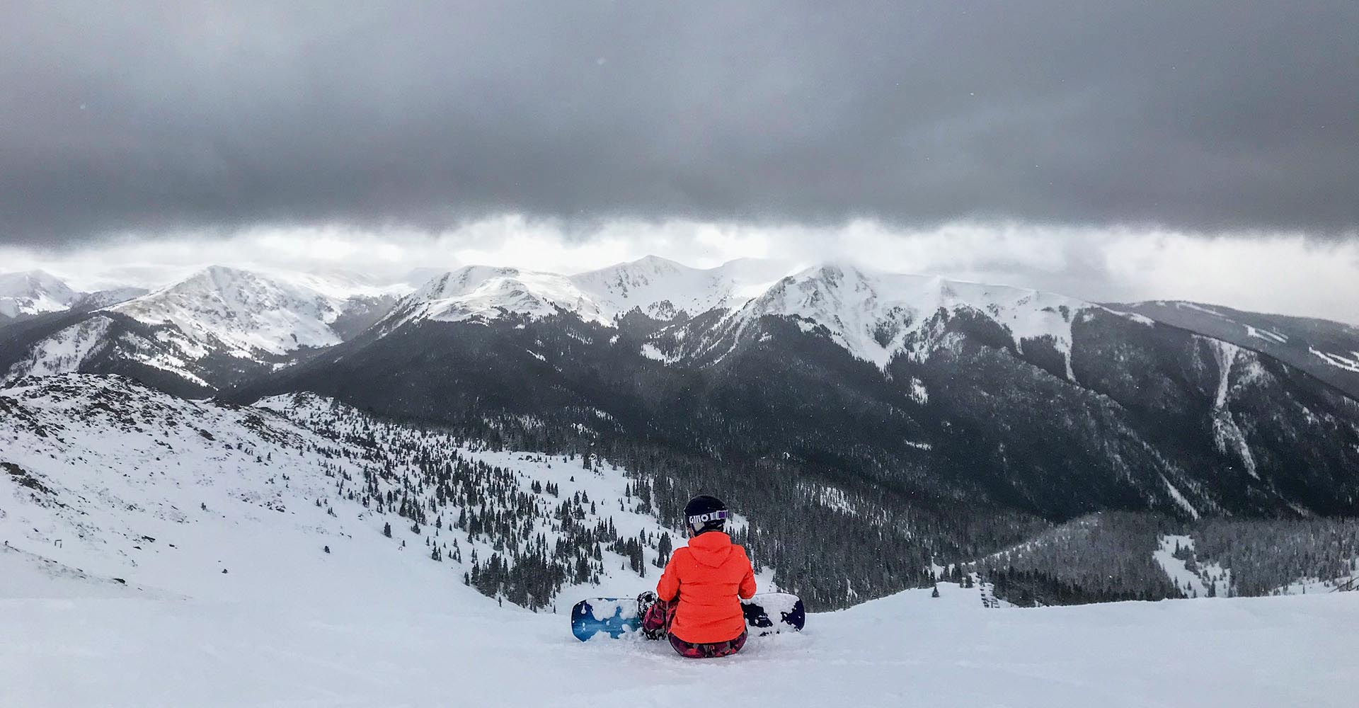
A snowboarder prepares to ride into Montezuma Bowl at Arapahoe Basin Ski Area. Photo by John Arnold
Click the link to read the article on the Summit Daily News website (Cody Jones). Here’s an excerpt:
Arapahoe Basin Ski Area has seen its first “real” snow of the season with rain storms producing snow showers in areas above 10,000 feet throughout the morning on Friday, Sept. 15. The snow comes after A-Basin and Summit County’s other ski areas saw a dusting of snow on Monday, Sept. 11. The first real snowstorm of the season points to the promise of more snow on the way and the beginning of snowmaking season at A-Basin.
Click the link to read the article on the Colorado Politics website (Marianne Goodland). Here’s an excerpt:
The U.S. Board on Geographic Names put a period on the dispute between two tribal groups on the new name for Colorado’s Mount Evans, selecting Mount Blue Sky on Friday. The vote was 15-1, with three abstentions. Last November, Colorado’s Geographic Naming Advisory Board unanimously recommended approving the change to Mount Blue Sky, a name supported by the Southern Cheyenne and Arapaho tribes of Oklahoma. The recommendation went to Gov. Jared Polis, who forwarded it to the federal naming board.
But a request from a tribal government for a “government-to-government consultation” regarding the renaming abruptly halted the federal board’s vote in March. The vote has been held up for the past six months because of objections from the Northern Cheyenne of Lame Deer, Montana, the only original Colorado tribe, which is vehemently against the Mount Blue Sky name. The phrase “blue sky” is part of the sacred Tribal Arrow Ceremony and, thus, the Northern Cheyenne believe it would be “sacrilegious” for it to be spoken in common language, the tribe argued. Northern Cheyenne tribal leaders have, instead, long advocated to rename Colorado’s most famous peak to “Mount Cheyenne-Arapaho.”
[…]
“This renaming was the result of a thoughtful process, led by local communities and Tribes, and I’m grateful to everyone who contributed,” added U.S. Sen. Michael Bennet. “As we work to address the wrongs done to the Cheyenne & Arapaho Tribes, and to Native people across the country, this is a strong first step.”
At considerable risk, Arapaho and Cheyenne Indians traveled to Denver in September 1864 to seek an understanding of peace. Front row, on left, John Wynkoop, the commander at Fort Lyon, in southeastern Colorado, and Silas Soule. Behind Wynkoop was Black Kettle. Photo via The Mountain Town News
“Mount Soule” was the first name change submission, intended to honor Capt. Silas Soule, the whistleblower whose missives to Washington D.C. resulted in a federal investigation of the 1864 Sand Creek massacre, where 230 peaceful Cheyenne women, children and elders were slaughtered by Colorado troops under the command of Col. John Chivington.
Synopsis: El Niño is anticipated to continue through the Northern Hemisphere winter (with greater than 95% chance through January – March 2024).
In August, sea surface temperatures (SSTs) were above average across the equatorial Pacific Ocean, with strengthening in the central and east-central Pacific. All of the latest weekly Niño indices were in excess of +1.0ºC: Niño-4 was +1.1ºC, Niño-3.4 was +1.6ºC, Niño-3 was +2.2ºC, and Niño1+2 was +2.9ºC. Area-averaged subsurface temperatures anomalies increased compared to July in association with anomalous warmth in the central and eastern equatorial Pacific Ocean. Tropical atmospheric anomalies were also consistent with El Niño. Over the east-central Pacific, low-level winds were anomalously westerly, while upper-level winds were anomalously easterly. Convection was slightly enhanced around the International Date Line, stretching into the eastern Pacific, just north of the equator. Convection was mostly suppressed around Indonesia. The equatorial Southern Oscillation Index (SOI) and the traditional station-based SOI were both significantly negative. Collectively, the coupled ocean-atmosphere system reflected El Niño.
The most recent IRI plume indicates El Niño will persist through the Northern Hemisphere winter 2023-24. Despite nearly the same ensemble mean amplitude as last month, the shorter forecast horizon means that the odds of at least a “strong” El Niño (>= 1.5C for the November-January seasonal average in Niño-3.4) have increased to 71%. However, a strong El Niño does not necessarily equate to strong impacts locally, with the odds of related climate anomalies often lower than the chances of El Niño itself (e.g., CPC’s seasonal outlooks). In summary, El Niño is anticipated to continue through the Northern Hemisphere winter (with greater than 95% chance through January – March 2024).
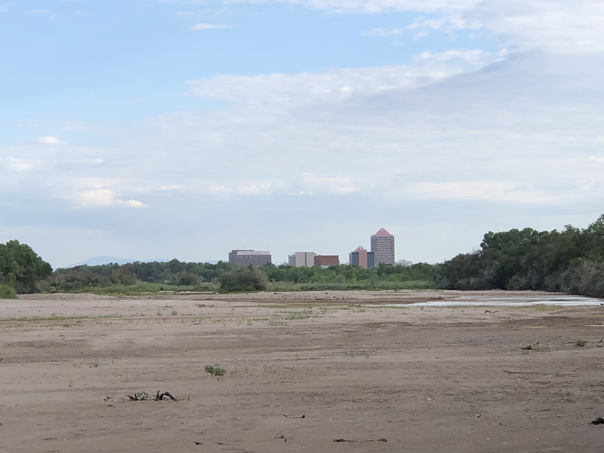
Albuquerque’s Rio Grande, drying September 3, 2023. Photo credit: John Fleck/InkStain
Click the link to read the article on the InkStain website (John Fleck):
There’s so much going on in this picture.
The buildings on the horizon, downtown Albuquerque, are a couple of miles away – foreshortened by the camera’s zoom. It’s a modest downtown, which grew up in that spot 140 years ago because the real estate entrepreneurs collaborating with the newly arrived Athchison, Topeka, and Santa Fe Railway were able to get the land cheap. The spot where Albuquerque’s downtown sits today was basically a swamp.
If you look closely in the picture above, you can see a bit of water, a languid meander across the sand beds of a rapidly shrinking river. When I went out this morning (Sunday, Sept. 3, 2023) the Rio Grande through the Albuquerque reach was still “connected”, in the words of the river managers. But barely. The river that is central to this community’s creation story is about to go dry.
THE FORMALISMS OF A DYING RIVER
In the parking lot by the old Barelas Bridge this morning, I ran into one of the members of the RiverEyes team, a young person of my acquaintance who bicycles through the riverside woods, checking at regularly spaced access points to see if the river is still connected. The operation is part of the staggeringly complex social-hydrological-institutional apparatus around this stretch of the river.
The RiverEyes observations feed into the elaborate effort to stave off the extinction of a fish called the Rio Grande silvery minnow (Hybognathus amarus), which survives only in a couple hundred miles of the Rio Grande through central New Mexico. And in hatcheries. We’ve been doing RiverEyes-like monitoring since 1996. River drying is common south of town, but last year was the first time we needed to monitor here, through Albuquerque. This is the second.
On Friday, there were 30.6 miles of dry channel in the San Acacia Reach 75 miles downstream from Albuquerque. There were 3.6 dry miles in the Isleta Reach, 20 miles downstream from Albuquerque. Sampling in one of the wet parts of the San Acacia reach found 615 juvenile silvery minnows and 14 adults.
Here, we count fish.
THE “DEATH” OF “A LIVING RIVER”?
Some years ago, a consulting firm ran a series of interviews and focus groups among Albuquerque residents to try to better understand their attitudes toward the Rio Grande. They found that residents viewed water issues – their supply – as a major concern. The river, not so much.
The Rio Grande, in fact, was kind of an embarrassment to local residents, the consultant found – small and struggling, not what a “real” river is supposed to look like.
Though, to be fair, even with lots of water, the Rio Grande here looks nothing like what a “real” river is supposed to look like. In a more natural state, before we built a city here, the Rio Grande wandered a broad flood plain, five miles wide in places. The narrow 600-foot channel you see in the picture at the top is a 20th century creation, begun in the 1930s with levees, expanded in 1959 in a project the U.S. Bureau of Reclamation called “channel rectification” meant to turn a meandering river into a more efficient water delivery canal.
In response, the flood control works created ideal habitat for the development of the cottonwoods you see flanking the river, and the magnificent gallery forest we call the “bosque” grew alongside the river for most of its 200-ish miles through central New Mexico.
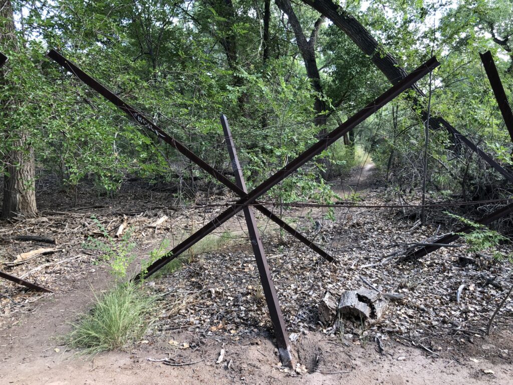
I’m hunting for a good jetty jack photo for the book. This isn’t it. Photo credit: John Fleck/InkStain
Riding this morning with a friend on a twisting path through the bosque, looking for spots to get out to the river channel to see for ourselves, we had to periodically stop and carefully navigate through “Kellner jetty jacks”, big metal contraptions installed in the ’50s as part of the “rectification” effort. Their job was to slow water and hold sediment and enhance the narrowing of the river channel. In so doing, the trapped sediments made ideal seed beds for the opportunistic cottonwoods. They also can be gnarly if you’re cycling, with cables that can snag a pedal, and sharp edges that can cut out a chunk of flesh if you’re not careful.
They also are a reminder of how profoundly unnatural this lovely natural-seeming park, which I so love, really is.
In the circles in which I spend my time, there’s a lot of talk about how to maintain a “living river” here, which is an interesting conceptual framework. Maybe it means simply continuous flowing water? But the whole system is so completely hydrologically (and therefore ecologically) altered by human interventions that we quickly end up down a deep and confusing conceptual rabbit hole when we try to think too hard about what “natural” and “living river” might mean. The terms might help us think well about desired future conditions. But they also can mislead.
THE PART ABOUT HOW IT’S GOING DRY
Weirdly, the Rio Grande is going dry this year through Albuquerque for the second time in the last four years because of a lack of plumbing. El Vado Dam on the Rio Chama, a tributary, is under repairs. Normally we’d store water from the spring runoff, using it to stretch out the river’s flows into the dry months of late summer and early fall. If we’d had El Vado storage this year, I’m told, the river would have been still flowing in the spot where I was standing to take the picture at the top of the post.
Without El Vado storage, the river here will likely dry through the lower end of the Albuquerque reach early next week. The RiverEyes team is on it. They’ll let us know.
Aerial view of Navajo Dam and Reservoir. Photo credit: USBR
From email from Reclamation (Susan Novak Behery):
Reclamation will be releasing additional water over the next two weeks to fulfill a request by the Jicarilla Apache Nation’s subcontractors, The Nature Conservancy and the New Mexico Interstate Stream Commission.
The release will be increased to 900 cubic feet per second (cfs) on Saturday, September 16th , at 4:00 AM. The release may vary slightly as weather and river flows dry out next week, but should remain near this elevated level through 4:00 AM on September 27th.
Widespread precipitation amounts of 0.5 to 2 inches (locally more) were observed across much of the Great Plains, Upper Mississippi Valley, and East. Improvements were made to areas that received the heaviest amounts. In the wake of a cold front, 7-day (September 5 to 11) temperatures averaged near to slightly below normal for the Northern Great Plains and Upper Midwest. Farther to the south, above-normal temperatures continued across the southern Great Plains and western Gulf Coast. Since early August, persistent excessive heat coupled with a lack of adequate rainfall led to a rapid onset and intensification of drought from Texas eastward to the Lower Mississippi Valley and parts of the Southeast. Monsoon rainfall began to decrease throughout the Four Corners region and Southwest during early September, while seasonal dryness prevailed along the West Coast…
Heavy rainfall (1.5 to 3 inches, locally more) prompted a 1-category improvement to southwestern Kansas along with parts of Nebraska. Also, NDMC’s drought blends were a factor in these improvements. Conversely, 30-day SPEI and soil moisture supported small degradations across eastern parts of Kansas. Worsening soil moisture indicators led to an expansion of severe drought (D2) across northeastern North Dakota…
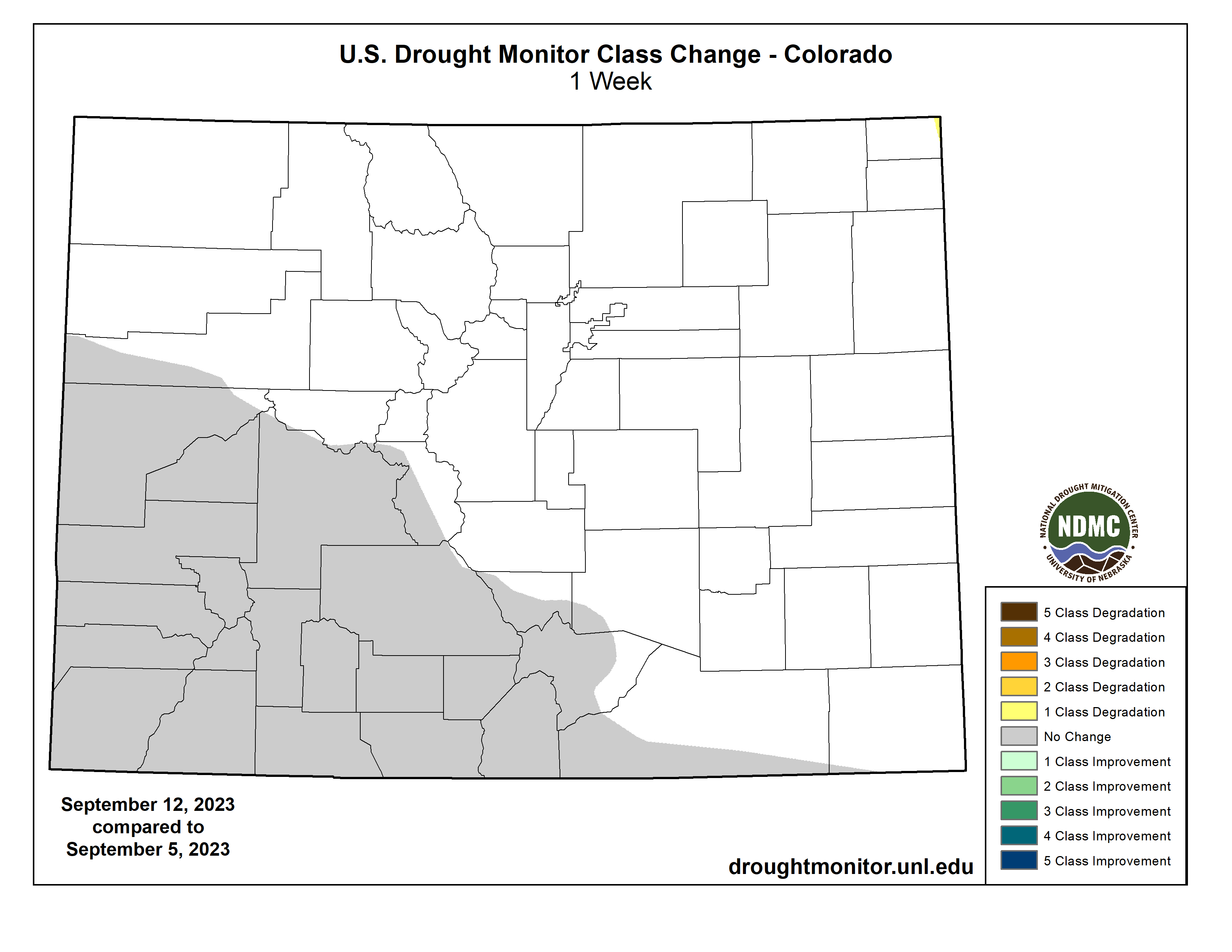
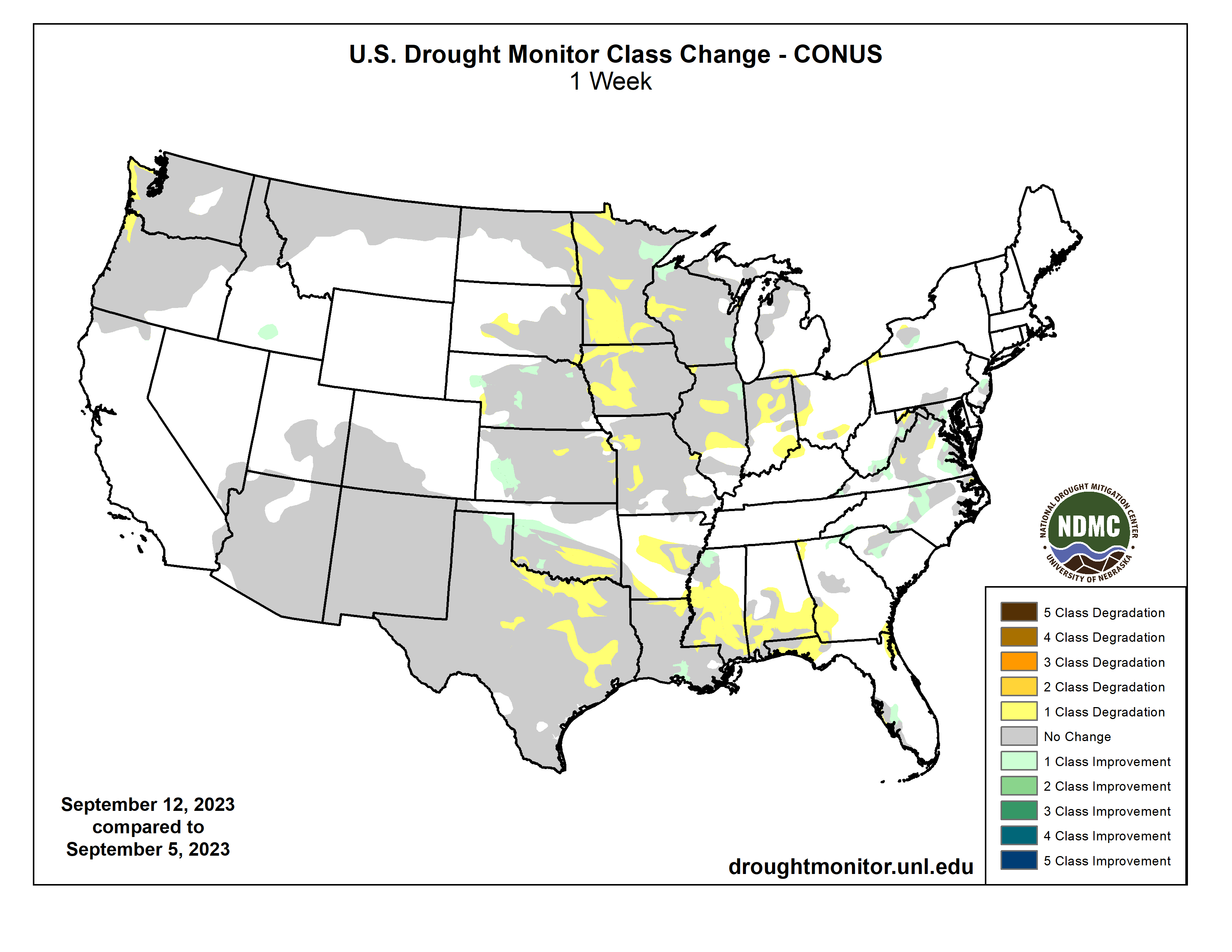
Colorado Drought Monitor one week change map ending September 12, 2023.
Much of the West was status quo this week as Monsoon rainfall begins to decrease during September and this is a drier time of year for California and the Pacific Northwest. However, low 28-day streamflows and SPEI at various time scales led to an expansion of severe drought (D2) across coastal Washington and northwestern Oregon…
The rapid onset and intensification of drought continues throughout central and southern Mississippi. According to the NCEI, numerous counties in the southern half of Mississippi had their driest August on record and many of those counties have received less than 0.5 inch of precipitation during the first ten days of September. Along with this dryness, persistent above-normal temperatures have led to high evapotranspiration rates and worsening impacts to agriculture and high fire danger. Little change was made to Louisiana this week since the previous USDM map matches up well with the indicators (NDMC short-term blend and soil moisture) and many areas received at least a 0.5 inch of precipitation this past week. A 1-category degradation was warranted for southeastern Oklahoma and parts of Texas due to the prolonged excessive heat this summer and lack of adequate precipitation. The expansion of extreme (D3) to exceptional (D4) drought across central and eastern Texas was based largely on the 90-day SPEI and soil moisture indicators. Despite heavier rainfall (more than 1 inch) across west-central Texas, soil moisture indicators, 90-day SPEI, and NDMC’s drought blends support a continuation of D2+ levels of drought. More than 1.5 to 2 inches of precipitation prompted a 1-category improvement to northwestern Oklahoma and the northeastern Texas Panhandle…
US Drought Monitor one week change map ending September 12, 2023.
I suppose it goes without saying, but just in case you haven’t noticed: We live in interesting times climate- and water-wise. And by interesting I mean whiplash-inducing and uncertain; downpour mingled with drought; massive flash-floods in the same region as dried out river beds.
Tropical storm Hillary wreaked havoc in southern and central California even as massive wildfires burned through tens of thousands of acres in the north. Flash flooding caused so much damage in Death Valley that the entire national park remains closed, weeks later.
Flood damage in Death Valley National Park, which remains closed weeks after Hurricane Hilary brought widespread flooding and damage to the park. Source: NPS
A successive wave of storms brought more rain to Nevada, turning Burning Man into a mud-and-poop fest from which celebrants couldn’t escape (God’s punishment, according to Rep. Marjorie Taylor Greene, who is not exactly the sharpest tool in the shed). Las Vegas Wash, which carries treated wastewater from Las Vegas back into Lake Mead (credited against Nevada’s Colorado River allocation), swelled up to 14,100 cubic feet per second on Sept. 2, the second highest flow since 1957.
A woman and her dog were caught in a flash flood in Mary Jane Canyon near Moab and was swept about 200 feet downstream before escaping the rushing, muddy waters. She lost her shoes, was covered with mud, but otherwise escaped mostly unharmed, according to reports.
The southern San Juan Mountains and headwaters of the Rio Grande have received about 40% more precipitation than normal this water year. And yet the Rio is nearly dry through Albuquerque. In early July, about 44% of New Mexico was in moderate drought; today the entire state is gripped by drought, with 20% at extreme levels.
It’s a similar story on the Animas River in southwestern Colorado, which had its healthiest spring runoff in years, only to see flows drop below median levels in August and September as the monsoon failed to deliver its usual deluges. Inflows into Lake Powell were far above average this spring, but in August they were back down to the median levels and on a par with last year. The surface level is now sitting at about 3,573 feet above sea level. That’s a lot better than last year at this time (3,530), but still 43 feet below what it was on Sept. 12, 2019.
Phoenix’s high temperature has reached 110 degrees Fahrenheit or hotter on 55 days so far this year, breaking the 2020 record. And at least 194 people have died from heat-related causes in the metro area this year, with 351 fatalities still being investigated. Pikes Peak experienced its first snow of the year, with a few inches accumulating on top.
Things might get even crazier. Forecasters say there is a greater than 95% chance that the El Niño climate pattern will continue through the winter. Typically that means more moisture than normal for the Southwest, less for the Northwest, and about average in between. But what does “typical” even mean in these climate-crazy days, anyway?
And it is. But not only because greenhouse gas emissions continue to rise. What we are also observing is the long-predicted water vapour feedback within the climate system.
Since the late 1800s, global average surface temperatures have increased by about 1.1℃, driven by human activities, most notably the burning of fossil fuels which adds greenhouse gases (carbon dioxide and methane) to the atmosphere.
As the atmosphere warms, it can hold more moisture in the form of water vapour, which is also a greenhouse gas. This in turn amplifies the warming caused by our emissions of other greenhouse gases.
Some people mistakenly believe water vapour is a driver of Earth’s current warming. But as I explain below, water vapour is part of Earth’s hydrological cycle and plays an important role in the natural greenhouse effect. Its rise is a consequence of the atmospheric warming caused by our emissions arising especially from burning fossil fuels.
Water vapour: the other greenhouse gas
For every degree Celsius in warming, the water-holding capacity of the atmosphere increases by about 7%. Record-high sea temperatures ensure there is more moisture (in the form of water vapour) in the atmosphere, by an estimated 5-15% compared to before the 1970s, when global temperature rise began in earnest.
Water vapour is a powerful greenhouse gas. Since the 1970s, its rise likely increased global heating by an amount comparable to that from rising carbon dioxide. We are now seeing the consequences.
In many ways, water vapour is the most important greenhouse gas as it makes Earth habitable. But human-induced climate change is primarily caused by increases in the long-lived greenhouse gases carbon dioxide, nitrous oxide, methane and chlorofluorocarbons (CFCs).
As a general rule, any molecule with three or more atoms is a greenhouse gas, owing to the way the atoms can vibrate and rotate within the molecule. A greenhouse gas absorbs and re-emits thermal (infrared) radiation and has a blanketing effect.
Clouds have a blanketing effect similar to that of greenhouse gases but they are also bright reflectors of solar radiation and act to cool the surface by day. In the current climate, for average all-sky conditions, water vapour is estimated to account for 50% of the total greenhouse effect, carbon dioxide 19%, ozone 4% and other gases 3%. Clouds make up about a quarter of the greenhouse effect.
Water vapour plays a significant role in Earth’s natural greenhouse effect, and it amplifies current, human-induced warming. Adapted from Trenberth (2022), CC BY-SA
Why is water vapour different?
The main greenhouse gases – carbon dioxide, methane, nitrous oxide and ozone – don’t condense and precipitate. Water vapour does, which means its lifetime in the atmosphere is much shorter, by orders of magnitude, compared to other greenhouse gases.
On average, water vapour only lasts nine days, while carbon dioxide stays in the atmosphere for centuries or even millennia, methane lasts for a decade or two and nitrous oxide a century. These gases serve as the backbone of atmospheric heating, and the resulting rise in temperature is what enables the observed increase in water vapour levels.
The rise in carbon dioxide doesn’t depend on weather. It comes primarily from the burning of fossil fuels. Atmospheric carbon dioxide has increased from pre-industrial levels of 280ppmv to 420ppmv (an increase of 50%) and about half of that increase has happened since 1985.
This accounts for about 75% of the anthropogenic heating from long-lived greenhouse gases. The rest of human-induced atmospheric warming mainly comes from methane and nitrous oxide, with offsets from pollution aerosols.
The extra heating from water vapour has been on a par with that from increased carbon dioxide since the 1970s.
The water vapour feedback: increased heating promotes increased evaporation and higher atmospheric temperatures, which in turn lead to higher levels of atmospheric water vapour. Author provided, CC BY-SA
Water vapour and the water cycle
Water vapour is the gaseous form of water and it exists naturally in the atmosphere. It is invisible to the naked eye, unlike clouds, which are composed of tiny water droplets or ice crystals large enough to scatter light and become visible.
The most common measure of water vapour in the atmosphere is relative humidity.
During heatwaves and warm conditions, this is what affects human comfort. When we sweat, the evaporation of moisture from our skin has a cooling effect. But if the environment is too humid, then this no longer works and the body becomes sticky and uncomfortable.
This process is important for our planet, too, because about 70% of Earth’s surface is water, predominantly ocean. Extra heat generally goes into evaporating water. Plants also release water vapour through a process called transpiration (releasing it through tiny stomata in leaves as part of photosynthesis). The combined process is called evapotranspiration.
Water vapour is part of Earth’s hydrological cycle, Author provided, CC BY-SA
The moisture rises into the atmosphere as water vapour. Storms gather and concentrate the water vapour so that it can precipitate. As water vapour has an exponential dependence on temperature, it is highest in warm regions, such as the tropics and near the ground. Levels drop off at cold higher latitudes and altitudes.
The expansion and cooling of air as it rises creates clouds, rain and snow. This vigorous hydrological cycle means water vapour molecules only last a few days in the atmosphere.
Water is the air conditioner of the planet. It not only keeps the surface cooler (albeit at the expense of making it moister) but rain also washes a lot of pollution out of the atmosphere to everyone’s benefit.
Precipitation is vitally important. It nourishes vegetation and supports various ecosystems as long as the rate is moderate. But as the climate warms, higher moisture levels increase the potential for heavier rainfall and the risk of flooding.
Moreover, the latent energy that went into evaporation is returned to the atmosphere, adding to heating and causing air to rise, invigorating storms and making weather extremes greater and less manageable.
These changes mean that where it is not raining, drought and wildfire risk increase, but where it is raining, it pours.
The outflow at the bottom of Navajo Dam in New Mexico. Photo: Brent Gardner-Smith/Aspen Journalism
From email from Reclamation (Susan Novak Behery):
With the current rainfall pattern adding sufficient hydrology to the river system, flows downstream in the critical habitat have increased and are forecast to remain high. For this reason, the Bureau of Reclamation has scheduled a decrease in the release from Navajo Dam from 800 cubic feet per second (cfs) to 700 cfs for tomorrow, September 14th, at 4:00 AM.
Releases are made for the authorized purposes of the Navajo Unit, and to attempt to maintain a target base flow through the endangered fish critical habitat reach of the San Juan River (Farmington to Lake Powell). The San Juan River Basin Recovery Implementation Program recommends a target base flow of between 500 cfs and 1,000 cfs through the critical habitat area. The target base flow is calculated as the weekly average of gaged flows throughout the critical habitat area from Farmington to Lake Powell.
The historic 2013 flood in Colorado occurred over a week, Sept. 9-15, 2013, but the bulk of the more than 18 inches of rain in some locations occurred during a 30-hour period Sept. 11-12. An extremely moist, subtropical airmass ignited by a cold front parked over Colorado through much of the week, resulting in rainfall approaching totals that statistically would happen once every 500 to 1,000 years. Here’s a snapshot of one of Colorado’s most devastating natural disasters, including a lasting look at its impacts on Larimer County:
Nine fatalities, including two in Larimer County.
Around $4 billion in estimated damage (in 2023 dollars). Only the 1965 flood had higher damage estimates than the 2013 flood at around $5 billion (in 2023 dollars).
1,750 people rescued.
19,000 people evacuated.
2,006 homes destroyed.
26,000 homes damaged.
200 business destroyed.
750 businesses damaged.
200 miles of road damaged.
50 major bridges damaged.
15 counties included in a FEMA disaster declaration, from Larimer in the north to El Paso (Colorado Springs) in the south.
Rainfall records shattered during the 2013 flood
The heaviest rainfall totals of 12 to 18 inches were widespread through much of central Boulder County, stretching from Boulder north and west toward Jamestown, Lyons and into central Larimer County, including the Estes Park area.
The 24-hour state precipitation record was broken at the Fort Carson military base near Colorado Springs, with 11.85 inches of rain falling on Sept. 12.
Boulder set a calendar day all-time rainfall record of 9.08 inches and monthly record of 18.16 inches.
Air search for flood victims September 2013 via Pediment Publishing
Dillon Reservoir stores water from the Blue River Basin in Summit County for Denver Water customers on the Front Range. Photo credit: Denver Water.
Click the link to read the article on The Denver Post website (Elise Schmelzer). Here’s an excerpt:
For decades, Dillon Reservoir has been a place where anglers could hook the fish of a lifetime — a 10-pound, 30-inch wild brown trout. But the brown trout population in one of Colorado’s most visible and accessible mountain reservoirs has declined in recent years, prompting state wildlife officials to consider stricter fishing regulations on the reservoir and seasonal closures on nearby waters. It’s unclear exactly what is causing the decline, said Jon Ewert, an aquatic biologist at Colorado Parks and Wildlife. But increased fishing during the pandemic, and after, may be a factor…
Other potential causes include a change in water quality, development along the rivers and streams where the trout spawn, and stress from higher water temperatures caused by drought, Ewert said…
The number of brown trout measuring more than 14 inches long has declined for four consecutive testing years, according to population surveys conducted by Colorado Parks and Wildlife. The agency conducts surveys every two years. In 2014, trout larger than that size made up 62% of all brown trout caught in the survey nets. By 2022, they made up only 33%…The brown trout in the Blue River upstream from the reservoir also have experienced an “obvious and significant decline,” according to a 2019 CPW report…
The proposed rules would require anglers to immediately release brown trout that are longer than 14 inches, with the rule applying to the reservoir, to sections of the Blue River south of the reservoir and to Tenmile Creek. Fishing would be banned entirely from Sept. 1 to Dec. 1 in two places where the trout spawn in the fall: the Blue River between the reservoir and three miles north of Breckenridge, and West Tenmile Creek from Copper Mountain to the reservoir.
Across Colorado, this water year was a gift. It delivered unexpected bounties of a healthy snowpack, a cool, wet spring and early summer, and reservoirs which filled and spilled. Water managers at local, state, and federal levels exhaled a collective breath.
Yet this year was likely only a temporary reprieve. Aridification of the American Southwest remains our long-term reality, and new water management strategies and solutions must reflect that. The decisions we make today need to be able to weather both storm and drought – durable solutions for a hotter, drier future instead of reactive stopgap measures to the crisis we collectively face.
As water leaders and as water users, we must proactively plan for the success of future generations and the hotter, drier landscape in which they’ll live throughout the Colorado River Basin. Durable solutions hold space for the uncertainty ahead and the fast-growing communities dependent on a rapidly diminishing water source.
The Colorado River District is thrilled to announce its highly anticipated Annual Water Seminar, where experts, stakeholders, and community members will come together to explore the pressing issue of securing durable solutions for the Colorado River.
Percent of normal U.S. precipitation over the past 30 days (December 25, 2022, through January 23, 2023) after a series of weather events known as atmospheric rivers, fueled by tropical moisture, flooded the U.S. West with rain and snow. Places where precipitation was less than 100 percent of the 1991-2020 average are brown; places where precipitation was 300 percent or more than average are blue-green. NOAA Climate.gov image, based on analysis and data provided by the Climate Mapper website.
The climate crisis is no longer a looming threat – people are now living with the consequences of centuries of greenhouse gas emissions. But there is still everything to fight for. How the world chooses to respond in the coming years will have massive repercussions for generations yet to be born.
In my book How to Save Our Planet, I imagine two different visions of the future. One in which we do very little to address climate change, and one in which we do everything possible.
This is what the science suggests those very different realities could look like.
Year 2100: the nightmare scenario
The 21st century draws to a close without action having been taken to prevent climate change. Global temperatures have risen by over 4°C. In many countries, summer temperatures persistently stay above 40°C. Heatwaves with temperatures as high as 50°C have become common in tropical countries.
Every summer, wildfires rage across every continent except Antarctica, creating plumes of acrid smoke that make breathing outdoors unbearable, causing an annual health crisis.
Most mountain glaciers have completely melted. Skiing is now a predominantly indoor sport which takes place on giant artificial slopes. Most of the Himalayan plateau’s ice has disappeared, reducing the flows of the Indus, Ganges, Brahmaputra and Yamuna rivers which over 600 million people rely on for plentiful water.
The extra heat in the ocean has caused it to expand. Combined with water from melting ice sheets, sea levels have risen by more than one metre. Many major cities, including Hong Kong, Rio de Janeiro and Miami, are already flooded and uninhabitable. The Maldives, the Marshall Islands, Tuvalu and many other small island nations have been abandoned.
Many coastal and river areas are regularly flooded, including the Nile Delta, the Rhine valley and Thailand. Over 20% of Bangladesh is permanently under water.
Winter storms are more energetic and unleash more water, causing widespread wind damage and flooding each year.
South-east Asian monsoons have become more intense and unpredictable, bringing either too much or too little rain to each region, affecting the lives of over three billion people.
Fish stocks have collapsed. The acidity of the ocean has increased by 125%. The ocean food chain has collapsed in some regions as the small marine organisms that form its base struggle to make calcium carbonate shells and so survive in the more acidic waters.
This is what our planet could look like if we do everything in our power to contain climate change.
Global temperatures rose to 1.5°C by 2050 and remained there for the rest of the century. Fossil fuels have been replaced by renewable energy. Over a trillion trees have been planted, sucking carbon dioxide from the atmosphere. The air is cleaner than it has been since before the industrial revolution.
Cities have been restructured to provide all-electric public transport and vibrant green spaces. Many new buildings have a photoelectric skin which generates solar energy and green roofs which cool the cities, making them a more pleasant place to live. High-speed electric trains reaching 300 mph link many of the world’s major cities. Intercontinental flights still run, using large and efficient planes running on synthetic kerosene that’s made by combining water and carbon dioxide sucked directly from the atmosphere.
Urban life must become greener, with cleaner air and zero-carbon public transport. Yyama/Shutterstock
Global diets have shifted away from meat. Farming efficiency has greatly improved during the transition from industrial-scale meat production to plant-based sustenance, creating more land to rewild and reforest.
Half of the Earth is dedicated to restoring the natural biosphere and its ecological services. Elsewhere, fusion energy is finally set to work at scale providing unlimited clean energy for the people of the 22nd century.
Two very different futures. The outcome your children and grandchildren will live with depends on what decisions are made today. Happily, the solutions I propose are win-win, or even win-win-win: they reduce emissions, improve the environment and make people healthier and wealthier overall.
Lyons and Estes Park community members reflect on damage and recovery from deadly natural disaster
In early September 2013, after a storm stalled over the Front Range, rivers rose out of their beds and rushed right through several Northern Colorado communities, resulting in one of the state’s worst floods.
Meteorologists classified it as the kind of flood that happens only once every 500 or more years.
From Sept. 9 until Sept. 16, the Front Range experienced uncharacteristically heavy rainfall, which flooded several communities, resulting in nine deaths, 11,000 people evacuated, 1,850 destroyed homes and about $4 billion in damages across the state, with 18 counties declared federal disaster areas, according to the Colorado Encyclopedia.
From the initial damage of the flood and the difficult recovery period to later commemorations, the 2013 flood has stayed with many people as a painful memory 10 years on. On this anniversary, communities are reflecting on lessons of the flood and its story of resilience amid tragedy.
A ‘biblical’ flood
Sitting at the intersection of the North St. Vrain and South St. Vrain creeks, the small mountain town of Lyons was one of the hardest hit communities.
Victoria Simonsen, the town administrator for Lyons, stepped into the role in 2013 prior to the flood and stayed in the position, helping the town recover ever since.
She said the whole town went to bed the night of Sept. 11, 2013, with the creeks at a normal level and no suspicion of the disaster that was to come.
“We were watching the creek, but we were not in any kind of panic mode at all,” Simonsen said.
It was in the late hours of that night, however, when the flooding started. At about 11 p.m. the water rose above the river beds, Simonsen said.
Usually local creeks hit low flooding levels when the water flows at 1,200 cubic feet per second, she said. By the end of the event, Lyons’ two creeks were flowing at 26,000 cubic feet per second. Simonsen said it was true flash flooding, and the water went from ankle deep to 12 feet deep very quickly.
“This was classified as between a 500 and 1,000 year event. The National Weather Service actually called it biblical in Lyons,” Simonsen said.
But it wasn’t until 2 a.m. that the town’s flood sirens actually went off, Simonsen said.
That was also when the water, which was rushing down from 14,000-foot mountains to the town at 5,300 feet, completely isolated neighborhoods and took out all three access points into town.
“The water came through the town at 2 a.m. and it literally divided our community into five islands,” Simonsen said.
Planet Bluegrass during the September 2013 flood. The Wildflower Pavilion is the building at center. (Courtesy of town of Lyons)
The siren system sounded based on population, not location along the rivers, and when many residents woke to the sirens, Simonsen said she got calls from people saying the river was flowing in front of their homes, trapping them.
“We were stranded on our island for about 36 hours before we were able to get contact, and then the National Guard started arriving by helicopter and high water vehicles,” Simonsen said.
About 20 miles northwest, further into the Rocky Mountains, the Big Thompson River rushed through Estes Park and communities along the Big Thompson Canyon around the same time.
“It was the middle of the night I got a call saying it’s gonna be bad, so we opened up an emergency operations center,” Frank Lancaster, the Estes Park town administrator at the time and current trustee.
In the tourist town outside of Rocky Mountain National Park, two rivers and several creeks run through town, and one after another started flooding.
“We were dealing with one and then the other one came up and then basically all hell broke loose everywhere and couldn’t get in or out of town,” Lancaster said.
The only road in or out of Estes Park was Trail Ridge Road, a winding, small road that goes through the national park.
September 2013 flooding via AWRA Colorado Section Symposium
“Because the flooding was so widespread, the county was affected everywhere. So we really didn’t have much assistance from the county, because they couldn’t get up here and they were dealing with other places,” Lancaster said.
The National Park Service became their lifeline. Rangers helped sandbag the town to protect vital infrastructure and bring in materials.
Lancaster said the population in Estes Park is older, and when he went door-to-door to check on people he was surprised to find a lot of residents who were isolated and didn’t realize there was flooding.
Around Boulder County and Larimer County, communities large and small started calling for help.
Joe Pelle, then the Boulder County sheriff, said it was the first time in his career that deputies were unable to get to people in need.
He said during his tenure, he helped create a robust emergency management system and even went through several simulations of floods. None of these simulations could have prepared deputies for this kind of catastrophe, because almost all access to mountain communities was wiped out. In all of the simulations, Pelle said, first responders were able to create an alternate route.
“That night, one after another, all of the canyon roads failed or washed away in places and within a matter of a few hours,” Pelle said. “There was literally no access to our folks who live in the mountains.”
First responders couldn’t reach people in medical emergencies for a day and a half, Pelle said.
Click the image to go to the Colorado Newsline website to view the timeline graphic.
The unusual weather pattern, a prolonged rain storm in early September, that loomed over Northern Colorado was what experts call a cut-off low pressure system, according to Andreas Prein, a scientist with the National Center for Atmospheric Research in Boulder.
Prein said these systems can be dangerous, because whatever weather the system brings, it will last for days.
The storm lasted from Sept. 9 to Sept 16 with persistent rain throughout the seven days, accumulating into torrential rain Sept. 11 and 12.
At the end of the event, Boulder County recorded 18.1 inches of rain and Larimer County recorded 12.4 inches.
“That night, Sept. 11, when those two storms collided over the top of our county, the rain was something I’d never seen happen throughout my entire life. It was just torrential,” Pelle said.
Prein said there are two factors that created that much rainfall. The first was the cut-off low pressure system that didn’t move, and the second was the warm sea surface temperatures in the Pacific Ocean and the Gulf region, which contributed to the amount of moisture in the atmosphere and then the amount of rainfall over Colorado.
“It’s almost unimaginable how strong the force of nature is in these kinds of events and how fast this can evolve, because there was a heat wave and very warm temperatures before the event,” Prein said.
A view of Foothills Mobile Home Park, which suffered a total loss during the September 2013 flood in Lyons. (Courtesy of town of Lyons)
Communities coming together
Lesly Fajardo-Feaux and her family lived in downtown Lyons at the time of the flood. She had two children, and one of them was just two-and-a-half months old.
It was the noise that woke her up that night.
“I thought this is so weird, and I heard the sirens and I went to see it, and there was water all over,” Fajardo-Feaux said. “I couldn’t believe what was happening.”
The whole street had flooded, she said. The river rerouted itself in front of their house, which trapped them that night and early the next day. Her house sat on a hill, which she said made it difficult to get up to in the winters with icy roads, but she was thankful for the hill during the flood.
That night she watched the street flood and her neighbor’s furniture flow past her.
“We were seeing refrigerators coming down the street and sofas and people’s furniture and people’s lives floating by,” Farjardo-Feaux said.
By the next afternoon, they were able to leave their home, and she saw the aftermath of the flood in the daylight.
There was no running water, no electricity, no internet and no phone service. About 20% of the town’s housing was destroyed, Simonsen said.
A view of a neighborhood in Lyons after the 2013 flood. (Courtesy of town of Lyons)
Although Lyons didn’t look like a town anymore, Farjardo-Feaux said the community really came together. There was even a community barbecue to use the food that would have gone bad.
“Lyons was a town where people are so happy all the time having music and people and all. There was a feeling that like, OK, everything is gonna be good, things are gonna be OK,” she said.
During those first couple of days, Simonsen said the community, which was already close-knit, came together to survive the isolation.
“When you’re facing actual life and death situations, you get pretty close, and our community really pulled together,” Simonsen said.
Pelle said he made it a priority to get a declaration of a federal disaster as soon as possible to get funds for what would be an expensive search, rescue and recovery operation.
An emotional sight he remembers was when the National Guard units were sent from Kansas and Utah. He couldn’t believe the size of the convoy and the amount of equipment they brought with them, he said.
“It was just incredible, and it was a couple of miles long with a military police escort, and it’s like the cavalry had arrived,” Pelle said. “Then within a matter of days or weeks all those roads that had been washed out were at least temporarily recovered.”
Air search for flood victims September 2013 via Pediment Publishing
The National Guard coordinated one of the largest air lift evacuations since Hurricane Katrina to get people out of the mountains, according to Pelle.
For Fajardo-Feaux and everyone in town, that was just the beginning.
Fajardo-Feaux and her family cried as they drove down the mountain, unsure of where they would go and for how long. They spent the next few months couch-hopping and staying in hotels and rentals.
When Simonsen told residents they had to leave, she had no idea how long it would take to repair the damage and put in utilities. It ended up being about seven weeks, and Simonsen said families started coming back by Thanksgiving, and most were home by Christmas.
But for those whose homes were destroyed, coming back to Lyons wasn’t in their future.
Damage during the September 2013 flood on U.S. 34 leading up to Estes Park. (Courtesy of the town of Estes Park)
Road to recovery
The process of repairing and recovery was another mountain of challenge the communities had to face.
Where to even start — that was the first obstacle. But Simonsen and her team created a comprehensive plan that she now sends to flood victims across the country as an example.
The Federal Emergency Management Agency showed up in Lyons in October, and the town got to work putting in temporary utilities.
Simonsen said it was a difficult process, because the flood in Boulder County was different than others FEMA had dealt with. Permits, permissions and impact studies stood in the way of recovery.
Lancaster experienced similar challenges with Estes Park’s recovery. He said FEMA understood flooding in the midwest and coastal areas, where water rose and went back down, not where water rushed through destroying anything in its path.
Both communities had to fight for recovery of recreational attractions that fueled much of their towns’ economies — white water rafting features, trees, wildlife habitats and parks. These were things FEMA didn’t originally cover.
During the early period of recovery from the flood, Simonsen set a goal of being back to normal in four years. But Simenson said FEMA agents told her it would take much longer.
“I said, ‘No way, we’re really close, we’ll get it done.’ And they said, ‘No, you’re not understanding the financial part, this will be a six to 10 year event.’ And it was nine years,” Simonsen said.
The small town of Lyons was able to leverage $75 million in federal funds to recover from the flood, according to Simonsen. At the time, its annual budget was $1.2 million with $4 million in reserves. The recovery funds, though, are all reimbursement-based, and it is still waiting for reimbursement from the federal government for some projects.
Simonsen said there were very positive moments throughout the recovery process, but the community went through many low points.
“You start this rebuilding phase and then you, of course, have setbacks. They say anniversaries are usually low points for people where they’re reflecting. But, you know, very gradually you make your way back up. But it’s a long, long process,” Simonsen said.
One of those low points was when neighbors realized some people weren’t going to come back.
“At some point, you have to move on with your life if you aren’t able to rebuild,” Simonsen said.
The issue of affordable housing haunts Lyons. The flood wiped out the town’s mobile home park, Riverbend, and 32 families lost their homes there.
For Craig Ferguson, founder and owner of Planet Bluegrass, which hosts beloved bluegrass and folk music festivals in Lyons, the flood was an attack on his home and business. He decided to stay when the whole town evacuated and started right away on the road to recovery.
“Once you clean it up,” Ferguson said of his house in Lyons, “it’s pretty comfortable. I’d rather live here. I’d rather camp in my house and take showers elsewhere than go live somewhere else.”
Ferguson didn’t wait to ask for permission before getting to work on his Planet Bluegrass property. He said he had a deadline in sight to be open for the next festival in the summer.
Before him was about $2 million in damages, mountains of flood-deposited sand and damaged utilities.
So, Ferguson said he bought one of the last available backhoes in the state and got to work.
“We fixed up our place pretty aggressively and we just had to do it that way in order to survive,” Ferguson said.
Ferguson put on the bluegrass festival that summer as usual.
“That was the biggest celebration you can imagine. You know to the bluegrass world this is a pretty special place,” Ferguson said. “No one thought it would happen during the first two months, seeing the pictures, even most of my partners (said) we couldn’t do it.”
Lancaster said during this period, people’s creativity really shined.
He said the Estes Park community also came together and during its annual Thanksgiving parade, when people decorated their neighborhood-assigned Porta Potties to bring some joy to the difficult times.
“You know, people could be really frustrated and angry instead, but they said my Porta Potty is prettier than your Porta Potty and they decorated them and some of them put them on wheels and brought them in the parade,” Lancaster said.
Estes Park took severe hits to its roads, especially up the Big Thompson Canyon, which was severely damaged during the flood of 1976, when the road was completely wiped out. It was rebuilt with a promise it was floodproof, but in 2013 it was again wiped out.
The water undermined the canyon walls and rockslides completely covered the roads in certain areas.
“There was a section down in the Big Thompson in the narrows where you couldn’t tell there was ever a road there,” Lancaster said. “It wasn’t like the road was missing or damaged, there was no road and there was no sign of it either.”
Lancaster said he remembers after the 1976 flood the road wasn’t back to normal for years, so he could not imagine the road being back up for a while after the 2013 flood. But crews got U.S. 34 repaired by the new year.
“They got it up, and they did it right this time, and that’s why they made so many changes. They worked a lot on making the road a lot more resilient,” Lancaster said.
He said resiliency was their priority. Everything was about how to repair and make infrastructure more resilient. Bridges, riverbeds and buildings all went through a process to ensure the community could last through more floods.
“There’s still some other things we really need to do. We need to deepen this channel (along the local riverwalk) and have it handle more water. There’s a couple more bridges we need to replace even 10 years later,” Lancaster said.
For Lyons, Simonsen said the last flood-recovery project wrapped up in October, but she is still waiting for reimbursements from the federal government.
With the end of the last recovery project, she said the town can finally move on.
“Now that the projects are actually all done, we can actually kind of close that chapter, but we will always be recovering in different ways,” Simonsen said.
The town plans to hold a commemoration and remembrance of the flood this year for the 10th anniversary.
Simonsen said, however, community members remember the flood in different ways. For some, every time it rains they get nervous. Others still hold a barbecue on the night of Sept. 11, like they did 10 years ago.
Simonsen said she knew she had to see the recovery through in Lyons during the last decade.
Now, she said the community can focus on other parts of town that need attention.
“Pretty much the rest of town was kind of neglected the last 10 years. So now we have lots of work to do on streets, sewer and water lines, where we simply did not have funds to put toward it the last 10 years,” Simonsen said.
The issue of affordable housing still looms over Lyons, which lost nearly all its affordable housing to the flood.
Many families couldn’t afford to come back to the community. With disagreements on how to achieve affordable housing, the town is just now starting to see less-expensive units come in.
Ferguson worked to provide affordable housing downtown at a property that used to be a bank. He worked with Habitat for Humanity to bring back people who lost their homes to the flood.
Recently, Simonsen said the town started on a project to get 40 units of affordable housing built on a property donated by someone who lives in Kansas and has land in Lyons. The first eight opened and more are due to open soon.
“The community thought there’s not going to be anyone left who wants to come back because people had to move, but I’m happy to say that over 30% were here 10 years ago,” Simonsen said.
A bridge over St. Vrain Creek in Lyons, July 31, 2023. (Shannon Tyler/ Colorado Newsline)
Looking to the future
After the rebuilding and mitigation efforts, communities still consider what would happen if another event like the 2013 flood were to happen.
“It’s not a question of will this happen and will we be ready or even when it does happen again. Will it not be as devastating?” Lancaster said.
Prein, of NCAR, researches climate change’s effects on major weather events like the flood. He said if another low pressure system stalls over the Front Range, there is likely to be even more rainfall because of the effects of a warming climate.
“The answer will almost certainly be there will be way more rainfall, because it’s really this moisture that you get from the south from the Gulf. Moisture increases with warming,” he said.
Researchers are not certain about how climate change affects the likelihood of cut-off low pressure systems, he said. But, if one does happen again, it is likely to be more devastating.
Colorado authorities built bridges higher, moved buildings out of the floodplains, carved further into the mountains to lay roads, and completely rebuilt stream banks. Yet, Simonsen, Lancaster and Ferguson all said another flood will happen, and they can’t fully prepare for what it will bring.
“What you try to do is minimize the risk, but you can’t avoid the risk, there will always be risk, and you have to balance that with the other needs of the community,” Lancaster said.
Preparing for the damage that comes with flooding of that magnitude isn’t possible, but in the last 10 years communities focused on mitigating what risk they could.
“It’s been a wonderfully challenging 10 years, and I think my goal always as a city manager is you leave the community better than you found it, and I think we did,” Simonsen said.
To study 11 tributaries on U.S. Forest Service land in the Yampa River basin, organizers and volunteers are traveling four seasons per year by snowmobile, ATV, raft, four-wheel drive, mountain bike or on foot to test stream water quality. The goal is to collect water quality samples and data so that the tributaries can be considered for the Outstanding Waters designation program that helps to safeguard water quality. Jenny Frithsen, environmental program manager at nonprofit Friends of the Yampa, is leading the local Outstanding Waters two-year study and application process to determine if the candidate tributaries on Forest Service land qualify for the water quality protection program. The 11 streams are located in four general areas across northern Routt County and in Steamboat Springs, including Elkhead and First creeks in the west California Park area, middle fork of the Little Snake River north of Columbine, four tributaries that feed into the Elk River east of Clark, and Fish, Walton and Soda creeks near Steamboat.
Friends of the Yampa staff are working with the Colorado River Basin Outstanding Waters Coalition formed in summer 2022 to identify and try to protect “clean water” across the state and to designate more headwater streams as outstanding waters deemed worthy of increased protections by Colorado. Frithsen said similar studies are underway in the region, for example, in the Roaring Fork and Eagle River watersheds…
The water quality sampling at 13 different sites in the Yampa River basin started in summer 2022 and will be completed in spring 2024 with a decision on the designations in summer 2024, Frithsen said. The designation would not impact irrigation water rights that are based on water quantity but would serve as an added layer of protection from dangers to water quality from point-source pollution such as wastewater treatment plant discharge or runoff or discharges from mining. Outstanding Waters is the highest level of anti-degradation protection under the federal Clean Water Act, Frithsen said. The designation prevents new or increased sources of pollution, but preexisting uses such as grazing and recreation can continue at current levels as long as pollution is not increased.
The Outstanding Waters designation is awarded through the Water Quality Control Commission of the Colorado Department of Public Health and Environment. For a stream or part of a stream to qualify, the water must meet specific quality criteria gathered across 12 key parameters such as dissolved oxygen, pH, E. coli bacteria levels, nutrients, metals and water temperature. Partners on the local project include The Pew Charitable Trusts and two nonprofits, American Rivers and Mountain Studies Institute in Durango.
Advocates for Grand Lake, Colorado’s largest and deepest natural lake once known for its crystal clear waters, will ask state lawmakers in 2024 to approve a resolution calling for its restoration in an effort to win statewide support and break a bureaucratic stalemate that has stymied efforts to restore its clarity.
The move comes one year after the legislature’s Water Resources and Agriculture Review Committee was asked to intervene in the issue, which centers on the federal Colorado-Big Thompson Project (C-BT). The C-BT moves water through Grand Lake before pumping it under the Continental Divide to the Front Range, where it serves 1 million people and hundreds of farmers. Lawmakers declined to act at that time, citing the need for more study.
Advocates have long been frustrated at the failure to find a permanent fix to the lake’s clarity issues, whether it’s through a major redesign of the giant system or more operational changes. They are hopeful that if they can get state lawmakers to approve the resolution, they may have more leverage with their federal partners.
“[The resolution] doesn’t have any teeth,” said Mike Cassio, president of the Three Lakes Watershed Association, a nonprofit focused on protecting Grand Lake and two reservoirs in the area: Granby Reservoir and Shadow Mountain Reservoir. “But it is something state legislators could vote on, and it would put people on the record.”
Map of the Colorado-Big Thompson Project via Northern Water
For years, the once-clear lake has been clouded by turbidity created by the pumping. Before the C-BT was built, clarity was 9.2 meters, roughly 30 feet. The goal now is 3.8 meters, according to Esther Vincent, Northern Water’s director of environmental services. Northern Water jointly operates and maintains the C-BT along with the U.S. Bureau of Reclamation.
Historic protections?
Early on locals had hoped the lake would be protected from damage caused by the giant water systen. A 1937 federal law, U.S. Senate Document 80, was approved in part to protect Grand Lake’s recreational and scenic values, and a 15-year-old state standard was designed to improve water clarity, but officials acknowledge more must be done.
As advocates seek to broaden support, the Three Lakes Technical Committee, a working group that includes multiple federal and state agencies and interest groups, restarted formal meetings Sept. 1 for the first time since 2014, though other groups have met more often, examining annual operating results and testing new management scenarios. The idea behind restarting the technical meetings, is in part, to identify shorter-term fixes that could be quickly implemented and paid for more easily.
Vincent sees the resumption of the technical committee meetings as a hopeful sign.
“We have a lot of people who are newer to the work and it’s important that we bring everybody up to speed,” she said. “We would like to see clarity get better.”
This year, thanks to an exceptionally wet winter and spring, and high runoff, the lake has been clearer than locals have seen it in decades.
Grand Lake Mayor Steve Kudron said seeing the lake temporarily improve this summer has been gratifying.
“My goal has always been to maintain the recreational, scenic natural quality of Grand Lake and I have that this summer … I should smile while keeping an eye on what we’re going to do when it gets worse,” Kudron said.
Grand Lake via Cornell University
A Colorado landmark
The lake is considered a prime jewel in Colorado’s scenic landscapes. Located on the western edge of Rocky Mountain National Park, it has been a tourist haven since the late 1800s.
But it changed when the C-BT began construction in the late 1930s. The system gathers water from streams and rivers in Rocky Mountain National Park and Grand County, and stores it in man-made Lake Granby and Shadow Mountain Reservoir. From there it is eventually pumped up into Grand Lake and delivered via the Adams Tunnel under the Continental Divide to Carter Lake and Horsetooth Reservoir on the Front Range
During the pumping process, algae, certain toxins and sediment from Shadow Mountain are carried into Grand Lake, clouding its formerly clear waters and causing algae blooms and weed growth, and harming recreation.
In 2008, the Colorado Water Quality Control Commission moved to set a clarity standard, but it has since been replaced with a clarity goal and the aim of achieving “the highest level of clarity attainable.”
Northern Water and others have implemented different management techniques, including changing pumping patterns, to find ways to improve water quality in all three water bodies. In some years, Northern has been able to improve clarity, but not to historical levels.
In 2016, Reclamation took the first steps required under the National Environmental Policy Act of 1969 (NEPA) to do the scientific and engineering studies and public hearings that would be required for a major structural fix to the system. But Reclamation stopped the process in 2020, saying that it could not definitively establish any structural alternatives that would work, nor could it find a way forward on funding what could be a wildly expensive project, according to Jeff Rieker, manager of Reclamation’s Eastern Colorado Area office.
Redesigning the massive 85-year-old water project could easily cost hundreds of millions of dollars, officials said and would take years of permitting. It would also likely require local partners to share some of the cost.
Long-running frustrations
Rieker said the resumption of the technical meetings, scheduled to occur monthly through next April, could help move everyone closer to a solution.
“We certainly recognize the concerns and frustrations that are out there … my hope is that through these dialogues that we are having this year, it will lead to people being less frustrated,” Rieker said.
Shadow Mountain Dam via USBR
Cassio said one avenue that may hold promise would be to focus on Shadow Mountain, a shallow manmade reservoir whose warm temperatures, high levels of algae and weeds, and sediment loads do the most damage to Grand Lake. If technology could be introduced to harvest the weeds and aerate Shadow Mountain, that could improve Grand Lake without a major federal infrastructure project.
Rieker said that his agency is very interested in that approach.
At the same time, Northern and Reclamation, along with other Grand Lake interest groups, will update the Colorado Water Quality Control Commission in November on their efforts since 2016. Whether the state will take additional action isn’t clear yet.
Cassio said he remains deeply worried that the lake’s long-term condition will not improve, especially as more frequent droughts and climate change reduce streamflows and degrade water quality even further.
Getting state lawmakers on board could generate a new level of support for the lake. “I am hoping we can get the resolution on the books and that it means something,” Cassio said. “If we have a couple more years of bad snowpack and rainfall, it’s going to be ugly.”
Fresh Water News is an independent, nonpartisan news initiative of Water Education Colorado. WEco is funded by multiple donors. Our editorial policy and donor list can be viewed at wateredco.org.
More by Jerd SmithJerd Smith is editor of Fresh Water News. She can be reached at 720-398-6474, via email at jerd@wateredco.org or @jerd_smith.
Updated Colorado River 4-Panel plot thru Water Year 2022 showing reservoirs, flows, temperatures and precipitation. All trends are in the wrong direction. Since original 2017 plot, conditions have deteriorated significantly. Brad Udall via Twitter: https://twitter.com/bradudall/status/1593316262041436160
Rising temperatures have sucked more than 10 trillion gallons of water out of the Colorado River Basin between 2000 and 2021.
“Water in western Colorado is not a partisan issue,” said Andy Mueller, the executive director for the Colorado River District. “We have some of the most liberal counties in America, but we also have some of the most conservative counties in America, and yet when they come together — their representatives who employ me — 90% of the time they agree on water policy issues. And it is the one area in today’s really divided political discourse where we see some united discussion.”
A new study out of UCLA shows the Colorado River has lost 10% of its water since the 1950s due to rising temperatures. Along parts of the Colorado, that loss is due to lessened snowpack as the area becomes more arid, but in others it’s due to evaporation as the temperatures cause the water to change to a gas more quickly.
At its Aug. 24 meeting, the Pagosa Area Water and Sanitation District (PAWSD) Board of Directors heard a presentation from Carol Malesky of Stantec on the rate study Stantec is performing for the district. Malesky explained that the rate study being presented to the board is the first part of the study Stantec is working on and that the study aims to evaluate what the district’s water and wastewater funding needs will be over the next 10 years…
She stated that the water and wastewater funds were analyzed as separate utilities, which she noted is a “sound” management practice, and that the study attempts to mini- mize impacts on PAWSD customers…
Following further discussion of the details of the CIF calculation, Malesky explained that, if PAWSD does nothing, water rate revenue will increase at the speed of growth from just below $5 million in 2024 to approximately $5.95 million in 2032. She noted that this growth in revenues would be eclipsed by the revenue demands for the district, with the water fund projected to fall below the reserve requirement in 2027 and to go into the negative in 2028…
Malesky then presented the pro-
posed water rate changes, with a 6 percent increase for 2023, 3 percent annual increases between 2024 and 2027, 3.5 percent annual increases between 2028 and 2030, and no increases between 2031 and 2032. She stated that these increases would take an average monthly water bill for 6,000 gallons of water from $54 in 2023 to $60.74 in 2027 to $67.35 in 2030.
Crews set up a workover rig June 3, 2022, in the Salt Creek oil field where CO2 from ExxonMobil’s Shute Creek facility was injected for enhanced oil recovery. (Dustin Bleizeffer/WyoFile)
Backed by the promise of billions in federal dollars, energy companies are lining up to accept an invitation by Wyoming officials to collect industrial sources of carbon dioxide and pump it deep underground.
Essentially, the vision is to build a new low-carbon energy industry that scrubs the planet-warming gas from fossil fuels, keeping those fuels in the energy mix and simultaneously helping to address the climate crisis in a way that pays dividends to developers and the state.
Wyoming, according to Gov. Mark Gordon and other state officials, is primed to launch the industry. Not only has the state spent years testing its subterranean capacity to permanently store carbon dioxide, it has devoted more than a decade to building a legal and regulatory framework to win the federal government’s approval. Only Wyoming and North Dakota have won primacy over the federal program to permit such activities.
Now, the state’s top environmental regulator is considering the first in what many expect to be a wave of permit applications to drill the deep wells necessary to launch the new industry.
This schematic depicts how carbon dioxide from industrial sources might be collected for geologic sequestration. (Wyoming Department of Environmental Quality)
“Since 2010 [Wyoming has] been working on how to ensure this particular program could get off the ground and be protective of the environment with a lot of the risks that are involved with these kinds of projects,” said Lily Barkau, natural resources program manager at the Wyoming Department of Environmental Quality.
The agency is soliciting public comments on three carbon dioxide injection well permit applications submitted by Frontier Carbon Solutions. Two more “Class VI” permits are under review at the agency, but not yet ready for public feedback.
Sequestering CO2
Industry and regulatory officials eagerly note that pumping carbon dioxide underground isn’t fantasy. For decades, oil and gas developers have pumped the gas into oilfield formations to squeeze out more oil. Wyoming even has a “backbone” carbon dioxide pipeline that delivers the gas from southwestern and central Wyoming to multiple oilfields in the northeast corner of the state and into Montana.
While Wyoming still hopes to expand “enhanced oil recovery” via carbon dioxide injection, officials are also eager for companies to pump the gas deeper underground into saline formations. Here, at depths of 10,000 to 15,000 feet, carbon dioxide — compressed into liquid form — can be pumped and stored permanently, according to state and industry officials.
Assurances that the gas will remain underground are based on seismic surveys and deep geologic testing conducted by the U.S. Geological Survey and the University of Wyoming School of Energy Resources.
There are skeptics, however, and many questions about the logistics of deep carbon dioxide “sequestration,” as well as whether all of the public resources invested are justified.
Skepticism and questions
So far, capturing carbon dioxide from industrial smokestacks — be they attached to trona processing plants, cement factories or coal-fired power plants — hasn’t proven economical at large scale. However, industry officials point to the federal 45Q tax credit — which was expanded under the Inflation Reduction Act — for vastly improving the economics of carbon capture and storage.
Gov. Mark Gordon and U.S. Environmental Protection Agency Administrator Michael Regan met with University of Wyoming School of Energy Resources officials Aug. 9, 2023 in Laramie. (Dustin Bleizeffer/WyoFile)
Until industrial facilities in the southwest region of the state — including in corners of Colorado and Utah — are fitted with carbon capture, Frontier Carbon Solutions plans to collect its carbon dioxide from a “direct air capture” project still in development.
Other questions remain:
How will facilities such as direct air capture farms get carbon-free power without sprawling renewable energy development on sensitive landscapes?
How much will it cost to safely manage highly saline water displaced by carbon dioxide in deep geologic formations?
And, is all the time and public resources merely a distraction from proven renewable energy and the declining costs of installing wind and solar energy?
“Billions of dollars have been wasted trying to prove that this technology is real,” Wenonah Hauter, executive director of Food & Water Watch, told the Associated Press in May. “And all we have to show for it are a series of spectacular failures.’’
Projects under review
Texas-based Frontier Carbon Solutions is a partner in the Sweetwater Carbon Storage Hub project in southwest Wyoming. The effort is part of the federal CarbonSAFE Initiative led by the University of Wyoming’s School of Energy Resources, which won $40.5 million in support from the U.S. Department of Energy. UW and Frontier Carbon Solutions will contribute another $10.1 million to the project for a total of $50.6 million, according to DOE and university officials.
The “storage hub” will have a minimum storage capacity of 50 million metric tons of carbon dioxide over the life of the project — about 20 years, according to Frontier Carbon Solutions. For context, Wyoming’s annual carbon dioxide emissions from industrial fossil fuel consumption — excluding motor vehicle pollution — was 54.6 million metric tons in 2021, according to the U.S. Energy Information Administration.
The company is seeking three permits under the Wyoming Department of Environmental Quality’s Underground Injection Control program. Public comment closes Oct. 19.
Click here for more information about the company’s permit applications. Comments can be submitted electronically via DEQ-online portals for each of the three permits: permit 242, permit 243 and permit 244. Comments may also be submitted by mail to: Ms. Lily Barkau, P.G., Groundwater Section Manager, Wyoming Department of Environmental Quality, Water Quality Division, 200 West 17th Street, 2nd Floor, Cheyenne, WY 82002.
DEQ will also hold a public hearing on the Class VI well permits, with dates yet to be announced. If the permits are approved, the company will still have to submit more information from initial drilling activities before DEQ can grant Frontier Carbon Solutions a permit to actually inject carbon dioxide, Barkau said.
Tallgrass Energy is also seeking a Class VI injection well permit for its Eastern Wyoming Sequestration Hub in Laramie County. That permit is not yet up for public comment. However, the U.S. Bureau of Land Management is seeking public comment regarding the company’s application for rights-of-way on federal surface in Laramie County.
This diagram depicts how CO2 is injected deep underground for geologic storage. (U.S. Department of Energy)
Public comment has been extended to Oct. 10. More about the project and how to comment can be found on the BLM’s project website.
Tallgrass was awarded $4.1 million for the project from the Wyoming Energy Authority in 2022, which the company will match in full, according to the agency. The grant comes from a $10 million legislative appropriation for carbon capture, storage and utilization projects.
First round of carbon dioxide injection permitting
The state won authority over the program after more than a decade of legislation to establish a legal and regulatory framework to allow for the geologic storage of carbon dioxide.
That framework includes settling the question of who owns the underground “pore space” where carbon dioxide will be stored. The state declared it belongs to the surface estate, which clarifies who gets paid for use of the pore space and who is liable. The state also set out to appease potential developers by giving them an opportunity to transfer their liability for carbon dioxide injections to the state if they meet post-closure requirements intended to protect water and human health, according to Barkau.
Wyoming, with primacy over the federal Class VI injection well permitting program, can shave years off the permitting process, Barkau said. And that makes Wyoming an attractive place to launch carbon dioxide storage projects.
“I think we’ve been able to prove that if the operator is willing to work collaboratively, it can be done in a very expedited time frame and still meet all of the rules and regulations and be protective of human health and the environment,” Barkau said.
When State Climatologist Russ Schumacher presented a preview of the Climate Change in Colorado assessment update to a conference audience in late-August in Steamboat Springs, he said the statewide annual temperature has warmed by 2.9 degrees Fahrenheit since 1895 and could warm by 5.5 degrees total by 2050.
“Observations in the past decade have only affirmed the long-term trends as described in the 2014 report, more warming everywhere, in all seasons,” Schumacher presented in his take-home messages.
“The observed warming alone is already imposing reductions on snowpack, soil moisture and stream flows,” Schumacher said. “Some climate extremes and hazards have already become more frequent and intense due to warming: heat waves, drought, wildfires. Heat waves, droughts and wildfire will worsen with the additional warming. Heavy and extreme precipitation and flooding are likely to worsen as well.”
Precipitation trends and future precipitation change are less clear and certain, but the early 21st century will be drier than late 20th century, the state climatologist noted. Snow, soil moisture and streamflows are “very likely to decline further,” reported Schumacher, the director of the Colorado Climate Center and professor in the Colorado State University atmospheric science department.
Schumacher’s presentation was part of the annual summer Colorado Water Congress hosted in Steamboat. He told the audience of water professionals and guests that scientists have a “very high confidence in change” that evaporative demand in Colorado will continue to be higher and a “high confidence in change” that summer soil moisture will continue to lower and runoff timing will be earlier. Scientists have a “medium confidence in change” that annual stream flow and spring snowpack will continue to lower in the future.
Two Colorado Democrats on Thursday joined local governments and environmental groups in urging the federal Bureau of Land Management to undertake a full review of the proposed expansion of an oil-train terminal in eastern Utah.
The operator of the Wildcat Loadout Facility, located along existing rail lines near Price, Utah, has petitioned the BLM to expedite approval of an expansion that would more than triple its current capacity. The terminal is currently used to export limited amounts of crude oil from Utah’s Uinta Basin, which must be trucked out of the region and then loaded into tank cars to transported by rail to refineries along the Gulf Coast — a route that runs directly through Colorado.
The terminal’s expansion from a capacity of 30,000 barrels to 100,000 barrels per day is viewed by environmental groups as a possible interim or backup measure in relation to the Uinta Basin Railway, the multibillion-dollar public-private partnership that aims to build a new 88-mile railroad to connect the basin to the national rail network. The railway project is on hold after a federal appeals court last month ordered regulators to better analyze the “downline” risks the increased oil-train traffic would pose to Colorado.
U.S. Sen. Michael Bennet and Rep. Joe Neguse of Lafayette, who have also spoken out against the Uinta Basin Railway, cited similar concerns about the proposed Wildcat Loadout expansion in a letter to BLM Director Tracy Stone-Manning. Though more limited in scope than the projected 350,000-barrel-per-day capacity of the proposed railway, the facility’s expansion is expected to result in a substantial increase in oil-train traffic through western and central Colorado.
“A train derailment that spills oil in the Colorado River’s headwaters would be disastrous to our state’s water supplies, wildlife habitat, and outdoor recreation assets, and the broader Colorado River Basin,” Bennet and Neguse wrote. “In addition, an accident on the train line further increases wildfire risk at a time when the West already faces historically dry conditions.”
Following a permit application submitted earlier this year by the Wildcat facility’s operator, the BLM has initiated proceedings for an “environmental assessment” of the proposed expansion under the National Environmental Policy Act. Such analyses are much more abbreviated than environmental impact statements for large projects, which can involve years of study and public feedback.
Echoing calls from Colorado’s Eagle County and more than a dozen environmental groups, Bennet and Neguse urged the BLM to conduct a full EIS process instead.
From left, Glenwood Springs Mayor Jonathan Godes, state Sen. Dylan Roberts, U.S. Rep. Joe Neguse, U.S. Sen. Michael Bennet and Colorado House Speaker Julie McCluskie participate in a press conference near Interstate 70 at the confluence of Grizzly Creek and the Colorado River to voice opposition to the Uinta Basin Railway project, April 7, 2023. (Chase Woodruff/Colorado Newsline)
A full review is especially necessary, they argued, in the wake of last month’s halting of the Uinta Basin Railway by the D.C. Circuit Court of Appeals, which ruled that the federal Surface Transportation Board had violated NEPA requirements by failing to adequately analyze the railway’s environmental risks. Eagle County and five environmental groups had sued the agency to overturn the STB’s December 2021 approval of the project.
“In light of the court’s decision, the BLM should not repeat the STB’s mistakes, and instead conduct a robust environmental review,” wrote Bennet and Neguse. “The BLM cannot adequately account for potential harm from increased oil shipments through Colorado with an EA, given its lower requirements for public involvement and environmental analysis.”
“We urge BLM to prepare a full EIS that accounts for the full risks of the Wildcat Loadout expansion to Colorado’s communities, water supplies, and environment,” the letter concludes.
Heavy rainfall associated with Hurricane Idalia brought damaging winds and flooding centered along its path. Idalia moved from the Gulf of Mexico inland along the northeastern Gulf Coast of Florida and continued northeastward through south-central and east-central Georgia, slightly inland from the South Carolina Coast, then across southeastern North Carolina before moving into the open waters of the northwestern Atlantic Ocean. A solid swath of heavy rains were observed in a band from the eastern Florida Panhandle northward through middle Georgia, interior eastern South Carolina, and southeastern North Carolina as far north as the lower Outer Banks. Between 4.5 to 10.0 inches of rain fell solidly along this swath of land, but rainfall totals dropped off rapidly to the west and east of the main band.
Farther west, a surge of tropical moisture pushed northward into the southwestern U.S., continuing northward across the Great Basin, Intermountain West, and adjacent Rockies into adjacent Canada. Heavy rainfall fell in a broken pattern over this general area, with the highest amounts reported across interior southeastern California, over much of the middle Colorado River Basin, and across scattered areas farther north. The heaviest amounts outside the lower Colorado River Basin fell on higher elevations and over areas where precipitation was enhanced by orography, as is typical.
Most of the Nation, however, endured a hot and drier-than-normal week, including most areas of drought. Temperatures averaged 5 to 10 deg. F accompanied deficient precipitation over a large area from the Rockies to the Appalachians and central Gulf Coast Region, prompting drought intensification over large parts of the Upper Mississippi Valley, the Central States, and the southern tier of the country west of the Florida Panhandle. Improvement was limited to the band of heavy precipitation from Hurricane Idalia, and in scattered locales affected by the tropical moisture surge in the Desert Southwest, from southeastern Utah to central Arizona westward toward central California. According to the U.S. Department of Agriculture (USDA), the coverage of topsoils short or very short of moisture increased by 6 percent this past week, now covering 58 percent of the contiguous 48 states. This is the greatest coverage at this time of year in more than 9 years, the prior record in that short interim being just over 50 percent in 2020…
Conditions vary markedly from southeast to northwest here. Similar to western sections of the Midwest Region, Kansas and Nebraska in the southeastern High Plains region are largely covered by drought, including significant expanses of D2 to D3 conditions, with new or expanded D4 (exceptional drought) noted in a few locations. Farther west and north, conditions are much more favorable. To the north and west of central Nebraska, dryness and drought are restricted to the eastern and northern Dakotas, and southwestern Colorado. As in other parts of the Nation’s midsection, agricultural drought stress is palpable, and on the rise. Across Kansas, 40 percent of soybeans are in poor or very poor condition, as are 33 percent of the corn crop, 29 percent of sorghum, and 47 percent of rangelands. Across Nebraska, about one quarter of all the aforementioned crops are in poor or very poor condition. Still, this region did not see the degree of deterioration observed in the Midwest Region, with significant worsening most notable in central and eastern Kansas…
Colorado Drought Monitor one week change map ending September 5, 2023.
Monsoon rains remained subpar across eastern Arizona, New Mexico, and southwestern Colorado, prompting a continued slow deterioration in dryness and drought there. With the monsoonal wet season winding down during September, the odds for heavy precipitation episodes declines, and thus the prospects for significant relief from the intensifying dryness and drought become progressively worse. Dryness and drought also cover large parts of Washington and Oregon as well as the northern tiers of Idaho and Montana. Some deterioration was noted in north-central Montana, but farther west, conditions were essentially unchanged in northern Idaho and the Pacific Northwest…
Brutally hot and dry weather again this week kept dryness entrenched across Texas, southern Oklahoma, Louisiana, and southern Mississippi. For the past 2 months, temperatures averaged 4 to 8 deg. F above normal from most of the Four Corners States eastward through most of Texas and Louisiana, and across southern Mississippi. A solid swath of extreme to exceptional drought (D3-D4) is now entrenched from central Texas eastward through most of Louisiana and southern Mississippi, expanding slightly northward as well. Outside the large area of solid D3-D4 conditions, conditions generally deteriorated where dryness was antecedent or on the cusp of developing, and remained essentially unchanged elsewhere. In contrast, Tennessee and most of Arkansas remained free of any systemic dryness. According to the USDA, the cotton crop has not fared well this summer, suffering through the persistent hot and rain-free weather. Almost 80 percent of the Oklahoma cotton crop is in poor or very poor condition, as is 61 percent of Texas cotton. Peanuts, sorghum, soybeans, and rice planted in Texas, Louisiana, southern Oklahoma, and southern Mississippi were also being stressed by from heat and lack of rainfall, although the proportion in poor condition or worse is considerably lower. In addition, deteriorating pastures and rangelands are stressing livestock. As of early September, 72 percent of Texas rangelands, 63 percent of Louisiana pastures, and almost 40 percent of Mississippi pastures were in poor or very poor condition…
Looking Ahead
According to the Weather Prediction Center (WPC), the next 5 days (September 7-11, 2023) will bring some much-needed rainfall to the parched central Plains. Over 0.5 inch is forecast from parts of Oklahoma and the Texas Panhandle northward through Nebraska, with 1.5 to locally 3.0 inches anticipated in part of central Kansas. Moderate to heavy precipitation is also anticipated from the southern Appalachians and adjacent foothills northeastward through the mid-Atlantic and Northeast. At least 1.5 inches is expected from the mountains of northwestern Virginia northeastward through most of the Northeast and New England. The heaviest amounts are expected from central Pennsylvania northeastward through interior southeastern New York, where totals could top 4 inches. Eastern Florida could also receive moderate to locally heavy precipitation, generally 0.5 to locally 2.0 inches. A broad area covering most of the Plains and the Lower Mississippi Valley are expecting several tenths of an inch of precipitation, as are most locations from the Appalachians and eastern Gulf Coast Region eastward to the Atlantic Seaboard. Most other places might see light precipitation, but little or none is expected across the Far West, most of the Rockies, southern Texas, the southern High Plains, the Middle Mississippi and Lower Ohio Valleys, And parts of the interior Deep South. Hot weather is expected to accompany subnormal rainfall totals along the southern tier of the country from southernmost California eastward through the central Gulf Coast Region, as has been the case much of the summer. Daily maximum temperatures are expected to average 5 to 9 deg. F above normal there. In contrast, milder than normal temperatures are expected to displace the heat that has recently affected parts of the Nation’s Midsection, with readings expected to average 3 to 7 deg. F below normal across much of the region from the central High Plains eastward across the Middle Mississippi and Ohio Valleys.
The Climate Prediction Center’s 6-10 day outlook (valid September 12-16, 2023) favors a similar pattern. Odds favor above-normal temperatures from the South Atlantic Region westward across the southern tier of the Contiguous 48 states, over most areas from the Rockies westward, and the northern Plains. Meanwhile, below-normal temperatures are favored across a large swath from the south-central Plains eastward through most of the Mississippi Valley, the Upper Southeast, the Appalachians, the Atlantic Piedmont, the Mid-Atlantic, and the lower Northeast. There are enhanced chances for surplus precipitation across the central and southern Rockies, much of the central and southern Plains, the southern half of the Mississippi Valley, the Ohio Valley, the interior Southeast, the Appalachians, the mid-Atlantic, and the Northeast. In contrast, drier-than-normal weather is favored across most of the Great Lakes, the northern tiers of the Plains and Rockies, the northern Intermountain West, and the Pacific Northwest, as well as across the Florida Peninsula.
US Drought Monitor one week change map ending September 5, 2023.
Just for grins here’s a slideshow of early September US Drought Monitor maps for the past few years.
I hope you’ll excuse my irreverence in showing the image above. If you haven’t noticed, ‘what’s real’ versus what we wish were real is what a lot of our discourse is about these days, and not just along the Colorado River. Denial is more than just a river in Egypt.
But moving on – I concluded the last post with a discussion of the first real break the First Peoples of the arid lands got after being forced onto reservations that were far too small for their timeless lives as hunter-foragers (requiring as much as a square mile or two per person in the arid lands). The U.S. Supreme Court decreed in 1908, in Winters v. The United States, that when the federal government reserved western land for any purpose (removed it from private-sector development), it also implicitly reserved enough water to carry out the purpose of the reservation.
For the First Peoples put on dryland reservations, the ‘Winters doctrine’ meant enough water had to be reserved to ‘civilize’ the First Peoples, primarily via irrigated farming. Quite a lot of water, in other words – enough reserved, with seniority to the date of the reservation’s creation, to throw a little panic in the hearts of the conquering Second People who, by the turn of the century, were already realizing the water supply was not really infinite.
But the Court said nothing in Winters about how the First Peoples – then still struggling just to maintain their cultural identities under a heavy-handed federal policy of forced assimilation – might go about obtaining their entitlement of water. And more to the point, with no developed economy of their own: how to turn that ‘Winters water’ into real water flowing onto the land and into their communities.
Given the supposedly benevolent and paternalistic trust relationship established in their treaties with the federal government, the First Peoples were aware that the ‘Great Father’ held their implied water rights in trust for them, just as the feds held the reservation in trust for them. So it seemed reasonable to presume that the government would be bound by the trust’s fiduciary responsibilities to help them do such basic things as determining how much water the Winters doctrine gave them, and helping them plan for the development of the water.
But while the Winters decision itself was not openly contested, the Bureau of Indian Affairs, the Bureau of Reclamation and other Interior Department agencies did not jump eagerly into implementing it; they instead argued that there was nothing explicit in the treaties requiring them as federal trustees to help in assessing and developing the implicit Winters rights. This position was quite explicitly – as it were – affirmed just this past June, in the decision on a suit that the Navajo Nation began more than a decade ago against the Department of Interior, but which ended up before the Supreme Court as Arizona v. The Navajo Nation. The Supremes essentially absolved the federal agencies of any obligation not explicitly stated in the original reservation treaties – even though most of the treaties never got really specific about the trustee’s fiduciary obligations to the tribes. Had the current Supreme Court majority been deciding the Winters case in 1908, one suspects the whole issue of First People reserved water rights would never have made it out of the courtroom; the Fort Belknap Reservation treaty considered in the Winters decision said nothing explicitly about water rights reserved for the reservation.
The Supremes’ 5-4 decision against the Navajo plea this summer did not, however, go so far as some of the reporting in major media suggested. It did not, for example, really ‘dash the hopes of the Navajo Nation for more running water,’ as was reported in the L.A. Times, suggesting the federal government would henceforth deny water to the reservation.
Survey work begins in 2018 for the Navajo-Gallup Water Supply Project on the Navajo Nation. Photo credit: U.S. Bureau of Reclamation
In fact, while the Court was considering the case, the U.S. Bureau of Reclamation was plugging away on a multi-billion dollar 300-mile set of pipelines and pumps from the San Juan River in northern New Mexico as far south and west as Gallup, and eventually into Arizona and the Navajo capital in Window Rock, Arizona, bringing reliable and sustainable domestic water to numerous Navajo communities en route. In exchange for that project, the Navajo People will give up some of their still unquantified water rights – just as they did back in the 1960s when the Bureau undertook the Navajo Indian Irrigation Project, to irrigate 110,000 acres of reservation land. (There will be more about the NIIP somewhere down the line: an interesting story in itself.)
These water projects for the Navajo move slowly – some of the planned NIIP irrigation system is still not completed sixty years later, and the anticipated completion of the pipeline project has been pushed back from 2024 to 2029. But the feds have in fact exercised some of their presumed fiduciary responsibility to help bring running water to the Navajo – even though the Supremes just said they have no explicit legal obligation to do so.
But the feds are still reluctant to provide what the Navajo most want – and have been requesting for decades: knowledge of how much water they actually have ‘reserved,’ in order to do their own water planning for whatever is left. The longest, most articulate and most interesting part of the Arizona v. Navajo Nation decision is Justice Gorsuch’s dissent against the conservative majority he usually joins. In addition to a thorough history of the relationship between the United States and the Navajo Nation from the beginning, he explores the big gray zone between the explicit letter of the law and the often more implicit spirit of the law. He all but accuses his conservative colleagues of fussy pettiness in their insistence on explicit water-development instructions for the government in treaties that often predated formal water law in the West.
Native America in the Colorado River Basin. Credit: USBR
The Navajo People are not alone in this ambiguous situation; most of the First Peoples in the Colorado River region who tried to get an answer on how much water is ‘reserved’ for their use, encountered the same ambiguity and reluctance from the federal government that had claimed the water and land in trust for them.
Basically this is not so much residual anti-Indian bias, as it is the First Peoples caught in the middle of a perpetual American tussle over the prerogatives of individual states in the more federated than united states. The ‘first-come-first-served’ appropriation law for water use evolved from the bottom up in all of the arid-land states from the time they were territories, and with a clear bias toward protecting existing users. Water law thus came to be developed and administered at the state level – a prerogative guarded jealously by each state. Only interstate water disputes and problems involving federal lands (like the Winters case) went directly to the federal court system, often straight to the U.S. Supreme Court as the trial court.
Readers can thus imagine the consternation caused by the Supreme Court’s assertion of federal reserved water rights for any reservation of land that required water to fulfill the purpose of the reservation; this meant large quantities of water effectively removed from the state-administered appropriation systems – a huge wild card dropped in their already complicated water games. For organizations like the federal government that tend to kick controversial cans of worms down the road as far as possible, this meant putting off federal-versus-state showdowns like quantifying First People water rights.
This particular situation was, in the way of governments, clarified through adding further complexity in 1952, with an amendment to the section of the United States Code that gives the federal government ‘sovereign immunity’ against being sued for its actions. The ‘McCarran Amendment’ – by Nevada Senator Pat McCarran – waived that federal immunity for situations involving the states’ adjudication and administration of water rights. The federal government, in other words, would have to submit its senior reserved rights to state adjudication and administration; this would give all other water users impacted by the use of the reserved water the opportunity to oppose that use, and even to sue the federal government if their concerns were not addressed.
This established the state courts as the place where the First People water rights would have to be ultimately quantified and adjudicated. There are two ways in which the Peoples go about that. One way was to get their own reasonable estimates of their ‘civilizing’ needs, based on ‘practicably irrigable land,’ domestic and industrial needs to develop a ‘modern life,’ and go to court with that claim. Interior Department agencies will support them without taking the lead, trust notwithstanding. But depending on the quantity desired, it is a slow process, averaging well over a decade and with some tribal claims going on for two or three decades. And the ultimate decree is seldom what was asked. The Hopi People went through the court system, but withdrew their claim when the court offered them only a quarter of their claim.
And when the court process is over, as one tribal leader put it, what you have is ‘paper water,’ and the People are still faced with the challenge of turning the adjudicated amount into water flowing in ditches and pipes.
The other alternative for the tribes is a negotiated settlement: tribal leaders take their estimates of the Winters water rights they could reasonably expect to eventually get from the courts, and sit down in a mediated palaver with other water users, large and small, that are either already using the People’s water (free) or want to be using it in their own future, and they all see what can be worked out so some dependable tribal rights are shoehorned in without serious damage to existing (potentially junior) users. The People can lease or even sell some of their water from federal projects to other parties, in order to get the wherewithal to build systems for putting the rest of their water to work. They can trade water rights for projects (as the Navajo did for their pipeline project). They can try to work out joint systems for moving water around for different users. Plans can be made for sharing shortages in bad times rather than asserting seniority. Everyone involved can usually pare back existing uses and future needs a little (and is aware that eventually they will probably have to). Tribal settlements have even traded some of the tribe’s water for things not directly related to water, like a Yavapai Nation settlement near Tucson that gave up some water for $23 million federal funds for the Nation’s community development fund. Settlements obviously get very complicated, and embrace moves the courts would never tolerate. But in the end, the People have a settled water right and some of the wherewithal to develop the water. The bird in the hand that’s worth two in the bush. Depending on the state, settlements can be ratified by the courts, the legislature or Congress.
Some settlements are harder to obtain than others. A number of tribes, including the Navajo and Hopi, have to negotiate with big mining companies; growing cities like Phoenix, Tucson, Las Vegas can be hard negotiators. And most of the basin nations have to deal with a really difficult state, Arizona.
Arizona has a reason for being a difficult party in negotiations: 22 of the 30 First People reservations in the Colorado River region are entirely or partially in Arizona, and the downside of state administration of water rights makes each state responsible for tribal claims within the state. Fourteen of the Nations have settled rights for almost 1.9 million acre-feet, which, were they all acknowledged with seniority, would constitute two-thirds of Arizona’s total allotment under the Colorado River Compact and Law of the River; seven others (including the Navajo), are still trying to work their way through court and settlement processes, and would probably take care of the other third.
Arizona has responded to this situation by making it as hard as possible for the First Peoples to ascertain their Winters rights – and then to actually develop them. The big Bureau of Reclamation San Juan-Gallup pipeline project stops at the New Mexico-Arizona border, until the Navajo People have come up with a settlement or court decree the state finds acceptable, and the state has an arsenal of strategies for making that difficult – part of the reason the Navajo People wanted the Supreme Court to make establishing their total Winters rights a responsibility of the Interior Department. For those wishing to look at this more deeply, the July 2023 High Country News (issue 55:7) has an excellent set of articles, assembled by their staff and the ProPublica investigative journalists.
Map credit: AGU
The other Colorado River Basin states are of course happy to let Arizona grapple with this alone, although in a parallel intelligent and generous universe, it would probably be acknowledged as everyone’s problem. But we begin with western state boundaries that, for the most part, bear no relationship to any geographic reality – then give the individual geographically irrelevant states the duty of administering first-come-first-served water rights on a river that mostly ignores state boundaries, despite the fact that all the states have been mandated to respect each other’s prior appropriations from the river. We further complicate this tangle by dividing the river into two basins, essentially two rivers: one river required to supply a set amount of water to the other river, irrespective of how much water the upper river receives naturally.
If there is a beam of light in this morass of management murk, possibly lighting a way to a more intelligent future, it might be the First Peoples plugging away through their creative settlement palavers to get a little water by giving a little, rather than (futilely) asserting their reserved senior rights. That may be the shape of a functional future; but it will be hard to bring that kind of open negotiation to a system whose foundation law is the fiercely guarded first-come-first-served philosophy.
Next post, I want to look at some First People stories of life along the river, not old stories, but stories from the 20th century – which is where the Colorado River region still seems to be, culturally, economically and politically, as the past year has shown in Colorado River management decisions. Only the climate is really in the 21st century.
Wheat fields along the Colorado River at the Colorado River Indian Tribes Reservation. Wheat, alfalfa and melons are among the most important crops here. By Maunus at English Wikipedia, CC BY-SA 3.0, https://commons.wikimedia.org/w/index.php?curid=47854613
Close to 30 boats floated the Colorado River through Glenwood Canyon on Aug. 26 as part of a flotilla protesting the Uinta Basin Railway. The event turned celebratory after the Aug. 18 ruling from the U.S. Court of Appeals that overturned the Federal Surface Transportation Board’s 2021 approval of the project. CREDIT: AMY HADDEN MARSH/ASPEN JOURNALISM
Uinta Basin Railway (UBR) opponents floated a portion of the Colorado River on Aug. 26 to celebrate a setback to the UBR. Organized by two citizen groups — Colorado Rising and 350 Roaring Fork — a flotilla of about 30 boats and 100 activists put in at Grizzly Creek in the Glenwood Canyon and landed at Two Rivers Park in Glenwood Springs for a rally and picnic. The flotilla was originally planned as a protest to draw attention to the river and what would happen if a train carrying waxy crude derailed in the Glenwood Canyon.
“We’re not fighting a train. We’re not fighting increased train traffic. We’re a rail town,” said former Glenwood Springs Mayor Jonathan Godes, who is now a City Council member and who emceed the rally. “We’re fighting a train that is full of toxic, waxy crude. To think that five trains, two miles long, every day would not derail in one of the most difficult, sensitive places on the entire line is crazy.”
The Colorado River is the lifeblood for local communities and provides water to 40 million people across the western U.S. and parts of Mexico. The proposed UBR — an 88-mile line that would connect oil fields in the Uinta Basin to the national rail network near Price, Utah, in order to access Gulf Coast refineries — would increase the amount of waxy crude shipped east by rail to between 130,000 to 350,000 barrels per day. The federal Surface Transportation Board (STB) approved the UBR in December 2021, which was followed by two separate lawsuits — one filed by the Center for Biological Diversity (CBD) on behalf of four other conservation groups, and another by Eagle County. They were consolidated in February 2022. On Aug. 18, U.S. Court of Appeals for the District of Columbia Circuit Judge Robert L. Wilkins overturned the STB’s decision, transforming the planned flotilla from a protest to a celebration. Five Colorado counties and five municipalities along the national railway — the proposed route for eastbound Uinta Basin waxy crude — signed on to an amicus brief in support of Eagle County in October, making the Aug. 18 decision a victory across the state.
Ted Zukoski, CBD attorney, told Aspen Journalism that the STB and the U.S. Fish and Wildlife Service (FWS), whose flawed biological opinion (BiOp) informed the STB’s decision, must go back to the drawing board. “The existing approvals from the STB and FWS are null and void,” he said. “The UBR has been knocked back a number of steps.”
A CBD news release summarized Wilkins’ ruling by stating that the STB “violated the National Environmental Policy Act [NEPA] by failing to fully analyze the railway’s potential harm to the climate, wildlife, the Colorado River and people, including environmental justice communities along the Gulf Coast.” Key findings show a mixed bag of what counted as a violation and what did not.
According to the ruling, NEPA violations include ignoring the risk to endangered fish in the Colorado River and failure to take a hard look at upstream and downstream impacts of oil production, accident data and downline wildfire risk. The court’s discussion of the UBR’s impacts from production in the Uinta Basin and the downstream impacts on communities near refineries continues a line of precedent and keeps federal agencies accountable, said Zukoski.
“When federal agencies are the on/off switches for climate impacts, air pollution impacts, surface impacts of wildlife habitat, they can’t say, as the [STB] did here, ‘Oh, no, not our problem. We don’t control who develops oil in the Uinta Basin. We don’t know where the oil is going. We’re just approving the railway,’” he said. “The court saw through that.”
In the December 2021 decision, STB Chair Martin Oberman cast the sole dissenting vote, stating that “the environmental impacts outweigh the transportation merits.” Oberman’s opinion questioned his colleagues’ evaluation of the downstream impacts of the UBR and the overall contribution to climate change. He also cited the financial viability of the project given volatile oil prices and the shifting fossil fuel industry.
Wilkins found that the STB violated its own rail policies by looking at the UBR’s economic benefits while ignoring the full significance of the UBR’s environmental costs. He did not uphold plaintiffs’ claims about failure to address landslide risks, violation of the National Historic Preservation Act, downline impacts on biological resources, land use and recreation, or increased noise and potential impacts to the Tennessee Pass rail line.
A raft of activists protesting the Uinta Basin Railway, captained by Christina Rivera, floats the Colorado River under the Grand Avenue Bridge in Glenwood Springs as part of a flotilla protesting the Uinta Basin Railway on Aug. 26.
CREDIT: AMY HADDEN MARSH/ASPEN JOURNALISM
Glenwood Springs pleased with outcome
Glenwood Springs City Attorney Karl Hanlon, who worked on the amicus brief in support of Eagle County, told Aspen Journalism that the circuit court opinion was a “huge, huge win,” particularly for the process. “There were things that [the court] did accept and things that they didn’t,” he said. “But at the core of it, NEPA requires a more detailed analysis than [the STB] did. You can’t just sort of gloss over it and rubber-stamp a NEPA process.”
Hanlon said the money and time that Glenwood Springs and other towns spent working on the amicus brief was well spent. “I think [the ruling] lays out three really big areas,” he said. “Quantifying the reasonably foreseeable upstream and downstream impacts from increased drilling in the Uinta Basin on vegetation and special status species, the increased oil train traffic along the UP line, and the issue of environmental justice on the Gulf Coast.”
According to a 2018 feasibility study conducted as part of the EIS, most of the refineries equipped for Uinta Basin waxy crude are in MIssissippi and Louisiana, including Marathon Petroleum in Garyville, Louisiana. On Aug. 25, a massive fire at that refinery, caused by a leaky naphtha tank, produced a plume of black smoke and forced nearby evacuations. “This is the kind of harm the Uinta Basin Railway will worsen by pouring billions of gallons of crude per year into Gulf Coast refineries,” said Zukoski. “And the kind of harm that the D.C. Circuit Court of Appeals explicitly held that the [STB’s] EIS failed to take a hard look at.”
Hanlon is satisfied with the ruling and how comprehensive it was. He said it’s a win for those who work on conservation and environmental issues. “I think it affirms the rules that we all thought we were operating under, right? That these agencies have to take these analyses seriously,” he said.
Godes added that he’s proud of the stance that many Colorado communities have taken. “We are in a really good space with a recent victory,” he said at the rally. “We have a lot of support. This flotilla is proof of that. All of the neighboring communities and jurisdictions, save for Garfield County, have come out against this.”
Boaters approach the Grand Avenue Bridge in Glenwood Springs as part of a flotilla protesting the Uinta Basin Railway on Aug. 26. The event turned celebratory after an Aug. 18 ruling from the U.S. Court of Appeals, District of Columbia Circuit that overturned the Federal Surface Transportation Board’s 2021 approval of the project.
CREDIT: AMY HADDEN MARSH/ASPEN JOURNALISM
What’s next?
Aspen Journalism reached out to the Seven County Infrastructure Coalition, the quasigovernmental engine behind the UBR, for comment on the ruling. In an official email statement, Melissa Cano, strategic communications coordinator for Jones and DeMille Engineering, said the UBR team is not giving up.
“While we disagree with the D.C. Circuit Court’s recent decision, we respect the authority of the U.S. Court of Appeals,” the statement said. “We firmly believe that the railway’s environmental impact statement (EIS) contains appropriate and thorough analysis of the highlighted concerns, as it stands today. Nonetheless, we are ready, willing and capable of working with the U.S. Surface Transportation Board to ensure additional reviews and the project’s next steps proceed without further delay. We look forward to bringing this railway to the basin in a safe and cost-effective way to enable economic stability, sustainable communities and an enriched quality of life to Utahns and beyond.”
Zukoski said there are strategies the SCIC could use as result of the Wilkins ruling, including an appeal to the U.S. Supreme Court. “But they are better off just saying, ‘Well, now we have a roadmap from the courts on what we need to fix. Let’s go fix it.” He added that the “fix” would be, more or less, a do-over. “They’re going to need approval from the STB again,” he said.”They’re going to need to go through a supplemental environmental impact statement process and get a new biological opinion from the FWS that looks at the spill risk to endangered fish.”
Hanging in the balance are the September 2022 lawsuit against the U.S. Forest Service (USFS) decision to allow construction of the UBR through an inventoried roadless area (IRA); the expansion of the Wildcat Loadout Facility near Price, which would allow an increase in production, storage and transport of Uinta Basin crude regardless of the success or failure of the UBR; and the use of Private Activity Bonds (PAB) issued through U.S. Department of Transportation to fund the UBR. The City of Glenwood Springs wrote a letter to U.S. Transporation Secretary Pete Buttigeig in early August against the use of PAB bonds and requesting a meeting this month. “It would be incredibly precedent-setting if we ever started allowing our tax dollars to be utilized by a private corporation for their profit and their shareholders,” Godes said at the rally. “It doesn’t benefit Colorado and it doesn’t benefit this country.”
The Wildcat Loadout Facility, near Price, Utah, stores and transports Uinta Basin crude.
CREDIT: COURTESY PHOTO BY JOHN WEISHEIT
USFS suit undecided
The USFS approved construction of the UBR in July 2022 through 12 miles of an IRA in Utah’s Ashley National Forest. Prior to the approval, CBD and other conservation groups sent a letter to USFS Chief Randy Moore, urging him to reject the Ashley National Forest’s application. But Moore refused, stating, “By definition, a railway does not constitute a road under the Roadless Rule.”
In September 2022, CBD, Living Rivers, Sierra Club and Utah Physicians for a Healthy Environment filed suit in D.C. Circuit Court of Appeals. Zukoski told Aspen Journalism at the time that the argument goes beyond whether a railroad is a road. “We raised many issues, including a failure of the Forest Service to consider the impact on roadless values,” he said. That case has not been briefed.
Legal documents show that the court on April 24 granted an abeyance request by the USFS, the Seven County Infrastructure Coalition and the Uinta Basin Railway, temporarily suspending court proceedings until the Eagle County suit was decided. The original request shows that the USFS Record of Decision used portions of the same EIS and FWS BiOp that were used in the STB approval and that a decision in favor of Eagle County could make moot the USFS case.
On Aug. 18, the court requested that all parties involved in the suit file motions to govern future proceedings by Sept. 18. “The order suggests that the parties come up with a plan, or competing plans, for resolving the case in light of the decision in the Eagle County case,” said Zukoski. “So, it’s up to the parties to address that decision and seek further relief on the USFS decision. We’ll have to do that by Sept. 18.”
The outcome could also be compromised by the fact that federal approval no longer exists and that construction of the UBR cannot begin until all approvals are finalized. “One potential path forward is that the USFS voluntarily takes some action, such as withdrawing the ROD, and then one or more of the parties files a motion to dismiss the case,” said Zukoski. “Another potential outcome is the USFS believes that it can continue to litigate the case on the merits and we proceed to briefing.”
the location of the Wildcat Loadout Facility near Price, Utah is shown on this map.
CREDIT: FROM GOOGLE MAPS
Wildcat workaround
Meanwhile, Uinta Basin oil producers are upping their game. Utah’s output of crude oil has more than doubled in the past four years. Most of the state’s crude comes from Carbon, Daggett, Duchesne, Rich, Summit and Uintah counties — all within the Uinta Basin. Utah state Division of Natural Resources statistics show that Uinta Basin oil production has increased from a total of 31 million barrels per year in 2020 to 45.3 million in 2022. In the first five months of 2023, nearly 20.1 million barrels have come out of the ground.
Several loadout facilities currently transfer Uinta Basin oil from trucks to rail cars bound for California and the Gulf Coast. More and more tanker trucks are carrying crude over winding, two-lane highways from Myton to loadout facilities near Price, Helper, Ogden and Salt Lake City. Wildcat is one such facility near Price.
The Bureau of Land Management is considering a request from Coal Energy Group 2 to expand the capacity of the existing Wildcat Loadout Facility (WLF) to 100,000 bpd from 30,000 bpd. The project would add tank farm facilities, loading and unloading and other operations on about 13 acres of the existing right of way.
Zukoski said there are two theories about Wildcat. “One is that it’s a workaround. It’s a way to take advantage of high oil prices now,” he said. “The other is that it’s basically a proof-of-concept exercise.” The SCIC needs to show investors that there is a market for Uinta Basin crude. Mark Hemphill, who is with Rio Grande Pacific, in 2019 told the Utah Division of Oil, Gas and Mining that a minimum of 130,000 bpd would need to come out of the basin to support the UBR. But without the UBR, the increase in production has been impossible due to caps on Salt Lake City refineries and no way to transport that much crude to other refineries. Wildcat could be a way out of the financial catch-22 that has been dogging the UBR. “If industry can show a significant boost in Uinta Basin oil production and proof that refineries will take that crude, they can take it to investors,” said Zukosky. “They’re in it to make money. That’s what this whole thing is about, and they’re just trying to figure out how to do it.”
The BLM needs to decide what kind of National Environmental Protection Act (NEPA) analysis is best for the WLF expansion. ”Actions are analyzed in an EA [environmental assessment] if they are not categorically excluded, not covered in an existing environmental document, and not normally subject to an EIS,” Angela Hawkins, public affairs officer for Utah BLM, said in an email. “The EA is used to determine if the action would have significant impacts. If that is the case, then BLM would need to prepare an EIS.”
Glenwood Springs, Eagle County and conservation groups, including CBD, would prefer an EIS. Over the summer, they informed the BLM of their concerns in separate letters. CBD public lands senior campaigner Deeda Seed said in the conservation groups’ letter that the ruling in the Eagle County case “demonstrates that BLM has a duty to disclose all of the environmental harms the Wildcat Loadout Project would cause, and makes clear that BLM must weigh those harms in evaluating whether the project is in the public interest.” Zukosky told Aspen Journalism that WLF’s maximum capacity would be less than one-third of the UBR’s top capacity of 350,000 bpd. “So, presumably the upstream and downstream impacts would be reduced,” he said. ”But since they didn’t look at those [in the EIS or FWS BiOp), they have to go look at them for this project.”
Colorado state Sen. Lisa Cutter spoke out against the Uinta Basin Railway at a rally at Two Rivers Park in Glenwood Springs on Aug. 26. Cutter represents SD-20, which is in Jefferson County and includes parts of Arvada and Lakewood. CREDIT: AMY HADDEN MARSH/ASPEN JOURNALISM
Meanwhile, Colorado state Sen. Lisa Cutter (D-Senate District 20) told Aspen Journalism at the Aug. 26 rally that the state legislature has begun to take a look at rail-transport issues. She’s on the Interim Transportation Legislative Review Committee that has been meeting over the summer. One of the ideas they talked about was enhanced rail safety. But this, too, is in its initial phase.
“It’s not drafted yet, but we’re looking at several provisions,” she said. “Maybe training people along the route, training first responders, maybe having more people on board, more hazardous material specialists on board.” She figures if toxic materials are going to be transported by rail through the state, safeguards must be in place. “We’re not threatening Colorado, our forests, our water, our recreation, our hearts,” said Cutter, whose district includes Jefferson County and parts of Arvada and Lakewood. “I mean, this is the most important thing to me — the mountains, the forests and the way we live here in Colorado.”
Cutter is not sure why Colorado Gov. Jared Polis remains silent on the issue. Asked what she had to say to him about it, she replied that she knows he cares about the Colorado way of life. “Please lend your voice should the opportunity become available,” she said. Aspen Journalism has not yet received a statement from the governor’s office.
For now, citizens from Grand County to Glenwood Springs are celebrating the recent, hard-won success. But Godes urged Polis, a Democrat, and U.S. Rep. Lauren Boebert, a Republican who represents many of the communities that would be impacted by increased crude oil transport out of the Uinta Basin, to clarify their positions on the issue. Godes wonders if Boebert’s silence on the issue is a tacit objection to the UBR. “Congresswoman Boebert is not against it,” he said. “But she has not come out in support of this and that’s a victory.”
This May the Biden Administration gave the final go-ahead for the SunZia transmission line, which is designed to carry power from wind facilities in New Mexico to a major grid hub in the Phoenix area. The approval — which came after 17 years of review — is being hailed as a major win for clean energy because it will enable the Southwest grid’s dastardly solar “duck curve” to be tamed by wind power, not dirty natural gas generation.
The National Audubon Society also considers SunZia a case study for designing and siting clean energy infrastructure in a way that does the least harm to birds and other wildlife. It seems at first glance like a win-win situation. And in some ways and places it is. But there’s at least one loser here, and that’s the San Pedro River valley in southern Arizona, which will be traversed by the line. Now the San Carlos Apache Tribe, the Tohono O’odham Nation, and Archaeology Southwest are standing up for the cultural and natural landscape of the valley by disputing the Bureau of Land Management’s environmental review and approval of the project.
SunZia was first proposed nearly two decades ago by the Southwest Power Group to carry electricity generated at its proposed natural gas plant in Bowie, Arizona, to the Phoenix area where it could tie into lines continuing westward. When the gas plant plan languished, developers saw opportunities further to the east, in windy central New Mexico, where a lack of transmission capacity has left potential wind farms “stranded.” They expanded the SunZia proposal to enable the development of New Mexico wind that could be sold to Arizona or California utilities (Salt River Project, which serves most of metro Phoenix, was an investor in the line). This shift garnered the support of clean energy boosters like Western Resource Advocates and helped get the Obama administration’s support and final approval in 2015.
But it still had to get the go-ahead from the states. New Mexico regulators hesitated because of strong opposition from conservationists due to the proposed route’s potential impact on migratory birds. Also, the line would cross a portion of the White Sands Missile Range, making the Pentagon “uncomfortable.” So, in 2020, SunZia said it would reopen the NEPA process in order to reroute the line around wildlife refuges and the missile range, and it tracked migratory bird paths to determine where the line could cross the Rio Grande with the least impact. That alleviated most concerns — and gained the blessings of Southwest Audubon. New Mexico gave its approval clearing the way for the feds to do the same.
Unfortunately, the process didn’t work as well in Arizona. There, sovereign Indigenous nations and conservation groups have attempted to get SunZia to reroute the line away from the fragile, biodiverse San Pedro River, because it would endanger birds and other wildlife and potentially damage culturally significant sites. But that didn’t seem to faze Arizona regulators, who tend to be more amenable to such projects and less responsive to environmental concerns than their New Mexican counterparts, and they unanimously approved the project. That removed any incentive for SunZia to reroute the line in Arizona as it had done in New Mexico. The BLM’s preferred route remained alongside the San Pedro River, despite protests from the tribal nations and conservationists.
The BLM issued its final decision this spring, which included the contested San Pedro River route. That sparked the dispute accusing the BLM of failing to properly address the project’s impacts to historic properties and failing to engage in meaningful government-to-government consultation with the tribes.
Audubon Southwest acknowledged the shortcomings in the process and the routing problem, but maintained their support because they felt the developer’s plan to mitigate impacts by, say, altering the placement and height of towers or using helicopters to avoid building new roads, is sufficient to minimize habitat loss or fragmentation. Besides, they say, climate change is a bigger threat to birds and people and the San Pedro River than a transmission line.
It’s clear that averting more calamitous effects of climate change will require cleaning up the power grid, even as it expands to accommodate more people and more electric cars, appliances, and other gadgets. It won’t be easy. The grid is a huge machine that was built up over the last seven decades to move power from giant coal-fired plants and enormous hydropower dams to faraway cities and states. Since then, the way we use and generate electricity has evolved dramatically, and it will need to continue to change in order to slash greenhouse gas emissions and other pollution. This must include small-scale, distributed generation and energy storage and microgrids. We can and should blanket every warehouse, big-box store, parking lot, irrigation canal and home with solar panels. And, perhaps more importantly, we as a society need to learn to become more energy-efficient, using less power even as we electrify everything.
Even that won’t be enough, however. Utility-scale wind and solar installations will also be necessary, as will the long-distance transmission lines needed to carry the energy they generate, such as TransWest Express (which is under construction and will carry wind power from Wyoming to the California grid) and SunZia. These are massive undertakings, and undoubtedly will affect the natural and cultural landscapes, views, habitats, and wildlife.
As Audubon’s recent Birds and Transmission report points out, there are ways to build these projects while also minimizing the impacts. Doing so requires collaborating with and, more importantly, listening to stakeholders and their concerns. And it requires flexibility on the agencies’ and developers’ part. More than that, it requires avoiding “carbon tunnel vision” and a tendency to forget about on-the-ground impacts when focusing solely on tackling climate change.
It appears that in the SunZia case, both the BLM and the developers were afflicted with this tunnel vision and were unable to see the harm the project would inflict on the San Pedro River and the people who consider it sacred. In his protest letter to the BLM, San Carlos Apache Tribe Chairman Terry Rambler wrote:
“This Valley … one of the ‘Last Great Places’ in America, is the fragile core for the largest expanse of unfragmented land in the Southwest, an area that includes the southern half of the San Carlos Apache Reservation. At least as importantly, the Valley is the home to more than 60 landforms named and remembered in our Apache language. The Valley also hosts thousands of localities having religious, cultural, historical, and archaeological importance to Apache, O’odham, Hopi, and Zuni peoples.”
Does that sound like the place you’d want massive transmission towers and high-voltage lines slashing through — even with a great mitigation package? Probably not. What’s most aggravating is that there was a reasonable alternative route: along the I-10 and Highway 70 corridor. The biggest impact there would have been to motorists’ views.
This year we bid farewell to two lost frogs, the Chinese paddlefish, a plant from New Hampshire, and many others.
Last July scientists in Texas announced some surprising news: They had rediscovered an oak tree species previously believed to be extinct. Until then the last known Quercus tardifolia tree was believed to have died more than a decade earlier. But lo and behold, one more tree was discovered in Big Bend National Park, meaning the species wasn’t extinct after all.
The rest of the news wasn’t as good: That lone tree isn’t doing so well. It’s been burned by fire and shows signs of a fungal infection. Scientists say it’s in need of “immediate conservation.”
This situation isn’t that atypical in the world of wildlife conservation, where species that have avoided extinction in the Anthropocene still need dramatic support. A recent study found that more than half of all known endangered species require targeted recovery efforts if they’re to avert “human-induced extinction.”
If that doesn’t happen, we’re going to lose more species — a lot of them. Despite rediscoveries like the oak tree in Texas, the world is still losing biodiversity at dangerously high rates. In 2022, scientists announced that they had given up efforts to find dozens of long-lost species, including two frogs, one of the world’s biggest fish, an orchid from Florida, a grass from New Hampshire and many others.
And those are just the ones we know about. Another 2022 study warned about the threat of “dark extinction,” the loss of species science has never even identified as having existed in the first place. By conservative estimates, millions of species are yet to be discovered, identified and named, and most are at risk of disappearing before that ever happens as humanity continues its relentless expansion. And if we don’t know they exist, we can’t do anything to save them.
So let’s take a moment to talk about the ones we do know that we’ve lost, to remember their names, to add them to the Book of the Dead, and to use their lessons to prevent others from suffering the same fate. We’ve compiled dozens of stories of extinction from the past year, including species that have been declared lost after many decades of looking, other species that have vanished from key ranges of their habitat, and others that are now extinct in the wild and exist only in captivity.
But before we get to those names, let’s take a lesson from the Endangered Species Act here in the United States — a law that turns 50 this year. Virtually every species that has been protected under the Act has had its extinction prevented. Some were added to the list too late, and they died out as a result. Many are still hanging on by a thread, but active conservation efforts are preventing them from disappearing any further. Many have recovered — most recently two plants from the Channel Islands — and more are likely to do so in the future. That is the ultimate lesson of the extinction crisis: It’s preventable if we work hard enough.
Chinese paddlefish (Psephurus gladius) — The declared extinction of this iconic fish shouldn’t come as a surprise to anyone. Last seen in 2003, these massive beasts — who reportedly reached up to 23 feet in length — were already on the decline due to overfishing and habitat degradation before the Gezhouba Dam was built in 1981. That dam cut off their migration route in the Yangtze River and doomed the species. People have been looking for them ever since but, given their gigantic stature and the fact that no one has spotted any in that time, the species was declared extinct this past year. As the only member of its genus, the Chinese paddlefish’s extinction represents the loss of an entire evolutionary line.
Yangtze sturgeon (Acipenser dabryanus) — An extinction in the making, or recovery on the cusp? Either of those could be the fate of the Yangtze sturgeon. No mature fish have been seen in the wild in years, and the species was declared extinct in the wild this year by the IUCN. Ongoing captive-propagation efforts have produced tens of thousands of young sturgeon, who are released annually into the Yangtze River, but so far that hasn’t paid off in terms of wild reproduction. The species initially declined due to a long list of threats, including overfishing, shipping, dams, pollution and other habitat degradations, and few of those dangers have faded. Those same threats affect all other sturgeon species: Two-thirds are now critically endangered.
Florida govenia (Govenia floridana) — This large orchid, native to Everglades National Park in Florida, was mistakenly identified as another species when it was first discovered in 1957. That delay in recognition probably doomed it. At the time of discovery, only 25 plants existed. Poaching probably quickly wiped them out before they could be protected. The IUCN declared the species extinct in 2022, decades after its last verified sighting in 1964.
Sharp-snouted day frog (Taudactylus acutirostris) — Gone in the blink of an eye. It took just five years for this once-common Australian amphibian species to decline and ultimately disappear, probably due to the deadly chytrid fungus, which is causing frog extinctions all around the world. Last seen in 1997, the day frog was declared extinct this past year following two decades of extensive searches.
Mountain mist frog (Litoria nyakalensis) — Another Australian frog, another probable victim of the chytrid fungus. This one was last seen in 1990, and extensive searches have failed to prove it still exists.
Rare orchid. Photo: Denise Molmou via Kew Gardens
Saxicolella deniseae — Known from a single waterfall in the Republic of Guinea, this herb appears to have gone extinct after its only habitat was flooded during construction of a hydroelectric dam.
Raiatean ground partula snail (Partula navigatoria) and Garrett’s tree snail (P. garrettii) — These species from French Polynesia were nearly eaten into extinction by the notorious, carnivorous rosy wolf snail, an invasive species around the planet. The last live animals were found and brought into a captive-breeding program in the early 1990s. A reintroduction program began in 2016 at a site that (unfortunately) was later found to contain another predatory invasive species, the New Guinea flatworm. Pending the success of future reintroductions, these species have been assessed as extinct in the wild, joining other snails from French Polynesia in that purgatory-like category.
Jaguarundi (Herpailurus yagouaroundi) in the United States — One of the major regional extinctions on this year’s list. The jaguarundi, a small feline, was last officially seen in the United States — the northernmost part of its range — in 1986. In 2022 a major 18-year study reported no evidence the species still exists in the country and declared it ripe for reintroduction efforts.
Beilschmiedia ningmingensis — This tree was last seen in China in 1935, in an area that has long since been converted to agriculture and plantations. China already considered it extinct; the IUCN added it to the list of extinct species this year after extensive recent surveys.
Coote’s tree snail (Partula cootei) — Last seen in French Polynesia in 1934, this snail probably disappeared slowly as it hybridized with another introduced species. Researchers assessed it as extinct in 2017, but the information wasn’t published or added to the IUCN Red List until this past year.
White-handed gibbon. Photo: Bernard Dupont (CC BY-SA 2.0)
White-handed gibbon (Hylobates lar) and northern white-cheeked gibbon (Nomascus leucogenys) — China formally declared both these primates extinct in the wild within their borders this past September, at least a decade after they were last seen in the country. Researchers blamed “human activities” (including hunting, deforestation and the pet trade) for their disappearance. Each species still exists in other countries in Southeast Asia, although the white-handed gibbon is endangered, and the northern white-cheeked gibbon is critically endangered.
Dugong (Dugong dugon) in China — These gentle manatee relatives, who are considered “vulnerable to extinction” through most of their range, have all but disappeared from China, another major extirpation for the country this year. A paper published in July declared dugongs “functionally extinct” in Chinese waters, meaning some of them still exist there but not enough to form a healthy population. This, according to researchers, represents “the first reported functional extinction of a large vertebrate in Chinese marine waters” and serves as a “sobering reminder” of the threats faced by other species.
Poecilobothrus majesticus — What little we know about this long-legged fly from the United Kingdom stems from a single male specimen collected on the Essex coast in 1907. Scientists didn’t taxonomically name it until 1976, and a 2018 report on UK flies of the Dolichopodidae family concluded that it was probably extinct, as “one would have expected them to have been encountered by now.” The IUCN added it to the Red List as extinct this past year.
Luciobarbus nasus — This fish was known from just a single river system in western Morocco, where it hasn’t been seen since 1874. Pollution from a nearby city may have done it in, but that remains unclear. Here’s the good news though: After years of scientific debate, this species has now been reclassified into four species, with three of them remaining in existence (and one of those endangered).
Chott el Djerid barbel (Luciobarbus antinorii) — When you use too much water, don’t expect fish to stay alive much longer. That’s what happened in Tunisia, where this rare fish disappeared sometime around the 1990s or 2000s. It was listed under the IUCN Red list as a data deficient for many years but was declared extinct in 2022.
Syzygium humblotii — This tree, a member of the myrtle family, hasn’t been seen in about 130 years. It grew in Mayotte, an overseas department of France located in the Indian Ocean between Madagascar and Mozambique, in an area that has since been degraded by farms, livestock and other nonnative species. Searches over the past three decades have failed to turn up signs of its existence, so this year the IUCN declared it extinct.
Kalanchoe fadeniorum — Relatives of this long-lost Kenyan plant are grown as houseplants around the world. This species isn’t as lucky. Known from just one site, it hasn’t been seen since 1977. The areas surrounding where it grew aren’t very well surveyed, so scientists are hedging their bets and calling it “extinct in the wild.”
Heenan’s cycad (Encephalartos heenanii) — Every member of this plant genus (commonly referred to as bread trees or bread palms) is endangered due to overcollection, sometimes for food, sometimes for traditional medicine, sometimes just to own them. Previously listed as critically endangered, Heenan’s cyad was reassessed as extinct in the wild in 2022 due to “persistent pressure from plant collectors.”
Giant Atlas barbel (Labeobarbus reinii) — Although this Moroccan fish was last seen in 2001, it was listed on the IUCN Red List as “vulnerable to extinction” for several years. Well, that prediction has come true: This year the IUCN declared it extinct. It was known from just one small stretch of river that suffered from pollution and runoff from a nearby city, as well as a dam that separated populations. These factors undoubtedly affected the fish, but the exact reason for its extinction remain unknown.
Abrolhos painted button quail. By Grahame Bowland, CC BY 3.0, Link
Abrolhos painted button-quail (Turnix varius scintillans) — This Australian bird subspecies is known from just three islands. Now it’s down to two. The population on North Island in the Houtman Abrolhos Archipelago has been “eaten out of house and home” by introduced invasive species, which degraded the habitat. Researchers spent nearly 13,000 nights camera trapping the island between 2018 and 2021 and concluded in a 2022 paper that the bird no longer exists there. The quail is considered one of the five Australian species most likely to face extinction in the coming years, so this extirpation represents a major blow for its conservation.
Cystophora — Not one extinction, but many? A 2022 paper declares several species of this algae genus “functionally extinct” along the coast of southern Australia. At least seven species are reportedly now absent from the warmest edges of their historical range. The causes of their decline and disappearance are not known, but the paper cites slightly likely impacts from “gradual warming, marine heatwaves and rapid urbanization.”
Smooth slender crabgrass (Digitaria filiformis var. laeviglumis) — Known from a single park in Manchester, New Hampshire, this rare plant was last seen in 1931. The New Hampshire Natural Heritage Bureau declared it extinct this past June. Other varieties of the crabgrass species still exist in neighboring New England states, but this version was unique and is now considered lost.
Mollinedia myriantha — This Brazilian tree has a sad history. It was discovered in [1892], then lost for 123 years. A sole individual tree was rediscovered in 2015, but fieldwork conducted in the following years found that the lonely tree had died. Researchers officially declared it “critically endangered, possibly extinct” this past year. The same paper warns that the genus faces a wide range of threats and many species remain unassessed, meaning they too could soon face extinction.
Irrawaddy dolphin. Dan Koehl, CC BY 3.0, via Wikimedia Commons
Irrawaddy dolphin (Orcaella brevirostris) in Laos — The last individual of this species in Laos was found dead on Feb. 15. It had been injured by being caught in fishing gear — it escaped, but only after receiving injuries that left it unable to hunt. Irrawaddy dolphins remain in other countries, but the species is endangered, and its loss in Laos represents a major population gone.
And 562 more? — Proving an extinction is never easy — it’s easier to see something than it is to not see something. But many species have gone unseen for decades, and while scientists still look for them every year, hope begins to dwindle after a time.
Is it time to give up hope for 562 lost species? That’s the question raised by a paper published this May, which examines long-unseen species listed on the IUCN Red List. It identifies 137 amphibians, 257 reptiles, 38 birds and 130 mammals that have not been seen for at least 50 years and asks if that half-century of no sightings means they’re extinct. Maybe, maybe not. We need to be prepared for that possibility, but the paper suggests this analysis actually provides something positive: a way to prioritize geographic “hotspots” where scientists can target their searches for long-lost species.
In other words, let’s find these lost species while there’s still time.
The consultant with UnderstandAG — which uses the tagline restoring soil, profits, farms and futures — conducted a water infiltration test in the field that after 10 minutes showed very little water soaking into the hard soil. That is because, for one reason, the field had no armor, or a soil cover of plant residue on the surface. Soil cover is one of the six key elements for building healthy soil that the landowners and ranchers learned about during the all-day Soil Health Field Day on Aug. 15.
“Hay producers might be better off in the long term if they left a 3 or 4-inch stubble of hay, which would help generate a more healthy soil system and by maintaining a continuous living root or ground cover,” said Lyn Halliday, board president of the Routt County Conservation District, which organized the free workshop.
Halliday explained that healthy soils act like a sponge helping to absorb and contain moisture. Low soil moisture can cause plants to stop growing or dry out and may provide fuels for wildfires. On the other hand, when soil moisture content is high, fires have more difficulty in igniting, burning and spreading rapidly.
In the next demonstration area on the property, Fuchs showed with an infrared thermometer the 30-40 degree difference in temperatures of healthy soil versus compacted, poor soil. When Fuchs took a reading of 143 degrees on bare soil, he stopped to take a photo of the startling results because, he said, at 140 degrees, good soil bacteria die. He pointed out a soil temperature study that showed at 130 degrees, 100% of moisture is lost through evaporation and transpiration. At 100 degrees, 15% of moisture is used for plant growth and 85% is lost…
The conservation district recently released a “Routt County Landowner Toolkit for Building Drought, Wildfire and Soil Health Resiliency,” that is online at RouttCountyCD.com. The toolkit includes links to helpful resources with the goal of inspiring county landowners and ranchers to adapt to changing conditions that affect the land and daily practices of farming and ranching. The toolkit points out the best management practices for agriculture include reducing or eliminating tillage, nurturing the living organic components of soils, promoting diversification of soil flora and fauna below ground and plants above ground, creating pollinator habitat, diversifying rotations including grazing, and reducing wind erosion by establishing wind breaks.
Ralph Parshall squats next to the flume he designed at the Bellevue Hydrology Lab using water from the Cache la Poudre River. 1946. Photo Credit: Water Resource Archive, Colorado State University, via Legacy Water News.
The Colorado Division of Water Resources (CDWR) met Wednesday, Aug. 9, to go over and develop water measurement rules for Division 7. According to its water administration Web page, the Division of Water Resources (DWR) “has focused on measurement rules in recognition of the importance of measuring both surface water and groundwater diversions. DWR is now beginning a formal effort to develop measurement rules in Division 7 by conducting stakeholder meetings in Southwestern Colorado in late July and early August.”
The rules are based off of the rules appointed in Division 6. The CDWR is “in charge by law to make sure the people that divert water off the river according to their water rights, or pump water out of the ground do it according to their water right and … don’t injure other people” said Kevin Ryan, state engineer for the CDWR, at the Aug. 9 stakeholder meeting. Injury is used to describe when someone’s water flow is negatively impacted by an upstream user.
Jimmy Buffett performing in January 2008. By Chief Mass Communication Specialist Michael W. Pendergrass – This file was derived from: US Navy 080128-N-3235P-221 Recording artists Jimmy Buffett, right, and Mac Macnally, a member of the.jpg, Public Domain, https://commons.wikimedia.org/w/index.php?curid=3899111
[Jerry Jeff] Walker introduced Buffett to the music community in Miami, then did the same for him in Key West. Buffett said discovering the Florida Keys “changed my life.” Settling into Key West, he worked as second mate on a fishing charter while playing barrooms at night. Buffett soaked up stories from dope dealers, smugglers, hippies and hustlers who all acted as a collective muse for the singer-songwriter, planting the seeds for a singular music career and business empire based on living a white-sand-and-margarita-filled version of the American dream…
A storyteller who specialized in tales of beach bums, burnouts and small-time hustlers, Buffett chronicled coastal life with a light touch and an affectionate sense of humor. Developing a sun-bleached spin on country-rock that he’d wryly dub “gulf and western,” he first drifted into the mainstream with the easy-rolling “Come Monday” in 1974 but it was 1977’s “Margaritaville,” his lone Top 10 hit, that provided the foundation for the rest of his career…
Born in Pascagoula, Miss., on Christmas Day 1946, James William Buffett had wanderlust in his blood. His grandfather James Delaney Buffett captained a steamship, and his father served in the Army Corps of Engineers before raising his family in the gulf town of Mobile, Ala. Enamored of his grandfather’s stories of the sea, Buffett spent his childhood buried in books; his love of the sea and books remained lifelong. His love of music arrived later, when he learned how to play guitar while attending Auburn University. He hoped the instrument would help him meet girls…
“Margaritaville” entered the National Recording Registry in 2023. When asked by Rolling Stone in 2019 how he’d like to be remembered, he replied, “‘He had a good time and made a lot of people happy’ would be good.”
Vegetation smolders in the aftermath of a tropical fire. Credit: NOAA
Click the link to read the article on the NOAA website:
August 23rd, 2023
Key Findings
GFDL-ESM4.1, a fully coupled global climate and carbon cycle model which can account for the simultaneous effect of fires, water stress, and plant competition, was used to analyze recent trends and future projections of tropical forest biomass and fire carbon emissions.
The results showed a possibility of abrupt response of Amazonian carbon stocks to unmitigated future climate change.
Up to 40% of Amazon forests may begin to convert to savanna before mid-century under high greenhouse gas emission scenarios.
Results reveal the importance of complex nonlinear responses to projected warming and drying over the Amazon and the urgent need to research postfire recovery and its representation in Earth System Models.
Tropical forests buffer climate change impacts by acting as a major sink for anthropogenic carbon emissions, which is essential to slowing down the buildup of atmospheric CO2. However, the response of tropical forests to more frequent weather extremes and long-recovery disturbances like fires remains uncertain. Analyses of field data and ecological theory raise concerns about the possibility of the Amazon crossing a tipping point, leading to catastrophic tropical forest loss. In contrast, climate models consistently project an enhanced tropical sink.
The authors bring these two bodies of work together by analyzing recent trends and future projections of tropical forest biomass and fire carbon emissions using GFDL-ESM4.1, a fully coupled global climate and carbon cycle model. Experiments with this model accounted for the simultaneous effect of fires, water stress, and plant competition.
The results showed a heterogeneous response of Amazonian carbon stocks. GFDL-ESM4.1 simulates a distinct response of forest carbon stocks across the tropical biome and among climate change scenarios. The model concurs with observations in predicting a larger forest biomass in the Paleotropics (tropical areas of Africa and Asia) than in the Neotropics (tropical Americas) under current climate conditions. Projection experiments suggest that climate change will exacerbate regional differences in tropical forest biomass.
Under low emission scenarios, enhanced productivity due to CO2 fertilization promotes increases in forest biomass that lasts until the end of the century. Under high emissions, positive trends reverse after 2060, when simulated fires prompt forest loss that results in a 40% decline in tropical forest biomass by 2100. Projected fires occur under dry conditions associated with El Niño Southern Oscillation and the Atlantic Multidecadal Oscillation, a response observed under current climate conditions, but exacerbated by an overall decline in precipitation. Following the initial disturbance, grassland dominance promotes recurrent fires and tree competitive exclusion, which prevents forest recovery. EC-Earth3-Veg, an Earth System Model (ESM) with a dynamic vegetation model of similar complexity, projected comparable wildfire forest loss under high emissions but faster postfire recovery rates.
The terrestrial biosphere component (LM4.1) of GFDL-ESM4.1 simulates vegetation dynamics by following the fate of individual demographic cohorts of multiple, competing vegetation types, including tropical trees and grasses. Realistic patch dynamics emerge through the simulation of multiple tiles within each grid cell and subgrid scale disturbances like fires. The outcome of height-structured competition among vegetation types and fires results in a mosaic of patches (tiles) with varying degrees of tree dominance, ranging from pure grasslands to forests through savanna landscapes.
These results reveal the importance of understanding complex nonlinear responses to climate change impacts and the urgent need to research postfire recovery and its representation in ESMs. The resilience of tropical forests to climate-induced disturbances should be reassessed. This study demonstrates the importance of taking action to reduce carbon emissions to prevent tropical forest degradation.
Mauna Loa is WMO Global Atmosphere Watch benchmark station and monitors rising CO2 levels Week of 23 April 2023: 424.40 parts per million Weekly value one year ago: 420.19 ppm Weekly value 10 years ago: 399.32 ppm 📷 http://CO2.Earthhttps://co2.earth/daily-co2. Credit: World Meteorological Organization
Pine River Marina at Navajo Reservoir. Photo credit: Reclamation
From email from Reclamation (Susan Novak Behery):
September 1, 2023
The upcoming forecast is warmer and drier than average, and forecast flows in the critical habitat reach are steadily decreasing. For this reason, the Bureau of Reclamation has scheduled an increase in the release from Navajo Dam to 800 cubic feet per second (cfs) for tomorrow, September 2nd, at 4:00 AM.
Releases are made for the authorized purposes of the Navajo Unit, and to attempt to maintain a target base flow through the endangered fish critical habitat reach of the San Juan River (Farmington to Lake Powell). The San Juan River Basin Recovery Implementation Program recommends a target base flow of between 500 cfs and 1,000 cfs through the critical habitat area. The target base flow is calculated as the weekly average of gaged flows throughout the critical habitat area from Farmington to Lake Powell.
Colorado won’t be buying up agricultural water rights to reduce water use and help stabilize the Colorado River, according to a briefing top river officials provided state lawmakers last week.
Rebecca Mitchell, Colorado’s representative on the Upper Colorado River Commission, reassured lawmakers that the state would not buy agricultural water rights from growers as part of any program to reduce Colorado River water use within the state.
Asked by Rep. Barbara McLachlan, D-Durango, whether the state wants to permanently acquire water from agriculture, Mitchell responded with an emphatic “No … We don’t have our eyes set on agricultural [water] rights.”
She also emphasized that whatever policies Colorado considers “should focus on making our own state stronger… We need to do this to protect Colorado.”
Mitchell’s comments came at a meeting of the legislature’s Water Resources and Agriculture Review Committee Aug. 23 in Steamboat Springs, held during the Colorado Water Congress Summer Conference.
The Colorado River, despite a bountiful water year thus far, has been mired in a 23-plus year drought, believed to be the worst in at least 1,200 years, and it is witnessing alarming reductions in flows due to climate change and overuse.
Last year lakes Powell and Mead, the river’s largest reservoirs, dropped to historic lows and federal officials ordered all seven Colorado River Basin states to permanently reduce water use by 2 million acre-feet to 4 million acre-feet annually.
This summer critical negotiations on how to continue to operate the river beyond 2026, when current operating guidelines expire, have begun. Mitchell said it was critical the new federal operating guidelines change the way water is released from lakes Powell and Mead. “Operations at Lake Powell and Lake Mead must respond to actual hydrology [how much the river produces] and available water supply.” She noted that currently, in eight out of 10 years, more water leaves Lake Powell than comes in.
As the crisis on the river continues, Colorado water users, growers and lawmakers have been asking for more clarity and more assurances on how the state intends to protect their water interests and help stabilize the giant river system.
Because agriculture uses roughly 80% of the Colorado River’s supplies, a major focus across the seven-state basin is on how to reduce agricultural water use while maintaining farm economies and food production.
Earlier this year a new federal program, known as the System Conservation Pilot Program (SCPP), launched, but it received little interest from Colorado growers.
It used federal funds to provide incentives to Upper Basin irrigators to temporarily reduce their use of Colorado River water.
Chuck Cullom, executive director of the Upper Colorado River Commission, the agency that represents Colorado, New Mexico, Utah and Wyoming on Colorado River issues, said the idea was “to demonstrate that the Upper Basin has the tools to manage water uses and to take actions necessary to live within the means of the river.”
But the results so far have been disappointing, with low farmer participation and only 2,700 acre-feet of water conserved. Cullom said there is no commitment yet to run the SCPP again in 2024.
Rep. Marc Catlin, R-Montrose, asked how it might be improved. Cullom said the program would need to operate differently, including starting earlier, developing different pricing policies, and providing more clarity on the program’s purpose and scope, among other things.
Sen. Dylan Roberts, D-Avon, asked what additional tools could help agriculture engage in more conservation? Based on feedback he has received from water users, Cullom suggested expanding investments in irrigation efficiency infrastructure—such as canal lining, sprinkler drip systems, center pivot irrigation—and growing alternative crops.
Key to maintaining ownership of water, under Colorado law, is to demonstrate it is being used. Some growers fear that if they reduce use through conservation techniques, their water rights could be taken from them.
Roberts asked Mitchell if Colorado should consider a recently enacted Arizona law that protects agricultural water users who invest in greater efficiencies from losing their water rights. She thought the state already offered those protections “at some level” and would get back to the committee to see if they could be expanded.
Roberts said it would be a good idea “if we could give them assurances in law that they won’t lose their water rights just because they tried to be more efficient.”
Larry Morandi was formerly director of State Policy Research with the National Conference of State Legislatures in Denver, and is a frequent contributor to Fresh Water News. He can be reached at larrymorandi@comcast.net.
Map of the Colorado River drainage basin, created using USGS data. By Shannon1 Creative Commons Attribution-Share Alike 4.0
This U.S. Drought Monitor (USDM) week saw continued intensification of drought across areas of the Midwest, South, Southwest, and the Pacific Northwest. In the Midwest, extreme heat impacted areas of the region including Minnesota, Iowa, Missouri, Wisconsin, and Illinois with temperatures soaring 6 to 10+ degrees F above normal. Daily high temperature records were broken across the region during the past week including in Chicago (98), Milwaukee (101), Minneapolis (101), and Des Moines (100). Similarly, areas of the South including the northern Gulf Coast of Texas, Louisiana, and southern Mississippi saw continued drought-related deterioration on this week’s map as the heatwave continued to push high temperatures over 100 degrees F with numerous records broken during the past week. Record daily highs were set or tied in various southern cities including Houston (109), San Antonio (104), Austin (107), Dallas (109), Baton Rouge (106), New Orleans (103), Jackson (106), and Mobile (101). In Louisiana and southern Mississippi, the continued hot and dry conditions have led to numerous wildfire outbreaks as well as widespread poor hydrologic conditions and severe impacts within the agricultural sector. In the Southwest, monsoon precipitation has been well below normal across much of the region with areas of southern Arizona and New Mexico reporting rainfall deficits ranging from 3 to 6 inches since the beginning of July. In the Pacific Northwest, areas of drought expanded on the map in Oregon, Washington, and Montana in response to a combination of above-normal temperatures over the past 90-day period, precipitation shortfalls, and poor surface water conditions. Conversely, some areas saw improved drought-related conditions on the map, including southern Texas where heavy rains, in association with Tropical Storm Harold last week, provided much-needed moisture to the region. Rainfall accumulations along the southern Gulf Coast and South Texas Plains regions ranged from 2 to 6 inches. In the Southeast, areas of Florida braced themselves for the impacts of Hurricane Idalia as it intensified rapidly early this week. The hurricane made landfall in the Big Bend region of Florida early Wednesday morning (8/30) as a dangerous Category3 hurricane bringing a life-threatening storm surge, catastrophic winds, and severe flooding…
On this week’s map, degradations were made in northern portions of North Dakota and in eastern Kansas. Conversely, recent precipitation during the past 30-60-day period led to some minor improvements on the map in drought-affected areas of southeastern Nebraska. Across most of the Plains, hot and dry conditions prevailed this week except for some isolated shower activity along the Kansas-Nebraska border region where 1 to 3 inches were observed. Average temperatures for the week were well above normal (2 to 8 degrees F) with the greatest departures observed in northwestern North Dakota and eastern portions of Nebraska and Kansas…
Colorado Drought Monitor one week change map ending August 29, 2023.
On the map, degradations were made across areas of the Southwest and Pacific Northwest including New Mexico, Oregon, Washington, and Montana. In the Pacific Northwest, an area of Extreme Drought (D3) was added in the North Cascades where precipitation has been below normal both in the short and long term. Moreover, 7-day average streamflows on numerous creeks and rivers were below the 10th percentile and numerous other drought indices were supporting deterioration in the Cascades as well as other areas in the state. Likewise, poor soil moisture and low streamflow levels led to expansion of Extreme Drought (D3) in northwestern Montana. In New Mexico, the combination of short- and long-term precipitation deficits, poor soil moisture, and impacts in the agricultural sector (eastern New Mexico) led to continued deterioration on the map across parts of the state. For the week, some light precipitation accumulations (generally < 1 inch) were observed in isolated areas of the Four Corners states and Intermountain West…
In the South, the heatwave continued across the region during the past week with record-breaking temperatures observed across the eastern half of Texas, Louisiana, and Mississippi. On the map, areas of Extreme Drought (D3) and Exceptional Drought (D4) expanded along the northern Gulf Coast of Texas and Louisiana as well as areas of Severe Drought (D2) and Extreme Drought (D3) in southern Mississippi. According to the latest U.S Department of Agriculture (USDA) Weekly Weather and Crop Progress Bulletin (8/29), the percentage of topsoil in Texas rated short to very short was 92%, while neighboring Louisiana was rated 88% short to very short. In addition, Water Data for Texas was reporting (8/30) reservoirs in the Edwards Plateau Climate Division were 35.9% full, while the South-Central Climate Division reservoirs were 44.2% full. In terms of drought-related impacts, the National Drought Mitigation Center’s Condition Monitoring Observer Reports (CMOR) were reporting hundreds of impact reports from across Louisiana and Mississippi during the past 30 days. For the week, average temperatures across the region were well above normal across most of the region with temperature departures ranging from 2 to 10+ degrees F above normal. In terms of precipitation, the region was generally very dry except for some isolated areas of light to moderate accumulations observed in areas of Texas (East Texas, Trans-Pecos), Louisiana, and southern Mississippi. In South Texas, some locally heavy rainfall was observed in association with Tropical Storm Harold making landfall and providing beneficial rainfall to drought-affected areas…
Looking Ahead
The NWS WPC 7-Day Quantitative Precipitation Forecast (QPF) calls for heavy precipitation accumulations ranging from 4 to 10+ inches in association with impacts of Hurricane Idalia, which is forecast to bring very heavy rains across the Big Bend region of Florida as well as across areas of the Coastal Plain of Georgia and the Carolinas. In the Northeast, dry conditions are expected, while most of the South, Midwest, and the Plains states are forecasted to experience generally dry conditions. In the West, some light to moderate accumulations ranging from 1 to 3 inches are expected across portions of Arizona, Utah, and in isolated areas of the central and northern Rockies. The CPC 6-10 Day Outlooks call for a moderate-to-high probability of above-normal temperatures across much of the conterminous U.S. in an area extending from the Rocky Mountains to the Eastern Seaboard, while near-normal temperatures are expected over the remainder of the West except in Washington state where temperatures are forecasted to be below normal. In terms of precipitation, below-normal precipitation is expected across much of the southern tier of the conterminous U.S. as well as portions of the Mid-Atlantic, Great Basin, and Intermountain West. Meanwhile, above-normal precipitation is forecasted for areas of the Upper Midwest, Northern Plains, and the Pacific Northwest.
US Drought Monitor one week change map ending August 29, 2023.