2nd Annual Front Range Standards Committee Water Utility Expo, Friday, June 8th, 2012

conservation2000to2008currentwaterusage06262011dp.jpg

Click here to download an information packet. From the website:

Gain direct contact with other municipalities and vendors. This event gives you the opportunity to see and talk about the current and the latest products on the market.

More conservation coverage here.

Metro Wastewater Reclamation District inks monotoring contract with US Geological Survey for METROGRO farm’s groundwater quality

metrowastewater.jpg

Here’s the release from the Metropoitan Wastewater Reclamation District (Steve Frank):

The Metro Wastewater Reclamation District has signed a contract with the US Geological Survey for a continuation of the independent monitoring program at the 52,000-acre METROGRO Farm in eastern Arapahoe and Elbert Counties.

This monitoring program was developed based on the current USGS monitoring program, which has just ended. The new monitoring program runs April 1, 2012, through December 31, 2014.

The new program covers monitoring water quality conditions in eight wells on or near the METROGRO Farm. Five wells will be sampled quarterly and three will be sampled annually. With each sample, depth to water, water temperature, specific conductance, pH, dissolved oxygen concentration, and acid-neutralizing capacity will also be measured.

Stakeholders involved with the Metro District’s biosolids management program also provided input to this plan’s development.
“Based on data collected at our farm for almost 20 years, we have seen no negative effects from using biosolids as a fertilizer and soil amendment,” said Alicia Gilley, director of the Metro District’s Resource Recovery and Reuse Department.

“As in the past, the data we collect will continue to be made available to the public via the USGS NWISWeb database.”

The Metro District is the largest wastewater treatment agency in the Rocky Mountain West. The Robert W. Hite Treatment Facility at 64th and York treats about 140 million gallons of wastewater a day. The service area includes nearly 1.7 million people and encompasses approximately 715 square miles, including Denver, Arvada, Aurora, Brighton, Lakewood, Wheat Ridge, Thornton, and part of Westminster, together with about 40 sanitation and water and sanitation districts in the metropolitan Denver area.

More wastewater coverage here and here.

Western Resource Advocates: ‘Oil Shale 2050’ report is hot off the press

oilshale2050wra.jpg

Click here to download a copy of the report Oil Shale 2050: Data, Definitions, & What You Need to Know About Oil Shale in the West. Here’s an excerpt:

As the debate over potential oil shale development in
the western United States continues, Western Resource Advocates (WRA) has focused on understanding the nature of the oil shale deposits; the state of the technologies companies are trying to advance; the environmental, economic, social, and climate impacts of exploiting these deposits; and what development would mean for our energy demands and goals. This report explores these matters.

This report is largely an educational tool, concentrating on the salient issues central to the ongoing debate over the wisdom and feasibility of producing liquid fuel from oil shale. Many of the issues discussed in this report are framed from the perspective of the year 2050. Why 2050? First, it is a baseline that states commonly use to project water demands. It is also roughly the date by which such companies as Royal Dutch Shell predict they might be in a position to produce large quantities of oil from shale, depending on the results of current research and testing…

By the year 2050, economists, biologists, climatologists, and a variety of other scientists predict huge changes to the West. Their models forecast that there will be less water in the Colorado River Basin, with escalating demand from a rapidly growing population. The population of the state of Colorado is projected to swell by 57% over the next 30 years. Utah, the second-driest state in the nation, anticipates a 105% increase in its population by 2050. Because of this growth, in Colorado alone, municipal and industrial water demands are estimated to increase by as much as 83%.

By 2050, the competition for water will be fierce and will only be compounded by climate change. Decisions we make today about a host of concerns, including whether or not to develop oil shale, will directly impact the amount of available water in 2050. As a result of climate change, water in the Colorado River Basin is projected to decrease anywhere from 5% to 20% by 2050. Current projections conclude that we will rely heavily on water currently used for agriculture to cover growing municipal and industrial demands.

By 2050 we might be less reliant on fossil fuels for planes and automobiles. Alternatives might include electric cars powered by renewable sources, or biodiesel made from algae, or energy sources that researchers are not yet exploring.

More oil shale coverage here and here.

Parker: Rueter-Hess Reservoir is complete, just add water

rueterhesswithwaterexample1.jpg

Here’s the announcement from the Parker Water and Sanitation District website:

What does it take to construct a 72,000 acre-foot reservoir on Colorado’s crowded Front Range during years of belt-tightening and competition for scarce water resources? It takes 25 years of managing complex planning, permitting and construction projects, and more importantly, it takes the vision and tenacity of the water district managers in charge. In Parker, all these elements coalesced to complete Rueter-Hess Reservoir – the first major water storage facility on the Front Range in several decades.

Parker Water celebrated the completion of the massive Rueter-Hess Reservoir project on March 21st with more than 100 contractors, metro water partners and government officials in attendance on the tower of the Frank Jaeger Dam.

John Stulp, special policy advisor on water issues to Governor Hickenlooper, commended Parker Water and its partners in Douglas County for collaborating on a forward-looking project that will be needed as Colorado gains an estimated 4-5 million residents over the next 30-40 years.

Colorado State Senator Ted Harvey read a resolution adopted unanimously by both houses of the legislature the previous day, congratulating Parker Water on its foresight and persistence in planning and constructing Rueter-Hess Reservoir. Senator Harvey said, “We can’t bring in good companies to Douglas County and create jobs if we don’t have the needed resources to serve them. Rueter-Hess is a key part of that.”

The Douglas County Commission also adopted a resolution of congratulations for 50 years of service to customers in Douglas County. County commissioners Jack Hilbert and Jill Repella specifically cited the cooperation that led communities to work together on Rueter-Hess Reservoir.

To culminate the ceremony, the PWSD Board Members in attendance: Mary Spencer, Sheppard Root, Mike Casey and Darcy Beard, activated the release of water stored in the nearby Cherry Creek diversion structure into the reservoir. The crowd applauded as a remote camera captured the water flowing from the outlet into the south side of the reservoir.

Already, Rueter-Hess Reservoir holds some 4,000 acre-feet of water from flows captured in the reservoir beginning in May 2011 – enough water to serve 9,000 homes over the course of a year. The Douglas County water districts partnering in the reservoir, including the Town of Castle Rock, Castle Pines North, and Stonegate, will continue to capture storm runoff and reuse water, and plan to develop additional surface-water sources in the future.

More coverage from Clayton Wouliard writing for YourHub.com. From the article:

A completion ceremony was held March 21 by Parker Water and Sanitation, which paid for the construction of the reservoir that can hold 72,000 acre feet of water. The dam for it cost about $135 million, with a total cost of the project at about $200 million, including an environmental impact study, pumps and legal work, according to Jim Nikkel, assistant manager of Parker Water and Sanitation. The project was funded through a general obligation bond approved by voters in 2002.

“It’s the first of a long process of ensuring the area of northern Douglas County has sustainable water for now and in the future,” Nikkel said.

Nikkel said a water treatment plant is currently being built for $50 million that is slated to be finished by summer 2014 and will treat water from the reservoir. Currently, Parker gets its water from aquifers, which are not renewable. The treatment plant construction is being funded through revenue bonds and will process up to 10 million gallons per day, Nikkel said.

More Rueter-Hess Reservoir coverage here and here.

Yampa River basin: Peabody Energy is in the beginning stages of permitting a new hydroelectric power generation station on Trout Creek

hydroelectricdam.jpg

From Steamboat Today (Tom Ross):

“As currently planned, the reservoir would have a surface area of approximately 385 acres and a reservoir volume of approximately 11,720 acre-feet,” [David Merritt, principal water resources engineer with URS Corp] wrote…

“Water stored in the reservoir would be used to generate hydropower expected to average approximately 1 million kilowatt-hours per year. Additionally, the reservoir would support residential development, recreation and fish habitat as well as provide a source of water to support Peabody’s mining operations in Northwest Colorado,” Merritt added…

Routt County Planning Director Chad Phillips said Wednesday that as an industrial facility supporting the operations of an existing coal mine, the proposed reservoir would need to seek a special-use permit through the county planning process.

More hydroelectric coverage here and here.

SB12-097: ‘Streamline Change Of Surface Water Diversion Point’ sails through the General Assembly, signed by Governor Hickenlooper on March 22

burlingtonditchheadgatehistoricalbdrc.jpg

Here’s an analysis of the bill from Amy Huff writing in The Durango Herald. Click through and read the whole article. Here’s an excerpt:

Senate Bill 97 creates a new category of water court application – A Simple Change in a Surface Point of Diversion – that enjoys a rebuttable presumption that the change will not enlarge the historic use of the water right and that eliminates the requirements to satisfy “can and will” and the anti-speculation doctrine…

This new less onerous procedure for changing the point of diversion for water right is available only when the change involves a surface diversion and there are no intervening water rights between the decreed point of diversion and the new point of diversion. It can be utilized for either conditional water rights or absolute water rights with respect to a change that has already been physically accomplished or one that is anticipated.

The Applicant for A Simple Change in Surface Point of Diversion, however, still must prove that the change will not result in the diversion of a greater flow rate or amount of water than has been decreed and is physically and legally available at the original point of diversion and that the change will not cause injury to other water rights. Those burdens of proof are consistent with the requirements for any change of water right.

More 2012 Colorado Legislation coverage here.

Snowpack/runoff news: The Rotary Club of Summit County’s Ice Melt Contest ends on the earliest date ever, previous record set in drought year of 2002

dillonicemeltsummitrotary.jpg

From the Summit Daily (Caddie Nath):

It was the earliest ending to the Rotary Club of Summit County’s Ice Melt Contest — a fundraiser which allows the community to bet on the date and time the clock will fall as the lake melts — in the history of the event. Last year, the clock stayed above water until May 23. The thawing of the reservoir, carefully tracked by Denver Water, and the clock’s plunge through the ice, are normally May events. Since 1965, the earliest the lake had ever been declared free of ice was April 28 in 2002, a significant drought year for Colorado. This year, Dillon Reservoir is an alarming two weeks ahead of even 2002.

“We’re moving into the edges of some drought conditions,” National Weather Service meteorologist Kyle Fredin. “Probably not like we saw in 2000 and 2001, but on the dry side.”

The Upper Colorado River Basin, which includes Summit County, has received only 65-70 percent of its normal snowfall this season. The melting snowpack has been reduced to 35-60 percent of average for the time of year.

From the Sky-Hi Daily News (Jack Bakken):

Ice break-up on Lake Granby happened on Thursday, April 12, the earliest ice free day in the 21st century. And Northern Water Conservancy District officials say they could see no ice between the Farr Pumping Plant and Granby Dam on April 10, the earliest day shown in the records during the Plant’s history. The last remnants of ice were on Arapahoe Bay at the east end of the lake until Thursday morning. Most of the lake was free of ice by Monday afternoon, April 9.

From the Tri-Lakes Tribune (Norma Engelberg):

“The reservoirs are full,” [Palmer Lake Water Trustee Max Stafford] said “We’re done working on the water treatment plant and we completed the dredging at the lower reservoir and most of the cleanup last year. There’s still a little cleanup left to do and, of course, we’ll always be working on infrastructure. The town’s water system is old and there are always maintenance, repairs and upgrades.”

From The Wet Mountain Tribune (Nora Drenner):

A heavy, wet snow Tuesday [April 3] blanketed the two towns with about a foot of the white stuff, with two-feet or more reported elsewhere in Custer County. The snow began falling shortly after 5 a.m. on April 3, and continued throughout most of the day. The snowstorm was good news to ranchers as it raised the snowpack equivalent at the South Colony SNOTEL site in the Arkansas River Basin to 74 percent of average with a snow/water equivalent of 13.6 inches.

The Colorado Legislature intends to pony up $36 million for Animas-La Plata Project water

coloradocapitolfront.jpg

From the Associated Press (Catharine Tsai) via The Durango Herald:

Colorado’s Legislature has authorized paying $36 million to the U.S. Bureau of Reclamation for its share of 10,460 acre-feet of water, plus interest on construction costs. But the interest has been building, and the $36 million likely won’t cover everything Colorado owes.

The tribes had proposed that Colorado allow its share of water to revert back to the tribes, which weren’t assessed for construction. The tribes then would sell the water back to the state at what they say would be a much lower price than what the state would pay the bureau.

“When we heard what the state would spend to get water, our first thought was, ‘Why?’” said Peter Ortego, general counsel for the Ute Mountain Ute tribe. “We can make it cheaper for the state. Sure, it puts money in our coffers, but it keeps it in Colorado.”

However, after two years of talking with tribal representatives, the Colorado Water Conservation Board has directed its staff to move forward on contract talks with the Bureau of Reclamation, board director Jennifer Gimbel said.

Gimbel said the board took the tribes’ proposal “very seriously.” However, some board members questioned whether outside parties would challenge the proposal in court. Though legislators already have approved $36 million for project water, some board members also questioned how willing legislators would be in future years to spend on Animas-La Plata Project water.

More Animas-La Plata Project coverage here and here.

The Bureau of Reclamation has released end of year operations reports for McPhee and Jackson Gulch reservoirs

jacksongulchreservoir.jpg

From the Cortez Journal:

Jackson Gulch reservoir live content stood at 3,703 acre-feet with a 9,977 acre-feet maximum capacity and a 4,492 acre-feet average (1980-2010) end-of-month content. At Jackson Gulch, a daily maximum/minimum of 11/0 cubic-feet-per second was released into the Mancos River, and 15 acre-feet were released for municipal purposes.

McPhee Reservoir live content stood at 289,298 acre-feet, with a 381,051 acre-feet maximum capacity and a 270,692 average (1986-2010) end-of-month content. At McPhee, 1,835 acre-feet were released into the Dolores River, and 2,958 acre-feet were released for transbasin purposes. At McPhee, a daily maximum/minimum of 31/30 cubic-feet-per-second was released into the Dolores River.

More Dolores River watershed coverage here and here. More Mancos River watershed coverage here and here.

State of the Rockies Project: ‘It’s so hard to imagine when you look at the river as it passes through Glenwood Springs that it just dries up at the Mexico border’ — Zak Podmore

zakpodmorewillstauffernorrisstateoftherockies2012.jpg

From the Glenwood Springs Post Independent (John Stroud):

“Where there used to be 3,000 square miles of wetlands in the Colorado River delta, there is now less than 10 percent remaining,” Podmore described. “It’s so hard to imagine when you look at the river as it passes through Glenwood Springs that it just dries up at the Mexico border,” he said. Podmore and Stauffer-Norris, both 23, paddled their kayaks 1,700 miles from the Colorado River Basin headwaters on the Green River to the Gulf of California…

In Mexico, the river turns into a complicated series of canals. Then, much of the final stages of the trek involved hiking through desert farmlands, mud flats and dried-up river beds before they finally reached the beach on the Sea of Cortez. “No hay agua en El Rio Colorado.” Those were the words of a Mexican fisherman they encountered one day late in the journey as they pulled their kayaks from one of the canals. “There’s no water in the Colorado River.”[…]

“The lower river just gets more interesting,” Will Stauffer-Norris said in a phone interview along with Podmore this past week. “Usually rivers get bigger and bigger as you go farther downstream. But the Colorado just keeps getting smaller.

“This big river turns into a creek, then just dries up in the original riverbed,” he said. “It’s pretty eye-opening to see that first-hand.”

Adds Podmore, “You go from some of the best fly fishing in the world in Wyoming, through the gas drilling and industrial areas, then into scenic wilderness canyons and these massive lakes.”

“To see the river the whole way and how it’s used in different ways really makes you appreciate it,” he said.

More Colorado River basin coverage here.

Northern Water’s new Carter Lake hydroelectric plant is scheduled to be online June 1

carterlakehydroelecricinstallation042012reporterherald.jpg

From the Loveland Reporter-Herald (Pamela Dickman):

By June, it will be up and running, adding as much as 2.6 megawatts of power to the Poudre Valley Rural Electric Association grid, or enough to power 1,000 homes.

The water from Carter Lake drops 120 feet to a feeder canal that distributes it to cities and farmers east of Loveland. The kinetic energy unleashed in that drop will now be harnessed and turned into electric power for the grid, all by a simple detour through two turbines built and imported from Gilkes, a company based in Kendal, England.

The twin turbines weigh 10 tons apiece and are connected to generators that tip the scale at 15 tons — equipment held into place by bolts as large and heavy as dumbbells, shipped to Houston by boat then trucked to Colorado along highways. The special equipment arrived Thursday, and a team from Northern Water, Gilkes and Berthoud-based Aslan Construction have been working every day since to get the equipment in place — within a thousandth of an inch. The team is carefully balancing and placing the equipment to work as efficiently a possible.

More hydroelectric coverage here and here.

Two Rivers Water Company has inked a purchase contract for a farm on the Bessemer Ditch

bessemerditch1890waterarchives.jpg

Here’s the release from Two Rivers Water Company via PR Newswire:

Two Rivers Water Company announced today it has entered into an agreement to acquire the operating assets of Dionisio Produce & Farms, LLC, including 150 acres of high yield irrigated farmland and 150 shares in the Bessemer Mutual Ditch Company, a senior water right on the main stem of the Arkansas River. Dionisio Produce & Farms has been producing vegetable crops in Pueblo County, Colorado since the 1930s.

Two Rivers will also lease approximately 170 additional acres of farmland and purchase farm equipment, essentially merging the former operations of Dionisio Produce & Farms into Two Rivers’ farming subsidiary. Russ Dionisio, the third generation owner/operator, will join Two Rivers and continue to manage the farming operations on the acquired and leased land. Two Rivers intends to operate the acquired assets under the Dionisio name, one of the most respected growers under the Bessemer Ditch with well-established produce marketing relationships.

John McKowen, Two Rivers’ CEO, commented, “Acquiring Dionisio Produce & Farms is an important strategic transaction for our company for several reasons. First, Dionisio is a trusted grower of fruits and vegetables for human consumption, which are a higher value agricultural category that compliments the Company’s existing livestock fodder crops. Second, this acquisition brings membership in the Bessemer Ditch, which takes its water by direct diversion from the Arkansas River. Finally, Russ Dionisio’s experience, reputation and proven skill in growing and marketing high value crops add substantially to our farming knowhow.”

The acquisition, which is subject to on-going due diligence, is expected to close by July 31, 2012. Two Rivers has advanced $400,000 into escrow to support Dionisio farming operations during the current growing season. The financial terms of the transaction were not disclosed, but the Company expects to arrange bank financing for a portion of the acquisition.

Russ Dionisio said, “I am proud of the Dionisio farming tradition in the Arkansas River Valley and pleased to join Two Rivers to help carry on our business. By joining Two Rivers, I will be able to concentrate on farming, the part of the business I love, and rely on the Company’s skilled business managers to handle the finance, insurance and compliance aspects of our integrated enterprise. Two Rivers has demonstrated the skill, capacity and perseverance to redevelop both farmland and water infrastructure to support productive agriculture in Huerfano and Pueblo Counties. I am eager to integrate Dionisio into this dynamic organization.”

As noted, the acquisition includes shares in the Bessemer Mutual Ditch Company. The Company’s President, Gary Barber, noted, “The productive integration of fertile land and reliable water under the Bessemer Ditch is a model the Company is trying to emulate as we build out our farm and water assets on the Huerfano and Cucharas Rivers system. When we finish refurbishing our upstream reservoirs and integrate a drought-proof groundwater component to our system, we expect to replicate the level of water reliability of the Bessemer Ditch that has sustained the Dionisios for more than 60 years, through all hydrological and weather cycles. By integrating the Dionisio business into our own, Two Rivers will gain not only a new source of farm revenue but also experience in growing and marketing the higher value crops that are the long-term future of our Company. This acquisition supports both our existing and our planned water rights and infrastructure, allowing us to manage our resources in conjunction with the Bessemer system.”

More coverage from Chris Woodka writing for The Pueblo Chieftain. From the article:

A water development company that plans to restore agricultural ground in Pueblo and Huerfano counties is purchasing a farm on the Bessemer Ditch…

The acquisition will be added to the 4,700 acres Two Rivers already owns in southeastern Pueblo County and Huerfano County. The company has purchased nearly all of the Huerfano-Cucharas ditch, Cucharas Reservoir and the Orlando Reservoir system. The Bessemer Ditch water rights will allow the company to add fruits and vegetable crops to the forage crops it is growing on the other acreage, McKowen said. It also gives the company a direct water right on the Arkansas River, part of the long-term strategy for finding water to fill Cucharas Reservoir…

The purchase of Bessemer shares is the latest in transfers that are changing the nature of the Bessemer Ditch. For years, the ditch was a collection of relatively small farming operations. Pueblo County’s largest ditch flows through Pueblo and irrigates about 20,000 acres, mostly east of Pueblo. It receives its water directly from Pueblo Dam. The Pueblo water board has purchased about 28 percent of water rights on the ditch since 2009 for $10,150 a share, and continues to make purchases. All of its contracts include allowing the farmers to use the water for irrigation for 20 years. The St. Charles Mesa Water District has purchased about 10 percent of the Bessemer Ditch over the years for domestic water service on the St. Charles Mesa.

More Bessemer Ditch coverage here and here.

Glenwood Springs: The next meeting of the Colorado Water Conservation Board is on for May 15-16

palisadepeachorchard.jpg

From email from the CWCB:

Notice is hereby given that a meeting of the CWCB will be held on Tuesday May 15th, 2012, commencing at 8:30 a.m. and continuing through Wednesday, May 16th, 2012. This meeting will be held at the Hotel Glenwood Springs located at 52000 Two Rivers Plaza Road, Glenwood Springs, CO 81601.

More CWCB coverage here.

El Paso County is in the second phase in assessing groundwater quality and supply resources

denveraquifer.jpg

From the Colorado Springs Independent (Pam Zubeck):

From the release:

Committee members will share information on the recently-completed proposal and scope of work for Phase 2 of the Groundwater Quality Study, continuing the investigation that started in 2009 of the alluvial aquifer of the Upper Black Squirrel Creek Basin. Committee members will provide information on how the study would benefit the community and will present a multi-year funding proposal and work plan to the Board.

The Groundwater Quality Study Committee was established by the Board of County Commissioners in 2009 because of growing concerns about groundwater quality and potential land use impacts. The Committee consists of the County, special districts, the Upper Black Squirrel Creek Groundwater Management District, representatives from development and agricultural communities, nongovernmental organizations and at-large members. This diverse group, representing a broad cross section of the community, has worked collaboratively for several years to complete Phase 1 of the study, an evaluation of existing groundwater quality data (available HERE), and to prepare a scope of work and funding package for Phase 2. Phase 2 would be led by the U. S. Geological Survey in coordination with the Committee and will take several years to complete. Water quality sampling, testing and analysis are proposed.

The public is welcome to attend. For more information on the April 26 work session, contact Community Services Department Planning Manager Elaine Kleckner at 520-6999 or email elainekleckner@elpasoco.com.

Fruita: The town formally opens the new $30 million wastewater treatment facility

wastewatertreatmentprocess.jpg

From The Fruita Times (Ellen Miller):

The plant has been operational since January and can process, clean and recycle Fruita sewage well into the future. Designed with a capacity of 2.3 million gallons per day, the estimated annual load of about 800,000 gallons leaves plenty of room for Fruita to grow. The $30 million cost of the project covers land acquisition at the end of 15 Road at the Colorado River south of U.S. 6 & 50, engineering, sewer main interceptor lines, an operations building, headworks building and solids handling building…

Formally called the Fruita Wastewater Reclamation Facility, household sewage enters the plant at the headworks building, which removes all “deleterious” material and runs water through grit removal. It does next to an anaerobic/anoxic selector and then circulates in two giant oxidation ditches, each 18 feet deep. Other scientific processes clean the water to the point where it is sent on to the Colorado River.

The solids building, through a variety of steps and equipment, produces byproducts to be dried and eventually used as potting soil and other garden and agricultural uses.

More wastewater coverage here and here.

Arkansas Basin Roundtable recap: Storage ‘is the lost child in the process’ — Gary Barber

barkermeadowdam.jpg

From The Pueblo Chieftain (Chris Woodka):

“It’s [storage] the lost child in this process,” roundtable Chairman Gary Barber said at the April meeting of the roundtable on Wednesday. “The next Statewide Water Supply Initiative update is 2016, and that seems like a long way off for some of the things we need in this basin.”

The state is looking at a strategy that involves new and ongoing projects, conservation and agricultural-urban transfers that won’t permanently dry up farmland. The strategies grew out of discussions among roundtables and the Interbasin Compact Committee. “You need to have storage to make any of the strategies work,” said Jim Broderick, executive director of the Southeastern Colorado Water Conservancy District.

More IBCC — basin roundtables coverage here.

Arkansas River basin: Josh Kasper named water commissioner for districts 66 and 67

lowerarkansasriver

From the Lamar Ledger:

Josh Kasper, a five year employee with the Division of Water Resources and formerly employed near Hotchkiss, Colo. has been named Water Commissioner for Districts 66 and 67. His new area of responsibility is the southeastern corner of Colo. which includes Bent, Prowers, Kiowa and Baca counties.

Josh’s father Pete Kasper is currently a Water Commissioner in the Pagosa Springs area. Josh brings the experience, skills and expertise to the Arkansas Valley that will ensure proper administration of the waters of the state of Colo. “Josh is his own man and has his own mind. He will bring transparency and accountability to the Division of Water Resources’ administration of the Lower Arkansas Valley by being able to answer the tough questions candidly and admit when he is wrong or doesn’t know the answer.” said Division Engineer Steve Witte.

Kasper, being a second-generation Water Commissioner, a rancher and farmer, knows what it takes to get things done while understanding the trials and tribulations of the profession. “I am happy to be selected as Water Commissioner in this community,” said Kasper. “This position provides a challenge for me and I feel that I am up for the task. Learning about Colorado’s obligations under the Arkansas River Compact is a new experience, and I am excited to be working closely with the farmers, ranchers, ditch companies and the local communities to provide quality water administration.”

More Arkansas River basin coverage here.

Colorado Foundation for Water Education tenth anniversary celebration April 20

olympusdamrelease062011

Here’s the announcement from the CFWE website:

It promises to be a fun and interesting evening featuring a special keynote address from U.S. Senator Mark Udall! Join us to celebrate the achievements of the Foundation and its founders– we’ve worked hard to help Colorado Speak Fluent Water and couldn’t have done it without your help. Join us as we look forward to another successful decade.

More Colorado Foundation for Water Education coverage here and here.

Aurora: Peter D. Binney water treatment plant receives national award

uvpretreatmentbinneyplant11172010

From the Aurora Sentinel:

Aurora’s Peter Binney Water Purification Facility received the Marvin B. Black Excellence in Partnering Award last month for representing exemplary partnership and collaboration in construction projects like the Prairie Waters Project. The national honor was awarded by The Associated General Contractors of America.

More Prairie Waters coverage here and here.

State releases NRC letter confirming federal government will not intervene in Piñon Ridge radioactive materials license decision

pinonridgesite.jpg

Here’s the release from the Colorado Department of Health and Environment (Warren Smith):

The Colorado Department of Public Health and Environment yesterday filed in Denver District Court its reply to Sheep Mountain Alliance in the alliance’s ongoing litigation challenging the state’s approval of a radioactive materials license for the Piñon Ridge Uranium Mill in western Montrose County. The state’s filing included a letter from the Nuclear Regulatory Commission to the department’s Executive Director Dr. Chris Urbina, dated April 4, confirming the federal government has neither the authority nor the intention to intervene in the state’s licensing decision.

Mark Satorius, director of the Office of Federal and State Materials and Environmental Management Programs at NRC stated in the April 4 letter, “The NRC’s February 27, 2012, letter [to the department] was intended to further a dialogue between the NRC staff and CDPHE staff regarding the compatibility of certain Colorado regulations. In retrospect, our letter was not clear, as it was not the NRC staff’s intent to intercede in the pending litigation related to the Piñon Ridge uranium license issued by the CDPHE.”

Satorius’s April 4 letter also noted the commission’s Feb. 27 letter “should not be taken to mean that the NRC has formed a conclusion with respect to the validity of any individual Colorado licensing action.”

Dr. Urbina said, “We are grateful the NRC has clarified its position and confirmed the commission did not intend to involve itself in litigation in Denver District Court regarding the radioactive materials license.

“We stand by our Piñon Ridge decision, which was based on a thorough and rigorous technical review featuring an open public process that far exceeded the requirements of Colorado law,” Dr. Urbina said. “We are eager to work with the NRC through the Integrated Materials Performance Evaluation Program, which is the appropriate forum in which to resolve any programmatic concerns.”

More coverage from Bruce Finley writing for The Denver Post. From the article:

U.S. Nuclear Regulatory Commission officials on Tuesday still questioned whether Colorado’s regulations go far enough to give the public the right to request an adjudicatory hearing on major licensing decisions.

“This issue will be addressed in our normal agreement-state consultations scheduled for this month,” NRC spokesman David McIntyre said.

The NRC had said a proper public hearing should be held on the Colorado Department of Public Health and Environment’s decision last year to grant a permit for the proposed Piñon Ridge uranium mill. However, in an April 4 letter, NRC officials clarified their position, saying it “was not the NRC staff’s intent to intercede in the pending litigation” related to the permit.

CDPHE officials say the NRC would not have the authority to overturn the state permit — issued for what would be the first uranium-processing facility in the U.S. since the Cold War.

More nuclear coverage here and here.

Salida: The Greater Arkansas River Nature Association presents ‘Overallocated – Water of the Upper Arkansas River’ April 18

arkansasriverbasin.jpg

From The Salida Citizen:

Are you curious about the allocation and management of the water in the Upper Arkansas River? If so, please join the Greater Arkansas River Nature Association (GARNA) for a discussion of the sources, history, and administration of water in our valley. Bruce Smith, Water Commissioner for Chaffee and Lake Counties, will discuss his role in enforcing water decrees that affect our area. Terry Scanga, General Manager of the Upper Arkansas Water Conservancy District, will present historical information on water use, law, and compacts and will describe augmentation plans that his agency oversees. Both Bruce and Terry will describe how they interface with Colorado state officials and institutions involved in water use and management.

This discussion will take place on Wednesday, April 18, 2012, from 6:30 p.m. until 8:30 p.m. in the conference room of the Upper Arkansas Water Conservancy District office at 339 E. Hwy 50 in Salida. The event is free, but pre-registration is requested. Please contact GARNA at 539-5106 or email info@garna.org by Tuesday, April 17 if you plan to attend.

More Arkansas River basin coverage here.

La Plata River: Long Hollow Reservoir will help with compact deliveries

laplatariver.jpg

From the Cortez Journal (J. Paul Brown):

A water storage project, on the La Plata drainage, that has been on the drawing board since 1945, the Long Hollow project, finally is about to become a reality. This is a project located in the mouth of the Long Hollow Drainage about 3 miles from the New Mexico state line. It will allow Colorado to store winter runoff and floodwater in the off irrigation season to be used to satisfy the New Mexico water right at critical times.

One of the big problems in managing the delivery of water to New Mexico under the compact is when there is very little water at Hesperus, all of it can be released and because of seepage and evaporation nothing is delivered to the state line. The idea of the Long Hollow project is to store water so that New Mexico’s portion can be delivered out of the dam and Colorado can use more water that is in the river. It is a great project, and it is too bad that it has taken 67 years to become a reality.

More La Plata River coverage here.

Pagosa Area Water and Sanitation District board election May 8

pagosahotsprings

From the Pagosa Daily Post:

The Pagosa Area Water and Sanitation District, a special district in Archuleta County that provides treated drinking water and sewer treatment services for the area around Pagosa Springs, will hold an election of board officers on May 8, 2012.

More San Juan River basin coverage here and here.

Leadville: Arkansas River Basin Water Forum set for April 25-26

californiagulchleadville

Click here to go to the website.

From email from the Interbasin Compact Committee:

Get ready for the 2012 Arkansas River Basin Water Forum taking place at the Climax-Molybdenum Leadership Center at Colorado Mountain College in Leadville, CO! See the attached program and check out the website (www.arbwf.org) for details on special lodging and registration rates

Register here for the Forum at our early rate of $45.00. Mail-in registration is also accepted and exhibitors are also welcome at the same registration rate.

Our Keynote Speaker this year will be Mr. Richard Bratton – a Salida native with state wide experience in water law, agriculture, higher education, and public service. A member of Bratton-Hill LLC, he has practiced law in Gunnison since 1958 after discharge from the Army and a stint in Denver. He was counsel to the Upper Gunnison River Water Conservancy District (1961-2006). Mr. Bratton is a former Chairman of Colorado Water Resources and Power Development Authority and founder of the Western State Water Workshop, recipient of the Colorado Water Congress Aspinall Leadership award and outstanding alumnus from CU (Law) and Western State College.

We also have interesting panels planned on the Effects of River Compact Calls, Restoration Innovations to Improve Water Quality, Source Water Planning, Advancements in the Mining Industry to Protect the River, and Trends in Agriculture.

Finally, join us for an evening on April 25 with Gillian Klucas, author of Leadville: The Struggle to Revive an American Town at the City on a Hill Coffee Shop in downtown Leadville.

Questions may be directed to Chairperson Melissa Wolfe (Colorado Mountain College) at (719) 486-4239 or the Southern Region Extension Office at (719) 545-2045.

From The Mountain Mail (Joe Stone):

Salida native Richard Bratton will deliver the keynote address at the 2012 Arkansas River Basin Water Forum April 25-26 at Colorado Mountain College in Leadville. A member of Bratton-Hill law firm, Bratton has practiced law in Gunnison since 1958. Bratton’s credentials include statewide experience in water law, agriculture, higher education and public service. Bratton served as counsel to the Upper Gunnison River Water Conservancy District from 1961 to 2006. He is a former chairman of Colorado Water Resources and Power Development Authority and founder of the Western State Water Workshop. Bratton also received the Colorado Water Congress Aspinall Leadership award and was named an outstanding alumnus of both Western State College and the University of Colorado, where he earned his law degree.

Additionally, State Climatologist Nolan Doesken will provide an assessment of the upcoming year.

More coverage from the Summit Daily News (Janice Kurbjun):

The conference also includes panel discussions on innovation in water quality protection, the effects of a Colorado River compact call, mining advancements for river protection, source water protection planning and healthy agriculture from the High Country to the grasslands. Presentations include an Arkansas Basin weather update, information on the economic value of water use in the headwaters areas and updates on the Arkansas Basin Roundtable and the Interbasin Compact Committee.

More Arkansas River basin coverage here.

Governor Hickenlooper’s oil and gas task force lays out recommendations

superhick

From the Summit County Citizens Voice (Bob Berwyn):

Some of the recommendations in the draft summary:

COGCC, Colorado Counties, Inc., Colorado Municipal League, and the Colorado Department of Local Affairs (DOLA) will work with local governments to promote and encourage participation in the LGD program.

The Colorado Oil and Gas Association (COGA) and Colorado Petroleum Association (CPA) will communicate strong encouragement for early operator engagement with local governments through the LGD program.

COGCC rules provide an opportunity for local governments to engage with operators and COGCC prior to the decision-making process for oil and gas permitting. Meetings and work sessions, as appropriate, may enhance this engagement. COGCC and DOLA will develop a guidebook for the work sessions.

COGA, CPA, and DOLA will develop local government best practice recommendations, including those relevant to engagement prior to operators’ filing of the application for the permit to drill.

COGCC will hire two new positions to serve as LGD liaisons.

COGCC will develop a training curriculum for new LGDs and schedule LGD/local
government annual work sessions and trainings beginning in 2012.

COGCC, DOLA, and CDPHE will develop and distribute informational materials and presentations for the public on the LGD program, as well as opportunities for LGD input into permitting.
LGDs will provide COGCC with information on local processes or requirements, as appropriate, and COGCC will, in turn, create links on its website to information on local government processes and requirements.

COGCC will develop minimum qualifications for delegated inspectors and will develop curriculum for certifications, consistent with both COGCC inspector requirements and the scope of inspection assignments.

COGCC will develop a program to train delegated inspectors and establish thresholds and frequency parameters for routine inspections.

On a case by case basis, COGCC and the local jurisdiction will communicate the assignment of inspection authority to surface owners and operators and will provide a copy of the IGA memorializing the relationship between COGCC and the local jurisdiction, as appropriate.

Communicating enforcement matters to local jurisdictions and providing user friendly information to the public on responses to complaints:

COGCC will develop protocols for communicating Notices of Alleged Violations or related enforcement documents to LGDs.

COGCC will update its website and publications, where necessary, according to feedback received by LGDs, industry, the public, and other entities and provide a new area on the homepage that will facilitate ease of use by members of the public.

COGCC will develop a brochure, fact sheet, and public outreach materials to explain its enforcement and compliance process, as well as histories of past enforcement activities and provide contact information so that the public can follow-up in an appropriate way.

More oil and gas coverage here and here.

Coyotegulch.net outage

stevensarchfromcoyotegulch19951

The URL http://coyotegulch.net/ has not been working since a computer upgrade last week. I apologize.

Roaring Fork Valley: Friends of Rivers and Renewables forms to promote ‘civil discussion’ the proposed hydroelectric generation station

aspen

From The Aspen Times (Andre Salvail):

The organization, Friends of Rivers and Renewables, is an offshoot of Old Snowmass resident Tim McFlynn’s nonprofit Public Counsel of the Rockies. McFlynn served as a mediator last year in negotiations between city officials and Castle Creek project critics, a process that led to the city’s “slow start” concept for the plant and other compromises.

Old Snowmass resident Chelsea Congdon Brundige, a documentary filmmaker and conservationist, will serve as director of the new organization. The group is seeking to provide a “grassroots educational effort to engender a more collaborative, less confrontational discussion of the important issues raised by the city’s proposed hydropower project,” according to a statement.

In a phone interview on Thursday, Brundige said she understands that city officials and other project supporters likely will look upon her group as another gadfly organization that hopes to cast the Castle Creek Energy Center in a negative light and eventually stop the project. But that’s far from the case, she said.

“This is a project that we would like to pursue for at least the next 10 years,” Brundige said. “The nexus between what we do in western Colorado about energy and what we do about water are going to be the two most important subjects for the next 50 years. All you have to do is look at the drought that we’re going to have this summer and realize how important it is for us to dig really deep and develop a good understanding and community dialogue about what our clean energy choices are and what we should be doing to protect our rivers and streams.”

Meanwhile, Aspen’s report to the Federal Energy Regulatory Commission contained errors. Here’s a report from Brent Gardner-Smith writing for the Aspen Daily News. From the article:

City officials say once the mistakes in the report are corrected, the estimate of net power to be produced by both the new Castle Creek hydro plant, and the existing Maroon Creek plant, will likely be shown to be 6.1 million kilowatt hours a year, down from a previously estimated 6.4 million hours.

The report, as it was submitted to the federal government, indicated that the net power generated by both plants would be 5.4 million kilowatt hours.

The report, an “assessment of project operation, stream flow and power generation” relating to the proposed Castle Creek Energy Center, was dated Wednesday, April 4 and submitted to FERC the same day.

It was prepared by Kerry Sundeen, a hydrologist and president of Grand River Consulting in Glenwood Springs, who has been advising the city on its proposed hydro project for several years.

At least some of the information in the report was specifically requested by officials at the FERC, which is in the process of reviewing the city’s license application for the new hydro project.

Mitzi Rapkin, the city’s communications director, said that Aspen City Manager Steve Barwick noticed some of the mistakes over the weekend while reading the report, and that a story in Monday’s Aspen Daily News prompted other city officials to take a closer look at the report.

Here’s a report about FERC’s visit to Aspen this week, from Curtis Wackerle writing for the Aspen Daily News. From the article:

But Jim Fargo, a project manager with the FERC based in Washington, D.C., said the city of Aspen’s proposal is on the agency’s radar to a greater extent than other small projects. For one, he said he’s seen in submitted public comments, and in the local press, sufficient confusion about the federal licensing process the city is entering. So he gave a presentation at Tuesday’s public meeting to the 50 or so gathered on the “traditional licensing process,” explaining how it requires a vetting of all studies presented and a review under the National Environmental Policy Act (NEPA). At best, the remainder of the licensing process will take another two-and-a-half to three years, he said.

Later in the process, people can formally contest information and file protests. However, “because of the level of controversy on this project, it’s being treated like it’s already a contested proceeding,” Fargo said.

Anyone is welcome to contact him at his office with process questions — (202) 502-6095 or james.fargo@ferc.gov — but he said he can’t debate the merits of the project due to the formal nature of the proceedings.

At this stage in the game, the city is still in the pre-application phase. Within 12 to 18 months, it will officially submit its license application and go through a NEPA process, requiring either an environmental assessment document or an environmental impact statement. But at this point, the feds are interested in public and stakeholder comments on what else still needs to be done — as far as studies conducted or data collected — to fully understand the project’s environmental impacts, said meeting facilitator Pamela Britton of Community Engagement Associates, who was hired by the city.

More hydroelectric coverage here and here.

Four-state Launch for Latino Effort to Save Colorado River

coloradoriverbasinusgs

Here’s the release from Nuestro Rio via The Public News Service:

A new advocacy group is raising concerns about the growing imbalance of water use and supply from the Colorado River. Made up of of 13,000 Latinos in Southwestern states, Nuestro Rio (Spanish for “our river”) supports actions to sustain the river’s flow.

Its Arizona coordinator, Sal Rivera, suggests a variety of what he calls “practical” measures, including water banking, agricultural efficiency and urban conservation.

“I can’t remember how many hundreds of thousands of pools we have in Phoenix, but the simple use of pool covers would prevent the large amounts of evaporation. You know, use of more efficient irrigation techniques and watering techniques; using appropriate plants.”

Nuestro Rio held kickoff events Thursday in four Southwestern states, emphasizing historical connections between the Latino community and the river. Rivera says many people don’t realize how crucial a healthy Colorado River is to the region’s economy.

“Eighty-five percent of all the irrigated agriculture acreage in Arizona is fed by the Colorado River. Six-point-six million Arizonans drink their water from the Colorado River. The river supports at least 82,000 jobs, just in Arizona.”

Latinos have a special connection to this river, adds Rivera, as part of their history in the Southwestern states.

“Something as simple as Cesar Chavez, who was born in Yuma and died in San Luis, near the river basin. Some of the first Spanish explorers that came up and explored up through the Colorado River. The fact that our community for so long has been involved in the agricultural industry.”

A highlight of the four events was the public debut of a new corrido or ballad, remembering Cesar Chavez and urging policies that promote a healthy Colorado River for future generations.

More coverage from Troy Hooper writing for the Colorado Independent. From the article:

Over the centuries, the river has lost much of its might. It no longer spills into the Gulf of California but instead dries up in a dusty wasteland in Mexico. Climate change, drought, unrelenting urban demand and stepped-up oil and gas exploration are all contributing to the Colorado River’s decline.

Nuestro Rio is calling on lawmakers and utility companies to raise the river’s water flows.

“The Latino voice, heritage and economic component of the Colorado River are a big part of [its] story,” U.S. Department of the Interior Assistant Secretary for Water and Science Anne Castle said at a Denver event Thursday. “The river provides millions of jobs from the headwaters to the delta. There is more demand than supply right now. We are analyzing the best solutions to correct the imbalance.”

The United States and Mexico are in negotiations over a new allocation agreement for the river. A coalition of conservation groups in the Southwest delivered more than 5,000 signatures to the U.S. Department of State this week, also urging officials to restore flows to the Colorado River Delta.

More Colorado River basin coverage here.

NRDC: Colorado could do more hardening of water supplies to mitigate climate change effects

owensvalley

Not everyone was smitten with the methodology in the recent NRDC report on climate change preparedness. Here’s a post from Emily Green on the Chance of Rain blog. Thanks to the High Country News for the link. Ms. Green writes:

If a state that turned Owens Lake into a salt bed, that led the West in destroying the Colorado River estuary and is well on its way to finishing off the Sacramento-San Joaquin Bay Delta gets a top ranking for water management in the face of climate change, it must be asked: What merits a fail?

The NRDC’s enthusiasm for California water security policy amounts in many ways to a pat on its own back. It lobbied hard for the legislation that the new report congratulates for, among other things, mandating reduction of urban water use by 20% by 2020. What the report doesn’t mention is that lobbying by urban water authorities ensured that the reduction could be set against such a high use point that it’s not really 20% from the date of the bill.

Rio Grande River basin: Subdistrict No. 1 public hearing April 19, come by and see the latest groundwater model run results

unconfinedaquiferstorageriogrand04022012.jpg

Click here for a copy of the letter from State Engineer Dick Wolf to the SLV Advisory Committee.

More coverage from Ruth Heide writing for the Valley Courier. From the article:

Groundwater users will begin to pay back surface water users for the harm they have caused them on May 1, at least in the closed basin area north of the Rio Grande where the San Luis Valley’s first water management sub-district was formed.

Before that happens, however, area residents will have an opportunity to comment on the sub-district’s annual replacement plan detailing how it will begin to replace depletions this year.

The state engineer’s office plans a formal public hearing on the replacement plan next Thursday, April 19, at 10 a.m. at the Ramada Inn (formerly Inn of the Rio Grande) in Alamosa.

Colorado Division of Water Resources Division Engineer for Division 3 Craig Cotten said the sub-district board at its meeting on April 3 took comments on its replacement plan and voted to send the plan on to the state engineer’s office with some minor modifications and additions. The sub-district has to have its final annual replacement plan to the state engineer by April 15.

The state engineer will then hold a formal public hearing on April 19. People may sign up that morning to speak, and comments will be recorded. State Engineer Dick Wolfe will likely make a decision soon afterward and must make a decision prior to May 1, when the replacements must begin.

Here’s the link for the Rio Grande Water Conservation District Annual Replacement Plan from the Division of Water Resources.

More San Luis Valley Groundwater coverage here and here.

Southern Delivery System: Colorado Springs Utilities is, ‘disappointed that the Court disregarded several years of studies and evaluation’

southerndeliverysystemnorthoutletworksconstructionpueblodampueblochieftain.jpg

From KRDO.com (Rana Novini):

A Pueblo County judge ruled Friday that the Southern Delivery System (SDS) would further degrade water quality and violates water quality standards in Pueblo County. The SDS water project would divert water from Pueblo Dam to Colorado Springs.

District Attorney Bill Thiebaut says he is pleased with the court’s decision. Thiebaut says he filed the lawsuit because the State of Colorado “failed to protect the citizens of Pueblo.”

Despite the ruling, Colorado Springs Utilities announced they will continue construction of the SDS project while they evaluate their appeal rights. Utilities says it is “disappointed that the Court disregarded several years of studies and evaluation by federal and state environmental agencies and the extensive mitigation already required of the project.”

More Southern Delivery System coverage here and here.

Snowpack/runoff/drought news: The Eagle River is melting out early, statewide snowpack slumps to 39% of the thirty year average

snowpackcolorado04132013.jpg

usdroughtmonitor04102012.jpg

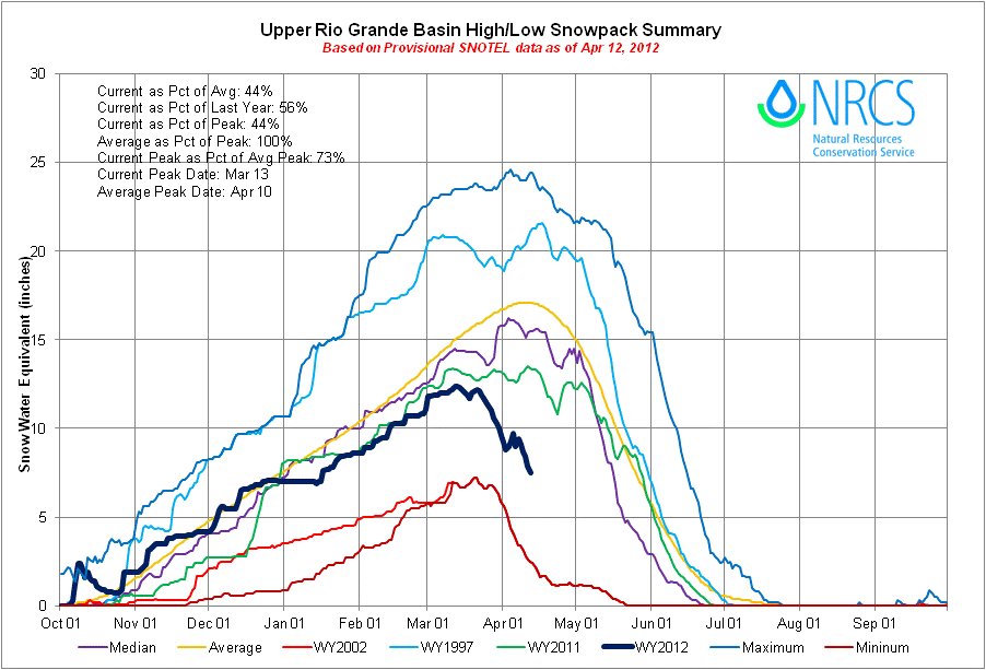
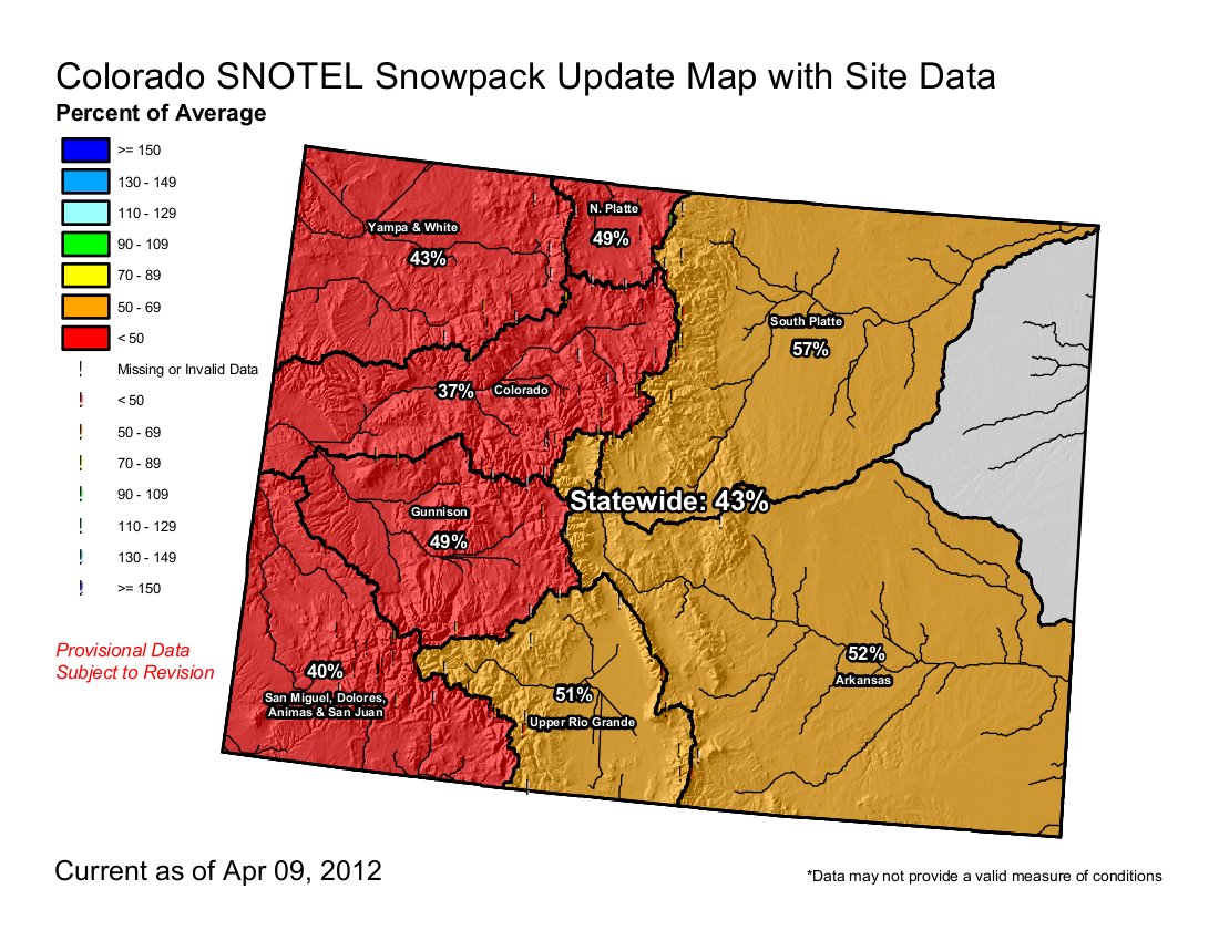
Direct irrigators operations can become a casualty of drought when the snowpack melts out before they need water. Click on the thumbnail graphic to the right for the latest snowpack map from the Natural Resources Conservation Service along with the April 10, 2012 drought map from the U.S. Drought Monitor.

From the Vail Daily (Lauren Glendenning):

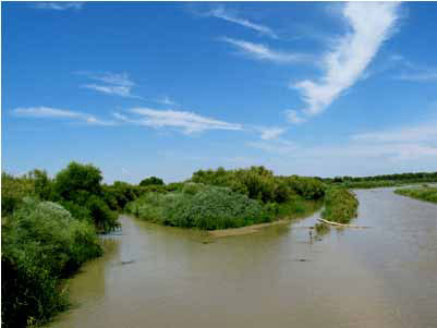
The Eagle River basin is melting four to eight weeks earlier than normal this year because of below average snowfall, warm spring temperatures and wind, according to the Eagle River Water and Sanitation District, presenting what could be the worst water supply year in Eagle County history…

“2002 was the worst thing we had seen,” said Water District General Manager Linn Brooks. “It was the worst drought Colorado had seen since like the 1750s, according to tree ring data, and this one is so much worse, or at least shaping up to be much worse.”

While Front Range water supplies rely heavily on reservoirs that are currently full or near-full because of an above average snowpack in 2010-11, Eagle County relies on streamflows for its water supply, Brooks said. “The Front Range is worried about next year, but that’s not true for us — we’re worried about this year,” Brooks said…

A lot of the outlook still depends on the weather, though. Water district spokeswoman Diane Johnson said the snowpack story is essentially over — we know what we’ve got in terms of the snowpack, and the answer is bad news.

Click through to the website. They’ve got all the links you need, streamflow, SNOTEL, etc.

From The Durango Herald (Seth Borenstein):

Temperatures in the lower 48 states were 8.6 degrees above normal for March and 6 degrees higher than average for the first three months of the year, according to calculations by the National Oceanic and Atmospheric Administration. That far exceeds the old records.

The magnitude of how unusual the year has been in the U.S. has alarmed some meteorologists who have warned about global warming. One climate scientist said it’s the weather equivalent of a baseball player on steroids, with old records obliterated.

From the Fort Collins Coloradoan (Bobby Magill):

The snow is sparse this year, but rafting companies are optimistic that won’t mute the roar of the Poudre…

…rafting companies are counting on late-season irrigation releases from brimming mountain reservoirs to sustain the rafting season through what is expected to be a tepid mountain runoff this spring. The mountain snowpack this week has reached low levels not seen in years, with the Upper Colorado River Basin 63 percent below normal for snowpack water content and the South Platte River Basin at 47 percent below normal. The snowpack levels could mean decent flows for rafting early in the season as rivers and streams swell with a brief shot of snowmelt, but all bets are off for later in the summer.

“It’s going to affect our late season, our late July and August, to the effect that we’ll probably only be rafting on irrigation water by then,” Rothwell said. The good news for the rafting industry is that the reservoirs are full of water leftover from 2011’s above-average snow season, much of which will be sent down the Poudre to farmers on the plains.

From The Denver Post (Jason Blevins) via The Durango Herald. From the article:

U.S. ski resorts posted record visitation in the last few years, reaching more than 60 million nationally and more than 12 million in Colorado. Diversified resort operations – from real estate to lodging to lessons to dining – buoyed bottom lines, and aggressive snowmaking pushed resorts away from a live-or-die reliance on bountiful snow. Then came this season, with snowfall so weak that Colorado’s snowpack is half its normal level. Skier visits were down around 7 percent before a record dry March effectively killed the season. “This year certainly puts the perspective back on how much we really do rely on snow,” said Ethan Mueller, general manager of Crested Butte Mountain Resort, which expects to see visits fall 10 percent. “Maybe the industry can trump the economy, but snow is king.”[…]

Michael Berry, president of the 321-resort National Ski Areas Association, said the nearly 10 million-visit drop nationwide mirrors the season of 1980-81, when a dearth of snow in the Northeast, California and central Rockies rocked the industry. “Usually, it’s just one or two (regions),” Berry said. “This is the first time in what, 30 years, that we’ve seen a line through all three. Our fundamental strengths remain strong, but this certainly was a weather-impacted year.”[…]

In Colorado, the Front Range’s Echo Mountain and Eldora saw strong gains in part because of heavy upslope storms that missed every other hill in the state. Still, Echo closed for the season last weekend because of warm weather. “As our owner says, it’s better to be lucky than good. I don’t think it’s anything special we did. The snow came at the right time,” said Rob Linde with Eldora, which saw huge storms in February that forced the ski area to turn away visitors for lack of parking. “We know it can be feast or famine. It might be the reverse next year.”

Farther south, where La Niña delivered some of Colorado’s healthiest storms, Wolf Creek is expecting to be up 17 percent. Silverton Mountain will be up and Durango Mountain Resort also is expecting visits to climb.

From the Cortez Journal (Reid Wright):

Last month, water officials were anticipating a modest whitewater boating release based on 85 percent of average snowpack levels and a favorable forecast. Now they say it will be fortunate if McPhee Reservoir even fills.

“It kind of goes to show you how quickly a forecast can go south,” said Mike Preston, manager of the Dolores Water Conservancy District. “Something that looked like a promising year can take a turn for the worst.”

The good news, Preston said, is that due to reserves left over from last year, there should be enough water for drinking and irrigation for the coming year. Only if it is dry for several years in a row, will there be shortages.

There is also enough water to sustain fish populations on the Lower Dolores. An early ramp-up trickle release was initially planned to cool waters on the river to postpone the spawning of native fish species until after the rafting spill. However, now that a rafting spill is unlikely, the cooling waters are no longer needed, Preston said.

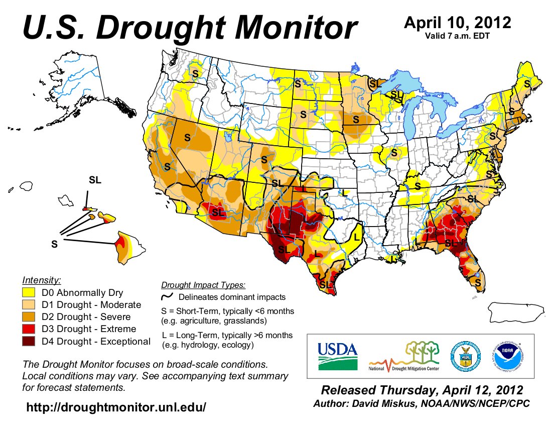
From USA Today (Doyle Rice/Julie Snider):

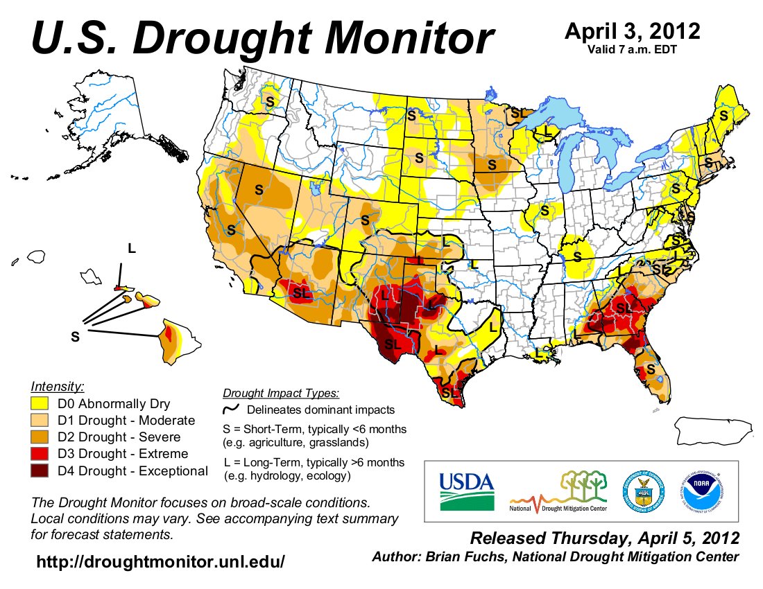
A mostly dry, mild winter has put nearly 61% of the lower 48 states in “abnormally dry” or drought conditions, according to the U.S. Drought Monitor, a weekly federal tracking of drought. That’s the highest percentage of dry or drought conditions since September 2007, when 61.5% of the country was listed in those categories. Only two states — Ohio and Alaska — are entirely free of abnormally dry or drought conditions, according to the Drought Monitor.

San Miguel River: 48 feet of the historic hanging flume has been restored

sanmiguelhangingflumeaerialhangingflumeorg.jpg

Click on the thumbnail graphic to the right for an aerial shot of the San Miguel River canyon. The hanging flume, before the restoration, is along the cliff wall in the middle of the photo. Here’s a report from Dann Cianca writing for KJCT8.com. Click through for his video report with shots of the reconstruction. Here’s an excerpt:

“It’s a work of art, it really is,” said Kent Diebolt, team leader from Vertical Access, a company working to reconstruct part of the flume.

The Hanging Flume was built between 1889-1891 to assist in gold mining operations. Located in the canyon carved by the San Miguel River just before it meets the Dolores River, the flume was a canal of sorts to transfer water to the gold mining operations. The miners used the the water, assisted by gravity to separate gold from other minerals. The waterway stretched for ten miles along the San Miguel River and existed in part as a ditch but also as a hanging wooden trough, known as a flume. While the miners found gold, after a few years of mining, it was realized that the operation was not economical. Eventually, the flume was no longer being used and its pieces were scavenged.

“The flume was built with about 1.8 million board feet of timber and people would walk through the flume box and dismantle the side boards and the floor boards and that ended up in some of the communities around this area,” said project manager Ron Anthony.

For years afterward, the flume sat untouched, slowly being weathered by the environment until people realized that it should be preserved. Since then, groups have come together to discover the history of the flume and protect it. Thanks to private donations by the JM Kaplan Fund, the Hendricks Foundation and more along with the support of the BLM and Western Colorado Interpretive Association, part of the original flume is being reconstructed.

“This effort on this project is to reconstruct a segment about forty eight feet long that has the flume box, (the floor boards and side boards) that will allow people to see from below what was here when the flume was operational,” Anthony said.

Builders are using the same type of timber to reconstruct the flume as well as some of the original methods. But it takes a special type of worker to take part in the project. The flume is suspended half-way up a two hundred foot cliff! Builders have to repel into work, not to mention the effort it takes to make sure building supplies can get to where they need to be.

Click here for a photo gallery from HangingFlume.org.

hangingflumerestoration042012denverpost.jpg

More coverage from The Denver Post (Nancy Lofholm):

Those who keep returning to measure, survey, photograph and examine the mysterious structure known as the Hanging Flume call it “flume fever.” The afflicted wake in the middle of the night to puzzle over how enterprising but misguided gold seekers pinned a 10-mile-long wooden water chute to a sheer cliff to create a hydraulic gold separator.

They spend years in faraway city offices calculating angles and load factors and building mini models.
Finally, on this blustery week, about a dozen of them — engineers, scientists, archaeologists, industrial riggers, carpenters and historians — gathered at a cliff edge that locals like to say is “50 miles from nowhere” to remake history.

“The fascination with this thing is beyond belief. It’s a window into the way people thought in those days,” said Bureau of Land Management archaeologist Glade Hadden.

More San Miguel watershed coverage here and here.

Restoration: ‘When you put a hole in a mountain, it would fill up with water’ — Mike Holmes (EPA)

commodorewasterockcreede.jpg

From the Valley Courier (Lauren Krizansky):

On Wednesday, the Environmental Protection Agency officials presented the Willow Creek Reclamation Committee, a Creede grassroots mining waste clean-up group, the findings and conclusions of its December 2011 Nelson Tunnel/Commodore Waste Rock Pile Site report.

“We are still not seeing the water quality improve in the Rio Grande,” said EPA Environmental Protection Agency Project Manager Mike Holmes in the Creede Town hall meeting room. “For the old miners, the biggest problem was water. When you put a hole in a mountain, it would fill up with water. That is the problem that we are still dealing with today.”

Water passing through the site enters Willow Creek, flows through flood plains and spills into the Rio Grande. The EPA has concluded in order to lower zinc and cadmium levels in the Rio Grande, the water passing through the site must either undergo treatment or reroute through new hydrology.

“We won’t magically make up water quality standards in the Rio Grande,” said EPA Hydrologist Mike Wireman. “But it is something we should do.”

The site feeds 150 to 250 gallons of water a minute into the Rio Grande and contributes less than 50 percent of the river’s contaminated minerals.

More restoration coverage here.

The Northern Water board sets a 90% water quota, let’s hear it for a good water year last year, and for storage

coloradobigthompsonprojecteastslopesystemncwcd.jpg

From The Fort Morgan Times:

Their decision, which they based on low snowpack and precipitation conditions, bolsters this year’s supplemental water supplies with a 40 percent increase from the initial quota set earlier this water year.

The C-BT quota sets the percentage of an acre foot that a C-BT allottee will receive during the current water year for every unit of C-BT water the allottee owns. The 90 percent quota means that each unit will yield nine-tenths of an acre foot. This is the first year since 1977 that the board set an April quota of 90 percent or above.

Every year the directors base their April quota decision on updated snowpack, precipitation and reservoir storage information while striving to balance the overall needs within Northern Water’s district boundaries.

As of today, snowpack in watersheds integral to C-BT is significantly below average for this time of year, at 34 percent of average in the Upper Colorado River Basin and 53 percent in the South Platte River Basin. To add to that, the year’s precipitation within district boundaries is sitting at 59 percent of the historical average.

Northern Water is also forecasting below-average streamflows this season.

More coverage from the North Forty News (Kate Hawthorne):

The quota will make 279,000 acre feet of C-BT water available to agricultural, municipal and industrial users in the district — a 40 percent increase in supplemental supplies over the initial quota for the 2012 water year. This is the first time since 1977 that the April quota has been 90 percent or above…

“This is one of those years why we have the C-BT,” said Director Kenton Brunner from Weld County in a prepared statement announcing the April quota. “Farmers need to get their crops in and they need the water.” The board can make additional water available anytime through October if they see the need, according to the district.

More coverage from the Loveland Reporter-Herald:

It is the highest amount of water allowed to be released from reservoirs such as Carter Lake and Horsetooth Reservoir in several years…“This will allow the project to do what it is intended to do: Get us through the dry years,” said Director John Rusch, who represents Morgan and Washington counties, in a release from the agency.

More Northern Colorado Water Conservancy District coverage here and here.

Wiggins: The new town board is reviewing the new water supply project

drillingawaterwell.jpg

From The Fort Morgan Times (Dan Barker):

The new members and remaining incumbents took a long, intense look at the status of the water project, focusing on the projected timeline and budget. They also set a date for a workshop on all the water issues for Wednesday, April 25 at 6 p.m. at the town hall. The public is invited.

Tim Holbrook of Industrial Facilities Engineering, the company overseeing the project, gave the board an overview of the project. Board members had a chance to look at some photos of construction and were invited to take tours of the various parts of the construction.

The augmentation ponds are completed and starting to fill up, said Wiggins Town Administrator Bill Rogers. That water is used to offset the effects on the South Platte River of drilling for water in its basin and sending it to Wiggins, Holbrook explained.

More Wiggins coverage here and here.

Snowpack/drought news: ‘Snowpacks [in March] were falling faster than a 3-year-old in high heels’ — Randy Julander

basinhighlowriogrand04122012.jpg

snowpackcolorado04122012.jpg

Click on the thumbnail graphics to the right for the current snowpack map for Colorado and the Basin High/Low graph for the Rio Grande Basin, from the Natural Resources Conservation Service.

From The Pueblo Chieftain (Matt Hildner):

“There are some water commissioners that think we could have a very, very dry season and possibly even worse than 2002 on some of the smaller creeks,” Division Engineer Craig Cotten said.

The biggest areas of concern are along the Sangre de Cristo Mountains, where snowpack stands at 43 percent of average, according to the Natural Resources Conservation Service…

The snowpack in the San Juans, which feed the valley’s two biggest and most heavily used rivers — the Rio Grande and the Conejos — stands at 45 percent of average. Before the warm and dry weather hit, snowpack in the San Juans was at 98 percent of average as of March 1…

As of now, water users on the Conejos are expected to face a 6 percent curtailment as the state is tasked with sending 12,100 acre-feet of water downstream during the irrigation season. On the Rio Grande, curtailment sits at 9 percent, while the expected delivery obligation downstream during irrigation season is 36,700 acre-feet.

From the Las Vegas Review Journal (Henry Brean):

One terrible month in the mountains that feed the Colorado River has erased almost 600 billion gallons from an already bleak outlook for Southern Nevada’s primary water source. Federal forecasters have slashed their projections for the river after an unusually warm, dry March sent mountain snow into full retreat. “Snowpacks were falling faster than a 3-year-old in high heels” last month, said Randy Julander, who supervises the federal snow survey program in Nevada, Utah and California. “They were tumbling left and right.” Julander said much of the range already looks like it usually does at the end of May. In places where snow should still be accumulating, there is barren ground and the threat of wildfires…

But there is a silver lining, according to Rose Davis, spokeswoman for the U.S. Bureau of Reclamation’s lower Colorado River regional office in Boulder City. Last year was so wet that Lake Mead won’t feel much immediate impact from this year’s sorry snowpack…

The surface of the reservoir is now expected to drop about 17 feet over the next year, according to a Bureau of Reclamation forecast released Tuesday. That’s not much worse than last month’s forecast, which predicted a 15-foot drop in Mead by next April.

From the Aspen Daily News (Dorothy Atkins):

Two documents that provide guidelines for what the community should do to manage the water supply during times of drought were released to the public on Thursday. The Roaring Fork Watershed Plan and a Water Conservation Report were presented by the Roaring Fork Watershed Collaborative at a meeting in Carbondale that drew about 65 people…

From The Aspen Times (Scott Condon):

About 60 people in water-conservation groups as well as local, state and federal government agencies gathered in Carbondale on Thursday as part of a loose-knit effort called the Roaring Fork Watershed Collaborative. They discussed a variety of topics, but garnering the most attention were the short- and long-term prospects for drought and what can be done to protect rivers. “Last spring I was talking to you about flooding and flood risk,” Sharon Clarke, of the Basalt-based Roaring Fork Conservancy, told the crowd. “What a difference a year makes. We’re in a short-term drought right now.”

The lower reaches of the Crystal River could go dry this summer if dry conditions persist, she said, as could the Roaring Fork River through Aspen. Hunter Creek, Woody Creek and East Snowmass Creek also are facing critically low streamflows, she said…

Pitkin County has already applied to work within Colorado’s water-rights laws to provide water to troubled reaches of the Roaring Fork River. The goal is to allow some landowners to forgo irrigating temporarily and essentially parking their water rights for a beneficial use. “There are quite a few folks that are willing and even anxious to talk to us about that prospect,” Ely said. If a legal path can be cleared, a section of the Roaring Fork River above the confluence with the Fryingpan River would be targeted for aid. Ely stressed Colorado water law is designed to remove surface water for beneficial uses. To reverse that is “bucking a trend,” he said.

Colorado Water 2012: An exhibit detailing the water history in the Arkansas Valley to be showcased starting tomorrow in Pueblo

stewartudalljohnkennedy.jpg

From The Pueblo Chieftain (Chris Woodka):

“In conjunction with Colorado Water 2012 (a statewide celebration of water projects) we wanted something that tied in with our new schedule of exhibits,” said Maria Tucker, director of the InfoZone News Museum at the Robert Hoag Rawlings Public Library. The exhibit opens Saturday, when the InfoZone will have a grand reopening celebration, and be on display until May 20.

Printed on 6-foot-tall cloth panels, the exhibit details the history of water in Pueblo that led up to the creation of the Fry-Ark Project, which Kennedy signed into law on Aug. 16, 1962. The next day, Kennedy came to Pueblo and delivered a speech at Dutch Clark Stadium. Many Puebloans still remember the motorcade to the stadium or the address itself. For those who don’t, a digital version film of Kennedy’s speech will be shown on a monitor near the display.

Included in the exhibit are old photos, newspaper articles and memorabilia of water history. The settlement of Pueblo, the catastrophic flood of 1921 and the Dust Bowl of the 1930s are all depicted…

Rare photos from the Bureau of Reclamation show how Pueblo Dam was constructed and how Lake Pueblo filled in the early 1970s.

More Colorado Water 2012 coverage here.

Southern Delivery System: ‘District Judge Victor Reyes set aside the Colorado Water Quality Control Commission’s decision to issue a water quality permit to Colorado Springs’ — Chieftain

sdspreferredalternative.jpg

From The Pueblo Chieftain (Chris Woodka):

District Judge Victor Reyes set aside the Colorado Water Quality Control Commission’s decision to issue a water quality permit to Colorado Springs and ordered new hearings by the commission. The lawsuit was brought by Pueblo District Attorney Bill Thiebaut and joined by the Rocky Mountain Environmental and Labor Coalition against the commission and Colorado Springs.

The commission approved a Section 401 permit under the federal Clean Water Act that was approved by the Water Quality Control Division in April 2010. However, in upholding the staff decision to grant the permit, the commission failed to consider scientific evidence and instead relied on “gut feeling” and “best professional judgment” in approving the permit, Reyes said in a 57-page ruling. Under deposition, a staff member admitted that no scientific measurement was used in reaching a decision. Reyes also chided the state for not documenting its findings, not evaluating the impacts of growth and failing to use its own methodology.

Thiebaut and the environmental groups argued that the impact of 800,000 people living in El Paso County by 2030 had not been fully considered, and that water quality in Fountain Creek and the Arkansas River would be significantly degraded…

Ross Vincent of the Sierra Club praised the decision as well. “Clean water is really important, and the agencies we rely on to keep it clean are not getting the job done,” Vincent said. “The decision shows Colorado Springs Utilities is not above the law. Urban growth and water quality are unavoidably linked and the state must consider those links when evaluating big projects like SDS.”

More coverage from Pam Zubeck writing for the Colorado Springs Independent. From the article:

The decision is a blow to Colorado Springs Utilities’ SDS pipeline project, now under construction, that will bring water here from Pueblo Reservoir. Utilities’ spokeswoman Janet Rummel explains in an e-mail to the Indy:

The Colorado Department of Public Health and Environment’s (CDPHE) Water Quality Control Division (Division) issued a 401 water quality certification under the Clean Water Act for the SDS project in April 2010, certifying that SDS would comply with all applicable state water quality requirements. The Rocky Mountain Environmental Labor Coalition (RMELC) and Pueblo County District Attorney, Bill Thiebaut, then appealed the CDPHE 401 certification for SDS.

Following extensive review, including testimony from experts at a hearing in December 2010, the Colorado Water Quality Control Commission voted unanimously in January 2011 to confirm the SDS 401 Certification issued by the Water Quality Control Division.

Today, we received Pueblo County Judge Reyes’ ruling regarding the RMELC and District Attorney Thiebaut’s request for a judicial review of the Commission’s affirmation of the Division’s certification. The judge reversed the Commission’s ruling and sent the case back to the Division to revise the 401 Certification.

We are disappointed that the Court disregarded several years of studies and evaluation by federal and state environmental agencies and the extensive mitigation already required of the project.

We are currently evaluating our appeal rights and coordinating with the appropriate state and federal agencies.

Construction of the SDS project is proceeding — providing hundreds of regional jobs and infusing tens of millions of dollars in the southern Colorado economy — while we work to resolve this issue in the courts.

Meanwhile, Colorado Springs has filed an application in water court to build a terminal reservoir for SDS on Williams Creek (same site planned for the Flaming Gorge pipeline), according to Chris Woodka writing for The Pueblo Chieftain. From the article:

The Utilities reservoir is part of a future phase of the Southern Delivery System. The first phase of SDS is a 50-mile long, 66-inch diameter pipeline, new outlet works at Pueblo Dam, three pump stations and a treatment plant now under construction. Completion is expected in 2016. To fully use the pipeline’s entire capacity, the reservoir would be built to provide terminal storage before water is treated. It would be developed in the 2020-25 timeframe. A March filing in Division 2 Water Court indicates a 129-foot high dam, spanning 8,100 feet would detain about 30,500 acre-feet of water. Water would come through the Williams Creek drainage, exchanges from other sources and direct deliveries from SDS…

It’s no secret that Colorado Springs has had designs on the site for years. The site was part of a water court exchange application Colorado Springs filed in 2007, when it was listed as an alternative site in the SDS study. After problems with Colorado Springs’ first choice for SDS terminal storage at Jimmy Camp Creek, to the north of Williams Creek, surfaced in 2008, the Bureau of Reclamation identified Williams Creek as the preferred location. In 2010, the El Paso County planning commission approved the site for location of a reservoir. In 2011, under state legislation adopted the previous year (HB1165), the State Land Board approved sale of land for the reservoir.

But much of the site is on private land owned by the Norris family, which has filed to create the Marlborough Metropolitan District…

The Marlborough district would be to construct a 30,000 acre-foot reservoir for regional use as well as recreation. Located south of the Colorado Springs site, it could be expanded with a higher earthen dam, according to engineering reports. The site also is identified as terminal storage for Aaron Million’s Flaming Gorge pipeline proposal…

There are major differences in approach. Utilities plan would require relocating part of Bradley Road, while the Norris plan does not. The Norris family also has discussed sharing revenue from storage fees with the State Land Board as an alternative to buying that portion of the land, Duncan said.

More coverage from Ryan Maye Handy writing for The Colorado Springs Gazette. From the article:

The crucial 401 certification, which has been battled over for two years, is headed back to the Colorado Public Health and Environment’s Water Quality Control Division. The division granted the certification for Utilities’ Southern Delivery System, a 62-mile-long pipeline, in April 2010. Pueblo County Judge Victor Reyes upheld concerns about the project and reversed a January 2011 decision by the Colorado Water Quality Control Commission to confirm the certification, according to Janet Rummel, a spokeswoman for the project. The 401 certification is a prerequisite for the only remaining obstacle in the project’s completion — a 404 permit issued by the U.S. Army Corps of Engineers…

Since 2010, the SDS project has battled with the Rocky Mountain Environmental Labor Coalition and Thiebaut over its 401 certification. Thiebaut and the coalition challenged the project’s certification when it was granted two years ago.

More Southern Delivery System coverage here and here.

Governor Hickenlooper’s oil and gas task force is seeking a local/state collaboration on regulating oil and gas operations

derrick.jpg

From the Denver Business Journal (Mark Harden/Cathy Proctor):

In a draft report, the task force says that the state’s “local government designee” program, which allows local governments to suggest restrictions on drilling permits, needs to be used more effectively than it is now.

> The draft report, dated Wednesday, is available here.

A final version of the task force’s report is to be delivered by April 18.

More coverage from Mark Jaffe writing for The Denver Post. From the article:

“There are still a whole lot of unresolved issues,” said Stan Dempsey, president of the Colorado Petroleum Association and a task force member. The task force outlined a plan to increase cooperation between state regulators and local governments and to enable local inspectors for rigs and wells.

The commission did not address a range of issues that Hickenlooper outlined in his executive order, including well setbacks from homes, air quality, noise abatement and traffic management. The task force’s aim was, in six weeks, to try to resolve some of the emerging conflicts among the industry, the state and cities and counties.

“This is an evolving process,” said Mike King, the director of the state Department of Natural Resources and chairman of the task force.

More oil and gas coverage here and here.

Environmental Working Group: The drinking water used by millions of Americans is contaminated!

bluegreenalgaebloom.jpg

Colorado is debating new standards for nitrogen and phosphorus in wastewater streams to reduce nutrients in surface water ahead of a federal mandate.

Here’s a research paper on the problem from the Environmental Working Group (Olga V. Naidenko/Craig Cox/Nils Bruzelius). Here’s the executive summary:

Water that runs off fields treated with chemical fertilizers and manure is loaded with nitrogen and phosphorus, two potent pollutants that inevitably end up in rivers and lakes and set off a cascade of harmful consequences, contaminating the drinking water used by millions of Americans. Treating this water after the fact to clean up the contamination is increasingly expensive, difficult and, if current trends continue, ultimately unsustainable. The only solution that will preserve the clean, healthy and tasty drinking water that people expect is to tackle the problem at the source. This paper explains why.

Nitrate, the most common form of nitrogen in surface and groundwater, is directly toxic to human health. Infants who drink water with high nitrate levels can develop an acute, life-threatening blood disorder called blue baby syndrome. high nitrate levels in water can also affect thyroid function in adults and increase the risk of thyroid cancer.

Phosphorus stimulates explosive blooms of aquatic algae, including the especially dangerous cyanobacteria (blue-green algae) that produce toxins that can be deadly to pets, livestock, wildlife – and people. Toxins pro- duced by cyanobacteria can harm the nervous system, cause stomach and intestinal illness and kidney disease, trigger allergic responses and damage the liver. Even after a brief exposure, cyanobacterial toxins can cause skin rashes, eye irritation and breathing problems.

The cascade continues when utilities try to combat these and other threats by treating drinking water with chemical disinfectants such as chlorine. Treating algal contamination this way gives rise to carcinogenic disinfection byproducts, whose levels typically spike during the summer months – when algae blooms peak. Commonly used measures to reduce algal contamination add hundreds of thousands of dollars annually to water utilities’ treatment costs. Algae can also give tap water an unpleasant taste and smell, a recurrent annoyance for agricultural areas and the water utilities that serve them.

This report focused on four states in the core of the Midwestern corn belt – Illinois, Iowa, Minnesota and Wisconsin. Nutrient overload in surface and groundwater is a significant water quality problem for these states, making nitrate and phosphorus levels higher and algal blooms more frequent compared to national averages.

To tackle polluted source water, water utilities in the region are often forced to install expensive treatment plants that can cost millions to install and operate. USDA economists estimate that removing nitrate alone from drinking water costs more than $4.8 billion a year. The cost of dealing with algal blooms is particularly daunting. The total capital cost of water treatment that would address cyanobacterial blooms and cyanotoxins, can range between $12 million and $56 million for a town of 100,000 people.

The only true solution is to confront the issue upstream, at the point where pollution – much of it from farms – first flows into America’s precious surface water and groundwater. This year’s debate over renewing the federal farm bill is a referendum on America’s commitment to protecting our drinking water supplies at the source.

With the exception of large animal feeding operations, farm businesses are exempt from the pollution control requirements of the federal Clean Water Act, and few states have authority to compel farm businesses to adopt practices that reduce the amount of farm pollution reaching our rivers, lakes and bays. As a result, the farm bill, which is renewed every five years, serves as the primary tool for addressing the environmental damage caused by polluted runoff from agricultural operations.

Congress should take three steps to ensure the new farm bill protects drinking water:

· Reform Farm Subsidies – Congress should end direct payments, reduce subsidies for farm insurance programs and refuse to create new farm entitlement programs that encourage all-out production to the detriment of the environment. Instead, lawmakers should help farmers when they suffer deep losses in yields and provide options for them to purchase additional crop and revenue insurance at their own expense.

· Renew the Conservation Compact — Congress should renew the “conservation compliance” provisions of the 1985 farm bill by relinking wetland and soil protection requirements to crop insurance programs. In addition, legislators should require farm businesses that receive subsidies to update their conservation plans and should strengthen the government’s enforcement tools.

· Strengthen Conservation Incentive Programs – Congress should strengthen programs that reward farmers who take steps to protect sources of drinking water. In addition to providing adequate fund- ing, Congress should expand “collaborative conservation” tools that award funds to groups of farmers working together to protect drinking water sources. Greater focus should be placed on restoring buffers and wetlands that filter runoff of farm pollutants.

Meanwhile, here’s a analysis closer to home from Dan Randolph running in The Durango Herald. From the article:

In 2002, the Animas River through Durango experienced algae blooms, and with the possibility of low water levels again this year, the risk is again on some of our minds. Right now, the Animas River in New Mexico, from the state line down to Farmington, where it joins with the San Juan, is out of compliance with New Mexico’s nutrient standards. This is not a theoretical issue…

For a decade, the Colorado Water Quality Control Commission and hundreds of stakeholders from throughout the state have wrestled with developing nutrient standards for Colorado’s rivers and streams. In March, the commission preliminarily adopted a two-pronged approach to nutrients that reflects Colorado’s needs and abilities. The proposed rules recognize that meeting new standards will take both time and flexibility. The rules include a generous implementation timeline for wastewater treatment plants to upgrade their systems, and voluntary programs for farmers and ranchers.

The system the Water Quality Control Commission has set out will be refined to meet the individual needs of each stream or river during the regular review of water-quality standards done for metals and other pollutants, and treatment-plant reviews. Known as the triennial review process, each of Colorado’s nine river basins is studied in turn, and standards are determined. Under the new rules, these standards will now also include nutrients. The San Juan, Dolores and Gunnison basins will undergo this review process later this year.

More wastewater coverage here and here.

CDPHE: Cotter Corp diverted Ralston Creek past its Schwartzwalder Mine to minimize discharge of uranium into creek

schwartwalderpipelinecotterralstoncreek.jpg

From TheDenverChannel.com (Thomas Hendrick):

The Colorado health department had ordered Cotter to divert water from the creek away from the Schwartzwalder Mine so that pollutants wouldn’t get into the creek water. Ralston Creek flows into a Denver Water reservoir that provides drinking water.

The health department’s water quality control division says Cotter completed a pipeline Tuesday to divert up to 8 cubic feet per second of creek flows past the mine.

More nuclear coverage here and here.

South Platte Basin Roundtable recap: Conservation is complicated because water in the river is reused many times

southplattebasinnonconsumptiveneedsmapswsi2010.jpg

From The Greeley Tribune (Eric Brown) via The Fence Post:

Roundtable members, made up of water experts and officials in northeastern Colorado, stressed during their meeting that — because it takes water-supply projects, such as new reservoirs, 20-30 years to come to fruition, from the planning stages to their completion — the expected shortfalls in the South Platte’s water availability could arrive before enough new projects can come to fruition. That is, unless much more aggressive planning among regional and state water officials begins to take place soon, members agreed…

South Platte Roundtable members also made note of the ongoing push from others in the state — particularly those from the Western Slope — to heavily rely on conservation efforts to meeting future water needs, rather than depend on building new projects that transport water from the Western Slope to the Front Range. Roundtable members pointed out that conservation is complicated in the South Platte, because so many of its users depend on reused water. They noted that many other people in the state don’t fully understand that, and more education is needed.

Unlike other basins in the state, water in the South Platte Basin is reused six or seven times before it flows out of the state. South Platte water users, particularly those east of Greeley and further downstream, are dependant on water that’s used in the Denver area and other parts of the upper South Platte region, treated before it returns to the river and then flows downstream to be used again. It’s estimated that about 50 percent of the water used by farmers in flood irrigating returns to the river — either by soaking through the soil and into underground aquifers, or through ditch runoff. About 18 percent of water used in residential lawn irrigating is estimated to return to the river.

With its reuse system in place, the South Platte Basin’s economic value per acre-foot of water is higher than any other basin in the state.

More South Platte River basin coverage here.

Snowpack/runoff news: 50% of average flows forecast for the Arkansas River at Salida

threedayrainurbandrainage04122012.jpg

snowpackcolorado04092012.jpg

Click on the thumbnail graphic to the right for the April 9 snowpack map. The NRCS hasn’t updated since then (as of this morning at 5:00 a.m.). The other graphic is from the Urban Drainage and Flood Control District. Most of the Denver Metro area received some rain yesterday and overnight. The two stations closest to Gulch Manor are showing eight hundredths and four hundredths. One station near Henderson shows 51 hundredths.

From The Pueblo Chieftain (Chris Woodka):

The April forecast by the Natural Resources Conservation Service shows the Arkansas River at about 50 percent of average at Salida, which matches the snowpack in the basin. That triggers a dry-year exception in the Pueblo flow program, meaning no additional water will be supplied for recreation at the Downtown Whitewater Park…

In the Upper Colorado River basin, which supplies supplemental water through the Fryingpan-Arkansas Project, snowpack was just 37 percent of average. “It’s very concerning,” said Roy Vaughan, manager of the Fry-Ark Project for the Bureau of Reclamation. “We had a sprinkle in the collection area today, and that was it.” The April 1 projection for Fry-Ark imports — they begin when snow starts melting — is 23,000 acre-feet, but that assumes normal precipitation during the remainder of the spring snowfall accumulation…

“We’ve talked about running the winter water on the hay and wheat, so you could get two cuttings of hay and finish the wheat,” said Dan Henrichs, superintendent of the High Line Canal. “But you’ve got guys talking about planting corn. I don’t see how they’re going to finish the crop.”

Garry Clark, who farms near Rocky Ford, was philosophical about the situation. “You can’t tell. There’s been years like this before,” Clark said…

Aurora is planning on taking as much water as it can this year, but that likely will be just 50 percent to 60 percent of the average yield, said Tom Simpson, water resources manager for the Arkansas Valley. Aurora will leave some water in the valley, due to other circumstances. It will sell about 2,500 acre-feet to the Lower Arkansas Valley Water Conservancy District to help farmers meet augmentation requirements under Rule 10 of the state engineer’s surface irrigation rules…

Aurora’s reservoirs are 76 percent full, well above the 60 percent level that could trigger additional water purchases through leases from the Arkansas Valley. The city also has permanent water restrictions imposed after the 2002 drought, and has completed the Prairie Waters Project that allows it to recapture some wastewater and reuse it…

Colorado Springs Utilities has about two years of demand in storage, and is expecting a yield of about 77 percent of average. “The bottom line for us is that we’re not concerned about the snowpack this year, but that it might be the leading year for a multiyear drought,” said Brett Gracely, water resources planning manager for Colorado Springs Utilities.

NIDIS Weekly Climate, Water and Drought Assessment Summary of the Upper Colorado River Basin

wyutcoprecipitation0401to04072012.jpg

Here’s the link to the summaries from Tuesday’s webinar via the Colorado Climate Center. Click on the thumbnail graphic to the right for the precipitation summary.

The ‘State of the Rockies Report Card’ is hot off the press

stateoftherockiesreportcardposter2012.jpg

Here’s the announcement from the Colorado College State of the Rockies Project:

This 2012 State of the Rockies Report Card is titled The Colorado River Basin: Agenda for Use, Restoration, and Sustainability for the Next Generation. The sections of the Report Card include a summary of the Rockies Project Source to Sea trip, an investigation into the Colorado River’s many diversions and uses, and an assessment of the “Law of the River,” among many other topics.

The Rockies Project aims to inspire Report Card readers and Rockies events attendees to creatively contemplate, discuss, and engage in shaping the future of our beloved, beautiful, and fragile region-the Rocky Mountain West. Enjoy!

Here’s the first installment of a three-part series analyzing the report from Walt Hecox (director of the project) writing in the Mountain West News. From the article:

Colorado College’s 2012 State of the Rockies Report Card is dedicated to a single topic of vital interest: the past development, present condition, and future options for the Colorado River Basin. We add a special dimension: the perspectives of today’s youth who will become tomorrow’s Basin users and stewards.

Competing interests for water rights and a dwindling supply of the vital natural resource have created challenges for the Colorado River Basin, which stretches across portions of seven Southwestern states. Some experts predict that by 2050, climate change and burgeoning uses of the river system will result in inadequate water to meet all of the shares allocated for municipal, agricultural, industrial and wildlife use, two-thirds to nine-tenths of the time.

But such a crisis can be averted, if actions are taken now, according to findings from this year’s State of the Rockies Project.

Conducted by students and faculty at The Colorado College in Colorado Springs, each year a research project is undertaken to increase public understanding of issues affecting the environment and economy of the Rocky Mountain region.

This year’s topic of study: The Colorado River Basin. Student researchers spent last summer and the 2011-2012 academic year analyzing the 1,400-mile waterway, wrote sections of the Report Card on critical dimensions, and recommended five action steps so that a viable, living Colorado River Basin exists, even thrives for the next generation. Their work was unveiled and the Report made public during the April 9-10 State of the Rockies Project Conference.

Held at Colorado College, the conference not only unveiled the report but also featured as guest speakers U.S. Secretary of the Interior Ken Salazar, who discussed the challenges of saving the river basin now and in the future. And Colorado Gov. John Hickenlooper addressed what future generations can do to manage the state’s water resources.

More coverage from R. Scott Rappold writing for The Colorado Springs Gazette. From the article:

The conference is an annual exercise for students to study an environmental issue facing the West. This year’s event focused on the Colorado River, the source of 80 percent of Colorado Springs’ water. [Interior Secretary Salazar] said the interstate compacts that delineate how the water is shared are flawed, and scientists overestimated the flow of the river by up to 2 million acre feet, using data from only recent wet years, not drier times…

Marcia McNutt, director of the U.S. Geological Survey, also spoke Monday. She said records from tree rings show periods of long droughts, slow to arrive and slow to lift, some lasting 28 years. So the snowy 2010-11 winter may have been the anomaly, and this winter may be the eventual norm. “The record shows the Colorado plateau, as far back as recent centuries, is pretty much drier than what we as Americans have experienced,” McNutt said…

McNutt quoted explorer John Wesley Powell, who urged that water rights to the river be left in the hands of small water districts, advice that was ignored. “You saw what has happened to the Colorado River. It no longer reaches the ocean,” she said.

Here’s a Q&A session with McNutt and Salazar from the Huffington Post:

Salazar: “When we look at the economy and conservation, there are those who would have us choose between them and I think that’s a false choice. We can do both conservation and energy development and good economics in a way that we have done here in Colorado — Great Outdoors Colorado is one of the great examples where we’ve been able to improve the quality of life here, and those are the kinds of things that I think are good for job creation and also good for conservation.

More State of the Rockies Project coverage here. More Colorado River basin coverage here.

Bureau of Reclamation request yields over 140 ideas for easing demands on the Colorado River

towinganiceberg.jpg

From the Associated Press (Catharine Tsai) via the San Francisco Chronicle:

…the U.S. Bureau of Reclamation asked the public what to do about it. It got more than 140 ideas: Tow an iceberg to California and capture what melts for the Colorado River basin. Divert water from the Mississippi River. Deliver water bags from Alaska to Southern California. Change the desire for beef to reduce demand for thirsty cattle. The bureau won’t single out any options to pursue, but it will review them as part of its larger study of water supply and demand in the arid Colorado River basin through 2060. It published the suggestions in late March. “It’s an entertaining list,” said Jim Pokrandt, who handles education and outreach for the bureau’s Colorado River District in Colorado. “There’s a couple good ideas on there that bear further discussion. Other ideas are kind of fantastic, as in maybe not based in reality.”[…]

Native American tribes have suggested exploring voluntary water transfers from tribes with water rights. Other ideas include changing how water is priced, removing invasive plant species that suck up water, and requiring lawns and golf courses to be watered with “gray water,” wastewater like that from showers that could be used for purposes other than drinking.

Here’s the Reclamation webpage for the effort. Here’s the detailed list of options.

More Colorado River basin coverage here.

Snowpack/drought news: The outlook for the San Luis Valley remains dry in the second year of drought, snowpack checks in at 51%

usdroughtmonitor04032012.jpg

snowpackcolorado04092012.jpg

From the Valley Courier (Ruth Heide):

“It does not look like a good year for stream flows, worse than last year. Last year was not a good year either. It is so low in certain areas of the Valley we are looking at probably a lower stream flow than we had in 2002,” Colorado Division of Water Resources Division 3 Engineer Craig Cotten said on Tuesday.

That was one of the Rio Grande Basin’s worst drought years. Cotten explained that the 2002 levels would not hit the San Luis Valley’s bigger streams, the Rio Grande and Conejos, “but we could have it in isolated smaller creeks.”

He said the Natural Resources Conservation Services’ (NRCS) annual forecast currently for the Rio Grande is 465,000 acre feet, or about 71 percent of the long-term average. The NRCS forecast for the Conejos River system is 215,000 acre feet or about 65 percent of the long-term average…

The Rio Grande Basin, encompassing the San Luis Valley, stands at 51 percent of average for snowpack right now, Cotten reported to the Rio Grande Roundtable members on Tuesday…

“We just have not had a good snowmelt year for several years,” Cotten explained. “We started off this last winter with a decent snowpack up until maybe February. We were looking at a fairly good, at least average year. Then the snow stopped.” Even the big snowstorm a week and a half or so ago did not help the overall picture much, he said…

Cotten said the stream flows now are higher than average, but that is not a good sign because it means the water will be gone faster…

Taryn Hutchins-Cabibi, technical specialist for the Colorado Water Conservation Board’s drought program, told the Rio Grande Roundtable members on Tuesday that every part of the state, including the San Luis Valley, is listed at some level of drought classification according to the U.S. Drought Monitor…

Hutchins-Cabibi said some assistance could be available for members of the agricultural community should the drought continue. Other areas of the economy throughout Colorado including municipalities and tourism-related industries could also potentially be adversely affected should drought conditions persist another year, which is quite possible, Hutchins-Cabibi explained.

Colorado Water 2012: History and purpose of the San Luis Valley’s closed basin project

slvdischargerecharge.jpg

Here’s the latest installment of the Valley Courier’s series for Colorado Water 2012, written by Ken Beck, manager of the Bureau of Reclamation’s Closed Basin Project. Click through and read the whole article. Here’s an excerpt:

The Closed Basin Project, which is operated and maintained by the Bureau of Reclamation and currently employs 23 individuals, pumps water from the sump area through a network of shallow groundwater wells or salvage wells. This salvaged water is delivered through a 42-mile canal to the Rio Grande. The project also delivers water to the Alamosa National Wildlife Refuge, the Blanca Wildlife Habitat Area and San Luis Lake.

The Rio Grande Water Conservation District (RGWCD) provides civil maintenance on the Closed Basin Project.

A three person operating committee consisting of representatives of the Colorado Water Conservation Board, RGWCD and Reclamation oversees operation of the Closed Basin Project. The committee ensures operation within parameters outlined in the Rio Grande Compact regarding pumping restrictions and water quality requirements.

More Colorado Water 2012 coverage here.

State of the Rockies Project: Governor Hickenlooper names conservation as a major part of the solution to Colorado’s supply gap

conservation2000to2008currentwaterusage06262011dp.jpg

From The Pueblo Chieftain (Chris Woodka):

While talking about the ongoing efforts to find statewide solutions through the more traditional route of roundtable meetings, Gov. John Hickenlooper suggested the answer to projected water shortfalls could be found in social media — the favored means of communication and sometimes creative solutions for today’s young people. Hickenlooper spoke Tuesday at Colorado College as part of the release of the 2012 State of the Rockies report…

As mayor of Denver, Hickenlooper witnessed conservation reduction of nearly 20 percent after 2002, largely because of creative messages crafted by Denver Water to encourage saving water.
“We now have collaboration and a conservation ethic,” Hickenlooper said. “The next step is to take those frameworks and drive conservation to another level.”[…]

One student asked Hickenlooper what the state is doing to “combat more pipelines across the Continental Divide.” “Conservation, where we take as little as possible from the West Slope,” Hickenlooper replied. Saying the whole state is better off with a healthy Colorado River, he urged both urban and agricultural conservation techniques to reduce transmountain diversions.

More coverage from Bruce Finley writing for The Denver Post. From the article:

Denver’s done better than most U.S. cities, with residents reducing use by 20 percent since 2002 to 160 gallons a day, but “we can make dramatic additional efforts,” Hickenlooper said. “Our self-discipline in the amount of water we use is going to be the foundation of everything we will do,” he said.

Yet further drawdown of the over-subscribed Colorado River is continuing as state officials support two major projects that would divert more river water across the Continental Divide to sustain Front Range urban communities…

Beyond conservation, “we’re going to need some more dams, ways to manage water,” Hickenlooper said.

Two rival pipeline projects would divert an additional 100,000 acre-feet or more of water from the upper Colorado River basin in Wyoming to the Front Range. A state-backed task force is exploring the idea. State planners calculate that Colorado could be entitled to as much as 900,000 acre-feet of unallocated river water under the 1922 interstate compact that governs use of the river. Hickenlooper declined in an interview to rule out a Wyoming diversion, saying that “we have to let that process run its course.”[…]

“‘The frog does not drink up the pond in which he lives.’ Colorado has to find a balance so that rivers can live alongside our human culture,” Save the Colorado coordinator Gary Wockner said. “The next year or two will be pivotal. Every water project on the table is proposing to drain more water out of our river.”

stoptwoforksdampostcardfrontcirca1988.jpg

More coverage from Ben Noreen’s column running in The Colorado Springs Gazette. He writes:

As many other water users have pumped their share of the Colorado and we’ve learned more about the river’s annual flow, it is becoming apparent that Colorado Springs’ share of the river is a bit tenuous. That’s the central theme of this week’s conference at Colorado College, “The Colorado River Basin: Agenda for Use, Restoration and Sustainability for the Next Generation.”

Gov. John Hickenlooper joined in Tuesday, re-stating something that has become increasingly apparent since the 1970s: “Bigger and better dams are not going to be the solutions.”

More coverage from Debbie Kelley writing for the Colorado Springs Independent. From the article:

The remark: Denver wouldn’t be Denver without Western Slope river water. Hickenlooper said what he meant was that all Front Range cities, also including Colorado Springs, Pueblo and Fort Collins, benefit if everyone uses less water. Because by keeping more water on the Western Slope and using less in urbanized areas, not only do skiing, white-water rafting and other tourism businesses succeed, but so do the ranchers and farmers. “There’s a direct benefit here. A home on the Front Range is worth more than a home in Kansas City or Indianapolis,” he said…

Hickenlooper says he advocates new creative ways of saving water and a commitment from every resident to do so. Front Range utilities companies now use about 60 percent of the water that originates in the upper Colorado River basin.

“A lot of it is our own self-motivation or discipline,” Hickenlooper said. “How we make it joyful and give people a kick out of it? I think that’s where the youth come in. If we can find ways of using that combination of youthful exuberance and optimism and technology, we have the formal framework to achieve changes.”

Hickenlooper also praised his Colorado River Cooperative Agreement, which he helped create last year between stakeholders in the Denver area and on the Western Slope to improve management of future water projects.

But it does not address two additional proposed diversion projects that would further deplete the river. And unlike U.S. Secretary of the Interior Ken Salazar, who spoke at CC’s conference on Monday, Hickenlooper did not mention the potential impact of oil shale development on the river, which some in Congress are pushing for, including U.S. Rep. Doug Lamborn of Colorado Springs.

More conservation coverage here.