From The Pueblo Chieftain (Chris Woodka):
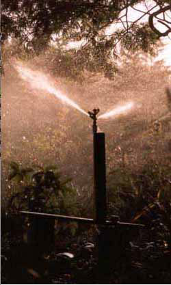
Since 2002, which was a dry year like this one, Puebloans have cut back per capita water use 17 percent, mostly through better watering habits and more efficient lawn irrigation systems. But with warmer temperatures this year and nearly the same amount of rainfall, Pueblo water use during May was the highest since 2008. The average water customer used 13,700 gallons per month, compared with 14,100 gallons per month in 2008. “In 2006, it was 15,000 gallons, but typically, it’s in the 12,000 to 12,500 gallon range,” Clayton said. Outside watering accounts for 55 percent of water use in Pueblo, he said.
Consumption for the year is up as well, since many people have been watering their lawns since March. So far, the water board has pumped 3 billion gallons in 2012, a little more than last year and well above the average of 2.6 billion to 2.9 billion gallons.
From The Telluride Daily Planet (Collin McRann):
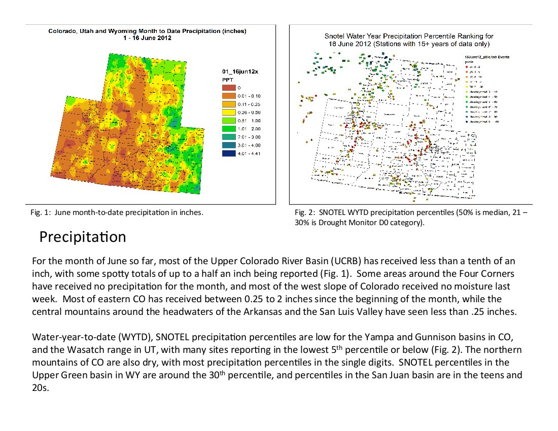
The NRCS is predicting stream flows for western Colorado to be around or less than 25 percent of average for the rest of June. “In most areas peak [stream] flows were around a month early,” Assistant Snow Survey Supervisor at the NRCS, Mage Skordahl said. “Going into the remainder of our stream forecast from April to July, things are well below normal. That means that we’re expected to see [streams and rivers] returning to base flow or minimum flow much earlier than normal.”
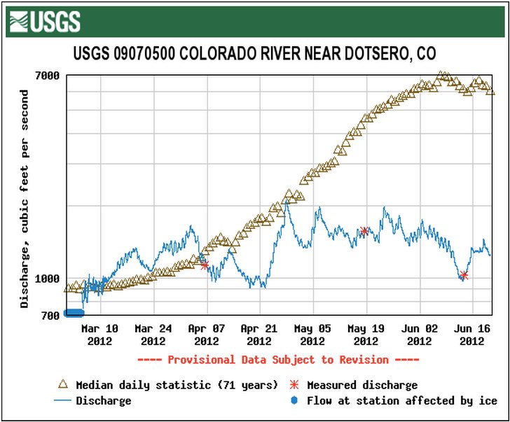
According to U.S. Geological Survey information, the San Miguel River near Nucla was flowing around 147 cubic feet per second Tuesday. The average flow for this time of year is around 677 cfs. The lowest recording was 60 cfs in 2002; the highest was 1,520 cfs, recorded in 1995…
Over past few years, most areas in Colorado have had closer to average snowpack levels, which has made the current situation less severe than it was in 2002. Ground water levels are closer to normal, but could be reduced if the dry conditions persist over the next couple of years. “If the soil’s wet then you are going to get surface flow,” Skordahl said. “Any year when you have low snowpack you’re not going to recharge your groundwater as much as a high snowpack year, but how much that system is [affected] by snowpack depends because it’s a slower system than the streams and snowpacks. So really it’s when you have multiple years of below average snowpack that you have to worry about your ground water recharge.”
From the Sky-Hi Daily News (Tonya Bina) via Steamboat Today:
Commissioners approved a fire ban for unincorporated Grand County on Tuesday. Although commercial professional fireworks displays are allowed, the sale and use of personal fireworks is prohibited by the ban, according to the decision made in Hot Sulphur Springs. Use of charcoal grills or gas outdoor grills on private property such as home decks still is allowed under the ban, but use of charcoal grills on public property is prohibited. And use of fire pits of any kind on private property is not allowed — such as chimineas, wrought iron fire pits and backyard fire pits. However, the fire ban does not restrict use of fire rings and pits at supervised, developed and “established” campgrounds in Grand County, commercial and public. Burning of fence rows, irrigation ditches, fields, wildlands, trash and debris is prohibited.
From Steamboat Today (Tom Ross):
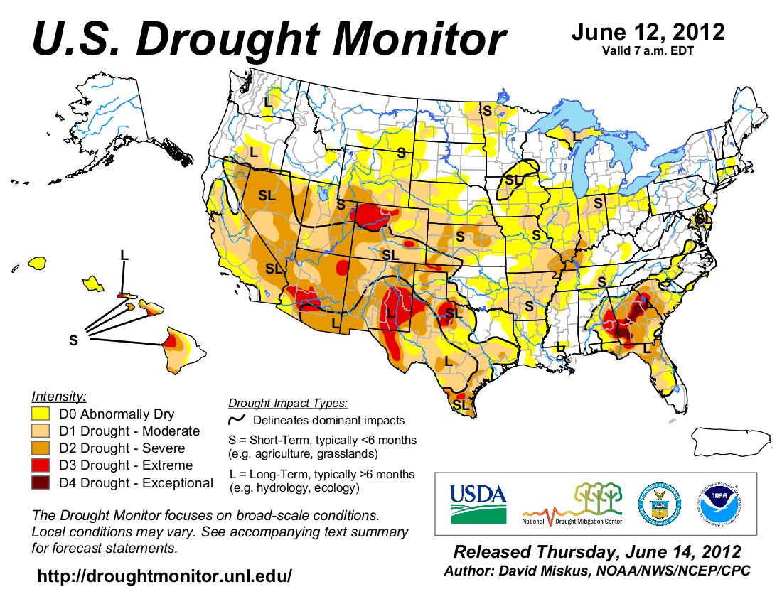
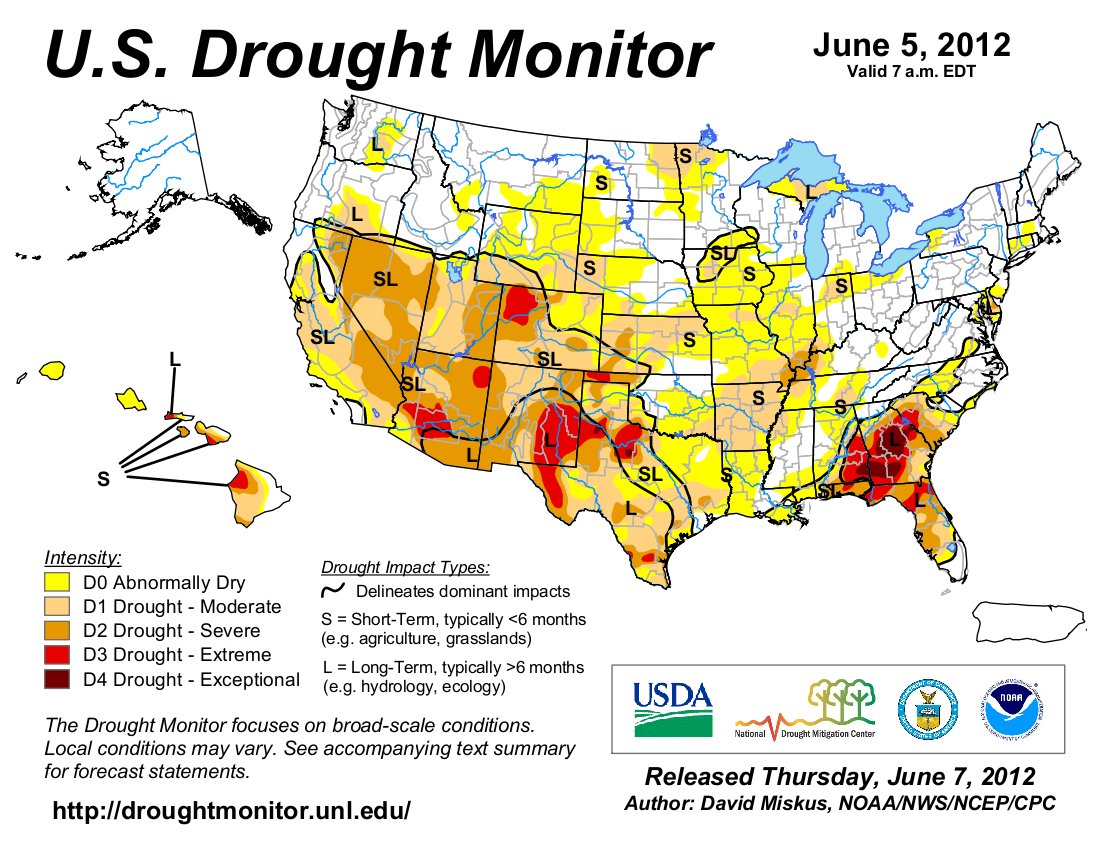
Local weather observer Art Judson reported this week that the monthly rainfall total stands at one-tenth of an inch, and the National Weather Service in Grand Junction confirmed Wednesday that there’s nothing significant on the way. The polar jet stream will dip toward Northwest Colorado this weekend, meteorologist Travis Booth said, but “there doesn’t appear to be any significant moisture on the way.” The National Integrated Drought Information system still has most of Routt County under an extreme drought with pockets of milder severe drought in North Routt and the far southeastern corner of the county…
This week, the drought monitor indicates soil in Routt County has been exceptionally dry through the first half of June, but at least in terms of streamflows, the area is better off than most despite the fact that the Yampa in downtown Steamboat was flowing at 141 cubic feet per second at midafternoon Wednesday compared with the average for the date of 2,070 cfs. The record low for June 13 was 120 cfs recorded in 1934…
“The models are hedging toward a high-pressure system setting up over the Texas Panhandle” that could allow the annual summer monsoon flow to reach Colorado in July.
From the Craig Daily Press (Joe Moylan):
The Moffat County Commissioners approved, 2-0, Resolution 2012-72 on Tuesday establishing a fire ban in unincorporated portions of Moffat County. The ban takes effect immediately. Among the activities prohibited include the burning of trash, fence rows, debris and vegetation; lighting a camp fire or charcoal grill outside of developed recreation areas featuring permanent fire pits with grates; smoking outside in non-designated areas; operating a chainsaw without a U.S. Department of Agriculture-approved spark arresting device; welding or using an open-flamed torch that is not clear of flammable materials for at least 10 feet on all sides; using explosives requiring fuses or blasting caps; and the discharge of any fireworks.
From The Greeley Tribune (Eric Brown) via Windsor Now!:
Standing as the hottest year on record so far for the Greeley area, the heat has forced winter wheat to mature much faster than normal. Therefore, it will force farmers to get out the combines well ahead of schedule. While it’s been hot this year, it’s also been dry — the driest year on record for much of the region, in fact. That means, while wheat heads popped out early this year, other aspects of the plant’s growth were stunted, and some of the area’s wheat fields won’t be producing the above-average yields farmers saw last year or the record-breaking yields they hauled to local elevators in 2010. In addition to the dry times, Thursday night’s hail storms wiped out thousands of acres across northeastern Colorado. Because of all of those factors — the early harvest, minimal precipitation and hail damage in isolated areas — Bosley said yields this year in northeastern Colorado will probably be all over the place. Some fields will produce average yields — 30 to 40 bushels per acre — while some fields will produce yields as low as 15 bushels per acre and some will produce 45 bushels per acre, he said. Some fields might not even be harvested, he added. Moisture was so low in some parts of northern Weld County, that some wheat only grew about 6 to 8 inches tall — some of which is so short it might not be able to be combined.
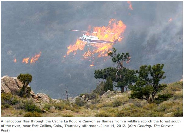
From the Fort Collins Coloradoan (Bobby Magill):
The reason the High Park Fire has spread so quickly is complicated, however, said Chad Hoffman, assistant professor of fire science at Colorado State University. “What’s really important to remember is that fire behavior and how it burns is always determined by a factor of the topography, the fuels and the weather,” he said. “Right now, when we look at the High Park Fire, it’s been windy, we have dry conditions and we have a lot of bark beetle mortality up there. To say it’s one or the other is really tricky because all those things kind of interact to determine what’s going to happen.”[…]
Research that Rocky Mountain National Park relies on for its forest management strongly suggests that beetle-killed trees play a small role in the spread of wildfire.
From the Cañon City Daily Record (Rachel Alexander):
The Fremont County Commissioners conducted a public hearing Tuesday regarding a new ordinance covering restrictions on open fires and open burning in the unincorporated area of Fremont County. The ordinance is a rewrite of the fire restriction ordinance already in place in the county. It adjusts the stage 1, 2 and 3 restrictions to be more in line with other local agencies, including the Bureau of Land Management.
From the Associated Press via The Colorado Springs Gazette:
For the first time in 15 years, the Boulder Fire Department Wildland Division is sending out fire patrols to find extreme fire conditions in an effort to prevent serious wildfires…Officials in Greeley say they also have been preparing for disasters like the one in northern Colorado that is blamed for one death and damage to more than 100 structures.
From email from the U.S. Forest Service (Barbar Timock):
Beginning immediately, Stage 1 fire and smoking restrictions are in place on public lands managed by the U.S. Forest Service (USFS), Pike and San Isabel National Forests located in Chaffee, Clear Creek, Custer, Douglas, El Paso, Fremont, Huerfano, Jefferson, Lake, Las Animas, Park, Pueblo, Saguache, and Teller Counties, Colorado. Restrictions will remain in effect until they are rescinded.
Here’s a release from Colorado Parks and Wildlife:
Colorado Parks and Wildlife announced Wednesday that county fire bans and restrictions will be strictly enforced in state parks and wildlife areas because the fire danger is extremely high across the state.
All fires, including those in pits and grills, have been banned in 14 counties due to dry conditions and the risk of wildfires. Fire restrictions are in place in many other counties. The agency reminds all park visitors and sportsmen that county bans and restrictions apply to the state parks and wildlife areas in those counties.
“Colorado Parks and Wildlife will enforce the county fire bans and other restrictions. We urge visitors to parks and wildlife area take every precaution possible to prevent new fires from starting,” said Rick Cables, Colorado Parks and Wildlife Director.
From the La Junta Tribune-Democrat (Bette McFarren):
The [Board of Utility Commissioners] recommend that citizens not water their lawns between the hours of 10 a.m. and 6 p.m. During these hours, much water is lost to evaporation. La Junta received an allocation of 150 acre- feet of water from the Fry-Ark Project this year. “That’s not quite enough to cover our evaporation losses for the year,” said Kelley. “I project that this will leave 1900 acre-feet at the end of this pumping year. Another winter of low snowpack would require the implementation of water restriction next year. Customers are advised not to waste water.”
From the Salida Citizen:
Chaffee County Sheriff Pete Palmer announced today that Stage I fire restrictions will be in effect as of Thursday, June 14. No open fires are allowed, with the following exceptions:
1) Campfires, warming fires and charcoal fires within a permanent constructed fire grate in a developed public campground or picnic ground or permanent constructed fire grate or fire ring in a commercial campground or on private property.
2) LP gas or liquid fueled stoves and appliances which allow the operator to turn the flame on and off.
3) Fireplaces within enclosed buildings which are equipped with adequate spark arresting screens on the flue.
4) Charcoal grill fires at private residences.
These restrictions are due to high winds, low relative humidity, and very dry conditions. They will remain in effect until further notice.
From the Boulder Daily Camera (Scott Rochat):
The Weld County commissioners declared a disaster emergency Monday because of the drought. The commissioners are asking Gov. John Hickenlooper to order water from normally restricted South Platte irrigation wells for 30 days to give the county the water it needs.
Commissioners said that too little snow in January and too little rain this spring led to the emergency. County Chairman Sean Conway said the county has between seven and 21 days to get more water, or else risk losing this year’s crops…
Since March, precipitation levels in the county have been, at best, 70 percent of normal, and some areas have been below 50 percent, according to the High Plains Regional Climate Center…
Conway said if Hickenlooper can turn the wells on for 30 days, the county should be able to make it to the “monsoonal” rains in August. “This is just a temporary solution to just get us through this hot, dry summer,” Conway said.