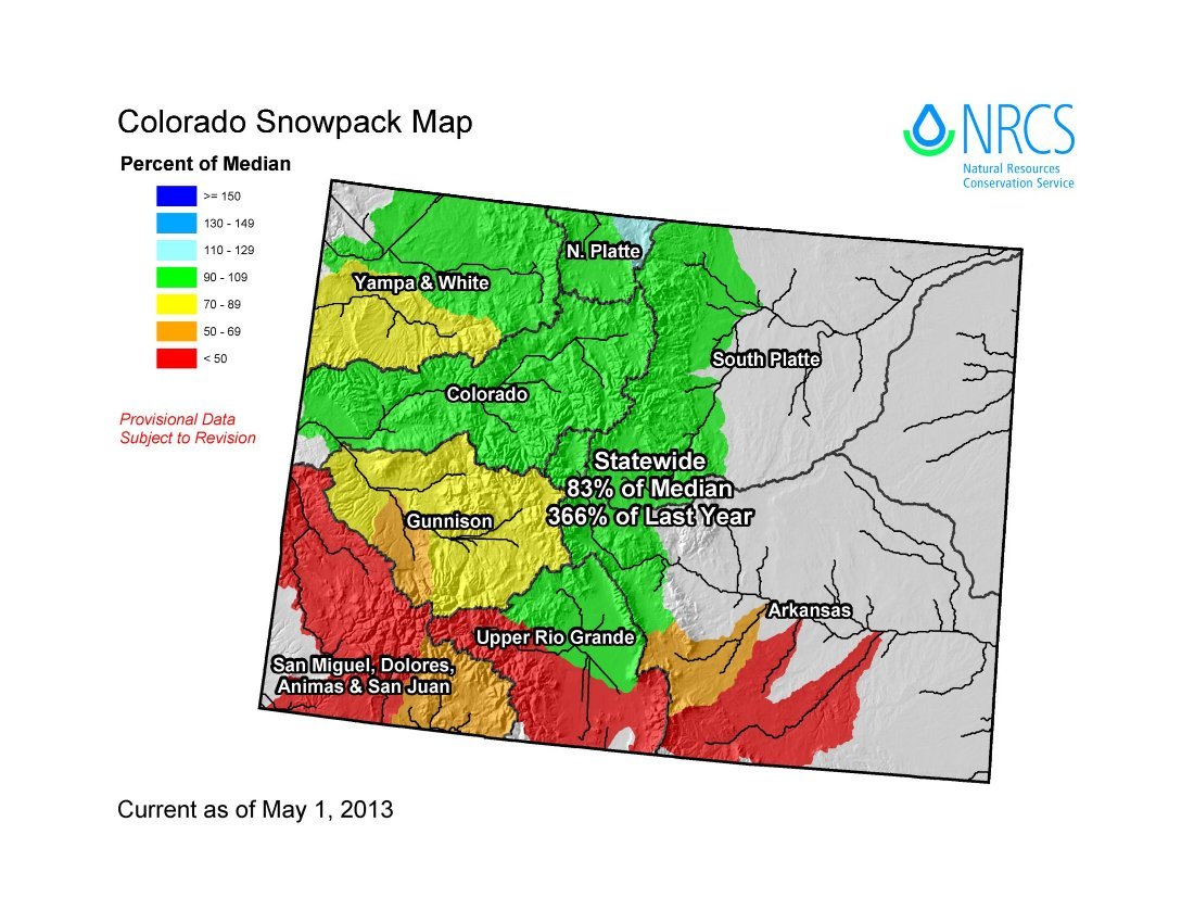
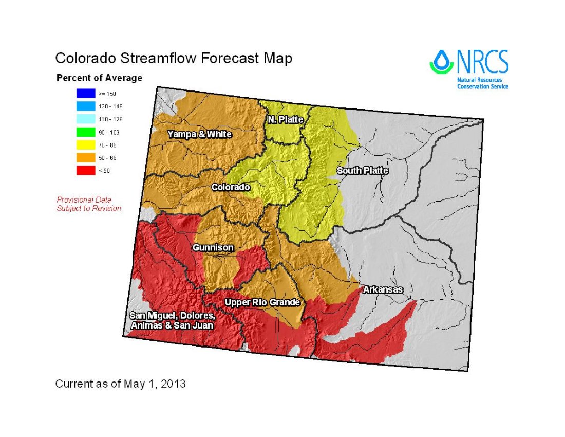
Click on the thumbnail graphic for the May 1 statewide snowpack map by sub-basin along with the May 1 streamflow forecast by basin from the Natural Resources Conservation Service. Click here to read the report. Here’s the introduction:
Summary
After three consecutive months of below average snow accumulation in Colorado, multiple storm systems in April finally brought the moisture we had been hoping for all season. The state received above average precipitation during April which primarily occurred as snow, and brought snowpack totals to near normal levels in the northern basins. Unfortunately the southern portion of the state did not benefit from these storm systems. Warm and dry conditions dominated the Upper Rio Grande basin, the combined San Juan, Dolores, Animas, & San Miguel basins and the southern tributaries of the Gunnison basins during April. Reservoir storage remains below average across most of the state but conditions should improve in the northern basins as the recent snow begins to runoff. The most recent streamflow forecasts mimic the snow and precipitation conditions across the state; big improvements in the northern basins and further decline in the southern basins. Overall though the water supply outlook this month is better than just a month ago, this just goes to show how big of a difference just a few snowy weeks can make.
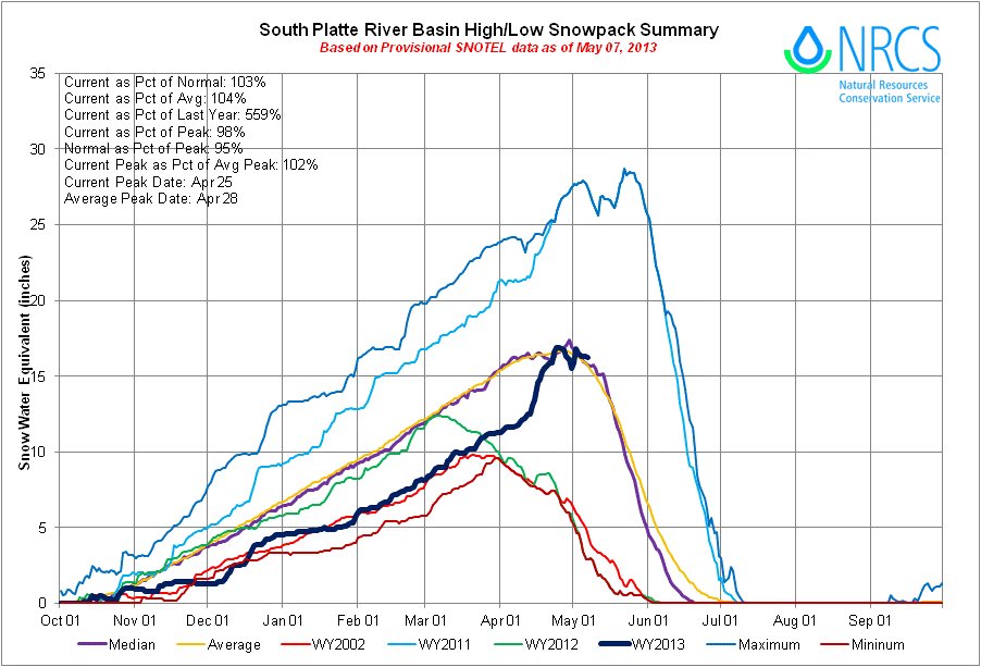
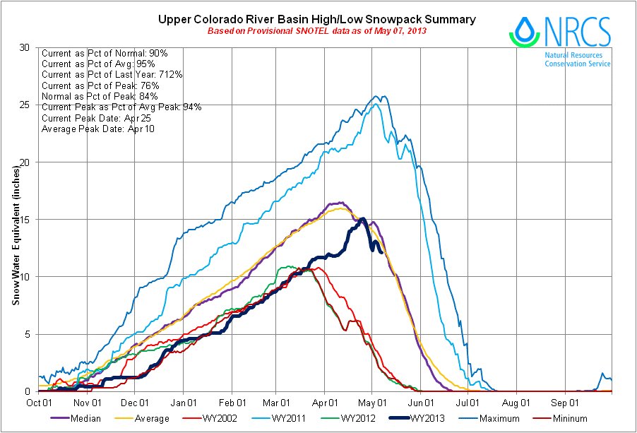
Snowpack
The wet weather pattern that started in late March continued into May and brought impressive improvements to snowpack percentages. After four consecutive months of snowpack reports that hovered in the low 70 percent range, the state snowpack recorded a significant gain this past month. Snowpack measurements recorded by automated SNOTEL sites and manual snow surveys across the state showed an increase of 9 percentage points from last month’s report. As of May 1 the snowpack was at 83 percent of median. This was a very unusual April, in most years the snow accumulation season ends in early April, and the rest of the month is normally characterized as the beginning of runoff season. The watersheds in the northern part of the state saw the largest benefit from the snowy April, posting increases that ranged from 28 percentage points (in the South Platte basin) to 15 percentage points (in the Yampa and White basins). Unfortunately, basins to the south saw similar changes in their snowpack percentages, but in the opposite direction. The Upper Rio Grande and the combined San Juan, Dolores, Animas, and San Miguel basins saw decreases of 28 to 30 percentage points respectively.
Precipitation
Statewide precipitation, measured by the SNOTEL network, was 114 percent of average this April and 197 percent of last year’s April totals. April was only the second month to record above average statewide precipitation this water year, with the previous month being back in December. The relatively wet month increased the water year to date totals to 80 percent of average on May 1, and 103 percent of last year’s cumulative precipitation on the same date. Precipitation was quite variable throughout the state in April, it was really a story of the haves and the have not’s. The combined Yampa, White and North Platte basins recorded precipitation at146 percent of average for the month, the Colorado basin was at 140 percent of average and the South Platte was at 143 of average. The Gunnison basin ended up at 101 percent of average for the month as a result of half the basin receiving decent precipitation and the other half missing out on the storms. The lowest percent of average for the month was reported in the combined San Juan, Animas, Dolores and San Miguel basins with 48 percent of average.
Reservoir Storage
The cool, wet weather we experienced in April delayed the expected increase in reservoir storage volumes this month. Reservoir storage across the state is at 74 percent of average as of May 1, and 68 percent of last year’s May1 storage amounts. The late season snowfall provides an optimistic outlook for storage improvements in the northern basins this spring. The additional runoff in these basins should extend water supplies further into the summer season. In the southern basins, storage levels remain well below average and the probability of vast improvements this season are slim. All in all we are still feeling the effects of the previous bleak winter but some basins should be able to replenish their reservoirs this season.
Streamflow
Most major basins in Colorado saw improvements to their streamflow forecasts this month. The northern basins once again boasted the greatest changes compared to last month; on average April to July forecasts in the combined Yampa, White and North Platte basins, the Colorado basin and the South Platte basin increased by 20 percentage points from those issued last month. A few of the headwater streams in the Colorado and South Platte basins are now expected to see near average flows. Despite these improvements, the majority of the forecasts in these basins still call for below average runoff this spring and summer season. On the flip side, current forecasts for the combined San Miguel, Dolores, Animas, and San Juan basins and the Upper Rio Grande basin call for streamflow volumes in the 30 to 50 percent of average range.
Special Note on Interpreting Forecasts
According to the National Water and Climate Center (NWCC), “a water supply forecast is a prediction of streamflow volume that will flow past a point on a stream during a specified season, typically in the spring and summer. These forecasts are given not as a single number, but as a range of numbers to reflect risk and forecast uncertainty. Each month, five forecasts are issued for each forecast point and each forecast period. Unless otherwise specified, all forecasts are for streamflow volumes that would occur naturally without any upstream influences.”
The forecasts we typically emphasize in this report are the 50 percent exceedance probability forecasts because they are in the middle of the range of forecasts with 50 percent chance that actual volumes will be above or below the predicted volume. The 50 percent exceedance forecasts assume that typical weather patterns will prevail into the forecast season. In a water year such as this one, when conditions have been anything but typical, it is important to pay attention to the other forecasts provided. If cool, wet conditions prevail into the rest of this spring and summer it may be prudent to use the 50 or 30 percent exceedance forecasts for management purposes this season. If conditions get very hot and dry this spring, actual streamflow volumes may be more in line with the 50 or 70 percent exceedance forecasts.