Waldo Canyon burn scar: Colorado Springs Utilities repurposes two drinking water reservoirs to flood mitigation

waldocanyonfirejuly2012

From KRDO.com (Rachael Plath)

The burnt ground left in the wake of the Waldo Canyon Fire has increased the likelihood of flash flooding and mudslides. This threat directly impacted two Colorado Springs reservoirs: the Nichols and the Northfield reservoirs.

“When we have rainstorms, it really churns everything up; brings out that vegetation and debris down into the streams and tributaries. It just makes it a little more challenging to treat,” said Andy Funchess, field operations manager for water systems with Colorado Springs Utilities.

According to Funchess, the area surrounding the two reservoirs was badly burned. The runoff and erosion around the reservoirs was affecting the water’s quality.

Funchess said CSU has the ability to treat the water, but the cost would outweigh the benefit. For this reason, CSU drained the two reservoirs. The empty basins will now help with flood mitigation, as in their empty state, the reservoirs will catch debris and water before it rushes down the mountainside.

From the Colorado Springs Independent (J. Adrian Stanley):

For months now, local leaders have breathlessly awaited [Dave] Rosgen’s Watershed Assessment of River Stability and Sediment Supply (WARSSS) study, a detailed explanation of how water will move off the Waldo Canyon burn scar and, more importantly, what we can do to stop it.

But as the study’s finally presented, it becomes clear that Rosgen can’t save us from the powers of nature.

His plan — thousands of pages long — represents a to-do list that likely will cost tens of millions. It’s currently largely unfunded, and will take years to complete regardless. And then there’s the biggest dose of reality: Even if the region does everything recommended, a five- or 10-year storm will still cause mass destruction and may claim many lives. “The increase in flow is going to be with us,” Rosgen tells the crowd. “It’s not going to change a lot. Flood peaks are a reality for the future.”

What the WARSSS can do is ease our suffering. The restoration work it recommends can hold back well over a million tons of mud in a normal monsoon season, ensuring that a two-year rain event doesn’t take out a neighborhood. Plus, it will help the burn scar heal more quickly.

More Colorado Spring Utilities coverage here.

Restoration: CSU Researchers Identify Environmental Risks and Opportunities for Conservation of Native Colorado Trout Populations

cutthroattrouthistoricranges.jpg

Here’s the release from Colorado State University (Jennifer Dimas):

With only 14 percent of their original habitat remaining, native Colorado River cutthroat trout have been forced into isolation by habitat loss and invading non-native trout in relatively short reaches of high-altitude headwater streams. A new research paper by scientists at Colorado State University’s Warner College of Natural Resources has found that 63 percent of the remaining populations will be at some risk of decline or extinction by 2080.

There are 309 individual fragments of rivers and streams where pure Colorado River cutthroat trout still persist in the Colorado River Basin. The CSU researchers developed models to assess the probabilities for a variety of risks to trout in these populations, including those from a warming climate as well as increases in drought that causes stream drying and wildfire that can produce erosion of sediment into streams.

Researcher and lead author on the paper James Roberts first developed a sophisticated model to predict future stream temperatures from the latest predictions of future air temperatures and stream flow under climate change, as well as a range of other important variables such as latitude, slope, and elevation. The researcher team then analyzed the impacts of potential environmental disturbance events, such as fire, erosion and drought. What they found was a surprising paradox, and an opportunity for conservation.

The scientists report that none of the populations of cutthroat trout are expected to be at risk of acute mortality from increasing temperatures as the climate warms, even 70 years in the future. This is because these native fish have already been forced into refuges in short high-altitude streams, above barriers that prevent invasion by non-native brook, rainbow, and brown trout. As a result, the surviving populations are less susceptible to extreme temperature changes such as those that will occur at lower elevations. However, these isolated havens of cool-water habitat are also at the crux of what is jeopardizing the Colorado River cutthroat trout population.

The study reported that the fish living in these short stream reaches are highly vulnerable to potential effects of drought, fire, sediment deposition and freezing because they lack the habitat that would shelter them from these events that longer stream segments would afford. In addition, the isolated populations are also compromised by genetic risks that occur in small populations.
Because Roberts’ models looked at each risk factor for each stream where the native trout still occur, the researchers are able to identify in which of the 309 fragments restoration to expand the native trout’s habitat can be most effective. Furthermore, they are able to determine approximately how many kilometers long a stream fragment needs to be in order to provide adequate habitat for enhanced persistence rates.

“The complexity and depth of this study has allowed us to sharpen our focus and help managers create sustainable solutions for this iconic native fish species,” said Roberts. “Our hope is that this research will empower land managers with the tools and information needed to make a significant impact on the conservation of native Colorado River cutthroat trout for generations to come.”

The paper, Fragmentation and thermal risks from climate change interact to affect persistence of native trout in the Colorado River basin, is published in the May 2013 issue of Global Change Biology. The study was conducted using data from the upper Colorado River Basin, which includes all tributaries above Glen Canyon Dam and Lake Powell.

Roberts, now working with the U.S. Geological Survey, conducted the research over three years while he was a post-doctoral researcher with CSU’s Warner College. CSU scientist Kurt Fausch served as Roberts’ research advisor and co-author, and is a professor in the Department of Fish, Wildlife, and Conservation Biology and a world-renowned expert in the ecology and management of trout and other stream fishes. Other co-authors of the study are Mevin Hooten with the USGS Colorado Cooperative Fish and Wildlife Research Unit and CSU alumnus Doug Peterson with the U.S. Fish and Wildlife Service.

“The exciting outcome of this research is that we now have a targeted tool to help land managers plan efficient and strategic habitat restoration to reduce these risks,” said Fausch. “In many other cases, managers may be able to do little for native trout as the climate changes and makes streams too warm for their survival.”

From the Summit Daily News (Breeana Laughlin):

Rising water temperatures, the Colorado State University study concludes, aren’t impacting the indigenous fish like some of its non-native brothers.

Results of the study, which included six streams in Summit County, indicate that the hardy fish may be less susceptible to increases in water temperature than other trout.

Researchers James Roberts and Kurt Fausch are suggesting this may be because cutthroat trout have already sought refuge in short, high-altitude streams, above the barriers that keep out non-native brook, rainbow and brown trout.

Although isolated havens of cool-water habitat could help native trout survive future temperature increases, they still face peril in the event of a drought, fire or hard freeze because they don’t have the expansive habitat larger fish populations rely on to survive.

More restoration/reclamation coverage here and here.

Bennet, Tipton Reintroduce Companion Bills to Preserve Hermosa Creek Watershed

hermosapark.jpg

Here’s the release from US Representative Scott Tipton’s office:

Colorado U.S. Senator Michael Bennet and Representative Scott Tipton are introducing a bill to protect more than 100,000 acres of the Hermosa Creek Watershed, an area in the San Juan National Forest north of Durango. The bill would establish management for the Hermosa Creek Watershed based on recommendations from the Hermosa Creek River Protection Workgroup, which included local water officials, conservationists, sportsmen, mountain bikers, off-road-vehicle users, outfitters, property owners, grazing permit holders and other interested citizens. Bennet’s bill was introduced today, while Tipton will introduce his bill in the House as early as tomorrow.

“We are lucky in Colorado to be able to enjoy many of the country’s most beautiful landscapes in our backyards. The Hermosa Creek Watershed represents some of the best Colorado has to offer,” Bennet said. “This bill will protect this land for our outdoor recreation economy and for future generations of Coloradans and Americans to enjoy. It is the result of a local effort that took into account the varied interests of the community, and that cooperation helped us put together a strong bill with the community’s input.”

“As one of Colorado’s most scenic areas, Hermosa Creek has long been treasured by the local community and by countless visitors who have explored all that the region has to offer,” Tipton said. “Local stakeholders including snowmobilers, anglers, hunters, other outdoor enthusiasts, elected officials, miners and Southwest Colorado residents have voiced their support to preserve the Hermosa Creek watershed and the multiple use recreation opportunities it provides. In response to this locally driven effort, Senator Bennet and I have joined together to put forward legislation to, without any additional cost to taxpayers, protect and preserve this special place, and ensure that Coloradans as well as visitors to our great state have the opportunity to experience Hermosa Creek’s abundant natural beauty for generations to come.”

“On behalf of the La Plata County Commissioners, I thank Senator Bennet and Congressman Tipton for their great work for the interests of La Plata County citizens,” said Julie Westendorff, La Plata County Commissioner. “This bill protects the clean waters of our Hermosa Creek and promotes the responsible use of federal lands for the recreation that supports our economy and sustains our quality of life.”

“We are very excited about this bill. We are hopeful that all the hard work and cooperative partnership that went into the Hermosa Creek Watershed Protection Act will lead to the swift passage of this bill for the benefit of Southwest Colorado and all the visitors to our area.” said Pete McKay, San Juan County Commissioner.

“The Hermosa Creek Wilderness bill rests on a foundation of broadly-based stakeholder input,” said Dick White, mayor of Durango. “It will protect the watershed while preserving historical and recreational values. In addition, it provides protection for iconic scenic and recreational areas near the City of Durango. The bill will contribute both to the natural amenities that attract residents and tourists to Southwest Colorado and to the economic benefits that they bring.”

“It was my privilege to represent the interests of the Southwestern Water Conservation District and San Juan County, Colorado during this process. Interests of the Southwestern Water Conservation District included protecting existing water rights and uses; and, the potential for future water development. The interests of San Juan County included protecting existing water quality, county road access, mineral development potential, forest product harvesting, and recreational uses,” wrote Stephen Fearn, President, Jo Grant Mining Company, Inc. “Both the District and San Juan County have voted to support the proposed legislation.”

The bill, which is cosponsored by Senator Mark Udall, would designate roughly 108,000 acres of San Juan National Forest land as the Hermosa Creek Watershed Protection Area. Much of the land would remain open to all historic uses of the forest under the bill, including mountain biking, motorized recreation, and selective timber harvesting. Grazing will continue to be allowed in the entire watershed.

In accordance with the consensus recommendations of the Hermosa Creek Workgroup, roughly 38,000 acres of the watershed would be set aside as wilderness, to be managed in accordance with The Wilderness Act of 1964. No roads or mineral development are permitted in wilderness areas; while hunting, fishing, horseback riding and non-mechanized recreation are allowed.

Per the community recommendations the following trails all remain open to mountain biking: Hermosa Creek, Dutch Creek, Elbert Creek, Corral Draw, the Colorado Trail, Little Elk Creek, Jones Creek, Pinkerton-Flagstaff and Goulding Creek. Also, in keeping with the community recommendations, the following trails will remain open to motorized use: Hermosa Creek, Jones Creek, Pinkerton Flagstaff, Dutch Creek and Corral Draw. In addition the bill will allow areas in the Hermosa Creek watershed currently used by snowmobiling to remain open to that use. Also, at the request of Silverton and San Juan County, the bill ensures areas currently open to snowmobiling on Molas Pass will remain open for that use.

The bill contains several provisions to provide for active land management in areas designated by the bill as necessary to control wildfires, insect infestations and disease outbreaks. Finally, per the request of the Durango City Council and La Plata County Commission, the bill would prohibit future federal mineral leasing on Animas Mountain, Perins Peak, Ridges Basin and Horse Gulch.

Supporters of the bill include the City of Durango, the La Plata County Commission, the San Juan County Commission, the Wilderness Society, Trails 2000, Four Corners Back County Horsemen, Jo Grant Mining Company, Inc., in addition to numerous business and sportsmen groups, among others.

More Hermosa Creek Watershed coverage here and here.

Restoration: Mary Murphy Mine project set to start mid-summer

Mary Murphy Mine

From The Mountain Mail (Maisie Ramsay):

High on Chrysolite Mountain south of St. Elmo sits the Mary Murphy Mine, one of many nearly abandoned mining sites dotting the landscape of Chaffee County. The mine, a once-rich source of gold and silver, is now a pollutant. “It’s discharging metals into Chalk Creek. It makes it difficult for fish to survive,” said Jeff Graves, senior project manager for the Colorado Division of Reclamation, Mining and Safety.

Work is now under way to permanently stop the mine’s discharge of zinc-laden water toxic to fish – runoff linked to a 1986 fish kill. “The goal is to reduce the amount of discharge significantly and by that hopefully improve water quality within Chalk Creek,” Graves said.

The reclamation agency is seeking bids on the first phase of a two-stage project to end contaminated seepage from the site, described in a 2009 state report as the “single greatest contributor of heavy metals” in Chalk Creek. The first phase of the estimated $500,000 project is set to begin mid-summer, Graves said.

The project will reinforce the mine’s Golf Tunnel to prevent it from collapsing on workers during the second phase of the project, when a long-term barrier will be put in place. The tunnel will be stabilized, the floor cleaned of muck, ventilation put into place and basic utilities installed such as electricity and telephone. The Golf Tunnel is 2,200 feet below the surface, the lowest level of the Mary Murphy Mine.

Companies interested in the project must attend a mandatory pre-bid meeting at 10 a.m. May 7 in the U.S. Forest Service parking lot near St. Elmo. Bids must be submitted by May 23.

Following the stabilization of the Golf Tunnel, workers will install concrete plugs designed to stop mining discharge during the second phase of the project. “It’ll be like putting a cork in it,” Graves said. The “cork” phase has not yet been scheduled. Graves could not provide a specific cost estimate, but said the installation of the concrete plugs is expected to cost more than reinforcing the tunnel.

There are still claims on the Mary Murphy Mine, though the site is largely abandoned. The latest remediation work follows prior efforts to reduce pollution at the site through consolidation, capping and revegetation of mine tailings.

The work is being funded by the state and federal government after it was determined that “existing landowners are nonviable … for insufficient funds,” Graves said.

More restoration/reclamation coverage here.

Boulder County ‘Water Tour 2013’ is Saturday, June 8

Grand Junction: Next CWCB board meeting May 14-15

historicdowntowngrandjunction.jpg

From email from the Colorado Water Conservation Board:

The meeting will be held in Grand Junction at the Ute Water Conservancy District offices located at 2190 H 1/4 Road, Grand Junction, CO, 81505.

More CWCB coverage here.

El Paso County Commissioners approve a regional stormwater approach for mitigation and management

arkansasfountainconverge.jpg

From the Colorado Springs Independent (J. Adrian Stanley):

On Tuesday, the soon-to-be-overhauled City Council approved a resolution to support a regional approach to stormwater management on a 6-2 vote. In the past, such a move may have been considered little more than ceremonial — most experts have long agreed that stormwater is best approached regionally. But Mayor Steve Bach has lately turned the issue into a political football…

Many believe the mayor is afraid that a regional approach will suggest a new tax to solve the area’s dangerous backlog of needed infrastructure projects, estimated to exceed $900 million. The mayor signed a pledge saying he would oppose any new tax, no matter how vital. But Bach’s long reach may not be able to control this process. With assistance from El Paso County, a Regional Stormwater Steering Committee, made up of dozens of citizen volunteers, is already studying how best to approach the problem.

More Fountain Creek coverage here and here.

POWELL to POWELL Episode 3 in the Colorado River series #ColoradoRiver

Las Vegas: ABA 31st Annual Water Law Conference June 5-7

CFWE watershed tours are coming up later this month, June and July

Click here for the 2013 tours page from the Colorado Foundation for Water Education. Watch their showcase video above to learn about the mission.

More Colorado Foundation for Water Education coverage here and here.

WWA Intermountain West Climate Dashboard: New Briefing Available #COdrought

swepercentofnormalwesternusmay122013wwa.jpg

From email from the Western Water Assessment:

Our latest Monthly Briefing was updated today on the Intermountain West Climate Dashboard. The briefing reviews April’s precipitation and temperature conditions; current drought, snowpack, and streamflow conditions; May 1 spring-summer streamflow forecasts; and the latest seasonal climate and ENSO forecasts.

New this month: Thumbnail images embedded in the text allow you to bring up the full-sized climate graphics while reading the briefing. [ed. very cool feature, click through, it’s worth it for you graphics junkies]

Highlights:

  • Recent snows have improved the runoff picture, but most of the Intermountain West is still facing low or very low 2013 spring-summer runoff with reservoirs already at low levels.
  • April precipitation was mixed for the region, with northern and central Colorado, portions of Wyoming, and eastern Utah being wetter than average, and northern Utah, southwestern Wyoming, and southern Colorado being mainly drier than average.
  • Snowpacks in eastern Utah, much of Wyoming, and northern and central Colorado saw large gains in April, reaching near-normal peak levels.
  • Southern Colorado and southern Utah did not see these gains and meltout began early, from well-below-normal peaks.
  • May 1 forecasts for spring-summer streamflow for the region are still below average or well below average, but are generally improved from the April 1 forecasted flows across Wyoming, northern and eastern Utah, and northern and central Colorado.
  • The NOAA CPC seasonal climate outlooks show a dry “tilt” for spring and summer precipitation for most of our region. In contrast, the “SWcast” for April-June shows a wet tilt over much of Colorado.
  • To view the Intermountain West Climate Dashboard, please click here.

    The latest ENSO Discussion is hot off the press: ENSO neutral conditions forecast to continue #COdrought

    iricpcplumeofmodelensopredictionsmidapril2013

    Click here to read the discussion and see all their graphics. Here’s an excerpt:

    Synopsis: ENSO-neutral is favored into the late Northern Hemisphere summer 2013.

    During April 2013, ENSO-neutral continued, with near-average sea surface temperatures (SSTs) observed across most of the equatorial Pacific Ocean, and below average SSTs confined to the far eastern equatorial Pacific. The Niño indices were near zero throughout the month, except for the Niño1+2 region which was between -1.2°C and -0.5°. The oceanic heat content (average temperature in the upper 300m of the ocean) remained near average during April, reflecting near- average subsurface temperatures at depth across most of the central and eastern equatorial Pacific. The tropical low-level easterly winds remained slightly enhanced over the western half of the Pacific basin, and anomalous upper-level westerly winds prevailed across much of the equatorial Pacific. Tropical convection was enhanced over Indonesia and the western Pacific and suppressed over the central Pacific. Collectively, these conditions indicate the continuation of ENSO-neutral.

    Most models forecast Niño-3.4 SSTs to remain ENSO-neutral into the Northern Hemisphere winter, with dynamical models tending to predict warmer conditions (-0.3°C to 0.4°C) than the statistical models (-0.7°C to 0°C). There is still low confidence in the forecasts for the latter half of the year, partly because of the so-called “spring barrier,” which historically leads to lower model skill for forecasts made between March and May. Forecast confidence will increase over the next few months. The current forecast indicates that ENSO-neutral will likely continue into the second half of the Northern Hemisphere summer 2013 (see CPC/IRI consensus forecast).

    This discussion is a consolidated effort of the National Oceanic and Atmospheric Administration (NOAA), NOAA’s National Weather Service, and their funded institutions. Oceanic and atmospheric conditions are updated weekly on the Climate Prediction Center web site (El Niño/La Niña Current Conditions and Expert Discussions). Forecasts for the evolution of El Niño/La Niña are updated monthly in the Forecast Forum section of CPC’s Climate Diagnostics Bulletin. The next ENSO Diagnostics Discussion is scheduled for 6 June 2013. To receive an e-mail notification when the monthly ENSO Diagnostic Discussions are released, please send an e-mail message to: ncep.list.enso-update@noaa.gov.

    Bureau of Reclamation Releases Updated Climate Data for Water Managers

    arcticseaicerecord962011nationalsnowicedatacenter.jpg

    From email from the Bureau of Reclamation (Peter Soeth):

    The Bureau of Reclamation and collaborators developed new downscaled climate projections that allow water managers to incorporate the new Coupled Model Inter-comparison Project Phase 5 data from the World Climate Research Program into their water management planning. The data, representing 234 contemporary climate projections for the contiguous United States, was downscaled to a 12 kilometer resolution in order to be more useful to water managers.

    “CMIP5 projections represent a new source of information about how a changing climate may impact water supplies in the United States,” Reclamation Commissioner Michael L. Connor said. “Reclamation and its partners are taking leading roles to develop an understanding on how this new information complements previous climate projections made available through CMIP3, and on how CMIP5 projections should be considered in water planning and management.”

    The World Climate Research Program develops global climate projections through its CMIP roughly every five to seven years. Results from CMIP3 were released in 2007 and later used in Reclamation research and assessments including the 2011 SECURE Water Act Report and WaterSMART Basin Studies completed in the Colorado, Yakima and St Mary River – Milk River Basins.

    “CMIP5 includes more comprehensive global climate models, updated greenhouse gas emissions scenarios and a broader set of experiments to address a wider variety of science questions,” Acting Science Adviser Levi Brekke said. “Through the West-Wide Climate Risk Assessment Implementation Team, Reclamation will consider best approaches for using CMIP5 projections in the future.”

    Reclamation, Lawrence Livermore National Laboratory, Santa Clara University, Climate Central, Climate Analytics Group, Scripps Institution of Oceanography, the U.S. Geological Survey and U.S. Army Corps of Engineers developed the new downscaled data collaboratively supported by funding from a WaterSMART Climate Analysis Tools Grant and Reclamation’s Science and Technology Program.

    The new downscaled climate projections are available at: http://gdo-dcp.ucllnl.org/downscaled_cmip_projections/.

    More Bureau of Reclamation coverage here.

    EPA’s Hydraulic Fracturing Drinking Water Study: What’s the latest?

    2013 Colorado legislation: ‘Each one of these things was epic’ — Senate Majority Leader Morgan Carrol #COleg

    coloradocapitolfront.jpg

    Joe Hanel sums up this year’s legislative session in his article running in The Durango Herald. Click through and read the whole thing. Here’s an excerpt:

    During the last 120 days, Democrats used their majorities in the House and Senate to push through a progressive agenda that’s been pent up for a decade.

    Election Day voter registration. Background checks for guns. Renewable-energy mandates. More health care for the poor. A $100 million tax break for low-wage workers. Civil unions for same-sex couples, and in-state tuition for students in the country illegally. Democrats in many other states can only daydream about the goals that Colorado Democrats achieved during the 2013 legislative session, which ended Wednesday.

    For good or ill, Capitol veterans called it the most consequential session in memory.

    “Each one of these things was epic,” said Senate Majority Leader Morgan Carroll, D-Aurora. “We were (able) to do public-safety measures with commonsense background checks that Congress couldn’t get done. Any one of these things by themselves would have been historic and epic for a session, and we did one after another after another.”

    More 2013 Colorado legislation coverage here.

    Chaffee County is still hammering away at 1041 regulations for geothermal exploration and production

    geothermalenergy.jpg

    From The Mountain Mail (James Redmond):

    When developing Chaffee County’s draft geothermal 1041 regulations, the consultant aimed to support geothermal development while protecting property rights, as the county requested, officials said at a special work session Tuesday. The 1041 regulations, when passed by the commissioners, will govern the use of geothermal resources for commercial production of electricity.

    The consultant who drafted the regulations, Barbra Green, partner at Sullivan Green Seavy LLC, said the draft contains flexible language that will give the county tools to handle all applications, from simple to controversial. “No one else in the state has geothermal regulations yet,” Green said. The process “is not easy and never perfect,” but she said she wants to talk through the draft with the county, hear feedback and get the regulations as close to the goals of the county as possible.

    The county’s draft geothermal 1041 regulations create a “permit-driven” process, Mary Keyes, Sullivan Green Seavy LLC paralegal, said. Unless staff makes a “finding of no impact,” any use of geothermal for commercial electricity will require a 1041 permit, she said.

    Chaffee County Commissioner Dave Potts asked when a project would get a finding of no impact. Green said she did not know how a geothermal project could actually get a finding of no impact. To do so, the project would have to cause no change on the site or surrounding properties in a number of areas. She said the draft has the no-impact language because in the future new technology or processes could possibly have no impact.

    The draft regulations include a mandatory pre-application meeting, Green said. Such meetings help all parties involved, by getting everyone on the same page, clarifying and answering questions about the application process. The meeting lets applicants determine their responsibilities and how to ensure their applications have everything they need up front instead of dealing with it later, she said.

    Once staff declares the application complete, the information goes to all reviewing agencies or consultants determined necessary, Keyes said. Then staff will compile all findings from the review agencies and consultants into a staff report prior to the public hearing for the application, she said.

    After the walkthrough of the process, the commissioners, consultant, county staff and others attending the meeting addressed areas of the draft they thought had issues or conflicts, and discussed possible solutions.

    The county will have to decide if it wants the drilling of exploration holes to fall into the definition of geothermal 1041 regulations, and therefore require a 1041 application, Green said. Hank Held and Fred Henderson, both of Mt. Princeton Geothermal LLC, spoke during public comments, saying the county should consider less regulation, not only on the drilling of exploration holes, but also on the entire geothermal 1041 regulations. Held said the county’s draft geothermal 1041 regulations duplicate both state and federal regulations. In cases such as drilling exploration holes, a company already must go through a regulatory process at the state level that could cover the need for regulation, he said.

    Green said in some cases the county has different standards than the federal or state regulations, so it may appear the county has redundant regulations.

    Paul Morgan, with the Colorado Geological Survey, warned commissioners that the west side of the Upper Arkansas River Valley has a large fault line running along it. He said, “I don’t think (county geothermal 1041 regulations) should have an option of a (finding of no impact). If an earthquake happens near geothermal development, “someone will sue the county,” he said.

    The county will hold a public hearing to start the process of approving the draft geothermal 1041 regulations during the May 21 regular commissioners meeting in Buena Vista, Jenny Davis, Chaffee County attorney, said. While the public hearing will start the process, the commissioners do not have to make a decision then, she said. Green will take comments and recommendations from the commissioners after the public hearing to work any requested changes into the draft document, she said.

    To develop geothermal 1041 regulations, Chaffee County partnered with Archuleta and Ouray counties and Pagosa Springs to hire the consultant for the process, Davis said previously. After the partners received a grant, Chaffee County’s portion of the contract for the consultant comes to $2,937.50, Don Reimer, Chaffee County development director, said previously.

    The county will have the most current version of its geothermal 1041 draft regulations on its website, chaffeecounty.org

    From The Mountail Mail (Joe Stone):

    The 800-acre Mount Princeton geothermal lease was recently terminated for nonpayment of rent. The lease owner, 3E Geothermal LLC in Colorado Springs, is a wholly owned subsidiary of Young Life, which also owns the Frontier Ranch youth camp on the flanks of Mount Princeton. The Bureau of Land Management Colorado leased the parcel to 3E Geothermal during its November 2010 oil, gas and geothermal lease sale. The lease was issued Jan. 1, 2011. As reported at that time by The Mountain Mail, Young Life officials made clear their intention to use the lease to protect the camping experience at Frontier Ranch by preventing development that would affect the natural beauty of the area.

    Denise Adamic, public affairs officer for the Bureau of Land Management Royal Gorge Field Office in Cañon City, said, “Rent needs to be received every year by the Office of Natural Resources Revenue by the anniversary date … the date the lease went into effect.”
    Adamic said, when the rental amount of $2,400 was not received by Jan. 1, officials with the Office of Natural Resources Revenue issued a notice to 3E Geothermal giving the company 15 days to pay. When the company did not respond to that notice, Adamic said officials issued a second notice giving the company 45 days from the anniversary date to pay the rental amount plus a 10-percent late fee. When 3E Geothermal failed to pay within the 45-day period, Adamic said, the lease was terminated.

    Adamic said the company then had 30 days from the time they received the termination letter to appeal the termination to the Interior Board of Land Appeals. Terry Swanson, Young Life vice president of communications, said failure to pay the lease was “an administrative oversight” by Young Life that is “being corrected.”

    Adamic said, if 3E Geothermal loses the appeal, the company would have to place the winning bid at another lease sale in order to retain the lease. BLM officials are “reviewing what, if anything, we will do with the area in question. We may or may not offer it for lease again,” Adamic said. She added that BLM officials are investigating whether or not a new lease-sale nomination would be required to offer the parcel for lease again.

    Adamic said the BLM had not received a plan of development for the lease and that 3E Geothermal had not begun any ground-disturbing work on developing the lease.

    This geothermal lease was the first sold in Colorado since the 1980s.

    More geothermal coverage here and here.

    Whitewater sports brought in $52 million in business along the Arkansas River mainstem in 2012

    raftingarkriver.jpg

    From The Mountain Mail (Casey Kelly):

    Commercial rafting activities brought more than $52 million into the Arkansas River Valley economy in 2012, Rob White, Arkansas Headwaters Recreation Area park manager, told Salida City Council during a work session Tuesday. White said the $52 million figure came from the Colorado River Outfitters Association’s 2012 year-end report on the economic impact of commercial rafting. In 2011, the impact on valley economy was a little more than $60 million. “You can see the effect that a low-water season has,” White said.

    To calculate economic impact, the report uses total cash spent in the local area for rafting, food, lodging and souvenirs by one rafting customer in one day, taken from a 1991 survey conducted by the Bureau of Land Management. That figure is multiplied by the number of commercial user days and an economic multiplier of 2.56 (the number of times a dollar is spent in the local area before being spent outside that area, according to the Colorado Tourism Board). “I don’t think people realize the economic impact whitewater boating provides to the communities in the Upper Arkansas River Valley,” White said. “People are bringing a lot of people into the area and spending a lot of money.”

    Other data White highlighted from the report included the Arkansas River recording a total of 169,486 commercial user days, the most of any river in the state in 2012. White said the Arkansas River saw “more than half the use of all other rivers in the state of Colorado. That’s including the Colorado River. So you can see basically how important the Arkansas River is in terms of drawing people from both the Front Range and out of state for whitewater boating and for rafting.”

    Commercial use on the Arkansas River in 2012 was down from 2011, which saw 208,329 commercial user days. “2011 was obviously a much better water year. In some respects, almost too good of a water year. We had big, big flows and we had high water advisories on the river a couple of different times,” White said.

    More whitewater coverage here and here.

    Upper Ark District board meeting recap: All district reservoirs are full, except DeWeese (89%) — Jord Gertson #COdrought

    upperarkansasvalley.jpg

    From The Mountain Mail (Joe Stone):

    Recent weather patterns in the Upper Arkansas River Valley precipitated discussion of snowpack and water supplies during the Thursday meeting of the Upper Arkansas Water Conservancy District. District hydrologist Jord Gertson reported that all district reservoirs are full, except for DeWeese Reservoir in Custer County, which is at 89 percent of capacity.

    Gertson presented Natural Resources Conservation Service data compiled May 1 that show Upper Arkansas River Basin snowpack at 93 percent of average and 287 percent of 2012 snowpack levels. Gertson said Snowpack Telemetry sites at Fremont Pass and Brumley show the snow water equivalent at 101 percent and 109 percent of median, respectively. The Fremont Pass SNOTEL site also reports precipitation at 106 percent of average for the current water year, which began Oct. 1. Gertson also showed snowpack charts indicating measurements at upper basin SNOTEL sites are “way better than last year,” including sites at Porphyry Creek, Independence Pass and St. Elmo.

    District directors also reported good news about the Frying Pan-Arkansas Project, which is expected to import 47,000 acre-feet of water from the Western Slope this year, compared to 14,000 acre-feet in 2012. Diversions of Fry-Ark Project water into the Arkansas Basin average approximately 52,000 acre-feet of water per year. In 2011, the project imported 98,000 acre-feet of Western Slope water, the second highest amount in the project’s 50-year history of operations.

    In other business, directors heard a legislative report from consultant Ken Baker. Baker’s report mainly focused on House Bill 1130, which, he said, targets Arkansas Basin water and is expected to be signed by the governor.

    Baker said HB 1130 would create a “selective application” of a 130-year-old Colorado water law. The bill would create the potential for 30 years of interruptible-supply agreements that are currently limited to a maximum of 10 years. The state engineer would have authority to approve these agreements, changing the use of the water and bypassing Water Court proceedings that are currently required to change the use of a water right. Baker said the bill mainly benefits Aurora, allowing the city to take Arkansas Basin water without having to pursue a change-of-use case in Water Court.

    To gain the votes needed to pass the bill, Baker said a special exclusion was added that exempts Western Slope water.

    In other business, Upper Ark directors:

  • Approved a modification to a Nestlé Waters North America augmentation agreement for 200 acre-feet of Fry-Ark Project water per year for 35 years.
  • Agreed to stipulate out of Poncha Springs case 09CW138, subject to favorable review of the stipulations by district engineer Ivan Walter.
  • Approved an agreement with law firm Wilderson, Lock and Hill to provide legal counsel for a flat fee of $2,000 per month.
  • Received an update on an integrated water agreement with Buena Vista.
  • Approved a cooperative water agreement with Colorado Parks and Wildlife.
  • Learned that the gate wheel at O’Haver Lake has been replaced after the old one was damaged by a vehicle.
  • Received an update on the Trout Creek Ditch exchange case, 08CW106, which is scheduled to go to trial June 11 if the Department of Corrections, division engineer and Colorado Water Conservation Board do not agree to proposed stipulations.
  • From The Mountain Mail (Joe Stone):

    Upper Arkansas Water Conservancy District directors heard a report about the potential for underground water storage in Chaffee County during their Thursday meeting. Tammy Ivahnenko and Ken Watts with the U.S. Geological Survey said areas identified for further study include aquifers near Salida, Nathrop, Johnson Village, Buena Vista and north of Buena Vista.

    Watts said the locations were identified based on slope (less than 3 percent), soil texture at a depth of 5 feet (loam, sandy loam or gravel preferred) and surface geology (alluvial or gravel deposits).

    Another important factor, Watts said, is the “stream-accretion response time factor,” which provides an indication of how long water will stay in an aquifer before draining into a stream.

    Ivahnenko described “water budgets” she developed for Cottonwood, Chalk and Browns creeks and the South Arkansas River.
    The water budgets include irrigated acres, consumptive use by crops and amount of water diverted for irrigation, and help determine how much water may be available for storage at a given time.

    Watts said he conducted “slug tests” at 29 wells to determine hydraulic properties in the aquifers, including conductivity and permeability. He also reported on findings from Colorado State University monitoring wells. Hourly readings from the monitoring wells documented seasonal changes in water level and temperature, showing seasonal changes in groundwater levels and surface-water infiltration.

    Some wells showed significant influence from surface irrigation while others indicated a more stable, natural water level.
    Upper Arkansas Water Conservancy District officials are developing plans to increase water storage capacity in the Upper Arkansas River basin. An important component of those plans is underground storage in alluvial aquifers, which would eliminate evaporative water losses and provide augmentation water through natural recharge to surface waters.

    Conservancy district officials said they will rely on USGS findings to help determine possible locations for underground water storage projects.

    More Upper Arkansas Water Conservancy District coverage here.

    Parachute Creek spill: Regulatory authority over the pipeline at fault is still a fuzzy question #ColoradoRiver

    parachutecreekspillmarch2013

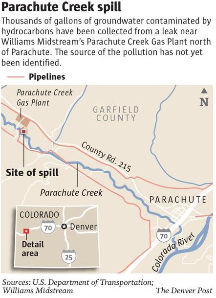
    From The Grand Junction Daily Sentinel (Dennis Webb):

    A state regulator recently acknowledged the lack of clarity over what agency, if any, regulates pipelines like the one that’s the source of a natural gas liquids leak in the Parachute Creek watershed northwest of Parachute. The comments by Jim Milne, environmental manager for the Colorado Oil and Gas Conservation Commission, came in response to a question by Commissioner DeAnn Craig at the commission’s meeting last week. Milne was providing an update on the investigation into the leak from a pipeline leaving Williams’ gas processing plant. “I’m just curious who writes the rules for pipeline integrity of this type of system?” Craig asked.

    “I don’t have an answer to that,” Milne responded. “I think the agencies have all been looking at that question.” He said he knows the Occupational Safety and Health Administration (OSHA) has some level of involvement with the plant, but added, “I think the question you ask is a good one.” He said he and commission Director Matt Lepore have discussed the need to contact any agencies that could be involved and get a better understanding of who has responsibility over the line.

    Williams believes a faulty gauge on the pipeline leaked about 10,000 gallons into the soil and groundwater. Carcinogenic benzene has contaminated groundwater and the creek. Williams has pointed to OSHA regulatory oversight of the pipeline. But OSHA has said it doesn’t regulate things such as what pipeline materials and welding should be used, and that its regulations are geared toward safety considerations such as protecting laborers working in pipeline trenches. The natural gas liquids pipeline runs from the plant and beneath the creek to tanks on the other side.

    Williams says the federal Pipeline and Hazardous Materials Safety Administration regulates the pipeline running from the tanks to another plant in Rio Blanco County, from which the liquids are then shipped out of state. That agency covers aspects such as pipeline construction, testing, inspection and maintenance.

    The question of jurisdiction over the Williams line takes on additional significance because the company wants to install a second natural gas liquids line in the same corridor going beneath the creek to accommodate an expansion of its plant. It recently announced a delay in the expansion for reasons it says relate to the local drilling slowdown and not the leak. That expansion plan went through a Garfield County review process, but a county planning staff report to county commissioners made no apparent mention of the new pipeline.

    The oil and gas commission’s ability to regulate the existing or planned pipeline appears to be limited. It recently handed off lead authority over the leak investigation to the Colorado Department of Public Health and Environment because it determined it didn’t have primary jurisdiction over the matter.

    Oil and Gas Commissioner Rich Alward of Grand Junction told Milne that despite the jurisdictional issues, he’d be interested in any recommendations about what the commission can do “to minimize the risk of this happening again.” Alward mentioned reporting requirements as one possible area to be addressed.

    Williams didn’t initially report the leak because it thought it involved less than 25 gallons, far below the minimum five barrels (210 gallons) that trigger a reporting requirement. It also didn’t consider the spill to be a threat to surface waters, something that triggers a commission requirement of immediate reporting of a spill of any size.

    A bill awaiting action by Gov. John Hickenlooper would require reporting within 24 hours of all waste spills of a barrel or more if they take place outside berms or secondary containment systems. But a barrel, or 42 gallons, is still more than what Williams initially thought had leaked.

    In addition, the commission determined the liquids that leaked, as a product leaving a gas plant, don’t involve exploration and production waste, which is why it gave up jurisdictional authority.

    Meanwhile, Williams reports that the highest benzene reading in the creek as of Thursday was 4.4 parts per billion. The level last week remained below the state drinking water standard of 5 ppb in the creek, after barely exceeding that standard the week before, although the standard doesn’t apply to the creek because it’s not considered a drinking water source. There continue to be no signs of benzene in the creek at the point downstream where the town of Parachute diverts irrigation water.

    On Tuesday, a new well was installed to recover contaminants from the soil.

    Also completed this week was installation of vertical air sparge wells designed to enhance the removal, through aeration, of benzene in groundwater once they are hooked up to a blower motor.

    Those wells are part of a plan, newly approved by the health department and Environmental Protection Agency, under which Williams is upgrading its treatment system at the point where contaminated groundwater is entering the creek.

    All containment booms in the creek were replaced Tueday with fresh ones. Work also began last week on sampling contaminated groundwater. The work is necessary to characterize the contamination before the water can be properly treated and disposed of, the health department said.

    Williams said Friday that it so far has recovered about 6,300 gallons of natural gas liquids. It also plans to construct by month’s end a water treatment system to remove hydrocarbons from the aquifer and from recovered water that then can be returned to the aquifer. The water will be subject to continuous testing to assure it meets state and EPA requirements before being discharged back to the surface.

    Meanwhile, the Clifton Water District is keeping an eye on the spill. They pull off the Colorado River downstream of the confluence of Parachute Creek. Here’s a recent release:

    The Clifton Water District has continued to monitor the developments related to the contamination of Parachute Creek with Benzene. Parachute Creek is a very small tributary to the Colorado River which is the water supply for the Clifton Water District. No reports have indicated that Benzene has reached the Colorado River and the District’s monitoring efforts have not detected the presence of Benzene.

    Even though there is no indication that Benzene has reached the Colorado River, the Clifton Water District has been proactively monitoring the Colorado River in multiple locations for the presence of 25 Volatile Organic Compounds (VOC’s), including Benzene. The Clifton Water District’s Certified Laboratory has not detected the presence of Benzene or any other Volatile Organic Compound in any of the samples. Monitoring of the Colorado River for Volatile Organic Compounds has been a regular and routine event since 1986 and is a fundamental commitment in providing safe drinking water for our customers.

    In addition to being mindful of source water quality, the District has been diligent to implement advanced water treatment technology which is very effective in treating the Colorado River. The District has worked to improve its water treatment system to a “state-of-the-art” facility utilizing Enhanced Coagulation/sedimentation, Rapid Sand Filtration, Reverse Osmosis and Nanofiltration. These processes are instrumental to the success of a multi-barrier treatment approach. Continuation of the District’s effort the next generation of “state-of-the-art” water treatment technology, Micro/Ultra Filtration Treatment Facility, is currently in design and projected to be constructed by 2015.

    It is not anticipated that Benzene will be present in the Colorado River because of its volatility characteristics. The District will continue to maintain routine monitoring procedures for Benzene and other Volatile Organic Compounds even after this situation has been resolved demonstrating our commitment to provide high quality water to our customers.

    Here’s a report from Dennis Webb writing for The Grand Junction Daily Sentinel:

    The Clifton Water District said Tuesday it has been monitoring the benzene contamination in Parachute Creek, but tests of the Colorado River continue to show no evidence of the carcinogen. A leak of natural gas liquids leaving the Williams gas processing plant has resulted in small amounts of benzene reaching the creek. However, samples farther down the creek show no sign of the substance, which readily dissipates in moving water.

    Clifton Water said in a news release that it doesn’t anticipate benzene reaching the river because of its volatility.

    The creek “is a very small tributary to the Colorado River, which is the water supply for the Clifton Water District,” the utility added.

    It said it “has been proactively monitoring the Colorado River in multiple locations for 25 volatile organic compounds, including benzene. But its certified lab has found no VOCs in any of the samples.

    The district has routinely tested the river for VOCs since 1986 and will continue doing so after the leak situation is resolved, it noted. It also has been installing advanced water treatment technology to better address sediment and other issues involving the river water.

    Last week, benzene in Parachute Creek barely exceeded the state drinking water maximum of 5 parts per billion. However, the creek isn’t designated as a drinking water source by Colorado’s Water Quality Control Commission, and instead a 5,300-ppb standard applies to protect aquatic life. Williams reports that benzene readings at the highest point of contamination in the creek from Saturday through Monday were all above 4 but below 5 ppb, with Monday’s level at 4.7 ppb.

    From the Associated Press (Alexandra Tilsley) via The Denver Post:

    One of the main contaminants in the groundwater is benzene, according to Mark Salley, a spokesman for the Colorado Department of Public Health and Environment, which is currently overseeing the remediation efforts. Benzene, a known carcinogen, was also found earlier this month in Parachute Creek in concentrations above the state’s health standard, but levels have since dropped and officials insist there is no threat.

    To remove the benzene from the creek, Williams injected air into the surface water to strip the hydrocarbons, a process known as air-sparging. The same technique is to remove surface hydrocarbons that are floating on top of the groundwater.

    How to handle all the benzene-infected groundwater is the next question. The recovered water is currently being stored in tanks, and Williams said Friday it is planning to install a water treatment system that can separate the benzene from the water. “They’re working on the plans right now for a water treatment system,” said Tom Droege, a Williams spokesman. “It’s not in place yet, but once it’s up and running, then they’ll begin to treat the groundwater on a regular basis.”

    The system will remove the benzene and any other hydrocarbons from the water through a multistep process. Contaminated water will first go through an oil and water separator. Then, it will move through an air stripper, which works like air-sparging. Finally, the water will be moved through activated carbon polishing tanks. The treated water will then return to a holding tank, where it will be tested to ensure it meets state health department and U.S. Environmental Protection Agency standards. Once officials have confirmed the water is safe, it will be returned to the aquifer. Any air emissions from the treatment system will be captured and treated according to the procedures approved by the Air Pollution Control Division of the state’s health department, Salley said.

    The system is expected to be functional by the end of May.

    More oil and gas coverage here and here.