
The irrigated farmland west of Grand Junction is a real treat.
Day: May 22, 2013
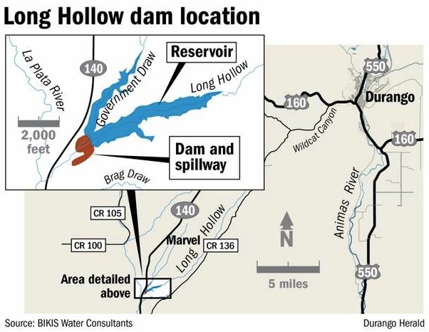
Long Hollow Reservoir should improve water rights administration on the La Plata River
From The Durango Herald (Dale Rodebaugh):
The water collected in Long Hollow Reservoir from Long Hollow Creek and Government Draw will supplement the often scant water from the La Plata River, half of which must be shared with New Mexico.
“We’re happy to see the project moving along so well,” Brice Lee, president of the sponsoring La Plata Water Conservancy District, said last week. “It’s been a tough year because we haven’t gotten the monsoons yet.” Lee gets water from a ditch off the La Plata River for pasture and to irrigate hay. But he’s had only four days of water from his ditch so far this spring…
Long Hollow Creek and Government Draw drain a basin of 43 square miles on the east side of Colorado Highway 140 about five miles north of the New Mexico line and about a half mile from the confluence of Long Hollow Creek and the La Plata River. The reservoir, expected to be completed this year, will have a capacity of 5,432 acre-feet and 160 surface acres…
Colorado and New Mexico share the water of the La Plata River under a 1922 agreement. Each state has unrestricted use of water from Dec. 1 to Feb. 15. But from then to Dec. 1, if the river is flowing at less than 100 cubic feet per second at the state line, Colorado must deliver one-half the flow at Hesperus to New Mexico.
Fulfilling the compact isn’t easy for several reasons:
The La Plata, which rises in the mountains north of U.S. Highway 160, doesn’t have abundant water even in its best years.
Water availability and the growing season don’t follow parallel paths. The bulk of the water – as 95 years of records show – is available from April 1 to July 1. Flow shoots from 50 cubic feet per second to 200 cfs then drops quickly to 50 cfs before trailing off. The growing season goes on much longer.
A porous river bed and vegetation siphon off water in the 31 river miles from Hesperus to the state line.
Lee said there are probably 15 major ditches off the La Plata River and many smaller ones. He estimated that 500 to 600 irrigators have a share of the flow, however small.
The cost of the project must come in at $18.6 million or less because there’s no additional funding in sight, Lee said. The source is $15 million – plus accrued interest – from what the state contributed for irrigation in the Animas-La Plata Project. The irrigation component was removed from the A-LP – a settlement of Native American water right claims – in the 1990s.
Drought news: The CWCB May 2013 Drought Update is hot off the press #COdrought

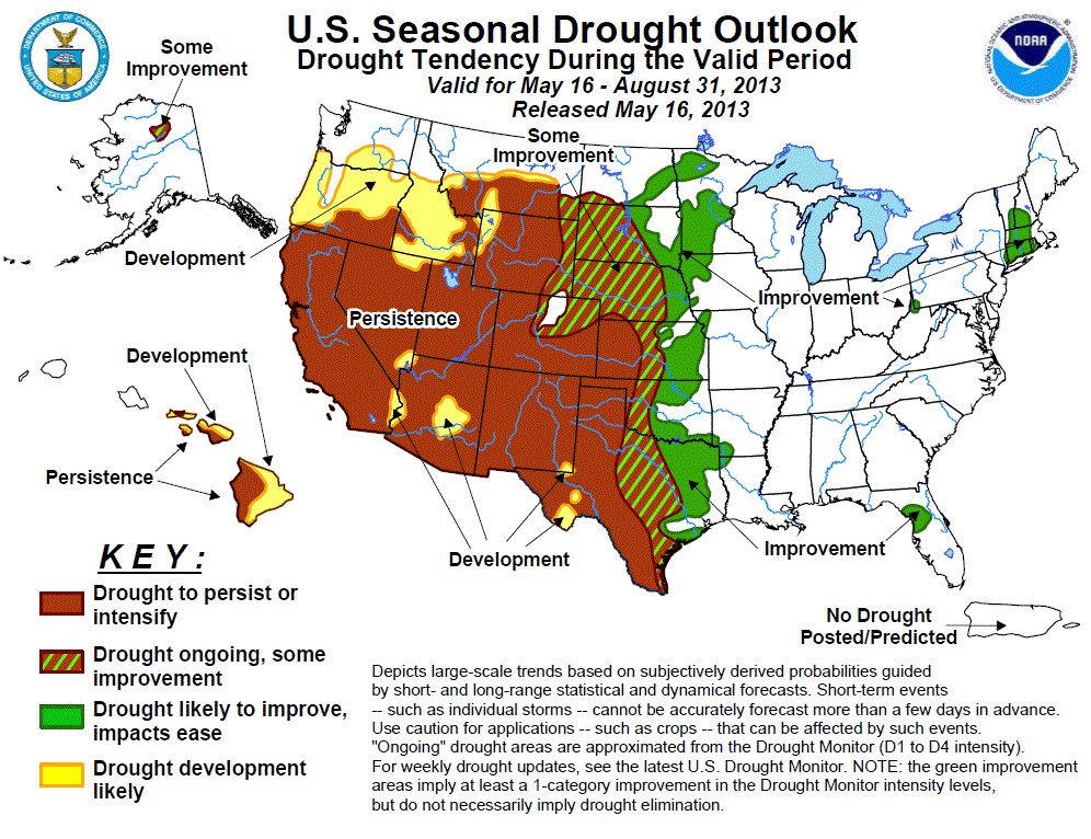
Click here the read the update with graphics. Here’s an excerpt:
Activation of Phase 2 &3 of the State Drought Mitigation and Response Plan, and the activation of the Agricultural & Municipal Impact Task Force remain in effect to respond to ongoing drought conditions throughout Colorado.
Late April and early May storms brought increased precipitation in the northern portion of the state and continued cool temperatures helped to maintain snowpack. However, storms largely missed the southern half of the state, which is experiencing increasingly severe drought conditions. Storage remains below average throughout most of the state and water providers are preparing for continued drought conditions throughout the spring and summer.
Governor Hickenlooper activated the Municipal Impact Task Force on May 10th in response to dry conditions is portions of the state, below average reservoir storage and continued water restrictions by municipal water providers. As of the May 14, 2013 US Drought Monitor, 100% of Colorado continues to experience some level of drought classification. There have been improvements along the northern Front Range and northeastern plains while conditions have declined to the south. D0 (abnormally dry) and D1 (moderate) conditions cover 28% of the state; while D2 (severe) covers 47% and D3 (extreme) accounts for an additional 9%. 16% of the state is now experiencing exceptional drought (D4), a slight increase from last month. Spring snow storms brought significant gains in the snowpack to the Colorado and South Platte River basins, which both achieved near normal peak accumulation with 94 and 105% of the average peak snowpack, respectively. The Yampa/ White basin also had a near normal peak at 91% of normal. All three basins experienced later than normal peaks, by nearly two weeks. All other basins had less than normal peak snow accumulation. The lowest peak snowpack, as a percent of normal, was in the Upper Rio Grande basin (68%) while the Southwest basin had 74% of average. The Arkansas and Gunnison had similar peak snowpack accumulations of 73 and 76% of average respectively. Despite recent gains in snowpack, municipalities and water providers are still responding to drought conditions with watering restrictions. The CWCB drought response portal http://www.COH2O.co continues to help individuals determine the restrictions in their specific community. Northern Colorado Water Conservancy District continues to hold the C-BT quota at 60%. As of the first of May, statewide reservoir storage is at 74% of average. The highest storage levels are in the Yampa/ White River Basin, at 107% of average, while the lowest storage in the state is the Arkansas River basin at 52% of average. All other basins range from 54% to 88% of average. Last year at this time the state was at 112% of average reservoir storage. Streamflow forecasts for the spring indicate below average streamflow across the state. The Colorado and South Platte have the highest streamflow forecasts ranging from 70-100% of normal, with forecasts better in the headwaters than downstream. Forecasts in the Colorado downstream of Glenwood drop to 62-68% of average. The lowest forecasts in the state are in the Upper Rio Grande, with flows ranging 24 to 54% of normal. The Southwestern basins and the Arkansas also have low forecasts ranging from 30-68% of normal. Surface Water Supply Index (SWSI) values remain negative despite improvements in the north. Below average reservoir storage and low streamflow forecasts contribute to these values and data reflect conditions on May 1, 2013.
Colorado Tornado History from Brian Bledsoe #COwx
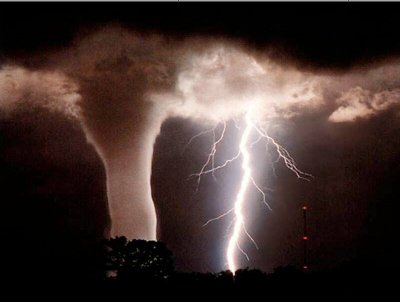
Here’s a blog post from Brian Bledsoe posted on KKTV.com. Click through and read the whole thing. Here’s an excerpt:
Strongest Tornado in Colorado History: This tornado occurred on November 4th, 1922. It started in southern Crowley County near Ordway and Sugar City before 5am. Yeah that’s right a big tornado that started in Colorado, in early November, before 5am. Crazy… Anyway, that tornado went on to move rapidly northward and struck the town of Holyoke around 9:30am. The distance as a crow flies between those two towns is about 180 miles and when you do the math, that twister was haulin’! It destroyed many farms/ranches along the way and when it struck Holyoke it killed one person. This is often a forgotten tornado when it comes to Colorado history. In typical Colorado fashion, a blizzard shut down Pueblo for that entire afternoon after the severe storms moved out that morning.
Say hello to CoRiverBasin.org — interactive mapping application for the Colorado River basin from Western Resource Advocates #ColoradoRiver
Here’s the release from Western Resource Advocates (Jason Bane):
With the Memorial Day Weekend just a few days away, Western Resource Advocates is proud to announce a new interactive online map of the Colorado River that helps everyone— from outdoor enthusiasts to casual explorers—to learn and understand more about the river that is truly the lifeblood of the entire Southwest. CoRiverBasin.org presents scenic points of interest, snowpack and river flow data, recreation businesses and other useful information on two interactive maps intended to engage and inform people of all ages.
“The helpful new interactive maps at CoRiverBasin.org illustrate our connection to the Colorado River and its importance in sustaining our outdoor recreation economy, irrigating our crops, and keeping our cities and towns running,” said U.S. Senator Mark Udall (D-Colo.). “Wayne Aspinall once said, ‘When you touch water, you touch everything.’ Nowhere is this more true than the Colorado River.”
The Colorado River is the most endangered river in the United States, according to the 2013 list of America’s Most Endangered Rivers®, and it is the primary source of water for 36 million people. Western Resource Advocates created CoRiverBasin.org to provide a visual understanding of how water from the river is used, through diversions to urban areas, water for power plants, and regular updates on snowpack and river flows.
“What I love about CoRiverBasin.org is that it lets the user determine how much information they want to see on the map,” said Bart Miller, Water Program Director at Western Resource Advocates. “This is truly a 21st century tool for a new way of thinking, and learning, about water issues. After all, there may be no more important issue than having clean water to drink.”
Western Resource Advocates has long advocated that water conservation and reuse should be the backbone of any plan for meeting future water demands in the Colorado River Basin. This is particularly critical in the face of climate change scenarios that experts agree will lead to increased frequency and severity of drought.
“CoRiverBasin.org shows how important the Colorado River is to businesses across the basin and beyond,” said Molly Mugglestone, Co-Director of Protect the Flows, a network of more than 800 businesses that depend on the Colorado River. “The tools on the site allow visitors to see a big picture view of the entire Colorado River Basin and how it connects into a $26 billion recreation economy.”

Added Senator Udall: “We need all the tools we can to better understand the demands we put on this precious resource and how to keep the Colorado River healthy and able to supply clean water to millions of Coloradans and Westerners.”