Snowpack/drought news: Statewide snowpack declines to 71% of avg, South Platte = 102% (best in state) #COdrought

statewidebasinhilow05062013

snowpackcolorado05062013

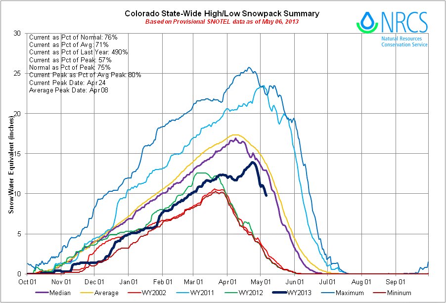
Click on the thumbnail graphics for the current statewide snowpack map and the statewide basin high/low graph from the Natural Resources Conservation Service.

Here’s a look at expected runoff in the North Platte Basin from the Bureau of Reclamation:

The Bureau of Reclamation’s Wyoming Area Office has prepared snowmelt runoff forecasts for the North Platte River Basin. According to Wyoming Area Manager Coleman Smith, the May 1 forecast indicates below average spring snowmelt runoff for the North Platte Basin.

April through July runoff in the North Platte Basin above Glendo Dam is expected to be 518,000 acre feet (AF) or 55 percent of the 30-year average of 944,600 AF. Approximately 450,000 AF (60 percent of average) of runoff is expected to enter Seminoe Reservoir (of which 50,000 AF was received in April) with an additional 18,000 AF (30 percent of average) being provided to Pathfinder Reservoir from the Sweetwater River (of which 6,500 AF was received April), and the balance of 50,000 AF (37 percent of average) coming from the basin between Pathfinder Reservoir and Glendo Reservoir (of which 14,900 AF was received in April).

The water in storage for delivery to North Platte Contractors as of April 30, 2013 is 349,400 AF or 45 percent of average.

Smith said, “Reclamation is advising North Platte Project water users that an allocation is expected. With reservoir storage well below average and below average inflow forecasted for April through July, water users will need to take measures to conserve the available water supply.”

With the current forecast, river flows throughout the system are expected to be much less than average.

From the Leadville Herald Democrat (Carol Werckman):

A record accumulation of snowfall in one hour was measured by the Herald’s weather guru. Charles Kuster, during the storm early Sunday morning – 3.6 inches between 12:07 and 1:07 a.m. Before that storm, the greatest accumulation of snowfall he had measured during his 30 years or so in Lake County was recorded during a very late storm on June 8, 1984, when he measured 3.1 inches in one hour during a storm that dropped 11.6 heavy, wet inches.

From The Greeley Tribune (Whitney Phillips):

Wednesday’s barrage of heavy, wet snow — an unwelcome sight to some residents who spent the weekend basking in temperatures upward of 70 degrees — was not as uncommon as some might think.

Kari Bowen a meteorologist with the National Weather Service in Boulder, said data dating back to the 1800s shows that systems like the one that dumped about 3 to 5 inches in the Greeley area isn’t an anomaly. “Every few years we do tend to get these late, spring snowstorms,” she said.

Todd Dankers, another meteorologist with the weather service, said there’s about a 38 percent chance of snowfall in May, and most storms produce several inches. “This is kind of on the heavy side for May storms but not uncommon,” Dankers said.

Dankers said snowfall readings were higher in the Fort Collins and Boulder areas, with the more western parts of the Front Range receiving anywhere from 6 inches to a foot of snow.

From the Summit County Citizens Voice (Bob Berwyn):

Spring storms that repeatedly targeted the north-central mountains of Colorado in April help bring the snowpack to near normal in a few river basins. The May 1 snow survey showed the statewide snowpack climbing up to 83 percent of average for the date, the highest level of the year…

The storm systems that moved through in April were mainly focused on northern Colorado while completely missing the southwest portion of the state. Snowpack totals in the South Platte River basin increased from 71 percent of median on April 1 to 99 percent of median on May 1. Both the Colorado River basin and the combined Yampa, White and North Platte basins were reported to be at 98 percent of median on May 1 up from 78 and 79 percent of median measured on April 1. The Colorado and South Platte basins are crucial for Denver Water supplies and reservoir storage.

From KUNC (Erin O’Toole):

Last year at this time, Northern Colorado’s snowpack was only at 23 percent of average. Poudre River commissioner Mark Simpson says this year is a different story.

“We measured snow right at the end of April,” Simpson says. “We came up with a 94 percent average for the basin of the Poudre – and that was right before this last storm hit. So I think we’re pretty close to average, which is phenomenal compared to last year.”

With water levels so bad in 2012 rafting outfitters had a bad season. One Poudre Canyon operator, Mountain Whitewater Descents, cited a 60 percent drop in business.

Atmospheric carbon dioxide to pass 400 PPM sometime this month for the first time in 400 million years

keelingcurvecarbondioxideatmaunaloa.jpg

From Ecology.com (Bob Petz):

Chances are that in the next few days, the concentration of carbon dioxide in Earth’s atmosphere will exceed 400 parts per million (ppm) for the first time in about 4 million years.

Recently, Mauna Loa Observatory on the big island of Hawaii has been regularly recording daily CO2 levels above 399 ppm, with several hours already exceeding 400.

Considering that carbon levels tend to peak in mid-May, one or more daily averages above 400 in the next few weeks is a near certainty. Yesterday’s reading, May 5, was 399.54 ppm.

While crossing the 400 ppm threshold is largely symbolic, the rate at which atmospheric carbon is increasing is anything but. When Mauna Loa began measuring CO2 in 1958, CO2 was running @ 317 ppm. Unless we begin to seriously slow the rate of greenhouse gas emissions now, we’re on track to surpass 450 ppm within 30 years.

Mauna Loa Observatory, operated by the US National Oceanic and Atmospheric Administration, not only has the longest continuous history of monitoring CO2 concentrations, but thanks in part to its location, its measurements are regarded as the baseline standard for atmospheric carbon.

At 11, 335 feet (3,397 m) above sea level, Mauna Loa’s sits above low-level, local pollution and temperature inversion layers. Its location in the mid-Pacific also isolates it from major sources of pollution.

More climate change coverage here and here.

The COGCC fines Antero $150,000 for produced-water pipeline leak near Rifle

riflegap.jpg

From The Grand Junction Daily Sentinel (Dennis Webb):

The Colorado Oil and Gas Conservation Commission approved a $150,000 fine Monday against Antero Resources in connection with a leak from a produced-water pipeline that resulted in oily contamination of groundwater and soil near Rifle. The fine was part of a consent agreement reached with Antero. The commission says Antero violated rules on pollution and management of waste in the incident, discovered in July 2010.

The leak from a faulty weld in a plastic pipe resulted in seeps of a paraffin-like substance in a nearby gravel pit owned by Grant Brothers Construction, and caused high levels of benzene, a carcinogen, in the groundwater. The oil-laden water came from 36 wells on five well pads in the Colorado River floodplain, the commission said.

Before the commission acted Monday, Commissioner Richard Alward of Grand Junction expressed concern about how much time has lapsed since the leak’s discovery. “It’s now 2013, and we’re now finally resolving things,” he said.

Commission staff said the delay was because Antero tried several approaches to cleaning it up, finally settling on full excavation, which was completed last September. The state then allowed for another half-year of environmental monitoring.

Denver-based Antero no longer operates in Colorado, having sold its assets in the Piceance Basin to Ursa Resources in order to focus on drilling in the eastern U.S.

More oil and gas coverage here and here.

Arkansas Valley Conduit update: Federal budget slashes funding to $1 million

arkansasvalleyconduitproposed.jpg

From The Pueblo Chieftain (Chris Woodka):

U.S. Sen. Michael Bennet, D-Colo., is asking the Senate energy appropriations subcommittee to provide additional funding for the Arkansas Valley Conduit. The conduit’s funding stream hit a snag in the 2014 budget request by President Barack Obama, which allocates $1 million. The Southeastern Colorado Water Conservancy District had asked the Bureau of Reclamation for $15 million to keep the project moving forward.

At April’s meeting, the Southeastern board learned that Reclamation projects across the board had been slashed, including some already under construction. “I don’t know what will happen,” said Southeastern Executive Director Jim Broderick. “We are going to Washington in a couple of weeks to try to learn more.”

In a letter to committee chairman Sen. Dianne Feinstein, D-Calif., and Sen. Lamar Alexander, R-Tenn., Bennet pointed out other long-term projects in California and Idaho that had received additional funding. “As the subcommittee prepares for the coming fiscal year, we must ensure that states and local communities have the resources to continue work on large-scale, multiyear projects,” Bennet said.

The conduit’s environmental impact statement is being prepared by Reclamation, and the conduit already has a built-in repayment mechanism through 2009 legislation that devotes Fryingpan-Arkansas contract revenue to conduit costs.

The cost of the project is estimated at $500 million. It would deliver fresh drinking water from Pueblo Dam to 40 communities as far east as Lamar. Many of those communities could face even higher treatment costs if the conduit is not completed.

More Arkansas Valley Conduit coverage here and here.

Restoration: The Eagle River Watershed Council is planting willows along Red Dirt Creek May 17-18

newlyplantedwillows.jpg

From email from the Eagle River Watershed Council:

We are beginning a second project along the East Fork of Red Dirt Creek, a tributary of the Colorado River. The Watershed Council, along with a team of volunteers and help from the US Forest Service and Trout Unlimited, will plant willows and remove a dirt road that is adding sediment to the creek and harming the local cutthroat trout population.

Friday, May 17th and Saturday, May 18th we will be planting willows along the East Fork of Red Dirt Creek and we are looking for 10-15 volunteers. Call us at 970-827-5406 or email outreach@erwc.org to sign up for one or both days!

More Eagle River Watershed coverage here and here.

Colorado’s water supply benefits from late season storms

nrcssnowpackstoragetablemay12013

Click on the thumbnail graphic to view the snowpack and storage table from the Natural Resources Conservation Service. Here’s the release from the NRCS (Mage Skordahl):

Unseasonably cool and wet weather throughout April allowed Colorado’s snowpack to increase to near normal accumulation totals. After an entire month of favorable storm tracks, May 1 snow surveys showed that the statewide snowpack percentage climbed to 83 percent of median from 74 percent of median measured on April 1, according to the USDA-Natural Resources Conservation Service (NRCS). “Those wet storms really improved our water supplies, especially along the Front Range and Upper Colorado River basin”, said Phyllis Ann Phillips, State Conservationist with the NRCS. April is typically the month in which the snowpack in Colorado begins to melt and the runoff season begins. This season, peak snowpack totals for the state were not reached until April 24th, over two weeks later than the long term average date of peak accumulation. Statewide maximum accumulation totals for 2013 ended up being 80 percent of the normal seasonal maximum.

The moisture laden storm systems that moved through in April were mainly focused on northern Colorado while completely missing the southwest portion of the state. Snowpack totals in the South Platte River basin increased from 71 percent of median on April 1 to 99 percent of median on May 1. Both the Colorado River basin and the combined Yampa, White and North Platte basins were reported to be at 98 percent of median on May 1 up from 78 and 79 percent of median measured on April 1. In contrast to these success stories, the Rio Grande and combined San Miguel, Animas, Dolores and San Juan basins saw major declines in their snowpack percentages this past month. As of May 1 the Rio Grande reported snowpack totals at 41 percent of median and the southwest basins were at 43 percent of median; both basins reached their seasonal peak snowpack in early March and began melting out in April.

With the additional snowfall in April, the water supply outlook has improved for most of the state’s seven major river basins. All basins, except for those in the southwest portion of the state, saw improvements to their streamflow forecasts this month. While most forecasts across the state still call for below normal runoff volumes this season, some of the forecasts for the headwaters of the Colorado and South Platte basins are now near to slightly above average.

Statewide reservoir storage volumes are currently 74 percent of average, and 68 percent of 2012’s volumes. The good news is that in the northern basins the recent snow accumulation has yet to run off and should help improve storage and extend water supplies further into the summer season. In the southern basins, storage levels remain low and the probability of vast improvements this season are slim.