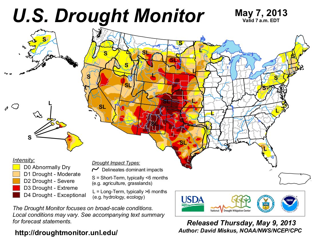
From The Pueblo Chieftain (Chris Woodka):
The agency Cindy Schleining works for was formed in response to the disastrous drought of the 1930s. But even the Natural Resources Conservation Service might be running out of options as the Arkansas Valley enters its third year of drought. “The ground is so hard, so dry, that the water runs right off,” Mrs. Schleining said. “Last year, it was so hot and windy.”
She knows the problems too well. She and her husband Jim — who works in the same building for the Farm Service Agency — started farming between McClave and Wiley 32 years ago, getting into the game when farmers faced a different problem — the financial storm of exorbitant interest rates.
But without water, either from the sky or the canals, these times are even more desperate. Like most of their neighbors, the Schleinings have sold off some cattle, keeping a few heifers to rebuild the herd when the time is right. They have a strategy to survive and hang on through tough times and are waiting for the drought to break. “What really concerns me is our young farmers. They’ve come in and put in irrigation systems and are carrying loans. I wonder how they will make it. . . . The older farmers have been through droughts, but not at this extreme,” Mrs. Schleining said.
She tells a story of one neighbor who found a job in town, just so he would not have to lay off his hired men. “He basically had to fire himself,” she said.
Most farmers carry insurance, but the payments are at best 60 percent of what they could make growing a crop. And the number is based on a five-year rolling average, Jim Schleining said. In 2011, many had already planted crops, so losses may have been higher than in 2012, when farmers could see the drought coming. But every year that pops up zero hurts the average.
Usually, either the price of cattle or feed is up, while the other is down. But for the past few years, both are high. Faced with more cost to feed cattle and fewer resources to grow crops, farmers are selling off herds or shipping them out of state to graze. “We’ve never been in a position like we are this year,” Schleining said.
From The Pueblo Chieftain (Chris Woodka):
On the road to Wesley Eck’s farm, there were no farmers riding tractors, even though it was a dry, partly sunny May day.
Clouds swirled around, but once again, they failed to deliver.
“I think a year ago, we were optimistic,” said Eck, who is president of the Fort Lyon Canal Co. “Here it is planting time, and some of the optimism is gone from the equation.”
Eck has lived in the area since 1958, and counts himself lucky for the opportunities he’s had as a farmer. He still has the equipment he used to raise vegetables for his roadside produce stand, as well as the equipment he still uses to grow hay, corn and wheat. He still owns land and water rights. “There are still farms, but fewer people. One guy can farm 10 times as much,” Eck said. “But there’s no alternative to water.”
He sold off all of his cattle this year because it was becoming too expensive to feed them. The wells he relies on to irrigate some of the land he farms, augmented by his Fort Lyon shares, have all been curtailed. Usually they would produce 90-120 acre-feet of water, but this year it will only be 18 acre-feet. “There’s hardly enough to know what to do with; hardly enough to pay the electric costs,” Eck said.
Farmers who flood-irrigate on the Fort Lyon are in no better shape. There have been only three runs this year, after a horrible season in 2012, when the water quit coming in mid-June. “It’s a big, long ditch,” Eck said of the 113-mile canal. “We lose 37 percent of the water in transit.”
Eck isn’t quite ready to give up on optimism, or maybe appeals to a higher power. “The other day, I was saying what we need is a good hard rain, and my 5-year-old granddaughter told me, ‘Only God can make it rain.’”
From The Pueblo Chieftain (Chris Woodka):
The cottonwoods along the Purgatoire River are dying, and John Davidson’s cattle are running out of grass. “It’s the worst it’s ever been. Two or three years of every 10 are bad, but there’s never been anything like this,” the 71-yearold rancher said last week over lunch in Las Animas. “We’ve had less than an inch of rain on the Picketwire (Purgatoire River) and the wind has taken that.”
Some areas along the Purgatoire where tamarisk were removed actually have more water than in past years, proof that removing invasive species increases water supply. Otherwise, the river is drying up. “There are 10 to 12 miles of the Picketwire that have dried up since Nov. 1,” Davidson said. “The cottonwoods are dying. The water table is dropping.”
During the 2000-02 drought, Davidson shipped some cattle to Oklahoma. He also ships some of the herd to Monte Vista, where it’s been at least as dry. His herd is down to about 900 head, from an average of 1,500. “If we go any lower, all of them will have to go,” Davidson said. “Next fall, it could be a situation of no feed, with winter looking you in the eye.”
One of the things that has kept Bent County landowners going this year are oil and gas leases. Some, like Davidson, own the mineral rights to land and have benefited from the boom in exploration. “You can’t bank on them, however. You don’t know what’s going to happen,” he said.
From The Pueblo Chieftain (Chris Woodka):
Recently, Glen Brown saw dirt blowing off grasslands near where he ranches in southern Bent County. “I’ve seen a few places where it’s blowing on native grass that I’ve never seen in my lifetime. It’s kind of scary,” Brown said.
His family has ranched in the area for more than 100 years. He also farms some ground under the Las Animas Consolidated Ditch.
After losing 35 percent of his calves in the 2007 blizzard, Brown was just getting back to normal in his operations when the drought started three years ago. This year, the herd is down to 230 mother cows, from the normal level of about 300. “We reduced the herd by 25 percent, and kept 25 percent fewer replacement heifers,” Brown said. “Last Tuesday, we sold all of the replacement heifers we did keep. If this continues, we will start thinning the herd.”