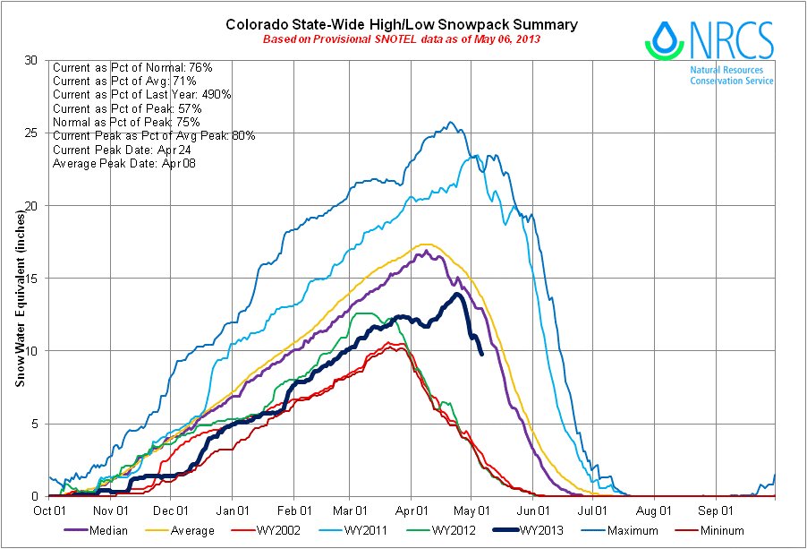
Click on the thumbnail graphics for the current statewide snowpack map and the statewide basin high/low graph from the Natural Resources Conservation Service.
Here’s a look at expected runoff in the North Platte Basin from the Bureau of Reclamation:
The Bureau of Reclamation’s Wyoming Area Office has prepared snowmelt runoff forecasts for the North Platte River Basin. According to Wyoming Area Manager Coleman Smith, the May 1 forecast indicates below average spring snowmelt runoff for the North Platte Basin.
April through July runoff in the North Platte Basin above Glendo Dam is expected to be 518,000 acre feet (AF) or 55 percent of the 30-year average of 944,600 AF. Approximately 450,000 AF (60 percent of average) of runoff is expected to enter Seminoe Reservoir (of which 50,000 AF was received in April) with an additional 18,000 AF (30 percent of average) being provided to Pathfinder Reservoir from the Sweetwater River (of which 6,500 AF was received April), and the balance of 50,000 AF (37 percent of average) coming from the basin between Pathfinder Reservoir and Glendo Reservoir (of which 14,900 AF was received in April).
The water in storage for delivery to North Platte Contractors as of April 30, 2013 is 349,400 AF or 45 percent of average.
Smith said, “Reclamation is advising North Platte Project water users that an allocation is expected. With reservoir storage well below average and below average inflow forecasted for April through July, water users will need to take measures to conserve the available water supply.”
With the current forecast, river flows throughout the system are expected to be much less than average.
From the Leadville Herald Democrat (Carol Werckman):
A record accumulation of snowfall in one hour was measured by the Herald’s weather guru. Charles Kuster, during the storm early Sunday morning – 3.6 inches between 12:07 and 1:07 a.m. Before that storm, the greatest accumulation of snowfall he had measured during his 30 years or so in Lake County was recorded during a very late storm on June 8, 1984, when he measured 3.1 inches in one hour during a storm that dropped 11.6 heavy, wet inches.
From The Greeley Tribune (Whitney Phillips):
Wednesday’s barrage of heavy, wet snow — an unwelcome sight to some residents who spent the weekend basking in temperatures upward of 70 degrees — was not as uncommon as some might think.
Kari Bowen a meteorologist with the National Weather Service in Boulder, said data dating back to the 1800s shows that systems like the one that dumped about 3 to 5 inches in the Greeley area isn’t an anomaly. “Every few years we do tend to get these late, spring snowstorms,” she said.
Todd Dankers, another meteorologist with the weather service, said there’s about a 38 percent chance of snowfall in May, and most storms produce several inches. “This is kind of on the heavy side for May storms but not uncommon,” Dankers said.
Dankers said snowfall readings were higher in the Fort Collins and Boulder areas, with the more western parts of the Front Range receiving anywhere from 6 inches to a foot of snow.
From the Summit County Citizens Voice (Bob Berwyn):
Spring storms that repeatedly targeted the north-central mountains of Colorado in April help bring the snowpack to near normal in a few river basins. The May 1 snow survey showed the statewide snowpack climbing up to 83 percent of average for the date, the highest level of the year…
The storm systems that moved through in April were mainly focused on northern Colorado while completely missing the southwest portion of the state. Snowpack totals in the South Platte River basin increased from 71 percent of median on April 1 to 99 percent of median on May 1. Both the Colorado River basin and the combined Yampa, White and North Platte basins were reported to be at 98 percent of median on May 1 up from 78 and 79 percent of median measured on April 1. The Colorado and South Platte basins are crucial for Denver Water supplies and reservoir storage.
From KUNC (Erin O’Toole):
Last year at this time, Northern Colorado’s snowpack was only at 23 percent of average. Poudre River commissioner Mark Simpson says this year is a different story.
“We measured snow right at the end of April,” Simpson says. “We came up with a 94 percent average for the basin of the Poudre – and that was right before this last storm hit. So I think we’re pretty close to average, which is phenomenal compared to last year.”
With water levels so bad in 2012 rafting outfitters had a bad season. One Poudre Canyon operator, Mountain Whitewater Descents, cited a 60 percent drop in business.


