Restoration: Pennsylvania Mine cleanup to begin

pennsylvaniamineperucreekcotu.jpg

From the Summit Daily News (Breeana Laughlin):

Cleanup work at one of Summit County’s most polluted landscapes will begin this month — more than a century after toxic metals were released from the Pennsylvania Mine site. The mine operated from the late 1880s into the early 1930s. It produced more than $3 million in silver, lead and zinc. But the mine exposed a source of toxic heavy metals that drain into Peru Creek, choking fish from the stream and sending pollutants into the Snake River.

Today, Peru Creek is devoid of aquatic life. The Snake River, which the creek drains into, supports a limited number of species only in its lower reaches.

Individuals and groups have recognized the mine as a tainted site and have been trying to address the problem since the late 1980s. But until now, little has been done to terminate the source of the pollution. “There have been several smaller mine cleanups in that basin with state and grant funding. But everyone has recognized that the major issue remains the Pennsylvania Mine,” said Brian Lorch, a county official overseeing open space and trails.

Mt. Emmons Mine NEPA review may begin soon

mountemmons.jpg

From The Crested Butte News (Aimee Brown):

“Theoretically, scoping could be initiated sometime this year,” added USFS district ranger John Murphy. “It will be an EIS, I can guarantee you that.”

Though US Energy’s MPO has not yet been made public, a statement released by the company cites a proposal for an underground molybdenum mine with a 33-year operational life that would produce up to 12,600 tons of ore per day using a vertical blast hole cut and fill method of mining. In addition to the mine, the MPO also calls for a cement mixing plant to be constructed at the mine site to prepare backfill materials; three fresh water reservoirs; and a state-of-the-art lined tailings storage facility.

Companies have been attempting to mine molybdenum deposits on Mt. Emmons since the 1970s, but have faced many economic, political, environmental and social setbacks, and rights to mining claims on the mountain have been repeatedly sold.

Currently US Energy owns 25 patented mining claims consisting of approximately 365 acres of fee land ((define: privately owned?)) and mineral rights within the Gunnison National Forest, as well as an additional 160 acres of fee land. It also holds approximately 1,353 unpatented mining and millsite claims associated with the Mt. Emmons project for approximately 15 square miles of holdings.

More Gunnison River Basin coverage here and here.

Colorado-Big Thompson shares commanding a steep price as farmers deal with shortages and oil and gas demand #COdrought

coloradobigthompsonin2007

From the Northern Colorado Business Report (Steve Lynn):

The Northern Colorado Water Conservancy District, which operates the Colorado-Big Thompson Project, doesn’t officially track water prices, but spokesman Brian Werner said water sales this year are registering at as much as $17,000 per share, or more than $28,300 per acre foot. Three years ago, prices were about $7,000 an acre foot. At Water Colorado in Fort Collins, a water brokerage, one client wants to sell 150 C-BT shares for $20,000 apiece, water broker Hannah Kleinhans said. The last C-BT transaction at Water Colorado involved shares sold for almost $16,000 recently…

Still another measure of water prices is how much cities charge developers. Greeley, for instance, requires developers to pay cash for water if developers can’t provide their own can’t provide their own supplies. This year, according to Greeley Water and Sewer Director Jon Monson, the city is charging $16,800 an acre foot, up from $9,300 in May 2010, an 81 percent increase…

In addition to high sale prices, Northern Water has seen rental prices of $400 per acre foot this year, said Dennis Miller, Northern Water operations manager. Rental prices still remain below the $650 per acre foot charged in 2003, another drought period.

Water experts say producers’ demand for water for oil and natural-gas drilling has led to higher rental and sale prices. “Those are the only people that can afford to pay that,” Miller said. “That’s what they’re willing to pay for it so that it doesn’t go to somebody else.”

Tom Cech, director of Metropolitan State University’s One World One Water Institute and former manager of Greeley’s Central Colorado Water Conservancy District, concurs with Miller’s view. “I think it’s going to be a challenge for many years, because the oil and gas industry is going to be placing demands on local water supplies for quite a while as they continue drilling and fracking,” he said. “So that will keep the price high for rental water.”

Governor Hickenlooper orders work to begin on Colorado Water Plan — draft due December 2014

waterfromtap.jpg

From The Pueblo Chieftain (Chris Woodka):

Gov. John Hickenlooper’s charge to the Colorado Water Conservation Board to develop a state water plan could have the same sort of impact as the 1969 overhaul of state water law. “It is major, and truly significant,” said Alan Hamel, the Arkansas River basin representative on the CWCB. “There is the need to not only look out for growth, but to deal with climate change and the validity of our water systems.”

Hickenlooper unveiled an executive order last week at the board’s meeting in Grand Junction that directs the CWCB to deliver a draft plan to him no later than Dec. 10, 2014. It will be completed by Dec. 31, 2015. “Throughout our state’s history, other water plans have been created by federal agencies or for the purpose of obtaining federal dollars,” Hickenlooper said in his written order. “We embark on Colorado’s first water plan written by Coloradans, for Coloradans.”

While the order is no surprise — Hickenlooper has talked about having a plan in place by 2016 for months — it clearly defines the CWCB as the lead agency in developing the plan. Hickenlooper also incorporated other state agencies into the planning process, including the Department of Natural Resources, which includes Parks and Wildlife; the Department of Public Health and Environment, which includes the Water Quality Control Commission; the Water Resources and Power Development Authority, which like the CWCB can make water project loans; the Department of Agriculture; and the Colorado Energy Office, which will incorporate the water-energy nexus. The plan also directs the CWCB to include input from the Interbasin Compact Committee and basin roundtables, because they have developed a grassroots approach and a framework for discussing water issues.

However, the plan suggests a more top-down approach to coordinate, streamline and align existing state processes with input from state water groups — much the same way the CWCB used to create the Statewide Water Supply Initiative reports.

It also comes during a shakeup in CWCB leadership. Executive Director Jennifer Gimbel will leave in June and the selection process for her replacement has already begun.

The biggest major change in state water law came in 1969, when the state Legislature revamped the law to combine tributary groundwater and surface rights. Changes since then have been influenced by court decisions more than decisions by the executive branch.

Other sweeping changes came in 1937, when the CWCB was created in response to the Colorado-Big Thompson Project, and through sweeping federal programs like the Clean Water Act in 1972.

From The Pueblo Chieftain (Chris Woodka):

Storage must be a key part of any statewide water plan, because other goals such as conservation, more efficient supply and water quality cannot occur without it. “There is an underlying understanding that storage is needed and it will be a vital component of a state water plan,” said Alan Hamel, who represents the Arkansas River Basin on the Colorado Water Conservation Board.

The state has been looking at water strategies that include conservation, completing existing and proposed projects and sharing water. Those things can’t happen unless the state has enough places to keep water until it’s needed, Hamel said.

Hamel is just one vote on the board that Gov. John Hickenlooper has charged with developing a state water plan by 2016. But he has been a consistent voice for increasing storage since he led the push for the Preferred Storage Options Plan as president of the Southeastern Colorado Water Conservancy District in the late 1990s.

He mentioned a new idea for the Arkansas River basin during an interview this week: A summer storage program. In the 1970s, after Pueblo Dam was built as part of the Fryingpan-Arkansas Project the Southeastern district crafted a winter storage program that allows farmers to store flows from Nov. 15 to March 15. The same concept could be used during extremely wet summers to capture and save water for both municipal and agricultural use, Hamel said.

The major difficulty in developing a plan is the state’s prior appropriation system, which allocates water according to its first historic use. Large storage projects like Lake Pueblo provide flood control by capturing excess water, but also decrease the peak flow of rivers, which can hurt junior rights. The key is to develop an accounting system, as the winter storage program did, that would protect junior rights, Hamel explained.

Hamel also pointed out that the CWCB already is working toward other aspects that eventually will be in the plan. One of those efforts is developing water-sharing arrangements, such as the Arkansas Valley Super Ditch, through demonstration projects under HB1248, already signed into law by Hickenlooper.

From The Grand Junction Daily Sentinel (Gary Harmon):

Colorado water officials are to draft a state water plan by December 2014 under an executive order issued on Wednesday by Gov. John Hickenlooper. The plan calls on the Colorado Water Conservation Board to head the planning process, working with other state agencies, river basin roundtables and other organizations to preserve agriculture in rural Colorado and while accommodating population growth.

The water conservation board met Wednesday in Grand Junction.

“Colorado deserves a plan for its water future use that aligns the state’s many and varied water efforts and streamlines the regulatory processes,” Hickenlooper said in a statement. “We started this effort more than two years ago and are pleased to see another major step forward. We look forward to continuing to tap Colorado’s collaborative and innovative spirit to address our water challenges.”

Ute Water Conservation District General Manager Larry Clever said the response to the governor’s call was guarded. “The devil’s in the details,” Clever said.

According to the Statewide Water Supply Initiative, the gap between water supply and demand could exceed 500,000 acre feet by 2050.

The report is to be complete by 2015.

More CWCB coverage here.

‘Trouble on the Colorado River’ — Fort Collins Coloradoan #ColoradoRiver

coloradoriverbasin2012doiviatheaspentimes.jpg

Bobby Magill is a terrific writer. Click here to read his in-depth report on the current state of the Colorado River, running in the Fort Collins Coloradoan. Here’s an excerpt:

The Colorado River — the carver of the Grand Canyon and the chaotic stage for river runners in Glenwood, Westwater, Cataract and numerous other canyons — is bridled by urban growth from its headwaters at La Poudre Pass at the Larimer-Grand county border all the way to its dry delta in Mexico…

Top to bottom, the story of the Colorado River is one of a plumbing system for the west’s cities, farms and backyards — a story that is both national in scope and intensely local to Northern Colorado even though the course of the river itself never touches Front Range cities.

The first drops are stolen from the Colorado River by the Grand Ditch, which girdles the Never Summer Mountains near La Poudre Pass, diverting spring snowmelt into the Poudre River for the benefit of farmers far below on the plains.

A few miles south, Colorado River water filling Lake Granby and Grand Lake is piped beneath Rocky Mountain National Park to provide water to Fort Collins, Loveland, Boulder and other cities via the Colorado-Big Thompson Project. That project supplements the water Fort Collins takes from the Poudre River — a lifeline for the city after the High Park Fire dirtied Fort Collins’ Poudre River water.

Denver diverts even more water from the Colorado River, and as ongoing drought leaves the mountain slopes bare of snow, those who rely on the Colorado River farther downstream worry about what the river’s future means for them…

Nearly all Colorado River water managers agree that the river’s headwaters are likely to become hotter and drier as the climate changes, making flows more erratic and less predictable from year to year. So, the problem is this: Because 90 percent of the people who rely on the Colorado River for water live in the Southwest, but 90 percent of its water comes from Colorado and Wyoming’s mountains, the laws of supply and demand on the Colorado River don’t benefit Coloradans.

Sometime down the line — maybe 20 years, maybe 30 or more — Colorado residents may be forced to cut back how much of the river’s water they use if there isn’t enough water in the river basin to give Front Range cities the water they need while sending Colorado’s legal quota of water down the river to Arizona and California, said Eric Kuhn, general manager of the Colorado River District.

More Colorado River Basin coverage here and here.

Drought/runoff news: April and May moisture has helped but drought is still statewide #COdrought

usdroughtmonitor05142013

seasonaldroughtoutlookcpc0516to08312013

From the Leadville Herald-Democrat:

Heavy snow in April and May have helped alleviate drought conditions in the Arkansas River basin and Colorado. However, that doesn’t mean the drought is over. That was the main message expressed by the four speakers at the Water Where? workshop on May 8. The workshop was sponsored by the Lake County Watershed Advisory Committee and Board of Commissioners.

Through April 1, the snowpack levels for the Arkansas Basin were looking dangerously low, said state climatologist Nolan Doesken. In fact, for most of the winter, snowpack levels were below last year’s levels. However, Doesken said, the heavy snows that started in mid-April and have continued into May helped boost the snowpack and put it near average levels. Doesken noted that the climate in the Arkansas Basin is highly variable and can change greatly over the course of a year or two.

For example, he said, above- average snowpack in 2011 pushed most reservoirs to above-average levels, but low snow pack in 2012 then greatly reduced those levels to below average. Right now, Doesken said, most forecasts indicate that drought indicators will persist in most areas of the state.

Parkville Water Manager Greg Teter echoed a similar sentiment. “The drought really isn’t over by any means,” he said. Like Doesken, Teter noted that variability of the snow pack in the area. “Every year has been so different for our water supply,” he said.

Teter spent some time explaining the Canterbury Tunnel, which the district brought into operation in November. Throughout its history, the district has had some issues with water supply around late winter, he said. Putting the tunnel online has helped alleviate some of those issues. “We’re so thankful to have that water,” Teter said.
Several speakers also touched on the state of local reservoirs. Kara Lamb, public involvement specialist for the Bureau of Reclamation, said that projections show that both Turquoise Lake and Twin Lakes should be just below their high-water marks sometime in May. Those reservoirs should stay around those levels throughout the summer, she added.

Lyle Whitney, water conservation specialist for Aurora Water, said that Aurora Water’s supply reservoirs are higher than last year, but still lower than average. The best-case scenario, he said, is that Aurora’s Water’s supply reservoirs, including Turquoise Lake, will be around 75 percent of normal at the end of the summer. “No matter where we are, it’s going to take several years to get back to normal,” he said.

From the Leadville Herald-Democrat:

Unseasonably cool and wet weather throughout April allowed Colorado’s snowpack to increase to near-normal accumulation totals. After an entire month of favorable storm tracks, May 1 snow surveys showed that the statewide snowpack percentage climbed to 83 percent of median from 74 percent of median measured on April 1, according to the USDA-Natural Resources Conservation Service.

“Those wet storms really improved our water supplies, especially along the Front Range and Upper Colorado River basin,” said Phyllis Ann Phillips, state conservationist with the NRCS. April is typically the month in which the snowpack in Colorado begins to melt and the runoff season begins. This season, peak snowpack totals for the state were not reached until April 24, more than two weeks later than the long-term average date of peak accumulation. Statewide maximum accumulation totals for 2013 ended up being 80 percent of the normal seasonal maximum.

The moisture-laden storm systems that moved through in April were mainly focused on northern Colorado, while completely missing the southwest portion of the state.

From the Valley Courier (Ruth Heide):

Colorado Division of Water Resources Division 3 Division Engineer Craig Cotten reported to the Valley-wide water group, the Rio Grande Roundtable, yesterday that predicted annual flows on the Rio Grande and Conejos River systems are even lower this month than they were in April. If those predictions hold true, he added, that would make this the fourth lowest year in recorded history on both the Rio Grande and Conejos Rivers.

The Natural Resources Conservation Service (NRCS) decreased its May 1 annual forecast for the Rio Grande by 40,000 acre feet from what it had predicted on April 1, “a very big drop, and we were pretty low already,” Cotten said.

The new forecast from NRCS on May 1 for the Rio Grande was 295,000 acre feet, which is 45 percent of the long-term average, Cotten reported. The delivery obligation to downstream states based on the new forecast would be 74,000 acre feet. To meet that obligation the Valley is currently delivering 4 percent of the flow on the Rio Grande to New Mexico.

The current delivery obligation on the Conejos River system, however, is zero. As with the Rio Grande, NRCS on May 1 decreased its forecast for the Conejos River by 40,000 acre feet, down to 145,000 acre feet, which is 44 percent of the long-term average. If that prediction holds true, the Conejos will share with the Rio Grande in the fourth lowest year on record.

The obligation under the Rio Grande Compact for the 145,000-acre-foot forecast on the Conejos River system is 18,000 acre feet, which Cotten said will not be difficult to make, considering what has already gone downriver and what will be delivered during the winter months after the irrigation season is over.

“We are not currently delivering water off the Conejos,” he said. “It’s pretty much dry at Los Sauces.”

From the Cortez Journal (Luke Groskopf):

Early in 2013, the weather outlook for Southwest Colorado looked promising. Storms swept through Cortez at a steady clip. Snowpack levels in the San Juan mountains were the best in state. The parched Front Range, by comparison, was struggling. Conditions grew so bad that a 1,300-acre wildfire broke out near Fort Collins in the middle of March. While human-caused, the blaze was a grim reminder of how much destruction a careless human decision or isolated lightning strike can wreak during dry years.

But then relief came.

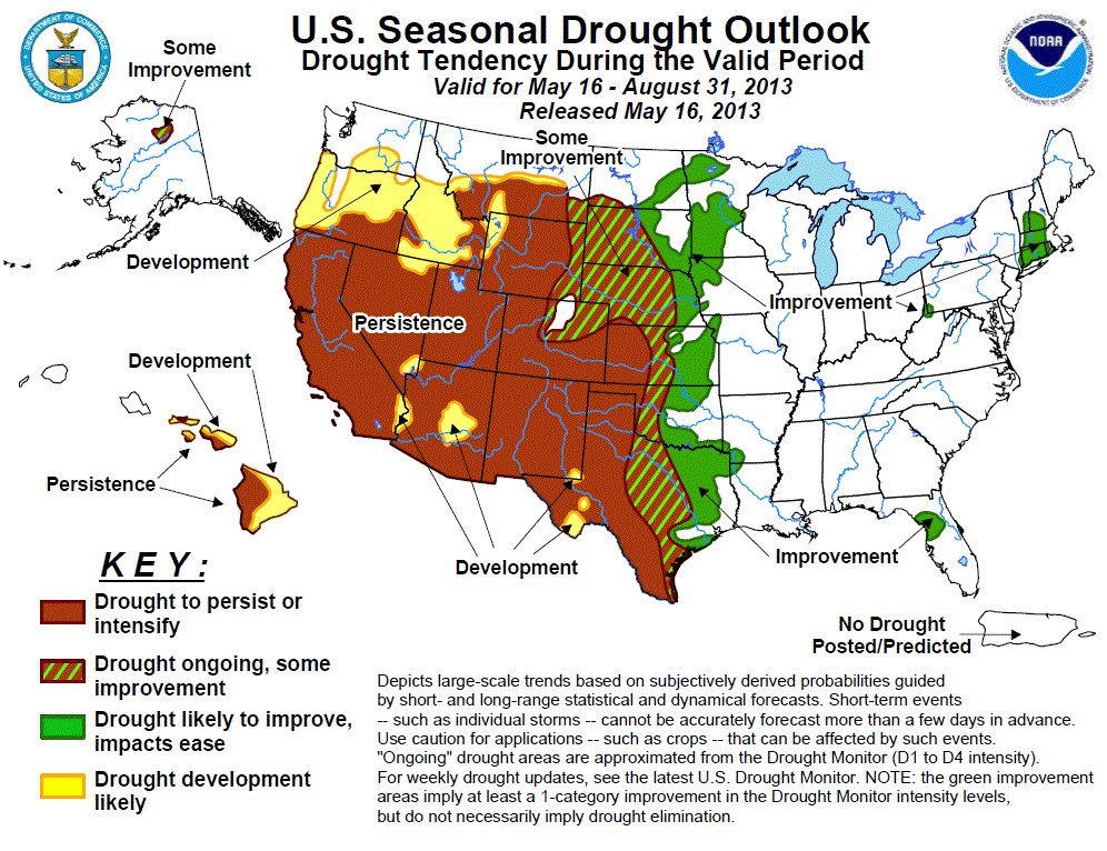
Late-season storms through April, and into May, have taken the edge off the drought in northern Colorado. As of May 3, the four northernmost river basins – Yampa/White, North Platte, South Platte and Colorado – were at or near 100 percent of average snowpack.

Temperatures have been kind to Colorado. Except in the very southwest corner and the San Luis Valley, temperatures were up to eight degrees below normal in April, according to the High Plains Regional Climate Center. The cooler air helped snow stick in the high country instead of melting quickly.

Agonizingly, the storms bypassed most of southern Colorado. From Cortez to Trinidad and into the Eastern Plains, towns have been left out to dry.

The Gunnison and Arkansas river basins sit at 75 percent of average snowpack, while the San Juan/Dolores basin is a meager 41 percent. The Upper Rio Grande is faring the worst, at 37 percent.

Local meteorologist Jim Andrus recorded only 0.22 inches of precipitation in April, about 25 percent of normal…

As of May 1, McPhee Reservoir’s active storage was only 49,000 acre-feet. Mike Preston, general manager for the Dolores Water Conservancy District, gave some context for how much projected inflow (runoff) has dropped. On Feb. 1, DWCD hoped for 205,000 acre-feet; at that level full-service irrigators would have, just barely, received their full water allocations, Preston said. By May 1, projected inflow plunged to 107,000 acre-feet, meaning only a 30 percent allocation supply.

“A month ago we were telling people not to count on any irrigation water in September. Now we’ll see how far we get into August,” he said. “It’ll depend how heavily farmers draw from their allocations early in the season, which is influenced on rainfall and other factors.”

From the Delta County Independent (Hank Lohmeyer):

The Cedaredge Town Board, acting on April 18, opted to move its water management regimen into official “Stage I” drought conditions. The move was expected following a very low 2011-12 water year that left reservoirs and springs that draw water from them in a low carryover condition into the current water year. Trustee Ray Hanson said, “We need to be pro-active on this.”

Uppermost in the town board’s consideration of drought conditions during an April 11 discussion of the subject was an abnormally low water equivalent content in the current Grand Mesa snowpack. Trustees noted the low water content at that time and low reservoir carryover during their April 11 work session. Also, the town public works supervisor recommended that the Stage I drought conditions be recognized now.

The trustees’ action took place just as a series of storm systems passed through the area raising hopes that water content might increase.

None of the proposed actions aimed at water consumers would be mandatory under the Stage I declaration, board members said. “It’s really just a voluntary kind of thing,” said Mayor Pat Means.

From The Norwood Post (Patrick Alan Coleman):

“It’s not looking so good in southwestern Colorado right now,” said CCC Research Associate Wendy Ryan. She explained that the CCC had considered recommending that the drought status for the region, currently categorized as severe, be downgraded to exceptional. However, due to a slight precipitation increase and below-average temperatures in late April, the CCC held off on recommending the change.

While the Front Range saw enough snow in April to boost the statewide average snowpack to over 90 percent of normal, the San Jauns saw little benefit from the weather systems that blanketed the eastern slope.

The most recent wet weather events in the region, which appeared the first full week of May, did deposit snow on the Uncompaghre Plateau and higher elevations. Unfortunately, the presence of dust layers from late-April storms, combined with a warming trend, will likely undo any benefits rather fast, Ryan said…

Recent data suggests that a predicted warming trend combined with dust will see the snowpack dwindling at a pace similar to that seen in 2012. With the snowpack only reaching 75 percent of normal in the region this year, the melt could go quickly. Compounding water woes is thefact that the region is seeing its second year of remarkable drought conditions. Melt from run-off will generally bolster the water supply in reservoirs and increase stream flow in average years. Due to last year’s dryness, the spring runoff isn’t reaching streams or storage…

While the snowpack and runoff has been poor, Ryan suggested that there was hope in the mid-to-late summer monsoonal flow. The three month precipitation outlook from the National Weather Service’s Climate Prediction Center suggests that the region has a high probability for precipitation being below normal for the region through July. For the same period, temperatures had a high probability of being above normal.

Q&A with State Climatologist Nolan Doesken

bigthompsonflood073176

The Fence Post is running a Q&A with Nolan Doesken. Click through and read the whole thing. Here’s an excerpt:

Q: You’ve been Colorado’s state climatologist for a number of years. Have the last couple years — with the 2011 record snowpack, the 2012 drought and the rapid bounce back in snowpack seen last month — represented the most extreme changes you’ve seen? How have other years compared to the volatility we’ve seen recently?

A: The flip flop from very, very wet (winter and spring 2011 and the high waters on the Yampa, Colorado, N. Platte and South Platte) to very, very dry (statewide in 2012) was definitely impressive.

The warmth of the 2012 spring followed by the cold this spring is surely attention grabbing.

In terms of back-to-back, year-to-year change, the high water of 2011 followed by low water in 2012 was the largest change in surface water supplies I’ve seen in such a short time (meanwhile both years were very dry in southern Colorado).

2013 Colorado legislation: Governor Hickenlooper signs SB13-019 (Promote Water Conservation) #COleg

dripirrigation.jpg

From email from Governor Hickenlooper’s office:

Saturday, May 18, 2013 — Gov. John Hickenlooper signed 13 bills into law today and yesterday…

SB13-019, Promote Water Conservation, Schwartz / Fischer Concerning the promotion of water conservation measures.

More 2013 Colorado legislation coverage here.

Rocky Mountain National Park hopes to have Trail Ridge Road open by May 24

plowingsnowtrailridge.jpg

From the Loveland Reporter-Herald (Tom Hacker):

Plows working their way westward along the road bordered by tundra have topped the 12,183-foot summit and made it to Alpine Visitors Center, just west of the high point. Park officials say that barring high-altitude weather that can derail plans, the road should open May 24 when road crews from the Eastern Slope and Western Slope meet on the cleared road.

Memorial Day is the traditional opening date of the road.

Vote Today in the 2013 Union of Concerned Scientists Editorial Cartoon Contest

itscalledsciencesenator.jpg

Click here to vote. Great cartoons but the underlying message is not funny.

More education coverage here.

CoCoRaHS: A look back at April 2013

Middle Colorado Watershed Council: May 29 tour of the Rifle and Harvey Gap Reservoir irrigation systems #ColoradoRiver

riflegap.jpg

From email from the Middle Colorado Watershed Council:

You are invited to join the MCWC for its May tour of the Rifle and Harvey Gap Reservoir irrigation systems. Learn about the history of the system, as well as how water is stored, measured, delivered and generally managed for the benefit of its many irrigation users within the watershed.

When: Wednesday, May 29th, 2013

Time: 8:45 AM to noonish

Who: Our Tour Guides will include Dan Crabtree, head of the Water Management Group of the Western Colorado Area Office of the Bureau of Reclamation; Scot Dodero, a Director with the Silt Water Conservancy District; and George Wear of George Wear Consulting.

Where: Meet at the NEW Colorado River Valley Field Office of the BLM at 2300 River Frontage Road, Silt, CO 81652. Exit I-70 at the Silt interchange (Exit #97) and head east on River Frontage Road along the south side of the interstate. The BLM office will be on the south side of the road.

How: We will congregate in the parking lot at 8:45 AM and leave promptly at 9:00 via carpool.

RSVP: Required. Send an e-mail to midcoriver@gmail.com.

This tour is free and open to the public. Please forward this notice on to others who might be interested in joining us.

More Colorado River coverage here and here.