Yampa River: ‘We wanted to keep the river rockin’ — Amy Beatie

yamparivertubingstanduppaddler.jpg

From Steamboat Today (Scott Franz):

The Yampa River will get another significant boost this summer when 4,000 acre-feet of water leased by the Colorado Water Trust once again starts to flow out of Stagecoach Reservoir. Water Trust Executive Director Amy Beatie said Thursday that her organization saw the benefits of the release it helped orchestrate for the first time last summer and is eager to repeat it.

“We wanted to keep the river rockin’, and we wanted to make sure all the different uses that benefited from our last release would make it through again this year,” Beatie said before she ticked off a list of beneficiaries that included fisheries, recreation and riparian vegetation. “When you do something like this, there’s not just one factor that benefits.”[…]

At noon Thursday, the Yampa was flowing at 130 cubic feet per second under the Fifth Street bridge. The measurement was nearly 70 cfs below the river’s historic flow for the date…

Kevin McBride, the general manager of the Upper Yampa Water Conservancy District that is leasing the water to the Water Trust, said the extra flows can help to ensure that there are few or no river closures this year. “If we hadn’t had a record precipitation in April, we would be in a very bad situation,” McBride said. “But it still is a dry year.”[…]

Like it did the first time, the Water Trust’s lease this year will cost about $140,000.

Beatie said her organization learned a lot from the lease program’s inaugural year but said there still are challenges it has to overcome before the releases become reality. “We’re moving water in the West, and anytime you do that, it’s going to be a little bit complicated,” she said.

More Yampa River Basin coverage here and here.

Monsoon news: ‘All monsoons are caused by temperature differences between the land and the sea’ — Peter Shelton

precipforecastjuly25to31.jpg

From The Watch (Peter Shelton):

The North American monsoon arrives every summer about this time, and blessedly so, following a baking-hot June with its smoke and fires and nervous fireworks bans.

The term monsoon comes, of course, from the famous Indian monsoon weather pattern that drenches much of the Asian subcontinent like clockwork every (well almost every) year. The root is an Arabic word, mausim, which means “wind-shift.” Sailors on the Arabian Sea noticed centuries ago that dry northeast winds in the winter suddenly turned southwest during the summer, bringing with them torrential rains. A similar wind-shift drives our mid-summer pattern.

All monsoons are caused by temperature differences between the land and the sea. The Indian summer heats the vast Rajasthan Desert. Ours is similarly driven by the hot, dry Sonoran/Mojave complex, stretching from western Mexico to eastern California. As the deserts heat up in June and July, surface low-pressure forms over Arizona triggering the wind-shift and sucking moisture up from the south. You can see it on the satellite pictures: moisture pumping northward from the Gulf of California.

The pattern starts along Mexico’s tropical Pacific coast and builds gradually to the north. When the plume bumps up against the high country, daytime convection builds those towering cumulus clouds, and the rainy season begins. In Asia, the barrier is the great Himalayan Range. In Arizona, the Mogollon Rim serves the same lifting/cooling function. When the moisture finally reaches Colorado (near the northern limit of most monsoons) the southern mountains especially present an impressive rain-generating barrier.

Parts of Mexico and Arizona receive 80 percent of their annual rainfall in July and August. Nearly a quarter of Telluride’s yearly total falls courtesy of the monsoon. As important perhaps as the wetting of the soil is the cooling of the psyche, the relief felt by flowers and wild things and the humans who tramp among them…

The worst days were the result of mesoscale convective complexes (MCCs). These super-size groupings of cells organize into monster storms capable of dropping furious amounts of water. These are the cells that cover Hwy 145 in red mud, that wash thousands of tires into the Uncompahgre River.

This is what happened on July 31, 1999, in the Dallas Creek drainage west of Ridgway.

An MCC got stuck between the Uncompahgre Plateau and the Sneffels Range and dropped about three inches of rain in three hours. Little Dallas Creek, which was flowing at a lazy 130 cubic feet per second the day before, leapt up to 3,960 cfs on the 31st – almost eight feet above flood stage. The flood took out bridges and hayfields and rural roads for miles around.

From the National Weather Service Pueblo office:

MONSOON RAINS BRING SOME RELIEF IN THE DROUGHT FOR PORTIONS OF SOUTHERN COLORADO…

SYNOPSIS…UPDATED

THE ONSET OF THE SOUTHWEST MONSOON HAS BROUGHT SOME MUCH NEEDED AND BENEFICIAL RAIN TO PORTIONS OF SOUTH CENTRAL AND SOUTHEAST COLORADO…WITH WIDESPREAD PRECIPITATION TOTALS BETWEEN 3 AND 4 INCHES RECORDED ACROSS THE SOUTHEAST MOUNTAINS SINCE THE BEGINNING OF JULY. THIS MOISTURE…HOWEVER…HAS NOT BEEN AS MUCH OR WIDESPREAD ENOUGH ACROSS THE REST OF SOUTH CENTRAL AND SOUTHEAST COLORADO TO BRING ANY LONG TERM RELIEF TO THE DROUGHT GRIPPING THE REGION OVER THE PAST TWO YEARS.

WITH THIS IN MIND…THE CURRENT US DROUGHT MONITOR INDICATES IMPROVEMENT IN THE DROUGHT ACROSS THE SOUTHEAST MOUNTAINS AND NOW DEPICTS SEVERE DROUGHT (D2) CONDITIONS IN PLACE ACROSS MOST OF CUSTER COUNTY…EXTREME SOUTHWESTERN PUEBLO COUNTY….WESTERN AND CENTRAL PORTIONS OF HUERFANO COUNTY AND EXTREME WESTERN LAS ANIMAS COUNTY.

EXCEPTIONAL (D4) DROUGHT CONDITIONS REMAIN DEPICTED ACROSS MOST OF THE SOUTHEAST COLORADO PLAINS AND INCLUDES SOUTH CENTRAL AND SOUTHEAST PORTIONS OF EL PASO COUNTY…CENTRAL AND EASTERN PORTIONS OF PUEBLO COUNTY…CENTRAL AND EASTERN PORTIONS OF LAS ANIMAS COUNTY…AS WELL AS ALL OF CROWLEY…OTERO…KIOWA…BENT…PROWERS AND BACA COUNTIES.

EXTREME DROUGHT (D3) CONDITIONS CONTINUE TO BE INDICATED ACROSS EXTREME NORTHEASTERN CUSTER COUNTY…EASTERN HUERFANO COUNTY AND WEST CENTRAL PORTIONS OF LAS ANIMAS COUNTY. EXTREME DROUGHT (D3) CONDITIONS REMAIN DEPICTED ACROSS MOST OF FREMONT COUNTY…MUCH OF TELLER COUNTY…MOST OF THE REST OF EL PASO COUNTY AND THE REST OF PUEBLO COUNTY. EXTREME DROUGHT (D3) CONDITIONS ALSO REMAIN INDICATED ACROSS EXTREME SOUTHWEST MINERAL COUNTY.

SEVERE DROUGHT (D2) CONDITIONS CONTINUE TO BE DEPICTED ACROSS SOUTHERN CHAFFEE COUNTY…EXTREME WESTERN FREMONT COUNTY…NORTHERN TELLER COUNTY AND EXTREME NORTHWESTERN EL PASO COUNTY. SEVERE DROUGHT (D2) CONDITIONS ALSO REMAIN ACROSS THE REST OF MINERAL COUNTY…AS WELL AS ALL OF SAGUACHE…RIO GRANDE…CONEJOS…ALAMOSA AND COSTILLA COUNTIES.

MODERATE DROUGHT (D1) CONDITIONS REMAIN DEPICTED ACROSS THE REST OF CHAFFEE COUNTY AND LAKE COUNTY.

MORE INFORMATION ON THE US DROUGHT MONITOR CLASSIFICATION SCHEME CAN BE FOUND AT: WWW.DROUGHTMONITOR.UNL.EDU/CLASSIFY.HTM

SUMMARY OF IMPACTS…UPDATED

THE VERY DRY CONDITIONS ACROSS THE STATE CONTRIBUTED TO THE START OF SEVERAL NATURALLY CAUSED AND HUMAN INDUCED WILDFIRES OVER THE PAST FEW MONTHS…INCLUDING THE BLACK FOREST FIRE…WHICH HAS BECOME THE STATES MOST DESTRUCTIVE WILDFIRE ON RECORD…WITH NEARLY 500 HOMES DESTROYED.

WITH THE ONSET OF THE SUMMER MONSOON…AREAS IN AND AROUND THESE NEWLY CREATED AND OTHER RECENT BURN SCARS ACROSS SOUTH CENTRAL AND SOUTHEAST COLORADO…HAVE ALSO EXPERIENCED DESTRUCTIVE FLASH FLOODING DUE TO THE LOSS OF VEGETATION AND THE DEVELOPMENT O HYDROPHOBIC SOILS CAUSED BY THE FIRES.

HOWEVER…THE BENEFICIAL MONSOONAL RAINS HAS PROVIDED SOME SHORT TERM RELIEF TO THE AREA…WITH SEVERAL LARGE MUNICIPAL WATER PROVIDERS EASING OR HAVING PLANS TO EASE THE STRICT WATER RESTRICTIONS IMPLEMENTED THIS PAST SPRING…INCLUDING DENVER WATER AND COLORADO SPRINGS UTILITIES.

THE STATE HAS SETUP THE FOLLOWING WEBSITE TO GIVE INDIVIDUALS INFORMATION ON WHAT THE CURRENT WATER RESTRICTIONS IN THEIR SPECIFIC COMMUNITY ARE: WWW.COH2O.CO

Drought news: Colorado Springs Utilities backs off tough water restrictions #COdrought

usdroughtmonitorcolorado07092013.jpg

usdroughtmonitor07092013.jpg

From The Colorado Springs Gazette (Monica Mendoza):

In a reversal from its “hold the line” stance earlier this month, Colorado Springs Utilities water experts now say the city has enough water in its reserves to relax the lawn watering restrictions and recommended going from two days a week to three days a week. They also recommended changing the amount of water each household can use per month, from 2,000 cubic feet to 2,500 cubic feet, before higher rates apply. And, they are asking to lower the penalty rate by almost half. The proposed changes were presented to the Utilities board on Wednesday. “The reason for that is a really late snow pack,” said Gary Bostrom, utilities chief water services officer. “It had accumulated and built, even well into June.”

The city tried to save water and hoped that lawn watering restrictions, coupled with penalties, would keep more water in the reservoirs. The program sailed through April and May, when spring rain showers kept people from turning on sprinklers. But in June, about 22 percent of Colorado Springs residents opened their water bills and found they had crested the threshold that triggers higher water rates. Outraged about their high water bills, residents bombarded City Council with hundreds of angry calls and emails.

Bostrom said that is not why Utilities is recommending the changes mid-summer. The city now has 1.8 years of water in storage and he feels comfortable with that, he said. “Looking at the end of June and looking at our reservoirs level and how they had responded, we went up 5,000 acre feet in one week, we didn’t expect to see that level of increase,” Bostrom said. “We are in a much better place.”

City Council is expected to vote on the issue July 23. If approved, the changes would go into affect Aug. 1…

As of early July, the city was out of runoff from this past winter’s snow pack. The city’s reservoirs are about 57 percent full. From 1970 to 2011, those reservoirs were 74 percent full. “We are in a good place to get through 2013, and our focus now is to get through 2014,” Bostrom said. “The big unknown is snow pack and where will we land in snow pack?”

From The Pueblo Chieftain (Chris Woodka):

Pueblo’s water storage has rebounded in the past two months, nearly back to the point where it was a year ago. Overall water use has dropped, despite the hot, dry weather that continued until a downpour earlier this week.

As of Monday, the Pueblo Board of Water Works had stored 38,550 acre-feet of water, more than a year’s supply for treated water, in four reservoirs. That compares with more than 42,000 acre-feet at the same time last year. “So, we’re within 5,000 acre-feet of last year?” water board President Mike Cafasso asked Water Resources Manager Alan Ward during a presentation at Tuesday’s monthly meeting.

“Yes,” Ward responded.

After the meeting, Ward said it was unlikely any more water would be stored and supplies could begin to be drawn down. That depends on weather.

Last year, there was little rainfall between June and November, and Pueblo’s storage dropped by 15,000 acre-feet. There was concern earlier this year that it could fall even more as the drought continued, and the water board slashed the outside leases of raw water it typically makes to farmers. No water restrictions inside the board’s service area were applied, however.

Still, water consumption in Pueblo through the first six months of 2013 was 3.28 billion gallons, down 4.7 percent over a five-year average, and less than 2012. That’s significant, because 2013 was even drier than 2012 through June. The major reason is an effort by the city of Pueblo to apply less water to parks and greenways, said Seth Clayton, director of administrative services. Residential use, which spikes in summer for lawn watering, is up.

Revenues should keep pace with this year’s budget because the water to the city is provided at no charge, he added.

Geothermal system at the state capitol is coming online

geothermalopenloop.jpg

From The Denver Post (Howard Pankratz):

The new geothermal heating and cooling system at the Colorado state Capitol, consisting of water pumped from two wells drilled into the Arapahoe Aquifer more than 850 feet underground, is being brought on line this week and should bring hefty savings on utility bills for the Capitol, officials said Wednesday…

The open-loop geothermal system will save an estimated $100,000 in heating and cooling costs in the first year. The savings should escalate each following year by 3 percent…

Gov. John Hickenlooper said the project will make the Colorado Capitol “the first LEED-certified capitol building in the country.” Hickenlooper listed a handful of reasons for the new system. “Several things — one, it (the Capitol) needs it, and there is a high return on the investment and resources,” he said. “Two, it is symbolic. Third, in terms of branding, the next time we are going out for Ardent Mills or another company to move here, it becomes part of that attraction to get people to move here.”

More geothermal coverage here and here.

MCWC: July 19 tour to learn about the water quality and quantity aspects of oil and gas #ColoradoRiver

roandrillingoilgaswesternresourceadvocates.jpg

Here’s the announcement from the Middle Colorado Watershed Council (Click through to register):

You are invited to join the MCWC for its July tour to learn about the water quality and quantity aspects of oil and gas extraction, transmission and production. This will include information on produced water treatment and management in the drilling and completion process.

When: Monday, July 29th, 2013

Time: 9:00 to 11:00 AM

Who: WPX Energy, Inc. will be our tour host and guide for the morning

Where: We will meet in Parachute at a pre-determined location. Additional details will be provided via e-mail to those who RSVP.

More Colorado River Basin coverage here and here.

It turns out the Colorado Springs did need a stormwater enterprise after all, Fountain Creek water quality has declined

ecoli.jpg

From The Pueblo Chieftain (Chris Woodka):

Stormwater flows, sedimentation and E. coli counts on Fountain Creek increased after Colorado Springs eliminated its stormwater enterprise in 2009. That’s not idle speculation, but an analysis provided by Colorado Springs to the Colorado Water Quality Control Division.

Preliminary results of the analysis were given to the Lower Arkansas Valley Water Conservancy District board Wednesday by Peter Nichols, the district’s water attorney. “At the same time, staffing and budgets have decreased, despite what they say their plans are,” Nichols told the board. “Funding has declined and bottomed out in 2012.”

Water quality data from Colorado Springs Utilities required by the state for the city’s stormwater permit from 2008-12 was used in the study by Nichols, a former director of the state water quality agency.

Flows on Fountain Creek increased from an average of 149 cubic feet per second in 2009 to 419 cfs in 2012 at Security, despite drier overall conditions in 2011-12. Similar increases were seen elsewhere in Colorado Springs.

At the same time, E. coli levels and sediment loads increased. Staffing for stormwater by Colorado Springs dropped from 47 in 2007, the first year of the stormwater enterprise to just 9 by 2012. Spending declined from $16.7 million in 2007 to just $1.8 million in 2012.

From the Colorado Springs Independent (Pam Zubeck):

Mayor Steve Bach seems hellbent on forcing Colorado Springs Utilities to fund the city’s stormwater needs, and he’s made yet another maneuver that could harm the city’s $1 billion Southern Delivery System pipeline project from Pueblo Reservoir.

Bach and City Council President Keith King, who is against a tax increase for stormwater, wrote a letter last month to Pueblo County Commission Chairman Sal Pace saying that Utilities had promised years ago to spend $17.6 million annually on stormwater mitigation to secure a construction permit from Pueblo County. Written as a follow-up to a meeting Bach had with Pueblo County officials May 3, it states the city has made “excellent progress” on the stormwater issue.

The city this week confirmed that the letter’s $17.6 million claim is accurate. But according to records and sources, it’s not — which would represent the second time in less than a year that Bach’s administration has used inaccurate statements while trying to foist stormwater funding onto Utilities…

This time around, on June 6, Bach and King sent Pace a letter saying the city submitted a five-year funding and project-priority plan “as part of” the 1041 process. “Colorado Springs and CSU submitted a five year funding and project priority plan for our stormwater capital projects during the review of the 1041 permit,” the letter states. “This plan contemplated spending approximately $88 million over the court of five years, for an average of $17.6 million per year. We have attached a copy of that funding summary for your review.”

But the attached list of Stormwater Enterprise projects is dated January 2010, which is eight months after the 1041 permit was issued. In addition, no such list shows up in the filings made as part of the 1041 process. The permit itself mentions the Stormwater Enterprise, but fails to state dollar figures or outline projects tied to SDS. Instead, the permit says the city “shall maintain stormwater controls and other regulations intended to ensure that Fountain Creek peak flows resulting from new development served by the SDS project within the Fountain Creek basin are no greater than existing conditions.” (Emphasis added.) In other words, as SDS project manager John Fredell says in a statement: “The SDS permit requirements related to stormwater are intended to mitigate the actual impacts of the project, not pre-existing conditions.”[…]

Neither Bach nor King consulted Utilities before writing the June 6 letter, according to Utilities spokeswoman Janet Rummel. King says the mayor’s office asked him to sign it, but he’s now “working with” Utilities officials “about an explanation of that particular letter, to make sure everything is copacetic on this.”

In response to a request for a comment from Bach, Melcher, the city attorney, writes the following via email: “The City confirmed that the June 6, 2013 letter to Pueblo County was accurate, and that early and later drafts of the attachment to that letter (a draft list of proposed Stormwater Projects, totaling $88 million) were communicated to Pueblo County by City and Stormwater Enterprise staff during the 1041 Permit process. The Mayor and City Council will continue to coordinate efforts to address Stormwater, and to communicate those efforts to our neighbors to the south in Pueblo County.”

It’s worth mentioning that Council, not Bach, has authority over Utilities.

Meanwhile Colorado Springs is hosting a public meeting about Fountain Creek Flooding in the wake of the Waldo Canyon Fire. Here’s a report from J. Adrian Stanley writing for the Colorado Springs Independent. Click through for the information for the meeting. Here’s an excerpt:

If you live along Fountain Creek, you’re probably worried about flash flooding. And you should be. The mud, water and debris that came roaring out of Williams Canyon on July 1 and claimed three homes, could have just as well come racing down Fountain Creek. And, in that scenario, who knows how many structures it would have claimed.

Where and when a flash flood happens is a matter of chance — it all depends on which area a storm decides to dump on, how much it rains, and how quickly the rain comes. Thus, the city of Colorado Springs is offering a meeting to help Fountain Creek residents prepare for the worst.

From the Colorado Springs Independent (J. Adrian Stanley):

For months now, the Stormwater Task Force has managed to be two things: (1) a group of interested citizens and government workers striving to fully identify the region’s stormwater problems and identify a funding solution, and (2) an enduring focal point for angst between El Paso County and Colorado Springs Mayor Steve Bach.

At a July 15 meeting of the Task Force, El Paso County Commissioner Amy Lathen said Springs City Attorney Chris Melcher had met with her weeks ago and stated unequivocally that the city would not work with the task force. But at the same meeting, task force member John Cassiani said he’d been talking with the executive department of the city and hoped that a meeting would be possible toward the end of the year.

Lathen said she hoped the meeting would happen, though she doubts it will. “The message that you just gave us is very different than the one we were given just a few weeks ago,” she told Cassiani.

Given that the area has as much as $906 million in stormwater capital needs, plus an estimated $11.5 million in annual stormwater maintenance needs, the ongoing political squabble is no small problem. The mayor believes that the city should solve its stormwater problems independently, and that the scope of the problems is exaggerated. He’s hired Englewood-based firm CH2M HILL to identify the city’s most pressing needs. It could report back as early as October.

Meanwhile, the Stormwater Task Force has been moving forward without the help of the city or its staff. At the July 15 meeting, leaders said they hoped to ask voters to fund a stormwater remedy in the fall 2014 election. What voters would be asked to approve is not yet clear — the task force has not decided whether to pursue a tax, or create a special enterprise that would charge a fee.

More Fountain Creek coverage here and here.

Aspinall Unit operations update: 1600 cfs in Black Canyon

blackcanyoninnercanyonnps.jpg

From email from Reclamation (Erik Knight):

Rainfall over the last week has helped keep river flows in the Gunnison River at the Whitewater gage well above the baseflow target of 900 cfs. Currently flows are over 1,200 cfs and the weather forecast is showing a good chance for a continuation of rain storms into the weekend.

Therefore releases from Crystal Dam will be reduced by 100 cfs (from 1,700 cfs to 1,600 cfs) today, Tuesday July 16, at 5:00 pm. This will bring flows in the Gunnison River through the Black Canyon down to around 600 cfs.

More Aspinall Unit coverage here.

Weekly Climate, Water and Drought Assessment of the Upper Colorado River Basin #ColoradoRiver #COdrought

wyutcoprecipitationjuly8to142013.jpg

Click on the thumbnail graphic for the July 8 through 14 precipitation map from the Colorado Climate Center. Click here for this week’s assessment. Click here to to to the website.

USFWS et al. to provide $12 million for fish habitat conservation projects, Colorado’s share = $1.3 million

arkansasdarter.jpg

Here’s the release from the US Fish and Wildlife Service (Laurie Parramore):

The U.S. Fish and Wildlife Service and its partners are providing $12 million during the next three years to support 75 fish habitat conservation projects in 27 states, ranging from restoring submerged aquatic vegetation and oyster beds in Florida and New York to restoring degraded stream and estuary habitat for native fish in Hawaii.

“Together with our partners, we identified the 75 projects through the National Fish Habitat Partnership, a diverse coalition of public and private organizations that works to reverse declines in fish habitat through voluntary, non-regulatory actions,” said Service Director Dan Ashe. “The projects will benefit aquatic species by protecting, restoring and enhancing stream, lake and coastal habitat as well as anglers by improving recreational fisheries. In doing so, they will also give a boost to local communities that benefit from the outdoor recreation economy.”

The National Fish Habitat Partnership helps Service biologists prioritize conservation work to get the greatest benefit for fish and other aquatic resources and ultimately for the American people. The partnership recently completed the first nationwide scientific assessment of the status of fish habitats and identified conservation priorities across the country.

To fund the projects, the Service is providing $3.17 million this year, with nongovernmental organizations, state resource agencies and other partners contributing an additional $9.45 million during the next three years.

Through the funded projects, partners will work in priority areas to restore stream banks, remove man-made barriers to fish passage, reduce erosion from farm and ranchlands, and conduct studies to identify conservation needs for fish and their habitats. Expected results of the projects include more robust fish populations, better fishing and healthier waterways. Many of the projects also are designed to help fish populations adapt to the effects of climate change and other environmental disruptions.

“Better fishing is a big benefit of these projects,” said Kelly Hepler, Assistant Commissioner of the Alaska Department of Fish and Game and Chairman of the National Fish Habitat Board. “With better fishing come more tourism, tackle sales and other economic activity, as well as a better quality of life in local communities.”

Projects sponsored by the Atlantic Coastal Fish Habitat Partnership will restore submerged aquatic vegetation and oyster beds in Florida and New York. The Eastern Brook Trout Joint Venture will remove barriers in Maine and Pennsylvania and remediate acid mine drainage in Virginia. The Western Native Trout Initiative will restore habitat that is crucial to cutthroat trout, Gila trout and bull trout, all of which are imperiled. Projects sponsored by the Hawaii Fish Habitat Partnership will restore degraded stream and estuary habitat for native fish.

The list of projects can be found at: http://www.fws.gov/fisheries/whatwedo/NFHAP/documents/2013_FWS_funded_NFHP_projects_listed_by_State.pdf

For more information about the National Fish Habitat Partnership, visit http://www.fishhabitat.org and connect on Facebook at http://www.facebook.com/NFHAP.

From the Sky-Hi Daily News:

Colorado will receive $1, 337,100 for three projects this year. They are a fish passage on Fountain Creek to benefit native plains fishes; Phase I of a sediment mitigation project on Bear Creek and a fish passage on Milk Creek for Native Colorado Cutthroat Trout Habitat Restoration.

More conservation coverage here.

‘Mining a $10.2 billion industry in Colorado in 2012’ — Northern Colorado Business Report

oilrigssharingaplatformfrontrangeschoolofminesalfredeustes.jpg

From the Northern Colorado Business Report (Molly Armbruster):

…concerns over the environmental impact, specifically to water and air quality, of oil and gas drilling continue to plague the industry, and regulations developed at both the state and local levels pose a problem for oil and gas companies.

Several regulations have already been passed in Colorado, including increased setbacks from 350 feet in urban areas and 150 in rural areas to 500 feet. Producers would not be able to operate within 1,000 feet of buildings such as schools, nursing homes and hospitals without a hearing before the commission.

But one of the biggest concerns for the industry are fracking moratoriums that have been discussed in various parts of Northern Colorado, and have been passed in several cities, including Longmont and Fort Collins.

In Longmont, both the city and the voters passed a fracking ban, and the Colorado Oil and Gas Association and other groups have sued Longmont over the voter- passed ban.

Even temporary moratoriums can be harmful for the oil and gas production companies, according to Brad Miller of Anadarko Petroleum. “Two years, three years, five years, that’s an eternity for our company,” Miller said.

Matt Lepore, director of the Colorado Oil and Gas Association, echoed this sentiment, saying that “a ban on fracking is really a ban on drilling.” Stopping drilling operations would mean increased dependence on coal, Lepore said, and would mean higher costs for utilities.

“Fugitive methane,” or gas that escapes from wells, is a “huge point of discussion,” Rueter said, but better data is needed to figure out how to reduce those emissions.

The release of volatile organic compounds, of VOCs, is also a concern, but more for Greeley and Weld County than Fort Collins, according to Fort Collins mayor pro tem Gerry Horak, because Weld County is home to more than 20,000 wells, whereas Fort Collins has fewer than 10.

More oil and gas coverage here and here.

Colorado River Basin: Yesterday’s US Senate hearing recap #ColoradoRiver

colorado-river-gore-canyon.jpg

From the Summit County Citizens Voice (Bob Berwyn):

The hearing was chaired Sen. Mark Udall, a Colorado Democrat, who knows first-hand what is at stake, from the headwaters in the mighty Rockies down to the Gulf of California. Business as usual just won’t cut it, Udall said, advocating for a short-term focus on conservation, innovation and better management of supply. A video of the hearing, as well as the written testimony of the witnesses, is online here.
“These strategies … will help us prepare for the future and reduce the River Basin’s vulnerabilities,” Udall said in a statement released after the hearing. “In the near-term, we need to focus — and I think we must — on conservation activities and water reuse and recycling. In short, we need to make every drop count.”
Udall’s leadership on the issue was music to the ears of conservation advocates, who for years have been urging for smarter water use to help protect the river’s natural resource values…

In late 2012, the U.S. Bureau of Reclamation Colorado River Basin Water Supply and Demand Study showed that demand in recent years has already outpaced river flows. The future looks even more challenging, with an 8-9 percent reduction in flows forecast by 2060, due to climate change, persistent drought and other factors.

The Colorado River and its tributaries provide water to nearly 40 million people for municipal use, supply water used to irrigate nearly 5.5 million acres of land and are also the lifeblood for at least 22 federally recognized tribes, seven National Wildlife Refuges, four National Recreation Areas and 11 National Parks.

From the Summit Daily News (Breeana Laughlin):

“Water is literally what makes the West as we know it possible, from our ski resorts in places like Vail and Powderhorn, to cities like Gunnison and Grand Junction to farmers in Utah, California and Arizona,” Udall said during the hearing…

Water experts say it isn’t too late to reverse the trends. The supply and demand study includes costs and benefits of a range of proposals to ensure the region has enough water to support its economy, environment and quality of life. Senator Udall said reducing demand through innovation, conservation and better management of supply, will help reduce the basin’s vulnerabilities. He also expressed the need to focus on conservation activities and water reuse and recycling…

Colorado residents will play a large part in shaping the overall health of the basin as the state commences work on the Colorado Water Plan, [Bart Miller] said. The Colorado Water Conservation Board will submit a draft of the plan for the governor’s review in 2014, and will work with the governor’s office to complete the plan in 2015. “There are a lot of interested parties that are going to be engaged in making the plan the best it can be, and reflect the modern values of people in Colorado,” Miller said.

From the Cronkite News (Emilie Eaton):

Kathleen Ferris pointed to Arizona’s years of successful water management policies that have kept water use at virtually the same level since 1957, despite an exploding population. But while conservation and reuse are essential, Ferris said other measures need to be taken, such as the augmentation of supplies…

She was one of several government, tribal and expert witnesses who appeared before the Subcommittee on Water and Power to discuss the Bureau of Reclamation’s December study on water supply and demand in the Colorado River Basin…

Taylor Hawes, the director of the Colorado River Program at the Nature Conservancy, told the hearing that states in the basin are heading into uncharted territory. “The future will not look like the past,” she said.

Besides the environmental issues at stake, Hawes said the Colorado also needs to be preserved because of the recreation it provides and the jobs that come with that. Hawes said the Colorado River contributes $26 billion to the economy and supports about 234,000 jobs in the six basin states: Arizona, Colorado, Nevada, New Mexico, Utah and Wyoming.

She also said famers need to be consulted about prospective solutions. Hawes said that the Colorado River Program works with farmers to ensure that any measures taken to protect the Colorado River do not infringe on property rights…

Witnesses said one part of the solution is conservation – an area that Arizona has been particularly successful at, Ferris said. A large part of the state’s success is due to the Groundwater Management Act, which regulates the use and conservation of groundwater in Arizona’s most heavily populated areas. “Since 1980, Arizona has pursued a comprehensive approach to water management,” Ferris said. “We implemented many programs to reduce consumption and increase efficiency.”

In addition to the conservation of water, Arizona has treated and reused water and required new residential subdivisions to prove they have a 100-year assured water supply.

From The Durango Herald (Paige Jones):

A two-year study by the U.S. Bureau of Reclamation found the river and its tributaries will not be able to provide enough water for its nearby communities in 50 years. The water supply will continue to diminish because of climate change and growing population, the report said. “There’s strong evidence of the increasing temperatures, and these are projected to occur over the next 20 years,” said Mike Connor, commissioner of the Bureau of Reclamation…

The study also offered possible solutions to address the basin’s future, including water conservation, reuse and augmentation efforts. However, there was some disagreement about these options concerning the suggestion of large-scale augmentation programs, Connor said…

The study cost approximately $7 million, which was shared among the Bureau of Reclamation and other regional agencies, Connor said. “Availability of funding to do studies such as this was extremely helpful,” said Don Ostler, executive director of the Upper Colorado River Commission.

The Department of Interior allotted $8.2 million to the WaterSMART program, which in part funded the Colorado River Basin study, in May to begin resolving this issue. However, a House bill proposed cutting WaterSMART funding by 53 percent for the next fiscal year, Connor said…

The Colorado River and its tributaries supply water to about 5.5 million acres of agricultural land, the report said. “We use that water to produce food with,” said [Reagan Waskom] of the Colorado Water Institute.

Here’s Reagan Waskom’s written testimony.

More Colorado River Basin coverage here and here.

CSU Pueblo Fountain Creek research update: Funding for Fountain Creek studies has all but evaporated

fountaincreekthrucoloradospringsfromdippity.jpg

From The Pueblo Chieftain (Chris Woodka):

Research on Fountain Creek could improve understanding in the scientific community of how selenium interacts with living tissues. Through five years of study of plants and fish tissue on Fountain Creek, Jim Carsella of the Colorado State University Aquatic Research Center has made an important discovery about the relationship of pH to selenium. “The bioaccumulation of selenium is highest in the spring, but the levels found in water are highest in the fall,” Carsella said. “That’s not what you’d expect to find.”

The reason appears to be related to higher pH levels when flows are lower in Fountain Creek, he said. Graphs show a strong correlation between selenium uptake in fish tissue and the concentration in the stream when the pH levels are in the neutral range. But when they increase toward base (as opposed to acidic) levels, the relationship is destroyed. “This has implications on a worldwide basis on how selenium affects levels in living tissues,” said Del Nimmo, a researcher with CSU-Pueblo.

It’s also important to ongoing water quality issues on Fountain Creek, which is listed as impaired for selenium by the Colorado Water Quality Control Commission. Selenium is an element that is necessary for life, but toxic in higher concentrations. Standards are based on the concentration of levels in fish and birds, as well as what is considered safe for humans.

Research by CSU-Pueblo also has shown an inverse relationship between selenium and mercury in fish tissue, meaning that as selenium increases, mercury decreases. There are high levels of mercury loading on Upper Fountain Creek — possibly from atmospheric sources or from former mining activity. Above Pueblo, selenium levels spike on Fountain Creek because of water flowing over layers of Pierre shale, believed to be the chief reason for higher selenium levels.

More coverage from Chris Woodka writing for The Pueblo Chieftain:

Colorado State University- Pueblo researchers are continuing to monitor Lake Pueblo, the Arkansas River below Pueblo Dam and Fountain Creek as a result of concerns about water quality that began about a decade ago. “Those are the three areas where we are concentrating our efforts,” said Scott Herrmann, an aquatic biology professor who began monitoring the changes at Lake Pueblo before the dam was built.

Like water levels in the Arkansas River basin, the level of enthusiasm for the research being conducted at the university has seen high and low points, particularly over the past five years. “We have a lot of background data on fish and plant species on Fountain Creek, and in the future, we would be interested in repeating the studies,” Herrmann said.

While conditions have changed on the Arkansas River and Fountain Creek, there still is value in the research that has been done to date. “We’re sitting in the catbird’s seat when it comes to data prior to the (Waldo Canyon and Black Forest) fires,” said Del Nimmo, a biologist with the Aquatic Research Center at CSU-Pueblo. Samples taken shortly after the Waldo Canyon Fire have not been tested because of a lack of funding.

Funding for Fountain Creek studies has all but evaporated as government agencies have pulled back.

The previous studies were funded at first by the Lower Arkansas Valley Water Conservancy District, which cut off its support last year after putting more than $400,000 into university studies. The board asked the CSU-Pueblo team to get broader funding contributions last July when it declined to put more money into Fountain Creek.

Pueblo County commissioners have funded about $75,000 per year, while the city of Pueblo and Colorado Parks and Wildlife also have contributed.

The Pueblo Board of Water Works is continuing to fund water sampling in Lake Pueblo and at two points downstream of Pueblo Dam, primarily driven by concern about mussels. The research was helpful in the water board’s recent position on Chlorophyll A levels in Colorado Water Quality Control Commission hearings.

Samples of water taken from Lake Pueblo by Herrmann and Nimmo were used in the discovery of zebra and quagga mussel larvae in 2008, as well as follow-up studies. Most recently, those samples led to the discovery of new invasive species in Lake Pueblo.

More Fountain Creek coverage here and here.

‘The Colorado River is at a critical crossroads’ — Amy Joi O’Donoghue #ColoradoRiver

cataractcanyon.jpg

From the Deseret News (Amy Joi O’Donoghue):

Members of the U.S. Senate Committee on Energy and Natural Resources received their first glimpse of the findings of the Bureau of Reclamation Supply and Demand study of the Colorado River, which projects a shortfall of 3.2 million acre-feet of water by 2060…

Tuesday’s events puts Utah and the other six Western states that draw water from the Colorado River in the center of one of the nation’s key environmental concerns.

U.S Bureau of Reclamation Commissioner Mike Connor said the impacts of a changing climate are being realized in extremely tough ways on the Colorado River, which has experienced 10 of its lowest flow years in the last 13 in more than a century of record keeping.

“Without a doubt there is evidence of increasing temperatures in the basin,” he said, which are being accompanied by diminished snowpack and more rainfall events.

“No single strategy will be enough,” added Tanya Trujillo, executive director of the Colorado River Board of California, stressing that the seven basin states will have to work together to find answers.

“These coordinated efforts are not easy, and if the hydrology continues to worsen, the tensions will increase.”

Sen. Mark Udall, D-Colorado, who described the water resource challenges that can hit in his state, said it is impossible to underestimate the influence of the river on the Western region.

“Water has literally shaped the West,” he said, pointing to geology carved out of sandstone by the river, the farm fields that have sprung up and the towns and cities that have grown over decades to depend on the Colorado River. “It makes the West, as we know it, possible … when you touch water, you touch everything.”

More Colorado River Basin coverage here and here.

AWRA Colorado Section: AWRA Summer field trip of the Southern Delivery System — Friday, August 16

sdspreferredalternative.jpg

Click here to go to the AWRA Colorado Section website for the pitch and to register.

More Southern Delivery System coverage here and here.

Drought news: ‘We’re [New Mexico] breaking the wrong kind of records’ — Gary Esslinger #COdrought

usdroughtmonitorcolorado07092013.jpg

usdroughtmonitor07092013.jpg

From Circle of Blue (Brett Walton):

…extremely low moisture conditions now grip New Mexico, the new the epicenter of a cell of intense water scarcity that has shifted across the U.S for several years.

The plains states, Nebraska and Kansas, were hit worst last year. Texas was driest in 2011. The Southwest, in fact, has experienced middling precipitation for more than a decade, conditions that set the stage for New Mexico’s year of terrible dry. Some 90 percent of the state is in extreme or exceptional drought, the harshest categories in the U.S. Drought Monitor. Only a quarter of the state was in such condition a year ago.

Precipitation is also at record lows. The June 2012 to May 2013 period was the driest in the state’s 118-year record. Southern Colorado, whose mountains are the source of the Rio Grande River, New Mexico’s principal source of surface fresh water, has not fared much better. Worst of all is the corridor the river traverses in New Mexico. The central valley and the southern deserts have seen roughly a quarter of normal precipitation since October, according to the National Weather Service.

“We’re breaking the wrong kind of records,” Gary Esslinger, who manages the Elephant Butte Irrigation District, in Las Cruces in southern New Mexico, told Circle of Blue.

Esslinger cites his district’s main water supply, the nearly empty Elephant Butte Reservoir, as the most tangible evidence. When the gates at a secondary reservoir just downstream of Elephant Butte close today, the shortest ever irrigation season for the federal Rio Grande Project, which dates to 1915, will end, little more than a month after it started. The Rio Grande Project typically provides sufficient water to irrigate 78,000 hectares (193,000 acres) along the river in New Mexico and Texas.<

Reagan Waskom and Taylor Hawes to testify today at senate hearing about #ColoradoRiver demand

coloradoriverbasin2012doiviatheaspentimes.jpg

From the Northern Colorado Business Report (Steve Lynn):

Reagan Waskom, director of the Colorado Water Institute at Colorado State University, and Taylor Hawes, director of the Nature Conservancy’s Colorado River Program in Boulder, will testify on the U.S. Bureau of Reclamation’s Colorado River Basin Supply and Demand Study.

U.S. Sen. Mark Udall, a member of the Senate Energy and Natural Resources Committee, will chair the hearing. He initiated the hearing to explore the Colorado River Basin’s future.

Released in December, the study forecasts a shortage of at least 2.8 million acre feet in Colorado River water by 2060.

Meanwhile, real estate values in the Colorado River Basin could drop with the streamflow. Here’s a report from Jason Blevins writing for The Denver Post. Here’s an excerpt:

The Department of the Interior’s three-year Colorado River Basin Water Supply & Demand Study revealed demands on the river outstripping supply in the coming decades, with a projected imbalance of 3.2 million acre-feet of water by 2060. That amounts to a possible 20 percent decline in Colorado River basin stream flows over the next five decades.

A survey of real estate brokers in the basin estimated that a 20 percent decline in flows would cut riverfront real estate sales prices by an average of 9.5 percent and river-view property values by 5.7 percent.

The survey of brokers in Sedona, Ariz., Aspen and Grand County and Farmington, N.M., showed the price premiums paid for riverfront and river-view property would wither as stream flows dwindled. And any decline in natural amenities — which are intricately entwined with real estate values and the overall economies of many communities in the Colorado high country — could stymie economic growth.

More Colorado River Basin coverage here and here.

Montezuma Valley Irrigation and the Dolores Water Conservancy District stipulate out of Cortez’s change of diversion case

montezumatunnel.jpg

From the Cortez Journal (Tobie Baker):

Last year, a Colorado Water Division engineer discovered the City of Cortez never filed an application to officially change its point of diversion from the Montezuma Valley Irrigation Canal to the Dolores Tunnel. In June of last year, the city filed the change application, but the proposal was met with opposition.

According to court documents, the city’s water rights date back to 1892, when the Sheek Ditch, Illinois Ditch, Giogetta Ditch and Dunham & Johnson Ditch were decreed for the town’s irrigation needs. In 1952 and 1953, the city’s point of diversion was changed to the Dolores River through the Dolores Tunnel, now via McPhee Reservoir, but water court officials never approved the change.

Court records show the application filed by the city last summer sought to officially change municipal water rights from the headgate of the Main No. 1 Canal of the Montezuma Valley Irrigation Company to the Dolores Tunnel via McPhee Reservoir.

The application met opposition from both Montezuma Valley Irrigation Company and Dolores Water Conservancy District, but an agreement has since been reached, said City Manager Shane Hale…

According to the agreement, the city will continue receiving water diverted via McPhee Reservoir through the Dolores Tunnel. The application and the proposed decree do not change the ability of the City of Cortez to continue to use the full 4.2 cubic feet per second it has historically had access to, Krob added.

More Dolores River Watershed coverage here and here.

‘Pueblo Reservoir is quite a home for exotic species’ — Scott Herrmann

puebloreservoir.jpg

From The Pueblo Chieftain (Chris Woodka):

It’s been nearly five years since evidence of invasive zebra mussels was found in Lake Pueblo, setting off a statewide campaign to keep them and their cousins, quagga mussels, from spreading. There has been no confirmation since then that a breeding population of either of the potentially damaging mussels exists in the reservoir, or anywhere else in the state.

But continued study at Lake Pueblo by Colorado State University-Pueblo researchers is turning up more exotic species. “Pueblo Reservoir is quite a home for exotic species,” said Scott Herrmann, an aquatic biology professor at CSU-Pueblo. “It’s surprising what we’ve found.”

Some of those, such as the Asian clam, have been known for years and cause relatively little damage. But others have the potential to displace related native species and harm fish habitat.

The invasive species were found in sampling done from 2008-10 by Herrmann and Del Beaver, an aquatic ecologist in Ohio. A scientific paper has been prepared, but is not yet published.

It’s not known if the populations could become large enough to have either a positive or negative impact on Lake Pueblo, Herrmann said.

A type of water flea has the potential to do the most damage, because unlike native species, it has long spines. Fish feeding on them would be expected to grow more slowly, Herrmann explained.

A type of moss animal, however, is a filter feeder like the invasive mussels, and could actually be out-competing any mussels for resources. Populations of the invasive species appear to peak during late summer and early fall, when the reservoir levels are lowest and warmest. Similar native species peak in late spring.

“Lake Pueblo is unique in that it is a cold-water reservoir in a warmwater environment,” Herrmann said. “There is a diversity of species without one dominating. What you find are rotating occurrences.”

More invasive species coverage here and here.

Another interesting weather day in Colorado: ‘That’s a tornado on top of the mountain’ — TwoShutes

Thanks to @MarciKrivonen for the link.

Curious about the North American Monsoon? #COdrought

monsoonforecastjuly122013.jpg

From the Summit County Citizens Voice (Bob Berwyn):

Flashes of lightning, loud thunder and heavy rains Friday marked the start of Colorado’s summer monsoon season. The one- to 2-month period when moist and warm air flows northward from the subtropics may not be as dramatic as the Asian monsoon, but it’s still a critical piece of the state’s overall weather picture, providing abundant moisture just at the time when forests and fields are reaching their driest point.

This seasonal switch in the dominant atmospheric circulation pattern over Colorado often makes July the wettest month of the year in Summit County, which is slightly amazing, considering that February and March often dump several feet of snow in the area. But you have to consider the fact that, when you melt down all that snow, it often only is the equivalent to an inch or two of water, while July delivers, on average, 2.32 inches of moisture.

The U.S. southwestern monsoon season occurs when winter and spring’s jet stream-driven westerlies retreat to the north. Instead of being dominated by incoming cyclonic storms off the Pacific, the weather in the Southwest and the Rockies is influenced by the clockwise rotation of air around a big area of high pressure parked in the center of the country, often over Texas. The rotation draws moist air northward from the Gulf of Mexico, the Gulf of California and the eastern Pacific.

According to the National Weather Service, the pattern is also driven by an eastward shift of a big high pressure system over the Pacific Ocean, which also helps displace the westerlies that prevail for much of the year and reinforces southerly winds that carry moisture into the desert Southwest and Colorado.

Yampa River Watershed: Yampa River Awareness Project float trip recap

yampariverbasin.jpg

Here’s a report from Tom Ross writing for Steamboat Today. Click through and read the whole article. Here’s an excerpt:

The float trip was part of the Yampa River Awareness Project and was hosted by the national conservation organization American Rivers, Friends of the Yampa and OARS river outfitters. The intent was to bring attention to the Yampa as the last free-flowing tributary of the Colorado River.

American Rivers Senior Communications Director Amy Kober posed the question: “What is the value of the Yampa?”

“On the Yampa, you see the river as it should be,” Kober said. “At every scale, there is something interesting going on. For endangered fish like the Colorado pikeminnow, the Yampa may be our best chance to save species that are thousands of years old from being lost forever.”

Expedition videographer and former longtime river guide Michael Bye, of Steamboat Springs, spoke about the values that humans draw from wild rivers.

“If you can go down this river, you can shake the outside world off” if only temporarily, Bye said. “The difference between Yampa Canyon and other river trips is that it is wilderness, and there are almost no signs of civilization. So many other rivers have railroad tracks and roads” running alongside of them.

Members of the expedition that took place just after high water June 7 to 11 included conservationists, water policy makers and scientists from the Colorado Water Conservation Board, The Nature Conservancy, Colorado Water Trust, the Upper Yampa Water Conservancy District and the Colorado River Water Conservation District…

What makes the Yampa special is the fact it is largely undammed, allowing it to behave the way it has for millennia. But it’s that same fact that suggests the river will become a target for water interests from Colorado’s Eastern Plains to Nevada. More and more, water users are looking at the Yampa as human demand for water to build cities, extract energy and feed the world in an era of climate change has begun to exceed supply.

From Steamboat Today (Tom Ross):

Less than a month before we launched our rafts at Deer Lodge Park, Colorado Gov. John Hickenlooper issued an executive order calling on the Colorado Water Conservation Board to act on the state’s grass-roots Basin Roundtables process to draft a statewide water plan by December 2014 and finalize that plan by December 2015. Hickenlooper’s executive order issued in May takes note of the fact that the past two decades have been the warmest on record since the 1890s and that the state is faced with a gap between water supply and demand that could grow to 500,000 acre-feet by 2050. To put that number in perspective, Dillon Reservoir’s capacity is a little more than half that amount at 257,304 acre-feet. And the capacity of Stagecoach Reservoir in South Routt County is just 33,275 acre-feet…

Ken Brenner, of Steamboat Springs and a board member of Friends of the Yampa and the Upper Yampa Water Conservancy District, pointed out that basing the upper basin states’ obligation to the lower basin states on a 10-year average creates opportunity for filling reservoirs. “On a year where there is 10 (million acre-feet), they get their 7.5,” and the upper basin can store water. “We’ll never renegotiate it better,” Brenner said…

“Most of us accept that the [Colorado River Compact] is here to stay,” he said…

The implications of Hickenlooper’s order for the Yampa aren’t clear, but the question of the week could be boiled down to: “Will the new plan result in new water storage projects or the expansion of existing storage projects on the Yampa River system?”

Seven years ago, two water developers were looking at hugely expensive plans to pump unappropriated Yampa River water hundreds of miles eastward to the hungry Front Range of Colorado. Matt Rice, director of Colorado conservation for American Rivers, said in the midst of last month’s float trip that those proposals are not the immediate threat that they once appeared to be. “Right now, the Yampa pumpback project is not (economically) feasible, and there is no proponent,” Rice said.

More Yampa River Basin coverage here and here.

Will the #ColoradoRiver 2007 Shortage Sharing Agreement come into play this season?

lowlakepowell2004.jpg

From jfleck at inkstain:

The latest monthly Colorado River water management report from the U.S. Bureau of Reclamation (pdf) takes a major step toward the river’s first ever shortage declaration. We’ll know more in a month, but the preliminary estimates now show drops in the level of Lake Powell by the end of this year could trigger provisions of a six year old shortage sharing agreement among the seven Colorado River Basin states that allow a reduction in releases in the 2013-14 water year from Powell, the reservoir spanning the Arizona-Utah border. That, in turn, would mean less water downstream for Lake Mead, which significantly increases the odds of reduced water availability for Arizona and Nevada in the 2015-16 time frame…

The key piece of institutional plumbing in the coming shortage discussions is the Colorado River Interim Guidelines for Lower Basin Shortages and Coordinated Operations for Lake Powell and Lake Mead, often called the “2007 shortage sharing agreement”. It’s Byzantine, with complex tables of “if Lake Powell’s got x water in it and Lake Mead’s got y water in it, do z” kinds of directives for managing the system. I can’t begin to give a full explanation of the details here, but it’s important to highlight a central feature: Everyone agreed to this. This is not a case of the federal government imposing a water management scheme on the states, or someone suing and persuading a judge to impose the rules. It was the product of negotiation, a collective recognition on the part of each state (and the federal government) that a deal that provided some certainty, even unpleasant certainty, was better than the previous uncertainty over what would happen in a shortage, and the downside risk of losing a legal fight at that point. This is the users of a common pool resource developing the institutional arrangements to collectively manage that resource.

More Colorado River Basin coverage here and here.

Restoration projects targeting riparian health and recreational opportunities planned for the Poudre River

fortcollins.jpg

From the Fort Collins Coloradoan (Kevin Duggan):

Fort Collins officials are planning a series of projects aimed at improving the river’s ecological health and recreational opportunities. Highly visible work is expected to be done at city-owned natural areas from the North Shields Ponds to Arapaho Bend near Interstate 25. Part of the work will involve reducing the height of river embankments that were built up over the years through gravel mining and building irrigation ditches to carry away the river’s water. The construction won’t be pretty, said John Stokes, the city’s director of natural resources. But in time, affected areas are expected to recover as plantings of native grasses, shrubs and trees take root…

Intertwined with the work at natural areas in the coming years will be several major construction projects, including building a channel to carry stormwater runoff from the area around West Vine Drive to the river. The Colorado Department of Transportation is planning to replace the bridge that carries Mulberry Street over the river — a project that is expected to begin this fall and last more than a year — and Larimer County is planning to replace the Shields Street Bridge in 2015…

Restoring and supporting the river’s ecology is a major thrust of projects planned at the city’s natural areas, Stokes said. But so is enhancing the recreational experiences of residents who bike, walk, fish, watch wildlife and float along the river. The popular Poudre River Trail will be redesigned and moved in places, including the former site of the Link-n-Greens golf course, where Woodward Inc. is planning to build its world headquarters. Woodward has donated 31 acres of the 101-acre site to the city for a natural area. The construction site is expected to be fenced off soon with grading work expected to begin in August, said Rick Bachand, environmental program manager for the Natural Areas Department…

Extensive embankment work also is planned at the Sterling Natural Area. Material heaped along the river decades ago will be used to fill in part of Sterling Pond, which is a former gravel pit, to create habitat The work is expected to begin this winter if permits can be obtained from regulatory entities including the U.S. Army Corps of Engineers and the Federal Emergency Management Agency, Stokes said…

At the same time, a massive concrete diversion built to supply the Josh Ames Ditch, which no longer carries irrigation water, will be removed or modified. The structure stretches across river; its drop of roughly 5 feet prevents fish and insects from moving upstream.

More Cache la Poudre River watershed coverage here and here.

Happy 30th birthday to the Colorado Lottery

confluenceparkdenver.jpg

From The Denver Post (Jason Blevins):

…the state’s lottery has distributed more than $2.4 billion to Colorado parks, recreation, open space, conservation and public-school construction. Almost $150 million has gone to the city and county of Denver, with a large chunk of that going to river restoration, parks and recreation along the city’s South Platte.

Thirty years ago, Colorado Lottery boosters hoped the program would generate $35 million for the state’s construction projects and parks. The first year saw $41 million in proceeds, and the lottery has defied economic turmoil ever since, posting a record $545.3 million in sales in fiscal 2012 and directing $123.2 million toward the state’s efforts to protect land, water and wildlife and promote outdoor recreation, especially for kids.

More conservation coverage here.

Seven Principles of Water-Wise Gardening #COdrought

logancountycourthousesterling.jpg

From the Sterling Journal-Advocate (Sara Waite):

[Brian Kailey] horticulturalist with the Logan County Extension Office spoke about the “Seven Principles of Water-Wise Gardening,” which uses water efficiently to create landscapes that are both attractive and use-appropriate…

Developing a water-wise garden requires:

• Planning and designing for water conservation, beauty and utility

• Improving the soil with organic matter so it will hold more water and minerals and allow for a deeper root system

• Creating practical turf and non-turf areas to match expectations with the actual use of the site

• Selecting plants appropriate for the climate and grouping them according to their water needs

• Watering efficiently with appropriate irrigation methods

• Mulching to reduce evaporation

• Maintaining plants with good horticultural practices

Kailey warned against “zero-scape,” which removes all or most vegetation and replaces it with rock, which then heats up the surrounding environment.

He said that grass offers benefits such as trapping dust and pollen, reducing noise and glare, cooling the surrounding environment and controlling soil erosion. However, there are places where grass may not be appropriate, such as under shade trees where it will not grow well.

He named several perennial plants that are drought tolerant and appropriate for the High Plains climate:

• Prairie coneflower

• Penstemon spp.

• Gaillardia

• California poppy

• Lilac (bush or trees)

• Sagebrush

• Rabbitbrush (“Chamisa”)

Kailey said 40 to 50 percent of water used for landscape irrigation is wasted because of poor design and maintenance and management. He said many systems were set up with little consideration of water conservation. Irrigation zones should reflect water demand, which is affected by exposure to sun, heat and wind. For example, the lawn on a southwest facing slope will typically require twice as much water as the lawn on the north side…

He recommended using drip irrigation for shrubs, flower beds, small fruits and vegetables to reduce water use by up to 50 percent.

More conservation coverage <a href="

CSU and CU are deploying researchers in Weld County to assess and monitor groundwater quality

denverjulesburgbasindrillpadoilandgasjournal.jpg

From The Greeley Tribune (Sharon Dunn):

Two teams of researchers will soon begin testing water throughout Weld County to determine what effects or changes, if any, come from oil and gas industry activities. In the end, there may be no question left as to the industry’s effects on water.

“I think people really are just concerned about their drinking water and, hopefully, will gain some confidence and reassurance by monitoring,” said Reagan Waskom, director of the Colorado Water Institute at CSU. “The message here is that there are several comprehensive efforts to determine whether or not we need to be worried about our drinking water.”

One team, from Colorado State University, working under a grant from the Department of Natural Resources, will begin live water monitoring stations throughout the county to detect changes over time. That could start later this month.

A second team working under a $12 million grant from the National Science Foundation, and headed up by the University of Colorado at Boulder, will start on Tuesday. That begins a five-year project that digs into the chemistry of Weld’s water, and how it changes over time based on geography, geology, proximity to oil and gas wells and a host of other factors. Researches also will be looking to see if there are pathways that lead volatile chemicals into water sources.

Both efforts are separate from Weld County’s voluntary water testing program in which residents concerned about their water can get free testing. About 150 tests so far have shown no contamination from Weld’s testing.

Oil and gas companies, too, are doing their own water testing.

Both teams are asking for volunteers. They need residents with domestic wells, livestock watering wells and irrigation ditches to consent to the testing and/or live monitoring, some over long periods of time. Wells that show signs of problems will be monitored the most.

“Our main research question is to make an assessment of water quality and understand where fluids are coming from, both waters and gases,” said Stephen Osborn, an assistant professor of geology at California State Polytechnic University Pomona, working on the NSF study. Osborn was part of a study two years ago in Pennsylvania that found a link between drilling and methane in water wells. He said he comes to Colorado with no preconceived notions about the water.

“It’s important for me to keep my objectivity,” Osborn said. “As a scientist, I’ve tried to keep out of the politics and stick with the science. We believe more science can really resolve a lot of issues. There needs to be more publicly available data generated by science, so these issues can be resolved a bit more effectively.”

The NSF grant is not all about water quality testing. Other parameters of the study will look at water quantity, recycling of water used in drilling, and natural gas infrastructure and air quality.

“We all create demand for natural gas so we have to accept some of the outcomes of its extraction,” said Professor Joe Ryan, of the University of Colorado at Boulder, the lead investigator on the NSF project, in a news release. “Our goal is to provide a framework for society to evaluate the trade-offs associated with the benefits and costs of natural gas development.”

CSU engineering professor Ken Carlson is heading up the CSU study, the Colorado Water Watch demonstration project, which is in addition to rules created recently by the Colorado Oil and Gas Conservation Commission requiring groundwater testing before and after a well is drilled.

Though all the parameters of the study are not yet finalized, it involves live monitoring of water quality to measure significant changes over time, but not necessarily as in-depth as other water studies looking for specific chemicals and isotopes.

“We aren’t reinventing the wheel,” Carlson said. “We’re taking a pretty good system with the COGCC rule, and attaching onto that a watching component. If there is a contamination event, we’re not going to tell people exactly what and how much, but we can say something has happened. Then a team from CSU initially will go out and do a more in-depth analysis.”

The study is not looking into drinking water, but rather, the health of an aquifer.

“If you do samples, you’re taking a snapshot in time,” Carlson said. “If it’s a short-lived event, you may not capture it. We want to see what the long-term trends are. Our premise is really to make people in the vicinity comfortable that someone is watching, that someone is there, ready to respond if there is a spike in the indicators.”

More oil and gas coverage here and here.

Drought news: Telluride nets just 3 hundredths so far in July, monsoon on the way? #COdrought

usdroughtmonitorcolorado07092013.jpg

usdroughtmonitor07092013.jpg

northamericanmonsoonmap.jpg

From The Telluride Daily Planet (Collin McRann):

As of Thursday morning, only three one hundredths of an inch of rain had been recorded in Telluride, according to Thom Carnevale, who keeps local weather records. (An afternoon cloudburst, which brought one of the heaviest rainfalls of the summer, certainly bumped that number up.) The National Oceanic and Atmospheric Administration (NOAA) is also reporting that for the past 30 days most of San Miguel County is between 1 to 2 inches below normal rain levels. Though the forecast for the coming week is calling for more rain, it will take a lot of storms like the one on Thursday to get to normal.

“The monsoon is really late, normally it begins around the 28th of June or the first few days of July,” Carnevale said. “Here we are — it’s the 11th, and we still haven’t seen any appreciable precipitation at all.”

Normally, Carnevale records around 2.5 inches of rain for the month of July, but he said this year will likely be below average.

Monsoons result from a seasonal change in the wind and they are dependent on a number of factors. Joe Ramey, a meteorologist with NOAA in Grand Junction, said the region’s monsoonal winds typically blow up from the south through Arizona and New Mexico, and they depend greatly on weather patterns over Texas and the Gulf of Mexico. He said a change in the direction of the winds brings monsoons to the region. Though the patterns have not been good for rain in southwest Colorado recently, they are changing, he said…

Though the heavy rains of mid summer can bring soaking showers, mudslides and ground-shaking thunderstorms, the moisture is badly needed this year. With the lack of precipitation this spring and summer, drought conditions have been upgraded. On Tuesday the U.S. drought monitor reported the majority of San Miguel County is in extreme drought up from severe drought, which had been observed since last summer. Southwestern Colorado is in better shape than the southeastern part of the state, but it will take a lot of rain for the area to see normal conditions.

Since the beginning of June most of San Miguel County has received less than half an inch of rain, according to NOAA. Carnevale recorded just .2 inches of precipitation in Telluride during June; the month’s average precipitation is 1.22 inches, according to his records.

From the US Drought Monitor:

Southwest and West: Some monsoon moisture streamed northward over the Southwest, making it as far north as the Great Salt Lake, bringing isolated rains to Utah, Colorado, Arizona, and New Mexico. The heaviest rains (1.0 – 2.6 inches) were confined to southeastern Arizona and the highest of terrain in central New Mexico, therefore the rains had little impact on the drought in New Mexico. Some small reductions in drought intensity were noted in Arizona where SPI values rebounded slightly in response to the rains. Likewise, the same plume of moisture brought rains to the Salt Lake City area, prompting the removal of some moderate drought (D1) from that region.

From Reuters (Christine Stebbins):

U.S. drought conditions expanded for the fourth week in a row as dryness persisted in the western half of the country, including key crop states of Kansas and Nebraska, while conditions in the South reached their driest in two months, according to a weekly drought report…

“Farther north and west, across Oklahoma and southeastern Colorado, reports indicate sage brush and large trees dying and even some cacti turning brown,” the Drought Monitor said. “Some drought expansion was also introduced across Kansas, where topsoil moisture reports indicated an increase of 38 percentage points for the portion of reports indicating short or very short moisture amounts.”

In Kansas, the top wheat producer, 75.73 percent of the state is rated moderate to exceptional drought, up from 74.56 percent a week ago. But that is much improved from a year ago, when nearly 98 percent was in moderate to exceptional drought.

Nebraska, the fourth-largest corn state and a big producer of cattle, sorghum, wheat and ethanol, is the driest of the big crop states, with 88.41 percent in moderate to exceptional drought. That is unchanged from last week but far worse than a year ago at 77.22 percent.

From The Colorado Springs Gazette (Monica Mendoza):

Council member Joel Miller has asked Colorado Springs Utilities water experts to give an update how much water is now in the city’s reservoirs. The report is expected at the July 17 utilities board meeting. If the reservoirs are up to 1.75 years of storage then Miller would want to consider easing watering restrictions for the remaining summer months. As of July 1, the city had 1.7 years of water in storage.

No doubt, it is a controversial question to pose. Council members, who are also the utilities board members, have been getting pummeled with phone calls and emails about the summer’s lawn watering restrictions and the higher water rates for use of more than 2,000 cubic feet of water per month. Miller said he might be the only board member who wants to consider lifting the ban, but he said it’s worth asking the question. “What’ I’m hearing, is people are doing the best they can and getting hammered regardless,” he said.

Click here to read the latest information from the Western Water Assessment special drought issue. Here’s an excerpt:

Overview of the 2012 drought

Under the influence of a second year of La Niña conditions, drought conditions emerged midway through the 2012 water year as below-average late-winter snowpacks were compounded by a very dry and warm spring. Spring and early summer runoff over most of the region was well below average, and in many basins worse than 2002 or other benchmark dry years (1977, 1992). In June, continued dry and hot conditions dried out vegetation and led to very large and intense wildfires in all three states, along with widespread range, pasture, and dryland crop losses. The US Drought Monitor as of July 10 showed severe or worse drought conditions covering all of Colorado, most of Utah, and about half of Wyoming (Figure DM-1).

A strong moisture surge into the region from July 5–9 saw up to 5″ of rain in eastern Colorado, with most parts of the state receiving the first significant moisture (>0.5″) in at least a month. Precipitation amounts were much less in Utah and Wyoming. This moisture has reduced fire danger, but only partially alleviates the long-term deficits in soil moisture and water supply in the region. The outlook for the drought shows some tentative indications for wetter conditions over the next several months. Conditions in the tropical Pacific are tipping towards El Niño, which tends to produce more moisture for the region for summer through the fall.

Since the onset of drought and the impacts so far have been similar to 2002, the comparison has been raised in many circles, particularly in Colorado. This issue will explore the different dimensions of the 2012 drought, and place most of them in the context of the 2002 drought.

Weekly Climate, Water and Drought Assessment of the Upper Colorado River Basin #ColoradoRiver

wyutcojune2013precipitationaspercentofnormal.jpg

Click on the thumbnail graphic for the June precipitation map. Click here to read the summaries from the Colorado Climate Center. Click here to go to the webpage for the assessments.

More Colorado River Basin coverage here and here.

Voluntary Flow Program in full swing on the Arkansas River

arkansasriverleadville.jpg

Here’s the release from the Colorado Division of Wildlife:

Outdoor enthusiasts looking to beat the heat of the summer season can enjoy rafting, kayaking, fishing, camping and other outdoor recreation activities at the Arkansas Headwaters Recreation Area (AHRA).

The AHRA will have more than 10,000 acre-feet of water available for the Voluntary Flow Management Program (VFMP) this summer as a result of a joint effort between the Bureau of Reclamation, the Southeastern Colorado Water Conservancy District and the Pueblo Board of Water Works, according to Rob White, AHRA park manager for Colorado Parks and Wildlife.

“This helps ensure the Upper Arkansas River will have great flows for rafting and kayaking at least through mid-August, and the fishing should continue to be stellar well into the fall,” White said.

The VFMP is a cooperative program crafted in the 1990’s with help from Trout Unlimited and the Arkansas Rivers Outfitters Association. Administered by the Bureau of Reclamation, in cooperation with the Southeastern Colorado Water Conservancy District, the VFMP provides water management guidelines that provide for whitewater flows in the Arkansas River for recreation users in the summer months, while also protecting and enhancing the fishery by establishing minimum flow guidelines throughout the rest of the year.

To take advantage of floating, fishing and other recreational experiences along the headwaters recreation area, check out http://www.aroa.org.

Additional information on the Arkansas Headwaters Recreation Area is available at http://www.parks.state.co.us/Parks/ArkansasHeadwaters.

From The Mountain Mail (Casey Kelly):

Arkansas Headwaters Recreation Area Park Manager Rob White said Thursday he was doubtful a target flow of 600 cubic feet per second of Voluntary Flow Management Program water could be maintained through Aug. 15. White made the comment during the AHRA Citizens Task Force meeting. White said Voluntary Flow Management Program water began running July 1. He said VMFP water totals about 11,000 acre-feet this year.

He said 10,000 acre-feet of water was provided by the Bureau of Reclamation, 700 acre-feet from Colorado Parks and Wildlife water and 191 acre-feet from the Pueblo Board of Water Works. He said AHRA initially ran Parks and Wildlife’s water out of Clear Creek Reservoir. “We emptied that account, which was about 695 acre-feet of water, (July 10),” White said. “We began running the Pueblo Board of Water Works water, which is about 191 acre-feet, and that will end today at 3:15 (p.m.)”

White said AHRA started out maintaining flows of 700 cfs. Later the target was lowered to 650 cfs, then lowered to 600 cfs, where it stands now. “The reason we’re lowering the target is because, if you look at (the amount of) water that we have, and then project using that water through Aug. 15, if we try to maintain 700 cfs now, we just won’t have anything left for August.”

White said 70 cfs had been released into the river at the time of the meeting, and it would run out at about 3:15 p.m., at which time the Bureau of Reclamation would begin to use its 10,000 acre-feet of water, “and we’ll begin that release at 1 (p.m.).” He said there is a “2-hour lag” between Twin Lakes and Clear Creek, and to avoid “a hole in the river,” the water would need to be released at Twin Lakes 2 hours before the release stops at Clear Creek. White also said the water gauge at Wellsville was reading 15 cfs too high prior to Monday.

More Arkansas River Basin coverage here and here.

Parachute Creek spill: ‘The cleanup is going very well’ — Walter Avramenko #ColoradoRiver

parachutecreekspilllocation2013.jpg

From the Denver Business Journal (Cathy Proctor):

All but one of the latest tests of Parachute Creek in western Colorado, near where an estimated 241 barrels of natural gas liquids spilled after a valve malfunctioned, detected no carcinogenic benzene, according to an update from the Colorado Department of Public Health and Environment…

Test results from nine out of 10 locations on Parachute Creek failed to detect benzene, a cancer-causing agent, according to the health department’s update, issued Friday.

The one location that tested positive, identified as CS-6, has repeatedly tested positive for relatively low levels of benzene since tests started, according to Walter Avramenko, the public health department’s hazardous waste corrective action unit leader. The health department is overseeing the cleanup of the spill. On July 8, the CS-6 location had 3.9 parts per billion of benzene, up from 2.8 parts per billion detected on July 5 and nearly double the 1.9 parts per billion detected on July 1, according to the department’s update.
“That location has had benzene levels fluctuate up and down, between non-detectable and 5 or 6 parts per billion,” Avramenko said. “In my opinion, it’s not significant to see this kind of change.”[…]

“The cleanup is going very well,” Avramenko said.

From The Denver Post:

Benzene levels at a point in Parachute Creek near the Williams Co. gas plant spill doubled in a week to 3.9 parts per billion Monday, just short of the 5 ppb considered safe for drinking water.

The Colorado Department of Public Health and Environment said new sparging systems at the sample point and upstream are being installed to stop contaminated groundwater from reaching the creek north of Parachute. The new systems will be turned on the week of July 22.

Benzene contamination has not been detected at any other test points, including where the town of Parachute diverts creek water, typically for irrigation, a health department news release said.

More oil and gas coverage here and here.

Green Mountain Reservoir operations update: 250 cfs in the Blue River below the dam

greenmountainreservoir.jpg

From email from Reclamation (Kara Lamb):

Just a quick note to let you know that today [Friday] we bumped up releases to the Lower Blue to 250 cfs.

More Green Mountain Reservoir coverage here.

The Rio Grande Roundtable approves $237,000 streamflow forecasting pilot project

conejosriver.jpg

From the Valley Courier (Ruth Heide):

The state water board, Colorado Water Conservation Board (CWCB), is so interested in how the project will affect stream flow forecasts in the future it is willing to put $215,000 into it.

The local basin-wide water group, the Rio Grande Roundtable, on Tuesday unanimously approved the Conejos Water Conservancy’s $237,000 request for basin and statewide funding: $200,000 from statewide funds and $37,000 from basin-allocated funds. The conservancy district is taking the lead in sponsoring the project.

The total project cost is about half a million dollars with funds coming from state and local water grants, the CWCB match, local match and other grant funds.

Conejos Water Conservancy Manager Nathan Coombs and Roundtable Chairman Mike Gibson said this project would provide more information to the Colorado Division of Water Resources and others to more accurately predict stream flows. The project will ultimately assist area irrigators as well because it will improve management of the Valley’s river systems. If the project is successful here, it will likely be installed in other parts of the state.

Joe Busto, with the CWCB Watershed Protection & Flood Mitigation Program, said improved forecasting translates to real dollars for irrigators. Improved forecasts assist the state in better managing water resources, which is even more critical in times of drought. Busto said this type of project is a high priority for the state.

Currently there are gaps in this basin and others where snowfall data is lacking…

The project would use radar mounted by Red Mountain west of La Jara Reservoir to collect more information about snowfall and snowmelt. Busto said SNODAS (Snow Data Assimilation System) spatial modeling provides 100,000 data points in Colorado, with 4,000 of those in the Rio Grande Basin. The radar data will enhance those data points, he explained…

The pilot project will focus on the watershed in Conejos and integrate radar data with other forms of snowfall measurements and modeling systems. Complete coverage for the basin would require radar on the top of Bristol Head and in Center, Busto explained. That could be a long-term goal but would be more complicated to install. Busto said the Conejos watershed is simpler, so it is a good place to test this out.

The pilot will run seven months, he added, with the radar installed in November…

David Gochis, National Center for Atmospheric Research, said additional measurements are needed on the ground to verify how well the radar is working. If the radar is validated, it would prompt more confidence in applying the radar precipitation estimates elsewhere, Gochis said.

He said a SNOTEL site is currently located at Lily Pond, and the state has survey sites at Platoro and a couple more sites further west, but additional measurement instruments are needed to verify that the information the radar is providing is correct. One obstacle to installing more measurement instruments is the wilderness boundary, Gochis said, because instruments cannot be placed in the wilderness area. They could be clustered around Platoro, however, he said.

More Rio Grande River Basin coverage here and here.

More than two dozen Colorado craft brewers appeal to Governor Hickenlooper better regulate hydraulic fracturing

horizontaldrillingmarcellusshale.jpg

From The Colorado Statesman (Peter Marcus):

Twenty-six craft brewers have sent a letter to the governor and launched a campaign expressing their fears over impacts of oil and gas development to air, water, land, communities and — especially — their own craft beer industry. The industry relies heavily on crisp, clean Rocky Mountain water.

The conflict for Hickenlooper is real. For one, he is a brother of the craft brew industry, having co-founded Wynkoop Brewing Co. in 1988. Brewers have always been some of his best friends and biggest supporters. Then add into the mash the governor’s career prior to Wynkoop, when he worked as a geologist for the oil and gas industry.

Much of the brewers’ concerns revolve around hydraulic fracturing, or fracking. Because fracking employs the pressure of a fluid to increase extraction rates — often times including chemicals, sand and water — fears have grown that groundwater can become contaminated.

“As a former brewer, you know that the most important ingredient in good beer is good clean water!” states the letter from the brewers to Hickenlooper dated June 26.

Glenwood Canyon Brewery’s head brewer Chip Holland joins the group at Hogshead Brewery in Denver to review Colorado environmental conditions in relation to its microbrewing industry.
Photos by John Schoenwalter/The Colorado Statesman
The message goes on to highlight the importance of the industry, pointing to a contribution last year of $446 million to the state’s economy and nearly 6,000 jobs.

“We ask you, as our governor and a craft beer enthusiast, to protect what we all value — clean water, clear skies and Colorado’s great outdoors,” the letter continues. “We urge you to support stronger standards for oil and gas industry operations. The quality of life we all enjoy and the integrity of communities where craft brewing thrives are depending on this.”

From the Denver Business Journal (Ed Sealover):

Twenty-six brewery officials gathered two weeks ago at Denver’s Hogshead Brewery to hold a “beer summit” about oil and gas standards. They crafted a letter to the Democratic governor — himself the founder and former co-owner of Wynkoop Brewing Co. — asking him to support stronger standards for oil and gas industry operations in Colorado.

“Our success depends on Colorado’s unique brand and the outdoor lifestyle that attracts new residents, businesses, entrepreneurs and millions of tourists annually,” wrote the group, which has a mix of Western Slope and Front Range breweries, in a June 26 letter to Hickenlooper. “That is why we must strike a better balance between energy development and conservation of our state’s natural beauty.”

Others have lobbied Hickenlooper on this issue. Environmental advocates worked with legislative Democrats last year to introduce nine bills that would have taken steps such as increasing groundwater testing in the oil-rich Greater Wattenberg Area, increasing permitting fees to fund local government oversight of drilling, and removing promotion of the oil industry from the mission of the Colorado Oil and Gas Conservation Commission (COGCC).

But seven of the nine bills died as Hickenlooper — who worked as a geologist before getting into the brewing industry — insisted several undermined the COGCC and its recent decisions. And that lack of success in increasing regulation is what inspired brewers to act. They rely heavily on the state’s water supply and are concerned, having seen several instances of Western Slope groundwater contamination this year that haven’t threatened their products yet but could one day, said Chip Holland, head brewer at Glenwood Canyon Brewery in Glenwood Springs.

More oil and gas coverage here and here.

Denver Basin Aquifer System: Well contamination a concern for officials in the wake of the Black Forest Fire

denverbasinaquifersandconfiningunitsandsprings.jpg

From KOAA (Maddie Garrett):

A new concern is surfacing in the wake of the Black Forest Fire. The El Paso County Health Department is surveying about 500 water wells for possible contamination. While some wells are unscathed by the fire, others are destroyed and left open on the surface. But all water wells reach down into the same aquifer that the people of Black Forest depend on.

“These wells are like a straw that goes into the aquifer. We want that straw capped because whatever is on the surface here, gets into the well, that could cause contamination. So it’s a risk when those wells are open,” said Health Department Director, Tom Gonzales.

The damaged wells are open to ash, dirt debris and rain water. That’s why the Health Department wants to get all of the exposed wells covered up. They are providing people with thick plastic and zip ties to temporarily protect the open wells until the homeowner can get them capped.

More Denver Basin Aquifer System coverage here and here.

Ault: Presentation — Great American Desert to state’s largest agricultural producing area July 23

longspeak.jpg

From The Greeley Tribune:

Brian Warner will give a presentation on water in northern Colorado at 7 p.m. July 23 at the Northern Plains Library, 216 2nd St. in Ault. Warner, of the Northern Colorado Water Conservancy District, will talk about the change from the “Great American Desert” to one of the state’s largest agricultural areas.

The presentation is being sponsored by the Ault Area Historical Museum and the Ault library. It is free and open to all. Reservations are preferred, but not required. To sign up, call the library at (970) 834-1259 or Anne White at (970) 381-2732.

More education coverage here.

Gunnison: Colorado Water Workshop July 17-19 — Planning for the new normal #ColoradoRiver

westernstatecollegegunnison.jpg

From the Grand Junction Free Press (Hannah Holm):

Water wonks, managers, scholars and officials — and various hybrids thereof — will gather at the Colorado Water Workshop in Gunnison next week to discuss “Planning for the New Normal.”

So what’s new in the new normal? Part of the workshop will be devoted to trying to answer that question. Both in hydrology and politics, two forces with powerful effects on water use, it can be hard to tell the difference between regular variability, short-term anomalies, and genuine trends.

On the theme of what nature has dished out so far and may serve up in the future, speakers will discuss our current drought and forest health problems, historical hydrology, and climate change projections. I haven’t seen the speakers’ presentations yet, but I have seen some of their past work. My prediction for their predictions is that they will say we are entering a future that will almost certainly be hotter and quite possibly drier, too, with attendant ecosystem challenges.

On the human factors related to water use, speakers will address changing demographics in agricultural communities and anticipated increases in urban water demands, as well as how our legal and policy tools for managing water have responded to changing public needs and values.

Besides discussing the changes that are happening to us, workshop participants will also hash out ideas about how to take an active role in shaping and responding to those changes. Colorado’s Legislative Water Resources Review Committee will hold a public discussion on what laws to introduce in the next legislative session. Representatives of Basin Roundtables from across the state, groups of stakeholders who are charged with “bottom-up” water planning, will also discuss their next steps in light of the governor’s recent call for the development of a Colorado Water Plan to comprehensively address a gap between anticipated water demands and developed water supplies.

The workshop promises lots of stimulating and enlightening discussion, as well as some fun — there are some social and recreational activities mixed into the agenda. If you would like to learn more, check out the workshop website at http://www.western.edu/academics/water. There is a cost to attend, but scholarships may be available if that presents a barrier to participation.

More education coverage here.

Arkansas River Basin: $50,000 USFWS grant for threatened greenback cutthroat protection

cutthroattrouthistoricranges.jpg

From The Pueblo Chieftain (Chris Woodka):

The U.S. Fish and Wildlife Service will help fund two projects in the Fountain Creek watershed designed to restore fish habitat. Federal grants of $50,000 each were awarded to the Bear Creek sediment mitigation project and the fish passage project at Clear Springs Ranch on Fountain Creek. The Bear Creek project, which totals $185,000, also is seeking a $100,000 grant from the Colorado Water Conservation Board to improve a 4-mile stretch of creek west of Colorado Springs. Bear Creek is home to the only known native population of greenback cutthroat trout in Colorado. The fish were discovered in 2012 and the project seeks to protect the creek from heavy recreation use alongside the creek.

The $640,000 project at Clear Springs Ranch is being led by Colorado Springs Utilities to help the Arkansas darter, a native plains fish, swim upstream to spawn.

One other project in Colorado was given a $50,000 grant that will assist in a $512,000 project in Northwestern Colorado to improve habitat and create a fish passage for cutthroat trout on Milk Creek.

More endangered/threatened species coverage here.

Drought news: Chaffee County included in drought disaster declaration #COdrought

usdroughtmonitorjuly22013.jpg

From The Mountain Mail (James Redmond):

Because of ongoing drought, the U.S. Department of Agriculture designated Chaffee County a contiguous disaster county Wednesday, making farmers and ranchers in the county eligible for additional Farm Service Agency assistance.

The USDA declared 14 counties primary natural disaster areas and 24 as contiguous disaster counties.
The primary counties are Alamosa, Conejos, Delta, Garfield, Gunnison, Jackson, Jefferson, Mesa, Moffat, Montrose, Rio Blanco, Rio Grande, Routt and Saguache.

The contiguous counties are Adams, Arapahoe, Archuleta, Boulder, Broomfield, Chaffee, Clear Creek, Costilla, Custer, Denver, Douglas, Eagle, Fremont, Gilpin, Grand, Hinsdale, Huerfano, Larimer, Mineral, Ouray, Park, Pitkin, San Miguel and Teller.

Producers in counties designated as primary or contiguous disaster areas become eligible for consideration for Farm Service Agency emergency loans. Farmers in eligible counties have 8 months from the date of the disaster declaration to apply for assistance. The FSA will consider each emergency loan application on its own merits, taking into account the extent of production losses, security available and repayment ability.
“Hot and dry conditions continue to take their toll on farmers and ranchers throughout the state,” Sen. Michael Bennet said. “These disaster declarations will provide critical assistance to producers as they deal with the damaging effects on crops and livestock.

“It also further demonstrates the need to get the Farm Bill passed and signed into law. Our rural communities need certainty to help them plan for the future and to navigate weather disasters like these severe drought conditions.”

Local FSA offices can provide affected farmers and ranchers with additional information. The FSA can be reached at a satellite office in Cañon City at 719-275-4465.

From the Denver Business Journal (Cathy Proctor):

The Aurora City Council on Monday voted unanimously to allow three-day-a-week watering. That city, like Denver Water, had limited lawn watering to two days a week since April 1…

The relaxation of watering restrictions is due to a series of heavy, wet snowstorms in April that boosted the mountain snowpack, and later, reservoir levels when the snows melted. In March, Aurora’s reservoirs were at 46 percent of capacity. As of Monday, the city’s reservoirs were at 67 percent of capacity, close to levels reported at this time last year, the city said.

From the Bureau of Reclamation (Mary Perea Carlson/Filiberto Cortez):

With the flow between Elephant Butte and Caballo reservoirs ending on Monday, the shortest irrigation season in the history of the Rio Grande Project is quickly coming to an end [ed.emphasis mine]. Although a limited flow will continue between the two reservoirs for the next few days, there are no further releases scheduled for 2013.

Flows from Caballo Reservoir for Rio Grande Project water delivery will end on July 14, which will mean the river channel between the two reservoirs and downstream of Elephant Butte will begin to dry.

Water levels at Elephant Butte Reservoir are at a historic 40-year low. The current level is 3.1 percent of total storage capacity. Irrigators on the Rio Grande Project received an initial allotment of just six percent of a full supply this year. The irrigation season began on June 1, 2013 and lasted just over one month.

Rio Grande Project water is used to irrigate lands in the Elephant Butte Irrigation District in southern New Mexico, the El Paso County Water Improvement District No. 1 in west Texas and Mexico. Project water is also used for municipal and industrial purposes by the city of El Paso, Texas.

Ruedi reservoir operations update: 160 cfs in the Fryinpan River below the dam, summer operations meeting July 17

ruedidam.jpg

From email from Reclamation (Kara Lamb):

We saw some demand come up downstream on the Colorado River today–the Fish & Wildlife Service has asked for additional water to bump up the Colorado per the Endangered Species Recovery Program. As a result, this afternoon, we bumped up releases from Ruedi Dam to the Fryingpan River. Flows past the Ruedi gage should now be around 160 cfs. To learn what to anticipate for the rest of summer and early fall, be sure to join us at our annual operations meeting on Wednesday, July 17, at the Basalt Town Hall from 7-8:30 p.m.

From the Bureau of Reclamation (Kara Lamb):

The Bureau of Reclamation has scheduled a public meeting regarding Ruedi Reservoir Water Operations.

July 17: Basalt Town Hall, 101 Midland Avenue, Basalt, Colo., 7 to 8:30 p.m.

The meeting will provide an overview of Ruedi Reservoir’s 2013 spring run-off, and deliver projected operations for late summer and early fall, which are key tourist seasons in Basalt. The meeting will include a public question and answer session.

Green Mountain Reservoir operations update: 200 cfs in the Blue River below the dam

greenmountainreservoir.jpg

From email from Reclamation (Kara Lamb):

Yesterday [ed. July 9], we saw demand come up just a little bit and bumped releases up to about 150 cfs. Today, after the morning conference call between upper Colorado River Basin operators, it was determined we should bump up another 50 cfs. That means the release from Green Mountain Dam to the Lower Blue is now at 200 cfs.

More Green Mountain Reservoir coverage here.

Parachute Creek spill: OSHA fines 3 firms over potential employee exposure and safety concerns #ColoradoRiver

parachutecreekspilllocation2013.jpg

From The Grand Junction Daily Sentinel (Dennis Webb):

A third company has been accused of safety violations in connection with efforts to clean up a natural gas liquids spill involving a pipeline near Parachute. That’s according to citation documents made available Tuesday by the Occupational Safety and Health Administration, which says actions by the three companies potentially allowed workers to be exposed to benzene and other hazardous substances.

One of the documents shows OSHA is seeking fines totaling $9,180 against W.C. Striegel Inc., a Rangely company that does pipeline work. As previously reported, OSHA also is pursuing fines of $7,854 against Bargath LLC and $10,200 against Badger Daylighting Corp.

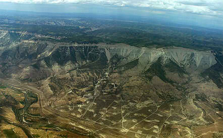
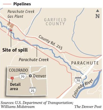
The actions relate to the companies’ responses to the discovery this winter of a leak ultimately blamed on a burst pressure gauge on a pipeline leaving Bargath’s gas processing plant northwest of Parachute. An estimated 10,000 gallons of hydrocarbons reached soil and groundwater.

Bargath is a wholly owned subsidiary of Williams, an oil and gas processing and pipeline company based in Tulsa, Okla.

According to the citations, Badger Daylighting employees were involved in excavation work in the pipeline corridor where the leak response was centered, in order to locate contaminated groundwater and soil. W.C. Striegel employees participated in excavation work and removal of contaminated soil. The companies operated under the direction of Bargath.

A failure to follow safety procedures may have exposed the workers to benzene and other volatile organic compounds, OSHA says. Long-term benzene exposure can cause cancer and short-term exposures at high levels can lead to effects ranging from headaches and tremors to unconsciousness or even death, according to the Centers for Disease Control and Prevention.

Benzene in groundwater was detected at levels as high as 18,000 parts per billion in March. The federal standard for benzene in water used for drinking is 5 ppb.

OSHA has accused each of the companies of seven identical violations and is seeking fines against each for three violations. Agency spokesman Juan Rodriguez said OSHA sometimes will group violations together and fine for some and not others. Among OSHA’s allegations against the companies are that they failed:

■ to inform employees, or in Bargath’s case the contractors, “of the nature, level and degree of exposure likely as a result of participation in … hazardous waste operations.”

■ to develop and implement a decontamination procedure before employees entered the work site.

■ to evaluate the site for specific hazards and determine appropriate protections for employees.

■ to perform personal air monitoring to ensure workers weren’t being exposed to hazardous substance levels exceeding exposure limits. Some workers have complained about not being provided respirators at first at the site.

■ to ensure employees received pertinent safety training.

Williams has said Bargath hasn’t agreed to or accepted OSHA’s allegations and is working with the agency to resolve them. Badger hasn’t commented and W.C. Striegel could not be reached Tuesday for comment.

Peggy Tibbetts, an oil and gas industry critic living in Silt, wrote on her http://www.fromthestyx.wordpress.com blog Tuesday that the fines are a “slap on the wrist.” “This reeks of appeasement to the public outcry over the spill. Evidently OSHA felt they had to do something. After all, their investigation was reported in the paper. This is a pittance compared to the long term costs due to environmental devastation and degradation of public health,” Tibbetts wrote.

A consent order between a Colorado Department of Public Health and Environment division, Williams and Bargath provides for no fine because the leak resulted from accidental equipment failure rather than negligence. However, the department says a fine remains a possibility in the incident.

From The Grand Junction Daily Sentinel (Dennis Webb):

The Occupational Safety and Health Administration is accusing a Williams contractor and subsidiary of safety violations in connection with their response to the natural gas liquids leak north of Parachute. The agency is seeking fines of $10,200 and $7,854, respectively, against Badger Daylighting Corp. and Bargath LLC. Bargath is a wholly owned subsidiary of the Williams oil and gas pipeline and processing company.

OSHA is accusing Badger and Bargath of violating hazardous waste operation and emergency response safety standards. It has accused each of them of seven violations but is pursuing fines for three violations apiece. The individual fines amount to $3,400 and $2,618, respectively, against Badger Daylighting and Bargath.

The actions relate to initial cleanup efforts after the discovery of a leak that was blamed on a valve pressure gauge leak from a natural gas liquids pipeline leaving Bargath’s gas processing plant near Parachute Creek. The leak is believed to have occurred this winter and resulted in an estimated 10,000 gallons of hydrocarbons reaching soil, groundwater and, in small amounts, the creek itself. Those hydrocarbons include benzene, a carcinogen.

Williams previously has said at its website, http://www.answersforparachute.com, that OSHA told it a Badger employee filed a complaint. Workers reportedly were concerned about not being immediately provided respirators at the leak site.

In an update on that website, Williams said the OSHA allegations against Bargath relate to worker safety training and processes, and allege that on the day after the leak discovery, Bargath did not have a fully developed written program for safety, site control, training and decontamination related to an emergency release of waste. “Bargath has not agreed to or accepted OSHA’s allegations, and is currently working with OSHA within its guidelines to fully resolve the citations,” Williams said.

It also has said that it has been told by Badger that four employees who were concerned about benzene exposure were examined by a physician and cleared to return to full-duty work.

Williams also says on its website, “You should know that all employees and contractors are given a thorough safety orientation before they are allowed to begin work. As part of that briefing they are empowered to stop work and remove themselves from any situation they feel is unsafe.”

A Badger employee who asked not to be identified said Monday he worked at the cleanup site for a number of days without a respirator. “Never were we ever told that we were dealing with a hazardous chemical,” he said. He said he experienced headaches, cramps and aching joints after working at the site. The employee said he recently was tested for benzene in his body and a minimal amount was found. However, he wasn’t tested for benzene immediately after working at the site, he said.

Badger did not return a call seeking comment.

Cleanup efforts at the leak site continue. Williams says only one test site on the creek has tested positive for benzene since May 14, and benzene at that site hasn’t topped 1.9 parts per billion during the last 30 days. The state drinking water standard is 5 ppb, but a more lenient standard applies to the creek. Williams continues to await state approvals to begin operating a system to remove treated contaminated groundwater and return it to the aquifer.

From The Denver Post (Bruce Finley):

Federal investigators found that Rangely-based Striegel Inc., Williams Co. subsidiary Bargath and Rifle-based Badger Daylighting Corp. failed to protect workers they sent to excavate toxic soil near Williams’ Parachute Creek gas plant, where a spill was revealed in March. The Occupational Safety and Health Administration issued more than $27,000 in fines for what it described as “serious violations,” which may include failure to provide workers with proper respirators…

“OSHA also wants to ensure that workers know their rights and that employers know their responsibilities for protecting workers,” Department of Labor spokesman Juan Rodriguez said. “Responding to a chemical spill without the appropriate level of respiratory protection places the employees at risk of sustaining adverse health effects resulting from their exposure.” OSHA concluded its investigation and “wants to ensure that the responding organizations implement the appropriate precautions needed to fully protect all workers from the safety and health hazards associated with their cleanup work,” Rodriguez said.

Click through to the Post article to read the letters from OSHA to the three companies.

More oil and gas coverage here and here.

Douglas County: Sterling Ranch scores enough water to start turning dirt on part of the project

sterlingranch.jpg

From The Denver Post (Carlos Illescas):

The Douglas County Planning Commission and the county commissioners originally approved Sterling Ranch several years ago but it has since been challenged, first by a community group in court then by a judge who blocked it August. Citing state law, the judge argued that Sterling Ranch had not lined up enough water and needed to prove it had enough water secured though build-out.

But a change to a state law in the legislature this year gave developers the leeway to phase-in water requirements whenever a certain stage of a project is up for approval by a government entity — at least that’s the way supporters see it.

It was not clear whether the community organization would fight it again this time. John Ebel asked the three-member commission how it could “ignore law, ignore the court, ignore promises made.”

Harold Smethills, managing director of Sterling Ranch, said developers hope to break ground on the project late this year or early next year. “Of course we’re very excited,” Smethills said. “This has been almost six years of public hearings.”
The county commissioners must still approve the development plans for each phase of the project but Wednesday’s ruling sets the project in motion, Smethills said.

From The Denver Post (Carlos Illescas):

About 80 people attended the special hearing in Castle Rock, with all 14 speakers urging the board not to approve it. Opponents say the project would negatively impact the quality of life, while supporters say the area is primed for growth.

Sterling Ranch would be home to about 31,000 people in 12,050 homes on 3,400 acres south of Chatfield State Park and east of Roxborough State Park. It would include 1,200 acres of residential neighborhoods, 1,200 acres of parks and open space, and 500 acres of commercial and retail properties.

According to a fiscal analysis done for Sterling Ranch, the project would have an economic impact of more than $435 million annually.

More Sterling Ranch coverage here.

Drought news: Aurora relaxes watering restrictions #COdrought

usdroughtmonitorjuly22013.jpg

From 7 News (Deb Stanley) via The Denver Post:

Aurora Water is joining Denver Water in loosening its watering restrictions. In April, Aurora city officials adopted a two-day a week watering schedule, because its reservoirs were at 46 percent of capacity. Thanks to heavy spring snow and a system to recapture water in the South Platte River, the reservoirs are now at 67 percent of capacity, officials said. Residents can now pick which three days they water, but watering is still banned between 10 a.m. to 6 p.m.

Drought news: Farmers are feeling the impact to winter wheat #COdrought

usdroughtmonitorjuly22013.jpg

From The Greeley Tribune (Kristen Schmidt):

Above average spring moisture normally would have been a good sign for Weld County wheat farmers, but the moisture proved to be too little, too late. With a late harvest now rolling around, local farmers find themselves with lack luster crops and the threat of subpar yields. Minimal production is expected for the entire state.

According to the most recent U.S. Department of Agriculture report, Colorado winter wheat production in 2013 is projected at only 51 million bushels, down 31 percent from the 73.8 million bushels produced last year, and down 29 percent from the 10-year average crop of about 72 million bushels. The estimate for the 2013 Colorado winter wheat crop is based upon only 1.5 million acres being harvested, which is the lowest harvested acres since 1965, with an average yield of 34 bushels per acre.

Late harvests are also being seen statewide. The USDA’s report estimated Colorado as 7 percent harvested, compared with 81 percent at this time last year, when harvest was dramatically earlier than normal. The five-year average for harvest at the beginning of July is around 25 percent complete.

According to Bruce Bosley, Colorado State University Extension crop system specialist, soil conditions and weather are to blame for winter wheat’s poor outlook. He explained that when wheat was drilled last fall, the soil was too dry. Dry soil combined with winter’s bitter cold and lack of moisture stunted the crops growth and development.

Curt Wirth, a New Raymer-area farmer, agrees that dry conditions combined with excessive cold disturbed root-system development and are the key contributors to this season’s delayed harvest. Wirth is expecting his fields to yield only two-thirds of the crop they produced last year.

Roggen-area farmer Vern Cooksey plans to start harvest this weekend and is only expecting 30-40 bushels per acre. Cooksey attributes lower yields in part to the hot dry spell that plagued the month of June.

Southeastern Colorado wheat farmers even more so find themselves struggling to stay afloat.

The USDA’s most recent report stated that “farmers in the southeastern growing areas of the state have already abandoned a large portion of the acreage seeded last fall due to continuing drought and spring freezes.”

Colorado Wheat Executive Director Darrell Hanavan expressed his concern for winter wheat in southeastern Colorado and attributes many of the acres included in the state’s 32 percent abandonment rate to acres lost south of Interstate 70.

Even in the face of a projected record low in acres harvested since 1965, Bosley noted that, in general, years with smaller yields tend to have higher protein content.

While it may not be much, producers are eager to take hold of whatever silver lining they can find in the face of this year’s tough growing season.

Colorado River Basin: ‘The realities of drought and climate change are increasing’ — Lisa Iams #ColoradoRiver

grandcanyonfromgrandviewpoint01242009nps.jpg

Here’s a guest column written by Alex and Fred Thevenin running in the Arizona Central. Click through and read the whole article. Here’s an excerpt:

In Arizona, 25 percent of us use Colorado River water, with Phoenix relying on the river for half of its drinking water, and the section of the river coursing through the Grand Canyon is the economic engine for a thriving Arizona tourism economy.

As owners of a third-generation rafting company in Flagstaff that guides more than 60 Grand Canyon trips per year, the condition of the Colorado River is crucial — to our employees, our bottom line, and the thousands of other businesses that rely on the river to attract visitors and outdoor enthusiasts. We must find ways to adapt the region’s water needs in the face of challenges like lean-snow years, drought, increasing demand and other factors stressing the river system.

The U.S. Bureau of Reclamation recently released the Colorado River Basin Water Supply and Demand Study. Taking their lead from the study, Congress and federal agencies must follow through and build a future that includes healthy rivers, state-of-the-art water conservation for cities and agriculture, and water reuse and sharing mechanisms that allow communities to grow, prosper and adapt to water demands and availability.

This year, Congress should continue funding programs that drive sustainable water management, while protecting the river system and the communities, businesses and wildlife it supports. Specifically, we should prioritize funding in the Colorado River Basin to:

— Implement management decisions that maintain and restore flows necessary for natural habitats, wildlife and recreation.

— Support cost-effective investments in water technology and delivery like piped sprinkler and drip irrigation to our farms and ranches.

— Provide for urban water education and conservation programs. Reducing urban water consumption by just 1 percent annually — a rate municipal utilities have averaged for two decades — produces significant savings at very low cost.

— Continue effective programs like the Bureau of Reclamation’s WaterSMART and Title XVI Water Reclamation and Reuse programs that drive water conservation and American jobs through adopting innovation and technology.

Bringing these approaches to the table can pull the Colorado River off the endangered list. We can refocus outdated ways of addressing our water supplies right now with cost-effective solutions that maximize water resources and prioritize conservation, reuse and efficiency.

Meanwhile a low Lake Powell impacts hydroelectric generation at Glen Canyon Dam. Here’s a report from Emily Guerin writing for The Goat. Here’s an excerpt:

The government entities that manage Glen Canyon Dam and sell the power its turbines generate are also distressed at Lake Powell’s retreat, albeit for economic and political reasons. According to the Bureau of Reclamation, in May the reservoir was only 48 percent full, and is expected to drop 11 feet before September, ending the summer at 44 percent capacity. Severe to extreme drought in much of the Colorado River’s watershed, plus record heat, isn’t exactly helping.

Despite the dismal conditions, Glen Canyon Dam is still discharging 8.23 million acre-feet of water this year (measured from Oct. 1, 2012 to Sept. 30), as it does every year that lake levels stay above approximately 3,650 feet (the exact levels were decided in a 2007 environmental impact study designed to address water storage issues on the Colorado River in times of drought). But there’s a 50-50 chance that the lake will soon drop below that height, triggering a lower water release next year. If that happens, it would be the first time since Lake Powell’s creation that less than 8.23 million acre feet of water will pass from Glen Canyon Dam, according to Bureau of Reclamation spokesperson Lisa Iams. “It’s not a promising statement about the hydrology that all of us face,” she said. “The realities of drought and climate change are increasing.”

More Colorado River Basin coverage here and here.

Drought news: Not much relief forecast for southern Colorado #COdrought

usdroughtmonitorjuly22013.jpg

From the National Weather Service Pueblo office:

…NO RELIEF IN LONG TERM DROUGHT CONDITIONS ACROSS SOUTHERN COLORADO…
SYNOPSIS…

ANOTHER HOT AND DRY JUNE WAS EXPERIENCED ACROSS THE MUCH OF SOUTH CENTRAL AND SOUTHEAST COLORADO…WITH MOST OF THE AREA SEEING WELL ABOVE NORMAL TEMPERATURES AND WELL BELOW NORMAL PRECIPITATION. ONE EXCEPTION TO THIS WAS OVER PORTIONS OF THE SOUTHEASTERN PLAINS…WHICH SAW NEAR OR SLIGHTLY ABOVE NORMAL PRECIPITATION…THANKS TO A FEW SLOW MOVING THUNDERSTORMS. WHILE THIS MOISTURE DID BRING SOME MINOR SHORT TERM RELIEF TO AREA FARMERS AND LAND MANAGEMENT AGENCIES…THE PRECIPITATION WAS NOT WIDESPREAD ENOUGH TO SHOW ANY IMPROVEMENT IN THE LONG TERM DROUGHT THE REGION HAS BEEN IN PLAGUED WITH OVER THE PAST TWO YEARS.

WITH THIS IN MIND…THE CURRENT US DROUGHT MONITOR CONTINUES TO INDICATE MOST OF SOUTHEAST COLORADO IN EXCEPTIONAL (D4) DROUGHT CONDITIONS. THIS INCLUDES SOUTH CENTRAL AND SOUTHEASTERN PORTIONS OF EL PASO COUNTY…CENTRAL AND EASTERN PORTIONS OF PUEBLO COUNTY…CENTRAL AND EASTERN PORTIONS OF LAS ANIMAS COUNTY…AS WELL AS ALL OF CROWLEY…OTERO…KIOWA…BENT…PROWERS AND BACA COUNTIES.

EXTREME DROUGHT (D3) CONDITIONS ARE NOW INDICATED ACROSS EXTREME SOUTHWESTERN MINERAL COUNTY. EXTREME DROUGHT (D3) CONDITIONS REMAIN DEPICTED ACROSS CENTRAL AND EASTERN PORTIONS OF FREMONT COUNTY…SOUTHERN TELLER COUNTY…MOST OF CUSTER COUNTY…THE REST OF PUEBLO COUNTY AND MOST OF THE REST OF EL PASO COUNTY. EXTREME DROUGHT (D3) CONDITIONS ALSO REMAIN INDICATED ACROSS HUERFANO COUNTY AND THE REST OF LAS ANIMAS COUNTY.
SEVERE DROUGHT (D2) CONDITIONS CONTINUE TO BE DEPICTED ACROSS SOUTHERN CHAFFEE COUNTY…WESTERN FREMONT COUNTY…NORTHERN TELLER COUNTY…EXTREME NORTHWESTERN EL PASO COUNTY…EXTREME WESTERN CUSTER COUNTY AND THE REST OF MINERAL COUNTY…AS WELL AS ALL OF SAGUACHE…RIO GRANDE…CONEJOS…ALAMOSA AND COSTILLA COUNTIES.

MODERATE DROUGHT (D1) CONDITIONS REMAIN ACROSS THE REST OF CHAFFEE COUNTY AND LAKE COUNTY.

MORE INFORMATION ON THE US DROUGHT MONITOR CLASSIFICATION SCHEME CAN BE FOUND AT: WWW.DROUGHTMONITOR.UNL.EDU/CLASSIFY.HTM

CSU is testing subsurface drip irrigation at the Fruita Agricultural Experiment Station

subsurfacedripirrigationnetafim.jpg

From The Grand Junction Daily Sentinel (Sam Waters):

In the back of almost every farm truck you are likely to find a pair of muddy irrigating boots. Stepping in the mud to shovel and straighten creases is common in the area, so getting muddy boots is just part of the job for most farmers. But one type of irrigation has the potential to get rid of some of the muck.

Subsurface drip (SDI) is a low-pressure, high-efficiency irrigation system that uses buried drip tubes or drip tape, essentially plastic tubing with holes in it, to meet crop water needs. This type of irrigation effectively waters the crops but keeps the surface dry. “The thing about this is that there is no run-off. If we do it correctly, there is no deep percolation. So essentially everything goes to the crop. So it’s very, very efficient,” said Calvin Pearson, research agronomist at the Colorado State University Fruita Agricultural Experiment Station.

Pearson and others at the experiment station installed an SDI system last spring with grant funding from the Colorado Water Conservation Board. Under the same grant, farmer Tom Landini installed a system last fall to water a small field of alfalfa. Both locations serve as demonstration systems to see how irrigation of this type would fit in with the cultural practices of the area.

While new to the Grand Valley, SDI technologies have been a part of irrigated agriculture since the 1960s. Although it can work for almost all crops, it is mostly widely used for high-
value vegetable and fruit crops such as strawberries, tomatoes, cantaloupe and onions. “There could be significant use of subsurface drip irrigation for landscaping in the Grand Valley as well,” said Luke Gingerich, agricultural engineer with the Natural Resource Conservation Service.

SDI systems could help keep grass evenly watered, Gingerich said. And residents could water their lawn while mowing it with no problems.

This type of system is suitable for dry, hot and windy areas with limited water supply. The Grand Valley is not short on water, but SDI has potential to work well in the area.

Wayne Guccini, of the Mesa Conservation District, works with Gingerich to oversee the system at Landini’s farm. “It will work, it’s just a matter of whether it will be economically feasible,” Guccini said. And that’s the big concern. SDI systems can range from about $1,200 to $2,400 per acre to install, depending on what models are used, so a farmer investing that much capital will want to be sure it will pay off in the end.

“Who knows, there may be a time in this valley where we might not have the water that we have, so we might need a system like that widespread to keep things green,” Landini said.

More conservation coverage here.