
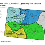
Click on a thumbnail graphic for a gallery of snowpack data from April 1, 2014 from the Natural Resources Conservation Service.
From KRDO.com (Bonnie Silkman):
“In 2013 at this time we were in a pretty dire situation. We were well below average for snow pack and snowfall,” said Patrice Lehermeier, spokesperson for Colorado Springs Utilities.
Fortunately, that’s not the case this year.
“The best way to describe it is cautiously optimistic,” said Lehermeier.
Optimism that this winter’s snow will mean years of water.
“If the snow that we’ve received in the mountains melt like we think it will, we can see our reservoirs and water storage at a two year supply. That’s a really good number for us,” said Lehermeier.
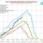
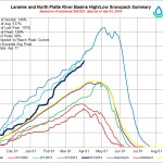
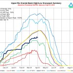
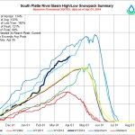
The majority of Colorado Springs water comes from the Upper Colorado Basin. Right now it’s 130% of average snowfall.
“Here’s the important part though- just because we’re not in mandatory restrictions doesn’t mean you should start over using water. Our goal is to sustain public safety. We know the drought is only one winter away, and who knows what could happen next summer. We also know that wildfire is a huge concern across our state and this area is a victim of some of that devastation,” said Lehermeier.
From The Aspen Times (Scott Condon):
The past two years have been challenging for whitewater-rafting companies. A meager snowpack created particularly tough times in summer 2012. There were very few Class IV rapids in the entire state, Ingram said, and most of the rafting that could be offered was a Class II float trip.
Business was better last summer, thanks to an improved snowpack and stronger economy, Ingram said.
Savvy tourists nowadays check streamflows before booking a rafting trip just like they check snow conditions before blowing a wad on skiing vacations. Ingram said reservations are rolling in already because of the prospects of impressive flows.
“I’m looking at a good Slaughter House season,” he said, referring to the Class IV Slaughter House Falls downstream from Aspen. Based on current conditions, experience tells him the streamflow will allow his company to run the falls at least halfway through July if not the entire month…
The Roaring Fork River Basin ecosystem also will be a winner this year. The riparian areas and wetlands located alongside rivers and creeks will be replenished from high flows and high groundwater, said Sharon Clarke, watershed action director for the Roaring Fork Conservancy, a Basalt-based nonprofit focused on education and activism on water issues…
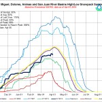
Snowpack levels in the Roaring Fork Valley have been higher than average since the region was hit by storms in late October. The Roaring Fork River Basin as a whole is at 126 percent of average, according to the Natural Resources Conservation Service, the agency that tracks snowpack.
In the vast geographic area covered by the Roaring Fork Basin, the snowpack ranges from a low of 115 percent of average at McClure Pass to 135 percent of average at Schofield Pass in the Crystal River headwaters and 134 percent of average at Ivanhoe, near the Fryingpan River headwaters.
East of Aspen, near the headwaters of the Roaring Fork River, the snowpack is 123 percent of average.
“It’s touching where it was in 2011, but in 2011 it kept cranking,” Clarke said. That’s the spring when the snow didn’t stop coming in April and May.
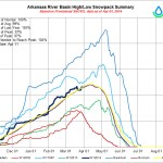
Conditions were perfect in late May and June 2011 for a long, sustained runoff that didn’t peak as abruptly as feared, given the high snowpack. The Roaring Fork River peaked at about 8,000 cubic feet per second at Glenwood Springs, according to the Colorado River Basin Forecast Center, a division of the National Weather Service and National Oceanic and Atmospheric Administration.
The Roaring Fork River’s highest recorded level was 11,800 cfs at Glenwood Springs in 1995, according to the forecast center. The low was 1,870 cfs in 2012…
It’s too early in the runoff season for an accurate picture of the Roaring Fork River’s peak. That will depend on how warm it gets, for how long and when, said Eric Kuhn, director of the Colorado River District, an organization that protects western Colorado water interests. However, it appears the volume of water produced by the snowpack melting from May through July will range between 110 and 120 percent of average.
“We’re thinking it’s going to be a good year,” Kuhn said.
The big advantage of the higher volume is that water managers can build storage levels in reservoirs, he said. There should be enough water remaining after irrigation and municipal uses to store in the reservoirs. Even Lake Powell in Utah, which has been drawn down to sustained, low levels, will “bump up a little” this year, Kuhn said.
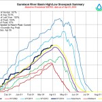
The U.S. Bureau of Reclamation has boosted releases from Ruedi Dam to above 210 cfs to make room for anticipated runoff. It increased the discharge to a higher level than usual earlier than usual. Ruedi Reservoir is currently two-thirds full. With the higher-than-average snowpack in the upper Fryingpan River Valley, prospects are great for a long boating season at high water levels on Ruedi.
Diversions from the Fryingpan-Arkansas Project from the upper Fryingpan River basin and from the Twin Lakes Canal Co. diversion system, from the upper Roaring Fork River basin, will likely benefit from the above-average snowpack. The diversion systems are limited by capacity, Kuhn said. If the snow melts at a slow and steady pace rather than during a more compact time period, they can divert water for more days.
From The Aspen Times (Scott Condon):
A thin layer of dust that a windstorm deposited on the Aspen area Sunday evening may play a key role in how the snowpack melts this spring and early summer, according to Chris Landry, executive director of the Center for Snow and Avalanche Studies in Silverton.
High winds blowing the dry sands of the Southwest and the Colorado Plateau slammed into the Colorado mountains late Sunday afternoon and into the evening. There was so much dust in the air, blowing through in plumes, that the sky turned an odd orange-ish hue before sunset.
“It was a significant event,” Landry said. The nonprofit center runs the Colorado Dust-on-Snow Program, which monitors “dust events,” measures how much dust gets deposited in the snowpack and assesses how it will affect the spring runoff.
Landry was in the field Sunday visiting 11 sites in Colorado, including McClure Pass in the Crystal River Valley, where the program monitors snowpack and assesses dust. He and a colleague stayed in Steamboat Springs on Sunday night and weren’t sure initially how extensive the dust incident was because fresh snow fell overnight at the resort. It became more apparent, by the time they reached Interstate 70, that dust had coated the snowpack, and it was “dead obvious” by the time they reached the Roaring Fork Valley that it was significant, Landry said.
It affected the mountains as far east as Loveland and extended into the Grand Mesa to the west and Red Mountain Pass and the surrounding San Juans to the south. The Dust-on-Snow Program still is assessing how far north the dust spread.
“This was a huge event. It might have got most of the mountains,” Landry said.
Although it covered a widespread geographic area, it didn’t leave a layer of dust as thick as windstorms did at some locations in the Colorado mountains last spring, Landry said. His staff will collect snowpack samples in June, where all layers have merged, to assess the dust’s potential impact on runoff. The dust leaves a distinctive layer in the snow sample.
Most dust storms occur in March, April and May, so the prospects are high that more will roll through the mountains, according to Landry…
Sunday’s storm was the fourth incident to deposit dust in at least a portion of the mountains. Two earlier events left smaller amounts of dust in the Aspen-area snowpack, he said…
More information on the Colorado Dust-on-Snow Program is available at http://www.codos.org/#codos.
From Steamboat Today (Tom Ross):
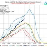
The Colorado Basin River Forecast Center in Salt Lake City is signaling that a warming trend next week could kick off low elevation runoff, causing the Yampa River in Steamboat Springs and downstream in Moffat County to begin to rise steeply.
The center is projecting that the Yampa will flow well above its historic norm at more than 350 cubic feet per second Thursday through Sunday. But the river’s flow could begin to stair-step more steeply to more than 700 cfs late next week. And if that comes to pass, it will because of a significant warming trend.
The Yampa at Maybell, west of Craig, also is expected to rise but with bigger peaks and valleys than further upstream in Steamboat. At Maybell, the river was flowing at more than 1,000 cfs Tuesday and could spike to nearly 1,700 cfs by Monday.
From The Greeley Tribune:
Greeley had far less precipitation than normal in March — typically a big snow month — but three months deep into the year, 2014 overall is still a wet one.
During March, Greeley received just .4 inches of snow — only 5 percent of its typical 8.3 inches for the month — and, with rain factored in, received just .75 inches of total precipitation, which is only 67 percent of its historic average of 1.12 inches, according to numbers provided by the Colorado Climate Center based in Fort Collins.
However, thanks to an abnormally wet January and February, Greeley’s total precipitation for 2014 is 3.23 inches — well above the typical 2 inches it receives through the end of March, and ranking as the fifth-wettest year on record — and it’s total of 18.9 inches of snow this year are right about normal for the city.