The health of our waters is the principal measure of how we live on the land — Luna Leopold
Weekly Climate, Water and Drought Assessment of the Upper #ColoradoRiver Basin
Upper Colorado River Basin June 2014 precipitation as a percent of normal Click here to read the current briefing from NIDIS via the Colorado Climate Center. Click here to go to the NIDIS website.
Meanwhile, here’s a look at the North American Monsoon forecast from Ryan Maye Handy writing for the Fort Collins Coloradoan. Here’s an excerpt:
The monsoonal flow of tropical moisture is a hallmark of late-summer weather in the Rocky Mountain West, where massive storms set up like clockwork almost daily in July and August. But this year an El Nino cycle, which pushes coastal moisture over the mountains, will add more water to what might be an already robust monsoon, said Mike Baker, a forecaster for the National Weather Service in Boulder.
“We always see the monsoon and it comes in different flavors and strengths,” he said on Tuesday. “We may be dealing with an enhanced monsoon.”
This week Northern Colorado has started to see some monsoonal rain, albeit through a “back doorway,” as Baker called it. Some monsoonal moisture has looped around the state, entering the atmosphere from the north, instead of its typical route from the south…
The bulk of monsoonal moisture is still sitting over Arizona and Nevada, but should move into the Rocky Mountains in the next two weeks, Baker said. The rains should also bring with them cooler than average summer temperatures, according to a three-month weather outlook…
It’s been a wet year for Northern Colorado all around. Water from the devastating September 2013 floods saturated soil sand lingered through winter in Big Thompson and Poudre rivers. Winter brought a well above-average snowpack — more than 200 percent of normal — and a high spring runoff season, with peak river flows that were among the highest in nearly 60 years in Northern Colorado.
June was dry in Grand Junction. Here’s a report from Rachel Sauer writing for The Grand Junction Daily Sentinel:
If it was hard to swallow in June, if it seemed like there were not enough eye drops in the world to make your eyes stop feeling gritty, if you reapplied Chap Stick every two minutes and it still didn’t seem often enough, there’s a reason: June was dry. Very, very dry.
“June’s typically our driest month, climatologically speaking, and this past June has been exceptionally dry for most of the region,” said Matthew Aleksa, a meteorologist with the National Weather Service in Grand Junction.
“Last month, for the most part, most of the days in June didn’t really receive any rain at all.”
In fact, during the entire month, Grand Junction received 0.13 inch of rain, 0.12 of that on June 8, Aleksa said. If it wasn’t for that one storm blowing through, June 2014 might have joined the ranks of June 2001, say, or June 1980 for being among the driest Junes on record.
The average moisture level for June is 0.46 inch, Aleksa said, but because of a high pressure ridge over the West, the rain just didn’t fall.
“We had some low-pressure systems over the Pacific northwest and one over the plains and Midwest and so they were getting a lot of storms out that way,” Aleksa said.
“But since we were right in between, in that ridge of high pressure, we had a drier type of air mass where the moisture wasn’t there for producing the storms or giving us the weather systems that would bring rain.”
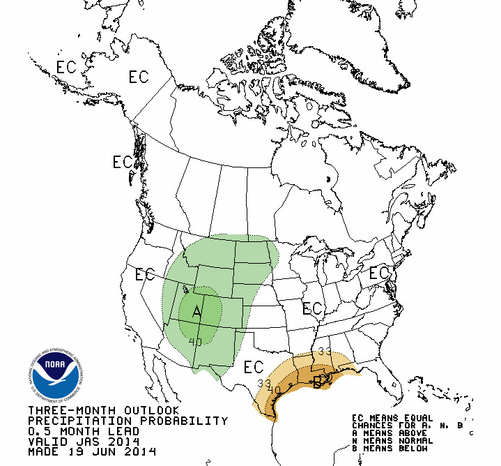
July through September 2014 precipitation outlook via the Climate Prediction Center
However, the news gets better. The National Weather Service’s Climate Prediction Center is forecasting above-normal precipitation for July, August and September.
“We’re looking at models that are starting to hint in the next week at a potential for more moisture to work its way up over Arizona and the Four Corners region,” Aleksa said.
“By the middle of next week, we’re going to start to see that high pressure start to shift into a more favorable pattern, start to see a more monsoon-like moisture surge.”
Plus, he said, temperatures for the next six to 10 days are forecast to be around normal — which, granted, is still 93, but double digits are better than triple.