Throughout the western United States, a network of Global Positioning System (GPS) stations has been monitoring tiny movements in the Earth’s crust, collecting data that can warn of developing earthquakes.
To their surprise, researchers have discovered that the GPS network has also been recording an entirely different phenomenon: the massive drying of the landscape caused by the drought that has intensified over much of the region since last year.
Geophysicist Adrian Borsa of the Scripps Institution of Oceanography and his colleagues report in this week’s Science that, based on the GPS measurements, the loss of water from lakes, streams, snowpack, and groundwater totals some 240 billion metric tons—equivalent, they say, to a four-inch-deep layer of water covering the entire western U.S. from the Rockies to the Pacific. (Related: “Water’s Hidden Crisis”
The principle behind the new measurements is simple. The weight of surface water and groundwater deforms Earth’s elastic crust, much as a sleeper’s body deforms a mattress. Remove the water, and the crust rebounds.
As the amount of water varies cyclically with the seasons, the crust moves up and down imperceptibly, by fractions of an inch—but GPS can measure such small shifts.
Borsa knew all this when he started to study the GPS data. He wasn’t interested in the water cycle at first, and for him the seasonal fluctuations it produced in the data were just noise: They obscured the much longer-term geological changes he wanted to study, such as the rise of mountain ranges.
When he removed that noise from some recent station data, however, he noticed what he describes as a “tremendous uplift signal”—a distinct rise in the crust—since the beginning of 2013. He showed his findings to his Scripps colleague Duncan Agnew.
“I told him, ‘I think we’re looking at the effect of drought,'” Borsa remembers. “He didn’t believe me.”
But Borsa was right. As he, Agnew, and Daniel Cayan of Scripps report in Science, the recent uplift spike is consistent across the U.S. West, and consistent with recent declines in precipitation, streamflow, and groundwater levels. With a great weight of water removed, the crust is rebounding elastically across the whole region.
The median rise across all the western GPS stations has been four millimeters, just under a sixth of an inch. But the Sierra Nevada mountains, which have lost most of their snowpack, have risen 15 millimeters—nearly six-tenths of an inch.
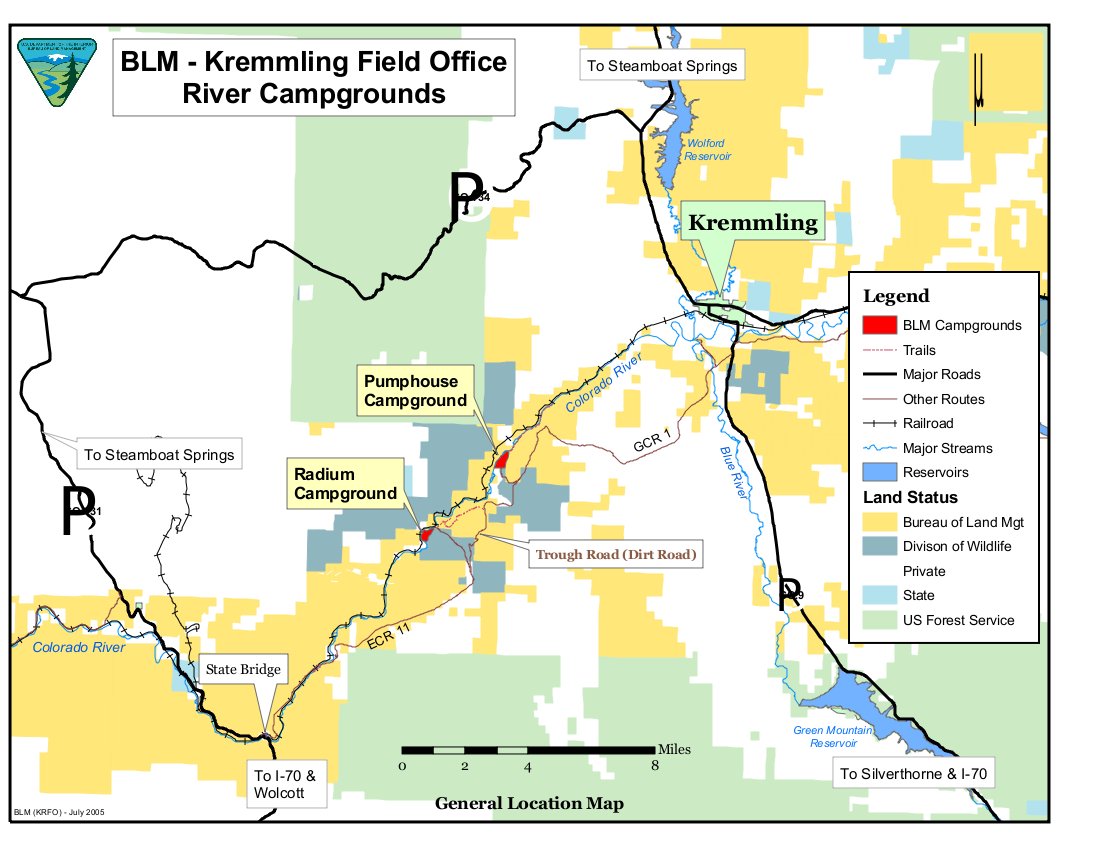
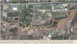
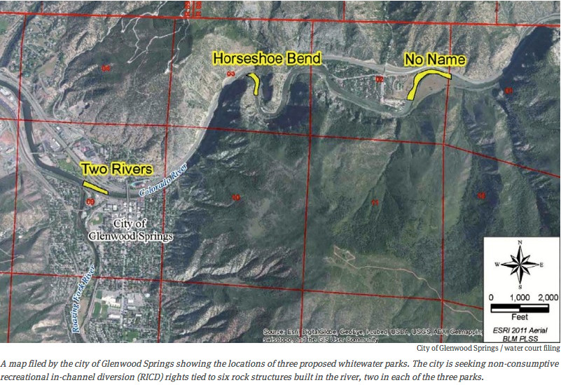
The Bureau of Land Management signed a Decision Record Aug. 15 authorizing the proposed Gore Canyon Whitewater Park at the Pumphouse Recreation Site on the upper Colorado River.
Grand County submitted a right-of-way application to build the feature across the full width of the river upstream of the Pumphouse boat launch 2. The county was recently awarded historic water rights for constructing this waterpark.
The feature consists of engineer-designed boulders and block-like concrete objects placed across the stream channel that would not be visible at normal flows and would allow for fish passage at all flow rates. Construction is scheduled to begin in November.
“The project will provide a unique recreational experience for the 60,000-70,000 people that visit the area each year,” said BLM Kremmling Field Manager Stephanie Odell. “It will also provide permanent protection for water flows supporting fishing and recreational floatboating.”
Developing a recreational in-channel diversion below Gore Canyon implements part of the Colorado River Cooperative Agreement among Denver Water and more than 30 Western Slope entities.
The Decision Record, Finding of No Significant Impact and Environmental Assessment are available on-line at: http://www.blm.gov/co/kfo.
From the Glenwood Springs Post Independent (John Stroud):
Protection of the river ecology and preservation of recreation and agricultural interests was the consistent message heard by a panel of Colorado legislators who convened here Thursday to gather public comments on the new state water plan.
And the best way to ensure that is through better statewide water conservation practices and no more trans-mountain water diversions from the Western Slope to the Front Range, those who testified before the state Legislature’s Interim Water Resources Review Committee concurred.
“What’s healthy for recreation is healthy for rivers and streams,” said Aimee Henderson, co-founder of the Upper Colorado Private Boaters, an affiliate of American Whitewater based in Glenwood Springs.
“Additional diversions are not an acceptable solution,” she said, adding there should be a statewide conservation agreement to decrease water consumption.
Pitkin County Commissioner Rachel Richards, who sits on the Colorado River Basin Roundtable, one of nine roundtables that is weighing in on the water plan, said it’s important to “truly acknowledge the value of the environmental and recreation economy in the state.”
Tourism promoters across the state, whether on the Front Range or the Western Slope, almost always showcase some type of high country water recreation in their attempt to attract visitors, Richards noted…
The Thursday meeting at the Glenwood Springs Branch Library attracted about 100 people, many of whom are members of the Colorado Basin Roundtable or have been involved in those discussions over the past several months.
The meeting was the second of nine sponsored by the 10-member legislative committee as it holds hearings within each of the major river basins as part of process to develop the state water plan…
The Glenwood Springs meeting focused on concerns within the main stem of the Colorado River, including the Roaring Fork, Eagle and Blue river valleys.
Many of the comments echoed those contained in the draft Colorado Basin Implementation Plan, which emphasizes a high conservation standard statewide and discourages further water diversions.
The draft basin plan concludes that any more water diversions would severely damage the state’s recreation-based economy, agriculture and the environment, and would jeopardize upper basin users should there be an interstate compact call by down-river water users.
It also includes specific recommendations, such as preserving the Shoshone water right for Western Slope needs rather than allowing it to be sold to Front Range water interests, and encouraging small water projects in western Colorado to meet agricultural needs…
[Ken Neubecker] summarized the comments of one of nine separate tables that engaged in small-group discussions with members of the legislative committee before the floor was opened up to general testimony.
“If you’re going to take a new supply for the Front Range, it’s going to come from someone else who is already using it,” Neubecker said.
Suggestion that any new diversions would come with an agreement that they occur only during peak runoff years “simply condemns the Western Slope to a permanent drought condition,” he said. “We need to educate everyone, especially the Front Range, about where their water comes from.”
Another concern expressed at the hearing included that the water plan is only intended to address water needs through 2050, even as growth pressures are likely to continue beyond that time. Others who spoke said it’s important to factor climate change models and predictions into the water plan.
The water committee has started its deep dive into conservation issues, especially as it relates to the transfer of water used in agricultural production to urban municipalities along the Front Range. This conversation was triggered by a controversial bill I carried last year. I’m determined that we’ll keep at this until we reach best practices that make sense and reflect the precious nature of water in our state.
I appreciate the active engagement of several of my constituents in bringing ideas and zeal to this topic and as I travel the state with the water committee as we hold hearings over the next two months on what should be in the state water plan, I’ll be sure that the topic of water conservation gets brought up and vetted in all areas of the state.
My principal concern with municipalities failing to do everything they can to conserve water is that the urban corridor on the Front Range, including, but certainly not limited to, Denver, seek to transfer more water from the Western Slope to satisfy their residents’ needs and desires. I don’t need to inform my constituents of the impacts this would have on our way of life, on our viable agricultural production, and on our environment.
Also breathing down our necks is the impact of a potential “call” on the Colorado River from downstream states legally entitled to a share of that water for their own uses. If such a call is made, we won’t be getting water shipped back from the Front Range to satisfy the call.
Seasonal Drought Outlook August 21, 2014 via the Climate Prediction Center
90-day precipitation outlook August 21, 2014 via the Climate Predication Center
09-day temperature outlook August 21, 2014 via the Climate Predication Center
Click on a thumbnail to view a gallery of 90-day predication from the Climate Predication Center. Click here to go the NOAA’s Climate Prediction Center website.
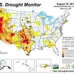
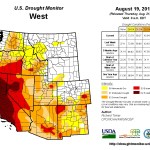
Click here to go to the US Drought Monitor website. Here’s an excerpt:
The Far West
Seasonably dry conditions kept drought conditions unchanged in most of the region, but unusual rainfall did lead to 2 areas of improvement. Some daily record rainfall amounts were recorded in southwestern Oregon, improving the marginal D3 conditions to D2 in part of that area. Farther south, rainfall during the last few weeks has been many times normal in part of the deserts of southeastern California, and severe drought was improved to moderate drought in some of this area where precipitation totals are now above normal for at least the last 6 months. Unfortunately, rainfall in this arid region will have no impact on the water shortages and seriously low reservoir stores reported throughout the state…
The Rockies and Intermountain West
Heavy monsoonal rains were reported through parts of southern and western New Mexico, central and eastern Arizona, southern Utah, and part of eastern Nevada. Most of these areas received at least an inch of rain, with larger amounts (3 to at least 6 inches) soaking some of the higher elevations in Arizona from north of Phoenix to the central New Mexico border.
Intense rainfall led to serious flash flooding north of Phoenix, AZ, but most of this fell after Tuesday morning August 19, which would be outside the period under consideration for this week’s Drought Monitor. Nonetheless, improvements to D2 were introduced in part of central Arizona where the heavier rain fell, with other spotty improvements noted in southeastern and east-central Arizona, and across southern New Mexico. D0 conditions were removed from part of interior southeastern New Mexico where more than 10 inches of rain has fallen in the past few weeks.
It should be noted that in spite of abundant rainfall this monsoon season, reservoirs primarily fed by the Rio Grande River remain seriously low due to upstream dryness and the very long-term precipitation deficits.
Elsewhere, moderate rains of 0.5 to 2.0 inches fell on part of the northern Intermountain West and part of the northern Rockies, but drought conditions remained unchanged outside Arizona and New Mexico…
The Western Great Lakes and the Plains States
It was a typical summer week in this region as a whole, with a highly variable rainfall pattern observed. Over 3 inches of rain was reported from south-central Iowa and adjacent Missouri southeastward into southern Illinois, with 5 or more inches soaking parts of northern Missouri. To wit, the small area of D0 there was removed.
Over 2 inches of rain, with scattered reports of 3 to 5 inches, fell on east-central Wisconsin, parts of southeastern Minnesota and North Dakota, and a few spots in central and northeastern Texas. Most other locations received somewhere between a few tenths of and 2 inches of rain, but little or no rain fell on northern Illinois, eastern Iowa, a strip from southwestern South Dakota through northeastern Nebraska, much of southern Kansas, and numerous locations in the southern Plains outside central Oklahoma, central Texas, and a few other isolated spots.
The rains prompted some improvement in central Oklahoma, central and part of northeastern Texas, and some small areas farther north. However, short-term moisture deficits have increased enough to warrant the introduction of D0 in a swath from south-central Minnesota through eastern Iowa, southwestern Wisconsin, and northwestern Illinois. Less than half of normal precipitation has fallen since mid-July in most of these areas, and 8-week rainfall is 5 to 8 inches below normal in much of the region.
Growing short-term moisture deficits also prompted the expansion of D0 southward into broader regions of southern Missouri…
Looking Ahead
During August 20 – 25, 2014, A swath of moderate to heavy rain is forecast from the northern Intermountain West eastward through the northern half of the Plains, the Great Lakes Region, the central Appalachians, and the mid-Atlantic. Between 2 and 5 inches is anticipated across much of Montana, western and southeastern parts of the Dakotas, southwestern and northeastern Minnesota, the southern Great Lakes, the central Appalachians, and the mid-Atlantic from central Pennsylvania southward through Maryland and eastern Virginia west of the Chesapeake Bay.
Light to locally moderate rain is forecast for most other parts of the central and southern Rockies, the Southeast, and areas immediately adjacent to the primary precipitation swath.
Little or no precipitation is expected along the West Coast, in the lower half of the Mississippi Valley, and across the southeastern Plains. Mild temperatures are expected from the Rockies and northern Plains westward to the coast. Montana and western North Dakota are expecting daily high temperatures 6oF to 15oF below normal. Hot weather is anticipated from the Southeast and central Appalachians westward through the southeastern half of the Plains, with daily highs averaging 9oF or more above normal from the Tennessee and lower Ohio Valleys northwestward through Illinois.
For the ensuing 5 days (August 26 – 30, 2014), odds at least slightly favor above-normal rainfall for a large swath of the country from the Southwest and the Rockies eastward through the Northeast, the central Appalachians, the central and eastern Gulf Coast region, and the Southeast as far east as Georgia and Florida. Enhanced chances for below-normal precipitation are restricted to the Northwest and southern Texas.
Climate change is globally impacting natural resources, particularly water supplies, and that can’t go unchecked, U.S. Sen. Mark Udall said Wednesday in Snowmass Village.
Managing water supply is clearly a critical issue in the West, but it is also an issue of national and international security, Udall said to a crowd gathered for the Colorado Water Congress Summer Conference at the Westin Snowmass Conference Center. Between now and 2040, the world’s water supply will not keep up with demand without better management, according to a recent assessment by the director of National Intelligence, Udall said.
“Water problems will hinder the ability of key countries to produce food and energy … hobbling economic growth here and around the world,” Udall said. “In turn, that will increase the risk of political instability, state failure and mounting regional tensions.”
Global water consumption has tripled in the past 50 years, and furthermore, the supply is diminishing due to climate change, he said.
“Our climate is changing, and the only thing constant and predictable on the subject is science, which shows we can’t ignore the problem,” Udall said. “Despite the mountains of proof, the volumes of scientific and peer-reviewed articles, some lawmakers and many talking heads still refuse to recognize that climate change even exists, much less that federal and state governments have a role to play alongside the private sector in solving it.”[…]
That stance is what sets him apart from his opponent in the upcoming Senate election, U.S. Rep. Cory Gardner, who also spoke to the Water Congress on Wednesday. Gardner doesn’t acknowledge that climate change is occurring, Udall said.
Without looking at the facts, legislators will not be working toward a solution that “maintains our special way of life” in Colorado, Udall said.
The Colorado River reaches 40 million people, and as the headwater state, Colorado has to fight to protect its interests from being overshadowed by those of downstream users, Udall said.
That is part of the role of Colorado’s representatives in Congress, by advocating to protect the state’s water rights as well as educating senators from parts of the country that are not faced with the same tight resources, Udall said.
FromAspen Journalism (Brent Gardner-Smith) via the Aspen Daily News:
Three members of Colorado’s Congressional delegation spoke on Wednesday in Snowmass Village at the annual summer convention of the Colorado Water Congress, which represents the interests of water providers and owners at the Colorado state house and in Washington, D.C.
Republican congressmen Cory Gardner and Scott Tipton spoke at lunch on the opening of the three-day water conference, while Sen. Mark Udall, a Democrat, spoke in an afternoon session. Also speaking in the afternoon was Abel Tapia, a Democrat from Pueblo who is challenging Tipton for his 3rd Congressional District seat.
Rep. Gardner, who is running against Udall for Senate, called for new water storage projects to be built in Colorado.
“I believe we have to focus on water storage, what we can do to move forward on common-sense, water-storage projects,” Gardner said. “If we were to build every water project on the books today and every one that’s under construction, we are still short of water into the future. And how are we going to meet the needs of industry and agriculture and our communities if we don’t store more water?”
Gardner called for simplifying the permitting process for water projects, including new dams and reservoirs, and said he wants to see federal, state and local partnerships formed to help pay for new projects.
And Gardner said he wanted to “stop and defeat” a new proposed rule from the EPA that would clarify the definition of “waters of the U.S.”
“Almost every molecule of water could come under the jurisdiction of that new rule the way it is currently written,” Gardner said.
The EPA, on its website about the proposed rule change, states that “the proposed rule does not protect any new types of waters that have not historically been covered under the Clean Water Act.” [ed. emphasis mine]
Rep. Scott Tipton also denounced the EPA’s proposed rule change.
“That’s going to have a regulatory impact and cost to us and it’s effectively going to be a taking,” Tipton said, “because if the EPA can step in this room and start to tell the state of Colorado, start to tell the western United States, how our water is going to be handled, we’re going to be stripping our farm and ranch community of the ability to be able to grow our crops, our communities to be able to grow and to be able to prosper and to be able to create jobs and certainty for our children to be able to have a prosperous future.”
After he spoke, Tipton was asked a question by Pitkin County commissioner Rachel Richards, who sits on the Colorado River Basin Roundtable, which is helping to shape the state’s forthcoming Colorado Water Plan.
“One of our big uncertainties is really water availability,” Richards said, noting that projections show that climate change could reduce water supplies in Colorado by 15 percent. “What is your position on climate change?”
“I always like to be able to say on climate change, I grew up in the shadow of some of the greatest climate change this nation’s ever seen — it’s called the Rocky Mountains,” Tipton answered lightly. “I guarantee you, the climate will change. And it will continue to do so. Unfortunately, we have some people that try and make this a political issue, for some reason.”
Sen. Udall had a different take on the subject.
“Our climate is changing, and the only thing constant or predictable on the subject is science that shows we can’t ignore the problem,” Udall said during his remarks to the crowd at the conference center in Snowmass.
“Rising temperatures and ongoing drought are only exacerbating the pressure on our river basins by contributing to insufficient rainfall and snowpack,” Udall said. “This has led to dwindling reservoir levels, leaving water managers in this room and across the state with difficult decisions on how to meet the water needs of cities, farmers and the environment.”
Just as the Colorado Water Congress kicked off its summer conference Wednesday, the political waters already were churning as the state’s U.S. Senate candidates traded jabs.
Democratic U.S. Sen. Mark Udall and Republican opponent U.S. Rep. Cory Gardner spoke at the premier summer conference on water issues.
Udall issued a news release at the start of the conference, attacking Gardner for supporting a 2008 ballot initiative when Gardner was a state representative that would have diverted millions from water projects to fund transportation. Amendment 52 would have redirected some gas and oil severance-tax revenues from water to highway projects.
The initiative was seen as a competing measure to another ballot question at the time, Amendment 58, that would have eliminated a state tax credit to increase severance-tax collection for college scholarships, among other areas.
Both ballot questions were rejected by voters.
“Senators have a duty to represent and protect the well-being of all Coloradans,” said former U.S. Sen. and Interior Secretary Ken Salazar in a news release issued by the Udall campaign.
Opponents of Amendment 52 pointed out at the time that three out-of-state energy companies contributed to the initiative.
“It is deeply disturbing that Congressman Gardner sided with out-of-state interests over the water needs of Colorado communities,” Salazar said. “Almost two-thirds of Colorado’s voters from every part of the state rejected Gardner’s scheme. Coloradans deserve better than Congressman Gardner.”
In a phone interview with The Durango Herald on Wednesday, as Gardner was driving to the Water Congress engagement, the congressman said Udall’s campaign was “running out of steam.”
“There’s a saying that I have for Mark Udall,” Gardner said. “Once again, Sen. Udall is missing the mark.”
Gardner turned the debate back on Udall, pointing out that the incumbent supported Amendment 58, which was viewed as being anti-energy industry. Gardner also said that Udall has shown no leadership on transportation, including easing congestion along Interstate 70.
“It’s a shame that Sen. Udall can’t even talk about how we need additional dollars for transportation and the water infrastructure in the state, he would rather resort to partisan attacks,” said Gardner.
The congressman said he would speak to the Water Congress about “federal intrusion,” including a proposed rule by the Environmental Protection Agency that would clarify regulatory authority under the Clean Water Act to protect streams and wetlands. Some farmers fear that the rule would allow the EPA to regulate small bodies of water, even ponds or puddles on their land.
Gardner also said he would discuss increased water-storage opportunities.
“I am passionate about water issues in Colorado I have been a leader at the state Legislature and U.S. Congress to protect Colorado water and Colorado water rights from intrusion,” Gardner said.
For his part, Udall was expected to speak to the Water Congress about how water is “the liquid gold that makes our lives possible.”
“Managing the supply and availability of our water is one of the most critical natural-resource issues facing the United States and the world,” Udall was expected to say, according to prepared remarks emailed to the Herald.
“The bottom line is, when it comes to water, we are living beyond our means,” Udall added. “And that’s a dangerous way to live.”
Udall used the opportunity to also highlight climate change, suggesting that the science is conclusive and Republicans continue to ignore concrete evidence.
“Yet, despite the mountains of proof, the volumes of scientific and peer-reviewed articles, some lawmakers and many talking heads still refuse to recognize that climate change even exists … much less that the federal and state governments have a role to play – alongside the private sector – in solving it,” Udall said. “Like you, I have made it one of my top priorities to protect our water and invest in our water infrastructure.”
Hundreds of people are helping to write and thousands more taking in interest in a state water plan, a legislative committee learned Wednesday.
“This really shows that we’ve gotten to the point where people are taking a real interest in the plan,” John Stulp, who advises Gov. John Hickenlooper on water issues, told the Legislature’s interim committee on water resources.
The committee was thrust in the middle of the state water debate by SB14-115 in the last legislative session. It is kicking off its own hearings tonight in Glenwood Springs and then will embark on seven more in each of the basins.
The Arkansas River basin hearing will be 9 a.m.-noon Aug. 29 at the Robert Hoag Rawlings Public Library.
More than 1,000 separate comments were received by basin roundtables at 120 outreach meetings in developing implementation plans that were submitted to the Colorado Water Conservation Board last month.
More than 160,000 unique hits have been recorded on the website for the plan (coloradowaterplan. com) with 2 million page views, he added.
By mid-September, those comments will be integrated into draft chapters for review by the CWCB.
The basins are in agreement on many issues, including the need to preserve agriculture, conserve water, protect recreation and preserve the environment.
The Arkansas River basin also has pushed ahead the need for watershed health to anticipate and counteract the ravages drought and wildfire have had in recent years.
Basins also agree that storage or other types of water projects should have multiple benefits, interstate compacts present challenges and more education of the public on water issues is needed, Stulp said.
“You’ve said the basins work together, but how do we resolve fundamental conflicts,” state Sen. Gail Schwartz, DSnowmass Village, asked Stulp.
“At this point, we recognize areas of agreement and will address conflicts as we move forward,” Stulp replied.
The Interbasin Compact Committee, established in 2005 along with the roundtables, is moving ahead on resolving conflicts, he added. Recently, it reached a “conceptual agreement” on transmountain diversions.
Diane Mitsch-Bush, DSteamboat Springs, said the amount of water for energy development has been a moving target for Western Colorado and also needs to be given priority in the state water plan.
The water needs for both oil shale and hydraulic fracturing of oil and gas wells are being accounted for in the ongoing Statewide Water Supply Initiative, due for revision in 2016.
The draft state water plan is scheduled to be presented to the governor in December.
“This is a historic document we’re working on, and many people have had a part in it,” Stulp said.
The Water Congress is an advocacy organization that gets involved with state and federal water issues, like water rights. The group’s annual summer conference brings together water managers, politicians and others involved in the resource. This week features candidates for a range of offices.
Weld County District Attorney Ken Buck was the first to speak. Regarding water, the republican says he’s developed a great pride for Northern Colorado.
“The pride is seeing people come together, work together and seeing people turn a desert into a very productive agricultural area. The frustration is seeing the government screw everything up.”[…]
Congressman Scott Tipton was up next. The republican touted his record including legislation signed into law last year that eliminates regulations on small-scale hydroelectric projects.
He spent much of his 10 minute talk criticizing regulations from the federal government. He highlighted the EPA’s “Waters of the U.S.” rulemaking, saying it gives the agency too much power.
“If the EPA can step in this room and start to tell the state of Colorado and the western United States how our water’s going to be handled, we’re going to be stripping our farming and ranching community of the ability to grow our crops,” he said.
The only question came from Pitkin County Commissioner Rachel Richards who asked Tipton about his position on climate change.
“I always like to be able to say with climate change, I grew up in the shadow of some of the greatest climate change this nation’s ever seen. It’s called the Rocky Mountains. I guarantee the climate will change, and it will continue to do so,” said Tipton.
Cory Gardner of Yuma began his talk by denigrating Congress, where he currently represents Colorado’s fourth congressional district.
“It’s always great to be at the Colorado Water Congress, a congress that has a much higher approval rating than other congress’ that we know of!”
Gardner is challenging Senator Mark Udall in a close and expensive race. He spent most of his time stumping – discussing not just water, but his so-called “Four Corner Plan,” that includes economic growth.
“What we are going to do to get this country’s economy growing again. Where does it start? I believe it starts with simple things like regulatory reform and getting government out of the way and letting America work,” he said.
Later in the day, democrat Abel Tapia stepped to the microphone. He is running against Congressman Tipton. The former engineer and Colorado state lottery director says he understands the challenges facing the Colorado River, which is over-utilized.
“I am committed to fighting to ensure that the Colorado and the Third Congressional District are protected, and get the water it deserves. I support a balanced water policy that takes into consideration the multiple users of our water – agriculture, municipalities and industrial.”
Calling water Colorado’s “liquid gold,” Senator Mark Udall was the last to speak. He pointed to the need for solving a projected water shortage on the Colorado River.
“Let’s have ongoing, tough and ongoing conversations within Colorado and between the Upper Colorado Commission and the lower basin states. If we don’t do that we risk losing site of our shared economic dependence.”
Climate change will exacerbate the problem of water shortages in Colorado and globally. He is concerned the majority of republicans in congress continue to deny climate science.
“Just last month, I tried to get a resolution passed that would put the senate on record acknowledging that climate change is a problem and poses a problem to the United States but enough members of the republican caucus objected and blocked it. But, Coloradoans know better,” said Udall.
More 2014 Colorado November election coverage here. More Colorado Water Plan coverage here.
Eagle Mine From the Eagle River Watershed Council:
For years, the abandoned Eagle Mine dominated all conversation surrounding water in Eagle County. Much progress has been made to clean up the mine – and the Eagle River flowing through the area – since its closure in 1984 and subsequent listing by the Environmental Protection Agency (EPA) as a Superfund site.
The legacy of pollution from the mine, however, is an indefinite one. What is the status of the mine today, three decades later? And what plans are in place for the future of the mine cleanup?
Mr. Russell Cepko, Vice President of Environmental Projects for CBS, will provide answers to these questions and more. As the owner of the mine site, CBS is responsible for administering the cleanup effort. We will also hear from Seth Mason, ERWC’s Water Quality Programs Director about the history of water quality impacts, regulatory action and ongoing concerns among local stakeholders.
When Denver physician and sportsman Kent Heyborne bought land in northeast Colorado, his intent was to leave it undeveloped as bird habitat.
But working with Ducks Unlimited along the South Platte River, he created a water-conservation project resulting in neighboring farms gaining additional irrigation credits. By putting the land under perpetual easement, he created a development-free zone spanning from one wildlife park to another, ensuring a corridor of waterfowl habitat several miles long. Plus, he earned state and federal tax credits along the way.
Colorado River Basin in Colorado via the Colorado Geological Survey
Gunnison River Basin via the Colorado Geological Survey
Gunnison Tunnel via the National Park Service
Hay meadows near Gunnison
Colorado River near De Beque
The Grand River Diversion
Orchard Mesa circa 1911
Palisade peach orchard
From the Glenwood Springs Post Independent (Hannah Holm):
Without the Colorado and Gunnison rivers, and the human determination to apply their waters to the land, there would be no human settlement as we know it in the Grand Valley. Instead of our towns, parks, farm fields and orchards, the landscape would resemble the desolate, empty territory along I-70 between the state line and Green River, Utah.
In order to cultivate appreciation and understanding of the ways we depend on our rivers, the Water Center at Colorado Mesa University contracted with local filmmaker Mara Ferris of Gen9 Productions to create a 30-minute documentary film.
The film tells the story of how the communities in the Grand Valley have depended on the Colorado and Gunnison rivers since the origins of these communities in the late 1800s, and how the communities’ relationship to the rivers has changed over time. It also addresses regional and climate factors that could pose challenges for current uses and the health of the river. The film is narrated by Steve Acquafresca and includes interviews with numerous local residents.
The Water Center is inviting the public to the first showing of this new film on Thursday, Aug. 28, at 6:30 p.m. in CMU’s University Center Ballroom. This free event will include a reception with a cash bar, displays by film sponsors, and a panel discussion. People who pre-register at http://www.coloradomesa.edu/watercenter may receive a free drink donated by the Palisade Brewing Company at the reception.
The panel discussion following the film will feature Mark Harris of Grand Valley Water Users Association; Bennett Boeschenstein of the Riverfront Commission, Grand Valley Audubon and Grand Junction City Council; Stacy Kolegas Beaugh of the Tamarisk Coalition; and Tom Kleinschnitz of Adventure Bound Outfitters.
Following the Aug. 28 event, the film will be made available for showings to schools and community groups around the region. It was made possible by financial contributions from the following sponsors: Chevron, the Colorado River District, the City of Grand Junction, the Western Colorado Community Foundation, Xcel Energy, the Grand Valley Water Users Association, Redlands Water and Power, the Grand Valley Irrigation Company, the Tamarisk Coalition, Colorado Riverfront Foundation, Grand Valley Audubon, Trout Unlimited’s Colorado River Project, and the John McConnell Math & Science Center of Western Colorado.
Colorado Parks and Wildlife (CPW) has selected 15 wetland and riparian restoration projects that will share in $600,000 in Wetlands Program grants funded by Great Outdoors Colorado (GOCO).
Approved projects will restore and enhance more than 4,700 acres of wetlands and riparian areas on State Wildlife Areas, State Parks, National Wildlife Refuges, and other public and private lands across Colorado. Two projects will restore habitats damaged by last September’s flooding. A project at Boulder County’s Webster Pond will create shallow wetlands from a former gravel mining pit, which will also be used for native fish rearing. A project at Loveland’s Morey Wildlife Preserve will improve stream channels for wildlife and fish along the Big Thompson River.
“Wetlands and riparian areas are critically important wildlife habitats,” said Brian Sullivan, CPW Wetlands Program coordinator. “Most wildlife species in Colorado use these areas, which represent only a small part of our landscape.”
Waterfowl aren’t the only species to benefit from these funded restoration projects. Twenty other species of conservation concern, including the Preble’s meadow jumping mouse, southwest willow flycatcher, boreal toad and Arkansas darter benefit too.
“GOCO strongly supports wetland and riparian conservation” says GOCO Executive Director Lise Aangeenbrug. “Healthy wetlands and riparian areas mean healthy wildlife populations and water supplies. Restoring these habitats helps build strong communities.”
GOCO, which invests a portion of Colorado Lottery revenues, has supported CPW’s wetland and riparian conservation efforts since 1997. GOCO also provided an additional $250,000 for 10 separate riparian restoration grants earlier this year, all of which include volunteer and Youth Corps labor.
More than 20 funding partners will contribute more than $1.2 million in matching funds for CPW’s wetland grants. Funding partners include city, county, state and federal governments, nonprofit conservation organizations, landowners, and volunteers.
“It is especially rewarding to see so many entities stepping up to partner with us in wildlife habitat conservation,” said Bob Broscheid, CPW director. “This is no surprise given the importance of this work to sustaining both game and nongame wildlife and improving waterfowl hunting in Colorado.”
Colorado Parks and Wildlife manages 42 state parks, more than 300 state wildlife areas, all of Colorado’s wildlife, and a variety of outdoor recreation. For more information go to http://cpw.state.co.us
Today, Latino Decisions and Hispanic Access Foundation released a new research brief — analyzing nine major public opinion polls from the last three years — that finds Latinos overwhelming support greater environmental protections, such as preserving parks and public lands, so much so that conservation issues could influence voting decisions in the mid-term elections.
“This report provides definitive proof to what we’ve seen across the country – there is a significant, growing Latino movement that is advocating for greater environmental protections of our parks and public lands and is willing to support candidates that share that same value,” said Maite Arce, president and CEO of Hispanic Access Foundation. “The Latino population is the fastest growing segment in the country — their engagement in conservation is critical and could have a far-reaching impact.”
“Hispanic Voter Perspectives on Conservation and Environmental Issues” additional findings include:
When it comes to policy priorities, water and air pollution are especially important to the overwhelming majority of Latino voters.
Looking at Latino attitudes on a range of conservation matters, conservation is viewed as essential to a better quality of life.
There is ample evidence Latinos in the West and Southwest have strong ties to the region and regularly partake in outdoor activities, all of which serve to sharpen interest in conservation and clean air and water.
Latino voters believe individuals and governments have important roles in protecting natural resources and promoting healthy, clean communities.
Latinos prefer policies and candidates that actively promote a cleaner environment and preserving public lands. They are more likely to vote for candidates based on their environmental positions.
“Clean air and water, preserving public lands, climate change and promoting clean energy solutions are all matters of concern for this rapidly growing electorate,” said Dr. Adrian Pantoja, Senior Analyst for Latino Decisions and Professor of Political Studies at Pitzer College in Claremont, California. “Decision makers and advocates with national and regional constituencies will need to demonstrate their attention to these concerns and policy preferences as the Latino population and electorate continues to grow into the foreseeable future.”
“We know that regardless of the issue, Latinos, like most Americans, will seek policy approaches that better the quality of life for them, their families, and their community” said Leo Murrieta, National Field Director of Mi Familia Vota. “From immigration reform to conservation, Latinos want candidates and elected officials who will best represent the issues they care about and will do so by promoting laws that will treat our community with dignity and respect. Ensuring that our families have access to clean air and water, cleaner environments, and preservation of outdoor recreational areas will continue to be important to Latino voters across the nation.”
Since its founding in 2010, HAF has made building environmental awareness among Latinos, going outdoors and empowering advocates one of its top priorities. During the last four years, HAF has experienced a growing number of Latino youth and community leaders clamoring for opportunities to participate in efforts for clean water, balanced energy development on public lands in the west, conservation funding, and enhanced protections for parks and monuments.
“When you recognize how many aspects of our lives are affected by the environment, it’s not surprising that Latinos are so passionate about conservation,” said Arce. “The outdoors provides a connection to their cultural heritage. Recreation, tourism and farming provide employment and financial security to many. Getting outdoors and experiencing nature benefits the physical and mental wellness of youth and adults. And unfortunately, Latinos are much more likely to suffer negative health issues due to environmental hazards,” said Arce.
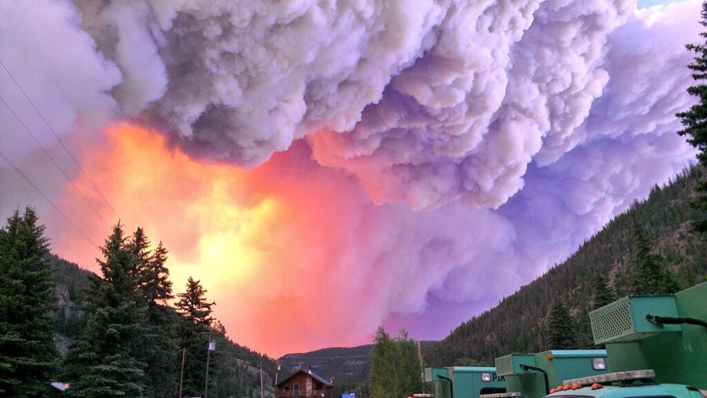
When fires raged through the eastern San Juan Mountains last summer, they left a threat to public safety even after the flames had gone out. Of the 88,000 acres burned on the Rio Grande National Forest last summer by the Papoose and West Fork fires, more than 21,000 acres of the burn scars were left with water-repellent soils. The condition, known as hydrophobicity, heightens the risk of flooding during summer and fall thunderstorms and, in part, prompted the formation of the Rio Grande Watershed Emergency Action Coordination Team.
The watershed team received $2.5 million in state funding last year for recovery work and emergency response and has installed rain and stream gauges throughout the burn scars to better detect flooding.
The team also deployed a temporary Doppler Radar to get a better picture of thunderstorms passing over the burn scar during the monsoon season. Last summer, the team placed a radar unit on Bristol Head Mountain, roughly six miles southwest of Creede. At the end of this month, the group will put a temporary unit at a new location on Lobo Overlook near Wolf Creek Pass.
“It actually gives a little bit better coverage over the burn scar,” Tom Spezze, the watershed team’s director, said.
The site is also more accessible than Bristol Head and will bring the radar unit closer to Internet and power utilities, he said.
The need for the radar stems from the inability of permanent National Weather Service radar units in Grand Junction and Pueblo to give a complete look at storms coming through the headwaters of the Rio Grande.
“There’s a black hole right there,” Spezze said.
Pamela Stevenson, a meteorologist in the weather service’s Pueblo office, said that’s because the radar units are set at such an angle that their signals rise in elevation the further they travel. By the time a signal from Pueblo’s radar reaches the burn scars, it’s at roughly 24,000 feet, she said While stronger storms are often detectable at that elevation, she said the watershed team’s temporary unit will give a better look at storms below that elevation “Definitely having the radar close to the burn scar is going to help,” she said.
Spezze said the need to closely monitor flood threats and inform locals of the dangers will likely last until vegetation can return to the sections of the burn scars with damaged soils. Spezze said that process can take anywhere from two to four years, according to discussions he’s had with officials monitoring the Hyde Park and Waldo Canyon burn scars near Fort Collins and Manitou Springs, respectively.
So far, property owners below the Papoose and West Fork scars have avoided much trouble with flooding and debris flows. The most significant event came at the end of last month when rain washed out a U.S. Forest Service Road near Shaw Lake.
Most of the significant rain since the fires have come from fast-moving storms, rather than slow-moving ones that pose a greater flood risk, Spezze said.
Colorado transmountain diversions via the State Engineer’s office
West portal Moffat Water Tunnel
Colorado transmountain diversions via the University of Colorado
Denver Water’s collection system via the USACE EIS
Colorado-Big Thompson Project Map via Northern Water
Fryingpan-Arkansas Project via the Southeastern Colorado Water Conservancy District (Click to enlarge)
From the Glenwood Springs Post Independent (Lauren Glendenning):
Climate change might not be the end-all, be-all in the state’s water discussion, but Brad Udall knows it needs to at least be a part of it.
“The proper way to deal with climate change is to get out of the scientific battles and deal with it as a risk,” said Udall, who is the director and principal investigator of the University of Colorado-National Oceanic Atmospheric Administration Western Water Assessment.
While Colorado isn’t dealing with what Udall says is the biggest climate change impact, sea level rise, it is dealing with impacts of the overall water cycle. The West faces an unprecedented 14-year drought, resulting in low water levels at Lake Mead and Lake Powell, supply-demand gaps, power losses and threats to conservation.
As the atmosphere warms, it also holds more moisture, resulting in water cycle changes. Udall said the effects are already appearing as more rain and less snow, earlier runoff, higher water temperatures and more intense rain.
The higher water temperatures are something that water conservation folks throughout the Western Slope are concerned about. At a recent Colorado Basin Roundtable meeting, Holly Loff, executive director of the Eagle River Watershed Council, introduced to the group a recent assessment of the Upper Colorado River. The study shows that elevated water temperatures are occurring in the Upper Colorado that are above the known thermal tolerance of trout.
Loff said more transmountain diversions out of the basin to the Front Range would only further affect aquatic life, which goes beyond just fish and bugs.
“It impacts everything that uses the riparian area, which is every creature,” Loff said. “Temperature, that is huge. When you take the water out [of the streams for diversions], the water that’s left heats up more. Water temperatures rise, and it completely changes the fish that want to be in that water. Our fishermen are going to see that.”
Loff said she isn’t so quick to join in on the finger-pointing to the Front Range. The Front Range has cut back on wasteful bluegrass lawns, for example, and is doing a great job in terms of per-capita water use.
“They’re actually doing much better than we are” in per-capita water use, she said. “We are all going to have to make some changes.”[…]
[Martha Cochran] points out that agriculture efficiencies could help improve water supplies, but the use-it or lose-it concept hampers progress.
Use-it or lose-it means that a water user who fails to divert the maximum amount of water that their right allows loses some of their rights the next time they go to court to transfer those rights.
“Sprinkling systems for agriculture are more efficient and use less water, they’re easier to control, you can direct them better, they’re more specific about how and when,” Cochran said. “And that’s a good thing, but it’s not [a good thing] if it means you lose your water rights because you’re not using all the water you traditionally used.”[…]
As the state crafts the Colorado Water Plan, one development holds out hope that East and West Slope entities can work together. Just last year, the Colorado River Cooperative Agreement was signed between Denver Water and Western Slope water providers and municipalities. The agreement is a long-term partnership that aims to achieve better environmental health in the Colorado River Basin, as well as high-quality recreational use.
The agreement, which included 43 parties from Grand Junction to Denver, states that future water projects on the Colorado River will be accomplished through cooperation, not confrontation. It’s debatable whether that will happen, given the finger-pointing cropping up during the draft stages of the Colorado Water Plan process.
James Eklund, director of the Colorado Water Conservation Board and head of the development of the Colorado Water Plan, believes it can happen, but he admits it won’t be easy.
“The idea is to take that paradigm shift that occurred with the Cooperative Agreement and exploit that and replicate and scale that up to the entire state,” he said. “Doing that is going to require some work.”
But positions like Loff’s that are 100 percent against more transmountain diversion projects are widespread on this side of the Continental Divide, and it’s going to take more than some conversations and a few handshakes to find some middle ground.
“The biggest thing for us, and the entire basin, is that we want to make it perfectly clear that having another transmountain diversion over to the Front Range is really going to damage our recreation-based economy,” she said. “And that it’s going to have more impacts on the environment and on agriculture. They need to understand that we’re not saying we don’t want to share the water, it’s just that there isn’t any more water to share. We have obligations through the compact [to downstream states with legal rights], so more water leaving our basin — that water doesn’t ever come back.”[…]
So that will be part of the process in the coming months as each of the nine basins drafting implementation plans polish up their drafts before sending them off to the state. Two of the Front Range basins, Metro and South Platte, are combining theirs into one document, for a total of eight plans being rolled into the Colorado Water Plan.
It’s like a community development plan that lays out a vision and direction, but it will require execution, said Jim Pokrandt, communications and education director for the Colorado River District.
“Hopefully it will address how we can get down the path of efficiency and the land use discussion,” he said. “It’s a very painful discussion, but not as painful as the need to start digging a new transmountain diversion tomorrow.”
It may not by the biggest wastewater merger in Colorado history, but Donala Water and Sanitation grew by more than 10 percent when the Academy Water and Sanitation District Board approved a resolution to connect its wastewater operations with Donala.
“Academy made the decision between Colorado Springs Utilities and us,” said Donala general manager Kip Peterson. “It makes sense for both Academy and us from a cost perspective.”
Academy, which has about 300 customers, managed its own wastewater treatment for nearly five decades. Donala has about 2,800 customers and has shown steady growth through difficult economic times in recent years.
“We’ve been talking with Academy about this merger for the last decade,” Peterson said. “We had a wastewater treatment plant already designed with that thought in mind.”
Peterson said that pipes will be laid from Academy’s lagoon on Spring Valley Drive to Donala’s collection pipes. From there, a lift station will pump Academy’s wastewater to the Donala pipes for treatment by the Upper Monument Creek Regional Wastewater Treatment Facility.
Peterson said the process will take some time and probably will not begin take place until the fall 2018, as required by Academy’s wastewater permit.
Academy’s Board was forced to make a change months ago because of new state regulations that could not be met by the district’s current lagoon treatment system. It looked at building a new plant at its current location, but the Board found that option to be much too costly.
Meanwhile, Donala’s General Manager explains why rate continue to increase in this report from Danny Summers writing for the Tri-Lakes Tribune. Here’s an excerpt:
One of Kip Peterson’s main goals as general manager of Donala Water and Sanitation is to keep an open-door policy to the folks in his District.
One of the main questions most residents want to know is why do their water rates continue to go up and why are they restricted on their outside watering?
“That is a big concern for a lot of people,” Peterson said. “And I completely understand why.”
Earlier this month, Peterson and his staff included in its newsletter to its customers a rare comparison with some local water companies. The list included Donala, Woodmoor, Woodmen Hills, Colorado Springs, Monument and Triview.
“I put it out there so folks can see for themselves, Peterson said. “I have a very strong belief that we have to remain transparent.”
Donala customers have been on water restrictions for eight years. Colorado Springs Utilities customers were on water restrictions in 2013, but that was lifted this year.
“I think that was a mistake,” Petersons said. “I think that sends a bad message to the community. Do you really want to conserve water or do you want to make money?
“(Donala’s) rate structure is intentionally designed for conservation.”
Improved weather conditions have freed up more water for the Pueblo Board of Water Works to lease, filling in a potential hole in revenues. Water leases on the spot market this year will bring in about $1.07 million, with 8,567 acre-feet (2.8 billion gallons) leased through the bidding process.
An additional 2,535 acre-feet in leases to two well augmentation groups and to Mauro Farms were approved Tuesday, bringing in $228,750, after the initial round of leases in March. The additional water is being provided because imports from the Western Slope are higher than expected, while demand in Pueblo has tapered off during a cool, wet summer, said Alan Ward, water resources manager.
Pueblo’s transmountain water sources have yielded more than 19,000 acre-feet in the first six months of this year, about 128 percent of average. More than 44,000 acre-feet of water are in storage, 114 percent more than last year at the same time.
At the same time, Pueblo pumped just above 5 billion gallons through its treated water system as of July 31, a decrease of 7.83 percent from the five-year average. The board has 39,890 accounts, which represents an increase of 324 over 2005.
Roughly two-thirds of the board’s revenue comes from metered water sales within the city, which are projected to bring in $23.3 million. However, if decreased use continues, that figure could be about $1 million less by the end of the year.
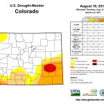
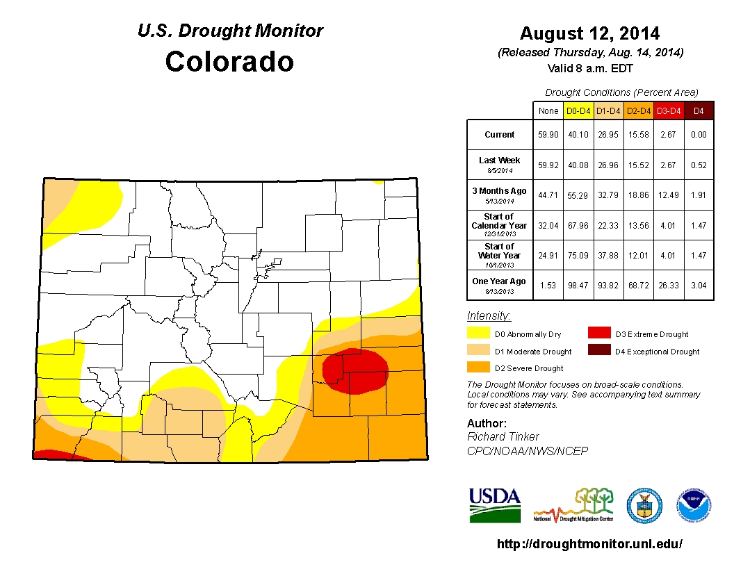
Once again, Southern Colorado has drawn the short end of the cloud. The latest state drought assessment shows that a wet, cool summer is alleviating drought conditions in much of Colorado, but the southern third of the state is still in some sort of drought condition. Parts of Crowley, Otero, Bent and Kiowa counties remain in the worst shape with extreme drought, according to the U.S. Drought Monitor, an assessment compiled by the nation’s top scientists. For other parts of the region, it is the first time in more than two years that no areas of exceptional drought — the highest stage — have been reported.
“The drought is well into its fourth year, but recent rains have brought relief,” according to a report co-authored by Taryn Finnessey of the Colorado Water Conservation Board and Tracy Kosloff of the Division of Water Resources. “It will likely take years for rangelands and producers to recover.”
In all, about 40 percent of the state remains in some sort of drought condition, which is much better than a year ago, when nearly all of the state was affected.
The good news is that much of the state is bouncing back to normal following rains that have been sufficient to douse fire danger while not causing the widespread flooding seen in 2013.
That’s not to say it’s been nothing but peaceful, gentle sprinkles. In the town of Eads, located north of Lamar, 7 inches of rain fell in just a few hours ending the dust in torrents of mud.
Statewide, Snotel weather stations are showing precipitation is 103 percent of average, while reservoir storage is at 97 percent of average. Storage and streamflow conditions remain worst in the Rio Grande basin.
July rainfall was plentiful along the Front Range, with many areas — El Paso, Huerfano and western Otero counties among them — receiving two-three times average amounts.
Temperatures during the first two weeks of August have been 3-4 degrees cooler than normal, helping to alleviate drought conditions, the report noted.
Meanwhile many eyes are watching the development of El Niño. Here’s a report from 9News (Maya Rodriguez):
Earlier this year, scientists predicted “El Nino” would be strong this year. That didn’t happen right away, but it’s picking up steam again…
For a state that’s grappled this year with heavy snow in the mountains and a severe drought in the plains, it sometimes seemed like Colorado’s weather had a split personality. With an El Nino now predicted to strengthen in the Pacific, Colorado’s winter could look different, depending on your elevation.
“When I think of El Nino, it’s giving us a little bit to hang our hats on in the very challenging world of trying to make seasonal climate predictions,” said Nolan Doesken, state climatologist for Colorado and part of the Colorado Climate Center at CSU.
Doesken said El Ninos don’t create a certainty for what the weather might bring in the future, but historically, they do show patterns.
“El Nino tips the odds a little bit towards certain factors dominating more often than ‘usual,'” he said.
One example: snowfall…
“The stronger the El Nino, the more likely we are to have some big fall and winter storms at lower elevations,” Doesken said.
Yet, the opposite can be true in the northern and central mountains, where a strong El Nino historically means less snow there…
“Winter recreationists and springtime whitewater rafters all love to watch accumulation of snow in mid-winter, but El Nino does not necessarily bode well for winter accumulations,” Doesken said, speaking about areas in the northern and central mountains.
Climatologists say there are many factors that could determine how much snow we see this winter. Still, El Nino is something they keep an eye on.
If “drought” is the villain, is “El Niño” – the climate pattern that brings our winter snows – the hero?
And if the answer is “yes,” has our hero abandoned us? What had been looking over the late spring and early summer like it could be gangbuster of an El Niño looks like it’s fizzling, slashing the odds of a wet winter to bail us out of this drought.
But maybe things aren’t as bad as all that. After a couple of recent trips up and down the Rio Grande this month, it was easy to shrug and ask, what drought?
Driving down I-25 the first weekend in August, I crossed the Rio Salado in northern Socorro County in its full flash-flood mode. Jumping off the freeway at the next exit, I drove out to see the Rio Grande roaring through the Middle Rio Grande Conservancy District’s San Acacia Diversion Dam. It was big and muddy and roiling with that unmistakable smell of a desert flash flood and, according to the U.S. Geologic Survey’s gauge just downstream of the dam, the most water at San Acacia in nearly a year.
Then last week, I drove through rain and saw many of the usually dry little arroyos between here and Las Cruces flashing with muddy thunderstorm remnants. The landscape the whole way was a lovely shade of green.
But when I pulled off in Truth or Consequences, and headed through town and up to Elephant Butte Dam, I looked down into a great big empty. Fifteen years of mostly lousy snowpacks in the upstream watersheds that feed the Rio Grande, combined with continued downstream water needs, have left Elephant Butte Reservoir in a hole that will take far more than a couple of wet months to dig out of.
The following day, I got off the freeway and drove the old road toward Las Cruces past irrigation ditches already dry and a bunch of farm fields left fallow because of the irrigation shortfalls. It was a reminder that drought is not one thing and fixing our water shortfalls takes more than a month or two of good rain.
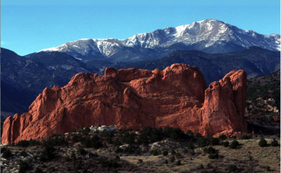
Pikes Peak with Garden of the Gods in the foreground FromThe Pueblo Chieftain (Chris Woodka):
El Paso County commissioners Tuesday voted 4-0 to put an issue on November’s ballot that would create the Pikes Peak Regional Drainage Authority to pay for storm water control. Voting for the measure were Chairman Dennis Hisey, Amy Lathen, Darryl Glenn and Peggy Littleton. Commissioner Sallie Clark was absent.
The authority would raise $39.2 million annually to address a $700 million backlog in stormwater projects in the Fountain Creek watershed.
Stormwater control is one of the premises Colorado Springs Utilities used in gaining approval from the Bureau of Reclamation and Pueblo County to build the Southern Delivery System, a pipeline to ship water from Lake Pueblo to El Paso County.
“With this step, the hard part’s over,” Hisey said.
Last week, Colorado Springs City Council approved, on a 7-2 vote, an intergovernmental agreement with El Paso County and other cities in the Fountain Creek drainage.
The next day, Mayor Steve Bach said he opposed the authority. proposals for ways to fund stormwater control within Colorado Springs.
A list of projects, which will be attached to the ballot proposal has yet to be approved, and will probably be in place by the El Paso County commission’s Sept. 2 meeting, Hisey said.
That would give Colorado Springs City Council time to review the list.
The approval is a huge step in “controlling stormwater,” said Commissioner Amy Lathen, who has played a major role in the regional stormwater task force that first met in August 2012. Dave Munger, co-chairman of the task force, was at Tuesday’s meeting and joined a small contingent who let out a smattering of applause after the commission’s vote.
Munger echoed Lathen about the need to solve stormwater issues regionally.
“Everyone, just about everyone, is aware of stormwater and its significance. Everyone agrees that it is a regional problem,” he said, noting that governments working together will create “a synergy that we’ve never realized.”
The decision appeared to be an easy one for the commissioners. But some debate arose after Colorado Springs Deputy City Attorney Tom Florczak gave the commissioners 18 projects the city insists be added to a list attached to the county’s resolution.
Florczak said the City Council did not include a project list in its resolution that passed on a 7-2 vote Aug. 12.
“The concern of the administration was that by having the list, it is limited,” Florczak said.
“It boils down to one word, flexibility,” said Steve Gardner, the Colorado Springs director of public works who was with Florczak on Tuesday.
After the City Council’s vote on the PPRDA, Mayor Steve Bach held a news conference announcing that he would not support the stormwater initiative.
More 2014 Colorado November election coverage here.
Click here to read the current update from the Colorado Water Conservation Board. Here’s an excerpt:
Mild temperatures and above average precipitation across much of the state has brought continued drought relief to the eastern plains. The four corners region is experiencing less precipitation and deteriorating conditions. Monsoon rains could potentially help alleviate the drying. Water providers indicated that storage levels remain strong, with many reservoirs near or at capacity and demands slightly below normal.
Currently, 40% of the state is in some level of drought classification according to the US drought monitor. 13% is characterized as “abnormally dry” or D0, while an additional 11% is experiencing D1, moderate drought conditions. 13% is classified as severe, 3% as extreme and for the first time in 110 weeks none of the state is in exceptional drought (D4).
Year-to-date precipitation at mountain SNOTEL sites is 103% of average, this is in part due to strong July precipitation of 122% of average. August to-date is already 90% of average.
Eads, which has been in drought for nearly 4 years, received seven inches of rain in just a few hours and for the first time in 110 weeks the southeastern portion of the state is out of exceptional drought conditions, although extreme and severe conditions persist.
Reservoir Storage statewide is at 97% of average at the end of July 2014, 26% ahead of where we were for storage this time last year. The lowest reservoir storage statewide is in the Upper Rio Grande, with 62% of average storage. The South Platte has the highest storage level at 125% of average.
The Surface Water Supply Index (SWSI) for the state is near normal across much of the state, with an “abundant” index in a few northern basins of the South Platte, Yampa/White, and Colorado. The lowest values in the state are in the Southwest and reflect very low reservoir and streamflow levels. This area of the state has not received the same moisture as the rest of the state.
The chance of El Niño has decreased to about 65% during the Northern Hemisphere fall and early winter, but it is still expected that El Niño will emerge in the next several months and persist through Northern Hemisphere winter; a weak event is most likely.
The soothing sound of the Colorado River as it meanders its way across Colorado’s Western Slope is the sound of a thriving economy, a fragile environment and also an impending crisis.
The state of water supplies in the arid West is volatile and forecasts are grim. Lake Powell and Lake Mead are at alarmingly low levels, while populations across the West are swelling past the capacities of current water supplies.
The Colorado River Basin is facing a battle of sorts as Colorado creates a statewide water plan. It’s a battle against time and against competing water needs, both here in Colorado and in lower basin states like Nevada and California.
Regionally, some view it as an Eastern Slope vs. Western Slope battle, although water officials are carefully shaping the public relations message as one of unity and collaboration. There’s a very real fear that exists west of the Continental Divide, though, that Colorado’s growing Front Range population is going to suck the Colorado River Basin dry. Some even say that has already happened…
“Population is still growing and there’s a need to find more water for municipal uses,” said Jim Pokrandt, chair of the Colorado Basin Roundtable and spokesman for the Colorado River Water Conservation District. “We don’t want to demonize the Front Range.”[…]
…the state’s water planning has really been going on for over a decade, said Brad Udall, a research faculty member at the University of Colorado’s Getches-Wilkinson Center for Natural Resources, Energy and Environment and former director of the Western Water Assessment.
Udall has written extensively about climate change issues as they relate to water resources but his passion for Western water began outside of books and classrooms. His mother took him down the Colorado River through the Grand Canyon in the early 1970s, paving the way for Udall’s future in guiding Grand Canyon river trips. After getting into environmental engineering at Stanford University and developing a passion for water issues, he also began working on climate change issues. That’s when he realized that climate change means water change. They’re one in the same, he said…
…none of the states want to go back and draft new laws based on the realistic flows, except for maybe California, [Glenn Porzak] said.
“If you go back and say, ‘We made a mistake when we negotiated, we thought there was 17 million acre feet.’ If you renegotiate, (Colorado’s) going to lose,” he said. “All water is political.”[…]
The major concern at Lake Powell is that it’s getting down to such a level that it will no longer be able to generate power, said Glenn Porzak, a water attorney based in Boulder who represents water entities and municipalities in both Summit and Eagle counties, as well as Vail Resorts.
“The cost of power is going to quadruple,” Porzak said of Lake Powell, should it drop below power generating levels. “Almost all of the Western Slope’s power comes from the power grid that’s generated off Colorado River storage projects. That hits the ski industry and every other industry if the cost of power goes up four times.”
It also hits the average citizen, who has been enjoying relatively cheap water at home, Udall said.
“You hear we’re running out of water and we gotta get more, but we’re running out of cheap water,” he said. “Water that people are putting on lawns, that shouldn’t just be free, it should come with significant costs. … One of the lessons here is that water is going to get more expensive in the municipal sector, and a little bit more in the (agriculture) sector.”
When prices are low, people over-use water, but when they’re high, conservation becomes a lot easier and more attractive. And conservation is a big theme in the first draft of the Colorado Basin Implementation Plan, which came out last month and will undergo several more revisions before it’s sent to the state later this year for incorporation into the state water plan.
From the Glenwood Springs Post Independent (Lauren Glendenning):
Nathan Fey’s passion for kayaking led him to a career in river conservation and water quality issues. As the Colorado stewardship director for the nonprofit American Whitewater, he’s watching carefully as the state progresses through its water planning process.
The state must address some major conflicts as it creates the Colorado Water Plan, he said.
“Sure, our population is focused on the Front Range, but the reason we all live here is because recreation is a way of life for us,” Fey said. “I think there’s a big disconnect for people in our urban areas about where their water comes from. They don’t understand that if they grow green grass, there’s less water in the river when they’re fishing.”[…]
Recreation along the Colorado River and its tributaries is a $9.6 billion industry, and that’s just within the state of Colorado. According to a 2012 study for Protect The Flows, done by the consulting firm Southwick Associates, which specializes in recreation economics, the Colorado River would rank as the 19th-largest employer on the 2011 Fortune 500 list based on the jobs it generates.
“People moved here for the environment — it underpins the economy,” said Jim Pokrandt, chair of the Colorado Basin Roundtable and the communications and education director for the Colorado River Water Conservation District. “Water in the streams is an economic driver in and of itself.”
The recreation-based economies in mountain resort towns depend on healthy streams for more than just the water-based activities. Indirectly, hikers, campers and mountain bikers, to name a few, also depend on healthy streams.
“That’s the value we’re hoping Colorado embraces, so the desire to push for another transmountain diversion is deferred for a long time, if not forever, in favor of using the water we already have to its highest and most efficient use,” Pokrandt said…
Pokrandt likens the process to economizing, just like any business would do during tough times. You look at internal expenses, in this case water uses, and you cut back…
With the Colorado Water Plan’s deadline more than a year away, the Colorado Basin Roundtable is polishing its plan to make sure it gets the point across that more transmountain diversions would be detrimental to tourism economies, the environment and agriculture…
In the mountains, many of the major water providers such as the town of Breckenridge, the Upper Eagle Regional Water Authority and the Eagle River Water and Sanitation District, have senior, or pre-compact, water rights. The same goes for the Grand Valley and Grand Junction areas, said water attorney Glenn Porzak, who represents those entities as well as Vail Resorts and other local municipalities.
“The water rights really affected the most (under a compact curtailment) are all of the transmountain diversions,” Porzak said. “Fifty percent of Denver’s supply comes from the Dillon and Moffat systems and are post-compact. All of the Northern Colorado Conservancy District comes from the Thompson project, also junior. All of Colorado Springs and Aurora diversions are junior to the compact.”
When 75 percent of the Front Range supply comes from junior diversions, Porzak said it’s clear what municipalities will do: They’ll buy up more senior agriculture rights for the Western Slope.
More Front Range municipalities buying Western Slope agriculture water rights depletes rivers. When the water is diverted over the Continental Divide, it never returns to the basin. That affects flows, which affect water quality, stream health and the economic powerhouse that is recreation-based tourism…
The ski industry is the pulse of Summit, Eagle and Pitkin counties during winter months. Water is the source of winter-based recreation, but the fact that it doesn’t always fall from the sky at the right times or in the right quantities means water must be taken from elsewhere.
Aspen Skiing Co. and Vail Resorts have bought and maintained important water rights since the beginning of each company’s existence…
Predictability like a start date for the season — something the company typically announces during the previous ski season — is crucial to lock in season pass sales. Without important water rights and water supplies, Hensler said opening for Thanksgiving might be impossible, and Christmas would even be a challenge…
Hensler points out that snowmaking is only about 20 percent consumptive.
“About 80 percent of the water we put on the mountain as snow melts and flows back into the streams — it’s a very sustainable use,” Hensler said.
The Eagle River Watershed Council is celebrating the 20th year of the Eagle River Cleanup. In 1994, before the formation of the Watershed Council, the local Trout Unlimited chapter organized the inaugural Eagle River Cleanup. There were two tents and 24 volunteers, half of which were Vail Resorts ski patrollers equipped with radios and trucks. There was a silent auction, which included a Vail season pass and raised a total of $400.
In the past 20 years, the Eagle River Cleanup has grown tremendously and become a fall tradition for many environmentally and community-minded families, groups and companies. This year, nearly 350 volunteers are expected to help care for our local waterways in the 20th annual Eagle River Cleanup on Sept. 13. This popular, countywide event is organized by the Eagle River Watershed Council, presented by Vail Resorts Echo, sponsored by many businesses and supported by volunteers from Red Cliff to Dotsero to East Vail.
Massive Community Effort
From 9 a.m. to noon, teams of volunteers will be cleaning up the banks of Gore Creek and the Eagle and Upper Colorado rivers. All told, this massive community effort will clean nearly 70 miles of river throughout Eagle County.
Following the cleanup, volunteers and their families are invited to the Broken Arrow at Arrowhead from noon to 2 p.m. for a free thank you barbecue provided by the Arrowhead Alpine Club. The party features music from local Minturn favorites, the Turntable Revue, beer from Crazy Mountain Brewing and a raffle for the entire family.
Volunteers Needed
More volunteers are always needed. Call the ERWC office at 970-827-5406 or email us at serrill@erwc.org to confirm your usual segment, sign up for a new one or join an existing team. Volunteers meet on the river at assigned locations on the day of the event, so you must pre-register in order to know where you’re needed most.
The Eagle River Watershed Council has a mission to advocate for the health and conservation of the Upper Colorado and Eagle River basins through research, education and projects.
Click here to go to the National Climactic Climate Center website. Here’s an excerpt:
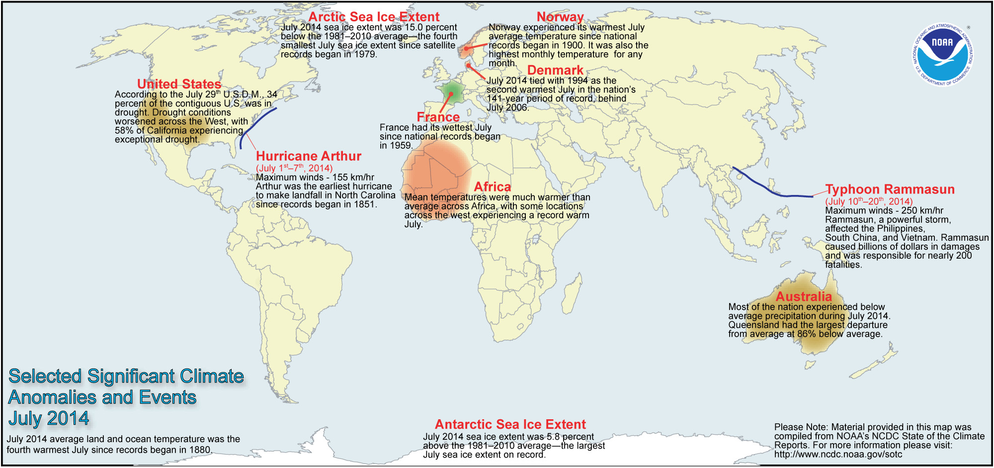
Global Highlights
The combined average temperature over global land and ocean surfaces for July 2014 was the fourth highest on record for July, at 0.64°C (1.15°F) above the 20th century average of 15.8°C (60.4°F).
The global land surface temperature was 0.74°C (1.33°F) above the 20th century average of 14.3°C (57.8°F), marking the 10th warmest July on record.
For the ocean, the July global sea surface temperature was 0.59°C (1.06°F) above the 20th century average of 16.4°C (61.5°F), tying with 2009 as the warmest July on record.
The combined global land and ocean average surface temperature for the January–July period (year-to-date) was 0.66°C (1.19°F) above the 20th century average of 13.8°C (56.9°F), tying with 2002 as the third warmest such period on record.
Colorado transmountain diversions via the State Engineer’s office
Hayfield message to President Obama 2011 via Protect the Flows
Flood irrigation in the Arkansas Valley via Greg Hobbs
Crop circles — irrigated agriculture
Colorado River Basin including out of basin demands — Graphic/USBR
From the Glenwood Springs Post Independent (Laura Glendenning):
Gary Bumgarner doesn’t like to hear statistics that say irrigated agriculture makes up 85 percent of Colorado’s consumptive water use. It’s misleading, he says, and as a fourth-generation Grand County rancher with senior and junior water rights, he knows a thing or two about water.
Agriculture uses the same water more than once, he says, referring to return flows and downstream water uses. Transmountain diversions use water up and never return it. It’s known as consumptive use in the water world, meaning the use permanently removes the water from its natural stream system. Bumgarner and plenty of other ranchers and farmers argue that the agriculture industry’s share of the total consumptive use in Colorado is much less than 85 percent.
More than half the water in Grand County heads east to the Front Range through transmountain diversions, which has Bumgarner concerned about the current statewide water planning process, sure, but he’s more concerned about what has already happened to water in the Colorado River Basin.
Bumgarner, who is also a Grand County commissioner, remembers when his mother used to have to cross high water in a rowboat on her way up to Kremmling, he said.
“In my teens and 20s, there was so much water,” he said. “Now, it’s a pretty stark contrast.”
When a river is over-developed — meaning too much water is taken from it — danger lurks. The effects range from water quality issues to riparian habitat depletions to economic and recreational devastation.
The agriculture industry in Colorado has a bull’s-eye on it as the state creates its Water Plan. Municipalities want to buy up senior agriculture water rights to secure supplies that can meet the demands of population growth — it’s known as “buy and dry” — and being that the agriculture industry uses more water than any other, it has found itself at the center of the discussion.
At a recent Colorado River Basin Roundtable meeting, Bumgarner and others brought up the consumptive use point time and time again. The agriculture representatives at the roundtable want to be sure there’s more clarification in the Colorado Basin Implementation Plan before it’s sent off to the state.
Six themes have emerged from the first draft of the basin’s plan, one of which is to “sustain agriculture.”
That’s the million dollar question. Senior agriculture water rights are private property rights, meaning the owners can do whatever they want with their property — including buy, sell and transfer their water rights. If a Front Range municipality wants to come in a buy the rights, and the farmer or rancher wants to sell, there’s not much anyone can do to stop it.
“If you’re making money, it’s sustainable. If you’re not making money, it’s not sustainable,” Bumgarner said. “Do I want my neighbor to sell out? No. Do I want the ability to sell out? Yes.”
Bumgarner said the agriculture industry has to be nimble in order to sustain itself. His family has changed its operations around three times from a dairy farm to a sheep operation to its present day business of cattle and calves.
“(Agriculture) has to learn to adapt,” he said. “Just because I do it, doesn’t mean my kids or grandkids should be doing it. It’s no different than any job. What you’re doing today doesn’t mean you should be doing it in 120 years.”
Reducing the stress on the basin
The Colorado Basin Implementation Plan does include projects and policies that “provide incentives and protections necessary to support agriculture.”
It also calls for improved water laws that would allow the agriculture community the flexibility to implement efficient irrigation without the loss of water rights.
“An additional (transmountain diversion) that supports more bluegrass lawns on the Front Range while decreasing Colorado Basin irrigated agricultural lands and associated food supply is poor planning and not sustainable,” the draft reads.
But the level of conservation that irrigation efficiencies could create is debatable. Much of the water lost through irrigation inefficiencies returns to the river or groundwater system for use by downstream water diverters, according to a 2008 Colorado Agricultural Water Alliance study, “Meeting Colorado’s Future Water Supply Needs.”
“Increased agricultural water conservation could potentially result in a voluntary reduction in the diversion of water to the farm, creating benefits such as improved water quality, allowing more water to remain in the streams, reduced waterlogging of soils, and reducing energy costs for pumping, but may not result in water that can be legally transferred to other uses,” according to the study. “If the use of water conservation measures can improve water supply availability without causing injury to downstream users or the environment, then the result may be improved water supplies for agriculture and other uses.”
Irrigation for agriculture isn’t the only water use under conservation scrutiny. Homeowners with non-native landscaping such as Kentucky bluegrass lawns could also start to face regulations and consequences, or at the very least some dirty looks from the neighbors.
Talk to Western Slope water officials and conservationists, and you’ll hear a lot of criticism over bluegrass lawns along the Front Range, as well as in the High Country — and especially in resort towns where $20 million homes spare no expense for opulence.
Martha Cochran, executive director of the Aspen Valley Land Trust, thinks Coloradoans have to start thinking differently about water resources and personal responsibility. She thinks a new standard could emerge for home landscaping that shuns those with bluegrass lawns, but that day will never come if citizens don’t become more educated about water resources. It also might not happen without government regulation.
“I think we can do huge amounts to reduce what’s creating the stress on the basin,” she said. “There was a time when (bluegrass lawns and swimming pools) were kind of a symbol of prosperity. I think that some day it’s going to be looked upon as just tacky.”
Municipalities are teaching and encouraging xeriscaping, a practice in which native plants and grasses, mulch and other low-water landscaping replaces landscaping that wastes water such as bluegrass.
An informed citizenry is the best protection for Western Slope water, said Jim Pokrandt, chair of the Colorado Basin Roundtable and spokesman for the Colorado River Water Conservation District.
“If you turn on your faucet and water didn’t come out, you’d be interested real fast,” he said.
Values differ across the state
With more than a decade of persistent drought conditions, there’s a focus on conservation. The U.S. Department of the Interior and municipal water suppliers in Arizona, Colorado, California and Nevada signed a landmark water conservation agreement last month called the Colorado River System Conservation Program. The suppliers — which include Denver Water in Colorado — are contributing $11 million to fund pilot conservation projects on the Colorado River.
And municipalities across the Western Slope like Aspen, Winter Park and Snowmass are looking at both conservation efforts and also land use codes that limit growth based on water supplies.
The City of Aspen has also incorporated a Center for Resource Conservation Slow the Flow Sprinkler Inspection program for the past two years, and the Eagle River Water and Sanitation District offers a similar program through certified irrigation professionals.
These are all steps applauded by conservation groups like Western Resource Advocates. Water Program Director Bart Miller said if Colorado and the Colorado River Basin as a whole can do the right amount of urban conservation, water recycling, irrigation and energy efficiencies, the vast majority of future water needs should be met.
“I think the state Water Plan provides a really unique opportunity, the first ever opportunity for the state to embed, articulate and follow through on the broad range of values that folks across the state have,” he said.
While great opportunities exist, it’s also a safe bet to assume the state water plan won’t please all stakeholders — there will likely be some grumbling from each of the basins, but the hope is the plan can strike the right balance so it’s not about Eastern Slope versus Western Slope, said James Eklund, director of the Colorado Water Conservation Board and the state water plan’s development director.
“Doing that is going to require some work,” he said. “(Colorado’s Water Plan) won’t read exactly the way every stakeholder wants it to.”
Western Slope stakeholders like Bumgarner fear the worst for the Western Slope: More transmountain diversions.
“I don’t think there’s any doubt that they’re going to come get more water, and (agriculture) will be the loser — and the tourism industry,” he said. “You’re not going rafting on rocks if there’s no water. I’m very much anti-government getting into things, but at some point the state has to figure out how many people the state can contain. We’re not going to get more water, and we’re going to double the population, so they have to take it from existing users.”
Part three in this series will explore the relationships between water and Western Slope economies. It will appear in Tuesday’s PI.
Typical water well Click here to read the newsletter. Here’s an excerpt:
Mark your calendars for a Drinking Water Well hands-on workshop on September 3rd from 5:30 to 7:00 PM hosted by the Middle Colorado Watershed Council. This evening event is designed to assist private land owners in insuring their wells are operable and clean. The workshop will cover:
Where does your water come from?
Basic well construction and components
Land use impacts on domestic well water quality and quantity
Naturally occurring contaminants
Treatment issues related to domestic wells and water quality
Well head protection and well-owner operation and maintenance tips
How to sample your well water, what to sample for, and where to find a laboratory.
From the Associated Press (Seth Borenstein) via The Pueblo Chieftain:
More than two-thirds of the recent rapid melting of the world’s glaciers can be blamed on humans, a new study finds. Scientists looking at glacier melt since 1851 didn’t see a human fingerprint until about the middle of the 20th century. Even then only one-quarter of the warming wasn’t from natural causes. But since 1991, about 69 percent of the rapidly increasing melt was man-made, said Ben Marzeion, a climate scientist at the University of Innsbruck in Austria.
“Glaciers are really shrinking rapidly now,” he said. “I think it’s fair to say most of it is man-made.”
Scientists fault global warming from the burning of coal, oil and gas as well as changes in land use near glaciers and soot pollution. Glaciers in Alaska and the Alps in general have more human-caused melting than the global average, Marzeion said.
The study is published Thursday in the journal Science.
The research is the first to calculate just how much of the glacial melting can be attributed to people and “the jump from about a quarter to roughly 70 percent of total glacier mass loss is significant and concerning,” said University of Alaska Fairbanks geophysicist Regine Hock, who wasn’t part of the study.
Over the last two decades, about 295 billion tons (269 billion metric tons) of ice is melting each year on average due to human causes and about 130 billion tons (121 million metric tons) a year are melting because of natural causes, Marzeion calculated. Glaciers alone add to about four-tenths of an inch of sea level rise every decade, along with even bigger increases from melting ice sheets — which are different than glaciers — and the expansion of water with warmer temperatures.
Marzeion and colleagues ran multiple computer simulations to see how much melting there would be from all causes and then did it again to see how much melting there would be if only natural causes were included. The difference is what was caused by humans.
Scientists aren’t quite certain what natural causes started glaciers shrinking after the end of the Little Ice Age in the middle of the 19th century, but do know what are human-causes: climate change, soot, and local changes in land use.
There is a sizable margin of error so the 69 percent human caused can be as low as 45 percent or as high as 93 percent, but likely in the middle.
“This study makes perfect sense,” said Pennsylvania State University glacier expert Richard Alley, who wasn’t part of the research. “The authors have quantified what I believe most scientists would have expected.”
Not all of the human-caused melting is from global warming from the burning of fossil fuels, but climate change is the biggest factor, said Ted Scambos, a scientist at the National Snow and Ice Data Center.
The study showed that it took time for global warming and other factors to build up and cause melting. That lag effect means the world is already locked into more rapid melting from the warming that has already occurred, Marzeion and Alley said.
Anyone up to applying a mathematical model to the butterfly effect?
The Arkansas Basin Roundtable is trying to develop a model that shows how changes in water use in one area affect flows elsewhere.
Called SWAM (simplified water allocation model), the latest addition to a growing base of knowledge is a $100,000 grant request from the Colorado Water Conservation Board to refine hydrologic models of the Arkansas River basin and analyze shortages that could occur — for both farms and cities — by the year 2050.
“This would be a scaled-down model that would give you an idea of the impact,” said Terry Scanga, general manager of the Upper Arkansas Water Conservancy District.
“Other basins have decision support systems,” said Alan Hamel, who represents the basin on the Colorado Water Conservation Board. “We’re years out from the development of a full basin model.”
The decision support system for the Arkansas River was delayed by the CWCB because of the federal Kansas Colorado lawsuit over the Arkansas River Compact. But major changes in hydrology occurred during the course of the 24-year lawsuit, including farm dry-ups, increased storage and pipeline construction.
Questions of harm to water rights were decided by lawyers and engineers, rather than a common scientific model. As it stands, the use of a model raises as many questions as it answers.
Roundtable members asked whether this particular model could solve the questions of water rights vs. flood control on Fountain Creek, change the amount of water owed to Kansas or reveal which water rights are harmed by a decision.
“This is a broader scope,” Scanga said.
The study would probably build on existing water balance studies for portions of the river. Some of the existing models were developed for a specific purpose, and don’t reflect overall impacts.
The new project will attempt to look at how municipal, industrial, agricultural, environmental and recreation uses of water would be affected by projects in wet, normal or dry years. It will also evaluate likely future conditions under various rates of growth.
The study won’t change water laws within the state, alter the allocation of water under the compact or prevent a drought, but it might help parts of the basin prepare for changes.
“We’re hoping that we get this right,” said Jay Winner, general manager of the Lower Arkansas Valley Water Conservancy District.
San Luis Valley Groundwater From the Valley Courier (Ruth Heide):
Years in the making, rules to govern wells in the San Luis Valley are likely one meeting away. In Alamosa yesterday Colorado Division of Water Resources State Engineer Dick Wolfe told the advisory group assisting his office in developing the rules that he expects next month’s meeting to be the last one before he submits groundwater rules to the water court.
“We have been working at this a long time now,” Wolfe said. “We would like to get this through.”
One of the goals of the rules is to reach sustainability in the confined (deep) and unconfined (shallow) aquifers in the Rio Grande Basin, which encompasses the San Luis Valley. The state legislature has set that sustainability benchmark as the time period between 1978 and 2000, and the rules specify how that goal will be determined and reached.
Wolfe said the peer review team, which has overseen the technical aspects associated with the rules, will be meeting again on Monday to finalize changes to the g r o u n d w a t e r m o d e l t h a t will be used to implement the rules. They will finalize response functions within the next few weeks, Wolfe added, and the final draft of the rules should be ready about this time next month.
Wolfe said anyone with further comments at this point should submit them to Deputy State Engineer Mike Sullivan.
“I envision about a month from now will be the last meeting and would envision very shortly thereafter being in a position to submit these to the water court for their consideration,” Wolfe said.
After Wolfe submits the groundwater rules to the court, objectors and supporters will have 60 days to file responses. If there are objections to the proposed rules, the judge will have to set a trial date to deal with objections that have not yet been resolved by that date. Wolfe said in Division 2, there were 21-22 objections filed , but the state was able to resolve all of the issues raised in the objections short of a trial.
“I hope we get to do that on these. We would like to get these implemented and operational,” he said.
The rules will become effective 60 days after publication or after all protests have been resolved, in the event there are protests.
Trying to minimize the objections that might arise over proposed groundwater rules, Wolfe set up an advisory group at the onset of the rulemaking process. In January 2009 he signed an order establishing the advisory committee, which includes representatives from senior and well user associations, residents from the basin’s various geographical areas, canal and irrigation companies , municipality and county designees, federal and state agencies, engineers and water attorneys. The initial group, comprised of 56 members , met for the first time in March of 2009. At that time Wolfe told the group he hoped to submit well regulations to the water court by the end of that year.
The process took longer than initially expected, in part due to the laborious development and revision of the groundwater model, the Rio Grande Decision Support System.
The arduous process may soon be over, however. Advisory group member LeRoy Salazar told Wolfe yesterday he hoped the rules would be ready by October so the farmers and ranchers could have time to review them in the winter months when they are not as busy.
“I think we are almost there,” Salazar said. “We appreciate all the work so many of you have done getting these rules.”
Wolfe explained as he went through changes in the proposed rules yesterday that most of the modifications now are for the purpose of clarity, consistency and flexibility within the document.
One new definition introduced into the document during yesterday’s meeting was composite water head, the metric by which sustainable water supplies will be evaluated and regulated. The composite water head represents water levels or artesian pressures of an aquifer system within specified areas. It is derived from the annual measurements collected outside of the irrigation season of multiple monitoring wells, water level or artesian pressure and applies weighting within the specified areas. The metric will refer to the change in the composite water head from a baseline rather than an aquifer’s absolute elevation.
Water Division 3 Assistant Division Engineer James Heath explained that this is not based on individual wells but composite water head representative of different areas throughout the Valley that have been divided into four response areas: Conejos Response Area; Alamosa La Jara Response Area; Saguache Response Area; and San Luis Creek Response Area.
“Each well would have its own percentage based on the area it represents,” he said. Wolfe said the water division has been working with the Rio Grande Water Conservation District to add new monitoring wells in areas where there might not be sufficient existing wells to provide representative data.
Those are scheduled to be in place by March 2015, which will serve as a baseline for the groundwater rules. Wolfe said the model would utilize the data that has been gathered over time as well as the new data, which will fill in some gaps that have existed in data collection. He added within 10 years after the effective date of the rules his office, using the model and all of the collected well monitoring data, should be able to establish with a fair amount of confidence the historical average composite water head for each response area for 1978-2000 , the sustainability target set by the state legislature.
“That’s what we are building back to,” Wolfe said. Heath said the new data would be calibrated into the model, which can go back in time to extrapolate the 1978-2000 ranges not available in existing data.
“This 10-year time frame gives us time to add in additional information ” that will better give us confidence when estimating the water levels in these locations going forward.”
The rules require that after five years the composite water head in each response area must be above the minimum level it was in 2015, the starting point.
“If not, there’s a provision they’ve got to reduce their pumping levels back to what they were in the 1978-2000 period,” Wolfe explained. The next benchmark is at 10 years and the next at 20 years, Wolfe added. Between the 11th and 20th years, composite water levels must be maintained above the 1978-2000 range for at least three out of 10 years, Wolfe explained.
“Once we reach the 20th year, they’ve got to meet absolutely that sustainability requirement from that point forward ” This is just the first step in that process getting there.”
Salazar said the 1978-2000 target set by the legislature may have been based on faulty assumptions and may need to be modified.
“I guess in the end we may need to go back to the legislature and say it didn’t make sense to do what you did,” Salazar said. “We didn’t have the database we needed.”
Wolfe said the data collected from this point on may confirm the need to go back to the legislature, but “what this does is gets us started on the path so we can collect data we need.”
He added, “We may have to come back and amend the rules at some point.”
He said the primary purposes of this plan are to protect senior water rights and reach sustainability, and if the plan needs to be modified in the future, the state can go back to the court to do that.
Pat McDermott from the water division office said the state is recognizing this basin has finite water supplies.
“We have to learn to live within our means,” he said. “That’s what this is all about.”
New Saint Vrain River channel after the September 2013 floods — photo via the Longmont Times-Call From the Loveland Reporter-Herald (Craig Young):
The city received its first FEMA reimbursements for flood losses this week — four checks totaling $1.66 million.
The checks came through the Colorado Office of Emergency Management, the state agency that is funneling Federal Emergency Management Agency payments to local governments.
Loveland suffered almost $24 million in infrastructure losses during the Sept. 12-13 flooding, and city finance director Brent Worthington said he expects FEMA to cover about $9 million of that.
Normally, FEMA pays 75 percent of eligible expenses, and local governments cover the rest. Last fall, Gov. John Hickenlooper pledged that the state would split that 25 percent remainder with city and county governments.
Worthington said the state’s share will be about $1.5 million, but Colorado won’t pay until each project is completed and the state does a complete review of the work.
“They’re doing advances of 50 percent of the FEMA share,” Worthington said. “They will hold back the remainder.”
The first checks from FEMA went to cover mostly water and sewer line repairs and replacements — $792,458 for emergency protective measures to save a 48-inch waterline in the first days of the flood, and $777,865 for water and sewer line repairs including replacement of the city’s “Meadow Pipeline,” according to a press release.
Colorado Water Plan website screen shot November 1, 2013
Click through to listen to the radio show. FromKRCC (Sam Fuqua):
“Civilization in this part of the world,” Preston says, “is really based on capturing the runoff that comes out of the snowpack, storing it, and being able to deliver it when it’s needed. Without that, this reverts to desert.”
Preston also coordinates the Southwest Basin Roundtable, a regular gathering of agricultural, municipal, environmental, and recreational water users…
In the Southwest Basin, Preston says some of the roundtable’s conversations have centered around balancing agriculture and the environment.
“A lot of the challenge—and I think the roundtable’s done a very good job of it, because everybody gets along and tries to understand each other’s perspectives,” Preston says, “is how you reconcile or integrate the need for agricultural deliveries with the environmental values and keeping kind of adequate water in the streams.”
Trying to support healthy ecosystems and a healthy farm and ranching economy with limited water is a big challenge, but add to that the state’s projected population growth of 5.5 million now to over 10 million by 2050.
Then, says James Eklund, director of the Colorado Water Conservation Board, there’s drought.
“We’ve had it over our history,” says Eklund. “What makes it unique now, or different now, is that we are seeing patterns of extreme drought in more sustained periods than we’ve ever seen them in our history. The Colorado River basin has been in a 14-year period of drought that has not been equaled in human recorded history.”[…]
There’s broad agreement that one of the biggest issues for the Colorado Water Plan—both now and in the foreseeable future—is the question of transbasin diversions. That’s the technical term behind moving water from the Western Slope to growing cities on the Front Range. It’s always been a sensitive topic, and the Delores Water Conservancy District’s Mike Preston says his basin roundtable favors tougher limits on household water use, especially on lawns.
“People aren’t really interested in bringing the Colorado River across the Continental Divide and diminishing agricultural potential in order to grow bluegrass in front of suburban households.”
Colorado Water Conservation Board director James Eklund says he’s seeing more cooperation from Front Range cities looking for more West Slope water.
“They’re saying that kind of for the first time,” Eklund says. “Saying, ‘We understand that even though we have a legal right to go take that water because we secured those rights a long time ago, we’re not just going to go do it because it’s something that we can do and we’ll see you in water court.’”
Eklund says the state water plan will not supersede prior appropriation– Colorado’s seniority-based system of water laws. But, he says, prior appropriation may need to bend to reflect the changing times, just as it’s done for over a century.
“Prior appropriation has had to either adjust or flex in each one of those times,” Eklund says, referencing the growth of cities and the agriculture economy across the state, as well as environmental needs, and even the connection between surface and ground water.
The Yampa-White-Green Rivers Basin Roundtable gave preliminary approval to the first draft of their Basin Implementation Plan on July 23. The plan now will be submitted to the Colorado Water Conservation Board, which will consolidate plans from the nine Colorado water basins and develop a State Water Plan to be delivered to the governor by December 2015.
The BIP addresses our basins’ responsibilities to balance current and future needs of our water resources. Development of this document has been a labor of love and concern by countless volunteers and a culmination of years of professional studies commissioned by the roundtable.
Our roundtable identified eight primary basin goals for Northwest Colorado:
• Protect existing decreed and anticipated future water uses in the Yampa-White-Green basins.
• Protect and encourage agricultural uses of water in the basins within the context of private property rights.
• Improve agricultural water supplies to increase irrigation land and reduce shortages.
• Identify and address municipal and industrial water shortages.
• Quantify and protect non-consumptive water uses.
• Maintain and consider the existing natural range of water quality that is necessary for current and anticipated water uses.
• Restore, maintain and modernize water storage and distribution infrastructure.
• Develop an integrated system of water use, storage, administration and delivery to reduce water shortages and meet environmental and recreational need.
The roundtable acknowledges long-standing discussions of trans-mountain diversions of West Slope water to the East Slope and are taking a position that prior to any development of a new trans-mountain diversion, the Front Range first must integrate all other water supply solutions including conservation and reuse plus maximize use of its own native water resources and existing trans-mountain supplies.
The BIP also states: “Before it could be considered by the Yampa-White-Green Basin Roundtable, any proposed trans-mountain diversion out of the Colorado River Basin must undergo a full operational analysis to determine its impact on the entire river system. The analysis must recognize that, within the Colorado River system, the diversion of any ‘extra’ water available during wet years may occur under certain ‘trigger’ conditions of a full (or nearly full) supply in reservoirs designed to carry the Colorado River Basin through a drought. This analysis must be sufficient to determine that the risks of operating project(s) in a junior manner to identified Colorado River Basin needs are understood by all. Such a project should not be funded by the state of Colorado, but by interests, public and/or private, willing to accept such operational and financial risk.”
Future projects and agreements cannot impact existing legal compact obligations to provide water to downstream users…
The current BIP, as presented to Colorado Water Conservation Board, is a working document. The roundtable continually will update and refine it in response to the needs and demands of our region. It is available for public review on the Colorado Water Conservation Board website at http://www.colorado.gov/pacific/cowaterplan/yampa-white-green-river-basin.
A project to restore a small portion of Fountain Creek could have benefits for longer reaches.
“There are 51 miles of bank on each side of the creek from Colorado Springs to Pueblo,” said Larry Small, executive director of the Fountain Creek Watershed Flood Control and Greenway District. “Now we know a method to use to control erosion.”
Small was giving a report to the Arkansas Basin Roundtable, which gave the green light to a $146,000 state grant toward the $189,000 project last year to undertake the project on Frost Ranch, located in El Paso County about 25 miles north of Pueblo.
The project restored the channel and fortified the bank along 480 feet of the Frost Ranch. Past floods had eaten away about 70 feet of the bank, including vegetation. Three tiers of dirt secured by netting rising about 4 feet were chosen as the way to restore this particular area. About 7,500 willow plants, along with grasses and other vegetation to hold the shore.
Work began in April and was completed in mid-May.
The first test of the work came on May 23, when the creek swelled to 3,000 cubic feet per second, rising nearly to the top of the newly constructed embankment, Small said. The work held, and the moisture spurred plant growth. About 75 percent of the plants survived.
A larger wave of water, 5,000 cfs, came on July 23. While some of the water overtopped the bank and deposited sand along the top, the bank stayed in place.
The roundtable applauded the district’s efforts.
“Frost Ranch has been an excellent neighbor to the creek,” said SeEtta Moss of Canon City, who was appointed to the roundtable to represent environmental interests. “I’m delighted to see what’s been done.”
Arkansas Valley Conduit Comanche North route via Reclamation FromThe Pueblo Chieftain (Chris Woodka):
The Arkansas Valley Conduit has received $2 million for the current fiscal year through reprogramming of funds within the Bureau of Reclamation, according to Colorado Democratic U.S. Sens. Michael Bennet and Mark Udall.
“Folks in Southeast Colorado have been waiting a long time for the federal government to fulfill its promise to build the Arkansas Valley Conduit,” Bennet said. “Making these resources available for the conduit is crucial to completing this phase of the project and moving it one step closer to completion.”
Earlier this year, the senators backed legislation that loosened purse strings within the Bureau of Reclamation and allowed for transfer of funds to projects such as the conduit, which was first authorized in the 1962 Fryingpan-Arkansas Act.
The Southeastern Colorado Water Conservancy District, sponsor of the project, was dismayed when President Barack Obama’s budget submitted to Congress contained only $500,000 in funding this year. More was needed to complete planning and feasibility analysis before the design work and land acquisition can begin.
“Southern Coloradans have been counting on the Arkansas Valley Conduit’s construction for access to clean drinking water — they’ve been waiting long enough,” Udall said.
U.S. Reps. Scott Tipton and Cory Gardner, both Colorado Republicans, also support the conduit and applauded the news.
“This completion of the Arkansas Valley Conduit will ensure the continued delivery of clean drinking water to families, agriculture producers and municipalities throughout Southeastern Colorado,” Tipton said.
The $400 million conduit is in its early stages, having gained approval last year from Reclamation for the 120-mile route from Pueblo Dam to Lamar and Eads.
It would serve 50,000 people in 40 communities by providing filtered drinking water. Most of the communities along the route rely on wells and many of them are facing water quality compliance issues that could force more expensive alternatives to the conduit.
“The support we have gotten from Congress, Gov. John Hickenlooper and James Eklund of the Colorado Water Conservation Board has been tremendous,” said Jim Broderick, executive director of the Southeastern district. “This will allow us to move the project forward as was intended more than 50 years ago.”
Hickenlooper praised the decision: “We have worked closely with all parties to stress the need for this conduit and will continue to support Southeastern and local government in the hard work to bring this project to fruition.”
Gov. John Hickenlooper today released the following statement on the Bureau of Reclamation’s decision to redirect $2 million to fund the Arkansas Valley Conduit.
“The Arkansas Valley Conduit will serve 50,000 people in more than 40 communities in southeastern Colorado. We commend the Bureau of Reclamation for prioritizing this project and thank the leadership of the Department of the Interior, Southeastern Colorado Water Conservancy District, as well our congressional delegation for ongoing efforts to deliver funding for this critical project. We have worked closely with all parties to stress the need for this conduit and will continue to support southeastern and local government in the hard work to bring this project to fruition,” Hickenlooper said.
The conduit, a water pipeline originally envisioned as part of the federal Fry-Ark Project legislation in 1962, will assist communities experiencing high water treatment costs by providing water from Pueblo Reservoir. The latest funding will assist with preconstruction costs associated with the 130-mile project.
More Arkansas Valley Conduit coverage here and here.
Thompson Creek via the Summit County Citizens Voice
From the Glenwood Springs Post Independent (John Stroud:
A second round of baseline water quality testing within the Thompson Divide region south of Glenwood Springs where natural gas development is proposed finds that two of the major drainages where samples were taken are presently “uncontaminated by any human activities.”
The study, released Thursday by the Thompson Divide Coalition, analyzed both surface and ground water within the Four Mile and Thompson Creek watersheds.
It is in follow-up to the first phase of the study in 2009-10, which produced similar results. Both studies were commissioned by the coalition, which is working to protect the Thompson Divide region from drilling, and were conducted by researchers from the Roaring Fork Conservancy.
Robert Moran, a water quality, hydrogeologic and geochemical specialist with Michael-Moran Associates, worked with the conservancy to analyze the data and is the main author of both reports.
Together, the baseline data contained in the studies should provide a yardstick against any changes in water quality within the two drainages, whether it’s from oil and gas development or other activities, Moran said during a telephone press conference Thursday arranged by Thompson Divide Coalition Executive Director Zane Kessler.
Moran also reiterated one conclusion in his analysis, which is that “some degradation of water quality is inevitable if oil and gas exploration and development becomes a reality within the Four Mile Creek and Thompson Creek watersheds.”
“This should serve as an important reminder that our fisheries and watersheds in the Thompson Divide are at risk,” Kessler said. “These watersheds are the lifeblood of our communities and they deserve to be protected for posterity.”
City of Glenwood Springs proposed whitewater parks via Aspen Journalism
Click through for the graphics. FromAspen Journalism (Brent Gardner-Smith):
American Whitewater and Western Resource Advocates have joined a long list of other parties in state water court now scrutinizing an application from Glenwood Springs to create water rights for three new whitewater parks on the Colorado River.
The two conservation groups were allowed on June 6 by water court judge James Boyd to intervene in the case, even though they had missed the original deadline to do so.
Glenwood Springs applied for a new water right on Dec. 31, 2013. The 60-day deadline to file a “statement of opposition” in the case was Feb. 28.
The court received 13 such statements, which despite their name, also can be a way for other parties to conveniently monitor a case or actually be in support of an application.
Both American Whitewater and Western Resource Advocates support Glenwood’s application, which would secure a right to a “recreational in-channel diversion,” or RICD, in which river water is diverted through concrete structures embedded in a river channel, but otherwise not diverted or consumed.
The conservation groups said they should be allowed to join the case because they were concerned, in part, about Glenwood’s resolve in water court “to pursue a full suite of flows” after seeing statements of opposition come in from Aurora, Colorado Springs and other powerful water interests.
“We were a little surprised by how much opposition there was, especially from some of the heavy hitters on the Front Range,” said Rob Harris, a staff attorney with Colorado Resource Advocates who was the lead attorney for both his organization and American Whitewater. “We just wanted to make sure that the city had some allies and that voices in support of recreation were heard.”
Three parks, six waves
Each of the three whitewater parks Glenwood Springs is proposing to build on the Colorado River would have two concrete control structures embedded into the river to create ridable waves — as well as clear passage — for everything from commercial rafts to pool toys.
The uppermost park on the river would be at the No Name rest stop on I-70, at exit 121. The rest stop area includes both CDOT property and private land along the river.
The next spot downstream is at Horseshoe Bend, where I-70 goes into a short tunnel. The location can be accessed off of exit 118 at No Name, or from the bike path that runs along the river.
“The city of Glenwood Springs owns the land along both banks of, and under, the river where the RICD control structures would be constructed,” says a report by S2o Design & Engineering about the Horseshoe Bend site. “Immediately upstream, the Bureau of Land Management manages the property and has developed a covered picnic area and boulder weir to produce a large river eddy.”
Expressions of concern
The concerns of the parties in the case that had filed statements of opposition were shared in a case management conference in late April. The water court referee, Holly Kirsner Strablizky, filed minutes from the conference call with the court on April 24.
The attorney for the Homestake Steering Committee, which is an entity jointly controlled by the Front Range cities of Aurora and Colorado Springs, “stated that it is an upstream water rights owner,” according to Strablizky’s minutes. “It is [involved in case] to ensure that there are appropriate terms and conditions to address impacts on compact and compact carve-outs.”
Such “carve-outs” allow for flexibility in the face of a “compact call” or a demand from downriver states for more water, while another type of “carve-out” allows for some future level of new water development by upstream parties outside of any new restrictions created by a proposed RICD. Such carve-outs were agreed to in the decrees for recently completed RICDs in Basalt, Carbondale and Grand County.
“It was an approach to settle those cases short of litigation,” said Chris Thorne, an attorney with Holland and Hart, which is representing Glenwood Springs in the water court application and also represented Carbondale in its RICD case. “The carve-outs preserve the ability for some reasonable additional water development upstream of the proposed boating parks. And to address concerns of upstream municipal water suppliers about protection of future water supply.”
Thorne added that he wasn’t suggesting that such a carve-out would be necessary or appropriate in the case of the Glenwood RICD.
On April 30, American Whitewater and Western Resource advocates filed a joint statement of opposition and a motion to intervene.
The two nonprofits, referring to themselves as “the conservation groups,” told the court they “should be afforded the opportunity to defend this important proposed RICD.”
Under state law, only certain governmental entities, such as cities and counties, can apply for a RICD, which means that conservation groups cannot do so on their own.
The two groups told the court they “cannot rely on the city of Glenwood Springs to adequately represent their interests in this litigation” and that it “is feasible that changes in policy or administration may cause the city of Glenwood Springs to shift away from a zealous defense of the full suite of flows.”
Harris, the attorney for the conservation groups, said it was important in the motion to draw a distinction between the interests of the city and the conservation groups, but that he currently doesn’t doubt Glenwood’s resolve in the case.
All the other parties in the case consented to the effort by American Whitewater and Western Resource Advocates to join the case. However, in consenting, Aurora and Colorado Springs also went on record stating legal reasons why the motion to intervene should be denied.
The two Front Range cities said the conservation groups role in the case should be “limited accordingly” and that they would “monitor the participation” of the conservation groups to make sure they didn’t “take over” the case.
Over 1,250 cfs
Denver Water, another powerful Front Range water entity, also consented to the groups joining the case, but it did so without formal comment.
At the April 24 case management conference, an attorney for Denver Water “stated that it is OK with 1,250 cubic feet per second (cfs) and it is not sure about the larger flow claims,” the referee wrote in her minutes.
The reference to 1,250 cfs is a reference to the proposed base flow of the three whitewater parks, and, not coincidentally, also to the 1,250 cfs water right that has been exercised by the Shoshone hydropower plant, six miles up river of the proposed parks, since 1907.
A base-level instream flow right of 1,250 cfs is proposed for all three of the whitewater parks, and that flow would be in effect from April 1 to Sept. 30.
A secondary flow right of 2,500 cfs would be in place for 46 days, between April 30 and July 23. And a flow of 4,000 cfs would be in place for five days between May 11 and July 6.
“Based upon interviews with the boating community, the response was a desire to maintain a flow of 2,500 cfs as long as possible and to have a late season event around the Fourth of July when other whitewater parks do not have reliable flows,” says a report from Wright Water Engineers.
The proposed 183-day water-right season includes 46 days at levels above the base flow of 1,250 cfs, and it’s not clear if that will be acceptable to Denver Water, which agreed to the 1,250 cfs level for a new Glenwood RICD in the recently signed Colorado River Cooperative Agreement, but not to new water rights above that level.
No threat to water developers
The report also concluded that “there are numerous existing transmountain diversion projects upstream of the Glenwood Spring’s RICD that are senior to 2013. Ongoing efforts to firm up the yield of these projects would not be adversely affected by the city’s RCID claims.”
And it concluded that the RICD “has no effect on the ability to develop additional water supplies on the lower Colorado River, including the Roaring Fork River, the White River, the Yampa River, or the Gunnison River.”
In the April 24 case management conference, an attorney for CDOT said “it needs to ensure that proper channels are pursued in obtaining right to access,” according to the water referee.
An updated report on the design and engineering of the parks, submitted to the court by S2o Design & Engineering on May 30, noted that “a collaborative process with CDOT has been initiated to identify cooperative management opportunities at the rest area to provide for parking, access and site facilities use.”
There is another agency that is concerned about the Horseshoe Bend proposal.
An attorney representing the Bureau of Land Management said “it is [involved in] the case to ensure that the applicant obtains access properly,” according to the water referee.
The location of the third whitewater park is at the upper end of Two Rivers Park, just above the confluence with the Roaring Fork River, which flows into the Colorado a few blocks west of downtown Glenwood.
In all, the three parks are located across 3.25 miles of the Colorado River. The “Glenwood wave,” an existing whitewater park in West Glenwood, is downstream of the three proposed parks.
The parties in the water court case now have until Sept. 12 to provide comments to Glenwood Springs on the new reports about the proposed parks. The Colorado Water Conservation Board has been granted until Feb. 2015 to submit its required findings on the city’s application.
And, perhaps optimistically, the water referee’s April 24 minutes state that “all parties believe the case can remain in front of the referee” and not require the involvement of James Boyd, the water court judge in Division 5.
“We’re optimistic that when folks sit down at the table, they can see that they can protect their own interests with little impact on the application,” said Harris of Western Resource Advocates. “And we’re certainly open to hearing any good faith concerns the opposers might have.”
Click here to go to the US Drought Monitor website. Here’s an excerpt:
The Far West
It was seasonably dry along the West Coast, with measurable precipitation limited to parts of the Sierra Nevada and northeastern California. To wit, areas of dryness and drought remained unchanged. The major reservoirs in California are in aggregate at 59% of the historical average, still above the 41% of average recorded during the 1976-77 drought. But some reservoirs are below 1977 levels, especially in west-central parts of the state, and water restrictions have been imposed statewide…
The Rockies and Intermountain West
Generally moderate to heavy rains of 0.5 to locally over 3.0 inches fell from central Idaho and northwestern Wyoming southward through northeastern Nevada and adjacent Utah. Farther north, little or no rain fell, and across the southern half of the Rockies and Intermountain West, only scattered totals of over 0.5 inch and isolated reports topping one inch were noted.
Monsoonal rainfall was relatively light in most locations, and with little or no rain affecting the southern deserts of Arizona, D3 conditions were expanded throughout that region. Farther north, increasing deficits led to deterioration in several areas of Utah, and dryness and drought expanded in central and western Montana, where streamflows and vegetative health were declining. Across Utah, most of Arizona, and adjacent sections of New Mexico and southwestern Colorado, only one-half to two-thirds of normal precipitation has fallen during the last 6 to 9 months.
The elevation of the Lake Mead water level has dropped to 1080 ft. (54% of the historical average), the lowest since the lake was being filled in the 1930’s. This is closest Lake Mead has come to dropping to its “ration level one” of 1075 ft. It has been below its “drought” level of 1l25 ft. for 28 of the past 33 months.
Lake Powell is low, but faring better. After reaching a level of 3574 ft. in mid-April (just over the 3rd percentile since 1964, and 64% of the historical average), the lake rebounded to 3608 ft. at the end of July (20th percentile)…
The Western Great Lakes and the Plains States
Moderate to very heavy rain, 4 to 8 inches in some areas, fell on many locations from the northeastern half of Oklahoma, Kansas, and southern Missouri northward through southern South Dakota, southwestern Minnesota, and the southwestern half of Iowa. Moderate rain was more scattered through the rest of this large region, with 0.5 inch or less falling on most of the upper Midwest, the central High Plains, southwestern Oklahoma, and central through northeastern Texas.
As a result, areas of dryness and drought improved significantly across south-central South Dakota, central Nebraska, central Missouri, southeastern Kansas, central through eastern Oklahoma, and parts of central and northern Texas, plus a few smaller, isolated locations. The small area of exceptional drought was removed in eastern Colorado, and extreme dryness was eliminated in southern New Mexico, with additional improvements in other central and eastern parts of the state. However, in areas that missed the heavier precipitation, some areas of abnormal dryness were introduced, specifically in western Nebraska, western South Dakota, southwestern Wisconsin, north-central Iowa and adjacent Minnesota, and north-central Missouri. These areas generally received well under half of normal rainfall since mid-July, and 60-day shortages of 2 to almost 4 inches affect north-central Missouri, north-central Iowa and adjacent Minnesota, and southwestern Wisconsin…
Looking Ahead
August 14 – 18, 2014 is expected to bring a swath of moderate to locally heavy rain (0.5 to 2.5 inches) from the northernmost reaches of the Cascades, Intermountain West, and Rockies southeastward through most of the Dakotas, the upper Mississippi Valley, the southern Great Lakes Region, and the Ohio Valley. Light rainfall is expected for most other regions of dryness and drought, with scattered moderate rains dampening the Rockies. Little if any precipitation is expected in much of Georgia and South Carolina, central and southern Texas, the Great Basin, and the Far West south of the Cascades.
The ensuing 5 days (August 19 – 23) favor above-median rainfall from the northern Rockies eastward through the northern Plains, the middle and upper Mississippi Valley, the Great Lakes, the Ohio Valley, the upper South, and the Northeast outside of New England. Below-median precipitation is anticipated for Oregon, Nevada, Utah, the Four Corners States, Texas, and adjacent parts of neighboring states. Elsewhere, neither unusually dry nor wet weather is favored.
Our planet probably experienced its hottest temperatures in its earliest days, when it was still colliding with other rocky debris (planetesimals) careening around the solar system. The heat of these collisions would have kept Earth molten, with top-of-the-atmosphere temperatures upward of 3,600° Fahrenheit.
Even after those first scorching millennia, however, the planet has sometimes been much warmer than it is now. One of the warmest times was during the geologic period known as the Neoproterozoic, between 600 and 800 million years ago. Another “warm age” is a period geologists call the Paleocene-Eocene Thermal Maximum, which occurred about 56 million years ago…
History of hot
Temperature records from thermometers and weather stations exist only for a tiny portion of our planet’s 4.54-billion-year-long life. By studying indirect clues—the chemical and structural signatures of rocks, fossils, and crystals, ocean sediments, fossilized reefs, tree rings, and ice cores—however, scientists can infer past temperatures.
None of that helps with the very early Earth, however. During the time known as the Hadean (yes, because it was like Hades), Earth’s collisions with other large planetesimals in our young solar system—including a Mars-sized one whose impact with Earth is thought to have created the Moon—would have melted and vaporized most rock at the surface. Because no rocks on Earth have survived from so long ago, scientists have estimated early Earth conditions based on observations of the Moon and on astronomical models. Following the collision that spawned the Moon, the planet was estimated to have been around 2,300 Kelvin (3,680°F).
Even after collisions stopped, and the planet had tens of millions of years to cool, surface temperatures were likely more than 400° Fahrenheit. Zircon crystals from Australia, only about 150 million years younger than the Earth itself, hint that our planet may have cooled faster than scientists previously thought. Still, in its infancy, Earth would have experienced temperatures far higher than we humans could possibly survive.
But suppose we exclude the violent and scorching years when Earth first formed. When else has Earth’s surface sweltered?
Thawing the freezer
Between 600 and 800 million years ago—a period of time geologists call the Neoproterozoic—evidence suggests the Earth underwent an ice age so cold that ice sheets not only capped the polar latitudes, but may have extended all the way to sea level near the equator. Reflecting ever more sunlight back into space as they expanded, the ice sheets cooled the climate and reinforced their own growth. Obviously, the Earth didn’t remain stuck in the freezer, so how did the planet thaw?
Even while ice sheets covered more and more of Earth’s surface, tectonic plates continued to drift and collide, so volcanic activity also continued. Volcanoes emit the greenhouse gas carbon dioxide. In our current, ice-age-free world, the natural weathering of silicate rock by rainfall consumes carbon dioxide over geologic time scales. During the frigid conditions of the Neoproterozoic, rainfall became rare. With volcanoes churning out carbon dioxide and little or no rainfall to weather rocks and consume the greenhouse gas, temperatures climbed.
What evidence do scientists have that all this actually happened some 700 million years ago? Some of the best evidence is “cap carbonates” lying directly over Neoproterozoic-age glacial deposits. Cap carbonates—layers of calcium-rich rock such as limestone—only form in warm water.
The fact that these thick, calcium-rich rock layers sat directly on top of rock deposits left behind by retreating glaciers indicate that temperatures rose significantly near the end of the Neoproterozoic, perhaps reaching a global average higher than 90° Fahrenheit. (Today’s global average is lower than 60°F.)
The tropical Arctic
Another stretch of Earth history that scientists count among the planet’s warmest occurred about 55-56 million years ago. The episode is known as the Paleocene-Eocene Thermal Maximum (PETM).
Stretching from about 66-34 million years ago, the Paleocene and Eocene were the first geologic epochs following the end of the Mesozoic Era. (The Mesozoic—the age of dinosaurs—was itself an era punctuated by “hothouse” conditions.) Geologists and paleontologists think that during much of the Paleocene and early Eocene, the poles were free of ice caps, and palm trees and crocodiles lived above the Arctic Circle. The transition between the two epochs around 56 million years ago was marked by a rapid spike in global temperature.
During the PETM, the global mean temperature appears to have risen by as much as 5-8°C (9-14°F) to an average temperature as high as 73°F. (Again, today’s global average is shy of 60°F.) At roughly the same time, paleoclimate data like fossilized phytoplankton and ocean sediments record a massive release of carbon dioxide into the atmosphere, at least doubling or possibly even quadrupling the background concentrations.
It is still uncertain where all the carbon dioxide came from and what the exact sequence of events was. Scientists have considered the drying up of large inland seas, volcanic activity, thawing permafrost, release of methane from warming ocean sediments, huge wildfires, and even—briefly—a comet.
Like nothing we’ve ever seen
Earth’s hottest periods—the Hadean, the late Neoproterozoic, the PETM—occurred before humans existed. Those ancient climates would have been like nothing our species has ever seen.
Modern human civilization, with its permanent agriculture and settlements, has developed over just the past 10,000 years or so. The period has generally been one of low temperatures and relative global (if not regional) climate stability. In our next Q&A, then, we’ll tackle this same question on a more Homo sapien-scale time frame: What’s the hottest Earth has been “lately”?
Many locals were among the 500 guests who toured the new $200 million Climax Molybdenum Water Treatment Plant during its grand opening on Thursday, Aug. 7. The new plant is located in Summit County and is visible from Colorado 91 on the left heading toward Copper Mountain from Leadville.
Prior to the tours, a number of local and state officials made comments, beginning with Fred Menzer, vice president of Colorado Operations for Climax Molybdenum, who called the water treatment plant another milestone for the company. He outlined how the Climax Mine had gone from 30 people up to the 360 employed today with a target number of 4000.
Since January 2012, Freeport-McMoRan has spent $550 million on the mine, and $300 million of this was spent in Colorado, he said. He also noted Climax has paid $145.5 million in taxes in both Lake and Summit counties.
Dave Thornton, president of Climax, added that since 2008, $1 billion has been spent at the Climax Mine site and more than $75 million has been spent in reclamation at both the Henderson and Climax sites.
U.S. Rep. Scott Tipton noted that the mine was both providing jobs and taking care of the environment.
“We all are environmentalists in Colorado,” Tipton said.
State Rep. Millie Hamner echoed those thoughts saying Climax is a model on how to do things right. She read a tribute to the mining company from the Colorado General Assembly.
Other speakers included Lake County Commissioner Bruce Hix who read a letter from U.S. Sen. Michael Bennet. His also expressed regret that the water treatment plant was not built in Lake County.
The Climax Mine started producing molybdenum in 2012, but the feasibility design for the water treatment plant began in March 2011. Climax has treated water since 1983, initially using the Tenmile and Mayflower ponds with lime addition, according to information distributed at the grand opening. The system received an upgrade in 1998; at that time the pH was increased in the Tenmile Pond, which began Stage 1 metals removal (removing iron, aluminum and copper). Stage 2 metals removal took place at the Mayflower Pond (removing manganese with traces of zinc and lead). An additional treatment plant was added in 2007.
Now the new treatment plant replaces the Mayflower pond as Stage 2 metals removal. Treated water is discharged into Tenmile Creek. The treatment plant has an Events Pond on-site to capture overflows and prevent unwanted discharges into Tenmile Creek.