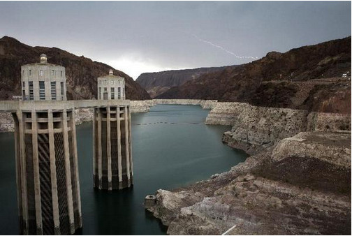
The U.S. Bureau of Reclamation’s key August forecast, out today (pdf),projects that there will be enough water in the Colorado River system next year to release a bonus pulse of 770,000 acre feet of water from Lake Powell down to lake Mead above and beyond the legal requirements of the Colorado River Compact. But even with that extra water, Lake Mead is projected to fall another five feet during 2015, flirting with levels that could trigger the Lower Colorado River Basin’s first formal shortage declaration in 2016.
How could this be? The Lower Basin is getting extra water above and beyond its minimum legal entitlement, yet Lake Mead keeps dropping?
It’s simple, really. The U.S. Supreme Court’s 1963 Arizona v. California decision effectively allocates more paper water than there is wet water in the system, (click here for the wonky explanation of the mistake, and the fact that folks kinda knew at the time it was a mistake but ignored it) and as long as each of the Lower Basin states keeps using its full entitlement, Mead will keep dropping unless a giant climatic wet spell delivers magic extra water.
Meanwhile, here’s a photo gallery of the California drought from the Huffington Post. From the article:
With major wildfires burning six at a time, more than half of California now experiencing the most severe category of dryness and experts warning that even an El Niño year won’t be enough to redeem the west in 2015, residents of California and beyond must face the terrifying reality that the drought probably isn’t done breaking records — and it’s not something just farmers and firefighters have to face.
The Huffington Post asked readers to share photos through the hashtag #OurDroughtIsReal to show how the drought is affecting them in their own backyards, literally. Here are some of the heartbreaking photos and stories you shared. Tweet @HuffPostGreen or use the hashtag if you have your own photo to share.
Colorado Water Plan website screen shot November 1, 2013
FromThe Grand Junction Daily Sentinel (Mike Wiggins):
Efforts to forge a state water plan to bridge the anticipated gap between supply and demand should focus on enhanced conservation efforts on the Front Range and shun any new transmountain diversions, according to a group of primarily Western Slope residents.
In a meeting this week with The Daily Sentinel editorial board, Adventure Bound River Expeditions owner Tom Kleinschnitz, Silt Town Trustee Aron Diaz, Western Resource Advocates Program Director Bart Miller, Bruce Talbott of Talbott Farms, Mesa Park Vineyards co-owner Brooke Webb and Mesa County Commissioner Steve Acquafresca said they want to see river basins in other areas of the state call more for reducing water usage. Some of them also pitched the ideas of investing in improving existing infrastructure and building smaller storage projects at higher elevations.
“Conservation and cooperation is the new paradigm,” Acquafresca said.
Colorado’s population is expected to double by 2050, one of the reasons why Gov. John Hickenlooper issued an executive order calling for the development of a statewide water plan by 2015. The state’s eight largest river basins will present draft plans to the Colorado Water Conservation Board.
Western Slope water stakeholders say arguments that the majority of Colorado’s water should be used on the Front Range because the vast majority of the population resides there ignore usage of the river by the entire basin. The Colorado River Compact requires the Upper Basin states to deliver no less than 7.5 million acre-feet of water to the Lower Basin states during any 10-year period.
“My biggest fear is we will get a call (on the river) from the Lower Basin,” Talbott said.
Members of the group applauded Clark County, Nevada, and its county seat, Las Vegas, and organizations like Denver Water for their conservation efforts. Las Vegas has redesigned its golf courses to be more water-efficient and pays residents to rip out their lawns, while Denver Water has dramatically reduced municipal water usage over the last several years. As a result, Western Slope water users say they enjoy a good relationship with Denver Water. That relationship, though, doesn’t yet exist with entities like the Northern Colorado Water Conservancy District, Aurora Water and Colorado Springs Utilities, group members said.
Colorado dry bean farmers are on pace to make up for last year’s historically “horrible” crop — and then some. Not only is this year’s abundant moisture expected to give the crop a boost, but the number of acres devoted to the crop this year has skyrocketed. According to recent crop reports, farmers planted about 60,000 acres of the crop this year in Colorado, ranking seventh nationally, and also marking a 54 percent increase over last year — far outpacing the nationwide 29 percent uptick in dry bean acres.
Larry Lande, who operates Northern Feed and Bean in Lucerne and serves on the Colorado Dry Bean Administrative Committee, said the uptick in acres across the board has much to do with dry bean prices holding strong while grain prices, particularly corn, have dropped.
More specific to Colorado, Lynn Fagerberg — who grows onions, corn, wheat and dry beans near Eaton — added that the improved water situation, with this year’s abundant snowpack, led him to replace many of his wheat acres with dry beans this year.
“And so far, it’s a good-looking crop,” Fagerberg said.
Last year, when water was in much shorter supply, Fargerberg upped his wheat acres because it’s a less water-dependent crop than others, like corn and dry beans. So, with more water now and corn prices low, increasing his dry bean acres made plenty of sense, he said.
The sharp uptick in dry bean acres comes less than a year after Colorado farmers saw one of their worst crops in memory.
Significant amounts of moisture in September — harvest time for dry beans — can cause discoloration and sprouting for mature beans still out in the fields, negatively impacting the appearance, which is important for a crop that’s sold on grocery store shelves.
And there was no shortage of rain last September.
In addition to destructive flooding that caused hundreds of millions of dollars in damage across northeast Colorado, the local dry bean crop, too, fell victim.
Weld County farmers were delivering to the local elevators the worst quality beans they’d harvest in years, or ever in many cases, local farmers said.
“The way things are going, that won’t be the case this year,” said Lande.
An increase in dry bean production this year would help Colorado — where sales of dry beans in recent years have amounted to about $30 million — rebound from its steady decline.
Dry bean acreage in the state has taken a hit in recent years as producers began planting crops that were seeing huge increases in commodity prices, and as Mexico, a big buyer of U.S. beans, has started growing more of its own crop. In 2001, 105,000 acres of dry beans were harvested in Colorado, nearly tripling the acres harvested in 2011 and 2013.
Members of the regional stormwater task force cheered Tuesday when the Colorado Springs City Council voted 7-2 to approve a contract for a stormwater funding program that was two years in the making.
With a sigh of relief following the vote, council member Jan Martin said the city has been trying to find a way to pay for millions of dollars in stormwater, flood control and drainage projects needs for a decade…
The contract and proposed November ballot language that would create a regional stormwater authority still needs to be approved by the other parties in the intergovernmental agreement: the El Paso County Board of County Commissioners, Green Mountain Falls, Fountain and Manitou Springs. All have indicated they will OK the contract.
The contract – the result of dozens of public meetings, community surveys and hours of public discussion – outlines the terms and duties of a Pikes Peak Regional Drainage Authority, a governmental agency that would plan regional flood control projects.
Voters are expected to be asked to OK an annual stormwater fee, which would be roughly $92 a year for a home with 3,000 square feet of impervious surface. If approved, a regional authority expects to collect about $39.2 million a year for 20 years. Most of the money would be spent on new construction projects, and maintenance and operations of existing flood control projects. A pot of money – about 10 percent of the fees collected – would be set aside for flooding emergencies.
An 11-member board would oversee the planning of the regional stormwater projects, and Colorado Springs would have six seats on the board.
But not everyone is happy. Mayor Steve Bach plans to hold a press conference Wednesday to detail his objections to the contract. He says it binds the city to a list of projects and does not give the city flexibility in cases of flooding emergencies. The contract infringes upon the city’s ability to manage its affairs, he said.
The stormwater contract requires that money collected from property owners in each city be spent in their city over a five-year rolling average, except for the emergency fund. Bach said spending the emergency pot of money will be decided by the authority’s board, which could reject a Colorado Springs project, he said.
“(The emergency fund) will not be returned to each city over a five-year rolling average,” he said. “Is it fair for third-party bureaucracy to have no responsibility to return it if we have an emergency in our city?”[…]
Bach also raised concerns about the proposed ballot language. He said it doesn’t detail the amount of the fees that will be assessed on each property.
“We need to be straight with the voters,” Bach said…
El Paso County Commissioner Amy Lathen, a member of the stormwater task force, noted that Colorado Springs is guaranteed a majority of the seats on the board, and said it is disingenuous for Bach to suggest that Colorado Springs, which has 80 percent of the flood control needs, would get short shrift.
Colorado Springs City Council approved, 7-2, an intergovernmental agreement Tuesday that is expected to lead to a vote on a regional drainage authority for El Paso County.
“I supported a regional process (when a stormwater task force started meeting). It made sense at the time and it still makes sense,” said Keith King, council president. “Let’s put it in the hands of the voters.”
Most council members said the agreement is not perfect, but supported the opportunity to ask voters for approval of the authority. Helen Collins said there are too many taxes already and Don Knight said it does not protect Colorado Springs adequately in voting against the agreement.
The authority would raise $39 million in 2016 and is expected grow over the next 20 years to meet a backlog of more than $700 million in stormwater projects and to maintain them. Money would be spent proportionally in the participating communities.
While council OK’d the agreement, El Paso County Commissioners will have to place the issue on the November ballot, which they could do as early as next week. The IGA also must pass muster with Manitou Springs, Fountain and Green Mountain Falls.
It’s important to Pueblo County because Colorado Springs City Council abolished its short-lived stormwater authority in 2009. The authority was one of the premises of the Southern Delivery System, including Pueblo County’s 1041 land-use permit and the Bureau of Reclamation’s contract for use of Pueblo Dam and Lake Pueblo.
Colorado Springs Utilities pledged to avoid worsening flooding on Fountain Creek as a result of SDS in permit hearings.
“Down-streamers like me have watched the stormwater issue for some time and we’re excited something is being done,” said Dennis Hisey, an El Paso County commissioner from Fountain who sits on the Fountain Creek Watershed Flood Control and Greenway District.
“This is a collaborative process such as I have never seen,” said Amy Lathen, a commissioner who has worked with the El Paso County stormwater task force since 2012. “We will not take a step without full agreement on the IGA.”
Council spent nearly three hours wading through the agreement’s details, with Assistant City Attorney Tom Florczak, former Pueblo city attorney, leading the panel through changes Mayor Steve Bach wanted.
Bach met Monday and Tuesday with the council and county to negotiate changes, which was portrayed in contrasting ways by his chief of staff, Steve Cox, and Lathen.
Cox maintained that Bach had little time to review the document.
Lathen said Bach had made public, misleading statements about the agreement, particularly in portraying the assessment to property owners as a tax, rather than a fee.
During the council meeting there also was some discussion about how costs would be divided among authority members and an emergency fund. Bach wants to make sure Colorado Springs’ needs are met, and some council members were wary that Colorado Springs would bankroll payments owed by smaller communities.
“We could have a huge storm that messes up the Fountain River through Pueblo,” King said. “Do we need to treat this as an insurance policy?”
Pueblo County Commissioner Sal Pace has closely followed the negotiations over the proposed El Paso County stormwater initiative and is crossing his fingers that political bickering won’t keep the issue from the November ballot.
Pace has talked about Colorado Springs’ floodwaters for years and says the stormwater initiative is directly tied to the $1 billion Southern Delivery System, a regional project that brings Arkansas River water stored in Pueblo Reservoir to Colorado Springs.
Stormwater management in Colorado Springs has been on Pueblo’s radar since Colorado Springs Utilities committed to Pueblo and Pueblo County that it would be in compliance with stormwater responsibilities before 2016 – when the water is due to start flowing north.
When the permits for SDS were inked, Colorado Springs had a stormwater fee in place and a list of projects designed to head off floodwaters going south, Pace said. But the fee ended in 2011 and left Pueblo officials wondering if the promised flood control projects would be built.
“We know there will be more water in Fountain Creek because of SDS,” Pace said. “Part of the SDS permit was a guarantee of no increase in stormwater flows.”
Pace said if Colorado Springs’ stormwater issues are not resolved, Pueblo could take Utilities to court and challenge the SDS permits that were based on stormwater controls. No one wants to go down that path, he said.
“The fact that Colorado Springs and El Paso County are moving in this direction is a very positive step,” he said.
Colorado Springs City Council is expected to vote on the proposed regional stormwater contract, called an intergovernmental agreement, for the creation of the Pikes Peak Regional Drainage Authority at its Tuesday meeting. El Paso Board of County Commissioners will consider the contract and ballot language at its Aug. 19 meeting.
The authority, if approved by voters in November, would collect about $39 million a year for the next 20 years to pay for flood control projects in the Fountain Creek Watershed, 928 square miles with a perimeter of 160 miles. Fountain, Green Mountain Falls and Manitou Springs also are considering joining the authority.
Mayor Steve Bach has raised concerns about the proposed contract, saying that it is too restrictive when it comes to the city planning stormwater projects within the city limits. He also worries that the city would not be able to quickly respond to a flood emergency.
“We have to be careful not to put ourselves in a straight jacket,” Bach said. “What if priorities change in a few years? Colorado Springs can’t change its priorities without a supermajority of the (stormwater) board.”
Bach sent a letter to the council July 31 outlining his concerns, which include the need for Colorado Springs to have seven seats on the 11-member governing board. He said he hoped the council would consider his concerns and adjust the contract before approving it.
“I would like to support the IGA,” Bach said. “But if it is so onerous and interferes with the business of the city, I may be forced to oppose the ballot initiative.”
The council appears ready to approve the contract without the mayor’s changes.
Council president Keith King said the stormwater task force designed a regional program so that flood control projects could be planned together among the four cities and county. It would defeat the purpose of a regional project if it were to change the contract to allow Colorado Springs to act on its own.
“I’m afraid we are probably at an impasse,” King said.
Last weekend, the stormwater task force conducted a phone survey asking potential voters whether it would matter to them if Bach did not support the stormwater initiative. The results, however, are “being kept close to the vest,” said Rachel Beck, a task force member.
Councilwoman Jill Gaebler said a conflict between the mayor and council could affect voters. Some, she said, equate the bickering to distrust.
“People want us to work together,” she said.
Gaebler said she believes Bach has the city’s best interests in mind with his proposed changes to the stormwater contract. But his proposal comes too late, she said.
“This task force has been meeting for two years,” she said. “Ever since I’ve been on council, every month an invitation was sent to (the city attorney) and the staff and no one ever attended.”
Richard Skorman, business owner and member of the stormwater task force, said he doesn’t expect the recent strife to influence voters.
“No one should beat themselves up for bringing up issues at the last minute,” Skorman said. “I think everyone at the table wants the same thing.”
Skorman said Bach’s request for seven seats on the board seems reasonable, given that Colorado Springs will contribute roughly 80 percent in fees and need 80 percent of the flood control projects.
“All of those things are important,” he said. “But the biggest goal is for us to finally address flooding problems. There seems to be unanimous support for that.”
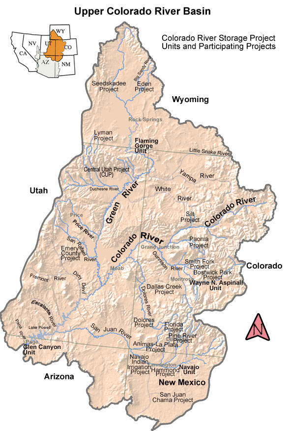
Colorado River Basin including out of basin demands — Graphic/USBR
After a winter of happy news about the generous snowpack in Colorado’s mountains, summer brought reminders that our regional water situation is dire – or, at least, poised on the edge of direness.
Just as the ink was drying on mid-July headlines announcing that Lake Mead had dropped to its lowest level since filling 80 years ago, a new study found that groundwater loss in the Colorado River Basin has been even more dramatic. The study used satellite data to track changes in the amount of water in the basin from 2004 to 2013, and found that 75 percent of the nearly 53 million acre feet lost during that period was from groundwater depletions.
While it is easy to measure how much water is in reservoirs, it is much less clear how much groundwater remains in the region’s aquifers. Western Colorado doesn’t rely much on groundwater, but other states in the basin do.
Then, in early August, researchers at CU-Boulder released an updated report on Climate Change in Colorado. The report notes that higher temperatures are likely to put further pressure on the state’s water supplies, even if we get a bit more rain and snow, because plants will need more and more will evaporate.
An historic 14-year drought plus increasing demands are pushing the Colorado River system ever closer to the point where it could no longer be able to provide the services people rely on. And groundwater appears to be disappearing too fast to be much of a safety net.
The City of Las Vegas, Central Arizona farmers and power generation at Glen Canyon Dam are among the first in line to take a hit if water levels in Lakes Powell and Mead continue to drop.
However, disaster is not inevitable. The multi-state, bi-national agreement to send water back to the Colorado River Delta last spring, for the first time in 30 years, demonstrates that those who manage the river are capable of improbable feats.
Many of the same minds that negotiated the deal that provided water for the delta are working intensely to find ways to keep Mead and Powell functioning and to keep the region’s cities, farms and environment intact. There seems to be both a growing sense of urgency and an increasingly cooperative spirit to these efforts.
Not long ago, when I heard Colorado officials and water managers discuss the overuse of water in the Colorado River Basin, they made it clear that this was mostly a problem for California, Arizona and Nevada — and that Colorado was still intent on developing its full legal share. That tune hasn’t exactly changed, but more cooperative efforts have moved into the foreground.
Most recently, the Central Arizona Project, Denver Water, The Metropolitan Water District of Southern California and Southern Nevada Water Authority announced that they will team up with the U.S. Bureau of Reclamation to provide $11 million for pilot conservation projects to boost levels in Powell and Mead.
Cooperation is crossing constituencies as well as Upper – Lower basin divisions. The Grand Junction Daily Sentinel recently reported that Denver Water, the Colorado River District, the Colorado Cattlemen’s Association, the Colorado Farm Bureau, the Southwestern Water Conservation District, the Nature Conservancy and Trout Unlimited are working together to explore ways to use some of that $11 million to test “temporary, voluntary and fully compensated” conservation strategies.
Even within Colorado, some of the conflict between West Slopers and Front Rangers over additional transmountain diversions could be softening. A recent “conceptual agreement” released by Colorado’s Inter-basin Compact Committee, which includes representatives from all the state’s river basins, outlines how additional Colorado River water could be sent East “under the right circumstances.” Central to the draft agreement is the recognition by East Slope entities that a new transmountain diversion may not be able to deliver water every year and must be used along with non-West Slope sources of water.
These shifts in tone seem to indicate a coming-to-terms with the fact that Colorado River Basin water supplies are limited, and that everyone who relies on them has a stake in finding ways for all to live within those limits. What remains to be seen is whether we can adapt quickly enough to keep ahead of crisis. Don’t stop praying for snow just yet.
A state report predicts climate change would stress Colorado’s water supplies by mid-century.
“It shows why the state water plan effort is timely,” said Alan Hamel, who represents the Arkansas River basin on the Colorado Water Conservation Board. “There’s a lot of good information that can help the state in the report.”
Warmer temperatures are projected to reduce spring snowpack, cause earlier snowmelt and increase the water use by all types of vegetation as the growing season expands, a report for the CWCB states.
“While future increases in annual natural streamflow are possible, the body of published research indicates a greater risk of decreasing streamflow, particularly in the southern half of the state,” it concludes.
The report was written by a team of climate scientists from the University of Colorado and Colorado State University, looking at historic records and future projections. It was funded by the CWCB, Western Water Assessment and the National Oceanic and Atmospheric Administration.
Annual temperature averages have heated up by 2.5 degrees Fahrenheit over the past 50 years, and the trend is expected to continue. However, there has been no longterm trend in precipitation, according to the report.
Although snowpack has been below average in all basins since 2000, no long-term trend has been detected. But runoff is occurring one to four weeks earlier because of higher spring temperatures and dust on snow.
Tree-ring research indicates that there were multiple droughts more severe than anything experienced since 1900 in Colorado.
The rise in temperature is expected by nearly all climate models to continue at the same rate or greater in Colorado through 2050, and climb even faster in the second half of the century.
There is little agreement about precipitation in climate models, except that more of it is expected to occur in the winter months and that it will melt off earlier.
The models project an increase in heat waves, droughts and wildfires.
The report suggests water planners incorporate climate change into scenarios, rather than focusing on a single trajectory of the future.
That’s already been initiated by the CWCB, which has used scenarios for variable climate and growth conditions in the state.
“Planning for longrange water supplies, it is critical to consider changes in climate,” Hamel said. “You have to have scenarios going forward. Just look at 2013 with record droughts, record fires and record floods, all in the same year. You have to plan for variability, as many of the state’s utilities are doing.”
FromTheDenverChannel.com (Phil Tenser, Mike Nelson):
“Climate Change in Colorado,” the report issued Tuesday and led by a University of Colorado researcher, is based on compiled climate science. It focuses on current observed trends and forecasts for the mid-21st century.
Over the past 30 years, average temperatures in Colorado have increased by 2 degrees Fahrenheit, the report finds. That is the same amount by which North America has warmed over the same period.
“These global changes have been attributed mainly to anthropogenic (human-caused) influences, primarily the increase in greenhouse gases in the atmosphere to the highest levels in at least 800,000 years,” the report’s executive summary says.
While it says that warming in Colorado is “plausibly linked to anthropogenic influences,” it says recent variability in annual precipitation here “has not exhibited trends that might be attributed” to humans. The next paragraph, however, states human influences may have increased the severity of the drought in the western United States.
“Drought is not just a matter of precipitation, the amount of evaporation is just as important. Even if the total annual precipitation were to remain the same, a warmer Colorado will experience more drought due to the increase in evaporation,” 7NEWS Chief Meteorologist Nelson said…
The report says, “The uncertainty in projections of precipitation and streamflow for Colorado should not be construed as a ‘no change’ scenario, but instead as a broadening of the range of possible futures, some of which would present serious challenges to the state’s water systems.”
According to the report, these observations and predictions could influence reservoir operations including flood control and water storage. Changes in the timing and volume of runoff may also “complicate” future water rights issues and interstate water compacts. Lower streamflows could also lead to higher concentrations of pollutants.
Earlier peak flows could have impacts on aquatic ecosystems and rafting or fishing industries, while reduced snowpack may also impact Colorado mountain tourism.
Every climate model assessed in the report indicates future warming will increase average annual temperatures by 2.5 to 5 degrees Fahrenheit by 2050 if greenhouse gas emissions are in the lower range of estimates. If emissions are in a higher range, the increase could be 3.5 to 6.5 degrees.
“We will still have cold winters and cool summers, but as the global climate warms, these cooler trends will become less frequent in the coming decades,” Nelson said.
“Climate model projections show less agreement regarding future precipitation change for Colorado,” the report states. Most predict additional precipitation by 2050 during the winters, but there is weaker consensus in the projections for the other seasons.
Hydropower facilities or power plants that need water for cooling could also be impacted, it says.
“Water truly is liquid gold in Colorado, the long term trend toward a warmer and drier climate is something we will need to plan for in the future,” Nelson said.
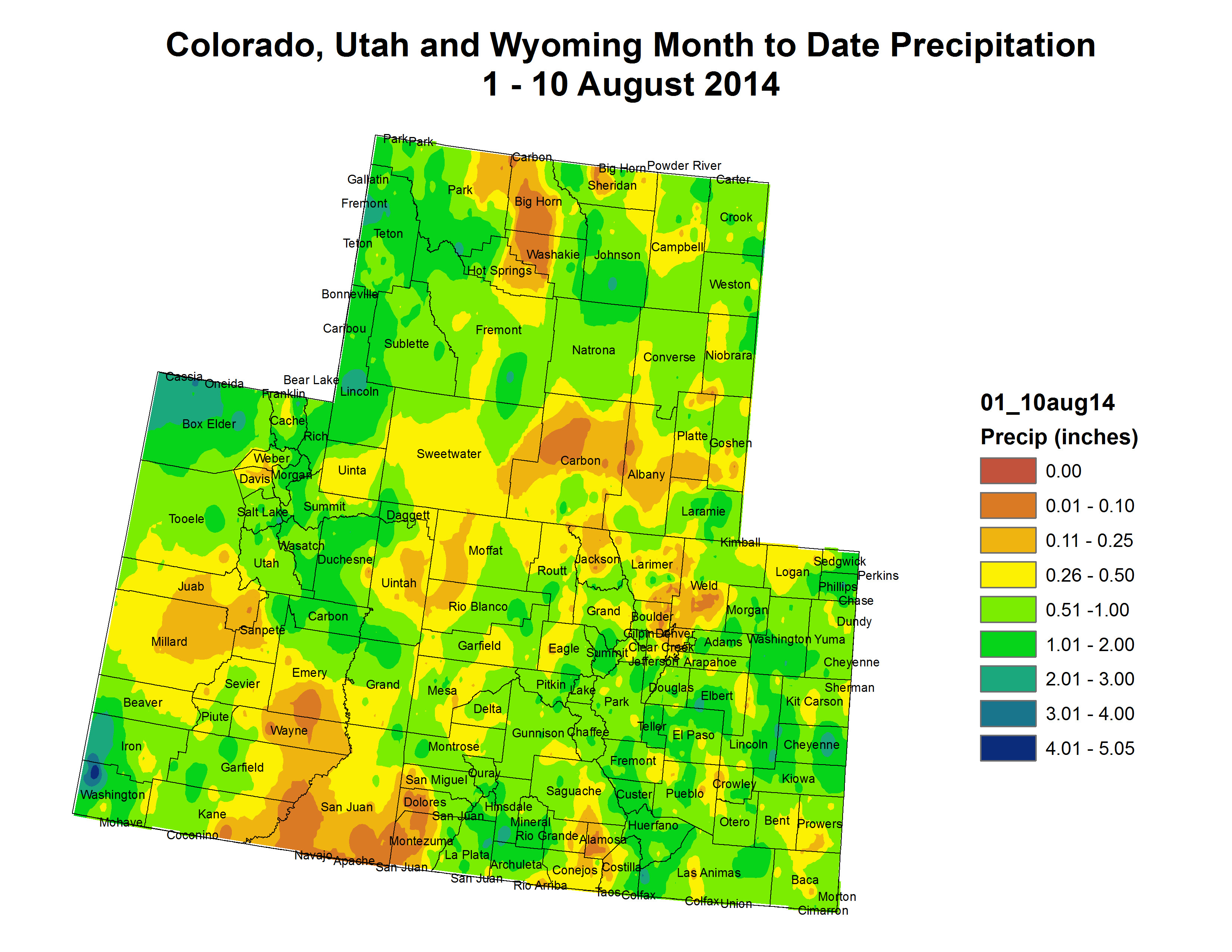
Summer rains have prolonged river flows in Southern Colorado beyond anyone’s expectations this year.
It’s been great for rafting on the Upper Arkansas River, a blessing for farmers and helped to replenish reservoir levels after years of drought.
“We’re seeing an increase in private boaters,” said Stew Pappenfort, lead ranger for the Arkansas Headwaters Recreation Area. “A lot have taken up kayaking or canoeing after going on a commercial outing.”
Caution was needed during the very high flows that occurred earlier this year, he added. There have been 11 deaths on the upper portion of the river, including seven drownings from boating accidents and one medical emergency.
Flows above Canon City remained above 1,000 cubic feet per second Friday, thanks to both wet conditions and releases to make even more space for imports in Turquoise and Twin Lakes in Lake County, near the headwaters of the Arkansas River.
“We’re still bringing water through the Boustead Tunnel. It’s running at twice of average,” said Roy Vaughan, manager of the Fryingpan- Arkansas Project for the Bureau of Reclamation.
The Boustead Tunnel brings water from the Roaring Fork watershed into Turquoise Lake.
So far, nearly 80,000 acre-feet (26 billion gallons) of water has been brought over, which is about 25 percent more than Reclamation forecast in June. Snowpack was about 25 percent above the median this year in Colorado’s central mountains. But regular summer rains, missing in 2012 and 2013, have boosted flows to more normal levels, Vaughan added.
For farmers, the wet conditions are welcome.
“We were dry early,” said Dale Mauch, who farms near Lamar. The Fort Lyon Canal has had 16 runs of water so far this year, compared with 12 total in 2013 and just seven in 2012. “We had a slow start, because it had been so dry, but it picked up in mid-June. We ran out of snow water on July 4, but then it started raining. You need rain. It really makes a difference.”
A high desert thunderstorm lights up the sky behind Glen Canyon Dam — Photo USBR
Here’s a look at the Lake Powell power pool and the cascading effects if the reservoir drops below the level necessary to continue to deliver power to the southwestern US, from Allen Best writing in The Denver Post:
Colorado water leaders used a curious approach last week in announcing a new water conservation program involving the Colorado River. They talked about electricity and the effect of spiking prices on corn farmers in eastern Colorado, ski area operators on the Western Slope, and cities along the Front Range.
The scenario? A Lake Powell receding to what is called a minimum power pool, leaving too little water to generate electricity. Glen Canyon Dam, which creates the reservoir, is responsible for 81 percent of the power produced by a series of giant dams on the Colorado River and its tributaries, including those on the Gunnison River. This electricity is distributed by the Western Area Power Administration to 5.8 million people in Colorado, Arizona and other states.
Should this power supply be interrupted, WAPA would make good on its contracts with local utilities by buying power in the spot market, such as from gas-fired power plants. But extended drought on the Colorado would certainly increase prices to reflect the higher costs of replacement by other sources.
Hydropower is far cheaper than renewables but also fossil fuels. Rural electrical cooperatives get nearly half the production, followed closely by municipalities, including Colorado Springs, Delta and Sterling, plus Longmont, Loveland, Estes Park and Fort Collins.
Right now, WAPA is selling the energy from Glen Canyon and the other dams at $12.19 per megawatt-hour with a separate charge for transmission. Just how much prices would increase in event of prolonged interruption is speculative. The same agency, however is shoring up August deliveries with purchases of power from other sources at $55 per megawatt-hour, according to Jeffrey W. Ackerman, the Montrose-based manager of WAPA’s Colorado River Supply Project’s Energy Management Office.
This illustrates the bone-on-bone relationship between energy production and water during time of drought.
Yet the broader story about the Colorado River is about a narrowing razor’s edge between supply and demand. There’s no crisis, but water officials are planning for one. A healthy snowpack in Colorado last winter helped, but did not solve problems. The basin as a whole was still below average, as it has been 11 of the last 14 years.
“As leaders, we simply cannot wait for a crisis to happen before we come together to figure out how to address it,” said Jim Lochhead, chief executive of Denver Water. “That would be irresponsible.”
Denver Water and providers in Arizona, Nevada and California, plus the U.S. Bureau of Reclamation, are pooling $11 million to launch a demand-management program. Utilities such as Xcel Energy have similar programs, offering to pay customers willing to suspend use of air conditioners for a couple hours on hot summer afternoons.
In this case, $2.5 million is being allocated to fund programs that would yield reduced demands in Colorado and other states upstream of Lake Powell. The obvious idea is fallowing of crops, such as a hay meadow, with the irrigator to be reimbursed. But Lochhead stresses that it’s a blank chalkboard. The intent is to solicit ideas and then “demonstrate effective demand-management techniques.”
“It’s not something we expect to do. It’s not something we want to do, but if the drought continues, we want to be ready,” says John McClow, Colorado’s representative on the Upper Colorado River Commission.
The bulk of the $11 million will be allocated to demand-management programs in the lower-basin states.
Doug Kenney, director of the Western Water Policy Program at the University of Colorado’s Getches-Wilkinson Center for Natural Resources, Energy and the Environment, sees the agreement as representative of broad shift in states sharing water from the Colorado River. “In the past, they could get together to build things such as dams. Now, they are teaming up to save water,” he says. “That’s a paradigm shift.”
An effort involving The Nature Conservancy and water agencies based in Durango and Glenwood Springs has been underway for five years. That parallel effort, however, is driven by a different trigger: the prospect of a compact curtailment or “call.” The 1922 Colorado River Compact requires Colorado and the other upper-basin states — Wyoming, Utah and New Mexico — to deliver an average 75 million acre-feet over any given 10-year period.
Upper basin states at this point have a cushion of 15 million acre-feet, or two years’ supply. Yet abundant snowfall last year in Colorado only slightly filled Lake Powell. One relatively good year does not compensate for several bad ones.
Always hovering in the background is the prospect of even worse. Tree rings from across the River Basin provide clear evidence of longer, more intense droughts 800 to 900 years ago. An additional layer is the prospect of higher temperatures caused by global warming.
Chris Treese, external affairs director for the Glenwood Springs-based Colorado River Water Conservation District, acknowledges a growing sense of urgency. “We could be back in a near-crisis or crisis situation in as little two or three years,” he says. And for water planners, who typically try to think decades ahead, that’s a current event, he adds. [ed. emphasis mine]
How likely is this dead pool? U.S. Bureau of Reclamation modelers in April found a 4 percent chance of a minimum power pool in 2018 and a 6 percent in 2019. The models are based on recorded hydrology of the last 105 years.
What if Powell does decline and electricity cannot be generated? It depends upon how long the shortage lasts. A longer outage would affect electrical consumers from Arizona to Nebraska. “We’re struggling to quantify the impact,” says Andrew Colismo, government affairs manager for Colorado Springs Utility.
Tri-State is the single largest consumer, purchasing 28 percent of all power produced in 2012 from the dams. It sells this power to 44 member co-operatives in a four-state region, including those who sell to irrigators in eastern Colorado.
Irrigation is a huge consumer of cheap power. In northeastern Colorado, Holyoke-based Highline Electric meets demand that ranges from a low of 25 megawatts to a high of 190 megawatts, the latter occurring when irrigation pumps are drawing water from the Ogallala aquifer to spread across 123-acre circles of corn, beans and other crops. Some large irrigators pay hundreds of thousands of dollars annually in electrical costs, says general manager Mark Farnsworth.
The irony is that if a drought occurs accompanied by heat, as is usually the case, irrigators will probably pump more water and air conditioners will work even harder. Power demands will rise as water levels drop.
Tri-State spokesman Lee Boughey says existing rate structures anticipate both droughts and heavy precipitation.
Lochhead and others also point to other ripples from interrupted power sales. Revenues from hydroelectric sales, which were $198 million last year, are used for a great many programs: selenium control in the Delta-Montrose area, work to maintain ecosystem integrity downstream from Glen Canyon and ongoing efforts to preserve four endangered fish species in the Colorado River and its tributaries.
On Wednesday, Lochhead met with an interim legislative water committee at the Colorado Capitol to report about the new agreement. The testimony all day had been about potential measures to expand water conservation as Colorado tries to figure out how to accommodate a population expected to double from today’s 5.3 million residents to 10 million people by mid-century without drying up rivers and farms.
Denver Water already serves 1.3 million, but gets about half of its water from the Western Slope. “We have a vested interest” in the Colorado River, Lochhead told legislators.
One outstanding question is whether Denver and other water providers on the High Plains should try to be able to get additional water from new or expanded transmountain diversions.
With this story from Lake Powell, the take-home message is don’t count on it.
Allen Best writes frequently for The Post about water and energy and also publishes an online news magazine, found at http://mountaintownnews.net.
Groundwater movement via the USGS
Here’s a guest column (The Pueblo Chieftain) from Sallie Clark dealing with the Environmental Protection Agencie’s proposed clarification of “Waters of the US” under the Clean Water Act:
Coloradans have a special appreciation for the beauty of nature all around us. Everyone benefits from the beauty and bounty of America’s rivers, streams, lakes and other waterways. Of course, these natural resources should be protected from irresponsible polluters, and regulations are in place to ensure clean water in our communities.
But, there is a proposal afoot that would extend federal jurisdiction and accompanying regulations far beyond what makes sense. The National Association of Counties (NACo) sees this proposal as a critical issue, and in my role as First Vice President of NACo and a Colorado county commissioner, I am concerned about how these rule changes will impact local communities.
A new rule, proposed by the Environmental Protection Agency and the Army Corps of Engineers, would erase the distinction between bodies of water — such as streams and lakes — and ditches on the side of a road. According to the proposed redefinition of “Waters of the U.S.,” a river would be no different than a public safety ditch; a lake no different than an emergency flood mitigation system.
This latest example of over-regulation makes no sense and creates more confusion than it seeks to address.
Local water conveyances, such as ditches and flood control channels, may fall under federal regulation in this unworkable proposal. It is unclear how far it would extend into drainage systems. That means counties would be required to obtain federal permits to do routine maintenance work on a roadside ditch or storm-water drain. These are essential components of effective water management.
In many cases, the nation’s counties are responsible for maintaining storm drains and other water conveyance systems that keep people safe from rising waters. They often pay a high price to wait for the federal government to issue permits. This new red tape would slow down the process even more and potentially put more people in harm’s way by inhibiting projects that keep water off of roads and away from homes.
The costs and delays of this federal over-regulation would have a significant impact on public safety and economic prosperity. To give a concrete example of some of these concerns, maintaining drainage is critical to keeping our roads safe and open for use, and it requires daily attention. Increasing fees due to additional regulatory permitting for all runoff, as anticipated by the proposal, could bring maintenance efforts to a halt.
How this regulation would be administered is unclear and would be especially cumbersome if it went directly through federal offices not adequately equipped to accommodate heavier permitting.
The expense for plan preparation would add costs not accounted for in our existing budgets.
If fully exercised every basic culvert maintenance or repair could be held up, placing not only a burden on counties financially, but also putting citizens at risk due to delays, as all work would have to first be reviewed and approved by a federal agency.
The approach taken by this proposal would drain local budgets and create delays in critical, time-crucial repairs with no demonstrated long-term environmental benefit.
Federal over-regulation and unfunded mandates unnecessarily hinder counties’ ability to get things done for local citizens. All of us want to protect the environment, but we cannot allow over-regulation to do more harm than good.
Sallie Clark is first vice president of the National Association of Counties and an El Paso County Commissioner.
More Environmental Protection Agency coverage here.
Orr Manufacturing Vertical Impact Sprinkler circa 1928 via the Irrigation Museum FromThe Mountain Town News (Allen Best):
Having a conversation about conservation may be clever word play. Having that conservation is rather more difficult than saying it, as became evident in legislative committee hearing last week in Denver.
Nobody testifying before the committee opposed the idea of saving water as Colorado seeks to accommodate 10 million people at mid-century, up from today’s 5.3 million. In fact, it became clear that much is already being done.
But neither was there clear agreement about what the next steps should be and what role state government might have. State Sen. Ellen Roberts, whose bill last winter spurred the legislative hearing, summarized the testimony as recommending “local control, state conversation.”
Without specific mandates, per capita water use has declined dramatically since the late 1990s. Per capita residential use in Pueblo dropped from 185 gallons per capita daily to 120 this year. “We’ve changed, the culture changed,” said Paul Fanning, of the Pueblo Board of Water Works.
Changes provoked by severe drought of 2002 has remained. Before the drought, people were giving turf 22 gallons per square foot in Denver. Now, it’s down to 16 gallons, said Chris Pipher, governmental affairs coordinator for Denver Water.
Municipalities use only 8 percent of water in Colorado, suggesting the state can easily reallocate or develop water for new residents. It’s not that simple. Water available for additional development in the Colorado River Basin is uncertain and highly contested in the case of new transmountain diversions. Rural, farming areas want to survive – while preserving the right for individuals to sell their water to cities, if they wish.
Roberts’ bill originally proposed sharp restrictions on lawn sizes when new subdivisions are built that use water obtained by drying up farms. That proposal didn’t survive.“I now know what it’s like to be between people and grass in Colorado,” said Steve Harris, of Durango, who originally came up with the idea.
The idea now on the table is to specify a ratio between indoor and outdoor use. The size of the dwelling wouldn’t matter. It’s currently at about 50-50, but in some places 60 percent of annual water at homes is used indoors. Some thing it can be pushed to 70 percent.
Why does this matter? Indoor water is typically flushed down drains and ultimately 85 to 90 percent is returned, after treatment, to streams and rivers. Water is being directly reused after treatment in several places in metropolitan Denver.
If that proportion is higher, that means less water is used outdoors.
Water budgets were also mentioned frequently. Boulder has already embraced the concept. The budget is the amount of water you are expected to use during a specific month. Each customer’s budget is based on the unique water needs and past use. Stay within your budget and you pay less for the water you use.
Two water districts in the southwest metropolitan Denver, Centennial and Highlands Ranch, also have adopted water budgets for customers.
“The water budget for outdoor irrigation provides enough water for healthy landscapes, but not so much that our resource is wasted,” the Centennial Water and Sanitation District website says. “Progressively higher tiered rates over the allotted budget serve to encourage conservation.
Several speakers made the point that it’s far easier to install water conservation when homes and other buildings are developed, instead of afterward. Rebecca Mitchell, of the Colorado Water Conservation Board, further offered that incorporating water conservation is much less expensive than developing new supply.
John Barnett, long-range planner for Greeley, noted that a 20 percent increase in density will yield a 10 percent decline in per-capita consumption.
But Greeley, like all other municipal representatives, pushed back at a “one size fits all” approach to conservation.
Joseph Stibrich, planning director for Aurora Water Department and the Metropolitan Roundtable representative at statewide negotiations, says one all-encompassing standards “does not work in Colorado as the ability to reach higher levels of conservation is dependent upon what has already been accomplished to date.”
Stibrich also spoke to the perceived drawbacks of conservation that goes too far in towns and cities: reduced tree canopy, increased “heat island” effects, increased stormwater runoff and accompanying water quality degradations, and reductions in property values.
A recurring theme was a call for “measurable outcomes.” Bruce Whitehead, director of the Southwestern Water Conservation District, said the conversation needs to lead to outcomes that are “meaningful and quantifiable.”
Drew Beckwith, of Western Resource Advocates, suggested one way that Colorado might allow local autonomy while move statewide conservation forward is to use funding as incentive. That’s what California does, he said.
April Washington, chairwoman of the Colorado Water Conservation Board, lives in Norwood, and as a resident of the Western Slope, she said she feels there needs to be something that is a “little more forceful.”
Despite the absence of clear ideas of how future legislation may take shape, Whitehead said he was pleased with the conversation in Denver. “I heard loud and clear that he entities do have conservation measure sin place, but they are all using different methods,” Whitehead said in a later interview. “I can’t say enough about the work that Denver has done, and other communities, too.”
Whitehead continues to think the proposal coming out of Durango might work. It sets a goal of indoor use vs. outdoor use, clearly pushing local governments to deeper conservation, but letting them figure out how to do it.
Also of note:
Denver Water’s Chris Pipher called “bluegrass still the path of lease resistance.”
Chris Elliot, a developer of master planned communities in Arvada, Aurora and Golden, said that planning offices generally are very open to landscaping that requires less water use, but parks departments are old school, wanting to lavish water.
Brenda O’Brien of Green Co said the role of state government is to provide consistency.
State Rep. Don Coram, of Montrose, listened to Denver Water’s Jim Lochhead talk about Colorado River problems, and then responded: “We’ve heard a lot today about water budgets,” he said. “It’s time they lived within their budget, as far as I’m concerned,” taking swipe at California’s water use in excess of its compact allocation.
Krista Bonfantine can look up into the mountains behind her Sandia Park home and understand, better than most, the connection between the forested watersheds that provide most of New Mexico’s water and the stuff coming out of her tap.
As she opened the lid on the concrete box that surrounds Cienega Spring, which supplies her neighborhood’s water, she pondered what might happen if a fire burned through the overgrown woods above – the risk of floods tearing down the picturesque canyon, ash and debris wiping out the water supply intake.
Fire and the resulting damage to watersheds have been an increasing concern in recent years, and Bonfantine is part of an ambitious effort to tackle the cause – overgrown forests in New Mexico’s mountains.
While the risk to Bonfantine’s neighborhood is nearby, and therefore immediately apparent, the widespread risk of fire in the watersheds that provide much of New Mexico’s water supplies is harder to see.
The problem is not just the forests themselves, explained Beverlee McClure, president of the Association of Commerce and Industry, a business group. The threat of upland fires threatens the reliability of the water supplies on which we all depend, she said…
McClure’s organization is part of The Rio Grande Water Fund, a broad-based coalition that is working to scale up patchwork efforts underway in the mountains of northern and central New Mexico to restore forests in order to protect the watersheds and water systems on which they depend.
As McClure spoke, a crew from a Corona-based company called Restoration Solutions was at work up the road with chain saws, felling trees in an overgrown patch of woods at a place called Horse Camp on the edge of the Cibola National Forest.
The overgrown woods in the mountains of New Mexico are the result of a century of firefighting that prevented natural, low-intensity fires that used to clear out undergrowth. The result is forests that are so thick in places that they are hard to walk through…
Trees being cut last week on Forest Service land near the Sandia Crest Road can be used as firewood, but there is not enough money to be made from cutting the small timber clogging the unhealthy forests to make such work self-supporting, Racher said. “There’s not enough value in that wood to pay for what needs to be done,” Racher said.
That is at the heart of the Forest Trust, which is attempting to raise $15 million per year in government money and private contributions to pay to expand the work, said Laura McCarthy, director of New Mexico conservation programs for the Nature Conservancy, an environmental group…
“This is a big problem that the federal government is not going to be able to solve for us,” McCarthy said.
Eagle River Basin Click here to read the newsletter. Here’s an excerpt:
While most people would consider it blessing enough to have just one incredible asset such as the Eagle River flowing through their communities, Eagle County residents are lucky to live in close proximity to two remarkable rivers. The Colorado River flows through Eagle County for 55 miles and is known locally as the Upper Colorado. It is the economic and cultural lifeblood for much of our state and most of the Southwestern U.S.
The Upper Colorado plays a vital role in our mountain community identity, as well as our tourism and recreation-driven economy. Locals and visitors log tens of thousands of river days each year, and the region’s difficult geography preserves much of the classic Western Slope Colorado culture and scenery that remains undeveloped in Eagle County.
The money will primarily be used to buy or lease water rights from ranchers and farmers in the Upper Colorado River Basin, including Colorado. Instead of being diverted for irrigation, the water will flow to Lake Powell, the giant desert reservoir in southeast Utah.
Denver, Phoenix, Las Vegas and Southern California want to boost flows to Lake Powell, because if the reservoir’s water level drops below a certain threshold, it changes everything.
In a worst-case scenario of extended drought, Denver Water might have to send water from its reservoirs down to Nevada and California, cutting the amount of water available to water bluegrass suburban lawns.
Under the deal announced last week, The Metropolitan Water District of Southern California, the Central Arizona Water Conservancy District, Denver Water and the Southern Nevada Water Authority pledge to work cooperatively with farmers and ranchers to find new and flexible ways of managing existing water supplies to avert a crisis.
Conservation is one of the ways to manage water supplies, and includes everything from fixing rusty, leaking irrigation pipes to installing high-tech soil moisture monitors that ensure efficient irrigation. The new agreement also specifically aims to pay farmers and ranchers in Wyoming, Utah, Colorado and New Mexico to stop irrigating some of their land, at least temporarily, and letting it lie fallow, or uncultivated.
Denver Water CEO Jim Lochhead said the agreement is not a water grab by cities.
“This is about water security,” Lochhead said, explaining that, in times of shortages, it’s important to manage the existing water supply as efficiently as possible. “We have to put our money where our mouth is,” he said. “Part of this is to try and determine really how much water we can obtain for the system through programs like this.”
A key principle of the agreement is demand management, which means focusing on water use rather than on building new diversions or dams. It can include using water more efficiently, and the sale or temporary lease of water rights. Since water managers only have a finite amount of water to work with, shifting around uses within the system is one of the few options for avoiding interstate conflicts while meeting projected gaps in supply…
The agreement looks good on its surface but raises a slew of thorny new legal issues, said Mark Squillace, a leading water law scholar at a University of Colorado natural resource think tank. According to Squillace, agreements reached under the new program could violate state laws that govern water allocation. Participants to voluntary agreements can bind each other legally with a water contract, but the new multi-state program doesn’t address what happens if those deals affect other water users not party to the agreement, Squillace said. At this point, the transfers envisioned under the agreement are probably more of a Band-Aid than the major surgery that may be required to equitably distribute Colorado River water during times of shortage, according to some water law experts.
Along with colleague Douglas Kenney at CU-Boulder’s Getches-Wilkinson Center for Natural Resources, Energy, and the Environment, Squillace has been advocating for revisions to the basic legal framework to reflect 21st-century realities, including climate change and shifts in the demand for water away from agriculture and to municipal use.
And with agriculture using so much of the water, those changes would mainly have to address concerns related to water use by farms and ranches. Squillace said the governing laws need to give farmers more flexibility to save water without losing their water rights.
“Right now, the incentives are for agriculture to use as much water as they can,” Squillace said. Instead, there should be incentives that would encourage farmers to switch to crops that use less water, he explained.
For example, if a farmer switches from growing alfalfa to growing a less water intensive crop like barley, he or she shouldn’t lose their water rights, which is the way things are under the existing use-it-or-lose-it doctrine. Instead, that farmer should be able to market the “extra” water, Squillace explained.
Once the basic laws have been revamped, market-based transfers of water like those envisioned by the new agreement have a much better chance of succeeding, he concluded.
The nascent Colorado Water Plan has begun to materialize in the form of draft implementation plans for each of the state’s eight largest river basins. And Front Range interests are once again looking toward the Colorado River to cushion water demand in the face of rising populations and interstate water obligations on the other side of the divide…
Each roundtable released its draft plan last week, and the joint draft plan from the South Platte and Metro roundtables, which includes the Denver Metro Area, identifies new Colorado River water supplies as one of the “four legs of the stool” to address water needs in the South Platte River Basin.
The draft plan cites a growing population in the South Platte River Basin and obligations to send water to other states as major factors that justify additional trans-mountain diversion.
As of yet, the South Platte and Metro roundtables haven’t established just how much extra water it would need to divert from the Colorado River.
“There’s a lot of speculation out there from different folks, but I think the basin plan was very deliberate not to put a number to it because it really seemed to stall the conversation,” said Sean Cronin, the chair for the South Platte Roundtable. “It really felt like it was more prudent that we ought to be having a discussion about additional supplies, and we ought to be having a discussion about what those additional supplies would look like.”
The South Platte and Metro roundtables saw that the gap between water supplies and water demands on the West Slope left room for additional diversions, Cronin said. Additional diversions would also be limited to wet years, when more water is available.
“In the end, it really wasn’t a matter of how much water,” Cronin said. “It was simply a matter of do we want to pursue this idea for the greater good for Colorado.”
But the Colorado River Basin Roundtable’s draft plan doesn’t view its resources as expendable.
“We think that a new project should be the last thing that’s sought in that there still might not be enough resources or water to make that viable,” said Jim Pokrandt, chair of the Colorado River Basin Roundtable. “We base that on the fact that the we are already big donors of water to the Front Range.”[…]
But as Mark Koleber, chair of the Metro Roundtable, explained, Denver Water doesn’t supply all of the Denver-Metro area and outlying parts of the South Platte River Basin.
“The metro area is much larger than that outside of the Denver water system,” Kobeler said. “So what might be provided by the Moffat-Gross expansion wouldn’t necessarily go to areas outside of the Denver Water service area unless they have a contract for it.”
This means another entity could seek permitting for a transmountain diversion project from the Colorado River, which wouldn’t fall under the Colorado River Cooperative Agreement.
But Pokrandt said any additional diversions to the South Platte, in theory, would have to come from other basins like the Yampa or the Gunnison.
“Some new big transmountain diversion would probably have to go somewhere else,” Pokrandt said. “It would have to go somewhere else that’s not hard hit.”[…]
The draft basin implementation plan issued from the Colorado River Basin Roundtable has found that additional transmountain diversion would damage agriculture and degrade environmental conditions in the Colorado River basin.
“There’s already so much water taken out of the headwaters that we don’t think that there’s any more water to give without severe economic and environmental degradation,” Pokrandt said…
Each roundtable will submit its final plan to the Colorado Water Conservation Board in April 2015. The board will submit the final state water plan to the governor in December 2015.
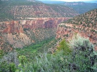
Historical Colorado River between Granby and Hot Sulphur Springs Click here to read the newsletter from the Colorado River Water Conservancy District. Here’s an excerpt:
The Colorado River District is working with partners on a new regional program to study agricultural conservation projects involving fallowing or deficit irrigation and is advocating the focus be larger than just Western Colorado agriculture, that Front Range agriculture and all municipal users also “share the pain.”
In discussing the subject at the July quarterly meeting of the Board of Directors, General Counsel Peter Fleming said that some degree of temporary fallowing and deficit irrigation may be required to manage the Colorado River Basin under a future dry scenario.
The River District would need to monitor closely and participate in pilot project proposals to ensure that West Slope agriculture and its related economies are best protected, he said.
General Manager Eric Kuhn said that as regional efforts focus on work in Colorado, they need to reach out more broadly than just Western Colorado agriculture. A successful program needs to explore methods to reduce Colorado River demands among all use sectors in the state: municipal, industrial, East Slope agriculture, as well as West Slope agriculture.
A program focused solely on West Slope agriculture will not be successful, he said.
More Colorado River Water Conservancy District coverage here.
Uncompahgre River Valley looking south FromThe Watch (William Woody):
Last week, the Project 7 Water Authority, which provides drinking water to the Montrose, Olathe and Delta communities (and the Menoken, Chipeta and Tri-State water districts, as well) stopped using sodium silicofluoride in its water treatment to boost fluoride levels.
At Monday’s work session of the Montrose City Council, Public Works Director John Harris explained he has already received some positive comments about the change. Harris, who also sits on the Project 7 board, said the supply of sodium silicofluoride, produced by a manufacture in Louisiana, was interrupted due to hurricane Katrina in 2005. He said that supply never recovered, leaving municipalities in the United States looking elsewhere, including China.
In July — just as supplies were running out — Harris said the Project 7 board voted in favor to end the practice.
“I’m not willing to take a risk on a Chinese-based project,” Harris told The Watch Monday. “Something would have to change to make us rethink that.”
Harris said residents can use supplemental fluoride found in toothpastes and mouthwashes, but because of the shortage, fluoride “just wouldn’t be added to the drinking water.”
Although fluoride can occur naturally, sodium silicofluoride has been used in America’s public drinking water for more than half a century, for prevention of tooth decay.Studies published by the Centers for Disease Control and Prevention suggest there has been an 18-to-40 percent reduction in cavities, in children and adults, as a direct result of water fluoridation.
In a press release, Project 7 said “sodium silicofluoride will no longer be added to boost the naturally occurring fluoride in the water to the “optimum level” as defined by the EPA…
“We can no longer obtain sodium silicoflouride that is manufactured in the USA, with the only supplier being China,” ” said Adam Turner, manager of Project 7. “We are not comfortable with the long-term quality control of the product we would be adding.”
According to the Project 7 website, water supplied to Project 7 from the Blue Mesa Reservoir contains a concentration range of naturally occurring fluoride (from 0.15 to 0.25 mg/l); the EPA limit of fluoride in water is 4 mg/l. Consuming levels higher than 4 mg/l, the EPA states, can cause bone disease and, for children, pits in their teeth…
An oil company’s claim for underground water near Gardner in Huerfano County was rejected last month by the state.
Shell Oil argued produced water from planned drilling is non-tributary, meaning it could be claimed for other uses. Produced water refers to excess water that nearly always accompanies oil and gas drilling operations.
But the Colorado Division of Water Resources said Shell failed to prove its case, in an initial report. Shell has until Aug. 22 to appeal the finding.
Shell’s consultant, AMEC, failed to consider local geologic factors that connect as well as separate the deep Niobrara shale formation with the natural stream system, according to a decision written by Ralf Topper and Matthew Sares of the hydrogeological services section of the division.
Shell’s application was opposed by Citizens for Huerfano County, a group of about 450 local residents and 600 total members that advocates for clean water and air.
“We’re contending that the water is connected because of the vertical dikes in the particular geology of the area,” said Jeff Briggs, president of the citizens group.
Shell made the claims for water underlying three 25,000-acre tracts known as the Seibert, State and Fortune federal units. It plans to drill 7,000 feet deep with horizontal fracturing at a depth of 5,000 feet.
That plan troubles area residents because of past contamination from drilling, Briggs said.
“We feel the state Legislature and executive branch have tried to facilitate as much oil and gas exploration as possible,” Briggs said. “I think what we are saying is that the decision by all levels of government and the oil and gas industry to go all in on fracking was economic and political and not scientific or medical.”
However the Huerfano County decision might not have statewide implications because it applies to specific geologic conditions found in the Spanish Peaks area.
A nontributary designation has advantages for a driller, because containing produced water for either direct use, treatment or deep injection would not require finding other sources to augment stream depletions
In a first-of-its-kind partnership, agricultural and environmental organizations, West Slope water districts and Denver Water have come together to explore measures that could help benefit the Colorado River and avoid reaching critically low water levels in Lake Powell. Should levels in this important reservoir continue to decline due to the prolonged drought in the basin, it could result in a compact call, putting water supplies to much of Colorado and the upper basin states at risk. This also could result in a loss of regionally important hydropower production, a reduction in revenues derived from the sale of this power, and an associated loss of funding for important programs like the Upper Colorado River Endangered Fish Recovery Program that provides the means by which all existing water use and an increment of future use in the upper basin can comply with the federal Endangered Species Act.
The Colorado Cattlemen’s Association, Colorado Farm Bureau, Colorado River District, Southwestern Water Conservation District, Denver Water, The Nature Conservancy and Trout Unlimited are working together to leverage $11 million made available under the Colorado River System Conservation Program, which will fund pilot projects to reduce demands in the Colorado River Basin and improve reservoir levels in Lake Powell as well as Lake Mead, which also has declined to its lowest level in its 80 year history.
“Without collaborative action, water supplies, hydropower production, water quality, agricultural output, recreation and environmental resources are all at risk in the next several years in the upper basin, if Lake Powell reaches critically low levels,” said Doug Robotham, Colorado water project director of The Nature Conservancy in Colorado.
The Colorado River System Conservation Program, announced last week, was created by the Bureau of Reclamation and four municipalities in the upper and lower Colorado basins, including Denver Water, to provide funding to develop, test and gather data on potential short-term demonstration or pilot programs that keep water in lakes Powell and Mead through temporary, voluntary and fully compensated mechanisms. If a pilot program proves to be successful, it could be part of a contingency toolbox developed by states and the federal government to be implemented only if a severe shortage looks imminent and discontinued when conditions improve.
“Our interest is to protect water users in Colorado and the upper basin. We know that if there is a compact call, agriculture is the first area that will be looked at for the solution,” said Don Shawcroft, Colorado Farm Bureau. “A crisis is bad for everyone — especially agriculture. It is vital that we have a voice at the table.”
The upper basin pilot projects developed under the System Conservation Program will be used to demonstrate ways to put water immediately in Lake Powell, through voluntary, compensated means, and only for as long as a drought continues.
“Lake Powell is the ‘bank account’ that assures the upper basin has the wherewithal to meet our obligation to the lower basin under the Colorado River Compact. While the risks of Lake Powell going below its power pool are low, the consequences are high,” said Jim Lochhead, CEO/manager of Denver Water. “Currently there are no contingency plans for such an event. Denver gets half its water supply from the Colorado River so we have a big stake in the future security of the river, not just for ourselves, but for all water users in Colorado. As leaders, we simply cannot wait for a crisis to happen before we come together to figure out how to address it. That would be irresponsible.”
“For a number of years now we have been working with Colorado, Front Range water providers, Southwestern, TNC, and agricultural producers on a long-term water banking solution. The System Conservation Program is a natural outgrowth of that effort. The challenge is to be sure all parties are represented and that we have fair and transparent processes,” said Eric Kuhn, general manager of the Colorado River District.
In order to ensure that local concerns are addressed, and that there is equity and fairness among all parties, the upper basin states of Colorado, New Mexico, Utah and Wyoming, and the Upper Colorado River Commission will have a direct role in program efforts. This envisioned structure is distinct from that of the Lower Colorado River Basin, where the Bureau of Reclamation will manage conservation actions in Arizona, California and Nevada to address declining reservoir levels in Lake Mead in a manner consistent with past programs.
“Complying with the Colorado River Compact is a shared responsibility across all water-use sectors and among all the upper basin states” said James Eklund, director of the Colorado Water Conservation Board. “We must control our destiny. The worst case is a compact call or a situation where the federal government determines how we will manage critical flows. We simply must work together to protect the future of this state, all our economies and critical industries to avoid a future compact call.”
As this is a basin-wide project, the coalition will continue to seek additional stakeholders throughout the upper basin states. The members also plan to actively seek additional funding for education and outreach.
“This is not a one-sector or one-state solution. The pilot programs will demonstrate the viability of cooperative means to reduce water demand from any number of different sources where water is lost or consumed — agriculture, municipal and industrial,” said Frank Daley, president of the Colorado Cattlemen’s Association.
“We have learned in Colorado though our Water Conservation Board and Basin Roundtables how critical public awareness is to project success. Education and awareness of the pilot projects may be equally as beneficial as the projects themselves. We have to be sure people have the real facts of what we are trying to do, buy in to the process and then document the benefits,” stated Bruce Whitehead, executive director of the Southwestern Conservation District.
The Colorado River and its tributaries provide water to nearly 40 million people for municipal use, and the combined metropolitan areas served by the Colorado River represent the world’s 12th largest economy, generating more than $1.7 trillion in Gross Metropolitan Product per year along with agricultural economic benefits of just under $5 billion annually.
Mid-July 2014 plume of model ENSO predictions via the Climate Prediction Center Click here to read the latest discussion. Here’s an excerpt:
Synopsis: The chance of El Niño has decreased to about 65% during the Northern Hemisphere fall and early winter.
During July 2014, above-average sea surface temperatures (SST) continued in the far eastern equatorial Pacific, but near average SSTs prevailed in the central and east-central equatorial Pacific. Most of the Niño indices decreased toward the end of the month with values of +0.3°C in Niño-4, – 0.1°C in Niño-3.4, +0.2°C in Niño-3, and +0.6°C in Niño-1+2. Subsurface heat content anomalies (averaged between 180o-100oW) continued to decrease and are slightly below average. The above-average subsurface temperatures that were observed near the surface during June (down to 100m depth) are now limited to a thin layer in the top 50m, underlain by mainly below-average temperatures. The low-level winds over the tropical Pacific remained near average during July, but westerly wind anomalies appeared in the central and eastern part of the basin toward the end of the month. Upper- level winds remained generally near average and convection was enhanced mainly just north of the equator in the western Pacific. The lack of a coherent atmospheric El Niño pattern, and a return to near-average SSTs in the central Pacific, indicate ENSO-neutral.
Over the last month, model forecasts have slightly delayed the El Niño onset, with most models now indicating the onset during July-September, with the event continuing into early 2015 . A strong El Niño is not favored in any of the ensemble averages, and slightly more models call for a weak event rather than a moderate event. At this time, the consensus of forecasters expects El Niño to emerge during August-October and to peak at weak strength during the late fall and early winter (3-month values of the Niño-3.4 index between 0.5°C and 0.9°C). The chance of El Niño has decreased to about 65% during the Northern Hemisphere fall and early winter (click CPC/IRI consensus forecast for the chance of each outcome).
The City of Evans received notice from Governor Hickenlooper’s office on Aug. 1 of a $1-million grant awarded to the city from the Colorado Department of Public Health and Environment’s Water Quality Division – Natural Disaster Grant Program…
The City of Evans will use the grant monies according to the guidelines established by the Water Quality Control Division of CDPHE for the following:
Repairs to the existing wastewater treatment facility to allow reliable and effective wastewater treatment until the new facility is fully operational
Hazard Mitigation Plan implementation at the Evans Wastewater Treatment Facility
Preliminary site applications, process design report, design of a future wastewater treatment facility and associated approvals.
When the flood occurred in September 2013, the City Council was already evaluating needed improvements to increase capacity of the wastewater infrastructure at the Evans Wastewater Treatment Facility. The flood caused serious damage to the facility, highlighting the vulnerability of maintaining a treatment facility in a floodplain. Receipt of these grant monies moves Evans one step closer to a treatment facility of appropriate capacity, out of the floodplain and which meets upcoming state regulatory standards.
Nearly a year after last September’s historic floods, many businesses in Boulder County are still trying to recover.
The U.S. Small Business Administration says they have approved nearly $11 million in loans to help with relief efforts…
Matt Varilek with the USBA says the long-term loans that were approved for businesses in Boulder County were at a 4 or 6 percent interest rates…
An SBA spokesperson says the window to apply for the business loans have passed. But, those who are in need of assistance can contact their local Small Business Development Center. There is still grant money available for businesses devastated by flood water.
The Small Business Development Center is an economic development organization that helps small businesses. There are 14 centers across Colorado to include to include one in Boulder and Larimer County.
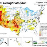
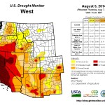
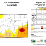
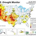
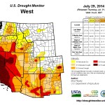
Click here to go to the US Drought Monitor website. Here’s an excerpt:
Summary
A vigorous monsoon circulation led to heavy rain (locally 2 inches or more) in parts of Arizona and the central and southern Rockies. The rain provided some drought relief, benefited rangeland and pastures, and eased irrigation demands. At times, showers spread as far west as California, resulting in some rare, locally heavy summer rainfall but having little overall impact on the state’s 3-year drought. Moisture also spilled across portions of the central and southern Plains, where interaction with a cold front led to copious rainfall (2 to 6 inches) in Oklahoma and environs. Rainfall totals were much lighter, however, across the majority of Texas. Farther north, however, only isolated showers interrupted an otherwise dry pattern from the Pacific Coast to the northern Plains and western Corn Belt. Despite a July drying trend, many Midwestern crops continued to thrive due to moderate temperatures and adequate subsoil moisture reserves. On August 3, USDA rated nearly three-quarters of the U.S. corn (73%) and soybeans (71%) in good to excellent condition—the highest such ratings this late in the season since 2004. In stark contrast, the return of extremely hot weather to the interior Northwest maintained stress on rangeland, pastures, and rain-fed crops. Elsewhere, locally heavy showers peppered the East, although amounts were highly variable. Some of the heaviest rain fell in the southern Mid-Atlantic States, helping to ease the effects of short-term dryness…
California
A strange thing happened on the path to California’s historic drought: it rained. Although the rain’s overall effect on the drought were inconsequential, there were some short-term benefits such as reduced irrigation demands and evaporation rates; lower temperatures in the wake of record-setting heat; and temporary relief for drought-stressed rangeland and pastures. Reasons that California’s rain did not provide substantial drought relief included: 1) a lack of widespread coverage of the heaviest showers, 2) the fact that heavy showers mostly fell outside California’s key watershed areas in the Colorado River basin and the Sierra Nevada, and 3) the fact that the high runoff rate of the heaviest rain did not allow for significant percolation into drought-parched soils. Nevertheless, intense rainfall on August 3 led to memorable flooding on the slopes of Mt. Baldy in southern California. Selected daily-record rainfall totals in California on August 3 included 0.49 inch in Needles and 0.07 inch in Long Beach. Scattered showers were reported in other parts of California on various days. Despite the cooler weather and showers, California’s rangeland condition remained steady (70% very poor to poor on August 3). Similarly, topsoil moisture (80% very short to short) and subsoil moisture (85% very short to short) were unchanged from the previous week. Across the northern tier of California, several wildfires—including the 30,000- to 40,000-acre Eiler and Bald fires—remained active in early August…
Northern Plains and Midwest
Spotty showers accompanied below-normal temperatures across the northern Plains and Midwest. Due to persistently cool weather and a lack of heat stress, impacts from short-term dryness have been slow to emerge. Nevertheless, there was some minor expansion of abnormal dryness (D0) and moderate drought (D1) in the southwestern Corn Belt, while a new region of D0 was introduced in northeastern Wisconsin and northwestern Michigan. From June 1 – August 5, rainfall in Traverse City, Michigan, totaled 4.77 inches (71% of normal). Similarly, Green Bay, Wisconsin, netted a June 1 – August 5 total of just 5.29 inches (67% of normal). In Wisconsin, USDA reports indicated that “dry soil conditions and a lack of heat units were keeping corn development behind normal, especially for late-planted fields.” Reports from Michigan echoed those comments: “cool, dry weather in most regions has been a challenge [with respect] to crop development.” In Nebraska, “another week of only scattered rainfall stressed dryland crops and pastures, [while] irrigation continued non-stop in many areas.” North Platte, Nebraska, completed its driest July on record, with rainfall totaling just 0.14 inch (5% of normal) [ed. emphasis mine]. Previously, North Platte’s driest July had occurred in 1901, when 0.34 inch fell. By August 3, topsoil moisture was rated at least one-third very short to short in Missouri (52%), Montana (52%), Nebraska (49%), South Dakota (36%), and Wisconsin (33%). On the same date, nearly one-fifth of the rangeland and pastures were rated very poor to poor in Montana and Nebraska—both at 18%…
Northwest
Record-setting heat returned to the interior Northwest, leading to some further increases in drought coverage—mainly in Washington and Oregon. In Washington, Omak posted consecutive daily-record highs (105 and 104°F, respectively) on July 29-30, followed by another record setting high of 100°F on August 2. Wenatchee, WA, also notched a pair of daily-record highs (105 and 103°F, respectively) on July 29-30. Other triple-digit, daily-record highs on July 29 included 105°F in Yakima, WA, and 104°F in Pendleton, OR. Effects of heat and drought were apparent on rangeland, pastures, and rain-fed summer crops. For example, 35% of Washington’s spring wheat crop was rated in very poor to poor condition on August 3, according to USDA. On the same date, 39% of Oregon’s rangeland and pastures were rated very poor to poor. And, topsoil moisture was rated more than half very short to short in Washington (65%), Oregon (62%), and Idaho (56%)…
Southern Plains
Heavy rain swept across Oklahoma and environs on July 30-31, resulting in modest reductions in drought intensity and coverage. A stripe of 2- to 6-inch rainfall totals stretched across southeastern Colorado, southwestern Kansas, central and eastern Oklahoma, and northeastern Texas, with official, 2-day totals reaching 5.18 inches in McAlester, Oklahoma; 4.02 inches in Paris, Texas; and 2.18 inches in Medicine Lodge, Kansas. Oklahoma’s topsoil moisture was rated 36% very short to short on August 3, an improvement from 47% the previous week. However, the effects of a multi-year drought were still apparent in the fact that, on August 3, subsoil moisture was rated 59% very short to short in Oklahoma, along with 52% in both Colorado and Kansas.
Aside from some heavy showers in northern and eastern Texas, significant rainfall largely bypassed the Lone Star State in late July and early August. As a result, both topsoil and subsoil moisture was rated 67% very short to short on August 3, according to USDA. Several degradations in the drought depiction were introduced in Texas, while USDA reported that rangeland and pasture “conditions began to deteriorate in areas of Edwards Plateau due to dry weather.” In addition, some producers in southern Texas “began to provide supplemental feed.”[…]
Southwest
Locally heavy showers associated with the monsoon circulation continued to pepper the Great Basin, Intermountain West, and Southwest, resulting in further improvements to the drought depiction where significant rain fell. Many of the improvements were concentrated across New Mexico, as well as portions of west-central and southeastern Arizona. On August 3, rangeland and pastures were rated 56% very poor to poor in New Mexico and 50% very poor to poor in Arizona. However, those numbers represented improvements from 65 and 56%, respectively, from the previous week. Shower activity continued to bypass many areas in Utah, which topped the Southwestern States on August 3 with 61% of its topsoil moisture rated very short to short. In northeastern Arizona, rain also continued to skirt much of the Navajo Nation and the Hopi Indian Reservation, leading to an increase in the coverage of severe drought (D2)…
Looking Ahead
From August 7 – 11, showery weather will gradually shift from the north-central U.S. into the Southeast. Five-day rainfall totals could reach 2 to 4 inches from the southwestern Corn Belt to the Carolinas. Meanwhile, mostly dry weather will prevail across the Great Lakes region and the southern Plains, although generally cool weather in the Midwest will contrast with hot conditions in the south-central U.S. Farther west, monsoon showers will be mostly confined to the northern Intermountain region, although a new surge of moisture may reach the Southwest during the next few days. In Hawaii, the remnants of Hurricane Iselle will pass over or very close to the Big Island during the night of August 7-8. Iselle, expected to be a tropical storm upon reaching the Big Island, could result in torrential rainfall and gusty winds. Effects from Iselle may also reach some of the other Hawaiian Islands, mainly on August 8.
The NWS 6- to 10-day outlook for August 12 – 16 calls for the likelihood of below-normal temperatures from the central Plains into the Midwest and Northeast, while hotter-than-normal conditions can be expected across the northern High Plains, Deep South, and much of the West. Meanwhile, near- to above-normal rainfall across the majority of the U.S. will contrast with the likelihood of drier-than-normal weather in southern Texas and from the Pacific Northwest to the northern High Plains.
Nobody doubts that the Colorado town of Pagosa Springs has hot water. It bubbles to the surface at around 140 degrees and in quantities sufficient to sustain a large commercial spa and several more public pools along the San Juan River.
As well, the hot water heats 13 businesses and 5 homes in downtown Pagosa Springs plus the Archuleta County courthouse, delivering this energy at a cost roughly 20 to 25 percent below the going rate for natural gas and 30 percent less than electricity.
But is there sufficient hot water available to produce electricity, warm 10 acres of greenhouses, and deliver heat to 600 homes?
Geologic modeling suggests there is, but until additional wells are drilled, as is expected later this summer, there’s no way of knowing for sure. If those exploratory wells confirm large volumes of hot water, then two large-bore wells will be required to extract the hot water and, after the heat is transferred from the water, return it underground.
Federal and state grants this year have given the project traction. The U.S. Department of Energy delivered $3.9 million, followed by $1.9 million from state sources. The town and county governments created a consortium called the Pagosa Area Geothermal Water and Power Authority to provide 30 percent in local funds, or $520,000, as required by the federal grant.
A private company, Pagosa Verde, which is pushing the project, came up with an equal amount in in-kind services. It owns 20 percent of the project and has the backing of a South Carolina-based investment firm called Natural Energy LLC.
Another milestone occurred in late May, when Colorado Gov. John Hickenlooper stopped in Pagosa to sign H.B. 14-1222 into law. The law, co-sponsored by Sen. Ellen Roberts, a Republican from Durango, and Sen. Gail Schwartz, a Democrat from Snowmass Village, lengthens the repayment period and otherwise provides great flexibility for private-activity bonds issued with the backing of the state government for geothermal and other renewable energy projects.
Michael McReynolds, policy advisor at the Colorado Energy Office, says the new law recognizes the large costs of proving the geothermal resource exists before development can occur.
However, other areas of the state are interested in replicating the business model of diverse revenue streams being assembled at Pagosa Springs. “It really depends upon the specific communities and what they want to pursue,” he said when asked if the new law will be used to finance other community renewable energy projects.
Jerry Smith, the chief executive at Pagosa Verde, says the new law was “huge” in allowing the project in Pagosa Springs to go forward.
In providing access up to $16.7 million available for as little as 2 percent interest, Smith’s project can now proceed. He estimates the need to spend $26 million before revenue can be gained.
“It’s a community-scale project, replicable throughout the Rocky Mountain states. I wanted town and county citizens to own it,” says Smith. “They only way they could participate was by forming an authority, similar to a housing authority. It’s a quasi-governmental authority.”
The public-private partnership is called Pagosa Waters LLC.
Because of the lower-cost money produced by the state and federal grants plus the clear bonding authority enabled by the new state law, he sees a financial path opening up.
Bonds will be just 2 percent. “That’s essentially free money,” he says. “We can borrow as much as we need to secure revenue for the project, “and it’s a way we go.”
Cheap borrowed money also relieves the onus of finding extremely hot water and arranging for sale of electricity, says Smith. If tests reveal merely hot water, such as bubbles up in the local springs, then that’s still hot enough for greenhouses and living rooms.
From the Romans forward
Hot water originating underground has long been put to practical uses. Romans at Pompei used hot water to heat buildings.
The Idaho Capitol Building has been heated with water drawn from 3,000 feet below ground, but 86 buildings with more than 5.5 million square feet of space are also heated by a separate geothermal heating district, according to Jon Gunnerson, geothermal coordinator for the City of Boise Public Works. It is the largest geothermal heating system in the United States, he says.
Commercial electrical production from geothermal sources began in 1911 in Larderello, Italy. The first commercial electrical production in the United States began in 1960 at The Geysers in California.
In 2013, according to the Geothermal Energy Association, the United States had 3,386 megawatts of installed geothermal capacity, or about three times as much as the trio of giant coal-fired power plants found in the Comanche complex near Pueblo, Colo.
Less prominent than photovoltaic panels, geothermal was nonetheless responsible for 0.41 percent of all electrical generation last year, ahead of solar at 0.23 percent. Biomass, wind, and hydro all produced more than geothermal.
California far and away has the most geothermal installed capacity, followed by Nevada, then trailed more distantly by Hawaii, Utah, and Idaho.
In Colorado, geothermal resources have been used to heat small greenhouses associated with the Mt. Princeton Hot Springs, near Buena Vista, as well as commercial springs. But no electrical production has been achieved because of concerns that new uses will rob existing users of their heat.
“Until very recently, Colorado’s geothermal potential for generating electricity has been assigned little promise,” notes the Colorado School of Mines at its geothermal website. “This appears to be based more on a lack of study, rather than on sound science.”
The website article goes on to note that a 2008 report from the Massachusetts Institute of Technology found that Colorado is the top state in the nation for potential commercial development of its heat, mostly if deep wells are drilled near Rico, Trinidad and other hot spots in a process called enhanced geothermal recovery.
Potential in Pagosa
Just how much electricity the Pagosa project could produce depends upon the heat of water. Colorado School of Mines studies concluded a strong likelihood of substantial hot water 2,000 to 5,000 feet under the land leased by Smith’s company about two miles south of downtown Pagosa Springs. Hot water for the downtown heating district is drawn from a depth of 300 feet.
Smith says it’s a cinch that the water found 2,000 to 5,000 deep will be at least 140 degrees Fahrenheit, the temperature of the water found closer to the surface. If so, it should be enough to produce four megawatts of round-the-clock electricity, what is called base-load generation.
If the water is 250 degrees, as the geological modeling suggests, it could generate 12 megawatts—and still have residual heat for the greenhouses and the homes.
Archuleta County altogether has baseload demand for 20 megawatts of generation. Another renewable source, a proposed biomass plant that would burn forest products to generate electricity, would generate 5 megawatts. Both biomass and geothermal generators probably need to get paid more for their electricity by the local electrical cooperative, La Plata Electric, than what the cooperative currently pays.
Biomass plant proponent J.R. Ford last winter said he needed 15 to 20 percent more than what the La Plata and other electrical cooperatives pay wholesale provider Tri-State Generation and Transmission. Tri-State’s power comes primarily from coal, natural gas, and hydroelectric.
Distributed generation
Both the geothermal and biomass projects in Archuleta County are representative of small sources of electricity called distributed generation. In a famous 1976 essay published in Foreign Affairs, Aspen-area resident Amory Lovins advocated more localized generation as necessary to shift power production from giant but often distant coal-fired power plants. In that same essay, Lovins also stressed that more local sources of electricity would reduce the vulnerability of the grid to terrorism.
“Distributed energy is what the world needs to get to,” says Smith, who cites Lovins as one of his heroes.
Smith moved to Archuleta County in 1989 after a career in the entertainment industry in California. He describes himself as a “liberal arts guy who values things that most people find technical and dry.”
Pagosa Skyrocket via Native Ecosystems
Geothermal is wet, of course, but whether it moves forward in Pagosa Springs depends upon the outcome of a review by the U.S. Fish and Wildlife Service. The 600 acres of land leased for the drilling between the San Juan River and Highway 84 has a plant species, the Pagosa skyrocket (Ipomopsis polyantha), which has been listed as endangered under the Endangered Species Act.
The plant grows one or two feet tall, often in the understory of Ponderosa pine, and has been found in only three places, all near Pagosa Springs.
The federal grant money triggered the need for a biological assessment, which will be the basis for a biological opinion. If adverse effects can be avoided, such as by using care in the placement of wells, the Fish and Wildlife Service can approve the drilling this summer.
Existing wells reach a maximum 1,200 feet, but Smith expects to need wells 2,500 to 5,000 feet deep. The working hypothesis is that the underground rocks at the site are fractured than those that provide the water for the commercial hot springs and downtown heating district.
How will anybody know if the new wells are tapping a new source of heat instead of robbing the existing geothermal resource? Smith says his company will inject heat and pressure gauges on all local hot-water wells, “so they know immediately whether we are tapping the resource.” Colorado law and new regulations in Archuleta County protect existing geothermal users in case of damage to their resource.
Chris Gallegos, who administers the town’s geothermal heating district, says it’s “an unknown” whether Smith’s project would impair the existing users. “Through the test wells we should be able to determine whether the extraction of that heat would affect us or not,” he says.
New numbers from the U.S. Drought Monitor suggest more than half of Colorado is drought-free.
This is significant improvement over this time last year, when nearly the entire state was in some sort of drought condition.
Dan Hobbs owns Hobbs Family Farm, in Avondale. He says farming in southern Colorado hasn’t always been easy.
“The last 14 years, on balance, have been pretty challenging due to the dry conditions,” Hobbs said.
But it appears help may be on the way for Hobbs and his fellow farmers. Heavy rainfall is bringing places, such as Pueblo County, out of the “exceptional drought” category.
“We’ve had some fun problems, and that’s more water than we can actually use,” Hobbs said. “It’s a good problem to have.”
For portions of southeast Colorado, drought fears are far from over.
“It takes a long time to get into a drought, and it takes a long time to get out of a drought,” said National Weather Service meteorologist Paul Wolyn.
Hobbs says he understands how vital precipitation can be to agriculture.
“It’s a precious resource, and to the extent possible, we need to figure out solutions to keep that water on the land so we can keep feeding the people of Colorado,” said Hobbs.
Click here to read the executive summary. Here’s an excerpt:
In the past 30 years, Colorado’s climate has become substantially warmer. The recent warming trend in Colorado is in step with regional and global warming that has been linked to increasing atmospheric concentrations of greenhouse gases. Annual precipitation, which has high natural variability, has not seen a statewide trend over that period. However, some drought indicators have worsened due to the warmer temperatures.
As greenhouse gases and other human effects on the climate continue to increase, Colorado is expected to warm even more by the mid-21st century, pushing temperatures outside of the range of the past century. The outlook for future precipitation in Colorado is less clear; overall increases or decreases are possible. The risk of decreasing precipitation appears to be higher for the southern parts of the state.
The future warming is projected to generally reduce Colorado’s spring snowpack, cause earlier snowmelt and runoff, and increase the water use by crops, landscaping, and natural vegetation. While future increases in annual natural streamflow are possible, the body of published research indicates a greater risk of decreasing streamflow, particularly in the southern half of the state.
FromTheDenverChannel.com (Phil Tenser, Mike Nelson):
Colorado’s warming climate is projected to cause significant changes for state’s water supply, according to a new study.
Released by the Western Water Assessment and the Colorado Water Conservation Board, the study echoes many of the predictions included in a national assessment issued by the federal government in May. Both forecast that ongoing warming of the local climate will reduce Colorado snowpack, cause earlier snowmelt and increase water use for agriculture and landscaping.
“Climate Change in Colorado,” the report issued Tuesday and led by a University of Colorado researcher, is based on compiled climate science. It focuses on current observed trends and forecasts for the mid-21st century…
The authors also stated that Colorado snowpack has been mainly below-average since 2000 and snowmelt timing has shifted earlier in the spring over the past 30 years. Projections call for the peak runoff time to continue shifting earlier, but the report says that changes in the timing are more certain than predictions for the amount of runoff.
The report says, “The uncertainty in projections of precipitation and streamflow for Colorado should not be construed as a ‘no change’ scenario, but instead as a broadening of the range of possible futures, some of which would present serious challenges to the state’s water systems.”
According to the report, these observations and predictions could influence reservoir operations including flood control and water storage. Changes in the timing and volume of runoff may also “complicate” future water rights issues and interstate water compacts. Lower streamflows could also lead to higher concentrations of pollutants.
Earlier peak flows could have impacts on aquatic ecosystems and rafting or fishing industries, while reduced snowpack may also impact Colorado mountain tourism.
Every climate model assessed in the report indicates future warming will increase average annual temperatures by 2.5 to 5 degrees Fahrenheit by 2050 if greenhouse gas emissions are in the lower range of estimates. If emissions are in a higher range, the increase could be 3.5 to 6.5 degrees.
“We will still have cold winters and cool summers, but as the global climate warms, these cooler trends will become less frequent in the coming decades,” Nelson said.
Here’s a release from the University of Colorado at Boulder:
As Colorado’s climate continues to warm, those who manage or use water in the state will likely face significant changes in water supply and demand, according to a new report on state climate change released today by the Western Water Assessment and the Colorado Water Conservation Board.
Rising temperatures will tend to reduce the amount of water in many of Colorado’s streams and rivers, melt mountain snowpack earlier in the spring, and increase the water needed by thirsty crops and cities, according to the new report, “Climate Change in Colorado: A Synthesis to Support Water Resources Management and Adaptation,” which updates and expands upon an initial report released in 2008.
The Colorado report comes on the heels of international and national assessments that discuss likely impacts of climate change in broad regions, and it leverages those assessments to provide state-specific information. Because Colorado is located between an area likely to dry further (the U.S. Southwest) and one likely to get wetter (Northern Great Plains), our precipitation future is less certain.
“Despite some uncertainties around precipitation, it’s clear that as temperatures rise in Colorado, there will be impacts on our water resources,” said Jeff Lukas, lead author of the new report and a researcher at the Western Water Assessment, a program of the University of Colorado Boulder funded by the National Oceanic and Atmospheric Administration.
“Already, snowmelt and runoff are shifting earlier, our soils are becoming drier, and the growing season has lengthened,” Lukas said. “Wildfires and heat waves have become more common, too. Climate projections suggest those trends—all of which can affect water supply and demand—will continue.”
The newest climate models are split on whether the future will see increasing, decreasing or similar amounts of annual precipitation in Colorado. Even if the future brings more precipitation, the report notes, skiers, farmers and cities may not benefit because a warmer atmosphere will pull more moisture out of the state’s snowpack, soils, crops and other plants.
In producing “Climate Change in Colorado,” the authors sought to provide information that would be useful to people involved in making long-term decisions about Colorado’s water in the face of climate change.
“This report will help to inform critical products like the Statewide Water Supply Initiative (SWSI) and Colorado’s Water Plan,” said James Eklund, Colorado Water Conservation Board director. “This report will add value, just as the 2008 report was widely used by the state and other entities to inform their long-term planning processes such as the Colorado Drought Mitigation and Response Plan and the city of Denver’s Climate Adaptation Plan.”
Among the findings presented in the new report:
Colorado has warmed: Statewide average annual temperatures are 2 degrees Fahrenheit higher than they were three decades ago.
Climate models indicate that the state’s average annual temperature will continue to increase, by 2.5 to 6.5 degrees by 2050.
A 2-degree increase would make Denver’s temperatures in 2050 more like Pueblo’s today.
A 4-degree increase would make Denver more like Lamar in southeastern Colorado, and a 6-degree shift would push Denver’s temperatures beyond any found in Colorado today, to more like those in Albuquerque, New Mexico, today.
Future warming in the state is likely to lead to more heat waves, wildfires and droughts. Observations show there have already been increasing trends in these three extremes over the past 30 years.
Warmer temperatures and other changes (dust on snow) mean that snowpack is melting earlier, on average, by one to four weeks compared with 30 years ago. This creates a strain for farmers and other users who draw water directly from rivers.
Colorado has seen no long-term increase or decrease in total precipitation or heavy rainfall events. Climate models are split about Colorado’s future precipitation, showing a range of possible outcomes from a 5 percent decrease in precipitation to an 8 percent increase by midcentury.
Climate models tend to show a shift toward higher midwinter precipitation across the state.
Hydrology models show a wide range of outcomes for annual streamflow in Colorado’s river basins, but an overall tendency towards lower streamflow by 2050, especially in the southwestern part of the state.
The Western Water Assessment (WWA) is part of the Cooperative Institute for Research in Environmental Sciences (CIRES), a joint institute of CU-Boulder and the National Oceanic and Atmospheric Administration (NOAA). The Colorado Water Conservation Board (CWCB) is a division of the Colorado Department of Natural Resources and spearheads the state’s climate change adaptation efforts.
Co-authors of the report are Joseph Barsugli of CIRES and NOAA’s Earth System Research Laboratory (ESRL), Nolan Doesken of Colorado State University and the Colorado Climate Center, Imtiaz Rangwala of WWA, and Klaus Wolter of CIRES and ESRL.
Gunnison River Basin via the Colorado Geological Survey
From the Grand Junction Free Press (George Sibley):
In July, the Gunnison River Basin Roundtable completed a “Gunnison Basin Water Plan,” finishing a year of concentrated hard work. This basin plan went to the Colorado Water Conservation Board, along with eight other plans from other Colorado basin roundtables; and by the end of the year a single consolidated Colorado Water Plan will emerge to shepherd the use of the state’s water resources out to 2050.
Exactly what this consolidated Colorado Water Plan will look like is not yet known. So fear fills the knowledge gap: Metropolitan water users (~80 percent of the population) fear that the Plan will impose draconian conservation measures; East Slope farmers fear that it will either outright redirect their water to the cities or will hatch complex “water-sharing” schemes that will slowly erode their property in water; and West Slope inhabitants fear that it will direct more water from our side of the mountains to Front Range cities.
Realistically, the plan will probably fulfill all of those fears to some extent. The planning was initiated when Colorado’s water leaders realized that, by mid-century, Colorado will probably have another 3-5 million people, all needing water from a supply that is already stressed by people pressures. Most of the new people will congregate in Colorado’s Front Range cities.
How do we equitably distribute an already stressed but essential resource among maybe twice as many people – most of them concentrated in one water-short area? And since most of that resource is already being used to produce food – also something urban dwellers need – how do we share out the water without diminishing the food supply?
Complicating matters, all nine basins, except for Colorado’s small part of the North Platte River, have discovered that they themselves are likely to be short of water for their own anticipated population growth. But the four West Slope basins (Yampa-White, Colorado, Gunnison and San Juan-Dolores) and the Rio Grande basin found that through a combination of small water projects, conservation programs, and “willing seller” agricultural transfers, they should be able to resolve their communities’ projected shortages from within their own basins.
The two East Slope “natural” basins (South Platte and Arkansas) and the Metropolitan “Sink” (the non-basin encompassing Denver and its first and second ring of South Platte suburbs) found that they would need to find “new supply” from outside their basins. The annual metropolitan shortfall by mid-century is estimated at 200,000-600,000 acre-feet, depending on actual growth and the extent of conservation programs. An acre-foot of water serves roughly two homes (with yards) for a year under current usage.
All of the “natural” basins have also quantified agricultural shortages – the difference between the water available and the “ideal” amount of water that would maximize the productivity of their land; these shortages added up to 2 million acre-feet statewide. Some of that shortage could be reduced through irrigation infrastructure repair and efficiency and more small storage.
None of the eight natural basins have discovered a big pool of unused water to resolve the metropolitan gap. That will have to be addressed in the state plan.
Where will the “new” metro water come from? There is a tendency in the state’s rural areas to sing the old song: “It’s your misfortune and none of our own.” But that requires forgetting what we learned in 2006 when a December blizzard shut down the Front Range – and suddenly our supermarkets were out of food. Like it or not, we hinterlanders need the Front Range as much as the Front Range needs hinterland water.
It is unlikely that there will be a significant transmountain diversion from the Upper Gunnison Basin, especially since water rights were quantified for the Black Canyon National Park and downstream flow targets were set for recovering endangered fish. Still, every gallon of water that goes to the Front Range from any West Slope stream decreases our local options under the terms of the Colorado River Compact, which prevents us from holding onto water relied upon by downstream states.
The Gunnison Basin Water Plan addresses the statewide issue by stressing, first, the absence of any significant pool of water not already being used to the max within the basin; and second, the high risk and high cost of very junior transmountain diversions that would only get water in above-average water years.
The core of each basin plan is the list of projects for meeting its own needs and goals; the Gunnison Basin plan lists over 100. These will require some projects for physically moving water around, but the harder work will be moving our minds around to figure out how a twice as many people can reasonably and equitably share out an already mostly developed resource.
To see the Gunnison Basin Water Plan (or any other basin’s), go to http://www.coloradowaterplan.com, and click on “Community” in the top menu. There are tracks on that website for submitting your own input on the planning process – but you may also send it directly to Gunnison Basin Plan Chair Frank Kugel, fkugel@ugrwcd.org, or give this correspondent a call at 970-641-4340.
George Sibley is chairman of Gunnison Basin Roundtable Education Committee.
An upcoming stormwater vote in El Paso County has been slightly scaled down. Following a meeting with El Paso County commissioners last week, an intergovernmental agreement being promoted by a stormwater task force now proposes raising $39.2 million annually rather than $48 million as suggested in the first draft of the agreement.
The fee for a typical home would drop to $7.70 per month, rather than $10 per month. The fee would be levied for 20 years and the money used toward addressing a backlog of $700 million in stormwater projects and maintenance of stormwater structures.
The agreement includes Colorado Springs, Fountain, Manitou Springs and Green Mountain Falls as well, and if all agree the formation of the Pikes Peak Regional Drainage Authority would be placed on the November ballot by commissioners.
It’s important to Pueblo because controlling flood water on Fountain Creek is one of the premises Colorado Springs used in obtaining permits for its Southern Delivery System. With its SDS permits in hand, the Colorado Springs City Council abolished its stormwater enterprise in late 2009, based on its interpretation of a vote.
The lower amount still would be sufficient, said Jay Winner, general manager of the Lower Arkansas Valley Water Conservancy District.
“The proof will be if they can get it passed in November,” Winner said. “It’s a lot more than they have now, so anything they do will be an improvement.”
The biggest remaining hurdle to getting the issue on the ballot is the rift between Mayor Steve Bach and the Colorado Springs City Council.
Bach last week sent a letter suggesting changes in the IGA that would allow cities to prioritize their own projects, allow non-elected officials to serve on the board, lock in the proposed rates and include nonprofits and churches in assessments.
Bach has not participated in the task force meetings that have been going on since 2012, and has suggested alternative ways of financing stormwater control.
The estimated construction cost of the Southern Delivery System, a water pipeline from Pueblo Dam to Colorado Springs, has been lowered to $841 million, about $145 million less than earlier estimates.
“It’s our responsibility to manage project costs as closely as possible to protect the investment being made by the SDS partner communities,” said Janet Rummel, spokeswoman for Colorado Springs Utilities.
The timing of SDS construction saved money primarily because of lower interest rates and lower pricing for materials and services, she said.
“Competitive bidding has allowed more than 100 Pueblo County-based businesses to benefit from $65 million in SDS spending so far,” Rummel said.
Although most of the benefit from SDS goes to Colorado Springs, Pueblo West, Security and Fountain also are SDS partners.
The pipeline has a capacity of 96 million gallons per day, with 78 mgd going to El Paso County.
Pueblo West will increase its capacity by 18 mgd through a connection to the newly constructed north outlet works.
Its current connection at the south outlet delivers 12 mgd — just above the metro district’s peak-day delivery. The outlet is shared by the Pueblo Board of Water Works and the Fountain Valley Authority. It also will be the hookup for the Arkansas Valley Conduit.
Pueblo West has paid $6.5 million for construction of its SDS connection, and estimates it will have paid a net price of $6.7 million — when all bills and refunds are totaled — by 2017.
The money came from reserves, said Jack Johnston, metro district manager.
“We have cash-funded the project out of reserves that were collected primarily during the growth years,” Johnston said. “They were fees that were set aside to help build the reserves to do capital projects.”
Pueblo West got some of the SDS savings, but just for the construction nearest the dam, where its 36-inch-diameter connection splits off from the 66-inch-diameter line that runs 50 miles north.
“Whatever savings were realized in building the north outlet works were passed on to us,” Johnston said.
Pueblo West had been negotiating an agreement to turn on SDS ahead of schedule, since its spur from the dam will be ready for use ahead of the rest of the project.
However, the board last month delayed action on a draft agreement that could allow early turn-on of SDS. If no agreement is reached, the startup would be whenever Colorado Springs gets the go-ahead from Pueblo County to turn on SDS, expected in 2016.
Colorado Springs must meet Pueblo County’s 1041 permit conditions in order to start SDS.
Those conditions include $50 million in payments, plus interest, to the Fountain Creek Watershed Flood Control and Greenway District; $15 million for road rehabilitation in Pueblo West; and $2.2 million for Fountain Creek dredging in Pueblo. All of those payments are included in the $841 million construction cost.
Colorado Springs also will pay $75 million for wastewater system improvements by 2024 within the city under the 1041 permit, but that cost is not included in the estimate.
The dust storms looked eerily similar to the ones you’d see on the pages of a history textbook. But it’s 2014, not the 1930s, and many of the same stretches of prairie once devastated by the Dust Bowl are once again dealing with terrible drought and massive dust storms. Some areas are technically drier now than they were when thousands of families abandoned their farms. Still, many farmers have managed to avoid tragedy.
While big swathes of the Great Plains have partially recovered from the extreme 2012 drought, some sections are still desperately dry. The drought has settled in what historians consider to be ground zero for the Dust Bowl of the 1930s: southeast Colorado, western Kansas, northeast New Mexico, and the panhandles of Oklahoma and Texas…
Portions of southeast Colorado haven’t seen a lack of moisture like this since we started keeping weather records. Farmers have seen some relief with the summer’s monsoonal rains, but moisture deep in the soil will take longer to recover. The cracked, dusty ground has been sapped by heat.
“When you put water on it, after it’s been that dry, it won’t absorb any,” Schweiser said. “It’s been bad as I ever remember seeing.”
How, then, is a farmer like Schweiser making a living? None of his neighbors have skipped town like Dust Bowl refugees. 2013 was a rough year, but he made it through. Farmers aren’t marching on Washington demanding relief.
“Most of them have been around to know that you have to take the good with the bad, and most people just accept that,” Schweiser said. “If they didn’t, they wouldn’t be farming in the first place.”
The reason more farmers haven’t gone bankrupt, even in Dust Bowl conditions, is far more than sheer persistence. It’s the culmination of decades of agricultural research, technological advances and changing practices.
“The 2012 drought was — is — severe. And very comparable to what we saw in the Dust Bowl,” said Eugene Kelly, a soil science professor at Colorado State University.
Farmers like Schweiser are able to keep their farms up and running even in Dust Bowl conditions, Kelly said, largely due to adaptations and adoptions of new technology. Farms in the 1930s relied on primitive horse-drawn plows. Now, large-scale crop farmers are testing conservation practices like planting cover crops, limiting tillage and updating irrigation, with financial benefits…
“I think they’re able to sustain the production in some of these areas,” Kelly said. “But that came from a lot of research and a lot of work in developing cropping systems and farming systems and learning a lot about the damage a plow can do.”[…]
In the decades since, former U.S. Department of Agriculture conservationist John Knapp says a suite of conservation programs has gone into effect. Those programs pull sensitive grasslands out of agricultural production and keep the soil intact.
“That really changed what was the Dust Bowl,” Knapp said. “Because those lands are in grass now. And that’s some of the most highly erodible anywhere in Colorado.”
Though some farmers have been able to adapt to a harsh environment, the economics of such a transition can wreak havoc on the small communities involved, Knapp said. Even though farmers like John Schweiser are able to keep their heads above water, times are tough. Selling off cattle or relying on insurance is taxing on farmers and on the surrounding towns.
“Even prior to this particular drought, we have been on kind of a slide in terms of the economics. Just because we weren’t able to sustain some of the higher value crops,” Knapp said.
When irrigation water was easier to come by, farmers grew high value crops like onions and melons along the Arkansas River in Colorado. But as drought persisted and worsened, packing sheds have closed, Knapp said. Farms then need fewer workers.
Some farmers are selling out completely. Mirroring a national trend, Otero County, Colorado, where John Schweiser grows corn and wheat, saw a 5 percent drop in the number of farms from 2007 to 2012 and a 19 percent increase in the average farm size. Those are larger economic issues not necessarily caused by drought, but certainly exacerbated by it, Knapp said. And playing out in many of the hardest hit areas.
Under the agreement, finalized late last week between the Department of Interior and the utilities Denver Water, the Central Arizona Project, the Southern Nevada Water Authority and the Metropolitan Water District of Southern California, farmers, cities and industries will get paid to implement two-year, voluntary conservation projects that put water back into the Colorado River. The goal is to demonstrate that so-called “demand management” can prevent water levels in lakes Powell and Mead from dropping too low for their dams to generate electricity.
“We want to demonstrate how we can live within our means on the river,” said Jim Lochhead, CEO of Denver Water, whose city relies on Colorado River water piped east over the Continental Divide for about half of its water supply.
In the agricultural sphere, one candidate for funding under the partnership would be rotational fallowing agreements, where farmers band together, dry up some of their land and leave the associated water in the river in dry years. Yet after years of Western cities “buying and drying” nearby farms to lubricate their growth, agricultural groups are eager to see other non-fallowing options explored as well…
“Fallowing is really a blunt force tool that would harm agriculture,” said Terry Frankhauser, executive vice president of the Colorado Cattlemen’s Association. “We want to try to explore other ways of reducing demand,” like switching to less water intensive crops, watering less and accepting reduced yields, or water banking—foregoing diversions when you don’t need them in exchange for the right to use more later.
In cities, projects eligible for funding could include things like water-smart landscaping, increased use of reclaimed water, or efficiency standards for appliances and new construction.
Whatever the demand-reducing mechanism, Lochhead said, “The goal is to develop a plan that we can put into place as we need to in emergency situations.” And for water managers who depend on the Colorado River, losing power-generating capacity in lakes Mead and Powell would certainly qualify as an emergency. If water levels drop that low, there likely won’t be enough head pressure in Lake Powell behind the Glen Canyon Dam to push through 7.5 million acre feet of water over 10 years. That’s how much the upper basin states—Colorado, New Mexico, Utah and Wyoming—are required to deliver to the lower basin under the 1922 Colorado River Compact. If they fall short, the lower basin states—Arizona, Nevada and California—have license to place a call on the river and force their friends in the upper basin to cut consumption…
“If that happens, it would mean chaos in the basin among water users because everyone would be scrambling to try to shore up our water supplies,” Lochhead said.
And losing power generating capacity could have other consequences: proceeds from the electricity generated at Glen Canyon Dam now fund recovery programs for four endangered species—the Kanab ambersnail, the razorback sucker, the humpback chub and the southwestern willow flycatcher—that are native to the Colorado River Basin. If enough water in Lake Powell evaporates, funding for those programs could too, allowing the federal government to intervene and curtail water use in the upper basin in the name of the Endangered Species Act.
Finally, if the turbines inside Glen Canyon Dam ground to a halt, Lochhead points out that it could prompt power prices in the upper basin to spike, since roughly 5.8 million people now depend on electricity from the dam for a portion of their power supply. Exactly how much rates would rise remains unclear.
State Reps. Don Coram and Jerry Sonnenberg are cool to the proposal. Here’s a guest column that’s running in the Sterling Journal-Advocate:
Denver Water on behalf of the Bureau of Reclamation and the respective water districts from Arizona, California and Nevada recently developed a drought management pilot program for the Upper Colorado River System to send more water downstream. Other than Denver Water, the water districts involved in this program represent the states known as the Lower Basin states. The proposal addresses several concerns, which can be summed up as the Lower Basin states cannot satisfy their current water demand. Unfortunately, when the drafters of this pilot program looked up stream for more water, it seems Colorado’s agriculture industry became their target for relief.
In order to send more water to these Lower Basin states, the pilot program suggests farmers could fallow more land, employ deficit irrigation techniques and plant crops that use less water; but let us explain why these ideas will greatly damage our agriculture industry. First, fallowing, a term for intentionally leaving a portion of a field vacant, is strategically used by farmers to let soils recover from a harvest. Fallowing can improve yields in future years, but because a farmer is choosing not to plant in a portion of the field, no crops are produced. Secondly, changing to deficit irrigation methods can be very difficult and result in lower crop yields. And lastly, crops are soil, location, elevation and climate specific, and each require an enormous investment in equipment specific to that crop. Additionally, crop selection is based on market prices, demand and cost of harvest. Requiring farmers to plant different crops can be costly, and in some cases, not viable.
On top of the burdens proposed in this program is the current Colorado drought, which reduced agricultural production by 25 percent last year alone. Yet despite this drastic drop in production, Colorado’s agriculture industry still contributed over $2 billion to our state’s economy. Asking Colorado farmers to plant less, reduce their yield and even switch crops will have devastating impacts on our agriculture industry and ultimately our state’s economy.
Much like Colorado, the Lower Basin states are struggling to meet their water demand, but with growing populations in this region and declining rain and snow fall, this problem is likely here to stay. However, as Colorado and its neighboring states continue to look for solutions for water management, they need to consider who has been and will continue to be a leader of water conservation — our agriculture industry. This industry is first to experience the effects of drought and consequently is the first to take steps to better manage its water supply. Simply put, farmers and ranchers are already consummate water conservationists because their livelihoods depend on it.
The Lower Basin states can receive water above their agreed upon allotment. If these states are looking for more water, cities like Las Vegas need to discuss ways to better manage their current water budget, and leave Colorado farmers’ and ranchers’ water out of the discussion.
Macro Invertebrates via Little Pend Oreille Wildlife Refuge Water Quality Research From the Vail Daily (Peter Wadden):
Thanks to ongoing support from the National Forest Foundation and Vail Resorts’ Ski Conservation Fund, 12 local high school students are participating in the third summer of the Walking Mountains Natural Resource Internship. The interns are working under the supervision of Matt Grove, fisheries biologist on the Eagle/Holy Cross Ranger District of the White River National Forest, to monitor stream and wetland health throughout the valley. The interns have searched for endangered boreal toads to identify sites where they are still breeding in the area, but most of the students’ work focuses on monitoring stream health.
The interns have learned two tried and true techniques for collecting information that helps the Forest Service gauge the health of waterways. The first is by collecting and measuring stream substrates. This involves plunging their hands into icy water to pull out rocks, pebbles and gravel to be measured. The size of the stones in a stream dictates what aquatic insects can live there because those stones provide a place for the insects to hide and a surface to cling to in the rushing stream.
The second way the interns are gathering valuable stream data is by collecting the macroinvertebrates themselves. What species of insects are living in a stream is a great indicator of how healthy that stream is. Some insects are tolerant of pollution while others are not. If only pollution-tolerant species are found, then we can tell a stream may not be very clean. On the other hand, if insects that require clean, clear water to survive are found in abundance, then we will have strong evidence that the stream is doing well. Samples of insects are netted and collected by the interns in each stream they visit and then are preserved in ethanol so they can be sent to a lab for DNA identification.
The 12 Walking Mountains interns have mastered these data-collection techniques with training and supervision from U.S. Forest Service fisheries biologists and seasonal fisheries technicians. In addition to providing valuable information to the U.S. Forest Service, the interns are gaining experience in field ecology and exposure to careers in science and natural resource management. The high school students also earn four environmental science credits from Colorado Mountain College, giving them a chance to connect their observations in nature to broader concepts in ecology and biology…
Isaac Yoder, a rising junior at Eagle Valley High School, recognizes the value of this type of learning saying, “Through this internship, I gain experience relevant to real life jobs and collect information that affects the community instead of just seeing it in a classroom.”
A rise in alternative energy demand has led to a fourth hydroelectric power facility now in the planning stages for the South Canal, east of Montrose.
The Delta-Montrose Electrical Association currently operates two facilities, at Drop 1 and Drop 3, with plans for a facility on Drop 2.
Last week, the U.S. Bureau of Reclamation released its draft environmental assessment for yet another proposed hydropower project, at Drop 4. Drops 1 and 3 is currently producing approximately 6.5 megawatts of power this summer, according to James Heneghan, renewable energy engineer for DMEA.
The proposed Drop 4 location, 0.8 miles downstream from the existing Drop 3 hydropower plant that was completed last year, drops approximately 71 ft. from Drop 3 to Drop 4. With a fourth facility, water would be diverted into a penstock and through the hydropower plant and returned to the canal to meet mounting irrigation delivery demands downstream.
The project also includes 1.27 miles of new overhead interconnection line across federal Bureau of Land Management and Reclamation lands.
“The purpose of the Drop 4 Hydropower Project is to develop a 4.8 megawatt (MW) hydropower plant on the South Canal at Drop 4 to provide a clean, renewable energy source that is locally controlled,” according to the bureau’s assessment. “Current federal policy encourages non-federal development of environmentally sustainable hydropower potential of Federal water resource related projects.”
The project, proposed by the Uncompahgre Valley Water Users Association and a private developer, and would not affect the seasonal delivery of irrigation water.
Like Drops 1 and 3, the power generated at Drop 4 would be handled by DMEA, and transmitted to the Municipal Energy Association of Nebraska.
“The electricity generated by the Project would provide the UVWUA with an additional source of revenue that can be used to defray annual operating expenses and assist in the maintenance and improvement of the Uncompahgre Project,” according to the assessment.
Structural plans for Drop 4 call for a new concrete intake canal connecting to an intake structure; a metal bar trash screen would remove debris as the water is forced into a 10-ft. pipe and flushed 1,347-ft. downstream to a new 30-ft. by 40-ft. powerhouse with a power generating turbine. It’s the same method now used in Drops 1 and 3…
When completed, the Drop 4 station could produce about 15,744 megawatt hours of energy per year, with an offset reduction of 32,000,000 to 34,000,000 pounds of CO2 and other greenhouse gases.
On May 14 of this year, a Preliminary Lease of Power Privilege was entered into by the UVWUA and the Bureau of Reclamation for the project, putting it on the fast track. “I would say with the promise of privilege being drafted, Drop 4 will be competed before Drop 2,” Heneghan told The Watch this week…
Amendment 37 to the Colorado Constitution established a Renewable Energy Standard, an initiated state statute approved by voters in 2004, requires Colorado providers of retail electric services serving over 40,000 customers to secure a minimum percentage of electricity from renewable energy sources (such as wind, solar, and hydroelectricity to be 10 percent) by 2020. DMEA is close to achieving that standard, thanks in large part to the two existing South Canal projects. The Drop 2 project could be the next addition of renewable energy to DMEA’s portfolio, Heneghan said.
Wholesalers, like Tri-State Generation have to reach 20 percent by 2020.
The draft environmental assessment is available online at http://www.usbr.gov/uc/envdocs/index.html, or a copy can be received by contacting the U.S. Bureau of Reclamation.
Comments can be submitted to the Terry Stroh at the email address above, or to Ed Warner, Area Manager, Bureau of Reclamation, 445 West Gunnison Ave, Suite 221, Grand Junction, CO 81501, up until Aug. 8. The bureau will consider all comments received by that date, prior to preparing a final environmental assessment.
The City of Colorado Springs has seen their flood project in Camp Creek go through hail, heavy rain and flash flooding. The good news is the water has stayed within the banks of the creek protecting people, but maintaining the flood project will not be cheap.
City Stormwater Engineer Tim Mitros said after the sediment and debris came down from last September’s floods, Camp Creek became a top priority for the city. A year later after the floods, Mother Nature put the flood project to the test. This time there is a pond to stop a majority of the debris, and a steady stream going through the Colorado Springs neighborhood near the creek…
He said if the sediment pond is full, about $100,000 will have to be spent to clean the pond, which will come from the city’s general fund.
Gary Rombeck lives in the neighborhood near Camp Creek. He said he took a look at the flood project saving his life, along with other people down stream; he said you can’t put a price on safety.
Mitros said the sediment removed from Camp Creek is put in North Douglas Creek, which is meant to slow down water during flooding.
The city wants to put another $4 million toward improving the Camp Creek flood project, but it’s waiting for the grant money.
Here’s a guest column in favor of the EPA’s proposed rule clarifying the “waters of the US” under the Clean Water Act, from Karn Stiegelmeier writing in The Denver Post:
We all want to protect Colorado’s iconic mountain streams that provide clean water to drink and clean water to fish, without unnecessary overregulation. A recent proposal from the Environmental Protection Agency and Army Corps strikes that balance. The new rule would restore important protections for waterways and reduce administrative burdens in permitting processes. While admittedly technical, this is an important step forward.
The Clean Water Act is all about restoring and maintaining healthy waterways throughout the United States. But it protects only those waters that meet the definition of “waters of the United States.” Two Supreme Court rulings over the last 15 years muddled the distinction between waters that were covered under the Clean Water Act and those that weren’t. Those rulings resulted in significant additional red tape, time and expense to the permitting processes.
Specifically, in 2009, Denver-based officials with the EPA reported that it takes their office three times as long to process a permit request after the Supreme Court decisions.
Many in Colorado and around the nation clamored for a remedy for the confusion and delays. The federal agencies issuing the proposed rule are currently accepting comments on how this first draft might be improved. The proposed rule, while not perfect, seeks to bring some clarity back to the process. Local governments and individuals around the state should submit comments on how the rule could be made better.
Many government and agricultural leaders have already opposed the rule-making in its entirety, providing little or no feedback on how the rule might be improved. There has been broad misinterpretation of this rule clarification as burdensome “over-regulation.” In fact, the proposal is precisely the opposite.
The proposed rule does not expand federal jurisdiction beyond its historic limits, but instead restores protections for some waters brought into question after the Supreme Court rulings. For example, in 2009 the Corps determined a 12-acre high altitude wetland in Park County was outside of federal jurisdiction because a manmade ditch interrupted the historic connection with the nearby stream. This wetland certainly would have received protection from water pollution before the Supreme Court decisions, and rightfully should under the proposed rule. Without protection under the Act, pristine sites like this wetland may be dredged, filled, and developed without any federal agency oversight, to the detriment not only of the wetland but also the neighboring stream, communities, and economies.
Second, many ditches have been under Clean Water Act jurisdiction since the 1970’s. The Act requires permits for some activities occurring on some ditches because they drain into natural waterways and affect the health of those waters. These ditches should be regulated under the Act, as they have historically, to protect the rivers into which they drain.
In fact, for the first time, the proposed rule would clearly exempt ditches which had been a concern. The rule actually explicitly restricts applicability of the Act to only those ditches that flow into another waterway, exempting ditches that do not flow annually or irrigate only dry lands without returning flows to another waterway.
Finally, the federal agencies also maintain a long list of activities that can receive expedited permits because those activities do not pose a significant threat of water pollution, such as small-scale road maintenance. The proposed rule will not change which activities receive expedited permits.
Healthy waterways benefit the whole state by protecting and enhancing recreational opportunities. For those of us living and working in Summit County, protecting our waters means protecting our clean water and our tourism economy. The proposed rule is a thoughtfully crafted, urgently needed clarification to protect Colorado’s waterways.
Karn Stiegelmeier is a Summit County commissioner.
About 8 miles east of Keystone and a couple of miles south of the 14,000-foot-plus Grays and Torreys peaks, the abandoned Pennsylvania Mine is considered the worst mine in the state. The mine adds toxic heavy metal concentrations and acidifies water flowing into the Peru Creek, a tributary of the Snake River, which feeds Dillon Reservoir.
A three-year, $3 million cleanup project aims to stop that pollution. The project could serve as a model for future mine reclamation efforts around the state, said Paul Peronard, on-scene coordinator for the U.S. Environmental Protection Agency. The collaborative effort is currently under budget and ahead of schedule, he said, even with the added cost of helping Summit County fix the part of Montezuma Road that washed away in early June.
“This is very much a huge partnership,” said Jeff Graves, senior project manager with the Colorado Division of Reclamation, Mining and Safety.
For decades, government agencies and other interested parties faced issues of liability and funding when trying to tackle the mine’s cleanup.
“It’s quite a conundrum,” said Lane Wyatt, a water-quality expert with the Northwest Colorado Council of Governments. “The problem is you don’t really have anybody to point your finger to in places like this to say, ‘You’re responsible. You got to go clean this up.’ ”
This year the state is working to place one of two bulkheads, or giant concrete plugs, about 500 feet inside the mine. The bulkheads will block water from leaving through one large entry and stop water from flowing freely through the mine, Graves said.
The Colorado River System Conservation program is an effort to address a long-term imbalance on the Colorado River caused by years of drought and water demands that exceed supply.
Denver Water, Central Arizona Project, the Metropolitan Water District of Southern California and Southern Nevada Water Authority each contributed $2 million and the U.S. Bureau of Reclamation pitched in $3 million to create an $11 million fund for Colorado River water conservation pilot projects.
The projects will demonstrate the viability of cooperative, voluntary compensated measures for reducing water demand in agricultural, municipal, industrial and other areas. [ed. emphasis mine]
“Summit County has a huge stake in this with Denver Water,” said Jim Lochhead, Denver Water CEO.
The county is a headwaters community for the Colorado River, and Lochhead said Summit shares a common interest with the utility in water conservation and in meeting collective obligations to the people and ecosystems down river.
One of the biggest causes for concern, he said, is the dangerously low water level at Lake Powell…
That has a host of consequences for communities up river from the lake, including increased energy bills due to less productive hydroelectric power plants, reduced agricultural output, diminished snowmaking capabilities at ski resorts, water quality issues and loss of funding for protections under the federal Endangered Species Act of 1973.
Plus, he said, “we might have to be cut off from our water supply in order to meet our obligations to the lower basin.”
Summit County especially would see the effects in Dillon Reservoir, which Denver Water constructed in 1963 to supply its customers in the Denver metro area.
“Dillon could be literally drained in that scenario,” he said…
“This situation is becoming increasingly critical. We are already dealing with unprecedented pressure on the southern California region’s water system,” said Jeffrey Kightlinger, general manager for The Metropolitan Water District of Southern California. “This innovative program is aimed at expanding conservation efforts from a local level to a collaborative system-wide program.”[…]
“I applaud the far sighted municipal water providers for beginning to address the imbalance in supply and demand on the Colorado River that could seriously affect the economy and the people who rely upon the river,” said U.S. Deputy Secretary of the Interior Mike Connor in a press release. “There is still much work to be done, and the Interior Department is committed to supporting the efforts of the Colorado River Basin states and other stakeholders as partners in improving water management and operations, particularly during this historic drought.”
The program’s pilot projects will include residential and industrial water conservation programs and in the agricultural sector, something called “temporary compensated borrowing,” which Lochhead said would pay farmers not to irrigate or to irrigate less than they were.
The pilot projects are in the planning stages but should start next year, he said, and the two-year program will fund them into 2016. Successful ideas could then be expanded or extended.
To ensure that local concerns are addressed and that there is equity and fairness among all parties, the Bureau of Reclamation will manage the conservation actions in the Lower Colorado River Basin states of Arizona, California and Nevada in a manner consistent with past programs. In the Upper Basin, the states of Colorado, New Mexico, Utah and Wyoming and the Upper Colorado River Commission will have a direct role in program efforts.
Denver Water plans to do a broad outreach program and partner with agricultural and environmental groups, Lochhead said.
“I think it’s important that we engage all of those groups in this effort,” he said. “We just set up the funds. Now we got to figure out how to make it work.”
Looking back at the past five decades, it is clear that most major events in Southern Colorado have been in some way influenced by Robert Hoag Rawlings, publisher and editor of The Pueblo Chieftain.
Water wars, military expansion or base closures, economic development, colleges and universities, retention of state facilities in the region and community amenities such as libraries all have been passions of the man from L.A. — that’s Las Animas to the uninitiated, as he would almost certainly let you know.
Rawlings turns 90 years old today [August 2], and is still hard at work protecting his vision of Southeastern Colorado.
The Chieftain staff and community threw him a surprise birthday party Friday, and don’t think that’s easy for a man whose finger has been on the pulse of the community all these years. Praise for Rawlings and the work of The Chieftain has come from many corners over the years.
In 1994, when he won the state’s top business award for the Colorado Association of Commerce and Industry, then-Gov. Roy Romer declared: “He is one of the greatest human beings we have in this state.”
Rawlings’ donation of $4 million to the city library that bears his name today was lauded by architect Antoine Predock, who observed that The Chieftain publisher never stopped dreaming of a better Pueblo.
“The aspiration to the sky that the building represents is a symbol of that attitude,” Predock told donors to the library at a fundraiser in 2001.
Rawlings was born in Pueblo on Aug. 3, 1924.
The son of John and Dorothy Hoag Rawlings, he was reared in Las Animas, where his father was a banker, and graduated from Bent County High School in 1942.
Those early years formed the basis of his fierce defense of the Arkansas Valley’s water. He explained this in an opinion piece he authored on Dec. 12, 2004:
“My particular story started in the 1930s,” Rawlings wrote. “The Arkansas Valley was experiencing the most severe drought in recorded times, resulting in horrific weather conditions we called the Dust Bowl. These conditions lasted nearly 10 years. Hundreds of people in the Valley lost their jobs and the farmers, while laboring valiantly to raise a crop without adequate water, found market prices so low it wouldn’t even pay them to harvest the meager crop they had. School teachers were let go. . . .
“The storms were frightening. A virtual wall of dirt moved relentlessly toward us. Propelled by fierce winds, they picked up tons of topsoil, tumbleweeds, trash, parts of building materials, whirling all this in a scary wall some 2,000 to 3,000 feet high.”
Rawlings spent years trying to convince others to share his alarm at the sale of water from farm ground in the Arkansas Valley, and was never one to hold his tongue when he perceived that position to be compromised. He concluded that particular op-ed with this statement, one he often repeated:
“The sad fact is that many of our local water officials still can’t seem to comprehend that to continue to pursue these unwise agreements with Colorado Springs and Aurora is to further assure that the entire Lower Arkansas Valley will become another Crowley County.
“How shortsighted can we be?”
If there is anything that motivates Rawlings more than water, it is patriotism.
“This stirring memorial will be a tribute to Pueblo’s four Medal of Honor recipients and also to all those heroes who contributed so gallantly to ensure the freedoms we enjoy in this wonderful country,” he said during the 1998 unveiling of bronze statues outside the Pueblo Convention Center.
He chaired the committee that erected the statues.
Two years later, Rawlings was a major sponsor for the national Medal of Honor Society convention.
He continues to advocate for the return of the USS Pueblo to the United States. The ship was seized by the North Korean government in 1968.
The publisher set a standard for all daily newspapers in publishing a full-page American flag in the newspaper on national holidays.
There is more than symbolism to his activities, however, including his ringing support for the Armed Forces and its activities in this part of the state. Of particular concern over the years has been maintaining activities at Fort Carson and finding new uses for the Pueblo Chemical Depot.
There also has been the wise counsel against further destruction of ranch land that would come with the expansion of Pinon Canyon Maneuver Site south of Pueblo.
That fervor also goes back to episodes from his own life.
Rawlings enrolled at Colorado College in Colorado Springs in the fall of 1942 and in December of that year enlisted in the United States Navy V-12 at the college. The following year he was transferred to the Navy ROTC unit at University of Colorado in Boulder where he subsequently received a commission as an ensign in the Navy.
He spent a year and a half in the South Pacific as supply officer and later executive officer of the Subchaser 648, serving in Leyte Gulf, Mindanao, Subic Bay and Manila in the Philippine Islands, and in Brunei Bay in the province of Sarawak, Borneo. When the Japanese surrendered in August 1945, he helped liberate from a Japanese prisoner of war camp near Kuching, Sarawak, more than 100 British and Dutch officers who had been imprisoned by the Japanese for five years.
He received an honorable discharge from the Navy in July 1946 and returned to Colorado College to graduate with a bachelor’s degree in economics in 1947.
That launched his career later that year as a reporter for The Chieftain and The Pueblo Star-Journal.
In 1951 he became an advertising salesman for the two newspapers; in 1962 he was named general manager; and in January 1980 he was appointed publisher and editor; in 1984 he was elected president of The Star-Journal Publishing Corporation.
The career has been personally rewarding.
Rawlings is a past chairman of the board of the Colorado Press Association; he was president of the association in 1985-86. He is a member and past-chairman of the Colorado Bar-Press Committee; past president of Rocky Mountain Ad Manager’s Association and past president of The Colorado Associated Press.
More importantly, Rawlings has given back to the community in numerous ways.
He was instrumental in helping to form the Pueblo Economic Development Corp., which sought to bring new industry here after massive layoffs at CF&I Steel in 1982.
Rawlings has tirelessly advocated for the city’s half-cent sales tax, and continues to protect it from those who would use it for purposes other than creating primary jobs.
To name a few of his other activities: He is past-chairman of the advisory board of Colorado National Bank-Pueblo (now US Bank); a member of the Air Force Academy Foundation and the University of Southern Colorado Foundation. He is president of The Robert Hoag Rawlings Foundation and the Southern Colorado Community Foundation.
His work has not gone unnoticed in the community.
In 1994, Rawlings was awarded the Pueblo Chamber of Commerce Citizen of the Year award, which recognized his all-out plunge into philanthropy through his business, professional, political and personal activities.
Abel Tapia spoke for the community when he said at the time:
“Even with these outstanding gifts to the community, one of the substantial benefits to the community has been the continued professional management of The Chieftain and the use of the newspaper to work for improvements which enhance the lives of all the citizens of Pueblo and Southeastern Colorado.”
FromThe Grand Junction Daily Sentinel (Dennis Webb):
Fifty years after the Wilderness Act became law, wilderness areas can be found in 44 states and Puerto Rico. But only one state, Colorado, can lay claim to what’s called the Cradle of Wilderness. It’s right here on the Western Slope, in the Flat Tops Wilderness Area east of Meeker, at a place called Trappers Lake.
The place has taken on its wilderness moniker thanks to the efforts of one Arthur Carhart, a native Iowan who had a degree in landscape architecture. In 1919, at the age of 27, he was sent by the Forest Service to the lake with instructions to survey it for 100 summer homes and a road circling the lake.
According to information on the White River National Forest website, Carhart did his work but “closed his report with a strongly worded recommendation that the area remain roadless and undeveloped.”
He wrote, “There are a number of places with scenic values of such great worth that they are rightfully the property of all people. They should be preserved for all time for the people of the nation and the world. Trappers Lake is unquestionably a candidate for that classification.”
“This was sort of the beginning of the idea that some places are too beautiful to be developed,” said Sloan Shoemaker, executive director of the Wilderness Workshop nonprofit group, based in Carbondale. “He came back with this idea of wilderness for wilderness’ sake.”
“The whole wilderness ideal started right there,” said Scott Fitzwilliams, supervisor of the White River National Forest, of which Trappers Lake is a part. “Here’s this 20-some-year-old … telling the agency, you’re on the wrong path.”
Carhart’s boss ended up agreeing with him.
Trappers Lake
“In 1920 Trappers Lake was designated as an area to be kept roadless and undeveloped. It remains so to this day. That designation marked the first application of the wilderness preservation concept in Forest Service history.”
That’s according to a biography on Carhart on the website of the Arthur Carhart National Wilderness Training Center, a federal interagency organization based in Missoula, Montana.
Although no one person can be called Father of the Wilderness Concept, Carhart has been referred to as “the chief cook in the kitchen during the critical first years,” the biography says.
He eventually became acquainted with another Forest Service employee, Aldo Leopold. The two put into a memorandum their shared vision for what at the time was still a nascent wilderness concept that they and others turned into a movement. Carhart left the Forest Service in 1923, but not before visiting and recommending preservation of what now is known as the Boundary Waters Canoe Area Wilderness in Minnesota.
He saw his dreams come to fruition with the passage of the Wilderness Act and designation of the Boundary Waters as wilderness in 1964.
“During his long life, Carhart continued to write about and work for the ideal of wilderness,” his training center biography reads. “On March 3, 1973, at the age of 81 Carhart said of himself: ‘I sometimes wonder how I had the nerve as a young punk to get my superiors turned around on some of these things. I feel real good about how it all turned out.’”
Carhart died in 1978. That was long enough to see the Flat Tops Wilderness Area, including Trappers Lake, designated three years earlier.